Greetings from Henry Glascock
|
|
|
- Tamsin Lane
- 5 years ago
- Views:
Transcription


1
2 Table of Contents Greetings from Henry Glascock... 1 Property Description... 2 Location Maps... 3 Tax Map Aerial... 5 Plat... 6 Hamilton County Zoning Map... 7 Topography Map... 8 Aerial Photos of the Property... 9 Individual Tract Descriptions and Photos Access and Utilities Property Record Card R-2 Urban Residential District Zoning Regulations Deed Deed Language - Legible... 30

3 Greetings from Henry Glascock To: From: Subject: Prospective Buyers Premium Chickamauga Lake Lots 7035 Glover Road Chattanooga, TN This property information package has been prepared to assist you in your due diligence. Please let me know if you have any questions or would like to schedule an appointment to tour the property. We encourage and invite you to inspect the property; it truly is some of the finest property on Chickamauga Lake. Sincerely, Company 1
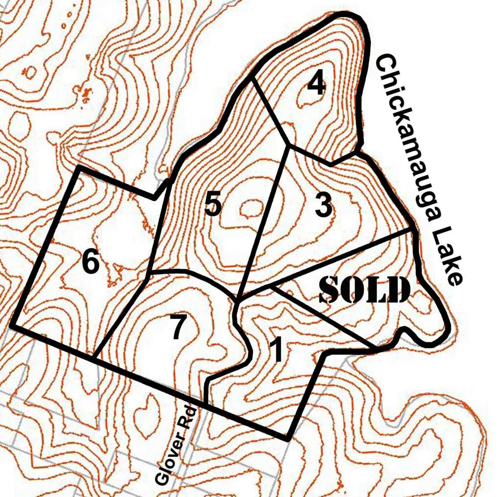
4 Property Description 44 acres on Chickamauga Lake is for sale divided into 6 separate tracts which may be sold as a whole or in combinations. This parcel of land has never been offered for sale divided up into smaller tracts. This property was originally purchased from the Tennessee Valley Authority in 1945 by the Provident Life and Accident Company (Provident Club) in The property was then improved with a club house, swimming pool, tennis courts, basketball court, several pavilions, several docks, a boat ramp, a care takers residence and other recreational use structures. Many years later, Provident gave the property to the YMCA who subsequently sold it to the present owners, YNOT, LLC. The remaining YNOT lake property is spectacular, consisting of approximately 39.5 rolling, wooded Chickamauga Reservoir acres with over 2,600 linear feet of shoreline on the contour. This property has never before been available in smaller tracts which presents a once in a lifetime opportunity. The property has been preliminarily divided into 7 smaller tracts, each in excess of five acres and each accessed by a fifty foot wide ingress/egress and utility easement that runs primarily along existing roadways. Only one of the tracts will require additional road construction for access. Tract 2 on the attached maps has already been sold. This property is one of the last remaining larger tracts within the Chickamauga Reservoir and no other available property is this well located relative to Chattanooga. Owners of these tracts will have superior privacy and lake front footage that is unheard of in this market. To get to the property, take Highway 58 from Highway 153 to its intersection with Hickory Valley Road. Go left at the Mapco Mart and take Hickory Valley Road to its terminus at Harrison Pike/Glover Road. Merge onto Glover Road and follow it all the way to the entrance to the YNOT property. Utilities provided on Glover Road include a six inch water line and overhead power. Tract # Approximate # of Acres List Price $400, SOLD $900, $1,000, $750, $500, $400,000 2


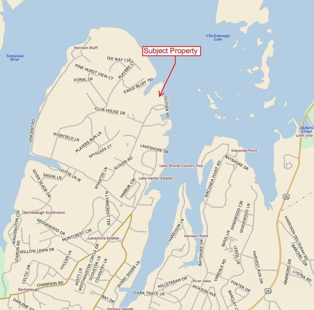
5 Location Maps 7035 Glover Road Chattanooga, TN
6 4

7 Tax Map Aerial 5

8 Plat Tract # Approximate Acres Approximate Lake Frontage 1 5 +/- 265' +/- 2 *SOLD* *SOLD* 3 6 +/ / /- 1,170' +/ /- 400' +/ / /- and Shared Boat Ramp & Dock /- Shared Boat Ramp & Dock 6

9 Hamilton County Zoning Map 7
10 Topography Map 8


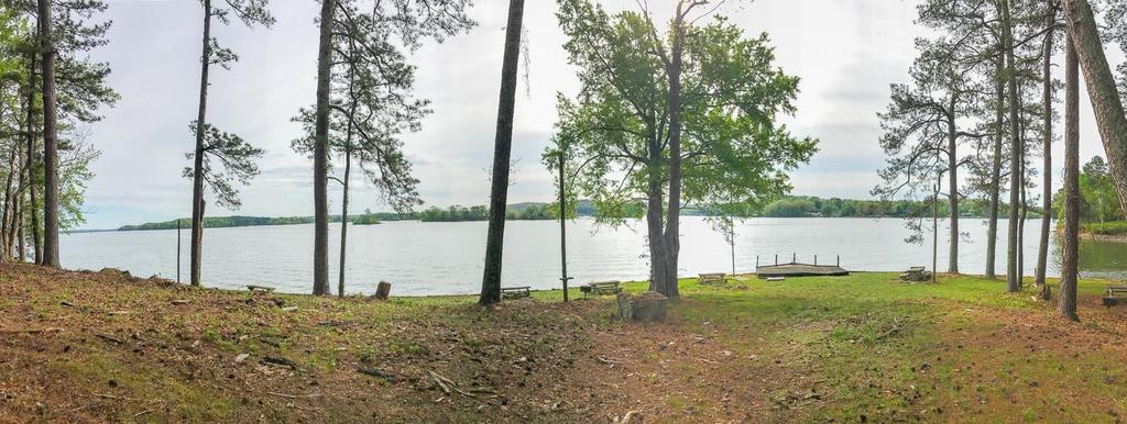
11 Aerial Photos of the Property Aerial view of the Chickamauga Lake Shoreline, Tracts 2 and 3 shorelines seen Tract 2 shoreline 9

12 Individual Tract Descriptions and Photos Tract One is located on the right side of the entrance gate and on the right side of the present paved driveway. The tract has gentle sloping topography that is oriented to the east for a very nice view of Harrison Bay. The tract is estimated to consist of over 5.5 acres with over 265 feet of lake frontage. It is wooded, has excellent road access and there are several building sites that provide privacy and enhanced lake access. Included is a dock located in a slough shared by Southern Realty Company (adjoining owner). Lake view from Tract 1 10

13 *SOLD* Tract Two is the location of the Provident club house, swimming pool, caretaker s residence and the majority of the water use facilities added by Provident. These include a sea wall and two docks as well as several picnic areas. This tract is also on a gentle slope but it includes land that extends out into the Reservoir creating a peninsula that is unmatched. The tract consists of over 5 acres and it includes over 925 feet of lake front footage. Tract 2 looking down the hill towards the clubhouse and shoreline Beautiful lake views from Tract 2 11


14 Tract Three has good road access from existing street improvements and it is oriented northeast with excellent views of and access to Chickamauga Lake. It is a wooded tract with several Provident improvements including a basketball court. The tract consists of an estimated 6 acres and it has over 435 feet of lake front footage. View of lake from possible building site on Tract 3 Tract 3 shoreline 12


15 Tract Four is the only tract that will require a road extension for access. However, it includes a knoll with potential for a promontory having a nearly 270 view overlooking Chickamauga Lake and the extended Tennessee River and surrounding topographical undulations. This wooded peninsula includes a pavilion and consists of an estimated 5 acres. Its dockable lake front footage is estimated to be over 1,170 front feet. Expansive views of the lake from Tract 4 Tract 4 shoreline 13


16 Tract Five is a 7+ acre tract on the east side of a slough shared with land owned by the State of Tennessee. It is a wooded tract that includes the tennis courts added by Provident. Its estimated lakefront footage will be approximately 400 feet. Tract 5 shoreline seen in the left side of the photopraph Access to Tract 5 14


17 Tract Six is estimated to consist of over eight acres and it adjoins a golf course on its west boundary and the State of Tennessee on its north line. This tract has a pavilion and a substantial boat ramp that was built by Provident. Use of that ramp will be shared with Tract Seven. Included with this tract will be an approximate 200 feet of shoreline along the east bank of the slough shared by the State of Tennessee. This will allow for construction and use of a dock to be shared with Tract Seven. Tract 6 looking southwest, away from the lake Tract 6 boat ramp and parking 15

18 Tract Seven, a wooded tract consisting of over an estimated five and one half acres, is the only tract with no lake front footage. However, Tract Seven will include the right to jointly construct and share use of a dock along the shoreline of Tract Six. Tract Seven will also have the right to shared use of the boat ramp with Tract Six. 16
19 Access and Utilities So that access and utilities can be provided to all of the planned tracts, a road construction and maintenance association has been formed that includes all property owners as members. Each owner will be required to pay an additional $25,000 per tract purchased to fund road and underground utility construction. Purchasers of Tracts Three, Four and Five will be granted joint use of the new road creating access and utilities to Tract Four, unless Tracts 3 & 4 or 4 & 5 are combined. 17

20 Property Record Card 18
21 19
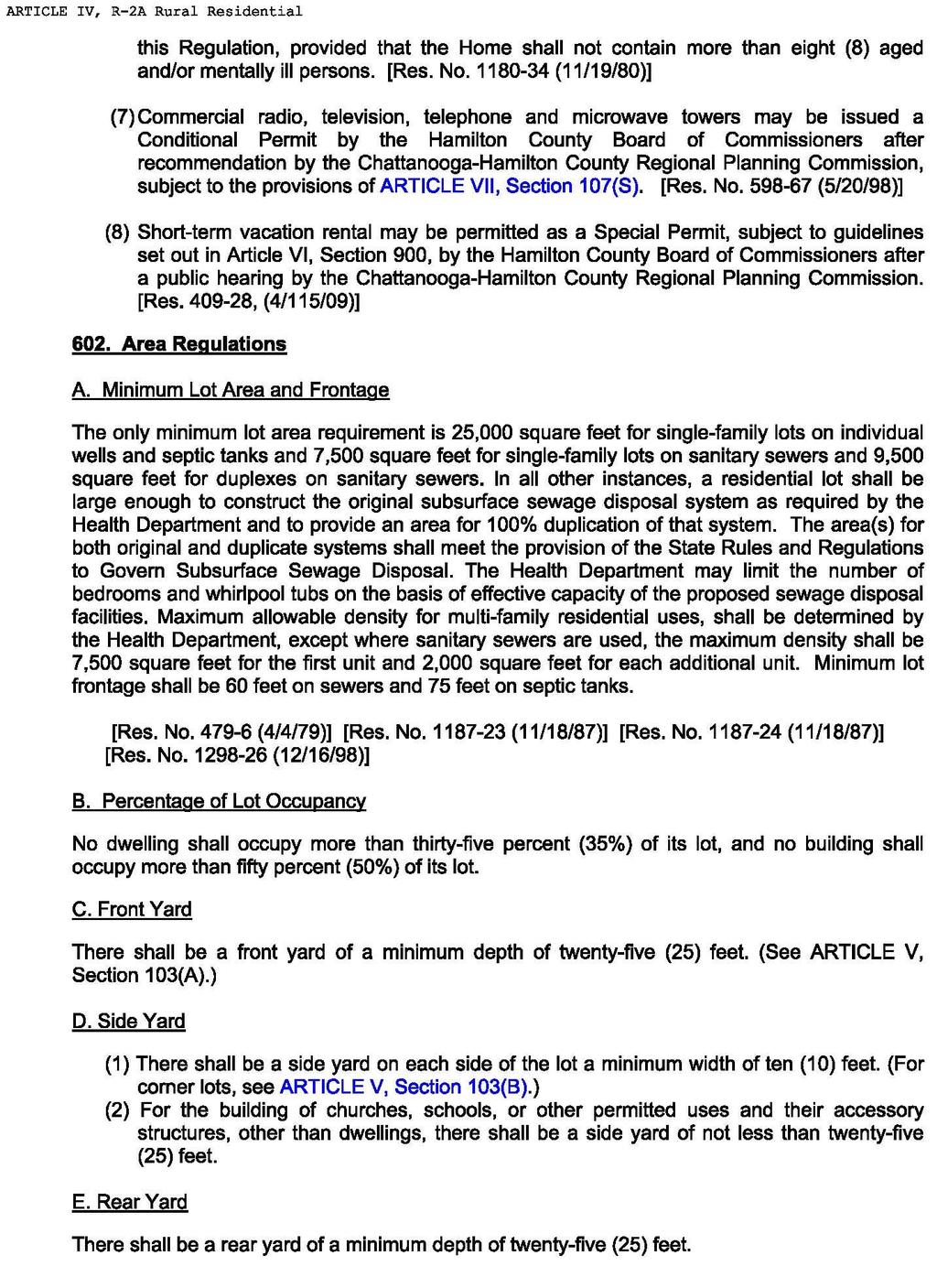
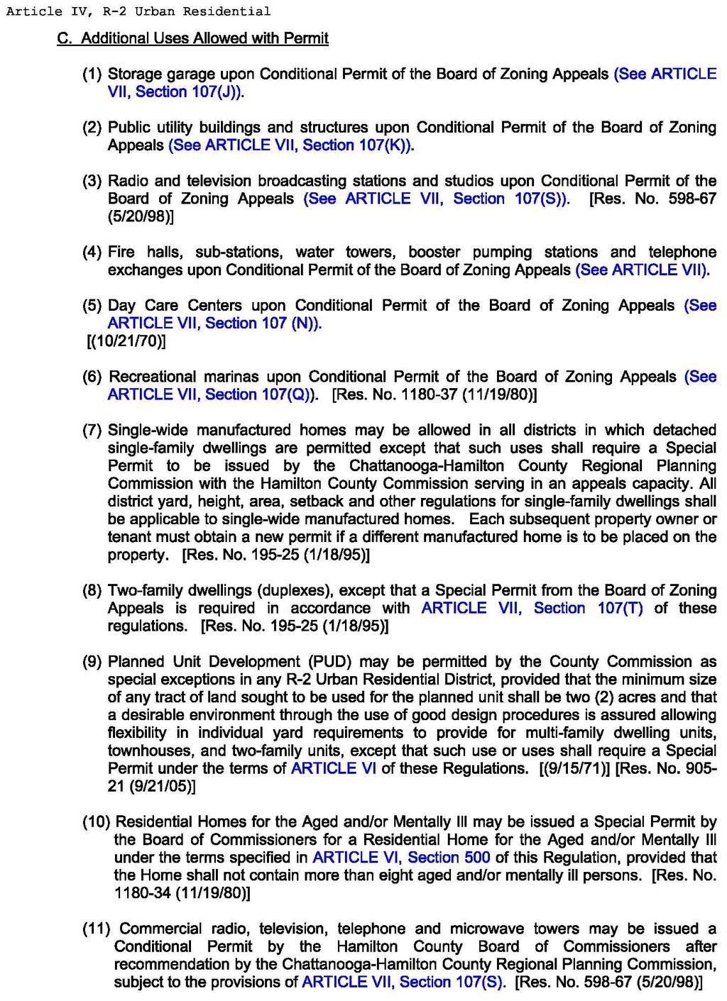
22 R-2 Urban Residential District Zoning Regulations 20
23 21
24 22
25 23
26 24
27 Deed 25
28 26
29 27
30 28
31 29
32 Deed Language - Legible Record Book 966 Page 595 THIS INDENTURE, made and entered into by and between the United States of America, hereinafter called the Grantor acting herein by and through its legal agent, the Tennessee Valley Authority (hereinafter sometimes referred to as the Authority ), a corporation created and existing under an Act of Congress, known as the Tennessee Valley Authority Act of 1933, as amended, and The Provident Club, a Tennessee Corporation, hereinafter call the Grantee. WITNESSETH; WHEREAS, Section 4 (k) (a) of the above mentioned Act of Congress authorities the Authority in the name of the United States of America, to covey any real property in its possession or under its control to any person for the purpose of recreation or for use as a summer resident; and WHEREAS, no permanent dam, hydroelectric power plant, fertilizer plant, or munitions plant is located on the land hereinafter described; and WHEREAS, the sale of the land hereinafter described has been duly approved by the President of the United States; and WHEREAS, after due advertisement said land was offered for sale at public auction on the 11 day of February 1948 at 10:00 o clock a.m. at Room 204 Old Post Office Building city of Chattanooga, county of Hamilton, State of Tennessee, and was finally struck off and sold to the Grantee for the sum of Five Thousand One Hundred and No/100 dollars ($5,100.00) that being the highest and best bid made at said auction sale. NOW, THEREFORE, in consideration of the premises and the full payment of the aforesaid bid, receipt whereof is hereby acknowledged, the Grantor does hereby, subject to the conditions hereinafter set forth, grant, bargain, sell, transfer and convey unto the Grantee, for the purpose of recreation by a private club only. A tract of land lying in the Second Civil District of Hamilton County, State of Tennessee on the west shores of Harrison Bay of Chickamauga Lake, approximately 2 miles north of New Harrison, and more particularly described as follows: TVA 2822 (LA-6-47) Beginning at US-TVA Monument 82-3 (Coordinate: N. 273,444, E 2,254,438) in the boundary of the United States of America s land at a corner to the lands of J.M. Glover, D.N. Lamon and Edgar B. Brewster; thence with the United States of America boundary line, N E. 775 feet to a point in the center line of a road; the said point being S W. 14 feet from US-TVA Monument 9-5; thence leaving the United States of America s boundary line, S E. 365 feet to US-TVA Monument 9-6 in the center line of a hollow; thence along the hollow N E. 102 feet to US-TVA Monument 9-7 at the head of the foot contour at the south end of an inlet of Harrison Bay; thence with the feet contour as it meanders in the north westerly direction to the 30
33 mouth of the inlet and subsequently up the bay in a general southerly direction for a total distance of approximately 3540 feet to an angle iron at the head of the contour in the center line of the hollow; thence leaving the contour S W. 413 feet to US-TVA Monument 82.2 in the boundary of the United States of America s land; thence with the United State of America s boundary line N W feet to the point of beginning, and containing 44.5 acres, more or less. FURTHERMORE, the rights to construct and maintain water use facilities at locations and upon plans to be approved in advance by the Authority and suitable ingress and egress over the adjoining land lying between the foot contour elevation and the water or the lake, upon the express condition that said rights shall be subject to and shall not in any way interfere with the Authority s statutory program for river control and development, including, but without limitations by reason of enumeration, the Authority deems necessary or desirable in the promotion of malaria control, flood control, navigation, or other essential programs, and the Authority shall not be liable for any loss or damage resulting therefrom. The positions of corner and directions of lines are referred to the Tennessee Coordinate System. The contour elevation is based on MSL Data as established by the USC&GS Southeastern Supplementary Adjustment of The boundary market designated US- TVA Monument are concrete monuments capped by bronze tablets imprinted with the given number and letters. The above described tract of land is conveyed subject to such rights as may be vested in the public and in the county to road rights of way and to such rights as may be vested in third parties in an existing road. The above described tract of land is a part of the same land acquired by the United State of America by virtue of the deed from Harry W. Durand, Jr. and Hugh T. Vinson, Trustees, dated March 11, 1937, recorded in Deed Book L. Vol 29 page 639 in the Register s office of Hamilton County, Tennessee. It is hereby agreed that this conveyance is made upon the express condition that the land herein described shall be used solely for recreational purposes by a private club. Upon breach of this condition, either in whole or in part, the Grantor, and its successors shall have the right to re-enter and take possession of said land, and to hold, own, and possess the same in the same manner and to the same extent as if this conveyance had never been made. Any failure on the part of the Grantor to re-enter and take possession of said land shall not be construed to be a waiver of this condition. T 2822 (modified) In making this conveyance, however, the Grantor expressly reserves the following described easement rights: (1) The right to maintain any existing boundary and traverse monuments and silt range stations upon the land above described. 31
34 (2) On and over that portion of the above described land which is located below the 690-foot contour elevation (all contour elevations referred to herein are based upon mean level as established by the 1936 Southeastern Supplementary Adjustment U.S. C. & G. S.) the right to enter upon said portion of said land and do any and all things that Grantor considers necessary and desirable in connection with its statutory program for river control and development, this right shall include but not be limited to, by reason of lack of specific enumeration, the right to temporarily or permanently flood said portion of said land with backwater created by the erection and operation of any dam or dams across the Tennessee River and its tributaries; the right to clean (illegible) and drain said land and apply larvicides and chemicals thereon; to carry on bank protection work, to erect or remove structures, and do any and all other things which Grantor deems necessary or desirable in the promotion and furtherance of malaria control, flood control, and navigation, and the right to prohibit the dumping or draining into the waters of any stream or reservoir, under Grantor s control, of any refuse, sewage or other material which might tend to pollute or render said water unsanitary. (3) And in addition, on and over the portion of the above described land which is located within a distance of 250 feet of the shore line ( Shore Line as used herein refers to the foot contour elevation) of any stream or reservoir under Grantor s control, the right to erect and maintain navigation aids and do such clearing as Grantor may deem necessary to ensure visibility. All uranium, thorium and all other materials determined pursuant to section 5 (b) (1) of the Atomic Energy Act of 1946 (60 sts. 761) to be peculiarly essential to the production of fissionable material, contained, in whatever concentration, in deposits in the lands covered by this instrument are hereby reserved for the use of the United States, together with the right of the United State through its authorized agents or representatives at any time to enter upon the land and prospect for mine, remove the same, making just compensations for any damage or injury occasioned thereby. However, such land may be used and any rights otherwise acquired by this disposition may be exercised, as if no reservation of such materials had been made; exempt that, when such use results in the extraction of any such material from the land in quantities which may not be transferred or delivered without a license under the Atomic Energy Act of 1946, as it now exists or may hereafter be amended, such material shall be the property of the United States Atomic Energy Commission, and the Commission may require delivery of such material to it by any possessor thereof after such material has been separated as such from the area in which it was contained. If the Commission requires the delivery of such material to it, it shall pay to the person mining or extracting the same, or to such other person as the Commission determines to be entitled thereto, such sums, including profits, as the commission deem fair and reasonable for the discovery, mining, developments, production, extraction, and other service performed with respect to such material prior to such delivery, but such payment shall not include any amount on account of the value of such material before removal from its place of deposit in nature. If the Commission does not require delivery of such 32
35 material to it, the reservation hereby made shall be of no further force or effect. Grantor further reserves, for the benefit of other properties of the Grantor or its assigns, in common with the Grantee, a right of way 50 feet wide for the construction, maintenance, and use of a road on, over and across the above described land, the first portion of the said right of way lying Northeast of and adjacent to a portion of the Southwest boundary of the described land and extending from a Southeast boundary line at the most Southerly property corner in a Northwesterly direction approximately 1030 feet, the second portion of the right of way extending from the Northwest end of the first described portion in a Northeasterly direction approximately 250 feet to an existing road and then along the existing road in a Northerly direction approximately 450 feet to a North boundary line at a point N W, 130 feet, more or less from the previously mentioned US-TVA monument 9-6; together with the right to do the necessary work of construction and maintenance of said road and the necessary work in construction maintenance of any draining ditches and other road appurtenance lying outside of but adjacent to the limits of the right of way. TVA 2522 (Modified) Grantor further reserves a permanent easement and right of way for. (illegible)... purposes timely: The perpetual right to enter and to erect, maintain, repair, rebuild, operate and patrol one or more electric power transmission lines, and one or more telephone lines, including the right to erect such poles and other transmission line structures, wires, cables, and any necessary appurtenances: the right to clear said right of way and keep the same clear of brush, timber, structures, and fire hazards, and the right to remove danger trees, if any, located beyond the limits of said right of way; all over, upon, across, and under the following described land to wit: A strip of land 30 feet wide lying 15 feet on each side of the center line of an existing transmission line, owned and operated by the Chattanooga Electric Power Board, across the said land, the said existing transmission line beginning at a power pole 5 feet, more or less, southwest of the southwest boundary line and 400 feet, more or less, northeast of the previously mentioned US-TVA Monument 82.2 and extending in a northwesterly direction approximately 450 feet to a power pole at the end of the transmission line. Neither the authority nor the United States of America shall be liable for any damage incidental to the exercise of any of the rights reserved except that the authority shall remain liable for any additional damage caused by its construction forces to the property (above described and hereby conveyed) as a result of the erection, maintenance, or rebuilding of its electrical power transmission and telephone lines on the right of way reserved. In accepting this conveyance, however, the grantee, for himself, his heirs, successors, and assigns, covenants and agrees to and with the grantor that the following shall constitute real covenants which shall attach to end run with the above described land and shall be binding upon anyone who may hereafter come into ownership thereof, whether by purchase, devise, decent or succession; (1) In the interest of public health and sanitation and in order that the land above described and all other land in the same locality may be benefited by a decrease in the hazards of stream pollution and by the protection of water supplies, recreation, wildlife and other public uses of Grantor s reservoir waters and shore lands, he 33
36 will not use the above described property for any purpose that would result in the draining or dumping into the reservoir of any refuse, sewage, or other material, which might tend to pollute the waters of said reservoir. (2) In order to foster the development of said land for the recreational purposes herein set forth, the Grantees (a) will not construct or maintain or cause or suffer to be constructed or maintained on said land any buildings or structures other than a club house, cabins/lodges, recreational facilities, and necessary and appurtenant outbuildings; (b) will construct for use with said buildings either septic tanks or outdoor toilets in accordance with the standards of the State and County public health officials; and (c) will not constructor maintain or cause or suffer to be constructed or maintained on said land any building located nearer than 25 feet from any aide or back line of said land and not hearer than 35 feet from the margin of the right of way of any road. (3) He will not construct or maintain any buildings or other structures except water use, facilities constructed in accordance with plans approved by the authority on any portion of the above described land which is located below the 690 feet contour elevation. To have and to hold said land and premises, subject to the condition hereinabove stated, unto the Grantee, his heirs, successors, and assigns in fee simple, together with all and singular the hereditaments and appurtenances thereunto belonging or in anywise appertaining. And the Authority does hereby covenant that the Unites States of America is seized and possessed of the above described land; that the Authority as legal agent of the United States is duly authorized to convey the same, that said land is free and clear of liens and encumbrances; and that, subject only to such exceptions, conditions, restrictions, and or limitations as may be expressly mentioned above, it will warrant and defend the title thereto against the lawful demands of all persons claiming by,.. or under the United States of America, but not further or otherwise. Wherever in this instrument the context requires the singular number and masculine gender as herein used may be read as plural and feminine, or neuter respectively, In Witness Whereof, the Tennessee Valley Authority, noting herein as legal agent of the United States of America, and being duly authorized so to do, has caused this instrument to be executed, in the name of the United States of America, by its authorizes officers and its corporate seal to be hereunto affixed on this the 11 day of February
Greetings from Henry Glascock
 Table of Contents Greetings from Henry Glascock... 1 Property Description... 2 Location Maps... 3 Tax Map Aerial... 5 Plat... 6 Hamilton County Zoning Map... 7 Topography Map... 8 Aerial Photos of the
EXHIBIT C TVA TRACT NO. XTBRDC-1, LOT REDBUD SUBDIVISION SPECIAL WARRANTY DEED
 EXHIBIT C THIS DEED WOULD BE USED FOR LAND OWNED BY TVA AND WHERE THE LOTS ARE NOT ON THE WATERFRONT. A STATEMENT OF SUBDIVISION STANDARDS AND SHORELINE MANAGEMENT ZONE (SAMPLES ATTACHED HERETO AS EXHIBITS
APARTMENT DEED WITH COVENANTS
 LAND COURT SYSTEM Return by Mail Pickup To: REGULAR SYSTEM TITLE OF DOCUMENT: APARTMENT DEED WITH COVENANTS PARTIES TO DOCUMENT: GRANTOR: 3702 LOWER HONOAPIILANI, LLC, a Colorado limited liability company
GENERAL WARRANTY DEED
 PROJECT. # 89008160 TRACT NO.:10 PARCEL ID NO.:PL199032200000001003 OWNERS NAME: Park Hill School District SITUS ADDRESS:5520 N. Northwood: KANSAS CITY, MISSOURI MAILING ADDRESS:7703 NW Barry Rd. Kansas
EXHIBIT B AGREEMENT OF TRANSFER. Between TENNESSEE VALLEY AUTHORITY. And UNITED STATES DEPARTMENT OF THE INTERIOR NATIONAL PARK SERVICE.
 EXHIBIT B AGREEMENT OF TRANSFER Between TENNESSEE VALLEY AUTHORITY And UNITED STATES DEPARTMENT OF THE INTERIOR NATIONAL PARK SERVICE Relating To LANDS IN SWAIN COUNTY, NORTH CAROLINA THIS AGREEMENT OF
RESOLUTION OF INDIAN LAKE BOROUGH. *, 1997 the Borough Council. WHEREAS, Bernie Wires submitted a proposed plan for an elevated sand mound on
 RESOLUTION 1997-2 OF INDIAN LAKE BOROUGH AND NOW, this 1 3 t h day of m *, 1997 the Borough Council of Indian Lake Borough hereby resolves as follows: WHEREAS, Bernie Wires submitted a proposed plan for
STATE OF GEORGIA, Athens-Clarke County
 Warranty Deed STATE OF GEORGIA, Athens-Clarke County This INDENTURE made and entered into this 19th day of August, in the year of our Lord One Thousand Nine Hundred and Ninety Eight (1998) between MARION
BILL NO (Emergency Measure) ORDINANCE NO. 5072
 ORDINANCE NO. 5072") BILL NO. 5210 (Emergency Measure) ORDINANCE NO. 5072 AN ORDINANCE AUTHORIZING THE MAYOR TO EXECUTE WITH MICHELSON-HADLEY HEIGHTS DEVELOPMENT, LLC, A CONTRACT AND QUIT CLAIM DEED CONVEYING CERTAIN PROPERTIES
BILL NO. 5210 (Emergency Measure) ORDINANCE NO. 5072 AN ORDINANCE AUTHORIZING THE MAYOR TO EXECUTE WITH MICHELSON-HADLEY HEIGHTS DEVELOPMENT, LLC, A CONTRACT AND QUIT CLAIM DEED CONVEYING CERTAIN PROPERTIES
PERMANENT EASEMENT AGREEMENT. good and valuable consideration, the sufficiency and receipt of which is hereby acknowledged, The Esther Harrison
 PERMANENT EASEMENT AGREEMENT For and in consideration of the sum of Seven thousand thirty and 00/100 dollars ($7,030.00) and other good and valuable consideration, the sufficiency and receipt of which
MECKLENBURG COUNTY Land Use & Environmental Services Agency Groundwater & Wastewater Services
 MECKLENBURG COUNTY Land Use & Environmental Services Agency Groundwater & Wastewater Services Instructions for Permitting On-Site Sewage Treatment & Disposal Systems Requiring a Septic System Easement,
Tax Map Key Nos. (1) : 003, :004 and :008 CPR No. Total Pages: Unit No.
 : 003, :004 and :008 CPR No. Total Pages: Unit No.") LAND COURT SYSTEM AFTER RECORDATION: RETURN BY MAIL ( ) PICK UP ( ) REGULAR SYSTEM Tax Map Key Nos. (1) 2-3-016: 003, :004 and :008 CPR No. Total Pages: Unit No. LIMITED WARRANTY UNIT DEED, ENCUMBRANCES
LAND COURT SYSTEM AFTER RECORDATION: RETURN BY MAIL ( ) PICK UP ( ) REGULAR SYSTEM Tax Map Key Nos. (1) 2-3-016: 003, :004 and :008 CPR No. Total Pages: Unit No. LIMITED WARRANTY UNIT DEED, ENCUMBRANCES
GENESIS PIPELINE CANADA LIMITED AGREEMENT FOR EASEMENT PROVINCE OF ONTARIO
 EASEMENT AGREEMENT GENESIS PIPELINE CANADA LIMITED Property Identification No.: GST #: Yes No GST# AGREEMENT FOR EASEMENT PROVINCE OF ONTARIO I, (We), (the "Owner(s)"), being registered as owner(s) or
Sketch & Legal Description of Mitigation Bank and Ingress/Egress Access Easements
 Appendix H: Sketch & Legal Description of Mitigation Bank and Ingress/Egress Access Easements Tippen Bay Wetland Mitigation Bank DeSoto County, Florida Prepared by: September, 2017 Original file
EASEMENT AGREEMENT. WHEREAS, Ferguson is the 100% owner of the property described on Exhibit B attached hereto (the Williams Property );
;") EASEMENT AGREEMENT THIS EASEMENT AGREEMENT ( Agreement ) is entered into as of this day of, 2016, by and between CRAIG FERGUSON ( Ferguson ), and MAMIE DAVIS and JERRY MOORE ( Davis & Moore ), whose legal
EASEMENT AGREEMENT THIS EASEMENT AGREEMENT ( Agreement ) is entered into as of this day of, 2016, by and between CRAIG FERGUSON ( Ferguson ), and MAMIE DAVIS and JERRY MOORE ( Davis & Moore ), whose legal
COMMUNITY DEVELOPMENT DEPARTMENT. To: Board of Commissioners VIA: Finance Committee. From: David Hainley, Director. Re:
 COMMUNITY DEVELOPMENT DEPARTMENT 1725 Reynolds Street, Suite 200, Brunswick, GA 31520 To: Board of Commissioners VIA: Finance Committee From: David Hainley, Director Re: Accepting 0.744 acres of land and
NORTH CAROLINA DEED OF TRUST
 NORTH CAROLINA DEED OF TRUST SATISFACTION: The debt secured by the within Deed of Trust together with the note(s) secured thereby has been satisfied in full. This the day of, 20 Signed: Parcel Identifier
NOTE: This agreement must be properly executed.
 NOTE: This agreement must be properly executed. Execution of this agreement by individuals must be witnessed in all cases and an Affidavit of Execution must be appended. THIS AGREEMENT MADE THIS DAY OF,
AMENDMENT TO POWER PURCHASE AGREEMENT
 AMENDMENT TO POWER PURCHASE AGREEMENT This Amendment Power Purchase and Agreement ( Amendment ) is entered into as of, 2012, by and between, (hereinafter RMW ) a Nevada limited liability company, and The
THAT WE, the undersigned, being sole Owners of the lands and premises described as follows:
 THE STATE OF TEXAS COUNTY OF POLK KNOW ALL MEN BY THESE PRESENTS: THAT WE, the undersigned, being sole Owners of the lands and premises described as follows: BRIDGEVIEW Subdivision, Section One, a subdivision
AGREEMENT FOR DEED. Articles of Agreement Made this day of A.D. 2016, between Seller, ( Seller ) and Buyers, ( Buyers ).
 and Buyers, ( Buyers ).") Prepared by and after Recording return to: Joseph M. Kosteck Law Office of Joseph M. Kosteck Ltd. 10201 W. Lincoln Hwy Frankfort, IL 60423 AGREEMENT FOR DEED Articles of Agreement Made this day of A.D.
Prepared by and after Recording return to: Joseph M. Kosteck Law Office of Joseph M. Kosteck Ltd. 10201 W. Lincoln Hwy Frankfort, IL 60423 AGREEMENT FOR DEED Articles of Agreement Made this day of A.D.
ORDINANCE NO.:
 ORDINANCE NO.: 2013-098 Authorizing the City Manager to execute a Limited Warranty Deed conveying the improvements (an approximate 300 space parking garage) known as the Bell South Parking Garage constructed
DEED AND DEDICATION FOR PUBLIC RIGHT OF WAY
 TO : BOARD OF DIRECTORS FROM : GARY PLATT, EXEC. DIRECTOR BUSINESS AND OPERATIONS SUBJECT : CITY OF STANWOOD CONSTRUCTION EASEMENT AND RIGHT-OF-WAY DEDICATION DATE : MARCH 17, 2009 TYPE : ACTION NEEDED
RESTRICTIVE COVENANT THIS RESTRICTIVE COENANT MADE THE DAY OF, 2017.
 Neighbourhood: Stage: BERM AND FENCE RESTRICTIVE COVENANT THIS RESTRICTIVE COENANT MADE THE DAY OF, 2017. BETWEEN: Developer s Name a body corporate carrying on business in the City of Edmonton, in the
HOME PROGRAM HOMEOWNER REHABILITATION NOTE, Tennessee, 20
 $ HOME PROGRAM HOMEOWNER REHABILITATION NOTE, Tennessee, 20 For value received and hereby acknowledged, _ ( Maker ), promises to pay to the order of _ ( Holder ) the principal sum of and 00/100 Dollars
Dated October 14, 1966 As to Acknowledged October 14, 1966 University Hills No. 2 Subdivision Reported October 18, 1966 Liber 1954, Page 28
 Orchard Lane Land Company Declaration of Restrictions Dated October 14, 1966 As to Acknowledged October 14, 1966 University Hills No. 2 Subdivision Reported October 18, 1966 Liber 1954, Page 28 This Declaration,
FIRST AMENDED DEED RESTRICTION
 RECORDED AT THE POLK COUNTY COURTHOUSE IN VOLUME 349, PAGES 850 TO 854 STATE OF TEXAS COUNTY OF POLK FIRST AMENDED DEED RESTRICTION WHEREAS, the undersigned DON E. WARFIELD, and C. L. CONNER, CO- TRUSTEES,
Utility Easement from Suncoast Community Health Centers Inc Release of Easement
 0 YLANi AGENDA REPORT 5T FLORID DATE 10 24 11 TO FROM SUBJECT City Commission Gregory Horwedel City Manager Utility Easement from Suncoast Community Health Centers Inc Release of Easement RECOMMENDATION
PUBLIC AUCTION SEALED BID PACKET
 Sara M. Baker, President Rebecca W. Arnold, Vice President Jim D. Hansen, Commissioner Kent Goldthorpe, Commissioner Paul Woods, Commissioner PUBLIC AUCTION SEALED BID PACKET FOR PUBLIC AUCTION SALE OF:
PIPELINE RIGHT-OF-WAY EASEMENT
 PIPELINE RIGHT-OF-WAY EASEMENT THIS RIGHT-OF-WAY EASEMENT made this day of March, 2014, by the City of Rochester Hills, a municipal corporation in the State of Michigan,, having an address at 1000 Rochester
NORTH CAROLINA DEED OF TRUST NORTH CAROLINA HOUSING FINANCE AGENCY $15,000 DPA Program Only
 NORTH CAROLINA DEED OF TRUST NORTH CAROLINA HOUSING FINANCE AGENCY $15,000 DPA Program Only After recording, return the executed document back to the Originating Lender (not NCHFA) within 24 hours of closing.
PROPERTY EXCHANGE & CONVEYANCE AGREEMENT RECITALS
 PROPERTY EXCHANGE & CONVEYANCE AGREEMENT This Property Exchange and Conveyance Agreement ( Agreement ) is entered into as of the date of execution by and between Laramie Church of Christ, Inc., a Wyoming
ADDENDUM TO PURCHASE AGREEMENT (WITH HOMEBUYER) NOTICE AND DISCLOSURE OF DEFERRED WATER AND SEWER CHARGES
 NOTICE AND DISCLOSURE OF DEFERRED WATER AND SEWER CHARGES") ADDENDUM TO PURCHASE AGREEMENT (WITH HOMEBUYER) NOTICE AND DISCLOSURE OF DEFERRED WATER AND SEWER CHARGES Pursuant to Section 14-117 of the Real Property Article of the Annotated Code of Maryland, and
ADDENDUM TO PURCHASE AGREEMENT (WITH HOMEBUYER) NOTICE AND DISCLOSURE OF DEFERRED WATER AND SEWER CHARGES Pursuant to Section 14-117 of the Real Property Article of the Annotated Code of Maryland, and
1 Acre Lot - Nickajack Lake
 1 Acre Lot - Nickajack Lake 17915 Highway 41 Chattanooga, TN 37419 COURT ORDERED ABSOLUTE AUCTION Property must sell for division among heirs Saturday, April 1 st at 11:00 A.M. Eastern Time Sale Site:
CONSENT ACTION BY THE BOARD OF DIRECTORS OF VENETO IN MIRAMAR CONDOMINIUM ASSOCIATION, INC.
 CONSENT ACTION BY THE BOARD OF DIRECTORS OF VENETO IN MIRAMAR CONDOMINIUM ASSOCIATION, INC. The undersigned, being all of the members of the Board of Directors of Veneto in Miramar Condominium Association,
Case 1:01-cv BLW Document Filed 01/18/11 Page 120 of 152 EXHIBIT I ) ) ) ) ) ) ) ) ) ) ) ) ) ) ) ) ) )
 ) ) ) ) ) ) ) ) ) ) ) ) ) ) ) ) )") Case 1:01-cv-00286-BLW Document 202-2 Filed 01/18/11 Page 120 of 152 EXHIBIT I DENNIS KOYLE, CHARLES K. TURNER, and the CARAVELLE CORPORATION, INC. on behalf of themselves and all others similarly situated,
Case 1:01-cv-00286-BLW Document 202-2 Filed 01/18/11 Page 120 of 152 EXHIBIT I DENNIS KOYLE, CHARLES K. TURNER, and the CARAVELLE CORPORATION, INC. on behalf of themselves and all others similarly situated,
6. No existing structure shall be moved onto any part of the premises within this plat.
 ADACROFT COMMONS BUILDING RESTRICTIONS (copy of original document as recorded w/ Kent Co. Register of Deeds, Liber 2274, pages 1182-1187) WHEREAS, Maryland Development Company, a Michigan corporation,
OPTION TO PURCHASE REAL ESTATE AGREEMENT BETWEEN CITY OF WICHITA, KANSAS AND DSW BROADVIEW, LLC
 OPTION TO PURCHASE REAL ESTATE AGREEMENT BETWEEN CITY OF WICHITA, KANSAS AND DSW BROADVIEW, LLC OPTION TO PURCHASE REAL ESTATE AGREEMENT THIS OPTION TO PURCHASE REAL ESTATE AGREEMENT ( Option Agreement
APPROVAL REQUIRED... A5 APPLICATION FOR APPROVAL OF PRELIMINARY PLAN... A6 APPLICATION FOR APPROVAL OF DEFINITIVE PLAN... A7
 APPENDIX FORM A. FORM A-2. FORM A-3. FORM B. FORM C. FORM C-1. FORM C-2. FORM D. FORM E. FORM F. FORM G. FORM H. FORM I. FORM J. FORM J-1. FORM K. FORM K-1 FORM L Form M. APPLICATION FOR A DETERMINATION
LAND CONTRACT. hereinafter referred to as the "Seller" whose address is and, hereinafter referred to as the "Purchaser" whose address is.
 LAND CONTRACT This Contract, made this day of, 20, between hereinafter referred to as the "Seller" whose address is and, hereinafter referred to as the "Purchaser" whose address is. Witnesseth: 1. THE
COVENANTS AND RESTRICTIONS VALHALLA DIVISION NO. 1
 COVENANTS AND RESTRICTIONS VALHALLA DIVISION NO. 1 THIS INDENTURE AND DECLARATION OF COVENANTS running with the land made this 4th day of December, 1962 by VALHALLA, INCORPORATED, a Washington corporation,
PERPETUAL DRAINAGE EASEMENT
 PERPETUAL DRAINAGE EASEMENT THIS GRANT OF PERPETUAL DRAINAGE EASEMENT is made this day of, 2016, between [name and address] ("Grantor"), and the City of Thornton, a Colorado municipal corporation, located
DECLARATION OF RESTRICTIONS GREYSTONE ESTATES SOUTH
 DECLARATION OF RESTRICTIONS GREYSTONE ESTATES SOUTH WHEREAS, EARNSHAW LAND CO., INC, a Kansas corporation, EARNSHAW, INC., a Kansas corporation, ROBERT R. EARNSHAW and BARBARA EARNSHAW, have heretofore
SCHEDULE U : EASEMENT FOR PARKING TERMS OF INSTRUMENT PART 2
 SCHEDULE U : EASEMENT FOR PARKING [attach Land Title Act Form C General Filing Instrument Part 1] TERMS OF INSTRUMENT PART 2 This Easement dated for reference the day of,. BETWEEN: AND AND WHEREAS: bcimc
EASEMENT AGREEMENT (Distributor Performance Non-Exclusive)
") EASEMENT AGREEMENT (Distributor Performance Non-Exclusive) THIS EASEMENT AGREEMENT, effective the day of, 20, is made between WITNESSETH:, hereafter called Grantor, (whether grammatically singular or plural)
EASEMENT AGREEMENT (Distributor Performance Non-Exclusive) THIS EASEMENT AGREEMENT, effective the day of, 20, is made between WITNESSETH:, hereafter called Grantor, (whether grammatically singular or plural)
ARCHITECTURAL CONTROL
 ARCHITECTURAL CONTROL The Franklin Valley Restrictions, or covenants, form a legally recorded document prepared by prior owners of the land on which the community is located. The purpose of restrictions
EASEMENT AGREEMENT. hereinafter called Grantor, (whether grammatically singular or plural) and the:
 and the:") EASEMENT AGREEMENT THIS EASEMENT AGREEMENT made and entered into as of the day of,, by and between: hereinafter called Grantor, (whether grammatically singular or plural) and the: hereinafter called Distributor.
EASEMENT AGREEMENT THIS EASEMENT AGREEMENT made and entered into as of the day of,, by and between: hereinafter called Grantor, (whether grammatically singular or plural) and the: hereinafter called Distributor.
FILED: NEW YORK COUNTY CLERK 12/15/ :54 PM
 Rosenthal Affidavit Exhibit 1 NYC DEPARTMENT OF FINANCE OFFICE OF THE CITY REGISTER This page is part of the instrument. The City Register will rely on the information provided by you on this page for
Dallas Sloan General Manager Barron Area Phone: (715) Toll Free: Fax: (715) NEW SERVICE PROCESS
 Toll Free: Fax: (715) NEW SERVICE PROCESS") Barron Area Phone: (715) 537-3171 Toll Free: 800-322-1008 Fax: (715) 637-1906 Dallas Sloan General Manager NEW SERVICE PROCESS Paperwork: Membership application social security number required for credit
Barron Area Phone: (715) 537-3171 Toll Free: 800-322-1008 Fax: (715) 637-1906 Dallas Sloan General Manager NEW SERVICE PROCESS Paperwork: Membership application social security number required for credit
WHEREAS, it is the desire and intent of the party of the first part to convey unto
 THIS DEED OF SUBDIVISION, DEED OF CONVEYANCE and DEED OF EASEMENT, made this 24th day of August, 1984, by and between LAKEPOINTE DEVELOPMENT CORPORATION, a Virginia corporation, party of the first part;
,2, day of May, 2013, by RB Homes, Inc., a Colorado corporation (the "Declarant")
") DECLARATION AND P ARTY WALL AGREEMENT This DECLARATION and PARTY WALL AGREEMENT ("Agreement") is made this_,2, day of May, 2013, by RB Homes, Inc., a Colorado corporation (the "Declarant") WHEREAS, Declarant
DECLARATION AND P ARTY WALL AGREEMENT This DECLARATION and PARTY WALL AGREEMENT ("Agreement") is made this_,2, day of May, 2013, by RB Homes, Inc., a Colorado corporation (the "Declarant") WHEREAS, Declarant
SOUTH DAKOTA BOARD OF REGENTS. Budget and Finance ******************************************************************************
 SOUTH DAKOTA BOARD OF REGENTS Budget and Finance AGENDA ITEM: 7 U DATE: October 4-6 ****************************************************************************** SUBJECT: SDSU 6 th Street Land Sale for
DECLARATIONS OF COVENANTS, RESTRICTIONS, CONDITIONS AND RESERVATIONS
 THIS DECLARATION, made this 30 th day of December, 1969, by Jasper Valley Development Corporation, hereinafter called the Developer. WITNESSETH: Whereas, Developer is the owner of the real property described
COUNCIL AGENDA MEMO ITEM NO. III - #1
 COUNCIL AGENDA MEMO ITEM NO. III - #1 FROM: Anton Jelinek, Director of Utilities MEETING: October 24, 2017 SUBJECT: PRESENTER: Permanent Utility and Right-of-Way Easement Anton Jelinek Discussion: At the
MARTIN COUNTY BOARD OF COUNTY COMMISSIONERS
 MARTIN COUNTY BOARD OF COUNTY COMMISSIONERS DOUG SMITH Commissioner, District 1 UTILITIES & SOLID WASTE DEPARTMENT PO Box 9000 Stuart, FL 34995-9000 John E. Polley Director Phone (772) 221-1442 Fax (772)
BOARD OF COUNTY COMMISSIONERS AGENDA ITEM SUMMARY
 6C BOARD OF COUNTY COMMISSIONERS AGENDA ITEM SUMMARY PLACEMENT: PUBLIC HEARINGS PRESET: TITLE: PUBLIC HEARING FOR THE EXCHANGE OF A QUIT CLAIM DEED GRANTED TO JEAN UZELAC, AS TRUSTEE OF THE JOHN CARL ZIMMERMANN
AMENDED RESTRICTIVE COVENANTS
 AMENDED RESTRICTIVE COVENANTS of WOODHAVEN HOMES, INC. State of North Carolina, County of Henderson This is a copy of the current Covenants. The original of this document was filed with the Henderson County
Sample Hunting Lease Agreement
 Sample Hunting Lease Agreement STATE OF NORTH CAROLINA COUNTY OF This Hunting Lease Agreement, made and entered into this day of, 20, by and between, hereinafter called Lessor and, hereinafter called Lessee.
FIFTH AMENDMENT OF DECLARATION OF DEED RESTRICTIONS AND DEDICATIONS FOR PINEHURST ESTATES (A Clatsop County, Oregon Subdivision)
") After Recording Return To: W. Louis Larson 990 Astor Street Astoria, OR 97103 FIFTH AMENDMENT OF DECLARATION OF DEED RESTRICTIONS AND DEDICATIONS FOR PINEHURST ESTATES (A Clatsop County, Oregon Subdivision)
After Recording Return To: W. Louis Larson 990 Astor Street Astoria, OR 97103 FIFTH AMENDMENT OF DECLARATION OF DEED RESTRICTIONS AND DEDICATIONS FOR PINEHURST ESTATES (A Clatsop County, Oregon Subdivision)
PERMANENT DRAINAGE EASEMENT
 City Project No. Project Name: ; Tr. # Parcel No. (LLC, Corporation, Partnership) PERMANENT DRAINAGE EASEMENT THIS AGREEMENT, made and entered into this day of, 201, by and between, a, hereinafter called
DEED OF DEDICATION, BOUNDARY LINE ADJUSTMENT, CONVEYANCE, VACATION, TRUST MODIFICATION AND RELEASE (Minor Adjustment of Property Lines)
") Prepared by/return to: Reed Smith LLP 7900 Tysons One Place, Suite 500 McLean, VA 22102-5979 Attn: Robert M. Diamond, Esq. Parcel ID Nos.: 58 2 10 01 001 58 2 10 01 002 58 2 10 01 003 58 2 10 01 004 58
Prepared by/return to: Reed Smith LLP 7900 Tysons One Place, Suite 500 McLean, VA 22102-5979 Attn: Robert M. Diamond, Esq. Parcel ID Nos.: 58 2 10 01 001 58 2 10 01 002 58 2 10 01 003 58 2 10 01 004 58
EASEMENT AGREEMENT. hereinafter called Grantor, (whether grammatically singular or plural) and the:
 and the:") EASEMENT AGREEMENT THIS EASEMENT AGREEMENT, made and entered into as of the day of,, by and between: hereinafter called Grantor, (whether grammatically singular or plural) and the: hereinafter called Distributor.
EASEMENT AGREEMENT THIS EASEMENT AGREEMENT, made and entered into as of the day of,, by and between: hereinafter called Grantor, (whether grammatically singular or plural) and the: hereinafter called Distributor.
MEMORANDUM. Mayor and City Council. Warren Hutmacher, City Manager. Date: February 11, 2013
 MEMORANDUM To: From: Mayor and City Council Warren Hutmacher, City Manager Date: February 11, 2013 Subject: Approval of an Intergovernmental agreement by and between the City of Dunwoody and DeKalb County
CLEAR LAKE FOREST, SECTION ONE. RECORDED: Vol. 6398, Page 278 Deed Record of Harris County, Texas STATE OF TEXAS KNOW ALL MEN BY THESE PRESENTS:
 RECORDED: Vol. 6398, Page 278 Deed Record of Harris County, Texas STATE OF TEXAS COUNTY OF HARRIS KNOW ALL MEN BY THESE PRESENTS: That Friendswood Development Company, an Arizona corporation with a permit
UTILITY RIGHT-OF-WAY AND EASEMENT
 THE LAND TITLES ACT UTILITY RIGHT-OF-WAY AND EASEMENT I (We), Hauser Development Corp., of Buck Lake, in the Province of Alberta, Canada (hereinafter call the Grantor ) being registered owner of an estate
OFFER TO PURCHASE AND CONTRACT
 1 NORTH CAROLINA WAKE COUNTY OFFER TO PURCHASE AND CONTRACT WHEREAS, ( Buyer ) hereby agrees to purchase and Wake County Board of Education ( Seller ) hereby agrees to convey a parcel of land at,,, being
CHAPTER 2 RELATED DOCUMENTS AND FORMS
 CHAPTER 2 RELATED DOCUMENTS AND FORMS TABLE OF CONTENTS CHAPTER 2 RELATED DOCUMENTS AND FORMS Resolution R00- Establishing Public Improvement Design Standards Page 1 Current Plans Review & Construction
EXHIBIT "B", Page 1 of 5 This Instrument Was Prepared By: Record and Return To: Lynn Bodor I Land Records City of Boca Raton 201 Palmetto Park Road Bo
 EXHIBIT "B", Page 1 of 5 This Instrument Was Prepared By: Record and Return To: Lynn Bodor I Land Records City of Boca Raton 201 Palmetto Park Road Boca Raton, Florida 33432 (Reserved) EASEMENT DEED THIS
Deed Restrictions. As recorded in Montague County, February 14, 2003, volume 241 page 671
 Deed Restrictions As recorded in Montague County, February 14, 2003, volume 241 page 671 EXHIBIT "A" NOCONA HILLS, a Subdivision in Montague County, Texas 1. USE: Said lots shall be used exclusively for
RESTRICTIONS OF VILLANOVA SUBDIVISION 1
 RESTRICTIONS OF VILLANOVA SUBDIVISION 1 This indenture made this 2 nd day of April, 1946, by and between Villanova Realty Company, a Missouri Corporation herein after referred to as Grantor; and the persons,
2. WHEREAS, thereafter said corporation, by additional plats did subdivide certain blocks and tracts of land in Lake Lotawana, as follows:
 LAKE LOTAWANA EXTENSION OF RESTRICTIONS Filed October 7th 1947 Book 803 Page 1 No. 533446 1. WHEREAS, Lake Lotawana Development Company, a corporation organized and doing business under the laws of the
Recitals. WHEREAS, Grantor owns real property ("Property"), under which Improvements (as defined in Section 1 below) will pass; and
, under which Improvements (as defined in Section 1 below) will pass; and") EASEMENT AGREEMENT This Easement Agreement ("Agreement") effective this 24 th day of April, 2017, by and between YMCA Community Campus, LLC, whose address is 3200 Spaulding Avenue, Pueblo, CO 81008 ( Grantor
EASEMENT AGREEMENT This Easement Agreement ("Agreement") effective this 24 th day of April, 2017, by and between YMCA Community Campus, LLC, whose address is 3200 Spaulding Avenue, Pueblo, CO 81008 ( Grantor
DEED OF EASEMENTS PREPARED BY, AND WHEN RECORDED RETURN TO:
 Addendum-12-14-13-C1-4736 Lee Highway Easements - Page 1 PREPARED BY, AND WHEN RECORDED RETURN TO: Real Estate Bureau Chief Department of Environmental Services Arlington County Government 2100 Clarendon
MARTIN COUNTY BOARD OF COUNTY COMMISSIONERS
 MARTIN COUNTY BOARD OF COUNTY COMMISSIONERS DOUG SMITH Commissioner, District 1 UTILITIES & SOLID WASTE DEPARTMENT PO Box 9000 Stuart, FL 34995-9000 John E. Polley Director Phone (772) 221-1442 Fax (772)
QUITCLAIM DEED CR 202 THE STATE OF TEXAS KNOW ALL MEN BY THESE PRESENTS: COUNTY OF WILLIAMSON
 QUITCLAIM DEED CR 202 THE STATE OF TEXAS KNOW ALL MEN BY THESE PRESENTS: COUNTY OF WILLIAMSON That WILLIAMSON COUNTY, TEXAS, hereinafter referred to as Grantor, whether one or more, for and in consideration
DECLARATION OF RECIPROCAL ACCESS AND UTILITY EASEMENTS
 ITEM 175-2701-C0517 Page 1 of 6 Return to: Grant Road LLC 1430 Country Manor Boulevard, Suite 3 Billings, MT 59102 DECLARATION OF RECIPROCAL ACCESS AND UTILITY EASEMENTS This Reciprocal Easement Declaration
This chapter shall be known and may be cited as the "Unit Property Act." (25 Del. C. 1953, 2201; 54 Del. Laws, c. 282.)
") DELAWARE 2201. Short title. This chapter shall be known and may be cited as the "Unit Act." (25 Del. C. 1953, 2201; 54 Del. Laws, c. 282.) 2202. Definitions. The following words or phrases, as used in
DELAWARE 2201. Short title. This chapter shall be known and may be cited as the "Unit Act." (25 Del. C. 1953, 2201; 54 Del. Laws, c. 282.) 2202. Definitions. The following words or phrases, as used in
REAL ESTATE PURCHASE AND SALE AGREEMENT. SALE NO. «Sale»
 REAL ESTATE PURCHASE AND SALE AGREEMENT SALE NO. «Sale» This Real Estate Purchase and Sale Agreement (the "Agreement") is made effective this 31st day of January, 2015, by and between Idaho Department
APPLICATION TO REGISTER NOTICE OF AN AGREEMENT THE LAND TITLES ACT SECTION 74
 26 th May 1981 Campeau - City of Kanata 40% Open Space Agreement APPLICATION TO REGISTER NOTICE OF AN AGREEMENT THE LAND TITLES ACT SECTION 74 TO: THE LAND REGISTRAR FOR THE LAND TITLES DIVISION OF OTTAWA-CARLETON
CONDITIONS OF SALE. The conditions of the present public sale are as follows:
 Prepare in duplicate. Post copy during sale and then give it to Purchaser. The conditions of the present public sale are as follows: CONDITIONS OF SALE 1. The property to be sold is a tract of improved
Gables Estates Club Inc.
 COMBINED DECLARATIONS OF PROTECTIVE COVENANTS OF GABLES NUMBER 2, GABLES NUMBER 3, GABLES NUMBER 4, LOTS 14-21, BLOCK 1 OF COCOPLUM SECTION ONE AND LOTS 1- Covering all of Gables Estates Number 2, a subdivision
SOUTH DAKOTA BOARD OF REGENTS. Committee on Budget and Finance ******************************************************************************
 SOUTH DAKOTA BOARD OF REGENTS Committee on Budget and Finance AGENDA ITEM: III O DATE: December 12-13, 2012 ****************************************************************************** SUBJECT: Resolution
PERMANENT EASEMENT AGREEMENT
 PERMANENT EASEMENT AGREEMENT This Permanent Easement Agreement ("Agreement") effective this day of, 2016, by and between Goin Straight, LLC, a Colorado limited liability company (Grantor"), whose mailing
CITY OF INDIANAPOLIS GRANT OF PERPETUAL DRAINAGE EASEMENT AND RIGHT-OF-WAY
 CROSS REFERENCE TO DEED#: PROJECT #: DRN - INSTRUMENT NO.: PARCEL #: CITY OF INDIANAPOLIS GRANT OF PERPETUAL DRAINAGE EASEMENT AND RIGHT-OF-WAY THIS INDENTURE made this day of, 20, by and between, ("GRANTOR")
MEETING TYPE: Board of Commissioners - Regular. MEETING DATE: 23 May STAFF RESPONSIBLE: Matt Hubert. DEPARTMENT: Development Services Department
 MEETING TYPE: Board of Commissioners - Regular MEETING DATE: 23 May 2017 STAFF RESPONSIBLE: Matt Hubert DEPARTMENT: Development Services Department DESCRIPTION Approval of Easement Agreement To approve
REVISED DECLARATION OF RESTRICTIONS FOR MILLER S CROSSING, SECTION II
 REVISED DECLARATION OF RESTRICTIONS FOR MILLER S CROSSING, SECTION II THESE RESTRICTIONS, made this day of 2002, by Miller s Crossing, LLC, a Kentucky Corporation, of Shepherdsville, KY 40165, hereinafter
50-Foot Non-Exclusive EASEMENT AGREEMENT
 50-Foot Non-Exclusive EASEMENT AGREEMENT THIS EASEMENT AGREEMENT is dated this day of _, 20, by Parker Task Force For Human Services (hereafter referred to as "Grantor"), having an address at 20118 East
DECLARATION OF PROTECTIVE COVENANTS FOR GREEN HILL SUBDIVISION
 DECLARATION OF PROTECTIVE COVENANTS FOR GREEN HILL SUBDIVISION STATE OF GEORGIA. COUNTY OF HALL COMES NOW, Saddle Creek Development, LLC ("Owner/Developer"), as record owner of all that tract or parcel
PROPERTY LEASE AGREEMENT
 Facility: Claytor Project Lands LeaseNo.: 14403 Plat/Tract: Par No. 165 and 174 PROPERTY LEASE AGREEMENT This Property Lease Agreement (the "Lease") by and between APPALACHIAN POWER COMPANY ("Lessor")
FEE SIMPLE OPTION AGREEMENT Ecosystem Enhancement Program SPO File Number
 STATE OF NORTH CAROLINA COUNTY OF Prepared by State Property Office Return after recording to: Blane Rice, State Property Office 1321 Mail Service Center Raleigh, NC 27699-1321 FEE SIMPLE OPTION AGREEMENT
REAL ESTATE PURCHASE AND SALE AGREEMENT. SALE NO. «Sale»
 REAL ESTATE PURCHASE AND SALE AGREEMENT SALE NO. «Sale» This Real Estate Purchase and Sale Agreement (the "Agreement") is made effective this 28th day of August, 2015, by and between Idaho Department of
RESTRICTIONS PLAT RESTRICTIONS
 RESTRICTIONS WHEREAS Hewitt-Boggs Co. hereinafter called Developer. Is the owner Of land in Stow, Summit County, Ohio which it intends to develop into a single family residential community. WHEREAS, Developer
AGREEMENT FOR TEMPORARY CONSTRUCTION EASEMENT AND PERMANENT SEWER UTILITY EASEMENT
 AGREEMENT FOR TEMPORARY CONSTRUCTION EASEMENT AND PERMANENT SEWER UTILITY EASEMENT This Agreement for Temporary Construction Easement and Permanent Sewer Utility Easement (hereinafter the "Agreement")
THIS INSTRUMENT IS AN OPEN-ENDED MORTGAGE FOR PURPOSES OF TCA
 THIS INSTRUMENT PREPARED BY: The maximum principal indebtedness for Tennessee recording tax purposes is $0 (Governmental Entity) Tennessee Housing Development Agency 502 Deaderick Street, Third Floor Nashville,
Forested Buffer Water Resource Easement Carroll County, Maryland
 Forested Buffer Water Resource Easement Carroll County, Maryland FORESTED BUFFER WATER RESOURCE EASEMENT THIS DEED OF EASEMENT, made this day of, in the year nineteen hundred and ninety-five, by and between,
REAL ESTATE CONTRACT (A&M SYSTEM - SELLER)
") REAL ESTATE CONTRACT (A&M SYSTEM - SELLER) This Real Estate Contract (this Contract ) is made and entered into by and between the BOARD OF REGENTS OF THE TEXAS A&M UNIVERSITY SYSTEM, an agency of the State
REAL ESTATE CONTRACT (A&M SYSTEM - SELLER) This Real Estate Contract (this Contract ) is made and entered into by and between the BOARD OF REGENTS OF THE TEXAS A&M UNIVERSITY SYSTEM, an agency of the State
DECLARATION OF PROTECTIVE COVENANTS, RESTRICTIONS, LIMITATIONS, CONDITIONS AND AGREEME1NTS WITH RESPECT TO THE PLAT OF SOMERSET # 8
 Auditors File #5499481 Dated: October 16, 1962 Auditor's File No. 5499481 Recorded: October 30, 1962 DECLARATION OF PROTECTIVE COVENANTS, RESTRICTIONS, LIMITATIONS, CONDITIONS AND AGREEME1NTS WITH RESPECT
(14) Roofs shall have a minimum pitch of 5/12.
 Roofs shall have a minimum pitch of 5/12.") STATE OF NORTH CAROLINA COUNTY OF HENDERSON RESTRICTIVE COVENANTS OF THE LEDGES OF HIDDEN HILLS THIS DECLARATION OF LIMITATIONS, RESTRICTIONS and USES made and entered into this 7th day of December, 1988,
STATE OF NORTH CAROLINA COUNTY OF HENDERSON RESTRICTIVE COVENANTS OF THE LEDGES OF HIDDEN HILLS THIS DECLARATION OF LIMITATIONS, RESTRICTIONS and USES made and entered into this 7th day of December, 1988,
ARLINGTON COUNTY, VIRGINIA. County Board Agenda Item Meeting of January 27, 2018
 ARLINGTON COUNTY, VIRGINIA County Board Agenda Item Meeting of January 27, 2018 DATE: January 22, 2018 SUBJECT: Deed of Easement for Public Sidewalk and Utilities Purposes on Property Located at the Corner
UTILITY EASEMENT WITNESSETH. WHEREAS, Grantee desires to install a storm water line through the Easement Property; and
 UTILITY EASEMENT THIS INDENTURE, made and entered into this 12 th day of March, 2013, by and between the SCHOOL BOARD OF BREVARD COUNTY, FLORIDA, hereinafter called "GRANTOR", whose post office address
EASEMENTS, DECLARATION OF COVENANTS, AND DECLARATION OF PRESERVATION RESTRICTIONS
 EASEMENTS, DECLARATION OF COVENANTS, AND DECLARATION OF PRESERVATION RESTRICTIONS This grant of Easements, Declaration of Covenants, and Declaration of Preservation Restrictions, executed the day of, 2008