AMENDED AGENDA SCARBOROUGH TOWN COUNCIL WEDNESDAY FEBRUARY 21, 2018 REGULAR MEETING 6:00 P.M. NO NEW BUSINESS SHALL BE TAKEN UP AFTER 10:00 P.M.
|
|
|
- Geoffrey Lucas
- 5 years ago
- Views:
Transcription
1 Item 1. Call to Order. Item 2. Pledge of Allegiance. Item 3. Roll Call. AMENDED AGENDA SCARBOROUGH TOWN COUNCIL WEDNESDAY FEBRUARY 21, 2018 REGULAR MEETING 6:00 P.M. NO NEW BUSINESS SHALL BE TAKEN UP AFTER 10:00 P.M. Order No Act on the request for an executive session pursuant to Title 1, of the M.R.S.A. 405(6)(C) regarding a personnel matter relating to the Town Manager s Evaluation. Item 4. General Public Comments.* Item 5. Minutes: February 8, Regular Town Council Meeting. Item 6. Adjustment to the Agenda. Item 7. Items to be signed: a. Treasurer s Warrants. *Procedure for Addressing Council [Posted in Chambers.] Order No , 7:00 p.m. Public hearing on the request for the Scarborough Town Council to Order the Discontinuance of all portions of Avenue 2 located southerly of King Street with no damages awarded to the abutting landowners; and to file said Order with the Town Clerk. [Second Public hearing scheduled for Wednesday, March 7, 2018.] [Town Manager] Order No , 7:00 p.m. Public hearing on the proposed amendments to the Higgins Beach Character-Based Zoning Districts. [Long Range Planning Committee] Order No , 7:00 p.m. Public hearing on the proposed amendments to the Town of Scarborough Zoning Map. [Long Range Planning Committee] Order No , 7:00 p.m. Public hearing on the proposed amendments to Chapter 405 Town of Scarborough Zoning Ordinance, Section VIIC. Residential Density and Affordable Housing Provisions, sub-section B. Affordable Housing In Lieu Fee - (f). [Housing Alliance Committee] Order No, , 7:00 p.m. public hearing and action on the request to extend the six month moratorium on Retail Marijuana Establishments and Retail Marijuana Social Clubs for another six months from March 19, 2018 to September 15, [Original date was September 20, 2017]. [Town Manager]
2 OLD BUSINESS: Order No Second reading on the request from the Town Manager to expend $77,950 from the undesignated fund balance, for the Commercial/Industrial Revaluation. [Town Manager] Order No Act on the request to approve the names posted to the various committees/board on Wednesday, February 8, 2018, as recommended by the Appointments/Negotiations Committee. [Appointments/Negotiations Committee] NEW BUSINESS: Order No Act on the annual "Seasonal Road Posting" for weight restrictions, if necessary, from March 5th to May 7th. [Director of Public Works] Order No Act on the following request, pursuant to Title 23, M.R.S.A and the requirements of Section 4, of the Scarborough Street Acceptance Ordinance of the following streets Trillium Way located in the Trillium Subdivision off Ash Swamp Road and Memory Lane [extension] located in the Theberge Subdivision off Two Rod Road. [Town Engineer] Item 8. Item 9. Non Action Items: Standing and Special Committee Reports and Liaison Reports. Item 10. Town Manager Report. Item 11. Council Member Comments. Item 12. Adjournment.
3 AGENDA SCARBOROUGH TOWN COUNCIL WEDNESDAY FEBRUARY 21, 2018 REGULAR MEETING 6:00 P.M. Order No Move approval on the request for an executive session pursuant to Title 1, of the M.R.S.A. 405(6)(C) regarding a personnel matter relating to the Town Manager s Evaluation. [Town Council] Town Council Sponsor Ought to Pass Recommendation 02/21/18 - Vote First Reading/Vote N/A Public Hearing N/A Second Reading/Final Approval/Vote
4 AGENDA SCARBOROUGH TOWN COUNCIL WEDNESDAY FEBRUARY 21, 2018 REGULAR MEETING 6:00 P.M. Order No The second public hearing on the request for the Scarborough Town Council to Order the Discontinuance of all portions of Avenue 2 located southerly of King Street with no damages awarded to the abutting landowners; and to file said Order with the Town Clerk will be held on Wednesday, March 7, [Town Manager] Town Manager Sponsor Ought to Pass Recommendation 10/18/17 - Vote to Table to 12/06/17 12/06/17 - Vote to Table to 01/17/18 01/17/18 - Vote to Table to 02/07/18 02/07/18 - Scheduled two public hearings First Reading/Vote 02/21/18 - Public Hearing #1 03/07/18 - Public Hearing #2 Public Hearing 03/21/18 Second Reading/Final Approval/Vote
5
6
7
8 DEED OF PUBLIC PATH EASEMENT AND PUBLIC CONSERVATION EASEMENT KNOW ALL PERSONS BY THESE PRESENTS THAT GABLES ON THE SEA CONDOMINIUM ASSOCIATION, a Maine nonprofit corporation with an office at Scarborough, County of Cumberland, and State of Maine ( Grantor ), grants to THE TOWN OF SCARBOROUGH, a Maine municipal corporation located in the County of Cumberland and State of Maine ( Grantee ), the Public Path Easement and Public Conservation Easement more particularly described in Exhibit A attached hereto and made a part hereof. IN WITNESS WHEREOF, GABLES ON THE SEA CONDOMINIUM ASSOCIATION has signed this instrument on this day of, GABLES ON THE SEA CONDOMINIUM ASSOCIATION Witness By: Nicholas C. Scaccia Its President, hereunto duly authorized The undersigned municipality hereby accepts this Deed rights set forth in Section II of Exhibit A TOWN OF SCARBOROUGH Witness By: Thomas Hall Its Town Manager, hereunto duly authorized 1
9 STATE OF MAINE Cumberland, ss., 2018 Then personally appeared before me the above named Nicholas C. Scaccia, President of the Gables on the Sea Condominium Association and acknowledged the foregoing instrument to be his free act and deed in said capacity and the free act and deed of the corporation. Before me, Attorney at Law/Notary Public Printed Name STATE OF MAINE Cumberland, ss., 2018 Then personally appeared before me the above named Thomas Hall, Manager of the Town of Scarborough and acknowledged the foregoing instrument to be his free act and deed in said capacity and the free act and deed of said Town Before me, Attorney at Law/Notary Public Printed Name 2
10 EXHIBIT A I. PURPOSE OF THE PUBLIC PATH EASEMENT AND PUBLIC CONSERVATION EASEMENT. It is the purpose of the Public Path Easement and Public Conservation Easement set forth in this instrument to clarify the legal status of Avenue 2, located within the Town of Scarborough, County of Cumberland, State of Maine, to protect in perpetuity the right of the public to utilize a portion of Avenue 2 as a means of access to Pine Point Beach and the Atlantic Ocean, and to both clarify and perpetually restrict the right of the Grantor, its members and assigns, to develop or otherwise augment the natural state of Avenue 2 as it currently exists. II. GRANTEE S RELEASE OF EXISTING INTERESTS. By acceptance of this instrument, Grantee releases to Grantor all right, title, or interest, if any, of the Grantee in any and all land within the boundaries of the way currently known as Avenue 2 located east of the centerline of Avenue 2 and south of the southerly sideline of King Street as shown on the Discontinuance Plan of P/O Avenue 2, 17 and 47 King Street, Scarborough, by Northeast Civil Solutions dated October 4, 2017 to be recorded at the Cumberland County Registry of Deeds herewith (hereafter the Plan ), a reduced copy of which is attached hereto as Exhibit B that Grantee may previously have acquired, as of the date of this deed, by dedication and acceptance, layout and taking, grant, prescription, custom, or any other means. III. THE PUBLIC PATH EASEMENT. A. Boundaries of the Public Path Easement. The Public Path Easement shall be more particularly described as follows: Beginning at a point on the southerly sideline of King Street located N E 5 from the centerline of Old Avenue 2 as shown on the Plan; Thence S E 886 ± to the low water mark of the Atlantic Ocean; Thence generally westerly along the low water mark of the Atlantic Ocean 5 ± to the centerline of Old Avenue 2 as shown on the Plan; Thence S E 886 ± along the centerline of Old Avenue 2 as shown on the Plan to the southerly sideline of King Street as shown on the Plan; 3
11 Thence N E along the southerly sideline of King Street as shown on the Plan 5 to the point of beginning. B. Grantor s Rights and Responsibilities Concerning the Public Path Easement. Except as may be otherwise expressly provided in this instrument, Grantor shall neither place structures of any kind on, nor alter in any way, the existing surface of any portion of the Public Path Easement. 1. Construction of travelled way over Public Path Easement. Grantor grants to Grantee and/or its agents or assigns (including, but not limited to, Charles P. Gendron, his heirs and assigns, acting pursuant to Paragraph III(B) of a Deed of Public Path Easement and Public Conservation Easement from Charles P. Gendron to the Town of Scarborough of near or even date) a perpetual and irrevocable license to construct, repair, maintain, and replace, at their sole cost, a travelled way within the boundaries of the Public Path Easement established under this instrument. Any such travelled way shall not be considered a structure for the purposes of this Public Path Easement. After completion of the travelled way, Grantor shall not alter that travelled way in any respect. C. Grantee s Additional Rights Under the Public Path Easement. 1. Signage. Grantee shall post at the intersection of the Public Path Easement with the southerly sideline of King Street a sign stating, in substance, the following: PUBLIC WAY TO PINE POINT BEACH / Use of Motorized Vehicles Is Strictly Prohibited. 2. Remedial Action. Should Grantor place any structures of any kind on the Public Path Easement or alter in any respect any travelled way constructed within the Public Path Easement as determined by the duly-elected officers of the Town of Scarborough, Grantee may, upon giving adequate notice to Grantor, enter upon the Public Path Easement for the purposes of (1) removing any such structures; and (2) restoring to its original condition any portion of the travelled way within the Public Path Easement that Grantor has altered in any respect; and may charge Grantor the reasonable costs of such activities, including but not limited to the cost of labor and all needed materials, as well as reasonable attorney s fees incurred by Grantee while exercising the aforementioned rights. 4
12 D. Use of the Public Path Easement. Use of the Public Path Easement by the Grantee and the public shall comply with all applicable town ordinances, including but not limited to Chapter 612 of the Town of Scarborough Code of Ordinances, and shall be limited to: (a) foot traffic by pedestrians, in common with Grantor, its members and assigns, directly between the southerly sideline of King Street and the low water mark of the Atlantic Ocean as shown on the Plan; and (b) travel by emergency vehicles owned and operated by Grantee, while the emergency vehicles are being operated for the purpose of providing emergency services authorized by Grantee, directly between the southerly sideline of King Street and the low water mark of the Atlantic Ocean as shown on the Plan, which emergency vehicles shall be limited to vehicles in the nature of ATV s or other similarly small vehicles that are capable of travelling on sand and/or other unpaved surfaces. Grantee s law enforcement officers shall retain the sole and exclusive responsibility and right to eject from the Public Path Easement any person or persons using the Public Path Easement for any unauthorized purpose. After the travelled way within the bounds of the Public Path Easement is completed, Grantee shall neither place structures of any kind within that travelled way nor alter that travelled way except for the purpose of maintaining and/or repairing that travelled way. E. Protection of Grantor from Liability Arising from Public Use of the Public Path Easement. By acceptance of this deed, Grantee agrees on behalf of itself, its agents, employees, invitees, and the public that all public use of the Public Path Easement (including, but not limited to, use of the Public Path Easement by emergency vehicles as authorized above) shall be deemed a recreational activity within the meaning of 14 M.R.S.A. 159-A as now and hereafter amended; that Grantor, its members and assigns shall be deemed an owner, lessee, manager, holder of an easement or occupant of premises within the meaning of 14 M.R.S.A. 159-A as now and hereafter amended; and that Grantor, its members and assigns are entitled to all protections extended to such an owner, lessee, manager, holder of an easement or occupant of premises under 14 M.R.S.A. 159-A as now and hereafter amended. Without limiting the generality of the foregoing, by acceptance of this Deed, Grantee further agrees on behalf of itself, its agents, employees, invitees, and the public (hereafter the Indemnifying Parties ) to save, indemnify, protect, and hold Grantor, its members and assigns, harmless from any and all claims, demands, causes of action, and/or defense costs arising, directly or indirectly or in whole or in part, from the condition or the use of the Public Path Easement, although such indemnification shall be limited to injuries arising out 5
13 of uses expressly allowed on the Public Path Easement under Paragraph III(D) of this instrument; that the Indemnifying Parties expressly assume all risks associated with their use of the Public Path Easement; that Grantor, its members and assigns make no representations or warranties whatsoever, express or implied, as to the use or suitability of the Public Path Easement for pedestrian or vehicular travel and hereby disclaim any and all such warranties; and that Grantor, its members and assigns shall have no duty to maintain the Public Path Easement either in a reasonably safe condition or in any other condition. IV. THE PUBLIC CONSERVATION EASEMENT The Public Conservation Easement granted by this instrument shall be divided into two areas: the Northerly Public Conservation Easement and the Southerly Public Conservation Easement. A. The Northerly Public Conservation Easement. 1. Boundaries of the Northerly Public Conservation Easement. The boundaries of the Northerly Public Conservation Easement are more particularly described as follows: Beginning at a point on the southerly sideline of King Street located N E 5 from the centerline of Old Avenue 2 as shown on the Plan, which point also marks the intersection between the southerly sideline of King Street and the easterly sideline of the Public Path Easement; Thence S E along the easterly sideline of the Public Path Easement 311 ± to the intersection of the easterly sideline of the Public Path Easement with the Junction as shown on the Plan; Thence N E along the Junction as shown on the Plan to the westerly boundary of the land described in the deed from Nicholas C. Scaccia and Clinton I. Strout to Gables on the Sea, Inc. dated December 20, 1988 and recorded at the Cumberland County Registry of Deeds in Book 8598, Page 129 (hereafter the Condominium Parcel ) as shown on the Plan; Thence N W along the westerly boundary of the Condominium Parcel 315 ± to the intersection of the westerly boundary of the Condominium Parcel and the southerly sideline of King Street as shown on the Plan; 6
14 THENCE S W along the southerly sideline of King Street to the point of beginning. 2. Limitations on Grantor s use of the Northerly Public Conservation Easement. Within the Northerly Public Conservation Easement, Grantor shall place no permanent man-made structures of any kind either on or in the ground, with the exception that Grantor may construct, maintain, repair, and replace one wooden, post-and-rail style fence along the easterly sideline of the Northerly Public Path Easement. The Grantee shall place, at Grantee s expense, two small signs within the Northerly Public Conservation Easement indicating that the area within said easement is Sensitive Dune Area. Notwithstanding the foregoing, Grantor reserves within the Northerly Public Conservation Easement: (a) the right to remove, replace, and plant trees, shrubs, grasses, and other vegetation, provided that no such vegetation is be planted as to construct a natural hedge, and to install other forms of landscaping and vegetative buffers (none of which vegetation, landscaping, or buffers shall be deemed a permanent man-made structure within the meaning of this paragraph) so long as such work is substantially consistent with the (i) plan entitled Planting Plan, Discontinuance of Avenue 2 Southerly of King Street, by Terrence J. DeWan & Associates dated January 11, 2018 (hereafter the Planting Plan ), a reduced copy of which is attached to this instrument as Exhibit C and incorporated by reference herein; (b) the right, but not the obligation, to replace any of that vegetation that dies or becomes diseased or damaged after initial planting; (c) to engage in customary residential uses of the land, including but not limited to light recreation, light horticulture, and other similar low-impact activities, provided that such uses shall include neither the placement of permanent man-made structures of any kind either on or in the ground nor the storage of personal property of any kind; and (d) all other rights as the fee owner of the land within the bounds of the Northerly Public Conservation Easement that are not specifically prohibited or by this instrument. If Grantor hereafter proposes to make a customary residential use of the Northerly Public Conservation Easement, not specifically allowed by this instrument, that would be materially inconsistent with the Planting Plan, then at least 30 days before Grantor commences such use, Grantor shall deliver to Grantee written notice of Grantor s intention to commence such proposed use, which notice shall include a reasonably detailed description of the nature of such proposed use and the area within the Northerly Public Conservation Easement in which such proposed use would take place. If Grantee does not, within 30 days after receiving such written notice, notify Grantor in writing that Grantee intends to prohibit such proposed use, such proposed use shall be deemed authorized by this instrument. 7
15 3. Grantee s limited right of access to the Northerly Public Conservation Easement. Except as provided below, neither the Grantee nor the public may enter upon, occupy, or use any portion of the Northerly Public Conservation Easement. Grantee s law enforcement officers shall retain the sole and exclusive responsibility and right to eject from the Northerly Public Conservation Easement any person or persons using the Northerly Public Conservation Easement for any unauthorized purpose. Should Grantor place any permanent man-made structures of any kind, other than the above-described wooden, post-and-rail style fence and signage as set forth above, either on or in the ground within the Northerly Public Conservation Area; or if Grantor installs the above-described wooden, post-and-rail style fence so that it is westerly of the easterly sideline of the Public Path Easement, Grantee may, upon giving adequate notice to Grantor: (1) enter into said Northerly Public Conservation area; (2) remove any such permanent manmade structures and/or any portion of the above-described wooden, post-and-rail style fence that is located westerly of the easterly sideline of the Public Path Easement; and (3) charge Grantor the reasonable costs of such activities, including but not limited to the cost of labor and all needed materials, as well as reasonable attorney s fees incurred by Grantee while exercising the aforementioned rights. In the event that Grantee exercises any or all of the above rights, Grantee shall keep an accurate accounting of the expenses incurred in performing the above-described actions and shall send to Grantor an invoice for the payment of said expenses. If Grantor fails to make adequate payment of said expenses within sixty (60) days of receiving notice of the same, then Grantee shall retain the right to place and record a lien on Grantor s real property equal to the amount of said expenses, consistent with the requirements laid out in 36 M.R.S.A. 942, et seq. B. The Southerly Public Conservation Easement. 1. Boundaries of the Southerly Public Conservation Easement. The area of this Public Conservation Easement hereafter referenced as the Southerly Public Conservation Easement is more particularly described as follows: Beginning at the intersection of the westerly boundary of the Condominium Parcel with the Junction as shown on the Plan; 8
16 Thence S E along the westerly boundary of the Condominium Parcel 575 ± to the low water mark of the Atlantic Ocean; THENCE generally westerly along the low water mark of the Atlantic Ocean 20± to the easterly sideline of the Public Path Easement; THENCE N W along the easterly sideline of the Public Path Easement 575 ± to the intersection of the easterly sideline of the Public Path Easement with the Junction as shown on the Plan; THENCE N E along the Junction to the point of beginning; 2. Limitations on Grantor s use of the Southerly Public Conservation Easement. Within the Southerly Public Conservation Easement, Grantor shall neither place any permanent man-made structures of any kind nor alter the existing natural topography and/or vegetation in any manner except as may be necessary either to (a) prevent or repair damage, to areas within the boundaries of the Southerly Public Conservation Easement and/or the Condominium Parcel caused by storms, flooding, sea-level rise, or other natural forces; and/or (b) vegetate or revegetate with dune grass any portion of the Southerly Public Conservation Easement. Notwithstanding the foregoing, Grantor reserves within the Southerly Public Conservation Easement the rights (a) to engage in customary residential uses of the Southerly Public Conservation Easement, provided that such uses shall include neither the placement of permanent man-made structures except signage as provided above, the storage of personal property of any kind, nor alterations to the existing topography or vegetation except to the extent permitted by Paragraph IV(B)(2) of this instrument; and (b) all other rights as the fee owner of the land within the boundaries of the Southerly Public Conservation Easement that are not specifically prohibited by this instrument. 3. Grantee s Limited Right of Access to the Southerly Public Conservation Easement. Except as provided below, neither the Grantee nor the public may enter upon, occupy, or use any portion of the Southerly Public Conservation Easement. Grantee s law enforcement officers shall retain the sole and exclusive responsibility and right to eject from the Southerly Public Conservation Easement any person or persons using the Southerly Public Conservation Easement for any unauthorized purpose. 9
17 Should Grantor fail to abide by the restrictions set forth in Paragraph IV(B)(2) of this instrument, as determined by the duly-elected officers of the Town of Scarborough, Grantee may, upon giving adequate notice to Grantor: (1) enter into said Southerly Public Conservation Easement; and (2) remove any such permanent man-made structures and/or prevent or repair any alterations to the existing natural topography and/or vegetation within the Southerly Public Conservation Easement. Should Grantee resort to its limited right of access in this regard, Grantee shall abide by the procedure and be entitled to reimbursement according to the terms set forth in Paragraph IV(A)(3) of this instrument. V. GENERAL A. This Public Easement shall be binding in perpetuity on the parties, their heirs, assigns, and successors in interest. B. Notwithstanding the use of the term conservation within this instrument, this instrument shall not create, or be considered to be, a conservation easement created under and governed by 33 M.R.S.A. 476, et seq. C. Grantee shall retain the right to clean, maintain, and patrol all areas of the beach that are located within the area forming part of the Southerly Public Conservation Easement area and the Southerly Public Path Easement seaward of the line shown on the Plan as dividing the Edge of Dune Grass and the Edge of Sand Beach. D. Within all areas of the beach located within the area forming part of the Southerly Public Conservation Easement area and the Southerly Public Path Easement seaward of the line shown on the Plan as dividing the Edge of Dune Grass and the Edge of Sand Beach, the Grantee and the Public shall have the right to continue in perpetuity the historical use of those areas for normal beach-going activities. E. Except for the restrictions and conditions above, including the sole and exclusive right of Grantee s law enforcement officers to eject users from the easement, Grantor retains the usual and customary right to enforce all other aspects of this easement in all manners prescribed by applicable law. 10
18 VI. EFFECT OF THIS INSTRUMENT ON PRIVATE RIGHTS AND BEACH OWNERSHIP This instrument, along with the attached maps, plans, and other visual depictions shall not affect in any way: A. The existence, lack of existence, or availability of any legal or equitable remedy to protect private rights associated with Avenue 2, including the right to access, use, or otherwise exercise any legal interest in, on, or over, the area of said Avenue 2; or B. The determination or establishment of any legal interest in Pine Point Beach, including but not limited to title in fee or any easement held by Gables on the Sea Condominium Association, the public at large, or by any other party. Notwithstanding the foregoing, it is Grantor s express intention that the Public Path Easement granted in Paragraph III of this instrument shall and does hereby convey to Grantee and the public at large a perpetual, irrevocable right of access (subject to the use limitations expressly set forth in Paragraph III of this instrument) to Pine Point Beach as far as the low water mark of the Atlantic Ocean. Gables Estm Avenue (2).docx 0/0/00 11
19 EXHIBIT B 12
20 EXHIBIT C 13
21 DEED OF PUBLIC PATH EASEMENT AND PUBLIC CONSERVATION EASEMENT KNOW ALL PERSONS BY THESE PRESENTS THAT CHARLES P. GENDRON of Scarborough, County of Cumberland, and State of Maine ( Grantor ), grants to THE TOWN OF SCARBOROUGH, a Maine municipal corporation located in the County of Cumberland and State of Maine ( Grantee ), the Public Path Easement and Public Conservation Easement more particularly described in Exhibit A attached hereto and made a part hereof. IN WITNESS WHEREOF, CHARLES P. GENDRON has signed this instrument on this day of, Witness Charles P. Gendron TOWN OF SCARBOROUGH Witness By: Thomas Hall Its Town Manager, hereunto duly authorized 1
22 STATE OF MAINE Cumberland, ss., 2018 Then personally appeared before me the above named CHARLES P. GENDRON and acknowledged the foregoing instrument to be his free act and deed. Before me, Attorney at Law/Notary Public Printed Name STATE OF MAINE Cumberland, ss., 2018 Then personally appeared before me the above named Thomas Hall, Manager of the Town of Scarborough and acknowledged the foregoing instrument to be his free act and deed in said capacity and the free act and deed of said Town Before me, Attorney at Law/Notary Public Printed Name 2
23 EXHIBIT A I. PURPOSE OF THE PUBLIC PATH EASEMENT AND PUBLIC CONSERVATION EASEMENT. It is the purpose of the Public Path Easement and Public Conservation Easement set forth in this instrument to clarify the legal status of Avenue 2, located within the Town of Scarborough, County of Cumberland, State of Maine, to protect in perpetuity the right of the public to utilize a portion of Avenue 2 as a means of access to Pine Point Beach and the Atlantic Ocean, and to both clarify and perpetually restrict the right of the Grantor, his heirs and assigns, to develop or otherwise augment the natural state of Avenue 2 as it currently exists. II. GRANTEE S RELEASE OF EXISTING INTERESTS. By acceptance of this instrument, Grantee releases to Grantor all right, title, or interest, if any, of the Grantee in any and all land within the boundaries of the way currently known as Avenue 2 located west of the centerline of Old Avenue 2 and south of the southerly sideline of King Street as shown on the Discontinuance Plan of P/O Avenue 2, 17 and 47 King Street, Scarborough, by Northeast Civil Solutions dated October 4, 2017, as amended, to be recorded at the Cumberland County Registry of Deeds herewith (hereafter the Plan ), a reduced copy of which is attached hereto as Exhibit B that Grantee may previously have acquired, as of the date of this deed, by dedication and acceptance, layout and taking, grant, prescription, custom, or any other means. III. THE PUBLIC PATH EASEMENT. A. Boundaries of the Public Path Easement. The Public Path Easement shall have a uniform width of 5 and a centerline more particularly described as follows: Beginning at a point on the southerly sideline of King Street located S W 5 from the centerline of Old Avenue 2 as shown on the Plan, Thence S E 286 ± to a point located N W from a #5 rebar with plastic cap stamped NCS, INC. PLS 1314 on the easterly boundary of land of Charles P. Gendron described in the deed from Lorraine R. Johnson to Charles P. Gendron dated June 6, 2013 and recorded at the Cumberland County Registry of Deeds in Book 30715, Page 193 (hereafter the Gendron Parcel ) as shown on the Plan; 3
24 Thence in a generally southeasterly direction 30 ± to the point on the centerline of the Sand Path to Beach as shown on the Plan (hereafter the Southerly Sand Path ) where the centerline of the Southerly Sand Path intersects the boundary between the Frontal Dune (D1) and the Back Dune (D2) as shown on the Plan (hereafter the Junction ); Thence in a generally southerly direction along the centerline of the Southerly Sand Path extended 575 ± to the low water mark of the Atlantic Ocean; PROVIDED, that if, in compliance with Paragraph III(B)(2) of this instrument, Grantor elects to apply for and in fact obtains all federal, state, or municipal governmental permits, licenses, or other approvals necessary to move the Southerly Sand Path from its present location so that it is adjacent to the centerline of Old Avenue 2 as shown on the Plan, thereafter the Public Path Easement shall be more particularly described as follows: Beginning at a point on the southerly sideline of King Street located S W 5 from the centerline of Old Avenue 2 as shown on the Plan, Thence S E 886 ± to the low water mark of the Atlantic Ocean; Thence generally easterly along the low water mark of the Atlantic Ocean 5 ± to the centerline of Old Avenue 2 as shown on the Plan; Thence S E 886 ± along the centerline of Old Avenue 2 as shown on the Plan to the southerly sideline of King Street as shown on the Plan; Thence S W 5 along the southerly sideline of King Street as shown on the Plan to the point of beginning. B. Grantor s Rights and Responsibilities Concerning the Public Path Easement. Except as may be otherwise expressly provided in this instrument, Grantor shall neither place structures of any kind on, nor alter in any way, the existing surface of any portion of the Public Path Easement located southerly of the Junction (hereafter the Southerly Public Path Easement ). Grantor shall place no structures of any kind within any portion of the Public Path Easement located northerly of the Junction (hereafter the Northerly Public Path Easement ). 4
25 1. Construction of travelled way over Northerly Public Path Easement Grantor shall construct a travelled way within the boundaries of (a) the Northerly Public Path Easement described in this instrument and/or the (b) Public Path Easement described in the Deed of Public Path Easement and Conservation Easement from The Gables On the Sea Condominium Association to the Grantee of near or even date; provided, that Grantor shall construct all portions of that travelled way of natural earth materials and shall not apply bituminous or similar manufactured paving materials to any portion of that traveled way. That travelled way shall not constitute a structure for the purposes of this Northerly Public Path Easement. After completing construction of that travelled way, Grantor shall have the right, but not the obligation, to maintain and repair that travelled way. Grantor shall be solely responsible for (a) obtaining all federal, state, or municipal governmental permits, licenses, or other approvals necessary to construct or otherwise establish that travelled way; (b) all costs of obtaining those permits, licenses, or other approvals, and (c) all costs of initially constructing that travelled way. Grantor grants to Grantee and the public a temporary license to continue using the existing sandy path located outside the bounds of the Northerly Public Path Easement until Grantor completes construction of a travelled way within the bounds of the Northerly Public Path Easement, at which time all public use of the existing sandy path located outside the bounds of the Northerly Public Path Easement shall cease. 2. Relocation of Southerly Public Path Easement. Grantor shall have the right, but not the obligation, to relocate the Southerly Public Path Easement from its present location so that its centerline is located 2.5 westerly of the centerline of Old Avenue 2 as shown on the Plan. If Grantor so relocates the Southerly Public Path Easement, Grantor shall construct a travelled way within the relocated boundaries of the Southerly Public Path Easement described in this instrument and/or the Public Path Easement described in the Public Path and Conservation Easement Deed from The Gables On the Sea Condominium Association to the Grantee of near or even date; provided, Grantor shall construct all portions of that travelled way of natural earth materials and shall not apply bituminous or similar manufactured paving materials to any portion of that traveled way. That travelled way shall not constitute a structure for the purposes of this Southerly Public Path Easement. After completing construction of that travelled way, Grantor shall have the right, but not the obligation, to maintain and repair that travelled way. 5
26 Grantor shall be solely responsible for (a) obtaining all federal, state, or municipal governmental permits, licenses, or other approvals necessary to relocate, construct, or otherwise establish that travelled way; (b) all costs of obtaining those permits, licenses, or other approvals, and (c) all costs of initially constructing that travelled way. Unless and until Grantor obtains all federal, state, or municipal governmental permits, licenses, or other approvals necessary to relocate, construct, or otherwise establish a travelled way over the relocated Southerly Public Path Easement, Grantor shall not alter the initial location of the Southerly Public Path Easement described in Paragraphs III(A) and (B) of this instrument in any way. C. Grantee s Additional Rights Under the Public Path Easement. 1. Signage. Grantee shall post at the intersection of the Northerly Public Path Easement with the southerly sideline of King Street a sign stating, in substance, the following: PUBLIC WAY TO PINE POINT BEACH / Use of Motorized Vehicles Is Strictly Prohibited. 2. Remedial Action. Should Grantor place any structures of any kind on the Public Path Easement; alter, in any way not expressly authorized by this instrument, the existing surface of any portion of the Southerly Public Path Easement; and/or fail to construct a travelled way over the Public Path Easement in compliance with all conditions set forth Paragraphs III(B)(1) and/or III(B)(2) of this instrument, as determined by the duly-elected officers of the Town of Scarborough, Grantee may, upon giving adequate notice to Grantor, enter upon the Public Path Easement for the purposes of (1) removing any such structures; (2) restoring to its original condition any portion of the surface of the Southerly Public Path Easement that Grantor has altered in a manner not authorized by Paragraph III(B)(2) of this instrument; and (3) constructing a travelled way over the Public Path Easement in compliance with all conditions set forth in Paragraphs III(B)(1) and III(B)(2) of this instrument; and may charge Grantor the reasonable costs of such activities, including but not limited to the cost of labor and all needed materials, as well as reasonable attorney s fees incurred by Grantee while exercising the aforementioned rights. D. Use of the Public Path Easement. Use of the Public Path Easement by the Grantee and the public shall comply with all applicable town ordinances, including but not limited to Chapter 612 of the Town of Scarborough Code of Ordinances, and shall be limited to: (a) foot traffic by pedestrians, in 6
27 common with Grantor, his heirs and assigns, directly between the southerly sideline of King Street and the low water mark of the Atlantic Ocean as shown on the Plan; and (b) travel by emergency vehicles owned and operated by Grantee, while the emergency vehicles are being operated for the purpose of providing emergency services authorized by Grantee, directly between the southerly sideline of King Street and the low water mark of the Atlantic Ocean as shown on the Plan, which emergency vehicles shall be limited to vehicles in the nature of ATV s or other similarly small vehicles that are capable of travelling on sand and/or other unpaved surfaces. Grantee s law enforcement officers shall retain the sole and exclusive responsibility and right to eject from the Public Path Easement any person or persons using the Public Path Easement for any unauthorized purpose. After Grantor completes construction of any travelled way within the bounds of the Public Path Easement, Grantee shall neither place structures of any kind within that travelled way nor alter that travelled way except for the purpose of maintaining and/or repairing that travelled way. E. Protection of Grantor from Liability Arising from Public Use of the Public Path Easement. By acceptance of this instrument, Grantee agrees on behalf of itself, its agents, employees, invitees, and the public that all public use of the Public Path Easement (including, but not limited to, use of the Public Path Easement by emergency vehicles as authorized above) shall be deemed a recreational activity within the meaning of 14 M.R.S.A. 159-A as now and hereafter amended; that Grantor, his heirs and assigns shall be deemed an owner, lessee, manager, holder of an easement or occupant of premises within the meaning of 14 M.R.S.A. 159-A as now and hereafter amended; and that Grantor, his heirs and assigns are entitled to all protections extended to such an owner, lessee, manager, holder of an easement or occupant of premises under 14 M.R.S.A. 159-A as now and hereafter amended. Without limiting the generality of the foregoing, by acceptance of this Deed, Grantee further agrees on behalf of itself, its agents, employees, invitees, and the public (hereafter the Indemnifying Parties ) to save, indemnify, protect, and hold Grantor, his heirs and assigns, harmless from any and all claims, demands, causes of action, and/or defense costs arising, directly or indirectly or in whole or in part, from the condition or the use of the Public Path Easement, although such indemnification shall be limited to injuries arising out of uses expressly allowed on the Public Path Easement under Paragraph III(D) of this instrument; that the Indemnifying Parties expressly assume all risks associated with their use of the Public Path Easement; that Grantor, his heirs and assigns make no representations or warranties whatsoever, express or implied, as to the use or suitability of the Public Path Easement for pedestrian or vehicular travel and hereby disclaim any and all such warranties; 7
28 and that Grantor, his heirs and assigns shall have no duty to maintain the Public Path Easement either in a reasonably safe condition or in any other condition. IV. THE PUBLIC CONSERVATION EASEMENT. The Public Conservation Easement granted by this instrument shall be divided into two areas: the Northerly Public Conservation Easement and the Southerly Public Conservation Easement. A. The Northerly Public Conservation Easement. 1. Boundaries of the Northerly Public Conservation Easement. The boundaries of the Northerly Public Conservation Easement are more particularly described as follows: AREA 1 Beginning at a #5 rebar with plastic cap stamped NCS, INC. PLS 1314 located at the intersection of the southerly sideline of King Street and the easterly sideline of the Gendron Parcel as shown on the Plan; Thence S E along the easterly boundary of the Gendron Parcel 308 ± to the intersection between easterly boundary of the Gendron Parcel and the Junction; Thence N E 5 ± along the Junction to the westerly sideline of the Northerly Public Path Easement; Thence generally northerly along the westerly sideline of the Northerly Public Path Easement 20 ± to a point on the westerly sideline of the Northerly Public Path Easement, which point is located S E from the southerly sideline of King Street as shown on the Plan; Thence N W along the westerly sideline of the Northerly Public Path Easement to the intersection of Northerly Public Path Easement and the southerly sideline of King Street as shown on the Plan; Thence S W to the point of beginning. 8
29 AREA 2 Beginning at the intersection between the easterly sideline of the Northerly Public Path Easement and the Junction as shown on the Plan; Thence N E 15 ± along the Junction to the centerline of Old Avenue 2 as shown on the Plan; Thence N W 25 ± to a point on the centerline of Old Avenue 2 where the easterly sideline of the Northerly Public Path Easement joins the centerline of Old Avenue 2 as shown on the Plan; Thence generally southerly along the easterly sideline of the Northerly Public Path Easement to the point of beginning. 2. Limitations on Grantor s use of the Northerly Public Conservation Easement. Within the Northerly Public Conservation Easement, Grantor shall place no permanent man-made structures of any kind either on or in the ground. Notwithstanding the foregoing, Grantor reserves within the Northerly Public Conservation Easement: (a) the right to remove, replace, and plant trees, shrubs, grasses, and other vegetation, provided that no such vegetation is be planted as to construct a natural hedge, and to install other forms of landscaping and vegetative buffers (none of which vegetation, landscaping, or buffers shall be deemed a permanent man-made structure within the meaning of this paragraph) so long as such work is substantially consistent with the plan entitled Planting Plan, Discontinuance of Avenue 2 Southerly of King Street, by Terrence J. DeWan & Associates dated January 11, 2018 (hereafter the Planting Plan ), a reduced copy of which is attached to this instrument as Exhibit C and incorporated by reference herein; (b) the right, but not the obligation, to replace any of that vegetation that dies or becomes diseased or damaged after initial planting; (c) the right to engage in customary residential uses of the land, provided that such uses shall not include the placement of permanent man-made structures of any kind either on or in the ground, the storage of personal property of any kind, or landscaping that is not substantially consistent with the Planting Plan; and (d) all other rights as the fee owner of the land within the boundaries of the Northerly Public Conservation Easement that are not specifically prohibited by this instrument. If Grantor hereafter proposes to make a customary residential use of the Northerly Public Conservation Easement, not specifically allowed by this instrument, that would be 9
30 materially inconsistent with the Planting Plan, then at least 30 days before Grantor commences such use, Grantor shall deliver to Grantee written notice of Grantor s intention to commence such proposed use, which notice shall include a reasonably detailed description of the nature of such proposed use and the area within the Northerly Public Conservation Easement in which such proposed use would take place. If Grantee does not, within 30 days after receiving such written notice, notify Grantor in writing that Grantee intends to prohibit such proposed use, such proposed use shall be deemed authorized by this instrument. 3. Grantee s Limited Right of Access to the Northerly Public Conservation Easement. Except as provided below, neither the Grantee nor the public may enter upon, occupy, or use any portion of the Northerly Public Conservation Easement. Grantee s law enforcement officers shall retain the sole and exclusive responsibility and right to eject from the Northerly Public Conservation Easement any person or persons using the Northerly Public Conservation Easement for any unauthorized purpose. Should Grantor place any permanent man-made structures of any kind either on or in the ground within the Northerly Public Conservation Easement, Grantee may, upon giving adequate notice to Grantor: (1) enter into said Northerly Public Conservation Easement; (2) remove any such permanent man-made structures; and (3) charge Grantor the reasonable costs of such activities, including but not limited to the cost of labor and all needed materials, as well as reasonable attorney s fees incurred by Grantee while exercising the aforementioned rights. In the event that Grantee exercises any or all of the above rights, Grantee shall keep an accurate accounting of the expenses incurred in performing the above-described actions and shall send to Grantor an invoice for the payment of said expenses. If Grantor fails to make adequate payment of said expenses within sixty (60) days of receiving notice of the same, then Grantee shall retain the right to place and record a lien on Grantor s real property equal to the amount of said expenses, consistent with the requirements laid out in 36 M.R.S.A. 942, et seq. 10
31 B. The Southerly Public Conservation Easement. 1. Boundaries of the Southerly Public Conservation Easement. The area of this Public Conservation Easement hereafter referenced as the Southerly Public Conservation Easement is more particularly described as follows: AREA 1 Beginning at the intersection of the centerline of Old Avenue 2 as shown on the Plan with the Junction as shown on the Plan; Thence S E along the centerline of Old Avenue 2 as shown on the Plan 575 ± to the low water mark of the Atlantic Ocean as shown on the Plan; Thence generally westerly along the low water mark of the Atlantic Ocean 25 ± to the easterly boundary of the Gendron Parcel as shown on the Plan; Thence N W along the centerline of Old Avenue 2 as shown on the Plan 485 ± to the intersection between the easterly sideline of Gendron Parcel as shown on the Plan and the easterly sideline of the Southerly Public Path Easement; Thence generally north along the easterly sideline of the Southerly Public Path Easement 90 ± to the intersection between the easterly sideline of the Southerly Public Path Easement and the Junction as shown on the Plan; Thence N E 15 ± to the point of beginning. AREA 2 Beginning at the intersection of the easterly boundary of the Gendron Parcel with the Junction as shown on the Plan; Thence S E along the easterly boundary of the Gendron Parcel 82 ± to the intersection of the easterly boundary of the Gendron Parcel with the westerly sideline of the Southerly Public Path Easement; Thence generally northerly along the westerly sideline of the Southerly Public Path Easement to the Junction as shown on the Plan; 11
32 Thence S W along the Junction as shown on the Plan a distance of 5 ± to the point of beginning; PROVIDED, that if, in compliance with Paragraph III(B)(2) above, Grantor elects to apply for and in fact obtains all federal, state, or municipal governmental permits, licenses, or other approvals necessary to move the Southerly Public Path Easement from its present location to a location adjacent to the centerline of Old Avenue 2 as shown on the Plan, the boundaries of the entire Southerly Public Conservation Easement shall be as follows: Beginning at the intersection between the easterly boundary of the Gendron Parcel and the Junction as shown on the Plan; Thence S E along the easterly boundary of the Gendron Parcel 575 ± to the low water mark of the Atlantic Ocean; Thence generally easterly along the low water mark of the Atlantic Ocean 20 ± to the westerly sideline of the Southerly Public Path Easement; Thence N W along the westerly sideline of the Southerly Public Path Easement 570 ± to the Junction as shown on the Plan; Thence S W along the Junction as shown on the Plan ± to the point of beginning. 2. Limitations on Grantor s use of the Southerly Public Conservation Easement. Within the Southerly Public Conservation Easement, Grantor shall neither place any permanent man-made structures of any kind nor alter the existing natural topography and/or vegetation in any manner except as may be necessary either to (a) prevent or repair damage, to areas within the boundaries of the Southerly Public Conservation Easement and/or the Gendron Parcel caused by storms, flooding, sea-level rise, or other natural forces; (b) vegetate or revegetate with dune grass any portion of the Southerly Public Conservation Easement; or (c) relocate and/or construct a travelled way over any relocation of the Southerly Public Path Easement made in compliance with Paragraph III(B)(2) of this instrument. 12
33 Notwithstanding the foregoing, Grantor reserves within the Southerly Public Conservation Easement the rights (a) to engage in customary residential uses of the Southerly Public Conservation Easement provided that such uses shall include neither the placement of permanent man-made structures, the storage of personal property of any kind, or alterations to the existing topography or vegetation except to the extent permitted by Paragraph IV(B)(2) of this instrument; and (b) all other rights as the fee owner of the land within the boundaries of the Southerly Public Conservation Easement that are not specifically prohibited by this instrument. 3. Grantee s Limited Right of Access to the Southerly Public Conservation Easement. Except as provided below, neither the Grantee nor the public may enter upon, occupy, or use any portion of the Southerly Public Conservation Easement. Grantee s law enforcement officers shall retain the sole and exclusive responsibility and right to eject from the Southerly Public Conservation Easement any person or persons using the Southerly Public Conservation Easement for any unauthorized purpose. Should Grantor fail to abide by the restrictions set forth in Paragraph IV(B)(2) of this instrument, as determined by the duly-elected officers of the Town of Scarborough, Grantee may, upon giving adequate notice to Grantor: (1) enter into said Southerly Public Conservation Easement and (2) remove any such permanent man-made structures and/or prevent or repair any alterations to the existing natural topography and/or vegetation within the Southerly Public Conservation Easement not authorized by Paragraph IV(B)(2) of this instrument. Should Grantee resort to its limited right of access in this regard, Grantee shall abide by the procedure and be entitled to reimbursement according to the terms set forth in Paragraph IV(A)(3) of this instrument. V. GENERAL A. This Public Easement shall be binding in perpetuity on the parties, their heirs, assigns, and successors in interest. B. Notwithstanding the use of the term conservation within this instrument, this instrument shall not create, or be considered to be a conservation easement created under and governed by 33 M.R.S.A. 476, et seq. C. Grantee shall retain the right to clean, maintain, and patrol all areas of the beach that are located seaward of the line shown on the Plan as dividing the Edge of Dune Grass and the Edge of Sand Beach. 13
34 D. Within all areas of the beach located seaward of the line shown on the Plan as dividing the Edge of Dune Grass and the Edge of Sand Beach, the Grantee and the public shall have the right to continue in perpetuity the historical use of those areas for normal beach-going activities. E. Except for the restrictions and conditions above, including the sole and exclusive right of Grantee s law enforcement officers to eject users from the easement, Grantor retains the usual and customary right to enforce all other aspects of this easement in all manners prescribed by applicable law. VI. EFFECT OF THIS INSTRUMENT ON PRIVATE RIGHTS AND BEACH OWNERSHIP. This instrument, along with the attached maps, plans, and other visual depictions shall not affect in any way: A. The existence, lack of existence, or availability of any legal or equitable remedy to protect private rights associated with Avenue 2, including the right to access, use, or otherwise exercise any legal interest in, on, or over, the area of said Avenue 2; or B. The determination or establishment of any legal interest in Pine Point Beach, including but not limited to title in fee or any easement held by Charles P. Gendron, the public at large, or by any other party. Notwithstanding the foregoing, it is Grantor s express intention that the Public Path Easement granted in Paragraph III of this instrument shall and does hereby convey to Grantee and the public at large a perpetual, irrevocable right of access (subject to the use limitations expressly set forth in Paragraph III of this instrument) to Pine Point Beach as far as the low water mark of the Atlantic Ocean. T:\G\GENC-001\Easement Revisions \Gendron Easement Deed CLEAN.docx 14
35 EXHIBIT B 15

36 EXHIBIT C 16
37 AGENDA SCARBOROUGH TOWN COUNCIL WEDNESDAY FEBRUARY 21, 2018 REGULAR MEETING 6:00 P.M. Order No The second reading on the proposed amendments to the Higgins Beach Character-Based Zoning Districts will be held on Wednesday, March 7, [Long Range Planning Committee] Long Range Planning Committee Sponsor Ought to Pass Recommendation 01/17/18 Vote: 7 Yeas on first reading and refer to Planning Board First Reading/Vote 02/21/18 Public Hearing Public Hearing 03/07/18 Second Reading/Final Approval/Vote
38 To: Tom Hall From: Jay Chace, Planning Director Subject: Higgins Beach Audit Zoning Language Amendment Date: December 26, 2017 The audit process identified that applying the Higgins Beach District requirements to existing non-conforming structures had been challenging because the Code did not have any built-in provisions for enabling modest improvements to these structures without the need to comply entirely with the Code or otherwise require approval from the Board of Appeals. To address this issue, new language was adopted in the Fall of 2017 as part of the Audit process which enables these structures to become more conforming, but perhaps not entirely conforming, through an administrative review process and without needing Board of Appeals approval. However as Staff has continued to work with the language it has been noted that there is a distinct difference within the adopted Code which has made the Higgins Beach Districts more restrictive than any other zoning district. Article 5.C.2.h states that if any non-conforming structure were damaged or destroyed to the extent of more than 50% of replacement value, the structure would not be able to be rebuilt or restored under any circumstance without coming into conformance. The Zoning Ordinance enables all other properties, outside the H.B. districts, the opportunity to rebuild or restore nonconforming structures within one year if the structure is damaged by causes outside the owners control. Upon reviewing the provisions of Zoning and Shoreland Ordinances, the Long Range Planning Committee is recommending the Council consider deleting Article 5.C.2.h from the H.B District, thereby treating all non-conforming structures which are damaged or destroyed by any means beyond the act of the property owner similarly throughout the community. The remainder of Article 5.C.2 would remain as previously adopted which would continue to meet the intent of the amendments adopted in the Fall. 1
39 AMENDMENTS TO CHAPTER 405 THE ZONING ORDINANCE BE IT HEREBY ORDAINED by the Town Council of the Town of Scarborough, Maine, in Town Council assembled, that Chapter the Zoning Ordinance of the Town of Scarborough, Maine is amended as follows Amend SECTION XVI.B. HIGGINS BEACH CHARACTER-BASED ZONING DISTRICTS AND BUILDING STANDARDS, by deleting the text as shown below: Article 5.C h. Restoration of Damaged Structures is permitted as follows: i. When a nonconforming structure is damaged or destroyed to the extent of 50% or more of its replacement value, the structure may be repaired or rebuilt only if it conforms to the provisions of this Ordinance. ii. When a nonconforming structure is damaged or destroyed to the extent of less than 50% of its replacement value, it may be repaired and rebuilt to its previous condition, so long as the cause of damage was not by any means within the control of the owner, the nonconformity is not expanded, and no new nonconformity is created. iii. A Zoning Permit for repairs or reconstruction must be granted within one year of the date of damage or destruction, unless an additional one year extension is granted by the Zoning Administrator. iv. When a structure containing a nonconforming use is damaged or destroyed, and the cause of damage was not by any means within the control of the owner, the nonconforming use may be reestablished provided that the above standards are met and the degree of the previous nonconforming use is not increased. 1
40 AGENDA SCARBOROUGH TOWN COUNCIL WEDNESDAY FEBRUARY 21, 2018 REGULAR MEETING 6:00 P.M. Order No The second reading on the proposed amendments to the Town of Scarborough Zoning Map will be held on Wednesday, March 7, [Long Range Planning Committee] Long Range Planning Committee Sponsor Ought to Pass Recommendation 01/17/18 Vote: 7 Yeas on first reading and refer to Planning Board First Reading/Vote 02/21/18 Public Hearing Public Hearing 03/07/18 Second Reading/Final Approval/Vote
41 To: Tom Hall From: Jay Chace, Planning Director Subject: Higgins Beach Audit Zoning Map Amendment Date: December 26, 2017 Based on feedback at the Public Open House and further inspection of the properties, the LRPC and has expressed interest in exploring updates to the standards that apply specifically to the properties along Ocean Ave, between Spurwink and Kelly Ln. These properties have been identified has being unique from the area of the neighborhood beyond Kelly Ln. in that these properties have a different development pattern, larger lot sizes, as well as being along a more heavily travelled corridor serving as the entrance to the inner neighborhood. The majority of the homes were originally developed prior to the current Character Code, but unlike the properties beyond the Kelly Ln., the primary design and pattern seems to have been developed more in keeping with the prior zoning standards of the R4 District. The structures sit deeper on the lots and the design is more typically of suburban home pattern. By in large, the development pattern in this area conflicts with the space and bulk standards of the Code, particularly as related to front and rear yard setbacks. Also, most of the homes are not served by public sewer, which more greatly impacts utilization of the space on the parcel. Also as mentioned, the utilization of the street and the public space along this stretch of Ocean Ave. differs from the rest of the neighborhood. The road is the primary/only way in and out of Higgins Beach, so expectedly traffic is heavier and moves at a greater speed. In reviewing the information and public feedback, it appears as though goal of the Higgins Beach Code to align the zoning with the prevailing development pattern was not achieved on these properties. Rather than making more homes conforming, the Code has essential converted conforming structures into non-conforming structures. Based on residents feedback and further inspection of the properties, the LRPC is proposing the Ocean Ave. area zoning be reverted back to the R-4 District as it was previously zoned prior to December 2015 when the zoning map amendments associated with the adoption of the Code were established. See accompanying zoning map amendment document. A letter has been sent to all property owners informing them of the proposed amendments and, to date, the Committee has received only positive feedback. 1
42 RF CMU1 SPURWINK RD RP HIGGINS CREEK RD Proposed R4 District from Coastal Residential (CR1) R3 OCEANWOOD DR m R4 HARMONS IS KELLY LN GREENWOOD AVE VESPER ST MORNING ST R4 CMU1 ASHTON ST CR1 PEARL ST OCEAN AVE PIPER RD RF LARK ST FOREST ST SHELL ST HOUGHTON ST CLIFF ST CMU1 BAYVIEW AVE RP ± Proposed Amendment to the Town of Scarborough Zoning Map Establishing the Boundaries for the R4 District at Higgins Beach For Council Consideration 2018
43 AGENDA SCARBOROUGH TOWN COUNCIL WEDNESDAY FEBRUARY 21, 2018 REGULAR MEETING 6:00 P.M. Order No The second reading on the proposed amendments to Chapter 405 Town of Scarborough Zoning Ordinance, Section VIIC. Residential Density and Affordable Housing Provisions, sub-section B. Affordable Housing In Lieu Fee - (f), will be held on Wednesday, March 7, [Housing Alliance Committee] Housing Alliance Committee Sponsor Ought to Pass Recommendation 01/17/18 Vote: 7 Yeas on first reading and refer to Planning Board First Reading/Vote 02/21/18 Public Hearing Public Hearing 03/07/18 Second Reading/Final Approval/Vote
44 AMENDMENTS TO CHAPTER 405 THE ZONING ORDINANCE BE IT HEREBY ORDAINED by the Town Council of the Town of Scarborough, Maine, in Town Council assembled, that Chapter the Zoning Ordinance of the Town of Scarborough, Maine is amended as follows Amend SECTION XIIC. RESIDENTIAL DENSITY AND AFFORDABLE HOUSING PROVISIONS, by adding the text as shown below: B. AFFORDABLE HOUSIN IN LIEU FEE [adopted 11/06/2013] This mechanism enables developments in designated zoning districts to contain additional residential density if a fee is paid per additional dwelling unit to support the creation of affordable housing within the community. These provisions may only be applied to residential developments that require subdivision and/or site plan review by the Planning Board within zoning districts that explicitly allow for the affordable housing in-lieu fee. The use of this mechanism requires Planning Board review and approval in accordance with the following provisions: 1. An application for use of the affordable housing in-lieu fee shall be submitted by the applicant as an element of their overall submission for subdivision and/or site plan review and approval. This submission shall include the number of additional dwelling units proposed utilizing the affordable housing in-lieu fee, the proposed dwelling unit types, and the overall residential density. 2. The payment of an in-lieu fell shall be required for each additional dwelling unit permitted through this provision, unless the zoning district in which the project is located allows for density to be determined on a bedroom and square footage basis in accordance with Section VII.C.(A) Residential Density. In these cases, the payment of a fraction of the fee shall be required for each unit in the same proportion as the density requirement for the type and size of the unit proposed (For example, a unit that is counted as half (0.5) a dwelling unit for density purposed required half (0.5) the fee amount as a full dwelling unit). The affordable housing in-lieu fee amount is listed in the Town of Scarborough Schedule of License, Permit and Application Fees (Chapter 311). 3. The total amount of the affordable housing in-lieu fees for the development may either be apportioned to each development phase for multi-phase projects or each dwelling unit or residential building lot within the development. In these cases the fees shall be paid prior to the commencement of construction of each phase of development or prior to the issuance of a building permit for each unit or lot. This scheduled of payment shall be established as part of the Planning Board approval for the development 4. These fees shall be paid to the Town of Scarborough. 5. Affordable housing in-lieu fees collected by the Town shall be deposited into a specific account, segregated from the Town s general revenue, and created for supporting the
45 creation of affordable housing with Scarborough. These funds shall be used in accordance with the following: a. The funds contributed to the specific account, entitled the Affordable Housing Initiative Fund, shall be used to further the establishment of affordable housing within the Town. More specifically, these funds may be used for the land acquisition, infrastructure, and/or building construction costs of an affordable housing project. b. A portion of these funds may also be used for administrative, legal, engineering or other costs related to the planning, design, permitting, and property acquisition for an affordable housing project. c. A portion of these funds may also be used to establish a revolving loan program to provide direct financial assistance to qualified homebuyers with down payments and other financing needs for purchasing affordable housing units. d. The Affordable Housing Trust Fund may be used in combination with other Town funds, and other private, non-profit, and government funding for establishing affordable housing within the community. e. The in-lieu fees contributed by a development shall not be used by the same or other developments to fund the construction of affordable housing required to meet a residential density bonus for the creation of affordable housing. f. The in-lieu fees collected by the Town shall not be utilized to fund affordable housing portions of a development which are otherwise required to include affordable housing in order to meet minimum zoning standards.
46 AGENDA SCARBOROUGH TOWN COUNCIL WEDNESDAY FEBRUARY 21, 2018 REGULAR MEETING 6:00 P.M. Order No, Move approval on the request to extend the six month moratorium on Retail Marijuana Establishments and Retail Marijuana Social Clubs for another six months from March 19, 2018 to September 15, [Original date was September 20, 2017]. [Town Manager]
47 TOWN OF SCARBOROUGH ORDINANCE ESTABLISHING A MORATORIUM ON RETAIL MARIJUANA ESTABLISHMENTS AND RETAIL MARIJUANA SOCIAL CLUBS WHEREAS, a referendum on legislation titled the Marijuana Legalization Act, codified at 7 M.R.S.A. Chapter 417, was approved, subject to recount, by the voters of the State of Maine on November 8, 2016; and, WHEREAS, as enacted by the voters, the Marijuana Legalization Act will authorize the licensure and operation of retail marijuana establishments and retail marijuana social clubs as a regulated program of the State of Maine; and WHEREAS, the Maine Department of Agriculture, Conservation and Forestry is required to adopt rules for the proper regulation and control of the cultivation, manufacture, distribution, sale and testing of retail marijuana and retail marijuana products and for the enforcement of the Act no later than February 2018; and, WHEREAS, 7 M.R.S.A. Section 2449, Local Licensing, allows municipalities to regulate the location, operation and licensing of retail marijuana establishments and retail marijuana social clubs and to adopt and enforce regulations for such uses; and, WHEREAS, operations related to retail marijuana establishments and retail marijuana social clubs raise a number of concerns related to public safety and welfare, including, but not limited to, potential adverse effects on neighborhoods, security of the facilities, and odors that may create a public nuisance or hazard; and, WHEREAS, there has been an increasing number of requests regarding the establishment of facilities for the cultivation and/or retail sales of marijuana; and, WHEREAS, the Town s existing ordinances do not provide an adequate mechanism to regulate and control the location and operation of retail marijuana establishments and retail marijuana social clubs and are inadequate to prevent the potential for serious public harm from the future establishment of retail marijuana establishments and retail marijuana social clubs; and, 1
48 WHEREAS, the Town needs a reasonable amount of time to study the land use implications of retail marijuana establishments and retail marijuana social clubs, to review the rules and regulations to be developed by the Maine Department of Agriculture, Conservation and Forestry and to develop reasonable regulations governing their location and operation; and, WHEREAS, during the period of this Moratorium, the Town will work on developing appropriate land use regulations concerning retail marijuana establishments and retail marijuana social clubs; and, NOW THEREFORE, pursuant to the authority granted to it by 30-A M.R.S. 4356, be it hereby ordained by the Scarborough Town Council, assembled as the legislative body of the Town, as follows: 1. DEFINITIONS. As used in this Ordinance, the following terms have the following meanings as defined in the Marijuana Legalization Act: Marijuana : means cannabis. Retail Marijuana Establishments : a retail marijuana store, a retail marijuana cultivation facility, a retail marijuana products manufacturing facility or a retail marijuana testing facility. Retail Marijuana Cultivation Facility : an entity licensed to cultivate, prepare and package retail marijuana and sell retail marijuana to retail marijuana establishments and retail marijuana social clubs. Retail Marijuana Products Manufacturing Facility : an entity licensed to purchase retail marijuana; manufacture, prepare and package retail marijuana products; and sell retail marijuana and retail marijuana products only to other retail marijuana products manufacturing facilities, retail marijuana stores and retail marijuana social clubs. Retail Marijuana Social Club : An entity licensed to sell retail marijuana and retail marijuana products to consumers for consumption on the licensed premises. Retail Marijuana Store : an entity licensed to purchase retail marijuana from a retail marijuana cultivation facility and to purchase retail marijuana products from a retail marijuana products manufacturing facility and to sell retail marijuana and retail marijuana products to consumers. Retail Marijuana Testing Facility : an entity licensed and certified to analyze and certify the safety and potency of retail marijuana and retail marijuana products. 2. APPLICABILITY AND PURPOSE. This moratorium shall apply to retail marijuana establishments and retail marijuana social clubs, as defined above, that are proposed to be located within the Town of Scarborough on or after the effective date of this Ordinance. Notwithstanding anything to the contrary in 1 M.R.S.A. 302 or any other law, this Ordinance applies to any application relating to the establishment or operation of a proposed retail marijuana establishment and retail marijuana social club, whether or not such application had become a pending proceeding as defined in 1 M.R.S.A. 302 prior to the enactment of this Ordinance. 2
49 3. PROHIBITION. During the time this Ordinance is in effect, no official, officer, board, body, agency, agent or employee of the Town of Scarborough shall accept, process or act upon any application for any approval, including but not limited to a building permit, certificate of occupancy, site plan review, conditional use, or any other approval, received after the effective date of this Ordinance relating to the establishment or operation of a business or operation of a retail marijuana establishment and/or retail marijuana social club. No person shall establish or operate a business or operation of a retail marijuana establishment and/or retail marijuana social club within the Town of Scarborough that was proposed on or after the effective date of this Ordinance. 4. ENFORCEMENT, VIOLATION AND PENALTIES. This Ordinance shall be enforced by the Scarborough Code Enforcement Officer. Any person who violates Section 3 of this ordinance shall be subject to civil penalties and other remedies as provided in 30-A M.R.S.A EFFECTIVE DATE. This Ordinance takes effect immediately upon adoption and shall expire on the 180th day thereafter, unless earlier extended by the Scarborough Town Council. 6. SEVERABILITY. Should any section or provision of this Ordinance be declared by any court to be invalid, such a decision shall not invalidate any other section or provision. 3
50 AGENDA SCARBOROUGH TOWN COUNCIL WEDNESDAY FEBRUARY 21, 2018 REGULAR MEETING 6:00 P.M. Order No Move approval of the second reading on the request from the Town Manager to expend $77,950 from the undesignated fund balance, for the Commercial/Industrial Revaluation. [Town Manager] Town Manager Sponsor Ought to Pass Recommendation 02/08/18 Vote: 7 Yeas. First Reading/Vote N/A Public Hearing 02/21/18 Vote: Second Reading/Final Approval/Vote
51
52
53
54
55 AGENDA SCARBOROUGH TOWN COUNCIL WEDNESDAY FEBRUARY 21, 2018 REGULAR MEETING 6:00 P.M. Order No Move approval on the request to approve the names posted to the various committees/board on Wednesday, February 8, 2018, as recommended by the Appointments/Negotiations Committee. [Appointments/Negotiations Committee] Appointments/Negotiations Committee Sponsor Ought to Pass Recommendation 02/21/18 Vote: First Reading/Vote 02/21/18 Public Hearing & Action Public Hearing N/A Second Reading/Final Approval/Vote
56 The following names were posted for approval: Board of Assessment Review: Re-appoint Alan Peoples & Christopher Herrick as full voting members, with terms to expire in 2020 Move Hugh O Shea from 1 st Alternate to a full voting member, current term expires in 2018 Move Marjorie DeSanctis from 2 nd Alternate to a full voting member, current term expires in 2019 Leaving 2 Vacancies [1 st and 2 nd Alternate Positions] Coastal Waters & Harbor Advisory Committee: Move Michael Lynch from 1 st Alternate to a full voting member, current term expires in 2018 Appoint Steve DeCrosta as a full voting member with a term to expire in 2020 Leaving 3 Vacancies [1 Full Voting Member and 1 st & 2 nd Alternates] Community Services/Rec Advisory Board: Re-appoint Leory Crockett as full voting members with a term to expire in 2020 Move Liam Somers, from 1 st Alternate to a full voting member, current term expires in Appoint Tim Lindsay to 1 st Alternate, with a term to expire in 2020 Leaving no vacancies. Conservation Commission: Re-appoint Ben Keller & Suzan Nixon, as a full voting members with a term to expire in 2020 Appoint Steve DeCrosta as a full voting member with a term to expire in 2020 Leaving no vacancies. Energy Committee: Re-appoint Anton Bodor & Judy Roy as full voting members, with terms to expire in 2020 Leaving no vacancies. Housing Alliance: Re-appoint Marjorie. DeSanctis & Kimberly Fowler as full voting members, with terms to expire in 2020 Appoint Hugh O Shea as a full voting member, with a term to expire in 2018 Leaving no vacancies. Parks and Conservation Land Board: Re-appoint Sean Flaherty, Richard Murphy and Jane Palmer, as full voting members, with terms to expire in Leaving no vacancies.
57 Personnel Appeals Board: Re-appoint Jennifer Beedy as a full voting member with a term to expire in 2020 Move Emily Ward from 1 st Alternate to a full voting member with a term to expire in 2020 Move Art Dillon, from 2 nd Alternate to the 1 st Alternate position with a current term to expire in 2019 Leaving 1 Vacancy [2 nd Alternate] Pest Management Advisory Board: Appoint Richard Sullivan as Arborist/Horticulturalist with a term to expire in 2020 Appoint Tim Lindsay as the Community Services Representative with a term to expire in 2020 Appoint Rita Breton as the Member-at-Large to fill a term to expire in 2018 Leaving no vacancies. Planning Board: Re-appoint Roger Beeley, as full voting member, with terms to expire in 2020 Re-appoint Richard DuPerre as 2 nd Alternate, with a term to expire in 2020 Leaving no vacancies. Senior Advisory Board: Re-appoint Donnamarie Collins & Kenneth Simons, as full voting members with terms to expire in 2020 Move Jane Palmer from 1 st Alternate to full voting member with a current term to expire in 2019 Appoint Hugh O Shea as a full voting member with a term to expire in 2020 Appoint Carol Spencer as 1 st Alternate to fill a term to expire in 2018 Leaving 1 vacancy [2 nd Alternate]. Shellfish Conservation Commission: Re-appoint Will Hamill and move him from 1 st Alternate to a full voting member, with a term to expire in 2020 Appoint Andy Blanchard as a full voting member, with a term expire in 2020 Appoint Nate Orff as 1 st Alternate with a term to expire in 2020 Leaving no vacancies. Zoning Board of Appeals: Re-appoint Mark Maroon & Rick Loisel as full voting members with terms to expire in 2020 Leaving 1 vacancy [2 nd Alternate]. Cable Television Committee - 7 vacancies
58 AGENDA SCARBOROUGH TOWN COUNCIL WEDNESDAY FEBRUARY 21, 2018 REGULAR MEETING 6:00 P.M. Order No Move approval on the annual "Seasonal Road Posting" for weight restrictions, if necessary, from March 5th to May 7th. [Director of Public Works] Director of Public Works Sponsor Ought to Pass Recommendation 02/21/18 Vote: First Reading/Vote N/A Public Hearing N/A Second Reading/Final Approval/Vote
59 M E M O TO: Tom Hall, Town Manager FROM: Mike Shaw, Director of Public Works DATE: February 20, 2018 RE: 2018 ROAD POSTING To prevent heavy vehicle damage to the town s road network it is in Scarborough s best interest to post roads each year during the annual spring thaw, Therefore, I am requesting permission to post the roads on the attached list as well as additional roads, as necessary due to weather conditions. The posting period will be from 03/05/2018 to 05/07/2018.

60 SCARBOROUGH, MAINE NOTICE of 2018 POSTED ROADS In an effort to minimize damage to Scarborough roads, it is the town s policy to post roads during the annual spring thaw. During the 2018 season roads will be posted in early March and may continue to May 11 th, or, until road conditions stabilize. Look for signs indicating a road is posted. The following list of posted roads is subject to change at the discretion of the Public Works Director. Road conditions become variable due to weather. Therefore, on a daily basis we may allow access to posted roads with limitations usually to morning hours. If you have questions regarding access to a posted roads: call and Press 2, after 6:00am any day of the week. /alm
61 Town of Scarborough Posted Roads 2018 The following roads will be posted through Friday, May 11, 2018 or until posting is lifted by the Scarborough Public Works Department. Access to posted roads may be granted as weather permits. Road conditions are evaluated on a daily basis during this time period. Ash Swamp Road Bridges Drive Burnham Road Chamberlain Road Commerce Drive Coulthard Farms Road Dresser Road Fogg Road Hanson Road Hearn Road Highland Avenue Holmes Road Jasper Street Jones Creek Drive King Street Longmeadow Road Milliken Mills Road Mitchell Hill Road New Road Ocean Avenue Old Blue Point Road Pineledge Road Ross Road Sawyer Road Tapley Road Two Rod Road Woodfield Drive To check on a road s status: Call & Press 2 Any Day of the Week AFTER 6:00 am All All All All All All All All All All Chamberlain Road to South Portland Line Beechridge Speedway to Saco Line All All All All All All All All All All All All All Payne Road to Holmes Road All Note: Other roads may be posted as deemed necessary by the Public Works Director.
62 AGENDA SCARBOROUGH TOWN COUNCIL WEDNESDAY FEBRUARY 21, 2018 REGULAR MEETING 6:00 P.M. Order No Move approval on the following request, pursuant to Title 23, M.R.S.A and the requirements of Section 4, of the Scarborough Street Acceptance Ordinance of the following streets Trillium Way located in the Trillium Subdivision off Ash Swamp Road and Memory Lane [extension] located in the Theberge Subdivision off Two Rod Road and authorize the Town Manger to sign any or all documents, if applicable. [Town Engineer] Town Engineer Sponsor Ought to Pass Recommendation 02/21/18 Vote: First Reading/Vote N/A Public Hearing N/A Second Reading/Final Approval/Vote
63 Town of Scarborough, Maine Planning and Code Enforcement MEMORANDUM TO: FROM: Scarborough Town Council Angela Blanchette, PE, Town Engineer DATE: February 21, 2018 RE: Street Acceptance Trillium Way Trillium Subdivision Pursuant to 23 MRSA 3025 and to the requirements of Section 4 of Scarborough Street Acceptance Ordinance, Woods Edge Scarborough, LLC petitions the Scarborough Town Council to accept the public infrastructure within the Trillium Subdivision, as shown on the plan approved by the Planning Board on May 12, Town Staff has reviewed the submitted materials and has concluded that Woods Edge Scarborough, LLC has met the requirements under the Town of Scarborough Ordinance and recommends that the Town Council accept Trillium Way. The public infrastructure has been inspected by this office and a 3 rd -party engineering consultant during construction. Based on these inspections and supplemental documentation provided by the applicant, it has been determined that the work associated with the project is in compliance with the Planning Board Subdivision approval and the Street Acceptance Ordinance specifications. Further, all necessary documents have been submitted, reviewed by Town staff, and are found to be satisfactory. Attached for your review is an excerpt from the Town s GIS database, and a reduced copy of the subdivision as-built plans. c: Mike Shaw, Public Works Director Tody Justice, Town Clerk Steve Colucci, Woods Edge Scarborough, LLC 259 US ROUTE ONE, PO BOX 360 SCARBOROUGH, MAINE PHONE: FAX: Page 1 of 1
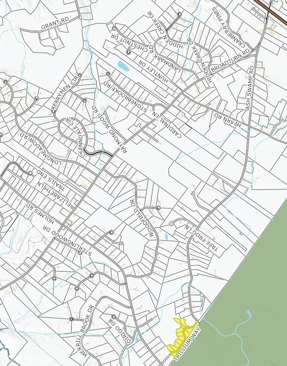
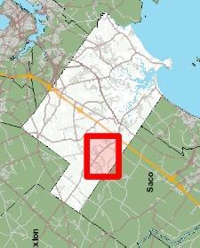
64
65
66 Town of Scarborough, Maine Planning and Code Enforcement MEMORANDUM TO: FROM: Scarborough Town Council Angela Blanchette, PE, Town Engineer DATE: February 21, 2018 RE: Street Acceptance Memory Lane Extension Theberge Subdivision Pursuant to 23 MRSA 3025 and to the requirements of Section 4 of Scarborough Street Acceptance Ordinance, Risbara Brothers Construction, Inc. petitions the Scarborough Town Council to accept the public infrastructure within the Theberge Subdivision, as shown on the plan approved by the Planning Board on September 14, Town Staff has reviewed the submitted materials and has concluded that Risbara Brothers Construction, Inc. has met the requirements under the Town of Scarborough Ordinance and recommends that the Town Council accept Memory Lane (extension). The public infrastructure has been inspected by this office and a 3 rd -party engineering consultant during construction. Based on these inspections and supplemental documentation provided by the applicant, it has been determined that the work associated with the project is in compliance with the Planning Board Subdivision approval and the Street Acceptance Ordinance specifications. Further, all necessary documents have been submitted, reviewed by Town staff, and are found to be satisfactory. Attached for your review is an excerpt from the Town s GIS database, and a reduced copy of the subdivision as-built plan. c: Mike Shaw, Public Works Director Tody Justice, Town Clerk Rocco Risbara III, Risbara Brothers Construction, Inc. 259 US ROUTE ONE, PO BOX 360 SCARBOROUGH, MAINE PHONE: FAX: Page 1 of 1
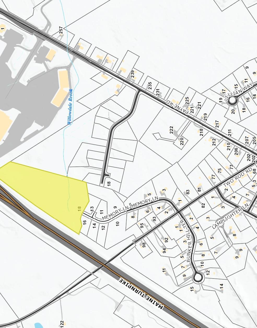
67
68
AGENDA SCARBOROUGH TOWN COUNCIL WEDNESDAY JANUARY 17, 2018 TOWN COUNCIL GOALS WORKSHOP 6:00 P.M. REGULAR MEETING 7:00 P.M.
 Item 1. Call to Order. Item 2. Pledge of Allegiance. Item 3. Roll Call. AGENDA SCARBOROUGH TOWN COUNCIL WEDNESDAY JANUARY 17, 2018 TOWN COUNCIL GOALS WORKSHOP 6:00 P.M. REGULAR MEETING 7:00 P.M. NO NEW
AGENDA SCARBOROUGH TOWN COUNCIL WEDNESDAY FEBRUARY 7, 2018 TOWN COUNCIL WORKSHOP RE. CROSSROADS/SCARBOROUGH DOWNS 5:30 P.M. REGULAR MEETING 7:00 P.M.
 Item 1. Call to Order. Item 2. Pledge of Allegiance. Item 3. Roll Call. AGENDA SCARBOROUGH TOWN COUNCIL WEDNESDAY FEBRUARY 7, 2018 TOWN COUNCIL WORKSHOP RE. CROSSROADS/SCARBOROUGH DOWNS 5:30 P.M. REGULAR
AGENDA SCARBOROUGH TOWN COUNCIL THURSDAY FEBRUARY 8, 2018 TOWN COUNCIL WORKSHOP RE: CROSSROADS/SCARBOROUGH DOWNS 5:30 P.M. SPECIAL MEETING 7:00 P.M.
 Item 1. Call to Order. Item 2. Pledge of Allegiance. Item 3. Roll Call. AGENDA SCARBOROUGH TOWN COUNCIL THURSDAY FEBRUARY 8, 2018 TOWN COUNCIL WORKSHOP RE: CROSSROADS/SCARBOROUGH DOWNS 5:30 P.M. SPECIAL
EASEMENT DEED. 2) Thence N 60º12 36 W through said Parcel 1 a distance of Two Hundred Ninety- Five and 97/100 (295.97) feet to a point;
 Thence N 60º12 36 W through said Parcel 1 a distance of Two Hundred Ninety- Five and 97/100 (295.97) feet to a point;") EASEMENT DEED TALL TREES CONSTRUCTION CORP., a Maine corporation having a mailing address of 30 Preservation Drive, Falmouth, Maine 04105 (the "Grantor") for consideration paid, grants to the TOWN OF FALMOUTH,
EASEMENT DEED TALL TREES CONSTRUCTION CORP., a Maine corporation having a mailing address of 30 Preservation Drive, Falmouth, Maine 04105 (the "Grantor") for consideration paid, grants to the TOWN OF FALMOUTH,
PERMANENT EASEMENT AGREEMENT
 PERMANENT EASEMENT AGREEMENT THIS PERMANENT EASEMENT AGREEMENT ( Agreement ) is made and entered into this day of, 2016 ( Effective Date ), by and between Staker & Parson Companies, a Utah corporation
EASEMENT AGREEMENT. WHEREAS, Ferguson is the 100% owner of the property described on Exhibit B attached hereto (the Williams Property );
;") EASEMENT AGREEMENT THIS EASEMENT AGREEMENT ( Agreement ) is entered into as of this day of, 2016, by and between CRAIG FERGUSON ( Ferguson ), and MAMIE DAVIS and JERRY MOORE ( Davis & Moore ), whose legal
EASEMENT AGREEMENT THIS EASEMENT AGREEMENT ( Agreement ) is entered into as of this day of, 2016, by and between CRAIG FERGUSON ( Ferguson ), and MAMIE DAVIS and JERRY MOORE ( Davis & Moore ), whose legal
Stormwater Treatment Facility Maintenance Agreement
 Stormwater Treatment Facility Maintenance Agreement This Agreement made and entered into this day of, 20, by, (hereinafter referred to as Property Owner") RECITALS: WHEREAS, the Property Owner is the owner
PERMISSIVE LAND USE AGREEMENT
 After recording return to: Richard B. Shattuck Attorney at Law 4102 NW Anderson Hill Road Silverdale, Washington 98383 PERMISSIVE LAND USE AGREEMENT Reference #: Grantor(s): Grantee(s): Legal Description:
RIGHT OF WAY AND COMMON DRIVEWAY AGREEMENT SUN8 PDC, LLC, c/o DISTRIBUTED SUN, LLC SUBDIVISION DRYDEN, NEW YORK
 RIGHT OF WAY AND COMMON DRIVEWAY AGREEMENT SUN8 PDC, LLC, c/o DISTRIBUTED SUN, LLC SUBDIVISION DRYDEN, NEW YORK THIS RIGHT OF WAY AGREEMENT ( Agreement ) is made this day of, 2017 by SCOTT PINNEY, an individual
Sketch & Legal Description of Mitigation Bank and Ingress/Egress Access Easements
 Appendix H: Sketch & Legal Description of Mitigation Bank and Ingress/Egress Access Easements Tippen Bay Wetland Mitigation Bank DeSoto County, Florida Prepared by: September, 2017 Original file
GRANT OF TRAIL ACCESS EASEMENT, COVENANTS AND RESTRICTIONS
 This is a sample easement provided for discussion and illustrative purposes only. Easements for each property will be customized based upon the needs of each landowner and the Path. GRANT OF TRAIL ACCESS
AGENDA SCARBOROUGH TOWN COUNCIL REGULAR MEETING 7:00 P.M. WEDNESDAY JUNE 17, 2009
 AGENDA SCARBOROUGH TOWN COUNCIL REGULAR MEETING 7:00 P.M. WEDNESDAY JUNE 17, 2009 Order No. 09-88. Move to approve the acceptance of the fee of the land identified on Scarborough Tax Map 22, Lot 109-A
RESOLUTION NO. A RESOLUTION AUTHORIZING EXECUTION OF AN EASEMENT AGREEMENT TO ILLINOIS BELL TELEPHONE COMPANY D.B.A. AT&T ILLINOIS
 RESOLUTION NO. A RESOLUTION AUTHORIZING EXECUTION OF AN EASEMENT AGREEMENT TO ILLINOIS BELL TELEPHONE COMPANY D.B.A. AT&T ILLINOIS BE IT RESOLVED by the Village Council of the Village of Downers Grove,
DECLARATION OF EASEMENTS AND COST SHARING AGREEMENT
 PREPARED BY AND AFTER RECORDING RETURN TO: James Johnston, Esq. Shutts & Bowen LLP 300 S. Orange Avenue Suite 1000 Orlando, Florida 32801 Tax Parcel I.D.s: 25-21-29-0000-00-032 25-21-29-4432-00-001 DECLARATION
WARRANTY DEED With Conservation Restrictions
 WARRANTY DEED With Conservation Restrictions KNOW ALL PERSONS BY THESE PRESENTS, that FRYE ISLAND, INC., a Maine corporation, for consideration paid, GRANTS TO the TOWN OF FRYE ISLAND, MAINE, a Maine municipal
DOCUMENT VET SHEET for Karen McConnaughay Chairman, Kane County Board
 DOCUMENT VET SHEET for Karen McConnaughay Chairman, Kane County Board Name of Document: Temporary Construction Easement for Grading Purposes between Geneva School District and Counzy of Kane Submitted
DEED OF EASEMENT AND AGREEMENT Forest Conservation Easement
 DEED OF EASEMENT AND AGREEMENT Forest Conservation Easement THIS DEED OF EASEMENT AND AGREEMENT, made this day of, 20, between ( Property Owner ), and Anne Arundel County, Maryland, a body corporate and
City of Melissa, Texas Plat Dedication Language
 City of Melissa, Texas Plat Dedication Language [INCLUDE THE FOLLOWING DEDICATION LANGUAGE FOR INDIVIDUALS (MODIFY APPROPRIATELY TO REFLECT EXACTLY AS SHOWN ON PROPERTY DEED)]: NOW THEREFORE, KNOW ALL
FIFTH AMENDMENT OF DECLARATION OF DEED RESTRICTIONS AND DEDICATIONS FOR PINEHURST ESTATES (A Clatsop County, Oregon Subdivision)
") After Recording Return To: W. Louis Larson 990 Astor Street Astoria, OR 97103 FIFTH AMENDMENT OF DECLARATION OF DEED RESTRICTIONS AND DEDICATIONS FOR PINEHURST ESTATES (A Clatsop County, Oregon Subdivision)
After Recording Return To: W. Louis Larson 990 Astor Street Astoria, OR 97103 FIFTH AMENDMENT OF DECLARATION OF DEED RESTRICTIONS AND DEDICATIONS FOR PINEHURST ESTATES (A Clatsop County, Oregon Subdivision)
TOWNSHIP OF LOWER MERION Building & Planning Department
 Exhibit C TOWNSHIP OF LOWER MERION Building & Planning Department MEMORANDUM TO: Douglas S. Cleland, Township Manager FROM: Robert E. Duncan, Director of Building & Planning SUBJECT: 11 East Athens Avenue
EASEMENT AGREEMENT (Distributor Performance Non-Exclusive)
") EASEMENT AGREEMENT (Distributor Performance Non-Exclusive) THIS EASEMENT AGREEMENT, effective the day of, 20, is made between WITNESSETH:, hereafter called Grantor, (whether grammatically singular or plural)
EASEMENT AGREEMENT (Distributor Performance Non-Exclusive) THIS EASEMENT AGREEMENT, effective the day of, 20, is made between WITNESSETH:, hereafter called Grantor, (whether grammatically singular or plural)
CONSENT ACTION BY THE BOARD OF DIRECTORS OF VENETO IN MIRAMAR CONDOMINIUM ASSOCIATION, INC.
 CONSENT ACTION BY THE BOARD OF DIRECTORS OF VENETO IN MIRAMAR CONDOMINIUM ASSOCIATION, INC. The undersigned, being all of the members of the Board of Directors of Veneto in Miramar Condominium Association,
TEMPORARY CONSTRUCTION EASEMENT AND AGREEMENT
 Recording Requested By and When Recorded Mail to: City Clerk City of Albany 1000 San Pablo Avenue Albany, CA 94706 TEMPORARY CONSTRUCTION EASEMENT AND AGREEMENT No recording fee pursuant to Government
DEED TO DEVELOPMENT RIGHTS CONSERVATION RESTRICTIONS
 DOC s 00000246 Bk5 319 Pss 29 DEED TO DEVELOPMENT RIGHTS A N D CONSERVATION RESTRICTIONS THIS WARRANTY DEED made this day of ^XP/'f ( 2018, by and between CATHERINE CONTE, hereinafter referred to as the
DRAFT September 12, 2012 DEED OF EASEMENT. KNOW ALL PERSONS BY THESE PRESENTS that MARTIN S FOODS OF SOUTH
 DRAFT September 12, 2012 DEED OF EASEMENT KNOW ALL PERSONS BY THESE PRESENTS that MARTIN S FOODS OF SOUTH BURLINGTON, a Vermont corporation with a principal place of business in Scarborough, Cumberland
PERMANENT DRAINAGE EASEMENT
 City Project No. Project Name: ; Tr. # Parcel No. (LLC, Corporation, Partnership) PERMANENT DRAINAGE EASEMENT THIS AGREEMENT, made and entered into this day of, 201, by and between, a, hereinafter called
50-Foot Non-Exclusive EASEMENT AGREEMENT
 50-Foot Non-Exclusive EASEMENT AGREEMENT THIS EASEMENT AGREEMENT is dated this day of _, 20, by Parker Task Force For Human Services (hereafter referred to as "Grantor"), having an address at 20118 East
HONORABLE MAYOR AND MEMBERS OF THE CITY COUNCIL TITO HAES, ASSISTANT CITY MANAGER/PUBLIC WORKS DIRECTOR
 CONSENT ITEM D-16 TO: FROM: VIA: HONORABLE MAYOR AND MEMBERS OF THE CITY COUNCIL TITO HAES, ASSISTANT CITY MANAGER/PUBLIC WORKS DIRECTOR JAMES MAKSHANOFF, CITY MANAGER DATE: JUNE 16, 2014 SUBJECT: RESOLUTIONS
Easement Agreement--Ingress and Egress Camel s Back Park City of Boise/Alistair and Connie Macmillan
 TO: FROM: RE: Mayor David H. Bieter Members of the City Council J. Patrick Riceci Assistant City Attorney R-127-12 Easement Agreement--Ingress and Egress Camel s Back Park City of Boise/Alistair and Connie
PERMANENT EASEMENT AGREEMENT. good and valuable consideration, the sufficiency and receipt of which is hereby acknowledged, The Esther Harrison
 PERMANENT EASEMENT AGREEMENT For and in consideration of the sum of Seven thousand thirty and 00/100 dollars ($7,030.00) and other good and valuable consideration, the sufficiency and receipt of which
MEETING TYPE: Board of Commissioners - Regular. MEETING DATE: 23 May STAFF RESPONSIBLE: Matt Hubert. DEPARTMENT: Development Services Department
 MEETING TYPE: Board of Commissioners - Regular MEETING DATE: 23 May 2017 STAFF RESPONSIBLE: Matt Hubert DEPARTMENT: Development Services Department DESCRIPTION Approval of Easement Agreement To approve
COUNCIL ACTION FORM Meeting Date: September 13, 2012 Staff Contact: John Sullivan, Public Works Director
 COUNCIL ACTION FORM Meeting Date: September 13, 2012 Staff Contact: John Sullivan, Public Works Director Agenda Item: Consider vacation of a Landscape Easement granted to the City of Westwood for the construction
CORPORATE SPECIAL WARRANTY DEED FOR RIGHT OF WAY
 CORPORATE SPECIAL WARRANTY DEED FOR RIGHT OF WAY THIS INDENTURE WITNESSETH that ELI LILLY AND COMPANY, an Indiana corporation, ( Grantor ), as a gift and for no other consideration, CONVEYS ANDSPECIALLY
ATTACHMENT Q DRAFT COMMON DRIVEWAY AGREEMENT
 ATTACHMENT Q DRAFT COMMON DRIVEWAY AGREEMENT RIGHT OF WAY AND COMMON DRIVEWAY AGREEMENT [Delaware River Solar LLC & NY Dryden I LLC] SUBDIVISION DRYDEN, NEW YORK THIS RIGHT OF WAY AGREEMENT ( Agreement
TEMPORARY ACCESS AGREEMENT
 TEMPORARY ACCESS AGREEMENT THIS TEMPORARY ACCESS AGREEMENT ( Agreement ) is made and entered into this 1st day of November, 2015, by and between the ANDREW WOMMACK MINISTRIES, INC. DBA CHARIS BIBLE COLLEGE
2. Attach copy of Certified Abutters List for abutters within 300 feet of the effected property line. (Form for Assessor s Office attached)
") Retreat Lot Application Instructions: Carefully read Section IV.N. Retreat Lot Bylaw (Attached) 1. Fill out one (1) copy of retreat lot application 2. Attach copy of Certified Abutters List for abutters
Retreat Lot Application Instructions: Carefully read Section IV.N. Retreat Lot Bylaw (Attached) 1. Fill out one (1) copy of retreat lot application 2. Attach copy of Certified Abutters List for abutters
Dact= Bk:31661 Ps: 116
 Dact= 33591 Bk:31661 Ps: 116 AMENDMENT TO THE MASTER DECLARATION OF COVENANTS, CONDITIONS AND RESTRICTIONS FOR DUNSTAN CROSSING [Submission of Project Phase IIIl CHAMBERLAIN CONSTRUCTION, INC., a Maine
MAINTENANCE AND INDEMNITY AGREEMENT PURSUANT TO SEAGATE VILLAGE COMMUNITY ASSOCIAITON S DECLARATION OF COVENANTS, CONDITIONS AND RESTRICTIONS
 RECORDING REQUESTED BY AND WHEN RECORDED RETURN TO: Jeffrey A. French, Esq. (SBN 174968) GREEN BRYANT & FRENCH, LLP 402 W. Broadway, Suite 1950 San Diego, CA 92101 Telephone: (619) 239-7900 Fax No.: (619)
STORMWATER BEST MANAGEMENT PRACTICES OPERATIONS AND MAINTENANCE AGREEMENT
 STORMWATER BEST MANAGEMENT PRACTICES OPERATIONS AND MAINTENANCE AGREEMENT THIS AGREEMENT, made and entered into this day of, 20, by and between, (hereinafter the Landowner ), and the TOWNSHIP OF HEMPFIELD,
BEACH STORM DAMAGE REDUCTION EASEMENT
 STATE OF FLORIDA COUNTY OF WALTON WALTON COUNTY, FL HURRICANE & STORM DAMAGE REDUCTION PROJECT FILE/REACH#: PARCEL ID#: BEACH STORM DAMAGE REDUCTION EASEMENT KNOW ALL MEN BY THESE PRESENTS, that for and
ESCROW AGREEMENT - MAINTENANCE
 ESCROW AGREEMENT - MAINTENANCE This ESCROW AGREEMENT (the Agreement ) is made and entered into this day of,, by and between the City of O Fallon, Missouri, a Missouri municipal corporation (hereinafter
This document was prepared by: Albemarle County Attorney County of Albemarle 401 McIntire Road Charlottesville, Virginia 22902
 This document was prepared by: Albemarle County Attorney County of Albemarle 401 McIntire Road Charlottesville, Virginia 22902 Tax Map and Parcel Number This deed is exempt from taxation under Virginia
PERMANENT DEEP TUNNEL EASEMENT AGREEMENT
 PERMANENT DEEP TUNNEL EASEMENT AGREEMENT Project Number: 75918 Project Name: Three Rivers Protection & Overflow Reduction Tunnel [3RPORT] Cross Reference Document(s): Deed Record F, page 481; Deed Book
COVENANT AGREEMENT BETWEEN THE CITY OF RAPID CITY AND GWH PROPERTIES, LLC TO PERMIT CERTAIN ENCROACHMENTS IN PEDESTRIAN AND UTILITY EASEMENT
 PREPARED BY: City Attorney s Office 300 Sixth Street Rapid City, SD 57702 (605) 394-4140 COVENANT AGREEMENT BETWEEN THE CITY OF RAPID CITY AND GWH PROPERTIES, LLC TO PERMIT CERTAIN ENCROACHMENTS IN PEDESTRIAN
ORDINANCE NO
 Draft No. 12-21 ORDINANCE NO. 2012-23 AN ORDINANCE ACCEPTING A RIGHT-OF-WAY AND UTILITY EASEMENT FOR WATER LINES, SEWER LINES, STORM SEWER LINES AND SUCH OTHER UTILITIES AS ARE NEEDED FROM THE CARTER JONES
CONSERVATION EASEMENT AND RESTRICTION
 CONSERVATION EASEMENT AND RESTRICTION The purpose of a Conservation Easement is to protect in perpetuity significant natural features and to minimize the environmental impact of activities associated with
SIDEWALK ACCESS EASEMENT AGREEMENT
 SIDEWALK ACCESS EASEMENT AGREEMENT THIS SIDEWALK ACCESS EASEMENT AGREEMENT ( Agreement ) is made by and among WATERWALK PLACE OWNERS ASSOCIATION, a Kansas non-profit corporation ( WWP ), FOUR-G, LLC, a
Exhibit A: REAL ESTATE TRANSFER AGREEMENT
 Exhibit A: REAL ESTATE TRANSFER AGREEMENT This agreement is made between the City of Urbana, Illinois, a municipal corporation of the State of Illinois (the Seller ), and Homestead Corporation of Champaign-Urbana,
BID PROPOSAL FORMS FOR THE SALE OF REAL PROPERTY LOCATED IN THE CITY OF CORONA IN THE COUNTY OF RIVERSIDE
 150813 BID PROPOSAL FORMS FOR THE SALE OF REAL PROPERTY LOCATED IN THE CITY OF CORONA IN THE COUNTY OF RIVERSIDE Bid Proposal to Purchase Real Property February 5, 2013 11:00 a.m. This Real Property is
PIPELINE RIGHT-OF-WAY EASEMENT
 PIPELINE RIGHT-OF-WAY EASEMENT THIS RIGHT-OF-WAY EASEMENT made this day of March, 2014, by the City of Rochester Hills, a municipal corporation in the State of Michigan,, having an address at 1000 Rochester
UTILITY EASEMENT WITNESSETH. WHEREAS, Grantee desires to install a storm water line through the Easement Property; and
 UTILITY EASEMENT THIS INDENTURE, made and entered into this 12 th day of March, 2013, by and between the SCHOOL BOARD OF BREVARD COUNTY, FLORIDA, hereinafter called "GRANTOR", whose post office address
DECLARATION OF DRAINAGE EASEMENTS. Document No. Document Title. (Declarant) Recording Data Return Address
 Recording Data Return Address") Document No. DECLARATION OF DRAINAGE EASEMENTS Document Title (Declarant) Recording Data Return Address DOCUMENT PREPARED BY AND AFTER RECORDING RETURN TO: Parcel No. - - - - - - DECLARATION OF DRAINAGE
Document No. DECLARATION OF DRAINAGE EASEMENTS Document Title (Declarant) Recording Data Return Address DOCUMENT PREPARED BY AND AFTER RECORDING RETURN TO: Parcel No. - - - - - - DECLARATION OF DRAINAGE
FIFTH AMENDMENT OF DECLARATION OF COVENANTS, CONDITIONS AND RESTRICTIONS FOR HICKS AIRFIELD, TARRANT COUNTY, TEXAS
 STATE OF TEXAS COUNTY OF TARRANT FIFTH AMENDMENT OF DECLARATION OF COVENANTS, CONDITIONS AND RESTRICTIONS FOR HICKS AIRFIELD, TARRANT COUNTY, TEXAS Hicks Airfield Pilots Association, a Texas non-profit
PROPERTY EXCHANGE & CONVEYANCE AGREEMENT RECITALS
 PROPERTY EXCHANGE & CONVEYANCE AGREEMENT This Property Exchange and Conveyance Agreement ( Agreement ) is entered into as of the date of execution by and between Laramie Church of Christ, Inc., a Wyoming
STORMWATER MANAGEMENT AGREEMENT AND DECLARATION OF EASEMENT
 APPENDIX F STORMWATER MANAGEMENT AGREEMENT AND DECLARATION OF EASEMENT THIS AGREEMENT AND DECLARATION OF EASEMENT made this day of 20, by and between BRECKNOCK TOWNSHIP, Lancaster County, Pennsylvania,
CITY AND COUNTY OF BROOMFIELD SUBDIVISION IMPROVEMENT AGREEMENT FOR (PROPERTY NAME - ALL CAPS)
") CITY AND COUNTY OF BROOMFIELD SUBDIVISION IMPROVEMENT AGREEMENT FOR (PROPERTY NAME - ALL CAPS) THIS AGREEMENT, made and entered into this day of, 20, by and between The CITY AND COUNTY OF BROOMFIELD, a
CITY AND COUNTY OF BROOMFIELD SUBDIVISION IMPROVEMENT AGREEMENT FOR (PROPERTY NAME - ALL CAPS) THIS AGREEMENT, made and entered into this day of, 20, by and between The CITY AND COUNTY OF BROOMFIELD, a
County of Santa Cruz
 Ou GOS87 County of Santa Cruz DEPARTMENT OF PUBLIC WORKS - REAL PROPERTY DIVISION THOMAS L. BOLICH DIRECTOR OF PUBLIC WORKS 701 OCEAN STREET, ROOM 410, SANTA CRUZ, CA 95060-4070 (831) 454-2331 FAX (831)
EASEMENTS, DECLARATION OF COVENANTS, AND DECLARATION OF PRESERVATION RESTRICTIONS
 EASEMENTS, DECLARATION OF COVENANTS, AND DECLARATION OF PRESERVATION RESTRICTIONS This grant of Easements, Declaration of Covenants, and Declaration of Preservation Restrictions, executed the day of, 2008
WAKE COUNTY STORMWATER CONTROL STRUCTURE AND ACCESS EASEMENT AND AGREEMENT (Corporate)
") Return to: Matthew Flynn Stormwater Field Services Administrator Water Resources Department Town of Cary PO Box 8005, Cary, NC 27512 NORTH CAROLINA WAKE COUNTY STORMWATER CONTROL STRUCTURE AND ACCESS EASEMENT
Return to: Matthew Flynn Stormwater Field Services Administrator Water Resources Department Town of Cary PO Box 8005, Cary, NC 27512 NORTH CAROLINA WAKE COUNTY STORMWATER CONTROL STRUCTURE AND ACCESS EASEMENT
CONSERVATION EASEMENT AGREEMENT
 CONSERVATION EASEMENT AGREEMENT THIS INDENTURE made this day of, 20, by and between of the Town of, County of, and State of ( Grantor ), and the Town of Coventry, a municipal corporation having its territorial
SOUTH DAKOTA BOARD OF REGENTS. Budget and Finance ******************************************************************************
 SOUTH DAKOTA BOARD OF REGENTS Budget and Finance AGENDA ITEM: 6 K DATE: October 2-4, 2018 ****************************************************************************** SUBJECT USD Discovery District:
Keenan Auction Company
 Keenan Auction Company PROPERTY INFORMATION PACKAGE Our 6,584 th Auction Real Estate Foreclosure Auction 14-46 Log Cabin 4.4+/- Acres View Sugarloaf Region 178 New Portland Hill Rd., New Portland, Maine
Appendix A - REQUIRED PLAT CERTIFICATES... A-1
 APPENDICES CONTENTS: Appendix A - REQUIRED PLAT CERTIFICATES... A-1 Appendix B - MINIMUM STREET IMPROVEMENT STANDARDS Standard 1A Minor Residential... B-1 Standard 1B Minor Residential... B-2 Standard
Commercial Lease Agreement
 Commercial Lease Agreement This Commercial Lease Agreement ("Lease") is made and effective [Date], by and between [Landlord] ("Landlord") and [Tenant] ("Tenant"). Landlord is the owner of land and improvements
GENERAL INSTRUMENT - PART 1 (This area for Land Title Office use) Page 1 of pages
 Page 1 of pages") LAND TITLE ACT FORM C (Section 233) Province of British Columbia GENERAL INSTRUMENT - PART 1 (This area for Land Title Office use) Page 1 of pages 1. APPLICATION: (Name, address, phone number and signature
LAND TITLE ACT FORM C (Section 233) Province of British Columbia GENERAL INSTRUMENT - PART 1 (This area for Land Title Office use) Page 1 of pages 1. APPLICATION: (Name, address, phone number and signature
PURCHASE AND SALE AGREEMENT
 PURCHASE AND SALE AGREEMENT THIS AGREEMENT made this day of July, 2017, by and between JPMCC 2011- C5 APPLETREE MALL LLC, having an address at c/o Torchlight Loan Services, 475 5th Avenue, 10 th Floor,
Keenan Auction Company
 Keenan Auction Company PROPERTY INFORMATION PACKAGE Parcel #1 Parcel #2 Our 6,207 th Auction Real Estate Foreclosure Auction 13-5 (2) Apartment Buildings (Offered Separately) 13 & 17 High St., Old Town,
To achieve the conservation purposes, the following conditions and restrictions are set forth:
 DEED OF CONSERVATION EASEMENT (Conservation Subdivision District) STATE OF GEORGIA COUNTY OF COBB THIS DEED OF CONSERVATION EASEMENT (herein "Conservation Easement") is made this day of, 20, by and between
PERPETUAL STORM WATER DRAINAGE EASEMENT (Non-Exclusive) This Non-Exclusive Perpetual Storm Water Drainage Easement (this Easement ) is
 This Non-Exclusive Perpetual Storm Water Drainage Easement (this Easement ) is") Magnolia Park COM15-0081 T4N, R1E, Section13 (Space Above Reserved for Ada County Recorder s Office) PERPETUAL STORM WATER DRAINAGE EASEMENT (Non-Exclusive) This Non-Exclusive Perpetual Storm Water Drainage
Magnolia Park COM15-0081 T4N, R1E, Section13 (Space Above Reserved for Ada County Recorder s Office) PERPETUAL STORM WATER DRAINAGE EASEMENT (Non-Exclusive) This Non-Exclusive Perpetual Storm Water Drainage
CHAPTER 2 RELATED DOCUMENTS AND FORMS
 CHAPTER 2 RELATED DOCUMENTS AND FORMS TABLE OF CONTENTS CHAPTER 2 RELATED DOCUMENTS AND FORMS Resolution R00- Establishing Public Improvement Design Standards Page 1 Current Plans Review & Construction
CONTRACT FOR SALE AND PURCHASE
 CONTRACT FOR SALE AND PURCHASE THIS Contract for Sale and Purchase ( Contract ) is made this day of, 20, by and between the Southwest Florida Water Management District, a public corporation of the State
EASEMENT AGREEMENT. hereinafter called Grantor, (whether grammatically singular or plural) and the:
 and the:") EASEMENT AGREEMENT THIS EASEMENT AGREEMENT, made and entered into as of the day of,, by and between: hereinafter called Grantor, (whether grammatically singular or plural) and the: hereinafter called Distributor.
EASEMENT AGREEMENT THIS EASEMENT AGREEMENT, made and entered into as of the day of,, by and between: hereinafter called Grantor, (whether grammatically singular or plural) and the: hereinafter called Distributor.
COMMERCIAL PROPERTY LEASE AGREEMENT
 COMMERCIAL PROPERTY LEASE AGREEMENT THIS AGREEMENT is hereby made between R.J.E.S., LLC., 208 South Pearl Street, Red Bank, New Jersey (hereinafter, Lessor ), and the Borough of Red Bank, 90 Monmouth Street,
TEMPORARY CONSTRUCTION EASEMENT AGREEMENT
 TEMPORARY CONSTRUCTION EASEMENT AGREEMENT This Temporary Construction Easement Agreement (the Agreement ) is made and entered into this 13th day of May, 2014 by and between the School Board of Manatee
AUCTION REAL ESTATE SALES CONTRACT
 STATE OF OHIO COUNTY OF OTTAWA BIDDER# AUCTION REAL ESTATE SALES CONTRACT THIS CONTRACT, made this the day of 2017, by and between CLEARWATER PRESERVE, LLC, ( Seller ) whose address is 1613 S DEFIANCE
PERPETUAL DRAINAGE EASEMENT
 PERPETUAL DRAINAGE EASEMENT THIS GRANT OF PERPETUAL DRAINAGE EASEMENT is made this day of, 2016, between [name and address] ("Grantor"), and the City of Thornton, a Colorado municipal corporation, located
ORDINANCE NO
 DRAFT NO. 09-90 ORDINANCE NO. 2009-81 AN ORDINANCE ACCEPTING FOR DEDICATION PURPOSES, A SANITARY SEWER EASEMENT FROM THE STATE OF OHIO FOR THE GREEK VILLAGE ON KENT STATE UNIVERSITY PROPERTY AND DECLARING
DECLARATION OF ELEVATED PEDESTRIAN WALKWAY EASEMENT
 AFTER RECORDING MAIL TO: Drury Southwest Broadview, LLC 101 S. Farrar Drive Cape Girardeau, Missouri 63701 Attn: Herbert J. Wedemeier (Space left blank for recording purposes) DECLARATION OF ELEVATED PEDESTRIAN
WILLIAM L. WELCH COMMUNITY SWIMMING POOL SHARED ACCESS AND RECIPROCAL PARKING AGREEMENT
 WILLIAM L. WELCH COMMUNITY SWIMMING POOL SHARED ACCESS AND RECIPROCAL PARKING AGREEMENT THIS SHARED ACCESS AND RECIPROCAL PARKING AGREEMENT made this day of, 2009, by and between: STATE COLLEGE AREA SCHOOL
EXHIBIT 1. PRIVATE ROAD ACCESS EASEMENT and SHARED ROAD MAINTENANCE AGREEMENT for KENNEDY SHORES LANE. Auction Tracts 1-8
 EXHIBIT 1 PRIVATE ROAD ACCESS EASEMENT and SHARED ROAD MAINTENANCE AGREEMENT for KENNEDY SHORES LANE Auction Tracts 1-8 This Private Road Access Easement and Shared Road Maintenance Agreement for Kennedy
**** DISCLAIMER ****
 STATE OF MAINE YORK, ss. DISTRICT COURT DISTRICT TEN Location: Springvale Docket No. SPR-RE-2008-356 MAINE STATE HOUSING AUTHORITY,) ) Plaintiff ) ) vs. ) ) ROBERT H. HARTLEY, JR., ) GINGER L. HARTLEY,
Stormwater Ordinance Appendix APPENDIX K EXAMPLE TAR-PAM CONVERSATION EASEMENT
 APPENDIX K EXAMPLE TAR-PAM CONVERSATION EASEMENT Tax Parcel ID # NORTH CAROLINA FRANKLIN COUNTY CONSERVATION EASEMENT Franklin County, North Carolina THIS CONSERVATION EASEMENT (this "Conservation Easement")
SOUTH DAKOTA BOARD OF REGENTS. Budget and Finance ******************************************************************************
 SOUTH DAKOTA BOARD OF REGENTS Budget and Finance AGENDA ITEM: 7 U DATE: October 4-6 ****************************************************************************** SUBJECT: SDSU 6 th Street Land Sale for
ORDINANCE NO
 DRAFT NO. 16-53 ORDINANCE NO. 2016-49 AN ORDINANCE ACCEPTING FOR DEDICATION PURPOSES FROM GARY PHILLIP BERARDINELLI A STORM SEWER EASEMENT, AND DECLARING AN EMERGENCY. WHEREAS, Gary Phillip Berardinelli
Landlord is the owner of land and improvements commonly known and numbered as. (address) and
 and") KENTUCKY COMMERICAL LEASE AGREEMENT This Commercial Lease Agreement ( Lease ) is made and effective this day of, 2, by and between ( Landlord ) and ( Tenant ). Landlord is the owner of land and improvements
KENTUCKY COMMERICAL LEASE AGREEMENT This Commercial Lease Agreement ( Lease ) is made and effective this day of, 2, by and between ( Landlord ) and ( Tenant ). Landlord is the owner of land and improvements
MUNICIPAL QUITCLAIM DEED
 DRAFT MUNICIPAL QUITCLAIM DEED The INHABITANTS OF THE TOWN OF WARREN, a body corporate and politic, located at Warren, Knox County, Maine, for consideration paid, Release to, whose mailing address is,
ARKANSAS COMMERCIAL LEASE AGREEMENT
 ARKANSAS COMMERCIAL LEASE AGREEMENT This Commercial Lease Agreement ("Lease") is made and effective [Date], by and between [Landlord]("Landlord") and [Tenant] ("Tenant"). Landlord is the owner of land
Commercial Lease Agreement
 Commercial Lease Agreement This Commercial Lease Agreement (Lease) is entered into on this day of, 20, by and between (Landlord) and (Tenant). Landlord is the owner of land and improvements whose address
THE TOWNHOMES AT WESTLINKS
 PROPOSED SECTION 98 AGREEMENT THE TOWNHOMES AT WESTLINKS Proposed Standard Phased Condominium Plan to be located on Fairway Road in Port Elgin Section 98 Agreement (The Townhomes at Westlinks) Page 1 This
APPLICATION TO REGISTER NOTICE OF AN AGREEMENT THE LAND TITLES ACT SECTION 74
 26 th May 1981 Campeau - City of Kanata 40% Open Space Agreement APPLICATION TO REGISTER NOTICE OF AN AGREEMENT THE LAND TITLES ACT SECTION 74 TO: THE LAND REGISTRAR FOR THE LAND TITLES DIVISION OF OTTAWA-CARLETON
COUNTY OF LOS ANGELES
 JAMES A. NOYES, Director COUNTY OF LOS ANGELES DEPARTMENT OF PUBLIC WORKS 900 SOUTH FREMONT AVENUE ALHAMBRA, CALIFORNIA 91803-1331 Telephone: (626) 458-5100 www.ladpw.org ADDRESS ALL CORRESPONDENCE TO:
Title summary for property offered for sale by Peppertree-Atlantic Beach Association, Inc.
 Title summary for property offered for sale by Peppertree-Atlantic Beach Association, Inc. The bulk of the property offered for sale consists of a total of 4.392 acres of land, more or less, as more particularly
PATH MAINTENANCE AGREEMENT
 PATH MAINTENANCE AGREEMENT This Path Maintenance Agreement ( Agreement ) is made effective as of, 2018 ( Effective Date ) by and among Northpark Mall/Joplin, LLC, a Delaware limited liability company (the
EASEMENT AGREEMENT. hereinafter called Grantor, (whether grammatically singular or plural) and the:
 and the:") EASEMENT AGREEMENT THIS EASEMENT AGREEMENT made and entered into as of the day of,, by and between: hereinafter called Grantor, (whether grammatically singular or plural) and the: hereinafter called Distributor.
EASEMENT AGREEMENT THIS EASEMENT AGREEMENT made and entered into as of the day of,, by and between: hereinafter called Grantor, (whether grammatically singular or plural) and the: hereinafter called Distributor.
OFFER TO PURCHASE AND CONTRACT
 1 NORTH CAROLINA WAKE COUNTY OFFER TO PURCHASE AND CONTRACT WHEREAS, ( Buyer ) hereby agrees to purchase and Wake County Board of Education ( Seller ) hereby agrees to convey a parcel of land at,,, being
Dated October 14, 1966 As to Acknowledged October 14, 1966 University Hills No. 2 Subdivision Reported October 18, 1966 Liber 1954, Page 28
 Orchard Lane Land Company Declaration of Restrictions Dated October 14, 1966 As to Acknowledged October 14, 1966 University Hills No. 2 Subdivision Reported October 18, 1966 Liber 1954, Page 28 This Declaration,
GREENWAY EASEMENT AGREEMENT
 GREENWAY EASEMENT AGREEMENT This greenway access easement is entered into by and between the Laramie County School District Number One ( Grantor ), a corporate body organized under the laws of the State
1 West Main Street -- Box 1, Fincastle, Virginia STORMWATER MANAGEMENT INFRASTRUCTURE MAINTENANCE AGREEMENT
 1 West Main Street -- Box 1, Fincastle, Virginia 24090 STORMWATER MANAGEMENT INFRASTRUCTURE MAINTENANCE AGREEMENT THIS AGREEMENT, made and entered into this day of, 20, by and between (Insert Full Name
BYRON TOWNSHIP 8085 BYRON CENTER AVENUE, SW BYRON CENTER, MI PHONE: FAX: STORMWATER APPLICATION AND PERMIT
 BYRON TOWNSHIP 8085 BYRON CENTER AVENUE, SW BYRON CENTER, MI 49315 PHONE: 616-878-9066 616-878-3980 STORMWATER APPLICATION AND PERMIT This application is not a valid Permit until reviewed / approved /
AGREEMENT TO TRANSFER REAL PROPERTY
 AGREEMENT TO TRANSFER REAL PROPERTY This AGREEMENT TO TRANSFER REAL PROPERTY ( Agreement ) is dated, 2015, by and between the TOWN OF CHEBEAGUE ISLAND, a Maine municipal corporation (the Town ); and GREAT