SUBDIVISION REGULATIONS. Meigs County, Tennessee. Prepared For The. Meigs County Regional Planning Commission
|
|
|
- Bennett Collins
- 5 years ago
- Views:
Transcription
1 SUBDIVISION REGULATIONS Meigs County, Tennessee Prepared For The Meigs County Regional Planning Commission APRIL 1994 (Amended through October, 2007) (Amended through October 2011) (Amended through December 2012)
2 TABLE OF CONTENTS ARTICLE PAGE SUBDIVISION PROCESS TITLE Short Title, Preamble, Enactment Clause Definition of Certain Terms Used Herein Platting Jurisdiction, Enforcement and Penalties for Violation Platting Authority Use of Plat Enforcement Opening and Improving Public Roads Erection of Buildings Penalties General Design Requirements Suitability of the Land Name of Subdivision Access Public Use Areas Large-Scale Development General Design Requirements for Roads and other Rights-of-Way Conformance to Adopted Major Thoroughfare Plan Continuation of Existing Roads Road Connections Road Elevations Road Names Restriction of Access Alleys Private Roads Requirements for Private Roads Reserve Strips Easements Road Grading Plan Required Specific Design Requirements for Roads and other Rights-of Ways Road Right-of-Way Widths Additional Width on Existing Roads i
3 6.03 Road Pavement Widths Road Grades Horizontal Curves Vertical Curves Intersections Tangents Road Jogs Design Standards for Blocks and Lots Block Lengths and Widths Flood-Free Building Site Lot Sizes Lot Lines Building Setback Lines Lots Abutting Public Roads Double and Reverse Frontage Lots Flat Lots Procedure for Preliminary Plat Approval of a Subdivision Pre-Application Review Application for Preliminary Plat Approval Review of Preliminary Plat Certificate of Tentative Approval Preliminary Plat Specifications for Subdivisions Scale Sheet Size Ground Elevations Information to be Provided on Preliminary Plat Required Site Improvements Before Final Plat Approval Monuments Grading Installation of Utilities Required Inspections During Road Construction Street or Road Base Surface Course Storm Drainage Water Supply System Sanitary Sewers Sidewalks Curbs and Gutters, or Road Shoulders Road Signs ii
4 10.13 Guarantee in Lieu of Completed Improvements Road Acceptance Procedure for Final Plat Approval of a Subdivision Application for Final Plat Approval Review of Final Plat Procedure for Expeditious Certification of a Minor Subdivision Requirements for Subdivisions in Previously Approved Subdivisions Recording of Final Plat Final Plat Specifications Final Plat Specifications Certifications Required Variances and Amendments Variances Amendments Legal Status Provisions Separability Conflict with other Regulations Adoption and Effective Date Appendix Suggested Steps for a Developer of a Subdivision When Preliminary Approval Has Been Granted Questions Often Asked About Subdivision Regulations Preliminary Subdivision Plat Checklist Final Subdivision Plat Checklist iii
5 LIST OF ILLUSTRATIONS TITLE PAGE SUBDIVISION PROCESS 100-YEAR FLOOD PLAIN SCHEMATIC ROAD TYPES WHAT IS A SUBDIVISION? SETBACKS AND YARDS SLOPE CALCULATION STREET JOGS/INTERSECTIONS HORIZONTAL CURVE/STREET PROFILE TYPES OF LOTS SUBDIVISION DESIGNS PRELIMINARY PLAT CUT AND FILL CROSS SECTION TYPICAL TANGENT SECTION TYPE TYPICAL TANGENT SECTION TYPE FINAL PLAT
6
7 MEIGS COUNTY SUBDIVISION REGULATIONS TITLE REGULATIONS CONTROLLING THE SUBDIVISION OF LAND IN MEIGS COUNTY, TENNESSEE: REQUIRING AND REGULATING THE PREPARATION AND PRESENTATION OF PRELIMINARY AND FINAL DESIGN STANDARDS; REQUIRING MINIMUM IMPROVEMENTS TO BE MADE OR GUARANTEED TO BE MADE BY THE SUBDIVIDER; SETTING FORTH THE PROCEDURE TO BE FOLLOWED BY THE PLANNING COMMISSION IN APPLYING THESE RULES, REGULATIONS AND STANDARDS: AND PRESCRIBING PENALTIES FOR THE VIOLATION OF ITS PROVISIONS. ARTICLE 1 SHORT TITLE, PREAMBLE AND ENACTMENT CLAUSE THIS DOCUMENT SHALL BE KNOWN AND MAY BE CITED AS THE "SUBDIVISION REGULATIONS OF MEIGS COUNTY." IN PURSUANCE OF AUTHORITY SET FORTH IN SECTION THROUGH , TENNESSEE CODE ANNOTATED, AND FOR THE PURPOSES OF PROMOTING THE HEALTH, SAFETY, MORALS, CONVENIENCE, ORDER, PROSPERITY AND GENERAL WELFARE OF THE COUNTY; TO ENCOURAGE ECONOMICALLY SOUND AND STABLE LAND DEVELOPMENT; TO ASSURE THE PROVISION OF REQUIRED STREETS, UTILITIES AND OTHER FACILITIES AND SERVICES TO LAND DEVELOPMENTS; TO ASSURE THE ADEQUATE PROVISION OF SAFE AND CONVENIENT TRAFFIC ACCESS AND CIRCULATION, BOTH VEHICULAR AND PEDESTRIAN, IN LAND DEVELOPMENT; TO ASSURE THE PROVISION OF NEEDED PUBLIC OPEN SPACES AND BUILDING SITES IN LAND DEVELOPMENTS THROUGH THE DEDICATION OR RESERVATION OF LAND FOR RECREATIONAL, EDUCATIONAL AND OTHER PUBLIC PURPOSES; AND TO ASSURE THAT LAND IS DEVELOPED IN CONFORMITY WITH THE COMPREHENSIVE PLAN OF MEIGS COUNTY, THE PLANNING COMMISSION OF MEIGS COUNTY, TENNESSEE DOES ORDAIN AND ENACT THE FOLLOWING ARTICLES AND SECTIONS. MCRPC Subdivision Regulations 1-1
8 ARTICLE 2 DEFINITION OF CERTAIN TERMS USED HEREIN Except as specifically defined herein, all words used in these regulations have their customary dictionary definitions where not inconsistent with the context. For the purposes of these regulations certain words or terms are defined as follows: The term "shall" is mandatory. when not inconsistent with the context, words used in the singular number include the plural and those used in the plural number include the singular. Words used in the present tense include the future. Bond. Any form of security (including a cash bond, surety bond, undated letterof-credit, cashiers check, or certified check) in an amount and form satisfactory to the planning commission for the amount of the estimated construction cost guaranteeing the completion of physical improvements according to plans and specifications within the time prescribed by the subdivider's agreement with the MCRPC. Community Wastewater Treatment System. (Added 10/20/2011) A type of decentralized wastewater treatment system or On-Site Sewage Facility (OSSF). However, unlike an individual septic system, in which effluent from a septic tank is absorbed into the soil by means of an absorption field, a community wastewater treatment system routes effluent to a dispersal field, which may be a drip field or a spray field. The installation and maintenance of such a facility in Meigs County shall be regulated and permitted by the Tennessee Department of Environment and Conservation (TDEC) and the Tennessee Regulatory Authority (TRA). Deed Restrictions. A private covenant among the residents of a subdivision or development limiting uses or setting conditions within the subdivision or development. Developer. Any individual, subdivider, firm, association, syndicate, partnership, corporation, trust, or any other legal entity commencing proceedings under these regulations to effect a subdivision of land hereunder for himself or for another (see "Subdivider"). Easement. The right given by a property owner to another party (either public or private) for a specific limited use of a designated part of his property. Easement, Drainage. A perpetual, unobstructed easement across property reserved to carry surface water drainage along specified routes to natural water courses. Drainage easements shall not be filled or built upon in any way that will impede the flow of surface water. Easement, Utility. An easement for the installation, operation, inspection, maintenance, repair, or replacement of public utility lines, cables, poles, ditches, pipes, manholes, etc. and the appurtenances belonging thereto. MCRPC Subdivision Regulations 2-1
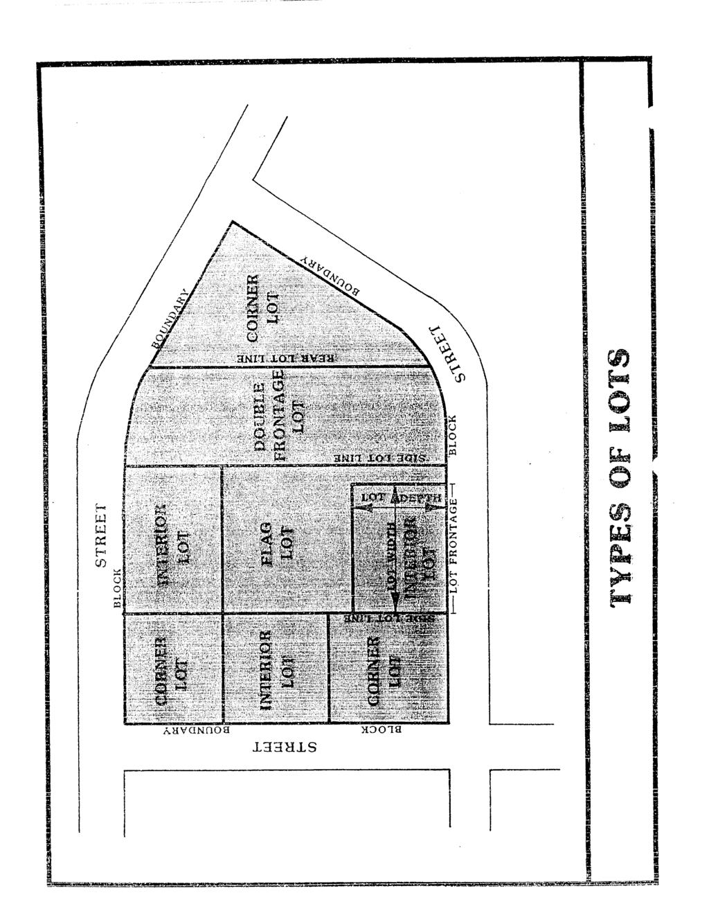
9 Easement, Vehicular. The right granted by the owner of land to another party by deed or prescription, to allow vehicular access across one parcel of land to another. Flag Lot. An interior lot located to the rear of another lot but with a narrow portion of the lot extending to the road. The narrow portion of the lot that extends to the road shall be suitable for ingress and egress, and shall not be included in the calculation of the minimum lot area. Flood. A temporary rise or overflow of a body of water onto adjacent lands not normally covered by water. Other FLOOD-RELATED TERMS are defined as follows: Channel. A natural or artificial watercourse with definite bed and banks to confine and conduct continuously or periodically flowing water. The top of the banks form the dividing lines between the channel and the floodplain. Floodplain. The relatively flat area or lowlands adjoining a watercourse or other body of water which has been or may be covered by water. Floodway. The channel of the watercourse and those portions of the adjoining flood plain which are reasonably required to provide for the passage of flow from the regulatory flood (the 100-year Flood). This area must be left unobstructed in order to preserve the flood-carrying capacity of the stream and its flood plain without appreciably increasing the height of the floodwaters. Floodway Fringe. That part of the flood plain located between the floodway and the designated outline of the 100-year Flood which would be covered by flood waters of the 100-year Flood. Uses are permitted if they are protected by fill, flood-proofed, or otherwise protected. Regulatory Flood. A large flood selected for regulatory purposes and a basis for floodplain management. In Meigs County, as in most places, the 100-year Flood is the regulatory flood or base flood and there are no flood restrictions outside its limit. The 100- year Flood statistically has a one-percent chance of occurring each year. Grade (slope). The slope of a road, or the ground, specified by the percentage that the horizontal distance is to the vertical rise which occurs within the horizontal distance. Health Authority. The director of the county or district health department having jurisdiction over the county health, or his duly authorized representative, usually a county environmentalist who works for the Tennessee Department of Health and Environment. MCRPC Subdivision Regulations 2-2
10 Improvements, Subdivision. Road pavement or resurfacing, curbs, gutters, sidewalks, water lines, sewer lines, storm drains, street lights, flood control and drainage facilities, utility lines, landscaping, and other related facilities normally associated with the development of raw land into building sites and which may be required by subdivision regulations. Lot. A portion or parcel of land separated from other portions or parcels by description as on a subdivision plat or record of survey map or as described by metes and bounds, and intended for transfer of ownership or for building development. For the purpose of these regulations, the term does not include any portion of a dedicated right-of-way. Lot, Non-residential. A lot intended to be used for purposes other than residential structures and their accessory uses; such as for commercial or industrial development. Lot of Record. A designated tract of land as shown on a plat or other document recorded in the County Register's Office or the County Assessor of Property's Office. MCRPC Subdivision Regulations 2-3
11
12 LOT DIMENSIONS are defined as follows: Lot Area. The total area of a lot calculated from surveyed boundaries or other reliable means. The lot area of a flag lot shall not include its access strip. Lot Width. The width of the lot measured along a straight line between side lot lines (generally parallel to the road) and measured at the building setback line as indicated on the plat. Lot Depth. The average distance from the front lot line measured perpendicularly to the rear lot line. MCRPC-PLANNING COMMISSION. Meigs County Regional Planning Commission Mobile Home-Manufactured Home. A factory-manufactured structure or housing unit at least eight feet in width and 40 feet in length, which is not selfpropelled, but which is built as a single unit and is transportable. It is built on a permanent single chassis and is designed to be used with or without a permanent foundation when connected to the required utilities. It does not include recreational vehicles or travel trailers. Monuments. Permanent concrete or iron markers used to establish definitely all lines on the plat of a subdivision, including all lot corners, boundary lines, corners, and points of change in road alignment. Offer of Dedication. The act of granting land or roads to an entity, such as the government, association, person, etc. The offer of dedication shall not constitute the acceptance of such land or roads by the local government, association or person. Owner. Any person, group of persons, firm or firms, corporation or corporations, or any other legal entity having legal title to or sufficient proprietary interest in the land sought to be subdivided under these regulations. Planning Region. The land within the Meigs County Planning Region. More specifically, all land in Meigs County which is outside of incorporated municipalities and their planning regions, if any. Planning Staff. The planner assigned to Meigs County from the Tennessee Department of Economic and Community Development, Local Planning Office. Plat. The scale drawing or map of a subdivision including plat, plan, plot, or replot. Preliminary Plat. A subdivision plat showing the proposed lot arrangement and with the provisions contained in Article 9. It is generally submitted to the MCRPC for approval prior to the preparation of the final plat. MCRPC Subdivision Regulations 2-5
13 Final Plat. A subdivision plat prepared in accordance with the provisions contained in Article 12. The final plat is designed to be placed on record with the County Register after approval by the planning commission. Public Wastewater Collection and Treatment Plant. (Added 10/20/2011) A facility, also known as a sewer treatment plant, where wastewater comprised of storm water runoff and / or household sewage is treated. The wastewater is transferred to the facility through a network of gravity and / or force mains. The treatment process involves a variety of physical, chemical, and biological processes to remove physical, chemical and biological contaminants. Ultimately, the facility s objective is to procuce an environmentally-safe effluent suitable for disposal. The installation and maintenance of such a facility shall be regulated and permitted by the Tennessee Department of Environment and Conservation (TDEC) and the Tennessee Regulatory Authority (TRA). Regional Flood (or its equivalent). A flood used in the most recent flood study comparable to the largest floods known to have occurred on streams of similar physical characteristics in the same geographic region. Resubdivision. A change in a map of an approved or recorded subdivision plat if such change affects any road layout on such map, or area reserved thereon for public use, or any lot line; or if it affects any map or plan legally recorded prior to the adoption of any regulations controlling subdivisions. Right-Of-Way (R.O.W). A strip of land occupied or intended to be occupied by a road, crosswalk, railroad, road, electric transmission line, oil or gas pipeline, water main, sanitary or storm sewer main, or for another special use. The usage of the term "right-of-way" for land platting purposes shall mean that every rightof-way hereafter established and shown on a final plat is to be separate and distinct from the lots or parcels adjoining such right-of-way and not included within the dimensions or areas of such lots or parcels. Right-of-way intended for roads, crosswalks, water mains, sanitary sewers, storm sewers, storm drains, or any other use involving maintenance by a public agency shall be dedicated to public use by the maker of the plat on which such right-of-way is established. Such rights-of-way shall not become a governmental responsibility until accepted, however. Road. Any right-of-way designed for vehicular movement. "Road" includes the full width of the right-of-way between property lines as well as the traveled portion thereof. "Road" includes "street", "highway", or any other designation of a right-of-way designed for vehicular movement. For the purpose of these regulations, ROADS are divided into the following categories: a. Interstate - the road designated as such in the Transportation Plan of Meigs County b. Major and Minor Arterials - the roads designated as such in the Transportation Plan of Meigs County. MCRPC Subdivision Regulations 2-6
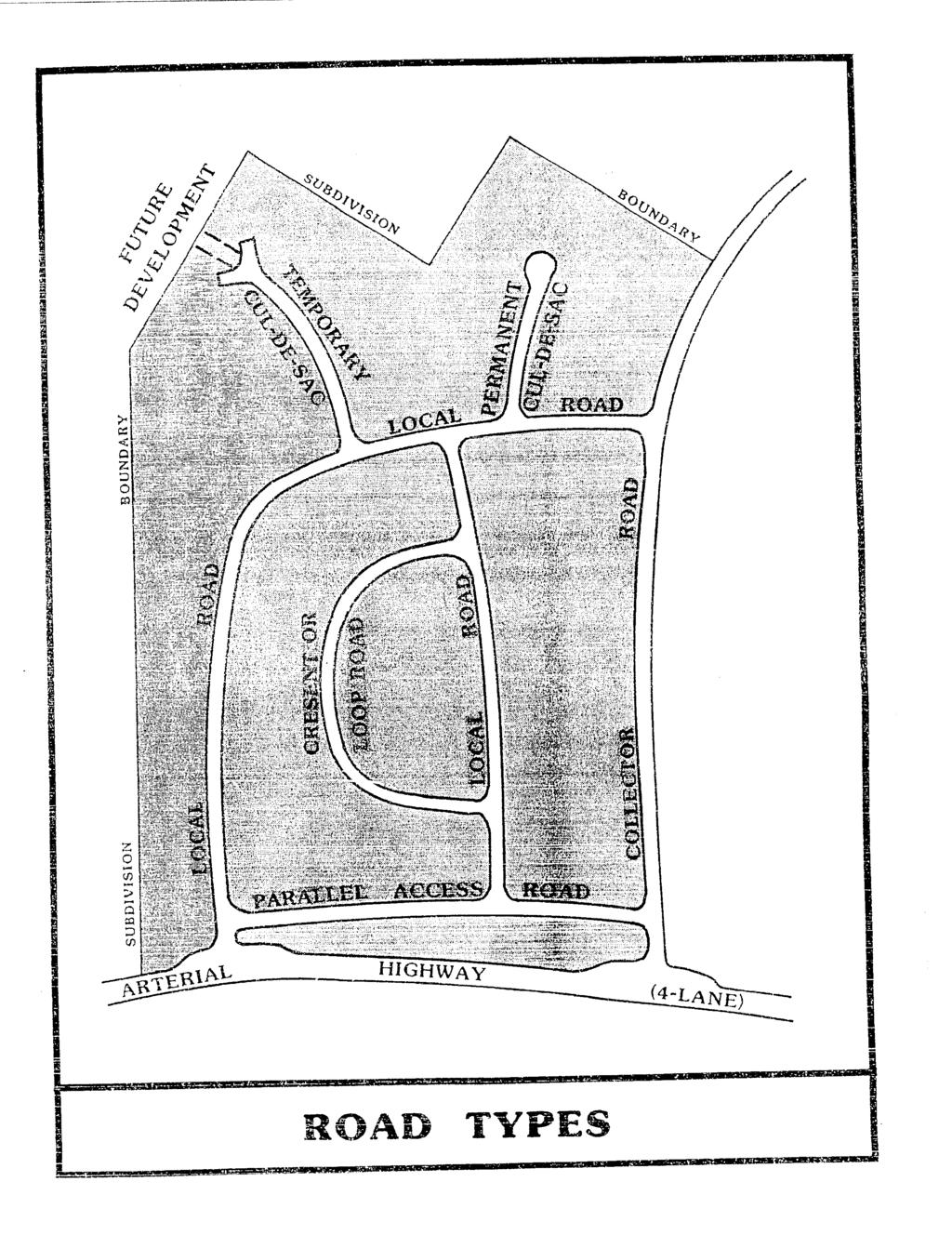
14 c. Collectors - a road which primarily carries traffic from local roads to arterials. Collector roads include those designated as such in the Transportation Plan of Meigs County. d. Local Road - a neighborhood road used primarily for access to the abutting properties. e. Marginal Access Road - a minor road parallel and adjacent to major thoroughfares which offers access to abutting properties and is used to limit access points on an arterial. f. Alley - a minor way used for service access to the back or side of properties otherwise abutting on a road. g. Cul-de-sac - a local road with only one outlet, sometimes called a "dead-end" road. A cul-de-sac is measured from its dead-end or vehicular turn around back to the first intersection. h. Private Road - a privately-maintained road constructed on a recorded permanent easement and built to the standards set forth in these regulations. MCRPC Subdivision Regulations 2-7
15
16 Roadway. The actual road surface which is utilized to transport motor vehicles including necessary road shoulders and drainage facilities including ditches, curbing and guttering. Road Paving Material Class. "Class" refers to the type and cleanliness of the paving material. Road Paving Material Grade. "Grade" refers to the size of the aggregate in the paving material. Sanitary Sewer System. A municipal or community sewage collection, treatment, and disposal system of a type approved by the Department of Health and Environment. Setback Line. A line established by the Subdivision Regulations, generally parallel with and measured from the lot lines, delineating the minimum allowable distance between the property line and a building on a lot within which no building or other structure shall be placed except as otherwise provided. Subdivider. The person, firm or corporation having such a proprietary interest in the land to be subdivided as will authorize the maintenance or proceedings to subdivide such land under this ordinance, or the authorized agent, person, firm or corporation for the purpose or proceeding under these regulations. Subdivision. The term "subdivision" means the division of a tract or parcel of land into two or more lots, sites, or other divisions for the purpose whether immediate or future, of sale or building development and includes resubdivision; and the definitions of such subdivision shall be restricted to the following: a. All such divisions where one (1) or more of the resulting tracts is less than five (5) acres in size; b. All such divisions where a new road or public utility installation (water or sewer) is required, regardless of the size of any or all of the parcels. The following are EXCLUDED from the definition of a "subdivision:" a. Testamentary division of property; b. Partnership division of property between two or more owners of an undivided interest by court order or by deeds; c. Divisions where the resulting tracts are all over five (5) acres, all have frontage on an existing publicly-maintained road, and where none require the extension of public water or sewer lines. Subdivision Regulations. The "Meigs County, Tennessee, Subdivision Regulations" in its entirety and future amendments, thereto. MCRPC Subdivision Regulations 2-9
17 Variance. A variance is a modification of the strict terms of the relevant regulations where such modification will not be contrary to the public interest and where, owing to conditions peculiar to the property and not the result of the action of the applicant, a literal enforcement of the regulations would result in unnecessary and undue hardship. MCRPC Subdivision Regulations 2-10
18
19
20 Yard, Front. The required open space, unoccupied by buildings, between the road or street right-of-way line and the principal building. Yard, Rear. The required space, unoccupied except by an allowed accessory use, extending from the rear of the principal building to the rear lot line the full width of the lot. Yard, Side. The space, unoccupied except as herein provided, measured between side lot line and the nearest point of the principal building and between the front yard and the rear yard. MCRPC Subdivision Regulations 2-13
21 ARTICLE 3 PLATTING JURISDICTION, ENFORCEMENT AND PENALTIES FOR VIOLATION The enforcement of these regulations and penalties for the unapproved recording or transfer of land are provided by state law in the authority granted by public acts of the State of Tennessee. Section Platting Authority. From and after the passage of these regulations, the Planning Commission shall be the official platting authority, and no plat of a land subdivision shall be entitled to record in the office of the Meigs County Register unless it shall have the approval of the Planning Commission inscribed thereon. The filing or recording of a plat of a subdivision without the approval of the Planning Commission, as required by these regulations, is declared to be a misdemeanor, punishable by law, with each day of noncompliance being a separate offense. Section Use of Plat. The transfer of, sale of, agreement to sell, or negotiation to sell land by reference to or exhibition of, or other use of a subdivision plat that has not been given final approval by the Planning Commission and recorded in the office of the Meigs County Register is prohibited, and the description by metes and bounds in the instrument of transfer or other document shall not exempt the transaction from such penalties. Section Enforcement. No plat or plan of a subdivision located within the area of planning jurisdiction shall be admitted to the land records of the county or received or recorded by the County Register of Deeds until said plat or plan has received final approval in writing by the Secretary of the Planning Commission as provided in Section , Tennessee Code Annotated. Section Opening and Improving Public Roads. No public officer, authority or county governing body shall accept, layout, open, improve, grade, pave or light any road, lay or authorize the laying of water mains or sewers, or the construction of other facilities or utilities in any road located within the area of planning jurisdiction unless such road shall have been accepted, opened, or otherwise received the legal status of a public road prior to the adoption of these regulations, or unless such road corresponds in its location and lines to a road shown on a subdivision plat approved by the Planning Commission, or on a road plan made and adopted by the Commission as provided in Section , Tennessee Code Annotated. Section Erection of Buildings. No building permit shall be issued and no building shall be erected on any lot in a subdivision within the area of jurisdiction of the Regional Planning Commission unless the road giving access thereto has been accepted as a public road in accordance with these regulations, or unless such road has been accepted as a public road prior to the effective date of these regulations. Any building or structure erected or to be erected in violation of this section shall be deemed an unlawful building or structure, and the building commissioner or MCRPC Subdivision Regulations 3-1
22 the county attorney or other official designated by the Meigs County Commission may bring action to enjoin such erection or cause it to be vacated or removed. Section Penalties. (Amended 9/12/06) No county register shall receive, file, or record a plat of a subdivision within the planning region without the approval of the Planning Commission as required in Section , Tennessee Code Annotated. Tennessee Code Annotated, Section , provides that whoever being the owner or agent of the owner of any land, transfers or sells or agrees to sell or negotiates to sell such land by reference to or exhibition of or by other use of a plat of subdivision of such land without having submitted a plat of such subdivision to the Planning Commission and obtained its approval as required before such plat be recorded in the office of the appropriate county register, and the description of metes and bounds in the instrument of transfer or other document used in the process of selling or transferring shall not exempt the transaction. The county, through its county attorney or other official designated by its chief legislative body, may enjoin such transfer or sale or agreement by action or injunction. MCRPC Subdivision Regulations 3-2
23 ARTICLE 4 GENERAL DESIGN REQUIREMENTS Section Suitability of the Land. The Planning Commission shall not approve the subdivision of land if, from adequate investigations conducted by all public agencies concerned, it has been determined that in the best interest of the public the site is not suitable for platting and development purposes of the kind proposed. Land within any designated floodway as shown on the Meigs County Flood Insurance Rate Map (FIRM), shall not be platted for residential occupancy or building sites. Fill may not be used to raise land within any designated floodway. In other areas subject to flood, fill may be used providing the proposed fill does not restrict the flow of water and unduly increase flood heights. Section Name of Subdivision. The name of the subdivision must have the approval of the Planning Commission. The name shall not duplicate or closely approximate the name of an existing subdivision unless such subdivision is a resubdivision according to Section of these regulations. Section Access. Access to every subdivision shall be provided over a county-maintained road. Access may also be provided over a private road according to Section 5.08 and Section 5.09 of these regulations. Section Public Use Areas. When features of other plans adopted by the Planning Commission, (such as schools or other public building sites, parks or other land for public uses) are located in whole or in part in a land subdivision, land for such features shall be either dedicated or reserved by the subdivider for acquisition within one (1) year by the appropriate public agency. Whenever a plat proposes the dedication of land to public uses that the Planning Commission finds not required or suitable for such use, the Planning Commission shall refuse to approve the plat, and shall notify the governing body of the reasons for such action. Note: One of the primary purposes and advantages of planning for the dedication and reservation of property for public use is to indicate areas which may be presently acquired at acreage prices rather than at greatly increased prices in the future, where future improvements would increase the expense to the taxpayer and create inconvenience for the individual property owner and for the neighborhood. Where public use is to be made of the property and where the residents of the subdivision will receive primary benefit, the dedication of the property should be encouraged. Where the public use is for the public as a whole, the community should pay proportionately for the acquisition of reserved areas within a reasonable time. A reasonable time is to be determined according to the circumstances, because the subdivider should not be required to hold his land idle for a lengthy indefinite period. MCRPC Subdivision Regulations 4-1
24 Section Large-Scale Development. The requirements of these regulations may be modified in the case of large scale community or neighborhood units, such as housing project, mobile home park or shopping center which is not subdivided into customary lots, blocks and roads. Plans for all such developments shall be presented to the Planning Commission for review and approval prior to the commencement of construction. The requirements and regulations of the "Manufactured Homes and Recreational Vehicles" chapter of the Tennessee Code Annotated, Sections through , and those of the Meigs County Regulations governing commercial mobile home parks and travel trailer parks, must be satisfied and the approval of the local health authority must be secured prior to approval by the Planning Commission. MCRPC Subdivision Regulations 4-2
25 ARTICLE 5 GENERAL REQUIREMENTS FOR ROADS AND OTHER RIGHTS-OF-WAY Section Conformance to Adopted Transportation Plan. All roads and other features of the Transportation Plan of Meigs County, Tennessee, shall be platted by the subdivider in the location and to the dimensions indicated on the Transportation Plan adopted by the Planning Commission. Section Continuation of Existing Roads. Existing roads shall be continued at the same or greater width, but in no case less than the required width. Section Road Connections. Where proposed roads are to adjoin existing roads, the developer must make the connection at his expense and meet all road design requirements set forth in these regulations. Section Road Elevations. The Planning Commission may require, where necessary, profiles and elevations of roads in areas subject to flood, as defined in these regulations. Fill may be used for roads provided such fill does not unduly increase flood heights. Drainage openings shall be so designed as to not restrict the flow of water and unduly increase flood heights, the minimum size of pipe or tile shall be fifteen (15) inches. (Amended 12/10/02) Section Road Names. The road names shall require the approval of the Planning Commission. Roads that are obviously in alignment with roads already existing and named shall be given the name of the existing road. Lot numbers shall be assigned to all parcels and shown on the final plat. Lots on the left side of the road while traveling north or west shall have odd numbers. Lots on the left side of the road while traveling south or east shall have even numbers. Roads that are obviously in alignment with roads already existing shall continue the existing numbering system. Before assigning any road or lot a number, the developer shall first contact the E-911 Director of Meigs County in order to locate the correct road number. Section Restriction of Access. When a tract fronts on an arterial or highway, the Planning Commission may require such lots to be provided with frontage on a marginal access road or may require reverse frontage lots. Section Alleys. Alleys may be required at the rear of all lots used for multi-family, commercial or industrial developments but shall not be provided in one-and-two family residential developments unless the subdivider provides evidence satisfactory to the Planning Commission of the need for alleys. MCRPC Subdivision Regulations 5-1
26 Section Private Roads. (Amended ) Permanent easements and private roads under this Resolution are defined as any non-exclusive permanent easement for vehicular access which: 1) serves one lot which does not front on a publicly maintained road and which will contain one, and only one residence, or 2) serving two or more owners or renters for the benefit the those being served by it. A permanent easement utilized by more than one lot or private road shall be owned by (a) the property owner(s) utilizing the easement/road or (b) a property owners association. Said permanent easement or private road may be vacated or closed only by all parties in interest, unless said easement/road is dedicated to public use by the owner(s) and accepted by the Meigs County Commission for maintenance. Private easements/roads serving two or more owners, renters or lots, shall meet the following standards: a. The subdivision plat and individual deeds shall be noted that the permanent easement/private road is a private road and not maintained by Meigs County. b. An additional certification shall be noted on the final subdivision plat defining the ownership of said permanent easement/private road. c. The permanent easement/private road shall be open to emergency, public safety. d. The permanent easement/private road may not connect two (2) or more public roads. e. The permanent easement/private road shall meet the specifications set forth in Section 5.09 below. f. When two lots abut end of a permanent easement/private road as shown in the drawing below, the private road shall extend into those two lots the same distance as the required width of the private road easement to provide a more adequate road frontage MCRPC Subdivision Regulations 5-2
27 g. All of the requirements for a permanent easement/private road established by this resolution shall be completed prior to final approval of the subdivision plat by the Meigs County Regional Planning Commission. Section Requirements for Private Roads. (Amended ) All permanent easements/private roads shall meet the following standards: a. Easement/road width and length: 1) Single lot permanent easement not to exceed five hundred feet (500') in length unless granted a variance by the planning commission, a minimum of twenty-five feet (25') in width. 2) For a subdivision which has a permanent easement/private road with six (6) or fewer lots, 1,000 feet or less in length, a 40-foot minimum easement or road right-of-way. 3) For subdivisions of seven lots or more, the pavement shall be a minimum of twenty (20) feet with 2 foot gravel shoulders; provided that where the planning commission requires a 60 foot right-of-way, the pavement width shall be 26 feet with two foot shoulders. All private roads that provide access to a subdivision of seven lots or more shall meet this requirement. Any such private road(s) shall also MCRPC Subdivision Regulations 5-3
28 meet the requirements for roads in Article 6 and Article 10 of this resolution (Amended December 11, 2012). 4) For subdivisions with a permanent easement/private road with seven (7) or more lots, a 50-foot right-of-way; provided that where 100 lots or more are served, the Meigs County Regional Planning Commission may require a 60-foot rightof-way. b. Road pavement widths: 1) Single-lot permanent easement: no requirement 2) For subdivisions of six (6) lots or less, the road surface shall be a minimum of two (2) inches of compacted crusher run gravel, sixteen (16) feet wide. 3) For subdivisions of seven lots or more, the pavement shall be a minimum of twenty (20) feet with 2 foot gravel shoulders; provided that where the planning commission requires a 60 foot right-of-way, the pavement width shall be 26 feet with two foot shoulders. c. Storm drainage. An adequate drainage system including necessary open ditches, pipes, culverts, intersection drains, drop inlets, bridges, etc., shall be provided for the proper drainage of all surface water. A professional engineer or land surveyor shall determine the size of the culvert. Cross drains should be provided to accommodate all natural water flow and shall be of sufficient length to permit a full width roadway and the required slopes. The U.S. Soil and Water Conservation Service shall determine the size and location of cross drains, but in no case shall they be less than fifteen (15) inches in diameter. All storm drainage contained in pipes or culverts under the roadway shall have endwalls, headwalls, or riprap with a concrete apron wall where necessary to prevent erosion. NOTE: Pipes shall be laid with the spigot end pointing in the direction of the flow and with the ends fitted and matched to provide tight joints and a smooth uniform invert. They shall be placed at a sufficient depth below the roadbed to avoid dangerous pressure of impact, and in no case shall the top of the pipe be less than one (1) foot below the roadbed. d. Curbs and Gutters, or Road Shoulders. Within Meigs County, the permanent easement/private road shall have concrete or asphalt curbs and gutters, or two (2) foot gravel shoulders on each side of the paved surface, of a type as shown in the Meigs County Subdivision Regulations, as amended. MCRPC Subdivision Regulations 5-4
29 e. Road Signs. 1) Street name blades shall be of 24 inch, 30 inch or 42 inch x 6 inch extruded aluminum, posted with X type or 90 brackets on 2" galvanized pipes, 10½' long, set 3 feet into the ground in a concrete base at the intersection of all roads within the subdivision and at the point existing roads are intersected by the roads of the subdivision. The blade shall be covered with brown 3M-engineer grade reflective sheeting with 4" standard capital letters in silver, 3M-engineer grade reflective sheeting, or approved equal. 2) All traffic control devices shall conform to the applicable provisions of the current edition of the U.S. DOT, Federal Highway Administration Manual on Uniform Traffic Control Devices. f. Width, pavements, and other specific design requirements shall conform to the standards shown in Articles 6 and 10 of the Meigs County Subdivision Regulations. Section Reserve Strips. There shall be no reserve strips controlling access to roads, except where the control of such strips is definitely placed with the county under conditions approved by the planning commission. Section Easements. Easements having a minimum width of ten (10) feet shall be provided where deemed necessary along each side or rear lot line for utility lines and underground mains and cables. Easements of the same or necessary greater width shall be required along the lines of, or across lots, where necessary for the extension of existing or planned utilities. Where a subdivision is traversed by a water course, drainage way, channel or stream, there shall be provided a storm-water or drainage right-of-way of adequate width. Parallel roads may be required by the Planning Commission in connection therewith. Section Road Grading Plan Required. (Added ) Every new road in a subdivision with five or more lots, or which shall in the future have five or more lots, and which is to be dedicated to the county for maintenance, shall have a grading plan bearing the stamp of a registered professional engineer licensed to practice in the State of Tennessee. Said plan shall accompany the preliminary plat of a subdivision. MCRPC Subdivision Regulations 5-5
30 ARTICLE 6 SPECIFIC DESIGN REQUIREMENTS FOR ROADS AND OTHER RIGHTS-OF-WAY Section Road Right-of-Way Widths. The right-of-way width shall be the distance across a road from property line to property line. Minimum road right-ofway widths shall be as follows: a. Major Arterials feet (See Transportation Plan) or as may be required b. Minor Arterials feet (See Transportation Plan) c. Primary Collectors feet (See Transportation Plan) Secondary or collector roads are those which carry traffic from minor roads to the major system of arterial roads and highways and include the principal entrance roads of a residential development and roads for major circulation within such a development; d. Minor Roads feet e. Marginal Access Roads feet Marginal access roads are minor roads which are parallel to and adjacent to arterial roads and highways; and which provides access to abutting properties and protection from through traffic; f. Alleys feet Alleys are minor public ways used primarily for service access to the back or side of properties otherwise abutting on a road. g. Cul-de-sacs feet (Amended 10/9/07) Cul-de-sacs are permanent dead-end roads or courts designed so that they cannot be extended in the future. Except where topographic or other conditions make a greater length unavoidable, cul-de-sacs, or dead-end roads, shall not be greater in length than 2,500 feet. They shall be provided at the closed end with a turn-around having a MCRPC Subdivision Regulations 6-1
31 property line radius of at least fifty (50) feet with an outside pavement radius of at least forty (40) feet. h. Temporary Cul-de-sacs feet Where, in the opinion of the Planning Commission, it is desirable to provide for road access to adjoining property, proposed roads shall be extended by dedication to the boundary of such property. Such dead-end roads shall be provided with a temporary turn-around having a property line radius of at least fifty (50) feet with an outside pavement radius of at least forty (40) feet. Where deemed necessary by the Planning Commission adequate rights-of-way shall be dedicated to connect with any temporary dead-end roads adjoining the subdivision. Section Additional Width on Existing Roads. Subdivisions that adjoin existing roads shall dedicate additional right-of-way to meet the minimum road width requirements. a. The entire right of way shall be dedicated where any part of the subdivision is on both sides of the existing road, and b. Where the subdivision is located on only one side of an existing road, the amount of right-of-way to be dedicated is as follows: 1. If the land across the roadway from the proposed subdivision has not been subdivided or developed, the subdivider is only required to dedicate one-half of the required right-of-way, measured from the center line of the existing roadway. 2. If the land across the roadway has been subdivided or developed, the subdivider is required to provide enough additional right-of-way on his side of the roadway to bring the total right-of-way to the required width. (In no case shall the right-of-way be less than fifty (50) feet.) c. In cases where rights-of-way in excess of fifty (50) feet are required, additional widths shall be reserved and when used just compensation therefore shall be paid by the condemning authority. Section Road Pavement Widths. Road pavement widths shall be as follows: a. Major Arterials feet or greater, or as may be required b. Minor Arterials feet or greater, or as may be required MCRPC Subdivision Regulations 6-2
32 c. Primary Collectors feet or greater, or as may be required d. Secondary Collectors feet e. Minor (Neighborhood) feet (with 2 foot gravel shoulders on each side of paved road) f. Alleys feet g. Cul-de-sacs foot radius or turnaround. h. Through proposed neighborhood or local business areas the road widths shall be increased ten (10) feet on each side to provide for turning movements of vehicles into and out of necessary off-road parking areas without interference to traffic. NOTE: The pavement widths are measured from inside of curb to inside of curb. These widths are considered the minimum necessary to accommodate modern traffic. All Arterials and Collectors are designed to be high-volume, highspeed traffic movers. At no time should parking be allowed along Arterials or Collectors; however in the case of Local Roads, road parking must be considered in the pavement width. Where no road parking is permitted or none is anticipated, allowances may be made. A parallel parking lane normally requires eight (8) feet. Section Road Grades. Maximum and minimum road grades shall be fourteen (14) percent and five-tenths of one percent (0.5) respectively. NOTE: These road grade limits are considered to be the optimum requirements to provide adequate safety. Different topographical situations may necessitate adjustment. The minimum grade requirement is necessary for drainage purposes. In this regard, it should be considered that in addition to accommodating traffic, roads are the heart of the surface drainage system. Section Horizontal Curves. Where a deflection angle of more than ten (10) degrees in the alignment of a road occurs, the road shall have a centerline radius of not less than the following: a. Arterials feet b. Collectors feet c. Minor Roads feet Section Vertical Curves. Every change in grade shall be connected by a vertical curve constructed so as to afford a minimum sight distance of two MCRPC Subdivision Regulations 6-3
33 hundred (200) feet, said sight distance being measured from the driver's eyes, which are assumed to be three and one-half (3 1/2) feet above the pavement, to an object six (6) inches high on the pavement. Where, in the opinion of the Planning Commission, topography warrants it profiles of all roads showing natural and finished grades drawn to a scale of not less than one (1) inch equals one hundred (100) feet horizontally and one (1) inch equals twenty (20) feet vertically may be required. MCRPC Subdivision Regulations 6-4
34
35 Section Intersections. Road intersections shall be as nearly at right angles as is possible, and no intersection shall be at an angle of less than sixty (60) degrees. Curb radii at road intersections shall not be less than twenty (20) feet, and where the angle of a road intersection is less than seventy-five (75) degrees, the Planning Commission may require a greater curb radius. Wherever necessary to permit the construction of a curb having a desirable radius without curtailing the sidewalk at a road corner to less than normal width, the property line at such road corner shall be rounded or otherwise setback sufficiently to permit such construction. Section Tangents. Between reverse curves there shall be a tangent having a length not less than one hundred (100) feet. Section Road Jogs. Road Jogs with centerline off-sets of less than one hundred fifty (150) feet shall not be allowed. MCRPC Subdivision Regulations 6-6
36
37
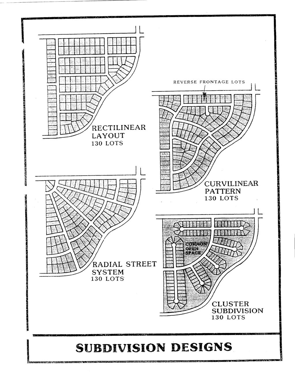
38 ARTICLE 7 DESIGN STANDARDS FOR BLOCKS AND LOTS Section Block Lengths and Widths. Block lengths and widths shall be as follows: a. Blocks shall be no greater than one thousand two hundred (1,200) feet nor less than three hundred (300) feet in length, except in unusual circumstances; and b. Blocks shall be wide enough to provide two (2) tiers of lots of minimum depth, except where abutting upon major roads or where other situations make this requirement impracticable. Section Flood-Free Building Site. Each lot in a subdivision shall contain a flood-free building site outside of the limits of any existing easement or the building setback lines as required by these regulations. The finished floor elevation for a concrete slab on grade type of structure or the bottom of the floor joist for a crawl space type of structure shall have a minimum elevation above the elevation for a flood of 100-year frequency. The authority for establishing the 100-year frequency of occurrence flood elevation shall be the Tennessee Valley Authority's Flood Control Branch or the Corps of Engineers, Department of the Army. In the event the site is not in an area covered by one of these agencies or for which a study has not been done, a comprehensive study will be required by a professional engineer licensed to practice in Tennessee. Section Lot Sizes. Residential lots shall meet the lot width and lot area requirements of the Zoning Resolution. In the absence of a Zoning Resolution, residential lots shall not be less than fifty (50) feet wide at the setback (building) line. Other lot size requirements follows: a. Residential lots shall have a depth of not less than one hundred (100) feet and not greater than three (3) times the width of the lot at the building line, unless unusual circumstances make these limitations impractical. b. Lots not served by public water and sanitary sewer systems shall be at least twenty-five thousand (25,000) square feet in area or of a size specified by the County health Officer to adequately accommodate both a fresh-water well and septic tank on the same lot. Where individual septic tanks are used and public water provided, minimum lot size shall be twenty thousand (20,000) square feet. The Health Officer shall also prescribe minimum lot sizes to conform to health standards, which may be greater than the standards contained herein. c. Residential corner lots shall have adequate width to meet building setback requirements for both abutting roads. d. Commercial and industrial lots shall be adequate in size to provide service areas and off-road parking suitable for the type of use and development contemplated. Platting of individual lots should be MCRPC Subdivision Regulations 7-1
39 avoided in favor of an overall design of the land to be used for such purposes. e. Land shall not be platted for commercial or industrial purposes unless the subdivider can demonstrate to the Planning Commission that each lot provides the following: 1. A site that does not unduly interfere with through traffic. (Each industrial subdivision or area shall utilize a single collector for all heavy traffic between the area and the general system of roads. Minor industrial roads and individual industrial parcels shall be oriented at right angles with the collector and with adjacent railroads.) 2. An integrated parking area. 3. An insulation against any adverse effect on any present or future adjacent residences. 4. A parcel size sufficient in area to allow future expansion. Section Lot Lines. All lot lines shall be perpendicular or radial to road lines, unless impractical because of topographic or other features. Section Building Setback Lines. A building line (setback line) meeting the front yard setback requirements of the Zoning Resolution shall be established on all lots. In the absence of a Zoning Resolution, the front yard setback shall be a minimum of thirty-five (35) feet from the road right-of-way lines. Other minimum setback lines shall be as follows: a. From the side property line feet b. From rear property line feet c. From side property line feet which abuts a minor road (corner lots) or greater Section Lots Abutting Public Roads. Each lot shall abut upon a dedicated public road or private easement/road meeting Meigs County Private Road Standards, as amended. (Amended 12/10/02) Section Double and Reverse Frontage Lots. Double frontage and reverse frontage lots shall be avoided, except where essential to provide separate residential development from traffic arteries or to overcome specific disadvantages of topography and orientation. Reverse frontage lots shall have a depth of not less than one hundred and fifty (150) feet. A planted evergreen screen easement of at least ten (10) feet wide, across which there shall be no right of access, shall be provided along the line of lots abutting a traffic artery or other incompatible use. Section Flag Lots. A Flag Lot is a lot which, except for a narrow private access lane, does not front on or abut a publicly-maintained street or road. These lots are to provide a building site in the interior or a tract of land behind lots which have full frontage on a publicly maintained street or road. a. Within the portion of the flag lot which excludes the access strip, the building setbacks for front, side and rear yards shall still apply and be measured from the boundaries of the parcel excluding the access strip. MCRPC Subdivision Regulations 7-2
40 b. No more than two access strips shall be located side-by-side. c. Flag stems shall not exceed six hundred (600) feet. d. Width: 1. For flag lots of two (2) acres or less, the access strip shall be not less than twenty-five (25) feet in width. 2. For flag lots of more than two (2) acres, but not more than five (5) acres, the access strip shall be not less then forty(40) feet in width. 3. For flag lots of over five (5) acres, the access strip shall be a minimum of fifty (50) feet in width. MCRPC Subdivision Regulations 7-3
41
42 ARTICLE 8 PROCEDURE FOR PRELIMINARY PLAT APPROVAL OF A SUBDIVISION Section Pre-Application Review. Whenever a subdivision of a tract of land within Meigs County is proposed, the subdivider is urged to consult early and informally with the Secretary or a designated member of the Planning Commission. The subdivider may submit sketch plans and data showing existing conditions within the site and in its vicinity and the proposed layout and development of the subdivision. No fee shall be charged for the pre-application review and no formal application shall be required. NOTE: (1) The purpose of the pre-application review is to afford the subdivider an opportunity to avail himself of the advice and assistance of the Planning Commission in order to facilitate the subsequent preparation and approval of plans. At this stage, the subdivider should also consult with any lending institution that will be participating in the financing of his proposed development and with the Federal Housing Administration of the Department of Housing and Urban Development that may be insuring mortgages on houses that may be built in this land subdivision. (2) The various plat reviews required by these regulations may properly be made by the Secretary or a designated member of the Planning Commission. It would be wasteful of time for the entire Planning Commission membership to review a proposed land subdivision, except in cases of conflict or unusual and difficult problems. Approval or disapproval in every case must be by action of the Commission. This note applies only to reviews. Section Application for Preliminary Plat Approval. Following the preapplication review of a proposed subdivision, the subdivider shall submit to the Chairman of the Planning Commission, at least fifteen (15) days prior to the next regular meeting of the Planning Commission for agenda inclusion, the following: a. A letter requesting review and approval of a preliminary plat and giving the name and address of a person to whom the notice of the hearing by the Planning Commission on the preliminary plat shall be sent, and b. Six (6) copies of the preliminary plat and other documents, as specified in Article 9. NOTE: Six (6) copies of the preliminary plat and other documents are suggested to provide a review and record copy for: 1. Planning Commission; 2. Subdivider; 3. Public Utility Department or Company (for record); 4. County Health Officer; 5. County Engineer; and 6. The County Road Superintendent. MCRPC Subdivision Regulations 8-1
43 Section Review of Preliminary Plat. The Planning Commission shall check the plat for conformance to these regulations and shall afford a hearing on the preliminary plat. Thereafter, the Planning Commission shall give tentative approval or disapproval of the preliminary plat. A notation of the action shall be made in the minutes of the meeting. Two (2) copies of a list containing the reasons for disapproval, if the preliminary plat is disapproved, shall be issued. One (1) copy shall be returned to the subdivider or his agent and one (1) copy added to the records of the Planning Commission. Tentative approval of a preliminary plat does not constitute approval of a final plat. It indicates only approval of the layout as a guide to the preparation of the final plat. Tentative approval shall expire and be null and void after a period of one (1) year unless an extension of time is applied for by the subdivider or his representative and approved by the Planning Commission. If action on a preliminary plat is not taken by the Planning Commission within sixty (60) days of the date of submittal, the preliminary plat shall be considered approved and a certificate of approval shall be issued on demand. However, the applicant for approval may waive this requirement and consent to an extension of time. Section Certificate of Tentative Approval. Two (2) Certificates of Tentative Approval of the Preliminary Plat by the Planning Commission shall be issued. One (1) copy for the subdivider or his agent and one (1) for the Planning Commission records. The certificate shall contain the following: "Pursuant to the Subdivision Regulations of Meigs County, all the requirements of tentative approval have been fulfilled. Therefore, this "Preliminary Plat" has been approved by the Meigs County Planning Commission on, 19. This approval does not constitute approval of a Final Plat. This Certificate of Tentative Approval shall expire and be null and void on (date) " Date Secretary, Meigs County Regional Planning Commission NOTE: After the subdivider has received preliminary plat approval, he may begin work on the necessary improvements for final plat approval or may post a surety bond in the amount needed to install the required improvements. MCRPC Subdivision Regulations 8-2
44
Table of Contents MCMINN COUNTY SUBDIVISION REGULATIONS TITLE ARTICLE 1 SHORT TITLE, PREAMBLE AND ENACTMENT CLAUSE
 Table of Contents MCMINN COUNTY SUBDIVISION REGULATIONS TITLE REGULATIONS CONTROLLING THE SUBDIVISION OF LAND IN MCMINN COUNTY, TENNESSEE: REQUIRING AND REGULATING THE PREPARATION AND PRESENTATION OF PRELIMINARY
Subdivision Regulations. for the. City of Dayton, Tennessee
 Subdivision Regulations for the City of Dayton, Tennessee Prepared for the Dayton Municipal Planning Commission April, 1996 (as amended through June, 2006) by the Local Planning Assistance Office 540 McCallie
CHAPTER 1 INTRODUCTION
 CHAPTER 1 INTRODUCTION Section 01.01. Preamble 01.02. Purpose 01.03. Enactment Clause 01.04. Title Section 01.01. Preamble. REGULATIONS CONTROLLING THE SUBDIVISION OF LAND IN DAYTON, TENNESSEE; REQUIRING
CITY OF ATHENS, TENNESSEE MINIMUM SUBDIVISION REGULATIONS
 CITY OF ATHENS, TENNESSEE MINIMUM SUBDIVISION REGULATIONS MINIMUM SUBDIVISION REGULATIONS Athens, Tennessee Prepared for the City of Athens and the Athens Planning Region By the Athens Regional Planning
ARTICLE 15. RULES, REGULATIONS AND DEFINITIONS
 ARTICLE 15. RULES, REGULATIONS AND DEFINITIONS Section 1. Interpretation and Construction: The following rules and regulations regarding interpretation and construction of the Ulysses-Grant County, Kansas,
Table of Contents CHAPTER 1 INTRODUCTION
 Table of Contents CHAPTER 1 INTRODUCTION Section: 01.00. Preamble 01.01. Purpose 01.02. Enactment Clause 01.03. Short Title 01.00. Preamble. PURSUANT TO THE AUTHORITY SET FORTH IN SECTION 13-4-301 THROUGH
CHAPTER 5. Subdivisions Regulations
 CHAPTER 5 Subdivisions Regulations 10-5-1 Introduction and Purpose 10-5-2 Definitions 10-5-3 General Provisions 10-5-4 Procedure for Submitting Subdivisions 10-5-5 Design Standards; Streets and Lots 10-5-6
SUBDIVISION DESIGN PRINCIPLES AND STANDARDS
 SECTION 15-200 SUBDIVISION DESIGN PRINCIPLES AND STANDARDS 15-201 STREET DESIGN PRINCIPLES 15-201.01 Streets shall generally conform to the collector and major street plan adopted by the Planning Commission
SUBDIVISION REGULATIONS WINCHESTER, TENNESSEE ADOPTED JANUARY 18, 1971
 SUBDIVISION REGULATIONS WINCHESTER, TENNESSEE ADOPTED JANUARY 18, 1971 AMENDED THROUGH JULY 31, 2016 THE SUBDIVISION REGULATIONS OF WINCHESTER, TENNESSEE, AND ITS PLANNING REGION ADOPTED: JANUARY 18,
Table of Contents CHAPTER 1 INTRODUCTION
 Table of Contents CHAPTER 1 INTRODUCTION Section: 01.00. Preamble 01.01. Purpose 01.02. Enactment Clause 01.03. Title 01.00. Preamble. PURSUANT TO THE AUTHORITY SET FORTH IN SECTION 13-4-301 THROUGH SECTION
-MENDOCINO COUNTY PLANNING AND BUILDING SERVICES- DIVISION OF LAND REGULATIONS TITLE 17
 ARTICLE VI -- GENERAL REGULATIONS AND PROVISIONS Sec. 17-50. Sec. 17-51 General Plan. Sec. 17-52 Lot and Block Design and Configuration. Sec. 17-53 Lot Access. Sec. 17-54 Private Roads. Sec. 17-55 Water
THE COUNTY BOARD OF SUPERVISORS OF THE COUNTY OF DOUGLAS DOES ORDAIN AS FOLLOWS:
 8.1 SUBDIVISION CONTROL ORDINANCE THE COUNTY BOARD OF SUPERVISORS OF THE COUNTY OF DOUGLAS DOES ORDAIN AS FOLLOWS: SECTION I. GENERAL INTERPRETATION This ordinance shall not repeal, impair or modify private
CITY OF HOBBS ORDINANCE NO..
 CITY OF HOBBS ORDINANCE NO.. AN ORDINANCE TO AMEND TITLE 16 OF THE HOBBS MUNICIPAL CODE IN ITS ENTIRETY. BE IT ORDAINED BY THE GOVERNING BODY OF THE CITY OF HOBBS, NEW MEXICO, that the following Chapter
ARTICLE 3 DEFINITIONS
 Sections: 3-1 Rules of Construction 3-2 Definitions ARTICLE 3 DEFINITIONS SECTION 3-1 RULES OF CONSTRUCTION 3-101. a. The language set forth in these regulations shall be interpreted in accordance with
ELK RAPIDS TOWNSHIP ANTRIM COUNTY, MICHIGAN ORDINANCE NO
 ELK RAPIDS TOWNSHIP ANTRIM COUNTY, MICHIGAN ORDINANCE NO. 3-2011 AN ORDINANCE TO REPLACE THE SUBDIVISION CONTROL ORDINANCE WITH A NEW SUBDIVISION DEVELOPMENT ORDINANCE, IN ACCORD WITH THE LAND DIVISION
ORDINANCE NO. Be it ordained by the City Council of the City of Abilene, Texas:
 ORDINANCE NO. An ordinance repealing Chapter 23, Subpart B of the Code of the City of Abilene, Texas, entitled Mobile Homes and Vacation Travel Trailers; stating the authority; setting forth the scope
SUBDIVISION REGULATIONS
 SUBDIVISION REGULATIONS Greene County, Tennessee Greene County Regional Planning Commission April 1972 Amended January, 2013 Prepared for: GREENE COUNTY REGIONAL PLANNING COMMISSION James Carter, Chairman
BEAR CREEK TOWNSHIP EMMET COUNTY, MICHIGAN. PRIVATE ROAD ORDINANCE Ordinance No. 11A-99. (to replace prior Private Road Ordinance No.
 BEAR CREEK TOWNSHIP EMMET COUNTY, MICHIGAN PRIVATE ROAD ORDINANCE Ordinance No. 11A-99 (to replace prior Private Road Ordinance No. 11-99) An Ordinance to protect the health, safety, and general welfare
SUBDIVISION REGULATIONS. 1. SHORT TITLE. This chapter shall be known and may be cited as "The City of Graf, Iowa, Subdivision Control Ordinance.
 GENERAL PROVISIONS SUBDIVISION REGULATIONS 1. SHORT TITLE. This chapter shall be known and may be cited as "The City of Graf, Iowa, Subdivision Control Ordinance." 2. PURPOSE. The purpose of this Ordinance
SUBDIVISION STANDARDS BEDFORD COUNTY, TENNESSEE. Certified by the Bedford County Regional Planning Commission. November 20, 1997.
 SUBDIVISION STANDARDS OF BEDFORD COUNTY, TENNESSEE Certified by the Bedford County Regional Planning Commission November 20, 1997 Effective Date November 24, 1997 Page 1 of 39 TABLE OF CONTENTS ARTICLE
I. Requirements for All Applications. C D W
 108-16.1. Application checklists. Checklist for Required Submissions to the Planning Board or Zoning Board of Adjustment of Monroe Township All required submissions are to be made to the Administrative
610 LAND DIVISIONS AND PROPERTY LINE ADJUSTMENTS OUTSIDE A UGB
 ARTICLE VI: LAND DIVISIONS AND PROPERTY LINE ADJUSTMENTS VI-21 610 LAND DIVISIONS AND PROPERTY LINE ADJUSTMENTS OUTSIDE A UGB 610-1 Property Line Adjustments (Property Line Relocation) A property line
Planning Grant Contract No. SC P-8 (G) South Carolina State Development Board Division of Community Planning of the Development and Research Center
 South Carolina State Development Board Division of Community Planning of the Development and Research Center") SUBDIVISION REGULATIONS Prepared for: Planning and Zoning Commission Anderson, South Carolina The preparation of this report was financed in part through an Urban Planning grant from the Department of
SUBDIVISION REGULATIONS Prepared for: Planning and Zoning Commission Anderson, South Carolina The preparation of this report was financed in part through an Urban Planning grant from the Department of
ORDINANCE NO. 41. PRIVATE ROAD ORDINANCE As Amended Through April 10, 2008
 ORDINANCE NO. 41 PRIVATE ROAD ORDINANCE As Amended Through April 10, 2008 An Ordinance to protect the health, safety, and general welfare of the inhabitants of Port Sheldon Township. The Township of Port
Chapter Plat Design (LMC)
") Chapter 18.14 Plat Design (LMC) Sections: 18.14.010 Lot width 18.14.020 Right-of-way requirements 18.14.030 Pipe stem lots 18.14.040 Division resulting in minimum lot sizes 18.14.050 Flood prone and bad
Chapter 18.14 Plat Design (LMC) Sections: 18.14.010 Lot width 18.14.020 Right-of-way requirements 18.14.030 Pipe stem lots 18.14.040 Division resulting in minimum lot sizes 18.14.050 Flood prone and bad
SUBDIVISION REGULATIONS
 166.01 Purpose 166.11 Final Plat Attachments 166.02 Definitions 166.12 Action by the Council 166.03 Platting Required 166.13 General Requirements 166.04 Procedure 166.05 Requirements of Preliminary Plat
Subdivision Regulations Madisonville, Tennessee
 Subdivision Regulations Madisonville, Tennessee January 1999 MADISONVILLE, TENNESSEE Prepared by the MADISONVILLE MUNICIPAL/REGIONAL PLANNING COMMISSION Assisted by the Local Planning Office Tennessee
PRELIMINARY PLATS. The following documents are provided as required by the City of Conroe for use in the above titled platting submittals:
 Public Works Engineering Division CITY OF CONROE PRELIMINARY PLATS The following documents are provided as required by the City of Conroe for use in the above titled platting submittals: Submittal Questionnaire
ARTICLE 24 PRIVATE ROAD, SHARED PRIVATE DRIVEWAY AND ACCESS EASEMENT STANDARDS
 ARTICLE 24 PRIVATE ROAD, SHARED PRIVATE DRIVEWAY AND ACCESS EASEMENT STANDARDS SECTION 24.00 INTENT AND PURPOSE The standards of this Article provide for the design, construction and maintenance of private
SUBDIVISION REGULATIONS
 CHAPTER 41 SUBDIVISION REGULATIONS 41.01 Short Title 41.17 Presentation to Commission or Board of Supervisors 41.02 Purpose 41.18 Subdivision Classified 41.03 Application 41.19 Plats Required 41.04 Recording
FINAL SUBDIVISION AND LAND DEVELOPMENT PLAN CHECKLIST. Plan Name. Applicant's Name:
 TOWNSHIP OF UPPER ST. CLAIR FINAL SUBDIVISION AND LAND DEVELOPMENT PLAN CHECKLIST Date Filed Plan Name PLC Applicant's Name: Phone Filing Date for Final Application Final Plat 114.22. FINAL APPLICATION
SECTION 11 PLANNING & ZONING. SUBDIVISION CONTROL Ord. No. 176 Adopted: December 10, 1969
 SUBDIVISION CONTROL Ord. No. 176 Adopted: December 10, 1969 An ordinance enacted under Act 288, Public Acts of 1967, as amended, of the State of Michigan establishing regulations governing the subdivision
WARREN COUNTY, IOWA CHAPTER 46 CHAPTER 46 SUBDIVISION REGULATIONS
 TITLE V- PROPERTY AND LAND USE CHAPTER 46 SUBDIVISION REGULATIONS 46.01 Title and Jurisdiction 46.09 Subdivision Design Standards 46.02 Definitions 46.10 Preliminary Plat Requirements 46.03 Filing Process
ARTICLE 23 CONDOMINIUM STANDARDS
 ARTICLE 23 CONDOMINIUM STANDARDS Section 23.01 Intent. The intent of this Article is to provide regulatory standards for condominiums and site condominiums similar to those required for projects developed
BRIDGETON SUBDIVISION APPLICATION CHECKLIST
 APPLICATION NAME AND # CHECKLIST COMPLETED BY: DATE: Signature and printed name BRIDGETON SUBDIVISION APPLICATION CHECKLIST TO SUBDIVISION APPLICANTS: The attached checklist is to assist you in the submission
ARTICLE 1: GENERAL PROVISIONS
 ARTICLE 1 GENERAL PROVISIONS AN ORDINANCE REGULATING THE SUBDIVISION OF LAND PRESCRIBING STANDARDS FOR SUBDIVISIONS AND FOR THE IMPROVEMENT THEREOF, PRESCRIBING PROCEDURES FOR THE REVIEW OF PROPOSED SUBDIVISION
ARTICLE VI. SUBDIVISION STANDARDS, PUBLIC
 ARTICLE VI. SUBDIVISION STANDARDS, PUBLIC IMPROVEMENTS, AND DESIGN REQUIREMENTS ARTICLE VI. SUBDIVISION STANDARDS, PUBLIC IMPROVEMENTS, AND DESIGN REQUIREMENTS DIVISION 1. GENERAL PROVISIONS Sec. 21-6100.
SUBDIVISION STANDARDS OF. Marshall County, Tennessee, Regional Planning Commission (hereafter referred to as the planning commission).
.") SUBDIVISION STANDARDS OF Marshall County, Tennessee, Regional Planning Commission (hereafter referred to as the planning commission). A. Purpose ARTICLE I PURPOSE, AUTHORITY, AND JURISDICTION Land subdivision
SUBDIVISION STANDARDS OF Marshall County, Tennessee, Regional Planning Commission (hereafter referred to as the planning commission). A. Purpose ARTICLE I PURPOSE, AUTHORITY, AND JURISDICTION Land subdivision
Chapter 22 LAND USE* Article III. Subdivisions
 Chapter 22 LAND USE* Article III. Subdivisions Sec. 22-256. Authority to Regulate. Sec. 22-257. Scope; plat required. Sec. 22-258. Definitions. Sec. 22-259. Interpretations and Meanings. Sec. 22-260. Procedure
CITY OF STURGIS Title 19-1 TITLE 19 SUBDIVISION OF LAND
 CITY OF STURGIS Title 19-1 TITLE 19 SUBDIVISION OF LAND BE IT ORDAINED by the Common Council of the City of Sturgis, Meade County, South Dakota, that the current Title 19 shall be replaced in its entirety
PART 19 SUBDIVISION DEVELOPMENT CHAPTER 1 SUBDIVISION REGULATIONS ARTICLE A GENERAL PROVISIONS ARTICLE B DESIGN STANDARDS
 19-101 Purpose and intent. 19-102 Short title. 19-103 Authority. 19-104 Jurisdiction. 19-105 Definitions. PART 19 SUBDIVISION DEVELOPMENT CHAPTER 1 SUBDIVISION REGULATIONS ARTICLE A GENERAL PROVISIONS
13-2 SUBDIVISION PLANS AND PLATS REQUIRED EXCEPTIONS Subdivision Plats Required To be Recorded
 ARTICLE XIII SUBDIVISIONS 13-1 INTENT AND PURPOSE 13-1-1 Intent: It is the intent of the County Commission through the adoption of this Article to more fully avail itself of the power granted under 17-27-601
SUBDIVISION CODE CITY OF FORT ATKINSON
 SUBDIVISION CODE CITY OF FORT ATKINSON Adopted September 7, 1993 Amended July 21, 2015 Section 26.09 (D)(8) Storm Sewer Systems amended by Council on 09-03-96. Section 26.08(B)(1)(a),(b) and (c) Land Dedications
E L M E R B O R O U G H L A N D U S E B O A R D APPLICATION COVER SHEET (to be completed for all applications and appeals)
") E L M E R B O R O U G H L A N D U S E B O A R D APPLICATION COVER SHEET (to be completed for all applications and appeals) 1. Name(s): 2. Address: 3. Telephone Number(s): 4. E-mail: 5. Owner Name(s) (if
E L M E R B O R O U G H L A N D U S E B O A R D APPLICATION COVER SHEET (to be completed for all applications and appeals) 1. Name(s): 2. Address: 3. Telephone Number(s): 4. E-mail: 5. Owner Name(s) (if
This Ordinance is adopted under the authority and provisions of the General Statutes of North Carolina, Article 6, Chapter 153A 121.
 Section 74, Regulations Governing Manufactured Home Parks 1. Purpose The purpose of these regulations to be known and cited as the Madison County Manufactured Home Park Ordinance is to regulate and guide
THE UNINCORPORATED AREA OF CLARKE COUNTY, IOWA TABLE OF CONTENTS
 ORDINANCE #11 THE UNINCORPORATED AREA OF CLARKE COUNTY, IOWA TABLE OF CONTENTS ARTICLE I:-------------------------------------------------------------------------GENERAL PROVISIONS ARTICLE II:--------------------------------------------------------------------------------------DEFINITIONS
SUBDIVISION REGULATIONS
 SUBDIVISION REGULATIONS Adopted the 14th day of January, 1970 Updated through December 2015 Article I. - Purpose and Title Sec. 1. Purpose. Sec. 2. Title. Article II. - Authority and Jurisdiction Sec.
SUBDIVISION APPLICATION
 SUBDIVISION APPLICATION Preliminary Plat Minor Plat Final Plat Amended Plat Applicant Name: Owner (if different from applicant) Name: Company: Company: Address: Address: City, State, Zip City, State, Zip
ARTICLE SINGLE FAMILY SITE CONDOMINIUM DEVELOPMENT STANDARDS
 ARTICLE 28.00 SINGLE FAMILY SITE CONDOMINIUM DEVELOPMENT STANDARDS Section 28.01 PURPOSE The purpose of this Article is to recognize that conventional single family developments, traditionally developed
SUBDIVISION REGULATIONS FOR THE CITY OF WEST CARROLLTON, OHIO
 SUBDIVISION REGULATIONS FOR THE CITY OF WEST CARROLLTON, OHIO 1979 Amended 1981, 1983, 2010 TABLE OF CONTENTS SECTION TITLE PAGE Preamble...1 TITLE, SCOPE, AND JURISDICTION 152.02 Title...1 152.03 Administration...1
a. provide for the continuation of collector streets and thoroughfare streets between adjacent subdivisions;
 Section 7.07. Intent The requirements of this Section are intended to provide for the orderly growth of the Town of Holly Springs and its extra-territorial jurisdiction by establishing guidelines for:
DIVISION 2 - CONSTRUCTION PLAN AND MISCELLANEOUS REQUIREMENTS
 DIVISION 2 - CONSTRUCTION PLAN AND MISCELLANEOUS REQUIREMENTS 2.1 Required Plan Sheets 2.2 Drawing Requirements 2.3 Graphic Standards 2.4 Easements 2.5 Utility Locations 2.6 Private Facility Locations
CHAPTER 23 SUBDIVISIONS. Article 1. General Provisions. Article 2. Administration. Division 1. General Provisions.
 CHAPTER 23 SUBDIVISIONS Article 1. General Provisions. Section 23-1. Section 23-2. Section 23-3. Section 23-4. Section 23-5. Title. Scope of chapter. Definitions. Penalty. Appeals. Article 2. Administration.
TOWNSHIP OF MARION LIVINGSTON COUNTY, MICHIGAN SUBDIVISION ORDINANCE NO. 5
 TOWNSHIP OF MARION LIVINGSTON COUNTY, MICHIGAN SUBDIVISION ORDINANCE NO. 5 An ordinance regulating the subdivision of land in the Township of Marion, requiring and regulating the preparation and presentation
SUBDIVISIONS REGULATIONS PIGEON FORGE, TENNESSEE AND THE PIGEON FORGE PLANNING REGION
 SUBDIVISIONS REGULATIONS OF PIGEON FORGE, TENNESSEE AND THE PIGEON FORGE PLANNING REGION PIGEON FORGE REIGONAL PLANNING COMMISSION Bill Bradley, Chairman Robert Young Jerry Clark Jay Ogle Kevin McClure
Chapter 405 SUBDIVISION OF LAND
 Chapter 405 SUBDIVISION OF LAND Cross References As to city zoning and planning commission generally, 400.280 400.290; as to buildings generally, ch. 500; as to mobile homes and mobile home parks generally,
SUBDIVISION REGULATIONS
 SUBDIVISION REGULATIONS KANAWHA COUNTY, WEST VIRGINIA KANAWHA COUNTY SUBDIVISION REGULATIONS TABLE OF CONTENTS PARAGRAPH PAGE SECTION I. AUTHORITY Purpose 101 2 Grant of Power 102 2 Effective Date 103
FREQUENTLY USED PLANNING & ZONING TERMS
 City Of Mustang FREQUENTLY USED PLANNING & ZONING TERMS Abut: Having property lines, street lines, or zoning district lines in common. Accessory Structure: A structure of secondary importance or function
TOWNSHIP OF BORDENTOWN LAND DEVELOPMENT APPLICATION CHECKLIST. General Requirements for all Applications
 TOWNSHIP OF BORDENTOWN LAND DEVELOPMENT APPLICATION CHECKLIST This CHECKLIST has been adopted in accordance with Section 25:807 of the Land Development Ordinance of the Township of Bordentown and will
Section Preliminary Plat Checklist and Application Forms
 Section 201 - Preliminary Plat Checklist and Application Forms PRELIMINARY SUBDIVISION PLAT REVIEW PROCESS CHART PRELIMINARY SUBDIVISION PLAT APPLICATION PRELIMINARY PLAT REVIEW CHECKLIST CITY OF NAMPA
Preliminary Subdivision Application (Major) (Four (4) lots or more)
 (Four (4) lots or more)") Gunnison City Offices www.gunnisoncity.org 38 West Center Gunnison, Utah 84634 (435) 528 7969 Date of Application: Preliminary Subdivision Application (Major) (Four (4) lots or more) APPLICANT INFORMATION
Gunnison City Offices www.gunnisoncity.org 38 West Center Gunnison, Utah 84634 (435) 528 7969 Date of Application: Preliminary Subdivision Application (Major) (Four (4) lots or more) APPLICANT INFORMATION
HENRY COUNTY, OHIO SUBDIVISION REGULATIONS AND DESIGN STANDARDS TABLE OF CONTENTS. TABLE OF CONTENTS... i-v. PREAMBLE... vi
 HENRY COUNTY, OHIO SUBDIVISION REGULATIONS AND DESIGN STANDARDS TABLE OF CONTENTS TABLE OF CONTENTS... i-v PAGE PREAMBLE... vi ARTICLE I GENERAL PROVISIONS 100 TITLE... 1 102 PURPOSE... 1 104 ADMINISTRATION...
SUBDIVISION REGULATIONS. for the CITY OF LAKE PARK, GEORGIA
 SUBDIVISION REGULATIONS for the CITY OF LAKE PARK, GEORGIA Adopted February 7, 1989 ** As amended through May 2, 2006 Prepared and Maintained by Greater Lowndes Planning Commission South Georgia Regional
THE LAND SUBDIVISION REGULATIONS PERRYVILLE, MISSOURI
 215 North West Street Perryville, MO 63775-1327 573-547-2594 Phone; 573-547-6474 Fax THE LAND SUBDIVISION REGULATIONS OF PERRYVILLE, MISSOURI Page 1 THE LAND SUBDIVISION REGULATIONS OF PERRYVILLE, MISSOURI
SUBDIVISION REGULATIONS
 SUBDIVISION REGULATIONS WASHINGTON COUNTY, TENNESSEE DATE ADOPTED MARCH 1981 RE-ADOPTED APRIL 4, 2010 AMENDED Prepared For The Washington County Regional Planning Commission Joe McCoy, Chairman Sam Lindley,
SUBDIVISION REGULATIONS
 SUBDIVISION REGULATIONS FOR THE CITY OF SELMER As Updated November 2007 PREPARED FOR THE SELMER MUNICIPAL-REGIONAL PLANNING COMMISSION Rascoe Rhea, Chairman Glenn Mutters, Vice Chairman Bruce Manley, Secretary
Article 10. Project Design and Construction Standards. Table of Contents DIVISION I. PROJECT DESIGN page
 Article 10. Project Design and Construction Standards Table of Contents page Sec. 1001. Purpose of Article 10.... 10-1 Sec. 1002. Standards incorporated by reference.... 10-1 Sec. 1002.01. Standard design
SUBDIVISION PROCEDURES AND REGULATIONS. for the Town of Stratford, New Hampshire
 SUBDIVISION PROCEDURES AND REGULATIONS for the Town of Stratford, New Hampshire TABLE OF CONTENTS Page A. PRE-APPLICATION 2 B. PRELIMINARY PLAN REQUIREMENTS 3 C. PRELIMINARY PLAN REVIEW 5 Site Plan Review
Short Title. This title shall be known as the "subdivision ordinance" of the City of Denver, Iowa. (Ord (part), 1992)
, 1992)") Title 19 PLATS AND SUBDIVISIONS Chapters: 19.01 General Provisions 19.02 Minor Plats 19.03 Preliminary Plats 19.04 Final Plats 19.05 Standards and Specifications 19.06 Other Provisions Chapter 19.01 GENERAL
Title 19 PLATS AND SUBDIVISIONS Chapters: 19.01 General Provisions 19.02 Minor Plats 19.03 Preliminary Plats 19.04 Final Plats 19.05 Standards and Specifications 19.06 Other Provisions Chapter 19.01 GENERAL
HANCOCK COUNTY ORDINANCE NO. 10
 HANCOCK COUNTY ORDINANCE NO. 10 TITLE: AN ORDINANCE REGULATING THE DEVELOPMENT OF SUBDIVISIONS. ARTICLE I GENERAL PROVISIONS 1. SHORT TITLE. This ordinance may be known and cited as the Subdivision Ordinance
SECTION 7000 LAND DEVELOPMENT REQUIREMENTS
 SECTION 7000 LAND DEVELOPMENT REQUIREMENTS 7000 LAND DEVELOPMENT REQUIREMENTS... 1 7001 LEGISLATIVE AUTHORITY... 1 7001.1 LAND DEVELOPMENT... 1 7001.1.1 Title 40, Idaho Code... 1 7001.1.2 Idaho Code 40-1415
PRELMINARY PLAT CHECKLIST
 PRELMINARY PLAT CHECKLIST A. All preliminary plat submitted for approval shall be prepared by a Registered Professional Land Surveyor. B. Preliminary plats must be drawn to a scale of XXX with such accuracy
Chapter 157 SUBDIVISION OF LAND
 157.1. Purpose. 157.2. Definitions. Chapter 157 SUBDIVISION OF LAND ARTICLE I General Provisions 157.3. Filing of preliminary plan. 157.4. Submission of final plans. ARTICLE II Procedures for Approval
Preliminary Subdivision Application (Minor) (Three (3) lots or less)
 (Three (3) lots or less)") Gunnison City Offices www.gunnisoncity.org 38 West Center Gunnison, Utah 84634 (435) 528 7969 Date of Application: Preliminary Subdivision Application (Minor) (Three (3) lots or less) APPLICANT INFORMATION
Gunnison City Offices www.gunnisoncity.org 38 West Center Gunnison, Utah 84634 (435) 528 7969 Date of Application: Preliminary Subdivision Application (Minor) (Three (3) lots or less) APPLICANT INFORMATION
MAJOR SUBDIVISION PRELIMINARY PLAT CHECKLIST
 TOWNSHIP OF EGG HARBOR PLANNING BOARD/ZONING BOARD OF ADJUSTMENT 3515 BARGAINTOWN ROAD EGG HARBOR TOWNSHIP, NJ 08234 MAJOR SUBDIVISION PRELIMINARY PLAT CHECKLIST The following checklist is designed to
Memorandum: October 13, 2008 REVISED To: Trowbridge Township Planning Commission From: P. Hudson, AICP Re: Suggested New Ordinance
 1 Memorandum: October 13, 2008 REVISED 2-11-09 To: Trowbridge Township Planning Commission From: P. Hudson, AICP Re: Suggested New Ordinance Because of changes in both the Michigan Planning Enabling Act
Olmsted County Code of Ordinances
 Olmsted County Code of Ordinances Chapter 1200 Subdivision Ordinance & 1250 Olmsted County Platting Ordinance Olmsted County, MN Resolution No. 96-85Updated September 28, 2017; October 11, 1955 508C May
Bolivar Subdivision Regulations Prepared by the BOLIVAR MUNICIPAL-REGIONAL PLANNING COMMISSION
 Bolivar Subdivision Regulations Prepared by the BOLIVAR MUNICIPAL-REGIONAL PLANNING COMMISSION Danny Cheshire, Chairman Tracy Byrum, Alderman, Secretary Jody Jackson Lajuana Hamer Tony Kirk E.W. McKinnie
APPENDIX A SUBDIVISIONS*
 APPENDIX A SUBDIVISIONS* * Editors Note: Printed herein are the subdivision regulations adopted by the county commission on August 21, 2007, and amended through December 18, 2007. These regulations replace
SUBDIVISION REGULATIONS VONORE, TENNESSEE MARCH 2009
 SUBDIVISION REGULATIONS OF VONORE, TENNESSEE MARCH 2009 SUBDIVISION REGULATIONS PREPARED BY THE VONORE MUNICIPAL/REGIONAL PLANNING COMMISSION (Initial Adoption December 1997) ii TABLE OF CONTENTS ARTICLE
SUBDIVISION REGULATIONS
 Adopted October 1, 1963 ARTICLE I PREAMBLE AND TITLE SECTION 101. Preamble Whereas it is deemed necessary to promulgate certain regulations in order to improve and protect the interests of the Town of
Knoxville-Knox County SUBDIVISION REGULATIONS. Adopted July 8, 1971 As amended through February 8, 2018
 Knoxville-Knox County SUBDIVISION REGULATIONS Adopted July 8, 1971 As amended through February 8, 2018 KNOXVILLE-KNOX COUNTY SUBDIVISION REGULATIONS TABLE OF CONTENTS ARTICLE 1 - GENERAL PROVISIONS 1.01
BEFORE THE JOSEPHINE BOARD OF COUNTY COMMISSIONERS OF THE STATE OF OREGON
 THURSDAY, OCTOBER 23, 1958 BEFORE THE JOSEPHINE BOARD OF COUNTY COMMISSIONERS OF THE STATE OF OREGON IN THE MATTER OF THE ADOPTION OF } REGULATIONS FOR SUBDIVIDING LAND } IN JOSEPHINE COUNTY, OREGON, OUTSIDE
LAND SUBDIVISION AND DEVELOPMENT CODE
 LAND SUBDIVISION AND DEVELOPMENT CODE REVISED: ORD. 16-758 MARCH 21, 2016 CLARKSVILLE, ARKANSAS TABLE OF CONTENTS ARTICLE 1. PURPOSE, AUTHORITY AND JURISDICTION... 1 1.1 Purpose... 1 1.2 Authority... 1
SUBDIVISION REGULATIONS ANDERSON COUNTY TENNESSEE. As Adopted by Anderson County Regional Planning Commission NOVEMBER 2007
 SUBDIVISION REGULATIONS OF ANDERSON COUNTY TENNESSEE As Adopted by Anderson County Regional Planning Commission NOVEMBER 2007 1 TABLE OF CONTENTS ARTICLE I PURPOSE, AUTHORITY, AND JURISDICTION 4 A. Purpose
CITY OF COZAD DAWSON COUNTY, NEBRASKA
 CITY OF COZAD DAWSON COUNTY, NEBRASKA SUBDIVISION REGULATIONS ADOPTED BY THE CITY OF COZAD, NEBRASKA Prepared By TABLE OF CONTENTS ARTICLE 1: TITLE, PURPOSE, AND DEFINITIONS... 1 SECTION 1.01 NAME AND
CITY OF SAND SPRINGS CODE OF ORDINACES TITLE 16
 CITY OF SAND SPRINGS CODE OF ORDINACES TITLE 16 10/30/2018 TITLE 16 SUBDIVISIONS Chapters: 16.04 GENERAL PROVISIONS 16.08 DEFINITIONS 16.12 APPLICATION PROCESS 16.16 SPECIFICATIONS FOR DOCUMENTS 16.20
REGULATIONS SWEETWATER, TN
 SUBDIVISION REGULATIONS SWEETWATER, TN AMENDED AND CODIFIED JULY 2009 SUBDIVISION REGULATIONS OF SWEETWATER, TN AND ITS PLANNING REGION TABLE OF CONTENTS CHAPTER PAGE ARTICLE I ARTICLE II A. Purpose...................................................
City of Bryant, Arkansas
 City of Bryant, Arkansas Subdivision Regulations Bryant Planning Commission 210 S.W. 3 rd Street Bryant, AR 72022 Phone: 501-847-5559, ext. 227 Fax: 501-847-2787 Email: ljones@cityofbryant.com City of
SUBDIVISION CONTROL, PLATTING OF LANDS, AND LAND DIVISION
 SUBDIVISION CONTROL, PLATTING OF LANDS, AND LAND DIVISION Section I. Title/Purpose. This Ordinance is entitled Subdivision Control and Platting of Lands. The purpose of this Ordinance is as follows: To
KASSON TOWNSHIP PRIVATE ACCESS ROAD ORDINANCE ORDINANCE NO (EFFECTIVE: MAY 12, 2007)
") KASSON TOWNSHIP PRIVATE ACCESS ROAD ORDINANCE ORDINANCE NO. 2007-01 (EFFECTIVE: MAY 12, 2007) An ordinance providing for the standards and specifications incident to the development of Private Motor Vehicle
KASSON TOWNSHIP PRIVATE ACCESS ROAD ORDINANCE ORDINANCE NO. 2007-01 (EFFECTIVE: MAY 12, 2007) An ordinance providing for the standards and specifications incident to the development of Private Motor Vehicle
MINOR SUBDIVISION PLAT CHECKLIST
 MINOR SUBDIVISION PLAT CHECKLIST Project Name: Tax ID #: Project Number: Date: _ Reviewed By: Telephone: NOTES: All lots on septic systems must comply with the Fulton County Health Department requirements
Appendix A. Definitions
 Definitions 1. Terms Defined. Words contained in this are those having a special meaning relative to the purposes of this Ordinance. Words not listed in this section shall be defined by reference to: (1)
FINAL PLAT APPLICATION
 FINAL PLAT APPLICATION (Page 1 of 3) LEGAL OWNER(s): NAME: STREET ADDRESS OWNER(s): CITY, STATE, ZIP CODE: PHONE NUMBER: BILLING ADDRESS: NAME OF ENGINEER/SURVEYOR: Engineer/Surveyor Address, Phone: PROPERTY
ARTICLE 15 - PLANNED UNIT DEVELOPMENT
 Section 15.1 - Intent. ARTICLE 15 - PLANNED UNIT DEVELOPMENT A PUD, or Planned Unit Development, is not a District per se, but rather a set of standards that may be applied to a development type. The Planned
Application for Preliminary Plat Checklist
 Application for Preliminary Plat Checklist Note: No portion of an existing parcel may be sold or transferred to another party without first legally subdividing the property according to the City of Richmond
TOWN OF LOXLEY, ALABAMA
 TOWN OF LOXLEY, ALABAMA SUBDIVISION REGULATIONS Adopted July 8, 1991 With Amendments Through June 27, 2013 Subdivision Regulations for the Town of Loxley, Alabama TABLE OF CONTENTS PAGE NUMBER ARTICLE
SUBCHAPTER 02C - SECONDARY ROADS SECTION SECTION SECONDARY ROADS
 SUBCHAPTER 02C - SECONDARY ROADS SECTION SECTION.0100 - SECONDARY ROADS Note: The Department of Transportation publishes a volume entitled "Minimum Design and Construction Criteria for Subdivision Streets"
SUBMITTAL REQUIREMENTS
 PRELIMINARY PLAT APPLICATION ***A PRE-APPLICATION MEETING WITH CITY STAFF IS REQUIRED FOR THIS APPLICATION*** DATE STAMP FOR CITY USE ONLY PROJECT NAME (if any): TO BE FILLED OUT BY APPLICANT PROJECT STREET
SUBDIVISION APPLICATION CHECKLIST SKETCH PLAN PRELIMINARY PLAT FINAL PLAT
 RECEIVED STAMP SUBDIVISION APPLICATION CHECKLIST SKETCH PLAN PRELIMINARY PLAT FINAL PLAT A checklist of background information and submission requirements for processing of a sketch plan, preliminary plat