Table of Contents CHAPTER 1 INTRODUCTION
|
|
|
- Theodora Haynes
- 5 years ago
- Views:
Transcription
1 Table of Contents CHAPTER 1 INTRODUCTION Section: Preamble Purpose Enactment Clause Short Title Preamble. PURSUANT TO THE AUTHORITY SET FORTH IN SECTION THROUGH SECTION , TENNESSEE CODE ANNOTATED, AND FOR THE PURPOSE OF PROMOTING THE HEALTH, SAFETY, MORALS, CONVENIENCE, ORDER, PROSPERITY, AND GENERAL WELFARE OF THE CITY; TO ENCOURAGE ECONOMICALLY SOUND AND STABLE LAND DEVELOPMENT; TO ASSURE THE PROVISION OF REQUIRED STREETS, UTILITIES, AND OTHER FACILITIES AND SERVICES TO LAND DEVELOPMENTS; TO ASSURE THE ADEQUATE PROVISION OF SAFE AND CONVENIENT TRAFFIC ACCESS AND CIRCULATION, BOTH VEHICULAR AND PEDESTRIAN, IN LAND DEVELOPMENT; TO ASSURE THE PROVISION OF NEEDED PUBLIC OPEN SPACES AND BUILDING SITES IN LAND DEVELOPMENT THROUGH THE DEDICATION OR RESERVATION OF LAND FOR RECREATIONAL, EDUCATIONAL, AND OTHER PUBLIC PURPOSES; AND TO ASSURE THAT LAND IS DEVELOPED IN CONFORMITY WITH THE COMPREHENSIVE PLAN OF DUNLAP, TENNESSEE, THE MUNICIPAL PLANNING COMMISSION OF THE CITY OF DUNLAP, TENNESSEE, DOES ORDAIN AND ENACT THE FOLLOWING CHAPTERS AND SECTIONS Purpose. Land subdivision is the first step in the process of community development. Once land has been divided into streets, lots and blocks and publicly recorded, the correction of defects is costly and difficult. Subdivision of land sooner or later becomes a public responsibility, in that roads and streets must be maintained and various public services must be provided. It is therefore in the interest of the public, the developer and the future owner that subdivisions be conceived, designed and developed in accordance with sound rules and proper minimum standards Enactment Clause. In pursuance of the authority set forth in Section through , of the Tennessee Code Annotated, and for the purpose of promoting the health, safety, morals, convenience, order, prosperity, and general welfare of the municipality; to encourage economically sound and stable land development; to assure the provision of required streets, utilities and other facilities and services to land developments; to assure the adequate provision of safe and convenient traffic access and circulation, both vehicular and pedestrian, in land development; to assure the provision of needed public open spaces and building sites in land developments through the dedication or reservation of land for recreational, educational and other public purposes; and to assure that land is developer in conformity with Comprehensive Plan of Dunlap, the Municipal Planning Commission of Dunlap Tennessee ordain and enact the following Chapters and Sections: Short Title. This document shall be known and may be cited as the Subdivision Regulations of Dunlap, Tennessee.
2 CHAPTER 2 DEFINITIONS OF TERMS Section: Definitions Definitions. Except as specifically defined herein, all words used in these regulations have their customary dictionary definitions where not inconsistent with the context. The term "shall" is mandatory. When not inconsistent with the context, words used in the singular include the plural and those used in the plural number include the singular. Words used in the present tense include the future. For the purpose of these regulations, certain words or terms are defined as follows. Abutting: having a common border with or being separated from such common border by an alley or easement. Access: the right to cross between public and private property, thereby permitting pedestrians and vehicles to enter and leave property. Area of Shallow Flooding: a designated AO Zone on a community's Flood Insurance Rate Map (FIRM) with base flood depths from one to three feet where a clearly defined channel does not exist, where the path of flooding is unpredictable and indeterminate, and where velocity flow may be evident. Area of Special Flood Hazard: the land in the flood plain within a community subject to a one (1) percent or greater chance of flooding in any given year. Base Flood: the flood having a one (1) percent chance of being equaled or exceeded in any given year. Building: any structure built for support, shelter, or enclosure for any occupancy or storage. Building Inspector: the codes enforcement officer or his authorized representative appointed by the Dunlap Board of Mayor and Commissioners. Conservation Subdivision: A conservation subdivision is a coordinated development which preserves undivided, buildable areas of land for communal space by densely grouping development. To qualify for a conservation subdivision, at least 25% of the total tract considered for development must be preserved as conservation land. Conservation lands must be designated as such on all plans and plats and protected from future development. (Added 3/28/2016) Development: any man-made change to improved or unimproved real estate, including, but not limited to, buildings or other structures, mining, dredging, filling, grading, paving, excavation, or drilling operations. Drainage: the removal of surface water or ground water from land by drains, grading, or other means. Drainage includes the control of runoff to minimize erosion and sedimentation during and after development and includes the means necessary for water supply preservation or prevention or alleviation of flooding. 2
3 Flag Lot: a "flag lot" is a lot which is shaped somewhat like a flag on a pole. These lots are used to provide a building site in the interior of a tract of land behind the lots which front a public street. Flood or Flooding: a general and temporary condition of partial or complete inundation of normally dry land areas from: 1. the overflow of inland or tidal waters; 2. the unusual and rapid accumulation or runoff of surface waters from any source. Flood Hazard Boundary Map (FHBM): an official map of a community, issued by the Federal Emergency Management Agency (FEMA), where the boundaries of the areas of special flood hazard have been defined as Zone A. Flood Insurance Rate Map (FIRM): an official map of a community on which the Federal Emergency Management Agency has delineated both the areas of special flood hazard and the risk premium zones applicable to the community. Flood Insurance Study: the official report provided by the Federal Emergency Management Agency. The report contains flood profiles, as well as the Flood Boundary Floodway Map and the risk premium zones applicable to the community. Flood Protection Elevation: the elevation to which structures and uses, regulated by these regulations, are required to be elevated or flood-proofed. Since Dunlap's floodways are calculated to pass the 100-year flood with an increase in water level not more than one (1) foot, the flood protection elevation at any point along a stream is the natural 100-year flood level at the point plus one (1) foot. Floodway: the channel of a river or other watercourse and the adjacent land areas that must be reserved in order to discharge the base flood without cumulatively increasing the water surface elevation more than one (1) foot. Floodway Fringe: the land located between the floodway boundary line and the maximum elevation subject to inundation by the 100-year flood. Health Authority: the environmentalist of the Sequatchie County Health Department or his duly authorized representative. Letter of Credit: An agreement or commitment by a bank made at the request of a subdivider/developer that the bank will honor drafts or other demands of payment from third parties (i.e. the City of Dunlap) if the subdivider/developer deviates from the conditions specified in the letter of credit. (Amended 6/24/2013) Lot: a portion or parcel of land separated from other portions or parcels by description as on a subdivision plat, or record of survey map, or as described by metes and bounds, and is intended for transfer of ownership or for building development. For the purpose of these regulations, the term does not include any portion of a dedicated right-of-way. Lot of Record: a lot which is part of a subdivision, recorded in the county register of deeds, or a lot, described by metes and bounds, the description of which has been recorded in the office of the county register of deeds prior to the adoption of the Dunlap Subdivision Regulations. 3
4 Performance Bond: Also known as a surety bond, it is a written promise from a bank or insurance company stating that if a given person does not complete work as required by the specified terms of the agreement, then the insurer will pay the City of Dunlap for incomplete work or will pay for damages. (Amended 6/24/2013) Planning Commission: refers to the Dunlap Municipal Planning Commission. Private Road: a privately maintained road constructed on a recorded permanent easement and built to the standards set forth in these regulations. (Amended 6/24/2013) Private Vehicular Access Easement: the right granted by the owner of land to another party by deed or prescription to allow vehicular access across one parcel of land to another. (Amended 6/24/2013) Right-of-Way: a strip of land upon which a public road is built. The right-of-way includes not only the pavement surface, but the additional dedicated width of land provided for utilities, drainage and future widening of the roadway. Street: a way for vehicular traffic, whether designated as an avenue, arterial, collector, boulevard, road, highway, expressway, lane, alley, or other way, and for the purpose of these regulations streets are divided into the following categories: 1. Arterials: major thoroughfares designed to move large volumes of vehicles. 2. Collectors: those which carry traffic from minor streets to the major system of arterial streets and highways and include the principal entrance streets of a residential development and streets for major circulation within such a development. 3. Local Street: a neighborhood street used primarily for access to the abutting properties. 4. Marginal Access Street: a minor street parallel and adjacent to arterials which offers access to abutting properties. 5. Alley: a minor way used for service access to the back or side of properties otherwise abutting on a street. 6. Cul-de-Sac: a local street with only one outlet, sometimes called a deadend street. Subdivider: the person, firm, or corporation having such a proprietary interest in the land to be subdivided as will authorize the maintenance or proceedings to subdivide such land under these regulations, or the authorized agent, person, firm, or corporation for the purpose of proceeding under these regulations. 4
5 Subdivision: (Amended ) within these regulations the term subdivison means the division of a tract or parcel of land into two (2) or more lots, sites, or other divisions for the purpose, whether immediate or future, for the sale or building development, and includes resubdivision and when appropriate to the context, relates to the process of subdividing or to the land or area subdivided. The term subdivision maybe further defined as follows: 1. Major Subdivison: All divisions of land into five (5) or more lots, building sites or other divisons for the purpose, whether immediate or future, of sale or building development; and including all division of land into two (2) or more lots involving a new street, or change in existing streets; or divisions of land involving the extension of water, sewer or gas lines and includes re-subdivisions and, where appropriate to the context, relates to the process of subdividing or to the land or area subdivided. 2. Minor Subdivision: All divisions of land into four (4) or less lots, building sites or other divisions for the purpose, whether immediate or future, of sale or building development, and where appropriate to the context, relates to the process of subdividng or to the land or area subdivided. This definition shall not include any divisions of land involving a new street, a change in an existing street, or the extension of water, sewer or gas lines. 3. Minor Subdivision B (Simple Land Splits): For divisions of land into no more than two (2) lots, approval may be endorsed in writing on the plat by the secretary of the Planning Commission without the approval of the Planning Commission, upon review and certification by planning staff of the Planning Commission that the subdivision complies with the Subdivision Regulations. This definition shall not include any divisions of land involving a new street, a change in an existing street, or the extension of water, sewer or gas lines, and provided that no request for a variance from such regulations has been requested or is needed. See Minor Subdivision B (Simple Land Split) Certificate Section (Added 6/24/02) Surety Instrument: A letter of credit or performance bond that has been accepted by the City of Dunlap guaranteeing the completion of required water lines, sewer lines, roads, or any other infrastructure project that is required by the City in order to obtain approval on a final subdivision plat. The subdivider/developer is bound by the terms of the agreement and the timeframe set by the Dunlap Municipal Planning Commission. (Amended 6/24/2013) 5
6 CHAPTER 3 PLATTING JURISDICTION AND ENFORCEMENT Section: Platting Authority Use of the Plat Enforcement Opening and Improving Public Streets Erection of Buildings Penalties Platting Authority. The Dunlap Municipal Planning Commission (DMPC) shall be the official platting authority for land within its planning jurisdiction. The DMPC's planning jurisdiction shall include land within the corporate limits of Dunlap, Tennessee and any future region, outside its corporate limits, that may be designated by the State of Tennessee Use of Plat. The transfer of sale, agreement to sell, or negotiation to sell land by reference to or exhibition of, or other use of a subdivision plat that has not been given final approval by the planning commission and recorded in the Office of the Sequatchie County Register of Deeds is prohibited. The description by metes and bounds in the instrument of transfer or other document shall not exempt the transaction from these regulations Enforcement. No plat or plan of a subdivision located within the area of planning jurisdiction shall be filed or recorded by the county register of deeds until said plat or plan has received final approval in writing by the Dunlap Municipal Planning Commission Opening and Improving of Public Streets. No public officer, authority, or city governing body shall accept, layout, open, improve, grade, pave, or light any street; lay or authorize the laying of water mains or sewers; or the construction of other facilities or utilities in any street located within the area of planning jurisdiction unless such street shall have been accepted, opened, or otherwise received the legal status of a public street prior to the adoption of these regulations, or unless such street corresponds in its location and lines to a street shown on a subdivision plat approved by the planning commission, or on a street plan made and adopted by the planning commission. The city commission may accept or layout any other road provided the ordinance for such acceptance, laying out, or adoption shall first be submitted to the planning commission for its approval. And if disapproved by the planning commission, shall receive at least a majority vote of the entire membership of the Dunlap Board of Mayor and Commissioners Erection of Buildings. No building permit shall be issued and no building shall be erected on any lot in a subdivision within the area of jurisdiction of the planning commission unless the street giving access thereto has been accepted as a public street in accordance with these regulations. Any new building or structure erected or to be erected in violation of this section shall be deemed an unlawful building or structure, and the building inspector or the city attorney or other official designated by the Dunlap Board of Mayor and Commissioners may bring action to enjoin such erection or cause it to be vacated or removed. 6
7 Penalties. No county register of deeds shall receive, file, or record a plat of a subdivision without the approval of the planning commission. Violation of this provision shall be deemed a misdemeanor, punishable as provided by law. Any owner or agent of the owner of any land, transfers or sells or agrees to sell or negotiates to sell such land by reference to or exhibition of or by other use of a plat of such subdivision to the planning commission and obtained its approval as required before such plat be recorded in the office of the appropriate county register, shall be deemed guilty of a misdemeanor, punishable as other misdemeanors as provided by law, and the description by metes and bounds in the instrument of transfer or other document used in the process of selling or transferring shall not exempt the transaction from such penalties. The city, through its attorney or other official designated by the city council, may enjoin such transfer or sale or agreement by action or injunction. 7
8 CHAPTER 4 DESIGN REQUIREMENTS FOR SUBDIVISIONS Section: Suitability of Land Name of Subdivision Access Public Use Areas Block Lengths and Widths Flood Protection Elevation Lot Sizes Lot Lines Building Setback Lines Lot Abutting a Public Street Double Frontage Lots Reverse Frontage Lots Flag Lots Conservation Subdivisions Suitability of Land. The planning commission shall not approve the subdivision of land if from adequate investigations is deemed unsuitable for platting and development purposes of the kind proposed. Land within the floodways shall not be platted for residential occupancy or building sites, but may be used in calculating overall lot size. Such land shall be set aside for uses as shall not be endangered by periodic or occasional inundation and extreme water velocities. Land located in floodway fringe areas may be platted for residential occupancy or for such other uses which will not increase the flood hazard, endanger health, life, or property, or aggravate erosion provided a notation of the flood hazard is shown on the plat and provided the lot has a flood-free building site. In applying this provision, land below the elevation of the 100-year flood shall be considered subject to periodic flooding. The elevation of these controls shall be determined from the "Flood Insurance Study" and the corresponding Flood Insurance Rate Maps (effective ), and any subsequent revisions thereto developed by the Federal Emergency Management Agency, which are made part of these regulations. Fill may not be used to raise land within the floodway area. In other areas subject to flood, fill may be used provided the proposed fill does not restrict the flow of water or increase flood heights Name of Subdivision. The name of the subdivision must have the approval of the planning commission. The name shall not duplicate or closely approximate the name of an existing subdivision Access. (Amended 6/24/2013) Access to every subdivision shall be provided over a public road. Access may also be provided over a private road or private vehicular access easement according to Section and Section of these regulations. 8
9 Public Use Areas. When public use features or other plans adopted by the planning commission are located in whole or in part in a subdivision, land for such features shall be either dedicated or reserved by the subdivider for acquisition within one (1) year by the appropriate public agency. The planning commission shall refuse to approve the plat and shall notify the governing body of the reasons for such action whenever it finds a dedication of land to public uses is not required or suitable for such use. Where public use is to be made of the property and the residents of the subdivision will receive benefit, the dedication of the property should be encouraged. Where the public use is for the public as a whole, the community should pay proportionately for the acquisition of reserved areas within a reasonable time. A reasonable time is to be determined according to the circumstance--the subdivider should not be required to hold his land idle for a lengthy, indefinite period Block Lengths and Widths. Block lengths and widths shall be as follows: 1. Blocks shall be no shorter than two hundred (200) feet nor longer than twelve hundred (1,200) feet in length, except in unusual circumstances. 2. Blocks shall be wide enough to provide two (2) tiers of lots of minimum depth, except where abutting upon major streets or where other situations make this requirement impractical Flood Protection Elevation. Each lot in a subdivision shall contain a flood-free building site outside the limits of any existing easement or the building setback lines as required by these regulations. The finished floor elevation for a concrete slab on-grade type of structure or the bottom of the floor joist for a crawl-space type of structure shall be a minimum of one (1) foot above the 100-year flood elevation Lot Sizes. Residential lots shall not be less than seventy-five (75) feet wide at the building setback line. The only exception to this rule is in a Conservation Subdivision, where lots may be fifty (50) feet wide at the building setback line. Other lot size requirements follow. (Amended 3/28/2016) 1. Residential lots shall have a depth of not less than one hundred (100) feet and not greater than three (3) times the width of the lot at the building line, unless unusual circumstances make these limitations impractical. 2. Lots not served public water or sewer systems shall be at least fifteen thousand (15,000) square feet in area or of a size specified by the county health authority; the minimum distance between the septic tank and well shall be one hundred (100) feet. 3. Where lots are served by public sewer and public water system, minimum lot size shall be seven thousand five hundred (7,500) square feet. 4. Corner lots shall have adequate width to meet building setback requirements for both abutting streets. 9
10 5. Commercial and industrial lots shall be adequate in size to provide service areas and off-street parking suitable for the type of use and development contemplated. 6. Land shall not be platted for commercial or industrial purposes unless the subdivider can demonstrate that each lot provides: (A) (B) (C) (D) A site that does not unduly interfere with through traffic, An integrated parking area, Insulation against any adverse effect on any present or future adjacent residences, A parcel size sufficient in area to allow future expansions Lot Lines. All lot lines shall be perpendicular or radial to the street lines, unless impractical because of topographic or other features Building Setback Lines. All building setback lines shall be measured from the property line. Minimum building setback lines shall be as follows: (Amended 3/28/2016) 1. Front yard setback: (A) Major Thoroughfares...25 feet (B) Local Streets...20 feet (C) Conservation Subdivisions...15 feet 2. Side yard setback...10 feet 3. Rear Yard Setback...20 feet In Conservation Subdivisions. 15 feet 4. Side yard setback abutting a local street (corner lot) (A) Major Thoroughfares...25 feet (B) Local Streets...20 feet (C) Conservation Subdivisions...15 feet In cases where a drainage or other easement is required on the plat, setbacks may be increased Lot Abutting Public Streets. Each lot shall abut for at least fifty (50) feet upon a dedicated public street Double Frontage Lots. Double frontage lots should be avoided, except to overcome specific disadvantages of topography and orientation Reverse Frontage Lots. Reverse frontage lots should be encouraged where essential to provide separate residential development from traffic arteries or to overcome specific disadvantages of topography and orientation. Reverse frontage lots shall have a depth of not less than one hundred fifty (150) feet. 10
11 A planted evergreen buffer strip, at least ten (10) feet wide, shall be provided along the lot lines which abut the traffic artery of highest classification. (An earthen berm or opaque fence may be used in lieu of an evergreen buffer strip.) Flag Lots. Flag lots may be allowed and shall meet the following criteria: 1. For flag lots of one (1) acre or less, the access strip shall be a maximum of 200 feet in length and a minimum of 20 feet in width; 2. For flag lots of more than one (1) acre, the access strip shall be a maximum of 500 feet in length and a minimum of 50 feet in width. (This additional width will allow for the construction of a public street if the flag lot is ever re-subdivided.); 3. The overall subdivision shall be designed so that the point where the access strip of the flag lot abuts the public street shall be safe for vehicular ingress and egress as far a visibility and grade are concerned since, unlike the purchaser of a conventional lot, the owner of a flag lot will have no other choice as to driveway location. (The safety of this location is even more important if the flag lot is ever made into a subdivision, containing several lots.); 4. Whenever a fifty (50) foot wide access strip is required, the developer shall locate it in a position where: (A) the grade could meet the specifications of section ; (B) the intersection for of ingress and egress is safe for vehicular traffic; 5. Within the portion of the flag lot which does not include the access strip the various building setbacks for front, side and rear shall still apply and be measured from the boundaries of the portion excluding the access strip; 6. Minimum lot sizes shall be calculated, excluding the access strip Conservation Subdivisions. (Added 3/28/2016) A conservation subdivision may be pursued as a coordinated development plan rather than traditional lot by lot division of land which spreads development evenly through a tract. Advantages to a developer include less infrastructure costs while maintaining or increasing density within the development. The conservation subdivision is not a by-right approval process. A site plan shall be required prior to the submission of a preliminary or final plat, and it shall detail the developer s proposal for the division of land; including the areas to be designated as conservation land. The developer may not proceed with the submission of a preliminary plat unless the Dunlap Planning Commission has reviewed and accepted the developer s proposal as detailed in the site plan. Inadequate protections for conservation lands or other site criteria which may result in conservation subdivision negatively impacting the health, safety and welfare of the public will result in the Planning Commission denying a conservation subdivision as a development option. 11
12 Criteria for Conservation Lands 1. Primary (Required) Conservation Areas: The following shall be considered Primary Conservation Areas and must be included as Conservation Lands, unless the applicant demonstrates that this provision would be counter to the purposes of a Conservation Subdivision: Land within the 100 year floodplain (SFHA) as designated by the latest FEMA flood maps Perennial and intermittent streams and associated floodways with a 35 foot buffer measured from the outer edge of each bank. Slopes of 25% or greater which cover 5,000 contiguous feet. 2. Secondary Conservation Areas: Secondary Conservation Areas shall receive priority and shall be included in Conservation Land to the fullest extent practicable: Land known to contain rare, threatened or endangered species as defined by USFWS Archaeological sites, cemeteries, burial grounds or land containing other significant natural features and scenic viewsheds. Land containing contiguous slopes between 15 and 25 percent. Land containing significant historical and cultural sites. Land containing mature trees. 3. Other Criteria: Conservation Lands should be configured to: Be free of all buildings except historic structures and those related to the provision of utilities for the conservation land. Be undivided by public streets. Be suitably landscaped by retaining existing natural cover and wooded areas and/or by landscaping with native trees, shrubs, and wildflowers. When possible, be connected to other conservation lands and open space to provide a continuous network within the adjoining land. Ownership: Conservation Lands may be owned by: 1. A community association with recorded by-laws. These by-laws are to be created by the developer before any lots are sold. The developer will remain in control of the community association until the development is complete and over 50% of the lots are sold. 2. An individual or group of individuals. 3. A non-profit conservation group or land trust. 12
13 Maintenance 1. The owner of the Conservation Lands is required to maintain the land and facilities according to all applicable property maintenance standards in the city. Protection 1. Conservation Lands shall be restricted from further development or subdivision. No development shall be permitted on any area designated as conservation lands except those listed in the Dunlap Zoning Ordinance. 2. Conservation Lands will be adequately protected by a conservation easement, deed restrictions or other suitable legal instrument determined adequate by the Planning Commission. 13
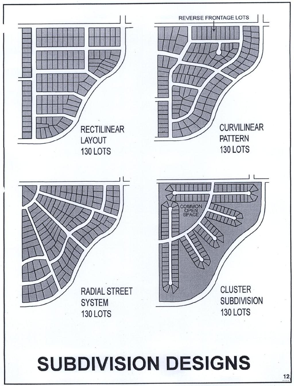
14 SUBDIVISION DESIGNS 14

15 TYPES OF LOTS 15
16 CHAPTER 5 DESIGN REQUIREMENTS FOR STREETS AND OTHER RIGHTS-OF-WAY Section: Conformance to Major Road Plan Continuation of Existing Streets Street Connections Street Elevations Street Names Restriction of Access Alleys Private Streets and Reserve Strips Easements Street Right-of-Way Widths Additional Widths on Existing Streets Minimum Pavement Widths Street Grades Horizontal Curves Vertical Curves Intersections Tangents Street Jogs Conformance to Major Road Plan. All streets and features of the Major Road Plan of Dunlap, Tennessee, shall be platted by the subdivider in the location and to the dimensions indicated on the Major Road Plan Continuation of Existing Streets. Existing streets shall be continued at the same or greater width, but in no case less than the required width Street Connections. Where proposed streets intersect existing streets, the developer must make the connection at his expense and meet all street design requirements set forth in these regulations. Where proposed streets connect with a city or state highway, the developer shall obtain authorization from the city or state highway department granting approval of the design of the proposed road connection Street Elevations. The planning commission may require profiles and elevations of streets in areas subject to flood. Fill may be used for streets provided such fill does not increase flood heights. Drainage openings shall be designed to not restrict the flow of water and increase flood heights. The minimum street elevation shall be no lower than the 100-year flood elevation Street Names. The street names shall require the approval of the planning commission. Streets that are in obvious alignment with existing streets shall be given the name of the existing street Restriction of Access. When a tract fronts on an arterial or highway, the planning commission may require such lots to be provided with frontage on a marginal access street or may require reverse frontage lots. 16
17 Alleys. Alleys may be required at the rear of all lots used for multi-family, commercial, or industrial developments, but shall not be provided in one- and two-family residential developments unless the subdivider provides evidence satisfactory to the planning commission of the need for alleys Private Streets and Reserve Strips. (Amended 6/24/2013) There shall be no private streets or private vehicular access easements platted in any subdivision or deeded to any property owner unless it meets the standards contained herein and has been approved by the Dunlap Municipal Planning Commission. Depending on the number of lots that will be served by a private right-of-way, there are several options that will allow access to property that otherwise does not front upon a public street. In all cases, the right-of-way whether it be for a private road or private vehicular access easement shall be no less than fifty (50) feet in width. 1. Access Serving 1-2 Lots In cases where proposed lots will not front upon a public street, a private vehicular access easement of at least fifty (50) feet in width may be platted to serve the newly created lots. The deeds must reference the easement, which shall allow for access and the extension of utilities. The deeds must also state that access will be granted in perpetuity until such time as access can be provided by a public street or by an extension of real property that would connect each individual subdivided lot to a public street. 2. Access Serving 3-4 Lots In cases where proposed lots will not front upon a public street, a private road may be constructed to serve the proposed lots. A right-of-way or easement of at least fifty (50) feet shall be provided. A road surface of at least two (2) inches of compacted crusher run gravel that is at least sixteen (16) feet wide shall also be provided. The deeds must reference the private road, which shall allow for access and the extension of utilities. The deeds must also sate that access will be granted in perpetuity until such time as access can be provided by a public street or by an extension of real property that would connect each individual subdivided lot to a public street. 3. Access Serving 5 or More Lots In cases where proposed lots will not front upon a public street, a private road may be constructed to serve the proposed lots. A right-of-way or easement of at least fifty (50) feet shall be provided. The surface of the road shall be the same as required for newly constructed streets in the City of Dunlap, which are contained in these regulations. The deeds must reference the private road, which shall allow for access and the extension of utilities. The deeds must also sate that access will be granted in perpetuity until such time as access can be provided by a public street or by an extension of real property that would connect each individual subdivided lot to a public street Additional Requirements for Private Roads and Private Vehicular Access Easements. (Amended 6/24/2013) a. Private road and private vehicular access easement improvements shall be maintained either by the owner, a legally established home-owner s association, or other similar group approved by the Planning Commission, 17
18 and not by the Government of the City of Dunlap. The legal documents establishing the private right-of-way shall be submitted with the final plat for review and approval and shall be recorded with the final plat and deed for each property. b. All desired utilities are the responsibility of the owner, a legally established home-owner s association, or other similar group approved by the Planning Commission. The Government of the City of Dunlap is not responsible for providing services beyond the limits of a public road. c. If, at any future date, a private road or private vehicular access easement is submitted for acceptance as a public street, it shall first be submitted to the Planning Commission for review. In considering the easement for approval as a public street, the Planning Commission shall require the improvements to the easements to meet the minimum street construction standards in effect at the time the request for public acceptance is made. Once the street has been built to the appropriate standard it shall be inspected by the Dunlap Field Superintendent prior to a request being made to the Dunlap Board of Mayor and Commissioners for acceptance into the City s street system. d. The private road or private vehicular access easement must have access to a public street, but shall not connect between two (2) or more public roads. e. No lot shall be bought or sold, or deed transferred, until all private road or private vehicular access easement requirements have been met Easements. Easements having a minimum width of ten (10) feet shall be provided where deemed necessary for utility lines and underground mains and cables. Easements of the same or greater width shall be required along the lines of, or across, lots where necessary for the extension of existing or planned utilities. Where a subdivision is traversed by a watercourse, drainage-way, channel, or stream, there shall be provided a storm water or drainage easement of adequate width. 18
19 Street Right-of Way Widths. The right-of-way width shall be the distance across a street from property line to property line. Minimum street right-of-way widths shall be as follows: 1. Arterials feet or as may be required 2. Collector Streets feet 3. Local Streets feet 4. Marginal Access Streets feet 5. Alleys feet 6. Cul-de-sacs feet Cul-de-sacs or dead-end streets shall not be greater in length than one thousand two hundred (1,200) feet. They shall be provided at the closed end with a turn-around having a property line radius of at least fifty (50) feet with an outside pavement radius of at least forty (40) feet (thirty [30] feet where shoulders are used). 7. Temporary Cul-de-sacs feet Where the opinion of the planning commission it is desirable to provide for street access to adjoining property, proposed streets shall be extended by dedicating to the boundary of such property. Such dead-end streets shall be provided with a temporary turn-around approved by the planning commission. Adequate rights-of-way shall be dedicated to connect with any temporary dead-end street adjoining the subdivision Additional Width on Existing Streets. Subdivisions that abut existing streets shall dedicate additional right-of-way to meet the minimum street requirements as follows: 1. The entire right-of-way shall be dedicated where any part of the subdivision is on both sides of the existing street. 2. Where the subdivision is located on one side of an existing street, the amount of dedicated right-of-way shall be dedicated: (A) (B) If the land across the roadway from the proposed subdivision has not been subdivided or developed, the subdivider is only required to dedicate one-half of the required right-of-way, measured from the centerline of the existing roadway. If the land across the roadway has been subdivided or developed, the subdivider is required to provide enough additional right-ofway on his side of the roadway to bring the total right-of-way to the required width in no case shall the right-of-way be less than forty (40) feet. 3. In cases where the rights-of-way in excess of fifty (50) feet are required, additional widths shall be reserved, and when used, just compensation therefore shall be paid by the condemning authority. 19
20 Minimum Pavement Widths. The required pavement widths will vary with the character of the building development and the amount of traffic encountered. (Amended 4/28/03) Minimum Surface Widths shall be as follows: 1. Arterial Streets.. 48 feet 2. Collector Streets 30 feet 3. Local Streets with 3 shoulders 20 feet Curbed 22 feet Local Streets includes streets of lower classification. 4. Cul-de-sacs same as local, with 40 foot pavement width for turn around *Greater widths may be required by the DMPC. Each subdivision plat will be reviewed on a case-by-case basis. The planning commission reserves the right to increase the minimum surface width if through its plat review the planning commission finds the type of development proposed warrants a larger minimum surface width Street Grades. Streets shall be planned to conform to existing topographic conditions. Grade may exceed twelve (12) percent for a distance up to four hundred (400) feet, but may not exceed fourteen (14) percent. Minimum street grade shall be 0.5 percent (this includes the lateral grade across the pavement to allow for an adequate 'crown' for drainage purposes) Horizontal Curves. Where a deflection angle of more than ten (10) degrees in the alignment of a street occurs, the street shall have a centerline radius of not less than the following. 1. Arterials feet 2. Collectors feet 3. All Other Streets feet Vertical Curves. Every change in grade shall be connected by a vertical curve constructed so as to afford a minimum sight distance of two hundred (200) feet. Sight distance shall be measured from four and one-half (4 1/2) feet above the pavement, to an object four (4) inches high on the pavement. Profiles of all streets, showing natural and finished grades drawn to a scale of not less than one (1) inch equals one hundred (100) feet horizontally and one (1) inch equals twenty (20) feet vertically, may be required Intersections. Street intersections shall be as nearly at right angles as is possible, and no intersections shall be at an angle of less than sixty (60) degrees. Curb radii at street intersections shall not be less than twenty (20) feet, and where the angle of a street intersection is less than seventy-five (75) degrees, the planning commission may require a greater curb radius. 20
21 Tangents. Between reverse curves, there shall be a tangent having a length of not less than one hundred (100) feet when used with minimum radius Street Jogs. Street jogs with centerline offsets of less than one hundred fifty (150) feet shall not be allowed. 21
22 STREET JOGS/INTERSECTIONS 22
23 HORIZONTAL CURVE/STREET PROFILE 23
24 CHAPTER 6 PRELIMINARY PLATTING REQUIREMENTS Section: Pre-Application Review Preliminary Plat Approval Use of Preliminary Plat and Expiration Timely Action and Automatic Approval Preliminary Plat Specifications Certificate of Approval Pre-Application Review. (Amended 6/24/2013) The subdivider is urged to consult early with the Dunlap Municipal Planning Commission and its staff as well as the Sequatchie County Health Department. The subdivider may submit sketch plans and data showing existing conditions within the site and its vicinity and the proposed layout and development of the subdivision. No fee shall be charged for the pre-application review and no formal application shall be required. At this stage, the subdivider should consult with any lending institutions participating in the financing of his proposed development. The subdivider should contact the Federal Housing Administration (FHA) or the Farmers Home Administration (FmHA) regarding mortgage insurance on houses that may be built in the proposed subdivision. It is important that the subdivider submit a sketch plat to the county health department prior to the meeting when he will ask the planning commission for preliminary approval Preliminary Plat Approval. (Amended 6/24/2013) The following procedures are required for all subdivisions consisting of five (5) or more lots or when new streets and/or utilities such as water or sewer are to be installed. The following steps shall be required prior to submitting a final plat to the Dunlap Planning Commission Application for Preliminary Plat Approval. (Amended 6/24/2013) The subdivider shall inform the Dunlap Codes Enforcement Officer of a request for preliminary plat approval at least 10 business days prior to a scheduled planning commission meeting. A preliminary plat shall be submitted no later than 8 business days prior to a scheduled planning commission meeting in order to be included on the agenda, and so that the planning staff will have adequate time to review the proposed plat. In no case shall the Planning Commission review a preliminary plat for which notification is given on the date of the regularly scheduled meeting. The subdivider shall distribute one copy of the preliminary plat to each of the following individuals or agencies for their review and records: 1) planning commission; 2) Dunlap Field Superintendent; 3) county health department; 4) city road commissioner; and 5) the city planner Review of Preliminary Plat. (Amended 6/24/2013) The planning commission shall check the plat for conformance to local regulations governing land development including but not limited to the Dunlap Subdivision Regulations and Zoning Ordinance. The planning commission shall then give approval or disapproval of the preliminary plat. A notation of the action shall be made in the minutes of the meeting. The minutes shall contain the reasons for disapproval or the conditions for approval. One (1) copy shall be returned to the subdivider or his agent, one (1) copy added to the records of the planning commission, and one (1) copy given to the city planner. 24
25 The planning commission shall act on the preliminary plat within the timeframe prescribed by Tennessee Code Annotated Use of Preliminary Plat and Expiration. Preliminary plat approval only indicates approval of the layout as a guide to the preparation of the final plat. Preliminary plat approval shall expire after a period of one (1) year unless an extension of time is applied for by the subdivider or his representative and approved by the planning commission. Approval of the preliminary plat does not constitute approval of the final plat Timely Action and Automatic Approval. (Amended 6/24/2013) Once a preliminary plat has been presented at a planning commission meeting, the planning commission shall act upon the preliminary plat within the timeframe specified in Tennessee Code Annotated Preliminary Plat Specifications The following specifications are required on the preliminary plat Scale. The preliminary plat shall be legibly drawn at a scale not smaller than one hundred (100) feet equals one (1) inch Sheet Size. Sheet size shall be eighteen (18) by twenty-four (24) inches from trim lines, with a two (2) inch binding edge on the long side. If the complete plat cannot be shown on one sheet of this size, it may be shown on more than one sheet with an index map on a separate sheet of the same size Ground Elevations. Contours shall be shown at vertical intervals of not more than five (5) feet, except when waived by the planning commission or the Sequatchie County Department of Public Health and Environment Information to be Provided on the Preliminary Plat. The preliminary plat shall contain the following information. 1. Name of subdivision. 2. Name and address of owner of record, subdivider, and surveyor. 3. North point, graphic or bar scale, and date plat was designed. 4. Vicinity map showing location and acreage of subdivision. 5. Exact boundary lines of the tract by bearings and distances. 6. Names of all adjoining property owners and/or subdivisions. 7. Existing streets, buildings, railroads, culverts, utilities and easements on and adjacent to the tract, as well as natural features such as sink holes, watercourses, and rock outcroppings. 8. Proposed design including streets and alleys with proposed street names, lot lines with dimensions, easements, land to be reserved or dedicated for public uses. 9. Consecutive lot numbers. 25
26 10. Plans of all proposed utility layouts and easements showing connections to the existing or any proposed utility systems. 11. Minimum building front yard setback lines. 12. The present zoning classification on the land to be subdivided and on the adjoining land. 13. Contour lines at least for every five (5) foot change in elevation. 14. Street centerline profiles 15. Street cross-sections profiles or drainage purposes. 16. If any portion of the land being subdivided is subject to flood, the following criteria shall be met: (A) (B) (C) (D) The flood plain limits shall be shown. Public utilities and facilities shall be constructed so as to minimize flood damage. Adequate drainage shall be provided. The developer of a subdivision greater than fifty (50) lots or five (5) acres shall develop base flood elevation data for the subdivision Certificate of Preliminary Plat Approval. The following certificate shall be attached to the preliminary plat and shall have all required signatures prior to the commencement of improvements to the subdivision. CERTIFICATE OF APPROVAL OF PRELIMINARY PLAT Pursuant to the Subdivision Regulations of Dunlap, Tennessee, all of the requirements of preliminary approval have been fulfilled. Therefore, the "Preliminary Plat of Subdivision" has been approved by the Dunlap Municipal Planning Commission on, 19, subject to the following modifications: This approval does not constitute approval of a final plat. This Certificate of Preliminary Approval shall expire and be null and void on, 19 (one year from date of approval). Variances granted (if any): Signed: Secretary, Dunlap Municipal Planning Commission 26
27 PRELIMINARY PLAT 27
28 CHAPTER 7 IMPROVEMENTS PREREQUISITE TO FINAL PLAT APPROVAL Section: Improvements Monuments Grading Installation of Utilities Street or Road Base Pavement Storm Drainage Water Service Sewage Disposal Guarantee In Lieu of Completed Improvements Improvements. Prior to the approval of a final plat, the subdivider shall be required to install the improvements set forth in sections through of these regulations Monuments. Concrete monuments four (4) inches in diameter or four (4) inches square, three (3) feet long, with a flat top, shall be set at all road corners and at all points where the road lines intersect the exterior boundaries of the subdivision. The top of the monument shall have an indented cross to properly identify the location and shall be set one (1) inch above the finished grade. Concrete monuments shall be set with reference to section lines, recognized geological marks, or other acceptable surveying techniques. All other lot corners shall be marked with iron pin not less than three-fourth (3/4) inch in diameter and twenty-four (24) inches long and driven so as to be one (1) inch above the finished grade. Lot corners fronting on public roads shall be marked with numbered wooden lot stakes Grading. All streets, roads, and alleys shall be graded to the required cross section. Where roads are constructed under or adjacent to existing electric transmission lines, the fifteen (15) foot easement from any transmission line structure and all grading for the road shall be done in a manner which will not disturb the structure or result in erosion endangering the structure. In the case of electric transmission lines, the clearance from the road to the nearest conductor shall meet the requirements of the National Safety Code. 1. Preparation. The entire right-of-way areas shall be first cleared of all stumps, roots, brush, and other objectionable materials. 2. Cuts. All tree stumps, boulders, and other obstructions shall be removed to a depth of two (2) feet below the sub-grade. Rock, when encountered, shall be scarified to a depth of twelve (12) inches below the sub-grade. This provision applies to the roadway and not necessarily to the entire right-of-way width. 3. Fill. All suitable material from roadway cuts may be used in the construction of fills, approaches, or at other places as needed. Excess materials, including organic materials, soft clays, etc., shall be removed 28
Table of Contents CHAPTER 1 INTRODUCTION
 Table of Contents CHAPTER 1 INTRODUCTION Section: 01.00. Preamble 01.01. Purpose 01.02. Enactment Clause 01.03. Title 01.00. Preamble. PURSUANT TO THE AUTHORITY SET FORTH IN SECTION 13-4-301 THROUGH SECTION
Subdivision Regulations. for the. City of Dayton, Tennessee
 Subdivision Regulations for the City of Dayton, Tennessee Prepared for the Dayton Municipal Planning Commission April, 1996 (as amended through June, 2006) by the Local Planning Assistance Office 540 McCallie
CHAPTER 1 INTRODUCTION
 CHAPTER 1 INTRODUCTION Section 01.01. Preamble 01.02. Purpose 01.03. Enactment Clause 01.04. Title Section 01.01. Preamble. REGULATIONS CONTROLLING THE SUBDIVISION OF LAND IN DAYTON, TENNESSEE; REQUIRING
THE COUNTY BOARD OF SUPERVISORS OF THE COUNTY OF DOUGLAS DOES ORDAIN AS FOLLOWS:
 8.1 SUBDIVISION CONTROL ORDINANCE THE COUNTY BOARD OF SUPERVISORS OF THE COUNTY OF DOUGLAS DOES ORDAIN AS FOLLOWS: SECTION I. GENERAL INTERPRETATION This ordinance shall not repeal, impair or modify private
-MENDOCINO COUNTY PLANNING AND BUILDING SERVICES- DIVISION OF LAND REGULATIONS TITLE 17
 ARTICLE VI -- GENERAL REGULATIONS AND PROVISIONS Sec. 17-50. Sec. 17-51 General Plan. Sec. 17-52 Lot and Block Design and Configuration. Sec. 17-53 Lot Access. Sec. 17-54 Private Roads. Sec. 17-55 Water
610 LAND DIVISIONS AND PROPERTY LINE ADJUSTMENTS OUTSIDE A UGB
 ARTICLE VI: LAND DIVISIONS AND PROPERTY LINE ADJUSTMENTS VI-21 610 LAND DIVISIONS AND PROPERTY LINE ADJUSTMENTS OUTSIDE A UGB 610-1 Property Line Adjustments (Property Line Relocation) A property line
SUBDIVISION REGULATIONS WINCHESTER, TENNESSEE ADOPTED JANUARY 18, 1971
 SUBDIVISION REGULATIONS WINCHESTER, TENNESSEE ADOPTED JANUARY 18, 1971 AMENDED THROUGH JULY 31, 2016 THE SUBDIVISION REGULATIONS OF WINCHESTER, TENNESSEE, AND ITS PLANNING REGION ADOPTED: JANUARY 18,
ARTICLE 15. RULES, REGULATIONS AND DEFINITIONS
 ARTICLE 15. RULES, REGULATIONS AND DEFINITIONS Section 1. Interpretation and Construction: The following rules and regulations regarding interpretation and construction of the Ulysses-Grant County, Kansas,
SUBDIVISION DESIGN PRINCIPLES AND STANDARDS
 SECTION 15-200 SUBDIVISION DESIGN PRINCIPLES AND STANDARDS 15-201 STREET DESIGN PRINCIPLES 15-201.01 Streets shall generally conform to the collector and major street plan adopted by the Planning Commission
SUBDIVISION REGULATIONS
 SUBDIVISION REGULATIONS Greene County, Tennessee Greene County Regional Planning Commission April 1972 Amended January, 2013 Prepared for: GREENE COUNTY REGIONAL PLANNING COMMISSION James Carter, Chairman
Planning Grant Contract No. SC P-8 (G) South Carolina State Development Board Division of Community Planning of the Development and Research Center
 South Carolina State Development Board Division of Community Planning of the Development and Research Center") SUBDIVISION REGULATIONS Prepared for: Planning and Zoning Commission Anderson, South Carolina The preparation of this report was financed in part through an Urban Planning grant from the Department of
SUBDIVISION REGULATIONS Prepared for: Planning and Zoning Commission Anderson, South Carolina The preparation of this report was financed in part through an Urban Planning grant from the Department of
CITY OF HOBBS ORDINANCE NO..
 CITY OF HOBBS ORDINANCE NO.. AN ORDINANCE TO AMEND TITLE 16 OF THE HOBBS MUNICIPAL CODE IN ITS ENTIRETY. BE IT ORDAINED BY THE GOVERNING BODY OF THE CITY OF HOBBS, NEW MEXICO, that the following Chapter
Chapter 22 LAND USE* Article III. Subdivisions
 Chapter 22 LAND USE* Article III. Subdivisions Sec. 22-256. Authority to Regulate. Sec. 22-257. Scope; plat required. Sec. 22-258. Definitions. Sec. 22-259. Interpretations and Meanings. Sec. 22-260. Procedure
SUBDIVISION REGULATIONS. Meigs County, Tennessee. Prepared For The. Meigs County Regional Planning Commission
 SUBDIVISION REGULATIONS Meigs County, Tennessee Prepared For The Meigs County Regional Planning Commission APRIL 1994 (Amended through October, 2007) (Amended through October 2011) (Amended through December
SUBDIVISION STANDARDS BEDFORD COUNTY, TENNESSEE. Certified by the Bedford County Regional Planning Commission. November 20, 1997.
 SUBDIVISION STANDARDS OF BEDFORD COUNTY, TENNESSEE Certified by the Bedford County Regional Planning Commission November 20, 1997 Effective Date November 24, 1997 Page 1 of 39 TABLE OF CONTENTS ARTICLE
SUBDIVISION REGULATIONS ANDERSON COUNTY TENNESSEE. As Adopted by Anderson County Regional Planning Commission NOVEMBER 2007
 SUBDIVISION REGULATIONS OF ANDERSON COUNTY TENNESSEE As Adopted by Anderson County Regional Planning Commission NOVEMBER 2007 1 TABLE OF CONTENTS ARTICLE I PURPOSE, AUTHORITY, AND JURISDICTION 4 A. Purpose
SECTION 11 PLANNING & ZONING. SUBDIVISION CONTROL Ord. No. 176 Adopted: December 10, 1969
 SUBDIVISION CONTROL Ord. No. 176 Adopted: December 10, 1969 An ordinance enacted under Act 288, Public Acts of 1967, as amended, of the State of Michigan establishing regulations governing the subdivision
ARTICLE 3 DEFINITIONS
 Sections: 3-1 Rules of Construction 3-2 Definitions ARTICLE 3 DEFINITIONS SECTION 3-1 RULES OF CONSTRUCTION 3-101. a. The language set forth in these regulations shall be interpreted in accordance with
WASCO COUNTY PRELIMINARY SUBDIVISION APPLICATION
 WASCO COUNTY PRELIMINARY SUBDIVISION APPLICATION DETAILED SPECIFIC WRITTEN REQUEST File Number: SDV- Number of Proposed Lots & their Dimensions: PRELIMINARY SUBDIVISION PLAN REQUIREMENTS The approval of
SUBDIVISION REGULATIONS
 SUBDIVISION REGULATIONS Adopted the 14th day of January, 1970 Updated through December 2015 Article I. - Purpose and Title Sec. 1. Purpose. Sec. 2. Title. Article II. - Authority and Jurisdiction Sec.
CHAPTER 5. Subdivisions Regulations
 CHAPTER 5 Subdivisions Regulations 10-5-1 Introduction and Purpose 10-5-2 Definitions 10-5-3 General Provisions 10-5-4 Procedure for Submitting Subdivisions 10-5-5 Design Standards; Streets and Lots 10-5-6
CITY OF ATHENS, TENNESSEE MINIMUM SUBDIVISION REGULATIONS
 CITY OF ATHENS, TENNESSEE MINIMUM SUBDIVISION REGULATIONS MINIMUM SUBDIVISION REGULATIONS Athens, Tennessee Prepared for the City of Athens and the Athens Planning Region By the Athens Regional Planning
APPENDIX A SUBDIVISIONS*
 APPENDIX A SUBDIVISIONS* * Editors Note: Printed herein are the subdivision regulations adopted by the county commission on August 21, 2007, and amended through December 18, 2007. These regulations replace
TOWNSHIP OF BORDENTOWN LAND DEVELOPMENT APPLICATION CHECKLIST. General Requirements for all Applications
 TOWNSHIP OF BORDENTOWN LAND DEVELOPMENT APPLICATION CHECKLIST This CHECKLIST has been adopted in accordance with Section 25:807 of the Land Development Ordinance of the Township of Bordentown and will
ARTICLE 23 CONDOMINIUM STANDARDS
 ARTICLE 23 CONDOMINIUM STANDARDS Section 23.01 Intent. The intent of this Article is to provide regulatory standards for condominiums and site condominiums similar to those required for projects developed
SUBDIVISION PROCEDURES AND REGULATIONS. for the Town of Stratford, New Hampshire
 SUBDIVISION PROCEDURES AND REGULATIONS for the Town of Stratford, New Hampshire TABLE OF CONTENTS Page A. PRE-APPLICATION 2 B. PRELIMINARY PLAN REQUIREMENTS 3 C. PRELIMINARY PLAN REVIEW 5 Site Plan Review
I. Requirements for All Applications. C D W
 108-16.1. Application checklists. Checklist for Required Submissions to the Planning Board or Zoning Board of Adjustment of Monroe Township All required submissions are to be made to the Administrative
ARTICLE 1: GENERAL PROVISIONS
 ARTICLE 1 GENERAL PROVISIONS AN ORDINANCE REGULATING THE SUBDIVISION OF LAND PRESCRIBING STANDARDS FOR SUBDIVISIONS AND FOR THE IMPROVEMENT THEREOF, PRESCRIBING PROCEDURES FOR THE REVIEW OF PROPOSED SUBDIVISION
This Ordinance is adopted under the authority and provisions of the General Statutes of North Carolina, Article 6, Chapter 153A 121.
 Section 74, Regulations Governing Manufactured Home Parks 1. Purpose The purpose of these regulations to be known and cited as the Madison County Manufactured Home Park Ordinance is to regulate and guide
ELK RAPIDS TOWNSHIP ANTRIM COUNTY, MICHIGAN ORDINANCE NO
 ELK RAPIDS TOWNSHIP ANTRIM COUNTY, MICHIGAN ORDINANCE NO. 3-2011 AN ORDINANCE TO REPLACE THE SUBDIVISION CONTROL ORDINANCE WITH A NEW SUBDIVISION DEVELOPMENT ORDINANCE, IN ACCORD WITH THE LAND DIVISION
Application for Preliminary Plat Checklist
 Application for Preliminary Plat Checklist Note: No portion of an existing parcel may be sold or transferred to another party without first legally subdividing the property according to the City of Richmond
FINAL PLAT APPLICATION
 FINAL PLAT APPLICATION (Page 1 of 3) LEGAL OWNER(s): NAME: STREET ADDRESS OWNER(s): CITY, STATE, ZIP CODE: PHONE NUMBER: BILLING ADDRESS: NAME OF ENGINEER/SURVEYOR: Engineer/Surveyor Address, Phone: PROPERTY
SUBDIVISION APPLICATION CHECKLIST SKETCH PLAN PRELIMINARY PLAT FINAL PLAT
 RECEIVED STAMP SUBDIVISION APPLICATION CHECKLIST SKETCH PLAN PRELIMINARY PLAT FINAL PLAT A checklist of background information and submission requirements for processing of a sketch plan, preliminary plat
Table of Contents MCMINN COUNTY SUBDIVISION REGULATIONS TITLE ARTICLE 1 SHORT TITLE, PREAMBLE AND ENACTMENT CLAUSE
 Table of Contents MCMINN COUNTY SUBDIVISION REGULATIONS TITLE REGULATIONS CONTROLLING THE SUBDIVISION OF LAND IN MCMINN COUNTY, TENNESSEE: REQUIRING AND REGULATING THE PREPARATION AND PRESENTATION OF PRELIMINARY
SUBDIVISION REGULATIONS
 Adopted October 1, 1963 ARTICLE I PREAMBLE AND TITLE SECTION 101. Preamble Whereas it is deemed necessary to promulgate certain regulations in order to improve and protect the interests of the Town of
TITLE 25. SUBDIVISIONS 1
 TITLE 25. SUBDIVISIONS 1 Sections: Chapter 25.01 General Provisions. Section 25.01.01 Short Title. Section 25.01.02 Purposes. Section 25.01.03 Final Plat Required Before Lots May be Sold. Section 25.01.04
LAND DEVELOPMENT AND SUBDIVISION ORDINANCE
 LAND DEVELOPMENT AND SUBDIVISION ORDINANCE (CHAPTER 18 OF THE MUNICIPAL CODE OF ORDINANCES) TO BE IMPLEMENTED BY: THE CITY OF FLORENCE July 2007 TABLE OF CONTENTS ARTICLE I: IN GENERAL... 1 1.1 Title...
APPLICATION PROCEDURE
 ANTRIM PLANNING BOARD P. O. Box 517 Antrim, New Hampshire 03440 Phone: 603-588-6785 FAX: 603-588-2969 APPLICATION FORM AND CHECKLIST FOR MINOR OR MAJOR SITE PLAN REVIEW File Date Received By APPLICATION
SUBDIVISION REGULATIONS
 CHAPTER 41 SUBDIVISION REGULATIONS 41.01 Short Title 41.17 Presentation to Commission or Board of Supervisors 41.02 Purpose 41.18 Subdivision Classified 41.03 Application 41.19 Plats Required 41.04 Recording
PART 19 SUBDIVISION DEVELOPMENT CHAPTER 1 SUBDIVISION REGULATIONS ARTICLE A GENERAL PROVISIONS ARTICLE B DESIGN STANDARDS
 19-101 Purpose and intent. 19-102 Short title. 19-103 Authority. 19-104 Jurisdiction. 19-105 Definitions. PART 19 SUBDIVISION DEVELOPMENT CHAPTER 1 SUBDIVISION REGULATIONS ARTICLE A GENERAL PROVISIONS
13-2 SUBDIVISION PLANS AND PLATS REQUIRED EXCEPTIONS Subdivision Plats Required To be Recorded
 ARTICLE XIII SUBDIVISIONS 13-1 INTENT AND PURPOSE 13-1-1 Intent: It is the intent of the County Commission through the adoption of this Article to more fully avail itself of the power granted under 17-27-601
PRELIMINARY PLATS. The following documents are provided as required by the City of Conroe for use in the above titled platting submittals:
 Public Works Engineering Division CITY OF CONROE PRELIMINARY PLATS The following documents are provided as required by the City of Conroe for use in the above titled platting submittals: Submittal Questionnaire
Section Preliminary Plat Checklist and Application Forms
 Section 201 - Preliminary Plat Checklist and Application Forms PRELIMINARY SUBDIVISION PLAT REVIEW PROCESS CHART PRELIMINARY SUBDIVISION PLAT APPLICATION PRELIMINARY PLAT REVIEW CHECKLIST CITY OF NAMPA
SUBDIVISION REGULATIONS. 1. SHORT TITLE. This chapter shall be known and may be cited as "The City of Graf, Iowa, Subdivision Control Ordinance.
 GENERAL PROVISIONS SUBDIVISION REGULATIONS 1. SHORT TITLE. This chapter shall be known and may be cited as "The City of Graf, Iowa, Subdivision Control Ordinance." 2. PURPOSE. The purpose of this Ordinance
SUBDIVISION STANDARDS OF. Marshall County, Tennessee, Regional Planning Commission (hereafter referred to as the planning commission).
.") SUBDIVISION STANDARDS OF Marshall County, Tennessee, Regional Planning Commission (hereafter referred to as the planning commission). A. Purpose ARTICLE I PURPOSE, AUTHORITY, AND JURISDICTION Land subdivision
SUBDIVISION STANDARDS OF Marshall County, Tennessee, Regional Planning Commission (hereafter referred to as the planning commission). A. Purpose ARTICLE I PURPOSE, AUTHORITY, AND JURISDICTION Land subdivision
ARTICLE 5 MINOR SUBDIVISION/LAND DEVELOPMENT
 ARTICLE 5 MINOR SUBDIVISION/LAND DEVELOPMENT SECTION 501 ONLY FINAL PLAN REQUIRED The classification of a proposed subdivision as a "Minor Subdivision" shall only require the submission, review and approval
BRIDGETON SUBDIVISION APPLICATION CHECKLIST
 APPLICATION NAME AND # CHECKLIST COMPLETED BY: DATE: Signature and printed name BRIDGETON SUBDIVISION APPLICATION CHECKLIST TO SUBDIVISION APPLICANTS: The attached checklist is to assist you in the submission
ARTICLE VI. SUBDIVISION STANDARDS, PUBLIC
 ARTICLE VI. SUBDIVISION STANDARDS, PUBLIC IMPROVEMENTS, AND DESIGN REQUIREMENTS ARTICLE VI. SUBDIVISION STANDARDS, PUBLIC IMPROVEMENTS, AND DESIGN REQUIREMENTS DIVISION 1. GENERAL PROVISIONS Sec. 21-6100.
ARTICLE 24 PRIVATE ROAD, SHARED PRIVATE DRIVEWAY AND ACCESS EASEMENT STANDARDS
 ARTICLE 24 PRIVATE ROAD, SHARED PRIVATE DRIVEWAY AND ACCESS EASEMENT STANDARDS SECTION 24.00 INTENT AND PURPOSE The standards of this Article provide for the design, construction and maintenance of private
VERGENNES TOWNSHIP, KENT COUNTY, MICHIGAN ORDINANCE AMENDMENT Ordinance Adopted May 17, 2004
 VERGENNES TOWNSHIP, KENT COUNTY, MICHIGAN ORDINANCE AMENDMENT Ordinance 2004-8 Adopted May 17, 2004 Private Road Ordinance Amendments An ordinance to amend portions of Section 202.000 Private Roads. The
ARTICLE 5 GENERAL REQUIREMENTS
 5.1 SUITABILITY OF THE LAND ARTICLE 5 GENERAL REQUIREMENTS 5.1.1 Land subject to flooding, improper drainage or erosion, and land deemed to be unsuitable for development due to steep slope, unsuitable
SUBDIVISION REGULATIONS
 166.01 Purpose 166.11 Final Plat Attachments 166.02 Definitions 166.12 Action by the Council 166.03 Platting Required 166.13 General Requirements 166.04 Procedure 166.05 Requirements of Preliminary Plat
THE UNINCORPORATED AREA OF CLARKE COUNTY, IOWA TABLE OF CONTENTS
 ORDINANCE #11 THE UNINCORPORATED AREA OF CLARKE COUNTY, IOWA TABLE OF CONTENTS ARTICLE I:-------------------------------------------------------------------------GENERAL PROVISIONS ARTICLE II:--------------------------------------------------------------------------------------DEFINITIONS
DIVISION 2 - CONSTRUCTION PLAN AND MISCELLANEOUS REQUIREMENTS
 DIVISION 2 - CONSTRUCTION PLAN AND MISCELLANEOUS REQUIREMENTS 2.1 Required Plan Sheets 2.2 Drawing Requirements 2.3 Graphic Standards 2.4 Easements 2.5 Utility Locations 2.6 Private Facility Locations
ORDINANCE NO. 41. PRIVATE ROAD ORDINANCE As Amended Through April 10, 2008
 ORDINANCE NO. 41 PRIVATE ROAD ORDINANCE As Amended Through April 10, 2008 An Ordinance to protect the health, safety, and general welfare of the inhabitants of Port Sheldon Township. The Township of Port
SECTION 10.7 R-PUD (RESIDENTIAL PLANNED UNIT DEVELOPMENT) ZONE
 ZONE") Article X Zones 10-20 SECTION 10.7 R-PUD (RESIDENTIAL PLANNED UNIT DEVELOPMENT) ZONE A. PURPOSE AND INTENT: The R-PUD Residential PUD Zone is intended to provide alternative, voluntary zoning procedures
Article X Zones 10-20 SECTION 10.7 R-PUD (RESIDENTIAL PLANNED UNIT DEVELOPMENT) ZONE A. PURPOSE AND INTENT: The R-PUD Residential PUD Zone is intended to provide alternative, voluntary zoning procedures
WARREN COUNTY, IOWA CHAPTER 46 CHAPTER 46 SUBDIVISION REGULATIONS
 TITLE V- PROPERTY AND LAND USE CHAPTER 46 SUBDIVISION REGULATIONS 46.01 Title and Jurisdiction 46.09 Subdivision Design Standards 46.02 Definitions 46.10 Preliminary Plat Requirements 46.03 Filing Process
MAJOR SUBDIVISION PRELIMINARY PLAT CHECKLIST
 TOWNSHIP OF EGG HARBOR PLANNING BOARD/ZONING BOARD OF ADJUSTMENT 3515 BARGAINTOWN ROAD EGG HARBOR TOWNSHIP, NJ 08234 MAJOR SUBDIVISION PRELIMINARY PLAT CHECKLIST The following checklist is designed to
E L M E R B O R O U G H L A N D U S E B O A R D APPLICATION COVER SHEET (to be completed for all applications and appeals)
") E L M E R B O R O U G H L A N D U S E B O A R D APPLICATION COVER SHEET (to be completed for all applications and appeals) 1. Name(s): 2. Address: 3. Telephone Number(s): 4. E-mail: 5. Owner Name(s) (if
E L M E R B O R O U G H L A N D U S E B O A R D APPLICATION COVER SHEET (to be completed for all applications and appeals) 1. Name(s): 2. Address: 3. Telephone Number(s): 4. E-mail: 5. Owner Name(s) (if
LAND DEVELOPMENT REGULATIONS CITY OF GEORGETOWN, SOUTH CAROLINA
 LAND DEVELOPMENT REGULATIONS CITY OF GEORGETOWN, SOUTH CAROLINA AN ORDINANCE GOVERNING THE SUBDIVISION OF LAND WITHIN THE CITY KIMITS OF GEORGETOWN, SOUTH CAROLINA, AND PROVIDING FOR DESIGN STANDARDS,
CHAPTER 23 SUBDIVISIONS. Article 1. General Provisions. Article 2. Administration. Division 1. General Provisions.
 CHAPTER 23 SUBDIVISIONS Article 1. General Provisions. Section 23-1. Section 23-2. Section 23-3. Section 23-4. Section 23-5. Title. Scope of chapter. Definitions. Penalty. Appeals. Article 2. Administration.
REGULATIONS SWEETWATER, TN
 SUBDIVISION REGULATIONS SWEETWATER, TN AMENDED AND CODIFIED JULY 2009 SUBDIVISION REGULATIONS OF SWEETWATER, TN AND ITS PLANNING REGION TABLE OF CONTENTS CHAPTER PAGE ARTICLE I ARTICLE II A. Purpose...................................................
TITLE 18 Subdivisions
 TITLE 18 Subdivisions ADMINISTRATION: 18.02 General Provisions 2 18.04 Definitions 6 18.06 Exceptions to Requirements 12 18.08 Enforcement 14 DIVISIONS OF LAND: 18.20 Tentative Parcel Maps 15 18.22 Tentative
ARTICLE XVI SUBDIVISION DEVELOPMENT
 ARTICLE XVI SUBDIVISION DEVELOPMENT 16.0 The division of land into 4 or more lots that will require the construction or extension of public streets, water or sanitary sewerage (other than the direct connection
MINOR SUBDIVISION PLAT CHECKLIST
 MINOR SUBDIVISION PLAT CHECKLIST Project Name: Tax ID #: Project Number: Date: _ Reviewed By: Telephone: NOTES: All lots on septic systems must comply with the Fulton County Health Department requirements
City of Bryant, Arkansas
 City of Bryant, Arkansas Subdivision Regulations Bryant Planning Commission 210 S.W. 3 rd Street Bryant, AR 72022 Phone: 501-847-5559, ext. 227 Fax: 501-847-2787 Email: ljones@cityofbryant.com City of
SUBDIVISION APPLICATION
 SUBDIVISION APPLICATION Preliminary Plat Minor Plat Final Plat Amended Plat Applicant Name: Owner (if different from applicant) Name: Company: Company: Address: Address: City, State, Zip City, State, Zip
SUBDIVISION REGULATIONS FOR THE CITY OF WEST CARROLLTON, OHIO
 SUBDIVISION REGULATIONS FOR THE CITY OF WEST CARROLLTON, OHIO 1979 Amended 1981, 1983, 2010 TABLE OF CONTENTS SECTION TITLE PAGE Preamble...1 TITLE, SCOPE, AND JURISDICTION 152.02 Title...1 152.03 Administration...1
Chapter 405 SUBDIVISION OF LAND
 Chapter 405 SUBDIVISION OF LAND Cross References As to city zoning and planning commission generally, 400.280 400.290; as to buildings generally, ch. 500; as to mobile homes and mobile home parks generally,
SUBDIVISIONS REGULATIONS PIGEON FORGE, TENNESSEE AND THE PIGEON FORGE PLANNING REGION
 SUBDIVISIONS REGULATIONS OF PIGEON FORGE, TENNESSEE AND THE PIGEON FORGE PLANNING REGION PIGEON FORGE REIGONAL PLANNING COMMISSION Bill Bradley, Chairman Robert Young Jerry Clark Jay Ogle Kevin McClure
AN ORDINANCE AMENDING THE CODE OF ORDINANCES OF THE TOWN OF TRYON. Chapter 156 Subdivision Ordinance
 AN ORDINANCE AMENDING THE CODE OF ORDINANCES OF THE TOWN OF TRYON Chapter 156 Subdivision Ordinance Chapter 156: Subdivision Regulations ARTICLE I GENERAL PROVISIONS Section 1.1 Title This Ordinance shall
DEVELOPMENT PLAN ORDINANCE
 DEVELOPMENT PLAN ORDINANCE CITY OF GLASGOW Ordinance No. 2026 SECTION A. Section 1. INTENT AND PURPOSE The purpose of this Ordinance is to establish and define development plans, which may be utilized
ARTICLE V PRELIMINARY PLAN SUBMISSION
 ARTICLE V PRELIMINARY PLAN SUBMISSION 501. Plan Requirements a. On or before the 25 th day of the month prior to a regularly scheduled meeting of the Planning Commission, the applicant shall submit two
CITY OF COZAD DAWSON COUNTY, NEBRASKA
 CITY OF COZAD DAWSON COUNTY, NEBRASKA SUBDIVISION REGULATIONS ADOPTED BY THE CITY OF COZAD, NEBRASKA Prepared By TABLE OF CONTENTS ARTICLE 1: TITLE, PURPOSE, AND DEFINITIONS... 1 SECTION 1.01 NAME AND
Preliminary Subdivision Application (Major) (Four (4) lots or more)
 (Four (4) lots or more)") Gunnison City Offices www.gunnisoncity.org 38 West Center Gunnison, Utah 84634 (435) 528 7969 Date of Application: Preliminary Subdivision Application (Major) (Four (4) lots or more) APPLICANT INFORMATION
Gunnison City Offices www.gunnisoncity.org 38 West Center Gunnison, Utah 84634 (435) 528 7969 Date of Application: Preliminary Subdivision Application (Major) (Four (4) lots or more) APPLICANT INFORMATION
CHAPTER 2 - SUBDIVISION AND PLATTING ORDINANCE OF DUBUQUE COUNTY, IOWA
 CHAPTER 2 - SUBDIVISION AND PLATTING ORDINANCE OF DUBUQUE COUNTY, IOWA Adopted February 11, 1991 Amended April 24, 1995 Amended May 10, 1999 Amended June 8, 2001 Amended October 19, 2009 Amended June 6,
Short Title. This title shall be known as the "subdivision ordinance" of the City of Denver, Iowa. (Ord (part), 1992)
, 1992)") Title 19 PLATS AND SUBDIVISIONS Chapters: 19.01 General Provisions 19.02 Minor Plats 19.03 Preliminary Plats 19.04 Final Plats 19.05 Standards and Specifications 19.06 Other Provisions Chapter 19.01 GENERAL
Title 19 PLATS AND SUBDIVISIONS Chapters: 19.01 General Provisions 19.02 Minor Plats 19.03 Preliminary Plats 19.04 Final Plats 19.05 Standards and Specifications 19.06 Other Provisions Chapter 19.01 GENERAL
Residential Subdivision Design Regulations
 Residential Subdivision Design Regulations Section 121. Street Requirements ARTICLE XII PROCEDURES FOR SUBDIVISION PLAT APPROVAL 121.4 Legal Status of Public Street required. No land dedicated as a public
CENTRAL POINT MUNICIPAL CODE
 Central Point Municipal Code CENTRAL POINT MUNICIPAL CODE A Codification of the General Ordinances of the City of Central Point, Oregon Updated since 2004 by: CODE PUBLISHING COMPANY Seattle, Washington
FINAL SUBDIVISION AND LAND DEVELOPMENT PLAN CHECKLIST. Plan Name. Applicant's Name:
 TOWNSHIP OF UPPER ST. CLAIR FINAL SUBDIVISION AND LAND DEVELOPMENT PLAN CHECKLIST Date Filed Plan Name PLC Applicant's Name: Phone Filing Date for Final Application Final Plat 114.22. FINAL APPLICATION
SUBDIVISION REGULATIONS
 SUBDIVISION REGULATIONS FOR THE CITY OF SELMER As Updated November 2007 PREPARED FOR THE SELMER MUNICIPAL-REGIONAL PLANNING COMMISSION Rascoe Rhea, Chairman Glenn Mutters, Vice Chairman Bruce Manley, Secretary
Condominium Unit Requirements.
 ARTICLE 19 CONDOMINIUM REGULATIONS Section 19.01 Purpose. The purpose of this Article is to regulate projects that divide real property under a contractual arrangement known as a condominium. New and conversion
BEAR CREEK TOWNSHIP EMMET COUNTY, MICHIGAN. PRIVATE ROAD ORDINANCE Ordinance No. 11A-99. (to replace prior Private Road Ordinance No.
 BEAR CREEK TOWNSHIP EMMET COUNTY, MICHIGAN PRIVATE ROAD ORDINANCE Ordinance No. 11A-99 (to replace prior Private Road Ordinance No. 11-99) An Ordinance to protect the health, safety, and general welfare
SUBDIVISION CONTROL, PLATTING OF LANDS, AND LAND DIVISION
 SUBDIVISION CONTROL, PLATTING OF LANDS, AND LAND DIVISION Section I. Title/Purpose. This Ordinance is entitled Subdivision Control and Platting of Lands. The purpose of this Ordinance is as follows: To
CITY OF LAKE CHARLES
 CITY OF LAKE CHARLES SUBDIVISION REGULATIONS UPDATED 04-06-05 AS AMENDED BY RESOLUTION 79-1 FEBRUARY 19, 1979 EXHIBIT A SUBDIVISION REGULATIONS CITY OF LAKE CHARLES, LOUISIANA TABLE OF CONTENTS PAGE SECTION
STATE OF MICHIGAN COUNTY OF MARQUETTE, TOWNSHIP OF NEGAUNEE LAND DIVISION, SUBDIVISION AND CONDOMINIUM ORDINANCE
 STATE OF MICHIGAN COUNTY OF MARQUETTE, TOWNSHIP OF NEGAUNEE LAND DIVISION, SUBDIVISION AND CONDOMINIUM ORDINANCE Adopted: August 8 th, 2008 Effective: August 28 th, 2008 Sec.100. Title ARTICLE I GENERAL
ARTICLE 15 - PLANNED UNIT DEVELOPMENT
 Section 15.1 - Intent. ARTICLE 15 - PLANNED UNIT DEVELOPMENT A PUD, or Planned Unit Development, is not a District per se, but rather a set of standards that may be applied to a development type. The Planned
SUBDIVISION REGULATIONS
 SUBDIVISION REGULATIONS KANAWHA COUNTY, WEST VIRGINIA KANAWHA COUNTY SUBDIVISION REGULATIONS TABLE OF CONTENTS PARAGRAPH PAGE SECTION I. AUTHORITY Purpose 101 2 Grant of Power 102 2 Effective Date 103
Chapter 3. Mobile Home Park Regulations Section 1. Intent and Application
 Chapter 3 Mobile Home Park Regulations Section 1. Intent and Application A. Statement of Authority and Intent 1. These mobile home park regulations are adopted under authority of the police power of the
APPLICATION FOR 555 Washington Street Tentative Map Red Bluff, CA Subdivision Map (530) ext Parcel Map.
 ext Parcel Map.") City of Red Bluff Community Development Department Application No. APPLICATION FOR 555 Washington Street Tentative Map Red Bluff, CA 96080 Subdivision Map (530) 527-2605 ext. 3059 Parcel Map Applicant
City of Red Bluff Community Development Department Application No. APPLICATION FOR 555 Washington Street Tentative Map Red Bluff, CA 96080 Subdivision Map (530) 527-2605 ext. 3059 Parcel Map Applicant
CHAPTER 22 SUBDIVISION AND LAND DEVELOPMENT
 CHAPTER 22 SUBDIVISION AND LAND DEVELOPMENT 22-101. Title 22-102. Legislative Intent Part 1 General Provisions 22-201. Development Permits Part 2 Administration 22-301. Fee Schedule Part 3 Fee Schedule
Subdivision Regulations Madisonville, Tennessee
 Subdivision Regulations Madisonville, Tennessee January 1999 MADISONVILLE, TENNESSEE Prepared by the MADISONVILLE MUNICIPAL/REGIONAL PLANNING COMMISSION Assisted by the Local Planning Office Tennessee
KASSON TOWNSHIP PRIVATE ACCESS ROAD ORDINANCE ORDINANCE NO (EFFECTIVE: MAY 12, 2007)
") KASSON TOWNSHIP PRIVATE ACCESS ROAD ORDINANCE ORDINANCE NO. 2007-01 (EFFECTIVE: MAY 12, 2007) An ordinance providing for the standards and specifications incident to the development of Private Motor Vehicle
KASSON TOWNSHIP PRIVATE ACCESS ROAD ORDINANCE ORDINANCE NO. 2007-01 (EFFECTIVE: MAY 12, 2007) An ordinance providing for the standards and specifications incident to the development of Private Motor Vehicle
a. provide for the continuation of collector streets and thoroughfare streets between adjacent subdivisions;
 Section 7.07. Intent The requirements of this Section are intended to provide for the orderly growth of the Town of Holly Springs and its extra-territorial jurisdiction by establishing guidelines for:
APPLICATION SUBMITTAL REQUIREMENTS FOR Tentative Parcel or Subdivision Maps
 CITY OF EL CERRITO Community Development Department Planning and Building Division 10890 San Pablo Avenue, El Cerrito, CA 94530 (510) 215-4330 FA (510) 233-5401 planning@ci.el-cerrito.ca.us APPLICATION
The following regulations shall apply in the R-E District:
 "R-E" RESIDENTIAL ESTATE DISTRICT (8/06) The following regulations shall apply in the R-E District: 1. Uses Permitted: The following uses are permitted. A Zoning Certificate may be required as provided
TOWN OF LEWISTON PLANNING BOARD APPLICATION
 TOWN OF LEWISTON PLANNING BOARD APPLICATION DESCRIPTION OF PROPOSED REQUEST: Name of Property Owner: Phone #: Name of Applicant:Phone #: Address or Location of Proposal:_SBL# Size of Parcel or Structure:Existing
PRELMINARY PLAT CHECKLIST
 PRELMINARY PLAT CHECKLIST A. All preliminary plat submitted for approval shall be prepared by a Registered Professional Land Surveyor. B. Preliminary plats must be drawn to a scale of XXX with such accuracy
ORDINANCE NO. Be it ordained by the City Council of the City of Abilene, Texas:
 ORDINANCE NO. An ordinance repealing Chapter 23, Subpart B of the Code of the City of Abilene, Texas, entitled Mobile Homes and Vacation Travel Trailers; stating the authority; setting forth the scope
BEFORE THE JOSEPHINE BOARD OF COUNTY COMMISSIONERS OF THE STATE OF OREGON
 THURSDAY, OCTOBER 23, 1958 BEFORE THE JOSEPHINE BOARD OF COUNTY COMMISSIONERS OF THE STATE OF OREGON IN THE MATTER OF THE ADOPTION OF } REGULATIONS FOR SUBDIVIDING LAND } IN JOSEPHINE COUNTY, OREGON, OUTSIDE