TOWN OF BLOOMING GROVE AND CITY OF MADISON COOPERATIVE PLAN UNDER SECTION , WISCONSIN STATUTES APRIL 20, 2006
|
|
|
- Mark Bridges
- 5 years ago
- Views:
Transcription
1 TOWN OF BLOOMING GROVE AND CITY OF MADISON COOPERATIVE PLAN UNDER SECTION , WISCONSIN STATUTES APRIL 20, 2006
2 TOWN OF BLOOMING GROVE AND CITY OF MADISON COOPERATIVE PLAN UNDER SECTION , WISCONSIN STATUTES The TOWN OF BLOOMING GROVE, a Wisconsin municipality with offices at 1880 South Stoughton Road, Madison, Wisconsin (hereinafter Town ), and the CITY OF MADISON, a Wisconsin municipal corporation with offices at 210 Martin Luther King, Jr. Blvd., Madison, Wisconsin (hereinafter City ) enter into this Cooperative Plan, (hereinafter Cooperative Plan or Plan ), subject to approval of the State Department of Administration, under authority of Section , Wisconsin Statutes. WHEREAS, Section , Wisconsin Statutes, authorizes municipalities to determine the boundary lines between themselves upon approval of a cooperative plan by the State Department of Administration; and, WHEREAS, the purpose of a cooperative plan is cited in Section (3)(b), Wisconsin Statutes, as follows: and, (b) Purpose of plan. The cooperative plan shall be made with the general purpose of guiding and accomplishing a coordinated, adjusted and harmonious development of the territory covered by the plan which will, in accordance with existing and future needs, best promote public health, safety, morals, order, convenience, prosperity or the general welfare, as well as efficiency and economy in the process of development. WHEREAS, Section (2)(a. through d.) of the Wisconsin Statutes requires that cooperative plans be organized around options for future boundary changes. These options, listed below, specify how boundary changes will occur over the boundary plan term: (a) (b) (c) (d) That specified boundary line changes shall occur during the planning period and the approximate dates by which such changes shall occur. That specified boundary line changes may occur during the planning period and the approximate dates by which the changes may occur. That required boundary line change under par. (a) or an optional boundary line change under par. (b) shall be subject to the occurrence of conditions set forth in the plan. That specified boundary lines may not be changed during the planning period. This Cooperative Plan between the Town and the City is organized around all of the options above; and, 1
3 WHEREAS, on February 18, 2005, the City and Town entered into an Intergovernmental Agreement (the Agreement ) under authority of Section , Wisconsin Statutes, to provide the basic foundation for this Cooperative Plan. The Agreement is attached hereto as Exhibit 1. As noted therein: A. The Town and the City are adjacent to one another and have a long history of disputes regarding boundaries and the provision of municipal services. Prior annexations to the Cities of Madison and Monona and the Village of McFarland have fragmented the Town, and potential and future annexations to the City make uncertain the long term viability of the Town as a separate governmental entity. The Agreement determines the Town s future with certainty, resolves potential disputes over Town territory, and establishes a basis for future governmental cooperation, providing for an orderly transition of Town territory to the City and the Village, and preserves the Town s viability while it remains a Town. B. The City desires that existing and new development in the Town north of Siggelkow Road be compatible with the City and eventually be assimilated by the City, and that all other development shall occur in the City, served by City municipal services and in compliance with applicable City development standards. C. The Town and the City desire to enter into the Agreement for the general purposes of guiding and accomplishing a coordinated, adjusted, and harmonious development of the Town and the City and transition from Town to City which will be in accordance with existing and future needs of the Parties and best promote public health, safety, morals, order, convenience, prosperity and the general welfare of the Parties and their residents as well as the efficiency and economy of the Parties. D. The Town and the City believe that: (1) The annexations and boundary changes governed by the Agreement are reasonably compatible with the characteristics and adopted plans of both Parties taking into consideration present and potential transportation, sewer, water and storm drainage facilities and other infrastructure, fiscal capacity, previous political boundaries, boundaries of school districts and shopping and social customs. (2) The annexations and boundary changes governed by the Agreement are not the result of arbitrariness and reflect due consideration of compactness of area, orderly urban growth, and efficient delivery of municipal services. (3) Entering into the Agreement should not produce significant adverse environmental consequences to the natural environment and may help reduce significant adverse environmental consequences to the natural environment by promoting the orderly and coordinated development of the lands hereby affected. 2
4 (4) The Agreement is generally consistent with current state and federal laws, shoreland zoning ordinances, municipal regulations and administrative rules that apply in the Town and the City. (5) The Agreement adequately addresses the delivery of necessary municipal services to the residents affected by the Agreement. WITNESSETH The Town of Blooming Grove and City of Madison enter into this Cooperative Plan under authority of Section , Wisconsin Statutes, and jointly Petition the State of Wisconsin Department of Administration for Plan approval, in accordance with statutory procedures and time frames. SECTION 1 PARTICIPATING MUNICIPALITIES This Plan applies to the Town of Blooming Grove and City of Madison, located in Dane County, in south central Wisconsin, which respective boundaries are shown on Exhibit 2. SECTION 2 CONTACT PERSONS The following persons and their successors are authorized to speak for their respective municipalities regarding this Cooperative Plan: For the Town of Blooming Grove: Mike Wolf, Town Administrator/Clerk/Treasurer, 1880 So. Stoughton Road, Madison, WI (608) , FAX (608) ; For the City of Madison: Bradley J. Murphy, Planning Unit Director, Room LL-100, Madison Municipal Building, Madison, WI 53703, (608) , FAX (608) SECTION 3 TERRITORY SUBJECT TO THE COOPERATIVE PLAN The territory subject to this Cooperative Plan is all of the Town territory shown on Exhibit 2. SECTION 4 ISSUES, PROBLEMS, OPPORTUNITIES This Cooperative Plan will address issues and problems and create opportunities as noted in the subsections below: A. Protect the Town and Eliminate Annexation Disputes. Like many urban towns located next to incorporated municipalities, the Town has been fragmented by numerous prior annexations to the Cities of Madison and Monona and the Village 3
5 of McFarland. Potential and future annexations to the City of Madison and Village of McFarland make uncertain the long term viability of the Town as a separate governmental entity. This Plan determines the Town s future with certainty through October 31, 2027, unless Early Termination of Protected Period is elected by Town, resolves potential disputes over Town territory, and establishes a basis for future governmental cooperation, providing for an orderly transition of Town territory to the City and the Village, and preserves the Town s viability while it remains a Town. The term and implementation phases of boundary adjustments under this Cooperative Plan recognize and attempt to balance the competing desires of existing Town residential and commercial properties with the development needs of the City and other Town property owners. Owners of most existing residential and commercial parcels desire to remain in the Town as long as possible. Owners of larger developable parcels typically seek to annex to the City or Village and develop their lands to City or Village standards and with a full range of municipal services that the Town generally does not provide in most future urban growth areas. Most significantly, the Plan provides for the eventual dissolution of the Town after a protected period of slightly more than twenty-one years. During the term of this Plan, unless otherwise provided, attachment to the City of Town parcels located north of Siggelkow Road and outside of designated Protected Areas will occur under a summary interim attachment procedure available only to willing owners. The Village of McFarland may annex Town lands south of Siggelkow Road in accordance with state law. Additionally, two Phased Attachments to the City of Town territory east of Interstate 39/90 and outside of Rustic Acres and the designated Protected Areas may occur without the consent of property owners in December, 2015 and December, 2020, respectively. On October 31, 2027, a final attachment to the City of all remaining Town lands, including any Town Protected Areas, islands and any other remaining Town territory, will occur and the Town will be permanently dissolved. B. Assure Orderly Development of City and Town Within the Plan Area. The City and Town agree that all defined development within all Town territory north of Siggelkow Road, except the defined Cooperative Development Property, shall be subject to approval by the City in accordance with the City Development Requirements. The Cooperative Development Property shall be initially developed within the Town, but on City public water and sewer utility service, in accordance with applicable City Development Requirements and pursuant to a zoning and development plan jointly prepared and approved by both the Town and the City. As more specifically provided in this Plan, the Cooperative Development Property shall remain in the Town for a period of time approximately one-half of the remaining term of this Plan, or the time between the date of occupancy of substantial new construction on the Cooperative Development Property and October 31, Then, at the designated midpoint of the remaining term of the Plan, the Cooperative Development Property will be automatically attached to the City and the City shall thereafter make two specified annual revenue sharing payments (four installments) to the Town from taxes the City collects from the Cooperative Development Property. 4
6 Capital infrastructure improvements typically require a planning, design and construction timeline of several years in length. This Cooperative Plan will enable the City to confidently plan and design for the ultimate extension of public infrastructure improvements into all of the Town territory which will eventually become attached to and develop in the City. The timely extension of such public infrastructure and the orderly phasing of urban growth and development will be greatly enhanced by the Plan. C. Establish Mechanism for Joint Planning. Historically, Town and City officials have met only infrequently, usually on a reactive basis. Subsection 11.C. of this Plan requires the Town and the City to jointly plan for the zoning and development of the 70-acre Cooperative Development Property. This joint project represents an opportunity for new development and revenue for the Town during a significant portion of its remaining existence; and, it also represents an opportunity for the City to assist the Town in approving and developing an important urban infill project that will become a part of the City. Section 13 provides for joint planning and cooperation in the management and control of storm water. Subsection 11.E. provides for Town and City cooperation to find mutually acceptable solutions to issues concerning the operation of quarries and non-metallic mines located on Town parcels that are adjacent to the City. The Town and City also believe that this Plan itself provides a mutually beneficial framework for joint discussion and planning; and that it will lead to a reduction in intergovernmental tension and promote cooperation, joint planning and problem solving, for more efficient delivery of municipal services both within and beyond the Plan Area. D. Provide for Revenue Sharing to Town for the Loss of Tax Revenue. This Plan allows several early attachments to occur. Whenever a Town property is attached to the City under the Plan, the statutory revenue sharing procedure over the first five years the City collects taxes based upon the final Town share of property taxes will reduce the immediate impact of the loss of tax revenue to the Town s budget. The unique revenue sharing arrangement after attachment of the Cooperative Development Property represents a compromise balance of the Town s revenue needs and recognition of the initial joint approval and development of the project in the Town with the assistance of City public water and sewer utility services. E. Orderly Urban Growth. Without provision of urban services of municipal sewer and water, new development in the remaining Town territory with development potential could result in a patchwork of noncompact Town and leap-frog City growth. The parties agree to the restriction and regulation of development in accordance with the provisions of this Plan in the Town territory north of Siggelkow Road and outside of the Protected Areas and to permit this territory to be attached to the City and developed to City standards served by the full range of City municipal services and facilities as allowed by this Plan. Within and outside of the Protected Areas, the Town agrees to condition all development approvals upon review and approval by the City under the Development Requirements, except that the full range of urban services may not be required, in 5
7 the sole discretion of the City. This approach will promote a more uniformly compact, economical and orderly urban development under a full municipal service local jurisdiction. F. Increase Level of Public Services Available to All Areas of Town. As more specifically provided in Section 8 of this Plan, the City will plan for and construct public sanitary and water service infrastructure throughout the Cooperative Plan Area from time to time, as Town lands become attached to and developed in the City. These facilities will enhance public health through protection of ground and surface waters, and enhance public safety through availability of sufficient fire suppression water flows and adequate transportation systems. These public health and safety amenities will enhance the quality of life for both Town and City properties within the Plan Area. SECTION 5 TERM OF THE PLAN AND BOUNDARY ADJUSTMENT PERIOD A. The term of this Cooperative Plan shall commence upon the date of its approval by the Wisconsin Department of Administration and shall terminate at 11:59 p.m. on October 31, 2027 (the Transition Date ), or at such earlier time as the Town may cease to exist as a separate entity in accordance with the terms of this Plan. This term shall also be known as the Protected Period. The term of the boundary adjustment period under this Plan shall also commence upon the date of approval by the State Department of Administration and shall terminate on the Transition Date. The basis for the twenty-one plus (21+) year boundary adjustment period is that such time period is deemed by the Town and City to be necessary to protect existing Town owners from annexations against their will and for the City and the Village of McFarland to fully assimilate the Town territory in an orderly and cost effective manner. Certain specified obligations, including, but not limited to, those in Section 17 of this Plan shall continue beyond the term of the Plan. Except for the final transfer of assets and liabilities from the Town to the City, no payments or revenue sharing between the Parties shall continue after the Transition Date. B. Early Termination of Protected Period. On or after January 1, 2019, the Town may, upon a 4/5 vote of the Town Board, elect to have all of the territory remaining in the Town become a part of the City upon at least fifteen months written notice to the City, unless a different notice period is agreed to by the Parties, by designating an earlier Transition Date and thereby shortening the Protected Period. C. Town Government During the Protected Period. Except as otherwise provided in this Plan, the Town retains full and independent governmental authority throughout the Town during the Protected Period. The Town shall exercise that authority in good faith in order to protect the Town s interests and to assure that the Town s finances and property are in reasonable condition for transfer to the City at the end of the Protected Period. 6
8 SECTION 6 DEFINITIONS For the purposes of this Plan: A. Develop or development refers to division of land, or construction of more than one principal structure on a parcel of land, or rezoning a parcel from a residential or agricultural classification to a non-residential classification. Use or division of land by the Town or City for governmental purposes does not constitute development. B. City Development Requirements means the City s adopted ordinances, plans, policies, standards and procedures and include, but are not limited to, all adopted neighborhood development plans, land use, master or comprehensive plans, the Land Subdivision Regulations Ordinance (Sec , Madison General Ordinances ( MGO ), Impact Fee Ordinance (Chapter 20, MGO), and the Public Stormwater System Including Erosion Control Ordinance (Chapter 37, MGO). All new or replacement signs, billboards or street graphics in the Town shall comply with the restrictions of the Madison Street Graphics Control Ordinance (Chapter 31, MGO) and with the applicable Dane County sign regulations. In the event of a conflict between the City and Dane County sign regulations, the more restrictive regulations shall apply. C. Cooperative Development Property means the territory north of Milwaukee Street and along North Fair Oaks Avenue in the Town that is described in the legal description and shown on the diagram attached hereto and incorporated herein as Exhibit 3. D. Town island means territory in the Town completely surrounded by City territory. E. Exhibits referred to in this Cooperative Plan are attached to the Plan and incorporated as part of the Plan. F. Plan Area or Cooperative Plan Area is the territory subject to and covered by this Cooperative Plan and includes the entire Town of Blooming Grove. The Plan Area is shown and described in Exhibit 2. G. Protected Areas is the territory of the Town specified in 9.C. of this Plan. H. State approval means State approval of this Cooperative Plan, under Wis. Stat , at the conclusion of any judicial appeal. 7
9 SECTION 7 CURRENT LAND USE AND PHYSIOGRAPHIC CONDITIONS OF THE TERRITORY OF THE COOPERATIVE PLAN AREA The territory subject to and covered by this Cooperative Plan is the entire Town of Blooming Grove. The Cooperative Plan Area is also included in the City s Comprehensive Plan (the Comprehensive Plan ), adopted on January 17, The territory covered by the Comprehensive Plan is referred to herein as the Comprehensive Plan Area. The City s Comprehensive Plan includes a description of existing conditions within the Comprehensive Plan Area. The existing conditions and background section of the Comprehensive Plan provides a narrative summary of existing land uses, topography and natural features, stormwater drainage, and site analyses. The Comprehensive Plan includes a series of maps summarizing existing conditions and growth and development problems and opportunities in the area covered by the Plan. In addition the following more detailed neighborhood development plans covering some of the Cooperative Plan Area include: Cottage Grove Neighborhood Development Plan, 1992 Sprecher Neighborhood Development Plan, 1998 Marsh Road Neighborhood Development Plan, 1999 The adopted neighborhood development plans guide the City s growth and development and extension of urban services within each of the neighborhoods. Some urban development has begun in all planned neighborhoods covered by adopted neighborhood development plans Included as Exhibit 4, is a current land use map for the Cooperative Plan Area which shows the level of existing development within the Cooperative Plan Area. The City s Peripheral Area Development Plan was prepared by the City and adopted in While the more recent and more detailed neighborhood development plans provide more current adopted policy recommendations for the Comprehensive Plan Area, the Peripheral Area Development Plan contains useful background information on conditions which existed within the Comprehensive Plan Area, and the growth and development policy recommendations applicable to this area in The Comprehensive Plan updates the City s 1990 Peripheral Area Development Plan. In addition to the City s adopted plans, the Town of Blooming Grove has prepared a Comprehensive Plan ( Town Comprehensive Plan ), which was adopted September 13, The Town Comprehensive Plan provides a general description of the physiographic conditions within the Town, a demographic profile, household characteristics, population projections, a summary of existing and proposed land uses and all nine required elements under the State s Smart Growth Law. In 2002, the Dane County Regional Planning Commission published a report based on the 2000 Decennial Census and the results of a 2000 Land Use Inventory for the County. This report entitled Dane County and Community Data , provides updated 8
10 data on the socio-economic characteristics of both the Town of Blooming Grove and the City of Madison and a land use inventory for both communities. While there are large undeveloped parcels remaining in the area east of Interstate 39/90, the vast majority of the remaining area of the Town has been subdivided, primarily for single-family detached housing. Land use changes and development proposals within the Town will be guided by the Town s adopted plans and the City s adopted plans and by the specific requirements included within the Cooperative Plan. SECTION 8 PROVISION OF SANITARY SEWER AND WATER SERVICE AND DEVELOPMENT IN COOPERATIVE PLAN AREA OUTSIDE OF PROTECTED AREAS The City will plan for and construct public sanitary and water service infrastructure throughout the Cooperative Plan Area, outside of Protected Areas, from time to time, as Town lands become attached to and developed in the City. With two conditional exceptions noted below, the City will continue its ordinance policy of not extending public sewer and water to serve unincorporated territory outside of Protected Areas. First, as briefly mentioned above in subsection 4.B. and as discussed in more detail in Section 11.C. below, the jointly approved development of the Cooperative Development Property shall be initially developed within the Town, but on City public water and sewer utility service. The Cooperative Development Property shall remain in the Town for a period of time approximately one-half of the remaining Protected Period, or the time between the date of occupancy of substantial new development and October 31, Then, at the designated midpoint of the remaining Protected Period, the Cooperative Development Property will be automatically attached to the City. Consequently, the City will be upholding its ordinance policy by extending public sewer and water service to the Cooperative Development Property only upon an irrevocable commitment of the Cooperative Development Property s automatic attachment to the City under a boundary adjustment provision of this Plan. Second, property in the Town may receive City sewer and water service as more specifically described in Section 12.C. of this Plan. The conditions of receiving such utility services are that the said services must be reasonably available, the property must be in the Urban Service Area, and the owner must agree to pay any costs of extension and connection to those services, plus interest thereon, over a five-year period and must further agree to attachment of the property to the City at the end of the five-year period, unless the subject property is already scheduled for attachment in less than five years under either a Phased or Final Attachment. The procedure to be followed for implementation of the property owner s agreement to attach may be through the contemporaneous adoption of an Intermediate Attachment ordinance with the effective date of attachment delayed for the five-year period. The City will be upholding its ordinance policy by extending public sewer and water service only upon an irrevocable commitment of attachment. Instead of paying to fix private wells and/or failing septic systems, the property owner will pay the initial costs of extension and connection to the City public utility services over five years, without also having to pay a higher local share of property taxes to the City during the same fiveyear period. 9
11 Prior to lands being served by public sewer service, the land must be included in the Central Urban Service Area or a limited service area under the provisions of the Dane County Land Use and Transportation Plan and the Water Quality Management Plan. To establish a limited service area or to amend the Central Urban Service Area boundary, the Dane County Community Analysis and Planning Division, or a successor agency to the Dane County Regional Planning Commission, and the Wisconsin Department of Natural Resources must approve the request. SECTION 9 ATTACHMENT OF TOWN TERRITORY TO CITY A. Immediate Attachment. The Ho-Chunk Nation lands, located south of Millpond Road, together with certain highway right of way segments, described in the legal description and shown on the map attached hereto as Exhibit 5, shall be attached to the City by adoption of an attachment ordinance adopted by a majority of the members of the City s Common Council, and without the consent of the owners or electors. Such ordinance shall become effective upon final State approval of this Cooperative Plan. At that time, the City Clerk shall provide notice of this Immediate Attachment, as required under the Procedure for Intermediate Attachments in paragraph 10.A.(2) below. B. Intermediate Attachments. During the Protected Period, there may be an unlimited number of Intermediate Attachments of Town territory north of Siggelkow Road, except lands in the Protected Areas or as expressly provided in this Plan, to the City prior to either of the two Phased Attachments or the Final Attachment hereinafter provided. The Procedure for Intermediate Attachments recognizes a compromise respecting the desire of the current property owners to remain Town property owners for as long as the Protected Period of this Cooperative Plan, subject to Phased Attachment in 2015 or 2020, or Final Attachment in 2027, unless those property owners petition the City for Intermediate Attachment. Approval of resident electors shall not be required. C. Protected Areas. During the Protected Period, the City shall not attach any territory from the following areas in the Town that are described in the descriptions and shown on the map attached hereto and incorporated herein as Exhibit 6 (the Protected Areas ): Gallagher Plat; Gallagher Garden; April Hill Subdivision; Rambling Acres Subdivision; Freeway Manor; Weather Oaks; the existing developed business and commercial areas along US Highway 12/18. D. Rustic Acres. The area known as Rustic Acres in the northeast portion of the Town is shown and described in the map and description attached hereto and incorporated herein as Exhibit 7. During the Protected Period, the City may attach territory in Rustic Acres, in accordance with the provisions of subsection 9.B. above. However, Rustic Acres is not included in the North Phased Attachment Area of subsection 9.E. below. E. Phased Attachments. All or part of Town territory east of the western right-ofway line of Interstate 39/90 and north of Siggelkow Road, as described in the description and 10
12 shown on the map attached hereto as Exhibit 8 (the North and South Phased Attachment Areas ), except territory in the Protected Areas, Rustic Acres (as described in subsections 9.C. and D. above), and the territory north of Weather Oaks described and shown in the legal description and diagram attached hereto as Exhibit 9, is subject to early attachment to the City, without the consent of property owners or electors, as described in subsection 10.B. below. Intermediate Attachments with the consent of the property owner are also permissible within the North and South Phased Attachment areas. The territory north of Weather Oaks shown on Exhibit 9 may be attached by the City in accordance with subsection 9.F. below. F. General Attachment Provisions. (1) The Town shall not oppose any attachments permitted by this Cooperative Plan or provide support, financial or otherwise, to those who do. (2) The City shall be responsible for all municipal services in the attached territory beginning on the effective date of the respective attachment. (3) Notwithstanding any amendment of the statutes subsequent to the effective date of this Plan, and except as otherwise provided in this Plan, the Town shall be entitled to all taxes (as between the City and the Town) for the year in which the attachment is effective, and revenue sharing from the City to the Town for all Immediate, Intermediate and Phased Attachments of Town territory shall be for five (5) years, as provided for annexations under 2003 Wisconsin Act 317. (4) Except as expressly allowed in this Plan, the City shall not attach any territory contrary to the wishes of any owners of the parcels proposed for attachment. Approval of resident electors shall not be required for any attachments to the City. G. Attachment of Cooperative Development Property. During the Protected Period, the City may attach the Cooperative Development Property, only in accordance with the provisions of subsection 11.C. below, by adoption of an attachment ordinance adopted by a majority of the members of the City s Common Council, and without the consent of the owners or electors of the Cooperative Development Property. At that time, the City Clerk shall provide notice of this Attachment, as required under the Procedure for Intermediate Attachments in paragraph 10.A.(2) below. H. Final Attachment. Final attachment of all territory remaining in the Town at the end of the Protected Period, including any territory south of Siggelkow Road, shall be effective at the end of the Protected Period, 11:59 p.m. on October 31, 2027, pursuant to a Final Attachment Ordinance, which shall be adopted by a majority of the elected members of the City Common Council, attaching all remaining Town lands to the City. The Parties acknowledge and agree that the City s adoption of the Final Attachment Ordinance is a fundamental condition and that absent the adoption of the Final Attachment Ordinance, the Parties would not have entered into this Plan. In the event the City does not adopt the Final Adoption Ordinance as required by this Plan, the Town may seek specific performance of this provision from a court of competent jurisdiction. The Final Attachment Ordinance may designate temporary or permanent zoning classifications for each parcel of land as prescribed in Sec (7)(d), Wis. Stats. No revenue 11
13 sharing shall be paid by either party. However, the Town shall take all necessary steps to transfer all Town assets and liabilities to the City on or before the end of the Protected Period. The City Clerk shall file, record, or send the Final Attachment Ordinance in the same manner as described under paragraph 10.A.(2) below. I. Intermunicipal Cooperation Agreement Between Madison and McFarland. The City and the Village of McFarland, Wisconsin ( Village ), have entered into an agreement entitled Intermunicipal Cooperation Agreement Between the City of Madison and the Village of McFarland relating to Lands Easterly of Marsh Road, Northerly of Eighmy Road, and Southerly of Siggelkow Road dated November 26, 1997 (the McFarland Agreement ). The McFarland Agreement has a term of 20 years, which expires on or about April 1, The McFarland Agreement provides in relevant part that no property south of Siggelkow Road and between School Street and County Highway AB (the Southern Siggelkow Area ) shall be annexed to the City during the term of the McFarland Agreement. The Town acknowledges that the City and the Village may make arrangements prior to or after the expiration of the McFarland Agreement that would allow any property in the Southern Siggelkow Area that becomes a part of the City on the Transition Date pursuant to this Plan under subsection H. above, to be detached from the City and attached to the Village after the Transition Date. SECTION 10 PROCEDURE FOR INTERMEDIATE AND PHASED ATTACHMENT A. Procedure for Intermediate Attachments. The procedure for Intermediate Attachment of territory from the Town to the City shall be as follows: (1) Upon written petition for attachment filed with the City Clerk on City forms signed by all of the owners of all the land, exclusive of Town roads abutting such land, the City may, with ten (10) days advance, written notice to Town Clerk, without further review and approval of the Town, and without mandatory review and recommendation by the City Plan Commission or any other sub-unit of City, adopt Attachment Ordinances by a majority of the elected members of its Common Council attaching the territory constituting the Intermediate Attachment. Town territory included in an Intermediate Attachment will be attached to the City effective at 12:01 a.m., on the next Monday after adoption of the respective Attachment Ordinance, unless a different date is specified therein. The City may adopt Attachment Ordinances for Town parcels whose owners request City public water or sewer utility service, with a delayed effective date of up to five years, as described in Section 8 of this Plan. The Attachment Ordinances may designate a temporary zoning classification for each parcel.. (2) Following adoption of each such Attachment Ordinance, the City Clerk shall immediately file, record and send copies of the same, in accordance with Sec (9)(a), Wis. Stats, as incorporated by Sec (10). Failure to file, record or send shall not invalidate the attachment and the duty to file, record or send shall be a continuing one. The information filed with the Secretary of State shall be utilized in making adjustments to entitlements under the federal revenue sharing program and distribution of funds under chapter 12
14 79, Wis. Stats., and to any successor or other federal or state entitlement or revenue-sharing program. (3) No land shall be attached to the City as an Intermediate Attachment without the consent of the owner(s). Where a petition for attachment involves residential property occupied by electors other than the owner(s) (or land contract vendee), only the owner(s) have the right to consent to and petition for the attachment. Approval of resident electors shall not be required. (4) All Intermediate Attachments shall include one half of the full width of abutting Town roads. (5) Territory may be attached to the City, under this Cooperative Plan, irrespective of the size, or shape of the territory covered by the petition. Such attachments may create Town Islands. The City, however, may reject any petition to attach territory that is not contiguous, configured or located in a manner as will enable City to provide adequate and timely service. B. Procedure for Two Phased Attachments. The procedure for the two Phased Attachments shall be as follows: (1) All or part of Town territory east of the western right-of-way line of Interstate 39/90 and north of the northern Chicago & Northwestern Railroad right-of-way line described and shown on Exhibit 8 North (the North Phased Annexation Area ) that has not previously been voluntarily annexed or attached to the City by January 1, 2015 may become a part of the City as follows: (a) At any time between January 1, 2015 and August 31, 2015, the City, upon a 2/3 vote of the elected members of the City s Common Council, may adopt an ordinance attaching such territory. The attachment shall be effective as of 12:01 a.m. on the last Monday in December Unless otherwise agreed to by the Parties in writing, if the Town gives written notice to the City Clerk between January 1, 2015 and April 30, 2015 reminding the City of the City s right to attach under this subsection, then the City shall lose the right if it is not exercised by August 31, If the Town fails to give such notice and the City fails to exercise its right, then the City may, by June 30 of any year after 2015, adopt an ordinance attaching such territory effective at 12:01 a.m. on the last Monday in December of the same year. (b) As a complete alternative to the City adopting an ordinance attaching such territory as provided in this paragraph (1), the City and the Town may agree in writing to a different schedule for attaching all or part of such territory to the City after January 1, (2) All or part of Town territory east of the western right-of-way line of I-39/90, south of the northern Chicago & Northwestern Railroad right-of-way line and north of Siggelkow Road described and shown on Exhibit 8 South (the South Phased Attachment Area ) that has not been voluntarily annexed or attached to the City by January 1, 2020 may become a part of the City as follows: 13
15 (a) At any time between January 1, 2020 and August 31, 2020, the City, upon a 2/3 vote of the elected members of the City s Common Council, may adopt an ordinance attaching such territory. The attachment shall be effective as of 12:01 a.m. on the last Monday in December Unless otherwise agreed to by the Parties in writing, if the Town gives written notice to the City Clerk between January 1, 2020 and April 30, 2020 reminding the City of the City s right to attach under this subsection, then the City shall lose the right if it is not exercised by August 31, If the Town fails to give such notice and the City fails to exercise its right, then the City may, by June 30 of any year after 2020, adopt an ordinance attaching such territory effective at 12:01 a.m. on the last Monday in December of the same year. (b) As a complete alternative to the City adopting an ordinance attaching such territory as provided in this paragraph (2), the City and the Town may agree in writing to a different schedule for attaching all or part of such territory to the City after January 1, SECTION 11 LOCAL ORDINANCES AFFECTING PLAN AREA The Plan Area, during the term of this Cooperative Plan, shall be governed by City, County and Town General Ordinances, and by applicable zoning ordinances as hereinafter provided: A. Attached Territory. Town territory attached to the City from time to time under this Cooperative Plan shall become City territory subject to all City Zoning and General Ordinances on the effective date of attachment. B. Development of Town Territory. All Town territory, other than the Cooperative Development Property as provided in subsection C. below, not yet attached shall be subject to applicable zoning ordinances and the following rules: (1) Any development in the Town shall be subject to approval by the City in accordance with City Development Requirements. In the Protected Areas, the full range of urban services may not be required, in the sole discretion of the City. In areas outside of the Protected Areas, the full range of urban services, including City water and sewer service, and attachment to the City may not be required, in the sole discretion of the City. The Town shall not grant any development approvals inconsistent with this paragraph. (2) All new or replacement signs, billboards or street graphics ( signs ) not part of any development shall comply with the restrictions of the Madison Street Graphics Control Ordinance, Chapter 31, Madison General Ordinances and with the applicable Dane County sign regulations. In the event of a conflict between the Madison and Dane County sign regulations, the more restrictive regulatory provision shall apply. The Town agrees to condition any electrical or other permits that it issues for new signs upon City approval that the proposed sign complies with the Madison Street Graphics Control Ordinance. 14
16 (3) The division of a five (5) acre or larger parcel (including parcels that are less than 5 acres because of a property acquisition by the City) existing as of February 18, 2005, into only two parcels for residential purposes shall not be considered development under this Plan, and the owners may divide and rezone the parcel to a single-family residential district and construct a single-family residence on each new parcel without the cooperation or approval of the City. A parcel is defined as the contiguous lands within the control of a single owner. (4) The City shall use its best efforts to give notice of zoning and other land use hearings, decisions and actions to the owners of record of properties in the Town, within the same distance from an affected property, in the same manner and on the same basis as it gives notice to the owners of record of properties in the City. The Town shall cooperate with the City to enable such notice. A failure to give notice shall not itself constitute a breach of this Cooperative Plan, but intentional, persistent or habitual failure to give notice shall be considered a breach of this Cooperative Plan. C. Development and Attachment of the Cooperative Development Property. The City and the Town specifically agree to work cooperatively on the joint planning and development of properties north of Milwaukee Street and along North Fair Oaks Avenue (the Cooperative Development Property ). The Cooperative Development Property is described in the legal description and shown on the map attached hereto and incorporated herein as Exhibit 3. (1) The City and the Town shall cooperate to establish zoning over the Cooperative Development Property, pursuant to the procedure attached hereto and incorporated herein as Exhibit 10, to allow the development of the Cooperative Development Property while the Cooperative Development Property is in the Town, consistent with the Town s Comprehensive Plan and the City s Comprehensive Plan in effect at the time zoning is established. At the present time, those plans would allow development for residential single family and multi-family use, including senior elderly housing, and some limited amount of mixed uses including neighborhood commercial uses, and associated improvements including roads, utilities, parkland, multipurpose trails, wetlands, other open spaces, ponds, and other governmental uses. The zoning established by the Parties will be effective in the City when the Cooperative Development Property is annexed to the City pursuant to this Plan. Any new construction of principal structures or development of the Cooperative Development Property shall require the review and approval of both the Town and the City and, unless the Parties agree otherwise, shall be conditioned upon compliance with City Development Requirements, including payments of all applicable special assessments, extension and connection charges and impact fees associated with the development of the Cooperative Development Property. As long as the anticipated value of the improvements to the Cooperative Development Property is at least $10,000,000, upon full build-out of the development, including all phases of the development, the City shall extend public water and sewer services to the Cooperative Development Property in advance of attachment in order to support development approved by the City and the Town. (2) In the event new principal structures are constructed on the Cooperative Development Property or the Cooperative Development Property is developed after February 18, 2005, the Cooperative Development Property shall remain in the Town and shall not be annexed 15
17 to the City for a period of time that is equal to approximately one-half of the period of time between: (a) the Occupancy/Assessment Date, which is the date upon which an occupancy certificate/permit has been issued for new principal structures on the Cooperative Development Property and the assessed or appraised value of the new principal structures (excluding the value of public improvements such as streets or water and sewer facilities) is $2,000, (Two million dollars) as jointly determined by the City s property tax assessor and the Town s property tax assessor; and (b) the Transition Date. In the event that the City s property tax assessor and the Town s property tax assessor cannot agree on the assessed or appraised value of the new principal structures on the Cooperative Development Property, the Parties shall jointly choose a third party with the appropriate experience to determine the assessed or appraised value of the new principal structures on the Cooperative Development Property. The Cooperative Development Property shall be automatically attached to the City effective as of 12:01 a.m. on the last Monday in December in the year which is closest to the mid-point between the Occupancy/Assessment Date and the Transition Date (the Cooperative Development Property Base Year ). In the event that no new principal structures are constructed on the Cooperative Development Property or the Cooperative Development Property is not developed after February 18, 2005, the Cooperative Development Property shall remain in the Town until the Transition Date. (3) In lieu of the revenue sharing for attachments provided in subsection 16.A. of this Plan, the Town shall keep 100% of the local government share of tax revenues collected by the Town for the Cooperative Development Property while the Cooperative Development Property is in the Town and for the Cooperative Development Property Base Year ( base year revenue sharing amount ). Payments received by the Town in lieu of taxes, if any, shall not be included in the base year revenue sharing amount, and the City shall receive any and all such payments in lieu of taxes following attachment of the Cooperative Development Property as long as the City is responsible for providing the municipal services covered by such payments. Additionally, the City shall pay the Town 70% of the base year revenue sharing amount from taxes it collects from the Cooperative Development Property for the tax year after the Cooperative Development Property Base Year; and 50% of the base year revenue sharing amount from taxes it collects for the second year after the Cooperative Development Property Base Year. Payments are due in two equal installments: the first due on February 15 and the second due on August 15 of the second and third years after the year of attachment, respectively. D. Development of Attached Rustic Acres Territory. In the event the City attaches territory in Rustic Acres after February 18, 2005, development shall be allowed as follows: (1) Lots in Rustic Acres in existence on February 18, 2005 that are immediately adjacent to Milwaukee Street or Sprecher Road may be developed in compliance with the City s neighborhood development plan or Comprehensive Plan in effect at the time such lots are developed, and in compliance with the City Development Requirements. (2) For all other lots in Rustic Acres in existence on February 18, 2005, development shall be limited to residential land uses and necessary associated improvements including roads, utilities, parkland, and other governmental uses. Residential densities shall be limited to an 16
18 average of 8 units per net acre of development. Residential development shall be limited to single family detached dwellings and two-family dwellings. The height of residential structures shall be limited to 35 feet. E. Cooperation Concerning Quarries and Non-Metallic Mines. The Town and the City will reasonably cooperate to find mutually acceptable solutions to issues concerning the operation of quarries and non-metallic mines located on parcels that are adjacent to the City. SECTION 12 DESIGN AND CONSTRUCTION OF, AND SPECIAL ASSESSMENT FOR, PUBLIC STREETS, SIDEWALKS AND OTHER PUBLIC IMPROVEMENTS, AND PLACEMENT OF PUBLIC UTILITIES IN STREET RIGHT-OF-WAY IN TOWN TERRITORY PRIOR TO ATTACHMENT TO CITY A. The City shall use public highway rights-of-way to extend municipal services wherever reasonably possible. The Town shall permit use of Town roads for such purpose, subject only to the City s obligations to maintain access for emergency vehicles and owners and occupants of property in the Town and to restore the road upon completion of construction. Where the City cannot use public highways for extensions of services, the Town acknowledges the City s right to obtain easements from private property owners subject to compensation as required by state law. B. The City may levy special assessments against a parcel of property in the Town for public improvements that specially benefit the parcel. The Town hereby approves such future levies, under Sec , Wis. Stats. In the event that this blanket pre-approval provision is either not approved by the State Department of Administration or invalidated by a court of competent jurisdiction, the Town further agrees to the extent it may lawfully do so that it shall timely approve each such special assessment levy by separate resolution pursuant to said statute. The following provisions shall apply to all such City special assessments levied against Town parcels: (1) The owner or other interested party may challenge such special assessments as an owner of property in the City would have the right to do. (2) Payment of such special assessments shall be deferred and interest shall not accrue thereon until the parcel is attached to the City. (3) Notwithstanding paragraph (2) above, the amount of each such special assessment shall be adjusted from the date of levy to the date of attachment based on the Engineering News Record Construction Cost Index, or such equivalent index as may be available at the time. (4) Each such special assessment shall be payable in eight (8) annual installments with interest, from the date of attachment. 17
19 (5) Prior to attachment there shall be only one special assessment of each benefiting public improvement component (e.g. road pavement, curb and gutter, public sidewalk, street lights, street trees, traffic signals and other intersection improvement components, public drainage improvements, sanitary sewer mains, sewer interceptors, public water mains, etc.), except for driveway, curb and gutter and public sidewalk repairs which may be billable to the abutting benefited property as special charges for current services rendered pursuant to Sec , Wis. Stats., and corresponding City ordinances and policies generally applicable to all property in the City. In accordance with Sec , Wis. Stats., the Town hereby pre-approves the levy of such future special charges by the City. In the event that this blanket pre-approval provision is either not approved by the State Department of Administration or invalidated by a court of competent jurisdiction, the Town further agrees that, to the extent that it may lawfully do so, it shall timely approve each such special charges levy by separate resolution pursuant to said statute. Any assessment, subsequent to attachment to the City, for another improvement of the same component shall be made only if consistent with the City s special assessment policy generally applicable to all property in the City. The first payment for such subsequent assessments shall be deferred with interest to a date not less than 10 years after attachment and the assessments shall be payable in eight (8) annual installments. (6) The City may improve the following streets and levy special assessments against benefiting abutting properties in the Town for curb, gutter, a four (4) foot width of pavement and public sidewalk (if public sidewalk is reasonably necessary for public safety or convenience), in a manner consistent with the City s special assessment policy generally applicable to property in the City, including City Resolution No , adopted June 19, 2001: Siggelkow Road; Mill Pond Road and Savannah Road; Femrite Drive; Buckeye Road/County Trunk Highway AB/Brandt Road; Cottage Grove Road/County Trunk Highway BB; Sprecher Road (relocated) between Buckeye Road and Cottage Grove Road; Sprecher Road north of Cottage Grove Road, a portion of which will be relocated; Milwaukee Street; Rethke Avenue; Commercial Avenue Service Road (south of State Highway 30), Marsh Road; and Raywood Road. The City agrees that any improvements assessed under this provision will be materially the same for the Town portion of the street and the City portion of the street. For example, if sidewalks will be assessed, sidewalks will be installed on both the City and Town portions of the street. The payment of such special assessments for public street improvements in this subd. (6) shall not be deferred under subd. (2) above until the benefited parcel is attached to the City. Each special assessment may be payable by eight (8) annual installments with interest, or, if required to meet the financial needs of the owner(s) of benefited parcels as determined by the City s Board of Public Works, by no more than fifteen (15) annual installments with interest. C. Notwithstanding subsection B. above, any owner of property in the Town that is not in a Protected Area shall be entitled upon request to receive City sewer and/or water services prior to attaching the property to the City, provided such services are reasonably available, the property is in the Urban Service Area, and the owner agrees to pay for extension of the services to the property over a five year period with interest and agrees to attachment of the property at the end of the five year period. Costs for extension shall be determined on the same basis as 18
20 costs generally applicable for extensions to similarly situated property within the City, including the collection of applicable connection or area charges (such as MMSD) and impact fees. The City may require immediate adoption of Intermediate Attachment Ordinances for Town parcels whose owners request City public water or sewer utility service, with a delayed effective date of up to five years, subject to other procedural requirements of subsection 10.A. of this Plan. An owner s entitlement to receive sewer and/or water services under this paragraph applies only to: existing uses on existing parcels as of February 18, 2005; new or expanded uses on existing parcels after February 18, 2005, provided the new or expanded uses do not constitute development as defined in this Plan; and new houses and accessory structures built on parcels created under paragraph 11.B.(3). D. Millpond Road. The City shall perform the following maintenance and improvement responsibilities for Millpond Road: (1) The City shall have the maintenance responsibility within the Millpond Road right-of-way from City limits west of the intersection with Savannah Road, west to the City limits at Evan Acres Road. Such maintenance responsibility shall include maintenance of pavement and drainage ditches, snowplowing, regulation of street and driveway access control for private properties in the City, and regulation of utilities. The Town shall retain street and driveway access control for private properties in the Town, and for traffic signing and marking as long as this road segment remains in the Town. (2) At such future time, as determined by the City, that Millpond Road is reconstructed to urban standards, the Town and City agree to jointly share the cost of the improvements, which shall be divided between the Town and the City based upon the frontage of abutting properties in each jurisdiction. The prorated local share may be financed, in whole or in part, as a special assessment, or from the general revenues of each municipality, as determined in the sole discretion of each municipality. If assessed, the Town shall adopt a resolution levying the assessments in accordance with Wis. Stat SECTION 13 STORM WATER MANAGEMENT AND CONTROL This Plan does not alter any rights the Town and the City have to continue to discharge public stormwater into the public stormwater system of the other Party; nor does this Plan require either Party to upgrade its respective public stormwater system. Except as otherwise agreed, the Town and the City shall be responsible for maintaining the public stormwater system located in their respective jurisdictions in compliance with applicable regulations. Owners of property in the Town requesting direct connection to the City s stormwater system shall be allowed to connect thereto, subject to becoming a customer of the Madison Stormwater Utility. Owners of property in the Town that have connected to the City s stormwater system without City permission shall either become a customer of the Madison Stormwater Utility or shall remove their connection. The City shall be responsible for notifying the owners of the property that are connected without City permission of this provision and for enforcing this provision. The 19
21 Parties are individually responsible for stormwater management in their respective jurisdiction, and for the Party s compliance with applicable stormwater management regulations, including Wisconsin Administrative Code Chapter NR 216 and WPDES Permit No. WI-S The City and the Town may work cooperatively with regard to complying with applicable stormwater management regulations by sharing or further contracting with each other for services such as street sweeping, catch basin cleaning, or the maintenance of retention pond facilities. SECTION 14 ENVIRONMENTAL EVALUATION OF THE COOPERATIVE PLAN The City and Town have evaluated the environmental consequences of the Cooperative Plan, including air and water pollution impacts, energy use and the protection of environmentally sensitive lands. The Cooperative Plan identifies all remaining Town areas which will become part of the City and be developed within the City and provided with the full range of urban services consistent with the City s growth and development ordinances and environmental control ordinances. All of these development areas are located in relatively close proximity to the Madison Metropolitan area; the major employment, educational, recreational and cultural center serving the area. Air Quality Impacts Recommended land uses within the area covered by the Cooperative Plan include a mix of residential units, commercial development, recreational and open space uses, a limited amount of light manufacturing, research and specialized manufacturing uses. Smoke stack type, heavy industrial uses are not recommended. The primary air quality impacts associated with the Cooperative Plan relate to transportation related impacts and impacts related to additional electric generating capacity needed to serve the additional development. Given the relatively close proximity of the Cooperative Plan Area to the urban core, the City and the Town believe that the Plan should have comparatively lower air quality impacts than comparable development which would occur further away from the urban core, which would result in additional vehicle miles traveled, and additional air pollutants related to additional vehicular use As development occurs within the Plan area, the City of Madison will extend Madison Metro Transit service to serve the area which will further reduce the reliance on low-occupancy motor vehicle use within the area. Water Quality Impacts The entire Plan Area will ultimately be served by the City s Water Utility. The City prepares and maintains a 5-year master plan to guide the extension of municipal water service to growth areas. It is anticipated that only limited numbers of new structures within the Town will be served by private wells in accordance with local and state regulations. The Dane County Community Analysis and Planning Division, in cooperation with the University of Wisconsin and the United States Geological Survey, maintain a hydrological model which monitors the groundwater impacts of well pumping within the Madison Metropolitan area. Additional municipal wells will be sited in compliance with local and state regulations. 20
22 Stormwater management planning and control will occur in conformance with the provisions included in Section 13 of this Cooperative Plan. The City prepares stormwater management plans as part of each extension of the urban service area boundary and for each development proposal approved by the City. In addition, the City periodically prepares longrange plans for larger drainage basins. These long-range plans also guide the development and implementation of more specific stormwater management plans for each subdivision plat and specific development proposal. The City s sewer utility and the Madison Metropolitan Sewerage District will provide sanitary sewer/waste water collection services to the Plan Area as urban services are extended and development occurs. The Madison Metropolitan Sewerage District will provide waste water treatment through the Nine Springs Treatment Plant, which has adequate capacity to serve the Plan Area. Very limited numbers of new structures will be served by on-site septic systems, sited and maintained in conformance with local and state regulations. Development occurring within the Plan Area which occurs within the City will conform to the City s on-site erosion control ordinance. Energy Use Given the proximity of the Plan Area and the areas covered by the Cooperative Plan to the Madison Metropolitan core, the City and the Town believe that the energy use impacts associated with the Cooperative Plan will be comparatively lower than energy use impacts associated with development which would occur further away from the urban core. Energy use can be measured by the energy consumed by various sectors including residential, commercial, institutional, industrial, agricultural and transportation. In 2000, Madison prepared a Climate Protection Plan which includes a greenhouse gas analysis, emission reduction targets, resource usage patterns, an inventory of existing environmental programs and a local action plan which describes measures which can be taken to reduce negative climatic impacts, including: waste and recycling, climate change education and tree planting, energy use, and transportation. Natural gas and electricity will be provided to development within the Cooperative Plan Area by Madison Gas and Electric and Alliant Energy in their respective service territories. Development occurring within the City within the Plan Area will eventually be served by Madison Metro Transit Service and on-going transportation demand management programs, including the Madison Metropolitan Planning Organization s Ride Sharing Program, which will further reduce energy impacts associated with the use of single-occupant vehicles. Implementation of the City s Pedestrian Plan and Bicycle Transportation Plan will further encourage the use of alternative modes of transportation and a commensurate reduction in the consumption of fossil fuels associated with the use of gasoline and diesel engine powered vehicles. 21
23 Environmentally Sensitive Lands The City s Comprehensive Plan and neighborhood development plans encourage the development of neighborhoods at comparatively higher densities. These neighborhoods will be located in close proximity to the metropolitan core which reduces typical impacts of urban sprawl by concentrating development in areas that can be provided with the full range of urban services. Neighborhood development plans are prepared for lands in peripheral locations prior to the extension of services. The Town s adopted Comprehensive Plan, September 13, 2005 identifies sensitive natural areas within the Town. All of the lands within the Plan Area are also covered by the Dane County Water Quality Management Plan and the Dane County Land Use and Transportation Plan, which identify environmentally sensitive areas. In addition, the City s adopted neighborhood development plans include an assessment of existing conditions and environmentally sensitive features. The Town and the City agree to use these adopted plans, where applicable, to guide the development which occurs within areas covered by the Cooperative Boundary Plan. Environmentally sensitive lands will be identified and preserved as part of the development review and approval process. Within the Plan area, development will occur in conformance with the City s neighborhood development plans that identify environmentally sensitive lands to be preserved as part of the development process, which include parks and open space lands, wetlands, stormwater drainage corridors, flood plain lands, navigable streams, natural areas, significant woodlands, and steep slopes. Open space corridors provide opportunities to develop interconnected off-road pedestrian and bicycle trails to serve the neighborhoods. The preservation of open spaces also aids in the preservation of wildlife habitat within these urbanizing areas. In summary, this Cooperative Plan has evaluated the potential environmental consequences associated with the implementation of the plan and has found no significant adverse environmental consequences to the natural environment, including air and water pollution, and energy use. The Cooperative Plan allows the City to fully develop and implement its neighborhood development plans which will result in the development of compact urban neighborhoods with the full range of urban services, including transit service. Additional development in the Plan Area will also be guided by the City s Comprehensive Plan. The Cooperative Plan provides a mechanism to ensure the orderly development and extension of services throughout the area covered by the Cooperative Plan. SECTION 15 HOUSING NEEDS The City s Comprehensive Plan and each of the adopted City neighborhood development plans includes a description of the recommended housing mix within planned neighborhoods. The Town has identified additional housing needs through the development of the Town s Comprehensive Plan for lands covered by the Cooperative Plan. The City has a long tradition of promoting the development of neighborhoods with the full range of housing types which are affordable to families and households of all income levels. The Town generally allows mainly single-family homes to be built which can be served with on- 22
24 site septic systems in those areas of the Town not served by sewer and water service. In the areas that are served, the Town has supported and approved some multi-family housing. The City has developed a set of housing goals, objectives and policies. Madison has adopted several major strategies to address the goals of housing preservation, housing affordability, and neighborhood viability. Madison recognizes that much of its own housing stock was built before 1980 and hence must be maintained in order to extend its useful life and contribute to the overall quality of life within the older neighborhoods within the City. Madison has an extensive building inspection program that conducts systematic inspections of older rental housing stock and responds to complaints about housing from tenants and neighbors. Madison also works extensively with property owners and managers to help them improve their management techniques or maintain safe environments through neighborhood watches and antidrug and beautification efforts. These goals, objectives, policies, and recommendations are summarized in the City s Comprehensive Plan. Madison administers several housing rehabilitation loan programs to facilitate owner renovation and property maintenance, including adaptation of older properties for accessibility and energy conservation improvements. Over 50 rehabilitation loans were provided in the year 2002 to help owners make these improvements to maintain the quality of their housing. Madison funds Project Home to help homeowners with minor repairs and assists Independent Living to make modifications for older people or people with disabilities, and served over 450 households in Madison has worked extensively over the last decade to foster a range of housing production efforts and programs of housing assistance in order to increase affordability on both the supply and demand sides of the housing equation. On the demand side, Madison, through its Community Development Authority provides over 1,500 rental vouchers to eligible low-income families. State Housing Cost Reduction Initiative and Federal Emergency Shelter Grant resources fund several community-based agencies such as the Community Action Coalition Rent-Able program to provide rent assistance, eviction prevention help and application/first month s rent to over 400 very low income households each year. To help families become homeowners, Madison uses State Housing Cost Reduction Initiative resources to administer HOME-BUY that helps families with down payment/closing cost assistance. Madison also uses Federal CDBG and HOME program resources through groups like Movin Out and Madison Development Corporation to provide down payments for special need populations or to accomplish specific policy goals, such as downtown homeownership. Madison provides a modest level of assistance to potential landlords who wish to purchase rental property and also use a unit within that property as their primary residence through the Project Home Neighborhood Owned Affordable Housing Program (NOAH). On the supply side, Madison operates an extensive public housing program with 840 units of low income housing and over two hundred units of other affordable housing, including an award-winning Monona Shores rental complex redeveloped as part of a neighborhood improvement strategy on Madison s south side and The Avenue, a central city mixed income complex. Madison has used its Federal CDBG and HOME resources to fund a wide and 23
25 effective range of programs to provide renovated or newly built housing for resale to income eligible families. Groups like Operation Fresh Start, Common Wealth, Urban League of Greater Madison, Madison Area Community Land Trust, Movin Out, the Wisconsin Partnership, Madison Development Corporation, C-CAP, and Habitat have all participated in projects aimed at expanding the supply of good affordable housing available to lower income buyers. Madison has also used its Federal CDBG and HOME resources to fund a wide and effective range of programs to provide renovated or newly built housing for rent to income eligible families. Groups like Independent Living, Community Housing and Services, the YMCA, Transitional Housing, Common Wealth, Madison Development Corporation, and others have all participated in projects aimed at expanding or improving the supply of good affordable housing available to lower income renters. Madison s bonding authority and statutory Tax Incremental Financing powers are used to assist larger-scale projects to construct or renovate housing, some of which is designed to be affordable, like the Alexander developments on West Washington Avenue or in the Old Market area. In its goal for continuing neighborhood and community vitality, Madison views the quality, range and diversity of housing as critical factors in strategies to improve neighborhoods and the general quality of life for all of its residents. Madison recognizes the importance of creating an environment that promotes housing choice, non-discrimination, and responsible behavior by tenant, owner/manager, broker, and financial service agents. Madison also recognizes that some populations have special needs in seeking and retaining their housing or in integrating their housing into the broader range of neighborhood and community activities. Madison administers an equal opportunity program that promotes housing choice and non-discrimination in rental and sale properties. The EOC handles housing discrimination complaints and works with property owners and other groups to inform them of fair housing laws and responsibilities. Madison funds community-based groups such as the Tenant Resource Center, the Fair Housing Council, and United Refugee Services to help particular population groups become better informed about their rights and fair housing practices. Also funded are community-based groups like the YWCA and Transitional Housing, Inc. to work with homeless families to help improve their choice and retention of housing. Madison has shaped several programs to improve the coordination of services within neighborhoods, or intended to redevelop or revitalize particular neighborhoods undergoing extensive pressure or transition. As part of this effort, Madison has organized 8 inter-agency Neighborhood Resource Teams to monitor neighborhood trends, exchange information on these trends and services and identify ways to improve those services. Housing is often a major focus of these efforts. Madison also has led or funded major redevelopment efforts in areas with a high level of crime or turnover of residents, including Vera Court, the Worthington and Broadway areas, and the Wexford Ridge complex. SECTION 16 TAXES AND REVENUE SHARING UPON ATTACHMENT AND FINAL TRANSFER OF TOWN ASSETS AND LIABILITIES A. Except as otherwise provided in this Plan, revenue sharing for all Attachments of Town territory shall be for five (5) years, as provided for annexations under 2003 Wisconsin 24
26 Act 317. No other adjustment or assignment of assets and liabilities shall occur in connection with any attachments under this Cooperative Plan. B. Capital Springs Centennial State Park. The Town currently receives aids from the Wisconsin Department of Natural Resources ( WDNR ) equivalent to property taxes pursuant to Wis. Stat for Capital Springs Centennial State Park ( Aids ). In the event that all or part of the area known as Capital Springs Centennial State Park (as it currently exists or as it exists in the future in the Town) is attached to the City, the City shall pay the Town the portion of the Aids payment received by the City for the attached land beginning in the year after the attachment is effective and the WDNR stops paying the Aids to the Town and for each year thereafter during the remainder of the Protected Period. In the event that Town territory is attached to the City for which the City is making revenue sharing payments pursuant to subsection A. above and such territory becomes a part of the Capital Springs Centennial State Park subsequent to attachment and is therefore tax exempt, upon such territory becoming a part of the State Park, the City shall no longer make revenue sharing payments for such territory, pursuant to subsection A., but shall pay the Aids attributable to the territory to the Town for the period of time the City would have made revenue sharing payments. C. At the end of the Protected Period and after the Final Attachment is effective, all Town assets and liabilities shall be immediately transferred to the City. At that time, the City shall automatically and without further formal action be assigned and shall assume all the Town s statutory rights and responsibilities for the levy, billing and collection of personal property taxes and real estate taxes on all taxable property located in the Town on January 1 of the final calendar year of the Protected Period. This authority shall include, but not be limited to, completing any unfinished assessment and/or Board of Review responsibilities for the January 1 assessments of that final calendar year of the Protected Period, including the cost of local municipal services in the City budget for the next calendar year, and levying, billing and collecting that budgeted local property tax share for each parcel in the said final year of the Protected Period, as if said parcels had been in the City on said January 1. The City is not responsible for collecting taxes levied by the Town until after the Final Attachment becomes effective. The City shall also without further formal action automatically and immediately succeed to the respective interest of the Town to any outstanding entitlement of county, state or federal revenue sharing or grants for the balance of the calendar year and fiscal years and, if applicable, beyond, upon the termination of the Protected Period. If such revenue and/or grant entitlements cannot be disbursed to the City by the responsible county, state or federal agency, the funds shall be collected by the Parties on behalf of the Town and allocated to the City in the final transfer of assets and liabilities hereunder. SECTION 17 JOB CONTINUITY FOR TOWN EMPLOYEES The Town and the City shall cooperate to provide job security and job continuity for Town employees following the Protected Period. Any person who is a Town employee at the end of the Protected Period, shall be either: (1) offered suitable employment by the City on 25
27 terms at least equivalent to those provided by Town employment; or (2) shall be paid a lump sum severance payment by the City according to the following schedule: Duration of Town Employment At the Time the Protected Period Expires Less than 6 months Amount of Severance Payment* at Employee s Town Rate of Pay None 6 months or more and less than 5 Years 3 months pay 5 years or more and less than 10 Years 6 months pay 10 years or more and less than 15 Years 9 months pay 15 years or more 1 Year s pay *For purposes of calculating the severance payment, the amount of pay for the table above shall not exceed the level of pay for comparable positions in the City. If a Town employee is employed by the City on a probationary basis and dismissed during the probationary period, but not for cause, the severance payment specified in the table above is due, less a credit for payments from the City to the employee during the period of City employment. This severance benefit is the obligation of the City, and shall be paid by the City, not the Town. SECTION 18 COMPREHENSIVE/MASTER PLANNING The Cooperative Plan Area is covered by adopted plans of the Town, City, the former Dane County Regional Planning Commission and the Madison Area Metropolitan Planning Organization. With very few exceptions, the proposed land use pattern for the Cooperative Plan Area is well known and described in existing adopted plans. These plans and the comprehensive plans of the Town and the City will guide new development and redevelopment which occurs within the Cooperative Plan Area. The following provides a listing of the plans currently in place for the Cooperative Plan Area. A. Town Plans. The Town Comprehensive Plan, adopted on September 13, 2005, provides a detailed background description of existing conditions within the Town, a summary of issues, a statement of goals and objectives, recommendations for the nine required elements, and implementation recommendations to guide development within the Town. 26
28 B. City Plans. The City has prepared a number of City-wide Master Plan elements that cover the Cooperative Plan Area. These include the City s Comprehensive Plan, the Peripheral Area Development Plan, the Parks and Open Space Plan, the Pedestrian Plan, the Bicycle Plan, the Climate Protection Plan, and the Land Use Plan. In addition, detailed neighborhood development plans covering the Cooperative Plan Area have also been prepared. These include: 1. Cottage Grove Neighborhood Development Plan, Sprecher Neighborhood Development Plan, Marsh Road Neighborhood Development Plan, C. Regional Plans. In addition to the plans of the Town and City, several plans prepared by the former Dane County Regional Planning Commission and the Madison Area Metropolitan Planning Organization also cover the Town territory. These include: 1. In 1997, the former Dane County Regional Planning Commission (DCRPC) completed the Dane County Land Use and Transportation Plan (Vision 2020). In March 2000, the Madison Area Metropolitan Planning Organization (MPO) also adopted Vision 2020 and reaffirmed the plan as the long-range regional transportation plan for the Madison Urbanized Area in November In 2000, the Madison Area (MPO) completed a Bicycle Transportation Plan for the Madison Urban Area and Dane County. 3. The Madison Area MPO completed work on the Transit Development Program for the Madison Urbanized Area which outlines near-term (5 year) recommendations for the transit system. The recommendations were approved by the Madison Common Council on July 20, 2004 and by the Madison Area MPO on August 4, Before it dissolved, the DCRPC prepared the Dane County Water Quality Plan which is the official water quality management plan for Dane County. Currently administered by the Dane County Community Analysis and Planning Division, the plan provides a framework of goals, objectives, policies and recommendations for federal, state and local water quality protection activities and programs. 5. Every year, the Madison area MPO prepares a 5-year transportation improvements program which contains recommended transportation improvements in the metropolitan area. A portion of the Cooperative Plan Area is covered by adopted City neighborhood development plans. Each of the neighborhood development plans includes a description of recommended land uses, including residential, commercial, institutional, parks and open spaces, 27
29 industrial, light manufacturing, research and specialized manufacturing. These plans include recommendations on the provision of transportation facilities and services, including streets, pedestrian-ways, bikeways and transit service. These plans also include development staging recommendations, including the provision of urban services and implementation recommendations. The neighborhood development plans include recommendations for the extension of urban services and public improvements to serve development within the area covered by this Cooperative Plan. These plans include a description of the relationship between land uses and linkages between land uses. The plans also include a description of historic and archeological sites, to the extent that they have been identified. Attached is a land use plan map for the Cooperative Plan Area as taken from the City s Comprehensive Plan (see Exhibit 4). In addition to the neighborhood development plans, the City s Comprehensive Plan elements also cover the Cooperative Plan Area. These include the City s Peripheral Area Development Plan, the Parks and Open Space Plan, the Pedestrian Plan, the Bicycle Plan, Climate Protection Plan. The City s Comprehensive Plan shall govern development and land use changes which occur within the Plan Area. The Town s adopted plans, including the Town Comprehensive Plan, September 13, 2005 will also be used to guide Town actions not covered by the City s plans. The Cooperative Plan is consistent and compatible with existing local, County, State and Federal plans, ordinances, codes and statutes. The Cooperative Plan was developed in recognition of the multiple jurisdictions with an interest in the planning area. The plan recognizes the presence of local districts, including the Madison Metropolitan Sewerage District, the multiple utilities serving the area, the McFarland School District, the Sun Prairie District, the Monona Grove School District, the Madison Metropolitan School District, location of major employment centers, and shopping, recreational and cultural centers serving the area. The Cooperative Plan recognizes those areas of the Town which will be developed in the City at urban densities and in conformance with the City s urban development standards, and also recognizes that some additional single-family homes at Town standards and Town densities will be permitted and that some residential and non-residential infill development may be occurring in the protected areas. The Plan will allow both units of government to move forward with confidence in planning for the delivery of services to their respective areas so that there will not be a competition between units of government, property owners and developers. SECTION 19 AUTHORIZING RESOLUTIONS, NOTICES, COOPERATIVE PLAN ADOPTION RESOLUTIONS, AND RECORD OF PUBLIC PARTICIPATION A. Initial Authorizing Resolutions. The Resolutions of the Town and City that authorize participation in the preparation of this Cooperative Plan are attached to Exhibit 1--the Intergovernmental Agreement, as Exhibits G and H, respectively. 28
30 B. Affidavits of mailing. The Affidavits of the Town and City attesting to the mailing of the authorizing resolutions as required pursuant to Sec (4)(a), Wisconsin Statutes, are attached as Exhibit 11. C. Affidavits of publication. The Affidavits of publication of the Notice of Joint Public Hearing are attached as Exhibit 12. D. Record of Public Participation and Comment. The public comments received are included in the attached Exhibit 13. E. Resolutions Adopting the Cooperative Plan and Authorizing Submittal of Plan to the State. The Resolutions of the Town and City that adopt the final version of the Plan and authorize it to be submitted to the State of Wisconsin Department of Administration for approval are attached as Exhibit 14. SECTION 20 BINDING EFFECT OF COOPERATIVE PLAN This Cooperative Plan shall bind, and accrue to the benefit of, all successors of the City and Town, whether one or more. Except as to the rights of owners of land currently in the Town as expressly set forth herein, this Cooperative Plan is for the exclusive benefit of the parties and their successors and assigns and shall not be deemed to give any legal or equitable right, remedy or claim to any other person or entity. SECTION 21 ENFORCEMENT A. Disputes Settled by Arbitration. Except as expressly provided otherwise in this Plan, disputes over compliance with this Cooperative Plan shall be resolved by binding arbitration in accordance with the Commercial Arbitration Rules of the American Arbitration Association then in effect but not under the auspices of the American Arbitration Association, and judgment upon the award rendered by the arbitrator may be entered in any court having jurisdiction thereof. The arbitration shall be by one arbitrator and shall take place in Madison, Wisconsin. Except to the extent the Parties remedies may be limited by the terms of this Plan, the arbitrator is empowered to award any remedy available under the laws of the State of Wisconsin, including, but not limited to, monetary damages and specific performance. Within 15 days of a demand for arbitration, the Town and the City shall attempt in good faith to select the arbitrator. The arbitrator shall be neutral and shall not have any financial or personal interest in the result of the arbitration. Except as otherwise agreed by the Parties in writing, if an arbitrator is not appointed within 15 days of a demand for arbitration, then, at the request of either Party, an arbitrator shall be appointed in accordance with Wis. Stat B. Limitation on Commencement of Civil Action. Subsection 21.A. of this Cooperative Plan shall be the exclusive method of resolving the issues specified under this Plan 29
31 and both the City and Town waive their rights under Sec , Wis. Stats., and their rights to seek remedies in court as to such issues except that the prohibition on court actions shall not apply to: (1) Actions to enforce an arbitration award under paragraph 21.A.; (2) Actions for injunctive relief necessary to protect the public health, safety or welfare during the dispute resolution process; (3) Disputes involving a necessary third party who refuses to consent to arbitration as provided above; or (4) Actions to enforce the adoption of the Final Attachment Ordinance pursuant to paragraph 9.H. of this Plan. SECTION 22 NO CHALLENGES TO THIS COOPERATIVE PLAN; REMEDIES A. Challenge to Cooperative Plan. (1) Except as expressly provided herein, both Parties waive all rights to challenge the validity or enforceability of this Cooperative Plan or any of its provisions or to challenge any actions taken pursuant to or in accordance with this Cooperative Plan. (2) In the event of a court action by a third party challenging the validity or enforceability of the Cooperative Plan or any of its provisions, both the City and Town shall fully cooperate to vigorously defend the Cooperative Plan. (a) If only the City or the Town is named as a party to the action the other shall seek to intervene and the named party shall support such intervention. (b) No settlement of such an action shall be permitted without the approval of the governing bodies of both the City and Town. (c) The workload to defend the Cooperative Plan shall be shared equally. (3) A challenge to the Cooperative Plan by one of the Parties or a failure to vigorously defend the Cooperative Plan constitutes a breach of the Cooperative Plan. B. Remedies. Except as expressly provided otherwise herein, in addition to other remedies provided in this Cooperative Plan, (1) Either the City or Town may seek specific performance of this Cooperative Plan in addition to any other remedies available at law or in equity. 30
32 (2) The breaching municipality shall pay the other s attorney fees reasonably incurred in seeking remedies for the breach. SECTION 23 AMENDMENT Stats. The procedure for amendment of this Cooperative Plan is found in Sec (8), Wis. SECTION 24 GOOD FAITH AND FAIR DEALING A. Good Faith. The Town and the City shall cooperate in good faith to implement this Cooperative Plan and may enter further agreements to facilitate an orderly transition of remaining Town territory to the City on the Transition Date. The Town and the City agree that they will not oppose this Cooperative Plan in any way privately or publicly, either when communicating with any government agency that is charged with review or evaluation of any part of this Cooperative Plan, or otherwise. B. Further Cooperative Agreements. The Town and the City agree to pursue further cooperative agreements that will qualify each of them for additional shared revenues. SECTION 25 INVALID OR INEFFECTIVE ORDINANCE In the event that any Ordinance, including but not limited to Attachment and Zoning Ordinances, which parties are required or entitled to enact and/or enforce by this Cooperative Plan is adjudged by any court of competent jurisdiction to be invalid or ineffective, in whole or in part, the City and Town shall promptly meet to discuss how they might satisfy the intent of this Cooperative Plan by alternative means, including, without limitation, enacting another ordinance designed to satisfy the court s objections. The Town and City shall use their best efforts to find, design and implement a means of successfully accomplishing the intent of this Cooperative Plan. If necessary, they shall negotiate appropriate amendments of this Cooperative Plan to maintain, as closely as possible, the original terms, intent and balance of benefits and burdens of this Cooperative Plan. In the event they are not able to reach agreement in such situation, either the City or Town may, by thirty (30) days written notice to the other, require the dispute to be resolved as provided in Section 21 of this Plan. 31
33 SECTION 26 IMPLEMENTATION Town and City shall each take such actions as may be necessary or desirable to implement and effectuate the provisions and intent of this Cooperative Plan. SECTION 27 MISCELLANEOUS INTERPRETATION A. References. Any references in this Cooperative Plan to any particular agency, organization or officials shall be interpreted as applying to any successor agency, organization or official or to any other agency, organization or official to which contemplated functions are transferred by statute or ordinance. Except as expressly stated otherwise, any references in this Cooperative Plan to any particular statute or ordinance shall be interpreted as applying to such statute or ordinance as recreated or amended from time to time. B. Section Titles. Section and subsection titles in this Cooperative Plan are provided for convenience only and shall not be used in interpreting this Cooperative Plan. C. Governing Law. This Cooperative Plan shall be governed by, construed, interpreted and enforced in accordance with the laws of the State of Wisconsin. D. Interpretation. If any term, section or other portion of this Cooperative Plan is reviewed by an administrative agency, court, mediator, arbitrator or other judicial or quasijudicial entity, such entity shall treat this Plan as having been jointly drafted by both the City and Town. By the terms of this Plan, neither municipal party shall benefit from not having drafted this document. E. Entire Agreement. The entire agreement of the City and Town with respect to the subject matter hereof is contained in this Cooperative Plan and it supercedes any and all oral representations and negotiations between the municipalities, and supercedes and replaces that certain Intergovernmental Agreement of February 18, 2005 and the agreement titled Annexation, Jurisdiction and Service Agreement Between the City of Madison, the Town of Blooming Grove and the Blooming Grove Sanitary District No. 8, dated April 6, The Parties acknowledge that Blooming Grove Sanitary District No. 8 no longer exists. F. Authority. Each party represents that it has the authority to enter into this Plan and that all necessary procedures have been followed to authorize this Plan. Each person signing this Plan represents and warrants that he or she is duly authorized to do so. 32
34 SECTION 28 NON-DISCRIMINATION In the performance of the services under this Cooperative Plan, the City and Town agree not to discriminate against any employee or applicant because of race, religion, marital status, age, color, sex, handicap, national origin, ancestry, income level, source of income, arrest record, conviction record, less than honorable discharge, physical appearance, sexual orientation, political beliefs, or student status. The City and Town further agree not to discriminate against any subcontractor or person who offers to subcontract on this Plan because of race, religion, color, age, disability, sex or national origin SECTION 29 NOTICES All notices required by or relating to this Cooperative Plan shall be in writing. Each notice shall specifically refer to this Cooperative Plan by name and shall refer specifically to the number of the section(s), subsection(s), paragraph(s) or subparagraph(s) to which the notice relates. Any such notice shall be delivered in person to the Clerk of the municipality receiving the notice or to the person apparently in charge of the Clerk s office during normal business hours, or shall be mailed to such Clerk by certified mail, return receipt requested (or equivalent private delivery service). Each notice to Town shall be addressed as follows: Town of Blooming Grove Clerk, 1880 South Stoughton Road, Madison, Wisconsin Each notice to the City shall be addressed as follows: City of Madison Clerk, Room 103A, City-County Bldg., 210 Martin Luther King, Jr. Blvd., Madison, Wisconsin Each municipality may change its address (or add addresses for facsimile, electronic mail or other communications media), for purposes of this Cooperative Plan, by written notice to the other pursuant to this paragraph. Each notice shall be effective upon delivery in person, or mailing, or upon actual receipt without regard to the method of transmission, whichever occurs first. Attachments Exhibit 1 - Intergovernmental Agreement Between the Town of Blooming Grove and City of Madison Exhibit 2 - Map of Territory Subject to the Cooperative Plan Exhibit 3 - Description and Map of the Cooperative Development Property Exhibit 4 - Current Land Use Map Exhibit 5 - Legal Description and Map of Ho-Chunk Nation Property Exhibit 6 - Description and Maps of Protected Areas Exhibit 7 - Description and Map of Rustic Acres Exhibit 8 - Description and Maps of North and South Phased Annexation Areas Exhibit 9 - Description and Map of Territory North of Weather Oaks Exhibit 10 - Joint Zoning Procedure for the Cooperative Development Property Exhibit 11 - Affidavits of Mailing Exhibit 12 - Affidavits of Publication Exhibit 13 - Record of Public Participation and Comment Exhibit 14 - Town and City Resolutions adopting Cooperative Plan 33
35 IN WITNESS WHEREOF, the City and Town certify that this Cooperative Plan has been duly approved by their respective governing bodies in accordance with State and local laws, rules and regulations, and each has caused their duly authorized officers to execute this Cooperative Plan. THE CITY OF MADISON a Wisconsin Municipal Corporation By: David J. Cieslewicz, Mayor By: City Clerk AUTHENTICATION Signatures of David J. Cieslewicz, Mayor, and, City Clerk of the City of Madison, Wisconsin, authenticated this day of, James M. Voss Member State Bar of Wisconsin 34
36 TOWN OF BLOOMING GROVE a Wisconsin Municipality By: Dwight Johnson, Town Chairperson By: Mike Wolf, Town Administrator/Clerk/Treasurer STATE OF WISCONSIN ) ) SS. COUNTY OF DANE ) Personally came before me this day of, 2006, Dwight Johnson, Town Chairperson, and Mike Wolf, Town Administrator/Clerk/Treasurer, of the TOWN OF BLOOMING GROVE, Madison, Wisconsin, a Wisconsin municipality, to me know to be such Town Chairperson and Town Administrator/Clerk/Treasurer of said municipality, and acknowledged to me that they executed the foregoing instrument as such officers as the Cooperative Plan of said municipality, by its authority. Notary Public, Dane County, Wisconsin My Commission: This instrument was drafted by: James M. Voss Assistant City Attorney State Bar No
37 EXHIBIT 1 INTERGOVERNMENTAL AGREEMENT BETWEEN THE CITY OF MADISON AND TOWN OF BLOOMING GROVE DATED FEBRUARY 18, 2005
38
39
40
41
42
43
44
45
46
47
48
49
50
51
52
53
54
55
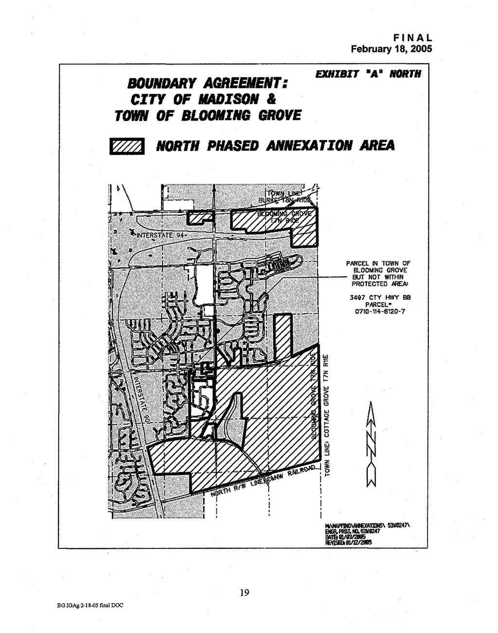
56
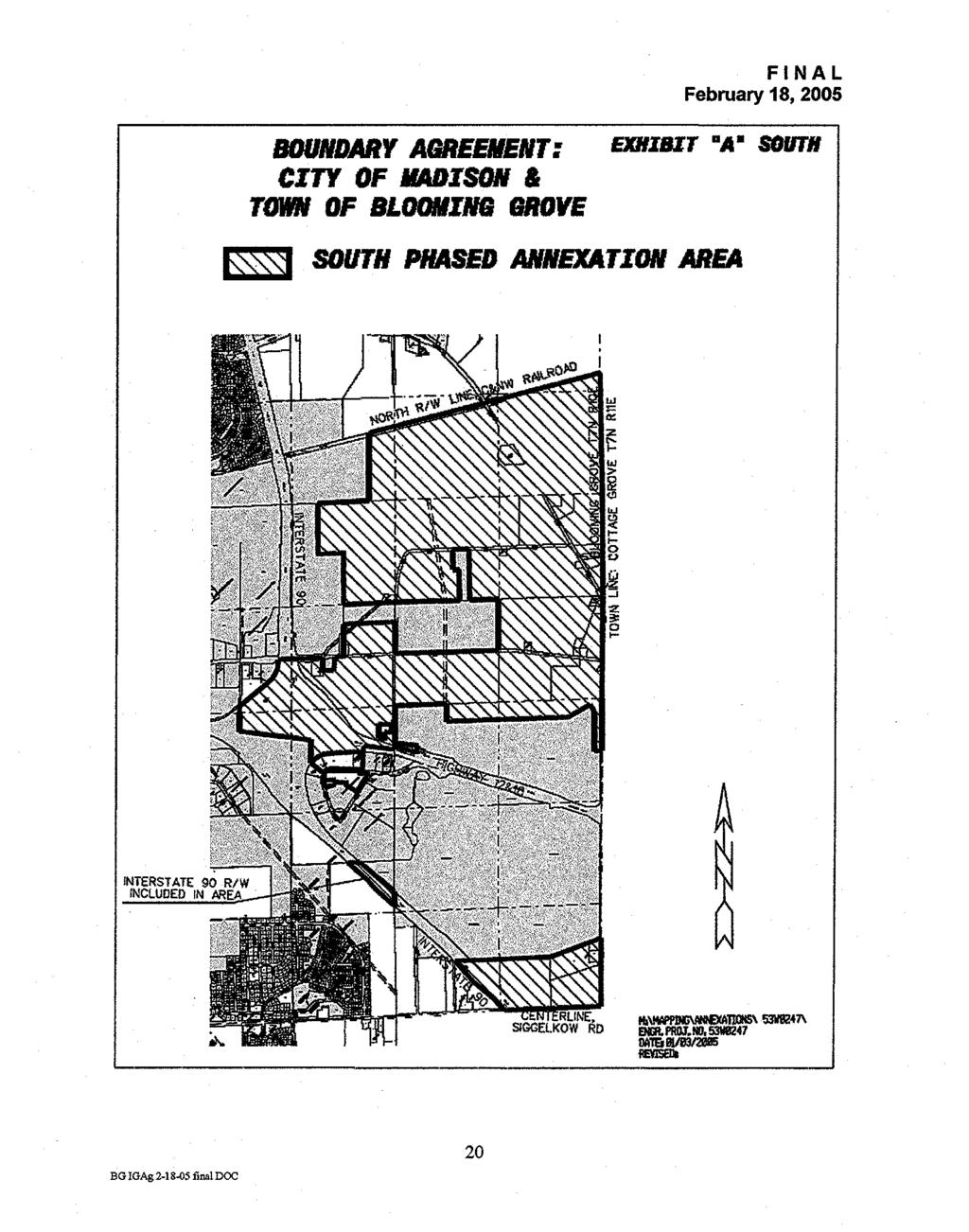
57
58
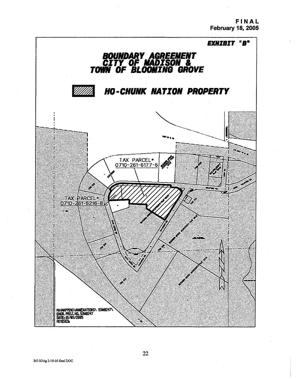
59
60
61
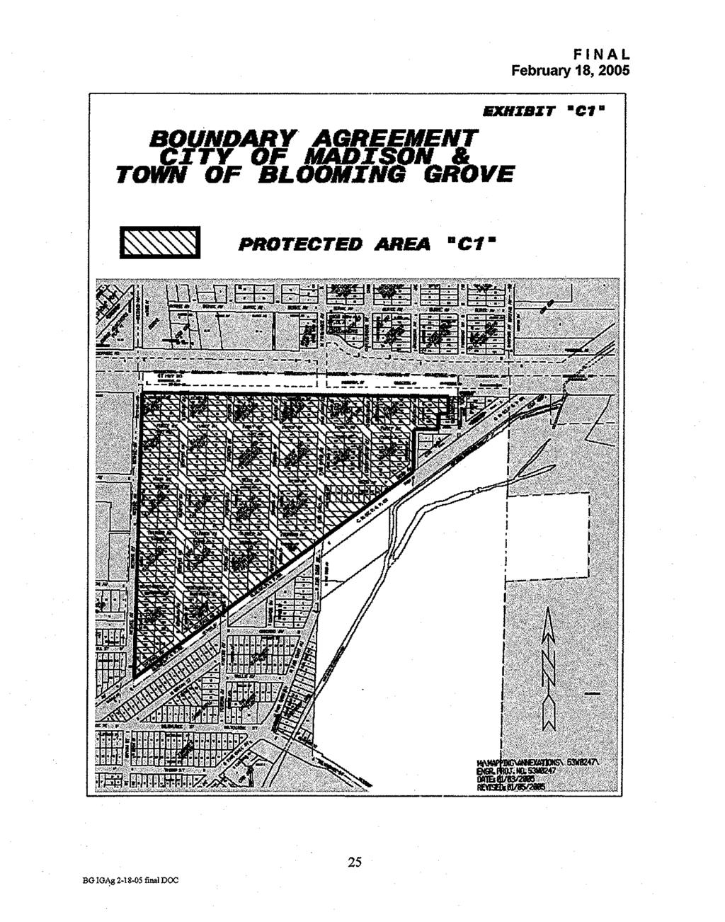
62
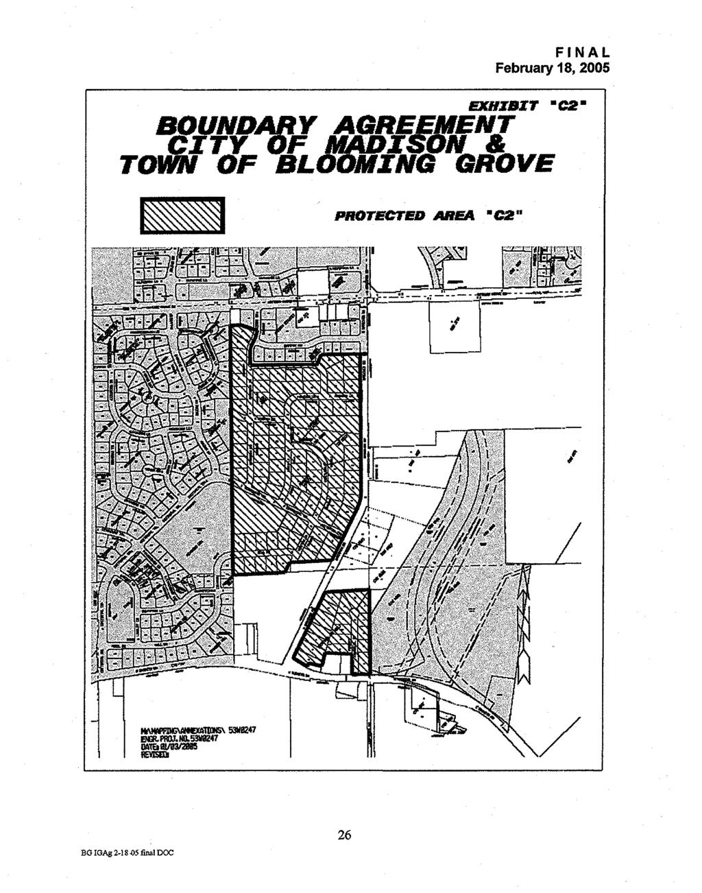
63
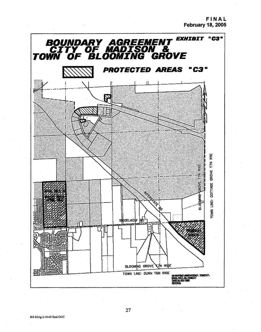
64
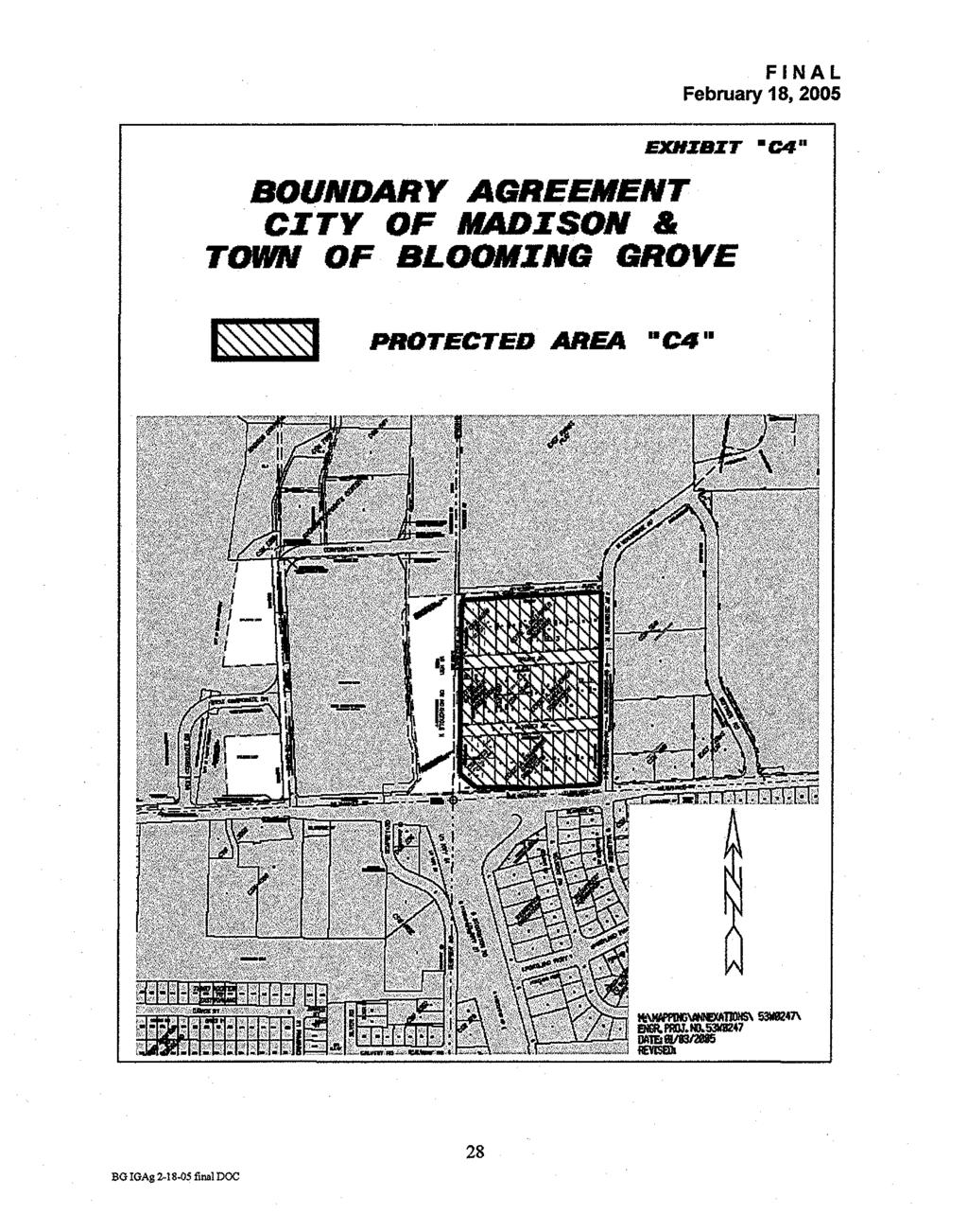
65
66
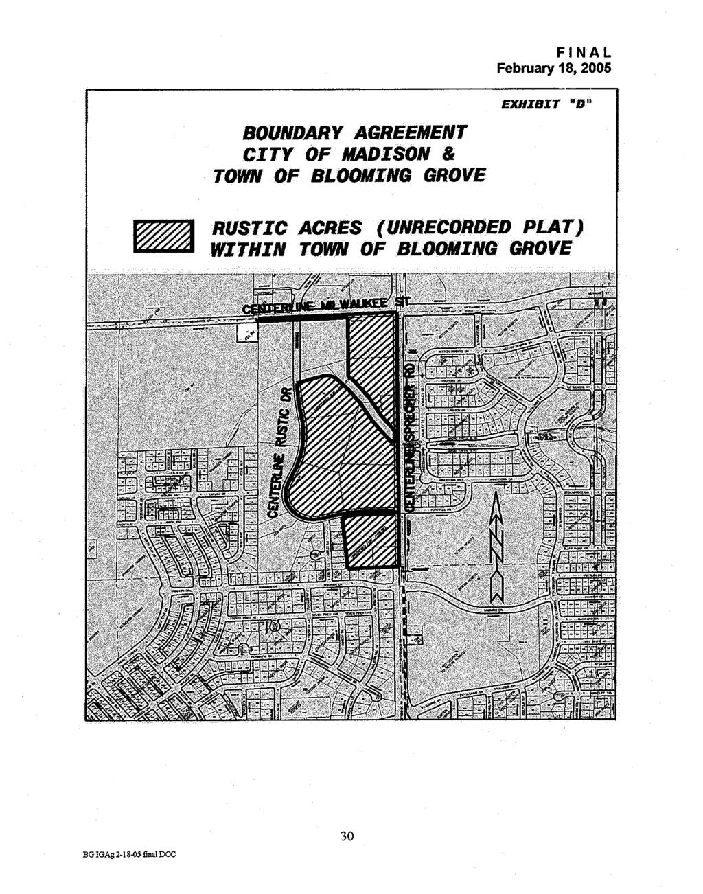
67
68
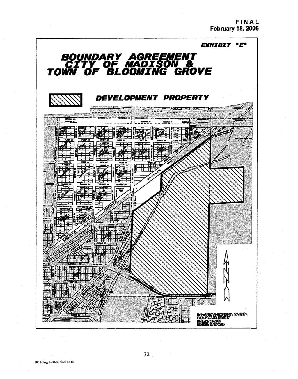
69
70
71
72
73
74
75
76
77
78
79
80
81
82 EXHIBIT 3 LEGAL DESCRIPTION AND MAP OF THE COOPERATIVE DEVELOPMENT PROPERTY All of that land described in Document No , in Vol. 598 of Deeds, Pg. 341, Dane County Registry, located in the Northwest 1/4 of the Northwest 1/4 of Section 4, Town 7 North, Range 10 East, and that part of the East 1/2 of the Northeast 1/4 of Section 5, Town 7 North, Range 10 East, bounded on the north by the southeasterly right-of-way line of the Chicago, Milwaukee, St. Paul and Pacific Railroad and bounded on the south by the existing centerline of Milwaukee Street (County Trunk Highway T ) except those lands described in Document No , Vol of Records, Pg. 2, and Document No , Vol of Records, Pg. 77, Dane County Registry, all in the Town of Blooming Grove, Dane County, Wisconsin, to wit: Beginning at the East Quarter Corner of said Section 5, being also the existing centerline of Milwaukee Street; thence N E (N00 24 E per Doc. No ), 1528 feet to the southwest corner of said lands per Doc. No ; thence N87 05 E, 581 feet to the southeast corner of said lands; thence N00 24 E, 600 feet to the northeast corner of said lands; thence S87 05 W, 581 feet to a the northwest corner of said lands, on the East line of Section 5; thence N E (N00 24 E per Doc. No ) along said East line, 556 feet, more or less, to the southeasterly right-of-way line of the Chicago, Milwaukee, St. Paul and Pacific Railroad; thence southwesterly along said right-of-way, 846 feet, more or less, to the northeast corner of said lands per Doc. No ; thence south, parallel with the easterly right-of-way line of Fair Oaks Avenue as described in said Doc. No , 300 feet to the southeast corner of said lands; thence S52 04 W along the southeast line of said lands per Doc. No , and along the southeast line of said lands per Doc. No , 620 feet, more or less, to the East line of the West 1/2 of the Northeast 1/4 of said Section 5; thence southerly along said East line, 1090 feet, more or less, to the existing centerline of Milwaukee St. and limits of the City of Madison; thence southeasterly and easterly along said centerline and city limits, 1400 feet, more or less, to the point of beginning. Containing 70 acres, more or less. Tax Parcel Numbers included in description:
83


84 EXHIBIT 4 Existing Land Use City and Blooming Grove Cooperative Planning Area Residential Industrial Commercial Institutional Lake Monona Park and Open Space Agriculture and Undeveloped City of Madison Town of Blooming Grove a City of Monona Lake Waubesa Village of McFarland Data Source: City of Madison Department of Planning and Development, Planning Unit Existing Land Use January 1, 2005 Dane County Existing Land Use January Miles
WHEREAS, the City of Kenosha, Wisconsin is a Wisconsin municipality with offices at nd Street, Kenosha, Wisconsin 53140; and
 2017 CITY OF KENOSHA/VILLAGE OF SOMERS/TOWN OF SOMERS/TOWN OF PARIS/COUNTY OF KENOSHA/KENOSHA WATER UTILITY/VILLAGE OF SOMERS WATER UTILITY/VILLAGE OF SOMERS SEWERAGE DISTRICT/COUNTY HIGHWAY COMMISSIONER
The Basics of Boundary Agreements. May 29, 1997
 The Basics of Boundary Agreements May 29, 1997 Wisconsin Statutes provide structures for cooperative action between municipalities including general agreements, cooperative plans, and municipal revenue
FINAL TOWN OF BURKE, VILLAGE OF DeFOREST, CITY OF SUN PRAIRIE AND CITY OF MADISON COOPERATIVE PLAN
 FINAL TOWN OF BURKE, VILLAGE OF DeFOREST, CITY OF SUN PRAIRIE AND CITY OF MADISON COOPERATIVE PLAN January 5, 2007 INTRODUCTION The TOWN OF BURKE, a Wisconsin municipality with offices at 5365 Reiner Road,
SECTION 1 INTRODUCTION TO THE PANAMA CITY BEACH COMPREHENSIVE GROWTH DEVELOPMENT PLAN
 1. PURPOSE SECTION 1 INTRODUCTION TO THE PANAMA CITY BEACH COMPREHENSIVE GROWTH DEVELOPMENT PLAN The purpose of the City of Panama City Beach's Comprehensive Growth Development Plan is to establish goals,
ORDINANCE NO
 ORDINANCE NO. 2014-160 AN ORDINANCE OF THE CITY COUNCIL OF THE CITY OF MENIFEE, CALIFORNIA, REPEALING SECTION 10.35 OF RIVERSIDE COUNTY LAND USE ORDINANCE NO. 460.152 AS ADOPTED BY THE CITY OF MENIFEE
DEVELOPMENT AGREEMENT RIVER EDGE COLORADO PLANNED UNIT DEVELOPMENT
 DEVELOPMENT AGREEMENT RIVER EDGE COLORADO PLANNED UNIT DEVELOPMENT THIS AGREEMENT, is made and entered into between the BOARD OF COUNTY COMMISSIONERS OF THE COUNTY OF GARFIELD, a body politic and corporate
RESOLUTION NO CITY OF MAPLE GROVE
 RESOLUTION NO. 18-122 CITY OF MAPLE GROVE RESOLUTION GRANTING PLANNED UNIT DEVELOPMENT CONCEPT STAGE PLAN, PLANNED UNIT DEVELOPMENT - DEVELOPMENT STAGE PLAN, AND PRELIMINARY PLAT FOR TERRITORIAL GREENS
CITY OF MADISON, WISCONSIN
 CITY OF MADISON, WISCONSIN A SUBSTITUTE ORDINANCE Amending Secs. 4.09(13), 16.23(8)(f), 16.23(9)(e), 20.04(18)(a), 20.06, and 20.09 relating to the imposition and collection of subdivision service costs
Suburban; Rural Town of Dunn Rural Preservation Program Document Last Updated in Database: March 15, 2017
 Land Use Law Center Gaining Ground Information Database Topic: Resource Type: State: Jurisdiction Type: Municipality: Year (adopted, written, etc.): 1997 Community Type applicable to: Title: Local Boards;
Report and Recommendations of the Chelsea City Study Committee
 Report and Recommendations of the Chelsea City Study Committee To the Honorable The Village President and Trustees The Village of Chelsea, Michigan Preamble By resolution dated June 9 1992 the Chelsea
CITY OF DEVELOPMENT AGREEMENT FOR
 Return Address: CITY OF DEVELOPMENT AGREEMENT FOR This DEVELOPMENT AGREEMENT ( Agreement ) between ( the Developer ), a corporation [?], and the CITY OF, a municipal corporation of the State of Washington
TOWN OF KINNICKINNIC St. Croix County, Wisconsin. Ordinance An Ordinance Requiring Developer Agreements
 Or 0^ TOWN OF KINNICKINNIC St. Croix County, Wisconsin Ordinance 2004-1 An Ordinance Requiring Developer Agreements In the interest of the public health, safety, and welfare, the Town Board of the Town
RECITALS STATEMENT OF AGREEMENT. Draft: November 30, 2018
 MEMORANDUM OF AGREEMENT TO FACILITATE THE EXPANSION, RENOVATION, AND EFFICIENT AND SAFE OPERATION OF THE ALBEMARLE CIRCUIT COURT, THE ALBEMARLE GENERAL DISTRICT COURT, AND THE CHARLOTTESVILLE GENERAL DISTRICT
Oregon Statutes Relevant to Quiet Water Home Owners Association
 Oregon Statutes Relevant to Quiet Water Home Owners Association 1 1 1 1 0 1 0 1 0 1 PLANNED COMMUNITIES (General Provisions).0 Definitions for ORS.0 to.. As used in ORS.0 to.: (1) Assessment means any
RECITALS. Page 1 of 9
 INTERLOCAL AGREEMENT BETWEEN THE COUNTY OF VOLUSIA AND THE CITY OF DEBARY FOR REIMBURSEMENT OF UTILITY CONSTRUCTION AND A UTILITY SERVICE AGREEMENT FOR POTABLE WATER THIS AGREEMENT is entered into by and
EXHIBIT A. City of Corpus Christi Annexation Guidelines
 City of Corpus Christi Annexation Guidelines Purpose: The purpose of this document is to describe the City of Corpus Christi s Annexation Guidelines. The Annexation Guidelines provide the guidance and
CITY OF MADISON, WISCONSIN
 CITY OF MADISON, WISCONSIN AN AMENDED SUBSTITUTE ORDINANCE Amending Section 28.04(25) to add a sunset provision, creating new Section 28.04(26) to set out a new inclusionary housing program, and renumbering
CHAPTER House Bill No. 963
 CHAPTER 2000-401 House Bill No. 963 An act relating to Manatee County; merging the Anna Maria Fire Control District and Westside Fire Control District to create a new district; creating and establishing
Chapter 100 Planned Unit Development in Corvallis Urban Fringe
 100.100 Scope and Purpose. Chapter 100 Planned Unit Development in Corvallis Urban Fringe (1) All applications for land divisions in the Urban Residential (UR) and Flood Plain Agriculture (FPA) zones within
Town of Onalaska. A scale map depicting the portion of Pineview Drive to be officially laid out as a Town highway is attached hereto as Exhibit A.
 Town of Onalaska Special Meeting Minutes for March 31, 2011 The Town Board met on site of the Pineview Road and County OT in Onalaska for the purpose of viewing the lay out of the road as required by law.
PROVO CITY MUNICIPAL ANNEXATION GUIDE
 COMMUNITY DEVELOPMENT PROVO CITY MUNICIPAL ANNEXATION GUIDE This guide has been prepared to outline the procedures and requirements of annexing unincorporated territory into Provo City. Annexations are
Midwest City, Oklahoma Zoning Ordinance
 2010 Midwest City, Oklahoma Zoning Ordinance 9/2/2010 Table of Contents Section 1. General Provisions... 5 1.1. Citation... 5 1.2. Authority... 5 1.3. Purpose... 5 1.4. Nature and Application... 5 1.5.
RECITALS. PPAB v3 PPAB v4
 STATE OF SOUTH CAROLINA ) AGREEMENT FOR DEVELOPMENT COUNTY OF OCONEE ) FOR JOINT COUNTY INDUSTRIAL/BUSINESS ) PARK (OCONEE-PICKENS INDUSTRIAL COUNTY OF PICKENS ) PARK PROJECT MACKINAW) THIS AGREEMENT for
PURPOSE AND BACKGROUND
 To: City of Manitowoc From: Mike Slavney and Jessica Schmiedicke, planning consultants Date: November 2, 2009 Re: Extraterritorial, Annexation and Intergovernmental Policies PURPOSE AND BACKGROUND The
Report to the Plan Commission December 19, 2011
 Report to the Plan Commission Legistar I.D. #24825, Extraterritorial Certified Survey Map Requested Action: Consideration of a two-lot Certified Survey Map (CSM) of the Keryluk-Wee property located at,,
ARTICLE I OPTION TO PURCHASE
 OPTION AGREEMENT THIS OPTION AGREEMENT (this "Agreement") is entered into as of this day of, 2006, by and between CITY OF MADISON, a municipal corporation (the "City"), and the Owner. W I T N E S S E T
City of Grande Prairie Development Services Department
 City of Grande Prairie Development Services Department COUNTRYSIDE SOUTH OUTLINE PLAN Prepared by: GPEC Consulting Ltd. #202, 10712-100th Street Grande Prairie, AB Council Resolution of August 20, 2001
ST. JOSEPH TOWNSHIP RESOLUTION CITY OF ST. JOSEPH RESOLUTION 2018-
 ST. JOSEPH TOWNSHIP RESOLUTION 2018- CITY OF ST. JOSEPH RESOLUTION 2018- JOINT RESOLUTION FOR DESIGNATION OF AN AREA FOR ORDERLY ANNEXATON AND FOR DESIGNATION OF AN AREA FOR IMMEDIATE ANNEXATION PURSUANT
CHAPTER 5. Subdivisions Regulations
 CHAPTER 5 Subdivisions Regulations 10-5-1 Introduction and Purpose 10-5-2 Definitions 10-5-3 General Provisions 10-5-4 Procedure for Submitting Subdivisions 10-5-5 Design Standards; Streets and Lots 10-5-6
WOODLAND AREA GENERAL PLAN URBAN DEVELOPMENT POLICY
 APPENDIX A WOODLAND AREA GENERAL PLAN URBAN DEVELOPMENT POLICY The following text indicates proposed amendments to the Woodland Area General Plan Urban Development Policy currently adopted and included
Comprehensive Plan 2030
 Introduction The purpose of this chapter of the Comprehensive Plan is to accurately describe, in words and images, the goals and visions for the future of Clearfield, as determined by the people who live
INTERLOCAL AGREEMENT BETWEEN LAKE COUNTY AND THE LAKE COUNTY TAX COLLECTOR FOR THE GREATER GROVES MUNICIPAL SERVICE BENEFIT UNIT
 INTERLOCAL AGREEMENT BETWEEN LAKE COUNTY AND THE LAKE COUNTY TAX COLLECTOR FOR THE GREATER GROVES MUNICIPAL SERVICE BENEFIT UNIT FOR NON-AD VALOREM ASSESSMENT SERVICES 1 INTERLOCAL AGREEMENT BETWEEN LAKE
RESOLUTION NO. #
 ".. &co ny J MM RESOLUTION NO. #2-29 A JOINT RESOLUTION OF THE CITY OF NORTHFIEL AN THE TOWNSHIP OF GREENVALE TO THE OFFICE OF MINNESOTA PLANNING ESIGNATING AN UNINCORPORATE AREA AS IN NEE OF ORERLY ANNEXATION
PRE-ANNEXATION AGREEMENT
 City of Commerce City 7887 East 60th Avenue Commerce City, Colorado 80022 p: 303.289.3683 f: 303.289.3731 c3gov.com PRE-ANNEXATION AGREEMENT PRE-ANNEXATION AGREEMENT THIS PRE-ANNEXATION AGREEMENT ( Agreement
ORDINANCE NO WHEREAS, in Chapter 166 Municipalities, Florida Statutes, the Florida State
 ORDINANCE NO. 2017- AN ORDINANCE OF THE VILLAGE OF PINECREST, FLORIDA, AMENDING CHAPTER 25, STORMWATER UTILITY, OF THE CODE OF ORDINANCES RELATING TO THE VILLAGE S STORMWATER UTILITY AND COLLECTION METHODS;
CERTIFIED SURVEY MAPS
 Chapter 1 - INTRODUCTION CERTIFIED SURVEY MAPS Certified Survey Maps (CSMs) are one of the permitted methods of dividing land in the City of Muskego. CSMs are allowed when it is proposed to create four
ANNEXATION. The Handbook for Georgia Mayors and Councilmembers 1
 ANNEXATION Growing and prosperous Georgia cities create a growing and prosperous Georgia. Although cities comprise only 6.8% of Georgia s land area, approximately 40% of the state s population lives in
MREC VH Madison LLC, a Delaware Limited Liability Company DSI Real Estate Group, Inc Royal Avenue Madison, WI 53713
 THE VILLAS AT SECRET PLACES, A CONDOMINIUM 6003-6059 and 6115-6138 Canyon Parkway Madison, WI CONDOMINIUM DISCLOSURE MATERIALS Pursuant to Chapter 703 Wisconsin Statutes Declarant: MREC VH Madison LLC,
Impact Fees. Section 1 Purpose and Intent.
 Impact Fees 1 Purpose and Intent 2 Definitions 3 Establishment of Impact Fees 4 Documentation Required 5 Segregated Accounts Required 6 Time Within Which To Use Impact Fees 7 Payment of Impact Fees 8 Appeals
ROAD USE AGREEMENT RELATING TO THE DEVELOPMENT OF (WIND FARM NAME) WIND FARM
 WIND FARM") ROAD USE AGREEMENT RELATING TO THE DEVELOPMENT OF (WIND FARM NAME) WIND FARM THIS ROAD USE AGREEMENT (this Agreement ), dated this day of, 20, between the BOARD OF COUNTY SUPERVISORS OF UNION COUNTY, IOWA,
ROAD USE AGREEMENT RELATING TO THE DEVELOPMENT OF (WIND FARM NAME) WIND FARM THIS ROAD USE AGREEMENT (this Agreement ), dated this day of, 20, between the BOARD OF COUNTY SUPERVISORS OF UNION COUNTY, IOWA,
FIRST AMENDMENT TO DEVELOPMENT AGREEMENT FOR PLAT OF BEAR TREE FARMS LOCATED IN THE VILLAGE OF WINDSOR, DANE COUNTY, WISCONSIN
 FIRST AMENDMENT TO DEVELOPMENT AGREEMENT FOR PLAT OF BEAR TREE FARMS LOCATED IN THE VILLAGE OF WINDSOR, DANE COUNTY, WISCONSIN THIS FIRST AMENDMENT TO DEVELOPMENT AGREEMENT is executed by and between Bear
PLANNING COMMISSION RESOLUTION NO
 Exhibit A PLANNING COMMISSION RESOLUTION NO. 2014-566 A RESOLUTION OF THE PLANNING COMMISSION OF THE CITY OF CALABASAS RECOMMENDING TO THE CITY COUNCIL APPROVAL OF FILE NO. 140000288, GENERAL PLAN AMENDMENTS
INTERLOCAL AGREEMENT FOR LEESVILLE BRANCH LIBRARY BETWEEN CITY OF RALEIGH, NORTH CAROLINA AND WAKE COUNTY, NORTH CAROLINA
 DRAFT 01-23-08 INTERLOCAL AGREEMENT FOR LEESVILLE BRANCH LIBRARY BETWEEN CITY OF RALEIGH, NORTH CAROLINA AND WAKE COUNTY, NORTH CAROLINA Dated as of, 2008 INTERLOCAL AGREEMENT THIS INTERLOCAL AGREEMENT
ELK RAPIDS TOWNSHIP ANTRIM COUNTY, MICHIGAN ORDINANCE NO
 ELK RAPIDS TOWNSHIP ANTRIM COUNTY, MICHIGAN ORDINANCE NO. 3-2011 AN ORDINANCE TO REPLACE THE SUBDIVISION CONTROL ORDINANCE WITH A NEW SUBDIVISION DEVELOPMENT ORDINANCE, IN ACCORD WITH THE LAND DIVISION
ORDINANCE NO AN ORDINANCE AMENDING THE CODE OF ORDINANCES OF THE CITY OF PORT ARANSAS, TEXAS, BY ADOPTING A NEW CHAPTER
 ORDINANCE NO. 2008-09 AN ORDINANCE AMENDING THE CODE OF ORDINANCES OF THE CITY OF PORT ARANSAS, TEXAS, BY ADOPTING A NEW CHAPTER TWENTY-SIX CONCERNING IMPACT FEES FOR ROADWAY FACILITIES; INCORPORATING
Subchapter 16 Subdivisions.
 Subchapter 16 Subdivisions. Sections: 35.16.1 Authority. 35.16.2 Purpose. 35.16.3 Jurisdiction. 35.16.4 Application. 35.16.5 Compliance and Enforcement. 35.16.6 Approval of Plat Required. 35.16.7 Lots,
GOVERNMENT CODE - GOV
 GOVERNMENT CODE - GOV TITLE 7. PLANNING AND LAND USE [65000 66499.58] ( Heading of Title 7 amended by Stats. 1974, Ch. 1536. ) DIVISION 2. SUBDIVISIONS [66410 66499.38] ( Division 2 added by Stats. 1974,
EXTRACTS FROM MINUTES OF MEETING OF THE BOARD OF TRUSTEES OF THE VILLAGE OF MAMARONECK, COUNTY OF WESTCHESTER, STATE OF NEW YORK
 EXTRACTS FROM MINUTES OF MEETING OF THE BOARD OF TRUSTEES OF THE VILLAGE OF MAMARONECK, COUNTY OF WESTCHESTER, STATE OF NEW YORK (Refunding Bond Resolution, 2019) A regular meeting of the Board of Trustees
Title 6 - Local Government Provisions Applicable to Special Purpose Districts and Other Political Subdivisions
 Title 6 - Local Government Provisions Applicable to Special Purpose Districts and Other Political Subdivisions CHAPTER 29. SOUTH CAROLINA LOCAL GOVERNMENT COMPREHENSIVE PLANNING ENABLING ACT OF 1994 1994
NC General Statutes - Chapter 153A Article 9 1
 Article 9. Special Assessments. 153A-185. Authority to make special assessments. A county may make special assessments against benefited property within the county for all or part of the costs of: (1)
MIDWAY CITY Municipal Code
 MIDWAY CITY Municipal Code TITLE 9 ANNEXATION CHAPTER 9.01 PURPOSE CHAPTER 9.02 GENERAL REQUIREMENTS CHAPTER 9.03 PROPERTY OWNER INITIATION OF ANNEXATION CHAPTER 9.04 PROCEDURES FOR CONSIDERATION OF PETITION
DEVELOPER S AGREEMENT BETWEEN THE TOWN OF CLIFTON AND
 DEVELOPER S AGREEMENT BETWEEN THE TOWN OF CLIFTON AND THIS AGREEMENT, made and entered into this day of, by and between the Town of Clifton, a municipal corporation organized under the laws of the State
2018 Declaration & Articles of Incorporation Vote
 2018 Declaration & Articles of Incorporation Vote WHITE PAPEr 2018 GATEWAY TO THE OUACHITAS The following pages outline recommended changes to the Hot Springs Village Declaration and Articles of Incorporation.
DECLARATION OF COVENANTS, CONDITIONS AND RESTRICTIONS OF MADISON CRESCENT HOMEOWNERS ASSOCIATION, INC.
 DECLARATION OF COVENANTS, CONDITIONS AND RESTRICTIONS OF MADISON CRESCENT HOMEOWNERS ASSOCIATION, INC. This Declaration of Covenants, Conditions and Restrictions is made this day of 2005,by [INSERT NAME
SUBDIVISION REGULATIONS
 CHAPTER 14 SUBDIVISION REGULATIONS 14-100 Provisions 14-200 Preliminary Plat 14-300 Final Plat 14-400 Replat 14-500 Minor Subdivision 14-600 Administrative Replat 14-700 Vacation of Roadways, Public Easements,
NC General Statutes - Chapter 116 Article 21B 1
 Article 21B. The Centennial Campus, the Horace Williams Campus, and the Millenial Campuses Financing Act. 116-198.31. Purpose of Article. The purpose of this Article is to authorize the Board of Governors
LAND USE RESTRICTION - - INCLUSIONARY ZONING
 LAND USE RESTRICTION - - INCLUSIONARY ZONING Re:, an Apartment development located at, City of Madison, Wisconsin WHEREAS,, a Limited Liability Wisconsin Corporation ( Developer ) will record a PLANNED
A SECTION-BY-SECTION ANALYSIS OF CHAPTER 23L. William F. Griffin, Jr. Davis, Malm & D Agostine, P.C.
 A SECTION-BY-SECTION ANALYSIS OF CHAPTER 23L William F. Griffin, Jr. Davis, Malm & D Agostine, P.C. A new Chapter 23L of the Massachusetts General Laws was enacted on August 7, 2012 as part of Chapter
AGENDA COLLETON COUNTY COUNCIL REGULAR MEETING TUESDAY, FEBRUARY 5, :00 P.M. COUNTY COUNCIL CHAMBERS, OLD JAIL BUILDING
 AGENDA COLLETON COUNTY COUNCIL REGULAR MEETING TUESDAY, FEBRUARY 5, 2013 6:00 P.M. COUNTY COUNCIL CHAMBERS, OLD JAIL BUILDING 1. Call to Order 2. Invocation 3. Present Colors and Lead Pledge of Allegiance-
Dated October 14, 1966 As to Acknowledged October 14, 1966 University Hills No. 2 Subdivision Reported October 18, 1966 Liber 1954, Page 28
 Orchard Lane Land Company Declaration of Restrictions Dated October 14, 1966 As to Acknowledged October 14, 1966 University Hills No. 2 Subdivision Reported October 18, 1966 Liber 1954, Page 28 This Declaration,
Implementation TOWN OF LEON COMPREHENSIVE PLAN 9-1
 9 Implementation 9.1 Implementation Chapter Purpose and Contents This element includes a compilation of regulatory and non-regulatory measures to implement the objectives of this comprehensive plan. The
Town of Bristol Rhode Island
 Town of Bristol Rhode Island Subdivision & Development Review Regulations Adopted by the Planning Board September 27, 1995 (March 2017) Formatted: Highlight Formatted: Font: 12 pt Table of Contents TABLE
RESOLUTION NO
 ITEM 4 ATTACHMENT B RESOLUTION NO. 2014-1412 A RESOLUTION OF THE CITY COUNCIL OF THE CITY OF CALABASAS APPROVING GENERAL PLAN AMENDMENTS ASSOCIATED WITH THE WEST AGOURA ROAD TERRITORY IN CONFORMANCE WITH
** If your lot does not meet the requirements above, please read Sec below
 Sec. 13-1-60 Zoning District Dimensional Requirements. For the Zoning Dept To Issue a Land Use Permit The Following Dimensions are Required. Minimum Side and Rear Yards s Lakes Classification Minimum Class
St. Mary s County Comprehensive Zoning Ordinance Article 1. GENERAL PROVISIONS
 0 0 0 0 ARTICLE. GENERAL PROVISIONS CHAPTER 0 TITLE, PURPOSE AND ORGANIZATION Sections: 0. Title. 0. Authority. 0. Purpose. 0. Organization of the Zoning Ordinance. 0. Official Zoning Map. 0. Applicability.
ARTICLE 1 GENERAL PROVISIONS AUTHORITY AND ADMINISTRATION RESPONSIBILITIES OF DEVELOPER AND PLANNING COMMISSION
 ARTICLE 1 GENERAL PROVISIONS 103.101. TITLE 103.102. AUTHORITY AND ADMINISTRATION 103.103. PURPOSE 103.104. INTERPRETATION 103.105. RESPONSIBILITIES OF DEVELOPER AND PLANNING COMMISSION 103.106. JURISDICTION
RESOLUTION NO. CONTAINING APPROXIMATELY 587 SQ.FT. RD:EEH:LCP
 RD:EEH:LCP 12-2-15 RESOLUTION NO. A RESOLUTION OF THE COUNCIL OF THE CITY OF SAN JOSE VACATING, UPON THE SATISFACTION OF CERTAIN CONDITIONS, A PORTION OF A PUBLIC EASEMENT ON PRIVATE PROPERTY LOCATED AT
DECLARATION OF BY-LAWS AND RESTRICTIVE COVENANTS BINDING SEVEN BAYS ESTATES UNLIMITED HOMEOWNERS AND HOMEOWNERS ASSOCIATION
 DECLARATION OF BY-LAWS AND RESTRICTIVE COVENANTS BINDING SEVEN BAYS ESTATES UNLIMITED HOMEOWNERS AND HOMEOWNERS ASSOCIATION ************************************************************************ This
SECOND AMENDED RATE AND METHOD OF APPORTIONMENT OF SPECIAL TAXES FOR TUSTIN UNIFIED SCHOOL DISTRICT COMMUNITY FACILITIES DISTRICT NO
 SECOND AMENDED RATE AND METHOD OF APPORTIONMENT OF SPECIAL TAXES FOR TUSTIN UNIFIED SCHOOL DISTRICT COMMUNITY FACILITIES DISTRICT NO. 07-1 (ORCHARD HILLS) A Special Tax shall be levied and collected within
ESCROW AGREEMENT - MAINTENANCE
 ESCROW AGREEMENT - MAINTENANCE This ESCROW AGREEMENT (the Agreement ) is made and entered into this day of,, by and between the City of O Fallon, Missouri, a Missouri municipal corporation (hereinafter
VILLAGE OF SOUTH RUSSELL SUBDIVISION RULES. Revised
 VILLAGE OF SOUTH RUSSELL SUBDIVISION RULES Revised 7 2 96 1 TABLE OF CONTENTS CHAPTER 1: TITLE AND SCOPE Page 1.00 Title 1 1.01 Jurisdiction 1 1.02 Objectives 1 1.03 Interpretation 1 1.04 Separability
APPLICATION FOR CONDITIONAL USE PERMIT
 Receipt No. Fee Date Date Permit Issued: Certificate of Compliance: Date DOOR COUNTY LAND USE SERVICES 421 Nebraska Street Door County Government Center Sturgeon Bay, Wisconsin 54235 (920) 746-2323 - FAX
PART 1 JURISDICTION, ZONING DISTRICTS, AND LAND USES
 PART 1 JURISDICTION, ZONING DISTRICTS, AND LAND USES ARTICLE 1 TITLE, PURPOSE, JURISDICTION, AND APPLICABILITY Division 1-1.1 Title and Reference Sec. 1-1.1.1 Title This Ordinance shall be known as "The
FIFTH AMENDMENT OF DECLARATION OF COVENANTS, CONDITIONS AND RESTRICTIONS FOR HICKS AIRFIELD, TARRANT COUNTY, TEXAS
 STATE OF TEXAS COUNTY OF TARRANT FIFTH AMENDMENT OF DECLARATION OF COVENANTS, CONDITIONS AND RESTRICTIONS FOR HICKS AIRFIELD, TARRANT COUNTY, TEXAS Hicks Airfield Pilots Association, a Texas non-profit
WATER AND WASTEWATER AGREEMENT (Individual)
") WATER AND WASTEWATER AGREEMENT (Individual) THIS AGREEMENT ("WATER AND WASTEWATER AGREEMENT") made and entered into this day of, 20_, by and between hereinafter referred to as "DEVELOPER" and the CITY
WATER AND WASTEWATER AGREEMENT (Individual) THIS AGREEMENT ("WATER AND WASTEWATER AGREEMENT") made and entered into this day of, 20_, by and between hereinafter referred to as "DEVELOPER" and the CITY
DECLARATIONS OF COVENANTS, RESTRICTIONS, CONDITIONS AND RESERVATIONS
 THIS DECLARATION, made this 30 th day of December, 1969, by Jasper Valley Development Corporation, hereinafter called the Developer. WITNESSETH: Whereas, Developer is the owner of the real property described
ARTICLE 14 PLANNED UNIT DEVELOPMENT (PUD) DISTRICT
 DISTRICT") ARTICLE 14 PLANNED UNIT DEVELOPMENT (PUD) DISTRICT Section 14.01 Intent. It is the intent of this Article to allow the use of the planned unit development (PUD) process, as authorized by the Michigan Zoning
ARTICLE 14 PLANNED UNIT DEVELOPMENT (PUD) DISTRICT Section 14.01 Intent. It is the intent of this Article to allow the use of the planned unit development (PUD) process, as authorized by the Michigan Zoning
ARTICLE IX. DEVELOPMENT FEES
 ARTICLE IX. DEVELOPMENT FEES ARTICLE IX. DEVELOPMENT FEES DIVISION 1: GENERAL PROVISIONS Sec. 21-9100. Purpose Sec. 21-9110. Methods of Satisfaction Sec. 21-9120. Development Fee Accounts Sec. 21-9130.
H 7425 S T A T E O F R H O D E I S L A N D
 LC001 0 -- H S T A T E O F R H O D E I S L A N D IN GENERAL ASSEMBLY JANUARY SESSION, A.D. 0 A N A C T RELATING TO THE SMITHFIELD LAND TRUST Introduced By: Representatives Winfield, and Costantino Date
Operating Plan Military Avenue Business Association BUSINESS IMPROVEMENT DISTRICT NO OPERATING PLAN. Page 1 11
 Operating Plan - 2018 Military Avenue Business Association BUSINESS IMPROVEMENT DISTRICT NO. 4 2018 OPERATING PLAN Page 1 11 TABLE OF CONTENTS Item Page Introduction 3 District Boundaries 3 Proposed Operating
Planning & Development 881 Senoia Road Tyrone GA, (770) Tax Map Number: Date. Date Annexation will become effective and official:
 Tax Map Number: Date. Date Annexation will become effective and official:") TOWN OF TYRONE Planning & Development 881 Senoia Road Tyrone GA, 30290 (770) 487-4038 Tax Map Number: Date Date Annexation will become effective and official: Address of subject property: Owner of Property:
TOWN OF TYRONE Planning & Development 881 Senoia Road Tyrone GA, 30290 (770) 487-4038 Tax Map Number: Date Date Annexation will become effective and official: Address of subject property: Owner of Property:
City of Edwardsville, Kansas Special Benefit District Policy
 City of Edwardsville, Kansas Special Benefit District Policy Date Adopted: September 12, 2011 Section 1. Objective The objective is to establish a policy to finance public streets, sanitary sewers, water
ARTICLES OF INCORPORATION OF KING S DEER HOMEOWNERS ASSOCIATION, INC. AS AMENDED JUNE 30, ARTICLE I Name. ARTICLE II Duration
 ARTICLES OF INCORPORATION OF KING S DEER HOMEOWNERS ASSOCIATION, INC. AS AMENDED JUNE 30, 2008 ARTICLE I Name The name of this Corporation shall be KING S DEER HOMEOWNERS ASSOCIATION, INC. ARTICLE II Duration
RESOLUTION NO
 MIA 184152500v2 RESOLUTION NO. 15-028 A RESOLUTION OF THE SCHOOL BOARD OF OSCEOLA COUNTY, FLORIDA, AUTHORIZING EXECUTION OF AMENDED AND RESTATED SCHEDULE 1995A AND AMENDED AND RESTATED SCHEDULE 2004A TO
IC Chapter 7. Real Property Transactions
 IC 8-23-7 Chapter 7. Real Property Transactions IC 8-23-7-0.1 Application of certain amendments to chapter Sec. 0.1. The amendments made to section 19 of this chapter by P.L.133-2007 apply only to public
this page left intentionally blank DENVER ZONING CODE
 Article 1. GENERAL PROVISIONS this page left intentionally blank Contents ARTICLE 1. GENERAL PROVISIONS DIVISION 1.1 GENERAL...1.1-1 Section 1.1.1 Purpose...1.1-1 Section 1.1.2 Intent...1.1-1 Section 1.1.3
CITY OF CIRCLE PINES SPECIAL ASSESSMENT POLICY
 CITY OF CIRCLE PINES SPECIAL ASSESSMENT POLICY Policy 53 Revised 02/10/2015 SECTION 1: GENERAL POLICY STATEMENT The purpose of this assessment policy is to set forth a guide of policies and procedures
CHAPTER House Bill No. 733
 CHAPTER 2004-410 House Bill No. 733 An act relating to the Loxahatchee Groves Water Control District, Palm Beach County; amending chapter 99-425, Laws of Florida; amending the district s election procedures;
SANFORD-BROADWAY-LEE COUNTY UNIFIED DEVELOPMENT ORDINANCE ARTICLE 12. NONCONFORMITIES AND VESTED RIGHTS
 SANFORD-BROADWAY-LEE COUNTY UNIFIED DEVELOPMENT ORDINANCE ARTICLE 12. NONCONFORMITIES AND VESTED RIGHTS Summary: This Article defines legal nonconforming uses of land, nonconforming structures and lots.
(c) County board of commissioners means 1 of the following, as applicable: (ii) In all other counties, 1 of the following:
 County board of commissioners means 1 of the following, as applicable: (ii) In all other counties, 1 of the following:") TOWNSHIP PLANNING Act 168 of 1959, as amended, (including 2001 amendments, 2006 amendments) AN ACT to provide for township planning; for the creation, organization, powers and duties of township planning
TOWNSHIP PLANNING Act 168 of 1959, as amended, (including 2001 amendments, 2006 amendments) AN ACT to provide for township planning; for the creation, organization, powers and duties of township planning
CHARTER OF THE TOWN OF HANOVER, N.H.
 CHARTER OF THE TOWN OF HANOVER, N.H. 1963 N.H. Laws Ch. 374, as amended Section 1. Definitions. The following terms, wherever used or referred to in this chapter, shall have the following respective meanings,
RESOLUTION NUMBER 4678
 RESOLUTION NUMBER 4678 A RESOLUTION OF THE CITY COUNCIL OF THE CITY OF PERRIS, CALIFORNIA, DECLARING THAT PUBLIC INTEREST AND NECESSITY REQUIRE ACQUISITION OF A FEE INTEREST IN A PORTION OF THE PROPERTY
ARTICLES OF INCORPORATION
 \\m 1 I o^rh'u;' ARTICLES OF INCORPORATION OF Cr.F'ARTK-yiT OF STATE STATEft
Stormwater Ordinance Appendix APPENDIX K EXAMPLE TAR-PAM CONVERSATION EASEMENT
 APPENDIX K EXAMPLE TAR-PAM CONVERSATION EASEMENT Tax Parcel ID # NORTH CAROLINA FRANKLIN COUNTY CONSERVATION EASEMENT Franklin County, North Carolina THIS CONSERVATION EASEMENT (this "Conservation Easement")
Agenda Item No. 6B May 9, Honorable Mayor and City Council Attention: Jeremy Craig, Interim City Manager
 Agenda Item No. 6B May 9, 2017 TO: FROM: SUBJECT: Honorable Mayor and City Council Attention: Jeremy Craig, Interim City Manager Barton Brierley, AICP, Community Development Director (Staff Contact: Barton
PROPERTY; PROVIDING FOR EXPENDITURE OF REVENUE; PROVIDING FOR REIMBURSEMENT
 ORDINANCE NO. 12- AN ORDINANCE OF MARION COUNTY, FLORIDA ESTABLISHING THE RAINBOW PARK UNITS 1 & 2 MUNICIPAL SERVICE BENEFIT UNIT FOR ROAD MAINTENANCE; PROVIDING FOR A PURPOSE; PROVIDING FOR THE POWERS
43 USC NB: This unofficial compilation of the U.S. Code is current as of Jan. 4, 2012 (see
 TITLE 43 - PUBLIC LANDS CHAPTER 35 - FEDERAL LAND POLICY AND MANAGEMENT SUBCHAPTER II - LAND USE PLANNING AND LAND ACQUISITION AND DISPOSITION 1716. Exchanges of public lands or interests therein within
RE: File No. LD 1516 Certified Survey Map Tradewinds Parkway (B-R Enterprises of Madison, LLC)
") Department of Planning & Community & Economic Development Planning Division Katherine Cornwell, Director Madison Municipal Building, Suite LL-100 215 Martin Luther King, Jr. Boulevard P.O. Box 2985 Madison,
Department of Planning & Community & Economic Development Planning Division Katherine Cornwell, Director Madison Municipal Building, Suite LL-100 215 Martin Luther King, Jr. Boulevard P.O. Box 2985 Madison,
Ordinance Page 1
 ORDINANCE NO. 671 (AS AMENDED THROUGH 671.20) AN ORDINANCE OF THE COUNTY OF RIVERSIDE AMENDING ORDINANCE NO. 671 ESTABLISHING CONSOLIDATED FEES FOR LAND USE AND RELATED FUNCTIONS The Board of Supervisors
STATE OF SOUTH CAROLINA ) AGREEMENT ) OF COUNTY OF RICHLAND ) PURCHASE AND SALE
 AGREEMENT ) OF COUNTY OF RICHLAND ) PURCHASE AND SALE") STATE OF SOUTH CAROLINA ) AGREEMENT ) OF COUNTY OF RICHLAND ) PURCHASE AND SALE THIS AGREEMENT (the Agreement ) executed the day of, 2010 (the Effective Date ), by and between COLUMBIA VENTURE, LLC, a
STATE OF SOUTH CAROLINA ) AGREEMENT ) OF COUNTY OF RICHLAND ) PURCHASE AND SALE THIS AGREEMENT (the Agreement ) executed the day of, 2010 (the Effective Date ), by and between COLUMBIA VENTURE, LLC, a