Work Session Code Enforcement Update Presentation by Deputy Building Official and Planning Director regarding current Coded Enforcement policies.
|
|
|
- Jonas George
- 5 years ago
- Views:
Transcription

1 PARK CITY MUNICIPAL CORPORATION PLANNING COMMISSION CITY COUNCIL CHAMBERS March 28, 2018 AGENDA MEETING CALLED TO ORDER AT 5:30PM ROLL CALL ADOPTION OF MINUTES OF March 14, 2018 PUBLIC COMMUNICATIONS Items not scheduled on the regular agenda STAFF AND BOARD COMMUNICATIONS AND DISCLOSURES CONTINUATIONS Twisted Branch Road Subdivision Plat A Subdivision Plat for 3 lots of record for an on-mountain private restaurant, a City water tank, and a recreational warming shelter/yurt; platted ROW for existing Twisted Branch Road; and platted parcels for Deer Valley Resort ski trails and bridges, open space, and existing Guardsman Pass Road, subject to the Flagstaff Annexation and Development Agreement, located within the Empire Pass Development Area. Public Hearing and continue to April 11, 2018 PL Planner Whetstone 23 REGULAR AGENDA Discussion, public hearing, and possible action as outlined below Park City Heights Subdivision Phase 2 The applicant is requesting a final subdivision plat for a total of 39 single family lots consistent with the Park City Heights Master Planned Development. Public hearing and possible recommendation for City Council on April 19, 2018 Land Management Code (LMC) Text Amendment Removing the Transfer of Development Rights Sending Treasure Hill (TDR-STH) language from LMC Section (A)(1) and (A)(7). Public hearing and possible recommendation for City Council on April 19, 2018 Work Session Code Enforcement Update Presentation by Deputy Building Official and Planning Director regarding current Coded Enforcement policies. ADJOURN *Parking validations will be provided for Planning Commission meeting attendees that park in the China Bridge parking structure. PL Planner Whetstone PL Planner Astorga Deputy Chief Building Official Downard and Director Erickson A majority of Planning Commission members may meet socially after the meeting. If so, the location will be announced by the Chair person. City business will not be conducted. Pursuant to the Americans with Disabilities Act, individuals needing special accommodations during the meeting should notify the Park City Planning Department at (435) hours prior to the meeting.
2 PARK CITY MUNICIPAL CORPORATION PLANNING COMMISSION MEETING MINUTES COUNCIL CHAMBERS MARSAC MUNICIPAL BUILDING MARCH 14, 2018 COMMISSIONERS IN ATTENDANCE: Melissa Band, Sarah Hall, John Kenworthy, John Phillips, Mark Sletten, Laura Suesser, Doug Thimm EX OFFICIO: Planning Director, Bruce Erickson; Tippe Morlan, Planner; Polly Samuels McLean, Assistant City Attorney =================================================================== REGULAR MEETING ROLL CALL Vice-Chair Band called the meeting to order at 5:35 p.m. and noted that all Commissioners were present. She welcomed the three new Commissioners. ADOPTION OF MINUTES February 28, 2018 MOTION: Commissioner Thimm moved to APPROVE the Minutes of February 28, 2018 as written. Commissioner Suesser seconded the motion. VOTE: The motion passed. PUBLIC COMMUNICATIONS Carol Sletta, a resident at 135 Sampson Avenue, expressed concern about the overcalled mitigation plan for the Sampson/Ridge/Upper Norfolk/King Road neighborhood. She was concerned about the multiple projects that will be started in the near future, and the lengthy construction time of the current projects. Ms. Sletta thought it would be helpful if the neighbors could be consulted regarding the mitigation of the neighborhood projects; in particular, noise, road closures, and general public safety. In reviewing the construction mitigation plan, Ms. Sletta noticed that there had been many violations in the neighborhood over the past many years, and there appears to be exceptions to many of the rules, such as street parking, construction equipment parked on the streets, use of construction equipment driven on the streets, off-site staging, road closures, etc. Ms. Sletta thought the mitigation plans should be customized for the protection of the Old Town neighborhoods, because they are different than Park Meadows, Prospector and Packet Pg. 2
3 Planning Commission Meeting March 14, 2018 Page 2 other areas. She was more than willing to talk to the City about helping to make upcoming construction in the neighborhood as painless as possible for the neighbors. Ms. Sletta stated that on Sampson Avenue over the last five or more years, no less than 12 cars would be parked on their street. At times the road would be so narrow that a fire truck could not go through, and that is very concerning. Ms. Sletta hoped that with the upcoming projects, the City will find a way to create a mitigation plan that would be safer in Old Town. Vice-Chair Band noted that the Planning Commission does its best to mitigate construction impacts, but most of the Commissioners do not live in Old Town. However, the few who do have great insight. She suggested that the Planning Commission discuss construction mitigation for Old Town at a future meeting and invite the City Engineer to participate in the discussion. Director Erickson thought it was a good idea. He announced that the City Council would be discussing Code Enforcement in two weeks. Approximately 50% of that is construction mitigation strategies. He and the Deputy Building Official would be giving a presentation to the City Council. Based on direction from the City Council, the Planning Department could prepare a Staff report for discussion on March 28 th. Director Erickson recalled that the conditions were added to the last rounds of Steep Slope CUPs and accessory apartment requests that the Planning Commission had approved. Regarding the two projects on the agenda this evening, Planner Morlan was prepared to add additional conditions prior to going to the City Council if the Planning Commission chooses to forward these projects this evening. Vice-Chair Band noted that Code Enforcement has been an issue for the Planning Commission. Director Erickson anticipated rigorous questioning. Commissioner Suesser liked the idea of customizing the construction mitigation plans and tailoring them to Old Town conditions. She believed that was important. Director Erickson agreed that it was a good idea and the Staff would look at that possibility. STAFF/COMMISSIONER COMMUNICATIONS AND DISCLOSURES Director Erickson introduced Liz Jackson, Laura Newberry, and Graham Bunt, the newest Analyst. The Commissioners can expect communications from all three because they work as a team. The Commissioners can contact Liz, Laura or Graham whenever they need something, and all three have authorization to add to Director Erickson s schedule. Director Erickson reported that he had validations for anyone who parked in the China Bridge to attend this meeting. Packet Pg. 3
4 Planning Commission Meeting March 14, 2018 Page 3 Director Erickson reported that the Commissioners would see an tomorrow from the City with an update on the ipads. The head of IT has put together an equipment stipend for the Planning Commissioner. The Commissioners will be able to pick either an ipad Pro 12.9 screen or a 10.5 screen. The City will purchase the ipads so they can be checked and maintained. Director Erickson stated that all the Commissioners were eligible for a new ipad. He did not expect the new ipad to be up and running by the next meeting. If anyone has concerns about mingling personal and City s for GRAMA reasons, the City can produce the information in paper to be delivered or picked up. They should contact Liz, Laura, or Graham if they prefer paper until the new ipads are ready. Director Erickson noted that the Commissioners would also be signing an agreement about how to use the equipment. Director Erickson commented on the Land Management Code. He hoped to have new copies printed for the three new Commissioners by Friday. Any other Commissioners wishing to have paper copies of the new LMC should be ready on Monday. Director Erickson stated that the Code on the website is more reliable than the paper Code, and he encouraged the Commissioners to use the website version. Both the electronic copy and the paper copy show the date when the ordinance was updated. It also tracks the previous ordinances. Vice-Chair Band requested a paper copy of the Code, since she was using Liza Simpson s old LMC. Director Erickson pointed out that when this next round of LMC changes go through for affordability, parking, the Affordable Master Plan, and solar in the Historic Districts, the LMC will be out of date again. The Staff was trying to find extra copies of the General Plan so it did not have to be published. He had put in a budget request to the City Council to fund that if they end up needing to re-publish for all the Commissioners. Director Erickson commented on the sign-up sheet that the Commissioners need to sign at each meeting. He stated that the Commissioners needed to go by HR to fill out their disclosure forms. They are paid for each meeting by direct deposit into their personal checking accounts. Director Erickson reminded the Commissioners to make sure their microphones are turned on when they speak. Director Erickson suggested that Vice-Chair Band move the Open and Public Meetings Training to the end of the agenda. Commissioner Suesser informed everyone that she was not feeling she may have to excuse herself before the end of the meeting. Packet Pg. 4
5 Planning Commission Meeting March 14, 2018 Page 4 REGULAR AGENDA - DISCUSSION/PUBLIC HEARINGS/ POSSIBLE ACTION 1. Election of Chair and Vice-Chair MOTION: Melissa Band nominated John Phillips as the Vice-Chair. Commissioner Thimm seconded the motion. VOTE: The motion passed unanimously. MOTION: John Kenworthy nominated Melissa Band as the Chair. Commissioner Suesser seconded the motion. VOTE: The motion passed unanimously. 2. Open and Public Meeting Training Not hearing any objections, Chair Band moved the Open and Public Meeting Training to the last item on the agenda King Road A plat amendment proposing to combine three existing lots and a remnant parcel of a fourth lot into one lot of record at 89 King Road to be 4,915 square feet in size. Application PL Planner Tippe Morlan reviewed the request to combine three existing lots and a sliver of a fourth lot on the south side into one lot of record. These lots and portion of a lot are all currently addressed at 89 King Road. All three interior lot lines bisect the existing non-historic house on the lot. The property owner has indicated intent to demolish the existing structure and construct a new single family dwelling. Planner Morlan clarified that this request would remove all existing encroachments and non-compliance from the existing house, as well as the proposed new house. When that application comes in it would be required to meet all LMC standards for the HRL zone. It would also have to go through the Historic District Design Review process. Planner Morlan noted that a Steep Slope CUP may also be required, depending on where the proposed future new house would sit on the lot, since the rear portion of the lot is quite a bit steeper than the portion where the existing house sits. Planner Morlan remarked that there would be additional applications for this property as changes progress. Commissioner Phillips asked if it was safe to say that a Steep Slope CUP was likely. Planner Morlan answered yes, especially since a good portion of the lot does not meet Packet Pg. 5
6 Planning Commission Meeting March 14, 2018 Page 5 the front or side setbacks and it would have to be pushed back. If the applicant wanted to maintain a similar footprint it would need to have a Steep Slope CUP. Planner Morlan explained that the proposed lot would meet HRL requirements. However, the existing house does not meet the current requirements of the front and side yard setbacks. There is also an encroachment of the wall on the north side of the lot. The Staff recommended that the Planning Commission conduct a public hearing and forward a positive recommendation to the City Council on this plat amendment, finding good cause that it cleans up property lines and allows the property owner to make improvements and changes to bring the lot into compliance with the LMC. Chair Band opened the public hearing. Mark Blue stated that he lives at 89 King Road. He asked about the applicant s timeline for destruction and rebuild. Planner Morlan stated that this application was only for a plat amendment. The City had not yet received applications for demolition or for a new house. In order to submit applications for a new house or a demolition, the property lines first need to be removed through a plat amendment. Mr. Blue asked about the timeline for the steps. Planner Morlan reiterated that currently there were no other applications submitted beyond this plat application. If the Planning Commission forwards the plat amendment to the City Council, it would be schedule for the City Council meeting on April 5 th. Mr. Blue asked if the City was aware of the applicant across the street. It is an empty piece of land that was sold and he understood that it already had an approval on October 15, He wanted to understand the amount of construction that would be occurring on King Road this next summer. Planner Morlan was not familiar with any other applications on King Road, and she was unable to answer his question this evening. She encouraged Mr. Blue to come into the Planning Department and the Staff would be able to help him with the status of any other applications. Chair Band agreed that the questions Mr. Blue was asking required research by the Planning Department. Packet Pg. 6
7 Planning Commission Meeting March 14, 2018 Page 6 Mr. Blue wanted to know what was planned for the meeting on April 5 th. Planner Morlan stated that the if the Planning Commission issues a recommendation this evening, on April 5 th the City Council will decide whether to approve, deny, or possibly table this application for a plat amendment. Mr. Blue clarified that the only approval tonight would be a plat amendment for the three lots. Planner Morlan replied that he was correct. It was only to approve the plat amendment and to get it recorded and finalized. Mr. Blue asked if the owner had applied for any type of architectural designs. Chair Band informed Mr. Blue that there was nothing other than this plat amendment. Director Erickson explained the application processes and noted that it could be several months before any activity takes place on the lot. Mr. Blue asked if the existing structure was historic. Planner Morlan answered no. She also stated that no architectural designs have been submitted. Planner Morlan did not believe the owner had reached that point in deciding how to proceed with the project. The Staff knows nothing further until the applicant submits an application. Mr. Blue stated that he was only doing his due diligence. Chair Band thanked Mr. Blue for his comments. She suggested that he follow the meeting agendas to be aware is another application is submitted. Commissioner Phillips told Mr. Blue that the Staff is very helpful if he goes into the Planning Department. Chair Band closed the public hearing. MOTION: Commissioner Thimm moved to forward a POSITIVE recommendation to the City Council for the 89 King Road Plat Amendment, based on the Findings of Fact, Conclusions of Law, and Conditions of Approval as found in the draft ordinance. Commissioner Phillips seconded the motion. VOTE: The motion passed unanimously. Findings of Fact 89 King Road 1. The property is located at 89 King Road. 2. The site consists of the entirety of Lot 26, Lot 27, Lot 28, and a remnant parcel of Lot 25 of Block 76 of the Park City Survey. Packet Pg. 7
8 Planning Commission Meeting March 14, 2018 Page 7 3. The property is in the Historic Residential Low Density (HRL) District. 4. There is an existing non-historic structure at this address. 5. On February 28, 2018, the property was posted and notice was mailed to property owners within 300 feet. Legal notice was also published in the Park Record and the Utah Public Notice Website on February 24, 2018, according to requirements of the Land Management Code. 6. The City received a Plat Amendment application for the 89 King Road Plat Amendment on January 9, The application was deemed complete on January 26, The proposed plat amendment will create one lot 4,915 square feet in size. 8. The existing home was constructed in The property lines between the existing lots bisect the structure. 10. The applicant proposes to combine the subject lots into one lot of record. 11. No known encroachments exist on this property. 12. The existing home is a single-family dwelling which is an allowed use in the HRL district. 13. The minimum lot area in this zone is 3,750 square feet. The proposed lot has an area of 4,915 square feet. 14. Lot size in this neighborhood ranges from 1,742 to 11,963 square feet. Proposed lot size of 4,915 square feet is consistent with lot sizes in the area and less than the average size of 5,128 sf. There is not sufficient lot area to create two HRL lots of 3,750 square feet each. 15. The minimum lot width is in the HRL zone is 35 feet. The proposed lot meets the requirements of this zone at 75 feet in width. 16. The proposed lot will also be approximately 60 feet deep. 17. The minimum front yard setback is 10 feet. The existing house has an 8-foot front Packet Pg. 8
9 Planning Commission Meeting March 14, 2018 Page 8 yard setback. 18. The minimum rear yard setback is 10 feet. The existing house has a 29-foot rear yard setback. 19. The minimum side yard setback is 5 feet on each side and 18 feet total. The existing house has an 8-foot side yard setback on the north side and a 1-foot side yard setback on the south side with a total of 9 feet on both sides. 20. The existing structure does not meet current LMC front or side yard setback requirements. 21. At the time the residence was constructed, the property was a part of the Historic Residential (HR-1) zoning district. 22. The zoning for King Road was changed from HR-1 to HRL as approved by the City Council on June 7, The maximum building footprint for a lot this size is 1,864.4 square feet. The existing footprint meets this standard at approximately 1,700 square feet. 24. A Historic District Design Review application is required for any new construction proposed at the existing site. 25. A Steep Slope Conditional Use Permit is required for any construction proposed on slopes greater than 30 percent according to the HRL requirements. 26. King Road is a narrow steep street that can at times receive heavy snowfall. Snow storage easements along public streets allow the City to efficiently plow and clear streets. Conclusions of Law 89 King Road 1. There is good cause for this Plat Amendment. 2. The Plat Amendment is consistent with the Park City Land Management Code and applicable State law regarding lot combinations. 3. Neither the public nor any person will be materially injured by the proposed Plat Amendment. 4. Approval of the Plat Amendment, subject to the conditions stated below, does not Packet Pg. 9
10 Planning Commission Meeting March 14, 2018 Page 9 adversely affect the health, safety and welfare of the citizens of Park City. Conditions of Approval 89 King Road 1. The City Planner, City Attorney, and City Engineer will review and approve the final form and content of the plat for compliance with State law, the Land Management Code, and the conditions of approval, prior to recordation of the plat. 2. The applicant will record the plat at the County within one year from the date of City Council approval. If recordation has not occurred within one (1) years time, this approval for the plat will be void, unless a request for an extension is made in writing prior to the expiration and an extension is granted by the City Council. 3. Residential fire sprinklers will be required for all new construction per requirements of the Chief Building Official. 4. Side lot line snow shedding easements may be required for new construction per requirements of the Chief Building Official. 5. A 10-foot wide public easement along the King Road frontage shall be shown on the plat Prospect Street A plat amendment proposing to convert two existing lots into three new lots of record including one lot 2,002 square feet in size and two lots 2,908 square feet in size. Application PL ) Planner Morlan handed out a new applicant statement that she had received the previous day. She noted that it was very similar to the one in the Staff report. The difference is that the new statement states that the existing building is non-historic. Planner Morlan reviewed the application to convert two existing parcels into three lots of record. Currently, the north lot is an existing Old Town lot and the south parcel is a metes and bounds parcel that was never platted in the City. The applicant would like to create three new lots from the entire property. Planner Morlan noted that the existing Lot 12 is 1,994 square feet, which allows for a single-family home in the zone. The metes and bounds parcel, which has not been subdivided, is currently 5,830 square feet. She stated that the area was sufficient in the zone to construct either a single family dwelling or a duplex. In the HR-1 zone a duplex dwelling requires 3,750 square feet. Planner Morlan reported that the proposed lots would be one lot of 2,202 square feet, and two lots of 2,908 square feet. Packet Pg. 10
11 Planning Commission Meeting March 14, 2018 Page 10 Planner Morlan stated that there were currently three existing structures on the property; the existing house, an accessory structure in the rear that was approved as an art studio in 1994, and a shed to the south which encroaches over the south property line. Planner Morlan reported that the applicant intends to demolish the structure and construct three new single-family dwellings. She pointed out that there were sufficient lot areas for only single-family dwellings on each of the three lots. Planner Morlan remarked that an HDDR and LMC requirements for the HR-1 will be required for all future structures. Steep Slope CUPs would also very likely be required on each of these lots given the slope around the distribution of the property. The existing structures must be removed before the plat is recorded, since new property lines cannot be recorded through an existing structure. That requirement was noted in Condition of Approval #6. Planner Morlan summarized that the proposed lots meet the HR-1 requirements. The Staff recommended that the Planning Commission conduct a public hearing and consider forwarding a positive recommendation based on finding good cause the plat amendment would resolve the existing encroachment and resolve the non-complying setbacks for the existing house, particularly in the front yard area. Commissioner Phillips noted that the Commissioners were given a printed copy of a document that appeared to be the same as Exhibit E in the Staff report; however, the dates were different. Planner Morlan explained that the one she handed out this evening was received from the applicant s engineer yesterday. The only change was that the new exhibit labeled the existing house as non-historic. Chair Band asked if there was a timeline for removing the existing structures. Planner Morlan replied that they would have to be removed before the plat could be recorded. If it is not recorded within one year of approval, the approval expires. Chair Band opened the public hearing. There were no comments. Chair Band closed the public hearing. Commissioner Phillips suggested that it would be a good idea for the Staff to include the purpose statements in the Staff report on future applications, as opposed to just a Packet Pg. 11
12 Planning Commission Meeting March 14, 2018 Page 11 link. He thought it would be helpful for the Commissioners and for the public to see the purpose statements written out on a particular project. Commissioner Phillips asked for a broad description as to why the existing house was determined to be non-historic. Planner Morlan stated that she had personally researched this house because it was constructed in 1907 but not on the Historic Sites Register. In her research she found that the existing structure was constructed in 1907, but in the1982 the Historic Property Survey it was identified as historic but close to being a new structure due to significant alterations and additions. The City does not have record of permits or alterations that far back. Planner Morlan was not familiar with what changes and additions that the1982 survey referred to. She stated that in the early 2000s, one of the historic property surveys conducted in the City had taken it off the Register, but there was no paper trail indicating any reasons other than quoting the 1982 Survey that it was close to being a new structure. Planner Morlan pointed out that it was not included on the 2009 Historic Property Inventory, and it is not on the current Inventory. Commissioner Phillips understood it was likely due to the additions that were put on to the house. Planner Morlan replied that he was correct. Commissioner Kenworthy asked if Planner Morlan had compared the footprint with the Sanborn map from Planner Morlan stated that Planners Anya Grahn and Hannah Tyler had done that for all the historic houses when they worked on the most recent Historic Properties Survey. Commissioner Phillips assumed the houses would come through as a CUP. It was not important this evening, but often times this is their only opportunity to look at projects. Commissioner Phillips referred to the topography Exhibit. He understood how it would lay out, but in the future it would be nice to see the new lot lines overlaid over the topography. If the Planning Commission does not have the opportunity to see it again, it would be nice to have that overlay in case they do have comments or something additional to add to the plat. MOTION: Commissioner Thimm moved to forward a POSITIVE recommendation to the City Council for the Prospect Place plat amendment for the property located at 86 Prospect Street, based on the Findings of Fact, Conclusions of Law and Conditions of Approval as found in the draft ordinance. Commissioner Phillips seconded the motion. VOTE: The motion passed unanimously. For the benefit of the new Commissioners, Director Erickson explained certain terms. In the Historic District any lot steeper than 30% cross slope is required to go through another conditional use permit with the Planning Commission, which is the Steep Slope Packet Pg. 12
13 Planning Commission Meeting March 14, 2018 Page 12 CUP. It is an excellent opportunity to add additional conditions of approval with respect to construction. Director Erickson stated that in the Historic Districts, excavation for foundations is not allowed between November-April with a Steep Slope CUP. Director Erickson explained that the Historic District Design Review, referred to as the HDDR, is a public process by which the Staff reviews projects inside the Historic District against the Historic District Guidelines. It is another level of review. The Staff compares the plat information and the Steep Slope Conditional Use Permit. Director Erickson noted that the Staff reports contains the recommendation by the Staff on each item. The Commissioners can read that language directly from the Staff report when making a motion. If the Planning Commission wishes to change the recommendation, they should direct the Staff to draft findings to support their direction. Findings of Fact 86 Prospect Street 1. The property is located at 86 Prospect Avenue. 2. The site consists of Lot 12 of Block 18 of the Park City Survey and a metes and bounds parcel 75 feet wide by 80 feet deep located south of and adjacent to Lot The property is in the Historic Residential (HR-1) District. 4. There is an existing non-historic structure with an accessory building approved as an art studio at this address. 5. On February 28, 2018, the property was posted and notice was mailed to property owners within 300 feet. Legal notice was also published in the Park Record and the Utah Public Notice Website on February 24, 2018, according to requirements of the Land Management Code. 6. The City received a Plat Amendment application for the Prospector Place Plat Amendment on February 8, The application was deemed complete on February 15, The proposed plat amendment will create three lots, one at 2,002 square feet and two at 2,908 square feet in size. 8. Each of the proposed lots is of sufficient area for a single family house and not of sufficient area for a duplex. 9. Existing Lot 12 is square feet and has sufficient lot area for a single family Packet Pg. 13
14 Planning Commission Meeting March 14, 2018 Page 13 house. 10. The metes and bounds parcel is 5,830 square feet and has sufficient area for a duplex. Duplexes require a Conditional Use Permit in the HR1 District. 11. The existing home was constructed in 1907 and has been altered in a manner that it is not on the Historic Sites Inventory. 12. The existing home is a single-family dwelling which is an allowed use in the HR-1 district. 13. There is an accessory structure on the property which was approved as an art studio in There is a shed on the property which encroaches over the south property line and onto neighboring property. 15. The minimum lot area in this zone is 1,875 square feet. One of the proposed lots is 2,002 square feet in size and two are 2,908 square feet in size. 16. The minimum lot width is in the HR-1 zone is 25 feet. The proposed lots meet this requirement with one lot 25 feet wide and two lots 36.3 feet wide. 17. The proposed lots will each be approximately 80 feet deep. 18. The minimum front yard setback is 12 feet. The existing house has a 4-foot front yard setback. 19. The minimum rear yard setback is 12 feet. The existing house has a 26-foot rear yard setback. 20. All three new lots will have a front and rear yard setback of 12 feet each and 25 feet total. 21. The minimum side yard setback is 10 feet on each side and 24 feet total. The existing house has a 27-foot side yard setback on the north side and a 23-foot side yard setback on the south side with a total of 56 feet on both sides. 22. The existing structure does not meet front yard setback requirements. Packet Pg. 14
15 Planning Commission Meeting March 14, 2018 Page The maximum building footprint for a lot this size is 2,520.4 square feet. The existing footprint meets this standard at approximately 1,805 square feet. 24. The maximum building footprint is square feet for the proposed Lot 1 and 1,234.8 square feet for the proposed Lots 2 and The existing structures will need to be removed before the plat is recorded. 26. A Historic District Design Review application is required for any new construction proposed at the existing site. 27. A Steep Slope Conditional Use Permit is required for any construction proposed on slopes greater than 30 percent according to the HR-1 requirements. Construction mitigation, including parking of construction vehicles, will need to be addressed with each building permit. 28. Prospect Avenue is a narrow steep street that can at times receive heavy snowfall. Snow storage easements along public streets allow the City to efficiently plow and clear streets. Conclusions of Law 86 Prospect Street 1. There is good cause for this Plat Amendment. 2. The Plat Amendment is consistent with the Park City Land Management Code and applicable State law regarding lot combinations. 3. Neither the public nor any person will be materially injured by the proposed Plat Amendment. 4. Approval of the Plat Amendment, subject to the conditions stated below, does not adversely affect the health, safety and welfare of the citizens of Park City. Conditions of Approval 86 Prospect Street 1. The City Planner, City Attorney, and City Engineer will review and approve the final form and content of the plat for compliance with State law, the Land Management Code, and the conditions of approval, prior to recordation of the plat. 2. The applicant will record the plat at the County within one year from the date of City Council approval. If recordation has not occurred within one (1) years time, this approval for the plat will be void, unless a request for an extension is made in writing prior to the expiration and an extension is granted by the City Council. Packet Pg. 15
16 Planning Commission Meeting March 14, 2018 Page Residential fire sprinklers will be required for all new construction per requirements of the Chief Building Official. 4. A 10-foot-wide public snow storage easement along the frontage of Prospect Avenue is required and shall be provided on the plat. 5. Removal of existing structures that will create new non-complying setback situations with the new lot lines is a condition precedent to recordation of this plat amendment. 6. The encroaching shed shall be removed or relocated to resolve the encroachment prior to plat recordation. 5. Planning Commission Rules of Order Resolution Assistant City Attorney McLean stated that this item was more for bookkeeping purposes. This Resolution was adopted by the Planning Commission in It is mandated by State Code. Although it was passed by the Planning Commission as a resolution, it was never signed because the Staff failed to get the signatures on the Resolution and it was never assigned a Resolution Number. Since the Open and Public Meetings Act training was on the agenda this evening, this was a good time to review the Rules and Procedure of Order for the Planning Commission. Assistant City Attorney McLean explained that if the Planning Commission does not have any rules, the rules adopted by the City Council become their rules. She noted that changes were made in order to follow more closely what the Planning Commission does to make it specifically their rules. If the Planning Commission feels that the rules should change in any way or they would like to do things differently, they can make that request. Ms. McLean stated that legally there are no firm requirements for what the rules should be, but they are required to have Rules of Order. Chair Band opened the public hearing. There were no comments. Chair Band closed the public hearing. Chair Band did not believe the Rules of Order addressed Planning Commission conduct. Director Erickson replied that it only discusses how to make motions, etc. He pointed out that it has a lot to do with public decorum, which is important for the Planning Commission to know and understand because the City Council functions Packet Pg. 16
17 Planning Commission Meeting March 14, 2018 Page 16 under the same rules. Director Erickson noted that the means of making a motion is the simplified version of the Roberts Rules of Order. He noted that some items needed additional discussion. For example, the possibility of moving more items to the Consent Agenda. Unless there were major changes this evening, Director Erickson recommended that the Planning Commission adopt the Resolution and make changes later if necessary. Chair Band clarified that the Rules of Orders were similar to what the City Council uses. Director Erickson replied that it was modified to how the Planning Commission functions versus the City Council. Public decorum and other things are exactly the same. He pointed out that when someone making public comment tries to engage the Planning Commission, the Commissioners should be polite but try not to engage in a discussion with the person making comment. The intent is for the public to make their comments and for the Commissioners to have a discussion among themselves based on the presentations and input. Assistant City Attorney McLean stated that in the future, when she does the Open Public Meetings Act annual training, they can review the Rules of Order at the same time to see if any changes need to be made or just as a reminder of the rules. Chair Band asked if the City Council had recently reviewed their rules. Ms. McLean replied that the Council adopted their rules in 2014, and they are required to be posted in the Council Chambers. Chair Band personally preferred to review the rules in a year if they pass the Resolution this evening. MOTION: Commissioner Kenworthy moved to ADOPT the Resolution regarding the Planning Commission Rules of Order and Procedure. Commissioner Sletten seconded the motion. VOTE: The motion passed unanimously. 6. Open and Public Meeting Training- Required training for compliance with Utah Code 52-4 Open Public and Meeting Meetings Act. Assistant City Attorney McLean stated that Open Public Meetings Act Training is does annually. She reminded everyone to update their disclosure forms with the City Recorder. Each Commissioner is responsible for updating the disclosure form any time they have a change in job, address, sitting on a new Board, or anything else that might be a potential conflict. The Commissioners that were re-appointed were asked to redo their disclosure forms even if nothing has changed, so they have a new up-to-date submittal as of the reappointment date. Packet Pg. 17
18 Planning Commission Meeting March 14, 2018 Page 17 Assistant City Attorney McLean remarked that Transparency in Government is one of the foundations of government. When people feel like things occur behind the scene it leads to the perception of corruption and lack of faith in government. Even on a local level, it is important to make sure that whatever they do is transparent and in the public eye. Ms. McLean stated that to be open means to act openly, make decisions openly, deliberate openly, and conduct the people s business in the Council Chamber where it is recorded and the public can witness their discussions. The Planning Commission is subject to the Open and Public Meetings Act and every meeting must be public. A meeting is defined by a quorum, which is four Commissioners. The Planning Commission cannot conduct any business unless there is a quorum. She pointed out that the Vice-Chair or a Chair Pro Tem is always allowed to vote. The Chair does not vote unless their vote is needed to break a tie. Assistant City Attorney McLean stated that convening means to talk about business. If the Commissioners have chance meetings or meet socially, they do not have to leave the event if they are in one place at the same time as long as they do not discuss Planning Commission business. Assistant City Attorney McLean cautioned the Commissioners about having a meeting after the meeting. Particularly after a contentious meeting everyone wants to rehash it. Often times the Commissioners go out socially after a meeting, and she always goes to make sure they do not fall into the habit of rehashing what just happened. She stressed the importance of not having a meeting after the meeting. Assistant City Attorney McLean reminded the Commissioners to be careful about ing. They should never the entire Planning Commission and they should never have a back and forth banter via because if four or more Commissioners participate, it could be considered a meeting. Ms. McLean noted that sometimes the Staff will send an to asked about availability on certain dates for a special meeting. The Commissioners can respond to those s, but they need to be careful about discussing agenda items. Director Erickson stated that if a Commissioner s the Planning Department with a question on an agenda item or other questions, the Staff will respond but it will also be made part of the public record to avoid any issues. Assistant City Attorney McLean stated that is a public record under GRAMA. She noted that the ipads are not City equipment. However, Planning Commission related s should always be done on their City accounts because the City backs it up and they do not have to worry about co-mingling with their private s. If something Packet Pg. 18
19 Planning Commission Meeting March 14, 2018 Page 18 is sent to their private they should forward it to their City account. If they follow that procedure there will never be a question of where to recapture that if someone does a GRAMA request. Assistant City Attorney McLean emphasized that people are entitled to know what the Planning Commission is doing and to observe them in the process. If people can see the process in action, it lessens the perception that decisions are made behind closed doors. Chair Band thinks people still believe that, and as the Chair she has to decide how much banter and back and forth to allow with the public. When people come for public comment they have things to say and the Commissioners just sit there with a stone face. She understood that part of the Rules of Order is not to engage in a discussion with the public, but without back and forth banter, the public often feels like they are not being heard. Chair Band was unsure how to strike a balance because sometimes people ask valid questions. People do not understand when they are told to talk with the Staff or someone else after the meeting to get the answer to their question, and then the Planning Commission goes ahead and makes a decision. Assistant City Attorney McLean stated that from an Open Public Meetings Act standpoint, the fact that the public can comment and the Commissioners can provide feedback and discuss it is transparency in action. In terms of how they want to balance it is up to the Planning Commission in terms of public input. The reason for the rule is because when they get into a dialogue it is very hard to stop, or it grows into a discussion with more than just the person making the comment and the Planning Commission. Ms. McLean pointed out that there was no legal requirement on what they have to do. She recommended that they let the public make their comments and then let the Staff or the applicant respond and either answer the question or let them know where they can get the answer. Ms. McLean pointed out that it was a recommendation, but ultimately it would be the call of the Chair in terms of running the meeting. Assistant City Attorney McLean noted that the State Code specifically says that nothing prevents the Commissioners from ing each other, but they are not allowed to communicate with each other via or text while the meeting is going on. Commissioner Phillips asked about handing a note from one Commissioner to another. Ms. McLean replied that technically a note could be part of a GRAMA request, depending on the content. If it is about the substance of what is being discussed, the public is not getting the benefit of hearing a private conversation. If someone sees a note being passed it goes against the appearance of transparency, even if the note is about something other than the item being discussed. Packet Pg. 19
20 Planning Commission Meeting March 14, 2018 Page 19 Assistant City Attorney reviewed the rules on the meeting location. State law states that the entire meeting has to occur in one place. Site visits or a retreat are exceptions to the rule. Another exception is the situation they had with Treasure Hill where they held the entire meeting at the Library to accommodate more people. Once the meeting is started in one location it cannot be moved. Director Erickson assumed the Planning Commission would have more site visits when they start looking at Land Management Code changes. Site visits are noticed differently. In order to keep public business in front of the public they would not have a discussion on site. The applicant and the Staff can provide information, but the discussion takes place at the meeting where it can be recorded. Assistant City Attorney McLean stated that she typically recommends that the Chair provide a brief summary of the site visit at the beginning of the meeting or when that item comes up on the agenda. Commissioner Phillips clarified that during a site visit the Commissioners are allowed to ask questions about the site and what they observe, as long as it does not turn into a discussion. Ms. McLean answered yes. For example, they cannot have a substantive discussion about potential impacts they might see. That discussion needs to take place during the meeting. The site visit is a factual gathering. Assistant City Attorney McLean stated that a Resolution from 2008 allows the Planning Commission to have electronic participation at a meeting. She noted that she generally discourages electronic meetings because even with 2018 technology, things get lost. The person trying to participate is not fully able to participate. The City now has live meetings and anyone can listen to the meeting. She reiterated that electronic meetings are not recommended, but the Planning Commission has the discretion to allow it; particularly in situations where they might not have a quorum. Assistant City Attorney McLean noted that the Planning Commission would rarely have a reason to go into a closed meeting. If that situation every occurs, she would counsel the Commissioners on the procedure. Assistant City Attorney McLean reviewed the notice requirement under the Open and Public Meetings Act. The agenda needs to be noticed at least 24 hours before. The agenda must be detailed enough to let people know what will be discussed. Notices must also be published at City Hall and on the Utah Public Notice Website. They send it to the Park Record but that it not mandatory by State law. Ms. McLean stated that they must also give notice of the annual schedule every year, which is the second and fourth Wednesday of each month. Packet Pg. 20
21 Planning Commission Meeting March 14, 2018 Page 20 Commissioner Thimm commented on times when the Commissioners get an or papers sitting on the dais that was not part of the Staff report and came in an hour or two before the meeting. He asked if there was any way to require last minute items to be received by the Planning Commission 24-hours prior to the meeting or it would not be considered. Commissioner Thimm thought that receiving information at the last minute was inappropriate. Assistant City Attorney McLean replied that the public has a right to submit information up to the last minute; but the Commissioners have the purview to weight it however they want. For example, if a neighbor submits last minute information in an attempt to get a continuance, they could decide whether or not it was fair and make their decision accordingly. Ms. McLean noted that the Staff encourages people to submit all materials in time for the Staff report because that give the Planning Commission the opportunity to read through and study it. State law requires that the applicant be provided with the Staff report 72 hours prior to the meeting. The Planning Commission Staff report is provided on Friday. Assistant City Attorney McLean stated that most applications require public hearings. If a public hearing is not required, the public still has the right to watch the meeting. However, the culture in Park City has been that if a member of the public would like to speak, they are usually given that opportunity. The Chair has the ability to keep the comments on point. Assistant City Attorney McLean noted that the public can bring up topics that are not on the Agenda, but the Planning Commission cannot take action or make any decisions. They could ask to have it on another agenda where it could be discussed for possible action. Assistant City Attorney stated that all meetings are recorded and Minutes are prepared. The Minutes are the official record of the meeting. The recordings are unedited. Therefore, even during a break the recording continues. State law requires that the meeting must be recorded from the beginning until it is adjourned. Chair Band noted that the Minutes of February 28 th that were in the Staff report were marked Approved, even though they were not approved until this evening. Ms. McLean replied that it was a mistake because Minutes are always marked as a Draft until they are approved. Assistant City Attorney McLean stated that an emergency meeting is when a meeting is called without 24-hour notice. She did not recall that the Planning Commission has ever called an emergency meeting, and it was unlikely to occur. Assistant City Attorney McLean stated that intentionally violating the Open and Public Meetings Act is a Class B Misdemeanor enforced by the County Attorney and Attorney General. The biggest mistakes usually happen out of good intentions, which is why it is Packet Pg. 21
22 Planning Commission Meeting March 14, 2018 Page 21 important to know the rules. Ms. McLean stated that there are no requirements for recusal on Legislative actions such as LMC Amendments and the General Plan, and interaction with the public is encouraged. They are not restricted from talking to the public on those matters outside of a meeting. Administrative matters are more restrictive. Interaction with the public outside of the meeting is discouraged. Their decisions should be based on adherence to the Code and the Findings and Conclusions substantiate their decision. Ms. McLean noted that if a Commissioner has interaction or communication outside of a meeting, it should be disclosed in the meeting so everyone is aware of what the conversation. If someone asks a question and the Commissioner stops the conversation, they do not have to disclose the encounter. However, if someone provides facts or their opinion on a project and it is difficult to stop the conversation, that should be disclosed. Chair Band stated that when she has a conversation with someone outside of a meeting she s it to the Staff and it becomes part of the public record. She asked if that was sufficient. Ms. McLean answered yes. If that happens they can forward an to her and to Director Erickson and they will make sure it gets into the record. Regarding quasi-judicial matters, Assistant City Attorney McLean noted that when the Planning Commission hear an appeal it is usually an appeal of the Planning Director s interpretation. In appeals, the Planning Commission acts as a judge and there should be no ex-parte or outside communication. They are restricted to the evidence that they hear at the meeting. Assistant City Attorney McLean stated that she reached out to Mr. Bateman, the Property Rights Ombudsman, but he had not yet responded. When she hears back she would try to schedule him on one of the agendas. The Park City Planning Commission Meeting adjourned at 6:45 p.m. Approved by Planning Commission: Packet Pg. 22
23 Planning Commission Staff Report Application: PL Subject: Twisted Branch Road Subdivision Author: Kirsten Whetstone, MS, AICP, Senior Planner Date: March 28, 2018 Type of Item: Continuation Summary Recommendations Staff recommends the Planning Commission conduct a public hearing and continue this item to April 11, Description Owner: Applicant: Location: Zoning: Adjacent Land Uses: REDUS Park City LLC and Park City Municipal Corporation Michael Demkowics - Alliance Engineering Guardsman Pass and Twisted Branch Roads and metes and bounds property between them within the Flagstaff Annexation area Residential Development (RD-MPD) and Recreation Open Space (ROS), subject to the Flagstaff Annexation and Development Agreement Deer Valley Resort, Guardsman Pass Road, B2 East Subdivision (undeveloped residential), Red Cloud Subdivision (residential lots) and open space areas and trails. Proposal This is a request for a subdivision plat to create platted lots of record for 1) an onmountain restaurant as described in the amended Flagstaff Development Agreement, 2) a City water tank and public trailhead parking, and 3) a small warming shelter (less than 800 square feet in area). The plat will also plat right-of-way for existing Twisted Branch Road and create parcels for Deer Valley Resort (ski runs, trails, bridges, snowmaking, access, etc.), open space, and Guardsman Pass Road, including platting the public right-of-way for Guardsman Pass Road. No residential development density is proposed or assigned to any of the proposed lots or parcels. Staff requests continuation to April 11 th, to allow additional time for review of a revised utility plan to ensure that the plat addresses all easements and conditions. Packet Pg. 23
24 Planning Commission Staff Report Subject: Park City Heights Phase 2 Subdivision plat Author: Kirsten Whetstone, MS, AICP Date: March 28, 2018 Type of Item: Legislative- Subdivision plat Project #: PL Summary Recommendations Staff recommends the Planning Commission conduct a public hearing for the Park City Heights Phase 2 Subdivision plat and forward a positive recommendation to City Council to approve this plat pursuant to the findings of fact, conclusions of law, and conditions of approval as outlined in the draft Ordinance. Topic Applicant: Ivory Development LLC Applicant representative: Brad Mackay Location: 3900 Calamity Lane (Located south of Richardson Flat Road and west of US Highway 40) Zoning: Community Transition (CT), subject to the Park City Heights Master Planned Development Adjacent Land Uses: Single family homes and lots of Park City Heights Phase 1, Open Space, and future Park City Heights phases. Disclosure: The City retains a security interest as the holder of a Trust Deed in conjunction with a prior transaction regarding the property. However, the City is not an applicant and does not have any current ownership in the property. Proposal This is a request for approval of a final subdivision plat (Exhibit A) for Phase 2 of the Park City Heights Master Planned Development (MPD) and Subdivision, pursuant to the November 6, 2013, approved Park City Heights amended preliminary plat for 239 residential lots (Exhibit B). This second phase consists of thirty-nine (39) single family lots ranging in area from 12,596 to 27,752 square feet and one acre open space parcel (Parcel D), located south and west of Park City Heights Subdivision Phase 1. Also included in this application is a request to revise the overall phasing plan for development of this subdivision (Exhibit C). This requested Phase 2 includes construction of the extension of Calamity Lane and two short cul-de-sacs. The applicants are required to construct a water tank this summer and plan to access the site from the extension of Calamity Lane. Proposed Phase 2 is a logical extension of Phase 1. Street and utility designs have been reviewed by the City Engineer, Water Packet Pg. 24
25 Department, and Snyderville Water Reclamation District. As conditioned, Parcel D will include easements for public trails and utilities. An access easement is provided for the landlocked Byers parcel (PCA-89) consistent with the preliminary plat. The first phase consisted of 28 Townhouse lots, 35 Park Home lots, and 40 Cottage/Homestead lots (Exhibit D). In Phase 1, all 28 Townhouses, all 35 Park Homes and 5 of the Cottage homes are designated as affordable deed restricted units for a total of 68 affordable units and 35 market units. Currently eight Townhouses, six Park Homes and eight market rate Cottage Homes are complete and have certificates of occupancy. An additional six Park Homes and nine market rate Cottage Homes are under construction. In the past month permit applications were submitted for an additional eight Townhouses and six Park Homes, for construction this summer. Lot and street layout is consistent with the amended Park City Heights MPD and the approved revised preliminary subdivision plat (amended and approved by the Planning Commission on November 6, 2013). Conditions of approval of the amended Park City Heights MPD Development Agreement (Exhibit E), as well as Park City Heights Annexation Agreement (Exhibit F) continue to apply. See Exhibits H and I for an aerial photo and photographs of the site. House size restrictions are proposed for all Homestead lots within the Park City Heights MPD, per the 2014 Amended Development Agreement (Agreement). Based on corresponding lot numbers from the approved preliminary plat and review of the topography and street layout, staff recommends the following maximum house sizes (where maximum house size means maximum Residential Floor Area as defined by the Land Management Code): 4,500 square feet for Lots 201 to 205 5,000 square feet for Lots 206 to 211 and Lots 236 to 239 6,000 square feet for Lots 212 to 235 Additionally, the Agreement requires a Conditional Use Permit (CUP) (with review of a visual analysis included as part of the CUP) for any house with a proposed maximum height greater than 28 (from top of the ridge/roof to existing grade) located on western perimeter Lots 205, 206, 214, and 215 (preliminary plat Lots 66, 67, 76 and 77). Staff recommends as a condition of approval that the Conditional Use Permit applications shall include a visual analysis of the proposed house from the intersection of State Highway 248 and Richardson Flat Road, from the intersections of Richardson Flat Road with Ledger Way and/or Piper Way, whichever location provides the best view of the lot, and from the Rail Trail crossing of Richardson Flat Road. Background May 27, The property was annexed into Park City with the Park City Heights Annexation and zoned CT-MPD (Community Transition- Park City Heights MPD). Packet Pg. 25
26 May 11, Park City Planning Commission approved the Park City Heights MPD for a mixed residential development consisting of 160 market rate units and 79 affordable units for a total of 239 units on 239 acres. June 22, Planning Commission approved a preliminary subdivision plat for the Park City Heights MPD. November 17, City Council approved the original Park City Heights Phase 1 subdivision plat. November of Ivory Development took ownership of the property. January 24, City Council approved an extension of the Phase 1 plat to allow the applicant addition time to resolve issues regarding historic mine soils. November 6, Planning Commission approved an amended MPD and an amended overall preliminary subdivision plat for the entire Park City Heights Development to address relocation of lots, streets, and parcels due to mine soils mitigation and a Voluntary Clean-up plan approved by the State. February 26, Amended Development Agreement for the Park City Heights MPD was ratified by the Planning Commission to include terms, requirements, and restrictions of the development, per the November 6, 2013 amended MPD, and includes all conditions of approval of the amended MPD. February 27, City Council approved the amended Park City Heights Subdivision Phase 1 plat. November 4, 2014 Amended Phase 1 plat was recorded at Summit County. March 8, 2017 Planning Commission approved amendments to the Design Guidelines that were subsequently recorded at Summit County as an amendment to the Development Agreement. May 2, City Planning Department received an application for a final subdivision plat for 16 single family lots as Park City Heights Phase 2. The application was deemed complete on May 24, Additional information was requested specific to MPD compliance regarding house size restrictions and utility plan details. January 19, revised submittal was received, requesting 39 single family lots and extending Calamity Lane to the end of the cul-de-sac in order to facilitate construction of a required water tank. February 2, revised submittal was considered complete. Packet Pg. 26
27 February 28, 2018 Planning Commission conducted a public hearing and reviewed the application and draft Ordinance in a work session. The Commission discussed a proposed amended phasing plan; maximum house sizes (e.g. maximum residential floor area consistent with the Land Management Code definitions); plat conditions regarding Conditional Use Permit and visual analysis requirements for Lots 205, 206, 214 and 215, consistent with the Park City Heights MPD Amended Development Agreement; and draft conditions of approval. No public input was provided at the hearing and the item was continued to March 28 th (Exhibit L- Minutes of the February 28 th meeting). Analysis Subdivision Plat Phase 2 consists of thirty-nine (39) single family Homestead lots ranging in area from 12,596 to 27,752 square feet and one acre open space parcel (Parcel D), located south and west of Park City Heights Subdivision Phase 1. Phase 2 includes construction of the extension of Calamity Lane off of Ledger Way and two short cul-desacs. Street and utility designs were reviewed by the City Engineer and the Snyderville Basin Water Reclamation District (SBWRD). The site was previously rough graded during the voluntary clean up and mine soil mitigation. Parcel D includes blanket easements for public trails, access and utilities. The lots, parcels, and street layout are consistent with the amended Park City Heights MPD and the preliminary subdivision plat. Dedication of public street ROW and utility, snow storage, drainage, access and trails easements are also included. Final review of the plat by the City Engineer and Legal Department is a condition precedent to plat recordation. Proposed lots are consistent with the Lot and Site Requirements of the Community Transition (CT) zone as further conditioned and allowed by the Park City Heights MPD and as stated in the approved and recorded Park City Heights Design Guidelines. No non-conforming conditions are created by the subdivision plat. Maximum houses sizes, setbacks, building height, and other site and lot restrictions consistent with the MPD and approved amended Park City Heights Design Guidelines will be noted on the plat prior to recordation. Access to the development is from Richardson Flat Road a public city road that intersects with State Highway 248 and becomes a county road after it crosses US 40. Access to individual lots and parcels is from local public streets within the subdivision, including Ledger Way and Calamity Lane. All streets and drives within the subdivision plat are public streets, with final dedication to the City required upon completion and acceptance of public improvements. The City will commence maintenance and snow removal once 50% of the units for this phase are complete with certificates of occupancy. An existing 50 wide power line easement for PacifiCorp traverses parcels D. An Packet Pg. 27
28 additional 10 is being dedicated with this plat for a total width of 60 as requested by PacifiCorp to meet future anticipated utility easement needs. Revised Phasing Plan The applicant is also requesting to revise the overall phasing plan (Exhibit C). Phasing approved with the preliminary plat (Exhibit B) for Phase 2 included 46 lots south of Phase 1 consisting of a mix of Cottage Homes and Homestead Homes. This requested Phase 2 plat includes construction of the extension of Calamity Lane (off Existing Ledger Way) and two short cul-de-sacs and incorporates a portion of approved Phase 3 as well as Phases 5 and 6. The applicants are required to construct a water tank this summer and plan to access the site from an extension of Calamity Lane. Proposed Phase 2 is a logical extension of Phase 1. Affordable Housing An affordable housing mitigation plan was approved by the Park City Housing Authority (Exhibit K) on July 17, 2014 and amended on December 15, 2017 to include a pricing per unit table (Exhibit B to the December 2017 approval). The housing mitigation plan requires Ivory Homes to return to the Housing Authority by December of each year with a status report to include: the number of units built, sales prices, projections for the following year, balance of obligation, and any requested adjustments to the plan. The housing plan allows for adjustments to the phasing and sub-phasing as plats are filed, but includes a condition that prior to issuance of building permits for the last 10% of the market rate units (e.g. last 16 market rate units), 100% of the affordable units shall be complete and have certificates of occupancy issued. As a condition of the Park City Heights MPD a total of 79 deed restricted affordable units are required. The Development Agreement states that all 28 Townhouse units and all 35 Park homes (all deed restricted affordable) are located in Phase 1, along with 5 Cottage homes (attainable) (on designated lots- Lots 36, 39, 42, 54, and 75 (lot numbers related to the Phase 1 plat) and affordable units for subsequent phases will be identified with the final subdivision plats for those phases. Phase 1 of the subdivision includes 68 affordable units (28 townhouses, 35 park homes and 5 cottage homes) and 35 market rate units. Proposed Phase 2 of the subdivision includes 39 market rate homestead units, Phase 3 includes 2 market rate homestead units, Phase 4 includes 43 market rate units and 3 affordable cottage homes, and Phase 5 includes 39 market rate units and 8 affordable cottage homes. The reason there are no affordable units in proposed Phase 2 is because all of these lots are Homestead lots. None of the Homestead lots are designated as affordable units. See table below. Packet Pg. 28
29 Current and proposed phasing of Market Rate and Affordable Units Phase Market rate units (160) current/proposed Affordable townhouses (28) current/proposed Affordable park homes (35) current/proposed Affordable cottages (16) current/proposed Total affordable current/ proposed (platted) n/a 0 n/a 0 n/a 0 n/a 0 n/a Totals The affordable housing plan indicates that the Project may be platted in phases and that each primary phase may include sub-phases as market conditions dictate and the phases may be adjusted. Staff recommends an adjustment to the Park City Heights Housing Mitigation Plan be reviewed and approved by the Park City Housing Authority during the annual review and status report in December of 2018 to reflect this amended subdivision phasing plan. A total of six Park Homes and eight Townhouses were constructed and completed in 2016 and 2017, with an additional 6 Park Homes currently under construction and slated for completion in Permits for 8 additional Townhomes and 6 additional Park Homes were recently submitted for construction in Construction of one deed restricted Cottage Home will also begin this summer (2018). To date 8 Market Rate homes have been completed and 9 additional Market Rate homes are under construction. A total of 14 of the 35 affordable permits and 8 of the 18 market rate permits have certificates of occupancy. The revised plat phasing plan does not change the affordable housing mitigation plan requirements. The applicant is on schedule to provide affordable housing according to the housing plan and with Certificates of Occupancy (CO). (See Table below). Year of permit Townhomes affordable Park Homes affordable Cottageaffordable Cottagemarket (COs) 6 (COs) 0 1 (CO in 2017) (COs) 6 (COs 0 7 (COs in anticipated in 2017/2018) 2018) (permits not issued yet, COs anticipated in 2018) 6 (permits issued, COs anticipated 2018/2019) 1 (permit not issued yet, CO anticipated 2018) 9 (permits issued, COs anticipated 2018/2019) Homesteadall market (permit just issued, CO anticipated 2018) planned 6 - planned 1- planned Not known Not known Totals with CO to date Packet Pg. 29
30 Land Management Code review The subdivision is located in the Community Transition (CT) District. The subdivision plat is subject to the following LMC criteria as well as the amended Park City Heights MPD conditions and Park City Height Design Guidelines (Exhibit J): CT Zone Per CT and MPD Proposed (or as plat notes) Height 28 (+5 for pitched roof) 28 (+5 for pitched roof). Lots 205, 206, 214 and 215 limited to 28 maximum without approval of a Conditional Use Permit and visual analysis. Consistent with MPD. Density 1 unit per acre (MPD approved 239 units on 239 acres) 39 single family units and 1 Open Space parcel for Phase 2. Consistent with MPD. Total area of Phase 2 is acres. Consistent with MPD. Lot Size No minimum lot size Homestead lots range in area from 12,596 to 27,752 sf. Consistent with MPD Front setback Rear setback Side setbacks Per MPD and Design Guidelines. Per MPD and Design Guidelines (DG) Per MPD and Design Guidelines (DG) Minimum of 20 to house, 30 to front garage, 15 to porches and single story bays (LMC exceptions apply). Consistent with DG. Minimum of 25 (LMC exceptions apply). Consistent with DG. Minimum of 6, minimum combined side setbacks of 16. Corner lot side minimum of 15 to house, 25 to front facing garage, and 10 to porches (LMC exceptions apply). Consistent with DG Parking 2 spaces per dwelling unit 2 spaces per dwelling unit. Consistent with LMC. Packet Pg. 30
31 Maximum house size No maximum required in LMC. 4,500 sf for Lots 201 to 205 5,000 sf for Lots 206 to 211 and Lots 236 to 239 6,000 sf for Lots 212 to 235 Consistent with MPD. General Subdivision Requirements (A) Subdivision Name- The proposed subdivision name does not duplicate or closely approximate the name of another Subdivision in the area. The streets have unique names. (B) Monuments- All survey monumentation as required by the LMC is required to be completed prior to acceptance of public improvements. (C) Limits of Disturbance- A grading and limits of disturbance plan for construction of the streets and utilities was submitted with the plat to identify limits of disturbance for construction of streets and utilities, with conditions related to revegetation of disturbed areas per the Park City Heights MPD for this phase. Limits of Disturbance plans are required for each individual building permit. (D) Ridgeline Development- Lots 205, 206, 214 and 215 (identified as Lots 66, 67, 76, and 77 on the preliminary plat) are identified as Lots located on a minor ridge along the western perimeter. The amended MPD requires that these lots be reviewed at the time of final plat to determine whether a Conditional Use Permit should be required for houses with a building height of greater than 28 from existing grade. Staff recommends a condition of approval that construction on Lots 205, 206, 214 and 215 requires a Conditional Use Permit if proposed building height exceeds 28 feet from existing grade. A visual analysis, as viewed from the intersection of State Highway 248 and Richardson Flat Road and from the intersection of Richardson Flat Road and Ledger Way, shall be submitted with the Conditional Use Permit applications for these lots. (E) Open Space- Open space parcel D is designated consistent with conditions of the Park City Heights MPD. (F) Roads and Utility Lines- All roads will be designated as public streets. Easements are provided for public utilities. Final approval of the utility plans is subject to approval of this plat and per final review by the City Engineer and other utility providers. Off-site utility improvements may require additional off-site easements that will need to be dedicated prior to commencing construction of said utilities. All utilities will be designed to minimize disturbance of existing vegetation. Re-vegetation and/or remediation of disturbed areas are conditions of final utility installation acceptance. (G) Drainage Ways- Existing drainage areas and ways will be incorporated into the storm water management system and open space parcels to the greatest extent possible, per the Park City Heights storm water management plan. Final design of the storm water management system for this phase is subject to approval by the City Engineer. (H) Soils Conditions- As required by the Park City Heights MPD, and due to the potential for areas of expansive soils within this subdivision, a soils conditions Packet Pg. 31
32 report shall be submitted prior to issuance of any building permits for structures, utilities, and roads, and shall be reviewed by the City Engineer and Building Official prior to issuance of an excavation permit for any construction. Mine Soils - The approved Voluntary Cleanup plan for historic mine waste soils is complete. (I) Trails and Sidewalks- Trails and sidewalks are consistent with the Park City Heights MPD. Sidewalks are proposed within public right of way areas. HOA open space areas shall include trail easements or shall state that blanket trail easements are dedicated for public trails within HOA open space parcels. Trails within dedicated open space parcels can be constructed without specific easements. Off-site trails crossing other property shall be placed in easements prior to construction. The exact location of trails within Parcel D will be approved by the City prior to construction and once constructed will assume to be within a 10 public trail easement. (J) Limits of Disturbance/Building Pad locations- The location of houses for this phase is stipulated by adherence to minimum building setbacks and limit of disturbance conditions, as further identified in the Park City Heights Design Guidelines. (K) Top Soil Preservation and Final Grading- Staff recommends a condition of approval that all applicable requirements of the LMC regarding top soil preservation and final grading be completed prior to issuance of a certificate of occupancy for each house. No portion of this phase is within the Park City Soils Ordinance boundary; however, areas of disturbance due to off-site utility improvements that do fall within the Park City Soils Ordinance boundary are required to adhere to all requirements of the Ordinance. (L) Architectural Standards- Architecture is reviewed at the time of building permit issuance for compliance with the Park City Heights Design Guidelines. (M) Water Bodies and Water Courses- There are no bodies of water that are iincorporated into the lots so as to not burden the City with responsibility of the water body. The HOA is responsible for maintenance of open space and drainage areas that are not part of individual lots, including natural drainage areas. Detention areas that are part of the storm water management plan may have standing water at times. Maintenance of these areas is the responsibility of the HOA. (N) Fire Sprinkling- There is a plat note requiring all construction to comply with the International Building Code requirements for fire sprinklers. General Lot Design Requirements Staff has reviewed the proposed plat for compliance with the General Lot Design Requirements per LMC as follows: (A) Lot Arrangement- there are no foreseeable difficulties, for reasons of topography or other conditions, in securing building permits to build on these lots in compliance with the IBC, the LMC, and in providing reasonable Driveway access. (B) Building Sites- proposed building sites are designed to minimize disturbance of Packet Pg. 32
33 existing vegetation in areas not already disturbed by grading required to remediate mine soils. (C) Square footage- maximum house sizes are recommended as a plat note per the amended Park City Heights MPD and Design Guidelines. (D) Lot Dimensions- proposed lot dimensions take into consideration additional width for corner lots, depth and width of lots for non-residential purposes, and areas for parking. (E) Double Frontage Lots and access to Lots- Lots fronting on two streets is avoided, with the exception of corner lots. (F) Lot Drainage- Lots are laid out to provide positive drainage away from all Buildings. Individual lot grading and drainage shall be included with each building permit. (G) Landscaping- Prior to issuance of a building permit for each lot a landscape plan is required to be submitted and reviewed by the Staff for compliance with the LMC and Design Guidelines. Any disturbed HOA open space areas shall be revegetated and/or landscaped per the MPD and Design Guidelines. (H) Limits of Disturbance/Vegetation protection- Prior to issuance of a building permit for each lot a landscape plan showing limits of disturbance and vegetation protection is required to be submitted and reviewed by the Staff for compliance with the LMC and conditions of the MPD. (I) Re-vegetation, seed, and sod- All disturbed areas will be re-vegetated, seeded, and/or sodded prior to issuance of a certificate of occupancy per the LMC. (J) Debris and Waste- Debris and waste are required to be removed per the LMC prior to issuance of a certificate of occupancy. This is a condition of building permitting. The Park City Heights MPD requires consolidation and recycling of construction waste and debris to be identified on the Construction Mitigation Plan prior to issuance of a building permit. (K) Fencing- Fencing of hazardous conditions may be required by the Chief Building Official. Fences will be constructed according to standards of the LMC and conditions of approval of the Park City Heights MPD. Road Requirements and Design Staff has reviewed the proposed plat for compliance with the Road Requirements and Design per LMC as follows: (A) Layout requirements- Street layout for this phase complies with general layout requirements, including frontage on improved streets, relation to existing topography, block design, access to arterials and collectors, and dead-end roads. (B) Road Names- Road names shall be sufficiently different in sound and spelling from other names in Summit County with final confirmation of street names to be provided by the City Engineer prior to plat recordation. (C) Road Regulatory Signs- All required road and street signs will need to be approved by the City Engineer and Public Works prior to installation. (D) Street Lighting- Installation of street lights shall be approved by the City Engineer and Planning Department prior to installation. No street lights are proposed Packet Pg. 33
34 (E) Reserve or Protection strip- No reserve or protection strips are proposed. (F) Road Design Standards- The roads are in compliance with the street design and layout approved by the Planning Commission during approval of the Park City Heights MPD and consistent with the LMC. (G) Intersection Design Standards- The streets are laid out in compliance with intersection standards of the LMC. (H) Bridges- No bridges are proposed. (I) Road Dedications and Reservations- No new perimeter half-streets are proposed. No new frontage roads are proposed with this phase. No new dedication for widening existing roadways is required. Staff finds this subdivision complies with the Land Management Code regarding final subdivision plats, including CT District requirements, general subdivision requirements, and lot and street design standards and requirements. General subdivision requirements related to 1) drainage and storm water; 2) water facilities; 3) sidewalks and trails; 4) utilities such as gas, electric, power, telephone, cable, etc.; 5) public uses, such as parks and playgrounds; and 6) preservation of natural amenities and features have also been addressed through the Master Planned Development process as required by the Land Management Code. Utility, grading, and site work (streets) plans were submitted with the plat for review and coordination by the City and service providers (Exhibit G1 and Exhibit G2). Sanitary sewer facilities are required to be installed in a manner prescribed by the Snyderville Basin Water Reclamation District (SBWRD). The applicants have met with the SBWRD officials to review the plat and utility plans for compliance with these requirements. Final approval of the sewer facilities and a signature on the plat from SBWRD is required prior to final plat recordation. A construction mitigation plan (CMP) is required to be submitted and approved by the City prior to building permit issuance on individual lots as well as for construction of public infrastructure. Staff recommends a condition of approval that the CMP shall address construction access, parking, allowed hours of work, temporary lighting, construction signs, limits of disturbance, recycling and stockpiling of materials, revegetation of all disturbance areas, noise, dust, and other items listed on the standard CMP form required by the Building Department. If an access easement can be acquired to use the US 40 frontage road for construction access to the site, that option shall be pursued to mitigate impacts on existing City Streets and residents. Good Cause There is good cause for this subdivision in that it creates legal lots and parcels of record from metes and bounds described parcels; memorializes and expands utility easements and provides for new utility easements for orderly provision of utilities; provides a parcel to be dedicated as open space areas within and around the subdivision; dedicates trail easements and public streets; provides snow storage easements; provides an access Packet Pg. 34
35 easement for an adjacent landlocked parcel; and provides future development parcels for units consistent with the approved the Park City Heights Annexation Agreement and amended Master Planned Development. Department Review This application has been reviewed by the Development Review Committee, including other City Departments and utility and service providers. Identified concerns were addressed by revisions and notes on the plat and with conditions of approval as stated in the attached ordinance. Notice On February 14, 2018, the property was posted and notice was mailed to property owners within 300 feet according to requirements of the Land Management Code. On February 10, 2018, legal notice was published in the Park Record and on the Utah Public Notice website, according to requirements of LMC. Public Input Staff has not received specific input from adjacent property owners regarding this plat application at the time of this report. Future Process Approval or denial of this subdivision application by the City Council constitutes Final Action that may be appealed following the procedures found in LMC Alternatives The Planning Commission may forward a positive recommendation to City Council to approve the revised Park City Heights Phase 2 subdivision plat as conditioned or amended. The Planning Commission may forward a negative recommendation to City Council to deny the revised Park City Heights Phase 2 subdivision plat and direct staff to make Findings for this decision. The Planning Commission may continue this item to a date certain and request additional information in order to make a recommendation. Significant Impacts There are no significant negative fiscal or environmental impacts that result from this application that have not been sufficiently mitigated with plat notes, conditions of approvals, and adherence to the approved, amended MPD and Park City Heights Design Guidelines. Portions of this phase were included in the voluntary soil remediation that removed vegetation and soils as necessary to receive certification that the clean-up was complete. An on-site soil repository for these soils was created at the Park City Heights site within Phase 1. The site has been rough graded as a result of the soil cleanup work. Packet Pg. 35
36 Consequences of not taking the Suggested Recommendation The property would remain as individual metes and bounds parcels and separate lots of record would not be created for the approved Park City Heights MPD. Building permits could not be issued for construction of dwelling units unless lots are platted. Recommendation Staff recommends the Planning Commission conduct a public hearing for the Park City Heights Phase 2 Subdivision plat and forward a positive recommendation to City Council to approve this plat pursuant to the findings of fact, conclusions of law, and conditions of approval as outlined in the draft Ordinance. Exhibits Ordinance Exhibit A - Proposed Park City Heights Subdivision Phase 2 plat Exhibit B - Approved amended Park City Heights Preliminary plat (and phasing) Exhibit C - Proposed revised overall phasing plan Exhibit D - Park City Heights Subdivision Phase One plat Exhibit E - Park City Heights MPD Development Agreement- link Exhibit F - Park City Heights Annexation Agreement - link Exhibit G1- Site and Utility plans - link Exhibit G2- Street Plans and details- link Exhibit H - Aerial photo Exhibit I - Photos of the site Exhibit J- Design Guidelines- link Exhibit K Housing Mitigation Plan Exhibit L Minutes of the February 28, 2018 Planning Commission meeting Packet Pg. 36
37 DRAFT Ordinance No xx AN ORDINANCE APPROVING THE PARK CITY HEIGHTS PHASE 2 SUBDIVISION LOCATED OFF CALAMITY ROAD SOUTH OF RICHARDSON FLAT ROAD AND WEST OF US HIGHWAY 40, PARK CITY, UTAH. WHEREAS, the owners of the property known as Park City Heights Phase 2 located south of Richardson Flat Road, south and east of State Road 248 and west of US 40, have petitioned the City Council for approval of the Park City Heights Phase 2 final subdivision plat; and WHEREAS, on February 14, 2018, the property was posted and mailed notice was sent to property owners within 300 feet, according to requirements of the Land Management Code; and WHEREAS, on February 10, 2018, legal notice was posted in the Park Record and on the Utah Public Notice website, as well as the Park City website; and WHEREAS, the Planning Commission held a public hearing on February 28, 2018, to receive input on the subdivision; and WHEREAS, the Planning Commission, held a public hearing on March 28, 2018 and forwarded a recommendation to the City Council; and WHEREAS, on April 19, 2018, the City Council held a public hearing on the Park City Heights Phase 2 final subdivision plat; and WHEREAS, there is good cause and it is in the best interest of Park City, Utah to approve the Park City Heights Phase 2 final subdivision plat. NOW, THEREFORE BE IT ORDAINED by the City Council of Park City, Utah as follows: SECTION 1. APPROVAL. The above recitals are hereby incorporated as findings of fact. The Park City Heights Phase 2 final subdivision plat, as shown in Exhibit A, is approved subject to the following Findings of Facts, Conclusions of Law, and Conditions of Approval: Findings of Fact 1. The property is located south of Richardson Flat Road, south and east of SR 248 and west of US Highway The property was annexed into Park City with the Park City Heights Annexation on May 27, 2010, and was zoned CT-MPD (Community Transition subject to the Park City Heights MPD). 3. On May 11, 2011, the Park City Planning Commission approved the Park City Packet Pg. 37
38 Heights MPD for a mixed residential development consisting of 160 market rate units and 79 affordable units on 239 acres. 4. On June 22, 2011, the Planning Commission reviewed and approved a preliminary subdivision plat as being consistent with the Park City Heights MPD. 5. On November 17, 2011, the City Council approved the original Park City Heights Phase 1 final subdivision plat. 6. On January 24, 2013 the City Council approved an extension of the Phase 1 plat to allow the applicant additional time to resolve issues regarding historic mine soils. 7. On November 6, 2013, the Planning Commission approved an amended Park City Heights MPD and preliminary plat to address relocation of lots and streets due to mine soils mitigation. 8. On February 27, 2014, the City Council approved a revised Park City Heights Phase 1 final subdivision plat that was subsequently recorded at Summit County on November 4, On May 2, 2017, the City Planning Department received an application for a final subdivision plat for 16 single family lots as Park City Heights Phase 2. The application was deemed complete on May 24, Additional information was requested specific to MPD compliance regarding house size restrictions. 10. On January 19, 2018, the City Planning Department received a revised submittal requesting 39 single family lots and extending Calamity Lane to the end of the culde-sac in order to facilitate construction of a required water tank in On February 2, 2018, the revised submittal for 39 lots was considered complete. 12. The property is restricted by the Land Management Code, the Park City Heights Annexation Agreement, and the Amended Park City Heights Master Planned Development Agreement and the Park City Heights Design Guidelines. 13. The lots are not within the Entry Corridor Protection Overlay zone (ECPO) and no portion of this plat is within the Park City Soils Ordinance boundary. 14. The proposed subdivision plat creates lots of record for 39 Homestead houses and dedicates public streets, utility, snow storage, drainage, access and trail easements. 15. The Homestead lots of this phase range in area from 12,596 to 27,752 square feet. Parcel D is also platted as a acre open space parcel. The lots are consistent with the Lot and Site Requirements of the Community Transition (CT) District as conditioned by the Park City Heights MPD and Design Guidelines. 16. The applicant requests a revised overall phasing plan to include the extension of Calamity Lane within this second phase in order to construct the required water tank this summer. Access to the water tank requires the extension of Calamity Lane. 17. No non-conforming conditions are created by the subdivision. 18. An existing 50 wide power line easement for PacifiCorp traverses Parcel D. An additional 10 is being dedicated with this plat for a total width of 60 as requested by PacifiCorp to meet future anticipated utility easement needs. 19. The Park City Heights development is accessed from Richardson Flat Road, a public county road, and access to lots and parcels within the proposed subdivision is from local public drives and streets. No lots or parcels access directly to Richardson Flat Road. All streets are public streets. 20. The subdivision complies with the Land Management Code regarding final Packet Pg. 38
39 subdivision plats, including CT zoning requirements, general subdivision requirements, and lot and street design standards and requirements. 21. General subdivision requirements related to 1) drainage and storm water; 2) water facilities; 3) sidewalks and trails; 4) utilities such as gas, electric, power, telephone, cable, etc.; 5) public uses, such as parks and playgrounds; and 6) preservation of natural amenities and features have been addressed through the Master Planned Development process as required by the Land Management Code. 22. Sanitary sewer facilities are required to be designed and installed in a manner prescribed by the Snyderville Basin Water Reclamation District (SBWRD). 23. There is good cause for this subdivision plat in that it creates legal lots and an open space parcel of record from metes and bounds described parcels; memorializes and expands utility easements and provides for new utility easements for orderly provision of utilities; provides for open space areas within and around the subdivision; dedicates easements and public streets; and provides for future development parcels for market rate units consistent with the approved the Park City Heights Annexation Agreement and Master Planned Development. 24. As a condition of the Park City Heights MPD a total of 79 deed restricted affordable units are required. The Development Agreement states that all 28 Townhouse units and all 35 Park homes (all deed restricted affordable) are located in Phase 1, along with 5 Cottage homes and that affordable units for subsequent phases will be identified with the final subdivision plats for those phases. 25. The lots within this Phase are designated as Homestead lots on the MPD. None of the Homestead lots are designated as affordable deed restricted lots. 26. The affordable housing mitigation plan indicates that the Project may be platted in phases and that each primary phase may include sub-phases as market conditions dictate and the phases may be adjusted. 27. An adjustment to the Park City Heights Housing Mitigation Plan should be reviewed by the Park City Housing Authority during the annual review and status report in December of 2018 to reflect the amended subdivision phasing plan. 28. A total of 14 of the 35 affordable permits to date and 8 of the 18 market rate permits have certificates of occupancy. The amended phasing plan does not change requirements of the housing mitigation plan. The applicant is on schedule to provide affordable housing according to the housing mitigation plan. 29. An access easement is provided for the landlocked Byers parcel (PCA-89) consistent with the preliminary plat. 30. Findings in the Analysis section are incorporated herein. Conclusions of Law: 1. The subdivision complies with LMC Chapter 7 as conditioned. 2. The subdivision is consistent with the Park City Land Management Code and applicable State law regarding subdivision plats. 3. The subdivision is consistent with the Park City Heights Annexation and the Park City Heights MPD and preliminary plat as amended and conditioned. 4. Neither the public nor any person will be materially injured as a result of approval of the proposed subdivision plat, as conditioned herein. Packet Pg. 39
40 5. Approval of the proposed subdivision plat, subject to the conditions stated herein, will not adversely affect the health, safety and welfare of the citizens of Park City. Conditions of Approval: 1. City Attorney and City Engineer review and approval of the final form and content of the subdivision plat for compliance with State law, the Land Management Code, and the conditions of approval, is a condition precedent to recordation of the plat. 2. The applicant will record the subdivision plat at Summit County within one year from the date of City Council approval. If recordation has not occurred within one year s time, this approval for the plat amendment will be void, unless a complete application requesting an extension is made in writing prior to the expiration date and an extension is granted by the City Council. 3. A plat note shall state that the plat is subject to the conditions of the Park City Heights Annexation, approved by the City Council on May 27, A plat note shall state that the plat is subject to conditions of approval of the Amended Park City Heights MPD approved on November 6, 2013, by the Planning Commission and memorialized in the Park City Heights Development Agreement, as amended, February 26, 2014 and March 8, A plat note shall state that this plat is subject to this Ordinance (2018-xx). 6. Final approval of the sewer facilities by the Snyderville Basin Water Reclamation District is required prior to final plat recordation. 7. A plat note shall state that trees, structures and retailing walls shall not be located within SBWRD easements. 8. The plat shall indicate that all streets and utilities, except for sewer laterals, constructed within the ROW are dedicated to the City for public use. Final acceptance of these streets by the City shall occur upon completion and acceptance of the public improvements. The City will commence maintenance and snow removal from public streets once 50% of the units within this phase are complete and certificates of occupancy have been issued. 9. Ten foot wide public snow storage easements are required along all street frontages. 10. All survey monumentation as required by the LMC is required to be completed prior to acceptance of public improvements. 11. Parcel D, a non-developable parcel, shall be dedicated to the Park City Heights HOA as restricted open space, to be owned and maintained by the Master HOA, and shall be encumbered by a blanket utility, drainage, snow storage, and public trails easement. 12. A plat note shall state that public trails within the open space parcels shall be constructed in type and location as approved by the City consistent with the MPD. Final constructed trails are agreed, by the recording of this plat, to be within ten (10 ) foot public trail easements. Trails within Phase 2 shall be constructed prior to issuance of 50% of the certificates of occupancy in this phase. 13. A plat note shall state that all construction, including streets, utilities and structures shall comply with recommendations of the supplemental, updated soils investigation conducted by AGEC on December 20, 2011 that updated and supplemented the June 9, 2006 Geotechnical Study provided by Gordon, Spilker, Huber Geotechnical Packet Pg. 40
41 Consultants, Inc. 14. A plat note shall state that additional soils studies and geotechnical reports may be required by the City Engineer and Chief Building Official prior to issuance of any building permits for structures, utilities, and roads. The report shall be reviewed by the City Engineer and Chief Building Official and any recommendations for utilization of special construction techniques to mitigate soils issues, such as expansive clays, shall be incorporated into conditions of the building permit and ROW Permit approval. 15. A plat note shall state that a landscape and irrigation plan shall be submitted and approved by the City for each lot, prior to building permit issuance. Landscaping and irrigation shall be consistent with the Park City Heights Design Guidelines. 16. A plat note shall state that a limits of disturbance plan (LOD) and existing vegetation protection plan shall be part of the building permit submittal. 17. A plat note shall state that exterior lighting shall conform to requirements of the City s Lighting Ordinance and the Park City Heights Design Guidelines. 18. A plat note shall state that applicable requirements of the LMC regarding top soil preservation, final grading, and landscaping shall be completed prior to issuance of a certificate of occupancy. 19. A plat note shall state that grading, drainage and storm water run-off plans shall be approved by the City Engineer prior to building permit issuance. 20. A plat note shall state that prior to issuance of a building permit for any units within this plat, all building plans shall be reviewed for compliance with the Park City Heights Design Guidelines, including building setbacks, building height, maximum floor area, building articulation, architecture and materials, landscaping, lighting and other elements as stated in the Park City Heights Design Guidelines. Include a table for setbacks, building height and maximum floor area on plat prior to recordation. 21. Confirmation of street names shall be provided by the City Engineer prior to plat recordation. 22. A note shall be added to the plat stating that all units shall be constructed to National Association of Home Builders National Green Building Standards Silver Certification (or other equivalent Green Building certification approved by the Planning Director) OR reach LEED for Homes Silver Rating (minimum 60 points). Green Building Certification or LEED rating criteria to be used shall be those applicable at the time of the building permit submittal. 23. A plat note shall state that In addition to meeting Green Building or LEED for Homes checklists and in order to achieve water conservation goals, each house must either: 1) achieve at a minimum, the Silver performance Level points within Chapter 8, Water Efficiency, of the National Association of Home Builders National Green Building Standards; OR 2) achieve a minimum combined 10 points within the 1) Sustainable Sites (SS2) Landscaping and 2) Water Efficiency (WE) categories of the LEED for Homes Checklist. Points achieved in these resource conservation categories will count towards the overall score, as further described in the Park City Heights Design Guidelines. 24. A plat note shall state that an industry standard Third Party inspector shall be mutually agreed upon by the Chief Building Official and the applicant prior to Packet Pg. 41
42 issuance of a building permit to provide third party inspection for compliance with Green Building and Water Conservation requirements. Final certification documenting compliance shall be provided to the Building Department prior to issuance of certificates of occupancy. 25. A construction mitigation plan (CMP) shall be submitted and approved by the City for compliance with the Municipal Code, LMC, and the MPD conditions of approval prior to building permit issuance on individual lots as well as for construction of public infrastructure. The CMP shall address construction access, parking, allowed hours of work, temporary lighting, construction signs, limits of disturbance, recycling and stockpiling of materials, re-vegetation of all disturbance areas, noise, dust, and other items listed on the standard CMP form required by the Building Department. 26. To mitigate impacts on existing City streets and residents, temporary construction access to Phase 2 and to subsequent phases shall be from Richardson Flat Road onto a temporary graded road, utilizing Lot C-1 and Parcel G located east of Piper Way, then connected to Piper Way just south of the Kinley Drive and Piper Way intersection. If an access easement can be acquired from the UDOT to use the US 40 frontage road that option should be pursued for temporary construction access. The disturbed area shall be re-graded and re-vegetated if not used for a period of one year or longer. 27. Ledger Way shall not be used for construction access to Phase 2 or any future phases. 28. A common construction recycling and excavation materials storage area within the development shall be utilized for this phase as required by the MPD. 29. A financial guarantee, in a form and amount acceptable to the City and in conformance with these conditions of approvals, for the value of all required public improvements, shall be provided to the City prior to building permit issuance for new construction. All public improvements shall be completed according to City standards prior to release of this guarantee. Ten percent of the bond shall be held by the City for the warranty period and until such improvements are accepted by the City. 30. A plat note shall state that maintenance of sidewalks (including, without limitation, snow removal), trails, lighting, and landscaping within the public rights-of-way and common areas, with the exception of public trails, shall be provided by the Master HOA, unless otherwise agreed upon by the City Council. 31. A plat note shall state that a fire protection and emergency access plan shall be submitted and approved by the Park City Fire District prior to the issuance of any building permits for this phase. The fire protection and emergency access plan shall include any required fire sprinkler systems and landscaping restrictions within the Wild land interface zones and shall ensure that Park City s ISO rating is not negatively affected by the development. 32. A plat note shall state that modified 13-D residential fire sprinklers are required for all occupied structures. 33. An existing 50 wide power line easement for PacifiCorp traverses Parcels D and an additional 10 shall be dedicated with this plat for a total width of 60, as requested by PacifiCorp to meet future anticipated utility easement needs. Packet Pg. 42
43 34. Issuance of building permits for Phase 2 are subject to completion and issuance of certificates of occupancy for deed restricted affordable housing as required by the approved Housing Mitigation Plan, as amended. 35. An adjustment to the Park City Heights Housing Mitigation Plan, regarding phasing of units, shall be reviewed by the Park City Housing Authority during the annual review and status report in December of 2018, to be consistent with the amended subdivision phasing plan. 36. A note shall be included on the final plat stating that a Conditional Use Permit is required for construction on Lots 205, 206, 214 and 215, if Building Height exceeds 28 from existing grade to the top (ridge) of the roof. Conditional Use Permit applications shall include a visual analysis of the proposed house from the intersection of State Highway 248 and Richardson Flat Road, from the intersections of Richardson Flat Road with Ledger Way and/or Piper Way, whichever location provides the best view of the lot, and from the Rail Trail crossing of Richardson Flat Road. 37. A note shall be included on the final plat stating the following maximum Residential Floor Area (aka house sizes), consistent with the LMC definitions, shall apply: 4,500 square feet for Lots 201 to 205 5,000 square feet for Lots 206 to 211 and Lots 236 to 239 6,000 square feet for Lots 212 to A note shall state that this plat is subject to the Water and Maintenance Agreement with Park City Municipal Corporation dated October 3, No through roads may be provided through the Park City Heights MPD to the Deer Valley MPD subdivisions. 40. A minimum 40 wide access easement shall be dedicated on the plat for the benefit of the landlocked Byers parcel (PCA-89), consistent with the preliminary plat. 41. All standard project conditions shall apply. SECTION 2. EFFECTIVE DATE. This Ordinance shall take effect upon publication. PASSED AND ADOPTED this day of, ATTEST: Michelle Kellogg, City Recorder PARK CITY MUNICIPAL CORPORATION Andy Beerman, MAYOR Packet Pg. 43
44 APPROVED AS TO FORM: Mark Harrington, City Attorney Exhibit A- Park City Heights Phase 2 Subdivision plat Packet Pg. 44
45 2 1 inch = ft. EXHIBIT A PARK CITY HEIGHTS PHASE 2 A SUBDIVISION LOCATED IN THE SW1/4 OF SECTION 2, TOWNSHIP 2 SOUTH, RANGE 4 EAST, SALT LAKE BASE AND MERIDIAN SOUTHEAST CORNER OF SECTION 2, T2S, R4E, SLB&M 1965 U.P.C.M.C. MONUMENT 3" BRASS CAP SUMMIT COUNTY, UTAH GRAPHIC SCALE SURVEYOR'S CERTIFICATE I, Spencer W. Llewelyn, do hereby certify that I am a Professional Land Surveyor, and that I hold Certificate No in accordance with Title 58, Chapter 22 of Utah State Code. I further certify by authority of the owners(s) that I have completed a Survey of the property described on this Plat in accordance with Section of said Code, and have subdivided said tract of land into lots, streets, and easements, and the same has, or will be correctly surveyed, staked and monumented on the ground as shown on this Plat, and that this Plat is true and correct. SOUTH 1/4 CORNER OF SECTION 2, T2S, R4E, SLB&M (CALCULATED POSITION) POINT OF BEGINNING NORTH CALCULATED: N89 45'25"E 2, ( IN FEET ) 200 Spencer W. Llewelyn Date Professional Land Surveyor Certificate No BOUNDARY DESCRIPTION A portion of the SW1/4 of Section 2 & the NW1/4 of Section 11, Township 2 South, Range 4 East, Salt Lake Base & Meridian, Park City, Utah, more particularly described as follows: Beginning at the Southwesterly Corner of Lot 65, PARK CITY HEIGHTS PHASE 1 SUBDIVISION, according to the Official Plat thereof on file in the Office of the Summit County Recorder, located S88 46'45 E along the Section Line 2, feet and North feet from the Northwest Corner of Section 11, T2S, R4E, SLB&M; thence S66 25'17"W feet; thence N24 03'34"W feet; thence S66 31'45"W feet; thence S17 17'28"E feet; thence S32 16'50"W feet; thence Easterly along the arc of a non-tangent curve to the right having a radius of feet (radius bears: S17 59'55"W) a distance of feet through a central angle of 08 18'09" Chord: S67 51'00"E feet; thence S26 18'05"W feet; thence S26 20'33"W feet; thence S53 23'00"E feet; thence S43 02'53"E feet; thence S34 28'01"E feet; thence S49 31'37"E feet; thence S42 31'04 W 2, feet; thence South feet; thence N89 30'31 W along the extension of and along the Northerly line of MORNING STAR ESTATES, according to the Official Plat thereof on file in the Office of the Summit County Recorder 1, feet; thence N0 19'41 E feet; thence N89 30'31 W feet to the Section line; thence N0 19'41 E along the Section line 1, feet; thence N63 17'52 E feet; thence N75 52'07 E 1, feet; thence N39 00'23 W feet to the Southerly line of that Real Property described as Deed Book 771 Page 718 of the Official Records of Summit County; thence S88 46'45 E along said deed feet; thence N0 00'41 E along said deed and extension thereof and along the Easterly line of Lot 3 QUINN'S WATER TREATMENT SUBDIVISION, according to the Official Plat thereof on file in the Office of the Summit County Recorder 1, feet to the Southerly line of that Real Property described in Deed Book 527 Page 47 of the Official Records of Summit County; thence N68 35'10"E along said deed feet; thence S26 10'21"E feet; thence S84 01'09"E feet to the Westerly line of PARK CITY HEIGHTS PHASE 1, according to the Official Plat thereof on file in the Office of the Summit County Recorder; thence along said plat the following 3 (three) courses and distances: Southerly along the arc of a non-tangent curve to the left having a radius of 1, feet (radius bears: S84 01'10"E) a distance of feet through a central angle of 22 31'59" Chord: S05 17'09"E feet; thence S23 19'58"E feet; thence Southerly along the arc of a non-tangent curve to the left having a radius of 1, feet (radius bears: N71 18'21"E) a distance of feet through a central angle of 04 39'30" Chord: S21 01'24"E feet to the point of beginning. Contains: acres+/- SHEET 2 SHEET 3 SHEET 4 PARK CITY HEIGHTS PHASE 2 2, (TIE) CALCULATED: S88 46'45"E (SECTION LINE) 2, DO HEREBY DEDICATE TO SUMMIT COUNTY ALL THESE TRACTS OF LAND DESIGNATED AS STREETS, THE SAME TO BE USED AS PUBLIC THOROUGHFARES FOREVER. THE UNDERSIGNED OWNERS ALSO CONVEY TO SUMMIT COUNTY, SNYDERVILLE BASIN WATER RECLAMATION DISTRICT, AND TO ANY AND ALL PUBLIC UTILITY COMPANIES A PERPETUAL, NON-EXCLUSIVE EASEMENT OVER THE PUBLIC UTILITY AND DRAINAGE EASEMENTS SHOWN ON THIS PLAT, THE SAME TO BE USED FOR DRAINAGE AND THE INSTALLATION, MAINTENANCE AND OPERATION OF UTILITY LINES AND FACILITIES. IN WITNESS WHEREOF HAVE HEREUNTO SET HAND THIS DAY OF A.D. 20 CHRISTOPHER P. GAMVROULAS PRESIDENT, IVORY DEVELOPMENT, LLC LIMITED LIABILITY ACKNOWLEDGMENT STATE OF UTAH S.S. COUNTY OF NORTHWEST CORNER OF SECTION 11, T2S, R4E, SLB&M PARK CITY BOUNDARY MARKER 2.5" ALUMINUM CAP BASIS OF BEARING: N0 19'41"E (SECTION LINE) MEASURED: 2, ON THE DAY OF A.D. 20 PERSONALLY APPEARED BEFORE ME, THE UNDERSIGNED NOTARY PUBLIC, IN AN FOR THE COUNTY OF SALT LAKE, IN SAID STATE OF UTAH, CHRISTOPHER P. GAMVROULAS, WHO AFTER BEING DULY SWORN, ACKNOWLEDGED TO ME THAT HE IS THE PRESIDENT OF IVORY DEVELOPMENT LLC, A UTAH LLC AND THAT HE SIGNED THE OWNERS DEDICATION FREELY AND VOLUNTARILY FOR AND IN BEHALF OF SAID LIMITED LIABILITY COMPANY FOR THE PURPOSES THEREIN MENTIONED. PREPARED BY ENGINEERING AND SURVEYING, LLC 32 WEST CENTER STREET MIDVALE, UTAH PH: (801) SNYDERVILLE BASIN SPECIAL RECREATION DISTRICT APPROVED THIS DAY OF A.D. 20 BY THE SNYDERVILLE BASIN SPECIAL RECREATION DISTRICT APPROVAL AS TO FORM APPROVED AS TO FORM THIS DAY OF A.D. 20 SUMMIT COUNTY ATTORNEY SNYDERVILLE BASIN WATER RECLAMATION DISTRICT REVIEWED FOR CONFORMANCE TO SNYDERVILLE BASIN WATER RECLAMATION DISTRICT STANDARDS ON THIS DAY OF 20 QUESTAR GAS APPROVED THIS DAY OF A.D. 20 QUESTAR GAS ROCKY MOUNTAIN POWER APPROVED THIS DAY OF A.D. 20 PARK CITY FIRE DISTRICT APPROVED THIS DAY OF A.D. 20 BY THE PARK CITY FIRE DISTRICT DIRECTOR, PARK CITY FIRE DISTRICT ENGINEER'S CERTIFICATE I HEREBY CERTIFY THAT THIS OFFICE HAS EXAMINED THIS PLAT AND IT IS CORRECT IN ACCORDANCE WITH INFORMATION ON FILE IN THIS OFFICE WEST 1/4 CORNER OF SECTION 11, T2S, R4E, SLB&M PARK CITY BOUNDARY MARKER 2.5" ALUMINUM CAP SHEET 1 OF 4 MOUNTAIN REGIONAL WATER PLANNING COMMISSION MOUNTAIN REGIONAL WATER SPECIAL SERVICE DISTRICT HAS COMMITTED TO PROVIDING WATER SERVICE TO THE LOTS APPROVED THIS DAY OF A.D. 20 INCLUDED IN THIS PLAT, AND HAS REVIEWED SAID PLAT FOR BY THE SUMMIT COUNTY PLANNING COMMISSION CONFORMANCE TO DISTRICT RULES AND REGULATIONS. APPROVED ON THIS DAY OF, 20. AUTHORIZED AGENT CHAIRPERSON, SUMMIT COUNTY PLANNING COMMISSION COUNTY ASSESSOR COUNTY MANAGER I HEREBY CERTIFY THAT ALL TAXES, INTEREST, AND APPROVED BY RESOLUTION/ORDINANCE OF PENALTIES OWING TO THE LAND HAVE BEEN PAID THE COUNTY MANAGER DAY OF A.D. 20. MY COMMISSION EXPIRES: A NOTARY PUBLIC COMMISSIONED IN UTAH RESIDING IN COUNTY MY COMMISSION No. PRINTED FULL NAME OF NOTARY PARK CITY HEIGHTS PHASE 2 A SUBDIVISION LOCATED IN THE SW1/4 OF SECTION 2, TOWNSHIP 2 SOUTH, RANGE 4 EAST, SALT LAKE BASE AND MERIDIAN SUMMIT COUNTY, UTAH RECORDED # STATE OF UTAH, COUNTY OF SUMMIT, RECORDED AND FILED AT THE REQUEST OF DATE TIME BOOK PAGE CHAIRPERSON, SNYDERVILLE BASIN RECREATION DISTRICT Packet Pg. BY: ROCKY MOUNTAIN POWER DATE SUMMIT COUNTY ENGINEER DATE SUMMIT COUNTY ASSESSOR ATTEST: SUMMIT COUNTY RECORDER COUNTY MANAGER, SUMMIT COUNTY FEE SUMMIT COUNTY RECORDER
46 PARK CITY HEIGHTS PHASE 2 A SUBDIVISION LOCATED IN THE SW1/4 OF SECTION 2, TOWNSHIP 2 SOUTH, RANGE 4 EAST, SALT LAKE BASE AND MERIDIAN SUMMIT COUNTY, UTAH GRAPHIC SCALE ( IN FEET ) 1 inch = 80 ft. EE E (S -LIN TCH MA ET SHE MATCH-LINE (SEE SHEET 3) 3) SHEET 2 OF 4 PARK CITY HEIGHTS PHASE 2 A SUBDIVISION LOCATED IN THE SW1/4 OF SECTION 2, TOWNSHIP 2 SOUTH, RANGE 4 EAST, SALT LAKE BASE AND MERIDIAN SUMMIT COUNTY, UTAH PREPARED BY RECORDED # STATE OF UTAH, COUNTY OF SUMMIT, RECORDED AND FILED AT THE REQUEST OF ENGINEERING AND SURVEYING, LLC Packet Pg. 32 WEST CENTER STREET MIDVALE, UTAH PH: (801) DATE TIME BOOK PAGE FEE SUMMIT COUNTY RECORDER
47 PARK CITY HEIGHTS PHASE 2 A SUBDIVISION LOCATED IN THE SW1/4 OF SECTION 2, TOWNSHIP 2 SOUTH, RANGE 4 EAST, SALT LAKE BASE AND MERIDIAN SUMMIT COUNTY, UTAH GRAPHIC SCALE ( IN FEET ) 1 inch = 80 ft. NOTES: EE E (S -LIN TCH MA ET SHE MATCH-LINE (SEE SHEET 2) 2) MATCH-LINE (SEE SHEET 4) 1. ALL UNITS SHALL BE CONSTRUCTED TO, NATIONAL ASSOCIATION OF HOME BUILDERS NATIONAL GREEN BUILDING STANDARDS SILVER CERTIFICATION (OR OTHER EQUIVALENT GREEN BUILDING CERTIFICATION APPROVED BY THE PLANNING DIRECTOR) OR REACH LEED FOR HOMES SILVER RATING (MINIMUM 60 POINTS). GREEN BUILDING CERTIFICATION OR LEED RATING CRITERIA TO BE USED SHALL BE THOSE APPLICABLE AT THE TIME OF THE BUILDING PERMIT SUBMITTAL. 2. THE OPEN SPACE AND COMMON AREA TO BE MAINTAINED BY THE MASTER HOA. 3. ALL STREETS AND UTILITIES, EXCEPT FOR SEWER LATERALS, CONSTRUCTED WITHIN THE RIGHT-OF-WAY TO BE DEDICATED TO CITY FOR PUBLIC USE. 4. PARCELS A, B & C ARE DEDICATED TO THE PARK CITY HEIGHTS HOME OWNERS ASSOCIATION AND ARE ALSO ENCUMBERED BY A BLANKET EASEMENT FOR UTILITY, DRAINAGE, ACCESS AND TRAIL EASEMENTS. 5. TRAIL EASEMENTS NOTED IN #5 ABOVE ARE FURTHER DESCRIBED IN CONSTRUCTION DRAWINGS. THE FINAL CONSTRUCTED TRAILS ARE AGREED, BY THE RECORDING OF THIS PLAT, TO BE WITHIN A 10' EASEMENT. ALL TRAILS SHALL BE CONSTRUCTED IN TYPE AND LOCATION THAT ARE CONSISTENT WITH THE PARK CITY HEIGHTS MPD SITE PLAN AND TRAIL PLAN. 6. MAINTENANCE OF SIDEWALKS (INCLUDING, WITHOUT LIMITATION, SNOW REMOVAL), TRAILS, LIGHTING, AND LANDSCAPING WITHIN THE PUBLIC RIGHTS-OF-WAY AND COMMON AREAS, WITH THE EXCEPTION OF THE PUBLIC PARK AND PUBLIC TRAILS, SHALL BE PROVIDED BY THE HOA, UNLESS OTHERWISE AGREED UPON BY THE CITY COUNCIL. 7. ALL CONSTRUCTION, INCLUDING STREETS, UTILITIES, AND STRUCTURES SHALL COMPLY WITH PARK CITY STANDARDS AND RECOMMENDATIONS OF THE DECEMBER 20, 2011, GEOTECHNICAL STUDY FOR THE PARK CITY HEIGHTS DEVELOPMENT PROVIDED BY AGEC GEOTECHNICAL CONSULTANTS, INC. SPECIAL CONSTRUCTION METHODS, REMOVAL OF UNSUITABLE SOILS, AND OTHER MITIGATION MEASURES ARE RECOMMENDED IN THE STUDY. ADDITIONAL SOILS STUDIES AND GEOTECHNICAL REPORTS MAY BE REQUIRED BY THE ENGINEERING AND BUILDING DEPARTMENT PRIOR TO ISSUANCE OF PERMITS FOR STREETS, UTILITY INSTALLATION, AND STRUCTURES. 8. A SUPPLEMENTAL, UPDATED SOILS INVESTIGATION BY AGEC WAS CONDUCTED ON DECEMBER 20, 2011 SUPPLEMENTING THE WORK DONE BY GORDON, SPILKER, HUBER GEOTECHNICAL CONSULTANTS, INC. (JUNE 9, 2006). SEE NOTE # A LANDSCAPING PLAN SHALL BE SUBMITTED FOR CITY REVIEW AND APPROVAL FOR EACH PARCEL AND SINGLE LOT PRIOR TO BUILDING PERMIT ISSUANCE. A LANDSCAPE PLAN SHALL BE REQUIRED AT THE TIME OF SUBMITTAL. LANDSCAPING PLAN MUST COMPLY WITH PARK CITY HEIGHTS DESIGN GUIDELINES. 11. EXTERIOR LIGHTING SHALL CONFORM TO REQUIREMENT OF THE CITY'S LIGHTING ORDINANCE. 12. ALL BUILDING CONSTRUCTION IS SUBJECT TO REVIEW AND APPROVAL, BY PARK CITY BUILDING DEPARTMENT. A LIMITS OF DISTURBANCE PLAN AND VEGETATION PLAN, SHALL BE PART OF THE SPECIFIC BUILDING PERMIT APPLICATION. 13. MODIFIED 13-D RESIDENTIAL FIRE SPRINKLERS ARE REQUIRED FOR ALL OCCUPIED STRUCTURES. 14. SNOW STORAGE EASEMENTS ARE GRANTED ALONG AND OUTSIDE THE PUBLIC RIGHT-OF-WAY WHERE NOTED ON THE PLAT. 15. CITY ACCEPTANCE OF THE PUBLIC STREETS FOR MAINTENANCE AND SNOW PLOWING SHALL NOT OCCUR UNTIL AT LEAST 50% OF HOUSES WITHIN THIS PHASE HAVE RECEIVED A CERTIFICATE OF OCCUPANCY. 16. SEE LOT RESTRICTIONS PLAT NOTE AND DESIGN GUIDELINES FOR SETBACK REQUIREMENTS. 17. THE FINAL PLAT IS SUBJECT TO THE CONDITIONS OF THE PARK CITY HEIGHTS ANNEXATION AGREEMENT APPROVED BY THE CITY COUNCIL DATED MAY 27, 2010 AND SUBJECT TO THE AMENDED MPD APPROVAL BY THE PARK CITY PLANNING COMMISSION DATED NOVEMBER 6, 2013, AND THE PARK CITY HEIGHTS DEVELOPMENT AGREEMENT RATIFIED BY THE PLANNING COMMISSION ON SEPTEMBER 24, 2014 AND THE DESIGN GUIDELINES THAT ARE AN EXHIBIT TO THE DEVELOPMENT AGREEMENT. 18. THIS PLAT IS NOT LOCATED WITHIN THE PARK CITY SOILS ORDINANCE BOUNDARY. 19. SEE PARK CITY HEIGHTS DESIGN GUIDELINES FOR ALLOWABLE HOUSE SIZES. THE FOLLOWING TABLE INDICATES THE MAXIMUM ALLOWABLE HOUSE SIZES PER PARK CITY HOUSE SIZING CALCULATIONS AND THE AMENDED MPD. LOTS = 5,000 SF LOTS = 6,000 SF LOTS = 6,000 SF LOTS = 5,000 SF 20.THE FINAL PLAT IS SUBJECT TO THE PARK CITY MUNICIPAL CORPORATION WATER AGREEMENT, DATED OCTOBER 3, THIS SUBDIVISION IS SUBJECT TO THE CONDITIONS OF APPROVAL OF ORDINANCE XX ALL APPLICABLE REQUIREMENTS OF THE LMC REGARDING TOP SOIL PRESERVATION, FINAL GRADING AND LANDSCAPING SHALL BE COMPLETED PRIOR TO ISSUANCE OF A CERTIFICATE OF OCCUPANCY. 23. A STORM WATER RUN-OFF AND DRAINAGE PLAN SHALL BE SUBMITTED WITH EACH PHASE OF THE PROJECT AND WITH THE BUILDING PLANS CONSISTENT WITH THE AMENDED MPD CONDITIONS OF NOVEMBER 6, 2013 APPROVAL AND SHALL BE APPROVED PRIOR TO BUILDING PERMIT ISSUANCE. 24. A CONSTRUCTION RECYCLING AREA AND EXCAVATION MATERIALS STORAGE AREA WITHIN THE DEVELOPMENT SHALL BE UTILIZED FOR THIS PHASE AS REQUIRED BY THE MPD CONDITIONS OF APPROVAL. 25. A FINANCIAL GUARANTEE, IN A FORM AND AMOUNT ACCEPTABLE TO THE CITY AND IN CONFORMANCE WITH THE CONDITIONS OF APPROVALS, AMOUNTING TO 100% OF THE VALUE OF ALL REQUIRED PUBLIC IMPROVEMENTS, INCLUDING THOSE PUBLIC IMPROVEMENTS IDENTIFIED IN THE AMENDED MPD, SHALL BE PROVIDED TO THE CITY PRIOR TO BUILDING PERMIT ISSUANCE FOR NEW CONSTRUCTION WITH EACH PHASE. ALL PUBLIC IMPROVEMENTS SHALL BE COMPETED ACCORDING TO THE CITY STANDARDS PRIOR TO RELEASE OF GUARANTEE. TEN PERCENT OF THE 100% BOND SHALL BE HELD BY THE CITY FOR THE WARRANTY PERIOD AND UNTIL SUCH IMPROVEMENTS ARE ACCEPTED BY THE CITY. 26.TREES, STRUCTURES AND RETAINING WALLS SHALL NOT BE LOCATED WITHIN SWBRD EASEMENTS.A LANDSCAPE PLAN SHALL BE SUBMITTED FOR CITY REVIEW AND APPROVAL FOR EACH LOT, PRIOR TO BUILDING PERMIT ISSUANCE FOR THAT LOT. 27. IN ADDITION TO MEETING GREEN BUILDING OR LEED FOR HOMES CHECKLISTS AND IN ORDER TO ACHIEVE WATER CONSERVATION GOALS, EACH HOUSE MUST EITHER: 1) ACHIEVE AT A MINIMUM, THE SILVER PERFORMANCE LEVEL POINTS WITHIN CHAPTER 8, WATER EFFICIENCY, OF THE NATIONAL ASSOCIATION OF HOME BUILDERS NATIONAL GREEN BUILDING STANDARDS; OR 2) ACHIEVE A MINIMUM COMBINED 10 POINTS WITHIN THE 1) SUSTAINABLE SITES (SS2) LANDSCAPING AND 2) WATER EFFICIENCY (WE) CATEGORIES OF THE LEED FOR HOMES CHECKLIST. POINTS ACHIEVED IN THESE RESOURCE CONSERVATION CATEGORIES WILL COUNT TOWARDS THE OVERALL SCORE. 28.THIRD PARTY INSPECTION WILL BE PROVIDED. AN INDUSTRY STANDARD THIRD PARTY INSPECTOR SHALL BE MUTUALLY AGREED UPON BY THE CHIEF BUILDING OFFICIAL AND THE APPLICANT PRIOR TO BUILDING PERMIT ISSUANCE. 29. OPEN SPACE PARCELS ARE DEED RESTRICTED AS OPEN SPACE, NON-DEVELOPMENT PARCELS TO BE OWNED AND MAINTAINED BY THE HOMEOWNER'S ASSOCIATION. SEE NOT # ALL LOTS CONTAIN A SNOW SHED EASEMENT TO ALLOW THE STORING OF SNOW SHED FROM THE ROOFS OF THE STRUCTURE ON TO THE ADJACENT LOT. SHEET 3 OF 4 PARK CITY HEIGHTS PHASE 2 A SUBDIVISION LOCATED IN THE SW1/4 OF SECTION 2, TOWNSHIP 2 SOUTH, RANGE 4 EAST, SALT LAKE BASE AND MERIDIAN SUMMIT COUNTY, UTAH PREPARED BY RECORDED # STATE OF UTAH, COUNTY OF SUMMIT, RECORDED AND FILED AT THE REQUEST OF ENGINEERING AND SURVEYING, LLC Packet Pg. 32 WEST CENTER STREET MIDVALE, UTAH PH: (801) DATE TIME BOOK PAGE FEE SUMMIT COUNTY RECORDER
48 1 inch = ft. PARK CITY HEIGHTS PHASE 2 A SUBDIVISION LOCATED IN THE SW1/4 OF SECTION 2, TOWNSHIP 2 SOUTH, RANGE 4 EAST, SALT LAKE BASE AND MERIDIAN SUMMIT COUNTY, UTAH MATCH-LINE (SEE SHEET 3) GRAPHIC SCALE ( IN FEET ) 100 PARK CITY HEIGHTS PHASE 2 A SUBDIVISION LOCATED IN THE SW1/4 OF SECTION 2, SHEET 4 OF 4 TOWNSHIP 2 SOUTH, RANGE 4 EAST, SALT LAKE BASE AND MERIDIAN SUMMIT COUNTY, UTAH PREPARED BY ENGINEERING AND SURVEYING, LLC 32 WEST CENTER STREET MIDVALE, UTAH PH: (801) Packet Pg. RECORDED # STATE OF UTAH, COUNTY OF SUMMIT, RECORDED AND FILED AT THE REQUEST OF DATE TIME BOOK PAGE FEE SUMMIT COUNTY RECORDER
49 EXHIBIT E PARK CITY HEIGHTS SUBDIVISION - *- ocare...,oano.sorseasons wr ow.ss "gag" 'r 'gase&wrigan immayous STATE agay@ sram.u.ace auin amousessm a m. a rep2s.uar set c< a PHASE1 orrom IEGEND use am.r 8= 14Air CB=S ill / fumence GILLMM mean on mova rw. -- neemnrule as amw.ween runess... smousnes,as... swear e awao we assor..twome.n.e..enanageneranesenwesomesteesses.ma. comm umousementenanam 0 N PHASE 6 PHASE 3 so xam we P5 9.naumans ou a PARK CITY HEIGHTS SUBDMSION Ow unnoumarcome avamon 1110 M 0( ansm am PARK CITY HEIGHTS SUBDIVISION acareempouno.so seenous ownsaw2si v30s sourason. SHEET 10F2 SNY AR MunCUMISSIW MONEBSCmtFICATE RASFA CDFICATE AUEST C NCILE ALM0ACCPT E me EXHIBIT B Packet Pg. 49
747-74400 Fax (801)747-7091 Packet Pg. 50")
50 EXHIBIT C 978 East Woodoak Lane Salt Lake City, Utah (801) Fax (801) Packet Pg. 50
51 Z:\_2016\ Ivory-Park City Heights\design \dwg\exhibits\Overall Phasing Exhibit.dwg PHASE 1 PHASE 2 PHASE 4 PHASE 5 PHASE 2 PHASE Packet Pg.

52 EXHIBIT D
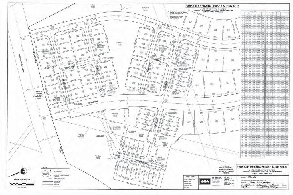
53
54 Packet Pg. 54 EXHIBIT E - LINK TO MPD AGREEMENT
55 Packet Pg. 55 EXHIBIT F- LINK TO ANNEXATION AGREEMENT
56 Packet Pg. 56 EXHIBIT G- LINK TO SITE AND UTILITY PLANS

57 EXHIBIT H Packet Pg. 57
58 EXHIBIT I- PHOTOS OF SITE Packet Pg. 58

59 Packet Pg. 59 View of Phase 2 looking southwest

60 View looking southeast towards soil repository and US 40 berm Packet Pg. 60

61 Packet Pg. 61 View of Phase 2 looking southwest from Calamity Ct

62 View looking west towards minor ridge from Calamity Lane Packet Pg. 62

63 Packet Pg. 63

64 Packet Pg. 64 View looking northeast from Calamity Court and Ledger Way intersection

65 Packet Pg. 65 View looking North to Phase Cottage homes on Ledger Way

66 Packet Pg. 66 View to Phase 2 site looking west from Calamity Court and Ledger Way

67 Packet Pg. 67 View looking south from Ledger Way and Richardson Flat Road

68 Packet Pg. 68 View looking south at Rail Trail crossing of Richardson Flat Road

69 Packet Pg. 69 View looking southeast from Richardson Flat Road near SR 248

70 Packet Pg. 70 View looking east from Richardson Flat Road at SH 248
71 Packet Pg. 71 EXHIBIT J - LINK TO DESIGN GUIDELINES
72 EXHIBIT K Packet Pg. 72
73 Packet Pg. 73
74 Packet Pg. 74
75 Packet Pg. 75
76 Packet Pg. 76
77 Packet Pg. 77
78 Packet Pg. 78
79 Packet Pg. 79
80 Packet Pg. 80
81 Town Homes October 24, 2016 Proposed Pricing from Ivory Homes # of Bedrooms Exhibit B Park City Heights Proposed Pricing by Unit Type Housing Resolution Pricing Limit Negotiated Pricing T25 319, , ,900 Bedroom Count Summary T26 249, , ,900 2 bedrooms 7 T27 297, , ,900 3 bedrooms 46 T28 329, , ,900 4 bedrooms 26 T9 326, , ,900 T10 254, , ,900 Numbers of Affordable Units Per Year TH PH Cottages total T11 303, , , T12 336, , , T21 332, , , T22 259, , , T23 309, , , T24 343, , , T13 339, , , T14 265, , , T15 316, , ,900 total T16 350, , ,900 T17 346, , ,900 T18 270, , ,900 T19 322, , ,900 T20 357, , ,900 T5 353, , ,900 T6 275, , ,900 T7 328, , ,900 T8 364, , ,900 T1 360, , ,900 T2 281, , ,900 T3 335, , ,900 T4 371, , ,900 sub-total 8,903,256 11,159,834 9,235,200 (1,924,634) amount below max allowed pricing Park Homes October 24, 2016 Proposed Pricing from Ivory Homes # of Bedrooms Limit Proposed Scenario 1 $408,900 3 $375,179 $375, $374,900 3 $375,179 $375, $408,900 3 $375,179 $375, $408,900 3 $375,179 $375, $374,900 3 $375,179 $375, $408,900 3 $375,179 $375, $477,900 4 $445,463 $465, $384,272 3 $375,179 $438, $419,272 3 $375,179 $438, $477,900 4 $445,463 $465, $384,272 3 $375,179 $438, $419,122 3 $375,179 $438, $489,878 4 $445,463 $465, $393,878 3 $375,179 $438, $429,600 3 $375,179 $438, $489,878 4 $445,463 $465, $393,878 3 $375,179 $438, $429,600 3 $375,179 $438, $502,095 4 $445,463 $465, $403,772 3 $375,179 $438, $440,340 3 $375,179 $438, $502,095 4 $445,463 $465, $440,300 3 $375,179 $438, $440,300 3 $375,179 $438, $514,648 4 $445,463 $465, $451,348 3 $375,179 $438, $451,348 3 $375,179 $438, $514,648 4 $445,463 $465, $451,348 3 $375,179 $438, $451,348 3 $375,179 $438, $527,515 4 $445,463 $465, $462,631 3 $375,179 $438, $462,631 3 $375,179 $438, $527,515 4 $445,463 $465, $462,631 3 $375,179 $438, $15,581,363 $13,834,105 15,241,574 $1,407,469 amount above max allowed pricing Cottages October 24, 2016 Proposed Pricing from Ivory Homes # of Bedrooms Limit Proposed Scenario 1 499, , , , , , , , , , , , , , , , , , , , , , , , , , , , , , , , , , , , , , , , , , , , , , , ,008 8,700,856 8,096,128 8,096,128 Total Revenue Initial Ivory Pricing Revenue $ 33,185,475 Total Revenue Resolution Limits $ 33,090,067 Total Negotiated Pricing Revenue $ 32,572,902 $ (517,165) amount negotiated pricing is below max allowed pricing 12/15/2016 Packet Pg
82 Packet Pg. 82
83 Packet Pg. 83
84 Packet Pg. 84
85 Packet Pg. 85
86 Packet Pg. 86
87 EXHIBIT L- February 28, 2018 Planning Commission minutes Packet Pg. 87
88 Planning Commission Meeting February 28, 2018 Page The proposed amended plat is consistent with the approved Master Planned Development for the Village at Empire Pass. Conclusions of Law 8902 Empire Drive 1. There is good cause for this amended condominium plat. 2. The amended plat is consistent with the Park City Land Management Code and applicable State law regarding condominium plats. 3. Neither the public nor any person will be materially injured by the proposed amended plat. 4. Approval of the amended plat, subject to the conditions stated below, does not adversely affect the health, safety and welfare of the citizens of Park City. Conditions of Approval 8902 Empire Club Drive 1. The City Attorney and City Engineer will review and approve the final form and content of the amended plat for compliance with State law, the Land Management Code, and the conditions of approval, prior to recordation of the plat. 2. The applicant will record the amended plat at the County within one year from the date of City Council approval. If recordation has not occurred within one year s time, this approval for the plat will be void. 3. A plat note indicating that all conditions of approval of the Village at Empire Pass Master Planned Development, the Village at Empire Pass West Side subdivision plat, and the Silver Strike Conditional Use Permit shall continue to apply. APPROVED 4. Prior to plat recordation and issuance of a building permit to combine the hallway with the Units 201 and 203, any common utilities within the hallway area shall be relocated as determined by the Chief Building Official, and an emergency and ADA exit plan for the building shall be approved by the Park City Fire District and Park City Building Department. 2. Park City Heights Subdivision Phase 2 The applicant is requesting a final Subdivision Plat for a total of 39 single family lots consistent with the Park City Heights Master Planned Development. (Application PL ) Planner Whetstone introduced the applicant, Brad Mackey, with Ivory Development. Packet Pg. 88
89 Planning Commission Meeting February 28, 2018 Page 9 Planner Whetstone noted that this was part of the Park City Heights Master Planned Development. It was annexed to the City and a lot of history is associated with it. This is the Second Phase Subdivision Plat. One standard to review it by would be the approved amended preliminary plat, as well as all of the conditions of approval, the development agreement, and the annexation. Planner Whetstone stated that because of the amount of history and the number of findings and conditions, the Staff thought it was important to conduct a public hearing and give the Planning Commission the opportunity to look through this application and discuss the issues outlined in the Staff report. She requested that the Planning Commission continue this item to March 28 th. Planner Whetstone reviewed a preliminary plat for 39 units in the next Phase. The units are located to the south of where homes are currently being built. She stated that 239 acres were annexed into the City and placed in the Community Transition Zone (CT), which has a density of one unit per acre for residential development. The agreement was that this would include 79 affordable deed restricted units as well as the market rate units. Planner Whetstone disclosed that at one time the City had an ownership interest; however, while it still retains a security interest as the holder of some of the agreements, the City does not have any current ownership in the property. Planner Whetstone oriented the Commissioners to the First Phase of the project. The units being built currently included the 28 Townhouse units, which are deed restricted, 35 Park Homes, and 16 of the Cottage-style units. The units further up the hill are the Homestead units. Commissioner Suesser asked if the Cottages were part of the affordable units. Planner Whetstone stated that 16 of the Cottages would be deed restricted. She had included the last Housing Mitigation Plan in the Staff report, which talks about the units being developed on an annual basis rather than a phasing basis. For example, if the affordable units are not on schedule by December 2018, the market rate Certificates of Occupancy are held until they catch up with the COs for the affordable units. APPROVED Planner Whetstone reported that Phase 2 are 39 single-family lots. All are Homestead units and none are affordable units. She explained that the primary reason for doing this phase next was based on the requirement to construct the water tank, which requires extending Calamity Lane. Since Calamity Lane needed to be extended it made sense to put in that infrastructure and plat those lots at the same time. The Staff requested that the Planning Commission provide input on amending the phasing plan and discuss maximum house sizes. She noted that the Design Guidelines Packet Pg. 89
90 Planning Commission Meeting February 28, 2018 Page 10 that were recorded as part of the MPD identified the house size for the Townhouses, the Park Homes and the Cottages. However, the Homestead lots were based on the preliminary subdivision plat that identified the maximum house size for certain lots. They were by number, but the numbering has changed. Planner Whetstone stated that she relooked at the numbers and it relates to the maximum house size in the preliminary plat. Commissioner Thimm asked if the shifting of numbers resulted in a higher number of larger houses, or whether it was the same number and only renumbered. Planner Whetstone replied that they were just renumbered to make an association between Lots 64, 65, 66 and what it related to. Planner Whetstone noted that in Phase 1 the lots on the east side of Ledger Way are 3500 square feet Cottage style units. In Phase 2, the downhill lots on the first cul-desac were identified as 4,000 square feet for Lots 201 to 205. She had spoken with the designer and the sale manager and he had requested that the square footage for Lots 201 to 205 be increased from 4,000 square feet to 4,500 square feet, because it is harder to bury a basement on a downhill lot. Planner Whetstone pointed out that the uphill lots on cul-de-sac A were already identified as 5,000 square feet. Planner Whetstone remarked that all the other sizes were consistent with the preliminary plat. Commissioner Suesser asked if there were townhomes on the north side of the lots. Planner Whetstone replied that they were all Homestead units. She identified Richardson Flat Road on the far north side and noted that the 35 lots were all Park Homes ranging up to 3,000 square feet; and all the basements are buried. Commissioner Phillips believed Commissioner Suesser was referring to the units abutting those lots. Planner Whetstone stated that all the Homestead lots in this Phase abut Homestead lots. Across Ledger Way are the Cottage lots. Commissioner Suesser understood that the square footage of the Homestead lots are 4,000 square feet. Planner Whetstone answered yes. She noted that they were all uphill lots where it was easy to bury the basement. Behind those lots is where the designer was requesting an increase to 4,500 square feet. APPROVED Commissioner Phillips asked how the additional 500 square feet would help to bury the basement. Planner Whetstone replied that it helps in counting the basement area that they are not able to bury. In addition, it would help minimize the excavation. Commissioner Phillips understood the reasoning. Planner Whetstone stated that when the preliminary plat was approved with the MPD, it said that house sizes could be discussed at the time of the final plat. Packet Pg. 90
91 Planning Commission Meeting February 28, 2018 Page 11 Planner Whetstone presented the Phasing Plan as it is now with Phase I, which has already been platted. Phase 2 was going to continue the two streets to the south with Phase 3 coming back to the north, and Phase 4. However, because of the water tank, the applicant was requesting that Phase 2 move up the hill, and plat all of the open space, which is Parcel D. Phase 3 are the two lots adjacent near Hidden Oaks. The applicant had submitted Phase 3 but they were still working on the access to those lots. Phase 4 would come back down and continue the infrastructure. Phase 5 fills in. Planner Whetstone stated that Phase 4 was where they were doing construction staging at this time. Commissioner Phillips wanted to know what amount was deed restricted in Phase 2 of the previous version versus Phase 2 of this version. Mr. Mackey stated that the original Phase 2 was now Phase 4. The layout is identical. Eleven deed restricted units in the Cottage area that was mostly in Phase 2 would now be Phase 4. Mr. Mackey remarked that Phase 2 has zero deed restricted units, but as Planner Whetstone had mentioned, they are on a yearly requirement for building those units. Currently, six Park homes under construction are all framed. Eight Townhomes are into the City for approval of a building permit. One Cottage home is ready to submit for building permit. Mr. Mackey stated that it complies with the affordable housing schedule and they intend to meet that schedule. He explained that they were bringing Phase 2 on now as it stands, because the Second phase of development requires the construction of a water tank concurrent with the phasing of Phase 2. They have to build the road to get to the water tank, as well as all the utilities in the road. As long as that was being built they thought it made sense to plat the lots. Commissioner Phillips assumed it would not have much impact on the progress of the deed restricted units. Mr. Mackey did not believe it would. APPROVED Planner Whetstone stated that five deed restricted Cottage homes that were identified in Phase 1 have already been platted and they can begin pulling building permits. Commissioner Thimm clarified that the phasing plan would not change the delivery schedule of affordable housing units. Planner Whetstone replied that he was correct. Commissioner Thimm asked if it would change the type of units and when they are delivered. Planner Whetstone answered no. Planner Whetstone stated that during the MPD when the visual analysis was done, there is a power line on a minor ridge on the property that was visible. At that time the Planning Commission had concerns about the lots on the western perimeter. She noted that four lots at the end of the cul-de sacs are in this Phase. Planner Whetstone reported that a condition was put on the MPD that development on the western perimeter lots requires a conditional use permit if the structure has a height greater than Packet Pg. 91
92 Planning Commission Meeting February 28, 2018 Page She pointed out that the condition would be placed on this plat. The Staff believes that if the height exceeds 28 there should be a visual analysis, consistent with the MPD. Mr. Mackey was comfortable with adding that condition. He explained that there is an allowance in the Code to exceed 28. If it is a gable they could go an additional five feet. These homes would be restricted to a rambler style or a modern type of architecture and he did not believe it would be an issue. Mr. Mackey stated that the ridge is approximately the western line of the power corridor. Therefore, there should not be visual issues over that ridge because they would be gaining 20+ feet up to the top of the ridge. Mr. Mackey was comfortable with a 28 restriction. If not, it would open up the additional ability to put a gable roof. If they wanted to design a home that did not comply with the condition, it would require a conditional use permit that would come back to the Planning Commission. Planner Whetstone requested input from the Planning Commission on the discussion items presented, as well as other comments on the Findings and Conditions. The Commissioners could submit their comments to her prior to preparing the Staff report for the March 28 th meeting. Commissioner Suesser asked for the location of the water tank. Mr. Mackey reviewed the new phasing plan to identify the location. He understood that Roger McLain with the Public Works Department and the City Council walked all the possible locations before choosing the tank site. He indicated an open space parcel that is a trail access that would also serve as an access road up to the tank site. Vice-Chair Band opened the public hearing. There were no comments. Vice-Chair Band closed the public hearing. APPROVED The Commissioners had no other questions or comments. Commissioner Thimm asked if they could take action this evening since the Planning Commission had no other issues. Assistant City Attorney McLean stated that they could since the agenda did not specify a continuance this evening. However, she questioned whether Planner Whetstone was comfortable with the Findings and Conditions as written since she had planned on a continuance. Planner Whetstone had no objection to a motion if the Commissioners and the applicant had reviewed the Findings and Conditions and had no changes or concerns. Director Erickson stated that if the Planning Commission took action this evening, Finding 35 needed to be modified for clarification. It defines how house sizes are Packet Pg. 92
93 Planning Commission Meeting February 28, 2018 Page 13 defined, and the Staff wanted to bring it more into alignment with the definitions in the Land Management Code. He explained that currently there are three different ways to measure home size. Planner Whetstone remarked that the Staff had discussed revising the language from the following maximum house size shall apply to language that ties it to the LMC. The revised language would read, maximum residential floor area shall apply, as defined by the Land Management Code. Commissioner Thimm read from page 173 of the Staff report under Staff Recommendations, The Staff recommends that the Planning Commission conduct a public hearing for Park City Heights Phase 2 subdivision plat, review the application and draft ordinance, and continue this item to March 28, 2018, with direction to Staff He believed anyone in the public who read the Staff report would think they had the opportunity to comment at the meeting on March 28 th. The Commissioners concurred. MOTION: Commissioner Phillips moved to CONTINUE Park City Heights Subdivision Phase 2, to March 28, Commissioner Suesser seconded the motion. VOTE: The motion passed unanimously. The Park City Planning Commission Meeting adjourned at 6:15 p.m. Approved by Planning Commission: APPROVED Packet Pg. 93

94 Planning Commission Staff Report Subject: Land Management Code Amendments Author: Francisco Astorga, AICP, Senior Planner Application No. PL Date: 28 March 2018 Type of Item: Legislative Land Management Code Amendments Removing the Transfer of Development Rights - Sending Treasure Hill Designation Summary Recommendations Staff recommends that the Planning Commission review the proposed Land Management Code (LMC) Amendments removing the Transfer of Development Rights - Sending Treasure Hill (TDR-STH) language from LMC Chapter TDR Overlay Zone, subject to Park City Municipal Corporation acquiring the Treasure Hill Hillside Properties (Creole-Gulch and Mid-station Sites) of the Sweeney Properties Master Plan by April 1, 2019, as described in this staff report. Staff recommends that the Planning Commission open a public hearing and consider forwarding a positive recommendation to the City Council. Description Proposal: Applicant: Location: Reason for Review: Removing the TDR-STH language from the LMC Planning Department, directed by City Council Hillside Properties (Creole-Gulch and Mid-station Sites) Sweeney Properties Master Plan LMC Amendments require Planning Commission review, public hearing, and recommendation plus City Council review, public hearing, and final action Acronyms within this Report LMC Land Management Code TDR Transfer of Development Rights STH Sending Treasure Hill (Overlay Zone) CUP Conditional Use Permit E Estate (District) MPD Master Planned Development ROS Recreation and Open Space (District) Background On February 15, 2018, the City Council approved an agreement to purchase Treasure Hill Hillside Properties (Creole-Gulch and Mid-Station sites) of the Sweeney Properties Master Plan, See Exhibit B February 15, 2018 City Council Staff Report and Exhibit C February 15, 2018 City Council Meeting Minutes. On February 14, 2018, the Planning Commission passed and adopted Planning Commission Resolution No Packet Pg. 94
95 supporting continuing the Treasure Hill Conditional Use Permit (CUP) application to a date uncertain and supporting the City Council and Mayor in their consideration of purchasing the Treasure Hill property, see Exhibit D Planning Commission Resolution No During the February 15, 2018 City Council meeting, the Council publicly deliberated removing the TDR-STH section in the LMC that provides the ability to transfer density from the Treasure Hill site to other sites in town. Although the TDR-STH section could allow the City an ability to recoup some of the cost of purchasing the site, the Council directed staff to remove the TDR-STH language from the code. The LMC includes the following language related to the transfer of development rights. Staff proposes to amend the language as redlined below: Establishment Of Sending And Receiving Districts A. The City Council may amend Sending Sites and Receiving Sites as TDR Zoning Districts within the Official Zoning Map by ordinance in the manner of amending the Official Zoning Map pursuant to Section of this Code. The designations TDR-S shall be the prefix title for the overlay Zoning District for Sending Sites, the designation TDR-R shall be the prefix title of the overlay Zoning District for Receiving Sites. B. All vacant lots within the Park City Historic Districts (except for those lots included in SOT1, SOT2, and SOT3, and STH) and all Sites listed on the Park City Historic Sites Inventory shall be eligible as Sending Sites and shall be an overlay Zoning District referred to as TDR-Sending Historic District (TDR-SHD). C. Sending Sites and Receiving Sites shall be consistent with the General Plan and the purpose statements of Chapter Development Credit Determination Letter A. The total number of Development Credits available to a Sending Site shall be determined as follows: 1. TDR Sending Treasure Hill (TDR-STH). For properties within TDR-STH, one (1) Development Credit per existing MPD Unit Equivalent may be calculated. A maximum of twenty-two (22) MPD Unit Equivalents may be sent from the TDR-STH Sending Site. 2. TDR Sending Old Town1 (TDR-SOT1), Sending Old Town 2 (TDR- SOT2), and Sending Old Town 3 (TDR-SOT3). For Properties within TDR- SOT1, TDR-SOT2, and TDR-SOT3, one (1) Development Credit may be calculated per existing minimum lot area within the underlying Zoning District. 3. TDR Sending Historic District (TDR-SHD). a. For vacant Lots of record in the Historic Districts, one (1) Development Credit per existing Lot of record may be calculated. b. For Sites listed on the Historic Sites Inventory, one (1) Development Credit per 2,000 square feet of unused development potential. Packet Pg. 95
96 B. If requested, this calculation will be made by the Park City Planning Director or his or her designee in the form of a determination letter. If the calculation results in a fraction it shall be rounded to the nearest hundredth. Such letter will indicate the Development Credits at the time the request is made. The letter is an indication of possible Development Credits that may Transfer. The Development Credits are not Base Zone Density. The number of Development Credits may change if an MPD is amended or expires, or if the LMC is amended. A determination letter is not a binding document and does not grant a vested right Sending Site Procedure A. The following is the Sending Site procedure that must be followed to send Development Credits: 1. TDR-S Property Owners may choose to develop their property under Base Zoning, or they may choose to sell, Transfer, or joint venture their Development Rights. 2. TDR-S fee Property Owners may request a Development Credit determination letter from the Park City Planning Director. 3. A TDR-S Property Owner is eligible to negotiate the sale, Transfer, or joint venture of their Property s Development Credits. 4. A Development Credit may only be sold, conveyed, or otherwise transferred by the Owner(s) or their legal representative. 5. The sale, conveyance, or Transfer shall occur upon surrender of the Development Credits which authorizes the Park City Planning Director, or designee to Transfer the Development Credits to the stated transferee by reissuing the Development Credits in the transferee s name, and recording a Development Credit Certificate in the real Property records of Summit County. 6. With each Transfer or sale, a Conservation Easement and/or deed restriction shall be recorded covering the entire Site, or if only a portion of the available Development Credits are sold then the Conservation Easement and/or deed restriction shall cover a proportional amount of the Site to be determined by the Park City Planning Director or a designee. 7. Within TDR-STH, portions of Development Rights may be sent to a Receiving Site. Within the TDR-STH portions of Development Rights up to the maximum of twenty-two (22) MPD Unit Equivalents may be sent to a Receiving Site overlay Zoning District. Twenty-two (22) MPD Unit Equivalents in the TDR-STH zone equates to twenty-two (22) Development Credits in a Receiving Site overlay Zoning District. 8. Within the TDR-SOT1, TDR-SOT2, and TDR-SOT3 overlay Zoning District, Property Owners must sell, Transfer, or joint venture all of the Development Rights within the overlay zone. Portions of the TDR-SOT1, TDR-SOT2, and TDR-SOT3 overlay Zoning District shall not be developed if any portion of the TDR-SOT1, TDR-SOT2, and TDR-SOT3 overlay Zoning District has been sent to a Receiving Site. An Owner of land within the TDR-SOT overlay Zoning District will not be eligible to Transfer Packet Pg. 96
97 Development Credit if they chose to sell or develop any portion of the TDR-SOT1, TDR-SOT2 and TDR-SOT3 overlay Zoning District. The TDR- SOT1, TDR-SOT2, and TDR-SOT3 overlay Zoning Districts must be transferred in whole. 9. When all available Development Credits on a Sending Site have been purchased, no Uses other than those enumerated in the Conservation Easement are allowed. Responsibility for any required maintenance or abatement remains with the fee title Owner. 10. The final Transfer of Development Credits will be completed upon Development Approval on a Receiving Site and the Recording of a deed restriction and/or Conservation Easement against the Sending Site or if the Owner of the Development Credits chooses to forfeit Development Rights and records a deed restriction and/or Conservation Easement to do so. 11. TDR-S Property Owners shall notify any lien or mortgage holders of the sale of the Development Credits, and such notification shall be demonstrated by written approval submitted to the City prior to Transfer. 12. TDR-S Property Owners shall be responsible for notification of the county tax assessor regarding possible changes in Property value. District Purpose The purposes of the TDR Overlay Zone are to: A. promote the general health, safety, and welfare of the present and future inhabitants, businesses, and visitors of Park City; B. preserve Open Space, scenic views, environmental areas, Steep Slopes and Sensitive Lands; C. conserve Agriculture, and forest areas; D. protect lands and structures of aesthetic, architectural, and Historic significance; E. retain Open Space in which healthful outdoor recreation can occur; F. improve upon Park City s well-established park and trail system; G. ensure the owners of preserved, conserved, or protected land may make reasonable use of their Property rights by transferring their right to develop to eligible zones; H. provide a mechanism whereby Development rights may be reliably Transferred; I. ensure Development Rights are transferred to properties in Areas or districts that have adequate community facilities and infrastructure, including transportation, to accommodate additional Development; and J. locate receiving zones to improve future traffic circulation. Analysis The proposed amendments remove the ability to transfer any density from the Treasure Hill site to other locations, subject to Park City Municipal Corporation acquiring the subject property. Currently the LMC designates the Treasure Hill Hillside Properties as a TDR-Sending zone allowing the transfer of up to the maximum of twenty-two (22) MPD Unit Equivalents that may be sent to a Receiving Site overlay Zoning District, subject to applicable review process and approval. Staff recommends that the LMC Packet Pg. 97
98 Amendment take effect if the Treasure Hill Hillside Properties (Creole-Gulch and Midstation Sites) of the Sweeney Properties are indeed acquired by Park City in accordance with the Settlement Agreement (and other relevant documents) by April 1, In addition, the official Zoning Map will also need to be amended pursuant to LMC and to remove the TDR-STH Zone Overlay designation and to change the zoning designation of the site from the current Estate District / Master Planned Development (E-MPD) to the Recreation and Open Space (ROS) zoning district. Staff requests to follow up on this Zoning Map Amendment after the results of the November 2018 Bond measure. Process Amendments to the Land Management Code require Planning Commission recommendation and City Council adoption. City Council action may be appealed to a court of competent jurisdiction per LMC Notice On March 14, 2018, legal notice of a public hearing was posted in the required public spaces and published in the Park Record. Public Input Public hearings are required to be conducted by the Planning Commission and City Council prior to adoption of LMC amendments. The public hearing for these amendments was properly and legally noticed as required by the LMC. No public input has been received as of the date of this report. Significant Impacts The proposed LMC amendments remove the ability to transfer any density from the Treasure Hill site to other sites, subject to City acquisition of the site. Recommendation Staff recommends that the Planning Commission review the proposed LMC Amendments removing the Transfer of Development Rights - Sending Treasure Hill language from LMC Chapter TDR Overlay Zone, subject to Park City Municipal Corporation acquiring the Treasure Hill Hillside Properties (Creole-Gulch and Midstation Sites) of the Sweeney Properties Master Plan by April 1, 2019, as described in this staff report. Staff recommends that the Planning Commission open a public hearing and consider forwarding a positive recommendation to the City Council. Exhibits Exhibit A Proposed Ordinance Exhibit B February 15, 2018 City Council Staff Report [hyperlink] Exhibit C February 15, 2018 City Council Meeting Minutes [hyperlink] Exhibit D Planning Commission Resolution No [hyperlink] Packet Pg. 98
99 Exhibit A Proposed Ordinance Draft Ordinance 2018-XX AN ORDINANCE AMENDING THE LAND MANAGEMENT CODE OF PARK CITY, UTAH, CHAPTER TRANSFER OF DEVELOPMENT RIGHTS (TDR) OVERLAY ZONE SECTIONS (B), (A)(1), AND (A)(7) RELATED TO THE SENDING TREASURE HILL OVERLAY ZONE. WHEREAS, the Land Management Code was adopted by the City Council of Park City, Utah to promote the health, safety and welfare of the residents, visitors, and property owners of Park City; and WHEREAS, the Land Management Code implements the goals, objectives and policies of the Park City General Plan to maintain the quality of life and experiences for its residents and visitors; and to preserve the community s unique character and values; and WHEREAS, the City reviews the Land Management Code and identifies necessary amendments to address planning and zoning issues that have come up in the past, and to address specific Land Management Code issues raised by the public, Staff, and the Commission, and to align the Code with the Council s goals and implementation of the General Plan; and WHEREAS, the City s goals include preservation of Park City s character regarding Old Town improvements, historic preservation, sustainability, affordable housing, and protecting Park City s residential neighborhoods and commercial districts; and WHEREAS, on February 15, 2018, the City Council approved an agreement to purchase Treasure Hill Hillside Properties (Creole-Gulch and Mid-Station sites) of the Sweeney Properties Master Plan subject to a bond approval by Park City voters in November 2018, and City Council determined that if the purchase occurred, City Council did not want to ability to transfer density from the Treasure Hill site to other sites in town; and WHEREAS, Chapter 2.24 Transfer of Development Rights (TDR) Overlay Zone provides a description of requirements, provisions and procedures specific to this overlay zone that the City desires to revise; and WHEREAS, by removing the TDR sending overlay zoning from the Treasure Hill site, it removes the ability to transfer any density from the Treasure Hill site to other sites, subject to City acquisition of the site; and WHEREAS, the Land Management Code amendments shall not take effect if the Treasure Hill Hillside Properties (Creole-Gulch and Mid-station Sites) of the Sweeney Packet Pg. 99
100 Properties are not acquired by Park City in accordance with the Settlement Agreement (and other relevant documents) by April 1, 2019; and WHEREAS, March 14, 2018, legal notice was published in the Park Record as required by the Land Management Code; and WHEREAS, the Planning Commission conducted a public hearing at the regularly scheduled meeting on March 28, 2018, and forwarded a recommendation to the City Council; and WHEREAS, the City Council conducted a public hearing at its regularly scheduled meeting on April 19, 2018; and WHEREAS, it is in the best interest of the residents of Park City, Utah to amend the Land Management Code to be consistent with the Park City General Plan and to be consistent with the values and identified goals of the Park City community and City Council to protect health and safety, maintain the quality of life for its residents, preserve and protect the residential neighborhoods, and preserve the community s unique character. NOW, THEREFORE, BE IT ORDAINED by the City Council of Park City, Utah as follows: SECTION 1. AMENDMENTS TO TITLE 15 - Land Management Code Chapter 2.24 Section (B), (A)(1), AND (A)(7). The recitals above are incorporated herein as findings of fact. Section of the Land Management Code of Park City is hereby amended as redlined (see Attachment 1). SECTION 2. EFFECTIVE DATE. This Ordinance shall be effective on December 1, 2018, only if the Treasure Hill Open Space Bond passes. If the Bond fails, this ordinance shall be null and void. PASSED AND ADOPTED this 19th day of April, 2018 PARK CITY MUNICIPAL CORPORATION Attest: Andy Beerman, Mayor Michelle Kellogg, City Recorder Packet Pg. 100
101 Approved as to form: Mark Harrington, City Attorney Packet Pg. 101
102 Attachment Transfer Of Development Rights (TDR) Overlay Zone Purpose Establishment Of Sending And Receiving Districts Sending Site Eligibility Development Credit Determination Letter Sending Site Procedure Receiving Site Eligibility Receiving Site Procedures Unit Equivalents Of Development Credits Purpose The purposes of the Transfer of Development Rights Overlay Zone are to: A. promote the general health, safety, and welfare of the present and future inhabitants, businesses, and visitors of Park City; B. preserve Open Space, scenic views, environmental areas, Steep Slopes and Sensitive Lands; C. conserve Agriculture, and forest areas; D. protect lands and structures of aesthetic, architectural, and Historic significance; E. retain Open Space in which healthful outdoor recreation can occur; F. improve upon Park City s well-established park and trail system; G. ensure the owners of preserved, conserved, or protected land may make reasonable use of their Property rights by transferring their right to develop to eligible zones; H. provide a mechanism whereby Development rights may be reliably Transferred; I. ensure Development Rights are transferred to properties in Areas or districts that have adequate community facilities and infrastructure, including transportation, to accommodate additional Development; and J. locate receiving zones to improve future traffic circulation Establishment Of Sending And Receiving Districts A. The City Council may amend Sending Sites and Receiving Sites as TDR Zoning Districts within the Official Zoning Map by ordinance in the manner of amending the Official Zoning Map pursuant to Section of this Code. The designations TDR-S shall be the prefix title for the overlay Zoning District for Sending Sites, the designation TDR-R shall be the prefix title of the overlay Zoning District for Receiving Sites. B. All vacant lots within the Park City Historic Districts (except for those lots included in SOT1, SOT2, and SOT3, and STH) and all Sites listed on the Park City Historic Sites Inventory shall be eligible as Sending Sites and shall be an overlay Zoning District referred to as TDR-Sending Historic District (TDR-SHD). C. Sending Sites and Receiving Sites shall be consistent with the General Plan and the purpose statements of Chapter Sending Site Eligibility Packet Pg. 102
103 All Properties located within the TDR-S overlay zone are eligible to Transfer Development Credits Development Credit Determination Letter A. The total number of Development Credits available to a Sending Site shall be determined as follows: 1. TDR Sending Treasure Hill (TDR-STH). For properties within TDR- STH, one (1) Development Credit per existing MPD Unit Equivalent may be calculated. A maximum of twenty-two (22) MPD Unit Equivalents may be sent from the TDR-STH Sending Site TDR Sending Old Town1 (TDR-SOT1), Sending Old Town 2 (TDR- SOT2), and Sending Old Town 3 (TDR-SOT3). For Properties within TDR-SOT1, TDR-SOT2, and TDR-SOT3, one (1) Development Credit may be calculated per existing minimum lot area within the underlying Zoning District TDR Sending Historic District (TDR-SHD). a. For vacant Lots of record in the Historic Districts, one (1) Development Credit per existing Lot of record may be calculated. For Sites listed on the Historic Sites Inventory, one (1) Development Credit per 2,000 square feet of unused development potential. B. If requested, this calculation will be made by the Park City Planning Director or his or her designee in the form of a determination letter. If the calculation results in a fraction it shall be rounded to the nearest hundredth. Such letter will indicate the Development Credits at the time the request is made. The letter is an indication of possible Development Credits that may Transfer. The Development Credits are not Base Zone Density. The number of Development Credits may change if an MPD is amended or expires, or if the LMC is amended. A determination letter is not a binding document and does not grant a vested right Sending Site Procedure A. The following is the Sending Site procedure that must be followed to send Development Credits: 1. TDR-S Property Owners may choose to develop their property under Base Zoning, or they may choose to sell, Transfer, or joint venture their Development Rights. 2. TDR-S fee Property Owners may request a Development Credit determination letter from the Park City Planning Director. 3. A TDR-S Property Owner is eligible to negotiate the sale, Transfer, or joint venture of their Property s Development Credits. 4. A Development Credit may only be sold, conveyed, or otherwise transferred by the Owner(s) or their legal representative. 5. The sale, conveyance, or Transfer shall occur upon surrender of the Development Credits which authorizes the Park City Planning Director, or designee to Transfer the Development Credits to the stated transferee by reissuing the Development Credits in the Packet Pg. 103
104 transferee s name, and recording a Development Credit Certificate in the real Property records of Summit County. 6. With each Transfer or sale, a Conservation Easement and/or deed restriction shall be recorded covering the entire Site, or if only a portion of the available Development Credits are sold then the Conservation Easement and/or deed restriction shall cover a proportional amount of the Site to be determined by the Park City Planning Director or a designee. 7. Within TDR-STH, portions of Development Rights may be sent to a Receiving Site. Within the TDR-STH portions of Development Rights up to the maximum of twenty-two (22) MPD Unit Equivalents may be sent to a Receiving Site overlay Zoning District. Twenty-two (22) MPD Unit Equivalents in the TDR-STH zone equates to twenty-two (22) Development Credits in a Receiving Site overlay Zoning District Within the TDR-SOT1, TDR-SOT2, and TDR-SOT3 overlay Zoning District, Property Owners must sell, Transfer, or joint venture all of the Development Rights within the overlay zone. Portions of the TDR-SOT1, TDR-SOT2, and TDR-SOT3 overlay Zoning District shall not be developed if any portion of the TDR-SOT1, TDR-SOT2, and TDR-SOT3 overlay Zoning District has been sent to a Receiving Site. An Owner of land within the TDR-SOT overlay Zoning District will not be eligible to Transfer Development Credit if they chose to sell or develop any portion of the TDR-SOT1, TDR-SOT2 and TDR-SOT3 overlay Zoning District. The TDR-SOT1, TDR-SOT2, and TDR-SOT3 overlay Zoning Districts must be transferred in whole When all available Development Credits on a Sending Site have been purchased, no Uses other than those enumerated in the Conservation Easement are allowed. Responsibility for any required maintenance or abatement remains with the fee title Owner The final Transfer of Development Credits will be completed upon Development Approval on a Receiving Site and the Recording of a deed restriction and/or Conservation Easement against the Sending Site or if the Owner of the Development Credits chooses to forfeit Development Rights and records a deed restriction and/or Conservation Easement to do so TDR-S Property Owners shall notify any lien or mortgage holders of the sale of the Development Credits, and such notification shall be demonstrated by written approval submitted to the City prior to Transfer TDR-S Property Owners shall be responsible for notification of the county tax assessor regarding possible changes in Property value Receiving Site Eligibility All Properties located within the TDR-R overlay zone are eligible to receive Transfer Development Credits within the procedures outlined in Packet Pg. 104
105 Receiving Site Procedures A. The following is the Receiving Site procedure that must be followed to receive Transfer Development Credits. 1. All regulations governing zoning, subdividing, and approval processes remain as currently adopted and amended. If any Development within the TDR-R overlay requests a Density greater than permitted by the Base Zoning, the increased Density shall be realized through Development Credits. 2. Any Development requesting higher density than the Base Zoning must be reviewed by the Planning Commission as a Master Planned Development. The Planning Commission shall consider all factors set forth in LMC Chapter Any Development requesting the higher densities shall bring evidence of Development Credits in the form of options to purchase, ownership or joint ventures at the time of Master Planned Development approval and evidence of ownership at time of Development Agreement approval. 4. Areas may develop at the underlying Base Zoning without purchasing Development Credits. If these Properties desire to increase their Densities beyond the existing zone, then Development Credits shall be required and the height limitation for the Site may be increased from the Base Zoning limits through an approved MPD. 5. Any Development Approval process, using Development Credits, shall adhere to the Base Zoning requirements including the Master Planned Development requirements Unit Equivalents Of Development Credits A. The following is the value of a Development Credit that may be applied to a receiving overlay zone: 1. One (1) Development Credit is equivalent to one thousand (1,000) square feet of Gross Commercial Floor Area or two thousand (2,000) square feet of Gross Residential Floor Area in the Receiving Site overlay Zoning District. Packet Pg. 105

106 City Council DRAFT Staff Report Subject: Author: Department: Date: March 29, 2018 Type of Item: Informational Strategic Code Enforcement Update Dave Thacker, Chief Building Official/Fire Code Official Michelle Downard, Deputy Chief Building Official Building Department Preface The following report is a draft of a Staff Report to City Council as part of a quarterly Code Enforcement update. The Planning Department and Building Department have agreed to use this report to brief the Planning Commission and Historic Preservation Board (April 4, 2018) on current Code Enforcement issues and practices. The report will be in final form when presented to City Council on March 29, Summary Staff is returning to Council with a strategic code enforcement update. Staff continues to balance their strategies between providing community education, compliance, and responding to community concerns while not being punitive. Efforts have been focused on high priorities such as conditions of approval in construction mitigation plans, noise, special events, designing a newsletter, parking enforcement and implementing online complaint submittals- all of which have proven effective. Staff will continue to adjust enforcement activity to ensure increased code compliance throughout the city. DRAFT Background The Code Enforcement team s approach is a hybrid or strategic code enforcement (as opposed to strictly proactive or reactive). Park City code enforcement is primarily complaint based with the ability to be proactive on specific, high priority topics. Analysis Staff is returning with a strategic code enforcement update related to the City Council discussions on the May 11, 2017 (packet pg. 192), the June 8, 2017 (packet pg. 75), Aug. 17, 2017 (packet pg. 22) and the November 9, 2017 (packet pg. 4) Council Meetings. Conditions of Approval/Construction Mitigation Plans Consistent with previous Council discussions, staff is prioritizing the coordination of conditions of approval and Construction Mitigation Plans. Applicable construction conditions of approval from Planning Commission and Historic Preservation Board Action Letters are being delivered to Building for inclusion within the Construction Mitigation Plan at the time of Planning s sign off on the Packet Pg. 106
107 permit. Staff has agreed to revise these documents to clarify conditions and increase the visibility / enforcement of Planning Commission conditions. New construction mitigation plans are reflective of the reduced number of restricted work dates as previously discussed with Council. Staff conducted process engineering to maximize efficiency and effectiveness of parking passes related to construction sites. Noise Amendments to the Park City Noise Ordinance were adopted by Council on November 16, 2017 (packet pg. 238). Code enforcement, the police department and the city attorney s office have been working in coordination with each other to conduct training for enforcement staff, develop and distribute informational fliers and conduct community outreach. Staff will be returning to Council with an additional update specific to the noise ordinance after approximately 6 months of implementation. Hawking Recently, staff has witnessed and received complaints regarding businesses calling to passersby on Main Street and passing out advertising material, in violation of Park City Municipal Code , Certain Acts Prohibited. Code Enforcement has applied strategic enforcement with escalating enforcement action. Enforcement is ongoing. Newsletter Staff designed and is circulating a newsletter to local contractors and designers to inform them of Building Department staff changes, new website tools and upcoming restricted work dates, (which were decreased from previous years). Parking/Gravel Code Enforcement activities related to construction and parking are heavily influenced by external conditions unrelated to the actual activity itself. Construction and parking impacts that would have gone un-reported are now very visible and impactful. The dwindling number of vacant lots and maximization of development on small lots further compound construction in the residential districts in comparison to 5 to 10 years ago. Materials storage, size of excavation, construction timelines and large cranes for delivery are all consequences of this same trend. Additionally, the increased occurrence of rental units and recreational vehicles (travel trailers, snowmobiles and boat) has increased parking demands. DRAFT On August 4, 2016, following numerous citizen concerns regarding enforcement of parking regulations, City Council approved an ordinance executing a stay of enforcement until October 31, 2016 for Parking and Driveway Standards, Municipal Code of Park City (MCPC) (A)(3)(b). (Packet pg. 198 and Ordinance No ) Specifically, this stayed the enforcement of driveway areas being utilized for storage of trailers, campers, motor homes, boats and equipment. The stay of enforcement has since expired and the city code is in effect. Packet Pg. 107

108 Code Enforcement continues to receive complaints about parking violations related to using driveways for storage. Enforcement of parking has been a difficult issue for code enforcement as citizens have voiced concerns on both sides of the issue. Code enforcement has an obligation to respond to complaints, and continues to be complaint based regarding this matter. 700 Code Enforcement Cases Complaint Submittals For some time, code enforcement has accepted complaints through , hard copy and telephone. However, concerns remained about the lack of anonymity involved with each of these options. In order to accommodate anonymous citizen complaints and provide another manner to submit a complaint, staff has created an Online Complaint Form. The form can be completed and submitted online. DRAFT (YTD) have reviewed this report Community Complaint Based Internal/Proactive Investigation Complainants may choose to remain anonymous or provide their contact information. Code enforcement officers receive notification of the submittal and investigate the issue regardless of complainant contact information being provided. With the addition of a code enforcement officer about 1 year ago, staff has focused on taking on more job duties, including stormwater inspections and focusing additional resources on accommodated community feedback through tools like online submittals. This has allowed staff to dedicate resources to the issues that the community is concerned about and caused code enforcement cases to increase. Staff has been striving to accomplish the goals of community education, compliance, and responding to Council and community concerns while not being punitive. Code enforcement strategies and priorities will continue to adjust as a result of evolving concerns, construction activity fluctuation, seasonal changes and the specific needs of special events. Department Review The Legal, Parking, Planning, Police, Special Events, Water and Executive Department Packet Pg. 108
Public hearing and possible recommendation to City Council on June 2, 2016 Astorga
 PARK CITY MUNICIPAL CORPORATION PLANNING COMMISSION CITY COUNCIL CHAMBERS May 11, 2016 AGENDA MEETING CALLED TO ORDER AT 5:30PM ROLL CALL ADOPTION OF MINUTES OF April 27, 2016 PUBLIC COMMUNICATIONS Items
CRE Residents Ballot Workshop
 CRE Residents Ballot Workshop 4 October 2018 Agenda 1. Welcome and housekeeping - Chair, Tom Bremner 2. Apologies and introductions 3. Presentation outlining Mayor of London Guidance on ballot 4. Workshops
STAFF PRESENT: Community Development Director: Nathan Crane Secretary: Dorinda King
 1 0 1 0 1 Highland City Planning Commission April, The regular meeting of the Highland City Planning Commission was called to order by Planning Commission Chair, Christopher Kemp, at :00 p.m. on April,.
John Kotowski, Tom Kostohryz, Jeff Risner, David Funk, Steve Robb, Keith Chapman
 Athens City Planning Commission Minutes of Regular Meeting Thursday, November 17, 2016, 12:00 p.m. The regular meeting of the Athens City Planning Commission was held in the Council Chambers, third floor,
Community Dev. Coord./Deputy City Recorder
 1 2 3 4 5 6 7 8 9 10 11 12 13 14 15 16 17 18 19 20 21 22 23 24 25 26 27 28 29 30 31 32 33 34 35 36 37 38 39 40 41 42 43 44 45 46 NORTH OGDEN PLANNING COMMISSION MEETING MINUTES December 18, 2013 The North
ANOKA PLANNING COMMISSION REGULAR MEETING ANOKA CITY HALL TUESDAY, MAY 16, :00 P.M.
 ANOKA PLANNING COMMISSION REGULAR MEETING ANOKA CITY HALL TUESDAY, MAY 16, 2017 7:00 P.M. CALL TO ORDER: The regular meeting of the Anoka Planning Commission was called to order at 7:00 p.m. ROLL CALL:
Cascade Charter Township, Zoning Board of Appeals Minutes July 14, 2015 Page 1
 ZONING MINUTES Cascade Charter Township Zoning Board of Appeals Tuesday, July 14, 2015 7:00 P.M. Cascade Library Wisner Center 2870 Jackson Avenue SE ARTICLE 1. ARTICLE 2. ARTICLE 3. Chairman Casey called
SPRINGFIELD TOWNSHIP ZONING BOARD OF APPEALS REGULAR MEETING October 17, 2018
 SPRINGFIELD TOWNSHIP ZONING BOARD OF APPEALS REGULAR MEETING October 17, 2018 Call to Order: Vice-Chairperson Whitley called the October 17, 2018 Zoning Board of Appeals meeting to order at 7:30 pm at
PENINSULA TOWNSHIP PLANNING COMMISSION MINUTES Center Road Traverse City, MI (Township Hall) February 27, :30 pm - amended time
 February 27, :30 pm - amended time") Meeting called to order at 5:30 pm by Couture. PENINSULA TOWNSHIP PLANNING COMMISSION MINUTES 13235 Center Road Traverse City, MI 49686 (Township Hall) February 27, 2017 5:30 pm - amended time Present:
Meeting called to order at 5:30 pm by Couture. PENINSULA TOWNSHIP PLANNING COMMISSION MINUTES 13235 Center Road Traverse City, MI 49686 (Township Hall) February 27, 2017 5:30 pm - amended time Present:
Boise City Planning & Zoning Commission Minutes November 3, 2014 Page 1
 Page 1 PUD14-00020 / 2 NORTH HOMES, LLC Location: 2818 W. Madison Avenue CONDITIONAL USE PERMIT FOR A FOUR UNIT PLANNED RESIDENTIAL DEVELOPMENT ON 0.28 ACRES LOCATED AT 2818 & 2836 W. MADISON AVENUE IN
VILLAGE OF CORNWALL ON HUDSON ZONING BOARD MEETING AUGUST 13, 2009
 PRESENT: PETER OSINSKI ANDREW MARONEY MICHAEL DEFRANCO MICHAEL KELLY ROBERT QUILLIN LAWYER-BRUCE DUNN BUILDING INSPECTOR WILLIAM A. LEE RECORDING SECRETARY- ARLENE ROBERTS VILLAGE OF CORNWALL ON HUDSON
AGENDA. 312/314 Norfolk Avenue Variance to front yard setback and building footprint Quasi-judicial hearing
 PARK CITY MUNICIPAL CORPORATION BOARD OF ADJOURNMENT COUNCIL CHAMBERS, CITY HALL OCTOBER 15, 2013 AGENDA MEETING CALLED TO ORDER - 5:00 PM pg ROLL CALL ADOPTION OF MINUTES OF SEPTEMBER 18, 2012 3 PUBLIC
Anderson County Board of Education 907 North Main Street, Suite 202, Anderson, South Carolina January 19, 2016
 Anderson County Board of Education 907 North Main Street, Suite 202, Anderson, South Carolina 29621 January 19, 2016 Call to Order Chairman David Draisen called the meeting to order and Dr. Rev. Rufus
PRELIMINARY AND FINAL PLAT APPLICATION AND REVIEW PROCESS
 COMMUNITY DEVELOPMENT PRELIMINARY AND FINAL PLAT APPLICATION AND REVIEW PROCESS Example Timeline MONTH A Preliminary Plat application Su M Tu W Th F Sa MONTH B Preliminary Plat action Su M Tu W Th F Sa
Town of Bayfield Planning Commission Meeting September 8, US Highway 160B Bayfield, CO 81122
 Planning Commissioners Present: Bob McGraw (Chairman), Ed Morlan (Vice-Chairman), Dr. Rick K. Smith (Mayor), Dan Ford (Town Board Member), Gabe Candelaria, Michelle Nelson Planning Commissioners Absent:
1. Roll Call. 2. Minutes a. September 24, 2018 Special Joint Meeting with Clay County Planning Commission. 3. Adoption of the Agenda
 1. Roll Call City of Vermillion Planning Commission Agenda 5:30 p.m. Regular Meeting Tuesday, October 9, 2018 City Council Chambers 2 nd Floor City Hall 25 Center Street Vermillion, SD 57069 2. Minutes
COMMON DILEMMAS CLERKS AND TREASURERS FACE AND HOW TO SOLVE THEM. Carol Nawrocki, Assistant Director Jann Charette, WTA Legal Counsel
 COMMON DILEMMAS CLERKS AND TREASURERS FACE AND HOW TO SOLVE THEM Carol Nawrocki, Assistant Director Jann Charette, WTA Legal Counsel Question 1: Recently, a clerk learns that she has been eligible to receive
We contacted all RNOs in the area to come to their meetings and personally explain the draft, and take questions. Four RNOs took us up on the offer,
 1 2 3 At the last TTF meeting at the end of April, the TTF reached a consensus recommendation on the draft zoning and directed staff to put it out in a draft for public review and feedback. I m going to
SECOND UNIT DRAFT. workbook. A tool for homeowners considering building a second unit in San Mateo County
 DRAFT SECOND UNIT workbook A tool for homeowners considering building a second unit in San Mateo County Step 1 Getting Started This section will help you get started. By the end of the chapter you will:
ZONING MAP CHANGE (REZONING) & ZONING TEXT AMENDMENT APPLICATION AND REVIEW PROCESS
 & ZONING TEXT AMENDMENT APPLICATION AND REVIEW PROCESS") COMMUNITY DEVELOPMENT ZONING MAP CHANGE (REZONING) & ZONING TEXT AMENDMENT APPLICATION AND REVIEW PROCESS Overview: Zoning Change applications will be reviewed by City staff and discussed in a public hearing
COMMUNITY DEVELOPMENT ZONING MAP CHANGE (REZONING) & ZONING TEXT AMENDMENT APPLICATION AND REVIEW PROCESS Overview: Zoning Change applications will be reviewed by City staff and discussed in a public hearing
AMERICAN FORK CITY PLANNING COMMISSION MINUTES MARCH 16, 2016
 AMERICAN FORK CITY PLANNING COMMISSION MINUTES MARCH 16, 2016 The American Fork Planning Commission met in a regular session on March 16, 2016, in the American Fork City Hall, located at 31 North Church
Approved ( ) TOWN OF JERUSALEM ZONING BOARD OF APPEALS. July 8, 2010
 TOWN OF JERUSALEM ZONING BOARD OF APPEALS. July 8, 2010") TOWN OF JERUSALEM ZONING BOARD OF APPEALS Approved (8-12-10) July 8, 2010 The regular monthly meeting of the Town of Jerusalem Zoning Board of Appeals was called to order on Thursday, at 7 pm by Chairman
TOWN OF JERUSALEM ZONING BOARD OF APPEALS Approved (8-12-10) July 8, 2010 The regular monthly meeting of the Town of Jerusalem Zoning Board of Appeals was called to order on Thursday, at 7 pm by Chairman
BELMONT LAND USE OFFICE
 BELMONT LAND USE OFFICE ZONING BOARD OF ADJUSTMENT Wednesday, May 27, 2015 Belmont Corner Meeting House Belmont, NH 03220 Members Present: Members Absent: Alternates Absent: Staff: Chairman Peter Harris;
REGULAR MEETING OF LURAY PLANNING COMMISSION APRIL 13, 2016
 REGULAR MEETING OF LURAY PLANNING COMMISSION The Luray Planning Commission met on Wednesday, April 13, 2016 at 7:00 p.m. in regular session. The meeting was held in the Luray Town Council Chambers at 45
RESIDENTIAL VACATION RENTALS
 RESIDENTIAL VACATION RENTALS WHAT IS A RESIDENTIAL VACATION RENTAL? A residential vacation rental is the renting of a house, apartment, or room for a period of less than thirty days to a person or group
SARPY COUNTY BOARD OF ADJUSTMENT MINUTES OF MEETING May 14, 2015
 l. CALL MEETING TO ORDER SARPY COUNTY BOARD OF ADJUSTMENT MINUTES OF MEETING May 14, 2015 A meeting of the Board of Adjustment of Sarpy County, Nebraska was convened in open and public session at the call
BOARD OF ZONING APPEALS November 13, 2018 Decisions
 BOARD OF ZONING APPEALS November 13, 2018 Decisions The Board of Zoning Appeals met in regular session on Monday, November 13, 2018, at 6:10 p.m., in the Commission Chamber of the Municipal Office Building
Subdivision FAQ s. Prepared by the Sitka Planning Office, Sara Russell, Planning Assistant Wells Williams, Planning Director
 Subdivision FAQ s Prepared by the Sitka Planning Office, 747-1814 Sara Russell, Planning Assistant Wells Williams, Planning Director Outline of Questions Answered on the following Pages - What defines
ECONOMIC DEVELOPMENT ZONE COMMITTEE (EDZC) MEETING MONDAY, MAY 21, :00 A.M. CITY HALL, COUNCIL CHAMBERS, VERO BEACH, FLORIDA A G E N D A
 MEETING MONDAY, MAY 21, :00 A.M. CITY HALL, COUNCIL CHAMBERS, VERO BEACH, FLORIDA A G E N D A") 1. CALL TO ORDER 2. APPROVAL OF MINUTES A) April 16, 2018 3. PUBLIC COMMENT 4. NEW BUSINESS ECONOMIC DEVELOPMENT ZONE COMMITTEE (EDZC) MEETING MONDAY, MAY 21, 2018 10:00 A.M. CITY HALL, COUNCIL CHAMBERS,
1. CALL TO ORDER 2. APPROVAL OF MINUTES A) April 16, 2018 3. PUBLIC COMMENT 4. NEW BUSINESS ECONOMIC DEVELOPMENT ZONE COMMITTEE (EDZC) MEETING MONDAY, MAY 21, 2018 10:00 A.M. CITY HALL, COUNCIL CHAMBERS,
TOWN OF DUCK PLANNING BOARD REGULAR MEETING. October 9, The Planning Board for the Town of Duck convened at the Duck Meeting Hall on Wednesday,
 TOWN OF DUCK PLANNING BOARD REGULAR MEETING October 9, 2013 The Planning Board for the Town of Duck convened at the Duck Meeting Hall on Wednesday, October 9, 2013. Present were: Chair Joe Blakaitis, Vice
MINUTES OF THE ORONO PLANNING COMMISSION MEETING Monday, July 17, :30 o clock p.m.
 5. 17-3945 PAUL VOGSTROM ON BEHALF OF WILLIAM AND SUE DUNKLEY, 2710 PENCE LANE AND 2709 WALTERS PORT LANE, SKETCH PLAN, 7:52 P.M. 8:42 P.M. Council Exhibit C William and Sue Dunkley, Applicants, and Paul
550 North 800 West West Bountiful, Utah Phone (801) FAX (801) PLANNING COMMISSION MEETING
 FAX (801) PLANNING COMMISSION MEETING") Mayor Kenneth Romney City Council James Ahlstrom James Bruhn Kelly Enquist Debbie McKean Mark Preece WEST BOUNTIFUL CITY 550 North 800 West West Bountiful, Utah 84087 Phone (801) 292-4486 FAX (801) 292-6355
Mayor Kenneth Romney City Council James Ahlstrom James Bruhn Kelly Enquist Debbie McKean Mark Preece WEST BOUNTIFUL CITY 550 North 800 West West Bountiful, Utah 84087 Phone (801) 292-4486 FAX (801) 292-6355
VILLAGE OF HINSDALE ZONING BOARD OF APPEALS MINUTES OF THE MEETING October 15, 2014
 0 0 0 0 VILLAGE OF HINSDALE ZONING BOARD OF APPEALS MINUTES OF THE MEETING October, 0. CALL TO ORDER Chairman Bob called the regularly scheduled meeting of the Zoning Board of Appeals to order on Wednesday,
Town of Round Hill Planning Commission Meeting July 11, :00 p.m.
 Town of Round Hill Planning Commission Meeting July 11, 2017 7:00 p.m. A regular meeting of the Town of Round Hill Planning Commission was held Tuesday, July 11, 2017, at 7:00 p.m. at the Town Office 23
Town of Hamburg. Planning Board Work Session. January 7, Minutes
 Town of Hamburg Planning Board Work Session January 7, 2009 Minutes The Town of Hamburg Planning Board met for a Work Session on Wednesday, January 7, 2009 at 7:30 p.m. in Room 7B of Hamburg Town Hall,
CITY BOARD OF ADJUSTMENT MINUTES: April 11, 2012 Approved with corrections by a motion on May 2, 2012
 01/04/1 0/01/1 03/07/1 04/11/1 05/0/1 06/06/1 07/05/1 08/01/1 09/05/1 10/05/1 11/07/1 1/05/1 TOTAL 01/04/1 0/01/1 03/07/1 04/11/1 05/0/1 06/06/1 07/05/1 08/01/1 09/05/1 10/05/1 11/07/1 1/05/1 CITY BOARD
Town of Waterford Planning Board 65 Broad Street Waterford, N.Y
 Town of Waterford Planning Board 65 Broad Street Waterford, N.Y. 12188 October 13, 2008 The meeting began at 7:30 p.m with attendance taken. Present were members Peter Fletcher, David Wendth, Harriett
MINUTES OF THE PLANNING AND ZONING COMMISSION CITY OF HAYDEN, KOOTENAI COUNTY, IDAHO. September 17, 2018
 MINUTES OF THE PLANNING AND ZONING COMMISSION CITY OF HAYDEN, KOOTENAI COUNTY, IDAHO September 17, 2018 Regular Meeting: 5:00 PM Council Chambers Hayden City Hall, 8930 N. Government Way, Hayden, ID 83835
AGENDA Wytheville Planning Commission Thursday, January 10, :00 p.m. Council Chambers 150 East Monroe Street Wytheville, Virginia 24382
 AGENDA Wytheville Planning Commission Thursday, January 10, 2019 6:00 p.m. Council Chambers 150 East Monroe Street Wytheville, Virginia 24382 A. CALL TO ORDER Chairman M. Bradley Tate B. ESTABLISHMENT
MINUTES of the Vernal City PLANNING COMMISSION Vernal City Council Chambers 447 East Main Street August 13, 2009
 MINUTES of the Vernal City PLANNING COMMISSION Vernal City Council Chambers 447 East Main Street Members Present: Freida Parker, Shirley Wilkins, Gordon Seitz, Eric Olsen, Sonja Norton, Troy Allred Alternates
VARIANCE APPLICATION
 TOWN OF CARY Submit to the Development Customer Service Center, P.O. Box 8005, Cary, NC 27512 Planning Department Planning Department Contact: (919) 469-4046 Fee: $600.00 For office use only: Method of
City of Driggs PLANNING AND ZONING COMMISSION MEETING MINUTES March 14, :30PM
 City of Driggs PLANNING AND ZONING COMMISSION MEETING MINUTES March 14, 2018 6:30PM MEMBERS PRESENT: Brian Gibson, Josh Holmes, Grant Wilson, and Larry Young STAFF PRESENT: Ashley Koehler, Planning and
Greenbelt Group Weighs Gordon Hall Issue Change in land preservation deal could have broader implications
 December 15, 2011 By MARY MORGAN Greenbelt Group Weighs Gordon Hall Issue Change in land preservation deal could have broader implications Ann Arbor greenbelt advisory commission meeting (Dec. 14, 2011):
CODE ENFORCEMENT BOARD MEETING MINUTES Thursday, April 20, 2017
 MINUTES ARE NOT VERBATIM CODE ENFORCEMENT BOARD MEETING MINUTES Thursday, April 20, 2017 A meeting of the Okaloosa County Code Enforcement Board was held Thursday, April 20, 2017 at 4:00 p.m. at the Okaloosa
BEDFORD TOWNSHIP BOARD OF ZONING APPEALS REGULAR MEETING MINUTES 8100 JACKMAN ROAD, TEMPERANCE, MICHIGAN MARCH 7, 2016
 BEDFORD TOWNSHIP BOARD OF ZONING APPEALS REGULAR MEETING MINUTES 8100 JACKMAN ROAD, TEMPERANCE, MICHIGAN MARCH 7, 2016 PRESENT: RICK STEINER, TOWNSHIP BOARD LIAISON TOM ZDYBEK, PLANNING COMMISSION LIAISON
NEIGHBORHOOD REFERRAL MEETING SUMMARY. Tim Carl, Development & Transportation Director, Jefferson County
 SITE Aerial Map SITE Zoning Map NEIGHBORHOOD REFERRAL MEETING SUMMARY Case No.: Project Manager: Applicant: Owner: Location: Request: ZP-09-019 Paul Rice, Principal Planner Tim Carl, Development & Transportation
PLANNING COMMISSION MINUTES - CITY OF INVER GROVE HEIGHTS. Tuesday, May 20, :00 p.m. City Hall Chambers Barbara Avenue
 PLANNING COMMISSION MINUTES - CITY OF INVER GROVE HEIGHTS Tuesday, 7:00 p.m. City Hall Chambers - 8150 Barbara Avenue Chair Hark called the Planning Commission meeting to order at 7:00 p.m. Commissioners
ROSEMEAD CITY COUNCIL STAFF REPORT
 ROSEMEAD CITY COUNCIL STAFF REPORT TO THE HONORABLE MAYOR AND CITY COUNCIL FROM JEFF ALLRED CITY MANAGER DATE JUNE 9 2015 6 SUBJECT MUNICIPAL CODE AMENDMENT 15 02 AMENDING CHAPTERS 17 04 AND 17 72 OF TITLE
MINUTES OF THE TOWN OF LADY LAKE REGULAR PLANNING AND ZONING BOARD MEETING LADY LAKE, FLORIDA. February 8, :30pm
 MINUTES OF THE TOWN OF LADY LAKE REGULAR PLANNING AND ZONING BOARD MEETING LADY LAKE, FLORIDA 5:30pm The Planning and Zoning Board Meeting was held in the Town Hall Commission Chambers at 409 Fennell Blvd.,
CITY OF MANHATTAN BEACH [DRAFT] PLANNING COMMISION MINUTES OF REGULAR MEETING JANUARY 28, 2015
![CITY OF MANHATTAN BEACH [DRAFT] PLANNING COMMISION MINUTES OF REGULAR MEETING JANUARY 28, 2015](/thumbs/94/121103169.jpg "CITY OF MANHATTAN BEACH [DRAFT] PLANNING COMMISION MINUTES OF REGULAR MEETING JANUARY 28, 2015") CITY OF MANHATTAN BEACH [DRAFT] PLANNING COMMISION MINUTES OF REGULAR MEETING JANUARY 28, 2015 A Regular Meeting of the Planning Commission of the City of Manhattan Beach, California, was held on the 28
CITY OF MANHATTAN BEACH [DRAFT] PLANNING COMMISION MINUTES OF REGULAR MEETING JANUARY 28, 2015 A Regular Meeting of the Planning Commission of the City of Manhattan Beach, California, was held on the 28
Village of Mount Horeb
 Village of Mount Horeb 138 E Main St Mount Horeb, WI 53572 Phone (608) 437-6884/Fax (608) 437-3190 Email: mhinfo@mounthorebwi.info Website: www.mounthorebwi.info PLAN COMMISSION/HISTORIC PRESERVATION COMMISSION
KENT PLANNING COMMISSION BUSINESS MEETING AUGUST 2, Amanda Edwards Peter Paino. Doria Daniels
 KENT PLANNING COMMISSION BUSINESS MEETING AUGUST 2, 2016 MEMBERS PRESENT: MEMBERS ABSENT: STAFF PRESENT: I. Call To Order John Gargan Amanda Edwards Peter Paino Anthony Catalano Doria Daniels Jennifer
Ombudsman Toronto Enquiry Report. Enquiry into the City of Toronto's Handling of a Building Permit for Construction of a House.
 Ombudsman Toronto Enquiry Report Enquiry into the City of Toronto's Handling of a Building Permit for Construction of a House May 15, 2018 Complaint Summary 1. Mr. L complained to Ombudsman Toronto. He
BOUNDARIES & SQUATTER S RIGHTS
 BOUNDARIES & SQUATTER S RIGHTS Odd Results? The general boundary rule can have results that seem odd - for example the Land Registry s Practice Guides make it clear that they may regard you as owning land
Presentation of PowerPoint Presentation will be available on Edison s website and a few copies will be on file in the Clerks Office
 April 6, 2016 Edison Community Meeting 6:00 pm Council Chambers Present from Township: Councilman Patil Councilman Karabinchak Councilman Sendelsky Melissa Perilstein, Administrator of Policy and Strategic
Chair Adam Strachan, Melissa Band, Preston Campbell, Steve Joyce, John Phillips, Laura Suesser, Doug Thimm
 PARK CITY MUNICIPAL CORPORATION PLANNING COMMISSION MEETING MINUTES COUNCIL CHAMBERS MARSAC MUNICIPAL BUILDING DECEMBER 14, 2016 COMMISSIONERS IN ATTENDANCE: Chair Adam Strachan, Melissa Band, Preston
Appendix C Tips for Making an Inspection a Cooperative Rather Than an Adversarial Experience
 Appendix C Tips for Making an Inspection a Cooperative Rather Than an Adversarial Experience A strongly expressed desire by the vocational educational program administrators, as well as by the enforcing
Brad Mertz; and Craig Huff. Director Fred Aegerter; Planner Laura Boyd; Planner Brandon Snyder and Secretary Darlene Gray
 PLANNING COMMISSION WORK SESSION NOVEMBER 8, 2011 6:30 PM Commissioners in attendance: Commissioners excused: Staff in attendance: Council Member excused: Brent Packard; Ryan Staker; Frank Young; Joyce
MINUTES from the P&D Meeting Harris Township Board Wednesday, May 23, 2012 at 7:30pm
 MINUTES from the P&D Meeting Harris Township Board Wednesday, May 23, 2012 at 7:30pm The regularly scheduled P&D Meeting of the Harris Town Board was held on Wednesday, May 23, 2012. The meeting was called
A i r l i n e R o a d, A r l i n g t o n, T N
 5 8 5 4 A i r l i n e R o a d, A r l i n g t o n, T N 3 8 0 0 2 Planning Commission Meeting OPEN PUBLIC HEARING To Consider a Request for a Master Development Plan for Hayes Place Planned Development,
CITY OF DERBY MEETING OF THE BOARD OF ZONING APPEALS REGULAR MEETING January 14, :30 PM MEETING MINUTES
 CITY OF DERBY MEETING OF THE BOARD OF ZONING APPEALS REGULAR MEETING January 14, 2016 6:30 PM MEETING MINUTES 1. CALL MEETING TO ORDER 2. ROLL CALL Pat Baer Jessica Rhein Justin Smith Joe Waugh Van Willis
WEST BOUNTIFUL PLANNING COMMISSION
 Mayor Kenneth Romney City Engineer/ Zoning Administrator Ben White City Recorder Cathy Brightwell WEST BOUNTIFUL PLANNING COMMISSION 550 North 800 West West Bountiful, Utah 84087 Phone (801) 292-4486 FAX
TOWN OF NEW LONDON, NEW HAMPSHIRE
 TOWN OF NEW LONDON, NEW HAMPSHIRE 375 MAIN STREET NEW LONDON, NH 03257 WWW.NL-NH.COM ZONING BOARD OF ADJUSTMENT MEETING MINUTES Thursday, July 20, 2017 Town Office Sydney Crook Conference Room 375 Main
House Party Planning Kit
 Party to End Hunger in India House Party Planning Kit House parties are a great way to educate friends and family, recruit new supporters, generate action, and raise funds for Akshaya Patra s work. This
DICKINSON COUNTY PLANNING AND ZONING COMMISSION. Monday, May 18, :00 P.M.
 DICKINSON COUNTY PLANNING AND ZONING COMMISSION Monday, May 18, 2015 1:00 P.M. The Dickinson County Planning and Zoning Commission met Monday, May 18, 2015 at the 1:00 P.M. in the community room of the
Logan Municipal Council Logan, Utah December 6, 2011
 Logan Municipal Council Logan, Utah December 6, 2011 Minutes of the meeting of the Logan Municipal Council convened in regular session on Tuesday, December 6, 2011 at 5:30 p.m. in the Logan City Municipal
How To Organize a Tenants' Association
 How To Organize a Tenants' Association Before You Begin Once again: * you have no heat and hot water. * the building's front door lock is broken, and a neighbor was mugged in the lobby. * you asked the
ZONING BOARD OF APPEALS MINUTES JUNE 14, Chairman Garrity thanked ZBA Member Michael Waterman for his many years of service on the ZBA.
 ZONING BOARD OF APPEALS MINUTES JUNE 14, 2011 The meeting was called to order by Chairman Richard Garrity at 7:30 p.m. Board Members Gregory Constantino, Barbara Fried, Edward Kolar, Mary Ozog, Dale Siligmueller
NOTICE OF MEETING The City of Lake Elmo Planning Commission will conduct a meeting on Monday December 10, 2018 at 7:00 p.m. AGENDA
 3800 Laverne Avenue North Lake Elmo, MN 55042 (651) 747-3900 www.lakeelmo.org NOTICE OF MEETING The City of Lake Elmo Planning Commission will conduct a meeting on Monday December 10, 2018 at 7:00 p.m.
SMITHFIELD CITY REDEVELOPMENT AGENCY JANUARY 23, 2019
 SMITHFIELD CITY REDEVELOPMENT AGENCY JANUARY 23, 2019 The Smithfield City Redevelopment Agency Board met for a specially scheduled board meeting at 96 South Main, Smithfield, Utah on Wednesday, January
1. #1713 Hovbros Stirling Glen, LLC Amended Final Major Subdivision
 Call to Order: The meeting was called to order at 7:00 p.m. by Vice Chairman Salvadori who read the following statement: Notice of this meeting was sent in writing to the South Jersey Times on May 28,
Guide to Minor Developments
 Guide to Minor Developments Introduction The Douglas County (DCD) is committed to providing open, transparent application processes to the public. This Guide is provided to assist anyone interested in
PORTER COUNTY PLAN COMMISSION Regular Meeting Minutes April 26, 2017
 PORTER COUNTY PLAN COMMISSION Regular Meeting Minutes April 26, 2017 The regular meeting of the was held at 5:30 p.m. on Wednesday, April 26, 2017 in the Porter County Administrative Center, 155 Indiana
LINN COUNTY BOARD OF ADJUSTMENT. Jean Oxley Public Service Center nd Street SW, Cedar Rapids, Iowa. MINUTES Monday, November 23, 2015
 LINN COUNTY BOARD OF ADJUSTMENT Jean Oxley Public Service Center 935 2 nd Street SW, Cedar Rapids, Iowa MINUTES Monday, I. QUORUM DETERMINED: The meeting was called to order at 6:30 p.m. by Chairperson
TOWN OF GILMANTON ZONING BOARD OF ADJUSTMENT THURSDAY, AUGUST 21, PM. ACADEMY BUILDING MINUTES
 Chair Elizabeth Hackett called the meeting to order at 7:08 PM. Members attending: Elizabeth Hackett, Perry Onion, Mike Teunessen, & Nate Abbott. Members not attending: none Also in attendance: Annette
ASHLAND PLANNING COMMISSION REGULAR MEETING AUGUST 9, 2011 AGENDA
 Note: Anyone wishing to speak at any Planning Commission meeting is encouraged to do so. If you wish to speak, please rise and, after you have been recognized by the Chair, give your name and complete
RENTERS GUIDE TO EVICTION COURT
 RENTERS GUIDE TO EVICTION COURT This booklet briefly describes the eviction process for Chicago renters who are in eviction court at the Daley Center, 50 W. Washington Street, Chicago, IL Subsidized Housing
Jonesboro Land Bank Commission Agenda for Tuesday, September 11 th, 2018 City Council Chambers, 300 South Church Street, Jonesboro, AR
 1. Roll Call Present: Becky Durham, Jeffrey Herndon, James Hollywood, Corey Mills, Jeremy Moore, Bob Warner, Dennis Zolper, Jessica Thomason, Bill Reznicek, Jonathan Smith Absent: Brent Martin, Ray Osment
BARRE TOWN PLANNING COMMISSION MINUTES
 BARRE TOWN PLANNING COMMISSION MINUTES The Town of Barre held its regular meeting on Wednesday, beginning at 7:00 p.m. at the Municipal Building, Lower Websterville, to consider the following: Members
EVICTIONS including Lockouts and Utility Shutoffs
 EVICTIONS including Lockouts and Utility Shutoffs Every tenant has the legal right to remain in their rental housing unless and until the landlord follows the legal process for eviction. Generally speaking,
THINGS YOU NEED TO KNOW ABOUT 6OWNING IN STRATA
 THINGS YOU NEED TO KNOW ABOUT 6OWNING IN STRATA About the author Amanda Farmer is a strata lawyer with over 14 years experience advising strata owners, communities, managers and developers. As a Fellow
BOARD OF REVIEW SCRIPT
 BOARD OF REVIEW SCRIPT CLERK'S SCRIPT: 1. Clerk introduces the case by stating the following information: a. Tax Key # b. Property address c. Property Owner d. Mailing address if different. e. Class of
WAYZATA PLANNING COMMISSION MEETING MINUTES MAY 21, AGENDA ITEM 1. Call to Order and Roll Call
 PC00-0 0 0 0 WAYZATA PLANNING COMMISSION MEETING MINUTES MAY, 0 AGENDA ITEM. Call to Order and Roll Call Chair Buchanan called the meeting to order at :00 p.m. Present at roll call were Commissioners:
MINUTES OF A REGULAR MEETING ZONING BOARD OF ADJUSTMENT OF THE BOROUGH OF MOUNTAIN LAKES February 24, 2016
 MINUTES OF A REGULAR MEETING ZONING BOARD OF ADJUSTMENT OF THE BOROUGH OF MOUNTAIN LAKES February 24, 2016 Chair Chris Richter called the meeting to order and announced: Adequate notice of this meeting
1. Consider approval of the June 13, 2017 Regular Meeting Minutes
 Board of Adjustment Regular Meeting Agenda Tuesday August 8, 2017-6:30 PM Town Hall A. Roll Call, Determination of Quorum B. Approval of Minutes of Previous Meeting 1. Consider approval of the June 13,
MINUTES OF THE ST. MARY S COUNTY PLANNING COMMISSION MEETING ROOM 14 * GOVERNMENTAL CENTER * LEONARDTOWN, MARYLAND Monday, May 8, 2006
 MINUTES OF THE ST. MARY S COUNTY PLANNING COMMISSION MEETING ROOM 14 * GOVERNMENTAL CENTER * LEONARDTOWN, MARYLAND Monday, May 8, 2006 Members present were Joseph St. Clair, Chair; Steve Reeves, Vice Chair;
02 Register with us 03 View with us 04 Making an offer 05 Helping you in your new home 06 Your utility bills 07 Move with us 08 Making your move
 Tenant s Guide 1 2 02 Register with us 03 View with us 04 Making an offer 05 Helping you in your new home 06 Your utility bills 07 Move with us 08 Making your move simple 09 Rent with us 10 Customer care
City of Pass Christian Municipal Complex Auditorium 105 Hiern Avenue. Zoning Board of Adjustments Meeting Minutes Tuesday, July 11, 2017, 6pm
 1 2 3 4 5 6 7 8 9 10 11 12 13 14 15 16 17 18 19 20 21 22 23 24 25 26 27 28 29 30 31 32 33 34 35 36 37 38 39 40 41 42 43 44 45 46 47 48 49 50 51 City of Pass Christian Municipal Complex Auditorium 105 Hiern
LINCOLN COUNTY PLANNING COMMISSION PO Box 329, Pioche, NV Phone , Fax
 LINCOLN COUNTY PLANNING COMMISSION PO Box 329, Pioche, NV 89043 Phone 775-962-5345, Fax 775-962-5347 Approved Minutes for January 14, 2008, 7:00 P.M. 1. Roll Call, Open Meeting Law: The Board met in regular
CITY OF APPLE VALLEY PLANNING COMMISSION MINUTES DECEMBER 7, 2016
 PLANNING COMMISSION MINUTES DECEMBER 7, 2016 1. CALL TO ORDER The City of Apple Valley Planning Commission meeting was called to order by Chair Melander at 7:01 p.m. Members Present: Tom Melander, Ken
MINUTES PARK TOWNSHIP PLANNING COMMISSION Park Township Hall nd Street Holland, MI Regular Meeting September 12, :30 P.M.
 MINUTES PARK TOWNSHIP PLANNING COMMISSION Park Township Hall 52 152 nd Street Holland, MI 49418 Regular Meeting September 12, 2018 6:30 P.M. DRAFT COPY CALL TO ORDER: Chair Pfost called to order the regular
JUNE 25, 2015 BUTTE-SILVER BOW PLANNING BOARD COUNCIL CHAMBERS BUTTE, MONTANA MINUTES
 JUNE 25, 2015 BUTTE-SILVER BOW PLANNING BOARD COUNCIL CHAMBERS BUTTE, MONTANA Members Present: Absent: Staff: Janet Lindh, Dan Foley, Rick LaBreche, Marc Murphy, Mike Kerns and John Taras Michael Marcum,
CBJ DOCKS & HARBORS BOARD SUB COMMITTEE MINUTES For Wednesday January 9 th, 2013
 SUB COMMITTEE MINUTES For Wednesday January 9 th, 2013 I. Call to Order. II. Mr. Kueffner called the Sub Committee meeting to order at 12:03 p.m. in CBJ Room 224. Roll Call. The following members were
COMMUNITY DEVELOPMENT DEPARTMENT 501 North Anderson Street, Ellensburg WA MINUTES OF ELLENSBURG CITY PLANNING COMMISSION
 COMMUNITY DEVELOPMENT DEPARTMENT 501 North Anderson Street, Ellensburg WA 98926 MINUTES OF ELLENSBURG CITY PLANNING COMMISSION Date and Time: Place of Meeting: Present: Absent: Others Present: Planning
City and Borough of Sitka PLANNING & ZONING COMMISSION Minutes of Meeting. July 1, 2008
 City and Borough of Sitka PLANNING & ZONING COMMISSION Minutes of Meeting Present: Don Alexander, Larry Crews, Brian McNitt, Richard Parmelee, Jeremy Twaddle, Planning Director Wells Williams, Planner
ARLINGTON COUNTY, VIRGINIA
 ARLINGTON COUNTY, VIRGINIA Board of Zoning Appeals Agenda Item V-11338-17-UP-1: Meeting of March 21, 2018 DATE: March 16, 2018 APPLICANT: LOCATION: ZONING: LOT AREA: GLUP DESIGNATION: Hajra Zahid & Zahid
CITY OF OLMOS OARK PLANNING AND ZONING COMMISSION MINUTES OF WORKSHOP MEETING HELD SEPTEMBER 2, 2014
 CITY OF OLMOS OARK PLANNING AND ZONING COMMISSION MINUTES OF WORKSHOP MEETING HELD SEPTEMBER 2, 2014 The Planning and Zoning Commission for the City of Olmos Park, Texas held a workshop at 5:30 p.m. on
Jonesboro Land Bank Commission Agenda for Tuesday, November 13 th, 2018 City Council Chambers, 300 South Church Street, Jonesboro, AR
 1. Roll Call Present: Becky Durham, Jeffrey Herndon, James Hollywood, Brent Martin, Corey Mills, Jeremy Moore, Ray Osment, Dr. Bob Warner, Dennis Zolper, Jonathan Smith, Jessica Thomason Absent: Bill Reznicek
Public Participation Zoning Code Amendment OV Planning and Zoning Commission Draft December 1, 2015 Attachment 1 Additions are shown in ALL CAP
 Public Participation Zoning Code Amendment OV1501056 Planning and Zoning Commission Draft December 1, 2015 Attachment 1 Additions are shown in ALL CAPS font, deletions shown in strikethrough font Section
All items include discussion and possible action to approve, modify, deny, or continue unless marked otherwise.
 Storey County Planning Commission Meeting and Public Workshop Agenda Thursday April 18, 2019 6:00 p.m. Lockwood Senior/Community Center 800 Peri Ranch Road, Lockwood, NV Jim Hindle Chairman Jim Collins