Efficient Use of Land Implementation Tools Compendium
|
|
|
- Jason Miles
- 5 years ago
- Views:
Transcription


1 Efficient Use of Land Implementation Tools Compendium
2
3 Effiicient Use of Land Implementation Tools Compendium Table of Contents A. Introduction...1 Introduction...1 Why Should You Use This Compendium?... 3 Who Should Use This Compendium?... 4 Compendium Purpose...5 Document Structure...6 B. Efficient Use of Land Tools and Best Practices Adaptive Reuse Agricultural Land Conversion Fees Alternative Development Standards Building Forms that Reduce the Development Footprint Checklists and Scorecards Cluster Zoning Cost of Servicing Studies Density Bonusing Eco-Industrial Parks Encouraging Living in Land-Efficient Locations Form-Based Codes Greenbelts and Agricultural Reserves Identification of Priority Growth Areas Inter-jurisdictional Agreements Land Budgeting LEED ND Standards...58 i
4 17. Limiting Residential Lot Creation in Rural and Agricultural Areas Minimum Density Requirements Minimum Intensification Requirements Optimizing Lot Sizes Integrated Resource Development Reducing Land Area Dedicated To Parking Scenario Modeling and Visualization Tax Increment Financing Transfer of Development Credits Transit-Supportive Land-use and Transit-Oriented Design Urban Growth Boundaries Variable Development Levies & Development Impact Fees Workshops and Education Programs C. Appendices Appendix A: Acronym Glossary Appendix B: Definitions ISBN: (Printed Edition) ISBN: (Online Edition) Printed July 2014 ii
5 Effiicient Use of Land Implementation Tools Compendium A. Introduction Introduction The Alberta Land-use Framework consists of seven basic strategies to improve land-use decision-making in order to achieve Alberta s long-term economic, environmental and social goals 1. It provides a blueprint for improved land-use management and decision-making that addresses Alberta s growth pressures. One of the Land-use Framework s (LUF) seven strategies is to: promote [the] efficient use of land to reduce the footprint of human activities on Alberta s landscape. This strategy (LUF strategy 5), the efficient use of land (EUL), was included in the LUF in response to strong calls by Albertans and stakeholders to build on past and existing efforts to promote the efficient use of public and private land and reduce the footprint of human activities on Alberta s landscape. As stated in the LUF: Land is a limited, non-renewable resource, and so it should not be wasted. Land-use decisions should strive to reduce the human footprint on Alberta s landscape. When it comes to land use, other things being equal, less is more more choices for future generations. This principle should guide all areas of land-use decision-making... To help promote the efficient use of land, the Government of Alberta has completed a review of tools and best practices by municipalities in Alberta and other jurisdictions. The results of this review have been compiled into this compendium document to serve as a resource for land-use planners, land users and decision-makers involved in land management planning and decision-making on public and private land. The Human Footprint The term human footprint can have different meanings and applications (e.g. ecological footprint, carbon footprint, or land footprint) and can be temporary or permanent in nature). Strategy 5 of the LUF focuses on the built environment of the human footprint and the measurable alteration of landscapes through developments associated with the built environment. Examples of this type of footprint include urban and rural residential development, commercial and institutional development, industrial development, surface mines, oil and gas well sites and pipelines, utility rights-of-way, infrastructure, transportation routes and recreation trails. 1 For more information on the Land-use Framework visit the Land Use Secretariat s website at 1

6 In completing this compendium, it was evident that Alberta municipalities and other jurisdictions have been using a variety of tools and best practices to utilize land more efficiently and manage the footprint of the built environment. Generally these tools and best practices can be grouped into the following strategies for promoting the efficient use of land: 1. Reduce the rate at which land is converted from an undeveloped state into the permanent, built environment; 2. Utilize the minimum amount of land necessary for new development, and build at a higher density than current practice; 3. Increase the proportion of new development that takes place within already developed or disturbed lands either through infill, redevelopment, and/or shared use, relative to new development that takes place on undeveloped lands; 4. Plan, design and locate new development in a manner that utilizes existing infrastructure and minimizes the need for new or expanded infrastructure; 5. Reclaim and/or convert previously developed lands that are no longer required for their original purpose to alternative productive uses in a progressive and timely manner; and 6. Decision-makers, land users and individuals have the information they need to make decisions and choices that support efficient land use. The EUL Implementation Tools Compendium sets out a series of tools and best practices that can be utilized by land-use planners, land users and decision-makers to help implement efficient use of land strategies and reduce the footprint of human activities on Alberta s landscape. This Compendium should be read in conjunction with the Government of Alberta`s related document, Integrated Land Management Tools Compendium, which focusses on approaches to achieving more efficient use of land associated with resource development on public lands. 2 2 The Integrated Land Management Tools Compendium is available on ca and search: ILM Toolbox 2
7 Effiicient Use of Land Implementation Tools Compendium Why Should You Use This Compendium? The key decisions with respect to how best to achieve efficient landuse through appropriate strategies and tools will be made at the local level. A wide range of potential approaches are available to land-use planners, land users and decision-makers with respect to how to achieve more efficient land-use within their particular context. This Compendium is designed to assist with selecting the right tool for the right situation. Some of these tools are typically applied at the municipal level, others at the regional level. Some are mandatory, while others are voluntary. Some are more appropriate in an urban context, others in a rural context. And many of the tools can be tailored to apply to multiple different contexts. Role of the Efficient Use of Land Implementation Tools in the Land-use Planning and Decision-Making Process Legislations and Regulations Regional Plans Other LUF Strategies and Policies Other Policies and Plans (GoA or Municipal) Land Use Decision Efficient Use of Land Implementation Tools Implementation: Tools and Best Practices on private and public lands Achieving Economic, Environmental and Social Outcomes 3
8 Who Should Use This Compendium? Municipal Planners Municipal planners have a critical role to play in identifying the most appropriate approach to efficient land-use in their communities. They should consider appropriate efficient use of land tools and strategies when developing local planning policies, such as Municipal Development Plans, Area Structure Plans, Concept Plans and Land Use Bylaws, as well as when reviewing individual development and subdivision applications. Provider of Public Services A wide range of public service deliverers from school boards to local parks and recreation departments should consider how their decisionmaking can contribute to more efficient land use. Landowners and Developers Landowners and developers can apply the efficient use of land tools and strategies when planning future development. Landowners and developers should be aware of the efficient use of land objectives of their local planning framework, and understand how the tools being applied in their community will affect their decision-making. Public Land Managers Several provincial departments are responsible for managing Alberta`s public lands. Public land managers in these departments are encouraged to familiarize themselves with the tools in this compendium, and how they can be used to achieve more efficient land use on public lands. 4
9 Effiicient Use of Land Implementation Tools Compendium Compendium Purpose The purpose of this compendium is to present and describe a set of potential tools for implementing efficient use of land strategies, with examples of how each tool has been applied both within Alberta and in other jurisdictions. These tools are intended to demonstrate the wide range of possible options that could be used in Alberta to help promote the efficient use of land. This compendium is not intended to prescribe where or how these tools should be used. The best approach for achieving more efficient land-use will need to be determined on the basis of local objectives, priorities and the many factors that affect land-use decisions. These include the priorities of the landowner, the concerns of nearby residents, the environmental impacts of development, the financial costs of development, the needs and desires of land users, and much more. The laws of property ownership must also be respected. Jurisdictions within Alberta, across Canada, and around the world have used various tools and approaches to achieve more efficient land use. This compendium describes many of these tools. It also describes some tools that have not yet been tried in Alberta, but which may have potential for use in the province. This compendium represents an initial collection of EUL tools. It does not include a complete description of all tools that are potentially available for achieving EUL objectives. This compendium should also be viewed as a living document. It is the intention of the Government of Alberta to update and expand on this compendium over time as new tools and best practices are developed, identified, and tested, and experience is gained in applying these tools in the Alberta context. This document should not be used as the sole reference for efficient land-use planning in Alberta. Each planner, decision-maker and developer is responsible for seeking other more detailed sources of information related to applicable legislative or regulatory requirements. 5
10 Document Structure For each tool in the compendium, a short description is provided as well as a discussion of how the tool could contribute to more efficient use of land. Because many of the tools are potentially interrelated and mutually supportive, the relationship of each tool to the others in this section is also discussed. Each of the tools described in the compendium can be applied in a variety of ways. Many of them can be applied as voluntary guidelines or incentives, or where appropriate they can also be made mandatory through local bylaws or other policies. They can be implemented at the local scale by municipalities, at the regional scale, and/or province-wide. They can apply to private urban or rural lands, and/or public lands. Each tool description provides an indication of how the tool is typically applied in other jurisdictions. However, it is important to keep in mind that in most cases this represents just one of many possibilities for how the tool could be applied. Each tool description also includes a discussion of how the tool is currently used in Alberta, as well as a case study profiling an example of how the tool has been used in Alberta or in another jurisdiction. For each tool, a series of considerations is also provided. These considerations relate to potential issues or challenges that may be faced in applying the tool in the Alberta context. 6
11 Effiicient Use of Land Implementation Tools Compendium B. EUL Tools and Best Practices Summary of Efficient Use of Land Tools and Best Practices No. Tool How Tool is Scale at Which Tool Scope Relevant EUL Typically Implemented is Typically Applied strategies Mandatory Voluntary Local Regional Provincial Urban Rural Public Adaptive Reuse Agricultural Land Conversion Fees Alternative Development Standards Building Forms that Reduce the Development Footprint 5 Checklists and Scorecards Cluster Zoning Cost of Servicing Studies Density Bonusing Eco-Industrial Parks Encouraging Living in Land-Efficient Locations 11 Form-Based Codes Greenbelts and Agricultural Preserves Identification of Priority Growth Areas Inter-jurisdictional Agreements Land Budgeting LEED ND Standards Limiting Residential Lot Creation Minimum Density Requirements Minimum Intensification Requirements Optimizing Lot Sizes A Phased Resource Development B Coordinated Resource Development Reducing Land Area Dedicated To Parking 23 Scenario Modeling & Visualization Tax Increment Financing Transfer of Development Credits Transit-Supportive Land-use & Transit-Oriented Design 27 Urban Growth Boundaries Variable Development Levies & Development Impact Fees 29 Workshops & Education Programs
12 Adaptive Reuse 1. Adaptive Reuse Description Adaptive reuse refers to the reuse of buildings and sites for a purpose other than which it was originally built or designed. The types of buildings that most typically become subjects of adaptive reuse include: industrial buildings, as cities become gentrified and manufacturing moves away from the urban area; civic buildings, which can no longer serve their original functions; and community buildings such as churches or schools where the use has changed over time. Adaptive reuse can also refer to the redevelopment of reclaimed brownfield sites to a beneficial uses such as intensification and the use of existing infrastructure. Adaptive reuse can stimulates neighbourhood rejuvenation. How Can This Tool Contribute to Efficient Land Use? The adaptive reuse of buildings increases land-use efficiency by accommodating growth within the existing footprint of a community. By locating new uses in existing, under-utilized buildings, the need to expand the overall urban footprint to accommodate growth can be reduced; and The adaptive reuse of brownfield sites can accommodate new growth and development on formerly derelict, under-utilized lands, thereby reducing the need for new lands to accommodate growth. Relationship with Other EUL Tools Policies and programs to promote adaptive reuse of existing buildings can help municipalities achieve intensification targets (#19) as well as increase the overall density of development in existing urban areas (#18). Depending on the location of the reused buildings, adaptive reuse can also support transit-oriented development (#26) and the direction of development to priority growth areas (#13). Use in Alberta Adaptive reuse of buildings in Alberta has a long history, in communities of all sizes. 8

 Land Private Land (Urban) 4 Private Land (Rural) 4 Aerial view (concept) of the Federal Building, Edmonton The renewal of the Federal Building and adjacent land by the Government of")

13 Effiicient Use of Land Implementation Tools Compendium How is this tool typically applied in other jurisdictions? Mandatory Voluntary or Incentive 4 At what scale or level of government is this tool typically applied in other jurisdictions? Provincial / State Regional Local 4 Federal Building, Edmonton Which types of land does this tool typically apply to? Public (Crown) Land Private Land (Urban) 4 Private Land (Rural) 4 Aerial view (concept) of the Federal Building, Edmonton The renewal of the Federal Building and adjacent land by the Government of Alberta will increase public space at the Legislature grounds and provide year-round recreational opportunities for visitors. Design highlights include additional water features and green space, a skating rink and a new west entrance pavilion for the Federal Building. The project will also create options for future redevelopment of the grounds and help kick-start the revitalization of the Edmonton s downtown. Which EUL strategies could this tool potentially support? 1. Reduced rate of land 4 conversion. 2. Utilize minimum amount 4 of land needed. 3. Utilize already developed 4 or disturbed lands. 4. Maximize the use of 4 existing infrastructure. 5. Disturbed lands are 4 reclaimed or reused. 6. The information needed for decisions that support efficient land use. The Federal Building is owned by the Government of Alberta and is located on the northeast corner of the Legislature grounds in Edmonton, Alberta. Based on a 1939 design and constructed in the late 1950s, the 10-storey Tyndal stone building is one of the best surviving examples of art deco design in Canada. 9
 Gold rating 3.")
14 Adaptive Reuse 3 Search: Federal Building 4 For additional information on LEED rating system, visit The project will preserve the historic character of the Federal Building, while achieving a Leadership in Energy and Environmental Design (LEED) Gold rating 3. Although the Federal Building has been vacant since 1989, work is now underway to restore this important architectural landmark to its former grandeur. In addition to renewing the Federal Building, government is also constructing a 650-stall underground parkade to replace existing surface parking lots 4. The Buffalo Park Centre and Regional Archives is currently undertaking the restoration of the historic Wainwright Hotel in Wainwright, Alberta to be used as their exhibition area and heritage gallery as well as office space and storage for the regional archives. Alberta Hotel Edmonton In 2009 the Alberta Hotel was rebuilt after being dismantled and removed from its original location on the corner of Jasper Avenue and 97 Street in 1984 to make way for the Canada Place development. Originally, the Alberta hotel was a wood structure replaced by the brick and stone Alberta Hotel in 1903, becoming the first building to have an elevator and the most luxurious accommodations in town. The exterior building materials were completely reused and some interior materials were also incorporated into the new building. The Alberta Hotel reconstruction was completed in 2013 and the CKUA radio station now occupies the majority of the building. The lounge area of the original hotel has been converted into a restaurant. 10


15 Effiicient Use of Land Implementation Tools Compendium The Mercer Building, located within the historic warehouse district along 104 Street in Edmonton represents the historic appeal of the area. The building was reconstructed in 1922 following a fire to replicate the original structure built in 1911 and was used to store liquor, cigars and wine for J.B Mercer s shop on Jasper Avenue. During the revitalization of 104 Street, the Mercer building along with several other stone and brick buildings, were adaptively reused as residential lofts, food establishments, retail stores and office space. The 7th Street Lots is a re-development of three distinct buildings in the warehouse district of Edmonton that includes the adaptive reuse of 2 older structures. The first building, the red brick building, is a conversion of a 1929 warehouse to 40 apartments.the second building located in the middle of the 2 older buildings is a new 36 unit building. The third building is a 1950s yellow brick concrete warehouse converted to 36 units, which includes the addition of twelve new 2-story units on the roof level. An exterior steel framework was added to the third building to accommodate exterior retractable sun-blinds. The third building also contains spaces on the main level for commercial tenants. Mercer Building Edmonton 7th Street Lofts Edmonton 3rd Building - 7th Street Lofts, Edmonton 11
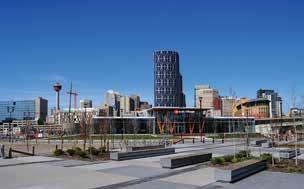
 East Village is located in the heart of downtown Calgary between the historic Fort Calgary and the downtown business core.")
16 Adaptive Reuse CASE STUDY Adaptive Reuse East Village in Downtown Calgary City of Calgary, Alberta Responsibility: Municipality, and Landowner and Developer How applied: Voluntary Scale: Local The 20 hectare (49 acre) East Village is located in the heart of downtown Calgary between the historic Fort Calgary and the downtown business core. In March 2005, a redevelopment plan was approved for the area, followed by a master plan unveiled in September A $150 million investment in infrastructure improvements acted as a catalyst for the implementation of the plan, which has resulted in two large-scale mixed use residential projects with roughly 1,200 new condominium units, the East Village Experience Centre, and extensive riverfront redevelopment in the form of RiverWalk and RiverWalk Plaza. Adaptive reuse of buildings is one of the major focuses of the Master Plan. The Simmons Building is one example of a specific building in the East Village that has undergone adaptive reuse. The original use of the building was by Simmons Canada, a national bedding manufacturing company. The two storey warehouse-style building is standard post-and-beam construction with brick exterior walls. Four years ago, the building underwent adaptive reuse to convert it into an interim office space for the Calgary Municipal Land Corporation, with the intention that the building will be used as an important community commercial space. The project required remediation to remove contaminants from the site such as lead paint, as well as extensive upgrades to fire protection systems, doors, windows, mechanical systems and electrical systems. Related Examples From Other Jurisdictions: As larger-scale shopping districts are developed across North America, many local neighbourhood strip malls are becoming increasingly underused pieces of the suburban 12

17 Effiicient Use of Land Implementation Tools Compendium landscape. In an effort to promote and showcase creative design proposals for the adaptive reuse of small-scale strip malls, the University of Alberta s City Region Studies Centre launched an ideas design competition titled Strip Appeal. The design competition promoted creative and innovative approaches for revitalizing blighted strip malls. Strip Appeal received hundreds of entries from all around the world and gained international media attention; The King-Spadina district west of Toronto s downtown core was a former warehouse and manufacturing district that had become largely vacant and underutilized by the 1980s. A new planning framework for the neighbourhood was enacted by Toronto City Council in 1996 to attract investment for a broad range of uses in a manner that reinforces the historic built form of the area. The planning framework seeks the retention, conservation, rehabilitation, re-use and restoration of the many historic buildings in the neighbourhood. It included amendments to the Official Plan, Reinvestment Area Zoning, Urban Design Guidelines and a Community Improvement Plan and The City of Saskatoon has introduced an incentive program to encourage adaptive re-use of existing vacant or brownfield sites and buildings in established areas within the city. The program provides grants or tax incentives to eligible properties which have been vacant for 48 months consecutively. The incentive amount is calculated based on the increment between the taxes paid upon completion and the existing municipal property taxes, multiplied by five years. Considerations for Using this Tool in Alberta Adaptive reuse of buildings is often used as a tool for conserving historic buildings while at the same time allowing them to evolve to serve modern uses; Adaptive reuse of buildings can be expensive, and is often much more expensive than constructing new buildings in greenfield areas. As a result, incentive programs are often required to make the project feasible; The adaptive reuse of buildings needs to take into account contemporary building code requirements, which complicate the redevelopment; and Depending on the nature of the redevelopment, upgrades to infrastructure may be required. The East Village Calgary 13
18 Agricultural Land Conversion Fees Considerations for Using this Tool in Alberta While agricultural land conversion fees are primarily used as a tool to protect agricultural lands, they can also have a secondary benefit in terms of efficient land use; Does not guarantee more efficient use of land. Development on converted lands could still be low density and inefficient; Not currently being used in Alberta, so there are no Alberta precedents upon which to evaluate potential positive or negative impacts; Can be implemented at the local level and tailored to local needs and circumstances, allowing municipalities to choose whether and how to use the tool; Does not prohibit conversion of agricultural lands, so some development potential would still exist in agricultural areas; If the added cost of converting the agricultural land is capitalized into land values, resulting in lower land values, agricultural landowners may be concerned; Farmers who wish to continue farming would welcome the revenue from an easement that is purchased on their land using the conversion fee revenues; Unless the charges for conversion are high, they could just become a cost of doing business that doesn t result in a significant change to the status quo; and Would require administration and oversight, including ongoing enforcement of easement conditions. 2. Agricultural Land Conversion Fees Description Agricultural land conversion fees are a tool used in some American states jurisdictions, in which a charge is applied to the conversion of agricultural land to other uses. This can be done at the time of sale by placing a surcharge on the sale of agricultural land, or when an application is made to change farmland to a different land use. Regardless of when the charge is applied, the goal is to place a financial disincentive on converting agricultural land to other uses. Agricultural land conversion fees promote using existing developable lands more efficiently. While in most cases the money gathered through the fee is used to purchase equivalent agricultural land for preservation, a land conversion fee does not necessarily require that all money received be used for this purpose. How Can This Tool Contribute to Efficient Land Use? Conversion fees can reduce fragmentation of agricultural land by reducing the amount of development happening in agricultural areas; and If the costs associated with converting the farmland are significant enough, agricultural land conversion fees can provide an economic incentive in favour of infill and redevelopment in existing towns, villages, hamlets and cities. They can also create an incentive to utilize available greenfield development lands more efficiently. Relationship with Other EUL Tools Agricultural land conversion fees are primarily used to limit urban development in agricultural areas. As such, they are complementary with policy limits on rural residential lot creation (#17). They can also be used to support policies that seek to reduce the rate at which urban areas expand into surrounding agricultural areas, such as greenbelts (#12) and urban growth boundaries (#27). Use in Alberta Agricultural land conversion fees are not currently used in Alberta. One tool that is somewhat similar is conservation offsets, which are provided for under the Alberta Land Stewardship Act. Conservation offsets enable municipalities to offset the negative environmental impacts of a particular land-use by requiring environmental benefits through, for example, the protection of environmentally sensitive lands in another area. 14
19 Effiicient Use of Land Implementation Tools Compendium CASE STUDY Agricultural Land Conversion Fees Conservation Property Tax Exemption Act Government of Nova Scotia, Nova Scotia Environment Responsibility: Province How applied: Voluntary Scale: Provincial In Nova Scotia, lands used for forestry, agriculture or non-profit uses are exempt from paying annual property taxes. There is a change of use tax due when the land is converted from one of these exempt land uses to any other land use. The change of use tax is a onetime fee equaling 20 per cent to 50 per cent of the assessed value depending on the previous use of the land and property taxes are then due annually. The Tax Exemption Act allows a landowner to remove their land from agriculture or forestry use and place it in ecological protection without paying the change of use tax or annual property taxes. To qualify, the land must be protected through a conservation easement, be designated as a protected area (nature reserve or wilderness area) by the Minister of Environment, or be owned by a qualifying land trust. In order to offset the loss in municipal revenues, the ministry provides municipalities with a grant equal to the annual property taxes that would have been paid. Related Examples From Other Jurisdictions: The City of Davis, California, requires that landowners proposing to rezone or develop agricultural land to a non-agricultural use meet agricultural land mitigation requirements. This includes a requirement that two hectares of agricultural land be preserved for every one hectare of agricultural land that is developed. The City of Davis specifies the type of land that can be used to offset the loss of farmland. Requirements can be partially met (up to 50 per cent) through an in-lieu fee which the municipality then uses to purchase conservation easements; The State of Maryland has an Agricultural Transfer Tax program. This tax is calculated at the time of sale of agricultural land. However, the tax can be waived if the new landowner files a Declaration of Intent stating that they will keep the land in agricultural use for 5 years after purchase, after which there is no cost associated with the conversion of land. The cost of the Agriculture Transfer Tax varies according to the amount of land that is being converted. The funds collected through the tax are used to purchase development rights on farmland in Maryland through the Agricultural Land Preservation Program. 15

20 Alternative Development Standards How is this tool typically applied in other jurisdictions? Mandatory 4 Voluntary or Incentive 4 At what scale or level of government is this tool typically applied in other jurisdictions? Provincial / State Regional Local 4 Which types of land does this tool typically apply to? Public (Crown) Land Private Land (Urban) 4 Private Land (Rural) 4 Which EUL strategies could this tool potentially support? 1. Reduced rate of land 4 conversion. 2. Utilize minimum amount 4 of land needed. 3. Utilize already developed 4 or disturbed lands. 4. Maximize the use of 4 existing infrastructure. 5. Disturbed lands are 4 reclaimed or reused. 6. The information needed for decisions that support efficient land use. Permeable paving of driveways and laneways can reduce stormwater runoff. This can help reduce the amount of land needed for large, centralized stormwater retention facilities. 3. Alternative Development Standards Description Alternative development standards refer to standards that are designed to support development that is more environmentally sustainable, land efficient, transit and pedestrian supportive, and so on. All municipalities have standards that new development must meet before it receives approval. These standards can address everything from on-site parking requirements to landscaping to stormwater retention to accessibility. Alternative development standards fall into two general categories: planning policies and regulations (e.g. lot dimensions, parking requirements, minimum housing size, frontage, etc.); and engineering standards (e.g. the locations, dimensions, and designs of rights-of-way, stormwater systems, utility corridors, etc.). How Can This Tool Contribute to Efficient Land Use? Alternative development standards can facilitate more compact forms of development. For example, standards can be altered to allow narrower lot frontages in residential neighbourhoods, which can result in higher densities. Similarly, standards allowing for greater on-site stormwater retention can reduce the need for larger, land intensive stormwater ponds. Relationship with Other EUL Tools Alternative development standards can be used to encourage transitoriented development (#26), building forms that reduce the overall development footprint (#4), and reductions in land areas dedicated to parking (#22). They can also be designed to facilitate the ability of new development to meet certain LEED criteria (#16). Often, development standards are a major barrier to achieving LEED certification. Alternative development standards can also be used to ensure that development that results from minimum density (#18) or intensification requirements (#19) is compatible with existing uses and contributes to a high quality of place, Permeable paving of driveways particularly if used in conjunction with form-based codes (#11). 16
21 Effiicient Use of Land Implementation Tools Compendium Use in Alberta The Town of Banff enacted alternative development standards to address its housing shortage and lack of affordable housing. The Town of Banff allowed for smaller lots, narrower streets and reduced parking requirements. This allowed for denser developments and an increase of housing supply in the community. Fort Saskatchewan altered its bylaws to allow narrower lots. It also reduced the servicing requirements for developers in order to encourage denser development. The City of Edmonton has reduced its parking requirements for developments in the downtown area and is contemplating doing the same for residential developments in close proximity to LRT stations. CASE STUDY Alternative Development Standards New Parking Standard to Promote Downtown Densification City of Airdrie, Alberta Responsibility: Municipal How applied: Mandatory Scale: Local The City of Airdrie is located just north of Calgary and in the late 1990s experienced rapid single-family residential growth pressure threatening to turn Airdrie into a bedroom community. Downtown mixed-use development was not keeping pace with new residential growth, leading the city to identify the development of a walkable and vibrant downtown as a key goal. The City of Airdrie decided to conduct a parking study in 2000 which found that only approximately half of on-street parking and one third of off-street parking were being used during peak periods. This led to the revision of the existing parking development standards. Best practices from surrounding municipalities were determined including parking ratios, shared parking policies, centralized parking facilities and other tools A Downtown Parking Bylaw was passed in It reduced parking requirements and introduced variances based on shared parking, off-site spaces and cash-inlieu payments. The intention was to encourage the successful redevelopment and densification of the downtown. The revised parking requirements allowed one condominium development to reduce allocated parking by 50%. Related Examples From Other Jurisdictions: The Pineglade Project in Ottawa is a 165 unit subdivision that was built using alternative development standards. The goal of the altered standards was to make housing more affordable. Alternative standards used for the subdivision include reductions in right-of-way, pavement, and boulevard widths, as well as lot frontage, lot size, setbacks, and amenity areas. An analysis showed that a house in Pineglade cost buyers approximately $8500 less than a comparable house in a suburban community built using traditional development standards. 17

 Land Private Land (Urban) 4 Private Land (Rural) 4 Which EUL strategies could this tool potentially support? 1. Reduced rate of land 4 conversion. 2.")
22 Building Forms that Reduce the Development Footprint How is this tool typically applied in other jurisdictions? Mandatory 4 Voluntary or Incentive 4 At what scale or level of government is this tool typically applied in other jurisdictions? Provincial / State Regional Local 4 Which types of land does this tool typically apply to? Public (Crown) Land Private Land (Urban) 4 Private Land (Rural) 4 Which EUL strategies could this tool potentially support? 1. Reduced rate of land 4 conversion. 2. Utilize minimum amount 4 of land needed. 3. Utilize already developed 4 or disturbed lands. 4. Maximize the use of 4 existing infrastructure. 5. Disturbed lands are 4 reclaimed or reused. 6. The information needed for decisions that support efficient land use. 4. Building Forms that Reduce the Development Footprint Description Utilizing forms of development that reduce the development footprint is a key mechanism for making more efficient use of land. One example of a land-efficient building form is mixed use development. A mixed use development typically includes retail or other commercial uses at-street level, with office development and/or residential development stacked above on the upper floors. Secondary suites are another building form that can reduce the footprint of development. Secondary suites are self-contained living units created within existing single-family homes or in buildings that are accessory to single-family homes. They can increase density and reduce the overall development footprint for residential development, without significantly changing the visual character of a neighbourhood. The most common form of secondary suite is a basement apartment that has a separate entrance leading to a self-contained unit in the lower level of a dwelling. Generally, there are minimal changes to the exterior of an existing dwelling to accommodate a basement apartment. Some other, less common types of secondary suites include: A garden suite, which is a self-contained, stand-alone dwelling that is accessory to the principal dwelling, generally found in the rear yard; or An above or beside garage suite, which is a self-contained dwelling that is located above or beside a detached garage. How Can This Tool Contribute to Efficient Land Use? Reduces the overall development footprint by concentrating multiple land uses within a single building and land parcel; Reduces the overall development footprint by accommodating additional residential units within an existing residential building or parcel. Mixed use in Edmonton, Rail Town Edmonton Live/Work Development Port Credit, Ontario 18
23 Effiicient Use of Land Implementation Tools Compendium Relationship with Other EUL Tools Mixed use buildings and secondary suites are a key mechanism for increasing rates of intensification (#19) as well as increasing overall density in a community (#18). These forms of development are also typically more consistent with Transit Oriented Development (#26). Use in Alberta Many municipalities encourage the development of mixed use buildings through their Municipal Development Plans, Land Use Bylaws, Area Structure Plans and Area Redevelopment Plans. Some also offer incentives for this form of development. One example is the City of Medicine Hat s Downtown Development Incentive Program (DDIP). Launched in 2011, the DDIP includes various incentives available to downtown property owners to assist them to redevelop or initiate new developments in the city centre. The program is administered through the city s Business Support Office. Among the options available to landowners is the Live/Work Residential Development program through which property owners can access up to $15,000 for the first residential unit and $5,000 per suite for up to two more units at the same location, as an incentive to develop a residential living space connected to their commercial building. Additional funds are available for up to two more suites on the property if space permits. Many municipalities in Alberta also offer programs to encourage the development of secondary suites. The City of Calgary Secondary Suites Program offers a grant of up to $25,000 to cover 70 per cent of the costs of developing or upgrading a legal secondary suite. In return for the grant, the city requires that recipients rent out their unit at 90 per cent of the average market rent. The City of Camrose developed a grant program that provides up to $15,000 to homeowners who complete a renovation to create a new secondary suite or bring to building code an existing secondary suite. The grant can cover up to 70 per cent of the renovation cost. The program was intended to provide affordable housing options throughout the city. As a condition of the grant, the applicant must enter into a five year agreement that outlines maximum rental rates. The grant is available to detached dwellings located within the districts where secondary suites are a prescribed use as per the city s land use bylaw. The City of St. Albert provides a basement suites guide for residents. The guide provides information about building code requirements, application requirements, permit fees, where basement suites are permitted under the City of St. Albert s Land Use Bylaw, and development regulations. Considerations for Using this Tool in Alberta One of the challenges that some landowners face when trying to construct a secondary suite is meeting the various building code and zoning regulations. For example, in Alberta, secondary suites must meet the Alberta Building Code and Fire Code regulations. These regulations were both updated in 2006 to recognize secondary suites as a distinct type of accommodation from apartments or duplexes. Some examples of the requirements contained within these regulations are a minimum ceiling height of 1.95 metres, a direct exit to the outdoors, emergency escape windows for each bedroom, fire protected walls and ceilings, interconnected smoke alarms, and fire protected walls for furnaces and water heaters; Any consideration of building forms that reduce the development footprint must take into account local market conditions to ensure they are viable; Mixed use development may not be appropriate in all neighbourhoods, particularly where commercial uses are not desired; Mixed use development and secondary suites can also provide a source of lower cost and more affordable housing; and Prior to the approval of mixed use and secondary suite development, the capacity of underground infrastructure, such as sewage treatment and sewer pipes, may need to be considered. Potentially, long-term upgrades may be needed to handle future increased capacity requirements. 19
24 Building Forms that Reduce the Development Footprint CASE STUDY Building Forms that Reduce the Development Footprint Secondary Suites Program City of Edmonton Responsibility: City How applied: Voluntary Scale: Local In 2007, Edmonton City Council passed a bylaw introducing the opportunity for secondary suites on a permitted use basis and garage suites on a discretionary use basis in single detached housing in most land-use zones throughout the city. Prior to this change, opportunities for secondary suites were restricted across much of the city as either discretionary uses, or non-permitted uses, and were limited by lot requirements and locational criteria. There were approximately 140,000 low density lots in Edmonton at the time of the adoption of the Bylaw, of which only 48,000 could previously have been considered for secondary suites. The Bylaw changes opened up opportunities for secondary suites to 130,000 lots. Amendments were made to open up opportunities for garage suites and garden suites as well, allowing consideration of such suites on corners lots, lots fronting a service road, lots backing onto a lane, or lots abutting row housing, apartments or community services. As a result of these bylaw reforms, permits issued for secondary suites within the City of Edmonton increased significantly. As part of implementation, the City of Edmonton developed the Cornerstone Grant Program which provides financial assistance to homeowners wishing to create secondary suites. Number of permits provided for secondary suites in the City of Edmonton ( ) 5 5 Growth Analysis Unit, Planning and Development Department. Mature Neighbourhood Reinvestment (2012). Edmonton. City of Edmonton Number of secondary suites City-Wide Mature Neighbourhoods Suburban 20
25 Effiicient Use of Land Implementation Tools Compendium 5. Checklists and Scorecards Description Development scorecards or checklists can help ensure that efficient use of land principles are applied as part of individual development applications and as part of the development approvals process. They identify a set of development objectives that a municipality is seeking to achieve. Often, these include objectives related to energy efficiency, water conservation, and other environmental factors. Objectives related to reducing development footprint and prompting the efficient use of land could also be identified. Examples of efficient use of land objectives that could be captured in a checklist or scorecard include: density of the proposed development relative to the municipal target; location of the development relative to priority growth areas or intensification areas; or land area of the development that is dedicated to surface parking. Typically, either the development proponent, or the person responsible for processing the development application, will complete the checklist or scorecard. Checklists or scorecards can be mandatory or voluntary. As a mandatory tool, development proponents could be required to complete a checklist as part of the development application process. As a voluntary tool, development proponents could be encouraged to complete checklists, and possibly provided with incentives to do so, such as reduced planning application fees or expedited approvals. How Can This Tool Contribute to Efficient Land Use? Can function as educational tools for local developers by translating a municipality s vision for efficient land-use into a set of clear and easily understood objectives that apply at the project level; and Can provide decision-makers such as municipal councils with a quick snapshot assessment of how a particular development meets the municipality s efficient use of land objectives. How is this tool typically applied in other jurisdictions? Mandatory 4 Voluntary or Incentive 4 At what scale or level of government is this tool typically applied in other jurisdictions? Provincial / State Regional Local 4 Which types of land does this tool typically apply to? Public (Crown) Land Private Land (Urban) 4 Private Land (Rural) 4 Which EUL strategies could this tool potentially support? 1. Reduced rate of land 4 conversion. 2. Utilize minimum amount 4 of land needed. 3. Utilize already developed 4 or disturbed lands. 4. Maximize the use of 4 existing infrastructure. 5. Disturbed lands are 4 reclaimed or reused. 6. The information needed 4 for decisions that support efficient land use. Relationship with Other EUL Tools Scorecards and checklists are best used as a means of reinforcing other efficient use of land strategies. For example, where a municipality has identified minimum density (#18) or intensification targets (#19), priority growth areas (#13), alternative development 21
26 Checklists and Scorecards Considerations for Using this Tool in Alberta Information required for completion of checklists and scorecards should be readily available, or relatively inexpensive for proponents to collect; To be most effective, the municipality should have clear targets and expectations with respect to each criteria in the checklist; In designing checklists and scorecards, and the decision-making process that goes along with them, municipalities should be careful not to create delays or other impediments to the development approvals process; and Checklist and scorecard information can also be used for measuring performance and compliance over the longer term. standards (#3), or many of the other strategies discussed in this compendium, the checklist becomes a way for the development proponent and the decision-maker to quickly assess the extent to which a particular development has addressed them. Use in Alberta While there is limited experience in Alberta using checklists or scorecards, the Municipal Government Act does state that within a municipality s land use bylaw, a municipality must establish a method of making decisions on applications for development permits. The provisions must include what needs to be included in an application and may include any other matters necessary to regulate and control the issue of development permits that appear necessary to the local council. Checklists or scorecards could therefore be included as a required or voluntary component of a development application. CASE STUDY Checklists and Scorecards Sustainability Screening Reports and Impact Offset Matrix Town of Canmore, Alberta Responsibility: City How applied: Voluntary Scale: Local The Town of Canmore uses a Sustainability Screening Process (SSR) to allow developers to present to Council how their proposals achieve the Town s commitment to sustainability as part of The Natural Step for a Sustainable Canmore initiative that began in The SSR is intended as a tool to help implement several plans and strategies for the town including the MDP, Green Building requirements, Sustainable Economic Development and Tourism Strategy and Environmental Sustainability Action Plan. Applicants complete an Impact Offset Matrix, a short checklist, to measure how the details of the development compare with the sustainability goals of the community. The checklist is then included within the presentation that the developer gives to Council when considering the merits of the project. The use of the matrix is mandatory. The intention is to promote developments that have a net zero or better impact. Several of the factors considered in the Impact Offset Matrix relate directly or indirectly to efficient land use, such as: The length of infrastructure that needs to be developed for the project; 22
27 Effiicient Use of Land Implementation Tools Compendium What percentage of the site is previously developed and what percentage of the site is previously undeveloped; and The distance of the development from the wastewater treatment plant. The process has been in place since 2007 and can be used for statutory plan amendment applications as well as for Development Permit applications. Related Examples From Other Jurisdictions: The City of Kelowna, B.C. provides developers with Sustainability Checklists for commercial or multi-unit residential developments. The intention is to provide a framework for both city staff and Council to quantify the merits of a proposed development. Three checklists are available depending on the type of application: Development Permit, Development Permit with Rezoning, or Rezoning. The aims of the checklists are to protect open space and natural areas, promote compact mixed use development, and discourage out-migration. Land-use management staff reviews the completed checklist and amends it as required in discussion with the applicant. The checklist is then included within the material used by the City Council, staff and advisory bodies to review the merits of the proposal. Examples of checklist provisions that relate to efficient land use include whether the project comprises redevelopment of a brownfield site and the extent to which the project requires extension of existing city infrastructure. The City of Dawson Creek, B.C. implemented the use of a Sustainability Checklist in 2009 through their Official Community Plan. Since then the City of Dawson Creek has had a positive experience using the checklist. Developers review and complete the checklist before it is provided to Council and staff as part of the development review process. The municipal government provides several versions of the checklist ranging in detail. The checklist encourages developers to consider the elements of their proposal and how it may impact the surrounding properties and broader context. City staff then prepares a report as part of the development approval process based on a summary of the checklist and other information provided, identifying major gaps as well as accomplishments. Examples of checklist provisions that relate to efficient land use include whether the development is in the Intended Infill / Redevelopment Area and/or on existing residential parcels, and whether any buildings, and particularly heritage buildings, are to be adaptively re-used. 23
28 Cluster Zoning Considerations for Using this Tool in Alberta Many Alberta municipalities already have experience using this tool; Can be implemented in a variety of ways, including mandatory or incentive-based; Has the ability to reduce fragmentation without eliminating development potential; When used in conjunction with conservation easements, it can also protect valuable landscapes; Does not actually prevent residential development in rural or agricultural areas; it merely focuses it in a more land efficient way. Cluster zoning has been criticized for not actually preserving valuable land but rather allowing clusters of sprawl; Could hinder the contiguous and orderly expansion of urban areas if several clusters are located at the edge of urban areas; Maintaining the retained open space can be a challenge. Maintenance costs could be incurred by the municipality. Retained areas may be too small to support viable agricultural uses; Could be at odds with market demand for large rural lots for country living ; In some cases, may require a revisiting of municipal building codes to address proximity of dwellings; and On its own, does not prevent multiple residential clusters from being developed across a municipality, which would lead to fragmentation and inefficient land use. 6. Cluster Zoning Description Cluster zoning refers to a pattern of residential development, typically in rural areas, where the developed area is clustered together on smaller lots, rather than spread out across the parcel. In Alberta, this is typically referred to as clustered country residential development. Clustered development is most often implemented by requiring that a minimum percentage of a parcel of land be retained as open space at the time of subdivision. It may also be supported by establishing maximum lot sizes and/or a maximum number of lots for a given area. For example, in Alberta, a typical quarter section is 64.7 ha (160 acre). Under conventional zoning, it might be subdivided into 32 lots of 2.02 ha (5 acre) each, evenly distributed across the quarter section. With cluster zoning, a portion of the quarter section would be left as open space. For example, 50 per cent of the land could be open space, and the remaining 50 per cent would be subdivided into 80 lots of 0.4 ha (1 acre) each, clustered in one portion of the quarter section. Within this basic principle of locating development close together to reduce the overall development footprint and landscape fragmentation, cluster zoning policies vary in a number of ways. Cluster zoning policies can range from a mandatory requirement to an incentive-based or voluntary tool. In most mandatory approaches, a specially designated area of a municipality, usually on the fringe, is zoned for cluster development. In these areas all new development must preserve a prescribed amount of contiguous open space (the exact amount varies among jurisdictions). An incentive approach would allow the developer to create additional lots if they are smaller in size, and clustered in one area. This approach is sometimes referred to as density bonusing (see #8). How Can This Tool Contribute to Efficient Land Use? Reduces the overall footprint of residential development in rural areas; Clustering development in concentrated locations leaves the rest of the land area undeveloped, thereby reducing fragmentation of rural and agricultural lands; and Reduces the need to extend infrastructure such as roads across a large area. 24

29 Effiicient Use of Land Implementation Tools Compendium Conventional Rural Development Cluster Zoning Development 25
30 Cluster Zoning How is this tool typically applied in other jurisdictions? Mandatory 4 Voluntary or Incentive 4 At what scale or level of government is this tool typically applied in other jurisdictions? Provincial / State Regional 4 Local 4 Which types of land does this tool typically apply to? Public (Crown) Land 4 Private Land (Urban) Private Land (Rural) 4 Which EUL strategies could this tool potentially support? 1. Reduced rate of land 4 conversion. 2. Utilize minimum amount 4 of land needed. 3. Utilize already developed or disturbed lands. 4. Maximize the use of 4 existing infrastructure. 5. Disturbed lands are reclaimed or reused. 6. The information needed for decisions that support efficient land use. Relationship with Other EUL Tools Cluster zoning can be used in conjunction with other tools such as greenbelts (#12) and limits on lot creation (#17) to minimize the development footprint in rural areas. It is also a way of achieving minimum density targets (#18) in rural areas. Agricultural land conversion fees (#2) can be used as an incentive to promote cluster zoning, as can density bonusing (#8). Policies to optimize lot sizes (#20) can help maximize the effectiveness of cluster zoning strategies. Use in Alberta Cluster zoning, typically called clustered country residential development, is used in a number of Alberta municipalities. Strathcona County s Municipal Development Plan promotes conservation design, wherein new development is clustered outside of priority environmental areas. Conservation design principles are applied to country residential and rural subdivisions under approved Area Structure Plans or Conceptual Schemes. In Mountainview County, multi-lot residential development (between 5 and 48 lots per quarter section) may be allowed within identified growth centres. Lots must be clustered in order to allow the balance of the quarter section to remain as open space or in agricultural operation where appropriate. Development must also be located on the periphery of the quarter section to minimize access roads and use of agricultural land for roads, and should be located adjacent to existing development or approved subdivisions on neighbouring quarter sections. 26
31 Effiicient Use of Land Implementation Tools Compendium CASE STUDY Cluster Zoning Capital Region Growth Plan Capital Region, Alberta Responsibility: Regional Board How applied: Mandatory Scale: Regional The Capital Region Growth Plan provides the policy framework for future growth in the Capital Region. One principle of the Plan is to minimize the regional development footprint. The Capital Region Growth Plan identifies four Cluster Country Residential Areas (CCRAs) for the region where cluster style residential development is supported. New Country Residential development within CCRAs must be clustered on smaller lots in order to maximize the retention of open space and optimize servicing. The CCRAs are expected to meet a density target of two dwelling units per gross hectare. Each member municipality which has a Cluster Country Residential Area within its boundary is expected to reflect the principles of the Plan within their planning documents. Related Examples From Other Jurisdictions: West Manchester Township, Pennsylvania identifies Open Space Residential Zones that utilize cluster zoning principles. The Open Space Residential Zones require that 45 per cent of the overall parcel must remain open space after it has been developed. They also include smaller minimum lot sizes, depths and widths. These smaller lot sizes, depths and widths allow for the tighter clustering of houses on the developable 55 per cent of each parcel. The Open Space Residential designation requires that the preserved portion of the parcel be the most environmentally sensitive portion. It also requires that the open space be contiguous rather than spread throughout the parcel. As part of the application process, the developer must outline how the preserved open space will be maintained. 27
32 Cost of Servicing Studies Considerations for Using this Tool in Alberta The effectiveness of COS studies is dependent on the quality and comprehensiveness of the data available; COS studies are more challenging when done on a site-specific basis, or at a smaller scale such as a particular neighbourhood within a municipality, due to the required level of detailed data; COS studies are generally less complex and simpler to do as a means of comparing the relative costs of broad growth scenarios, as opposed to determining actual servicing costs associated with a particular site or development; and Not all costs associated with inefficient land use are quantifiable in economic terms, so COS studies cannot give a complete, comprehensive picture of the pros and cons of various growth options. 7. Cost of Servicing Studies Description Cost of Servicing (COS) studies are a tool for comparing the financial costs to municipalities associated with alternative development scenarios. COS studies can evaluate the costs to provide municipal services and infrastructure to specific areas within a municipality in order to contrast the economic costs of directing growth to one area over another. They can also compare the costs of servicing different forms of development within the same area. These studies require detailed analysis and a diverse range of accurate data to determine capital and life-cycle costs of municipal services such as transportation, water supply, sanitary sewers and water treatment. The data available must be sufficient to reveal expenditures for initial capital investment, maintenance and replacement or upgrading. Expenditure estimates require a range of inputs such as design costs, labour costs, material costs, equipment costs, and scheduled and unscheduled maintenance costs, and how these costs vary in different contexts. How Can This Tool Contribute to Efficient Land Use? Often, low-density residential development in outlying areas is not only land inefficient, but also economically inefficient, when compared to higher density residential development and/or residential development close to existing services. 4 COS studies can be used to demonstrate the costs associated with servicing land inefficient forms of development and thereby help promote planning decisions that lead to more efficient use of land. Relationship with Other EUL Tools COS studies can be valuable tools for supporting efficient use of land, because they can demonstrate to decision-makers the relationship that typically exists between efficient use of land and economic costs. 4 Slack, Enid. Municipal Finance and the Pattern of Urban Growth. Urban Research. Blogger, 3 Apr Web. 04 Sept
33 Effiicient Use of Land Implementation Tools Compendium How is this tool typically applied in other jurisdictions? Mandatory Voluntary or Incentive 4 At what scale or level of government is this tool typically applied in other jurisdictions? Provincial / State 4 Regional 4 Local 4 Which types of land does this tool typically apply to? Public (Crown) Land Private Land (Urban) 4 Private Land (Rural) 4 Which EUL strategies could this tool potentially support? 1. Reduced rate of land conversion. 2. Utilize minimum amount of land needed. 3. Utilize already developed 4 or disturbed lands. 4. Maximize the use of 4 existing infrastructure. 5. Disturbed lands are reclaimed or reused. 6. The information needed 4 for decisions that support efficient land use. Use in Alberta COS studies have not been widely used in Alberta largely due to the lack of available data to undertake an effective and comprehensive study. In 2006 a Cost of Community Services study was conducted for Red Deer County to provide a look at the relationship between the county s land-use matrix and their 2004 fiscal revenues and expenditures. The study looked at four different land-use categories: Commercial, Industrial, Residential and Working Landscapes (Agriculture). The study found that commercial, industrial and working landscapes all paid their way but that residential development did not. It also revealed that industrial land uses contribute more to municipal revenues than commercial uses. The study was not intended as a means to determine the best type of development for the county in the future. The limitation of a COS study is that it only provides a picture of the current situation. However, this study can provide information to decision makers about how they can improve their fiscal bottom line based on the relationship between expenditures, revenues and different land-use types. 29
34 Cost of Servicing Studies CASE STUDY Cost of Servicing Studies Cost of Servicing Plan Halifax Regional Municipality, Nova Scotia Responsibility: Municipality How applied: Voluntary Scale: Regional The Halifax Regional Municipality (HRM) has used COS studies to evaluate the costs to provide municipal services and transportation links to specific areas within the HRM as part of its Regional Planning Strategy. The COS studies were intended to determine which of the future growth areas achieve the goals in the planning strategy. The studies determined the total cost of servicing specific areas. Factors considered included transportation, water supply and sanitary servicing. The results of the studies are used by Halifax Regional Municipality Council to determine whether or not to approve requests to initiate the updated and detailed process in a specific area. Related Examples From Other Jurisdictions: The Canadian Mortgage and Housing Corporation (CMHC) developed the Life Cycle Costing Tool for Community Infrastructure Planning to allow major costs of development to be calculated and compared using alternative development scenarios. The intended users are municipalities or developers who wish to estimate the major costs associated with community development. The tool considers different forms of development with the ability to input different density scenarios. The tool provides long-term cost estimates, particularly those that change with different development patterns, such as linear infrastructure. 30
35 Effiicient Use of Land Implementation Tools Compendium 8. Density Bonusing Description Density bonusing, also known as incentive zoning, typically refers to allowing a density that surpasses either what is currently allowed or what is currently in place on the site in exchange for the developer providing amenities or benefits needed by the community. How Can This Tool Contribute to Efficient Land Use? Density bonusing can reduce the development footprint by accommodating additional residential or commercial uses on a given area of land. The actions required of developers in order to qualify for a density bonus can also be tied to the implementation of strategies that achieve more efficient use of land. For example, a municipality could allow additional density in exchange for accommodating parking through structured parking, clustering development, incorporating design elements that reduce the development footprint, or incorporating alternative development standards. Relationship with Other EUL Tools Density bonusing can have a direct impact on the achievement of minimum density requirements (#18). Density bonusing can also serve as an incentive to implement many of the other strategies described in this compendium, such as reducing the land area dedicated to parking (#22), clustering development (#6), or utilizing alternative development standards (#3). Use in Alberta Several municipalities in Alberta include density bonus provisions within their Municipal Development Plans and Land Use Bylaws. The Municipal Government Act allows the Development Authority or Subdivision Authority of any municipality to approve development that does not conform to the existing Land Use Bylaw, subject to certain conditions, and provided the development conforms to the use prescribed for the land. This means that a municipality may approve additional density on a given site. How is this tool typically applied in other jurisdictions? Mandatory Voluntary or Incentive 4 At what scale or level of government is this tool typically applied in other jurisdictions? Provincial / State Regional Local 4 Which types of land does this tool typically apply to? Public (Crown) Land Private Land (Urban) 4 Private Land (Rural) 4 Which EUL strategies could this tool potentially support? 1. Reduced rate of land 4 conversion. 2. Utilize minimum amount 4 of land needed. 3. Utilize already developed 4 or disturbed lands. 4. Maximize the use of 4 existing infrastructure. 5. Disturbed lands are 4 reclaimed or reused. 6. The information needed for decisions that support efficient land use. 31
36 Density Bonusing Strathcona County has pioneered the use of density bonusing as a tool for conservation. It allows a maximum of eight country residential lots within the Agriculture Small Holdings Policy Area of the Municipal Development Plan. An additional two parcels per quarter section may be considered based on the over-dedication of Municipal Reserves and/or dedication of conservation easements to the satisfaction of Strathcona County. The policy requires a conceptual scheme be adopted for the site. The City of Calgary uses density bonus as an incentive for developers to employ conservation subdivision design when subdividing for residential purposes. For example, density bonusing has been considered regarding a subdivision in the Rocky Ridge Area Structure Plan (ASP). The primary objective of this plan is to accommodate future demand for urban housing. The approach would increase allowable density conditional on the developer providing an increased percentage of environmental reserve (ER) than would normally have been required. The existing density policies in the Rocky Ridge ASP were used as the base density. Three levels of bonus density were suggested with a prescribed percentage of ER dedication above what would otherwise qualify as ER: (a) 5 units per 0.4 ha (1 acre) on the gross parcel area in exchange for 15 per cent ER dedication increase; (b) 10 units per 0.4 ha (1 acre) on the gross parcel area in exchange for 20 per cent ER dedication increase; or (c) 15 units per 0.4 ha (1 acre) on the gross parcel area in exchange for 25 per cent ER dedication increase. 32

37 Effiicient Use of Land Implementation Tools Compendium Subdivided property without density bonusing Subdivided property with density bonusing 33
38 Density Bonusing CASE STUDY Density Bonusing Beltline Area of Calgary City of Calgary, Alberta Responsibility: Municipality How applied: Voluntary Scale: Local The City of Calgary has developed a density bonusing strategy that applies to the Beltline Area and that is implemented through the Beltline Area Redevelopment Plan (ARP). The Beltline has been divided into four areas: Area A: Primarily residential or expected to be developed as primarily residential and appropriate for lower density compared to other areas; Area B: Along major roads and adjacent to primarily residential areas or Stampede Park. Appropriate for higher density because of proximity to transit and 17 Avenue South; Area C: The highest density area, due to its proximity to the downtown and major transportation corridors; and Area D: Pedestrian-oriented and appropriate to provide a transition from the high density development close to downtown and lower density development to the south. Properties affronting on a specific category are assigned the corresponding density regime with a base density and a maximum density. The ARP then outlines several principles that the development must achieve to be deemed appropriate for higher density. Included within those principles is that the developer must provide items or features that provide a perpetual or enduring benefit to the community in which the density is being accommodated. Items or features that provide a perpetual or enduring benefit to the community are organized into five categories: 1. Community amenity space; 2. Publically accessible private open space; 3. Affordable housing units; 4. Heritage designation; and 5. Incorporation of sustainable building features. Within category five, the ARP lists reducing the development footprint as one of the benefits that can be provided in exchange for higher density provisions. 34
39 Effiicient Use of Land Implementation Tools Compendium 9. Eco-Industrial Parks Description An Eco-Industrial Park (EIP) consists of a community of manufacturing and service enterprises located together on a common property, in which members seek enhanced environmental, economic and social performance through collaboration in managing resources and integration with the surrounding community. By working together, the community of businesses seeks a collective benefit that is greater than the sum of the individual benefits each company would realize by only optimizing its individual performance. Collaborative strategies that can be pursued in EIPs include waste reduction, shared logistic and shipping and receiving facilities, shared parking, green technology purchasing blocks, multi-partner green building retrofits, district energy systems and local education and resource centres. 5 How Can This Tool Contribute to Efficient Land Use? Sharing road access, parking facilities, and services such as training centres, cafeterias and daycare centres can reduce the overall development footprint of an EIP. Clustering industrial buildings can reduce the overall development footprint and also facilitate the servicing of the area by transit. Considerations for Using this Tool in Alberta While municipalities can include Eco-Industrial Park standards in their Land Use Bylaws, most Eco-Industrial Park programs include extensive use of incentives; Many of the standards and objectives typically associated with Eco-Industrial Parks are equally applicable to all industrial parks, and consideration can be given to incorporating many of these standards into all industrial parks and business parks; Eco-Industrial Park standards should be sufficiently flexible to make the subject area attractive to a wide range of industries; and The standards applied to an Eco-Industrial Park will need to take into account health, safety and other standards as well. Relationship with Other EUL Tools By bringing together and coordinating the planning of multiple industries, EIPs can provide an ideal foundation for implementing a number of the efficient use of land tools and strategies discussed in this compendium, such as reduced parking areas (#22) and alternative development standards (#3). 5 Braziller, Clay. Putting the Eco in Industrial. Rep. ReNew Canada, n.d. Web. 5 Sept

40 Eco-Industrial Parks Hypothetical Eco-Industrial Development Conventional Industrial Development Eco-Industrial Development Shared Infrastructure (parking, power, waste collection, etc...) 36
41 Effiicient Use of Land Implementation Tools Compendium Use in Alberta Municipalities in Alberta can provide for Eco-Industrial Parks through their Land Use Bylaws and/or MDPs. MDPs can establish the general vision and policy direction to locate Eco-Industrial Parks in particular locations, and Land Use Bylaws can establish many of the regulatory provisions associated with eco-industrial parks, such as land uses and parking. Edmonton s Energy and Technology Park Area Structure Plan (ASP) provides a framework to encourage the development of ancillary petrochemical industries in the northeast part of the city. The ASP intends to provide industrial growth in an eco-industrial form that promotes economic and ecological values while optimizing efficient land use. The main mechanism for achieving this is to locate complementary industries that are integrated and work together in refining chemicals into market products within the area. Other aspects of the plan include provisions to allow alternative infrastructure solutions, a walking and cycling network to support recreational use and alternative transportation methods, development design guidelines that promote sustainability, and an integrated natural areas system. The Regional Municipality of Wood Buffalo s Land Use Bylaw includes a district intended to apply certain eco-industrial principles to industrial development. One example of where these provisions apply is the 53 ha TaigaNova Eco-industrial Park. Among the directions for this site that are relevant to the efficient use of land are: providing a report regarding the feasibility of pooling backup systems with other buildings; providing a statement describing opportunities considered to maximize land-use efficiency and whether strategies were implemented and how; and description of opportunities that were considered for coordinated heating/cooling; and obtaining resource needs and waste production information regarding businesses on nearby sites from the Development Authority. How is this tool typically applied in other jurisdictions? Mandatory 4 Voluntary or Incentive 4 At what scale or level of government is this tool typically applied in other jurisdictions? Provincial / State Regional Local 4 Which types of land does this tool typically apply to? Public (Crown) Land Private Land (Urban) 4 Private Land (Rural) 4 Which EUL strategies could this tool potentially support? 1. Reduced rate of land 4 conversion. 2. Utilize minimum amount 4 of land needed. 3. Utilize already developed or disturbed lands. 4. Maximize the use of existing infrastructure. 5. Disturbed lands are reclaimed or reused. 6. The information needed for decisions that support efficient land use. 37
42 Eco-Industrial Parks CASE STUDY Eco-Industrial Parks INNOVISTA: An Eco-Industrial Park Hinton, Alberta Responsibility: Municipal How applied: Mandatory Scale: Local Hinton is located in west-central Alberta. It was the first municipality in Canada to establish an eco-industrial zoning district in its Land Use Bylaw. The INNOVISTA development is located within this district. The municipality received federal funding to pilot the project and to pioneer the concept of developing an eco-industrial park on greenfield lands. The concept of INNOVISTA was developed in 2003 with guidelines following in 2006 and subdivision in INNOVISTA is a 44 hectare (108.7 acre) site, including 13 hectares (32.1 acres) of parks and ecological reserves. In focusing on efficient land use, INNOVISTA was planned to have significantly less road surface area than a traditional industrial park, while still maintaining road frontage for all lots. Road coverage in INNOVISTA is only 7 per cent, compared to 12 per cent in a standard industrial park and development must adhere to a maximum permeable surface percentage in order to retain natural vegetation. Where possible, utility corridors were built to double as trails and two footbridges enable pedestrians, cyclists and light electrical vehicles to access the site, all of which reduce demand for parking space. Trails and park space are also designed to function as stormwater management facilities. INNOVISTA also offers shared services, group purchasing and central storage facilities. The design guidelines for the INNOVISTA EIP include a number of provisions intended to encourage efficient land use: minimize overall development footprint (including building, warehousing, access roads and parking) by considering stackable or alternative warehousing techniques, using joint logistics facilities, clustering buildings, and reducing setbacks; facilitate shared service areas amongst buildings and with adjacent parcels (e.g., waste collection and sorting, shipping and receiving, parking, outdoor lunch areas); minimize the width and area of paved surfaces; where appropriate, consider travel lanes or paths for small, on-site, low-impact transportation modes such as small electric delivery vehicles or small landscape maintenance vehicles; to reduce parking demand, provide bicycle end of trip-facilities such as showers and secure bicycle storage; minimize the size of parking areas; share parking facilities with adjacent parcels where possible; and design parking spaces so that a portion of the vehicle hangs over into a landscape strip where possible. 38
43 Effiicient Use of Land Implementation Tools Compendium 10. Encouraging Living in Land-Efficient Locations Description Many of the strategies discussed in this compendium relate to encouraging efficient use of land by directing new development to locate in areas where available land can be used more efficiently. A related strategy is to encourage individuals to choose to live and work in these more land efficient locations. Land efficient locations could include areas that have been previously developed, but that are now under-utilized. They could also include locations where concentrations of development, higher densities, and/or a greater mix of uses help to reduce the overall development footprint per capita. One strategy for encouraging individuals to choose to live and work in more land efficient locations is the use of educational or incentive programs that highlight the potential individual cost savings. For example, research shows that lower transportation costs can make living in land efficient locations more affordable. According to a report by The Neptis Foundation, in the Toronto region it was calculated that for every kilometer away from a Central Business District a family lives, they spend 10 cents per day in transportation costs. That means, on average, a family that lives 50 kilometers away from a CBD spends an additional $1,600 more per vehicle each year on travel than a family that lives five kilometres from a CBD. That amounts to an extra $11.52 per day and $4,200 a year for a family that owns two vehicles. 6 Location cost calculators are an example of an educational tool to encourage living in land-efficient locations. Homebuyers are often unaware of the cost-savings that could be associated with living in land-efficient areas. Location cost calculators can help families predict their transportation costs and better determine the true affordability of their housing choices. Location cost calculators take into account the proximity of the dwelling to shops and services, public transit and employment. Transportation Savings Mortgage programs are an emerging area of interest in Canada and have been used with some success in the United States. They are an example of an incentive tool to encourage living in land-efficient locations. They reward homebuyers for choosing to purchase a home in a land-efficient area. Several of these products have been offered in the United States, including the Location Efficient Mortgage and the Smart Commute Mortgage. These programs differ from traditional mortgages in their risk assessment process. Traditionally, lenders assess risk and available credit based on a predetermined ratio between household income and a variety How is this tool typically applied in other jurisdictions? Mandatory Voluntary or Incentive 4 At what scale or level of government is this tool typically applied in other jurisdictions? Provincial / State Regional Local 4 Which types of land does this tool typically apply to? Public (Crown) Land Private Land (Urban) 4 Private Land (Rural) Which EUL strategies could this tool potentially support? 1. Reduced rate of land 4 conversion. 2. Utilize minimum amount 4 of land needed. 3. Utilize already developed 4 or disturbed lands. 4. Maximize the use of 4 existing infrastructure. 5. Disturbed lands are 4 reclaimed or reused. 6. The information needed 4 for decisions that support efficient land use. 6 Miller, Eric J., and Et Al. Travel and Housing Costs in the Greater Toronto Area: Publication. Toronto: Neptis Foundation, Web. 15 Aug
44 Encouraging Living in Land-Efficient Locations Considerations for Using this Tool in Alberta To be effective, location cost calculators require extensive data that is not always available in all jurisdictions; Location cost calculators are typically an imperfect measure, as they cannot take into account a variety of local factors that also affect the cost of living in a particular location; Mortgage-based incentive programs have been criticized for encouraging people to purchase homes that are more expensive than they could otherwise afford, which leads to concerns about personal debt loads; and Choosing to live or work in a landefficient location does not guarantee that an individual will exhibit the behaviours that make the location land-efficient, such as walking to stores and services, or utilizing transit. of factors including household debt and available down payment. Transportation Savings Mortgage programs consider the cost savings of location-efficiency in their risk assessment. As a result, homebuyers who locate in location-efficient areas can qualify for a larger mortgage. How Can This Tool Contribute to Efficient Land Use? Educational or incentive programs that highlight the cost savings associated with more land-efficient locations can encourage people to choose to live and/or work in these areas, rather than in less land efficient locations elsewhere in a municipality. Relationship with Other Tools Many of the strategies discussed in this compendium relate to encouraging efficient use of land by directing new development to locate in areas where available land can be used more efficiently, for example priority growth areas (#13), intensification targets (#19) and Transit Oriented Development (#26). Strategies to inform individuals about the individual economic benefits of choosing to locate in some of these areas can help ensure the success of these other strategies. Use in Alberta There are no Location Cost Calculators that have been designed specifically for use in Alberta. Similarly, as a product, Transportation Savings Mortgages are not currently available in Alberta. 40
45 Effiicient Use of Land Implementation Tools Compendium CASE STUDY Encouraging Living in Land-Efficient Locations H+T Index Center for Neighbourhood Technology, U.S. Responsibility: Third Party How applied: Voluntary Scale: Local The H+T Index is an affordability index available online that examines transportation costs at a neighborhood level. Created by the Center for Neighbourhood Technology (CNT), it allows users to view housing and transportation data as maps, charts, and statistics for nearly 900 urban and semi-urban areas in the United States. This tool is not yet available in Canada. The methodology for the H+T Index is drawn from peer reviewed research findings and nationally available datasets. The model considers all travel undertaken as part of a household s daily routine. The user inputs their city, county or region into the calculator and the calculator provides two maps: Housing Costs as a Percentage of Income and Housing + Transportation Costs as a Percentage of Income. The output is meant to reveal what a typical household s housing affordability is in a certain area when typical transportation trends are included. The tool is not specific to individual addresses. Related Examples From Other Jurisdictions: The Walk Score is an online tool that rates the walkability of any location at the neighbourhood scale. The principles considered to have high walkability correlate with location-efficiency, such as proximity to key amenities and connectivity. Amenities within 0.25 miles receive maximum points and no points are awarded for amenities further than one mile. The Walk Score can give homebuyers an idea of the location-efficiency of a certain property and help influence their decision to live in a more efficient or walkable location. The Pembina Institute suggests making the Walk Score part of real estate listings in the short term and including it as part of a comprehensive location efficiency cost and assessment in the long term. Many real estate listings in Alberta now show the property s Walk Score. The Smart Commute Mortgage program is a program of the Federal National Mortgage Association (Fannie Mae) in the U.S. In the pilot program offered in the City of Atlanta, homebuyers who locate within a half-mile of a MARTA (Metropolitan Atlanta Rapid Transit Authority) bus or rail stop, have only one car, and will use transit for daily commuting, qualify for proportionally higher mortgages and receive a six-month MARTA pass. 41

46 Form-Based Codes 11. Form-Based Codes How is this tool typically applied in other jurisdictions? Mandatory 4 Voluntary or Incentive 4 At what scale or level of government is this tool typically applied in other jurisdictions? Provincial / State Regional Local 4 Which types of land does this tool typically apply to? Public (Crown) Land Private Land (Urban) 4 Private Land (Rural) Which EUL strategies could this tool potentially support? 1. Reduced rate of land conversion. 2. Utilize minimum amount 4 of land needed. 3. Utilize already developed or disturbed lands. 4. Maximize the use of 4 existing infrastructure. 5. Disturbed lands are reclaimed or reused. 6. The information needed for decisions that support efficient land use. Description Form-based zoning codes control development by regulating its physical aspects, as opposed to traditional zoning that focuses on regulating the use of land. By regulating the dimensions of buildings, streets and open space, form-based codes aim to facilitate development that is more pedestrian-friendly and compact than traditional zoning. Form-based codes can differ in terms of the scales they address, and can be applied to anything from a single street to an entire city. However, they are most commonly implemented in small areas as part of urban redevelopment projects. They are typically easier to understand because they make more use of diagrams and graphics than traditional land-use zoning. How Can This Tool Contribute to Efficient Land Use? Form-based codes can be designed to promote more compact, mixed use developments that are transit-supportive and pedestrian-friendly. This can create more efficient land use by increasing densities, and reducing the need for road and other infrastructure that is typically required by conventional development. Excerpt from Form-Based Code in Troy, Michigan 42
47 Effiicient Use of Land Implementation Tools Compendium Relationship with Other EUL Tools Form-based codes can be used to encourage transit-oriented development (#26), adaptive reuse of existing buildings (#1) and building forms that reduce the overall development footprint (#4). They can also be designed to encourage or require the use of alternative development standards (#3) and/or to ensure that development meets certain LEED criteria (#16). Form-based codes can also be used to ensure that development that results from minimum density (#18) or intensification requirements (#19) is compatible with existing uses and contributes to a high quality of place. Use in Alberta While most experience with form-based codes has been in the United States, some Alberta municipalities have experience working with form-based codes or variations of form-based codes. Calgary s East Village Redevelopment Plan (2004) uses a form-based approach to zoning. It mandates certain styles of buildings, such as walk-ups and high-rise residential buildings, for specific areas of the site. Sylvan Lake created a Pattern Book to guide development in certain areas of the town. The Pattern Book is similar to a form-based code in that it contains graphics that describe the types of buildings required in each zone. Considerations for Using this Tool in Alberta Form-based codes can incorporate a number of standards that would support efficient land use; Form-based codes can facilitate mixed-use developments and create more visually coherent and coordinated neighbourhoods; If designed properly, can simplify and streamline the development process for both developers and regulators; Highly adaptable to local contexts can be applied in large and small municipalities alike; Form-based codes require consensus amongst developers, planners and the public on the type of development that is desired. If consensus cannot be reached, the process may never get off the ground; Changes to tried-and-true zoning codes may not be readily accepted by community members, developers, and elected officials; Many municipalities lack the staff and expertise necessary to undertake the creation and implementation of a form-based code; and Form-based codes can be more expensive to craft and administer than conventional zoning regulations. 43
48 Form-Based Codes CASE STUDY Form-Based Codes SmartCode Various jurisdictions in the U.S. Responsibility: Local How applied: Mandatory or Voluntary Scale: Local The SmartCode is a model form-based code created in the U.S. that combines zoning, subdivision regulations, municipal bylaws and urban design guidelines into a single document. It is intended to be integrated into a jurisdiction s plan and zoning bylaws once it has been calibrated to local contexts. It is appropriate for any size of area from large cities, to suburban municipalities, to small towns. The SmartCode divides a region into successive zones from rural to urban-core, requiring that new development attain physical standards that are appropriate to its zone. Many of these standards relate to the efficiency of land use. The SmartCode details the specific densities, block sizes, types of parks, parking requirements, etc. that are permitted in each zone in order to minimize wasted land. Although it can be applied to an entire city or region, most jurisdictions have adopted the SmartCode for specific areas. For example, Fort Myers, Florida adopted the SmartCode for its downtown area. Cities such as Flowood, Mississippi and Lawrence, Kansas adopted SmartCodes, but made them optional rather than mandatory it is up to the landowner to decide which zoning regime he or she would like to select. Some municipalities use incentives to encourage landowners to select the SmartCode for their developments. 44
49 Effiicient Use of Land Implementation Tools Compendium 12. Greenbelts and Agricultural Reserves Description Greenbelts and agricultural reserves are tools designed to protect large, contiguous natural or agricultural areas, typically surrounding a major urban region. In some cases, greenbelts are established around a single town or city. In other cases, greenbelts are defined on a regional basis around an entire urban region. Greenbelts are regulatory tools that set out a designated area that is to be preserved for agricultural uses and/or natural areas. Greenbelt policies typically work by strictly limiting the allowed uses within the designated greenbelt area. Allowed uses typically include agricultural activities as well as recreation and conservation uses. Other uses are not allowed within the designated greenbelt area. Most, if not all, greenbelt policies do make allowances for existing communities and other uses that pre-date the adoption of the greenbelt. How Can This Tool Contribute to Efficient Land Use? The primary goal of greenbelts is typically to protect valued landscapes, but they can promote efficient use of land by limiting the expansion of cities, towns or urban regions. This can help foster a market for higher density development and intensification in urban regions outside of the greenbelt. Relationship with Other EUL Tools Greenbelts are often used in conjunction with tools that limit the expansion of urban areas, such as urban growth boundaries (#27). Greenbelt policies may include various provisions related to controlling development within the greenbelt, such as limits on lot creation (#17), cluster zoning (#6), optimizing lot sizes (#20) and/or agricultural land conversion fees (#2). Careful and consistent land budgeting (#15) is also important for making sure that the greenbelt does not restrict land supply to the point of driving up land values and house prices. Considerations for Using this Tool in Alberta Greenbelts are often met with opposition from rural landowners and farmers who are concerned about loss of development potential on their lands; Successful greenbelts cover large areas that cross multiple local jurisdictions, so they require regional coordination; Particularly useful for controlling urban expansion where natural features and topography do not create a natural urban boundary; Can negatively affect property values due to decreased development potential. This might result in demands for compensation; If not configured correctly, greenbelts can result in development leapfrogging the greenbelt area, leading to inefficient use of land and infrastructure; Can be a very inflexible tool, that doesn t account for variations of local conditions within the greenbelt area; and Some have argued that regional planning that identifies environmentally significant open space systems and then coordinates where growth can occur is more effective than establishing rigid greenbelts. Current Use in Alberta There are currently no greenbelts in effect in Alberta that are designed to limit the expansion of urban areas and achieve more efficient land use. While Calgary has implemented a greenway and Edmonton has protected its river valley, these protected areas are for recreation and open space. 45

50 Greenbelts and Agricultural Reserves CASE STUDY Greenbelts and Agricultural Reserves Greenbelt Plan Province of Ontario Responsibility: Provincial How applied: Mandatory Scale: Regional Ontario s Greenbelt Plan is a provincial plan adopted under the Greenbelt Act. It designates a 730,000 ha (1.8 million acre) area of rural lands, agricultural lands, and natural areas surrounding Ontario s heavily urbanized Greater Golden Horseshoe region as a permanently protected greenbelt. The Greenbelt Plan defines three broad land-use categories: the Agricultural System (made up of specialty crop areas, prime agricultural areas and rural areas); the Natural System; and Settlement Areas (made up of existing towns, villages and hamlets). Within each of these land-use categories, the Greenbelt Plan defines various permitted uses. For example, in Prime Agricultural Areas, the only permitted uses are agricultural, agriculture-related and secondary uses which include home based businesses. The permitted uses generally do not allow residential development outside of settlement areas. In addition, the Greenbelt Plan lays out strict restrictions regarding when settlement areas can expand. Aggregate extraction and the development of new infrastructure are generally permitted throughout the Greenbelt. Ontario s Greater Golden Horseshoe Greenbelt 46
51 Effiicient Use of Land Implementation Tools Compendium Related Examples From Other Jurisdictions: In the United Kingdom, greenbelts have been in place for over 60 years and protect 14 per cent of the total land area of England. The purpose of England s greenbelts is to control sprawl, prevent neighbouring towns from merging into one another, safeguard the countryside from encroachment, preserve historic towns, and assist urban regeneration by encouraging recycling of derelict land. In Scotland, where more than 150,000 hectares of land lies within greenbelts, they are given a wider purpose than in England, including establishing a clear definition of the physical boundaries of towns. They are also often used as strategic land reserves for future growth. British Columbia s Agricultural Land Reserve (ALR) identifies priority agricultural use areas where agriculture was determined to be the best use for the land. The reserve is administered by the Agricultural Land Commission (ALC) appointed by the Minister of Agriculture and Lands. The ALR was established in 1973 and includes 4.7 million hectares (11.6 million acres) of land. The ALR is used to encourage farming and regulate non-agricultural uses. If a person wishes to subdivide land or introduce a non-agricultural development on land within the ALR, the application goes to the ALC for approval. Local municipalities are expected to reflect the intention of the ALR within local land-use policies, although the ALR policies are not intended to replace local land-use policies. How is this tool typically applied in other jurisdictions? Mandatory 4 Voluntary or Incentive At what scale or level of government is this tool typically applied in other jurisdictions? Provincial / State 4 Regional 4 Local 4 Which types of land does this tool typically apply to? Public (Crown) Land 4 Private Land (Urban) 4 Private Land (Rural) 4 Which EUL strategies could this tool potentially support? 1. Reduced rate of land 4 conversion. 2. Utilize minimum amount of land needed. 3. Utilize already developed 4 or disturbed lands. 4. Maximize the use of 4 existing infrastructure. 5. Disturbed lands are 4 reclaimed or reused. 6. The information needed for decisions that support efficient land use. 47
52 Identificatioin of Priority Growth Areas Considerations for Using this Tool in Alberta Where growth pressures are high, and where these pressures affect multiple municipalities, this tool could provide a framework for getting individual municipalities to agree on which areas are most appropriate for growth; Priority growth areas could help local, provincial and federal governments coordinate and prioritize their infrastructure spending; Clear guidelines or criteria would be needed to ensure that priority growth areas are located such that development within them actually results in more efficient land-use and a reduced development footprint; Identification of priority growth areas can create winners and losers both in terms of municipalities within a region, and landowners within a community; Market realities may limit the demand for residential, commercial and other forms of development within priority growth areas; Priority growth areas would have little relevance in areas where there is little growth pressure; and Design guidelines would be needed to ensure that development in priority growth areas is sensitive to the local context. 13. Identification of Priority Growth Areas Description Directing development to priority growth areas is a key strategy that has been employed in many local and regional plans. What constitutes a priority growth area varies across jurisdictions. Typically, they include transit nodes, transit corridors, former industrial areas, depressed or blighted areas in communities that are in need of new investment, or areas that have available infrastructure capacity. Once identified, priority growth areas are often supported by policies requiring a certain proportion of future growth to occur in these locations. The policy tools may also be supported by incentives or infrastructure investments that are designed to attract development to the priority growth areas. How Can This Tool Contribute to Efficient Land Use? Depending on how they are identified and where they are located, priority growth areas can contribute to efficient land use by directing development to areas with existing infrastructure capacity, thereby reducing the need to extend new infrastructure. They can also reduce the footprint of the built environment by shifting development pressure from previously undeveloped greenfield lands to brownfields, greyfields or other previously disturbed lands. Relationship with Other Tools Identifying priority growth areas within existing urban areas can help reinforce urban growth boundaries (#27), greenbelts (#12), limitations on residential lot creation in rural and agricultural areas (#17) and the achievement of minimum intensification targets (#19). Associating priority growth areas with areas of high transit service can assist with achieving transit-supportive land use and transit-oriented development (#26). If associated with brownfield sites, or transit nodes, directing development to priority growth areas can also help meet certain LEED criteria (#16). Priority growth areas can also be used as the basis for variable development levies (#28) or tax increment financing (#24) incentive programs (e.g. development in priority growth areas could qualify for lower development levies or tax increment financing). 48
, comprising Edmonton, Fort Saskatchewan, Sherwood Park, a new growth node in Strathcona County, Beaumont, Leduc, Spruce")
53 Effiicient Use of Land Implementation Tools Compendium Use in Alberta A number of Alberta municipalities use some form of priority growth area designation in their local planning. The Capital Region Growth Plan identifies seven Priority Growth Areas (PGAs), comprising Edmonton, Fort Saskatchewan, Sherwood Park, a new growth node in Strathcona County, Beaumont, Leduc, Spruce Grove, Stony Plain and St. Albert. The PGAs were defined by a series of transportation, infrastructure and land-use criteria. Key criteria were (a) proximity to existing or planned employment areas, transit corridors, utility corridors, social infrastructure, rail and road corridors, and existing urban areas (b) opportunities for redevelopment and intensification of existing urban areas, disturbed lands or reclaimed areas and (c) available land supply. Calgary s MDP identifies Activity Centres and Corridors that are to receive priority for growth. These areas are required to meet intensity thresholds which are essentially minimum density requirements. Priority Growth Areas and Cluster Country Residential Areas in the Capital Region Growth Plan 49
54 Identificatioin of Priority Growth Areas CASE STUDY Identification of Priority Growth Areas Medicine Hat Growth Management Strategy and MDP City of Medicine Hat, Alberta Responsibility: Municipality How applied: Mandatory Scale: Local As a precursor to developing its new Municipal Development Plan, the City of Medicine Hat undertook a Growth Management Strategy to define where, when and how Medicine Hat should grow in the future. The strategy concluded that the city had a significant surplus of available greenfield lands to accommodate future growth. The city undertook a process of identifying Priority Greenfield Areas to determine which available greenfield areas would be the priority for future development. The prioritization of greenfield areas was based on (a) a desire to encourage contiguous growth within Medicine Hat, (b) the ease and cost of providing servicing and transportation infrastructure and (c) infrastructure investments that had already been made. As a result of this analysis, four sites were identified as Priority One Greenfield Areas and three sites were identified as Priority Two. The City of Medicine Hat s 2012 Municipal Development Plan implements these growth management directions. It states that areas identified as Priority One Greenfield Areas will be considered suitable for future development during the first 30 years. Development will not be allowed in areas identified as Priority Two Greenfield Areas until the total aggregated capacity of the Priority One areas is within 5 years of build-out. 50

55 Effiicient Use of Land Implementation Tools Compendium How is this tool typically applied in other jurisdictions? Mandatory 4 Voluntary or Incentive 4 At what scale or level of government is this tool typically applied in other jurisdictions? Provincial / State 4 Regional 4 Local 4 Which types of land does this tool typically apply to? Public (Crown) Land Private Land (Urban) 4 Private Land (Rural) 4 City of Medicine Hat - Municipal Development Plan Land-use Schedule (2012) Related Examples From Other Jurisdictions: Ontario s Growth Plan for the Greater Golden Horseshoe (2006) identifies 25 urban growth centres across the region. These are typically the downtown areas or central business districts of the region s large and mid-sized cities. The Growth Plan requires that municipalities accommodate a minimum density of development within these areas, and that municipalities and the province make these locations focal areas for infrastructure and other investment. The State of Maryland passed the Priority Funding Areas Act in This legislation directs state government spending for projects that support growth (e.g. sewers, roads, economic development assistance) to Priority Funding Areas. Maryland s Priority Funding Areas are quite broad. Areas that qualify as Priority Funding Areas are every municipality, as they existed in 1997; areas inside the Washington Beltway and the Baltimore Beltway; and areas already designated as enterprise zones, neighborhood revitalization areas, heritage areas and existing industrial land. Which EUL strategies could this tool potentially support? 1. Reduced rate of land 4 conversion. 2. Utilize minimum amount 4 of land needed. 3. Utilize already developed 4 or disturbed lands. 4. Maximize the use of 4 existing infrastructure. 5. Disturbed lands are 4 reclaimed or reused. 6. The information needed for decisions that support efficient land use. 51
56 Inter-jurisdictional Agreements Considerations for Using this Tool in Alberta Inter-jurisdictional agreements have been widely used in Alberta and a number of precedents are available to guide those municipalities looking to put agreements in place; Inter-jurisdictional agreements are a highly flexible tool that can be adapted to meet local priorities; Inter-jurisdictional agreements provide a mechanism for supporting efficient land-use while at the same time ensuring that lower growth communities can share in the benefits of development; Both types of inter-jurisdictional agreements can help ensure development on either side of political boundaries reflects the common and individual interests of the municipalities involved by identifying mutually agreed upon objectives and policies; and An advantage of a non-statutory agreement is that it brings municipalities to the table in a nonbinding format which can foster open communication and cooperation on important issues. These agreements can also provide a basis for future communications and opportunity for more detailed or statutory plans. 14. Inter-jurisdictional Agreements Description Growth and development are inherently trans-boundary, particularly when growth pressures from urban areas spill into surrounding rural areas. Inter-jurisdictional agreements provide an opportunity for the coordination of planning and/or servicing between two or more municipalities to achieve a variety of goals. There are two approaches to inter-jurisdictional agreements in relation to land-use planning in Alberta, the first being Inter-municipal Development Plans (IDPs) and the second being voluntary multi-jurisdictional agreements. An IDP is a statutory plan that is prepared and adopted by bylaw by two or more neighbouring municipalities in accordance with the Municipal Government Act (MGA). The MGA outlines specific requirements for IDPs, and also allows flexibility for municipalities to include in them a wide range of policy objectives. An IDP may provide for future land-use within the subject area and any other matter relating to the physical, social or economic development of the area that the municipalities consider necessary. Often IDPs involve an urban and a rural municipality and are intended to address growth pressures at the rural-urban fringe. In addition to outlining objectives and policies to guide future land-use decisions, IDPs outline a referral process to allow each municipality to provide input on development decisions within the subject area. Inter-jurisdictional agreements can also be non-binding in nature and rely on the voluntary participation of the municipalities involved. Voluntary multi-jurisdictional agreements can involve joint resources to research, develop or implement policies that aim to address specific objectives. How Can This Tool Contribute to Efficient Land Use? A number of efficient use of land objectives can be addressed through inter-jurisdictional agreements, such as: Directing growth in the rural municipality to existing hamlets or villages, and avoiding non-contiguous development at the ruralurban fringe; Ensuring that planning on both sides of the border allows for efficient and orderly development over the long-term; and Directing, promoting or limiting growth by identifying where and what type of development is most beneficial to all municipalities involved; 52
57 Effiicient Use of Land Implementation Tools Compendium Making it clear where, if at all, urban services such as sewer and water can easily be extended and directing development to these areas; Concentrating development and allowing for higher densities in targeted areas in order to minimize the amount of land required for development; Avoiding leap-frog development and ensuring that growth in the rural municipality is contiguous and compatible with development within the urban municipality; Identifying opportunities for shared use of infrastructure and services that can reduce the development footprint of these facilities; Identifying mutually agreed upon environmentally sensitive areas and other areas where development may not be appropriate; Restricting lower density country residential developments within the inter-municipal fringe area that may negatively impact future higher density urban development; and Restricting further expansion of extensive agricultural operations as well as livestock operations that may negatively impact future urban development within the inter-municipal fringe area. Relationship with Other EUL Tools Many of the efficient use of land strategies and tools discussed in this compendium can fail to have the desired affect if they are undermined by the actions of a neighbouring municipality. Inter-jurisdictional agreements, therefore, can be a mechanism for implementing or reinforcing various efficient use of land strategies, such as identifying priority growth areas (#13), establishing urban growth boundaries (#27), or establishing cluster zoning areas (#6). The policy context that would be provided by an inter-jurisdictional agreement could also help determine which tools would be most appropriate to apply in a given situation in order to achieve the desired efficient use of land objectives. How is this tool typically applied in other jurisdictions? Mandatory 4 Voluntary or Incentive 4 At what scale or level of government is this tool typically applied in other jurisdictions? Provincial / State Regional 4 Local Which types of land does this tool typically apply to? Public (Crown) Land Private Land (Urban) 4 Private Land (Rural) 4 Which EUL strategies could this tool potentially support? 1. Reduced rate of land 4 conversion. 2. Utilize minimum amount 4 of land needed. 3. Utilize already developed 4 or disturbed lands. 4. Maximize the use of 4 existing infrastructure. 5. Disturbed lands are 4 reclaimed or reused. 6. The information needed 4 for decisions that support efficient land use. Use in Alberta Inter-jurisdictional agreements are a commonly used planning tool in Alberta. These take the form of both voluntary agreements as well as statutory agreements under the Municipal Government Act. The City of Edmonton Strathcona County Joint Planning Study (JPS) is an example of a non-statutory inter-jurisdictional study. The JPS was initiated to enable the municipalities to coordinate future planning along their shared borders. In relation to efficient land use, the study specifically made recommendations on how to achieve 53
58 Inter-jurisdictional Agreements 7 County of Brazeau and Town of Drayton Valley County of Brazeau and Town of Drayton Valley Intermunicipal Development Plan. Intermunicipal Development Plan. Lovatt Planning Consultants Inc., May Web. 4 Sept < planning-and-development>. coordinated transportation planning and manage drainage issues and apply risk management techniques. Coordination of these and other municipal responsibilities is intended to ensure that land resources on either side of the boundary are used efficiently, and to reduce duplication of servicing and infrastructure. In 2012, Brazeau County and the Town of Drayton Valley completed an inter-municipal development plan (IDP) which includes a long term land-use strategy and Growth Management Plan. The IDP aims to provide for the effective coordination of future land uses and growth management, economic development, transportation systems and municipal infrastructure. 7 The main objectives of the Growth Management Plan portion of the IDP reflect principles of efficient land use. It aims to accommodate the majority of future residential growth by optimizing existing developed areas first, and then allowing new development in the form of relatively compact, serviced residential communities. Minimum lot sizes were used to encourage more clustered development and development staging was used to ensure optimization of existing developed areas. Similar objectives were applied in identifying lands proposed for commercial and industrial developments by focusing on land capable of being serviced or in close proximity to existing developments. CASE STUDY Inter-jurisdictional Agreements JEDI (Joint Economic Development Initiative) Alberta City of Wetaskiwin, County of Wetaskiwin No. 10 and Town of Millet Responsibility: Municipality How applied: Voluntary Scale: Regional JEDI Alberta is a not-for-profit regional partnership between the City of Wetaskiwin, the Town of Millet and the County of Wetaskiwin No. 10 that aims to foster sustainable industrial growth throughout this region. The initiative supports sustainable growth and diversification of industrial enterprise while preserving the integrity of the natural environment and the communities they serve. Support services include site selection information and collaboration, business development, labour development and other related support. The JEDI Alberta program offers users in-depth knowledge on the region and outlines the strategic advantages of locating industry there. JEDI Alberta was one of the first municipal partnerships of its kind in Alberta to enter into a Cost and Revenue Sharing Master Agreement. This initiative encourages efficient land use by encouraging industrial development to occur in areas that are contiguous, close to transportation, and that can be serviced most efficiently. 54
59 Effiicient Use of Land Implementation Tools Compendium 15. Land Budgeting Description Municipalities prepare land budgets in order to determine how much additional land is needed to accommodate future growth. Land budgeting is an important means by which municipalities seek to manage land and housing supply and, by extension, land and housing prices. The intent is to avoid major land supply shortages that could drive up housing prices, or major land surpluses. In many municipalities, the land budgeting process only considers peripheral or greenfield land as potential future land supply. However, many cities have considerable amounts of underutilized industrial land ( brownfields ) or underutilized commercial or residential lands ( greyfields ) within their urban areas. Land budgeting can be used to inventory these available lands, and to ensure that they are included as part of the available future land supply. How Can This Tool Contribute to Efficient Land Use? Maintaining an inventory of brownfield, greyfield and other lands inside existing urban areas can help highlight these areas as development opportunities to potential developers and investors; Allocating a proportion of future growth to existing urban lands through the land budgeting process can reduce development pressure on greenfield lands on the periphery, and thereby support redevelopment and intensification within existing urban areas. Relationship with Other Tools Land budgeting can be used to provide the rationale and justification for establishing urban growth boundaries (#27) or greenbelts (#12). It can also support minimum intensification targets (#19) and the identification of priority growth areas (#13) by including these areas within the land budgeting assumptions. How is this tool typically applied in other jurisdictions? Mandatory 4 Voluntary or Incentive 4 At what scale or level of government is this tool typically applied in other jurisdictions? Provincial / State Regional 4 Local 4 Which types of land does this tool typically apply to? Public (Crown) Land Private Land (Urban) 4 Private Land (Rural) Which EUL strategies could this tool potentially support? 1. Reduced rate of land 4 conversion. 2. Utilize minimum amount of land needed. 3. Utilize already developed 4 or disturbed lands. 4. Maximize the use of existing infrastructure. 5. Disturbed lands are 4 reclaimed or reused. 6. The information needed for decisions that support efficient land use. 55
60 Land Budgeting Considerations for Using this Tool in Alberta Land budgets are already common practice in most municipalities. The potential exists to broaden the scope of these assessments without creating a substantial new burden on municipalities; Has the potential to inform provincial decisions on release of Crown lands; Coordination of land budgeting between neighbouring municipalities could reduce the inefficient use of land that often results from competition for development, and facilitate the orderly development of municipalities; Requiring municipalities to consider urban infill and redevelopment opportunities for some of their future growth may not be supported by rural and suburban municipalities who might see it as a mechanism for shifting growth from their communities to the larger centres; Without additional tools to facilitate or require infill and intensification within existing urban areas, or to restrict development outside of existing urban areas, land budgets that assume high rates of infill and intensification could result in mismatches between where the lands supply is, and where the demand is; and May require different approaches for different contexts. Land budgeting is less relevant to municipalities with little development pressure. Use in Alberta Although there is no formal requirement in Alberta for municipalities to prepare land budgets, the MDPs of most municipalities identify a land supply target. This target varies across municipalities. For example, Calgary s MDP states that the city should maintain up to a 15-year planned land supply, whereas Cochrane s MDP requires the town to maintain a 30-year land supply. To meet these land supply targets, most municipalities in Alberta complete land supply/demand evaluations for all major land uses when preparing their MDPs. However, these evaluations are typically done for the purpose of regulating overall land supply and planning for infrastructure needs. They are not generally geared towards supporting efficient use of land objectives. 56
61 Effiicient Use of Land Implementation Tools Compendium CASE STUDY Land Budgeting Strategic Housing Land Availability Assessments United Kingdom Responsibility: National Government How applied: Mandatory Scale: Local In the late 1990s and early 2000s, the United Kingdom faced a housing shortage and corresponding high housing prices. The federal government addressed this problem in 2006 through its Planning Policy Statement (PPS) 3, which mandated that all municipalities undertake Strategic Housing Land Availability Assessments. These assessments required local planning authorities to: identify sites with potential for housing; assess the potential of the sites for housing; and assess when the sites are likely to be developed. PPS 3 goes beyond traditional land budgeting, however, because it explicitly requires local planning authorities to consider the development potential of sites that might otherwise be overlooked, such as: vacant or derelict land and buildings; surplus public sector land; and land not currently being used for residential purposes but that may be suitable for redevelopment for housing (e.g. commercial buildings, parking lots, brownfields, etc.) The national government also maintains a national database of potential redevelopment sites, based on the findings of the local assessments. Related Examples From Other Jurisdictions: The Government of Ontario has developed a Projection Methodology Guideline to assist municipalities in completing land budgets. The guideline encourages municipalities to consider opportunities for redevelopment inside existing urban areas, including brownfield redevelopment. 57
62 LEED-ND Standards 16. LEED-ND Standards How is this tool typically applied in other jurisdictions? Mandatory Voluntary or Incentive 4 At what scale or level of government is this tool typically applied in other jurisdictions? Provincial / State Regional Local 4 Which types of land does this tool typically apply to? Public (Crown) Land Private Land (Urban) 4 Private Land (Rural) Which EUL strategies could this tool potentially support? 1. Reduced rate of land conversion. 2. Utilize minimum amount 4 of land needed. 3. Utilize already developed 4 or disturbed lands. 4. Maximize the use of 4 existing infrastructure. 5. Disturbed lands are 4 reclaimed or reused. 6. The information needed for decisions that support efficient land use. Description The Leadership in Energy and Environmental Design for Neighbourhood Development (LEED-ND) rating system is a third-party certification program to guide and assess sustainable community development. LEED-ND was developed by the United States Green Building Council (USGBC) in collaboration with the Congress for New Urbanism and Natural Resources Defence Council. New developments achieve points towards certification based on the principles of smart growth, urbanism, and green buildings. The Canadian Green Building Council (CaGBC) has developed an Alternative Compliance Path for the LEED-ND rating system that provides clarity and guidance for Canadian projects. 8 As with other LEED rating systems, LEED-ND has four levels of certification Certified, Silver, Gold, and Platinum based on the number of points a development achieves. The LEED-ND rating system is made up of prerequisites, which all projects under consideration must satisfy, and credits, which the developer can choose from in order to earn points towards one of the certification levels. Eligible projects can vary widely in their scope and character. Small infill projects qualify, as do large master planned communities. LEED ND is not designed to rate municipal plans or policies, but rather actual development projects. Some municipalities offer incentives to developers to build to LEED standards. These incentives usually come in the form of fast-tracked development applications or reduced development fees. Municipalities can also facilitate LEED standard development by reviewing their local zoning bylaws to ensure that they do not include any barriers to achieving LEED certification. How Can This Tool Contribute to Efficient Land Use? Many of LEED-ND s prerequisites and credits relate to efficient use of land. For example, LEED-ND in the U.S. includes points for density (10 dwelling units per 0.4 hectares (1 acre) or a Floor Area Ratio greater than 0.75) and for redevelopment of brownfield land. 8 For additional information visit 58
63 Effiicient Use of Land Implementation Tools Compendium Relationship with Other Tools Achieving LEED-ND standards could facilitate reaching minimum density targets (#18). It could also provide added support for transitoriented design (#26) and building forms that reduce the overall development footprint (#4). Developments pursuing LEED-ND certification may require or benefit from alternative development standards (#3). The LEED-ND standard of using no more than 20% of the total development footprint area for new off street parking facilities could help to reduce land area dedicated to parking (#22). Variable development levies can be used to provide an added financial incentive to achieving LEED standards (#28). Use in Alberta As part of developing LEED-ND in Canada, a series of pilot project sites were identified in early Five of these are in Alberta: Currie Barracks, Calgary (Stage 2 LEED ND Gold certification) Harmony, Rockyview County (under construction) Strathearn Master Plan, Edmonton (Stage 2 LEED ND Silver certification) The Village at Griesbach, Stage 8, Edmonton (Stage 2 LEED ND Gold certification) TwinHills CENTRO, Calgary (under construction) Some municipalities also promote LEED or similar standards through their MDPs. For example, the City of Calgary s MDP includes a policy that strongly encourages the use of energy design and management systems such as LEED, BuiltGreen Alberta, Go Green, or an equivalent rating system, to encourage energy efficiency in buildings. Similarly, the City of Medicine Hat s MDP states that developers are encouraged to build and design subdivisions and developments that meet environmental standards such as LEED or BuiltGreen Alberta. Considerations for Using this Tool in Alberta LEED is a broadly accepted standard.; Consistent application of LEED standards can lead to improved quality of development in Alberta; More frequent use of LEED in Alberta would help to normalize sustainable development and test new technologies and approaches; While LEED-ND standards are theoretically achievable in rural areas and small towns, the significance given to density, transit use, and other factors would make achieving these standards difficult outside of cities; LEED is quantifiable and measureable. There s a third-party certification process, further ensuring substance behind the claims; There is a fee for LEED certification and many developers hire LEED certified professionals to help in the planning and design stages. This adds to the cost of development; Achieving LEED certification can be a time-consuming process; Developments can achieve the same results in terms of environmental sustainability without going through the LEED process; and LEED is a program developed by a third-party organization. Municipalities can also create their own programs to achieve the same results. In the spring of 2007, the City of Calgary passed the Calgary Building Permit Bylaw, which allows for a fee reduction for all private projects pursuing LEED or BuiltGreen certification. Development authorities can also require some LEED standards as conditions attached to a discretionary use approval. Such a condition could also be added to a permitted use approval, as long as it does not render the development of the permitted use impractical. In addition, the Development authority could incentivize the meeting of LEED standards by varying the rules for a discretionary use as part of the approval process if LEED was proposed. 59
64 LEED-ND Standards CASE STUDY Leed ND Standards Various Responsibility: Municipal How applied: Voluntary / Incentive Scale: Local A number of municipal jurisdictions, mainly in the United States, offer incentives to developers to encourage them to pursue LEED certification. For example: In 2006, Sarasota County, Florida approved a Green Development Incentive Resolution that provides fast-track permitting for residential and commercial developments that are pursuing LEED certification; Mecklenburg County, North Carolina offers permit fee rebates to projects with proof of LEED certification. Rebates increase proportionate to the level of certification achieved; and The Green Neighborhood Grant Act in Illinois State enables the Department of Commerce and Economic Opportunity to fund three LEED-ND projects annually up to 1.5 per cent of the total development cost. In general, requiring certification as a condition of approval for developments is not necessary, and the legality of such an approach is questionable because it would rely on the actions of a third party to secure public approvals. However, an analysis of the project proposal against LEED-ND criteria can allow decision-makers to see how the project measures up without mandating certification. For example: In 2009, Oakland, California proposed a series of minimum environmental thresholds for new development, including a requirement that new developments greater than 60,000 square feet must submit a checklist based on LEED criteria for the city to review. Some jurisdictions choose to require certification, but only for projects receiving a certain level of financial support. For example: East Lansing, Michigan created a green building ordinance requiring private development projects receiving over 15 per cent municipal incentives to achieve at minimum LEED Silver certification. 60
65 Effiicient Use of Land Implementation Tools Compendium 17. Limiting Residential Lot Creation in Rural and Agricultural Areas Description In order to enjoy a more rural lifestyle, many people choose to live in acreage -style developments outside of developed areas, but they don t necessarily want to use their land for agricultural purposes. This style of development is often called country residential development or rural multi-lot subdivisions. It may also include first parcel out development. It occurs on large lots created through the subdivision of original quarter sections into residential lots. In some situations, this type of development can lead to the fragmentation of productive agricultural lands. It can also facilitate the introduction of incompatible residential land uses into farming areas, which could hinder farming operations due to concerns about odour, dust, noise, etc. Country residential development also tends to be lower density, resulting in higher land consumption per household. There are a variety of policy tools that different jurisdictions have used to control the proliferation of extensive residential lot creation in rural and agricultural areas. These tools vary from restricting the number of lots allowed in a specific area to outright banning the creation of new rural residential lots. How Can This Tool Contribute to Efficient Land Use? Reduces the proliferation of residential uses in agricultural or other resource areas, thereby reducing fragmentation of important resource landscapes; Shifts residential development to nearby towns, hamlets and other developed areas, thereby reducing the need to extend infrastructure such as roads; and Shifts residential development to what are generally smaller lots within existing towns, villages and hamlets. How is this tool typically applied in other jurisdictions? Mandatory Voluntary or Incentive 4 At what scale or level of government is this tool typically applied in other jurisdictions? Provincial / State 4 Regional 4 Local 4 Which types of land does this tool typically apply to? Public (Crown) Land 4 Private Land (Urban) Private Land (Rural) 4 Which EUL strategies could this tool potentially support? 1. Reduced rate of land 4 conversion. 2. Utilize minimum amount 4 of land needed. 3. Utilize already developed 4 or disturbed lands. 4. Maximize the use of 4 existing infrastructure. 5. Disturbed lands are 4 reclaimed or reused. 6. The information needed for decisions that support efficient land use. 61
66 Limiting Residential Lot Creation in Rural and Agricultural Areas Considerations for Using this Tool in Alberta Suitable for areas experiencing rapid growth pressures on rural and agricultural lands, and where there is significant urban-rural tension. Less relevant in slower growth areas, or where there are few alternatives to rural residential development; Can be implemented at the local level and tailored to local needs and circumstances; Facilitates the future expansion of towns and cities (i.e. they don t have to leapfrog over country residential developments or try to accommodate them within the new urban fabric); By limiting the residential development potential on rural and agricultural lands, could lessen development speculation and the high land prices that go with it. Conversely, in some cases, restricting new residential land uses could reduce overall supply, and drive up prices; May be opposed by landowners who would view controls on residential development as an infringement on their property rights; Some rural municipalities may be concerned that this sort of policy would make them land banks for the future expansion of urban municipalities; and Requires consistent application across a wide area, otherwise country residential development would just shift to neighbouring municipalities. Relationship with Other EUL Tools Limiting residential lot creation in rural and agricultural areas can be used to reinforce the effectiveness of urban growth boundaries (#27) and greenbelts (#12) and to facilitate the achievement of minimum intensification (#19) and density (#18) targets. Limits on residential lot creation in rural and agricultural areas can be supported by the use of agricultural land conversion fees (#2) and optimum lot size policies (#20). Use in Alberta This form of development is a common feature of many municipalities in Alberta. It is generally seen as an important part of the overall housing mix in the province. Municipalities use various planning tools to control or limit this particular land use. Many municipalities seek to shape or direct rural residential development through cluster zoning (#6), or by directing country residential development to lands of lesser agricultural capability through their Land Use Bylaws. It is also common for MDPs to establish a maximum number of country residential lots that can be subdivided from a quarter section. 62
67 Effiicient Use of Land Implementation Tools Compendium CASE STUDY Limiting Residential Lot Creation Municipal Development Plan Municipal District of Rockyview No. 44, Alberta Responsibility: Municipality How applied: Mandatory Scale: Local The MD of Rockyview limits the creation of residential lots within agricultural areas through their Municipal Development Plan and Land Use Bylaw. Within areas designated Agricultural, residential lot creation is limited to the separation of one existing farmstead per quarter section with a minimum lot size of 1.6 ha (4 acre) and a maximum lot size related to the existing footprint of the farmstead. Separation of the farmstead requires the redesignation of the subject lands to the Farmstead District within the LUB. The remainder of the parcel must remain as agricultural. The creation of one vacant residential parcel from a previously unsubdivided quarter section is also allowed with the redesignation of the subject lands to a Residential Land-use District within the LUB. The minimum and maximum lot sizes are determined within each district. Further subdivision of country residential parcels is not permitted unless authorized by an approved Area Structure Plan or Conceptual Scheme policy and the remainder of the quarter section is able to be maintained for agricultural use. Related Examples From Other Jurisdictions: In Ontario, the Ontario Provincial Policy Statement (PPS) forms the basis for local land-use planning. All planning decisions made by municipalities must be consistent with the PPS. It states that residential lot creation is not allowed in Prime Agricultural Areas. The Province defines Prime Agricultural Areas as places that have high value soils or lands that are suitable for specialty crops, or areas that have a local concentration of farms. The Growth Plan for the Greater Golden Horseshoe provides additional direction with respect to lot creation on rural lands that are not prime agricultural lands. It states that multiple lot residential development (defined as the creation of three or more units) is not permitted in rural areas. Manitoba s Provincial Planning Regulation aims to minimize the fragmentation of land designated for agricultural use. Designated agricultural land must be maintained in a minimum parcel size of at least 32 ha (80 acre) and only one subdivided parcel is permitted per 32 ha (80 acre) title. Subdivision can only occur in limited circumstances. For example, if the parcel will be used for a specialized agricultural operation that requires a smaller land holding, will separate out an existing farmstead, or is proposed for a commercial or industrial use that supports agriculture. 63
68 Minimum Density Requirements Considerations for Using this Tool in Alberta Minimum density targets are already being used by many municipalities in Alberta as part of their MDPs and other planning documents; Minimum density targets can be tailored to a wide range of contexts. However, they are less relevant in low growth rural municipalities; Currently there is no consistency in how municipalities in Alberta are measuring density (e.g. net vs. gross, persons vs. units), or in their actual density targets; Density targets establish clear ground rules for developers and also provide some certainty to existing residents about the form that new development near them will take; Without coordination, efforts by one municipality to require higher densities can be undermined if a neighbouring municipality allows lower densities; Higher densities without careful attention to design can negatively affect the livability and desirability of neighbourhoods; Proposals for higher density development in or near established neighbourhoods are often met with community opposition; and The market in some communities may not be supportive of higher density forms of housing or higher density forms of commercial and employment development. 18. Minimum Density Requirements Description Minimum density requirements establish the minimum amount of development that is allowed on a given area of land. With respect to residential development, minimum density requirements are most often expressed as residential units per hectare, or people per hectare. With respect to industrial and commercial development, minimum density targets can be expressed as jobs per hectare, or as floor area ratio (FAR). FAR bases the measurement of density on the square footage of the building relative to the size of the lot. Approaches to establishing minimum density requirements can vary in a number of key ways, including: the spatial scale at which the target applies (e.g., at the level of each individual property, or averaged across an entire neighbourhood or municipality); the context in which the target is applied (e.g., urban, rural); the type of uses that the target applies to (e.g., residential, employment or both); and the way in which the target is calculated (e.g., on a net developable basis or on a gross basis). How Can This Tool Contribute to Efficient Land Use? Higher density development utilizes less land by concentrating more development on each available parcel. Concentrating development through higher densities reduces the need to extend infrastructure such as roads and sewers over long distances. Relationship with Other EUL Tools Minimum density requirements can be used on their own as a tool to achieve more efficient land use. They can also be used in support of other tools. For example, having clear minimum densities can simplify the land budgeting process (#15). Higher density development is also supportive of alternative development standards (#3), transitsupportive land-use (#26) and it is a key criteria in achieving LEED development standards (#16). Minimum density requirements can also be used to reinforce or implement limitations on residential lot creation in rural and agricultural areas (#17) as well as cluster zoning 64
, density bonusing (#8) and variable development levies (#28).")
69 Effiicient Use of Land Implementation Tools Compendium policies (#6). The achievement of minimum density requirements can be supported by building forms that have lower development footprints (#4), density bonusing (#8) and variable development levies (#28). Use in Alberta A number of municipalities in Alberta have adopted minimum density policies in their Municipal Development Plans. For example, Cochrane s MDP has a goal of ensuring that all new subdivision areas meet a minimum residential density of 19.8 dwelling units per gross developable hectare. The City of Medicine Hat s MDP states that all greenfield areas will achieve a minimum density target of at least 17 dwelling units per gross hectare. The City of Red Deer sets a minimum residential density target for new neighbourhoods of 14.8 units per net developable hectare. The City of Grand Prairie takes a slightly different approach. Rather than setting its density target in units per hectare, it establishes a minimum target of twentyfive percent medium and/or high density residential units for all neighbourhood development 64 hectares (160 acre) or greater. Four Examples of Block Layouts at 22 units per hectare How is this tool typically applied in other jurisdictions? Mandatory 4 Voluntary or Incentive 4 At what scale or level of government is this tool typically applied in other jurisdictions? Provincial / State 4 Regional 4 Local 4 Which types of land does this tool typically apply to? Public (Crown) Land Private Land (Urban) 4 Private Land (Rural) 4 Which EUL strategies could this tool potentially support? 1. Reduced rate of land 4 conversion. 2. Utilize minimum amount 4 of land needed. 3. Utilize already developed or disturbed lands. 4. Maximize the use of 4 existing infrastructure. 5. Disturbed lands are reclaimed or reused. 6. The information needed for decisions that support efficient land use. 65
70 Minimum Density Requirements CASE STUDY Minimum Density Requirements Capital Region Growth Plan Capital Region, Alberta Responsibility: Regional How applied: Mandatory Scale: Regional The Capital Region Growth Plan identifies seven Priority Growth Areas (PGAs), four Cluster Country Residential Areas (CCRAs), and Traditional Country Residential Development Areas (TCRD) within the region. The Plan sets density targets for each PGA as well as a single target for all CCRAs and TCRDs. PGAs are locations where growth is directed due to existing or planned multi-modal transportation corridors, proximity to existing urban areas and ability to efficiently utilize or extend existing infrastructure. CCRAs are rural lands that will be subdivided to create multiple residential lots in line with conservation design principles. Every municipal statutory plan must reflect the density target assigned to any PGA, CCRA or TCRD within its boundaries and demonstrate how the density target will be achieved. Density targets for the PGAs range from 25 to 45 dwelling units per net residential hectare. Net residential area is defined as land required for residential purposes excluding environmental and municipal reserve, roadways, public utilities and other non-residential uses. The density targets are intended to be achieved within the 35 year time horizon of the Growth Plan. The established density target for CCRAs is 2 dwelling units per gross hectare which could result in approximately 129 lots per quarter section depending on the lands characteristics. The density target for TCRD is a maximum of 50 lots per quarter section. Related Examples From Other Jurisdictions: Ontario s Growth Plan for the Greater Golden Horseshoe includes a requirement that all future greenfield development achieve a minimum density of 50 people and jobs combined per gross hectare. The target is applied at the level of each region or county. The regions and counties are then responsible for allocating density targets to each of their constituent lower-tier municipalities. The Ontario target is unique in two ways. First, it is a measure of people and jobs per hectare, so it applies to both residential and non-residential development. Municipalities have the discretion to meet the target by allowing lower employment densities as long as these are offset by higher residential densities. Second, the Ontario target is applied on a gross basis. This means that lands that are removed from the developable area for roads, parks, schools, etc. cannot be removed from the density calculation. 66
71 Effiicient Use of Land Implementation Tools Compendium 19. Minimum Intensification Requirements Description Intensification refers to development that takes place through infill or redevelopment within existing urban areas. Examples of intensification include development on a vacant lot in an existing town, redeveloping a brownfield or former industrial area, or re-using an abandoned building for a new use. Intensification within existing urban areas is typically seen as the main alternative to urban sprawl. When more growth is accommodated through infill and intensification, less development needs to take place in previously undeveloped greenfield areas. Many jurisdictions have developed intensification targets as part of local or regional growth strategies. These targets establish the proportion of growth that is to occur through intensification. The approaches used vary in terms of the targets that are established, the definitions that are used for intensification, and the scale at which the targets are applied. How Can This Tool Contribute to Efficient Land Use? By directing more growth to under-utilized lands within existing urban areas, minimum intensification requirements can reduce the need for new development in previously undeveloped areas; and Infill and intensification can in many cases utilize existing roads, sewers and other infrastructure, thereby reducing the need to extend this infrastructure into previously undeveloped areas. Relationship with Other EUL Tools Minimum intensification targets can help reinforce urban growth boundaries (#27), greenbelts (#12) and limitations on residential lot creation in rural and agricultural areas (#17). Intensification targets can also help direct development to priority growth areas (#13) and encourage adaptive reuse of existing buildings (#1). Having clear targets for intensification simplifies the land budgeting process (#15). The location of development on brownfields or within previously developed or disturbed areas is also an important criterion in achieving LEED development standards (#16). How is this tool typically applied in other jurisdictions? Mandatory 4 Voluntary or Incentive At what scale or level of government is this tool typically applied in other jurisdictions? Provincial / State 4 Regional 4 Local 4 Which types of land does this tool typically apply to? Public (Crown) Land Private Land (Urban) 4 Private Land (Rural) Which EUL strategies could this tool potentially support? 1. Reduced rate of land 4 conversion. 2. Utilize minimum amount of land needed. 3. Utilize already developed 4 or disturbed lands. 4. Maximize the use of 4 existing infrastructure. 5. Disturbed lands are 4 reclaimed or reused. 6. The information needed for decisions that support efficient land use. 67
72 Considerations for Using this Tool in Alberta Many cities in Alberta have significant opportunities to accommodate intensification (e.g. brownfields, older commercial areas, etc.); With limited funds for municipal and provincial infrastructure investment, intensification presents an opportunity to grow communities on existing infrastructure. However, intensification still requires infrastructure investment, such as the upgrade and expansion of schools, community facilities, and transit; Increasing intensification could cause concern amongst municipalities that surround larger centres who may fear loss of future growth; Intensification is often opposed by existing residents, particularly in what are perceived as stable or mature neighbourhoods; There are a limited number of developers in Alberta that have experience undertaking intensification projects; Market realities may limit the demand for residential, commercial and other forms of development within existing urban areas; Intensification targets typically have less relevance in small towns, although many small towns do have brownfields and underutilized buildings and areas where intensification could occur; and Design guidelines would be needed to ensure that intensification is sensitive to the local context. Use in Alberta Minimum intensification targets are not commonly used in Alberta. One exception is the City of Edmonton s MDP, The Way We Grow, which encourages a minimum of 25 per cent of city-wide housing unit growth to locate in the downtown and mature neighbourhoods. In 2009, the City of Edmonton prepared and approved Residential Infill Guidelines. These guidelines identify appropriate forms of residential infill in mature Edmonton neighbourhoods. The City of Edmonton has also considered fast-tracking infill applications as an incentive for intensification; however, this has not yet been implemented. The City of Medicine Hat s MDP establishes a goal of accommodating 40 per cent of the city s growth over the next 50 years, or approximately 22,000 additional people, through intensification. The MDP identifies four neighbourhoods within the city as Priority One Intensification Areas which are anticipated to be redeveloped first, and two Priority Two Intensification Areas which are anticipated to be redeveloped over the longer term. 68
73 Effiicient Use of Land Implementation Tools Compendium CASE STUDY Minimum Intensification Requirements Growth Plan for the Greater Golden Horseshoe Province of Ontario, Canada Responsibility: Province How applied: Mandatory Scale: Regional Ontario s Greater Golden Horseshoe region encompasses more than 100 municipalities, including the City of Toronto. In 2006, the Ontario government approved a Growth Plan for this region. All municipal planning decisions must conform to the policies of the Growth Plan. One of the cornerstone policies of the Growth Plan is the requirement that 40% of each year s residential development be accommodated through intensification. While the target applies to all municipalities across the region, smaller communities and rural municipalities at the fringe of the Greater Golden Horseshoe are given the opportunity to request an alternative target. To implement the policy, the Province of Ontario delineated and mapped the built boundary for every municipality. This boundary defines the extent of the already developed area of each municipality as of the time the policy came into effect. Any development that takes place within the built boundary is classified as intensification and any development outside of the built boundary is classified as greenfield development. Related Examples From Other Jurisdictions: The Sydney Metropolitan Strategy is a plan by the state government of New South Wales for the growth and development of Sydney, Australia. The Strategy has a target of accommodating 70 per cent of growth through infill development and the remaining 30 per cent through greenfield development; and As part of the Metro Vancouver 2040: Regional Growth Strategy, the Greater Vancouver Regional District intends to intensify and focus growth in designated areas. Targets have been set for the number of dwelling units and employees for each designated area for the years 2021, 2031, and
74 Optimizing Lot Sizes Considerations for Using this Tool in Alberta This tool can be tailored to support the needs of specific areas according to their dominant agricultural industry; In wealthy or high-growth areas, the application of minimum lot sizes can actually result in less efficient use of land through the proliferation of large, luxury residential estates; Depending on the approach taken, there may be no actual limit on the number of lots created, only the size, so agricultural areas could still see significant rural residential development and a high degree of fragmentation; Larger lots could actually serve to disperse residential development more widely across this landscape, as opposed to promoting more efficient, compact residential development; Could be opposed by landowners who would view controls on lot sizes and subdivision as an infringement on their property rights; Potential for conflicts in areas where there are diverse agricultural operations that have varying land requirements (e.g. a minimum lot size established to protect one type of agricultural operation could be inappropriate for another); and Optimal lot sizes need to take into account other considerations, such as servicing requirements and adjacent land uses. 20. Optimizing Lot Sizes Description Optimizing lot sizes refers to establishing minimum or maximum lot sizes for the purpose of making more efficient use of land. A minimum lot size policy is a tool that is used in some jurisdictions to restrict the intensity of development that can occur within an area, usually a valued natural landscape or agricultural region. The minimum lot size is generally set at a level that ensures the parcels can continue to support viable agricultural uses, and/or maintain the agricultural or natural character of the area. It is also sometimes assumed that the higher land costs associated with large parcels will discourage new residential development in the area. In other words, it is hoped that the large lot size will prove cost-prohibitive to converting the land to residential uses or, if the land is converted, that the parcels will still be large enough to be viable in the future for agricultural use. A maximum lot size policy is a tool that can be used to minimize the amount of land that is converted to residential uses. The intent of maximum lot size policies is to maintain as much of the land area as possible in an undeveloped state. How Can This Tool Contribute to Efficient Land Use? Limits the overall development potential within the area that it is applied; Focuses development in a more concentrated area; and Maintains a greater proportion of the land base in an undeveloped state, with parcel sizes large enough to ensure the ongoing viability of agricultural uses. Relationship with Other EUL Tools Optimizing lot sizes can be used to discourage residential development in agricultural areas. As such, they can help reinforce urban growth boundaries (#27) and greenbelts (#12). They can also be used in conjunction with tools that limit residential lot creation in rural and agricultural areas (#17) or as a companion tool to transfer of development credit schemes (#25). The effectiveness of minimum lot sizes in making residential lot creation more cost-prohibitive can be augmented through the use of agricultural land conversion fees (#2). The effectiveness of lot size policies in reducing fragmentation of agricultural lands can be supported with the use of cluster zoning (#6). 70

75 Effiicient Use of Land Implementation Tools Compendium Minimum Lot Sizes as a Tool of Efficient Land Use Rural Area Prior to Development How is this tool typically applied in other jurisdictions? Mandatory 4 Voluntary or Incentive At what scale or level of government is this tool typically applied in other jurisdictions? Provincial / State Regional 4 Local 4 Which types of land does this tool typically apply to? Public (Crown) Land Private Land (Urban) Private Land (Rural) 4 No Minimum Lot Sizes Which EUL strategies could this tool potentially support? 1. Reduced rate of land 4 conversion. 2. Utilize minimum amount of land needed. 3. Utilize already developed 4 or disturbed lands. 4. Maximize the use of existing infrastructure. 5. Disturbed lands are reclaimed or reused. 6. The information needed for decisions that support efficient land use. Minimum Lot Sizes in Place 71

76 Optimizing Lot Sizes Maximum Lot Sizes as a Tool of Efficient Land Use Rural Area Prior to Development No Maximum Lot Sizes Maximum Lot Sizes in Place 72
77 Effiicient Use of Land Implementation Tools Compendium Use in Alberta Many rural municipalities in Alberta establish minimum or maximum lot sizes in agricultural areas through their MDPs and Land Use Bylaws. A number of jurisdictions allow subdivision of a typical quarter section of 65 ha (160 acres) into two 32 ha (80 acre) parcels, plus a first parcel out in each 32 ha (80 acre) parcel, which often has a maximum allowable size of 2.02 ha (5 acres). Thus, a typical quarter section could have two 2.02 ha (5 acre) parcels and two 30 ha (75 acre) parcels. The primary intent of these policies is typically to maintain an agricultural landscape and way of life. CASE STUDY Optimizing Lot Sizes County of Vermilion River Municipal Development Plan Country of Vermilion River, Alberta Responsibility: Local How applied: Mandatory Scale: Local The County of Vermilion River is a predominantly rural municipality that is under development pressure, especially in areas bordering the City of Lloydminster. Its MDP discourages the premature subdivision and development of good agricultural land by limiting the number of parcels permitted as well as restricting the size of the parcels allowed. Minimum and maximum parcel sizes are determined based on the proposed use and the current development located on the proposed site. The county requires a minimum agricultural parcel size of 80 acres and does not allow 80 acre split of a previously un-subdivided quarter section. Country residential lot sizes are determined based on whether the proposed subdivision is vacant or it is to separate out an existing farmstead. Vacant country residential lots must be a minimum of 0.8 hectares (2 acres) in order to allow for private sewage disposal and water wells and must not exceed a maximum of 2 hectares (5 acres). Vacant country residential lots may exceed the maximum if the applicant can demonstrate that the additional area includes topographical features such as large sloughs, treed areas and poor quality farmland. Related Examples From Other Jurisdictions: In New South Wales, Australia, the government has published a best practices guide that examines two ways to set a minimum lot size. The first method identifies the land needs of key agricultural industries and uses this data to generate a minimum lot size. The second examines production levels of existing farms and uses market prices and estimated overhead costs to determine the minimum lot size needed to break even as a farmer. 73
78 Integrated Resource Development 21. Integrated Resource Development How is this tool typically applied in other jurisdictions? Mandatory 4 Voluntary or Incentive At what scale or level of government is this tool typically applied in other jurisdictions? Provincial / State 4 Regional 4 Local 4 Which types of land does this tool typically apply to? Public (Crown) Land Private Land (Urban) 4 Private Land (Rural) 4 Which EUL strategies could this tool potentially support? 1. Reduced rate of land 4 conversion. 2. Utilize minimum amount of land needed. 3. Utilize already developed 4 or disturbed lands. 4. Maximize the use of existing infrastructure. 5. Disturbed lands are 4 reclaimed or reused. 6. The information needed for decisions that support efficient land use. Description Integrated resource development requires a strategic planning approach to ensure that resource development is in harmony with current and future opportunities for community development. This can be achieved by: Identifying areas of resource development opportunity; Protecting these areas until the resource has been exhausted or by identifying methods to integrate resource development with other development; 9 Ensuring information on the locations of abandoned and in use resource infrastructure is available to land users, land developers and land-use decision makers; and Introducing tools to encourage the redevelopment of reclaimed resource development sites. 21A. Phased resource development refers to an approach to resource development that seeks to exhaust surface and subsurface resources prior to allowing any development that would permanently preclude the exploitation of the resource. Examples include mining aggregates prior to allowing residential development on the surface, or logging trees prior to undertaking subsurface mining and, ultimately, some other desired end use of the land. 21B. Coordinated resource development refers to an approach to resource development that seeks to allow resource development and community development to occur at the same time. For example, placing gas wells on production prior to community development. Coordinated resource development requires a strategic planning approach to ensure the development of resources in a manner that permits community development. It requires that land developers are aware of regulatory setbacks from resource infrastructure that may be in place in their jurisdiction (e.g., in Alberta the setback is typically 100 metres). 9 For information on additional tools for the efficient use of public lands and the reduction of the resource development footprint, see the Integrated Land Management Tools Compendium available on Alberta Environment and Sustainable Resource Development s website. How Can This Tool Contribute to Efficient Land Use? Phased Resource Development ensures that resource development occurs prior to community development, maximizes the production of the land base, and reduces the overall need for new land to support resource development or urban development. Phased resource development can also result in reduced infrastructure costs for municipalities as they can re-use, where possible, existing infrastructure; and 74
79 Effiicient Use of Land Implementation Tools Compendium Coordinated Resource Development ensures that resource development does not prevent community development and allows the land base to support community growth and economic development goals simultaneously. Coordinated resource development can allow industry and local governments to share the costs of infrastructure (roads). Relationship with Other EUL Tools Phasing of resource extraction may be addressed through interjurisdictional agreements (#14) and may be supported by the use of urban growth boundaries (#27) to limit development in resource areas. Coordinating of resource development may also be addresse through inter-jurisdictional agreements (#14) and may be supported by the use of urban growth boundaries (#27) to limit development in resource areas. Coordination can be supported by the identification of priority growth areas (#13), ensuring that resource infrastructure is in place prior to community development. Use in Alberta Phased resource development is not widely instituted in Alberta municipalities. The Government of Alberta and municipalities have worked with industry in some cases to ensure that surface resources such as timber are harvested prior to clearing land to access subsurface resources such as oil sands or natural gas. Municipalities can use statutory plans (e.g., an Area Structure Plan) and Land Use Bylaws to identify resource areas, and to prohibit or limit urban development in these areas until such time as the resource has been developed. Coordinated resource development has been used in Alberta in Medicine Hat with conventional gas development and in Drayton Valley with conventional oil development. Municipalities can use statutory plans, Land Use Bylaws and other information tools (e.g., GeoDiscover, Alberta) to identify resource areas and existing resource infrastructure such as wells, pipelines, facilities, and roads, to coordinate urban development and resource development. The Government of Alberta, through Municipal Affairs, has released two bulletins that identify planning opportunities to accommodate abandoned wells in municipal bylaws and plans. Considerations for Using this Tool in Alberta A good understanding of the resource development potential of the area and information on the locations of existing resource infrastructure must be available to land users and land-use decision makers; Close collaboration amongst land users, particularly amongst land developers that share an interest in a specific area of land, enables integrated resource development; Integrated resource development requires that land-use decision makers, particularly municipal planners, have the capacity to dedicate resources to participate in necessary collaborating and planning exercises; Converting resource areas to subsequent uses, such as community development, may be difficult if the resource developer wishes to maintain the site for possible future development, if and when new technologies allow for further exploitation; and The phasing of resource development should be determined through established municipal planning and integrated resource management planning processes that include public and stakeholder consultation. Inter-jurisdictional agreements provide a mechanism for defining the terms and conditions for phased resource development. 75
80 Integrated Resource Development CASE STUDY Phased Resource Development The City of Brampton Official Community Plan: Resource Extraction Policies City of Brampton, Ontario Responsibility: Municipality How applied: Mandatory Scale: Local The City of Brampton includes policies within its Official Plan that are intended to protect the shale resource located within their urban boundary in advance of urban development. These policies recognize that, ultimately, population growth will require urban development on lands where shale resources exist. However, Brampton s Official Plan protects the shale resource from urban development for a certain period of time, by allowing resource extraction to occur prior to urban development subject to the property being zoned for mineral extraction and issuance of a license. The policy also requires that the development of the shale resource not hinder the future urban development of the lands. Key policies in this regard include: Design of the extraction, operation and rehabilitation of any shale extraction operation in a manner that does not preclude the long term use of the lands for urban purposes; Requires a warning clause for all residential plans of subdivision within 500 metres of the shale extraction area advising prospective homebuyers of the potential for impacts due to the possible interim use of lands in the area for shale extraction; and Recognizes that long range planning should proceed on the basis that all lands in the area will ultimately be used for urban purposes. Related Examples From Other Jurisdictions: Ontario s Provincial Planning Statement recognizes the need to protect mineral resources for their economic, environmental and social benefits in order to ensure the long-term prosperity and well-being of the province. The policies aim to protect the longterm resource supply and ensure rehabilitation after the resource has been exhausted. For example, it states that in areas adjacent to or in known deposits of mineral aggregate resources, any activities which would preclude or hinder the establishment of new operations or access to the resources shall only be permitted if (a) the resource use would not be feasible, or (b) the proposed landuse or development serves a greater long-term public interest and (c) issues of public health, public safety and environmental impact are addressed. 76
81 Effiicient Use of Land Implementation Tools Compendium CASE STUDY Coordinated Resource Development The City of Medicine Hat Guidelines for the Drilling, Construction and Operation of Oil Facilities City of Medicine Hat, Alberta Responsibility: Municipality How applied: Voluntary Scale: Local Within its Intermunicipal Development Plan, the City of Medicine Hat has included policies intended to coordinate energy development and other land uses (e.g. subdivision development). The municipality recognized that the development of the Glauc C oilfield would occur within the corporate limits of Medicine Hat and established Guidelines for the Drilling, Construction and Operation of Oil Facilities in and around the City of Medicine Hat. Gas and oil wells are considered a part of the landscape and are incorporated in the planning process like other types of infrastructure. For example, over the last decade, several gas wells were proposed to be drilled and considered in the subdivision approval process. Upon approval of the Subdivision Plan or Area Structure Plan, the wells were drilled and placed on production prior to subdivision construction. Key best practices in Medicine Hat include: Minimization of the oil facilities adverse visual impacts on adjacent residential development; Use of minimal land through effective planning of oil facilities while ensuring safe operation and protection of adjacent development; and Reclamation of disturbed landscape in a manner that blends into the surrounding topographic features. 77
82 Reducing Land Area Dedicated To Parking 22. Reducing Land Area Dedicated To Parking Considerations for Using this Tool in Alberta Alternative parking standards that reduce the overall parking supply are most appropriate in locations where alternative transportation modes such as transit are widely available; Some parking strategies, such as structured parking, reducing minimum parking standards, and cash-in-lieu of parking to support public parking facilities may be more appropriate in urban areas, whereas other strategies such as shared parking and increasing the capacity of existing parking facilities through design approaches may also be appropriate in smaller towns; and In some cases, consideration could be given to phasing the implementation of parking standards, to match the phased introduction of transit infrastructure. For example, higher parking supply could be allowed in the short term, provided it is located and designed to allow it to be phased out over time as new transit is introduced. 9 U.S Environmental Protection Agency. Washington, DC. Parking Spaces / Community Places. Washington: U.S Environmental Protection Agency, Print. EPA 231-K , p Condon, Patrick, Seven Rules For Sustainable Communities. (Island Press). p. 10 Description Parking is one of the most land consumptive uses in most urban areas. Planners and municipalities often base parking requirements on standardized guidelines. These conditions can result in surface parking taking up more than 50 per cent of the land area in a given development. 9 It is not uncommon for urban areas to have up to 10 parking spaces for every car. The amount of land dedicated to parking can reach approximately 1,000 ft 2 of parking pavement per capita. 10 How Can This Tool Contribute to Efficient Land Use? Recognizing that parking can account for a significant proportion of the development footprint, many municipalities have implemented specific strategies targeted at reducing the amount of land taken up for surface parking. Reduce or eliminate minimum parking requirements: Many cities have opted to reduce or eliminate minimum parking requirements, particularly in areas where the availability of alternative transportation options reduces the need for driving; Maximum parking requirements: While most municipalities establish minimum parking requirements, maximum parking limits are less common. Maximum parking requirements place a hard cap on the number of parking spaces that can be built as part of a new development; Structured parking: The development footprint of parking can be reduced through structured or underground parking. Although more expensive to build, structured or underground parking is more land efficient than surface parking; Shared parking: Zoning standards typically establish a minimum parking requirement for each land use. However, different types of land uses demand parking at different times of the day. For example, office places tend to attract the greatest number of users during the day, whereas residential areas and entertainment uses attract a greater proportion of users during evenings and weekends. The result is that, at any given time, half of the parking supply in a typical community can be going unused. Shared parking is the joint use of available parking spaces by two or more land uses, in order to reduce the overall supply of parking required in an area. 78

83 Effiicient Use of Land Implementation Tools Compendium Cash-in-lieu of Parking: Cash-in-lieu programs allow developers to meet their minimum parking requirements by contributing cash to a common municipally-managed fund, rather than providing the required parking on-site. The monies raised through cashin-lieu programs are then used by the municipality to develop centralized, municipally owned parking facilities. This approach can result in a more efficient use of land because it provides opportunities for meeting minimum parking requirements through shared spaces, and it also can create the economies of scale necessary to support structured parking. Cash-in-lieu programs have been applied in a number of Alberta municipalities (e.g., Canmore, Cochrane, Calgary, Banff, Okotoks), usually allowing for the acceptance of payments for between 25 and 50 per cent of the required parking. Increase Capacity of Existing Parking Facilities: In order to make more efficient use of land already dedicated to parking, and lower the amount of land required for new surface parking, the design of parking facilities can be optimized to increase capacity. Examples could include utilizing corners/edges for small cars, scooters and motorcycles or changing on-street parking from parallel to angled. Reduce Parking Demand: If demand for parking is reduced, the overall supply of parking can be reduced, thereby resulting in a smaller development footprint. A number of strategies exist that can reduce parking demand. Charging users for parking is a market-based approach that passes the cost of parking to users, and encourages the use of other transportation modes. One study asserts that each 1 per cent increase in parking fees is accompanied by a 0.3 per cent decrease in demand. 11 Employer managed cash-out programs allow employees to choose a transportation benefit such as a transit pass in place of a free parking space. 11 United States of Amercia. U.S Environmental Protection Agency. Washington, DC. Parking Spaces / Community Places. Washington: U.S Environmental Protection Agency, Print. EPA 231-K , p. 30. Relationship with Other EUL Tools Strategies aimed at reducing parking supply can be effective as standalone tools for achieving more efficient use of land. They can also support other efficient use of land strategies. For example, the costs of providing parking can be one of the major limiting factors in making higher density development cost effective (#18), or in promoting intensification and infill (#19). It can also be a barrier to the more widespread development of secondary suites (#4). Structured parking facility above ground floor retail. 79

84 Reducing Land Area Dedicated To Parking Reducing Land Area Dedicated to Parking Conventional Parking Shared Parking - Daytime Office/Evening Movie Theatre Parking Garage Use in Alberta The primary tool available to municipalities for establishing parking requirements is their Land Use Bylaw. The Municipal Government Act (MGA) allows for the establishment of a Land Use Bylaw that can require the provision and maintenance of parking on private lands. The MGA also includes other provisions that could be used to address parking issues: A municipal council can establish a business revitalization zone which could provide the mechanism for the development, improvement and maintenance of public parking on municipallyowned lands; 80
85 Effiicient Use of Land Implementation Tools Compendium The inclusion of conditions attached to a development permit to construct or pay for the construction of off-street or other parking facilities (which could include facilities on municipally-owned land); and The inclusion of conditions of subdivision approval to construct or pay for the construction of off-street or other parking facilities (which could include facilities on municipally-owned land). In Canmore, Alberta, under their Land Use Bylaw, the development authority may accept a cash-in-lieu payment for the difference between the total number of required parking stalls and the number of parking stalls provided for the development. The policy applies to all new developments and re-developments within the Town Centre and Gateway Commercial land-use districts. The parking cash-in-lieu fee is reviewed every year. In 2008, the cash-in-lieu fee was established at $40,000 per stall based on 80 per cent of $50,000 per stall cost of construction. The City of Red Deer has established several parking strategies in an effort to relax parking requirements under the right circumstances. For example, the Red Deer MDP states that a site that houses multiple, but complimentary facilities can make use of shared parking in order to use land efficiently. The decision to allow shared parking is made on a case-by-case basis. This policy is reflected in the Riverside Meadows Area Redevelopment Plan (ARP) which includes an Overlay District that includes a similar policy intended to relax parking requirements under the appropriate circumstances. How is this tool typically applied in other jurisdictions? Mandatory 4 Voluntary or Incentive 4 At what scale or level of government is this tool typically applied in other jurisdictions? Provincial / State Regional Local 4 Which types of land does this tool typically apply to? Public (Crown) Land Private Land (Urban) 4 Private Land (Rural) 4 Which EUL strategies could this tool potentially support? 1. Reduced rate of land 4 conversion. 2. Utilize minimum amount 4 of land needed. 3. Utilize already developed or disturbed lands. 4. Maximize the use of existing infrastructure. 5. Disturbed lands are reclaimed or reused. 6. The information needed for decisions that support efficient land use. 81
86 Reducing Land Area Dedicated To Parking CASE STUDY Reducing Land Area Dedicated to Parking Parking Policy Framework City of Calgary, Alberta Responsibility: Municipality How applied: Mixed Scale: Local Calgary s MDP sets out several broad policy directions related to minimizing the amount of land dedicated to parking, including: modified parking standards; in-lieu fees; maximum parking standards; reduced parking standards for higher-density housing and businesses located close to major transit stops; increasing parking costs and decreasing parking availability; and shared parking. The Parking Policy Framework for Calgary, which was approved by City Council in June of 2011 and is to be implemented in phases between 2012 and 2014, is intended to help implement these directions. Elements of the framework that are relevant to the efficient use of land are described below. The Downtown Long-Stay Vehicle Parking Strategy aims to manage long-stay parking spaces in the downtown to achieve a 60 per cent transit mode share for all work travel; The City of Calgary s cash-in-lieu program permits new office and commercial developments in the Restricted Parking Area of the downtown to provide a maximum of 50 per cent of their required parking on-site. The developer would then make a cash-in-lieu payment for the balance, which goes towards the construction and maintenance of centralized public parking; No new surface parking lots or standalone parking structures should be created downtown with the exception of facilities constructed with cash-in-lieu fees by the city in strategic locations; and The framework encourages the city to consider expanding the number of uses that have no minimum parking requirements. Calgary s LUB also includes directions related to reducing the amount of land dedicated to parking. For example, it includes parking maximums close to LRT stations, and policies that allow the relaxation of the required number of parking spaces when a transportation demand management measure has been approved by the development authority, and where its implementation is required as a condition in the development permit. 82
87 Effiicient Use of Land Implementation Tools Compendium Related Examples From Other Jurisdictions: Markham, Ontario s Comprehensive Zoning Bylaw for its central area reduces the minimum parking standard based on an assumed 25 per cent transit mode split, and also includes a maximum parking standard. However, recognizing that it would take some time for higher order public transit to be extended into the area and for municipal parking garages to be constructed, a holding provision was created, which permits the establishment of parking beyond the maximum standard provided certain conditions are met. For example, the extra surface parking must be designed and located in such a manner that it creates viable future development parcels; The City of Toronto s Design Guidelines for Greening Surface Parking Lots include policies aimed at reducing the development footprint of surface parking. The guidelines address techniques for reducing driveways, drive aisles, turning radii and so on, in order to reduce the overall land area for parking; and In 1972, Portland, Oregon froze the amount of parking spaces downtown at 45,000, and has since implemented a comprehensive suite of programs to reduce parking requirements. Parking minimums are not applied to the city s densest commercial and residential neighbourhoods. Further, minimums do not apply to any sites within 500 feet of a transit line that provides service at least every 20 minutes during peak hours. If a developer arranges shared parking or bike parking, they also receive reduced minimums. Bicycle parking may substitute up to 25 per cent of required car parking spaces; for every five bike parking spaces a developer builds, one fewer car parking space may be constructed. 83
88 Scenario Modeling and Visualization 23. Scenario Modeling and Visualization Considerations for Using this Tool in Alberta Scenario modeling and visualization can be effective tools for facilitating public input during planning processes, particularly at the municipal or regional scale; While several open source scenario and visualization tools are available, many have been developed in the U.S. and Canadian data may not be available to support the use of these tools locally; Scenario visualization and modelling tools may be cost prohibitive for smaller communities; and Scenario visualization and modelling tools are best used to stimulate discussion as part of broad consultation processes. They are more effective as a decision support tool, as opposed to a decision-making tool. Description Scenario modeling and visualization refers to the use of graphical tools to communicate to the public and stakeholders the implications of alternative growth and development options. Scenario modeling and visualizing has emerged as a key tool for a range of planning scales from site planning to regional planning. Computer-based scenario modeling and visualization programs can allow users to understand the implications of different planning decisions. The outputs are illustrated using a wide range of visual formats including 3D models, 2D maps, renderings and charts and graphs. The intent of scenario modeling and visualization tools is to evaluate different community designs and scenarios and how they achieve community goals, such as efficient use of land. Models can be static by using inputs provided by technical experts with the outcomes presented to the public or decision-makers; or they can be interactive by allowing any individual to insert data and generate different outcomes. A typical scenario modeling process occurs in four steps. Inputs are generally taken from current benchmark conditions and predetermined community goals. Multiple scenarios are sketched using inputs such as land use, density, community design and location of transportation facilities. With some tools, score indicators are then used to evaluate the type, amount and location of impacts of the various sketched scenarios. Each scenario can then be ranked based on its ability to achieve the community goals outlined in the beginning steps. Typical Four-Step Process for Scenario Modelling Benchmark Conditions Sketch Scenarios Score Indicators Rank by Goal Achievement Identify strength and weaknesses Set goals Paint landuses Draw transportation facilities Determine type, amount and location of impacts Iterate to most goalresponsive alternative 84
89 Effiicient Use of Land Implementation Tools Compendium How Can This Tool Contribute to Efficient Land Use? Highlights for the public and decision-makers the implications of alternative growth options. For example, visualizations can be created that compare the future development footprint in a community under various density and intensification scenarios; Illustrates how higher density developments can be integrated into a specific parcel of land, which may help to alleviate the concerns of residents regarding some efficient use of land strategies, such as higher density development and intensification. Relationship with Other EUL Tools Scenario modeling and visualization is a decision-support tool. Its purpose is to assist decision-makers in understanding the implications of using many of the strategies and tools identified in this compendium. For example, scenario modeling tools can allow users to vary development densities (#18), intensification rates (#19), or the locations of priority growth areas (#13), and then visualize how these assumptions would affect the overall footprint of future development. Use in Alberta A handful of municipalities in Alberta have used scenario visualization and modeling tools as an input to their growth management and planning processes. Many of these tools are available off-theshelf for a fee, and can then be adapted to the needs of a particular municipality. How is this tool typically applied in other jurisdictions? Mandatory Voluntary or Incentive 4 At what scale or level of government is this tool typically applied in other jurisdictions? Provincial / State Regional 4 Local 4 Which types of land does this tool typically apply to? Public (Crown) Land Private Land (Urban) 4 Private Land (Rural) 4 Which EUL strategies could this tool potentially support? 1. Reduced rate of land 4 conversion. 2. Utilize minimum amount 4 of land needed. 3. Utilize already developed 4 or disturbed lands. 4. Maximize the use of 4 existing infrastructure. 5. Disturbed lands are 4 reclaimed or reused. 6. The information needed 4 for decisions that support efficient land use. 85

90 Scenario Modeling and Visualization CASE STUDY Scenario Modeling and Visualization imaginecalgary City of Calgary, Alberta Responsibility: Municipality How applied: Voluntary Scale: Local The City of Calgary used a scenario exploration tool to perform forty visioning sessions as part of the larger community visioning project imaginecalgary. Launched in 2005, imaginecalgary was an eighteen month public consultation project which used various public engagement methods to gather input to inform a long-range urban sustainability plan. The City of Calgary used software that showed participants the long-term outcomes of different growth scenarios that considered a diverse set of factors including population growth, housing, land-use types, public and private transportation infrastructure, transportation policies, economic growth, energy, air pollution, solid waste and water conservation. In addition to the forty CalgaryQuest sessions, the project also included interviews, information booths at festivals and events, and focused visioning sessions with a diverse range of community members. It shows housing density and the development footprint, with darker yellows indicating more compact development and lighter colours representing lower density development. Alternate Scenarios Developed for imaginecalgary 86
91 Effiicient Use of Land Implementation Tools Compendium Related Examples From Other Jurisdictions: Over the past decade, Sussex County, Delaware s population has grown over 23 per cent. As a result, Milford, a city within Sussex County, has identified the need to extend its urban boundary into the surrounding county. To explore the land-use options, the University of Delaware used CommunityViz to develop a new Land-use Model. The model uses 40.5 ha (100 acre) tiles in a grid across Sussex County to illustrate potential development patterns. A palette of colours, called crayons, represented thirteen typical land-use types, each with its associated residential and non-residential densities, population, employment, tax, water and wastewater usage, and traffic generation characteristics. To help everyone visualize the land uses, the team created three dimensional models for each of the thirteen land-use types. These models were then used as the basis for a series of community workshops that ultimately identified a preferred growth scenario. In 2003, the Sacramento Area Council of Governments (SACOG) in California used computer based visualization and scenario modeling in their award-winning regional growth analysis called Blueprint. The intent was to show the impact of different development alternatives in order to determine the most appropriate development footprint to achieve regional goals. SACOG worked with elected officials and the public to compare the effects of different development scenarios on the region s transportation system, air quality, housing, natural resource protection and other issues. The visualization and scenario modeling tool are used to model and visualize the different scenarios as well as facilitate dozens of interactive planning workshops. Resources Opening Access to Scenario Planning Tools by the Lincoln Institute of Land Policy provides an in-depth look at the different computer based visualization and modeling tools available. It also provides case study examples where the programs have been used. 87
92 Tax Increment Financing 24. Tax Increment Financing Considerations for Using this Tool in Alberta TIF is appealing because it does not require municipalities to raise taxes or spend general revenue to support redevelopment; Even though TIF initially benefits only its particular district, the entire community can be energized and benefit in the long run; TIF can leverage private investment in a community; Residents and small businesses may fear that TIF will lead to gentrification that could displace them, either by forcibly acquiring their land or by pricing them out of their own neighborhoods; TIF does carry financial risk if the additional tax revenues that are generated are insufficient to pay for the initial public investments; Some may object to the use of public TIF revenues to support private development; Some question the economic rationale for TIF, arguing that the increased property assessment brought about by the TIF will occur at the expense of other areas, as business and development activities merely shift from one area of the city to another; There needs to be specific criteria for where TIF can be used in order to avoid subsidizing pet projects or investments in risky projects; and Some have argued that TIF is best suited to the U.S. municipal context where municipalities have broader powers to issue bonds. Description Tax Increment Financing (TIF), also called a Community Revitalization Levy, is a financing tool that has been used for community redevelopment and improvement projects in many U.S. and Canadian municipalities. While state and provincial governments establish enabling legislation, local governments typically initiate and administer TIF. Cities use TIF to finance public infrastructure, land acquisition, demolition, and all forms of local improvements. TIF is usually applied in downtown areas that are in need of revitalization, brownfield sites, or in blighted areas. Although there are many different variations of TIF, the basic principle is that redeveloping an area will generate a future increase in property tax revenues. To spur the redevelopment, the municipality undertakes infrastructure rehabilitation, land assembly, land write-downs and other improvements, and uses the promise of future tax revenues to finance the up-front improvements. Once a TIF district is identified, the annual property tax revenues accruing to all taxing authorities within the district (the municipality, school boards, and so on) are frozen at pre-revitalization levels. For a period of time, generally 15 to 35 years, all or some portion of the tax generated above the pre-revitalization level is used to finance the improvements. This can either be done on a pay-as-you-go basis, or by municipal borrowing or bond issues that are paid back using the incremental tax increases. Redevelopment is usually implemented by the private sector, under the auspices of a city board or a community redevelopment agency, which controls the use of the TIF funds. How Can This Contribute to Efficient Land Use? TIF is generally applied to spur growth and redevelopment in areas such as brownfields or blighted neighbourhoods. By shifting development to these areas, it reduces development pressure on previously undeveloped greenfield areas, thereby reducing the overall built environment footprint. Relationship with Other EUL Tools TIF can be used as a financial incentive to support other tools such as directing growth to priority growth areas (#13), meeting minimum density (#18) and intensification requirements (#19), or creating transit-oriented developments (#26) around key transit nodes or corridors. The financial incentives provided through TIF can be augmented by additional financial incentives through variable 88
93 Effiicient Use of Land Implementation Tools Compendium development levies (#28). To ensure that redevelopment of TIF neighbourhoods result in more efficient land uses, the TIF program can be supported by the use of form-based codes (#11) that direct the future redevelopment of the site. Use in Alberta The Municipal Government Act allows any municipality to establish a Community Revitalization Levy (CRL) area. A CRL area is a specially designated area that is established with the overall intent of hastening the redevelopment of property within the area. Like TIF programs elsewhere, the CRL utilizes funds obtained from the incremental increase in tax assessments. Once a CRL bylaw is approved, the existing tax assessment on properties within the CRL area is recorded and set as the base tax rate. Any future increase in property tax assessment in the area above this base rate becomes the incremental tax revenue which is used to finance improvements in the CRL area. The base tax revenue continues to go to general revenue. The CRL repayment period is set for 20 years. CRL Plans need to include a Funding Plan that identifies the specific projects and activities to be funded by the levy. One prominent example of the use of the CRL in Alberta is the City of Calgary s Rivers District, which was approved in Edmonton has also drafted CRL Plans for several areas, including The Quarters and the Belvedere Community. How is this tool typically applied in other jurisdictions? Mandatory Voluntary or Incentive 4 At what scale or level of government is this tool typically applied in other jurisdictions? Provincial / State Regional 4 Local 4 Which types of land does this tool typically apply to? Public (Crown) Land Private Land (Urban) 4 Private Land (Rural) Which EUL strategies could this tool potentially support? 1. Reduced rate of land conversion. 2. Utilize minimum amount of land needed. 3. Utilize already developed 4 or disturbed lands. 4. Maximize the use of 4 existing infrastructure. 5. Disturbed lands are reclaimed or reused. 6. The information needed for decisions that support efficient land use. 89
94 Tax Increment Financing 90 CASE STUDY Tax Increment Financing Rivers District Community Revitalization Plan City of Calgary, Alberta Responsibility: Municipal How applied: Mandatory Scale: Local A Community Revitalization Levy (CRL) was specifically created to help fund the implementation of the Rivers District Community Revitalization Plan adopted in The plan affects an area of downtown Calgary which has seen a lack of investment and extreme deterioration over the last quarter century. The funds were borrowed by the City of Calgary, equalling the estimated increase in tax revenue resulting from the redevelopment of the area. The funds were intended to establish and fund the Calgary Municipal Land Corporation (CMLC). CMLC s mandate is to fund and implement the Master Plan for the area, which includes a need for extensive infrastructure renewal. CMLC also purchases large tracts of land in the area and sells the land to developers who agree to follow the Master Plan. Related Examples From Other Jurisdictions: Manitoba s Municipal Act enables municipalities to pass a by-law establishing tax increment financing programs in designated areas of the municipality for the purpose of encouraging investment or development in those areas. The TIF program can provide that some or all of the incremental municipal taxes coming from the designated area be placed into a reserve fund that can be used to give financial assistance to individual land developers or to invest in various services, facilities and utilities. The TIF program is the dominant economic development initiative of the City of Chicago. With 125 TIF districts in the city, covering nearly 30 per cent of the land area, and nearly $400 million in TIF funds, the program touches all parts of the city. State law only allows cities or towns to create TIF programs in areas that are blighted or in danger of becoming blighted. Once a TIF area and program is approved, the municipality carries out an assessment to define the current property value and tax rates. The TIF project then obtains its funding for redevelopment from the subsequent increases in property value assessment and related taxes in the area. Some TIF areas operate only on the basis of the new funds generated ( pay-as-you-go ), others are front-end funded by issuing bonds to finance the improvements, with the bonds being repaid using the increased tax revenue. TIF funding can be used for infrastructure or other public improvements (e.g., schools, parks, public buildings) or to directly subsidize private residential, commercial or industrial development. The TIF program in Chicago has been criticized because many of the areas included for funding are not legitimately blighted. There are concerns over the lack of transparency as to what areas qualify for TIF and how TIF dollars are spent.
95 Effiicient Use of Land Implementation Tools Compendium 25. Transfer of Development Credits Description Transfer of development credits (TDCs) works by directing development away from areas of environmental, aesthetic or agricultural value and redirecting it into higher density clusters. To achieve this, two types of areas are identified: Sending Areas and Receiving Areas. The Sending Area is the area that the municipality wishes to protect from development, such as an agricultural area or natural area. The Receiving Area is a location where additional density could be accommodated. The goal of the TDC program is to send development from the Sending Area to the Receiving Area. To do this, development credits are sold or transferred by landowners in the Sending Area to landowners in the Receiving Area. This has the effect of reducing or eliminating development potential in the Sending Area while increasing it in the Receiving Area. The credits that are gained from the Sending Area can be used in the form of development bonuses (e.g., additional density, additional building heights, reduction in parking requirements, etc.) in the Receiving Area. Relationship with Other EUL Tools A TDC program can be used as a standalone tool for achieving more efficient use of land, but it can also be used in conjunction with other tools. Priority Growth Areas (#13) can be identified as Receiving Areas, so that additional growth and development can occur in those locations. Greenbelts or Agricultural Reserves (#12) can be identified as Sending Areas in order to direct development away from them. TDCs can also be used to further enhance cluster zoning strategies (#6). By permitting greater densities in Receiving Areas, TDCs can help to achieve minimum density (#18) or intensification (#19) requirements. As discussed in Box 1, TDCs are also typically used in conjunction with conservation easements to permanently protect lands in the Sending Areas. Considerations for Using this Tool in Alberta In order to have an effective TDC program, there needs to be a program administrator and system in place to track where the credits are coming from and where they are being applied on a property-by-property basis; In the case of a property in the Sending Area, an instrument, typically a conservation easement, would need to be registered on title with the TDC program authority as a concerned party. This instrument would need to state that the subdivision potential of the sending property has been removed and credited to another area and that it cannot be removed without the consent of the landowner and the TDC program authority; A legal acknowledgement would be needed concerning where the development credits would be applied in the Receiving Area. This can be applied to the registered title of a property (or multiple properties) as an instrument or another tracking system, to be determined by the TDC program administrator; and To be effective, there needs to be a viable development market in the Receiving Area so that the development credits have sufficient value. 91

96 Transfer of Development Credits Theoretical TDC Program Rural area prior to development Residential development without a TDC program Residential development with a TDC program 92
97 Effiicient Use of Land Implementation Tools Compendium How Can This Tool Contribute to Efficient Land Use? Slows the outward rate of urban development onto rural, countryside and agricultural lands that are identified as Sending Areas and directs this development to more suitable lands identified as Receiving Areas; Receiving Areas are typically locations where new development can take advantage of existing services, and/or in locations where higher density forms of development would be more likely and more appropriate. Use in Alberta In Alberta, the use of TDCs is enabled under the Alberta Land Stewardship Act (ALSA). The ALSA states that a TDC scheme can only be established in accordance with a regional plan, a local authority (if approved by the Lieutenant Governor in Council), or two or more local authorities (with a formal agreement or arrangement). The Sending Area in a TDC scheme must be for one or more of the following purposes: the protection, conservation and enhancement of the environment, natural scenic or esthetic values, agricultural land, or land for agricultural purposes; and/or providing for recreational use, open space use, environmental education use, scientific study or historical preservation. TDC schemes must identify all parcels which are to be conserved (i.e. the Sending Area) and developed (i.e. the Receiving Area), and what value will be assigned to a stewardship unit, which is the name given to development credits under the ALSA. Municipalities can pursue a TDC scheme in the absence of the regulation, but require approval from the Lieutenant Governor in Council to do so. Through Strathcona County, Alberta s involvement with the Beaver Hills Initiative there has been ongoing work to determine the feasibility of a TDC program to preserve the sensitive Beaver Hills Moraine area that surrounds Elk Island National Park. Wheatland County, Alberta developed a Subdivision Credit Application Transfer (SCAT) program in The program was designed to protect agricultural land from fragmentation without removing the economic benefit a landowner may receive from development of a first parcel out of a quarter section. In Wheatland County s SCAT program, the overall density in the areas included within the program remain neutral by displacing and clustering development from a Sending Area to a Receiving Area. Transfers must occur on lands that are adjacent, and therefore often occur between parcels owned by a single landowner. When transfers do occur between two landowners, it is negotiated privately between the sending and the receiving landowner. Wheatland County maintains a record of Subdivision Credit exchanges, but there is no instrument registered on either title. 93

98 Transfer of Development Credits How is this tool typically applied in other jurisdictions? Mandatory Voluntary or Incentive 4 At what scale or level of government is this tool typically applied in other jurisdictions? Provincial / State Regional 4 Local 4 Which types of land does this tool typically apply to? Public (Crown) Land Private Land (Urban) 4 Private Land (Rural) 4 Which EUL strategies could this tool potentially support? 1. Reduced rate of land 4 conversion. 2. Utilize minimum amount 4 of land needed. 3. Utilize already developed 4 or disturbed lands. 4. Maximize the use of 4 existing infrastructure. 5. Disturbed lands are reclaimed or reused. 6. The information needed for decisions that support efficient land use. How a TDC Scheme Works 1. Municipality determines the area to which the TDC program will apply. 2. Municipality designates TDC conservation areas and TDC receiving areas. 3. Municipality assigns a development credit to each parcel. 4. Developers in the receiving areas acquire credits from other parcels in the sending areas. 5. Development is carried out on receiving parcels. Development potential is extinguished on sending parcels. 94
99 Effiicient Use of Land Implementation Tools Compendium CASE STUDY Transfer of Development Credits Municipal District of Bighorn No. 8, Alberta Responsibility: Municipality How applied: Mandatory Scale: Local In 2007, the MD of Bighorn amended their MDP and Land Use Bylaw (LUB). It allows landowners with lands in the Conservation Easement (CE) District to reduce or eliminate the subdivision potential of their parcel, in exchange for increasing by the same amount the subdivision potential on another parcel within the Small Holdings area that is designated under the LUB as a Transfer of Subdivision Density (TSD) District. In other words, the CE District acts as the Sending Area, while the TSD District acts as the Receiving Area. Lands in the Sending Area must be placed under a conservation easement when the subdivision potential has been transferred. Related Examples From Other Jurisdictions: Boulder County, Colorado operates a Transfer of Development Rights program in the United States. The purpose of this program is to protect agricultural land, rural open space and character, scenic vistas, natural features, and environmental resources while directing development to existing urban centres. In this system, any piece of land that is 14 ha (35 acre) or greater is eligible as a Sending Area while Receiving Areas are to be primarily in two unincorporated urban centres. The transferable development credit is 1 unit per 14 ha (35 acre), with an additional unit available if the water rights are transferred as well. This system is operated entirely by the municipal government. The City of Vancouver s Heritage Density Transfer System is an example of a TDC program in an urban setting. The program is a combination of a Density Bonus program and a TDC program. The intention of the program is to achieve various public objectives such as protecting historical buildings in designated districts and preserving open space. The City of Vancouver negotiates with the owner of a heritage building to provide financial incentives that equal the financial gain that would occur if the owner decided to redevelop instead. The negotiations may include bonus floor space or heritage density that may be developed on site or transferred to another site. In exchange for the heritage density, the landowner agrees to perform specific reinvestments in the property that are documented within a Heritage Revitalization Agreement, which is registered on title. 95

100 Transfer of Development Credits For More Information about Conservation Easements Conservation Easements: Pluses and Pitfalls outlines the role of conservation easements in Canada and how they can be employed to protect the natural environment; The Alberta Land Stewardship Act is a valuable resource regarding the legal mechanisms applicable to conservation easements, including limitations or requirements for when conservation easements can be used. Additional information on conservation easements can be found on the Alberta Land-use Framework web site; and The Environmental Law Centre in partnership with Duck s Unlimited and the Alberta Law Foundation published Legal Aspects of Conservation Easements by Jason Unger. This resource provides an overview of what conservation easements are, the legal aspects of their use and what they are intended to achieve. Box 1: Conservation Easements as a Supporting Tool for Efficient Land Use Although conservation easements are primarily used as a tool for preserving land for environmental reasons, they can also be a useful tool for promoting efficient land use. A conservation easement is a voluntary legal agreement between a landowner and a government agency or a qualified organization to conserve the ecological integrity of the land by limiting the amount and type of development that can occur on a property. A conservation easement is attached to the land title and may be granted for a specified term, but typically it is granted in perpetuity. Under a conservation easement the land remains in private ownership, allowing the landowner to continue to manage and own the land while limiting the developable potential of the land. A conservation easement may only be modified or terminated by agreement between the grantor and the grantee, or by order of the Designated Minister. In Alberta, conservation easements are provided for under the Alberta Land Stewardship Act. Under that Act (Division 2), conservation easements may be granted for the following purposes: protection, conservation and enhancement of the environment, including biodiversity; protection, conservation and enhancement of natural scenic or esthetic values, or agricultural land; or recreational use, open space use, environmental education, research and scientific study. As shown in the figure, conservation easements can be effective as a supporting tool for several efficient use of land implementation tools. 96
101 Effiicient Use of Land Implementation Tools Compendium 26. Transit-Supportive Land-Use and Transit-Oriented Design Description Transit-supportive land-use or transit-oriented design (TOD) refers to development that supports the efficient delivery of transit services. Typically this involves focusing growth around transit stations, along transit corridors, and developing at higher densities. Many jurisdictions have adopted guidelines to encourage transit-supportive land use and transit-oriented design. How Can This Tool Contribute to Efficient Land Use? Transit-supportive development is typically higher density than traditional development, which means a lower development footprint per capita; Transit-supportive development is typically focused around transit stations and along transit corridors, which can support intensification within urban areas; and Transit-supportive development reduces the need for landintensive infrastructure, such as roads and surface parking. Relationship with Other EUL Tools Transit-supportive land use and transit-oriented design can provide a means for meeting minimum density (#18) and minimum intensification requirements (#19). Often, areas around transit stations and along transit corridors are identified as priority growth areas (#13). Designing development in a manner that supports transit use also helps to achieve LEED standards (#16). How is this tool typically applied in other jurisdictions? Mandatory 4 Voluntary or Incentive 4 At what scale or level of government is this tool typically applied in other jurisdictions? Provincial / State Regional Local 4 Which types of land does this tool typically apply to? Public (Crown) Land Private Land (Urban) 4 Private Land (Rural) Which EUL strategies could this tool potentially support? 1. Reduced rate of land conversion. 2. Utilize minimum amount 4 of land needed. 3. Utilize already developed 4 or disturbed lands. 4. Maximize the use of 4 existing infrastructure. 5. Disturbed lands are reclaimed or reused. 6. The information needed for decisions that support efficient land use. Use in Alberta Transit-supportive land use and transit-oriented design is a common feature of many municipal plans in Alberta. The City of Edmonton s MDP and Transportation Master Plan are based on the principle that land use and transportation are inherently linked. Great emphasis is placed in the Edmonton MDP on transforming the urban fabric of the city through a much greater emphasis on transit-oriented development. In February 2012, the City of Edmonton adopted a comprehensive set of Transit-Oriented Development Guidelines to help implement these plans. 97
102 Transit-Supportive Land Use and Transit-oriented Design Considerations for Using this Tool in Alberta Calgary and Edmonton both have extensive LRT systems that have high potential for supporting TOD; TOD has many benefits beyond supporting efficient land use. For example, by supporting transit use, TOD can contribute to reductions in greenhouse gas emissions and other harmful pollutants; The application of TOD is limited to municipalities with high levels of transit service, so it is less relevant to smaller municipalities; In some neighbourhoods, there may be a limited market for the higherdensity housing forms that TOD requires; For TOD to be successful, it requires significant investments in transit infrastructure; Successful TOD often requires an active role for the public sector, for example assembling land, financing, and building partnerships amongst landowners; and TOD can be difficult to achieve if it has to compete with an abundance of low density, low cost housing in suburban areas. The City of Red Deer s MDP states the municipality shall encourage Transit Oriented Development by promoting higher density development in proximity to transit stops and along transit corridors, managing parking to encourage walking and transit use, making appropriate provision for both vehicular and pedestrian circulation and creating a sense of place. The City of Red Deer s Integrated Movement Study will look more closely at how citizens in the community move around and how this will and should affect future growth. A key part of the study will be to look at the relationship between land use, neighbourhood development and transportation. Transit-oriented development is also encouraged in the most recent Lethbridge, Okotoks, and Grand Prairie MDPs. 98
103 Effiicient Use of Land Implementation Tools Compendium CASE STUDY Transit-supportive Land-use and Transit-oriented Design Transit Oriented Development Policy Guidelines City of Calgary Responsibility: Local How applied: Voluntary Scale: Local The City of Calgary adopted Transit Oriented Development (TOD) Policy Guidelines in The guidelines were developed, in part, in response to the failure of broader planning policies to generate TOD around key light rail stations. The guidelines are intended to guide the development or redevelopment of properties within 600 metres of an existing or planned Light Rail Transit (LRT) or Bus Rapid Transit (BRT) station according to six planning objectives: Ensure transit-supportive land uses; Increase density; Create pedestrian-oriented design; Make each station area a place ; Manage parking, bus and vehicular traffic; and Plan in context with local communities. For each of these planning objectives, a handful of design guidelines identify TOD options around different station types. The objectives and guidelines are intended to help developers, municipal staff and residents promote and implement TOD at all stages of the planning application process, including: Station Area Plans; Area Structure Plans and Area Redevelopment Plans; Land-use redesignations; Subdivision applications; and Development permit applications. Prior to releasing the guidelines, the City of Calgary released a Transit Oriented Development Best Practices Handbook that examined best practices in TOD from across North America. Calgary s Municipal Development Plan (2009), the Calgary Transportation Plan (2009), and the Sustainable Suburbs Study (1995) also contain city-wide policy directions that seek to encourage transit-supportive land use. 99

104 Transit-Supportive Land-use and Transit-oriented Design Excerpts from City of Calgary TOD Policy Guidelines Related Examples From Other Jurisdictions: In 2007, the City of Ottawa prepared Transit-Oriented Development Guidelines. The application of transit-oriented design is thought to be very successful in Ottawa and many important recent developments adjacent to transit stations likely would not have taken place if it weren t for the City of Ottawa s transit-oriented design policies; Ontario s Transit-Supportive Land-use Planning Guidelines, first adopted in 1992 and updated in 2011, is one of the earliest provincial-level TOD guidelines. These guidelines are intended to promote voluntary application of TOD by developers and municipalities; and In 2004, the Canadian Institute of Transportation Engineers (CITE) published Promoting Sustainable Transportation Through Site Design. Based on an international review of best practices, the guide recommends site design practices and supporting initiatives to enhance sustainable travel modes, including transit. 100
 limit or control the expansion of cities or towns into surrounding rural, countryside or agricultural areas by defining the areas")
105 Effiicient Use of Land Implementation Tools Compendium 27. Urban Growth Boundaries Description Urban growth boundaries (UGBs) limit or control the expansion of cities or towns into surrounding rural, countryside or agricultural areas by defining the areas within which urban development is allowed to occur. UGBs typically encompass existing urbanized areas of towns and cities, as well as an area of undeveloped, greenfield land that is sufficient to accommodate future growth for a specified period of time. Illustration of a Theoretical Urban Growth Boundary UGBs can either be delineated by a provincial or state government or, more typically, senior levels of government can require municipalities to identify them. A variation on UGBs is Urban Service Areas or Urban Service Boundaries. Urban Service Areas define the area to which urban services, particularly water and wastewater services, will be extended. In other words, rather than regulating land-use on either side of the boundary, as is the case with UGBs, Urban Service Boundaries regulate the availability of servicing. A weakness with the Urban Service Boundary approach is that it does not necessarily prevent large lot residential development or industrial or commercial development from taking place outside of the urban boundary. It would just require them to utilize private servicing. How is this tool typically applied in other jurisdictions? Mandatory 4 Voluntary or Incentive At what scale or level of government is this tool typically applied in other jurisdictions? Provincial / State Regional Local 4 Which types of land does this tool typically apply to? Public (Crown) Land Private Land (Urban) 4 Private Land (Rural) 4 Which EUL strategies could this tool potentially support? 1. Reduced rate of land 4 conversion. 2. Utilize minimum amount 4 of land needed. 3. Utilize already developed 4 or disturbed lands. 4. Maximize the use of 4 existing infrastructure. 5. Disturbed lands are 4 reclaimed or reused. 6. The information needed for decisions that support efficient land use. How Can This Tool Contribute to Efficient Land Use? Slows the outward rate of urban development onto rural, countryside and agricultural lands by directing this development to lands inside the boundary; Provides an incentive to make more efficient use of available greenfield land inside the boundary, through higher densities or more compact forms of development; 101
1.0 INTRODUCTION PURPOSE OF THE CIP VISION LEGISLATIVE AUTHORITY Municipal Act Planning Act...
 April 2017 TABLE OF CONTENTS 1.0 INTRODUCTION... 1 2.0 PURPOSE OF THE CIP... 1 3.0 VISION... 1 4.0 COMMUNITY IMPROVEMENT PROJECT AREA..3 5.0 LEGISLATIVE AUTHORITY... 3 5.1 Municipal Act... 3 5.2 Planning
City of Winnipeg Housing Policy Implementation Plan
 The City of Winnipeg s updated housing policy is aligned around four major priorities. These priorities are highlighted below: 1. Targeted Development - Encourage new housing development that: a. Creates
Bylaw No , being "Official Community Plan Bylaw, 2016" Schedule "A" DRAFT
 Bylaw No. 2600-2016, being "Official Community Plan Bylaw, 2016" Schedule "A" Urban Structure + Growth Plan Urban Structure Land use and growth management are among the most powerful policy tools at the
DRAFT FOR DISCUSSION PURPOSES ONLY. Port Credit Local Area Plan Built Form Guidelines and Standards DRAFT For Discussion Purposes
 Port Credit Local Area Plan Built Form Guidelines and Standards DRAFT For Discussion Purposes 1 Local Area Plan - Project Alignment Overview Directions Report, October 2008 (General Summary Of Selected
3.1. OBJECTIVES FOR RESIDENTIAL LAND USE DESIGNATIONS GENERAL OBJECTIVES FOR ALL RESIDENTIAL DESIGNATIONS
 3. RESIDENTIAL LAND USE DESIGNATIONS INTRODUCTION The Residential land use designations provide for housing and other land uses that are integral to, and supportive of, a residential environment. Housing
CITY OF SASKATOON COUNCIL POLICY
 ORIGIN/AUTHORITY Planning and Development Committee Report No. 26-1990; Legislation and Finance Committee Report No. 42-1990; City Commissioner s Report No. 29-1990, and further amendments up to and including
êéëé~êåü=üáöüäáöüí Livable Lanes: A Study of Laneway Infill Housing in Vancouver and Other Growing B.C. Communities
 êéëé~êåü=üáöüäáöüí November 2009 Socio-economic Series 09-020 Livable Lanes: A Study of Laneway Infill Housing in Vancouver and Other Growing B.C. Communities The term laneway housing or carriage housing
Township of Tay Official Plan
 Township of Tay Official Plan Draft for Consultation (v.3) March 2016 Contents 1. INTRODUCTION... 1 1.1 Content, Title and Scope... 1 1.2 Basis and Purpose of this Plan... 1 1.3 Plan Structure... 2 2.
Planning Justification Report
 Planning Justification Report Kellogg s Lands City of London E&E McLaughlin Ltd. June 14, 2017 Zelinka Priamo Ltd. Page i TABLE OF CONTENTS Page No. 1.0 2.0 2.1 2.2 3.0 4.0 5.0 5.1 5.2 5.3 5.4 5.5 5.6
STANDING POLICY COMMITTEE ON PLANNING, DEVELOPMENT AND COMMUNITY SERVICES
 STANDING POLICY COMMITTEE ON PLANNING, DEVELOPMENT AND COMMUNITY SERVICES Downtown Development Incentives Recommendation of the Committee That the proposed amendments to Policy No., as noted in the September
Residential Intensification in Established Neighbourhoods Study (RIENS)
") Residential Intensification in Established Neighbourhoods Study (RIENS) EXECUTIVE SUMMARY In December 2015, the City of Kitchener retained Meridian Planning Consultants to undertake the Residential Intensification
Residential Intensification in Established Neighbourhoods Study (RIENS) EXECUTIVE SUMMARY In December 2015, the City of Kitchener retained Meridian Planning Consultants to undertake the Residential Intensification
FEASIBILITY REPORT. 1486, 1490 and 1494 Clementine. Prepared by: Lloyd Phillips & Associates Ltd. For: Ottawa Salus
 DRAFT FEASIBILITY REPORT 1486, 1490 and 1494 Clementine Prepared by: Lloyd Phillips & Associates Ltd. For: Ottawa Salus LPA File No. 1008 Lloyd Phillips & Associates June 9, 2010 Feasibility Report Page
Housing Issues Report Shoreline Towers Inc. Proposal 2313 & 2323 Lake Shore Boulevard West. Prepared by PMG Planning Consultants November 18, 2014
 Housing Issues Report Shoreline Towers Inc. Proposal 2313 & 2323 Lake Shore Boulevard West Prepared by PMG Planning Consultants November 18, 2014 PMG Planning Consultants Toronto, Canada M6A 1Y7 Tel. (416)
Director, Community Planning, Toronto and East York District
 STAFF REPORT September 1, 2005 To: From: Subject: Toronto and East York Community Council Director, Community Planning, Toronto and East York District Further Report Applications to amend Official Plan
8.5.1 R1, Single Detached Residential District
 8.5.1 R1, Single Detached Residential District The purpose of this district is to provide for residential development in the form of single detached dwellings. Dwelling, Single Detached Home Business,
5. Housing. Other Relevant Policies & Bylaws. Several City-wide policies guide our priorities for housing diversity at the neighbourhood level: Goals
 5. Housing Other Relevant Policies & Bylaws Several City-wide policies guide our priorities for housing diversity at the neighbourhood level: Goals 1. Encourage more housing diversity while maintaining
A Guide to the Municipal Planning Process in Saskatchewan
 A Guide to the Municipal Planning Process in Saskatchewan A look at the municipal development permit and the subdivision approval process in Saskatchewan May 2008 Prepared By: Community Planning Branch
Staff Report for Council Public Meeting
 Agenda Item 3.3 Staff Report for Council Public Meeting Date of Meeting: September 27, 2017 Report Number: SRPRS.17.134 Department: Division: Subject: Planning and Regulatory Services Development Planning
Outline of Land Use Bylaw, 1P2007 Changes
 Outline of Land Use Bylaw, 1P2007 Changes Changes to single and multi-family builders, renovators, land developers and trades The City s new Land Use Bylaw, 1P2007 has been approved by Council. The new
POLICY AMENDMENT AND LAND USE AMENDMENT RICHMOND (WARD 8) RICHMOND ROAD SW AND 24 STREET SW BYLAWS 10P2018 AND 52D2018
 RICHMOND ROAD SW AND 24 STREET SW BYLAWS 10P2018 AND 52D2018") Page 1 of 12 EXECUTIVE SUMMARY This land use amendment proposes to redesignate two parcels of approximately 0.30 hectares ± (0.74 acres ±) located in the community of Richmond from DC Direct Control District
Page 1 of 12 EXECUTIVE SUMMARY This land use amendment proposes to redesignate two parcels of approximately 0.30 hectares ± (0.74 acres ±) located in the community of Richmond from DC Direct Control District
Appendix1,Page1. Urban Design Guidelines. Back to Back and Stacked Townhouses. DRAFT September 2017
 Appendix1,Page1 Urban Design Guidelines DRAFT September 2017 Back to Back and Stacked Townhouses Appendix1,Page2 Table of Contents 1 Introduction 1 1.1 Purpose 1 1.2 Urban Design Objectives 1 1.3 Building
City of Brandon Brownfield Strategy
 City of Brandon Brownfield Strategy 2017 Executive Summary A brownfield is a property, the expansion, redevelopment, or reuse of which may be complicated by the presence or potential presence of a hazardous
density framework ILLUSTRATION 3: DENSITY (4:1 FSR) EXPRESSED THROUGH BUILT FORM Example 1
 EXPRESSED THROUGH BUILT FORM Example 1") density framework 4 ILLUSTRATION 3: DENSITY (4:1 FSR) EXPRESSED THROUGH BUILT FORM INTRODUCTION The Downtown Core Area contains a broad range of building forms within its relatively compact area. These
density framework 4 ILLUSTRATION 3: DENSITY (4:1 FSR) EXPRESSED THROUGH BUILT FORM INTRODUCTION The Downtown Core Area contains a broad range of building forms within its relatively compact area. These
CITY OF PORTSMOUTH. CITY COUNCIL POLICY No HOUSING POLICY
 CITY OF PORTSMOUTH CITY COUNCIL POLICY No. 2016-03 HOUSING POLICY WHEREAS, the goals of the City of Portsmouth, as expressed in its 2025 Master Plan, include encouraging walkable mixed-use development,
DRAFT BY-LAW 2013-XXXX MAY 27, 2013
 DRAFT MAY 27, 2013 A BY-LAW OF THE CITY OF GREATER SUDBURY TO ADOPT AMENDMENT NO. 1 TO THE CITY OF GREATER SUDBURY BROWNFIELD STRATEGY AND COMMUNITY IMPROVEMENT PLAN WHEREAS Subsections 28(4), 28(5) and
ADMINISTRATION RECOMMENDATION(S) 2017 January 26. That Calgary Planning Commission recommends APPROVAL of the proposed Land Use Amendment.
 2017 January 26. That Calgary Planning Commission recommends APPROVAL of the proposed Land Use Amendment.") WEST OF NORTHMOUNT AND CHARLESWOOD Page 1 of 7 EXECUTIVE SUMMARY This land use amendment application seeks to redesignate a single residential parcel located in the community of Brentwood from Residential
WEST OF NORTHMOUNT AND CHARLESWOOD Page 1 of 7 EXECUTIVE SUMMARY This land use amendment application seeks to redesignate a single residential parcel located in the community of Brentwood from Residential
Jasper 115 Street DC2 Urban Design Brief
 Jasper 115 Street DC2 Urban Design Brief Greenlong Construction Ltd. Stantec Consulting Ltd. 2017 Overview The proposed rezoning application supports the development of two mixed-use high-rise buildings
Highland Green Estates Neighbourhood Area Structure Plan
 Highland Green Estates Neighbourhood Area Structure Plan Original Outline Plan approved by Council: March 10, 1997 Outline Plan amended by Council: March 24, 1997 Converted to a Neighbourhood Area Structure
Welcome Join us at our first open house focusing on Complete Community related updates!
 BLUEPRINT OUR ZONING BYLAW REVIEW Welcome Join us at our first open house focusing on Complete Community related updates! Theme One: Complete Community Preserving heritage character in Moody Centre, increasing
Community & Infrastructure Services Committee
 REPORT TO: DATE OF MEETING: September 12, 2016 Community & Infrastructure Services Committee SUBMITTED BY: Alain Pinard, Director of Planning, 519-741-2200 ext. 7319 PREPARED BY: Natalie Goss, Senior Planner,
Planning Rationale in Support of an Application for Plan of Subdivision and Zoning By-Law Amendment
 Planning Rationale in Support of an Application for Plan of Subdivision and Zoning By-Law Amendment The Kilmorie Development 21 Withrow Avenue City of Ottawa Prepared by: Holzman Consultants Inc. Land
25 Leonard Avenue - Official Plan Amendment and Zoning Amendment Applications - Preliminary Report
 STAFF REPORT ACTION REQUIRED 25 Leonard Avenue - Official Plan Amendment and Zoning Amendment Applications - Preliminary Report Date: March 8, 2017 To: From: Wards: Reference Number: Toronto and East York
Staff Report. Recommendations: Background:
 Staff Report d where yotj want to ìive Report To: Committee of Adjustment Report From: M. Potter Meeting Date: August t6,2016 Report Code: CS-16-118 Subject: Minor Variance A14/2016-1010 1st Avenue A West
PIN , Part 1, Plan SR-713 in Lot 2, Concession 5, Township of McKim (1096 Dublin Street, Sudbury)
") STAFF REPORT Applicant: Dalron Construction Limited Location: PIN 02124-0103, Part 1, Plan SR-713 in Lot 2, Concession 5, Township of McKim (1096 Dublin Street, Sudbury) Official Plan and Zoning By-law:
STAFF REPORT Applicant: Dalron Construction Limited Location: PIN 02124-0103, Part 1, Plan SR-713 in Lot 2, Concession 5, Township of McKim (1096 Dublin Street, Sudbury) Official Plan and Zoning By-law:
Corporate Services Planning and Economic Development. Memorandum
 Corporate Services Planning and Economic Development Memorandum TO: FROM: Committee of the Whole Paul Freeman, Chief Planner DATE: June 21, 2018 RE: York Region C omments on Draft Provinci al Guidance
Community Improvement Plan. Corporation of the City of Owen Sound
 Community Improvement Plan Corporation of the City of Owen Sound July 2010 TABLE OF CONTENTS 1.0 INTRODUCTION 1.1 Background... 1.2 Project Area... 1.3 Purpose of a Community Improvement Plan... 1.4 Current
Chapter 10: Implementation
 Chapter 10: Introduction Once the Comprehensive Plan has been adopted by the City of Oakdale, the City can begin to implement the goals and strategies to make this vision a reality. This chapter will set
Frequently Asked Questions
 Frequently Asked Questions Cambridge West Land Use Planning Matters January 10, 2018 Q1 What is proposed for the undeveloped lands within the Cambridge West area? A. Four separate landowners each own part
DOWNTOWN BEAUMONT CENTRE-VILLE: PARKING MANAGEMENT REPORT
 DOWNTOWN BEAUMONT CENTRE-VILLE: PARKING MANAGEMENT REPORT Prepared for: Prepared by: Town of Beaumont Planning & Development Services WATT Consulting Group Our File: 3364.T01 Date: October 5, 2016 1.0
Town of Niagara-on-the-Lake Official Plan Review. Discussion Paper: Second Residential Units. Prepared for: The Town of Niagara-on-the-Lake
 Town of Niagara-on-the-Lake Official Plan Review Discussion Paper: Second Residential Units Prepared for: The Town of Niagara-on-the-Lake October 15, 2015 PLANSCAPE Inc. Building Community through Planning
Residential. Infill / Intensification Development Review
 Residential Infill / Intensification Development Review How Best to Manage The Compatible Integration of New Housing Within Established Residential Neighbourhoods Identification of Issues Privacy/overlook/height
Town Centre Community Improvement Plan
 2012 Town Centre Community Improvement Plan City of Greater Sudbury Growth and Development Department 1.0 PLAN BACKGROUND 1.1 Introduction The following Community Improvement Plan (CIP) has been prepared
770 BROOKFIELD ROAD Site Plan Control Atlantis Investments November 2017
 770 BROOKFIELD ROAD Site Plan Control Atlantis Investments November 2017 Prepared for: Atlantis Investments Inc. Prepared by: Fotenn Planning + Design 223 McLeod Street Ottawa, ON K2P 0Z8 fotenn.com October
APPENDIX D: DEFINITIONS
 D APPENDIX D: DEFINITIONS Terms used throughout the 2040 Comprehensive Plan should be interpreted using the definitions provided in this appendix. For interpretation of any term not defined, defer to the
Town of Qualicum Beach M E M O R A N D U M
 Town of Qualicum Beach M E M O R A N D U M TO: Advisory Planning Commission FOR: APC Meeting April 18, 2012 FROM: Luke Sales, Director of Planning RE: Land Use Bylaw and Official Community Plan Bylaw Amendments
PLANNING PRIMER. Elective: Understanding Residential Intensification and Infill. Planning and Growth Management Department.
 PLANNING PRIMER Elective: Understanding Residential Intensification and Infill Planning and Growth Management Department Amended 2015 Agenda Information re: Infill and Intensification Initiatives Residential
STAFF REPORT PLN September 11, 2017
 Page: 1 TO: SUBJECT: GENERAL COMMITTEE APPLICATIONS FOR OFFICIAL PLAN AMENDMENT AND ZONING BY-LAW AMENDMENT 37 JOHNSON STREET WARD: WARD 1 PREPARED BY AND KEY CONTACT: SUBMITTED BY: GENERAL MANAGER APPROVAL:
6208 Jeanne D Arc Boulevard North. Planning Rationale. Site Plan Control
 Site Plan Control Prepared By: NOVATECH Suite 200, 240 Michael Cowpland Drive Ottawa, Ontario K2M 1P6 November / 24 / 2015 Novatech File: 115100 Ref: R-2015-179 November 24, 2015 City of Ottawa 110 Laurier
PLANNING REPORT Gordon Street City of Guelph. Prepared on behalf of Ontario Inc. March 17, Project No. 1507
 PLANNING REPORT 1131 Gordon Street City of Guelph Prepared on behalf of 1876698 Ontario Inc. March 17, 2016 Project No. 1507 423 Woolwich Street, Suite 201, Guelph, Ontario, N1H 3X3 Phone (519) 836-7526
CHAPTER 8: HOUSING. Of these units, 2011 Census statistics indicate that 77% are owned and 23% are rental units.
 CHAPTER 8: HOUSING Port Moody has traditionally been a family oriented community. Based on the 2011 Census, 64% of all census families include children. Overall the number of dwelling units in Port Moody
Proposed Development at Ajax Plaza Windcorp Grand Harwood Place Ltd.
 Proposed Development at Ajax Plaza Windcorp Grand Harwood Place Ltd. Presentation to Ajax Council July 4, 2013 Introduction 1. Background 2. Planning Policies and Regulations 3. Downtown Community Improvement
40-58 Widmer Street - Zoning Amendment Application - Preliminary Report
 STAFF REPORT ACTION REQUIRED 40-58 Widmer Street - Zoning Amendment Application - Preliminary Report Date: April 19, 2013 To: From: Wards: Reference Number: Toronto and East York Community Council Director,
FLAG LOT PILOT
 FLAG LOT PILOT 2017 1 BACKGROUND Action 10 in Edmonton s Infill Roadmap (2014) is to Identify and support a range of pilot projects that explore creative and new forms of infill in order to provide learning
4 LAND USE 4.1 OBJECTIVES
 4 LAND USE The Land Use Element of the Specific Plan establishes objectives, policies, and standards for the distribution, location and extent of land uses to be permitted in the Central Larkspur Specific
For Vintages of Four Mile Creek Town of Niagara on the Lake, Ontario
 Planning Impact Analysis For Vintages of Four Mile Creek Town of Niagara on the Lake, Ontario Prepared by: Upper Canada Consultants 261 Martindale Road Unit #1 St. Catharines, Ontario L2W 1A1 Prepared
AGENDA 1. CALL TO ORDER :00 P.M.
 MUNICIPAL PLANNING COMMISSION REGULAR MEETING CITY HALL COUNCIL CHAMBERS SEPTEMBER 24, 2015 AGENDA 1. CALL TO ORDER ------------------------------------------------------------------------ 7:00 P.M. 2.
6. RESIDENTIAL ZONE REGULATIONS
 6. RESIDENTIAL ZONE REGULATIONS PART 6A PURPOSE OF CHAPTER (1) The purpose of this Chapter is to provide detailed regulations and requirements that are relevant only to residential zones and specific residential
Zoning By-law and Zoning By-law Amendments to Permit Short-term Rentals
 PG24.8 REPORT FOR ACTION Zoning By-law and Zoning By-law Amendments to Permit Short-term Rentals Date: October 19, 2017 To: Planning and Growth Management Committee From: Acting Chief Planner and Executive
Planning Justification Report
 Planning Justification Report 101 Kozlov Street, Barrie, Ont. Destaron Property Management Ltd. November 2015 Revised February 2017 TABLE OF CONTENTS Page 1.0 INTRODUCTION... 1 2.0 DESCRIPTION OF SUBJECT
COMMUNITY PLAN PLANNING & URBAN DESIGN
 WHALE COVE COMMUNITY PLAN PLANNING & URBAN DESIGN WHALE COVE COMMUNITY PLAN Prepared for: Department of Community and Government Services Government of Nunavut Rankin Inlet, Nunavut Prepared by: FoTenn
CHAPTER Committee Substitute for Committee Substitute for Senate Bill No. 2188
 CHAPTER 2004-372 Committee Substitute for Committee Substitute for Senate Bill No. 2188 An act relating to land development; amending s. 197.502, F.S.; providing for the issuance of an escheatment tax
Development & Builders Association Comments on the Implementation Tools 2009 Affordable Housing Discussion Paper
 Development & Builders Association Comments on the Implementation Tools 2009 Affordable Housing Discussion Paper Guelph Wellington Development Association & Guelph & District Home Builders Association
Urban Design Brief Dundas Street. London Affordable Housing Foundation. November Zelinka Priamo Ltd.
 Urban Design Brief 1039-1047 Dundas Street London Affordable Housing Foundation November 2017 Zelinka Priamo Ltd. TABLE OF CONTENTS Page No. INTRODUCTION... 3 SECTION 1 LAND USE PLANNING CONTEXT... 3 1.1
Ministry of Municipal Affairs and Housing. Municipal Tools for Affordable Housing
 Ministry of Municipal Affairs and Housing Municipal Tools for Affordable Housing The Ministry of Municipal Affairs and Housing has developed this handbook to provide information on the planning and financial
DRAFT REPORT. Boudreau Developments Ltd. Hole s Site - The Botanica: Fiscal Impact Analysis. December 18, 2012
 Boudreau Developments Ltd. Hole s Site - The Botanica: Fiscal Impact Analysis DRAFT REPORT December 18, 2012 2220 Sun Life Place 10123-99 St. Edmonton, Alberta T5J 3H1 T 780.425.6741 F 780.426.3737 www.think-applications.com
MINTO COMMUNITIES INC. AVALON WEST STAGE 4 PLANNING RATIONALE. July Prepared for:
 MINTO COMMUNITIES INC. AVALON WEST STAGE 4 PLANNING RATIONALE July 2015 Prepared for: MINTO COMMUNITIES INC. 200 180 Kent Street Ottawa, Ontario K1P 0B6 Prepared by: J.L. RICHARDS & ASSOCIATES LIMITED
C Secondary Suite Process Reform
 2018 March 12 Page 1 of 9 EXECUTIVE SUMMARY On 2017 December 11, through Notice of Motion C2017-1249 (Secondary Suite Process Reform) Council directed Administration to implement several items: 1. Land
P. H. Robinson Consulting Urban Planning, Consulting and Project Management
 PLANNING RATIONALE REPORT FOR SITE PLAN AND DRAFT PLAN OF CONDOMINIUM APPLICATIONS 73-75 HARVEY STREET CITY OF OTTAWA PREPARED BY: P H ROBINSON CONSULTING AUGUST 2012 1 This report has been prepared on
Chairman and Members of the Planning and Development Committee. Thomas S. Mokrzycki, Commissioner of Planning and Building
 Exhibit 1 Port Credit DATE: TO: FROM: SUBJECT: Chairman and Members of the Planning and Development Committee Thomas S. Mokrzycki, Commissioner of Planning and Building Proposed Heritage Conservation District
The Corporation of the District of Central Saanich
 The Corporation of the District of Central Saanich COMMITTEE OF THE WHOLE REPORT For the Committee of the Whole meeting on November 28, 2016 To: Patrick Robins Chief Administrative Officer File: From:
Housing & Residential Intensification Study Discussion Paper Township of King
 Housing & Residential Intensification Study Discussion Paper Prepared by Planning Department January 2011 1.0 Background 1.1 Provincial Policies (Greenbelt and Growth Plan) Since 2001, the Province of
Peter Street and 357 Richmond Street West - Zoning Amendment Application - Preliminary Report
 STAFF REPORT ACTION REQUIRED 122-128 Peter Street and 357 Richmond Street West - Zoning Amendment Application - Preliminary Report Date: March 11, 2016 To: From: Wards: Reference Number: Toronto and East
Table of Contents. Title Page # Title Page # List of Tables ii 6.7 Rental Market - Townhome and Apart ment Rents
 RESIDENTIAL MONITORING REPORT 2013 Table of Contents Title Page # Title Page # List of Tables ii 6.7 Rental Market - Townhome and Apart ment Rents 21 List of Figures iii 7.0 Other Housing Demands and Trends
Community Affairs and Planning Committee Paul Allore, MCIP, RPP Director of Planning and Development Services
 TOWN OF AJAX REPORT Report To: Submitted By: Prepared By: Subject: Community Affairs and Planning Committee Paul Allore, MCIP, RPP Director of Planning and Development Services Margaret Kish, MCIP, RPP
LOT AREA AND FRONTAGE
 LOT AREA AND FRONTAGE Lot Area & Frontage for the R2.1 Zone Lot Area & Frontage for the R2.4 Zone Minimum Lot Minimum Lot Zone Area Width R2.1 700 sq m 18 m R2.4 600 sq m 16 m Lot Area means the total
CPC CA 3 SUMMARY
 CPC-2009-3955-CA 2 CONTENTS Summary Staff Report Conclusion 3 4 7 Appendix A: Draft Ordinance A-1 Attachments: 1. Land Use Findings 2. Environmental Clearance 1-1 2-1 CPC-2009-3955-CA 3 SUMMARY Since its
Corman Park - Saskatoon Planning District Official Community Plan
 1 Corman Park - Saskatoon Planning District Official Community Plan CONSOLIDATED: October, 2017 2 Table of Contents Bylaw Amendments... 3 Section 1: Foundations... 4 Section 2: Future Growth Sector Objectives
4650 Eglinton Avenue West - Zoning By-law Amendment Application - Preliminary Report
 STAFF REPORT ACTION REQUIRED 4650 Eglinton Avenue West - Zoning By-law Amendment Application - Preliminary Report Date: August 14, 2015 To: From: Wards: Reference Number: Etobicoke York Community Council
PLANNING REPORT. 33 Arkell Road City of Guelph. Prepared on behalf of OHM Arkell Inc. August 4, Project No. 1327
 PLANNING REPORT 33 Arkell Road City of Guelph Prepared on behalf of OHM Arkell Inc. August 4, 2015 Project No. 1327 423 Woolwich Street, Suite 201, Guelph, Ontario, N1H 3X3 Phone (519) 836-7526 Fax (519)
DRAFT Plan Incentives. Part A: Basic Discount
 DRAFT 2030 Plan Incentives July 26, 2006 Part A: Basic Discount In order for a development to be eligible for any 2030 Land Resource Management Plan Discounts it must be located in the Urban Corridor and
City of Bellingham Redevelopment Incentive Recommendations at a Glance
 City of Bellingham Redevelopment Incentive Recommendations at a Glance TARGETED DEVELOPMENT FORMS AND CITY WIDE ECONOMIC INCENTIVES KEY X Currently applicable Y Recommended TBD Further discussion or information
12 REGIONAL CENTRES AND CORRIDORS PROGRAM UPDATE
 Clause No. 12 in Report No. 11 of was adopted, without amendment, by the Council of The Regional Municipality of York at its meeting held on June 26, 2014. 12 REGIONAL CENTRES AND CORRIDORS PROGRAM UPDATE
PUBLIC REVIEW DRAFT OF OFF-STREET PARKING PROPOSAL CITY OF OAKLAND PLANNING DEPARTMENT OCTOBER 2015
 PUBLIC REVIEW DRAFT OF OFF-STREET PARKING PROPOSAL CITY OF OAKLAND PLANNING DEPARTMENT OCTOBER 2015 1. Downtown Parking Minimums Problem: The current regulations do not prescribe a minimum amount of required
Accessory Coach House
 Updated July 2018 Accessory Coach House Development Permit Guidelines 1 Accessory Coach House Development Permit Guidelines Zoning Bylaw, 1995 DIVISION VII C. Contents Part I General Reglations 1 Introduction
12. STAFF REPORT ACTION REQUIRED SUMMARY. Date: September 21, Toronto Public Library Board. To: City Librarian. From:
 STAFF REPORT ACTION REQUIRED 12. Property Redevelopment Feasibility Date: September 21, 2015 To: From: Toronto Public Library Board City Librarian SUMMARY At the meeting on May 25 2015, the Toronto Public
MAKING THE MOST EFFECTIVE AND SUSTAINABLE USE OF LAND
 165 SOC146 To deliver places that are more sustainable, development will make the most effective and sustainable use of land, focusing on: Housing density Reusing previously developed land Bringing empty
and King Street West Part Lot Control Exemption Application Final Report
 STAFF REPORT ACTION REQUIRED 260 270 and 274 322 King Street West Part Lot Control Exemption Application Final Report Date: December 16, 2016 To: From: Wards: Reference Number: Toronto and East York Community
1202 & 1204 Avenue Road Zoning By-law Amendment Application - Preliminary Report
 STAFF REPORT ACTION REQUIRED 1202 & 1204 Avenue Road Zoning By-law Amendment Application - Preliminary Report Date: March 17, 2017 To: From: Wards: Reference Number: North York Community Council Director,
LITTLE MOUNTAIN ADJACENT AREA REZONING POLICY
 LITTLE MOUNTAIN ADJACENT AREA REZONING POLICY JANUARY 2013 CONTENTS 1.0 INTENT & PRINCIPLES...1 2.0 APPLICATION...2 3.0 HOUSING TYPES, HEIGHT & DENSITY POLICIES...3 3.1 LOW TO MID-RISE APARTMENT POLICIES...4
To: Ogunquit Planning Board From: Lee Jay Feldman, Director of Planning Date: April 18, 2018 Re: Senior/Affordable Multi-Family Housing Assessment
 To: Ogunquit Planning Board From: Lee Jay Feldman, Director of Planning Date: April 18, 2018 Re: Senior/Affordable Multi-Family Housing Assessment I. Introduction The Planning Board held a workshop on
Director, Community Planning, North York District
 STAFF REPORT ACTION REQUIRED 3, 5, 11, 17, 21 Allenbury Gardens & 3, 5 Kingslake Road Official Plan and Zoning By-law Amendment and Rental Housing Demolition Applications Final Report Date: February 6,
Affordable Housing Strategy: Draft Directions Report
 Attachment 1 Affordable Housing Strategy: Draft Directions Report Prepared by City of Guelph Planning, Urban Design and Building Services (December 2015) 1 2 Affordable Housing Strategy: Draft Directions
Weston Road (Phase 2) - Official Plan and Zoning By-law Amendment and Lifting of the (H) Holding Symbol Applications - Preliminary Report
 - Official Plan and Zoning By-law Amendment and Lifting of the (H) Holding Symbol Applications - Preliminary Report") STAFF REPORT ACTION REQUIRED 3415-3499 Weston Road (Phase 2) - Official Plan and Zoning By-law Amendment and Lifting of the (H) Holding Symbol Applications - Preliminary Report Date: March 8, 2016 To:
STAFF REPORT ACTION REQUIRED 3415-3499 Weston Road (Phase 2) - Official Plan and Zoning By-law Amendment and Lifting of the (H) Holding Symbol Applications - Preliminary Report Date: March 8, 2016 To:
BROCKVILLE CITY OF BROCKVILLE COMPREHENSIVE ZONING BY-LAW REVIEW DISCUSSION PAPER OCTOBER 2013 FINAL D
 BROCKVILLE CITY OF BROCKVILLE COMPREHENSIVE ZONING REVIEW DISCUSSION PAPER OCTOBER 2013 FINAL D14-13-010 TABLE OF CONTENTS 1. INTRODUCTION... 1 1.1 Purpose and Goals of this Project... 1 1.2 Study Process...
Update on the Avenues and Mid-Rise Buildings Action Plan
 STAFF REPORT INFORMATION ONLY Update on the Avenues and Mid-Rise Buildings Action Plan Date: May 15, 2009 To: From: Wards: Reference Number: Planning and Growth Management Committee Chief Planner and Executive
Financial Impact Statement There are no immediate financial impacts associated with the adoption of this report.
 STAFF REPORT Planning and Development Department Subject: Application by RYC Property to rezone a portion of lands on John Murray Dr. and Megan Lynn Dr. from R2 to R3 and to enter into a Development Agreement
TRANSFER OF DEVELOPMENT RIGHTS
 STEPS IN ESTABLISHING A TDR PROGRAM Adopting TDR legislation is but one small piece of the effort required to put an effective TDR program in place. The success of a TDR program depends ultimately on the
Administration and Calculation of Servicing Agreement Fees and Development Levies
 Administration and Calculation of Servicing Agreement Fees and Development Levies Policy Title: Applies to: Reference # Administration and Calculation of Servicing Agreement Fees and City of Regina ###-XXX-##
WELCOME. Imagining New Communities. Open House. Planning & economic development department
 WELCOME Imagining New Open House Why are we Here? The City of Hamilton is working on several projects related to residential growth. The City is here to present an overview of the concepts behind these
Zoning Options. Key Questions:
 Zoning Options This section explores zoning options to encourage Character Home retention and improve size and compatibility of new homes in the study areas. Options being explored include: A Floor Area