DEPARTMENT OF CITY PLANNING
|
|
|
- Julian Pitts
- 5 years ago
- Views:
Transcription
1 DEPARTMENT OF CITY PLANNING RECOMMENDATION REPORT City Planning Commission Date: Time: Place: Public Hearing: Appeal Status: Expiration Date: June 9, 2016 After 8:30am City Hall, 3rd Floor Public Works Board Room 200 North Spring Street, Room 350 Los Angeles, CA Required Not Applicable (City Initiated) August24, 2016 Case No.: CEQA No.: Related Cases: Council No.: Plan Area: Certified NC: GPLU: Zone: Applicant: CPC GPA-ZC ENV ND 1- Cedillo Northeast Los Angeles Lincoln Heights Public Facilities [Q]PF-1 D City of Los Angeles PROJECT LOCATION: PROPOSED PROJECT: REQUESTED ACTION: 3339, 3333, 3329 N. Griffin Avenue and 3400 N. Smith St. Pursuant to Los Angeles Municipal Code Sections (LAMC) and , a Cityinitiated resolution and ordinance to revise the existing zoning and land use designation for private properties located at 3339 N. Griffin Ave., 3333 N. Griffin Ave., 3400 N. Smith St., and 3329 N. Griffin Ave. 1. Pursuant to Section of the Municipal Code, a General Plan Amendment to the Northeast Los Angeles Community Plan from Public Facilities to Low Medium II Residential. 2. Pursuant to Section of the Municipal Code, a Zone Change from [Q]PF-1 D to [Q]RD1.5-1 D 3. Pursuant to Section ( c)(3) of the California Public Resources Code, the adoption of the Negative Declaration ENV ND for the proposed project. RECOMMENDED ACTIONS: 1. Adopt the Negative Declaration, ENV ND, for the above referenced project pursuant to Section (c)(3) of the California Public Resources Code; 2. Approve and recommend that the City Council approve a General Plan Amendment from Public Facilities to Low Medium II Residential for the subject site;
2 CPC GPA-ZC Page 2 3. Approve and recommend that the City Council approve a Zone Change from [Q]PF-1 D to [Q]RD1.5-1 D for the subject site; 4. Approve and recommend that the City Council retain Qualified "Q" Conditions establishing development standards and restrictions for the subject site. 5. Adopt the attached findings. VINCENT P. BERTONI, AICP Director of Planning r, Principal City Planner Diefenderfer, Senior City Planner Clare H. Kelley, Planning Assistant
3 TABLE OF CONTENTS Project Analysis... A-1 Project Summary Background Issues Summary of Major Legislative Actions for the Subject Site Conclusion Findings... F-1 General Plan/Charter Findings Legislative Action Findings CEQA Finding Public Hearing and Communications... P-1 Hearing Communications Received Exhibits: A- Draft Ordinance B - Draft Resolution C- Environmental Clearance- Negative Declaration, ENV ND D- Existing Northeast Los Angeles Hillsides [Q] "Qualified" Conditions and D "Development" Limitations: Ordinance 180,403

4 CPC-1452-GPA-ZC A-1 PROJECT ANALYSIS Project Summary The proposed project is a City initiated General Plan Amendment and Zone Change for private properties, located at 3339 N. Griffin Ave., 3333 N. Griffin Ave., 3400 N. Smith St., and 3329 N. Griffin Ave., which were incorrectly designated for Public Facilities purposes in the Northeast Los Angeles Community Plan Revision of 2000, with a corresponding zone of [Q]PF-1 D. The proposed action on the part of the City is to re-designate the subject properties from Public Facilities to Low Medium II Residential, and to re-zone them from [Q]PF-1 D to [Q]RD1.5-1 D. This action would make both the land use designation and the zone consistent with the land use designation and zoning of surrounding properties and allow the existing residential uses. The subject properties are developed with residential uses and were designated and zoned for residential purposes prior to the 2000 revision to the Northeast Los Angeles Community Plan. This action is viewed as a correction by the City, in that the Public Facilities designation and PF zone were improperly applied to private properties with existing residential uses in the 2000 Community Plan Revision. The proposed Zone Change and General Plan Amendment would apply to the parcels highlighted in the accompanying map (Exhibit A). A correction to the Zoning and General Plan Land Use Designation is initiated to reflect the current and historic uses of the properties as residential uses. This action does not involve properties with active school uses. No physical construction or change of use is proposed. Background Site Description The subject site is situated in the Lincoln Heights neighborhood, located in the southeastern portion of the Northeast Los Angeles Community Plan area. The properties fall within the Northeast Los Angles Hillsides [Q] "Qualified" Conditions area and all provisions, procedures, and development standards apply to the subject properties. The subject site consists of four retangular parcels developed with residential uses (four residential buildings since the late 19 1 h and early 20 1 h centuries). The parcels are located between Griffin Avenue to the east and Smith Street to the north and west, and are bordered by multifam ily residential parcels to the south. Existing Land Uses and Zoning The subject properties are currently designated Public Facilities with a corresponding zone of [Q]PF-1 D. Given the fact that the properties are privately owned, the public facilities zone was applied in error and significantly limits the permitted uses and would not allow the existing residential uses. As a result, the current zoning and land use designation is not suitable for the existing legally permitted residential uses on the properties. Surrounding Land Use and Zoning To the north (across Smith Street) of the site is the Hillside Elementary School with a Public Facilities land use designation and a [Q]PF-1 D zone. Immediately to the west of the subject site are multifamily residential structures located along Pasadena Avenue, with a Low Medium II Residential designation and a [Q]RD1.5-1 D zone. Immediately to the south of the site are single and multifamily residential structures with a Low Medium II Residential designation and a [Q]

5 CPC-1452-GPA-ZC A-2 RD2-1 D zone. To the east of the site, across Griffin Avenue, are single family residential structures and vacant parcels with a Low Residential designation and a [Q)R 1-1 D zone. Site History The subject properties have been occupied with residential uses since the late 19 1 h and early 20 1 h centuries. Building permits for the 3339 N Griffin Avenue site were approved in 1924, for a 1,080 square feet two story duplex 29 feet in height, and in 1930 for a one story duplex. Alteration and repair permits, a certificates of occupancy, were issued for the site in 2002, 2004, and These alterations did not change the height or footprint of either building. According to Assessor records a duplex was built on the 3333 N Griffin Avenue site in An alteration and repair permit, and certificate of occupancy, for electrical work was issued in A one story single family home was relocated to the 3329 N Griffin Avenue site in 1920 and an alteration and repair permit to add four rooms to the structure was issued in A demolition permit was subsequently issued in 2002 and the structure was demolished. A building permit for a one story single family residence was issued in 1923 and an alteration and repair permit, and certificate of occupancy, was subsequently issued in 2010 for electrical work. In 1999 and 2000, as a part of the Northeast Los Angeles Community Plan Revision, the zoning (2000, Ordinance No ) for the subject site, part of Subarea 5060, was changed from R 4-1 to PF-1 to make the land use designation and zoning consistent with the educational uses present in a portion of the Subarea. Additionally, the subject properties were designated Public Facilities. At the time of the revision three parcels in Subarea 5060 had, and continue to have, Public Facilities uses (Hillside Elementary School) and are publically owned (Los Angeles Unified School District). However, the subject properties had existing residential uses and were privately owned. These residential uses and the private ownership of the properties has continued to the present day. Additionally, there are no plans to use the subject properties for Public Facilities purposes; therefore the zone and land use designation are inconsistent with the intent and purposes of the Public Facilities zone. Since the site was designated and zoned for the purpose of reflecting public use and ownership, yet the site was never used nor acquired by the school district, it is reasonable to infer that the boundaries of the school district property were mistakenly applied to the subject properties by staff in the 1999 and 2000 revision. In 2008, [Q] "Qualified" Conditions and D "Development" Limitations were applied to the subject properties, as well as other parcels in the Northeast Los Angeles Community Plan area, by Ordinance No This ordinance, known as the "Northeast Los Angeles Hillsides Area Zone Change", applied design and development standards and regulations to minimize that impacts of development in hillside areas. The subject properties will continue to remain subject to these [Q] Conditions and D Limitations if the zone is changed because they are not specific to the PF zone. Issues Community Plan Footnote According to Footnote #12 of the Northeast Los Angeles General Plan Land Use Map: "The Public Facility (PF) planning land use designation is premised on the ownership and use of the property by a governmental agency. The designation of the PF zone as a corresponding zone is based on the same premise. The Plan also intends that when a board or governing body of a government agency officially determines that a property zoned PF is surplus, and no other public agency has indicated an intent to acquire, and the City is notified that the agency intends to offer the property for sale to a private purchaser, then the property may be rezoned to the zones(s) most consistent within 500 feet of the property boundary and still be considered consistent with the adopted Plan. "

6 CPC-1452-GPA-ZC A-3 The footnote indicates that when a property with PF zoning is no longer needed for public purposes and is intended to be sold to a private owner, a zone change to a non-public Facilities corresponding zone may be considered consistent with the Public Facilities designation. The subject properties have never been publically owned, are not currently for sale by a public owner, and have never had public uses, and as such cannot be considered public surplus properties. Therefore, this footnote does not apply and a General Plan Amendment is required. However, it is good practice to rezone the subject properties to a zone that is both consistent with the zoning of surrounding properties and appropriate for the existing uses. Staff Intent ( ) During the Community Plan Revision, the subject properties and the publically owned parcels (containing Hillside Elementary School) to the north of the subject properties were rezoned from R4-1 to PF-1 and designated Public Facilities. The intent of this action was to make the zoning and land use designation on these properties consistent with the public ownership and public educational use of the elementary school property, which had previously not been zoned for public facilities uses. When applying the Public Facilities land use designation and zone to the school site, the designation and zoning were inaccurately extended to properties beyond the boundaries of the school that were neither in public ownership nor being used for the school or any other public use. At the time of this action, the subject properties had active residential uses and were privately owned (according to Assessor records and LADBS building permit data). Therefore a Public Facilities designation and zone should not have been applied to the properties. The Los Angeles Unified School District may have intended at one point to acquire the subject properties. However, the subject properties were never acquired by the school district or any other public entity and have remained under private ownership. The properties have continued to be used for residential purposes, consistent with their historic use. There is currently no intent by any public agency to acquire the properties. [Q] "Qualified" Conditions and D "Development" Limitations The subject properties' current zone, [Q]PF-1 D, includes the Northeast Los Angeles Hillsides [Q] "Qualified" Conditions and D "Development" Limitations, which require that projects comply with development standards regulating height and scale. The intent of these provisions are to protect neighborhood character and ensure that new development is compatible with the surrounding hillside context. The proposed zone for the subject properties, [Q]RD1.5-1 D, will continue to apply the Northeast Los Angeles Hillsides [Q] "Qualified" Conditions and D 'Development" Limitations. Any potential future projects on the subject properties would be required to comply with all development standards. Summary of Major Legislative Actions for the Subject Site July, : May 6, 1988: Council adopted the Northeast Los Angeles District Plan (Council File # ). The adopted Plan zoned the subject properties as R4-1 with a Low Medium II Residential land use designation. Council adopted Zone Changes (Council File # ) consistent with the AB283 General Plan/Zoning Consistency program. The subject properties are indicated in a subarea being rezoned from R4-1 to A 1-1, but the zoning never went into effect on these properties.

7 CPC-1452-GPA-ZC June 15, 1999: A-4 Council adopted the Northeast Los Angeles Community Plan Revision (Council File # ). The adopted Plan Update amended land use designations within the Community Plan Area. It was at this time that the subject properties were designated Public Facilities. The Council also adopted "in-concept" zone changes and directed the Department of City Planning to develop the necessary ordinance to implement the zoning regulations January 12, 2000: November 26, 2008: The Zone Change Ordinance (Ordinance No ) became effective. It was at this time that the subject properties were rezoned from R4-1 to PF-1. The Northeast Los Angeles Hillsides [Q) "Qualified" Conditions is adopted through Ordinance No Conclusion The Department recommends that the zoning and land use designation for the subject site be revised: to make them consistent with the zoning and land use designation of the surrounding residential parcels in the area and to allow the historic residential uses of the subject properties. The Northeast Los Angeles Hillsides [Q] "Qualified" Conditions Condition and D "Development" Limitations (Ordinance 180,403) will be retained since the subject properties are within the Northeast Los Angeles Hillsides area. The Height District will remain consistent- 1 D, with a height limit of 30 feet. With these recommendations in place, the Zone Change and General Plan Amendment will ensure compatibility with the existing neighborhood.

8 CPC GPA-ZC F-1 FINDINGS GENERAL PLAN/CHARTER FINDINGS 1. General Plan Findings a. Framework Element The General Plan guides the growth and development of the City and provides a comprehensive view of the City of Los Angeles as a whole. Per City Charter Section 555, and General Plan Framework Element Policy 3.1.5, amendments to community plans are allowed to further refine land use boundaries and categories to reflect local conditions, existing land uses, parcel characteristics, and public input. The proposed action re-designates the subject properties from [Q]PF-1 D to [Q]RD1.5-1 D and the General Plan Land Use designation from Public Facilities to Low Medium II Residentialthe proposed zone change and land use designation change are a reflection of the existing land uses on the subject properties and the zoning and land use designation of the surrounding residential area. The Public Facilities land use designation is applied to properties that are publically owned and that are planned for public use, not for private residential uses. The Public Facilities land use designation is not consistent with the land use designation and zoning of the surrounding residential areas and is not appropriate for the existing, and historic uses, of the properties. The subject properties currently have residential uses and have been occupied with residential uses since the late 19 1 h and early 2Q 1 h centuries. Immediately to the north of the properties is the Hillside Elementary School, to the west, south, and east are low density residential uses. The proposed [Q]RD1.5-1 D zone will bring the zoning of the subject properties into consistency with the surrounding residential context and allow for the existing uses. Should the properties be redeveloped, the proposed [Q]RD1.5-1 D wi ll ensure compatibility with the existing scale and character of the surrounding residential neighborhood. The proposed zone and land use designation are consistent with the General Plan Framework Element's policies that seek to retain low density multifamily residential uses with an emphasis on respecting surrounding context, as follows: Policy Provide for the siting and design of new development that maintains the prevailing scale and character of the City's stable residential neighborhoods and enhance the character of commercial and industrial districts. Policy Accommodate the development of multi-family residential units in areas designated in the community plans in accordance with Table 3-1 and Zoning Ordinance densities indicated in Table 3-3, with the density permitted for each parcel to be identified in the community plans. The proposed zone, [Q]RD1.5-1 D, would limit future development on the subject properties to low density residential uses and would assure compatibility with the surrounding residential neighborhood. The Northeast Los Angeles Hillsides [Q] "Qualified" Conditions and D "Development" Limitations require compliance with development standards that limit height and scale of new development. The neighboring properties with residential zoning consist mostly of low density multifamily and single family uses. The proposed zone and land use designation would be consistent with the

9 CPC GPA-ZC F-2 land use designation of surrounding residential properties as identified in the Northeast Los Angeles Community Plan. The proposed zone and land use designation would ensure that the existing low density multifamily residential uses on the subject properties, and the character of the surrounding residential neighborhood, would be preserved in accordance with Policy 3.4.1, as follows: Policy Conserve existing stable residential neighborhoods and lowerintensity commercial districts and encourage the majority of new commercial and mixed-use (integrated commercial and residential) development to be located (a) in a network of neighborhood districts, community, regional, and downtown centers, (b) in proximity to rail and bus transit stations and corridors, and (c) along the City's major boulevards, referred to as districts, centers, and mixed-use boulevards, in accordance with the Framework Long-Range Land Use Diagram (Figure 3-1 and 3-2). (P1, P2, P18). The subject properties have been developed with residential uses since the late 19th and early 20th centuries. The proposed zone and land use designation would preserve the historical uses of the properties and would maintain the character of the surrounding stable residential neighborhood. The proposed General Plan Amendment and corresponding Zone Change comply with Charter Sections 556 and 558 in that the recommended General Plan Amendment and Zone Change do reflect the land use patterns, trends, and uses in the immediate area and do further the intent, purposes, and objectives of the City's General Plan, specifically the Framework Element and the Northeast Los Angeles Community Plan. b. Northeast Los Angeles Community Plan The Land Use Element of the General Plan of the City of Los Angeles is comprised of 35 Community Plans. These plans regulate how land is utilized and developed. Community Plans are intended to promote an arrangement of land uses, streets, and services that encourage and contribute to the economic, social and physical health, safety, welfare, and convenience of the people who live and work in the community. The subject properties are situated in the Lincoln Heights neighborhood, located in the southeastern portion of the Northeast Los Angeles Community Plan area. The surrounding neighborhood is predominantly residential and many buildings were developed in the late 19th and early 20th centuries. The subject properties had been consistently zoned for multifamily residential uses up to Per LADBS, buildings on the subject properties had been legally permitted for residential uses since the 1920s. The site consists of four irregularly shaped parcels that are privately owned and developed with residential uses (four residential buildings since the late 19th and early 20th centuries). Two buildings on the subject properties were built in 1890, one building in 1924, and another building in The subject properties are privately owned and have been legally operating with residential uses. Changing the zoning and land use designation to match the current legally permitted residential use is consistent with the following policies and objectives described in the Northeast Los Angeles Community Plan:

10 CPC GPA-ZC F-3 Policy Protect existing stable single-family and other lower density residential neighborhoods from encroachment by higher density residential and other uses that are incompatible as to scale and character or would otherwise diminish the quality of life. Policy Promote neighborhood preservation, particularly in existing singlefamily neighborhoods, as well as in areas with existing multiple-family residences. The proposed Zone Change and General Plan Amendment are consistent with preserving existing low density residential neighborhoods. The subject properties are currently designated Public Facilities and zoned [Q]PF-1 D. As a result, the zoning and land use designation of the properties is not consistent with the land use designation and zoning of the surrounding residential area and is not appropriate for existing multifamily residential uses. The proposed zone and land use designation will ensure that any future development is compatible with the surrounding residential neighborhood and will bring the zoning and land use designation of the properties into consistency with the land use designation and zoning of the surrounding residential area and allow the existing legally permitted uses. Furthermore the subject properties will remain subject to the Northeast Los Angeles Hillsides [Q] "Qualified" Conditions and D "Development" Limitations. As such the proposed Zone Change and General Plan Amendment are consistent with the following community plan statement: Protect the quality and scale of the residential environment through attention to the appearance of new construction including site planning and compatible building design. The [Q] "Qualified" Conditions and D "Development" Limitations will ensure through development standards that any new development on the subject properties is compatible in height and scale with the surrounding context. The proposed zone, [Q]RD1.5-1 D, and land use designation, Low Medium II Residential, will protect the residential character of the neighborhood. The subject properties are privately owned and have been developed with residential uses since the late 19th and early 20th centuries. As such the proposed Zone Change and General Plan Amendment does not conflict with the following community plan statement: Goal 6 Appropriate locations and adequate facilities for schools to serve the needs of existing and future population. The existing school facility to the north of the subject properties will remain designated and zoned for Public Facilities. The Los Angeles Unified School District has not indicated any intention to acquire the subject properties and expand educational uses and the subject properties have consistently been privately owned. Therefore the proposed actions will not affect the provision of school facilities.
 require that prior to adopting a land use ordinance, the City Council make findings that the ordinance conforms with public necessity, convenience, general welfare and good zoning practice. a. Public Necessity.")
11 CPC GPA-ZC F-4 LEGISLATIVE ACTION FINDINGS 2. City Charter Sections 556 and 558. Los Angeles City Charter Section 558 and Section 12.32( c)(?) require that prior to adopting a land use ordinance, the City Council make findings that the ordinance conforms with public necessity, convenience, general welfare and good zoning practice. a. Public Necessity. Granting the requested legislative action, as recommended, will be deemed consistent with public necessity. The current zoning and land use designation is PF (Public Facilities). The PF zone and land use designation category is applied to properties that are planned for public use and are publically owned. The existing residential uses on the subject properties are not allowed by a Public Facilities designation, the properties are not planned for public acquisition or use, and the Public Facilities land use designation and zoning were applied in error (see previous discussion). Changing the zoning and land use designation from Public Facilities to Low Medium II Residential creates the appearance of a diminishment of land available for public use, however there are no plans on the part of any public entity to operate public uses on the subject properties. The proposed legislative action ensures compatibility with the existing legally permitted uses on the site and with the adjacent parcels that are currently zoned [Q]RD1.5-1 D and designated Low Medium II Residential and ensures that the proper regulatory zoning and land use designation is in place to allow for compatible development in the future. b. Convenience. Granting the requested legislative action, as recommended, will be deemed consistent with public convenience. The proposed General Plan Amendment, and Zone Change, which preserves the application of the Northeast Los Angeles Hillsides [Q] "Qualified" Conditions and D 'Development" Limitations, contribute to the preservation of neighborhood character and the stability of an existing low density residential neighborhood. The legislative action is consistent with the zoning and land use designation of adjacent residential properties and would allow the current legally permitted residential uses of the subject properties. c. General Welfare. Granting the requested legislative action, as recommended, will be deemed consistent with the general welfare, in that the proposed General Plan Amendment and Zone Change would preserve low density multifamily residential uses that are compatible and consistent with the land use designation and zoning of adjacent parcels with residential uses. In addition, under the proposed [Q]RD1.5-1 D zone, the properties will remain subject to the development standards required by the Northeast Los Angeles Hillsides [Q] "Qualified" Conditions and D "Development" Limitations. These standards will ensure that any future development of the subject properties is consistent with the character of the surrounding neighborhood. d. Good Zoning Practice. Granting the requested legislative action, as recommended, will be deemed consistent with good zoning practice. Currently, the Public Facilities land use designation and zone is not consistent with the land use designation and zoning of surrounding residential

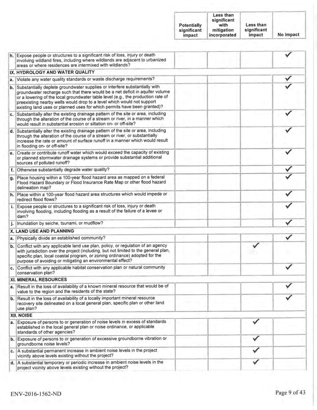
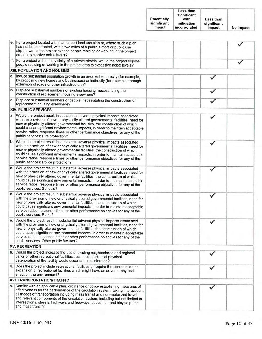
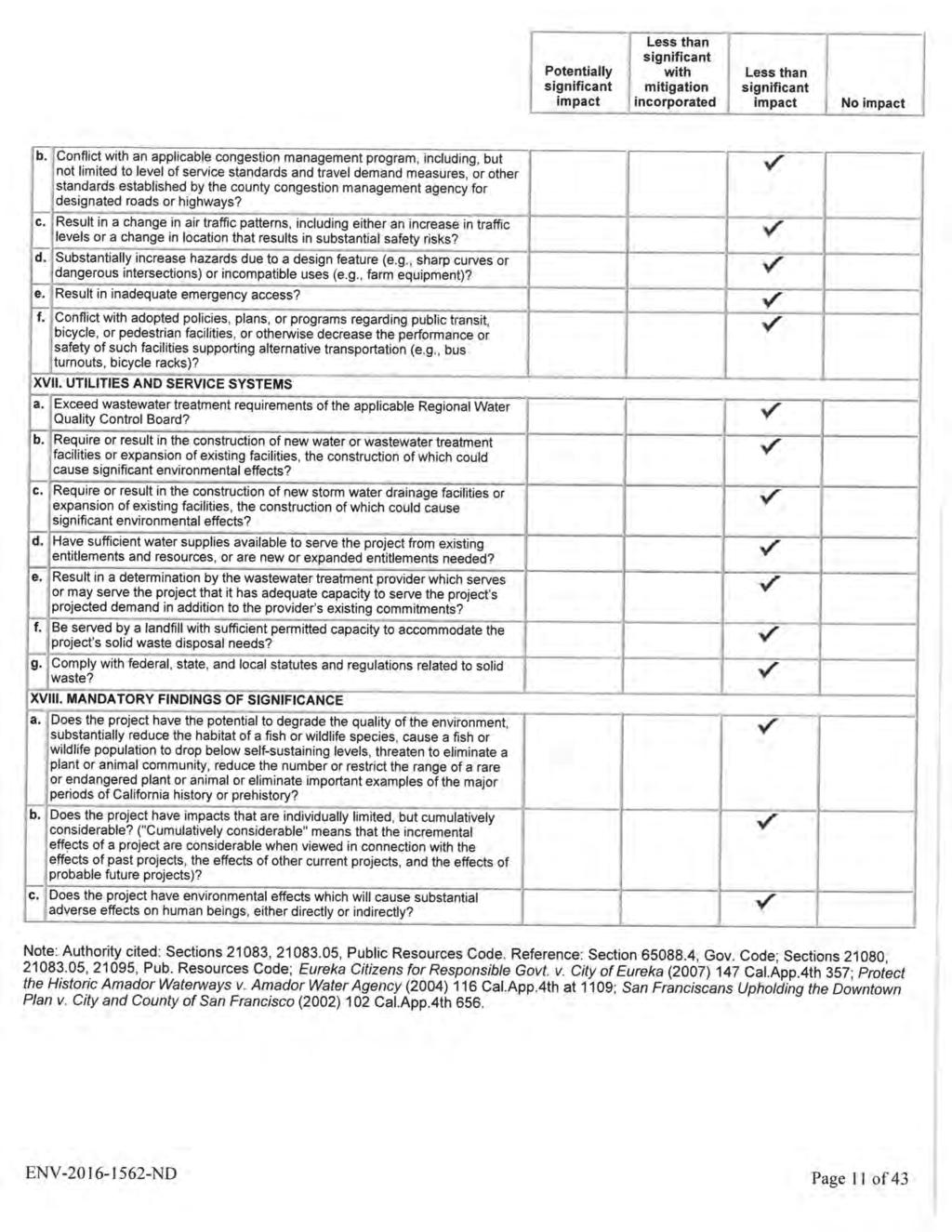
12 CPC GPA-ZC F-5 properties. The proposed Zone Change and General Plan Amendment would allow the existing legally permitted residential uses on the subject properties. In addition, the proposed zone, [Q]RD1.5-1 D, includes the Northeast Los Angeles Hillsides [Q] "Qualifying " Conditions and D "Development" Limitations, which require compliance with development standards that ensure compatibility with the surrounding neighborhood. The proposed legislative action would preserve the zoning intention to implement the community plan's goals to protect and conserve existing low density residential areas. Based on these findings, the recommended action is deemed consistent with the public necessity, convenience, general welfare and good zoning practice. CALIFORNIA ENVIRONMENTAL QUALITY ACT (CEQA) FINDINGS Pursuant to Section (c)(3) of the California Public Resource Code, the Department of City Planning has prepared a Negative Declaration (ENV ND), which concludes that the proposed zone change and land use designation change will result in less than significant impacts and/or that there will be no impacts. The Negative Declaration was published for a period of 20 days, from May 19, 2016 to June 8, As stated in the mandatory findings of significance in the Negative Declaration, the Department of City Planning concludes the following: a. The proposed changes and revisions to the zoning and land use designation would not have the potential to degrade the quality of the environment, substantially reduce the habitat of fish or wildlife species, cause a fish or wildlife population to drop below selfsustaining levels, threaten to eliminate a plant or animal community, or reduce the number or restrict the range of a rare or endangered plant or animal. Potential redevelopment of the site would be required to file for an environmental assessment form to be reviewed and evaluated for the level of environmental clearance and analyses, per CEQA and City CEQA Guidelines. Implementation of future mitigation measures identified in future environmental assessments and compliance with existing regulations would reduce impacts to less-than-significant levels. b. The impacts of the proposed change to zoning and land use designation, in addition to any future projects are considered less than significant. Considerable impacts were analyzed by way of discussing hypothetical probable new construction projects that would in the future file for entitlement review and construction and permitting processes. Although projects may be constructed in the project vicinity at a future time, the cumulative impacts to which the proposed project would contribute would be less than significant, after compliance with the proposed zoning, which includes but is not limited to the current [Q] "Qualified" Conditions, D "Development" Limitations, height limitation, development standards that ensure compatibility with the prevailing residential uses in the surrounding area. The current LAMC and all applicable ordinances and building and safety requirements and procedures remain in effect. The proposed zone change and land use designation from Public facilities to Low Medium II Residential is a technical correction that will ensure consistency with the land use designation and zoning of the surrounding residential area and allow the existing legally permitted residential uses on the subject properties that are privately owned. c. The proposed change to zoning and land use designation have less than significant impacts to human beings since the surrounding area is already fully developed with a mix of primarily residential, commercial, and commercial manufacturing uses and the proposed revisions are consistent with the land uses found in the area.
13 CPC GPA-ZC F-6 The environmental case file can be found with the case file in the Policy Division of the Planning Department in Room 667, 200 North Spring Street, Los Angeles CA
14 CPC ZC-GPA P-1 PUBLIC HEARING AND COMMUNICATIONS Hearing A public hearing will be conducted by the City Planning Commission on this matter in City Hall Room 350, located at 200 North Spring Street, Los Angeles, CA 90012, on Thursday, June 9, 2016 after 8:30a.m. Communications Received Inquiries regarding the nature and purpose of the proposed project were received in response to the public hearing notice and staff responded with information.
15 ORDINANCE NO. An ordinance amending Section of the Los Angeles Municipal Code by amending the Zoning map. THE PEOPLE OF THE CITY OF LOS ANGELES DO ORDAIN AS FOLLOWS: Section 1. Section of the Los Angeles Municipal Code is hereby amended by changing the zone classifications on the properties shown upon a portion of the zone maps attached thereto and made a part of Article 2, Chapter 1 of the Los Angeles Municipal Code, so that such portion of the zoning map shall set forth the zones and height districts as shown on the attached zoning map. This ordinance supersedes portions of Subarea 5060 in Ordinance No Existing [Q] Qualified Conditions and D Development Limitations adopted pursuant to Ordinance No shall be retained.
16 SECTION 2. The City Clerk shall certify to the passage of this ordinance and have it published in accordance with Council policy, either in a daily newspaper circulated in the City of Los Angeles or by posting for ten days in three public places in the City of Los Angeles: one copy on the bulletin board located at the Main Street entrance to the Los Angeles City Hall; one copy on the bulletin board located at the Main Street entrance to the Los Angeles City Hall East; and one copy on the bulletin board located at the Temple Street entrance to the Los Angeles County Hall of Records. I hereby certify that this ordinance was passed by the Council of the City of Los Angeles at its meeting of. HOLLY L. WOLCOTT, City Clerk By Deputy Approved Mayor File No(s). Pursuant to Charter Section 559, I approve this ordinance on behalf of the City Planning Commission and recommend that it be adopted. #### ##, 2016 See attached report. Vincent P. Bertoni Director of Planning
17
18 RESOLUTION WHEREAS the subject properties comprise approximately.43 acres located between Griffin Avenue and Smith Street within the area covered by the Northeast Los Angeles Plan, adopted by the City Council in June 1999; WHEREAS various residential structures were built on the subject properties for residential uses from the 1890s to the 1930s, and the properties have had continuous residential uses from that time; WHEREAS the subject properties are privately owned; WHEREAS the adjacent parcel to the north was acquired by the Los Angeles Unified School District for the use of Hillside Elementary School; WHEREAS the Northeast Los Angeles Community Plan Revision, adopted by the City Council in 1999, incorrectly identified the subject properties as being planned for school uses and designated the sites Public Facilities; WHEREAS the subject properties were subsequently re-zoned from R4-1 to PF-1 to be consistent with the Public Facilities designation per the Northeast Los Angeles Community Plan Revision; WHEREAS the subject properties were never actually purchased by the Los Angeles Unified School District and there is no intention for the subject properties to be used for Public Facilities purposes; WHEREAS the zone of the subject properties was changed from PF-1 to [Q]PF-1D when the Northeast Los Angeles Hillsides [Q] Qualified Conditions were adopted; WHEREAS the current residential parcels to the west of the subject properties are designated Low Medium II Residential with an associated zone of [Q]RD 1.5-1D; WHEREAS the residential uses on the properties are allowed uses within the [Q]RD 1.5 zone and the existing buildings comply with the use and development regulations set forth in the zone s qualifying conditions, the RD 1.5 zone itself, and the 1D height district; WHEREAS a re-zoning and re-designation of these properties from Public Facilities and [Q]PF-1D to Low Medium II Residential and [Q]RD 1.5-1D would designate and zone the subject properties to be consistent with the surrounding properties. WHEREAS pursuant to the provisions of City Charter the Mayor and the City Planning Commission have transmitted their recommendations; and WHEREAS the requested General Plan Amendment is consistent with the intent and purposes of the Northeast Los Angeles Community Plan to maintain residential land for
19 low density residential uses and to encourage the continuation of all existing residential uses permitted by-right in the RD 1.5 zone; NOW THEREFORE BE IT RESOLVED that the Northeast Los Angeles Community Plan be amended as shown on the attached General Plan Amendment Map.
20
21

22
23
24
25
26
27
28
29
30
31
32
33
34
35
36
37
38
39
40
41
42
43
44
45
46
47
48
49
50
51
52
53
54
55
56
57
58
59
60
61
62
63
64
65 CPC ZC Page ORDINANCE NO. _ An ordinance amending Section of the Los Angeles Municipal Code by amending the zoning map. THE PEOPLE OF THE CITY OF LOS ANGELES DO ORDAIN AS FOLLOWS: SECTION 1. Section of the Los Angeles Municipal Code is hereby amended by changing the zone classifications on properties shown upon portions of the zoning maps titled "Zone Change Ordinance Map Northeast Los Angeles Hillsides Zone Change" and the table for Section 1 below and incorporated herein by this reference, and made a part of Article 2, Chapter 1 of the Los Angeles Municipal Code. Table for Section 1 Existing Zone New Zone OS-1XL-HPOZ Q OS-1XLD-HPOZ OS-1XL Q OS-1XLD A1-1 Q A1-1D A1-1XL Q A1-1XLD RE40-1 Q RE40-1D RE20-1 Q RE20-1D RE9-1 Q RE9-1D RS-1 Q RS-1D R1-1-HPOZ Q R1-1D-HPOZ R1-1 Q R1-1D R2-1-HPOZ Q R2-1D-HPOZ R2-1 Q R2-1D RD6-1 Q RD6-1D [T][Q]RD6-1 T Q1RD6-1D RD5-1 Q RD5-1D [Q]RD5-1 Q RD5-1D RD4-1-HPOZ Q RD4-1D-HPOZ RD3-1-HPOZ Q RD3-1D-HPOZ RD3-1 Q RD3-1D RD2':1 Q RD2-1D RD1.5-1 Q RD1.5-1D (T)(Q)RD1.5-1 T Q]RD1.5-1D C1-1 Q C1-1 PF-1 Q PF-1D SECTION 2. Pursuant to Section G of the Los Angeles Municipal Code, and any amendment thereto, the following limitations are hereby imposed upon the use of that property described in Section 1 hereof which are subject to the Permanent "Q" Qualified Classification. Clarifications of these Permanent "Q" Qualified Classifications should be processed through Zoning Administrator Adjustments, pursuant to Section of the Los Angeles Municipal Code, whereby up to twenty percent increases in height and up to ten percent increases in residential floor area may be requested. Where the zone symbols of the new zoning designation as shown in the
66 NORTHEAST LOS ANGELES HILLSIDE CITY OF SOUTH PASADENA UJ 1( UJ ~ Z [QjOS 1XLD F=~~-~~ ~:~"~- I [QjOS.1XLD o NOTTOSCALE C.M A \233, 150A229, 150A231, 150 A A225, CPC ZC """AN NOTE: THIS MAP IS FOR [QJ CONDmONs AND D UMITATIONS PURPOSES ONLY. ALL ZONES THE AFFECTED IN AREA REMAIN THE SAME. ALL BOUNDARIES FOLLOW EXISTING ZONE UNES, EXCEPT WHERE NOTED. CITY TERRACE
![-"'a ~ iiiill"'" '-"'0!J n9i 9~~W~~ H~nh hi!{i1r- Hi 0 I I-I r- :I: HJ lil :-: ~ z z F 'i~ '" =,~~ih a ~ ~~UI g: ~ 'T,"i Co!1!. -c!l. ~. a ] ~ ~IiUI s:: o [ ~ ~\Jf, A l~~~i~1 0 :r: 3 ~ ~ c: ~n1t s ~ ~~i'hi l5' i li '" g II ~m~~n ij9tl!](/docs-images/81/84167230/images/67-0.jpg "i il. U~ [ g ~ I ~glil& h'!i ii., '1 J p-~h ~ 9!P.~&ii i i")
67 -"'a ~ iiiill"'" '-"'0!J n9i 9~~W~~ H~nh hi!{i1r- Hi 0 I I-I r- :I: HJ lil :-: ~ z z F 'i~ '" =,~~ih a ~ ~~UI g: ~ 'T,"i Co!1!. -c!l. ~. a ] ~ ~IiUI s:: o [ ~ ~\Jf, A l~~~i~1 0 :r: 3 ~ ~ c: ~n1t s ~ ~~i'hi l5' i li '" g II ~m~~n ij9tl!i il. U~ [ g ~ I ~glil& h'!i ii., '1 J p-~h ~ 9!P.~&ii i i
68 CPC ZC Page 2 table for Section 1, are preceded by the symbol "Q" in brackets, the conditions and limitations imposed by the new "Q" Qualified Classification are set forth as follows: A. All properties located within the Zone Change Ordinance Map shall be subject to the following [Q] Conditions: 1. Infrastructure a. Construction materials and equipment shall not be permitted to be stored in the public right-of-way in any manner that reduces roadway clearance to less than 20-feet in width. Storage of construction materials and equipment on public property requires a street use permit from the Bureau of Street Services. b. Construction vehicles shall be subject to the restrictions established by the Los Angeles Fire Department Red Flag - No Parking Program. Restricted parking signs shall be procured and installed along the project site at the owner/developer's expense when required by the LAFD and/or LADOT. 2. Building Design a. Second story setbacks or terraced structures and other design articulations are to be used to ensure that new development is compatible with existing neighborhood identity, character and scale. b. Building materials match architectural style of new development. c. Architectural design elements of the front and rear building elevations including articulation of facades, modulations of walls, shape, type details and the location of windows, doors, columns, balconies and garage doors vary from the adjacent/abutting buildings. d. Design of new structures shall meet one of the following standards: (1) The total residential floor area of each story other than the base floor in a multi-story building does not exceed 75 percent of the base floor area, where "Base Floor" and "Floor Area, Residential" shall be defined as set forth in Section of the Los Angeles Municipal Code for the purposes of this regulation; or (2) The cumulative length of the exterior walls facing the front lot line, equal to a minimum of 25 percent of the building width shall be stepped-back a distance of at least 20 percent of the building depth from a plane parallel to the lot width established at the point of the building closest to the front lot line. When the front lot line is not straight, a line connecting the points where the side lot lines and the front lot line intersect shall be used. When through-lots have two front yards, the step-back shall be provided along both front lot lines; or
69 CPC ZC Page 3 (3) The buildings of the project shall consist of 3 or more building elements, each with its own associated roof form. A building element may also be a major horizontal mass, setback, or forward from the face of other masses. e. Structures within 50 linear feet of identified ridgelines, as shown on attached map marked 'Northeast LA Ridgelines', are limited to one story or 15 feet in height. The 50 linear feet must be labeled on all plans accordingly. No structure shall exceed a height in excess of 15 feet above the identified ridgeline. The precise ridgelines shall be verified and identified on the required topographic survey, prepared by a licensed surveyor. f. New hardscape areas, not including foundations, shall utilize permeable paving systems including, but not limited to pavers, porous asphalt, porous concrete, grasscrete and/or similar materials as approved by LADBS. 3. Retaining Walls a. The maximum total height of all freestanding retaining walls shall not exceed 12 feet, with no individual wall measuring higher than 6 feet on private property. Each freestanding retaining wall shall not exceed 75 feet in linear length, nor extend beyond one lot. Walls shall be separated by a minimum horizontal distance equal to the height of the highest wall. Freestanding garden walls 36" in height or less shall not be considered retaining walls for the purposes of this regulation. b. Require that all retaining walls provide a standard surface backdrain system and all drainage shall be conducted to the street in a non-erosive device, as required by approved Soils Report. 4. Landscaping a. Landscaping palette for required landscape plans shall be comprised of drought tolerant and/or native plant material that is fire retardant and controls erosion. b. Retaining walls and building understory areas shall be fully screened with plantings in a reasonable amount of time, as shown on approved landscape plan c. Landscape plans must be submitted to Bureau of Street Services Urban Forestry Division prior to DCP clearance. Upon satisfaction of the requirements set forth under LAMC Ordinance No. 177,404 (Protected Trees) deemed necessary by the Urban Forestry Division, an approval letter will be issued by the Urban Forestry Division and submitted with new development filings as part of submission packages.
70 CPC ZC Page 4 d. Landscaping plans must be submitted to Bureau of Street Services, Urban Forestry Division, and Department of City Planning for review and approval consistent with LAMC Ordinance No. 177,404 (Protected Trees). e. A signed "Certified Arborist's or Licensed Landscape Architect's Certificate of Compliance" must be filed with the Department of Building & Safety prior to issuance of a "Certificate of Compliance" to ensure that landscaping plans are fully implemented. 5. Environmental a. A Geotechnical Investigation Report that evaluates the proposed project's soil and grading shall be submitted to the LADBS Grading Division for review. An approved Soils & Grading report letter from LADBS - Grading Division shall be required prior to approval of a grading, foundation or building permit. b. Grading shall be done in accordance with the Planning Guidelines Landform Grading Manual adopted by the City Council. c. All new graded slopes shall be no steeper than 2:1 (rise:run), except when the Grading Division has determined that slopes may exceed 2: 1 as part of an approved Soils Report. d. Grading shall be limited to a maximum of 500 cubic yards + numeric value equal to 5 percent of the total lot size, up to a maximum of 1,000 cubic yards total. Any deviations beyond these limits shall require a Zoning Administrator's approval under LAMC e. New hardscape areas, not including foundations, shall utilized permeable paving systems including, but not limited to pavers, porous asphalt, porous concrete, grasscrete and/or similar materials as approved by LADBS. B. In addition to those [Q] Conditions listed under Section 2A, the [Q] Conditions pursuant to Ordinances 166,216, 166,267, 179,344 shall be retained.
71 CPC ZC Page 5 SECTION 3. Pursuant to Section G of the Los Angeles Municipal Code, and any amendment thereto, the following limitations are hereby imposed upon the use of that property described in Section 1 hereof which are subject to the Permanent "0" Development Limitations. Where the zone symbols of the new zoning designation as shown in the table for Section 1, are followed by the symbol "0" in the suffix, the conditions and limitations imposed by the new "0" Development Limitation are set forth as follows: A. All properties located within the Zone Change Ordinance Map shall be subject to the following [0] Development Limitations: 1. Height a. In addition to the height limitations contained in LAMC Section A17(c), no building or structure shall exceed 30 feet in height from adjacent finished grade, measured as the vertical distance from the adjacent finished grade of the site to an imaginary plane located above and parallel to the finished grade; except that when the roof of the uppermost story of a building or structure or portion of the building or structure has a slope of less than 25 percent, the maximum height shall be 26 feet above adjacent finished grade. b. The finished floor elevation directly above an exposed underfloor area shall be limited to 6 feet above finished grade. c. Attached decks shall be limited such that no portion of the walking surface of a deck with visible underpinnings shall exceed a height of 6' above grade and decks shall be integrated into the architecture of the house, and not appear as an add-on to the primary building mass. 2. Maximum Residential Floor Area Residential Floor Area for all lots shall be calculated as defined in Section of the Los Angeles Municipal Code. Consistent with the definition contained therein, the first 400 square feet of covered parking area shall not be counted towards the maximum Residential Floor Area. In order to calculate the maximum Residential Floor Area permitted, a site survey showing 1-foot contours must be prepared by a licensed surveyor. The survey shall identify the total area of the lot, in square feet, according to the following slope intervals: Area A - Slope less than 15 percent; Area B - Slope at least 15 percent, but less than 30 percent; Area C - Slope at least 30 percent, but less than 45 percent; Area 0 - Slope at least 45 percent, but less than 60 percent; Area E - Slope at least 60 percent, but less than 100 percent; Area F - Slope greater than 100 percent.
72 CPC-200B-11B2-ZC Page 6 For lots in the RD1.5 and RD2 Zones, the maximum Residential Floor Area contained in all buildings and accessory structures shall be determined by the following formula: 100% of Area A + 90% of Area B + BO% of Area C + 70% of Area D + 60% of Area E + 50% of Area F. The maximum Residential Floor Area in the RD1.5 and RD2 Zones, however, shall not be limited below 3,000 square feet. For lots in the R2, RD3, RD4, RD5, and RD6 Zones, the maximum Residential Floor Area contained in all buildings and accessory structures shall be determined by the following formula: 75% of Area A + 65% of Area B + 55% of Area C + 45% of Area D + 35% of Area E + 25% of Area F. The maximum Residential Floor Area in the R2, RD3, RD4, RD5, and RD6 Zones, however, shall not be limited below 2,200 square feet. For lots in the R1 Zone, the maximum Residential Floor Area contained in all buildings and accessory structures shall be determined by the following formula: 50% of Area A + 45% of Area B + 40% of Area C + 35% of Area D + 30% of Area E + 0% of Area F. The maximum Residential Floor Area in the R1 Zone, however, shall not be limited below 20% of the total lot size, or 1,000 square feet, whichever is greater. The maximum Residential Floor Area in the R1 Zone, for lots 5,000 square feet in size with the slope entirely within Area F, however, shall not be limited below 20% of the total lot size, or 1,100 square feet, whichever is greater. For lots in the RS Zone, the maximum Residential Floor Area contained in all buildings and accessory structures shall be determined by the following formula: 45% of Area A + 40% of Area B + 35% of Area C + 30% of Area D + 25% of Area E + 0% of Area F. The maximum Residential Floor Area in the RS Zone, however, shall not be limited below 20% of the total lot size, or 1,000 square feet, whichever is greater. For lots in the RE9 Zone, the maximum Residential Floor Area contained in all buildings and accessory structures shall be determined by the following formula: 40% of Area A + 35% of Area B + 30% of Area C + 25% of Area D + 20% of Area E + 0% of Area F. The maximum Residential Floor Area in the RE9 Zone, however, shall not be limited below 20% of the total lot size, or 1,000 square feet, whichever is greater.
An ordinance amending Section of the Los Angeles Municipal Code by amending the Zoning map.
 ORDINANCE NO. An ordinance amending Section 12.04 of the Los Angeles Municipal Code by amending the Zoning map. THE PEOPLE OF THE CITY OF LOS ANGELES DO ORDAIN AS FOLLOWS: Section 1. Section 12.04 of the
ORDINANCE NO. An ordinance amending Section of the Los Angeles Municipal Code by amending the zoning map.
 ORDINANCE NO. An ordinance amending Section 12.04 of the Los Angeles Municipal Code by amending the zoning map. THE PEOPLE OF THE CITY OF LOS ANGELES DO ORDAIN AS FOLLOWS: SECTION 1. Section 12.04 of the
RECOMMENDATION REPORT
 DEPARTMENT OF CITY PLANNING RECOMMENDATION REPORT City Planning Commission Date: August 27, 2009 Time: After 8:30 AM Place: City Hall 200 North Spring Street Los Angeles, CA 90012 Public Hearing: Completed
La Brea Hancock Q Condition Ordinance
 Department of City Planning Case No. CPC-2017-2533-ZC ENV-2017-2534-ND La Brea Hancock Q Condition Ordinance Questions & Answers November 17, 2017 Overview The Department of City Planning is working on
ORDINANCE NO. An ordinance amending Section of the Los Angeles municipal Code by amending the zoning map.
 ORDINANCE NO. 184850 An ordinance amending Section 12.04 of the Los Angeles municipal Code by amending the zoning map. THE PEOPLE OF THE CITY OF LOS ANGELES DO ORDAIN AS FOLLOWS: Section. Section 12.04
DEPARTMENT OF CITY PLANNING
 CITY PLANNING COMMISSION DEPARTMENT OF CITY PLANNING Date: June 28, 2007 Time: After 8:30 a.m.* Place: Van Nuys City Hall City Council Chambers 2 nd Floor 14410 Sylvan Street Van Nuys CA. 91401 Public
An ordinance amending Section of the Los Angeles Municipal Code by amending the zoning map.
 ORDINANCE NO. 185805 An ordinance amending Section 12.04 of the Los Angeles Municipal Code by amending the zoning map. THE PEOPLE OF THE CITY OF LOS ANGELES DO ORDAIN AS FOLLOWS: Section 1. Section 12.04
RECOMMENDATION REPORT
 DEPARTMENT OF CITY PLANNING RECOMMENDATION REPORT Los Angeles City Planning Commission Date: September 11, 2008 Time: after 8:30 a.m.* Place: City Hall, 10th Floor 200 North Spring Street Los Angeles,
ORDINANCE NO An ordinance amending Section of the Los Angeles Municipal Code by amending the zoning map.
 ORDINANCE NO. 184536 An ordinance amending Section 12.04 of the Los Angeles Municipal Code by amending the zoning map. THE PEOPLE OF THE CITY OF LOS ANGELES DO ORDAIN AS FOLLOWS: Section. Section 12.04
Los Angeles City Planning Department RECOMMENDATION REPORT
 Los Angeles City Planning Department RECOMMENDATION REPORT CITY PLANNING COMMISSION DATE: June 22, 2006 CASE NO: CPC 2006-3536-CA TIME: After 8:30 a.m.* CEQA: ENV 2006-3552-CE PLACE: Van Nuys City Hall
RECOMMENDATION REPORT
 DEPARTMENT OF CITY PLANNING RECOMMENDATION REPORT CITY PLANNING COMMISSION DATE: January 8, 2009 TIME: after 8:30 a.m.* PLACE: City Hall, 10 th Floor Room 1010 200 N. Spring Street Los Angeles, CA 90012
LG~ ERIC GARCETTI Mayor
 To: The Council Date: JAN 1 3 2015 From: Mayor Council District: 5 Correction Ordinance: Correcting the Zoning of the Beverly Glen - Briarwood -Angelo Properties I herewith concur with the proposed correction
Planning Commission Report
 cjly City of Beverly Hills Planning Division 455 N. Rexford Drive Beverly Hills, CA 90210 TEL. (310) 285-1141 FAX. (370) 858-5966 Planning Commission Report Meeting Date: April 28, 2016 Subject: Project
ORDINANCE NO. _ _
 ORDINANCE NO. _2008-08-1385_ AN ORDINANCE OF THE CITY COUNCIL OF THE CITY OF SIGNAL HILL, CALIFORNIA, APPROVING ZONING ORDINANCE AMENDMENT 08-07, A REQUEST TO AMEND CHAPTER 20.41, SP-7, SPECIAL PURPOSE
Agenda Item No. October 14, Honorable Mayor and City Council Attention: David J. Van Kirk, City Manager
 Agenda Item No. October 14, 2008 TO: FROM: SUBJECT: Honorable Mayor and City Council Attention: David J. Van Kirk, City Manager Scott D. Sexton, Community Development Director ORDINANCE OF THE CITY COUNCIL
ORDINANCE NO. An ordinance amending Section of the Los Angeles Municipal Code by amending the zoning map.
 ORDINANCE NO. An ordinance amending Section 12.04 of the Los Angeles Municipal Code by amending the zoning map. THE PEOPLE OF THE CITY OF LOS ANGELES DO ORDAIN AS FOLLOWS: Section. Section 12.04 of the
CPC CA 3 SUMMARY
 CPC-2009-3955-CA 2 CONTENTS Summary Staff Report Conclusion 3 4 7 Appendix A: Draft Ordinance A-1 Attachments: 1. Land Use Findings 2. Environmental Clearance 1-1 2-1 CPC-2009-3955-CA 3 SUMMARY Since its
LOS ANGELES CITY PLANNING DEPARTMENT RECOMMENDATION REPORT
 LOS ANGELES CITY PLANNING DEPARTMENT RECOMMENDATION REPORT CITY PLANNING COMMISSION DATE: April 13, 2006 TIME: after 8:30 a.m.* PLACE: Los Angeles City Hall 200 N. Spring Street, 10 th Floor Los Angeles,
CALIFORNIA - 1 .«A ERIC GARCETTI MAYOR
 DEPARTMENT OF CITY PLANNING CITY PLANNING COMMISSION DAVID H.J. AMBROZ PRESIDENT RENEE DAKE WILSON VICE-PRESIDENT ROBERT L. AHN CAROLINE CHOE RICHARD KATZ JOHN W. MACK SAMANTHA MILLMAN VERONICA PADILLA-CAMPOS
DEPARTMENT OF CITY PLANNING
 DEPARTMENT OF CITY PLANNING RECOMMENDATION REPORT North Valley Area Planning Commission Date: May 21, 2015 Time: After 4:30 p.m.* Place: Marvin Braude Building First Floor Conference Room 6262 Van Nuys
City of Placerville Planning Commission AGENDA REPORT ITEM 6.2
 Placerville, a Unique Historical Past Forging into a Golden Future City of Placerville Planning Commission AGENDA REPORT ITEM 6.2 MEETING DATE: APPLICATION & NO: 996 Thompson Way - Site Plan Review 2015-07
An ordinance amending Section of the Los Angeles Municipal Code by amending the zoning map.
 ORDINANCE NO. 185479 An ordinance amending Section 12.04 of the Los Angeles Municipal Code by amending the zoning map. THE PEOPLE OF THE CITY OF LOS ANGELES DO ORDAIN AS FOLLOWS: Section 1. Section 12.04
City of Los Angeles CALIFORNIA. Antonio R. Villaraigosa MAYOR VENICE COASTAL SPECIFIC PLAN DIRECTOR OF PLANNING SPECIFIC PLAN INTERPRETATION
 DEPARTMENT OF CITY PLANNING 200 N. SPRING STREET, ROOM 525 LOS ANGELES, CA 90012-4801 AND 6262 VAN NUYS BLVD., SUITE 351 VAN NUYS, CA 91401 C CITY PLANNING COMMISSION WILLIAM ROSCHEN PRESIDENT REGINA M.
THE PEOPLE OF THE CITY OF LOS ANGELES DO ORDAIN AS FOLLOWS:
 ORDINANCE NO..1_, 8_'2_{_19_5 An ordinance amending Sections 11.01, 12.03, 12.24, 12.28, 13.03, 14.3.1, and 16.05 of the Los Angeles Municipal Code to update common findings for conditional uses, adjustments,
published by title and summary as permitted by Section 508 of the Charter. The approved "Summary
 Introduced by: ORDINANCE NO. AN ORDINANCE OF THE CITY OF PASADENA AMENDING TITLE 17 (THE ZONING CODE) TO CHANGE THE DEVELOPMENT STANDARDS OF THE MULTIFAMILY RESIDENTIAL DISTRICTS (RM-16,32 AND 48; CITY
City of Placerville Planning Commission AGENDA REPORT ITEM 6.1
 Placerville, a Unique Historical Past Forging into a Golden Future City of Placerville Planning Commission AGENDA REPORT ITEM 6.1 MEETING DATE: APPLICATION & NO.: 994 Thompson Way - Site Plan Review 2015-06
DEPARTMENT OF CITY PLANNING. Recommendation Report. Central Area Planning Commission. Case No.: CEQA No.: Incidental Cases: Related Cases:
 DEPARTMENT OF CITY PLANNING WtoEl Recommendation Report Central Area Planning Commission Case No.: CEQA No.: Incidental Cases: Related Cases: Date: August 23, 2016 Time: After 4:30 p.m.* None Place: Los
TOWN OF LOS ALTOS HILLS January 11, 2018 Staff Report to the Planning Commission
 ITEM #3.2 TOWN OF LOS ALTOS HILLS Staff Report to the Planning Commission SUBJECT: FROM: REQUEST FOR APPROVAL OF A CONDITIONAL DEVELOPMENT AND SITE DEVELOPMENT PERMITS FOR A NEW 2,831 SQUARE FOOT, TWO
ORDINANCE NO An ordinance amending Section of the Los Angeles Municipal Code by amending the zoning map.
 ORDINANCE NO. 184741 An ordinance amending Section 12.04 of the Los Angeles Municipal Code by amending the zoning map. THE PEOPLE OF THE CITY OF LOS ANGELES DO ORDAIN AS FOLLOWS: Section. Section 12.04
THE PEOPLE OF THE CITY OF LOS ANGELES DO HEREBY ORDAIN AS FOLLOWS:
 ORDINANCE NO. 184307 An ordinance adding Subdivision 10 to Section 14.00.A of Chapter 1 of the Los Angeles Municipal Code to preserve and create affordable housing units by establishing a process for granting
PLANNING & COMMUNITY DEVELOPMENT DEPARTMENT STAFF REPORT
 PLANNING & COMMUNITY DEVELOPMENT DEPARTMENT STAFF REPORT DATE: TO: Hearing Officer SUBJECT: Minor Variance #11876 LOCATION: APPLICANT: ZONING DESIGNATION: GENERAL PLAN DESIGNATION: CASE PLANNER: STAFF
THE PEOPLE OF THE CITY OF LOS ANGELES DO HEREBY ORDAIN AS FOLLOWS:
 ORDINANCE NO. 184271 An ordinance amending Ordinance No. 173,749, the Vermont/Western Transit Oriented District Specific Plan (Station Neighborhood Area Plan) to create a new Subarea F. THE PEOPLE OF THE
DEPARTMENT OF CITY PLANNING
 DEPARTMENT OF CITY PLANNING RECOMMENDATION REPORT City Planning Commission Case No.: CPC-2018-5222-SP Date: November 8, 2018 Time: After 8:30 am Place: Los Angeles City Hall Council Chambers, Room 340
ORDINANCE NO. The Board of Supervisors of the County of Sonoma, State of California, ordains as follows:
 ORDINANCE NO. AN ORDINANCE OF THE BOARD OF SUPERVISORS OF THE COUNTY OF SONOMA, STATE OF CALIFORNIA, AMENDING THE TEXT OF CHAPTER 26C (COASTAL ZONING ORDINANCE) OF THE SONOMA COUNTY ZONING CODE TO: 1)
REPORT TO PLANNING AND DESIGN COMMISSION City of Sacramento
 REPORT TO PLANNING AND DESIGN COMMISSION City of Sacramento 915 I Street, Sacramento, CA 95814-2671 www.cityofsacramento.org 9 PUBLIC HEARING December 10, 2015 To: Members of the Planning and Design Commission
Plan ning Commission Report
 çbevrlyrly Beverly Hills Planning Division 455 N. Rexford Drive Beverly Hills, CA 90210 TEL. (310) 235-1141 FAX. (310) 858-5966 Plan ning Commission Report Meeting Date: June 11, 2015 Subject: 603 North
ORDINANCE NO. 1_8_0_1_0_3_
 ORDINANCE NO. 1_8_0_1_0_3_ An ordinance imposing interim regulations on the issuance of all permits related to the establishment of new fast food restaurants on commercial or industrial zoned properties
PLANNING COMMISSION STAFF REPORT
 PLANNING COMMISSION STAFF REPORT West Capitol Hill Zoning Map Amendment Petition No. PLNPCM2011-00665 Located approximately at 548 W 300 North Street, 543 W 400 North Street, and 375 N 500 West Street
THE PEOPLE OF THE CITY OF LOS ANGELES DO HEREBY ORDAIN AS FOLLOWS:
 ORDINANCE NO. An ordinance adding Subdivision 10 to Section 14.00 A of Chapter 1 of the Los Angeles Municipal Code to create a process for granting legal status to existing unapproved dwelling units in
 EXHIBIT A: Proposed Ordinance CPC-2016-1245-CA May 12, 2016 Exhibit A CPC 2016 1245 CA ORDINANCE NO. An ordinance repealing Subsections 12.24.W.43 and 12.24.W.44 of Chapter 1 of the Los Angeles Municipal
DEVELOPMENT STANDARDS FOR RESIDENTIAL PROJECTS RESIDENTIAL BUILDING TYPES: APPROPRIATE ZONES AND DENSITIES 2-1
 2 DEVELOPMENT STANDARDS FOR RESIDENTIAL PROJECTS RESIDENTIAL BUILDING TYPES: APPROPRIATE ZONES AND DENSITIES 2-1 This Chapter presents the development standards for residential projects. Section 2.1 discusses
1069 regarding Accessory Dwelling Units (ADUs) were signed into law; and
 were signed into law; and") AN ORDINANCE OF THE CITY COUNCIL OF THE CITY OF ARROYO GRANDE AMENDING TITLE 16 OF THE ARROYO GRANDE MUNICIPAL CODE REGARDING ACCESSORY DWELLING UNITS FOR COMPLIANCE WITH STATE LAW AND ADDITIONALLY ROOFTOP
AN ORDINANCE OF THE CITY COUNCIL OF THE CITY OF ARROYO GRANDE AMENDING TITLE 16 OF THE ARROYO GRANDE MUNICIPAL CODE REGARDING ACCESSORY DWELLING UNITS FOR COMPLIANCE WITH STATE LAW AND ADDITIONALLY ROOFTOP
Indicates Council-recommended changes Introduced by: Mr. Tackett Date of introduction: June 14, 2016 SUBSTITUTE NO. 1 TO ORDINANCE NO.
 Indicates Council-recommended changes Introduced by: Mr. Tackett Date of introduction: June 14, 2016 SUBSTITUTE NO. 1 TO ORDINANCE NO. 16-067 TO AMEND NEW CASTLE COUNTY CODE CHAPTER 40 (ALSO KNOWN AS THE
MEMORANDUM. Mr. Sean Tabibian, Esq. Dana A. Sayles, AICP, three6ixty Olivia Joncich, three6ixty. DATE May 26, 2017
 MEMORANDUM TO FROM Dana A. Sayles, AICP, three6ixty Olivia Joncich, three6ixty DATE VIA Email RE 3409 W. Temple Street, Los Angeles, CA 90026 Zoning Analysis and Entitlement Strategy three6ixty (the Consultant
a. provide for the continuation of collector streets and thoroughfare streets between adjacent subdivisions;
 Section 7.07. Intent The requirements of this Section are intended to provide for the orderly growth of the Town of Holly Springs and its extra-territorial jurisdiction by establishing guidelines for:
PLANNING COMMISSION MAY 3, 2018 PUBLIC HEARING
 PLANNING COMMISSION MAY 3, 2018 PUBLIC HEARING SUBJECT: REQUEST TO DEMOLISH TWO SINGLE-FAMILY DWELLINGS ON TWO ADJOINING LOTS AND CONSTRUCT TEN RESIDENTIAL CONDOMINIUM UNITS AT 947 GENESEE AVENUE AND 944
Request. Recommendation. Recommended Motion. Planning Division Department of Community and Economic Development
 PLANNING COMMISSION STAFF REPORT Legislative Item 900 South 900 East Rezone Zoning Map Amendment PLNPCM2010-00360 700 East 900 East, 700 South 900 South December 12, 2012 Applicant: City Council Luke Garrott
ARTICLE 3: Zone Districts
 ARTICLE 3: Zone Districts... 3-1 17.3.1: General...3-1 17.3.1.1: Purpose and Intent... 3-1 17.3.2: Districts and Maps...3-1 17.3.2.1: Applicability... 3-1 17.3.2.2: Creation of Districts... 3-1 17.3.2.3:
NOW, THEREFORE, THE CITY COUNCIL OF THE CITY OF SIGNAL HILL, CALIFORNIA, DOES HEREBY ORDAIN AS FOLLOWS:
 ORDINANCE NO. AN ORDINANCE OF THE CITY COUNCIL OF THE CITY OF SIGNAL HILL, CALIFORNIA, APPROVING ZONING ORDINANCE AMENDMENT 08-06, A REQUEST TO AMEND THE OFFICIAL ZONING MAP BY CHANGING THE DESIGNATION
UPPER MOUNT BETHEL TOWNSHIP NORTHAMPTON COUNTY, PENNSYLVANIA
 UPPER MOUNT BETHEL TOWNSHIP NORTHAMPTON COUNTY, PENNSYLVANIA JOINDER DEED / LOT CONSOLIDATION TOWNSHIP REVIEW PROCESS When accepting proposed Joinder Deeds / Lot Consolidations, review the Joinder Deed
MINOR SUBDIVISION COMMITTEE COUNTY OF MONTEREY, STATE OF CALIFORNIA
 MINOR SUBDIVISION COMMITTEE COUNTY OF MONTEREY, STATE OF CALIFORNIA RESOLUTION NO. 05010 In the matter the application GIANNINI FAMILY LIMITED PARTNERSHIP (PLN040273) APN# 113-071-006-000 FINDINGS & DECISION
RESOLUTION NO. FILE NO. PT14-047
 RESOLUTION NO. A RESOLUTION OF THE COUNCIL OF THE CITY OF SAN JOSE APPROVING A VESTING TENTATIVE MAP TO SUBDIVIDE ONE (1) LOT INTO NINE (9) LOTS FOR RESIDENTIAL USES, AND ONE (1) LOT FOR COMMON USES ON
2. Rezone a portion of the lot from R2 (Small Lot Residential) to RD2 (Duplex: Housing Lane).
 to RD2 (Duplex: Housing Lane).") Public Notice September 6, 2018 Subject Property Subject Property: 337 Hastings Ave Lot 24, District Lot 1, Group 7, Similkameen Division Yale (Formerly Yale-Lytton) District, Plan 932 Application: The
Public Notice September 6, 2018 Subject Property Subject Property: 337 Hastings Ave Lot 24, District Lot 1, Group 7, Similkameen Division Yale (Formerly Yale-Lytton) District, Plan 932 Application: The
ORDINANCE NO
 ORDINANCE NO. 20060622-022 AN ORDINANCE AMENDING CHAPTER 2-1 OF THE CITY CODE TO ADD ARTICLE 53 RELATING TO THE RESIDENTIAL DESIGN AND COMPATIBILITY COMMISSION; ADDING SECTION 25-2-566 TO THE CITY CODE
Z.I. NO INTERIM CONTROL ORDINANCE (ICO) FOR PROPOSED HISTORIC PRESERVATION OVERLAY ZONE (HPOZ) NEIGHBORHOODS
 FOR PROPOSED HISTORIC PRESERVATION OVERLAY ZONE (HPOZ) NEIGHBORHOODS") CITY OF LOS ANGELES ZONING INFORMATION FILE EFFECTIVE DATE: MARCH 25, 215 Z.I. NO. 2444 INTERIM CONTROL ORDINANCE (ICO) FOR PROPOSED HISTORIC PRESERVATION OVERLAY ZONE (HPOZ) NEIGHBORHOODS COUNCIL DISTRICTS:
CITY OF LOS ANGELES ZONING INFORMATION FILE EFFECTIVE DATE: MARCH 25, 215 Z.I. NO. 2444 INTERIM CONTROL ORDINANCE (ICO) FOR PROPOSED HISTORIC PRESERVATION OVERLAY ZONE (HPOZ) NEIGHBORHOODS COUNCIL DISTRICTS:
Planning Commission Report
 ~BER~9 Beverly Hills Planning Division 455 N. Rexford Drive Beverly Hills, CA 90210 TEL. (310) 458-1140 FAX. (310) 858-5966 Planning Commission Report Meeting Date: April 10, 2014 Subject: 1801 Angelo
Staff Report PLANNED DEVELOPMENT. Salt Lake City Planning Commission. From: Lauren Parisi, Associate Planner; Date: December 14, 2016
 Staff Report PLANNING DIVISION COMMUNITY & NEIGHBORHOODS To: Salt Lake City Planning Commission From: Lauren Parisi, Associate Planner; 801-535-7932 Date: December 14, 2016 Re: 1611 South 1600 East PLANNED
ORDINANCE NO. An ordinance amending Section of the Los Angeles Municipal Code by amending the zoning map.
 ORDINANCE NO. An ordinance amending Section 12.04 of the Los Angeles Municipal Code by amending the zoning map. THE PEOPLE OF THE CITY OF LOS ANGELES DO ORDAIN AS FOLLOWS: Section. Section 12.04 of the
PLANNING COMMISSION RESOLUTION NO
 Exhibit A PLANNING COMMISSION RESOLUTION NO. 2014-566 A RESOLUTION OF THE PLANNING COMMISSION OF THE CITY OF CALABASAS RECOMMENDING TO THE CITY COUNCIL APPROVAL OF FILE NO. 140000288, GENERAL PLAN AMENDMENTS
PIN , Part 1, Plan SR-713 in Lot 2, Concession 5, Township of McKim (1096 Dublin Street, Sudbury)
") STAFF REPORT Applicant: Dalron Construction Limited Location: PIN 02124-0103, Part 1, Plan SR-713 in Lot 2, Concession 5, Township of McKim (1096 Dublin Street, Sudbury) Official Plan and Zoning By-law:
STAFF REPORT Applicant: Dalron Construction Limited Location: PIN 02124-0103, Part 1, Plan SR-713 in Lot 2, Concession 5, Township of McKim (1096 Dublin Street, Sudbury) Official Plan and Zoning By-law:
1.0 REQUEST. SANTA BARBARA COUNTY ZONING ADMINISTRATOR Coastal Zone Staff Report for Vincent New Single-Family Dwelling & Septic System
 SANTA BARBARA COUNTY ZONING ADMINISTRATOR Coastal Zone Staff Report for Vincent New Single-Family Dwelling & Septic System Hearing Date: February 26, 2007 Supervisorial District: First Staff Report Date:
SPECIAL ZONING DISTRICTS
 SPECIAL ZONING DISTRICTS 5.01 5.99 RESERVED 5.100 PLANNED DEVELOPMENTS: Purpose: This district is intended to accommodate unified design of residential, commercial, office, professional services, retail
ORDINANCE NO
 ORDINANCE NO. 2014-160 AN ORDINANCE OF THE CITY COUNCIL OF THE CITY OF MENIFEE, CALIFORNIA, REPEALING SECTION 10.35 OF RIVERSIDE COUNTY LAND USE ORDINANCE NO. 460.152 AS ADOPTED BY THE CITY OF MENIFEE
RESOLUTION NO. B. The proposed amendment would not be detrimental to the public interest, health, safety, convenience, or welfare of the City; and
 RESOLUTION NO. RESOLUTION OF THE PLANNING COMMISSION OF THE CITY OF SANTA ROSA RECOMMENDING TO CITY COUNCIL REZONING TO MODIFY THE EXISTING POLICY STATEMENT AND ADOPT THE BAY VILLAGE HOMES DEVELOPMENT
published by title and summary as permitted in Section 508 of the Charter. The approved "Summary
 Introduced by Council Member: ORDINANCE NO. AN ORDINANCE OF THE CITY OF PASADENA AMENDING TITLE 17 (THE ZONING CODE), ARTICLE 2 (ZONING MAP) TO ESTABLISH A HEIGHT OVERLAY DISTRICT (HL-28) ON CERTAIN PARCELS
Agenda Report TO: CITY COUNCIL DATE: NOVEMBER 21, 2005 FROM: CITY MANAGER
 Agenda Report TO: CITY COUNCIL DATE: NOVEMBER 21, 2005 FROM: SUBJECT: CITY MANAGER PROPOSED ZONING CODE AMENDMENTS TO LIMIT THE HEIGHT OF COMMERCIAL AND INDUSTRIAL DEVELOPMENT ABUTTING PROPERTIES IN THE
SUBJECT: Character Area Studies and Site Plan Approval for Low Density Residential Areas. Community and Corporate Services Committee
 Page 1 of Report PB-70-16 SUBJECT: Character Area Studies and Site Plan Approval for Low Density Residential Areas TO: FROM: Community and Corporate Services Committee Planning and Building Department
RESOLUTION NO
 ITEM 4 ATTACHMENT B RESOLUTION NO. 2014-1412 A RESOLUTION OF THE CITY COUNCIL OF THE CITY OF CALABASAS APPROVING GENERAL PLAN AMENDMENTS ASSOCIATED WITH THE WEST AGOURA ROAD TERRITORY IN CONFORMANCE WITH
4. PUBLIC HEARINGS a. Public hearing on revisions to Accessory Dwelling Unit Standards in the Land Development Code LEGISLATIVE
 1. CALL TO ORDER AGENDA ELLENSBURG CITY PLANNING COMMISSION City Council Chambers City Hall, 501 N. Anderson St. Ellensburg, WA 98926 Thursday September 27, 2018 5:45 P.M. 2. APPROVAL OF THE AGENDA 3.
Stenberg Annexation Legal Diagram Exhibit "B" W Subject Property Annexed to the City of Red Bluff VICINITY MAP "1:3:
 Stenberg Annexation Legal Diagram Exhibit "B" W Subject Property Annexed to the City of Red Bluff VICINITY MAP "1:3: ORDINANCE NO. 991 REZONE NO. 210 AN ORDINANCE AMENDING SECTION 25.13 OF THE RED BLUFF
COUNTY OF SACRAMENTO CALIFORNIA ZONING ADMINISTRATOR REPORT
 COUNTY OF SACRAMENTO CALIFORNIA ZONING ADMINISTRATOR REPORT For the Agenda of: May 4, 2016 To: From: Subject: Supervisorial District(s): Zoning Administrator Department of Community Development PLNP2015-00222.
EL DORADO COUNTY PLANNING AND BUILDING DEPARTMENT ZONING ADMINISTRATOR STAFF REPORT VARIANCE
 EL DORADO COUNTY PLANNING AND BUILDING DEPARTMENT ZONING ADMINISTRATOR STAFF REPORT Agenda of: April 18,2018 Item No.: Staff: 5.a. Emma Carrico VARIANCE FILE NUMBER: APPLICANT: REQUEST: LOCATION: V17-0003/La
FULL TEXT OF MEASURE I CITY OF YORBA LINDA
 FULL TEXT OF MEASURE I CITY OF YORBA LINDA ORDINANCE NO. 2011-962 AN ORDINANCE OF THE CITY COUNCIL OF THE CITY OF YORBA LINDA ADOPTING THE YORBA LINDA TOWN CENTER SPECIFIC PLAN AND AN AMENDMENT TO THE
TENTATIVE PARCEL MAP TIME EXTENSION
 EL DORADO COUNTY DEVELOPMENT SERVICES ZONING ADMINISTRATOR STAFF REPORT Agenda of: October 15, 2008 Item No.: Staff: 4.a. Mel Pabalinas TENTATIVE PARCEL MAP TIME EXTENSION APPLICATION FILE NO.: APPLICANT:
Planning & Transportation Commission Staff Report (ID # 8862)
") Planning & Transportation Commission Staff Report (ID # 8862) Report Type: Action Items Meeting Date: 2/14/2018 Summary Title: Title: From: Affordable Housing (AH) Combining District Draft Ordinance PUBLIC
Planning & Transportation Commission Staff Report (ID # 8862) Report Type: Action Items Meeting Date: 2/14/2018 Summary Title: Title: From: Affordable Housing (AH) Combining District Draft Ordinance PUBLIC
CITY OF ELK GROVE CITY COUNCIL STAFF REPORT
 AGENDA ITEM NO. 9.2 CITY OF ELK GROVE CITY COUNCIL STAFF REPORT AGENDA TITLE: A public hearing to consider a Specific Plan Amendment to the Laguna Ridge Specific Plan and a Rezone of approximately 4.14
Appendix1,Page1. Urban Design Guidelines. Back to Back and Stacked Townhouses. DRAFT September 2017
 Appendix1,Page1 Urban Design Guidelines DRAFT September 2017 Back to Back and Stacked Townhouses Appendix1,Page2 Table of Contents 1 Introduction 1 1.1 Purpose 1 1.2 Urban Design Objectives 1 1.3 Building
CITY OF LOS ANGELES DEPARTMENT OF CITY PLANNING ZONING INFORMATION FILE. Effective Date: March 15, 2011 ZI 2416 DOWNTOWN DESIGN GUIDE PROJECT AREA
 COUNCIL DIRICTS: 9 & 14 CITY OF LOS ANGELES DEPARTMENT OF CITY PLANNING ZONING INFORMATION FILE Effective Date: March 15, 2011 ZI 2416 DOWNTOWN DESIGN GUIDE PROJECT AREA COMMENTS: On March 15, 2011, Ordinance
-MENDOCINO COUNTY PLANNING AND BUILDING SERVICES- DIVISION OF LAND REGULATIONS TITLE 17
 ARTICLE VI -- GENERAL REGULATIONS AND PROVISIONS Sec. 17-50. Sec. 17-51 General Plan. Sec. 17-52 Lot and Block Design and Configuration. Sec. 17-53 Lot Access. Sec. 17-54 Private Roads. Sec. 17-55 Water
MICHAEL N. FEUER CITYATIORNEY REPORT RE:
 MICHAEL N. FEUER CITYATIORNEY REPORT RE: R14-0291 REPORT NO. ------.JUN 2 J) 2014 DRAFT ORDINANCE AUTHORIZING SALE OF 2535 SOUTH SYCAMORE AVENUE, LOS ANGELES, CALIFORNIA AND 2520 ALSACE AVENUE, LOS ANGELES,
Applicant's Response to Appeal in Case No. CPC GPA-ZC-HD-MCUP-ZV-SPR
 CL Ul 633 W. 5th Street 32nd Floor Los Angeles, CA 90071.2005 213.694.3100 main 213.694.3101 fax AndrewJ. Brady 213.694.3108 direct abrady@linerlaw.com August 22, 2017 Honorable Members of the Planning
Proposed Transit Oriented Communities Affordable Housing Incentive Program Guidelines (TOC Guidelines)
") March 13, 2017 - Pg. 1 Proposed Transit Oriented Communities Affordable Housing Incentive Program Guidelines (TOC Guidelines) Implementing Section 6 of Measure JJJ, approved by the voters in November 2016,
March 13, 2017 - Pg. 1 Proposed Transit Oriented Communities Affordable Housing Incentive Program Guidelines (TOC Guidelines) Implementing Section 6 of Measure JJJ, approved by the voters in November 2016,
ARTICLE FIVE FINAL DRAFT
 ARTICLE FIVE 021218 FINAL DRAFT Sec. 503.6 Open Space Preservation Option Open Space Preservation Option Open Space Preservation developments may be approved in the AR, R-1, R-2 and R-3 zoning districts,
Transit Oriented Communities Affordable Housing Incentive Program Guidelines (TOC Guidelines)
") Transit Oriented Communities Affordable Housing Incentive Program Guidelines (TOC Guidelines) Implementing Section 6 of Measure JJJ, approved by the voters in November 2016, and added to Los Angeles Municipal
Transit Oriented Communities Affordable Housing Incentive Program Guidelines (TOC Guidelines) Implementing Section 6 of Measure JJJ, approved by the voters in November 2016, and added to Los Angeles Municipal
An Interim Control Ordinance temporarily prohibiting the Conversion or Demolition of Residential Hotels, citywide.
 ORDINANCE NO. 177557 An Interim Control Ordinance temporarily prohibiting the Conversion or Demolition of Residential Hotels, citywide. WHEREAS, Residential Hotels, including single-room occupancy (SRO)
City of San Juan Capistrano Agenda Report
 City of San Juan Capistrano Agenda Report TO: Zoning Administrator FROM: Reviewed by: Sergio Klotz, AICP, Assistant Development Services DirctJ. o ~ Prepared by: Laura Stokes, Housing Coordinator I Assistant
A G E N D A CITY OF BUENA PARK ZONING ADMINISTRATOR
 A G E N D A CITY OF BUENA PARK ZONING ADMINISTRATOR December 13, 2017 COMMUNITY DEVELOPMENT CONFERENCE ROOM 3:00 p.m. Members of the public who wish to discuss an item should fill out a speaker identification
CITY OF WILDOMAR PLANNING COMMISSION Agenda Item #2.3 PUBLIC HEARING Meeting Date: January 6, 2016
 CITY OF WILDOMAR PLANNING COMMISSION Agenda Item #2.3 PUBLIC HEARING Meeting Date: January 6, 2016 TO: FROM: Chairman and Members of the Planning Commission Matthew C. Bassi, Planning Director SUBJECT:
CITY OF MANHATTAN BEACH DEPARTMENT OF COMMUNITY DEVELOPMENT. Richard Thompson, Director of Community Development
 CITY OF MANHATTAN BEACH DEPARTMENT OF COMMUNITY DEVELOPMENT TO: FROM: BY: Planning Commission Richard Thompson, Director of Community Development Angelica Ochoa, Assistant Planner DATE: February 13, 2013
PLANNING COMMISSION AGENDA REPORT. 17-CA-02 Accessory Dwelling Unit Ordinance. Jon Biggs, Community Development Director
 PLANNING COMMISSION AGENDA REPORT Meeting Date: May 3, 2018 Subject: Prepared by: Initiated by: 17-CA-02 Accessory Dwelling Unit Ordinance Jon Biggs, Community Development Director City Council Attachments:
WHEREAS, the extreme shortage of housing in the City of Los Angeles has been well documented;
 ORDINANCE NO. 185489 An ordinance amending Sections 12.03, 14.00 and 151.02 of the Los Angeles Municipal Code establishing regulations to facilitate the use of existing hotels and motels for Supportive
A G E N D A CITY OF BUENA PARK ZONING ADMINISTRATOR
 A G E N D A CITY OF BUENA PARK ZONING ADMINISTRATOR September 2, 2016 COMMUNITY DEVELOPMENT CONFERENCE ROOM 10:00 a.m. Members of the public who wish to discuss an item should fill out a speaker identification
ZONING AMENDMENT, PLANNED UNIT DEVELOPMENT & SUBDIVISION STAFF REPORT Date: August 8, 2013
 ZONING AMENDMENT, PLANNED UNIT DEVELOPMENT & SUBDIVISION STAFF REPORT Date: August 8, 2013 NAME SUBDIVISION NAME PV-Magnolia, LLC Twelve Trees Subdivision LOCATION 2860, 2862 and 2866 Pleasant Valley Road
PALM BEACH COUNTY PLANNING, ZONING AND BUILDING DEPARTMENT ZONING DIVISION
 PALM BEACH COUNTY PLANNING, ZONING AND BUILDING DEPARTMENT ZONING DIVISION Application No.: Z-2014-01627 Application Name: Dazco Center Control No.: 2003-00040 Applicant: 4730 Hypoluxo LLC Owners: 4730
DEVELOPMENT DEPARTMENT STAFF REPORT THE PARK AT 5 TH
 DEVELOPMENT DEPARTMENT STAFF REPORT ARB Meeting Date: July 3, 2018 Item #: _PZ2018-293_ THE PARK AT 5 TH Request: Site Address: Project Name: Parcel Number: Applicant: Proposed Development: Current Zoning:
This is a conditional use permit request to establish a commercial wind energy conversion system.
 Public Works 600 Scott Boulevard South Hutchinson, Kansas 67505 620-694-2976 Road & Bridge Planning & Zoning Noxious Weed Utilities Date: March 28, 2019 To: From: Reno County Planning Commission Russ Ewy,
CITY OF VAUGHAN EXTRACT FROM COUNCIL MEETING MINUTES OF SEPTEMBER 27, 2018
 CITY OF VAUGHAN EXTRACT FROM COUNCIL MEETING MINUTES OF SEPTEMBER 27, 2018 Item 5, Report No. 28 of the Committee of the Whole (Public Hearing), which was adopted without amendment by the Council of the
Planning Department 168 North Edwards Street Post Office Drawer L Independence, California 93526
 Planning Department 168 North Edwards Street Post Office Drawer L Independence, California 93526 Phone: (760) 878-0263 FAX: (760) 8782-2712 E-Mail: inyoplanning@inyocounty.us AGENDA ITEM NO.: 4 (Action
Planning Commission Report
 Beverly Hills Planning Division 455 N. Rexford Drive Beverly Hills, CA 90210 TEL. (310) 285-1141 FAX. (310) 858-5966 Planning Commission Report Meeting Date: August 12, 2013 Subject: 1184 Loma Linda Drive
That the Planning Commission finds and advises EBMUD that the proposed disposal of property is in conformance with the County General Plan.
 STAFF ANALYSIS JUNE 19, 2006 GPC 2006-02 DISPOSAL OF PROPERTY EAST BAY MUNICIPAL UTILITY DISTRICT PROPOSED SALE OF EAST BAY MUNICIPAL UTILITY DISTRICT S SYDNEY RESERVOIR PROPERTY: Request by the Real Estate