Application of Multipurpose Cadastre to Evaluate Energy Security of Land Parcel (Case Study: Gedung A and Gedung B, Institut Teknologi Sumatra)
|
|
|
- Morris Bryan
- 5 years ago
- Views:
Transcription
1 Application of Multipurpose Cadastre to Evaluate Energy Security of Land Parcel (Case Study: Gedung A and Gedung B, Institut Teknologi Sumatra) Satrio Muhammad ALIF, Agung Pandi NUGROHO, Bambang Edhi LEKSONO, Indonesia Key words: Multipurpose Cadastre, Energy Security, Land Parcel SUMMARY Energy security has one of its dimensions: Short-term energy security which focuses on the ability of the energy system to react promptly to sudden changes within the supply-demand balance. Non-energy components (such as land parcel) that comprise an energy system are analyzed comprehensively with other component to measure energy security related to energy supply. Multipurpose cadastre which is an integrated land information system containing legal, physical, and cultural is used to evaluate energy (electrical energy) security of land parcel. The fundamental component of multipurpose cadastre used to evaluate energy security is attribute data which is the value of land parcel facilities. Other fundamental components (geographic control data, base map data, cadastral data) are used as position information and provide weight in room (part of land parcel) valuation. High value-room means the room is comfortable and/or used productively by its occupant. The method of valuation is by comparing one facility to other facilities. Facilities included in room valuation are relatively static items (such as chair, desk, and cabinet) except lamps and other electronic devices. The room value and number of electronic devices which consume electrical energy are correlated with each other. Consumption of electrical energy of electronic devices in the room with average value remains constant while consumption in other room needs to be evaluated to save the energy. The result of this research shows that room value correlate weakly with number of electronic device in corresponding room. It shows excess energy consumed in low- value room. Although numbers of electronic devices do not always mean the consumption of electrical energy and there are plenty electronic devices, it is recommended for occupant to be careful in utilizing electronic devices in low-value room to minimize energy consumption.
2 Application of Multipurpose Cadastre to Evaluate Energy Security of Land Parcel (Case Study: Gedung A and Gedung B, Institut Teknologi Sumatra) Satrio Muhammad ALIF, Agung Pandi NUGROHO, Bambang Edhi LEKSONO, Indonesia 1. INTRODUCTION Energy security which is the uninterrupted availability of energy sources at an affordable price has one of its dimensions: Short-term energy security which focuses on the ability of the energy system to react promptly to sudden changes within the supply-demand balance. Nonenergy components (such as land parcel) that comprise an energy system are analysed comprehensively with other component to measure energy security related to energy supply. Multipurpose cadastre, which is an integrated land information system containing legal (e.g. property ownership or cadastre), physical (e.g. topography, man-made features), and cultural (e.g. land use, demographics), is used to evaluate energy (electrical energy) security of land parcel. Multipurpose cadastre is ideal solution as inputs as well as instrument in establish modern land administration system [1]. Multipurpose cadastre can be used as basic information and backbone for government policy [2]. The fundamental component of multipurpose cadastre used to evaluate energy security is attribute data which is the value of land parcel facilities. Other fundamental components geographic control data, base map data, cadastral data) are used as position information and provide weight in room (part of land parcel) valuation [3]. High value-room means the room is comfortable and/or used productively by its occupant. The case studies of this research are Gedung A and Gedung B that are located in land parcel owned by Institut Teknologi Sumatra in Lampung Province, Indonesia. The location of case study is shown on Figure 1. This research will show the method to evaluate excess energy consumption of room based on productivity and electronic devices. 2. METHOD The process in giving value of facilities in room begins with collecting facilities data which related to attribute data and defining room boundary which related to spatial data. The process starts with data management and data processing. Tool used in applying multipurpose cadastre to evaluate energy security in this case energy consumption of land parcel is geographical information system (GIS). GIS The advent of computerised databases and GIS technology provides an opportunity to develop a greater understanding of land and how land may be more efficiently and effectively managed [4].

3 Figure 1. Location of case study. Gedung A is pointed by red rectangle while Gedung B is pointed by blue rectangle 2.1 Data Management Method Data collected in applying multipurpose cadastre are the fundamental component of multipurpose cadastre. Those are spatial reference frame, base maps, cadastre map, attributes data. Spatial reference frame is collected from 13 bench marks located in Institut Teknologi Sumatera referred to geospatial reference frame SRGI2013, reference ellipsoid WGS84 and reference frame ITRF2008 epoch Current base map is obtained from photogrammetry measurement with scale 1:1000 acquired on February Cadastre map that delineate boundary of Institut Teknologi Sumatra parcel is obtained from Institut Teknologi Sumatera land document. The principal boundary of this research is delineation of boundaries of Gedung A and Gedung B which is obtained from Institut Teknologi Sumatera building floor

4 plan. Attributes data which is facility, occupant, and electronic devices are obtained by doing facility counting activity. Those attributes data are stored in database to facilitate updating, modifying, deleting the data. Those attributes data are classified into three entities: Facility, Room, and Facility-Room. Facility entity contains code, name, brand, figure, and category of facility. Category of facility is mark to distinguish whether the facility is electronic devices. Room entity contains code, name, usage, location, floor, and activity hour per day. Activity hour per day is mark to identify occupant activity in the room. Facility-Room entity contains facility code, room code which is constraint to code in facility entity and room entity, respectively, and number of good-conditioned facility, bad-conditioned facility, and unused facility in corresponding room. The code of facility and room are unique. Entity relationship diagram of this research is shown on Figure 2. Figure 2. Entity relationship diagram of this research The boundaries of Gedung A and Gedung B which is obtained from Institut Teknologi Sumatera building floor plan are rectified in Institut Teknologi Sumatera base maps with control points used are 4 corners of respective building. Area of room is calculated to provide weight in room valuation. 2.2 Data Processing Method Exceed of energy consumption of every room are analysed by firstly calculate room value based on facilities beside electronic devices and electronic devices itself. Valuation and weighing for every facility is done depends on objective of valuation [5]. The objective of valuation in this research is to obtain energy consumption on respective room. It correlates with productivity of respective room. Less productive the room, it should be less energy consumed. Productivity of room can also be used to value a room [6]. Facility both electronic devices and general facilities valuation method is rating method based on its functionality. The method of valuation is by comparing one facility to other facilities. General facilities included in room valuation are relatively static items (such as chair, desk, and cabinet) except lamps and other electronic devices. Electronic devices included in room valuation are air conditioner, CCTV, computer, dispenser, fan, lamps speaker, and other machines. The room value and number of electronic devices which consume electrical energy are correlated with


5 each other. Consumption of electrical energy of electronic devices in the room with average value remains constant while consumption in other room needs to be evaluated to save the energy. 3. DISCUSSION The results of valuation are room values calculated both from general facilities and electronic devices. Differences in value for same room then are evaluated by comparing with other room value. 3.1 Room Value Analysis Total room which is calculated in this research are 40 rooms in 2 buildings with 2 floors in respective building. Display of result is based on the location of room inside building and its floor resulting 4 displays: first floor of Gedung A, second floor of Gedung A, first floor of Gedung B, and second floor of Gedung B. Each display shows only either value calculated from general facilities or electronic devices. The value of room and its category is shown on Table 1. Displays of room value of first floor of Gedung A, second floor of Gedung A, first floor of Gedung B, and second floor of Gedung B are shown on Figure 3, Figure 4, Figure 5, and Figure 6. Figure 3. First floor of gedung A value calculated from general facilities (left) and electronic devices (right)
6 Table 1. Room value based on general facilities and electronic devices Room Code Room Name Value based on general facilities Category based on general facilities Value based on electronic devices Category based on electronic devices A101 Toilet Pria 13.0 Low 7.8 Low A102 Toilet Wanita 0.0 Low 9.4 Low A103 Ruang Panel 4.9 Low 4.1 Low A104 Gudang 48.4 Low Medium A105 A High High A106 A Medium High A107 A Medium High A108 Server 18.2 Low 39.3 Low A109 A High High A110 Bilik Toilet Wanita 41.1 Low 0.0 Low A111 Bilik Toilet Wanita 37.8 Low 0.0 Low A112 Bilik Toilet Pria 39.6 Low 0.0 Low A113 Koridor Gedung A 65.2 Low 86.4 Medium A201 A Medium 36.9 Low A202 A Low 16.6 Low A203 A Medium High A204 A High High A205 A Medium 84.8 Medium A206 A Medium Medium A207 A Medium High A208 A Medium Medium A209 Koridor Gedung A 12.0 Low Medium
7 B101 Ruang Panel 3.7 Low 3.2 Low B102 Toilet Wanita 44.0 Low 9.4 Low B103 Toilet Pria 41.2 Low 2.2 Low B104 B Medium High B105 B High Medium B106 B Low 54.1 Low B107 B Medium High B108 B Medium High B109 Bilik Toilet Pria 69.0 Low 0.0 Low B110 Bilik Toilet Wanita 36.9 Low 0.0 Low B111 Bilik Toilet Wanita 40.5 Low 0.0 Low B112 Koridor Gedung B 74.3 Medium 49.4 Low B201 B Medium Medium B202 B Medium Medium B203 B Low Medium B204 B Medium Medium B205 B Medium High B206 Koridor Gedung B Medium High

 and")

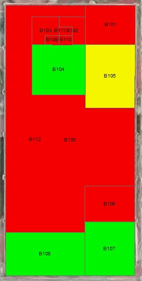
8 Figure 4. Second floor of gedung A calculated from general facilities (left) and electronic devices (right) Figure 5. First floor of gedung B calculated from general facilities (left) and electronic devices (right)
 and electronic devices (right) The classification of room value falls into three categories: high, medium, low for either facility")
 category in facility which becomes green (high) category in electronic devices.")
9 Figure 6. Second floor of gedung B calculated from general facilities (left) and electronic devices (right) The classification of room value falls into three categories: high, medium, low for either facility based value or electronic devices based value. Based on those figures and category, room with excess energy can be identified such as room with yellow (medium) category in facility which becomes green (high) category in electronic devices. Each room falls into one category because of cumulative reason. Reasons are number of general facilities, number of electronic devices, occupant, and area of respective of room. For example, room B106 has low facility based value because of lack of facility and low activity hour. Room A204 has high facility based value because of considerably facility and high activity hour. Room B206 has high electronic devices based value because there are many electronic devices that possibly to consume much energy. Room B102 which is toilet room has low electronic devices based value because there are few electronic devices mean less energy consumption. 3.2 Energy Consumption Consumption of electrical energy of electronic devices in the room with average value remains constant while consumption in other room needs to be evaluated to save the energy. It is identified by looking at facility based value. In this research facility based average value is and electronic devices based value is Simply, it means room with facility based value below should have electronic devices based value below to save energy. Excess of energy is calculated by subtracting difference of each room electronic based value
10 and average electronic based value with difference of each room facility value and average facility value. The result of this research shows that room value correlate weakly with number of electronic device in corresponding room. It shows excess energy consumed in low value-room. Correlation between facility based value and electronic devices based value sorted by facility based value is shown on Figure 7. The category of excess energy in each room with excess energy is shown on Table 2. Room which is not shown on Table 2 means energy used in corresponding room is secure. Figure 6. Correlation between facility based value and electronic devices based value Table 2. Excess energy in room Room Code Value Difference Category A Critical B Critical A Critical B High Need A High Need
11 B High Need B High Need A High Need B High Need A Low Need B Low Need B Low Need A Low Need A Low Need B Low Need A Low Need The classification of excess energy falls into three categories: critical, high need, and low need. Theoretically, there are some treatments to diminish excess energy of room. More critical the excess, more treatment needs to be done. Those treatments are: 1. Minimize energy consumption in the room. Although numbers of electronic devices do not always mean the consumption of electrical energy and there are plenty electronic devices, it is recommended for occupant to be careful in utilizing electronic devices in low-value room to minimize energy consumption. 2. Move electronic devices to other broader room. One of the factors in evaluating room value is room area. High electronic based value room often have many electronic devices with less facility because of not enough space in corresponding room. 3. Increase general facility in the room. If the room still have enough space to provide general facility, it will increase the productivity of corresponding room and make energy consumption more secure.
12 CONCLUSION The method to evaluate excess energy consumption of room based on productivity and electronic devices produce classification of room with excess energy. The classification could lead to policy and strategies of energy security. The process started with concept of multipurpose cadastre: every land parcel has coordinates, boundary, and attribute data that show facility information and ends with evaluation of energy security. In this case study, there are 3 rooms with critical excess energy, 6 rooms with high excess energy, 7 rooms with low excess energy, and 24 rooms with secure energy. Although numbers of electronic devices do not always mean the consumption of electrical energy and there are plenty electronic devices, it is recommended for occupant to be careful in utilizing electronic devices in low-value room to minimize energy consumption. REFERENCES [1] Dale P F and McLaughlin J D 1988 Land Information Management: an Introduction with Special reference to Cadastral Problems in Third World Countries Oxford: Clarendon Press [2] Pesl I 2003 Cadastre and Other Public Registers: Multipurpose Cadastre or Distributed Land Information System FIG Working Week [3] Council N R 1983 Procedures and Standards for a Multipurpose Cadastre National Academy of Sciences Washington DC p 1 [4] Dale P F and McLaren R A 1999 GIS in land administration Geographical information systems [5] Malczewski J 1999 GIS and Multicriteria Decision Analysis New York: John Wiley & Sons, Inc. [6] Boyd T and Boyd S 2011 Valuing The Land Component Of Improved Investment Property For Tax Purposes 17th Pacific Rim Real Estate Society Conference Paper BIOGRAPHICAL NOTES Satrio Muhammad Alif is born at Bandarlampung, July 8 th He started bachelor degree in 2011 at and Geodesy and Geomatics Engineering in Institut Teknologi Bandung. He continued his master degree in 2015 at Geodesy and Geomatics Engineering. His research during his study belongs in geodynamics and GIS.
13 CONTACTS Satrio Muhammad Alif, M.T. Institut Teknologi Sumatera Jalan Terusan Ryacudu, Way Hui, Jati Agung Lampung Selatan INDONESIA Tel Fax Web site:
Integration of Market Price Comparison Approach and Income Approach in Urban Land Assessment
 Integration of Market Price Comparison Approach and Income Approach in Urban Land Assessment Nanin Trianawati SUGITO, Irawan SUMARTO, S. HENDRIATININGSIH, and Bambang Edhi LEKSONO, Indonesia Key words:
Outline. Property taxes-general. Tax concept. Property taxes-liabilities. authorizations. Property taxes-authorizations
 Outline Property Taxation and Land Management Ress. Asst. Volkan Cagdas TURKEY i. General attributes of taxes ii. Land and its functions iii. Land management concept iv. Land policies v. Property for land
Functional system for cadastral plans
 , Republic of Macedonia Key words: Cadastre, Digital plans, Data, System SUMMARY The analysis shows that the real estate market in Republic of Macedonia grows daily. With the expansion of this market increases
Mass Appraisal of Income-Producing Properties
 Chapter 10 Mass Appraisal of Income-Producing Properties Whether valuing income-producing property or residential property, you can use similar information and methods for collecting and analyzing data
A New Vision on Cadastral Data Model
 Mohsen KALANTARI, Abbas RAJABIFARD, Jude WALLACE and Ian P. WILLIAMSON, Australia Key words: Land administration, cadastre, land parcel, legal property object, interoperability SUMMARY Land administration
The Challenge to Implement International Cadastral Models Case Finland 1
 The Challenge to Implement International Cadastral Models Case Finland 1 Tarja MYLLYMÄKI and Tarja PYKÄLÄ, Finland Key words: cadastre, modelling, LADM, INSPIRE SUMMARY Efforts are currently made to develop
Cadastre and Other Public Registers: Multipurpose Cadastre or Distributed Land Information System?
 Cadastre and Other Public Registers: Multipurpose Cadastre or Distributed Land Information System? Ivan PESL, Czech Republic Key words: Cadastre, Land Registry, Property, Taxes, Land Use, Territorial Planning,
Challenges for the multi purpose cadastre
 Jens RIECKEN, Markus SEIFERT, Germany Key words: Multi purpose cadastre, 3d-cadastre, land use, SDI, solar cadastre SUMMARY Over the past 30 years, with the progress of information technologies the development
From 2D representation of the buildings into cadastral maps towards 3D GIS applications and BIM a case study for Prishtina
 From 2D representation of the buildings into cadastral maps towards 3D GIS applications and BIM a case study for Prishtina This is a Peer Reviewed Paper Fisnik LOSHI, Kosovo Keywords: 3D cadastre, property
Support to Implementation of Multipurpose Cadastral Information system in Vietnam
 Support to Implementation of Multipurpose Cadastral Information system in Vietnam Lennart JOHANSSON and Per SÖRBOM, Sweden Key words: Land Registration, Land Information, Land Administration, SWOT analyse,
Aspect of preliminary activities in the function of supporting NSDI
 Sonja DIMOVA, Republic of Macedonia Key words: e-governance, geospatial data, NSDI, INSPIRE, metadata SUMMARY The successful establishment of the NSDI in the true sense of the word cannot be performed
From Parcel to Global Cadastre: Challenges and Issues of the Post-Reform Quebec Cadastre. Elisabetta Genovese, Francis Roy
 From Parcel to Global Cadastre: Challenges and Issues of the Post-Reform Quebec Cadastre Elisabetta Genovese, Francis Roy Department of Geomatic Sciences, Laval University, Québec, Canada elisabetta.genovese@scg.ulaval.ca
Problems and Solution Proposals in Integration of Cadastral Data into Geographical Information System (GIS) in Turkey
 in Turkey") Problems and Solution Proposals in Integration of Cadastral Data into Geographical Information System (GIS) in Turkey Gülgün OZKAN, S. Savas DURDURAN, Ali ERDI and Bilal GIRGIN, Turkey Key words: Cadastre,
Problems and Solution Proposals in Integration of Cadastral Data into Geographical Information System (GIS) in Turkey Gülgün OZKAN, S. Savas DURDURAN, Ali ERDI and Bilal GIRGIN, Turkey Key words: Cadastre,
D DAVID PUBLISHING. Mass Valuation and the Implementation Necessity of GIS (Geographic Information System) in Albania
 in Albania") Journal of Civil Engineering and Architecture 9 (2015) 1506-1512 doi: 10.17265/1934-7359/2015.12.012 D DAVID PUBLISHING Mass Valuation and the Implementation Necessity of GIS (Geographic Elfrida Shehu
Journal of Civil Engineering and Architecture 9 (2015) 1506-1512 doi: 10.17265/1934-7359/2015.12.012 D DAVID PUBLISHING Mass Valuation and the Implementation Necessity of GIS (Geographic Elfrida Shehu
Analyses of the Results of Land Consolidation Studies by GIS
 Analyses of the Results of Land Consolidation Studies by GIS Fatih ISCAN, Turkey Key words: Land consolidation, GIS, landholding, planning, spatial analyse SUMMARY Rural development generally refers to
Establishing Efficient Cadastral Surveying Plan in Accordance with Introducing World Geodetic Reference System in Korea
 Modern Environmental Science and Engineering (ISSN 2333-2581) December 2015, Volume 1, No. 6, pp. 299-303 Doi: 10.15341/mese(2333-2581)/06.01.2015/003 Academic Star Publishing Company, 2015 www.academicstar.us
DIGITAL CADASTRAL MAP: A MULTIPURPOSE TOOL FOR SUSTAINABLE DEVELOPMENT
 DIGITAL CADASTRAL MAP: A MULTIPURPOSE TOOL FOR SUSTAINABLE DEVELOPMENT Moha ELAYACHI and Prof. El Hassane SEMLALI, Morocco Key words: cadastral information, digital cadastral map, design, implementation,
A Geocoded Cadastral Fabric as a Precondition for a Sustainable Land Management System
 A Geocoded Fabric as a Precondition for a Sustainable Land Management System Gottfried KONECNY, Germany; J.P. LAUZON, Canada; Abdul Salam MOHAMMED, India Key words: SDI,, Parcel Boundaries, GPS-GNSS, Land
Benchmarking Cadastral Systems Results of the Working Group 7.1
 Benchmarking Cadastral Systems Results of the Working Group 7.1 Jürg KAUFMANN, Switzerland Key words: ABSTRACT In 1998, FIG-Commission 7 launched three new working groups for the period 1998-2002. Working
Chapter 9: 3D Visualisation as a Tool to Facilitate Managing Land and Properties
 Chapter 9: 3D Visualisation as a Tool to Facilitate Managing Land and Properties Davood Shojaei Overview The rapid population growth and decrease of natural resources have concerned decision makers about
FGDC Cadastral Data Subcommittee. December 2008
 FGDC Cadastral Data Subcommittee Annotated Bibliography: Foundational Documents for Building a Cadastral National Prepared by David Stage and Nancy von Meyer for the FGDC Cadastral Data Subcommittee Annotated
GAUSSCAD A WEBGIS APPLICATION FOR COLLECTING CADASTRAL DATA
 M.M. Moise GaussCAD a WebGIS Application for Collecting Cadastral Data GAUSSCAD A WEBGIS APPLICATION FOR COLLECTING CADASTRAL DATA Mihai-Mircea MOISE, S.C. GAUSS S.R.L., mihai.moise@gauss.ro Abstract:
The Digital Cadastral Database and the Role of the Private Licensed Surveyors in Denmark
 IRISH INSTITUTE OF SURVEYORS, DUBLIN INSTITUTE OF TECHNOLOGY, 23 NOVEMBER 2005 PUBLISHED IN IIS NEWS, WINTHER 2006. The Digital Cadastral Database and the Role of the Private Licensed Surveyors in Denmark
Directorate of Survey and Mapping NAMIBIA. Cadastral Information System. Vehupisa Kasuko Tjatindi Surveyor Directorate of Survey and Mapping NAMIBIA
 Vehupisa Kasuko Tjatindi Directorate of Survey and Mapping NAMIBIA Tel: +64 61 965000 Directorate of Survey and Mapping NAMIBIA Cadastral Information System Introduction Over the past few decades cadastral
Property Based Land Information Systems of Turkey
 Property Based Land Information Systems of Turkey Mehmet Fatih DİRİ, Bilgehan ÖZSOY, Ünsal ERGÜN, Turkey Key words: Cadaster, Land Registry, GIS, Property, TURKEY SUMMARY The property, addition to the
QUESTIONNAIRE. 1. Authorizing statute(s) citation West Virginia Code and 11-1C-4(d)
 citation West Virginia Code and 11-1C-4(d)") QUESTIONNAIRE (Please include a copy of this form with each filing of your rule: Notice of Public Hearing or Comment Period; Proposed Rule, and if needed, Emergency and Modified Rule.) DATE: 6/8/15 TO:
QUESTIONNAIRE (Please include a copy of this form with each filing of your rule: Notice of Public Hearing or Comment Period; Proposed Rule, and if needed, Emergency and Modified Rule.) DATE: 6/8/15 TO:
Danish Multipurpose Cadastre Experiences so Far
 Danish Multipurpose Cadastre Experiences so Far Jørgen SKRUBBELTRANG, Denmark Key words: Multipurpose cadastre, restrictions pertaining to public law, new users, top down implementation, quality of the
TOWARDS E-LAND ADMINISTRATION - ELECTRONIC PLANS OF SUBDIVISIONS IN VICTORIA
 TOWARDS E-LAND ADMINISTRATION - ELECTRONIC PLANS OF SUBDIVISIONS IN VICTORIA Mohsen Kalantari 1, Chris Lester 2, David R Boyle 3, Neil Coupar 4 1 eplan Coordinator 2 SPEAR Manager 3 Deputy Surveyor General
A Method For Building Legal Digital Cadastre Without Using Cadastral Measurements Field Book Data Is It Accurate Enough?
 A Method For Building Legal Digital Cadastre Without Using Cadastral Measurements Field Book Data Is It Jad JARROUSH, Dmitri BRICKMAN, Israel Key words: Digital Cadastre, Least Squares Cadastral Computations,
REGISTRATION OF PROPERTIES IN STRATA
 REGISTRATION OF PROPERTIES IN STRATA REPORT ON THE WORKING SESSIONS INTRODUCTION A cadastre is usually, and in most countries, a parcel-based, and up-to-date land information system containing records
Conservancy Mission. Leveraging GIS Technologies in Chesapeake Conservation and Restoration 10/17/2018
 Leveraging GIS Technologies in Chesapeake Conservation and Restoration Rachel Soobitsky Geospatial Project Manager Chesapeake Conservancy Conservation Innovation Center Kristin Kirkwood Executive Director
Object Oriented Unified Real Estate Registry for a Good Spatial Data Management
 Object Oriented Unified Real Estate Registry for a Good Spatial Data Management Gyula IVÁN Gábor SZABÓ Zoltán WENINGER Institute of Geodesy, Cartography and Remote Sensing (FÖMI), Hungary Workshop on e-governance,
Moving from a Successful to a Modern Cadastre in LAO PDR
 Moving from a Successful to a Modern Cadastre in LAO PDR Daniel CARTER (Australia) and Bounhom HEUANGSAVATH (Lao PDR) Key Words: cadastre; digital cadastre; land administration systems; South East Asia
Universal Geo-database Connector Interface Component (UG-CIC) For Virtual Web-base GIS Server Essential For Real Estate Industry Uses
 For Virtual Web-base GIS Server Essential For Real Estate Industry Uses") Universal Geo-database Connector Interface Component (UG-CIC) For Virtual Web-base GIS Server Essential For Real Estate Industry Uses Jad Jarroush & Dr. Kobi Zaid Zaid Orniv Group L.T.D Israel kobi_z@zaidorniv.co.il
Universal Geo-database Connector Interface Component (UG-CIC) For Virtual Web-base GIS Server Essential For Real Estate Industry Uses Jad Jarroush & Dr. Kobi Zaid Zaid Orniv Group L.T.D Israel kobi_z@zaidorniv.co.il
Supporting Capacity Development for Sustainable Land Administration Infrastructures
 THE EIGHTH UNITED NATIONS REGIONAL CARTOGRAPHIC CONFERENCE FOR THE AMARICAS (UNRCCA) 27 June 1 July 2005, United Nations Headquarters, New York Supporting Capacity Development for Sustainable Land Administration
Ministry of Mines, Industry and SME
 Republic of Senegal Ministry of Mines, Industry and SME User Conference 2010 08/02/2010 COPYRIGHT 2010. SPATIAL DIMENSION (PTY) LTD. A MINING CADASTRE IN SENEGAL: IMPLEMENTATION PROCESS AND ORGANIZATIONAL
A Review and Perspective on Parcel Data Models for Urban Planning
 A Review and Perspective on Parcel Data Models for Urban Planning Yiqiang Ouyang Prof. Dr. Ilir Bejleri Department of Urban and Regional Planning University of Florida June 19-21, 2010 1 Content 1. Introduction
The Proposal of Cadastral Value Determination Based on Artificial Intelligence
 The Proposal of Cadastral Value Determination Based on Artificial Intelligence Jarosław BYDŁOSZ, Piotr CICHOCIŃSKI, Piotr PARZYCH, Poland Key words: neural network, artificial intelligence, cadastral value,
PROJECT INFORMATION DOCUMENT (PID) CONCEPT STAGE Report No.: AB3229 Project Name. Land Registry and Cadastre Modernization Project Region
 CONCEPT STAGE Report No.: AB3229 Project Name. Land Registry and Cadastre Modernization Project Region") PROJECT INFORMATION DOCUMENT (PID) CONCEPT STAGE Report No.: AB3229 Project Name Land Registry and Cadastre Modernization Project Region EUROPE AND CENTRAL ASIA Sector Central government administration
PROJECT INFORMATION DOCUMENT (PID) CONCEPT STAGE Report No.: AB3229 Project Name Land Registry and Cadastre Modernization Project Region EUROPE AND CENTRAL ASIA Sector Central government administration
Developing a Modern Cadastre in Lao PDR
 Developing a Modern Cadastre in Lao PDR Bounhom Heuangsavath Deputy Director General, Department of Lands, Lao PDR 1 May 27 Project Contributors Lao PDR 16 provinces, 1municipality 6.2 million population
DEVELOPMENT OF A GIS-BASED LAND REGISTRY SYSTEM
 DEVELOPMENT OF A GIS-BASED LAND REGISTRY SYSTEM *Vanum Govindu 1, Kidu Gebremedhin 2 and Desta Luel Tsegay 3 1 Department of GEOS for Natural Resource Management, Institute of Geo-Information and Earth
Building Integrated Land Information Systems and Development of NSDI
 Stig JÖNSSON, Sweden Key words: Land administration, land information systems, property formation, spatial data infrastructure, Inspire, institutional cooperation SUMMARY Lantmäteriet the Swedish agency
THE DEVELOPMENT AND CHARACTERISTICS OF THE MODERN CADASTRAL EDUCATION IN KOREA
 THE DEVELOPMENT AND CHARACTERISTICS OF THE MODERN CADASTRAL EDUCATION IN KOREA Jongduck JI and Hwanzong YU, Korea Key words: cadastral education, cadastral course, curriculum, computerization. 1. INTRODUCTION
Field surveying inspection using tablets
 Field surveying inspection using tablets Rami Farraj, Ahmad Sghyyer Survey of Israel, Lincoln 1, Tel-Aviv, Israel rami@mapi.gov.il ahmad@mapi.gov.il Key words: Field Surveying, Cadastre, Mapping Procedures
Egyptian Nationwide Title Cadastre System
 Kholoud SAAD, Egypt Key words: Cadastre, Registration, Urban, Rural, National Cadastre, Automation, reengineering. SUMMARY With growing need for integrated information, Enterprise Solutions has become
PROCESSES IN CADASTRE: PROCESS MODEL FOR SERBIAN 3D CADASTRE
 UNIVERSITY IN NOVI SAD, SERBIA FACULTY OF TECHNICAL SCIENCES PROCESSES IN CADASTRE: PROCESS MODEL FOR SERBIAN 3D CADASTRE Dubravka SLADIĆ, Aleksandra RADULOVIĆ and Miro GOVEDARICA 6th International FIG
GIS & GPS Applications in Valuation/Appraisal Assessments
 GIS & GPS Applications in Valuation/Appraisal Assessments Simon ADCOCK, Australia Key words: GIS, GPS, mass assessments, 3-dimensional, modelling. SUMMARY The development of GIS and GPS systems has substantially
Fiscal Cadastral Reform and the Implementation of CAMA in Cape Town: financing transformation
 Fiscal Cadastral Reform and the Implementation of CAMA in Cape Town: financing transformation Jennifer WHITTAL, South Africa Mike BARRY, Canada Policies and Innovations Expert Group Meeting on Secure Land
Summary of IFRS Exposure Draft Leases
 The International Accounting Standards Board (IASB) recently issued a revised exposure draft (ED) relating to leases. Once these proposals are finalized the new guidance will replace the IAS 17 Leases.
Cadastral Framework Standards
 Cadastral Framework Standards The goal of the Data Standards and Recommendations Committee is to provide recommendations and guidelines to Indiana GIS user communities to facilitate the collection, maintenance
Development of Cadastral Survey and Land Ownership Registration System in Mongolia
 Development of Cadastral Survey and Land Ownership Registration System in Mongolia M.Saandar,, Ph. D Vice President, the Mongolian Association of Surveying and Mapping, ( As National Member of FIG ) MonMap
Developing a Prototype Marine Cadastre for Chedabucto Bay, Nova Scotia
 Michael SUTHERLAND and Susan NICHOLS, Canada Keywords: Marine Cadastre; Marine Information System; Coastal Zone Management; Ocean Governance; Administration of Marine Spaces ABSTRACT The idea of a marine
The Study on the Utilisation of Spatial Unit Above and Beneath the Surface in Indonesia based on 3D Cadastre System
 The Study on the Utilisation of Spatial Unit Above and Beneath the Surface in Indonesia based on 3D Cadastre S. HENDRIATININGSIH, Bambang Edhi LEKSONO, Lucy MEYKE, Wisang WISUDANAR, Andi RISTIAWAN and
The Boundary and the Effects of Cadastral Surveying in Cyprus
 The Boundary and the Effects of Cadastral Surveying in Cyprus Aristi Louca, Margarita Fani Surveyor Engineers, Cyprus Association of Rural and Surveying Engineers The History of Cyprus goes back 11000
Real Estate Transaction Method And System
 ( 1 of 1 ) United States Patent Application 20060282378 Kind Code A1 Gotfried; Bradley L. December 14, 2006 Real Estate Transaction Method And System Abstract A method and system for brokering real estate
An Approach to Integration of Land Administration System
 An Approach to Integration of Land Administration System, Republic of Korea Key words: Land Administration System, Integration, South Korea SUMMARY Korea s modern land system was enforced after the land
Is there a conspicuous consumption effect in Bucharest housing market?
 Is there a conspicuous consumption effect in Bucharest housing market? Costin CIORA * Abstract: Real estate market could have significant difference between the behavior of buyers and sellers. The recent
Crestview Realty. John Doe, Salesperson REALTOR Franchise or office logo
 The Canadian Real Estate Association (CREA) owns a number of trademarks. Some of these marks including REALTOR, Multiple Listing Service and MLS are exclusively licensed to members of CREA to use in the
The importance of changes in land surveyors education
 András OSSKÓ Key words: land administration, roles of land surveyors, extended education, lifelong learning SUMMARY It s a world wide experience, especially in developed countries that the interest in
The Multi-Purpose Information System of Real Estates in the Czech Republic. Vladimíra ŽUFANOVÁ, Czech Republic
 The Multi-Purpose Information System of Real Estates in the Czech Republic Vladimíra ŽUFANOVÁ, Czech Republic Key words: Cadastre; Land management SUMMARY The Cadastre of Real Estate and Land administration,
International Training Program (ITP) Coordinated Mentor Training Program
 Coordinated Mentor Training Program") Coordinated Mentor Training Program Presented at the FIG Congress 2018, May 6-11, 2018 in Istanbul, Turkey International Training Program (ITP) Paper no 9587: Peter Wasström, Head of International Services
Coordinated Mentor Training Program Presented at the FIG Congress 2018, May 6-11, 2018 in Istanbul, Turkey International Training Program (ITP) Paper no 9587: Peter Wasström, Head of International Services
PROJECT INFORMATION DOCUMENT (PID) APPRAISAL STAGE Report No.: PIDA Project Name. Region Country Sector(s) Theme(s)
 APPRAISAL STAGE Report No.: PIDA Project Name. Region Country Sector(s) Theme(s)") Public Disclosure Authorized Public Disclosure Authorized Public Disclosure Authorized Public Disclosure Authorized Project Name Region Country Sector(s) Theme(s) Lending Instrument Project ID Borrower(s)
Public Disclosure Authorized Public Disclosure Authorized Public Disclosure Authorized Public Disclosure Authorized Project Name Region Country Sector(s) Theme(s) Lending Instrument Project ID Borrower(s)
New Technology for Cadastral Systems. Brent Jones, PE, PLS
 New Technology for Cadastral Systems Brent Jones, PE, PLS Benefits of Good Land Administration Key to addressing global challenges.. Secure Tenure Equitable Land and Property Taxation Support for Government
NEW DEVELOPMENTS IN THE REAL PROPERTY REGISTER AND CADASTRE IN LITHUANIA
 NEW DEVELOPMENTS IN THE REAL PROPERTY REGISTER AND CADASTRE IN LITHUANIA Jaunius Grigas E-mail: jaunius.grigas@registrucentras.lt Verona, 2008 FUNCTIONS OF STATE ENTERPRISE CENTRE OF REGISTERS Registration
Land Administration Education in Belarus: Past, Present, and Future
 Marina VASKOVICH, Belarus Key words: land administration, education, curriculum, Belarus, Russia, and Ethiopia. SUMMARY The paper elucidates the current structure of education in Belarus and particularly
Devin Defriza Harisdani 1*, Edward Anugrah Zai 1
 International Journal of Architecturee and Urbanism Vol. 02, No. 02, 2018 108 114 Flat Rental Housing in Medan Labuhan Devin Defriza Harisdani 1*, Edward Anugrah Zai 1 1 Department of Architecture, Universitas
Chapter 1: Appraisal Terminology. While USPAP does not define the term competency, it does contain a COMPETENCY RULE.
 - 22 - Chapter 1: Appraisal Terminology Competency While USPAP does not define the term competency, it does contain a COMPETENCY RULE. The COMPETENCY RULE states that in all cases, the appraiser must perform
THE TURKS & CAICOS ISLANDS
 THE TURKS & CAICOS ISLANDS CROWN LAND POLICY Empowering our people, building our nation The Ministry of Natural Resources Government Compound Grand Turk Tel: 946-2801 PREAMBLE The crown is the largest
Demonstration Properties for the TAUREAN Residential Valuation System
 Demonstration Properties for the TAUREAN Residential Valuation System Taurean has provided a set of four sample subject properties to demonstrate many of the valuation system s features and capabilities.
TURKISH CHAMBER OF SURVEY AND CADASTRE ENGINEERS (HKMO)
") TURKISH CHAMBER OF SURVEY AND CADASTRE ENGINEERS (HKMO) Capital : Ankara Largest City : İstanbul Area : 783,562 km 2 Population : 78,741,053 Population increase ratio : %1,3 Provinces : 81 The Chamber
TURKISH CHAMBER OF SURVEY AND CADASTRE ENGINEERS (HKMO) Capital : Ankara Largest City : İstanbul Area : 783,562 km 2 Population : 78,741,053 Population increase ratio : %1,3 Provinces : 81 The Chamber
Quality Improvement of the Real Estate Cadastre in Serbia
 , Serbia Key words: quality improvement, real estate information, quality assurance, Serbia SUMMARY The concept of cadastral modernization in the Republic of Serbia was defined in 1992, and it is being
Modelling a hedonic index for commercial properties in Berlin
 Modelling a hedonic index for commercial properties in Berlin Modelling a hedonic index for commercial properties in Berlin Author Details Dr. Philipp Deschermeier Real Estate Economics Research Unit Cologne
Report on the methodology of house price indices
 Frankfurt am Main, 16 February 2015 Report on the methodology of house price indices Owing to newly available data sources for weighting from the 2011 Census of buildings and housing and the data on the
The Continuous Cadastral Mapping Plan the Computerized Digital File of Cadastral Map in Korea - Focusing on the Accurative Continuous Cadastral Map -
 The Continuous Cadastral Mapping Plan the Computerized Digital File of Cadastral Map in Korea - Focusing on the Accurative Continuous Cadastral Map - KO Jeongseok, PARK Sungseok, SHIN Donghyun, Republic
Cadastre: definitions
 Introduction New vision towards a multipurpose cadastral system to support land management in Morocco Moha EL-AYACHI, El Hassane SEMLALI, Mohamed ETTARID, Driss TAHIRI, Institut Agronomique et Vétérinaire
Cube Land integration between land use and transportation
 Cube Land integration between land use and transportation T. Vorraa Director of International Operations, Citilabs Ltd., London, United Kingdom Abstract Cube Land is a member of the Cube transportation
Internet Data Exchange TM
 Internet Data Exchange TM PUTTING BROKERS IN CONTROL OF THEIR LISTINGS ON THE WEB Revised: August 2018 For Questions & Concerns Contact: J Stepp Data Distribution Director Phone: 919-654-5400 Fax: 919-654-5401
Proposals for Best Practice
 WPLA Fees & Charges in Cadastre and Registration Proposals for Best Practice Neil King United Kingdom WPLA Fees and Charges Study Best Practice This presentation offers an overview of a draft report that
THINKING OUTSIDE THE TRIANGLE TAKING ADVANTAGE OF MODERN LAND MARKETS. Ian Williamson
 THINKING OUTSIDE THE TRIANGLE TAKING ADVANTAGE OF MODERN LAND MARKETS Ian Williamson Professor of Surveying and Land Information Head, Department of Geomatics Director, Centre for Spatial Data Infrastructures
Opportunities for Surveyors in Modern Land Markets
 Opportunities for Surveyors in Modern Land Markets Ian WILLIAMSON, Australia Key words: Land administration, land market, cadastre SUMMARY A large component of the activities of the land surveyor, land
CENTRAL GOVERNMENT ACCOUNTING STANDARDS
 CENTRAL GOVERNMENT ACCOUNTING STANDARDS NOVEMBER 2016 STANDARD 4 Requirements STANDARD 5 INTANGIBLE ASSETS INTRODUCTION... 75 I. CENTRAL GOVERNMENT S SPECIALISED ASSETS... 75 I.1. The collection of sovereign
Demonstration Appraisal Report Utilizing a Form Report
 Demonstration Appraisal Report Utilizing a Form Report National Association of Independent Fee Appraisers 330 North Wabash Avenue, Suite 2000 Chicago, IL 60611 Phone: (312) 321-6830 Fax: (312) 673-6652
A NOMINAL ASSET VALUE-BASED APPROACH FOR LAND READJUSTMENT AND ITS IMPLEMENTATION USING GEOGRAPHICAL INFORMATION SYSTEMS
 A NOMINAL ASSET VALUE-BASED APPROACH FOR LAND READJUSTMENT AND ITS IMPLEMENTATION USING GEOGRAPHICAL INFORMATION SYSTEMS by Tahsin YOMRALIOGLU B.Sc., M.Sc. A thesis submitted for the Degree of Doctor of
DALLAS CENTRAL APPRAISAL DISTRICT DCAD VALUATION PROCESSES
 DALLAS CENTRAL APPRAISAL DISTRICT DCAD VALUATION PROCESSES DALLAS CENTRAL APPRAISAL DISTRICT DCAD DCAD appraisers appraise a large universe of properties by developing appraisal models DCAD appraisers
Tangible Personal Property Summation Valuation Procedures
 Property Tax Valuation Insights Tangible Personal Property Summation Valuation Procedures Robert F. Reilly, CPA For ad valorem property taxation purposes, industrial and commercial taxpayer tangible personal
Revenue. Major part of ULB's revenue comes by means of:
 Revenue Major part of ULB's revenue comes by means of: Collecting property tax Issuing trade licenses Alloting its land and buildings to carry out business Collecting usage charges and service fees for
Integrated Cadastral System (ICS) of Poland Supported by the European Union
 of Poland Supported by the European Union") Integrated Cadastral System (ICS) of Poland Supported by the European Union Prof. Hans KNOOP, Germany and Prof. Wojciech WILKOWSKI, Poland Key words: Cadastral System, Cadastral Objects, Computerisation
Integrated Cadastral System (ICS) of Poland Supported by the European Union Prof. Hans KNOOP, Germany and Prof. Wojciech WILKOWSKI, Poland Key words: Cadastral System, Cadastral Objects, Computerisation
Cadastre 2020 a Vision for a Future Cadastral System in Poland
 Cadastre 2020 a Vision for a Future Cadastral System in Poland Wojciech Wilkowski, Marcin Karabin, Poland Key words: model of cadastre, cadastral system, land register SUMMARY The paper presents results
SUBJECT: CONSIDERATION OF CENTRAL PARK VILLAGE BREA ENTITLEMENT DOCUMENTS FOR A PROPOSED MIXED USE PROJECT AT W.
 City of Brea Agenda Item: 18 COUNCIL COMMUNICATION Date: July 17, 2012 TO: FROM: Honorable Mayor and City Council City Manager SUBJECT: CONSIDERATION OF CENTRAL PARK VILLAGE BREA ENTITLEMENT DOCUMENTS
I GIS market of Korea.
 I. GIS market of Korea National Informationization Base Preparing National Informationization Driving The 1st National basic computer network basic plan(1987~1991) GIS Base Creating The 1st National geographic
Land Information Management: An Introduction With Special Reference To Cadastral Problems In Third World Countries By Peter F.
 Land Information Management: An Introduction With Special Reference To Cadastral Problems In Third World Countries By Peter F. Dale If searched for the ebook by Peter F. Dale Land Information Problems
Understanding the Land Management Paradigm
 FIG COM 7 SYMPOSIUM ON INNOVATIVE TECHNOLOGIES FOR LANDADMINISTRATION 19 25 June 2005, Madison, Wisconsin, USA. Understanding the Land Management Paradigm Prof. Stig Enemark Vice-President of FIG Department
New Models for Property Data Verification and Valuation
 New Models for Property Data Verification and Valuation for 2006 IAAO Councils and Sections Joint Seminar May 9-11, 2006 Charleston, South Carolina Presented by George Donatello, CMS Principal Consultant
LIS a motivation for SDI initiative
 Eric Mwaikambo Ardhi University Dar es Salaam Tanzania Overview Status of LIS in Tanzania Relationship between SDI and LIS Spatial Standards LIS a motivation for SDI initiative Conclusion & Recommendations
Developing a Performance Review Questionnaire for Hong Kong Cadastral Survey System
 Developing a Performance Review Questionnaire for Hong Kong Cadastral Survey System Haodong ZHANG and Conrad TANG, Hong Kong SAR, CHINA Key words: Fit-for-Purpose, Cadastral Surveying, Land Administration,
Land Administration and Management using Geographical Information System (GIS): A Case Study of Bethel Estate, Enugu State, Nigeria
: A Case Study of Bethel Estate, Enugu State, Nigeria") Land Administration and Management using Geographical Information System (GIS): A Case Study of Bethel Estate, Enugu State, Nigeria Ndukwe Chiemelu Canice Eze Department of Geoinformatics and Surveying,
Land Administration and Management using Geographical Information System (GIS): A Case Study of Bethel Estate, Enugu State, Nigeria Ndukwe Chiemelu Canice Eze Department of Geoinformatics and Surveying,
General Market Analysis and Highest & Best Use. Learning Objectives
 General Market Analysis and Highest & Best Use Learning Objectives Module & Title Module 1 Real Estate Markets and Analysis Module 2 Types and Levels of Market Analysis Module 3 The Six-Step Process and
PIP practice note 1 planning assumptions. How to use this practice note. Planning assumptions. What are planning assumptions? Type.
 PIP PRACTICE NOTE 1 How to use this practice note This practice note has been prepared to support in the preparation or amending of planning assumptions within a priority infrastructure plan (PIP). It
The Bathurst Declaration on Land Administration for Sustainable Development
 United Nations and International Federation of Surveyors The Bathurst Declaration on Land Administration for Sustainable Development The Story The cumulative evolution of society s land administration
GOVERNMENT. Case Study Ville de Trois Rivières streamlines property assessment
 GOVERNMENT Case Study Ville de Trois Rivières streamlines property assessment GIS-generated parcel basemap provides powerful visualization & analysis capabilities With a population of just over 130,000,