Nelson Street Tract. Preliminary Investigation of an Area in Need of Redevelopment (Non-Condemnation):
|
|
|
- Jonas Whitehead
- 6 years ago
- Views:
Transcription

1 2016 Preliminary Investigation of an Area in Need of Redevelopment (Non-Condemnation): Nelson Street Tract JULY 14, 2016 Readington Township, Hunterdon County, New Jersey Clarke Caton Hintz 100 barrack street trenton, NJ 08608
2 Preliminary Investigation of an Area in Need of Redevelopment (Non-Condemnation): Nelson Street Tract Readington Township, Hunterdon County, New Jersey Adopted pursuant to N.J.S.A. 40A:12A-1, The New Jersey Local Redevelopment and Housing Law, as a Non-Condemnation Preliminary Investigation by the Planning Board on July 25, Endorsed by the Township Committee on August 1, Prepared for Readington Township by Clarke Caton Hintz Michael F. Sullivan, ASLA, AICP Emily Goldman, PP, AICP Principal-in-Charge Project Planner NJPP License #5153 NJPP License #6088 A signed and sealed copy is available at the municipal building.
3 PLANNING BOARD STAFF AND CONSULTANTS Ronald P. Monaco, Chair Cheryl Filler, Vice-Chair Betty Ann Fort, Mayor M. Elizabeth Duffy, Township Committee John Albanese Julia C. Allen Jerry Cook Alan Harwick Christopher John Rebekah Harms, Board Secretary Trishka Waterbury Cecil, Esquire, Board Attorney John Hansen, PE, Board Engineer Michael F. Sullivan, ASLA, AICP, Township Planner
4 TABLE OF CONTENTS Introduction... 5 Statutory Authority and Process... 5 Study Area Description... 6 Application of Redevelopment Criteria to the Study Area... 7 Criterion c... 8 Recommendation Subsequent Procedural Steps Public Hearing Planning Board Recommendation to Township Committee Redevelopment Plan Appendices Appendix A: Appendix B: Appendix C: Resolution R Figures NJDEP Approvals and Road Improvement Plan
5 INTRODUCTION The Township Committee of Readington directed the Planning Board, pursuant to resolution R (adopted on February 16, 2016), to conduct a preliminary investigation to determine whether the area known as the Nelson Street Tract qualified as an area in need of redevelopment (AINR), according to the criteria established at N.J.S.A. 40A:12A-1 et seq., known as the Local Redevelopment and Housing Law (a.k.a LRHL, See Appendix A). The Nelson Street Tract is composed of Block 32, Lot 12; Block 34, Lots 8, 10, and 11; Nelson Street right-of-way; and, Cleveland Place right-of-way (the Study Area ) (See Figure 1 in Appendix B Nelson Street Study Area). Furthermore, the Township Committee, in accordance with the requirements of the LHRL, indicated that the Nelson Street Tract was being considered for classification as a non-condemnation redevelopment area, such that the use of the power of eminent domain shall not be used withing the AINR, should it be so designated. Subsequent to the Township Committee resolution, the Planning Board directed this office to undertake such a study. This report, which constitutes a Preliminary Investigation of the Nelson Street Tract, is the statutorily-enabled vehicle by which the Planning Board may respond to the Township Committee s request to study the area in question. It provides an examination of the existing conditions of the study area, depicted through photography, written descriptions and data analysis based on the in-person site inspections and data from other public sources. The information gathered is compared to the criteria contained within the LRHL and, based on that comparison, a recommendation is made as to whether it should be formally identified as an AINR. Statutory Authority and Process Under New Jersey s Local Redevelopment and Housing Law, N.J.S.A. 40A:12A-1 et seq., (LHRL) municipalities are empowered to determine whether an area is in need of rehabilitation or redevelopment, to adopt a redevelopment plan, and to implement and carry out redevelopment projects. The Township of Readington must follow the statutorily defined process set forth in the LHRL (see summary this page). This process may result in the adoption of a redevelopment plan, which is new set of development regulations, along with the ability to offer enhanced fiscal tools that may act as NJ Local Redevelopment and Housing Law: Redevelopment Process Governing body directs the planning board to undertake a preliminary investigation to determine whether or not an identified area is in need of redevelopment. Planning board conducts an investigation and holds a public hearing on the proposed redevelopmentarea designation. Based on the planning board s recommendation, governing body may designate all or some of the study area as an area in need of redevelopment. The governing body prepares a redevelopment plan for the area, or directs the planning board to prepare the plan. The governing body adopts the redevelopment plan The governing body or another public agency/ authority designated as the redevelopment entity that oversees the implementation of the redevelopment plan. The redevelopment entity selects a redeveloper(s) to undertake a project(s) that implement the plan. Nelson Street Tract: Preliminary Investigation of an Area in Need of Redevelopment Readington township, Hunterdon county, NJ Page 5
 acres in size (See")
6 incentives to prospective redevelopers. Ultimately, it is a means to lay the groundwork for redevelopment that benefits, both, the public and private interests. STUDY AREA DESCRIPTION The Nelson Street Tract is located within the Village of Whitehouse Station in the northwestern quadrant of the Township and is approximately seven (7) acres in size (See Figure 2 Location Map). It is bounded by detached single-family residences to the north and south, townhouse residences to the east, and a combination of commercial and residential uses to the west. The surrounding land uses immediately adjacent to the Study Area include residential and commercial uses. The Nelson Street Tract is located within the Village Residential / Senior Citizen 4 (VR/SC4) zoning district. The VR zoning district permits tracts of land five (5) acres or greater in size with public sewer and water to be subdivided into 20,000 square- foot lots. Therefore, the tract could be entitled to be developed with, approximately, 14 detached single-family homes. The SC-4 Senior Citizen-4 Overlay zone is an optional designation that may be applied within the VR zoning district. The SC-4 overlay zone permits three (3) apartment dwelling units per acre; which could allow, approximately, 20 multi-family apartment dwellings. Such dwellings must be age-restricted. Pursuant to B(3), the SC-4 overlay zone requires all of the dwellings to be age-restricted and require that one (1) member of a couple be at least 55 years of age and that no permanent resident may be younger than 19 years old. Notwithstanding, up to 15% of the dwellings in the development may be owned and/or occupied by families, at least one member of which has attained the age of 45, and no permanent resident of the dwelling shall be under 19. The Study Area consists of vacant lots and the unimproved Nelson Street and Cleveland Place rights-of-way. The Study Area is within the Readington-Lebanon Sewer Authority (RLSA) Readington-Whitehouse sewer service area (NJ ). It contains two (2) existing major sanitary trunk lines, as shown on the adopted Hunterdon County Future Wastewater Service Area (FWSA) Map, dated May 16, An existing Township sewer service easement (20-feet wide) runs in a northwesterly direction along the eastern boundary of the Study Area (Photo 1). An existing sanitary sewer main exists within the unimproved Nelson Street right-0f-way. Nelson Street Tract: Preliminary Investigation of an Area in Need of Redevelopment Readington township, Hunterdon county, NJ Page 6
7 The Study Area consists, largely, of undeveloped deciduous woodlands that also contains freshwater wetlands, wetland transition areas, a section of the South Branch Rockaway Creek tributary (and associated riparian zone and flood hazard areas). (See Figure 3 Environmental Constraints Map). The New Jersey Department of Environmental Protection ( NJDEP ) issued both a freshwater wetlands letter of interpretation/line verification and a flood hazard area verification for portions of the site. The NJDEP also issued freshwater wetlands statewide general permit No. 6 for the filling of isolated wetlands on Block 32, Lot 12 and Block 34, Lot 10. (See Appendix C). The parcels within the Study Area were acquired by the Township during two (2) separate transactions. The Township acquired Block 34, Lot 8 on March 31, 2010 from Tadeusz Dabrowski. The remaining three (3) parcels were acquired on January 14, 2015 from Fallone at Readington, LLC. APPLICATION OF REDEVELOPMENT CRITERIA TO THE STUDY AREA Criteria set forth in the LRHL at N.J.S.A. 40A:12A-5 provides the bases for the determination of an area in need of redevelopment (AINR). Although there are a variety of factors that could apply to an area, an area qualifies as being in need of redevelopment if it meets at least one (1) of the eight (8) statutory criteria. These criteria are commonly identified by the letter (a-h) corresponding to the paragraphs of Section 5 of the LRHL. They relate to the impact of a particular area on public health, safety and welfare, primarily through conditions of deterioration, obsolescence, disrepair and faulty designs. The absence of use and an area s relationship to an Urban Enterprise Redevelopment Criteria a through d (N.J.S.A. 40A:12A-5) a. The generality of buildings is substandard, unsafe, unsanitary, dilapidated, or obsolescent, or possess any of such characteristics, or are so lacking in light, air, or space, as to be conducive to unwholesome living or working conditions. b. The discontinuance of the use of buildings previously used for commercial, manufacturing, or industrial purposes; the abandonment of such buildings; or the same being allowed to fall into so great a state of disrepair as to be untenantable. c. Land that is owned by the municipality, the county, a local housing authority, redevelopment agency, or redevelopment entity, or unimproved land that has remained so for a period of ten years prior to adoption of the resolution, and that by reason of its location, remoteness, lack of means of access to developed sections or portions of the municipality, or topography, or nature of the soil, is not likely to be developed through the instrumentality of private capital. d. Areas with buildings or improvements which, by reason of dilapidation, obsolescence, overcrowding, faulty arrangement or design, lack of ventilation, light and sanitary facilities, excessive land coverage, deleterious land use or obsolete layout, or any combination of these or other factors, are detrimental to the safety, health, morals, or welfare of the community. Nelson Street Tract: Preliminary Investigation of an Area in Need of Redevelopment Readington township, Hunterdon county, NJ Page 7
8 Zone or smart growth area are also addressed in the criteria. In addition to the criteria contained at N.J.S.A. 40A:12A-5, the LRHL also permits the designation of areas, or portions of study areas that are not necessarily detrimental to the public health, safety and welfare to be designated as an area in need of redevelopment when their inclusion facilitates the redevelopment of the remaining area. At N.J.S.A. 40A:12A-3, the LRHL defines a redevelopment area or area in need of redevelopment to include: lands, buildings, or improvements which of themselves are not detrimental to the public health, safety or welfare, but the inclusion of which is found necessary, with or without change in their condition, for the effective redevelopment of the area of which they are a part. Criterion c The Nelson Street Tract meets the c criterion since it is land that is owned by the municipality. Additionally, the Study Area is unimproved land that has remained so for a period of ten years prior to adoption of the resolution lack of access to developed sections or portions of the municipality or nature of the soil, it is not likely to be developed through the instrumentality of private capital. The following discussion provides the evidence supporting the appropriate application of Criterion c to the Study Area. Redevelopment Criteria e through h (N.J.S.A. 40A:12A-5) e. A growing lack or total lack of proper utilization of areas caused by the condition of the title, diverse ownership of real property therein or other conditions, resulting in the stagnant or not fully productive condition of land potentially useful and valuable for contributing to and serving the public health, safety and welfare. f. Areas, in excess of five contiguous acres, whereon buildings or improvements have been destroyed, consumed by fire, demolished or altered by the action of storm, fire, cyclone, tornado, earthquake or other casualty in such a way that the aggregate assessed value of the area has been materially depreciated. g. In any municipality in which an enterprise zone has been designated pursuant to the New Jersey Urban Enterprise Zones Act, P.L. 1983, c.303 (C.52:27H-60 et seq.) (subject to limited redevelopment powers) h. The designation of the delineated area is consistent with smart growth planning principles adopted pursuant to law or regulation. Public Ownership The entirety of the Study Area is under the Township of Readington s ownership. The Township acquired the parcels of land between 2010 and In its most basic interpretation, criterion c is fulfilled by virtue of public ownership. However, an isolated lower court decision in South Jersey disputes such a simplistic view of the statute. In a 1998 case entitled, Winters v. Twp. of Voorhees (320 N.J. Super. 150), Judge Orlando found in Nelson Street Tract: Preliminary Investigation of an Area in Need of Redevelopment Readington township, Hunterdon county, NJ Page 8
9 favor of plaintiffs that challenged the ability of Voorhees Township to declare an area in need of redevelopment solely based on the fact that it was owned by a governmental entity below the level of the State government. Judge Orlando found that a misplaced comma in criterion C meant that a Planning Board must find not only that governmentally owned land was involved but that it also had to meet the condition being poorly located, remote, lacking access, topographic condition or poor soil conditions to the degree that it could not feasibly be developed by private capital. Criterion C is repeated below. Land that is owned by the municipality, the county, a local housing authority, redevelopment agency or redevelopment entity, or unimproved vacant land that has remained so for a period of ten years prior to adoption of the resolution, and that by reason of its location, remoteness, lack of means of access to developed sections or portions of the municipality, or topography, or nature of the soil, is not likely to be developed through the instrumentality of private capital. It is instructive to compare this portion of the LHRL with the prior law, the Blighted Area Act (N.J.S.A. 40: (c), repealed) as did Judge Orlando. This reads as follows: Unimproved vacant land, which has remained so for a period of ten years prior to the determination hereinafter referred to, and which land by reason of its location, or remoteness from developed sections or portions of such municipality, or lack of means of access to such other parts thereof, or topography, or nature of the soil, is not likely to be developed through the instrumentality of private capital. In other words, the LHRL added, Land that is owned by the municipality, the county, a local housing authority, redevelopment agency or redevelopment entity to the beginning of the earlier law and this criterion. Instead of reading the criterion as creating two different classes of land, Judge Orlando believed that the lack of a semi-colon after the word entity instead requires that the Planning Board find that governmentally owned land is not likely to be developed through private capital. The judge, however, failed to indicate in the decision how one could expect to redevelop land that is not held by a private entity through private money (or capital in the decision). By definition, land in public ownership is not available for development by the private sector. It is exactly the provisions in the redevelopment law - declaring an area in need of redevelopment, creating a redevelopment plan and issuing a Request for Proposal to redevelopment - that can lead to the leveraging of private dollars coupled with the public asset of land to further growth. The decision also leads to absurd conclusions. For example, suppose the municipal government obtained a vacant lot through the in rem tax foreclosure process and deeded it to the redevelopment agency. Tax foreclosure demonstrates that the person or legal entity most intensely interested in the property has walked away and abandoned it. The decision would mean that unless the property was remote, lacking access, or there were soil or topographic problems, the redevelopment agency precisely the governmental entity designed to Nelson Street Tract: Preliminary Investigation of an Area in Need of Redevelopment Readington township, Hunterdon county, NJ Page 9


10 specifically tackle abandoned property would be unable to declare an area in need of redevelopment. A declaration of an area in need of redevelopment allows a redevelopment agency to craft specific financial incentives in an attempt to correct a market failure. That failure is when the owner abandons a property because their risks are too high that an adequate market return will be realized. So high in in fact that the cost of holding the property is such that walking away from the property is a logical outcome. However, under Judge Orlando s decision, governmental action in the form of an area in need of redevelopment declaration to address this failure would not be allowed. While this decision has been considered here, the judge s reasoning seems to lead to untenable conclusions. This decision was made in the Camden County vicinage and is not binding upon other vicinages. Based on the analysis in this document, ownership by a Township government supports the finding that Criterion C is met. Vacant and Undeveloped Land Although the interpretation that criterion c is met through public ownership, the Study Area also exhibits the characteristics identified in criterion c beyond public ownership: unimproved vacant land that has remained so for a period of ten years prior to adoption of the resolution, and that by reason of its location, remoteness, lack of means of access to developed sections or portions of the municipality, or topography, or nature of the soil, is not likely to be developed through the instrumentality of private capital. The Study Area is comprised of approximately seven (7) acres of vacant and unimproved land hindered by wetlands, soils, and accessibility. The land has remained unimproved for more than ten (10) years prior to this report. Its undeveloped condition is a function of its lack of Nelson Street Tract: Preliminary Investigation of an Area in Need of Redevelopment Readington township, Hunterdon county, NJ Page 10
")
 (see Photo 2), whereas, the unimproved Cleveland Place right-of-way intersects with Whitehouse Avenue (see Photo 3).")
.")
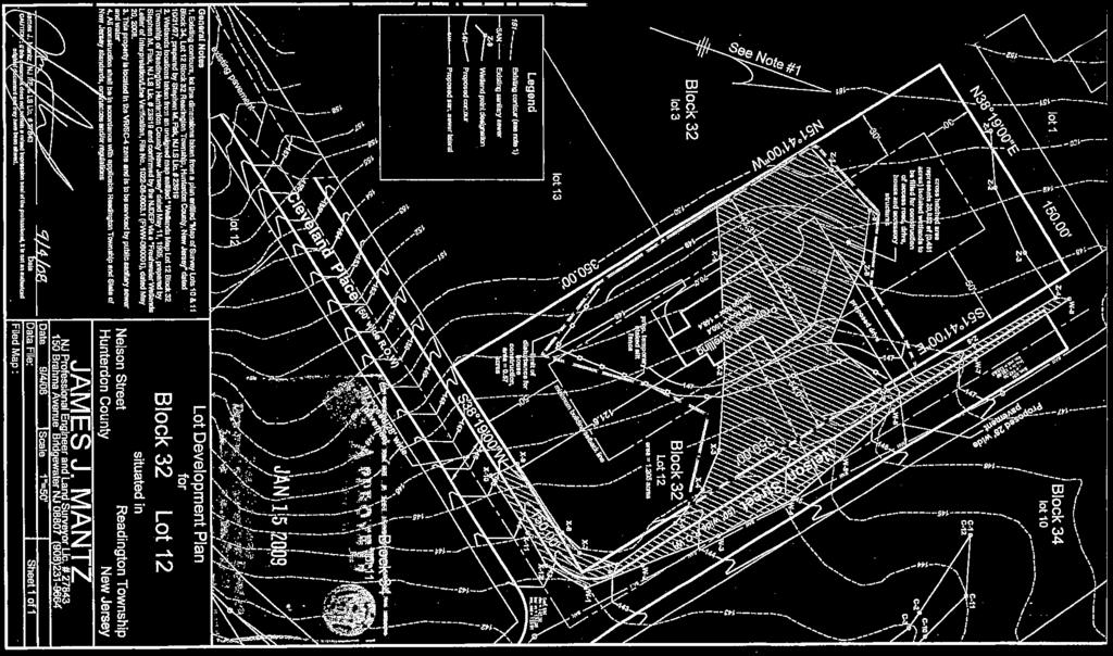
11 access to developed sections of the municipality and the presence of freshwater wetlands, which stand as a surrogate for restrictive soil and topographic conditions as set forth in detail below. Lack of Access The Study Area contains two unimproved streets: Nelson Street (50 ft. right-of-way) and Cleveland Place (50 ft. right-of-way). The unimproved Nelson Street right-of-way intersects with Main Street (CR 523) (see Photo 2), whereas, the unimproved Cleveland Place right-of-way intersects with Whitehouse Avenue (see Photo 3). The Study Area contains approximately 90-feet of fragmented frontage (a 50-foot wide strip and a 40-foot wide strip) along Main Street (see Photo 4) and 50-feet of frontage along Whitehouse Avenue. The bulk of the Study Area is landlocked behind existing residential uses; which, if developed, would necessitate the construction of the unimproved streets (see Photo 5). Soil Condition As previously indicated, the Study Area contains freshwater wetlands, wetland transition areas (see Photo 6), a section of the South Branch Rockaway Creek tributary (see Photo 7) and associated NJDEP-regulated riparian zone and flood hazard areas. The isolated wetlands with 50-foot transition areas are located on Block 32, Lot 12 and Block 34, Lot 10 within the Study Area. The South Branch Rockaway Creek tributary flows northeasterly along the eastern side of the Study Area and has a NJDEP regulated 150-foot riparian zone because the watercourse is classified as a trout maintenance waterway pursuant to the NJDEP Surface Water Quality Standards, NJAC 7:9B-1.15(g), and Nelson Street Tract: Preliminary Investigation of an Area in Need of Redevelopment Readington township, Hunterdon county, NJ Page 11


12 supports a trout population throughout the year. The presence of the NJDEP riparian zone limits access to Bergamot Way further isolating the Study Area from developed sections of the municipality. Waste Dumping Evidence of waste dumping is present throughout the Study Area. Waste is usually dumped on vacant lots, along right-of-ways, on public and private lands, and at other normally unattended locations (see Photos 8 and 9). Such activities are evidence of the remoteness and lack of access and are detrimental to public health, safety and welfare. Conditions not Conducive to Private Development The Township acquired the parcels within the Study Area at two different times. The Township acquired Block 34, Lot 8 on March 31, 2010 from Tadeusz Dabrowski. The remaining three (3) parcels were acquired on January 14, 2015 from Fallone at Readington (Fallone), LLC. Prior to the Township s acquisition, Fallone prepared or obtained the following (see Appendix C): NJDEP freshwater wetlands letter of interpretation/line verification, dated May 20, 2008 for block 32, lot 12 and block 34, lots 10 and 11; NJDEP freshwater wetlands general permit no. 6, dated January 15, 2009 for block 32, lot 12; NJDEP freshwater wetlands general permit no. 6, dated January 15, 2009 for block 34, lot 10; NJDEP flood hazard area verification, dated July 20, 2010 for block 34, lots 10 and 11 and block 35, lot 37; and Road Improvement Plan, prepared by James J. Mantz, PE & LS, dated November 7, The NJDEP freshwater wetlands general permit no. 6 permit plans, prepared for Fallone, identified two (2) proposed detached single-family units. The permit plans indicated the proposed units would be served by public water and sewer. While an existing sanitary sewer Nelson Street Tract: Preliminary Investigation of an Area in Need of Redevelopment Readington township, Hunterdon county, NJ Page 12
13 main exists within the Study Area; water main extensions are required to service the Study Area. Pursuant to a telephone conversation with Sharon Dragan, Esq., Township Solicitor, it is understood that it was too costly to for the private investor to develop the property due to the lack of access, and constraints presented by the freshwater wetlands and stream corridor, despite having sewer capacity and NJDEP permits in hand. Ultimately, the private developer did not proceed with the project; selling the land to the Township and perpetuating seven (7) acres of land to remain off the tax rolls. The aforementioned conditions within the Study Area have thwarted the ability to develop the Study Area solely through private efforts. As such, the Study Area meets the c criteria at N.J.S.A. 40A:12A-5(c). RECOMMENDATION This report and appendices constitutes the preparation of a preliminary investigation for determining an Area in Need of Redevelopment as directed by the Township Committee of Readington Township. It is the conclusion of this preliminary investigation that the Study Area qualifies under the criteria set forth at N.J.S.A. 40A:12A-1 et seq., to be designated as an Area in Need of Redevelopment. The Study Area satisfies criterion c since the land is owned by the municipality. The Study Area further satisfies criterion c due to: lack of access; soil conditions; and failure to develop under private ownership due to those conditions. SUBSEQUENT PROCEDURAL STEPS Public Hearing Upon receipt of this preliminary investigation, the Planning Board is required to hold a public hearing. Notices for the hearing are required to be published in the newspaper of record in the municipality once each week for two (2) consecutive weeks. A copy of the notice should be mailed to the last owner of record of each property within the proposed Redevelopment Area. Although the Township is the owner of the properties, the Planning Board is still required to satisfy the notice requirements. The newspaper notice should be published in the official paper. Nelson Street Tract: Preliminary Investigation of an Area in Need of Redevelopment Readington township, Hunterdon county, NJ Page 13
14 Planning Board Recommendation to Township Committee Once the hearing has been completed, the Planning Board makes a recommendation to the Township Committee that the delineated area, or any part of such an area, should or should not be determined to be an Area in Need of Redevelopment. The Township Committee may then adopt a resolution determining that the delineated area, or portion, is a Redevelopment Area. Notice of such determination is then sent to each objector who has sent in a written protest. Redevelopment Plan If so designated by the township, the next action would be the creation and adoption of a redevelopment plan for the Redevelopment Area. A Redevelopment Plan is adopted by ordinance by the Township Committee before any project is initiated. Depending on the nature of the Redevelopment Plan, it may contain some or all of the land use controls for a particular Redevelopment Area. Furthermore, a plan may be created in such a way as to provide for detailed recommendations regarding circulation, open space, housing urban design and architecture. At a minimum, pursuant to N.J.S.A. 40A:12A-7.a, a redevelopment plan is required to address a series of required elements. A Redevelopment Plan should be, either, substantially consistent with the municipal master plan or designed to effectuate the master plan. Redevelopment Plan: Required Elements (N.J.S.A. 40A:12A-7.a) The plan s relationship to definite local objectives as to appropriate land uses, density of population, and improved traffic and public transportation, public utilities, recreational and community facilities and other public improvements. Proposed land uses and building requirements in the project area. Adequate provision for the temporary and permanent relocation, as necessary, of residents in the project area, including an estimate of the extent to which decent, safe and sanitary dwelling units affordable to displaced residents will be available to them in the existing local housing market. An identification of any property within the redevelopment area which is proposed to be acquired in accordance with the redevelopment plan. The relationship of the plan to the master plans of contiguous municipalities, the master plan of the county in which the municipality is located, and the State Development and Redevelopment Plan. Pursuant to N.J.S.A. 40A:12A-7.c., the Redevelopment Plan must also describe its relationship to pertinent municipal development regulations as defined in the Municipal Land Use Law, N.J.S.A. 40:55D-1 et seq Nelson Street Tract: Preliminary Investigation of an Area in Need of Redevelopment Readington township, Hunterdon county, NJ Page 14
15 APPENDIX A RESOLUTION R Nelson Street Tract: Preliminary Investigation of an Area in Need of Redevelopment Readington township, Hunterdon county, NJ
16
17
18
19 APPENDIX B FIGURES Nelson Street Tract: Preliminary Investigation of an Area in Need of Redevelopment Readington township, Hunterdon county, NJ
20 ASHINGTON DR WILLOW CT Study Area Township Sewer Service Easement (20ft width) Block 34 Lot Acres MAIN ST (COUNTY ROUTE 523) Block 34 Lot Acres NELSON ST (50' UNIMPROVED) CLEVELAND PL (50' UNIMPROVED)!!!!!!!!!!!!!!!!!!!!!!!!!!!!!!!!!!!!!!!!!!!!!!!!!!!!!!!!!!!!!!!!!!!!!!!!!!!!!!!!!!!!!!!!!!!!!!!!!!!!!!!!!!!!!!!!!!!!!!!!!!!!!!!!!!!!!!!!!!!!!!!!!!!!!!!!!!!!!!!!!! Block 32 Lot Acres Block 34 Lot Acres WHITEHOUSE AVE!!!!!!!!!!!!!!!!!!!!!!!!!!!!!!!!!!!!!!!!!! BERGAMOT WAY Parcel Base Source: Parcels of Hunterdon County, New Jersey State Plane NAD83 Originator: Hunterdon County Division of GIS - Publication Date: 8/28/2014 Sewer Easement Source: Readington Tax Map Feet Clarke Caton Hintz Architecure Planning Landscape Archjtiecture Nelson Street Study Area Study Area LOCATION: Readington Township, Hunterdon County, NJ DATE: July 2016
21 Tewksbury Township!"#$ 78 Bedminster Township Lebanon Borough (/ Nelson Street Study Area Clinton Township Æ Æ 31 Branchburg Township Raritan Township (/ Æ 31 Æ 12 Æ 12 Flemington Borough (/ Æ Hillsborough Township 0 8,000Ft Clarke Caton Hintz Architecure Planning Landscape Archjtiecture Nelson Street Study Area Location of Study Area LOCATION: DATE: Readington Township, Hunterdon County, NJ July 2016


22
23 APPENDIX C NJDEP APPROVALS AND ROAD IMPROVEMENT PLAN Nelson Street Tract: Preliminary Investigation of an Area in Need of Redevelopment Readington township, Hunterdon county, NJ
24 ]ON S. CORZINE Governor ~ of Nm.t ~nsry DEPARTMENT OF ENVIRONMENTAL PROTECTION Division ol"lancl Use Rcgulution P.O. Box 439, Trenton, New Jersey FAX# (609) Web Silc: LISA P. JACKSON Cummissioner Mr. Edward Kuc Eastern States Environmental Associates RR3 Box 541 Kunkletown Road Kunkletown, PA HAY % RE: Freshwater Wetlands Letter of Interpretation/Line Verification File No.: (FWW ) Applicant: Fallone Properties, LLC Block: 32/34 Lot(s): 12/10 & 11 Readington Township; Hunterdon County Dear Mr. Kuc: This.letter is in response to your request for a Letter of Interpretation to verify the jurisdictional boundary of the freshwater wetlands and waters on the referenced property. In accordance with agreements between the State of New Jersey Department of Environmental Protection, the U.S. Anny Corps of Engineers Philadelphia and New York Districts, and the U.S. Environmental Protection Agency, the NJDEP, Division of Land Use Regulation is the lead agency for establishing the extent of State and Federally regulated wetlands and waters. The USEPA and/or USACOE retains the right to reevaluate and modify the jurisdictional determination at any time should the information prove to be incomplete or inaccurate. Based upon the information submitted, and upon a site inspection conducted on April 7, 2008, the Division of Land Use Regulation has determined that the wetlands and waters boundary line(s) as shown on the 3 plan maps entitled, "WETLANDS MAP, (one map for each) LOT 10 & 11, BLOCK 34, (and a map for) LOT 12, BLOCK 32, TOWNSHIP OF READINGTON, HUNTERDON COUNTY, NEW JERSEY", consisting of3 sheets, dated May 11, 1995, unrevised, and prepared by Stephen M. Fisk L.S., of Fisk Associates, is accurate as shown. Any activities regulated under the Freshwater Wetlands Protection Act proposed within the wetlands or transition areas or the deposition of any fill material into any water area, will require a permit from this office unless exempted under the Freshwater Wetlands Protection Act, N.J.S.A. 13:9B-1 et seq., and implementing rules, N.J.A.C. 7:7A. A copy of this plan, together with the information upon which this boundary determination is based, has been made part of the Department's public records. New Jersey ls An Equal Opportunity Employer Pri111ed on Recycled Paper and Recyclable

25 Freshwater Wetland Letter oflnteipretation Page 2 Pursuant to the Freshwater Wetlands Protection Act Rules (N.J.A.C. 7:7A-1 et seq., you are entitled to rely upon this jurisdictional determination for a period of five years from the date of this letter. The freshwater wetlands and waters boundary 1ine(s), as determined in this letter, must be shown on any future site development plans. The line(s) should be labeled with the above file number and the following note: "Freshwater Wetlands/Waters Boundary Line as verified by NJDEP." In addition, the Department has determined that the wetlands on the subject property-are of intermediate resource value. The transition area or buffer required adjacent to intermediate resource value wetlands is 50 feet. This classification may affect the requirements for an Individual Wetlands Permit (see N.J.A.C. 7:7A-7), the types of Statewide General Permits available for the wetlands portion of this property (see N.J.A.C. 7:7A-5) and the modification available through a transition area waiver (see N.J.A.C. 7:7A-6). Please refer to the Freshwater Wetlands Protection Act (N.J.S.A. l3:9b-l et seq.) and implementing rules for additional information. It should be noted that this determination of wetlands classification is based on the best information presently available to the Department. The classification is subject to change if this ill.formation is no longer accurate, or as additional information is made available to the Department, including, but not limited to, information supplied by the applicant. Under NJSA 13:9B-7a)(2), if the Department has classified a wetland as exceptional resource value, based on a finding that the wetland is documented habitat for threatened and endangered species that remains suitable for use for breeding, restirig or feeding by such species, an applicant may request a change in this classification. Such requests for a classification change must demonstrate that the habitat is no longer suitable for the documented species because there has been a change in the suitability of this habitat. Requests for resource value classification changes and associated documentation should be submitted to the Division of Land Use Regulation, P.O. Box 439, Trenton, New Jersey This letter in no way legalizes any fill, which may have been placed, or other regulated activities, which may have occurred on-site. Also this determination does not affect your responsibility to obtain any local, State, or Federal pennits which may be required. In accordance with N.J.A.C. 7:7A-l.7, any person who is aggrieved by this decision may request a hearing within 30 days after notice of the decision is published in the DEP Bulletin by writing to: New Jersey Department of Environmental Protection, Office of Legal Affairs, Attention: Adjudicatory Hearing Requests, 401 East State Street, P.O. Box 402, Trenton, NJ This request must include a completed copy of the Administrative Hearing Request Checklist. If a person submits the hearing request after this time, the Department shall deny the request. The DEP bulletin is available through the Department's website at I
26 Freshwater Wetland Letter of Interpretation Page3 Please contact Jill Neall of our staff at (609) should you have any questions regarding this letter. Be sure to indicate the file number in all communication. ~$12 Lou Cattuna Northern Delaware Regional Supervisor Bureau of Inland Regulation c: Readington Township Construction Official Applicant.,

27
28
29

30


31

32

33
34
35 CHRIS CHRISTIE Governor KIM GUADAGNO Lt. Governor ~tat.e of ~ 2fo ID.ers.eu DEPARTMENT OF ENVIRONMENTAL PROTECTION Division of Land Use Regulation P.O. Box439 Trenton.. New Jersey, BOB MARTIN Commissioner James J. Mantz, PE & LS 15 0 Brahma A venue Bridgewater, NJ, July 20, 2010 Re: Flood Hazard Area Verification Approval File No.: FHA Applicant: Fallone Properties Blocks: 34, 35; Lots: 10, 11, 37 Readington Township; Hunterdon County Dear Mr. Mantz: This letter is in response to your request for a verification of the flood hazard area and riparian zone limits for an unnamed tributary to the Rockaway Creek, on a parcel located on Nelson Street and Whitehouse Avenue, within Lot Nos. 10, 11, 37 of Block Nos. 34, 31, in Readington Township, Hunterdon County, New Jersey. This verification establishes that the unnamed tributary to the Rockaway Creek on site has a contributory drainage area greater than 50 acres and possesses a flood hazard area onsite as depicted on the approved plans described below. Additionally, the Department has determined that the riparian zone is 150 feet from the top of bank along both sides of the 9.rainage feature on site. The riparian zone has been determined to be 150 feet wide because the watercourse is trout maintenance and supports a trout population. It should be. noted that the flood hazard area delineation and riparian zone limits are based on the best information presently available to the Department. This verification is subject to change if this information is no longer acc~ate or if additional information is made available to the Department including, but not limited to, information supplied by the applicant. Furthennore, please note that any regulated activity, as defined in the Flood Hazard Area Control Act rules at N.J.A.C. 7:13-2.4, proposed within the riparian zone and flood hazard area requires a flood hazard area approval from the Department prior to construction. The drawings hereby approved are nine (9) sheets prepared by James J. Mantz, PE&LS, dated January 5, 2010, last revised June 22, 2010, unless otherwise noted and entitled: "AND BLOCK 31, LOT 37 AND BLOCK 34, LOTS IO & 11, SITUATED IN READINGTON TOWNSHIP, HUNTERDON CO., NEW JERSEY" "STREAM ENCROACHMENT PLAN" Sheet Nos. 1, 2, 3, of9, "STREAM CROSS SECTIONS" Sheet Nos. 4, 5, 6, 7, 8 of9, unrevised, New Jersey is an Equal Opportunity Employer Printed on Recycled Paper and Recyclable

36 . "DRAINAGE AREA PLAN" Sheet No. 9 of9, unrevised. Within 90 calendar days of the date of this letter, the applicant shall submit the following information to the clerk of each county in which the site is located, and shall send proof to the Department that this information is recorded on the deed of each lot referenced in the verification:. 1. The Department file number for the verification; 2. The approval and expiration dates of the verification; 3. A metes and bounds description of any flood hazard area limit and/or tloodway limit approved under the verification; 4. The flood hazard area design flood elevation, or range of elevations if variable, approved under the verification; and 5. The following statement: "The State of New Jersey has determined that all or a portion of this lot lies in a flood haz.ard area. Certain activities in flood hazard areas are regulated by the New Jersey Department of Environmental Protection and some activities may be prohibited on this site or may first require a permit. Contact the Division of Land Use Regulation at (609) for more information prior to any construction onsite." Failure to have this information recorded in the deed of each lot and/or to submit proof of recording to the Department constitutes a violation of the Flood Hazard Area Control Act rules and may result in suspension or termination of the verification and/or subject the applicant to enforcement action pursuant to N.J.A.C. 7: A copy of this plan, together with the information upon which this boundary determination is based, has been made part of the Division's public records. Please note that this letter in no way legalizes any fill that may have been previously placed onsite, or any other regulated activities that may have previously occurred. Also this determination does not affect the applicant's responsibility to obtain any local, State or Federal permits that may be required. This verification is valid for five years from its issuance date. A verification shall not be extended but it can be transferred at the time of sale of a property to which the verification applies to a new owner pursuant to N.J.A.C. 7: Pursuant to N.J.A.C. 7:13-6.l(f), ifthe Department issues a verification for a site, and within five years issues a general permit authorization or an individual permit. for a regulated activity that references or relies upon the verification at that site, the Department shall automatically reissue the verification upon approval of the permit or authorization so that the verification and permit or authorization have the same expiration date. This automatic reissuance shall occur only once per verification and there is no fee for this reissuance. The reissued verification shall reflect any alterations to the floc?d hazard area design flood elevation, flood hazard area limit and/or floodway limit that will result from the regulated activities authorized under the individual permit or general permit authorization. All. pre-construction and post-construction elevations and limits shall be demarcated on drawings approved under the reissued verification. In accordance with N.J.A.C. 7: , any person who is aggrieved by this decision may request a hearing within 30 calendar days after notice of this decision is published in the DEP Bulletin by writing to: New Jersey Department of Environmental Protection, Office of Legal Affairs, Attention: Adjudicatory Hearing Requests; 401 East State Street, P.O. Box 402, Trenton, NJ This request must include all items as outlined in N.J;A.C. 7: and include a copy of the attached Adjudicatory Hearing Request Checklist and Tracking Form. If a person submits the hearing request after this time, the Department shall deny the request. The DEP bulletin is available through the Department's website at
37 Please contact Marian Asante-Grable, of my staff at (609) or via at should you have any questions regarding this letter. Be sure to indicate the Division's file number in all communication. /?~b Vincent J. MB='Q!;zervis" North/Central Engineering Se c. Applicant Municipal Clerk Municipal Construction Official Municipal Engineer
2019 Township of Verona New Jersey. Determination of Area in Need of Redevelopment
 2019 Township of Verona New Jersey Property located at 1 Sunset Avenue, Verona, NJ 07044 Block 303 Lot 4 Determination of Area in Need of Redevelopment PREPARED FOR THE MAYOR & COUNCIL AND THE PLANNING
Oak Shade Road South Area
 Oak Shade Road South Area Area in Need of Redevelopment without Condemnation Investigation Study October 1, 2015 Township of Shamong, New Jersey Joint Land Use Board Members Kenneth Long Kathleen Wigley
2019 Township of Verona New Jersey. Determination of Area in Need of Redevelopment
 2019 Township of Verona New Jersey For Property located at Block 2301 Lots 1 through 19 Township of Verona Determination of Area in Need of Redevelopment PREPARED FOR THE MAYOR & COUNCIL AND THE PLANNING
FRESHWATER WETLANDS LETTER OF INTERPRETATION (LOI) APPLICATION CHECKLIST AND FEE TABLE (Updated March 2016)
 APPLICATION CHECKLIST AND FEE TABLE (Updated March 2016)") State of New Jersey Department of Environmental Protection Land Use Regulation Program Mail Code 501-02A PO Box 420 Trenton, NJ 08625-0420 Fax# (609)-777-3656 www.nj.gov/dep/landuse/ FRESHWATER WETLANDS
State of New Jersey Department of Environmental Protection Land Use Regulation Program Mail Code 501-02A PO Box 420 Trenton, NJ 08625-0420 Fax# (609)-777-3656 www.nj.gov/dep/landuse/ FRESHWATER WETLANDS
Nelson Street Redevelopment Plan
 Nelson Street Redevelopment Plan MARCH 20, 2017 Readington Township, Hunterdon County, New Jersey Clarke Caton Hintz 1 0 0 b a r r a c k s t r e e t T r e n t o n, N J 0 8 6 0 8 Readington Township, Hunterdon
AREA IN NEED OF REDEVELOPMENT INVESTIGATION FOR BLOCK 10, LOT 10 AND BLOCK 12, LOT 1 IN THE TOWNSHIP OF CRANBURY, NJ
 AREA IN NEED OF REDEVELOPMENT INVESTIGATION FOR BLOCK 10, LOT 10 AND BLOCK 12, LOT 1 IN THE TOWNSHIP OF CRANBURY, NJ PREPARED FOR THE TOWNSHIP OF CRANBURY BY PHILLIPS PREISS GRYGIEL LLC JULY 2015 Area
ALREADY SUBMITTED FOR HIGHLANDS COUNCIL PRE
 Highlands Preservation Area Approval Application Checklist Items Block 15901 Lot 1, West Milford See Highlands Council Review at: http://www.highlands.state.nj.us/njhighlands/projectreview/ **For advisory
FINAL APPLICATION. N.J.A.C. 7: (Minor disposals or diversions of parkland)
") FINAL APPLICATION N.J.A.C. 7:36-26.6 (Minor disposals or diversions of parkland) PRIOR TO SUBMITTING THE FINAL APPLICATION: The pre-application must be reviewed by the and the applicant must be given permission
FINAL APPLICATION N.J.A.C. 7:36-26.6 (Minor disposals or diversions of parkland) PRIOR TO SUBMITTING THE FINAL APPLICATION: The pre-application must be reviewed by the and the applicant must be given permission
P.L. 2003, CHAPTER 125, approved July 9, 2003 Senate, No (Fourth Reprint)
") P.L. 00, CHAPTER, approved July, 00 Senate, No. 0 (Fourth Reprint), - C.0A:A-. & 0A:A-., - C.0A:0- & 0A:0- - Note 0 0 0 AN ACT concerning long-term property tax exemptions, amending R.S.:-, and amending
P.L. 00, CHAPTER, approved July, 00 Senate, No. 0 (Fourth Reprint), - C.0A:A-. & 0A:A-., - C.0A:0- & 0A:0- - Note 0 0 0 AN ACT concerning long-term property tax exemptions, amending R.S.:-, and amending
Redevelopment Study & Preliminary Investigation Report
 Redevelopment Study & Preliminary Investigation Report Township of Harmony Warren County, New Jersey September 16, 2009 Prepared by: 11 Tindall Road Middletown, NJ 07748 THE ORIGINAL OF THIS DOCUMENT HAS
State, County, or Municipal Agency or instrumentality thereof, applying for authorization
 Application for Project Authorization Under the New Jersey Register of Historic Places Act NJ Department of Environmental Protection Natural & Historic Resources Historic Preservation Office Date September
AN ORDINANCE AMENDING AND SUPPLEMENTING THE REVISED GENERAL ORDINANCES OF THE CITY OF BAYONNE THE, CHAPTER 33 PLANNING AND DEVELOPMENT REGULATIONS
 AN ORDINANCE AMENDING AND SUPPLEMENTING THE REVISED GENERAL ORDINANCES OF THE CITY OF BAYONNE THE, CHAPTER 33 PLANNING AND DEVELOPMENT REGULATIONS WHEREAS, pursuant to N.J.S.A. 40:48-2, the Legislature
Hennepin County Department of. Housing, Community Works and Transit. Transit Oriented Development (TOD) Guidelines
 Guidelines") Hennepin County Department of Housing, Community Works and Transit 2007 Transit Oriented Development (TOD) Guidelines Hennepin County Transit Oriented Development (TOD) Bond Funds Hennepin County Housing,
Hennepin County Department of Housing, Community Works and Transit 2007 Transit Oriented Development (TOD) Guidelines Hennepin County Transit Oriented Development (TOD) Bond Funds Hennepin County Housing,
BRISTOL CONSERVATION COMMISSION INLAND WETLANDS AGENCY FORM IW-1 (Application for a Wetlands Permit)
") APPLICATION NO. BRISTOL CONSERVATION COMMISSION INLAND WETLANDS AGENCY FORM IW-1 (Application for a Wetlands Permit) DATE FILED: APPROVED: DENIED: 1. APPLICANT: Name: Signature: Address: City: State: Zip
APPLICATION NO. BRISTOL CONSERVATION COMMISSION INLAND WETLANDS AGENCY FORM IW-1 (Application for a Wetlands Permit) DATE FILED: APPROVED: DENIED: 1. APPLICANT: Name: Signature: Address: City: State: Zip
Cape May Court House, NJ April 2, 2018 REGULAR MEETING FLAG SALUTE THIS MEETING IS BEING RECORDED:
 Cape May Court House, NJ April 2, 2018 REGULAR MEETING FLAG SALUTE THIS MEETING IS BEING RECORDED: I hereby declare that notice has been given to the Herald Times, the Atlantic City Press and posted on
TOWNSHIP OF MENDHAM Ord. No
 ORDINANCE SUPPLEMENTING THE LAND USE ORDINANCE OF THE TOWNSHIP OF MENDHAM BY A NEW CHAPTER XXIVA ESTABLISHING THE REQUIREMENT OF AN ENVIRONMENTAL PERMIT AND AMENDING AND SUPPLEMENTING SAID ORDINANCE WITH
TRANSFERABLE DEVELOPMENT RIGHTS PROCESS GUIDE
 TRANSFERABLE DEVELOPMENT RIGHTS PROCESS GUIDE Clear Creek County Planning Department P.O. Box 2000 Georgetown, Colorado 80444 (303) 679-2436 - phone (303) 569-1103 - fax 1 PURPOSE: A Transfer of Development
The purpose of this Chapter is to establish rules, regulations, standards and procedures for approval of subdivisions of land to promote and ensure:
 CHAPTER 7 SUBDIVISION SECTION 7.1 PURPOSE The purpose of this Chapter is to establish rules, regulations, standards and procedures for approval of subdivisions of land to promote and ensure: A. Conformity
FRESHWATER WETLANDS PROTECTION IN NEW JERSEY Tools for Municipal Action
 FRESHWATER WETLANDS PROTECTION IN NEW JERSEY Tools for Municipal Action The Freshwater Wetlands Protection Act INTENT OF FRESHWATER WETLANDS LAW The New Jersey legislature passed the Freshwater Wetlands
IN RE CLINTON TOWNSHIP, ) NEW JERSEY COUNCIL HUNTERDON COUNTY ) ON AFFORDABLE HOUSING
 NEW JERSEY COUNCIL HUNTERDON COUNTY ) ON AFFORDABLE HOUSING") IN RE CLINTON TOWNSHIP, ) NEW JERSEY COUNCIL HUNTERDON COUNTY ) ON AFFORDABLE HOUSING ) ) OPINION This matter arises as a result of an Order to Show Cause issued by the New Jersey Council on Affordable
IN RE CLINTON TOWNSHIP, ) NEW JERSEY COUNCIL HUNTERDON COUNTY ) ON AFFORDABLE HOUSING ) ) OPINION This matter arises as a result of an Order to Show Cause issued by the New Jersey Council on Affordable
FINAL DRAFT CONSISTENCY REVIEW AND RECOMMENDATIONS REPORT
 CHRIS CHRISTIE Governor KIM GUADAGNO Lt. Governor State of New Jersey Highlands Water Protection and Planning Council 100 North Road (Route 513) Chester, New Jersey 07930-2322 (908) 879-6737 (908) 879-4205
Chapter 100 Planned Unit Development in Corvallis Urban Fringe
 100.100 Scope and Purpose. Chapter 100 Planned Unit Development in Corvallis Urban Fringe (1) All applications for land divisions in the Urban Residential (UR) and Flood Plain Agriculture (FPA) zones within
H 7291 S T A T E O F R H O D E I S L A N D
 LC000 01 -- H 1 S T A T E O F R H O D E I S L A N D IN GENERAL ASSEMBLY JANUARY SESSION, A.D. 01 A N A C T RELATING TO TOWNS AND CITIES -- REDEVELOPMENT AGENCIES AND PROJECTS Introduced By: Representatives
Sherman Tract Rehabilitation Investigation Report
 Hillsborough Township Somerset County, NJ Sherman Tract Report May 21, 2018 Prepared by: David K. Maski, PP, AICP, Director Planning & Zoning Department Peter J. Biondi Municipal Building 379 South Branch
Scattered Sites Redevelopment Plan
 Scattered Sites Redevelopment Plan Township of Woodbridge Middlesex County, New Jersey Prepared by: Township of Woodbridge Department of Planning & Development January 2017 Amended September 2018 ENDORSED
PLANNED UNIT DEVELOPMENT (PUD) AREA PLAN/REZONING REVIEW PROCEDURE
 AREA PLAN/REZONING REVIEW PROCEDURE") PLANNED UNIT DEVELOPMENT (PUD) AREA PLAN/REZONING REVIEW PROCEDURE Professional inquiries will be made to our Township Planning Consultant, Township Engineer, and Township Attorney to get their opinions
PLANNED UNIT DEVELOPMENT (PUD) AREA PLAN/REZONING REVIEW PROCEDURE Professional inquiries will be made to our Township Planning Consultant, Township Engineer, and Township Attorney to get their opinions
ARTICLE 15 - PLANNED UNIT DEVELOPMENT
 Section 15.1 - Intent. ARTICLE 15 - PLANNED UNIT DEVELOPMENT A PUD, or Planned Unit Development, is not a District per se, but rather a set of standards that may be applied to a development type. The Planned
Flood Hazard Area Control Act Rules
 An Overview of New Jersey s Flood Hazard Area Control Act Rules State of New Jersey Department of Environmental Protection Chingwah Liang Why Regulate NJ s Floodplains? 1. New Jersey endures enormous
Chapter 136. SOIL EROSION
 1 of 8 12/19/2011 4:17 PM Township of Andover, NJ Monday, December 19, 2011 Chapter 136. SOIL EROSION [HISTORY: Adopted by the Township Committee of the Township of Andover by Ord. No. 77-11 (Ch. XVII
SENATE, No STATE OF NEW JERSEY. 217th LEGISLATURE INTRODUCED SEPTEMBER 8, 2016
 SENATE, No. 0 STATE OF NEW JERSEY th LEGISLATURE INTRODUCED SEPTEMBER, 0 Sponsored by: Senator BOB SMITH District (Middlesex and Somerset) Senator CHRISTOPHER "KIP" BATEMAN District (Hunterdon, Mercer,
BOROUGH OF CALIFON Hunterdon County, New Jersey
 BRUGH F CALIFN HIGHLANDS MDULE 3 - PART I DCUMENT FR SUBMISSIN T THE NEW JERSEY HIGHLANDS CUNCIL FR BASIC PLAN CNFRMANCE December 8, 2009 Submitted for Review to the Califon Planning Board/Zoning Board
Residential Major Subdivision Review Checklist
 Residential Major Subdivision Review Checklist Plan Submittal Requirements: 2 full sets of stamped plans Electric submittal - all plans contained in a single PDF 3 full sets if commercial kitchen or dining
MINOR SUBDIVISION FINAL PLAT APPLICATION Town of Apex, North Carolina
 MINOR SUBDIVISION FINAL PLAT APPLICATION Town of Apex, North Carolina This document is a public record under the North Carolina Public Records Act and may be published on the Town s website or disclosed
AREA IN NEED OF REDEVELOPMENT STUDY
 CONDEMNATION AREA IN NEED OF REDEVELOPMENT STUDY WESTBOUND ROUTE 46 STUDY AREA BLOCK 162 LOTS 2 THRU 7 Montville, New Jersey September 24, 2015 Prepared by: Burgis Associates, Inc. Contents I. Introduction...
TOWNSHIP OF EGG HARBOR ZONING BOARD ADJUSTMENT CHECK LIST
 TOWNSHIP OF EGG HARBOR ZONING BOARD ADJUSTMENT CHECK LIST Schedule A - General Requirements 1. Where the application involves only a variance one (1) original and nineteen (19) copies of the appropriate
PLANNED UNIT DEVELOPMENTS (Ordinance No.: 3036, 12/3/07; Repealed & Replaced by Ordinance No.: 4166, 10/15/12)
") 159.62 PLANNED UNIT DEVELOPMENTS (Ordinance No.: 3036, 12/3/07; Repealed & Replaced by Ordinance No.: 4166, 10/15/12) A. PURPOSE 1. General. The Planned Unit Development (PUD) approach provides the flexibility
159.62 PLANNED UNIT DEVELOPMENTS (Ordinance No.: 3036, 12/3/07; Repealed & Replaced by Ordinance No.: 4166, 10/15/12) A. PURPOSE 1. General. The Planned Unit Development (PUD) approach provides the flexibility
CONDOMINIUM REGULATIONS
 ARTICLE 37 CONDOMINIUM REGULATIONS SECTION 37.01. Purpose The purpose of this Article is to regulate projects that divide real property under a contractual arrangement known as a condominium. New and conversion
SUBDIVISION REGULATIONS
 CHAPTER 14 SUBDIVISION REGULATIONS 14-100 Provisions 14-200 Preliminary Plat 14-300 Final Plat 14-400 Replat 14-500 Minor Subdivision 14-600 Administrative Replat 14-700 Vacation of Roadways, Public Easements,
Eleven Tindall Road Middletown, New Jersey 07748
 MASTER PLAN REVISION TO THE HOUSING PLAN ELEMENT AND FAIR SHARE PLAN AMENDMENT MANALAPAN TOWNSHIP MONMOUTH COUNTY, NEW JERSEY NOVEMBER 24, 2008 REVISED APRIL 9, 2010 PREPARED FOR: MANALAPAN TOWNSHIP PLANNING
UPPER MOUNT BETHEL TOWNSHIP NORTHAMPTON COUNTY, PENNSYLVANIA
 UPPER MOUNT BETHEL TOWNSHIP NORTHAMPTON COUNTY, PENNSYLVANIA JOINDER DEED / LOT CONSOLIDATION TOWNSHIP REVIEW PROCESS When accepting proposed Joinder Deeds / Lot Consolidations, review the Joinder Deed
TOWNSHIP OF WHITE PLANNING BOARD COUNTY OF WARREN, STATE OF NEW JERSEY
 Application # 757 Resolution Approved: 4/12/11 TOWNSHIP OF WHITE PLANNING BOARD COUNTY OF WARREN, STATE OF NEW JERSEY RESOLUTION GRANTING PRELIMINARY AND FINAL MAJOR SITE PLAN APPROVAL TO PPL RENEWABLE
(c) County board of commissioners means 1 of the following, as applicable: (ii) In all other counties, 1 of the following:
 County board of commissioners means 1 of the following, as applicable: (ii) In all other counties, 1 of the following:") TOWNSHIP PLANNING Act 168 of 1959, as amended, (including 2001 amendments, 2006 amendments) AN ACT to provide for township planning; for the creation, organization, powers and duties of township planning
TOWNSHIP PLANNING Act 168 of 1959, as amended, (including 2001 amendments, 2006 amendments) AN ACT to provide for township planning; for the creation, organization, powers and duties of township planning
GRANT OF CONSERVATION RESTRICTION (Wetland Mitigation/Riparian Zone Mitigation) WITNESSETH:
 WITNESSETH:") NJDEP File No.: Prepared by: GRANT OF CONSERVATION RESTRICTION (Wetland Mitigation/Riparian Zone Mitigation) THIS GRANT OF CONSERVATION RESTRICTION is made this day of 20, by, its heirs, successors and
NJDEP File No.: Prepared by: GRANT OF CONSERVATION RESTRICTION (Wetland Mitigation/Riparian Zone Mitigation) THIS GRANT OF CONSERVATION RESTRICTION is made this day of 20, by, its heirs, successors and
STATE OF NEW JERSEY NEW JERSEY LAW REVISION COMMISSION. Final Report. Relating to. Uniform Environmental Covenants Act. July 2009
 STATE OF NEW JERSEY NEW JERSEY LAW REVISION COMMISSION Final Report Relating to Uniform Environmental Covenants Act July 2009 John M. Cannel, Esq., Executive Director NEW JERSEY LAW REVISION COMMISSION
ORDINANCE NO OA
 ORDINANCE NO. 2013 11-OA AN ORDINANCE OF THE TOWNSHIP OF BERKELEY, COUNTY OF OCEAN, STATE OF NEW JERSEY, AMENDING THE TOWNSHIP CODE OF THE TOWNSHIP OF BERKELEY, SO AS TO CREATE ARTICLE XX, ENTITLED VOLUNTARY
Residential Project Convenience Facilities
 Standards for Specific Land Uses 35.42.220 E. Findings. The review authority shall approve a Land Use Permit in compliance with Subsection 35.82.110.E (Findings required for approval) or a Conditional
MIDWAY CITY Municipal Code
 MIDWAY CITY Municipal Code TITLE 9 ANNEXATION CHAPTER 9.01 PURPOSE CHAPTER 9.02 GENERAL REQUIREMENTS CHAPTER 9.03 PROPERTY OWNER INITIATION OF ANNEXATION CHAPTER 9.04 PROCEDURES FOR CONSIDERATION OF PETITION
I. Requirements for All Applications. C D W
 108-16.1. Application checklists. Checklist for Required Submissions to the Planning Board or Zoning Board of Adjustment of Monroe Township All required submissions are to be made to the Administrative
SUBDIVISION APPLICATION: RECOMBINATION PLAT or EXEMPT PLAT
 SUBDIVISION APPLICATION: RECOMBINATION PLAT or EXEMPT PLAT Pursuant to Article 7, Section 155.706 of the Unified Development Code, an owner of land within the jurisdiction of the Town (or a duly authorized
MAJOR SUBDIVISION PRELIMINARY PLAT CHECKLIST
 TOWNSHIP OF EGG HARBOR PLANNING BOARD/ZONING BOARD OF ADJUSTMENT 3515 BARGAINTOWN ROAD EGG HARBOR TOWNSHIP, NJ 08234 MAJOR SUBDIVISION PRELIMINARY PLAT CHECKLIST The following checklist is designed to
SUBDIVISION REGULATIONS OF THE CITY OF DERBY, KANSAS
 SUBDIVISION REGULATIONS OF THE CITY OF DERBY, KANSAS ARTICLE 1. TITLE, PURPOSE, AUTHORITY, JURISDICTION, APPLICABILITY AND EXEMPTIONS 100 TITLE. These regulations shall be known and may be cited as the
MASTER SUBDIVISION FINAL PLAT APPLICATION Town of Apex, North Carolina
 MASTER SUBDIVISION FINAL PLAT APPLICATION Town of Apex, North Carolina This document is a public record under the North Carolina Public Records Act and may be published to the Town s website or disclosed
MAJOR RESIDENTIAL AND NONRESIDENTIAL SUBDIVISIONS
 Lawrence-Douglas County MAJOR RESIDENTIAL AND NONRESIDENTIAL SUBDIVISIONS Preliminary Plats The applicant shall schedule a Pre-Application meeting with Planning Staff at least seven (7) working days prior
Town of Bristol Rhode Island
 Town of Bristol Rhode Island Subdivision & Development Review Regulations Adopted by the Planning Board September 27, 1995 (March 2017) Formatted: Highlight Formatted: Font: 12 pt Table of Contents TABLE
BOARD OF COUNTY COMMISSIONERS ARCHULETA COUNTY, COLORADO RESOLUTION 2018-
 BOARD OF COUNTY COMMISSIONERS ARCHULETA COUNTY, COLORADO RESOLUTION 2018- ARCHULETA COUNTY IMPROPERLY DIVIDED PARCELS EXEMPTION INTERIM RESOLUTION - A RESOLUTION ADDRESSING PARCELS UNDER THE SIZE OF 35
Lake County Planning, Building and Development Department
 SUBMISSION CHECKLIST FOR SUBDIVISION FINAL PLAT Lake County Planning, Building and Development Department 500 W. Winchester Rd. Unit 101 Libertyville, Illinois 60048-1331 Telephone (847) 377-2600 E-mail:
Solar Act Subsection t. Application Form
 Application Form: Requirements, Instructions, Terms and Conditions The following application is intended only for entities associated with the development of solar electric power generation facilities
DRAFT NJ Highlands Module 3: Housing Plan
 Architecture Planning Landscape Architecture DRAFT Township of Clinton, Hunterdon County Station Place 400 Sullivan Way Trenton NJ 08628 clarkecatonhintz.com Tel: 609 883 8383 Fax: 609 883 4044 November
ASSEMBLY, No. 326 STATE OF NEW JERSEY. 217th LEGISLATURE PRE-FILED FOR INTRODUCTION IN THE 2016 SESSION
 ASSEMBLY, No. STATE OF NEW JERSEY th LEGISLATURE PRE-FILED FOR INTRODUCTION IN THE 0 SESSION Sponsored by: Assemblyman TROY SINGLETON District (Burlington) SYNOPSIS Requires municipalities to share certain
FINAL SITE PLAN PLAT APPLICATION Town of Apex, North Carolina
 FINAL SITE PLAN PLAT APPLICATION Town of Apex, North Carolina This document is a public record under the North Carolina Public Records Act and may be published on the Town s website or disclosed to third
MINUTES 7:30 PM. Block 40, Lots 8 & 8.04 Minor Subdivision Tumble Falls Road Completeness Determination
 MINUTES 7:30 PM PRESENT: R. Dodds ABSENT: P. Lubitz D. Haywood L. Riggio J. Mathieu M. Syrnick S. McNicol L. Voronin, Alt #1 J. Strasser C. Ely, Alt #2 CALL TO ORDER The meeting was called to order by
PLANNED UNIT DEVELOPMENT (PUD)
") SECTION 38.01. ARTICLE 38 PLANNED UNIT DEVELOPMENT (PUD) Purpose The purpose of this Article is to implement the provisions of the Michigan Zoning Enabling Act, Public Act 110 of 2006, as amended, authorizing
SECTION 38.01. ARTICLE 38 PLANNED UNIT DEVELOPMENT (PUD) Purpose The purpose of this Article is to implement the provisions of the Michigan Zoning Enabling Act, Public Act 110 of 2006, as amended, authorizing
City of Hoboken Planning Board. Michael Sullivan, ASLA, AICP Elizabeth McManus, PP, AICP, LEED AP
 Clarke Caton Hintz Architecture Planning Landscape Architecture To: From: City of Hoboken Planning Board Michael Sullivan, ASLA, AICP Elizabeth McManus, PP, AICP, LEED AP MEMORANDUM Re: Revisions to the
Residential Minor Subdivision Review Checklist
 Residential Minor Subdivision Review Checklist Plan Submittal Requirements: 2 full sets of stamped plans Electric submittal - all plans contained in a single PDF 3 full sets if commercial kitchen or dining
Staff Report: Date: Applicant: Property Identification: Acreage of Request: Current Zoning of Requested Area: Requested Action: Attached:
 Staff Report: Completed by Jeff Palmer Director of Planning & Zoning Date: November 7, 2018, Updated November 20, 2018 Applicant: Greg Smith, Oberer Land Developer agent for Ronald Montgomery ET AL Property
BY BOARD OF COUNTY COMMISSIONERS AN ACT TO BE ENTITLED
 BY BOARD OF COUNTY COMMISSIONERS ORDINANCE NO. AN ACT TO BE ENTITLED AN ORDINANCE AMENDING THE PASCO COUNTY LAND DEVELOPMENT CODE, ARTICLE 700, BY REPEALING EXISTING SECTION 702, ENVIRONMENTALLY SENSITIVE
WARMINSTER TOWNSHIP SUBDIVISION AND LAND DEVELOPMENT APPLICATION
 Project Name WARMINSTER TOWNSHIP SUBDIVISION AND LAND DEVELOPMENT APPLICATION W.T.P.C. File No. Date of Application: Fee Paid: Escrow Paid: Application for: Sketch Review Lot Line Change Preliminary Review
IN RE TOWN OF ) SECAUCUS/XCHANGE AT ) SECAUCUS JUNCTION ) OPINION INCLUSIONARY DEVELOPMENT ) DOCKET # /
 SECAUCUS/XCHANGE AT ) SECAUCUS JUNCTION ) OPINION INCLUSIONARY DEVELOPMENT ) DOCKET # /") IN RE TOWN OF ) SECAUCUS/XCHANGE AT ) SECAUCUS JUNCTION ) OPINION INCLUSIONARY DEVELOPMENT ) DOCKET #09-2156/09-2104 This matter comes before the Council on Affordable Housing (COAH or Council) upon the
IN RE TOWN OF ) SECAUCUS/XCHANGE AT ) SECAUCUS JUNCTION ) OPINION INCLUSIONARY DEVELOPMENT ) DOCKET #09-2156/09-2104 This matter comes before the Council on Affordable Housing (COAH or Council) upon the
WHARTON BOROUGH MORRIS COUNTY, NEW JERSEY
 WHARTON BOROUGH MORRIS COUNTY, NEW JERSEY AREA IN NEED OF REDEVELOPMENT STUDY For Block 1317, Lots 1-23 May 22, 2018 145 Spring Street, Suite E, Newton, NJ 07860 Acknowledgements: PLANNING BOARD Ken Loury,
ASSEMBLY COMMITTEE SUBSTITUTE FOR. ASSEMBLY, Nos. 326 and 1475 STATE OF NEW JERSEY. 217th LEGISLATURE ADOPTED MARCH 7, 2016
 ASSEMBLY COMMITTEE SUBSTITUTE FOR ASSEMBLY, Nos. and STATE OF NEW JERSEY th LEGISLATURE ADOPTED MARCH, 0 Sponsored by: Assemblyman TROY SINGLETON District (Burlington) Assemblyman MICHAEL PATRICK CARROLL
HIGHLANDS TRANSFER OF DEVELOPMENT RIGHTS PROGRAM DEED OF EASEMENT (For Non-Agricultural Property with Bonus Highlands Development Credit Allocation)
") SAMPLE DRAFT EASEMENT PREPARED BY Signature Typed or Printed Name HIGHLANDS TRANSFER OF DEVELOPMENT RIGHTS PROGRAM DEED OF EASEMENT (For Non-Agricultural Property with Bonus Highlands Development Credit
SAMPLE DRAFT EASEMENT PREPARED BY Signature Typed or Printed Name HIGHLANDS TRANSFER OF DEVELOPMENT RIGHTS PROGRAM DEED OF EASEMENT (For Non-Agricultural Property with Bonus Highlands Development Credit
Staff Report: Date: Applicant: Property Identification: Acreage of Request: Current Zoning of Requested Area: Requested Action: Attached:
 Staff Report: Completed by Jeff Palmer Director of Planning & Zoning Date: November 7, 2018 Applicant: Greg Smith, Oberer Land Developer agent for Ronald Montgomery ET AL Property Identification: Frontage
E L M E R B O R O U G H L A N D U S E B O A R D APPLICATION COVER SHEET (to be completed for all applications and appeals)
") E L M E R B O R O U G H L A N D U S E B O A R D APPLICATION COVER SHEET (to be completed for all applications and appeals) 1. Name(s): 2. Address: 3. Telephone Number(s): 4. E-mail: 5. Owner Name(s) (if
E L M E R B O R O U G H L A N D U S E B O A R D APPLICATION COVER SHEET (to be completed for all applications and appeals) 1. Name(s): 2. Address: 3. Telephone Number(s): 4. E-mail: 5. Owner Name(s) (if
City of Sanibel. Planning Department STAFF REPORT
 City of Sanibel Planning Department STAFF REPORT Planning Commission Meeting: July 23, 2013 Planning Commission Agenda Item: No 7b. Application Number: 13-7438DP Applicant Name: Attorney Beverly Grady
201 General Provisions
 201 General Provisions 201.01 Title 201.09 Amendments 201.02 Purpose and Intent 201.10 Public Purpose 201.03 Authority 201.11 Variances and Appeals 201.04 Jurisdiction 201.12 Nonconformances 201.05 Enactment
City of East Orange. Department of Policy, Planning and Development LAND USE APPLICATION & SITE PLAN REVIEW CHECKLIST
 Department of Policy, Planning and Development LAND USE APPLICATION & SITE PLAN REVIEW CHECKLIST COMPLETE: Applicant Information: Type of Proposal: OFFICE USE ONLY: New Residential Case #: Date: New Accessory
ARTICLE III GENERAL PROCEDURES, MINOR PLANS AND FEE SCHEDULES
 ARTICLE III GENERAL PROCEDURES, MINOR PLANS AND FEE SCHEDULES 301. Prior to Submission a. Copies of this Ordinance shall be available on request, at cost, for the use of any person who desires information
ADUs and You! Common types of ADUs include mother-in-law suite, garage apartments and finished basements.
 ADUs and You! Accessory Dwelling Units Town of Lyons Accessory Dwelling Units (ADUs) are a form of housing that can be an important tool for diversifying and increasing the local housing stock. Lyons lost
ORDINANCE NO. 875 (AS AMENDED THROUGH 875
 ORDINANCE NO. 875 (AS AMENDED THROUGH 875.1) AN ORDINANCE OF THE COUNTY OF RIVERSIDE TO ESTABLISH A LOCAL DEVELOPMENT MITIGATION FEE FOR FUNDING THE PRESERVATION OF NATURAL ECOSYSTEMS IN ACCORDANCE WITH
RICHFIELD WAY REDEVELOPMENT PLAN
 VILLAGE OF MENOMONEE FALLS, WISCONSIN RICHFIELD WAY REDEVELOPMENT PLAN Prepared by: Village of Menomonee Falls, Wisconsin Community Development Authority Approved by the Community Development Authority
AREA IN NEED OF REDEVELOPMENT INVESTIGATION FOR THE CHENEY/HAGERTY/KUSHNER SITE CRANBURY, NJ
 AREA IN NEED OF REDEVELOPMENT INVESTIGATION FOR THE CHENEY/HAGERTY/KUSHNER SITE CRANBURY, NJ Prepared by PHILLIPS PREISS GRYGIEL LLC Planning & Real Estate Consultants in conjunction with Hoder Associates,
CHAPTER Committee Substitute for Committee Substitute for Senate Bill No. 2188
 CHAPTER 2004-372 Committee Substitute for Committee Substitute for Senate Bill No. 2188 An act relating to land development; amending s. 197.502, F.S.; providing for the issuance of an escheatment tax
WHEREAS, the duly elected governing authority of the City of Hapeville, WHEREAS, the existence of real property, which is maintained in a blighted
 1 2 3 4 5 6 7 8 9 10 11 12 13 14 15 16 17 18 19 20 21 22 23 24 25 26 27 28 29 30 STATE OF GEORGIA CITY OF HAPEVILLE ORDINANCE NO. AN ORDINANCE TO AMEND THE CODE OF ORDINANCES OF THE CITY OF HAPEVILLE,
PUBLIC NOTICE TO HUNTERDON COUNTY VOTERS NOTICE OF GENERAL ELECTION
 PUBLIC NOTICE TO HUNTERDON COUNTY VOTERS NOTICE OF GENERAL ELECTION A General Election will be held on November 4, 2008 between the hours of 6:00AM and 8:00PM. The several State, County and local positions
Franklin Township Somerset County, New Jersey
 Franklin Township Somerset County, New Jersey DEPARTMENT OF PLANNING AND ZONING Planning Zoning Affordable Housing Planning Board Zoning Board of Adjustment July 24, 2012 Sean Thompson, Acting Executive
APPLICATION REVIEW CHECKLISTS
 APPLICATION REVIEW CHECKLISTS The following must be submitted with and are part of each application. No application is complete until all required documentation has been submitted to the Community Development
Township of Little Egg Harbor Planning Board 665 Radio Road Little Egg Harbor, New Jersey Phone: ext. 221 Fax:
 BLOCK(S) LOT(S) Township of Little Egg Harbor Planning Board 665 Radio Road Little Egg Harbor, New Jersey 08087 Phone: 609-296-7241 ext. 221 Fax: 609-294-3040 Development Application Amended Development
ARTICLE 14 PLANNED UNIT DEVELOPMENT (PUD) DISTRICT
 DISTRICT") ARTICLE 14 PLANNED UNIT DEVELOPMENT (PUD) DISTRICT Section 14.01 Intent. It is the intent of this Article to allow the use of the planned unit development (PUD) process, as authorized by the Michigan Zoning
ARTICLE 14 PLANNED UNIT DEVELOPMENT (PUD) DISTRICT Section 14.01 Intent. It is the intent of this Article to allow the use of the planned unit development (PUD) process, as authorized by the Michigan Zoning
Module 3: December 8, 2009 Submission To the New Jersey Highlands Water Protection and Planning Council
 Module 3: December 8, 2009 Submission To the New Jersey Highlands Water Protection and Planning Council Bethlehem Township, Hunterdon County, New Jersey November 2009 Prepared for Bethlehem Township by:
BARROW COUNTY, GEORGIA
 BARROW COUNTY, GEORGIA Application For Rezoning, Special Use, and Change in Conditions BARROW COUNTY DEPARTMENT OF PLANNING AND DEVELOPMENT 30 North Broad Street Winder, Georgia 30680 770-307-3034 APPLICATION
Guide to Combined Preliminary and Final Plats
 Guide to Combined Preliminary and Final Plats Introduction The Douglas County is committed to providing open, transparent application processes to the public. This Guide is provided to assist anyone interested
Notice to All Municipal Clerks & Administrative Agents
 Notice to All Municipal Clerks & Administrative Agents Due to the recent surge in condominium conversions in New Jersey, the Landlord-Tenant Information Service would like to take this opportunity to remind
URBAN REVITALIZATION PLAN CITY OF DECORAH, IOWA 2014 DECORAH HOUSING URBAN REVITALIZATION AREA ADOPTED NOVEMBER 3, 2014
 URBAN REVITALIZATION PLAN CITY OF DECORAH, IOWA 2014 DECORAH HOUSING URBAN REVITALIZATION AREA ADOPTED NOVEMBER 3, 2014 Public Hearing held September 2, 2014 Second Public Hearing held October 6, 2014
Article 7: Residential Land Use and Development Requirements
 Article 7: Residential Land Use and Section 701: Statement of Intent (A) (B) (C) The intent of Article 7 is to develop certain land use and development requirements for the residential uses within Cumru
SECTION 1 INTRODUCTION TO THE PANAMA CITY BEACH COMPREHENSIVE GROWTH DEVELOPMENT PLAN
 1. PURPOSE SECTION 1 INTRODUCTION TO THE PANAMA CITY BEACH COMPREHENSIVE GROWTH DEVELOPMENT PLAN The purpose of the City of Panama City Beach's Comprehensive Growth Development Plan is to establish goals,
ARTICLE V PRELIMINARY PLAN SUBMISSION
 ARTICLE V PRELIMINARY PLAN SUBMISSION 501. Plan Requirements a. On or before the 25 th day of the month prior to a regularly scheduled meeting of the Planning Commission, the applicant shall submit two
New Residential Construction Off-Site Conditions Disclosure 5:36-3 NEW RESIDENTIAL CONSTRUCTION OFF-SITE CONDITIONS DISCLOSURE GENERAL PROVISIONS
 5:36-3 NEW RESIDENTIAL CONSTRUCTION OFF-SITE CONDITIONS DISCLOSURE GENERAL PROVISIONS 5:36-3.1 Purposes (a) The purposes of this chapter are as follows: 1. To prescribe the form and manner of submission
TOWNSHIP OF BORDENTOWN LAND DEVELOPMENT APPLICATION CHECKLIST. General Requirements for all Applications
 TOWNSHIP OF BORDENTOWN LAND DEVELOPMENT APPLICATION CHECKLIST This CHECKLIST has been adopted in accordance with Section 25:807 of the Land Development Ordinance of the Township of Bordentown and will
Chapter 9 - Non-Conformities CHAPTER 9 - INDEX
 CHAPTER 9 - INDEX 9-10: GENERAL... 3 9-20: SUBSTANDARD SIZE LOTS OR PARCELS... 3 9-20-10: GENERAL... 3 9-20-20: CUMULATING OF SUBSTANDARD SIZE LOTS OR PARCELS... 3 9-20-30: SEPARATION OF PLATTED SUBSTANDARD
TOWNSHIP OF DOYLESTOWN APPLICATION FOR REVIEW OF SUBDIVISION OR LAND DEVELOPMENT PROPOSAL. Please PRINT; all information MUST be filled out completely
 TOWNSHIP OF DOYLESTOWN APPLICATION FOR REVIEW OF SUBDIVISION OR LAND DEVELOPMENT PROPOSAL Please PRINT; all information MUST be filled out completely Date: Name of Subdivision or Land Development: Location: