Planning Services Report
|
|
|
- Roderick Shelton
- 6 years ago
- Views:
Transcription

1 Planning Services Report If this information is required in an alternate accessible format, please contact the Accessibility Coordinator at ext Report To: Planning and Development Committee Date of Meeting: December 4, 2017 Report Number: PSD Resolution: #PD & C File Numbers: COPA , By-law Number: S-C , ZBA and PLN Report Subject: Applications by Tornat Newcastle Limited for a mixed-use development at King Avenue West and Rudell Road, Newcastle Recommendations: 1. That Report PSD be received; 2. That Clarington Official Plan Amendment application file COPA be closed since the proposal is in conformity with the Clarington Official Plan, as amended through the comprehensive review (Official Plan Amendment 107); 3. That the Director of Planning Services and the Director of Engineering Services be authorized to amend the Foster North East Neighbourhood Design Plan as contained in Attachment 1 to Report PSD ; 4. That the application for a Draft Plan of Subdivision S-C submitted by Tornat Newcastle Limited be supported subject to conditions as contained in Attachment 2 to Report PSD ; 5. That the Zoning By-law Amendment application submitted by Tornat Newcastle Limited be approved as contained in Attachment 3 to Report PSD ; 6. That once all conditions contained in the Official Plan and Zoning By-law with respect to the Removal of the (H) Holding Symbol are satisfied, the By-law authorizing the Removal of the (H) Holding Symbol be approved; 7. That the Durham Regional Planning and Economic Development Department and Municipal Property Assessment Corporation be forwarded a copy of Report PSD and Council s decision; and 8. That all interested parties listed in Report PSD and any delegations be advised of Council's decision.
2 Report PSD Page 2 Report Overview This report recommends approval of the proposed applications by Tornat Newcastle Limited to amend the Foster Northeast Neighbourhood Design Plan, the Zoning By-law, and for a proposed Draft Plan of Subdivision to permit a mixed use development on the north side of King Avenue West, east of Rudell Road in Newcastle. The requested Official Plan Amendment is no longer required as the application is consistent with the Local Corridor policies as contained in the Clarington Official Plan. The application has been withdrawn. The original applications have been revised to: Reduce the height of the north portion of the apartment building from six storeys to five storeys; Remove the lofts for the apartment building which reduces the visual height; and remove the King Avenue access to accommodate the Region of Durham requirements. A comparison of the original site plan and the current preliminary site plan, as follows: Original Application Apartment: 180 units 4-6 storeys plus loft Townhouse units: 10 units in 2 blocks Current Submission Apartment: 172 units 4-6 storeys without loft Townhouse units: 10 units in 2 blocks Mixed Use Building 1: Mixed Use Building 1: Commercial 1,120 sq.m. Commercial 1,120 sq.m. Residential 12 units Residential 12 units Mixed Use Building 2: Mixed Use Building 2: Commercial 450 sq.m. Commercial 450 sq.m. Residential 4 units Residential 4 units TOTAL: 206 residential units TOTAL: 198 residential units 1,570 sq.m commercial 1,570 sq.m commercial
3 Report PSD Page 3 1. Application Details 1.1 Owner/Applicant: Tornat Newcastle Limited 1.2 Agents: D.G. Biddle & Associates Ltd. 1.3 Proposal: Amendment to Official Plan / Neighbourhood Design Plan 1.4 Area: hectares The applicant proposes an amendment to the Foster Northeast Neighbourhood Design Plan and an amendment to the Clarington Official Plan to place lands in a Local Corridor, consistent with Council Adopted Official Plan Amendment 107. Proposed Draft Plan of Subdivision to permit: Creation of four development blocks and one park block (0.143 ha). Realignment of Given Road to connect with McDonald Crescent (pending the closure and conveyance of portions of Given Road). Proposed Rezoning appropriate to permit the proposal identified above: 1.5 Location: Part Lot 30, Concession 2, Former Township of Clarke North side of King Avenue West, east of Rudell Road, Newcastle (Figure 1) 1.7 Roll Number: , , , and Within Built Boundary: No 2. Background 2.1 The subject applications were deemed complete on May 1, 2017 and circulated for comments. A Public Information Centre was held May 9, 2017 followed by a statutory Public Meeting on June 5, Since that time the applicant and his consulting team has worked towards resolving comments and concerns. 2.2 The subject lands are on a triangular parcel of land generally between Rudell Road and Pedwell Street and north of King Avenue West. The application proposes the closure and conveyance of parts of Given Road to support the proposed realignment and closure east

4 Report PSD Page 4 of the east leg of McDonald Crescent. Such an application would be processed by the Engineering Services Department. 2.3 The preliminary plan for the realignment of Given Road would result in Given Road connecting to the west leg of McDonald Crescent. Additional lands would be required from the Tornat parcel (Block 6) in order to create a 20 metre wide road allowance. The alignment of McDonald Crescent would be adjusted slightly in the southwest where the connection to a portion of Given Road is proposed. Other parts of land within Given Road road allowance are proposed to be melded with partial blocks in the Lindvest plan of subdivision, resulting in three new lots for single detached dwellings. (Refer to Future Single Detached Dwelling Lots outlined in Figure 1). Figure 1: Future Single Detached Dwelling Lots
5 Report PSD Page The proposed Draft Plan of Subdivision (Figure 2) would have the effect of creating four blocks to accommodate the proposed phased development. Block 2 is the location of the two mixed use buildings, Block 1 would contain the apartment building, while Blocks 3 and 4 would contain the townhouse blocks (10 units). Block 6 is to accommodate the proposed realignment of Given Road. The plan also includes a park block east of Pedwell Street and a road widening along King Avenue. 2.5 The proposal includes a mix of uses on the site, including an apartment building, two blocks of townhouses, and two mixed-use buildings with commercial on the first floor and residential units integrated into to the building. 2.6 Since the Public Meeting, the development concept has been revised as follows: Elimination of the King Avenue West mid-block access; Reduced height of building from six storeys (plus loft) to a maximum of six storeys at King Avenue/Rudell Road (Figure 3); Reduced height of building adjacent to Given Road from six storeys (plus loft) to a maximum of six storeys (Figure 4 and Figure 5); Adjust the type and mix of building materials, including less glass; and Reduction in the number of apartment units from 180 to 172.

6 Report PSD Page 6 Figure 2: Proposed Draft Plan of Subdivision


7 Report PSD Page 7 Figure 3: North View along King Avenue West Figure 4: South View from Existing Residential Neighbourhood

8 Report PSD Page 8 Figure 5: Southeast Perspective View from Given Road/Rudell Road 2.7 The applicant s architect has also provided more visual analysis of the development in the context of existing grades and the development of the remnant Lindvest block to the north of the development. 2.8 Since the Public Meeting, OPA 107 was approved by the Region of Durham, including the Local Corridor along King Avenue West. As this was not subject of an appeal, the Official Plan Amendment 107 submitted in support of this application is no longer necessary and has been withdrawn. 2.9The applicant submitted the following studies in support of the applications which are reviewed in Section 7 of this report: Planning Justification Report Site Screening Questionnaire Noise Study Energy Conservation and Sustainability Plan Shadow Study Traffic Impact Study Functional Servicing Report Archaeological Assessment Urban Design Plan
9 Report PSD Page 9 3. Land Characteristics and Surrounding Uses 3.1 The subject lands are currently vacant. The existing Given Road right-of-way forms the north limit of the subject lands. The lands slope down towards King Avenue West, and towards the west to Rudell Road. 3.2 The surrounding uses are as follows: North South East West Existing vacant, draft approved, medium density block at Given Road and Rudell Road (zoned to permit townhouse units); existing single detached residential dwellings in Registered Plan of Subdivision 40M Existing single detached dwellings in Registered Plan of Subdivision 10M-819. Existing single detached residential dwellings; long term care facility. Existing dwellings along King Avenue West; a tributary of Wilmot Creek; and lands within approved Foster Northwest Neighbourhood Design Plan (Subdivision Application submitted). 4. Provincial Policy 4.1 Provincial Policy Statement The Provincial Policy Statement identifies settlement areas as the focus of growth. Land use patterns shall be based on densities and a mix of land uses that efficiently use land, resources and infrastructure. Opportunities for redevelopment and intensification must be promoted. Municipalities must provide a variety of housing types and densities, and a range of housing options that are affordable to the area residents. Healthy and active communities should be promoted by planning public streets to be safe, meet the needs of pedestrians, foster social interaction and facilitate active transportation and community connectivity. Compact and diverse developments promote active modes of transportation such as walking and cycling. The subject applications are consistent with the Provincial Policy Statement. 4.2 Provincial Growth Plan The lands are located in a Designated Greenfield Area within a settlement area. The Growth Plan establishes the target of 50 jobs and residents combined per net hectare in the Designated Greenfield Area. This target is measured across the Region of Durham. The Growth Plan encourages the creation of complete communities that are compact and transit-supportive, offering a diverse mix of land uses, a range and mix of employment and housing types, high quality public open space and easy access to local stores and services. New transit-supportive and pedestrian-friendly developments will be concentrated along existing and future transit routes.
10 Report PSD Page 10 The Growth Plan continues to reinforce and provide strong policies to guide growth in consideration of: Making use of existing infrastructure; Addressing traffic congestion in the GTA; Avoiding the environmental impacts of continued urban sprawl, and impact to natural resources; Avoiding low density and automobile dependent development; Accommodating an aging population and providing more varied housing unit types and affordability; Supporting the Province s Climate Change Action Plan. The proposed development conforms to the objectives of the Growth Plan and contribute to population targets. 5. Official Plans 5.1 Durham Regional Official Plan The Durham Region Official Plan designates the subject lands Living Area. King Avenue West is an arterial road and is also designated as a Transit Spine. The Region has implemented existing Growth Plan targets. Development applications in Living Areas must consider having a compact built form, including providing intensive residential and mixed uses along arterial road and transit routes. Consideration must also be given to urban design, pedestrian connections, grid pattern of roads, and the availability of services and infrastructure. The Region s Official Plan establishes a framework for Regional and Local Corridors. The Region s Official Plan identifies and maps Regional Corridors, and provides a policy direction to local municipalities for designating Local Corridors in local Official Plans. Local Corridors are mixed use areas, planned to support frequent transit service. Local Corridors make connections to Regional Centres (ie. Downtown Newcastle, Downtown Bowmanville, Bowmanville West Town Centre). Local Corridors support a long term density target of a minimum 30 units per gross hectare, and a Floor Space Index of 2.0. Corridors have the following characteristics: Promote transit having a mix of uses with higher densities; A sensitive urban design that orients development to the corridor and access points are consolidated; Maintain and enhance historical main streets, and integrate new development with existing; and Preserve and enhance cultural heritage resources. This section of King Avenue West is a Type A Arterial road and has the most restrictive access and intersection spacing, and the most rigorous design requirements.
11 Report PSD Page 11 Access/intersection spacing shall be a minimum of 200 metres along a Type A Arterial road. The proposed development, as revised, conforms to the Regional Official Plan. 5.2 Clarington Official Plan On November 1, 2016, Council adopted Official Plan Amendment 107 to bring the Clarington Official Plan into conformity with the Regional Official Plan and provincial policies. Objectives of the Official Plan are: to create walkable neighbourhoods and to provide a variety of uses within each neighbourhood. to provide for a variety of housing densities, tenure and types in neighbourhoods for all incomes, ages and lifestyles. The approved Clarington Official Plan establishes urban structure typologies and built form directives for Centres, Corridors, Transportation Hubs, Waterfront Places, Edge of Neighbourhoods, Along Arterial Roads and Internal to Neighbourhoods. The subject lands are within a Local Corridor. Mixed-use buildings, apartments and townhouse units are permitted (between two and six storeys) with a minimum net density of 40 units per net hectare. The mix between low-rise (two-four storeys) and mid-rise (five-six storeys) shall generally be split 80% and 20%, respectively, measured across the local corridor area. Local Corridors are considered one of the Priority Intensification Areas and one of the areas for higher densities in Greenfield Areas. Corridors shall be comprehensively developed to provide mixed uses and densities that support transit-oriented development, uses that are complementary to the function of the corridor and site design that is sensitive to the existing neighbourhoods. Corridors are approximately 100 metres deep on both sides of the road. The non-residential floor area policies limit the cumulative floor space to a maximum of 1,500 square metres per site in a Local Corridor, with individual commercial units having a maximum floor area of 300 square metres. Consistent with the Region s Official Plan, King Avenue West is an arterial road and is designated as a Regional Transit Spine. Higher densities and economic activity are to be directed along the Transit Spine, around Transportation Hubs and along Regional and Local Corridors. The Clarington Official Plan includes detailed site and urban design policies to be considered during the review of development applications. The intersection of King Avenue and Rudell Road is defined as a prominent intersection and special urban design policies apply.
12 Report PSD Page 12 Urban design polices dealing with the relationship to the street, height and massing, open spaces and connections are applicable at the rezoning/subdivision stage, while other policies on detailed building design, architectural elements, landscaping and lighting are applicable at the site plan review stage. No significant natural heritage features are identified on the subject lands. The lands are within the Foster Neighbourhood which has a targeted unit count of 1,917. Consistent with the Region s Official Plan, King Avenue West is a Type A arterial road and is also designated as a Regional Transit Spine. The proposed applications conform to the Clarington Official Plan. 5.3 Foster Northeast Neighbourhood Design Plan The proposed plan of subdivision is within the Foster Northeast Neighbourhood Design Plan. The design plan predates the approval of current Provincial, Regional and Local policies that now require higher densities along corridors and throughout new neighbourhoods. The Neighbourhood Design Plan identifies a medium density block at the intersection of King Avenue West and Rudell Road, together with the Lindvest block to the north of existing Given Road. Street E (McDonald Crescent) is proposed to loop south to King Avenue, as a window street. The plan shows Given Road being completely closed and a parkette block on the east side of Pedwell Street. Neighbourhood Design Plans are being replaced by Secondary Plans in new communities. Given the near buildout of the neighbourhood, the amendment to the Neighbourhood Design Plan is appropriate at this time. 6. Zoning By-law Zoning By-law zones the subject lands "Holding Urban Residential Type One ((H)R1) Zone. A rezoning is required to permit the requested uses. 7. Summary of Background Studies 7.1 Planning Justification Report, D.G. Biddle & Associates, March 2017, updated October 2017 This report provided a detailed planning context of the subject lands and surrounding neighbourhood along King Avenue West in Newcastle. The report identifies that the land is part of the Living Area in the Region s Official Plan and within a proposed Local Corridor in the Clarington Official Plan now approved by OPA 107.
13 Report PSD Page 13 The report finds that the development proposal is consistent with the Provincial Policy Statement, conforms to the Growth Plan and conforms to current Durham Regional Official Plan, and Clarington Official Plan as amended by OPA Functional Servicing Report, D.G. Biddle & Associates, February 2017, updated October 2017 The Functional Servicing/Stormwater Management report indicates the lands can be serviced by connecting to existing sanitary sewers and water services in the neighbourhood. Since there is limited capacity in the existing sanitary sewer system, full build out of the development will require the extension of the Wilmot Creek trunk sanitary sewer to service the Foster Creek Neighbourhood. Final phasing details will be determined at the site plan approval stage and prior to construction. Existing storm sewer connections will convey stormwater from the site to the existing stormwater management facility on the west side of Rudell Road. 7.3 Traffic Impact Study, Tranplan Associates, April 2017, updated October 2017 The original report found only minor impacts from the development on the adjacent road network. The roads and intersections would continue to generally operate at a good level of service and the following recommendations were proposed: - Monitor operation of the King Avenue and Rudell Road intersection and adjust signal time to accommodate the peak hour directional traffic volumes. - Monitor traffic patterns at King Avenue and Pedwell Street intersection; it is likely that full signalization of the intersection will be warranted when the study area is fully built-out. - Implement Transportation Demand Management strategies in accordance with the Clarington Transportation Master Plan by providing pedestrian and cycling connections to existing sidewalks and future active transportation networks. The updated October 2017 report provided updated findings based on the latest concept plan and without the right-in/right-out mid-block access to King Avenue West. The updated traffic study concluded that the site traffic has a minor impact on the adjacent road network. The study demonstrates that there will be sufficient on-site resident, visitor and commercial parking available. All resident and visitor parking will be underground, including resident and visitor spaces for the residential units within the commercial buildings, and visitor spaces for the 10 townhouse units fronting onto Given Road. Resident parking for the 10 townhouse units along Given Road will be in the driveway and garages accessed from the internal road. The surface parking for the commercial units will be for patrons only, with staff parking provided underground.
14 Report PSD Page Urban Design Report, Romanov Romanov, April 2017, updated October 2017 The report provides an analysis of how the design of the site and building satisfies the objectives of the Urban Design and Prominent Intersection policies of the Official Plan and the site s location in a designated local corridor. The report also provides a detailed assessment of how the grading of the site accommodates the built form of the development, including the underground parking. The lowest point of the site is at King Avenue and Rudell Road. The elevation of Given Road is higher than the subject lands which has the effect of screening the first floor of the development giving an appearance of a shorter, four storey building along the Given Road frontage. The October 2017 report was updated to reflect the adjustments in height of certain sections of the building to address resident concerns. 7.5 Sustainability Plan, D.G. Biddle & Associates Limited, April 2017 The report identifies preliminary construction techniques that will be employed on site to meet sustainable development objectives including energy efficiency, air quality, water quality and quantity, solid waste, natural environment and homeowner education. 7.6 Shadow Study, Romanov Romanov, March 2017, updated October 2017 The report provides an overview of shadows cast by the development at the shortest and longest days of the year, and on the spring and fall equinox. During the spring, summer and fall months, shadows do not extend past Given Road road allowance, or into the existing subdivision. These are the months when residents will most likely be enjoying their outdoor spaces. The worst case scenario, on the shortest day of the year in December, shadows cast by the development extend north of realigned Given Road, however the majority of the shadows will be cast onto the vacant Lindvest parcel, with long shadows having limited impacts in the early morning, and late afternoon at the most southerly existing lots along McDonald Crescent. 7.7 Noise Impact Study, D.G. Biddle & Associates Limited, February 2017 The preliminary Noise report identifies noise mitigation techniques in the form of mandatory air conditioning for apartment units and special wall construction and window glazing for the building along King Avenue West. The report also recommends warning clauses for agreements of purchase and sale. The noise study will require an update during the site plan stage once final grading, amenity space and additional architectural details are established.
15 Report PSD Page Archaeological Study The Stage 1 study finds that 85% of the site lacks archaeological potential giving grading and disturbance. An area on the east side of the site, adjacent to Pedwell Street, has not been impacted by previous site alteration. This area may contain artefacts and requires test pits, further study and clearance prior to development. 7.9 Environmental Site Assessment A Site Screening Questionnaire was submitted with the application, however further Environmental Site Assessment will be required given grading/filling activity on site. 8. Public Submissions 8.1 A Public Information Centre was held May 9, 2017 at the Newcastle Public Library. Upwards of 100 people were in attendance. At the Public Meeting held June 5, 2017 twenty residents spoke out in opposition to the applications. 8.2 In addition to the comments received at the Public Information Centre, staff have received several written comments expressing concerns. Comments and enquiries of support have also been received from those interested in a residential unit or retail space for their business. 8.3 Principle concerns raised to date relate to: Development is too dense, buildings too tall and will obstruct views and produce shadows. Apartments are not desirable; residents were told land to be developed with townhouses or other uses, but not apartments. The type and design of development does not fit in with historic character and small town feel of the Village of Newcastle. Concerned about the future of McDonald Crescent, and no longer being a crescent. Loss of green/amenity space Where will kids play? What are plans for the park? Protection of trees, additional tree planting and improved maintenance requested. How will stormwater be addressed and what are the impacts to the environment? The development will have a negative impact on other businesses, including the historic downtown. Tenure of proposed residential units (i.e. rental vs. ownership). Traffic congestion, speeding, lack of transit and availability of parking signals needed at Pedwell Street and King Avenue intersection. Pedestrian and driver safety will be compromised; crossing guard needed. School overcrowding. Development would put a strain on local services, facilities and infrastructure. Development would negatively impact property values and taxes. Increase in police presence/crime rates. More residents will result in additional littering and trespassing on private property. Overlook, headlights from cars will negatively impact privacy.
16 Report PSD Page 16 Property will not be well maintained, become an eyesore. Noise generated by the development will impact neighbouring residents. Recommend a new long term care facility or other residential options for seniors. Water pressure and quality is poor in the area. Residents will experience negative impacts from construction (dust, vibration etc.). What are the plans for adjacent parcels, partial development blocks? Put restrictions on the builder. - No balconies facing the North or East. - Plant trees in the backyards of those living on Flood Avenue. - Building should be no higher than 4 storeys inclusive of loft. - Builder must pay to have security systems installed in houses within a 250m radius and pay the monthly bills for two years after residents move into the building. - Restrict purchases to one unit per family to prevent rental units. - Allow residents within 250m with free access to amenities for two years after opening (with the option of continuing at a reasonable cost). - Declare how many units will be luxury units or rental apartments. - Provide security and a 24/7 desk staff position. - All staff must be hired from within Clarington for the first 10 years. 9. Agency Comments 9.1 Region of Durham Regional Planning has not provided formal comments on the latest submission, however the Region s comments on the initial 206 unit mixed use proposal found that the proposed development is consistent with the Provincial Policy Statement and conforms to the Growth Plan. The proposal provides for mixed use development with mid-rise housing with a planned local corridor and along a transit spine. The development exceeds the minimum density requirements and conforms to the Regional Official Plan. The Region s plan does not identify any natural heritage or hydrologic features that require assessment. To mitigate noise from Highway 2 and any other sources, the recommendations of the Noise Impact Study, and any addendum reports, will be implemented during the site plan and condominium approvals. Prior to final approval the Region requires clearance from the Ministry of Culture Tourism and Sport regarding archaeological potential, and completion of the Site Screening Questionnaire or an appropriate Environmental Site Assessment. Regional Works provided many comments on the initial Functional Servicing Report and Traffic Impact Study, and the applicant subsequently updated the plans and reports to the Region s satisfaction.
17 Report PSD Page 17 The updated Functional Servicing report appropriately identifies that the residential development on the west side of the site will need to be phased given the proposed Trunk Sewer needed to ultimately service the Block 1 lands. There is capacity for approximately 150 persons at this time. Development of the commercial buildings can be serviced by existing sanitary sewer on Pedwell Street. Water services will need to be upgraded and looped to service the lands with both domestic and fireline connections. Regional Works accepted the findings of the Traffic Study, and determined that the rightin/right-out midblock access at the on-site roundabout was not necessary or supported given the predicted level of service at both Rudell Road and Pedwell Street intersections. The Region notes that King Avenue West is a Type A arterial road in the west end of Newcastle Village, but only has one lane of travel in each direction making access control very rigid. Together with the design requirements for a controlling a right-in/right-out movement (tapers, median, trumpets etc.) Regional Works determined that an entrance to King Avenue is not supported at this time. Road widenings will be required along King Avenue. The Region has requested that the internal road width be widened from 6.0 m to 6.5 metres to accommodate Regional Waste Pickup. The Region s comments included proposed conditions of Draft Approval which have been included in Attachment Durham Region Transit Durham Region Transit has no objections to the application and has provided site plan related comments and suggests a public walkway, mid-block between Rudell Road and Pedwell Street should be provided. DRT also notes existing stops east of Rudell Road and Pedwell Street to be maintained during the development of the subject lands. 9.3 Ganaraska Region Conservation Authority The Ganaraska Region Conservation Authority provided technical comments to the applicant regarding the submitted stormwater management study which the applicant s consultant address. The Conservation Authority has no objection to the approval of the applications, and provided conditions of approval. 9.4 Veridian Connections While Veridian Connections has no objection to the development, expansion/upgrades to the electrical system are required to service the development including padmounted transformer(s).
18 Report PSD Page 18 In addition, the existing services that exist along abutting road allowances may have to be relocated to accommodate the development. An existing line along Given Road will have to be addressed/relocated. These technical comments have been forwarded to the applicant and must be resolved as part of the site plan approval and detailed design stage. 9.5 School Boards Both the Kawartha Pineridge District School and the Peterborough Victoria Northumberland and Clarington District School Board have both advised that they have no objection to the proposal. 9.6 Canada Post and Enbridge Gas have no objections. Technical comments were forwarded to the applicant. 10. Departmental Comments 10.1 Engineering Services Engineering Services Department has no objection to the proposed development. Access to the development will be via Given Road and Pedwell Street, without direct access to King Avenue West. The realignment of Given Road and connection to McDonald Crescent can be supported in principle subject to the applicant pursuing the road closure and conveyance and subject to Council s approval. Special conditions of Draft Approval are recommended to implement the realignment at the applicant s cost. The Clarington Engineering Services Department can support an entrance to Pedwell Street, however the access should shift as far north as possible, which will result in the loss of one lot on the west side of Pedwell Street in the location of the former road allowance. As Lindvest owns a small triangle that would assist in creating this additional proposed lot, the Municipality acknowledges that further consultation with Lindvest is required. This will be reviewed through the site plan application. The applicant must install a suitable slip or bypass lane on the east side of Pedwell Street. This will allow through traffic to proceed north should there be any northbound left-turn queuing and to ensure no impact to the intersection. The preliminary design for the slip lane requires further refinement and will be addressed at the detailed design stage. Other standard conditions of approval will be applied relating to road design, final approval of servicing, grading and engineering details, noise attenuation and parkland dedication.
19 Report PSD Page Emergency and Fire Services Emergency and Fire Services has no objections and has provided technical comments to be addressed at the site plan stage. Fire routes are to be provided and signed appropriately as no parking/fire route. The distance from fire hydrant to the fire department connection cannot exceed 45 metres Building Division The Building Division has no concerns with the proposed applications Operations The Operations Department has no objections to the proposal in principle. However they have requested details on new public infrastructure proposed by this development. Additional comments relating to a future site plan application would be required to address snow storage, maintenance of clean roads during construction, and snow clearing of the public sidewalk. 11. Discussion 11.1 The Proposal implements the Official Plan s Community Structure for Newcastle The subject site is located within a Local Corridor in the approved Official Plan connecting to the downtown. The Local Corridor policies support mixed-use developments up to six storeys in height, provided the policies of the Official Plan can be satisfied. The purpose of establishing Local Corridors in Clarington Official Plan Amendment 107 is to support the overall framework for growth that can accommodate population and housing targets. Encouraging higher densities in key areas that support transit initiatives and helps to build a critical mass to support the business case for expansion of transit services. Midrise development also reduces consumption of agricultural land, provides a range of housing choices, efficiently uses infrastructure and supports climate change initiatives. The development provides a residential density of 110 units per net hectare, and a Floor Space Index of approximately 1.2. The development meets the minimum density requirements however the Floor Space Index falls short of the Local Corridor Target of 2.0 which is intended to be a long term target. The site is within a section of Local Corridor that extends between the Newcastle urban boundary to the west, and the village commercial centre to the east. Based on other constraints to development and redevelopment within the Newcastle Local Corridor (existing fire hall, municipal lands, open space including stormwater management facilities, existing low rise development), there are limited opportunities to accommodate higher densities. While the majority of the apartment building is four storeys, higher densities are being achieved only because the proponent is constructing underground
20 Report PSD Page 20 parking. This development contributes to the Municipality s overall built form and housing unit targets for the Local Corridor. A total of 1,570 square metres of commercial floor space is proposed. The Official Plan policy permits this amount of commercial floor space, however individual stores will be limited to a maximum of 300 square metres to limit the scale of commercial units to service the neighbourhood. The proposed Zoning By-law amendment implements this requirement. Overall, the density, built form and unit types conform to the Regional and Clarington Official Plan and implement the community structure plan The Building Height has been Reduced Following the Public Information Centre and Public Meeting the proposal was revised to address comments regarding scale, height and design. Reduced height of the apartment building at King Avenue/Rudell Road by removing the loft from six storey elevation; Reduced height of the apartment building adjacent to Given Road from six storeys (plus loft) to a maximum of five storeys without any loft; Adjust the type and mix of building materials, including less glass; Design elements of the project will be further elaborated through the site plan process. While the Village has significant historical buildings in the central commercial area, the subject lands are within a suburban area of Newcastle. Through the site plan process, staff will provide balanced consideration of the site s existing context and the Official Plan urban design objectives, including prominent intersection policies. With the removal of the lofts and the reduction of one storey for the portion of the apartment building along Given Road, the visual impact is reduced by two storeys Privacy and Overlook is not an issue due to reduced building heights, relative grades and intervening buildings A major concern for residents of Flood Avenue was the potential overlook of their rear yards from this development. It is staff s view that this is not of concern due to the following: The building height at the northern portion of the building (by the Given Road/Rudell Road intersection) has been reduced as outlined in the previous section. There is a significant grade change, particularly on the easterly sections, where the single detached homes on Flood Avenue are at a higher elevation than the apartment building, thus obscuring the views behind the privacy fences. There is a future intervening townhouse development on the Lindvest townhouse block on the north side of Given Road. This townhouse development will block views into rear yards with the exception of limited gaps between the townhouse


21 Report PSD Page 21 blocks. Even there, the grade changes and privacy fencing at the rear of the Flood Avenue lots will make any views extremely limited. The images demonstrate that once the townhouse units are built on the Lindvest parcel, the obstruction of views and perceived negative impacts to privacy are negligible. The images assume two storey townhouses on the vacant lands, Figure 6: View from Flood Avenue residence toward the apartment building with view of intervening two-storey townhouse north of Given Road on Lindvest Lands. Figure 7: View from 5 th floor apartment building looking toward Floor Avenue with intervening two-storey townhouses on Lindvest Lands.
22 Report PSD Page 22 Shadow impacts as outlined the Shadow Study (See Section 7.6) will be minimal on existing residential dwellings Neighbourhood Level Commercial Uses are provided. As population growth continues in Newcastle, so too will the demand for retail space and services. In planning for complete communities the goal is to provide services and convenience opportunities within 5-10 minute walk. The intersection of Pedwell Street and King Avenue East is approximately a 10 minute walk from Mill Street making virtually all of this neighbourhood outside of the ideal walking distance to the downtown commercial area. The commercial units will service the west end of Newcastle, generally west of Foster Creek, with limited convenience type uses. Store sized are limited to 300 square metres. In staff s opinion, the commercial services offered through this project will not have any negative impact on the existing downtown. Instead the proposed retail space will provide amenities that are needed for a growing walkable neighbourhood The Condominium Apartment Building will contribute to the variety and affordability of housing in Newcastle The applicant has clarified that the proposed apartment building will be condominium tenure. This does not preclude some units from being purchased as an investment and rented. Many residents have raised the question of whether the units would be assisted housing or geared to income units in a rental building. The Planning Justification Report referenced that the proposed development improves housing accessibility by increasing the provision of affordable housing. The term affordable is used in a relative sense to compare a unit within the proposed condominium building versus a single detached dwelling in the general vicinity. These units are expected to be considered mid-range condominium units and affordable for moderate income families, including some seniors. So while it contributes to a variety of housing choice, it doesn t provide housing for low income residents Expansion of School Capacity has to be addressed by the School Boards for not only this project but for the Neighbourhood as it grows School capacity is raised as a concern. It should be noted that apartment style units, regardless of tenure, yield considerably fewer students per dwelling than single detached homes. Many of the apartment units are occupied by adults only. For planning purposes the public school board has previously indicated that on average there are only elementary age students per apartment unit and secondary school students per apartment unit. For Townhouse units the estimated student yield is and.0673 for elementary and secondary schools respectively. Based on these numbers the total development will yield approximately seven elementary school and four secondary school students respectively to the Kawartha Pine Ridge District School Board system. Generally, yields to Separate School Board are less than the public board.
23 Report PSD Page 23 School boards have the exclusive jurisdiction over school capacity concerns or new school construction. New school sites are planned, together with the school boards, as part of Secondary Plan or Neighbourhood Design Plan exercise, based on projections for school aged children related to proposed growth in the area. However, provincial funding together with a declining school enrolment has seen designated and approved school sites in all three urban areas being relinquished by both the public and separate school boards. With the relinquishment of the Elementary School site on Grady Drive, it is our understanding that Kawartha Pine Ridge District School Board is considering an elementary school as part of new school facilities on the site that they acquired on the west side of Rudell Road. Both the Kawartha Pineridge District School Board and the Peterborough Victoria Northumberland and Clarington District School Board have both advised that they have no objection to the proposal Regional Review has constrained site access Due to access spacing requirements of the Region of Durham for Type A arterials, the right-in/right-out access to King Avenue has been deleted. The Region and Clarington Engineering Staff are satisfied that the development can function adequately with access via Rudell Road and Pedwell Street. At such time King Avenue West is widened to two lanes in each direction, it may be possible to introduce a right-in/right-out access along King Avenue. The existing signals at Rudell Road, and future signals at Pedwell Street will ensure safe traffic movements in and out of the development and existing neighbourhood and will provide safe pedestrian crossings for residents and students. The east side of Pedwell Street will be widened to accommodate a slip lane in the event that northbound traffic creates a queue from turning left into the site Realigned Given Road connecting to McDonald Crescent will not create significant impacts The revisions to the road network are presented in the amendment to the Neighbourhood Design Plan (Attachment 1). Some residents were concerned about traffic impacts with McDonald Crescent becoming connected via Given Road to Rudell Road, versus maintaining a crescent with access to Flood Avenue only. Staff have reviewed this concern in depth including discussions with the traffic consultant. Very few vehicular trips from the development will use McDonald Crescent. Terminating Given Road as a cul-desac is not desirable where opportunity for a more grid like pattern is possible. It removes options for better pedestrian and vehicular circulation including easier access for McDonald Crescent residents to Highway 2and thus reducing their reliance of Flood Avenue as the only point of access. Staff recommend Given Road connect to McDonald Crescent.
24 Report PSD Page Pedestrian Connectivity to transit and Highway 2 will be enhanced To address Durham Regional Transit comments about access to transit stops and overall pedestrian connectivity within the neighbourhood, a condition of Draft Approval requires the owner to provide a public easement over the subject lands (mid-block between Rudell Road and Pedwell Street) which will have the effect of connecting the rest of the neighbourhood to King Avenue West. This will be in the form of a sidewalk or paved connection, with final location and details determined at the final approval stage Sufficient Parking is provided Residents expressed concern about the lack of parking on site. As discussed in the Traffic Impact Study (Section 7.3) on-site parking has been provided in accordance with the provisions of the Zoning By-law including visitor parking at a rate of 0.25 spaces per unit.. An area of the underground parking will be reserved for residents, while a separate area will be set aside for visitor and staff of the commercial units. This will be implemented through the site plan and condominium approvals Water and Sanitary Sewer services will be upgraded Water and sanitary sewers are available to service the site, however development of the apartment building on Block 1 is dependent on the trunk sewer extension via Toronto Street to the Foster Neighbourhood. Site plan conditions will be required to address servicing and phasing. The Region indicates that the trunk sewer work will be tendered late 2017/early Regional Works staff were forwarded all resident concerns and comments relating to lack of water pressure. Regional staff indicated that the water pressure for the entire Foster Creek neighbourhood is within the acceptable servicing range (above 275 kpa / 40 psi). The proposed development is not expected to impact existing water pressure given the location of the site and the existing watermain infrastructure. An upcoming Environmental Assessment will be assessing the water system in Newcastle On-site Amenity Space will be provided and public parkland will be enhanced Through the site plan process, the applicant must demonstrate that there is sufficient private amenity space on site. Amenity space guidelines seek to provide a minimum of four square metres per unit. Based on 198 units, a total of 792 square metres (8,525 square feet) will need to be provided on the site plan. This has been included as a requirement of the zoning by-law amendment. The intent of amenity space on site is to provide outdoor recreation space for residents of the development. It could be provided at grade or on the roof top, and could include play area for children, shade structures, barbecue space, seating, and landscaping among other elements. The applicant continues to explore where this will be provided on site but is prepared to provide the space in accordance with the Municipality s Amenity Space Guideline.
25 Report PSD Page 25 Public parkland is also provided at a neighbourhood level. Block 5 will be dedicated to the Municipality as part of the Owner s public parkland requirements and will meld with a small parcel located just east of Block 5 to create a landscape feature along King Avenue. The Rickard neighbourhood park is situated along Grady Drive, with another park planned west of Rudell Road. Future park plans within the 5 year capital works forecast anticipate the construction of additional sports fields on the lands surrounding the Diane Hamre Recreation Complex. These parks together with nearby walking trails provide multiple areas for outdoor recreation Mid-rise development does not create the perceived social impacts that residents fear Residents raised concerns that the project would attract the criminals or criminal activity, have a negative impact on property values, and lead to additional noise, littering and trespass on private property. These opinions are not supported by research. People who live in mid-rise apartments, whether rental or condominium tenure, are a crosssection of society like the rest of the neighbourhood. One resident also requested putting restrictions or costs on the builder which are not supported by staff. It is unreasonable to expect the owners of the new condominium units to, for example, provide free access to their private amenity space or install security systems in adjacent homes Construction Impacts will be consistent with a new neighbourhood. A new neighbourhood builds out over a number of years creating inevitable impacts on the first residents to move into the area. Municipal staff will take the evolving municipal practices to mitigate the impact on existing residents. This includes a dust management plan which is a condition of all development approvals. This does not mean that dust from construction will be completely eliminated, the aim is to keep it under control. This will equally be applied to the medium density site to the north of the subject lands Proposed Disposition of the Applications a) Official Plan Amendment With the approval of the Official Plan Amendment 107 to the Clarington Official Plan by the Region of Durham on June 19, 2017 implementing the Municipality s comprehensive review, the proposed application implements Council s policy with respect to Local Corridors. Accordingly, the Official Plan amendment application is unnecessary and the file will be closed at the Applicant s request.
26 Report PSD Page 26 b) Amendment to Neighbourhood Design Plan The proposed amendment to the Neighbourhood Design Plan (Attachment 1) provides for the realignment of Given Road and the creation of the proposed mixed use block. Lindvest, the owner of the medium density block has indicated they may proceed with 21 street townhouse units in five blocks, although they have not completed their analysis. This is also represented in the amendment to the design plan but will still require Planning Act approvals should they wish to proceed. c) Proposed Conditions of Draft Approval Conditions of Draft Approval (Attachment 2) contain standard conditions reflecting staff and agency requirements. Special conditions relating to the closure and conveyance of Given Road, cost sharing for the signalization of Pedwell Street at King Avenue West, and parkland dedication are included. Parkland will be calculated a rate of 1 hectare per 300 units for the residential component and 2% of the land area for commercial purposes, less the dedication of the parkette Block 5 (0.136 ha), with the remaining parkland provided as a cash-in-lieu payment. The applicant has provided their concurrence on the conditions of draft approval. d) Proposed Zoning By-law Amendment The proposed Zoning By-law Amendment (Attachment 3) places lands in a site specific Urban Residential R4 zone and a site specific General Commercial (C1) Zone which are scoped to permit the development as presented on the preliminary site plan. e) Closure/Conveyance of Given Road Taxes The applicant is requesting the closure and conveyance of part of the Given Road, road allowance and the realignment of the right-of-way. A condition of approval will require the applicant to proceed through the Municipality s closure and conveyance process to facilitate the development. All taxes owing to the Municipality of Clarington have been paid in full. 12. Concurrence Not Applicable.

27 Report PSD Page Conclusion The proposed development successfully implements the Municipality s vision for a mixed use, higher density development along a Local Corridor and the primary transit spine of the Region. The proponent has responded to resident concerns regarding height and building materials which has resulted in a reduction of units. The only part of the building at six storeys will be the portion right at the corner of Rudell Road and Highway 2 while the majority of the building is four storeys tall. It is respectfully recommended that the applications to for a mixed use development including 198 residential units and 1,570 square metres of commercial floor space be approved. 14. Strategic Plan Application The recommendations contained in this report conform to the Strategic Plan. Submitted by: Reviewed by: David J. Crome, MCIP, RPP Director of Planning Services Andrew C. Allison, B.Comm, LL.B CAO Staff Contact: Anne Taylor Scott, Senior Planner, ext or ataylorscott@clarington.net Attachments: Attachment 1 Proposed Amendment to the Foster North East Neighbourhood Design Plan Attachment 2 Proposed Conditions of Draft Approval Attachment 3 Proposed Zoning By-law Amendment List of interested parties to be notified of Council's decision is on file in the Planning Services Department. ATS/CP/tg/ah I:\^Department\LDO NEW FILING SYSTEM\Application Files\SC-Subdivision\S-C-2017\S-C Tornat\Staff Report\Recommendation\PSD _Final.docx
28 Attachment 1 to Report PSD

29 Attachment 2 to Report PSD Part 1 Plan Identification Conditions of Draft Approval File Number: S-C Issued for Review: November 21, 2017 Notice of Decision: Draft Approved: David J. Crome, MCIP, RPP Director of Planning Services Municipality of Clarington 1. The Owner shall have the final plan prepared on the basis of approved draft plan of subdivision S-C prepared by D.G. Biddle and Associates Limited identified as job number , last revised October 13, 2017 which illustrates an apartment block (1.096 hectares) containing 172 units, two townhouse blocks (0.147 hectares) containing 10 units, and a mixed use block (0.554 hectares) including 1570 square metres of commercial floor space and 16 residential units for a total of 198 residential units. The redline revisions are: 1. Widen Given Road by an additional 1 metre on the south side of Given Road to accommodate an ultimate 20 metre right-of-way width (together with a future widening on the north side of Given Road, from the access to Block 1, westerly to Rudell Road 2. Add a 0.3 metre reserve to preclude access along the south side of realigned Given Road (along Blocks 1, 2, 3 and 4), with the exception of 30 m approximately 60 metres east of Rudell Road, which is subject to site plan approval. Part 2 General 2.1 The Owner shall enter into a subdivision agreement with the Corporation of the Municipality of Clarington (the Municipality ) that contains all of the terms and conditions of the Municipality s standard subdivision agreement respecting the provision and installation of roads, services, drainage, other local services and all internal and external works and services related to this plan of subdivision. A copy of the Municipality s standard subdivision agreement can be found at Page 1
30 2.2 The Owner shall name all road allowances included in the draft plan to the satisfaction of the Municipality and the Regional Municipality of Durham (the Region ). 2.3 All works and services must be designed and constructed in accordance with the Municipality s Design Guidelines and Standard Drawings. Architectural Control 2.4 (1) The Owner shall be 100% responsible for the cost of a Control Architect to review and approve all proposed models and building permits, to the satisfaction of the Director of Planning Services. (2) No residential units shall be offered for sale to the public on the draft plan until such time as the exterior architectural design of each building has been approved by the Director of Planning Services. (3) No building permit shall be issued for the construction of any building on any residential lot or block on the draft plan, until the exterior architectural design of each building and the location of the building on the lot has been approved by the Director of Planning Services. Marketing and Sales 2.5 (1) The Owner shall prepare a Land Use Plan which shows the draft plan and surrounding land uses. The Land Use Plan shall be in a format approved by the Director of Planning Services. (2) The Owner shall erect and maintain a sign on the development site and/or in the sales office which shows the Land Use Plan as approved by the Director of Planning Services. (3) The Owner shall submit its standard Agreement of Purchase and Sale to the Director of Planning Services which includes all warning clauses/ notices prior to any residential units being offered for sale to the public. Site Alteration 2.6 Draft plan approval does not give the Owner permission to place or dump fill or remove fill from, or alter the grade of any portion of the lands within the draft plan. The Owner shall be required to obtain a permit from the Municipality under Site Alteration By-law , as amended, for any such work. If any portion of the lands are within an area regulated by a conservation authority, the Owner shall obtain a permit from the conservation authority in addition to obtaining approval from the Director of Engineering Services regarding the intended haulage routes, the time and duration of the site alteration work and security relating to mud clean up, road damage and dust control in accordance with the Dust Management Plan in Section 4.7. After registration of a subdivision agreement, the provisions of the Page 2
31 Municipality s standard subdivision agreement shall apply to any proposed site alteration on the lands covered by the subdivision agreement. Part 3 Final Plan Requirements 3.2 The Owner shall transfer to the Municipality (for nominal consideration free and clear of encumbrances and restrictions) the following lands and easements: (a) (b) (c) (d) (e) Road Widenings A road widening to accommodate the realignment of Given Road shown as Block 6 on the draft plan A road widening along the east side of Pedwell Street as shown as Block 8 on the draft plan Sight Triangles A 5 metre x 5 metre sight triangle at the corner of Rudell Road and realigned Given Road. Reserves A 0.3 metre reserve shown as Blocks x and x on the draft plan. Parkland Dedications Park or other public recreational area shown as Block 5 on the draft plan. Easement for Public Walkways The Owner shall agree through the subdivision agreement to transfer an easement for the construction of a walkway, at 100% cost of the Owner, in the vicinity of the common lot line of Block 1 and 2. The location of the walkway shall be detailed as part of the Site Plan approval. 3.4 The Owner shall transfer to the Region (for nominal consideration, free and clear of encumbrances and restrictions) the following lands and easements: (a) Road widening along King Avenue West as shown as Blocks 7 and 9 on the Draft Plan to provide a minimum of 18.0 metres measured from the centreline of King Avenue West (Durham Regional Road Highway 2) along the total frontage of King Avenue West. Page 3
32 Part 4 Plans and Reports Required Prior to Subdivision Agreement/Final Plan Registration 4.1 The Owner shall submit the following plans and report or revisions thereof Phasing Plan (1) The Owner shall submit plans showing the proposed phasing to the Municipality and the Region for review and approval if this subdivision is to be developed by more than one registration. The Phasing Plan must show how the roads and associated infrastructure within each phase are intended to connect to subsequent phases of development, including the provision of temporary or transitional works such as temporary turning circles, external easements for temporary turning circles, and associated frozen lots. The Municipality shall require the preparation of a subdivision agreement for each phase of development. Noise Report (2) The Owner shall submit to the Director of Engineering Services, the Director of Planning Services and the Region, for review and approval, an updated noise report, based on the preliminary noise report entitled entitled Noise Impact Study prepared by D.G. Biddle & Associates Limited and dated February 2017 (the Noise Report ), Project No The Owner acknowledges that an updated noise report will be required as part of Site Plan Approval for Blocks 1, 2, 3 and 4, and agrees to implement noise mitigation and warning clauses as recommended at that time. Functional Servicing (3) The Owner shall submit an updated Functional Servicing Report satisfactory to the Director of Engineering Services and Ganaraska Region Conservation Authority. Community Theme (4) Establishing a Community Theme will be approved as part of the required site plan approval for the blocks to the satisfaction of the Director of Planning Services and Director of Engineering Services. Consideration will be given to approve Community Theme plans for abutting lands in the Foster Neighbourhood to ensure that previously approved design elements can be extended to this plan, where feasible. Plans shall include a cohesive design for gateway treatments, landscape treatments, lighting fixtures, and fencing details and shall meet the Urban Design policies of the Clarington Official Plan, including the Prominent Intersection policies. Environmental Sustainability Plan (5) The Owner shall submit an update of the Environmental Sustainability Plan based on the preliminary Environmental Sustainability Plan entitled Sustainability Energy Conservation Plan prepared by D.G. Biddle and Associates Limited, dated April 2017, to the satisfaction of the Director of Planning Services. Such plan shall identify the measures that the Owner will undertake to conserve energy and water in excess of the standards of the Ontario Building Code, reduce waste, increase Page 4
33 recycling of construction materials and utilize non-toxic, environmentally sustainable materials and finishes. Soils Management Plan (6) Prior to Authorization to Commence, the Owner shall provide a Soils Management Plan for review and approval by the Director of Engineering Services. Such plan shall provide information respecting but not limited to any proposed import or export of fill to or from any portion of the Lands, intended haulage routes, the time and duration of any proposed haulage, the source of any soil to be imported, quality assurance measures for any fill to be imported, and any proposed stockpiling on the Lands. All imported material must originate from within the Municipality of Clarington. The Owner shall comply with all aspects of the approved Soils Management Plan. The Director may require the Owner to provide security relating to mud clean up, dust control and road damage. Dust Management Plan (7) Prior to Authorization to Commence Works, the Owner is required to prepare a Dust Management Plan for review and approval by the Director of Engineering Services. Such plan shall provide a practical guide for controlling airborne dust which could impact neighbouring properties. The plan must: (a) (b) (c) (d) (e) (f) identify the likely sources of dust emissions; identify conditions or activities which may result in dust emissions; include preventative and control measures which will be implemented to minimize the likelihood of high dust emissions; include a schedule for implementing the plan, including training of on-site personnel; include inspection procedures and monitoring initiatives to ensure effective implementation of preventative and control measures; and include a list of all comments received from the Municipality, if any, and a description of how each comment was addressed. Part 5 Special Terms and Conditions to be Included in the Subdivision Agreement 5.1 Lands Requiring Site Plans The owner shall not make an application for a building permit in respect of Blocks 1, 2, 3 and/or 4 until the Owner has received site plan approval from the Municipality under Section 41 of the Planning Act, R.S.O. 1990, C.P Sale of Units within the Draft Plan of Subdivision As all lands require site plan approval which may result in the reconfiguration of the site, units and parking areas, the owner shall not offer for sale nor enter into Purchase and Sale Agreements until Draft Site Plan approval has been granted and to the satisfaction of the Director of Planning Services. 5.3 Closure, Conveyance and Realignment of Given Road Page 5
34 The owner apply for the closure, conveyance and realignment of Given Road road allowance. All approvals shall be subject to the approval of the Director of Engineering Services and by by-law approved by the Municipality of Clarington. The owner shall be 100% responsible for all costs associated with the closure and conveyance process. The owner shall be 100% responsible for all cost associated with the reconstruction of Given Road and for completing the necessary connections to McDonald Crescent. The Engineering drawings for the Subdivision S-C shall include all works necessary for the realignment, including but not limited to any utility/service relocation, road construction and road restoration along the former road alignment all to the satisfaction of the Director of Engineering Services. This work shall also form part of the Engineering Works Cost Estimate and Performance Guarantee. 5.4 Public Walkway The Owner agrees to provide a 3.0 metre wide access easement/dedication to accommodate a public connection over the plan to connect McDonald Crescent to King Avenue West. The exact alignment shall be subject to the approval of the Director of Engineering Services. The Owner agrees to construct a suitable hard surface connection with the easement with final approval determined at the Site Plan Approval stage. Grading of the connection shall be accessible in accordance with the Ontario Building Code. 5.5 Parkland (a) (b) The Owner shall convey Block 5 to the Municipality for Park or other public recreational purposes and pay the Municipality cash-in-lieu of parkland under Section of the Planning Act, R.S.O. 1990, c.p.13. The Owner acknowledges that the land and payment represents the value of the land that would otherwise be required to be conveyed at the rate of 1 hectare of land for each 300 dwelling units in the draft Plan as of the day before the approval of draft Plan of Subdivision S-C , less the area of Block 5 at the time of registration of the plan. The Owner shall also pay the Municipality cash-in-lieu of parkland for the commercial block in the amount of 2% of the area of Block 2. (1) In this section, Park Plan means a plan prepared by a qualified landscape architect showing: (a) (b) all proposed park features including walkways, landscaping and seating areas; and the proposed grading and stormwater drainage system to demonstrate that the proposed park size, configuration and topography will allow for the construction of park facilities. Page 6
35 (2) An Authorization to Commence shall not be issued for any Works until the Owner has submitted and the Director has approved the Park Plan. (3) The Owner shall construct, and ensure the Engineering Drawings incorporate the final grades for the park including 200 mm minimum topsoil and seeding, sodding, all storm sewer servicing within the park, and any other park facility as required within the approved Park Plan. (4) For purposes of the Subdivision Agreement, all works under the section 5.5(3) are considered a separate Works Component with a minimum maintenance period of 2 years. 5.6 Noise Attenuation (1) The Owner shall implement the noise attenuation measures recommended in the noise report entitled Noise Impact Study prepared by D.G. Biddle & Associates Limited and dated February 2017 (the Noise Report ), and the required addendum report, including noise attenuation measures and warning clauses. (2) The Owner shall not make an application for a building permit for any building on the Lands until an acoustic engineer has certified that the plans for the building are in accordance with the Noise Report. 5.7 Signalization of Pedwell Street/King Avenue West (1) Together with the adjacent landowner of Registered Plan 40M-2540 (Lindvest Properties), the Owner agrees to fund its proportionate share based on trip generation from the respective developments using standard engineering practices in the cost of the installation of traffic signals at Pedwell Street and King Avenue West to the satisfaction of the Director of Engineering Services. Part 6 Agency Conditions 6.1 Region of Durham (1) The Owner shall provide for the extension of such sanitary sewer and water supply facilities which are external to, as well as within, the limits of this plan that are required to service this plan. In addition, the Owner shall provide for the extension of sanitary sewer and water supply facilities within the limits of the plan which are required to service other developments external to this subdivision. Such sanitary sewer and water supply facilities are to be designed and constructed according to the standards and requirements of the Region. All arrangements, financial and otherwise, for said extensions are to be made to the satisfaction of the Region, and are to be completed prior to final approval of this plan. Page 7
36 (2) Prior to entering into a subdivision agreement, the Region shall be satisfied that adequate water pollution control plant and water supply plant capacities are available to the proposed subdivision. (3) Prior to the finalization of this plan of subdivision, the Owner must provide satisfactory evidence to the Regional Municipality of Durham in accordance with the Region of Durham s Site Contamination Protocol, which includes, but may not be limited to the submission of a Site Screening Questionnaire signed by the Owner and a qualified person. (4) The Owner shall grant to the Region any easements required for provision of Regional services for this development and these easements shall be in the location and of such widths as determined by the Region. (5) The Owner shall satisfy all requirements, financial and otherwise, of the Region. This shall include, among other matters, the execution of a subdivision agreement between the Owner and the Region concerning the provision and installation of sanitary sewers, water supply, roads and other regional services. 6.2 Ganarska Region Conservation Authority (1) Prior to any on-site grading or construction of final registration of the Plan, the Owner shall submit a detailed stormwater management report in accordance with the current MOE criteria and the report titled function Servicing Report, Tornat Group, Given Road Foster Creek North, D.G. Biddle & Associates, October, 2017, which includes: Conceptual Servicing Plan CP-1 (Feb 2017) Conceptual Grading Plan CP-2 (Feb 2017) Conceptual erosion and Sediment Control Plan CP-1 (April 2017) Be prepared to the satisfaction of the Municipality of Clarington and the Ganaraska Region Conservation Authority. (2) That a report be prepared to the satisfaction of the Municipality and the Ganaraska Region Conservation Authority detailed the means whereby erosion and siltation will be minimized and contained on the site both during and subsequent to the construction period. (3) That the Owner agrees in the subdivision agreement to carry out or cause to be carried out all of the measures and recommendations contained within the reports approved under Conditions 6.2 (1) and 6.2 (2). (4) That the Owner agrees in the subdivision agreement to maintain all erosion and siltation control devices in good repair during the construction period in a manner satisfactorily to the Municipality and the Ganaraska Region Conservation Authority Page 8
37 6.3 Ministry of Culture, Tourism and Sport (1) The Owner shall carry out archaeological assessment work for the subject property and mitigation and/or salvage excavation (if required) of any significant heritage resources to the satisfaction of the Ministry of Tourism, Culture, and Sport. No demolition, grading or other soil disturbances shall take place on the lands prior to the Ministry of Culture, Tourism and Sport confirming that potential adverse impact to the archaeological resources identified in the archaeological assessment prepared by AST Archaeological and Cultural Heritage Services, and dated November 29, 2016 have been addressed through measures such as preservation, resource removal, licensing and resource conservation requirements. 6.4 Canada Post Corporation (1) The Owner shall satisfy the following requirements of Canada Post Corporation and the Municipality with respect to the provision of mail delivery to the Subdivision Lands and the provision of community mailbox locations, as follows: (a) (b) (c) (d) (e) (f) The Owner shall advise Canada Post as to the excavation date for the first foundation/first phase as well as the date development work is scheduled to begin. If applicable, the Owner shall ensure that any street facing installs have a pressed curb or curb cut. The Owner shall advise Canada Post as to the expected first occupancy date and ensure the site is accessible to Canada Post 24 hours a day. The Owner will consult with Canada Post and the Municipality to determine suitable permanent locations for the Community Mail Boxes. The Owner will then indicate these locations on the appropriate servicing plans. The Owner agrees, prior to offering any units for sale, to display a map on the wall of the sales office in a place readily accessible to potential homeowners that indicates the location of all Community Mail Boxes within the development, as approved by Canada Post. The Owner will provide a suitable and safe temporary site for a Community Mail Boxes upon approval of the Municipality (that is levelled with appropriate sized patio stones and free of tripping hazards), until curbs, sidewalks and final grading are completed at the permanent locations. Canada Post will provide mail delivery to new residents as soon as the homes or units are occupied. Page 9
38 (g) Owner agrees to provide the following for each Community Mail Boxes and to include these requirements on the appropriate servicing plans (if applicable): i) Any required walkway across the boulevard, per municipal standards; and ii) Any required curb depressions for wheelchair access, with an opening of at least two meters (consult Canada Post for detailed specifications). 6.5 Utilities (1) The Owner shall coordinate the preparation of an overall utility distribution plan that allows for the safe installation of all utilities including the separation between utilities to the satisfaction of the Director of Engineering Services. (2) All utilities will be installed within the proposed road allowances. Where this is not possible, easements will be provided at no cost to the utility provider. Proposed easements are not permitted on lands owned by the Municipality unless it can be demonstrated that there is no other alternative. Such easements must not impede the long term use of the lands and will be at the discretion of the Director of Engineering Services. (3) The Owner shall cause all utilities, including hydro, telephone, and cable television within the streets of this development to be installed underground for both primary and secondary services. Part 7 Standard Notices and Warnings 7.1 The Owner shall include a clause in Agreements of Purchase and Sale for all Lots informing the purchaser of all applicable development charges in accordance with subsection 58(4) of the Development Charges Act, 1997, S.O. 1997, C The Owner shall include the notices and warnings clauses set out in Schedule 3 of the Municipality s standard subdivision agreement in Agreements of Purchase and Sale for all Lots or Blocks. 7.3 The Owner shall include the following notices and warning clauses in Agreements of Purchase and Sale for the Lots or Blocks to which they apply: 7.4 Noise Report (1) The Owner shall include the following notice in the Agreements of Purchase and Sale for Lots/Blocks within this Plan of Subdivision: Purchasers are advised that sound levels will be assessed in detail during the Site Plan Approval stage which is required as a condition of development for the subject lands. Purchasers are advised to refer to detailed warning clauses and noise mitigation techniques included in the Site Plan Agreement. Page 10
39 7.5 Public Walkway Noise from road/rail traffic/existing/proposed commercial development may interfere with some activities of the dwelling occupants as the sound levels will exceed the Ministry of Environment s noise criteria. Dwellings equipped with central air conditioning system will allow windows and exterior doors to remain closed, thereby ensuring that the indoor sound levels are within the Ministry of the Environment s noise criteria. Dwelling units may be fitted with a forced air heating system and the ducting etc. sized to accommodate a central air conditioning unit. The installation of central air conditioning by the homeowner will allow windows and exterior doors to be kept closed, thereby achieving indoor sound levels within the limits recommended by the Ministry of the Environment. (Note: The location and installation of the outdoor air conditioning device should be done so as to comply with noise criteria of MINISRY OF ENVIRONMENT AND CLIMATE CHANGE publication NPC-216, Residential Air Conditioning Devices and thus minimize the noise impacts both on and in the immediate vicinity of the subject property). Despite the inclusion of noise control features in the design of the subdivision and individual units, noise levels from road/rail traffic/existing/proposed commercial development may be of concern and may occasionally interfere with some activities of the dwelling occupants as the noise exposure level may exceed the noise criteria of the Ministry of the Environment. The Owner shall include the following warning clause in agreements of purchase and sale and lease agreements for Lots and units within the Draft Plan of Subdivision: Public Walkway A 3.0 m easement through Block has been designated for use as a public walkway which shall be maintained and open for public use. 7.7 Canada Post Corporation The Owner shall include the following notice in the agreements of purchase and sale for all lots: Mail Service - Purchasers are advised that Canada Post intends to service this property through the use of community mailboxes that may be located in several locations within this subdivision. Page 11
40 Part 8 - Clearance 8.1 Prior to final approval of the plan for registration, the Municipality s Director of Planning Services shall be advised in writing by, (a) (b) (c) (d) the Region how Conditions 3.4(a), 4.1(1), 5.6, 6.1, 6.3 have been satisfied; Ganaraska Region Conservation Authority, how Condition 6.2 has been satisfied; Ministry of Tourism, Culture and Sport, how Condition 6.3 has been satisfied; Canada Post, how Condition 6.4 have been satisfied; Part 9 Notes to Draft Approval 9.1 Terms used in these conditions that are not otherwise defined have the meanings given to them in the Municipality s standard subdivision agreement. 9.2 As the Owner of the proposed subdivision, it is your responsibility to satisfy all conditions of draft approval in an expeditious manner. The conditions of draft approval will be reviewed periodically and may be amended at any time prior to final approval. The Planning Act provides that draft approval, may be withdrawn at any time prior to final approval. 9.3 If final approval is not given to this plan within three (3) years of the draft approval date, and no extensions have been granted, draft approval shall lapse and the file shall be closed. Extensions may be granted provided valid reason is given and is submitted to the Director of Planning Services for the Municipality of Clarington well in advance of the lapsing date. 9.4 Where an agency requirement is required to be included in the Municipal subdivision agreement, a copy of the agreement should be sent to the agency in order to facilitate their clearance of conditions for final approval of this plan. The addresses and telephone numbers of these agencies are: (a) (b) (c) (d) Durham Regional Planning Department, 605 Rossland Road East, P.O. Box 623, Whitby, Ontario L1N 6A3 (905) Ganaraska Region Conservation Authority, Box 328, Port Hope, Ontario LIA 3W4 (905) Ministry of Tourism, Culture and Sport Canada Post, Metro Toronto Region, 1860 Midland Ave. 2nd Floor Scarborough ON, M1P 5A1 I:\^Department\LDO NEW FILING SYSTEM\Application Files\SC-Subdivision\S-C-2017\S-C Tornat\Correspondence\Attachment 1 Tornat Conditions of Draft Approval V1 Nov 16, 2017.docx Page 12
41 Attachment 3 to Report PSD Corporation of the Municipality of Clarington By-law Number being a By-law to amend By-law 84-63, the Comprehensive Zoning By-law for the Corporation of the Municipality of Clarington. Whereas the Council of the Corporation of the Municipality of Clarington deems it advisable to amend By-law 84-63, for ZBA ; Now Therefore Be It Resolved That, the Council of the Corporation of the Municipality of Clarington enacts as follows: 1. Section 15.4 Special Exceptions Urban Residential Type Four (R4) ZONE is hereby amended by adding thereto, the following new Special Exception: Urban Residential Exception (R4-42) ZONE Notwithstanding 3.16 d., 15.1 a., 15.2 a., 15.2 c., 15.2 g., 15.2 h., 15.2 i, those lands zoned R4-42 on the Schedules to this By-law shall only be used subject to the following zone provisions: a. Permitted Uses i) Apartment ii) Link Townhouse Dwelling b. Density i) minimum 130 units per net hectare ii) maximum 150 units per net hectare iii) The number of Link Townhouse Dwelling units shall not exceed 10 units. c. Private Lane Width (minimum) 6.5 metres d. Regulations for Apartment Buildings:
42 i) The street façade (minimum) shall be 70% of the length of Street Line along King Avenue West and shall have a setback between 2 metres and 8 metres ii) The street façade (minimum) shall be 70% of the length of Street Line along Rudell Road and shall have a setback between 2 metres and 15 metres iii) Transparent Glazing on first storey along King Avenue West street façade (minimum) 30% iv) Transparent Glazing on first storey along Rudell Road street façade (minimum) 30% v) Setback to Street Line along Given Road (minimum) 6 metres vii) Height i) Minimum 4 storeys ii) Maximum 6 storeys iii) Maximum for a building within 25 metres Given Road 5 storeys ix) Underground Parking Structure Setbacks (minimum) 1.2 metres to any property line x) Provisions for air intake, parking structures, and stairwells a) Minimum 3 metre setback to any property line b) Maximum height of air intake/exhaust 1 metre c) Maximum height of stairwell for access to underground parking 2.5 m xi) Bicycle Parking (minimum) 0.5 space per dwelling unit A minimum of 75% of the required spaces shall be within a building or structure. xii) Minimum indoor amenity space xiii) Minimum outdoor amenity space 2 square metres per unit 4 square metres per unit e. Regulations for Link Townhouse Dwellings: i) Setback to the Street Line along Given Road 1.5 m minimum ii) Exterior side yard setback to a private street or sidewalk 1.2 m minimum iii) Setback between Link Townhouse Dwellings without a common wall 5 m minimum Page 2
43 v) Minimum outdoor private amenity space per unit 30 square metres vi) Minimum outdoor shared amenity space vii) Maximum height 4 square metres per unit 12 metres 2. Section 16.5 Special Exceptions General Commercial (C1) Zone is hereby amended by adding thereto, the following new Special Exception: GENERAL COMMERCIAL EXCEPTION (C1-64) ZONE Notwithstanding 3.12, 3.16 d., 3.17 a., 16.1, 16.2 and 16.3 those lands zoned C1-64 as shown on the Schedules to this By-law shall be subject to the following uses and regulations: a. Permitted Residential Uses i) Single Detached Dwelling; and ii) Dwelling units as part of a building containing a permitted nonresidential use(s); b. Permitted Non-Residential Uses i) Artisan Studio ii) Convenience Store iii) Retail Commercial Establishment iv) Business, Administrative or Professional Office v) Eating Establishment vi) Eating Establishment, Take-out vii) Financial Office viii) Fitness Centre ix) Day Nursery x) Dry Cleaning Distribution Centre xi) Laundry xii) Medical or Dental Clinic xiii) Printing or Publishing Establishment xiv) School, Commercial xv) Service Shop, Personal xvi) Service Shop, Light c. Regulations for Residential Uses i) Single Detached Dwellings shall comply with the regulations in Section ii) Dwelling units as part of a building containing a permitted nonresidential use shall comply with the regulations in Section 16.2 b. and c. d. Regulations for Non-Residential Uses i) Lot Frontage (minimum) 50 metres Page 3
44 ii) Setback to Street Line along Pedwell Street and King Avenue West minimum maximum 2 metres 5 metres iii) Setback to R4-42 Zone (minimum) 1.5 metres iv) Setback to Street Line along Given Road (minimum) 20 metres v) Setback to R2-45 Zone (minimum) 10 metres vi) Height minimum maximum 2 storey 4 storeys vii) Storey Height First storey minimum First storey maximum All other storeys maximum 4 metres 5 metres 3 metres viii) Minimum Storey Requirements Above the ground floor, each storey shall contain a floor area equal to no less than 50% of the floor area immediately beneath it to be considered a storey. ix) Street Façade Minimum length of the street façade along King Avenue West and Pedwell Street 50%. x) Minimum amount of transparent glazing within the non-residential use street façade 50% xi) xii) Each building shall have a minimum 12 metre street façade along King Avenue and a minimum of one main active non-residential entrance within the street façade. Maximum gross floor area of non-residential units within a mixed use building 300 square metres xiii) Maximum total gross floor area of non-residential units within the C1-64 Zone 1,500 square metres xiv) Landscaped Open Space (minimum) 10% xv) Planting strip width abutting the R2-45 zone (minimum) 2 metres Page 4
45 xvi) Minimum bicycle parking/storage spaces for non-residential uses as a percentage of the required automobile parking spaces. 10% xvii) Minimum bicycle parking/storage spaces for residential uses, minimum of 75% of the required spaces shall be within a building or structure. 0.5 per dwelling xviii) Parking and Loading Parking Requirements for Commercial Plaza (minimum) 1 for every 20 square metres xix) Minimum number of loading spaces (3 metres x 7.5 metres) 1 xx) Minimum aisle width (metres) Schedule 4 to By-law 84-63, as amended, is hereby further amended by changing the zone designation from "Holding - Urban Residential Type One ((H)R1) Zone" to "Holding - Urban Residential Exception ((H)R4-42) Zone" "Holding - Urban Residential Type One ((H)R1) Zone" to "Holding General Commercial Exception ((H)C1-64) Zone" as illustrated on the attached Schedule A hereto. 7. Schedule A attached hereto shall form part of this By-law. 8. Special provisions for removing the (H) Holding Symbol in the R4-30 and R3-53 Zone. In addition to the general provisions of the Official Plan with respect to the removal of the (H) Holding symbol, Council shall only enact a by-law to remove the (H) Holding Symbol from the R4-42 and C1-64 Zone when: a) Durham Region provides clearance with respect to the Environmental Site Assessment and Archeological Study; b) An agreement is entered into with respect to the funding of signals at Pedwell Street and King Avenue West; c) A pedestrian easement across the site linking McDonald Crescent to King Avenue West is created to the satisfaction of the Municipality; and d) The necessary approvals and agreements are in place for the closure, conveyance and relocation of Given Road to the satisfaction of the Director of Engineering Services. 9. This By-law shall come into effect on the date of the passing hereof, subject to the provisions of Section 34 of the Planning Act. Page 5
46 By-Law passed in open session this day of, 2017 Adrian Foster, Mayor C. Anne Greentree, Municipal Clerk Page 6
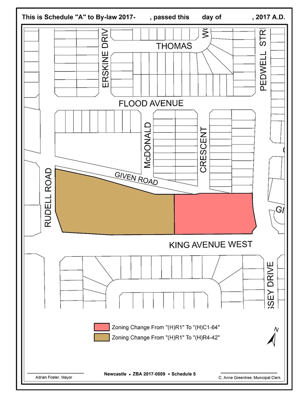
47
STAFF REPORT PLN September 11, 2017
 Page: 1 TO: SUBJECT: GENERAL COMMITTEE APPLICATIONS FOR OFFICIAL PLAN AMENDMENT AND ZONING BY-LAW AMENDMENT 37 JOHNSON STREET WARD: WARD 1 PREPARED BY AND KEY CONTACT: SUBMITTED BY: GENERAL MANAGER APPROVAL:
Planning Justification Report
 Planning Justification Report 101 Kozlov Street, Barrie, Ont. Destaron Property Management Ltd. November 2015 Revised February 2017 TABLE OF CONTENTS Page 1.0 INTRODUCTION... 1 2.0 DESCRIPTION OF SUBJECT
3.1. OBJECTIVES FOR RESIDENTIAL LAND USE DESIGNATIONS GENERAL OBJECTIVES FOR ALL RESIDENTIAL DESIGNATIONS
 3. RESIDENTIAL LAND USE DESIGNATIONS INTRODUCTION The Residential land use designations provide for housing and other land uses that are integral to, and supportive of, a residential environment. Housing
Director, Community Planning, Scarborough District ESC 44 OZ & ESC 44 SB
 STAFF REPORT ACTION REQUIRED 6175, 6183 Kingston Road and 1, 2, 4, 5, 7,10 & 11 Franklin Avenue - Official Plan Amendment, Zoning Amendment and Draft Plan of Subdivision Applications Preliminary Report
PIN , Part 1, Plan SR-713 in Lot 2, Concession 5, Township of McKim (1096 Dublin Street, Sudbury)
") STAFF REPORT Applicant: Dalron Construction Limited Location: PIN 02124-0103, Part 1, Plan SR-713 in Lot 2, Concession 5, Township of McKim (1096 Dublin Street, Sudbury) Official Plan and Zoning By-law:
STAFF REPORT Applicant: Dalron Construction Limited Location: PIN 02124-0103, Part 1, Plan SR-713 in Lot 2, Concession 5, Township of McKim (1096 Dublin Street, Sudbury) Official Plan and Zoning By-law:
Paul D. Ralph, BES, RPP, MCIP, Commissioner, Development Services Department
 Public Report To: From: Report Number: Development Services Committee Paul D. Ralph, BES, RPP, MCIP, Commissioner, Development Services Department DS-16-50 Date of Report: April 14, 2016 Date of Meeting:
39 Thora Avenue Zoning Amendment Application Preliminary Report
 STAFF REPORT ACTION REQUIRED 39 Thora Avenue Zoning Amendment Application Preliminary Report Date: January 28, 2014 To: From: Wards: Reference Number: Scarborough Community Council Director, Community
1555 Midland Avenue - Zoning Amendment & Subdivision Applications - Preliminary Report
 STAFF REPORT ACTION REQUIRED 1555 Midland Avenue - Zoning Amendment & Subdivision Applications - Preliminary Report Date: October 24, 2013 To: From: Wards: Reference Number: Scarborough Community Council
PREPARED FOR: ADI DEVELOPMENT GROUP INC.
 Acronym Urban Design and Planning/Mark Sterling Consulting Inc. 111 Clendenan Avenue, Toronto, Ontario M6P 2W7 URBAN DESIGN BRIEF PROPOSED DEVELOPMENT 4880 VALERA ROAD, CITY OF BURLINGTON PREPARED FOR:
Planning Rationale in Support of an Application for Plan of Subdivision and Zoning By-Law Amendment
 Planning Rationale in Support of an Application for Plan of Subdivision and Zoning By-Law Amendment The Kilmorie Development 21 Withrow Avenue City of Ottawa Prepared by: Holzman Consultants Inc. Land
TOWN OF WHITBY REPORT RECOMMENDATION REPORT
 TOWN OF WHITBY REPORT RECOMMENDATION REPORT REPORT TO: Planning and Development Committee REPORT NO: PL 4-08 DATE OF MEETING: January 21, 2008 FILE NO(S): MI-01-07 (SW- 2002-03) PREPARED BY: Planning Department
Chair and Members Planning and Economic Development Committee
 TO: FROM: Chair and Members Planning and Economic Development Committee Melissa Halford Manager of Planning DATE: June 23, 2016 SUBJECT: Amendment No. 6 to Draft Approval Subdivision File No. S2006-3 (Loon
THE CORPORATION OF THE TOWNSHIP OF KING THE CERTIFICATE PAGE FOR AMENDMENT NO. 89 TO THE OFFICIAL PLAN OF THE TOWNSHIP OF KING
 THE CORPORATION OF THE TOWNSHIP OF KING THE CERTIFICATE PAGE FOR AMENDMENT NO. 89 TO THE OFFICIAL PLAN OF THE TOWNSHIP OF KING (KING CITY COMMUNITY PLAN) The attached text and schedules constituting Amendment
STAFF REPORT. March 14, Toronto and East York Community Council. Director, Community Planning, South District
 STAFF REPORT March 14, 2005 To: From: Subject: Toronto and East York Community Council Director, Community Planning, South District Preliminary Report Official Plan Amendment and Rezoning Application 05
Paul D. Ralph, BES, RPP, MCIP, Commissioner, Development Services Department
 Public Report To: From: Report Number: Development Services Committee Paul D. Ralph, BES, RPP, MCIP, Commissioner, Development Services Department DS-18-64 Date of Report: March 22, 2018 Date of Meeting:
For Vintages of Four Mile Creek Town of Niagara on the Lake, Ontario
 Planning Impact Analysis For Vintages of Four Mile Creek Town of Niagara on the Lake, Ontario Prepared by: Upper Canada Consultants 261 Martindale Road Unit #1 St. Catharines, Ontario L2W 1A1 Prepared
3390, 3392, 3394, 3396 and 3398 Bayview Avenue - Official Plan Amendment, Zoning By-law Amendment Application - Preliminary Report
 STAFF REPORT ACTION REQUIRED 3390, 3392, 3394, 3396 and 3398 Bayview Avenue - Official Plan Amendment, Zoning By-law Amendment Application - Preliminary Report Date: March 14, 2016 To: From: Wards: Reference
20 Edward Street Zoning Amendment Application - Preliminary Report
 STAFF REPORT ACTION REQUIRED 20 Edward Street Zoning Amendment Application - Preliminary Report Date: January 20, 2015 To: From: Wards: Reference Number: Toronto and East York Community Council Director,
1417, , 1427 & 1429 Yonge Street - Official Plan Amendment and Zoning Amendment Applications - Preliminary Report
 STAFF REPORT ACTION REQUIRED 1417, 1421-1425, 1427 & 1429 Yonge Street - Official Plan Amendment and Zoning Amendment Applications - Preliminary Report Date: March 24, 2015 To: From: Wards: Reference Number:
Keele Street - Official Plan and Zoning By-law Amendment Application - Preliminary Report
 STAFF REPORT ACTION REQUIRED 406-410 Keele Street - Official Plan and Zoning By-law Amendment Application - Preliminary Report Date: September 20, 2017 To: From: Wards: Reference Number: Etobicoke York
PLANNING REPORT Gordon Street City of Guelph. Prepared on behalf of Ontario Inc. March 17, Project No. 1507
 PLANNING REPORT 1131 Gordon Street City of Guelph Prepared on behalf of 1876698 Ontario Inc. March 17, 2016 Project No. 1507 423 Woolwich Street, Suite 201, Guelph, Ontario, N1H 3X3 Phone (519) 836-7526
PLANNING RATIONALE REPORT
 PLANNING RATIONALE REPORT Zoning By-law Amendment Application 2920 Danbury Way Prepared for: Bravar Custom Builders Inc. and Village View Estates Ltd. by: 6393 Roslyn Street Ottawa (Orleans), Ontario K1C
Galloway Road and 4097 Lawrence Avenue East - Zoning Amendment Application - Preliminary Report
 STAFF REPORT ACTION REQUIRED 197-201 Galloway Road and 4097 Lawrence Avenue East - Zoning Amendment Application - Preliminary Report Date: November 29, 2013 To: From: Wards: Reference Number: Scarborough
1202 & 1204 Avenue Road Zoning By-law Amendment Application - Preliminary Report
 STAFF REPORT ACTION REQUIRED 1202 & 1204 Avenue Road Zoning By-law Amendment Application - Preliminary Report Date: March 17, 2017 To: From: Wards: Reference Number: North York Community Council Director,
PLANNING RATIONALE 680 BRONSON AVENUE OTTAWA, ONTARIO PROPOSED ZONING BY-LAW AMENDMENT
 PLANNING RATIONALE 680 BRONSON AVENUE OTTAWA, ONTARIO PROPOSED ZONING BY-LAW AMENDMENT FRANK PARAVAN APRIL 2014 Planning Rationale Introduction FOTENN Consultants Inc. has been engaged by Frank and Michael
Planning and Building Department
 Page 1 of Report PB-83-13 TO: Development and Infrastructure Committee Planning and Building Department SUBJECT: OP & Rezoning 5001 Corporate Drive Appleby Gardens LJM Developers Report Number: PB-83-13
TOTTENHAM SECONDARY PLAN
 TOTTENHAM SECONDARY PLAN AMENDMENT NO. 11 TO THE OFFICIAL PLAN OF THE TOWN OF NEW TECUMSETH The following text and schedules to the Official Plan of the Town of New Tecumseth constitute Amendment No. 11
Director, Community Planning, North York District
 STAFF REPORT ACTION REQUIRED 3, 5, 11, 17, 21 Allenbury Gardens & 3, 5 Kingslake Road Official Plan and Zoning By-law Amendment and Rental Housing Demolition Applications Final Report Date: February 6,
111 Plunkett Road (formerly part of 135 Plunkett Road) - Zoning By-law Amendment Application and Plan of Subdivision Application - Preliminary Report
 - Zoning By-law Amendment Application and Plan of Subdivision Application - Preliminary Report") STAFF REPORT ACTION REQUIRED 111 Plunkett Road (formerly part of 135 Plunkett Road) - Zoning By-law Amendment Application and Plan of Subdivision Application - Preliminary Report Date: May 27, 2013 To:
STAFF REPORT ACTION REQUIRED 111 Plunkett Road (formerly part of 135 Plunkett Road) - Zoning By-law Amendment Application and Plan of Subdivision Application - Preliminary Report Date: May 27, 2013 To:
40-58 Widmer Street - Zoning Amendment Application - Preliminary Report
 STAFF REPORT ACTION REQUIRED 40-58 Widmer Street - Zoning Amendment Application - Preliminary Report Date: April 19, 2013 To: From: Wards: Reference Number: Toronto and East York Community Council Director,
P. H. Robinson Consulting Urban Planning, Consulting and Project Management
 PLANNING RATIONALE REPORT FOR SITE PLAN AND DRAFT PLAN OF CONDOMINIUM APPLICATIONS 73-75 HARVEY STREET CITY OF OTTAWA PREPARED BY: P H ROBINSON CONSULTING AUGUST 2012 1 This report has been prepared on
Kingston Road - Zoning Amendment and Draft Plan of Subdivision Applications - Preliminary Report
 STAFF REPORT ACTION REQUIRED 6480-6484 Kingston Road - Zoning Amendment and Draft Plan of Subdivision Applications - Preliminary Report Date: April 19, 2016 To: From: Wards: Reference Number: Scarborough
Staff Report for Council Public Meeting
 Agenda Item 3.3 Staff Report for Council Public Meeting Date of Meeting: September 27, 2017 Report Number: SRPRS.17.134 Department: Division: Subject: Planning and Regulatory Services Development Planning
Director, Community Planning, Etobicoke York District
 STAFF REPORT ACTION REQUIRED 3555 Don Mills Road Zoning By-law Amendment Application Preliminary Report Date: May 22, 2012 To: From: Wards: Reference Number: North York Community Council Director, Community
Weston Road (Phase 2) - Official Plan and Zoning By-law Amendment and Lifting of the (H) Holding Symbol Applications - Preliminary Report
 - Official Plan and Zoning By-law Amendment and Lifting of the (H) Holding Symbol Applications - Preliminary Report") STAFF REPORT ACTION REQUIRED 3415-3499 Weston Road (Phase 2) - Official Plan and Zoning By-law Amendment and Lifting of the (H) Holding Symbol Applications - Preliminary Report Date: March 8, 2016 To:
STAFF REPORT ACTION REQUIRED 3415-3499 Weston Road (Phase 2) - Official Plan and Zoning By-law Amendment and Lifting of the (H) Holding Symbol Applications - Preliminary Report Date: March 8, 2016 To:
4027 and 4031 Ellesmere Road Zoning Amendment and Draft Plan of Subdivision Applications - Request for Direction Report
 STAFF REPORT ACTION REQUIRED 4027 and 4031 Ellesmere Road Zoning Amendment and Draft Plan of Subdivision Applications - Request for Direction Report Date: August 22, 2013 To: From: Wards: Reference Number:
Director, Community Planning, Toronto and East York District
 STAFF REPORT September 1, 2005 To: From: Subject: Toronto and East York Community Council Director, Community Planning, Toronto and East York District Further Report Applications to amend Official Plan
333 College Street and 303 Augusta Avenue Official Plan Amendment and Zoning Amendment Applications Final Report
 STAFF REPORT ACTION REQUIRED 333 College Street and 303 Augusta Avenue Official Plan Amendment and Zoning Amendment Applications Final Report Date: August 15, 2017 To: From: Wards: Reference Number: Toronto
PLANNING REPORT. 33 Arkell Road City of Guelph. Prepared on behalf of OHM Arkell Inc. August 4, Project No. 1327
 PLANNING REPORT 33 Arkell Road City of Guelph Prepared on behalf of OHM Arkell Inc. August 4, 2015 Project No. 1327 423 Woolwich Street, Suite 201, Guelph, Ontario, N1H 3X3 Phone (519) 836-7526 Fax (519)
Yonge Street and 3 Gerrard Street East - Zoning Amendment Application - Preliminary Report
 STAFF REPORT ACTION REQUIRED 363-391 Yonge Street and 3 Gerrard Street East - Zoning Amendment Application - Preliminary Report Date: May 22, 2015 To: From: Wards: Reference Number: Toronto and East York
3005 Bloor Street West and 14 Humbervale Boulevard - Official Plan and Zoning Amendment Applications - Preliminary Report
 STAFF REPORT ACTION REQUIRED 3005 Bloor Street West and 14 Humbervale Boulevard - Official Plan and Zoning Amendment Applications - Preliminary Report Date: March 10, 2018 To: From: Wards: Reference Number:
SUBJECT: Official Plan and Zoning By-law Amendment Applications for 4853 Thomas Alton Boulevard
 Page 1 of Report PB-100-16 SUBJECT: Official Plan and Zoning By-law Amendment Applications for 4853 Thomas Alton Boulevard TO: FROM: Development and Infrastructure Committee Planning and Building Department
5 to 25 Wellesley Street West and 14 to 26 Breadalbane Street - Zoning Amendment Application - Preliminary Report
 STAFF REPORT ACTION REQUIRED 5 to 25 Wellesley Street West and 14 to 26 Breadalbane Street - Zoning Amendment Application - Preliminary Report Date: May 16, 2013 To: From: Wards: Reference Number: Toronto
30 Widmer Street and Adelaide Street West - Zoning Amendment Application - Preliminary Report
 STAFF REPORT ACTION REQUIRED 30 Widmer Street and 309-315 Adelaide Street West - Zoning Amendment Application - Preliminary Report Date: January 13, 2015 To: From: Wards: Reference Number: Toronto and
i. The only permitted uses shall be a maximum of two (2) multiple dwellings and related accessory uses;
 multiple dwellings and related accessory uses;") Presented To: Planning Committee Request for Decision Application for rezoning in order to permit 80 dwelling units, comprising two (2) six-storey multiple dwellings with 40 units, Paris Street, Sudbury
Presented To: Planning Committee Request for Decision Application for rezoning in order to permit 80 dwelling units, comprising two (2) six-storey multiple dwellings with 40 units, Paris Street, Sudbury
10 Wilby Crescent - Zoning By-law Amendment Application Final Report
 REPORT FOR ACTION 10 Wilby Crescent - Zoning By-law Amendment Application Final Report Date: June 14, 2018 To: Etobicoke York Community Council From: Director, Community Planning, Etobicoke York District
Islington Avenue - Official Plan and Zoning By-law Amendment Application - Preliminary Report
 STAFF REPORT ACTION REQUIRED 3002-3014 Islington Avenue - Official Plan and Zoning By-law Amendment Application - Preliminary Report Date: Febuary 2, 2016 To: From: Wards: Reference Number: Etobicoke York
150 Eglinton Avenue East - Zoning Amendment Application - Preliminary Report
 STAFF REPORT ACTION REQUIRED 150 Eglinton Avenue East - Zoning Amendment Application - Preliminary Report Date: May 15, 2015 To: From: Wards: Reference Number: Toronto and East York Community Council Director,
York Neighbourhood Area Structure Plan
 York Neighbourhood Area Structure Plan Office Consolidation March 2006 Prepared by: Planning and Policy Services Branch Planning and Development Department City of Edmonton Bylaw 7064 was adopted by Council
111 Wenderly Drive Official Plan and Zoning By-law Amendment Applications - Preliminary Report
 STAFF REPORT ACTION REQUIRED 111 Wenderly Drive Official Plan and Zoning By-law Amendment Applications - Preliminary Report Date: August 17, 2015 To: From: Wards: Reference Number: North York Community
307 Sherbourne Street - Zoning Amendment Application - Preliminary Report
 STAFF REPORT ACTION REQUIRED 307 Sherbourne Street - Zoning Amendment Application - Preliminary Report Date: August 14, 2015 To: From: Wards: Reference Number: Toronto and East York Community Council Director,
6040 Bathurst Street and 5 Fisherville Road Zoning Bylaw Amendment Application Preliminary Report
 STAFF REPORT ACTION REQUIRED 6040 Bathurst Street and 5 Fisherville Road Zoning Bylaw Amendment Application Preliminary Report Date: January 24, 2017 To: From: Wards: Reference Number: North York Community
CITY OF VAUGHAN EXTRACT FROM COUNCIL MEETING MINUTES OF MAY 16, 2017
 CITY OF VAUGHAN EXTRACT FROM COUNCIL MEETING MINUTES OF MAY 16, 2017 Item 1, Report No. 18, of the Committee of the Whole (Public Hearing), which was adopted without amendment by the Council of the City
Report to: Development Services Committee Report Date: April 21, 2015
 SUBJECT: Preliminary Report Applications for Draft Plan of Subdivision, Zoning By-law Amendment, Plan of Condominium and Site Plan Approval by Urbancorp Inc. 9064-9110 Woodbine Avenue File No s: SU/ZA/CU/SC
200 St. Clair Ave W - Official Plan Amendment and Zoning Amendment Applications - Preliminary Report
 STAFF REPORT ACTION REQUIRED 200 St. Clair Ave W - Official Plan Amendment and Zoning Amendment Applications - Preliminary Report Date: December 15, 2014 To: From: Wards: Reference Number: Toronto and
Director, Community Planning, North York District NNY 10 OZ and NNY 10 RH
 STAFF REPORT ACTION REQUIRED 847 873 Sheppard Avenue West - Official Plan Amendment and Zoning By-law Amendment and Rental Housing Demolition and Conversion Applications - Preliminary Report Date: April
Bylaw No , being "Official Community Plan Bylaw, 2016" Schedule "A" DRAFT
 Bylaw No. 2600-2016, being "Official Community Plan Bylaw, 2016" Schedule "A" Urban Structure + Growth Plan Urban Structure Land use and growth management are among the most powerful policy tools at the
Toronto and East York Community Council. Director, Community Planning, Toronto and East York District
 STAFF REPORT ACTION REQUIRED 1481, 1491, 1501 Yonge Street, 25 & 27 Heath Street East and 30 Alvin Avenue Official Plan and Zoning Amendment Application 06 199698 STE 22 OZ Preliminary Report Date: March
66 Isabella Street Rezoning Application - Preliminary Report
 STAFF REPORT ACTION REQUIRED 66 Isabella Street Rezoning Application - Preliminary Report Date: November 15, 2010 To: From: Wards: Reference Number: Toronto and East York Community Council Director, Community
3035 Weston Road - Official Plan and Zoning By-law Amendment and Draft Plan of Subdivision Applications - Request for Directions Report
 STAFF REPORT ACTION REQUIRED 3035 Weston Road - Official Plan and Zoning By-law Amendment and Draft Plan of Subdivision Applications - Request for Directions Report Date: December 18, 2007 To: From: Wards:
Financial Impact Statement There are no immediate financial impacts associated with the adoption of this report.
 STAFF REPORT Planning and Development Department Subject: Application by RYC Property to rezone a portion of lands on John Murray Dr. and Megan Lynn Dr. from R2 to R3 and to enter into a Development Agreement
12, 14, 16 and 18 Marquette Avenue and 7 Carhartt Street Zoning By-law Amendment Application - Preliminary Report
 STAFF REPORT ACTION REQUIRED 12, 14, 16 and 18 Marquette Avenue and 7 Carhartt Street Zoning By-law Amendment Application - Preliminary Report Date: July 17, 2014 To: From: Wards: Reference Number: North
Planning Justification Report - Update Castlegrove Subdivision, Gananoque Draft Plan of Subdivision and Class III Development Permit
 Planning Justification Report - Update Castlegrove Subdivision, Gananoque Draft Plan of Subdivision and Class III Development Permit by IBI Group Table of Contents Executive Summary... 1 1 Introduction...
Bathurst Street Zoning Amendment Application and Rental Housing Demolition Application under Municipal Code Chapter 667 Final Report
 STAFF REPORT ACTION REQUIRED 1996-2000 Bathurst Street Zoning Amendment Application and Rental Housing Demolition Application under Municipal Code Chapter 667 Final Report Date: January 26, 2017 To: Toronto
Acting Director, Community Planning, Toronto and East York District
 STAFF REPORT ACTION REQUIRED 620 Avenue Road, 215 & 217 Lonsdale Road OPA & Rezoning Application Preliminary Report Date: March 13, 2008 To: From: Wards: Reference Number: Toronto and East York Community
Director, Community Planning, North York District
 STAFF REPORT ACTION REQUIRED 35-53 and 101-113 Valley Woods Road and 1213-1229 York Mills Road Official Plan, Rezoning, Draft Plan of Subdivision and Rental Housing Demolition Applications Final Report
STAFF REPORT. September 25, City Council. Chief Planner and Executive Director, City Planning Division
 STAFF REPORT September 25, 2006 To: From: Subject: City Council Chief Planner and Executive Director, City Planning Division Request for Directions Report Toronto & East York Community Council, Report
Housing Issues Report Shoreline Towers Inc. Proposal 2313 & 2323 Lake Shore Boulevard West. Prepared by PMG Planning Consultants November 18, 2014
 Housing Issues Report Shoreline Towers Inc. Proposal 2313 & 2323 Lake Shore Boulevard West Prepared by PMG Planning Consultants November 18, 2014 PMG Planning Consultants Toronto, Canada M6A 1Y7 Tel. (416)
507, 509 and 511 Kingston Road - Official Plan and Zoning By-law Amendment Applications - Preliminary Report
 STAFF REPORT ACTION REQUIRED 507, 509 and 511 Kingston Road - Official Plan and Zoning By-law Amendment Applications - Preliminary Report Date: March 9, 2017 To: From: Wards: Reference Number: Toronto
AMENDMENT NUMBER 38 TO THE OFFICIAL PLAN OF THE TOWNSHIP OF WEST LINCOLN (COMPLIANCE)
") AMENDMENT NUMBER 38 TO THE OFFICIAL PLAN OF THE TOWNSHIP OF WEST LINCOLN (COMPLIANCE) 2013 AMENDMENT NUMBER 38 TO THE OFFICIAL PLAN OF THE TOWNSHIP OF WEST LINCOLN PART 1 - THE PREAMBLE 1.1 TITLE This
AMENDMENT NUMBER 38 TO THE OFFICIAL PLAN OF THE TOWNSHIP OF WEST LINCOLN (COMPLIANCE) 2013 AMENDMENT NUMBER 38 TO THE OFFICIAL PLAN OF THE TOWNSHIP OF WEST LINCOLN PART 1 - THE PREAMBLE 1.1 TITLE This
3 and 5 Southvale Dr - Official Plan Amendment and Zoning Amendment Applications - Preliminary Report
 STAFF REPORT ACTION REQUIRED 3 and 5 Southvale Dr - Official Plan Amendment and Zoning Amendment Applications - Preliminary Report Date: August 20, 2015 To: From: Wards: Reference Number: North York Community
Infrastructure, Development and Enterprise Services
 Staff Report To Service Area City Council Infrastructure, Development and Enterprise Services Date Monday, April 9, 2018 Subject Report Number Statutory Public Meeting 671 Victoria Road North Proposed
Appendix1,Page1. Urban Design Guidelines. Back to Back and Stacked Townhouses. DRAFT September 2017
 Appendix1,Page1 Urban Design Guidelines DRAFT September 2017 Back to Back and Stacked Townhouses Appendix1,Page2 Table of Contents 1 Introduction 1 1.1 Purpose 1 1.2 Urban Design Objectives 1 1.3 Building
1970 Victoria Park Avenue and 9 Clintwood Gate Zoning By-law Amendment Application Preliminary Report
 STAFF REPORT ACTION REQUIRED 1970 Victoria Park Avenue and 9 Clintwood Gate Zoning By-law Amendment Application Preliminary Report Date: September 23, 2013 To: From: Wards: Reference Number: North York
50 and 52 Finch Avenue East - Official Plan and Zoning By-law Amendment Applications - Preliminary Report
 STAFF REPORT ACTION REQUIRED 50 and 52 Finch Avenue East - Official Plan and Zoning By-law Amendment Applications - Preliminary Report Date: August 16, 2016 To: From: Wards: Reference Number: North York
LITTLE MOUNTAIN ADJACENT AREA REZONING POLICY
 LITTLE MOUNTAIN ADJACENT AREA REZONING POLICY JANUARY 2013 CONTENTS 1.0 INTENT & PRINCIPLES...1 2.0 APPLICATION...2 3.0 HOUSING TYPES, HEIGHT & DENSITY POLICIES...3 3.1 LOW TO MID-RISE APARTMENT POLICIES...4
DRAFT FOR DISCUSSION PURPOSES ONLY. Port Credit Local Area Plan Built Form Guidelines and Standards DRAFT For Discussion Purposes
 Port Credit Local Area Plan Built Form Guidelines and Standards DRAFT For Discussion Purposes 1 Local Area Plan - Project Alignment Overview Directions Report, October 2008 (General Summary Of Selected
Urban Design Brief Dundas Street. London Affordable Housing Foundation. November Zelinka Priamo Ltd.
 Urban Design Brief 1039-1047 Dundas Street London Affordable Housing Foundation November 2017 Zelinka Priamo Ltd. TABLE OF CONTENTS Page No. INTRODUCTION... 3 SECTION 1 LAND USE PLANNING CONTEXT... 3 1.1
50 Wellesley Street East - Official Plan Amendment & Zoning Amendment Applications - Preliminary Report
 STAFF REPORT ACTION REQUIRED 50 Wellesley Street East - Official Plan Amendment & Zoning Amendment Applications - Preliminary Report Date: July 18, 2014 To: From: Wards: Reference Number: Toronto and East
1.0 Introduction. November 9, 2017
 November 9, 2017 Andrew Bone, Planner III Regional Planning Policy and Strategic Initiatives Halifax Regional Municipality 40 Alderney Drive Dartmouth, NS, B2Y 2N5 Subject: Application to amend the Bedford
45 & 77 Dunfield Avenue - Zoning Amendment Application - Preliminary Report
 STAFF REPORT ACTION REQUIRED 45 & 77 Dunfield Avenue - Zoning Amendment Application - Preliminary Report Date: January 22, 2014 To: From: Wards: Reference Number: Toronto and East York Community Council
250 Lawrence Avenue West - Official Plan and Zoning By-law Amendment Applications Preliminary Report
 STAFF REPORT ACTION REQUIRED 250 Lawrence Avenue West - Official Plan and Zoning By-law Amendment Applications Preliminary Report Date: April 22, 2015 To: From: Wards: Reference Number: North York Community
Church Street and 117 Dundas Street East - Zoning Amendment Application - Preliminary Report
 STAFF REPORT ACTION REQUIRED 215-229 Church Street and 117 Dundas Street East - Zoning Amendment Application - Preliminary Report Date: February 26, 2015 To: From: Wards: Reference Number: Toronto and
5. That the Owner shall agree that all development Blocks shown within the Draft Plan will be connected to full municipal services.
 Conditions Relating to Draft Plan of Subdivision Approval East Fonthill 26T 01014 (Draft Plan dated December 1, 2013, and revised August 28, 2014), the Town of Pelham 1. This approval applies to the Draft
8.5.1 R1, Single Detached Residential District
 8.5.1 R1, Single Detached Residential District The purpose of this district is to provide for residential development in the form of single detached dwellings. Dwelling, Single Detached Home Business,
Community & Infrastructure Services Committee
 REPORT TO: DATE OF MEETING: September 12, 2016 Community & Infrastructure Services Committee SUBMITTED BY: Alain Pinard, Director of Planning, 519-741-2200 ext. 7319 PREPARED BY: Natalie Goss, Senior Planner,
Urban Design Brief. Italian Seniors Project 1090, 1092, 1096 Hamilton Road City of London
 Urban Design Brief Italian Seniors Project City of London October 1, 2017 TABLE OF CONTENTS Page No. INTRODUCTION... 2 1.0 LAND USE PLANNING CONCEPT... 2 1.1 Subject Lands... 2 1.2 Official Plan and Zoning
2306 St. Clair Avenue West Zoning By-law Amendment Application - Preliminary Report
 STAFF REPORT ACTION REQUIRED 2306 St. Clair Avenue West Zoning By-law Amendment Application - Preliminary Report Date: August 10, 2017 To: From: Wards: Reference Number: Etobicoke York Community Council
4650 Eglinton Avenue West - Zoning By-law Amendment Application - Preliminary Report
 STAFF REPORT ACTION REQUIRED 4650 Eglinton Avenue West - Zoning By-law Amendment Application - Preliminary Report Date: August 14, 2015 To: From: Wards: Reference Number: Etobicoke York Community Council
Montreal Road District Secondary Plan [Amendment #127, October 9, 2013]
![Montreal Road District Secondary Plan [Amendment #127, October 9, 2013]](/thumbs/72/66783104.jpg "Montreal Road District Secondary Plan [Amendment #127, October 9, 2013]") [Amendment #127, October 9, 2013] 1.0 General The following policies are applicable to the Montreal Road District as set out in Schedule 1. 1.1 District Objectives The objective of this Plan is to guide
[Amendment #127, October 9, 2013] 1.0 General The following policies are applicable to the Montreal Road District as set out in Schedule 1. 1.1 District Objectives The objective of this Plan is to guide
Ashcroft Homes Trim Road Development Planning Rationale
 18 Antares Drive Ottawa, ON K2E 1A9 Ashcroft Homes Trim Road Development Planning Rationale Proposed Site Plan & Zoning Amendment Applications File No: D02-02-17-0129 & D07-12-17-0175 August 2018 Planning
Staff Report. October 19, 2016 Page 1 of 17. Meeting Date: October 19, 2016
 October 19, 2016 Page 1 of 17 Staff Report Report No.: PDSD-P-58-16 Meeting Date: October 19, 2016 Submitted by: Subject: Recommendation: Ben Puzanov, RPP, Senior Planner Application for Zoning By-law
250, 252, 254 and 256 Royal York Road and 8 and 10 Drummond Street - Zoning By-law Amendment Application - Preliminary Report
 STAFF REPORT ACTION REQUIRED 250, 252, 254 and 256 Royal York Road and 8 and 10 Drummond Street - Zoning By-law Amendment Application - Preliminary Report Date: May 28, 2013 To: From: Wards: Reference
Frequently Asked Questions
 Frequently Asked Questions Cambridge West Land Use Planning Matters January 10, 2018 Q1 What is proposed for the undeveloped lands within the Cambridge West area? A. Four separate landowners each own part
and Members of Municipal Council
 REPORT TO: SUBMITTED BY: SUBJECT: Mayor James M. Diodati and Members of Municipal Council Planning, Building & Development 26T-11-2017-002 Winzen Niagara Draft Plan of Subdivision 4825 Pettit Avenue Applicant:
Peter Street and 357 Richmond Street West - Zoning Amendment Application - Preliminary Report
 STAFF REPORT ACTION REQUIRED 122-128 Peter Street and 357 Richmond Street West - Zoning Amendment Application - Preliminary Report Date: March 11, 2016 To: From: Wards: Reference Number: Toronto and East
Urban Design Brief. Proposed Medical / Dental Office 1444 Adelaide Street North. Vireo Health Facility Ltd.
 Urban Design Brief Proposed Medical / Dental Office Vireo Health Facility Ltd. November 27, 2013 TABLE OF CONTENTS Page No. INTRODUCTION... 1 SECTION 1 LAND USE PLANNING CONTEXT... 1 1.1 The Subject Lands...
230 Oak Street- Official Plan Amendment and Zoning Bylaw Amendment Applications - Preliminary Report
 STAFF REPORT ACTION REQUIRED 230 Oak Street- Official Plan Amendment and Zoning Bylaw Amendment Applications - Preliminary Report Date: February 6, 2014 To: From: Wards: Reference Number: Toronto and East
M-43 CORRIDOR OVERLAY ZONE
 ARTICLE 26.00 M-43 CORRIDOR OVERLAY ZONE Section 26.01 Findings A primary function of the M-43 state highway is to move traffic through the Township and to points beyond. As the primary east-west arterial
10 St Mary Street - Zoning Amendment Application - Preliminary Report
 STAFF REPORT ACTION REQUIRED 10 St Mary Street - Zoning Amendment Application - Preliminary Report Date: May 14, 2015 To: From: Wards: Reference Number: Toronto and East York Community Council Director,