U.S. Department of the Interior Bureau of Land Management
|
|
|
- Oscar Carson
- 6 years ago
- Views:
Transcription
1 U.S. Department of the Interior Bureau of Land Management Upper Snake River District Shoshone Field Office Shoshone, Idaho August 2003 Amendments to Shoshone Field Office Land Use Plans for Land Tenure Adjustment and Areas of Critical Environmental Concern
2 Shoshone Field Office 400 West F Street PO Box 2-B Shoshone, Idaho (208) In Reply Refer To: 1675 (ID-076) August 18, 2003 Dear Public Lands User: Attached for your information and use are a Decision Record and Amendments to the Shoshone Land Use Plans for Land Tenure Adjustment and Areas of Critical Environmental Concern (ACECs). This documentation completes the land use planning and environmental review process needed to implement changes to land tenure management direction and ACEC designations for the Shoshone Field Office and an ACEC designation for the Four Rivers Field Office. The amendments apply to approximately 1.44 million acres of public lands administered by the Shoshone Field Office, and about 840 acres administered by the Four Rivers Field Office. The approved Amendments are the same as the proposed management direction that was described and analyzed in the Proposed Amendments to Shoshone Land Use Plans for Land Tenure Adjustment and Areas of Critical Environmental Concern (USDI-BLM, April 2003), with one change: The King Hill Creek ACEC will remain open to livestock grazing. Due to a protest on the proposed amendments, the management prescriptions for the King Hill Creek ACEC were re-evaluated by the protester, the Idaho Department of Fish and Game, and the BLM. The three parties agreed that livestock are not presently causing impacts to the values for which the ACEC is designated, and another management action for the ACEC (prescription g of the approved Amendments) will ensure that actions can be taken if livestock become an issue in the ACEC. [Note: Prescription g states that the BLM will authorize only those actions within the ACEC which maintain or improve desirable habitat conditions for redband trout. ] Additional copies of the approved Shoshone Land Use Plans Amendments and Decision Record may be obtained by visiting or writing the BLM, Upper Snake River District, Shoshone Field Office at P.O. Box 2-B, 400 West F Street, Shoshone, Idaho , calling the Field Office at (208) , or sending an message to ID_Shoshone_LUPA@blm.gov.
3 Thank you for your interest and participation in the planning process for these land use plan amendments. I look forward to your continuing involvement as we implement the management guidance contained in the amendments. Sincerely, Bill Baker Field Manager Attachment (1)
4 Table of Contents Decision Record i Summary of the Shoshone Land Use Plans Amendments 1 Planning Issues and Concerns 2 Affected Area 2 Amendments to Shoshone Field Office Land Use Plans 4 Land Tenure Adjustment 4 Lands Status and Management Zones 6 Criteria for Land Ownership Adjustment 11 Additional Management Direction 13 ACEC Designations 17 Management Applicable to all Three New ACECs 17 King Hill Creek ACEC/RNA 19 McKinney Butte ACEC/RNA 19 Tee-Maze ACEC/RNA 20 Amendments Monitoring and Evaluation 24 Attachment 1: Lands Identified for Potential Disposal under FLTFA 25 References Cited 36 List of Maps Map 1: Shoshone Field Office Public Lands Managed According to Existing Land Use Plans vi Map 2: Shoshone Field Office Land Status and Tracts Identified for Potential Disposal 3 Map 3: Land Tenure Management Zones 7 Map 4: New and Existing ACECs in the Shoshone Field Office 18 Map 5: King Hill Creek ACEC/RNA 21 Map 6: McKinney Butte ACEC/RNA 22 Map 7: Tee-Maze ACEC/RNA 23 List of Tables Table 1: Steps in Evaluating Land Tenure Adjustment Proposals 5 Table 2: Land Status within Each Management Zone 6
5 Decision Record Decision The BLM s decision is to amend the Shoshone Field Office s land use plans by incorporating the management direction described below. The Amendments are the same as the Proposed Amendments to Shoshone Field Office Land Use Plans published in April 2003, except for one change in management direction for the King Hill Creek ACEC (the ACEC will remain open to livestock grazing). [Note: The Proposed Amendments were the same as the preferred alternative (Alternative 3) identified in the Draft Amendments to Shoshone Field Office Land Use Plans/Environmental Assessment (June 2002), with minor revisions made in response to public comments received on the Draft Amendments.] The Amendments apply to approximately 1.44 million acres of public lands managed by the Shoshone Field Office. These management actions and designations amend the Magic Management Framework Plan (MFP) approved in 1975, the Bennett Hills/Timmerman Hills MFP (1976), the Sun Valley MFP (1982), and the Monument Resource Management Plan (RMP) (1985). The King Hill Creek ACEC designation also amends the Jarbidge RMP, approved in This designation applies to approximately 840 acres of public lands managed by the Four Rivers Field Office BLM. The Amendments include the following changes in management direction: Land Tenure Adjustment - Existing management limits land tenure adjustment through disposal to those tracts that were identified for potential disposal in the existing land use plans (approximately 50,000 acres). The amendments change land tenure adjustment guidance for the entire Shoshone Field Office area by defining land management areas or zones where public lands are emphasized for retention or can be considered for disposal. Zone 1 lands (approximately 14,000 acres) are identified for retention and will not be disposed of. Zone 2 lands (about 950,000 acres) will also be retained, except for public lands along a boundary with Zone 3, 4, or 5 that may be disposed of in order to acquire additional high resource value lands and/or consolidate public lands ownership. Zone 3 (127,000 acres) emphasizes land tenure adjustments that consolidate ownership and improve manageability of public lands. Zone 4 (62,000 acres) contains public lands that are isolated from one another and from other public lands tracts managed by the Shoshone Field Office; the emphasis in this zone is to dispose of appropriate tracts primarily through exchange, in order to improve resource values and consolidate ownership within Zones 1, 2, 3, and 5. Like Zone 3, Zone 5 (121,000 acres) stresses consolidation of ownership; however, unique considerations of the Zone 5 area (Wood River Valley) must be evaluated prior to any land tenure adjustment. In addition to utilizing a zones approach to defining retention and adjustment areas, the amendments identify criteria for evaluating land tenure adjustment proposals. These criteria are intended to help the BLM consistently review land tenure adjustment proposals and determine which lands are the highest priority for retention, acquisition, and disposal. The amendments also provide detailed direction for various specific aspects of land tenure, including acquisition priorities, emphasis on State and private land exchanges and sales, DLE/Carey Act disposals, R&PP Act leases and patents, aquifer recharge and communication site authorization, management of the Isolated Wildlife Tract Program, resolution of unauthorized use, split estate mineral situations, and acquisition of access. All land tenure adjustment actions will be required to comply with the guidelines in the Federal Land Policy Management Act (FLPMA), meet the criteria for land ownership adjustment and the emphasis of the applicable management zone(s), stand on their own merit through public input and review, and be in compliance with NEPA. i
6
7 The impacts analysis for the King Hill Creek ACEC (Environmental Assessment, pp and 113) indicated designation and management will protect and improve Interior redband trout habitat and help insure the genetic purity of the existing strain of Interior redband trout, a BLM sensitive species. Protection of the genetic strain will help reduce the need to list Interior redband trout as a threatened or endangered species. Under existing management direction for King Hill Creek, this genetically pure population of Interior redband trout will continue to be at risk of hybridization. Designating the King Hill Creek ACEC and implementing the identified management direction will focus management attention on the identified ACEC values and reduce the risk of loss or damage to those values. For example, restrictions on introduction of non-native genetic strains of trout into King Hill Creek should preserve the genetic integrity of the existing Interior redband trout population. The BLM s Upper Snake River District, including the Shoshone Field Office area, contains the largest concentration of caves in the State of Idaho and one of the largest concentrations of caves within the BLM s national jurisdiction. The impacts analysis for the McKinney Butte and Tee-Maze ACECs (Environmental Assessment, pp ) indicated designation and management will reduce impacts to fragile and irreplaceable cave resources (physical, scenic, and biological). Under existing management direction, those resources will continue to be at risk of loss or damage. Designating these two areas as ACECs and implementing the identified management direction will focus management attention on the identified ACEC values and reduce the risk of loss or damage to those values. For example, restrictions on cave access should reduce human disturbance of bat hibernacula and reduce the potential for bat mortality which could lead to listing of the Townsend s Western bigeared bat, a BLM sensitive species. Four additional ACECs were proposed for designation in Alternative 2: Bennett Hills, Camas Creek, Coyote Hills, and Dry Creek. The BLM has chosen not to make these designations because either (a) the resource protection desired can be achieved under existing management, and/or (b) an ACEC designation would increase the risk of adverse impacts to the identified ACEC values. The impacts analysis for the Camas Creek and Dry Creek ACEC designations indicated little to no difference in impacts from continuing existing management versus designating the ACECs (Environmental Assessment, pp and ). Management to maintain or enhance the identified scenic and ecological ACEC values has already been implemented or can be implemented if needed under existing management guidance in the Bennett Hills/Timmerman Hills MFP. An ACEC designation is not necessary in order to protect the ACEC values. The impacts analysis for the Bennett Hills and Coyote Hills ACECs disclosed that highlighting the cultural values in those areas through an ACEC designation may increase the potential for adverse impacts to occur (Environmental Assessment, pp. 92, , and 113). An ACEC designation would call attention to the general location of cultural resources and thereby increase the potential for vandalism or unauthorized excavation and collection. Existing management (Bennett Hills/ Timmerman Hills MFP), law, regulation, and policy afford the BLM the ability to implement additional management actions to protect cultural values in those areas without an ACEC designation. Site-specific cultural clearances will continue to be required prior to approval of mineral activities, which will insure cultural resources are not adversely affected by those actions. Currently, offhighway vehicle (OHV) use is light. If use increases to the point where cultural resources are affected, the BLM has the authority to restrict OHV use in order to protect cultural resources. iii
8 The public lands nominated as the Bennett Hills ACEC, but not proposed for ACEC designation, will continue to be managed according to the management direction stated in the Bennett Hills/ Timmerman Hills MFP (1976), including the following summary of actions: manage mule deer, elk, and antelope habitat to provide food and cover for specified populations; improve 283,000 acres of sage grouse brood rearing habitat; manage for a maximum diversity of vegetative species in order to meet the habitat requirements for a variety of wildlife species; provide for the protection and conservation of threatened or endangered plants; and implement management practices on all grazing lands in the Bennett Hills area to reach and maintain good range condition. This direction will enable the BLM to effectively manage vegetation and wildlife resources in the Bennett Hills area without an ACEC designation, including resources that were nominated as ACEC values (e.g., sagebrush ecosystem, sage grouse), but did not meet relevance and importance criteria for ACEC designation. After careful review of the Environmental Assessment of and comments received on the Draft Amendments, the BLM has decided to implement Alternative 3 identified in the Draft Amendments, with slight changes in response to public comments on the Draft Amendments and a protest letter received on the Proposed Amendments. These Amendments to existing management direction provide a framework for land tenure adjustment that will be flexible, efficient, and responsive to public, government, and tribal needs in the present and future. The Amendments also improve resource protection for fragile fisheries and cave resources by designating three new Areas of Critical Environmental Concern in the Shoshone Field Office. iv
9 Amendments to Shoshone Field Office Land Use Plans for Land Tenure Adjustment and Areas of Critical Environmental Concern
10
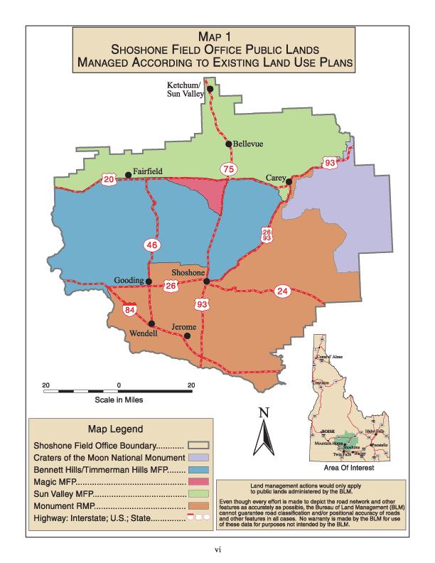
11 Summary of the Shoshone Land Use Plans Amendments The management direction in this document amends the following four land use plans in order to define new land tenure adjustment criteria and designate three new Areas of Critical Environmental Concern (ACECs) within the Upper Snake River District, BLM s Shoshone Field Office area (see Map 1): the Magic Management Framework Plan (MFP) (1975), Bennett Hills/Timmerman Hills MFP (1976), Sun Valley MFP (1982), and Monument Resource Management Plan (RMP) (1985). [Note: The Monument RMP guides management of public lands administered by the Burley Field Office and the Shoshone Field Office. The Amendments only apply to sections of the Monument RMP that guide management of Shoshone Field Office-managed lands.] These four land use plans provide a framework for land use allocations and management of public lands within the 1.44 million-acre Shoshone Field Office area. The Amendments replace existing land tenure adjustment decisions in those plans and make new ACEC designations and management decisions. Other management decisions in the current plans remain unchanged. Designation of the King Hill Creek ACEC/RNA also amends the Jarbidge RMP (BLM 1987), which provides management direction for public lands administered by the Four Rivers Field Office, Lower Snake River District, BLM. The Amendments were developed to achieve the following: Establish new direction for land tenure adjustment within the Shoshone Field Office area. Make lands available for public purposes, including city, county, State, and Tribal purposes. Make decisions regarding ACECs nominations and management direction. Provide for planning consistency within the BLM s Shoshone Field Office management area. The Shoshone Field Office sought public and tribal input on the Amendments during an initial scoping period, a public comment period on a Draft Amendments/Environmental Assessment document (USDI- BLM, June 2002), and a Governor s consistency review/public protest period on the Proposed Amendments (USDI-BLM, April 2003). The BLM also initiated and completed consultation with the two affected tribes (Shoshone-Bannock Tribes and Shoshone-Paiute Tribes), the U.S. Fish and Wildlife Service, and the State Historic Preservation Office. No inconsistencies with the officially approved or adopted resource-related plans, policies, and programs of tribes, other federal agencies, or State and local governments were identified during the amendments planning process. The Amendments are derived from the management direction that was described and analyzed in two prior planning documents: Proposed Amendments to Shoshone Field Office Land Use Plans (USDI- BLM, April 2003) and Draft Amendments to Shoshone Field Office Land Use Plans/Environmental Assessment (USDI-BLM, June 2002). The Draft Amendments/Environmental Assessment described and analyzed existing management (Alternative 1) and three action alternatives, including the BLM s preferred alternative (Alternative 3). Based on public comments and some new information, the preferred alternative was modified slightly and then analyzed as the Proposed Amendments. The Amendments defined in this document carry forward the management direction contained in the Proposed Amendments with only one change: the King Hill Creek ACEC will remain open to livestock grazing. Due to a protest on the proposed amendments, the management for the ACEC was re-evaluated by the protester, the Idaho Department of Fish and Game, and the BLM. The three parties agreed that livestock are not presently causing impacts to the values for which the ACEC is designated, and another management action for the ACEC (prescription g of the approved Amendments) will ensure that actions can be taken if livestock become an issue in the ACEC. [Note: Prescription g states that the BLM will authorize only those actions within the ACEC which maintain or improve desirable habitat conditions for redband trout. ] Summary of Shoshone Land Use Plans Amendments 1
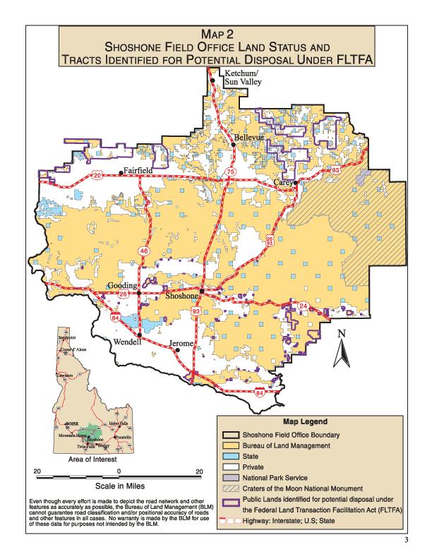
12 Planning Issues and Concerns Initial scoping for the plan amendments identified two planning issues: land tenure adjustment and new ACEC designations. The amendments address the following concerns related to land tenure adjustment: Improve manageability of public lands by consolidating ownership and focusing on management priorities within watersheds. Emphasize retention and acquisition of high resource value lands and public access. Provide for disposal of lower resource value and/or scattered and isolated parcels. Provide for resolution of long term unauthorized uses. Establish criteria to consistently evaluate land tenure adjustment proposals. Increase flexibility to meet the existing and future land tenure adjustment needs of private individuals; local, state, and federal government agencies; Indian tribes; and the BLM. Improve the efficiency of the land tenure adjustment process. The amendments also resolve the planning issue related to ACEC designations by: Designating as ACECs only those nominated areas that met relevance and importance criteria for designation, where designation is the most appropriate avenue to provide special management for the identified values and resources; and Identifying special management to maintain or enhance the identified values and resources. Affected Area The BLM s Shoshone Field Office manages approximately 1.44 million acres of public lands in southcentral Idaho (see Map 2). Public lands comprise approximately 52% of all lands within the planning area (2.77 million acres), which lies within Blaine, Camas, Gooding, Jerome, Lincoln, Elmore, and Minidoka counties. Private lands account for approximately 1.2 million acres, or 43% of the planning area, while State lands total 144,000 acres or 5%. Designation of the King Hill Creek ACEC/RNA also affects approximately 840 acres of public lands managed by the Four Rivers Field Office - BLM in the King Hill Creek area (see Map 5, p. 21). 2 Shoshone Land Use Plans Amendments
13
14 Amendments to Shoshone Field Office Land Use Plans The Amendments to the Shoshone Field Office Land Use Plans include amended land tenure adjustment management direction (pages 4-16, Map 2 (page 3), and Attachment 1 (pages 25-35)) and new ACEC designations and management direction (pages and Maps 4-7 (pages 18, 21-23)). Land Tenure Adjustment The Amendments identify land tenure adjustment availability and priorities for large land areas called zones (areas that contain common issues or planned actions), instead of identifying specific parcels by legal description. The Amendments also establish new land tenure adjustment review criteria. The result is a flexible, dynamic mechanism whereby the BLM and a proponent can evaluate the merits of a proposal by considering factors that include (a) the zone s emphasis on retention or land tenure adjustment (see zone descriptions on pages 6-11 below), (b) specific criteria for land ownership adjustment (see pages 11-12), and other applicable management actions (listed on pages 13-16). Once the Shoshone Field Office determines that a land tenure adjustment proposal is consistent with requirements of the Federal Land Policy Management Act (FLPMA), the project area s zone definition, and the Amendments criteria for land ownership adjustment, the BLM will consider the likelihood that the proposal will have public support. If the proposal appears to have public support, the BLM will assess current and anticipated workloads, priorities, staff, and funding, and set a priority for the proposal to be evaluated through appropriate NEPA documentation. Each individual action will be required to comply with direction in FLPMA, be within the Amendments guidelines for land tenure adjustment, meet the project area s zone definition and the Criteria for Land Ownership Adjustment, and stand on its own merit through public input and review. All disposals, whether by sale, exchange, or other authority, are subject to a decision by the authorized officer which will be based on detailed NEPA analysis and documentation as prescribed by law or regulation. The following example illustrates how a proposal will be considered according to the Amendments land tenure adjustment framework: 4 Shoshone Land Use Plans Amendments
15 Table 1: Steps in Evaluating Land Tenure Adjustment Proposals Step 1: Land Tenure Adjustment Proposal Submitted Does the proposal meet the intent of FLPMA? Is there a Federal interest (i.e., public benefit) to implementing the proposal? If the proposal is a land exchange, are the monetary values of the offered and selected lands relatively similar? YES - Continue to step 2. NO - No further consideration of the action as presently proposed. Step 2: Proposal Screened by Zone Definition Does the proposal fit within the guidelines of the affected area s zone definition for the selected amendment? YES - Continue to step 3. NO - No further consideration of the action as presently proposed. Step 3: Proposal Screened by Land Ownership Adjustment Criteria Is the proposed action a high priority based on the land ownership adjustment criteria? YES - Continue to step 4. NO - No further consideration of the action as presently proposed. Step 4: Likelihood of Proposal Receiving Public Support Is it likely the proposal will receive public support during the NEPA process? YES - Continue to step 5. NO - No further consideration of the action as presently proposed. Step 5: Scheduling the Proposal for Appropriate Public Involvement and NEPA Given established and future priorities, current and anticipated public and private funding and staffing, and the extent to which the proposal will benefit the American public, what should be the priority for completing the NEPA work on this proposal? Amendments Land Tenure Adjustment 5
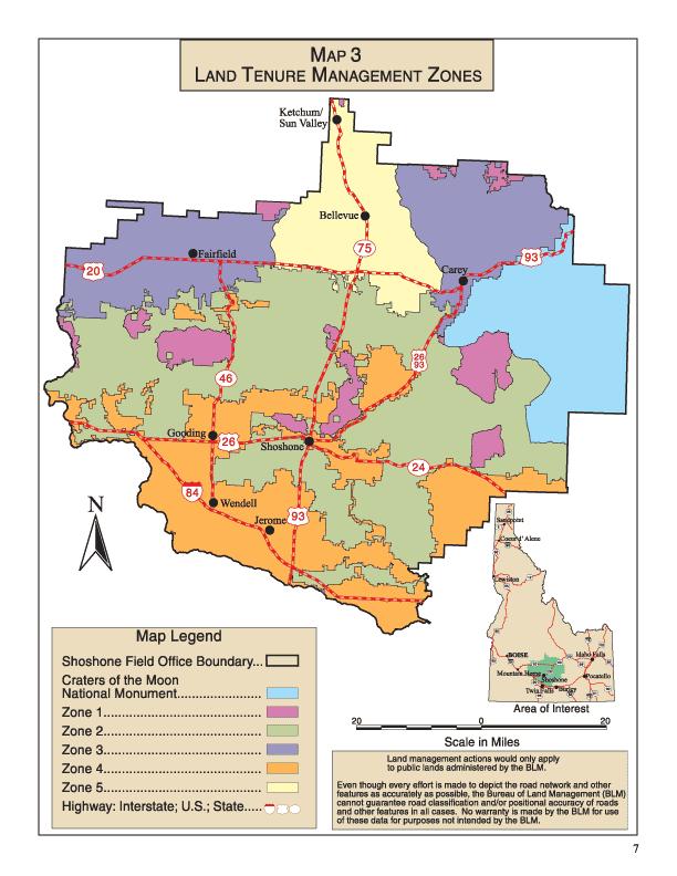
16 Lands Status and Management Zones The Amendments identify five land management zones, as shown on Map 3 and defined below. The approximate acreage of each zone is shown in Table 2. All acres and percentages cited in the zone definitions are based upon the information in this table. Table 2: Land Status Within Each Lands Management Zone Note: Acres and percentages are approximate. Zone Private (acres) State (acres) BLM Total (acres) acres % 1 7,000 7, , , ,000 44, ,000 1,086, ,000 48, , , ,000 25,000 62, , ,000 20, , , Total 1,187, ,000 1,440,000 2,771, Retention Areas (Zone 1 and Zone 2): Retention areas are those regions of public lands that will be retained in public ownership. Zone 1 lands are public lands with special designations because of significant resource values; all Zone 1 lands shall be retained in public ownership. Examples of Zone 1 lands include Wilderness Areas, Wilderness Study Areas (WSAs), National Monuments, National Trails, eligible Wild and Scenic Rivers (W&SR), Natural Conservation Areas (NCAs), and ACECs. Zone 1 lands also include public lands acquired through means, such as the Land and Water Conservation Fund, which require such lands to remain in Federal ownership. In the future, as lands receive a special designation, they will automatically be added to this zone. At present, Zone 1 contains about 180,000 acres of public lands, or 12.5% of public lands managed by the Shoshone Field Office. The zone has few private or State inholdings (14,000 acres or 7% of lands in the zone). The BLM s acquisition priority for Zone 1 is to seek to acquire all private and State land in-holdings. Public access will be considered in all land tenure actions. Zone 2 lands are public lands that have a fairly well-consolidated ownership pattern and contain potentially high values for resources and land uses such as minerals, recreation, range, riparian, cultural resources, and wildlife habitat. Zone 2 is the largest management zone, and includes 950,000 acres of public lands, or 66% of the public lands managed by the Shoshone Field Office. Zone 2 has a well consolidated ownership pattern, with only 12% of the zone (136,000 acres) in private or State ownership. The BLM s priorities for Zone 2 lands are to: 6 Shoshone Land Use Plans Amendments
17
18 first, retain the existing large blocks of high value public lands within the zone; second, consolidate public lands ownership within high priority watersheds by seeking to acquire private and State inholdings in those watersheds; and third, acquire additional high resource value lands within lower priority watersheds, as long as those acquired lands also improve efficiencies in public lands management. Public lands within ½ -mile of either side of the Zone 2 boundary will be considered potentially suitable for disposal primarily by exchange (and secondarily by sale or R&PP patent), unless that ½ mile extends into a Zone 1 (retention) area. Each individual disposal action will be required to comply with the guidelines in FLPMA, meet the Criteria for Land Ownership Adjustment (see pages 11-12), stand on its own merit through public input and review, and be in compliance with NEPA. Public access will be considered in all land tenure actions. Adjustment Areas (Zone 3, Zone 4, and Zone 5): Public lands within the three zones labeled as adjustment areas are generally smaller parcels that are (a) fragmented because they are interspersed with private and/or State lands or (b) isolated from the larger blocks of public lands within the planning area. These geographic and ownership factors make management of the public lands in Zones 3, 4, and 5 difficult. Most of these lands are therefore identified for disposal through exchange, in order to consolidate land ownership within the three zones. The net result is expected to be larger blocks of public, private, and State lands than at present, with increased public and administrative access to public lands. Although Zones 3, 4, and 5 are considered adjustment areas (because most land ownership adjustment in the planning area will occur there), public lands with high resource values will generally be retained in Federal ownership. Zone 3 lands are small to medium-sized blocks of public lands which are interspersed with State and private lands. Zone 3 lands in the northwest portion of the planning area are also isolated from other public lands managed by the Shoshone Field Office. Zone 3 is a relatively small component of the Field Office area, containing only 127,000 acres or 9% of public lands managed by the Shoshone Field Office. However, the zone has extensive acres in private ownership (359,000 acres or 67% of the zone). This zone also has the largest amount of lands in State ownership (48,000 acres or 9% of the zone). The emphasis in Zone 3 is to consolidate ownership, which will maximize public values, provide public access, and improve efficiencies in public lands management. The BLM s priorities for lands management in Zone 3 are to: Maintain the total amount of public land in Zone 3, including lands adjacent to the Sawtooth National Forest and Craters of the Moon National Monument (since these adjoining lands provide public access and improve Federal interagency efficiencies); and Acquire, primarily through exchange, additional high resource value lands that improve the manageability of the public lands. (Note: These acquisitions will result in disposal of lower resource value and difficult-to-manage tracts of Zone 3 public lands). 8 Shoshone Land Use Plans Amendments
19 Zone 3 lands are potentially suitable for disposal primarily by exchange; however, disposal of lands through sales and R&PP patents will also be allowed in this zone. Specific parcels within the zone may contain potentially high values for resources and land uses such as minerals, recreation, range, riparian, cultural resources, and wildlife habitat. These high-value parcels may not be suitable for disposal individually, except through exchange for equal resource value lands that are adjacent to existing public lands or that improve efficiencies in public land management. Each individual land tenure adjustment action will be required to comply with the guidelines in FLPMA, meet the Criteria for Land Ownership Adjustment (see pages 11-12), stand on its own merit through public input and review, and be in compliance with NEPA. Due to the present land ownership pattern, acquisition of public access will be a high priority in this zone. Zone 4 lands are small to medium-sized blocks of public lands that are isolated from one another and from other public lands tracts in the Field Office area. Zone 4 public lands comprise only 62,000 acres, or 4% of the public lands administered by the Shoshone Field Office and 9% of all lands in Zone 4. The Isolated Wildlife Tract Program is managed on Zone 4 lands (and some Zone 2 lands) along the Snake River. Public lands in Zone 4 are potentially suitable for disposal primarily by exchange; if land exchanges are not feasible, then land tenure adjustment via sale or R&PP patent will be considered. The land tenure adjustment emphasis in Zone 4 should result in a net decrease in public lands acreage within the zone. However, there may be specific parcels within Zone 4 that contain potentially high values for resources and land uses such as minerals, recreation, range, riparian, cultural resources, and wildlife habitat. These parcels may not be suitable for disposal individually, except through exchange for equal resource value lands that are not fragmented or isolated from existing public lands. Due to the present land ownership pattern in Zone 4, acquisition of public access will be a low priority in this zone. Each individual lands action will be required to comply with the guidelines in FLPMA, meet the Criteria for Land Ownership Adjustment (see pages 11-12), stand on its own merit through public input and review, and be in compliance with NEPA. Zone 5 is generally described as an Area of Influence of the Wood River Valley, and includes those lands that are within the viewshed of the communities of Bellevue, Hailey, Ketchum, and Sun Valley, Idaho. This zone was created based on public comments and concerns communicated during the scoping period. The land ownership characteristics of Zone 5 are very similar to Zone 3: public lands are small to medium-sized tracts interspersed with private and State lands. Zone 5 is a small land area, with only 121,000 acres of public lands (8% of lands administered by the Shoshone Field Office and 41% of lands within Zone 5). More acres within the zone are in private ownership than public ownership (156,000 acres of private lands, or 54% of the zone). State lands account for 20,000 acres or 7% of the zone. The general land management strategy for Zone 5 is very similar to that of Zone 3. However, the concerns of the local Wood River Valley communities are addressed through some unique considerations within Zone 5. Amendments Land Tenure Adjustment 9
20 Zone 5's General Land Tenure Management Strategy: The emphasis in Zone 5 is to consolidate ownership, which will maximize public values, provide public access, and improve efficiencies in public lands management. The BLM s priorities for lands management in Zone 5 are to: Maintain the total amount of public land in Zone 5, including lands adjacent to the Sawtooth National Forest (since these adjoining lands provide public access and improve Federal interagency efficiencies); and Acquire, primarily through exchange, additional high resource value lands that improve the manageability of the public lands. (Note: These acquisitions will result in disposal of lower resource value and difficult-to-manage tracts of Zone 5 public lands.) Zone 5 lands are potentially suitable for disposal primarily by exchange; however, disposal of lands through sales and R&PP patents will also be allowed in this zone. Specific parcels within the zone may contain potentially high values for resources and land uses such as minerals, recreation, range, riparian, cultural resources, and wildlife habitat. These high-value parcels may not be suitable for disposal individually, except through exchange for equal resource value lands that are adjacent to existing public lands or that improve efficiencies in public land management. Each individual land tenure adjustment action will be required to comply with the guidelines in FLPMA, meet the Criteria for Land Ownership Adjustment (see pages 11-12), stand on its own merit through public input and review, and be in compliance with NEPA. Due to the present land ownership pattern, acquisition of public access will be a high priority in this zone. Zone 5's Unique Considerations to Address Local Concerns: Several local concerns are addressed through the unique characteristics of land tenure management for Zone 5. These concerns include (a) the local governments interest in acquiring public lands to benefit the local community; (b) interagency (BLM and IDFG) and local residents concerns about wildlife habitat fragmentation; (c) wildfire risks; (d) retention of open space (undeveloped landscapes) and scenic values; (e) motorized and non-motorized recreation opportunities and access; and (f) floodplain protection. For each proposed lands transaction within Zone 5, the following factors need to be considered in addition to the standard Criteria for Land Ownership Adjustment (see pages 11-12). the local (city or county) government s interest in acquiring public lands to support infrastructure and extend community services; the extent to which the transaction will provide for high quality continuous habitat by retaining existing wildlife habitat and reducing the extent of fragmented wildlife habitat; the extent to which the transaction will reduce hazardous fuels and the risk of wildfire; the ability of the lands action to retain open space (undeveloped landscapes) and protect scenic corridors, the extent to which the lands action will facilitate ongoing or future motorized and nonmotorized trails and other public access; and the extent to which the lands action will protect floodplains from development. 10 Shoshone Land Use Plans Amendments
21 Furthermore, the lands proposal evaluation must consider the public values acquired and local factors addressed by acquiring State or private lands, versus the public values relinquished and local factors addressed when ownership transfers from the BLM. The following land tenure adjustment criteria also specifically apply to Zone 5: C C Exchanges will be considered to the extent that they result in no net loss of public lands within Zone 5. The BLM s goal for this zone is to maintain the public land acreage by exchanging public land in other zones for private land in Zone 5. The BLM will prefer disposal through R&PP patent to local or State government entities (since these are expected to provide management of the lands over the long term versus a nonprofit organization) when the BLM s priorities, the local or State government s priorities, and the public s needs are met by the patent process. C Disposal to private landowners through land sales will only be for small (generally less than 10 acres), isolated parcels generally left from mining patents or a resurvey by the USDI Cadastral Survey. Many of these parcels are less than an acre and are difficult to identify without researching the Master Title Plats; because of their small size, they often do not show up on land status maps. The priority will be to pool these numerous small parcels for disposal and exchange them for high resource value parcels within Zone 5. Criteria for Land Ownership Adjustment In addition to complying with guidelines for land tenure adjustment that are stated in FLPMA, a lands proposal must fit within the relevant zone s management strategy (see Lands Status and Management Zones descriptions above) and meet criteria for land ownership adjustment. The proposed action will be compared with the criteria to see if the proposal fits within the highest priorities for retention, acquisition, or disposal. FLPMA and other Federal laws, Executive Orders, and policies suggest criteria to use when categorizing public lands for retention or disposal, and for identifying acquisition priorities. The following list of criteria is not considered all-inclusive, but represents the major activities and issues affecting lands within the planning area. These criteria are meant to streamline consideration of land tenure adjustment proposals. These criteria will be among those considered in preparing lands reports and environmental analyses for specific land tenure adjustment proposals. Land tenure adjustments involving sales, exchanges, or R&PP patents may be permitted based on site-specific application of the adjustment criteria stated on page 12. Transfer to other public agencies will also be considered where improved management efficiency will result. All disposal actions will be consistent with the management actions and zones described in the approved Shoshone Land Use Plans Amendments. Amendments Land Tenure Adjustment 11
22 Lands with Highest Priority for Retention or Acquisition Those lands specifically identified by the Shoshone-Bannock and/or Shoshone-Paiute Tribes as having special importance related to treaty and/or traditional uses and values; Important, crucial, or critical habitat for special status species including proposed species, listed species, and candidate species under the Endangered Species Act; State-listed species; and BLM State Director-designated sensitive species; Riparian areas and wetlands; Parcels that provide public and/or administrative access to larger blocks of public land; Lands with special designation or management emphasis (see category below). Special Designation/Management Areas Where it is a High Priority to Acquire Inholdings Areas of Critical Environmental Concern, or lands adjacent to and important for expansion of such areas; National Historic Trails; Wild and Scenic Rivers (eligible, recommended suitable, or designated); Significant cultural resources and sites eligible for inclusion on the National Register of Historic Places; Wilderness and Wilderness Study Areas. Areas Generally Retained, but May be Exchanged for Parcels with Higher Resource Values Important habitat for fish or wildlife; Developed recreation sites and recreation access; Recreation opportunities and benefits; Significant energy and mineral resources; Significant cave resources; Significant paleontological resources. Areas that Are a High Priority for Disposal Parcels which are difficult or costly to administer (manageability and/or isolation of the parcel); Parcels more suitable for management by another Federal or State agency; Parcels of special importance to (and generally adjacent to) local communities for purposes including, but not limited to, community expansion, extended community services, or economic development. Other Issues to be Considered Prior to any Land Tenure Adjustment Action To what extent the individual action will help achieve overall land ownership management objectives at the watershed level, in cooperation with State and private landowners; Existing legal accessibility of the land for public uses; Amount of public investments in facilities or improvements and the potential for recovering those investments; Consistency with cooperative agreements and plans or policies of other agencies. 12 Shoshone Land Use Plans Amendments
23 Additional Management Direction Land Tenure Adjustment Summary of Management Direction: The land tenure adjustment management direction in this document amends the following land use plans: Magic MFP, Bennett Hills/Timmerman Hills MFP, Sun Valley MFP, and Monument RMP. Land tenure management zone designations are as shown on Map 3 (page 7) (also see zone definitions on pages 6-11). Each land tenure adjustment proposal will be reviewed on a case-by-case basis and evaluated to see if it meets the intent of FLPMA, the guidelines for the relevant land tenure and management zone(s), and the Criteria for Land Ownership Adjustment presented on page 12. Land tenure adjustments will seek to facilitate a watershed approach to natural resource management, in order to improve efficiencies in public lands management. The BLM will also seek to acquire high resource value lands made available by willing landowners. Depending on the merits of each proposal, disposal of public lands will be a priority if the disposal provides opportunity to consolidate public lands, accommodate the need for community expansion, improve management in areas of high resource values, and/or resolve long-standing unauthorized uses. Acquisition Priorities: The BLM s acquisition priorities will be to reconnect habitats within priority watersheds and to acquire other lands with high resource values. An additional acquisition priority within Zone 1 will be to seek to acquire all private and State in-holdings. Acquisitions, including easements, can be completed through exchange, Land and Water Conservation Funds (LWCF) purchases, donation, or receipts from Federal Land Transaction Facilitation Act sales or exchanges. Land Exchanges and Sales: The BLM s first priority will always be to use land exchanges rather than land sales. Lands considered for disposal through sale must meet the intent of FLPMA, Section 203(a) (1) (i.e., be difficult and uneconomical to manage) or FLPMA, Section 203(a) (3) (i.e., meet public objectives such as community expansion and economic development). Disposal of public lands through sale or exchange will be allowed in Zones 2, 3, 4, and 5. In Zone 5, sales to private land owners will only be allowed if the tracts are small, isolated parcels generally left from mining patents or a resurvey by the USDI cadastral survey. Public land sales will be in balance with, and, if possible, pooled with State and private land exchanges to facilitate a watershed approach and thereby improve efficiencies in public lands management. Sales will be a low priority, due to increased emphasis on land exchanges. Approximately 45,739 acres of public lands identified for disposal as of July 25, 2000, will continue to be available for disposal (see Attachment 1, pp ). Proceeds from the sale or exchange of these public lands may be used to purchase additional public lands, as provided for in the Federal Land Transaction Facilitation Act. State Land Exchanges: State land exchanges will be in balance with, and, if possible, pooled with private land exchanges to facilitate a watershed approach and thereby improve efficiencies in public lands management. Private Land Exchanges: Private land exchanges will be in balance with, and, if possible, pooled with State land exchanges to facilitate a watershed approach in order to improve efficiencies in public land management. Desert Land Entry (DLE) Act/ Carey Act Applications and Lands Transfer: No new DLE or Carey Act applications will be accepted. Current Desert Land Entry Act and Carey Act applications will be Amendments Land Tenure Adjustment 13
24 processed, and lands meeting the criteria of the Acts will be disposed of. The following are identified as current applications: Current Desert Land Entry (DLE) Applications: IDI 29776, and between Wendell and Gooding. IDI 27342, 27343, 27344, 27345, 27406, 27443, 27444, 27472, 27855, 27857, 27858, 27859, 28096, and in the Hidden Valley between Dietrich and Kimama and below State Highway 24. Current Carey Act Applications: IDI 9897, 9483 and (These overlap with the same DLE applicants between Wendell and Gooding.) Recreation and Public Purposes (R&PP) Act Leases and Patents: R&PP leases and patents are allowed in Zones 2, 3, 4, and 5. Proposed patents in Zone 5 must meet an additional criterion for that zone. In Zone 5 the BLM will prefer disposal through R&PP patent to local or State government entities (since these are expected to provide management of the lands over the long term, versus a non-profit organization) when the BLM s priorities, the local or State government s priorities, and the public s needs are met by the patent process. Aquifer Recharge Sites (including flood control sites which are ancillary benefits to the aquifer recharge program): The existing recharge site authorized in Zone 1 will be retained in public ownership and continue to be authorized through the signed Cooperative Agreement. The existing flood control site (ancillary benefit to the aquifer recharge program) authorized in Zone 2 through the signed Cooperative Agreement, and the aquifer recharge site within Zone 2 that has been approved by the BLM through a signed Decision Record, will be made available for acquisition through exchange or purchase with the State of Idaho or other public entity. The BLM will also allow the State or other public entities to exchange or purchase future recharge sites identified within Zones 2 or 4, if the sites are approved through the NEPA process. Communication Sites: The communication sites within the planning area that have been approved by the BLM through right-of-way grants will be made available for acquisition through exchange with the State of Idaho. The BLM will allow the State to exchange for entire communication site complexes and any other additional area needed for ancillary support for the sites identified in Zones 2-5, if the sites are approved through the NEPA process. Ancillary support for existing and future communication sites (e.g., power lines, access roads, etc.) will not be authorized on public lands once the sites are transferred to the State. Any transfer of public lands will be subject to all valid existing rights, including existing rights-ofway. Isolated Wildlife Tract Program: Continue to manage the Isolated Wildlife Tract Program on existing lands, and look for opportunities in partnership with the Idaho Department of Fish and Game (IDFG) to exchange the current properties for higher value properties that are adjacent to BLM lands, have equal or higher wildlife values, and help reconnect fragmented habitats within priority watersheds. As isolated lands are disposed of, the program will be reduced accordingly. Continue the present cooperative agreement with IDFG. Future Land Use Permits and Resolution of Unauthorized Use (e.g., farming, equipment storage, material disposal, fences): While waiting for land tenure actions to be completed, new land use permits, leases, or agreements will not be allowed on the public lands being considered for disposal. In areas not identified for disposal (e.g., Zone 1), consideration of new land use permits, leases, or agreements will be a low priority. 14 Shoshone Land Use Plans Amendments
25 Short-term authorizations or permits to cross BLM lands for the sole benefit of private farming practices (such as dry or wet pivot lines) will not be approved. No form of waste water application will be approved. A FLPMA right-of-way will be available to provide long-term authorization for actions such as water main lines and power lines grants, if needed to service private agricultural lands. Resolution of long-term unauthorized uses through land tenure adjustment will be equal in priority to retaining or acquiring high resource value lands. Existing permits, leases, or agreements that currently authorize known trespass will be retired within 18 months of the date the permit, lease, or agreement expires, and all agreed-to rehabilitation will occur to the satisfaction of the authorized officer within 36 months of the date the permit, lease, or agreement expires. Public lands with unauthorized uses that are temporarily authorized by existing land use permits, leases, or agreements will be evaluated for disposal in a pooled lands approach with the assistance of local county governments, in order to meet the needs of all land owners and the public. Isolated BLM parcels (isolated from other BLM properties or isolated due to structures like highways or major irrigation canals) may be sold. New cases of unauthorized use (or situations the BLM becomes aware of after these amendments are approved) will be resolved by current laws, regulations, and priorities. In the future, no new land use permits, leases, or agreements will be authorized to validate unauthorized use. Water Rights: Current Idaho water law and BLM water rights policy will be adhered to. Adherence to Idaho water law will be a condition of use on all existing, new, or renewed farming permits, leases, or agreements. When an existing permit is renewed, current Idaho BLM s State-wide policy is that any privately-held water right place of water use (POU) on public land shall either be removed from public land, or be transferred to the United States through the Bureau of Land Management. It is also BLM s policy that a privately-owned water right with a point of diversion (POD) on privately-owned property, but one or more places of water use on public land, shall be split and transferred to the United States, in proportion to the amount of water used on public land to the total water used on all land, both private and public; this transfer will be made for the duration of time the permitted use of public lands is authorized. Private/Public Land Boundary Adjustments Within and Adjacent to Zone 2: Public lands within ½ -mile of either side of the Zone 2 boundary will be considered potentially suitable for disposal primarily by exchange (and secondarily by sale or R&PP patent), unless that ½-mile extends into a Zone 1 (retention) area. Private/public land boundary adjustments within ½-mile of the Zone 2 boundary will be a priority if the land tenure adjustment provides opportunity to consolidate public lands, accommodate the need for community expansion, improve management in areas of high resource values, and/or resolve long-standing unauthorized uses. Split Estate Mineral Values (private surface owner/ BLM subsurface owner): The exchange or sale of BLM sub-surface minerals for private surface lands will be allowed in Zones 2, 3, 4, and 5. The BLM will seek to reduce or eliminate the split mineral estate whenever the opportunity arises. The priority will be to identify groups of landowners interested in acquiring their sub-surface mineral values, and to pool these values in order to acquire high resource value parcels through sale or exchange. Future lands transactions will follow current policy on transfer of sub-surface mineral values (current policy is to not split estates when completing a land tenure transaction). Priorities for Consolidating Land Ownership: First priority will always be to use land exchanges rather than land sales. Priority is to retain and acquire additional high resource value lands made available by a willing land owner, while considering opportunities to consolidate lands. High resource Amendments Land Tenure Adjustment 15
26 value lands will be retained unless equal or higher resource value lands are available. A priority is also to reconnect habitats within priority watersheds. Zone 5 Considerations: The following definitions apply for the purposes of these amendments: Open space is defined as a primitive and peaceful area that provides solitude, and where the public lands user will tread lightly and leave no trace of having been there. The open space definition accommodates all approved permits, developments, land uses, and activities at the time a land tenure adjustment occurs. Local governments include Blaine County and the cities of Bellevue, Hailey, Ketchum and Sun Valley, Idaho. Lands to Support Local Needs - Reasonably necessary sized parcels of public land may be made available for disposal through the R&PP Act, preferably directly to local governments, to support local needs for community infrastructure and extended services. Community needs will be accommodated to the greatest extent possible. Open Space Concept - In Zone 5 the following will be emphasized to promote open space: Pool numerous small, low public value parcels and acquire through exchange high resource priority parcels to complement the BLM and local governments Master and/or Comprehensive Plans. Acquisition of Access: Knowing that limited resources are available to acquire access through individual actions (unless access is acquired as a component of another proposed transaction), future access needs and priorities will be coordinated with the Shoshone-Bannock and Shoshone-Paiute Tribes, IDFG, and local governments to ensure resource values are evaluated along with public needs. Existing public access will be retained. When evaluating proposals for acquisition of access, the BLM will seek to address concerns about overdevelopment, over-use, and habitat fragmentation. New points of access will seek to protect both the acquired access area and the resources accessed by that area (e.g., a parking area next to a trailhead; a pull-off next to a fishing hole). The BLM will seek to balance acquisition of legal public and administrative access. When developing or evaluating land tenure adjustment proposals, the BLM will seek to acquire legal public or administrative access and prevent relinquishment of such access. The emphasis on initiating lands actions in order to acquire access (versus completing other types of lands transactions) varies by zone: Zone 1: Public access will be considered in all land tenure actions. Zone 2: Public access will be considered in all land tenure actions. Zone 3: Acquisition of public access will be a high priority. Zone 4: Acquisition of public access will be a low priority. Zone 5: Acquisition of public access will be a high priority. Forest Resources: Small, isolated, and hard to manage public lands in the timber base will be considered for disposal if they meet the amendments criteria for disposal (zone definition and Criteria for Land Ownership Adjustment (pages 11-12)). 16 Shoshone Land Use Plans Amendments
27 ACEC Designations The Federal Land Policy Management Act (FLPMA) defines an ACEC as an area...within the public lands where special management attention is required (when such areas are developed or used or where no development is required) to protect and prevent irreparable damage to important historic, cultural, or scenic values, fish and wildlife resources or other natural systems or processes, or to protect life and safety from natural hazards (43 U.S.C (a)). The Shoshone Field Office presently has five designated ACECs (see Map 4, p. 18). The Amendments designate three new ACECs (King Hill Creek, McKinney Butte, and Tee-Maze) totaling approximately 17,026 acres (see Maps 4-7 on pages 18 and 21-23). These ACECs satisfy relevance and importance criteria listed in 43 CFR and BLM Manual Section 1613, and also have a need for special management of the identified resources and values. Relevance is based on the presence of a significant historic, cultural, or scenic value; fish or wildlife resource or other natural system or process; or natural hazard. All three ACECs meet relevance criteria and also have substantial significance and values that meet one or more importance criteria: Has more than locally significant qualities which give it special worth, consequence, meaning, distinctiveness, or cause for concern, especially compared to any similar resource. Has qualities or circumstances that make it fragile, sensitive, rare, irreplaceable, exemplary, unique, endangered, threatened, or vulnerable to adverse change. Has been recognized as warranting protection in order to satisfy national priority concerns or to carry out the mandates of FLPMA. Has qualities which warrant highlighting in order to satisfy public or management concerns about safety and public welfare. Poses a significant threat to human life and safety or to property. These three new ACECs are also designated as Research Natural Areas (RNAs), since they contain natural resource values of scientific interest and will be managed primarily for research and educational purposes. Management Applicable to all Three New ACECs Any future land uses or activities approved within an ACEC must not impair the values, resources, systems, and/or processes for which the ACEC was designated. Off-road vehicle use (cross-country use) is allowed within areas with a closed or limited off-highway vehicle use designation under these circumstances: (a) any military, fire, emergency, or law enforcement vehicle while being used for emergency purposes; (b) any vehicle whose use is expressly authorized by the authorized officer or otherwise officially approved; (c) vehicles in official use (43 CFR ); (d) vehicles being used by members or representatives of the Shoshone-Bannock Tribes or Shoshone-Paiute Tribes to access traditional use areas of importance to the Tribes; and (e) vehicles being used by members of the Shoshone-Bannock Tribes to exercise their tribally reserved treaty rights. Amendments ACEC Designations 17

28
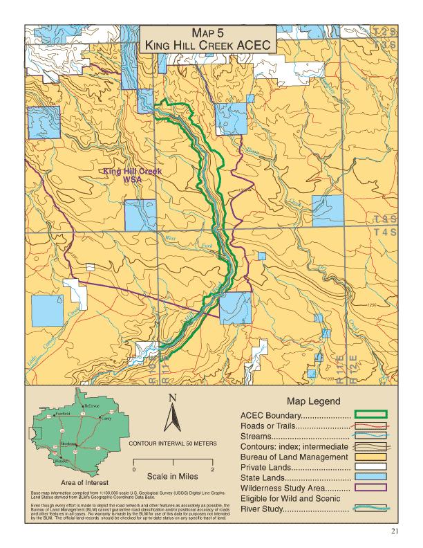
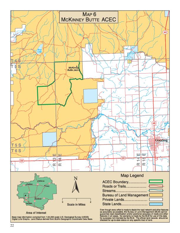
29 King Hill Creek ACEC/RNA Relevance: Extremely deep, vertical-walled canyon with scenic vegetation and geology. Genetically pure Interior redband trout, a BLM sensitive species. Near-pristine low elevation riparian area. Importance: Isolated, with spectacular scenery. Important source of Interior redband trout for reintroduction elsewhere. Important as a riparian reference area. Designate 10 miles (approximately 2,500 acres) of King Hill Creek as an ACEC/RNA, including approximately 840 acres managed by the Four Rivers Field Office - BLM (see Map 5, p. 21). Implement the following actions to highlight management of the scenic, fisheries, and riparian values within the ACEC: (a) Close all aquatic habitat in the King Hill Creek ACEC/RNA to introduction of genetic strains of trout which are not native to the King Hill Creek watershed. Petition the Idaho Department of Fish and Game to prohibit the introduction of genetic strains of trout into King Hill Creek which are not native to the King Hill Creek watershed. (b) Prevent noxious weed invasion by treating public lands adjacent to the ACEC and promptly treating existing and new weed infestations within the ACEC. (c) Exclude the ACEC from new land use authorizations (e.g., rights-of-way, R&PP Act leases, land use permits). (d) Close the ACEC to mineral material sales and free use permits. (e) Designate the ACEC/RNA as closed to motorized vehicle use. (f) Designate the ACEC as VRM Class I. (g) Authorize only those actions which maintain or improve desirable habitat conditions for redband trout. McKinney Butte ACEC/RNA Relevance: Outstanding cave scenery and examples of volcanism and lava tube formation. Significant hibernating populations of two bat species, both BLM sensitive species. Diverse cave-adapted insect community. Known paleontological resources, including remains of extinct or extirpated species. Importance: Unique variety, abundance, and undisturbed character of cave features. Hibernation habitat for significant numbers of a BLM sensitive species (Townsend s big-eared bat). Unusual plant and invertebrate communities. High potential of additional fossil resources. Designate 3,764 acres as the McKinney Butte ACEC/RNA to protect significant subsurface resources and focus use of the area on research and education (see Map 6, p. 22). Implement the following actions to highlight management of the identified scenic, wildlife, and cave values: (a) Prepare an activity plan for the McKinney Butte ACEC/RNA. The plan will incorporate limitations on any activity that may adversely impact physical, biological, or cultural resources; fire suppression guidelines; annual reporting procedures; physical protection measures; regulatory and/or interpretive signs; law enforcement; and Limits of Acceptable Change concepts to protect cave resource values. The Limits of Acceptable Change will be cave-specific and developed in consultation with affected user groups. (b) Continue to follow the provisions and guidance stated in the Upper Snake River District Cave Management Plan (USDI-BLM, 1999). [Note: The Cave Management Plan directs monitoring of cave resources and impacts. It includes direction to conduct comprehensive inventories of each cave s physical and structural makeup and biological life. Where needed to protect cave resources, special management actions will be implemented such as surface vehicular closures, marking travel routes through caves, installing bat gates, and requiring permits for visitor use. Law enforcement and public education strategies and actions are also discussed.] (c) Restrict access to the cave(s) containing bats during winter hibernation periods (October 15 through May 1), except for approved research or BLM management actions. Prohibit access to caves which provide maternity roosts from June 1 through August 31. (d) Close the ACEC to mineral Amendments ACEC Designations 19
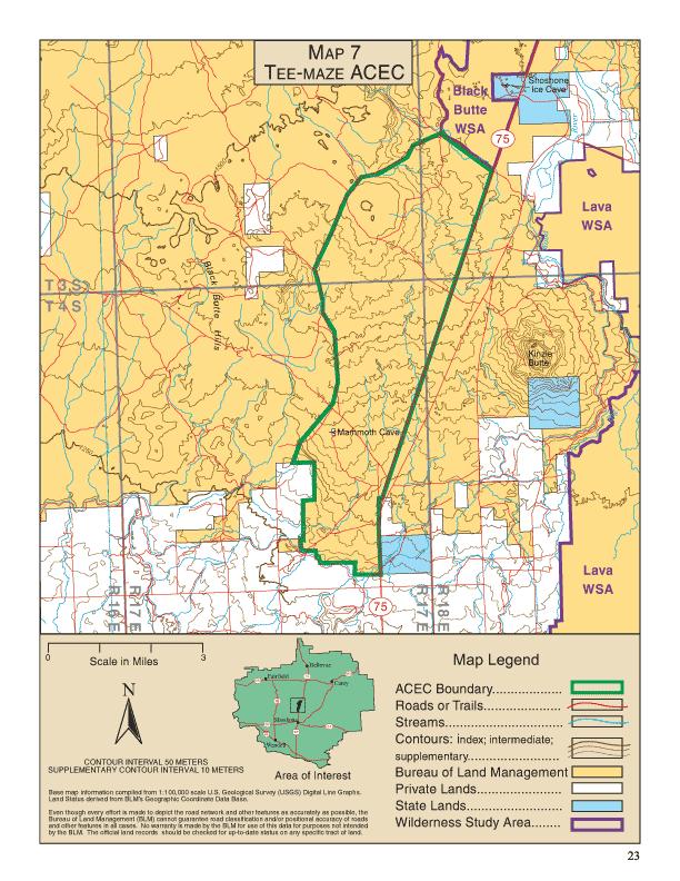
30 material sales and free use permits. (e) Limit vehicle use to designated and signed roads and trails. (f) Do not allow new land use authorizations (e.g., rights of way, R&PP leases, land use permits). (g) Designate a total of 13 caves as significant. Tee-Maze ACEC/RNA Relevance: Outstanding cave scenery and examples of volcanism and lava tube formation. Significant hibernating populations of two bat species, both BLM sensitive species. Diverse cave-adapted insect community. Known paleontological resources, including remains of extinct or extirpated species. Importance: Unique variety, abundance, and undisturbed character of cave features. Hibernation habitat for significant numbers of a BLM sensitive species (Townsend s big-eared bat). Unusual plant and invertebrate communities. High potential of additional fossil resources. Designate 10,762 acres as the Tee-Maze ACEC/RNA to protect significant subsurface resources and focus use of the area on research and education (see Map 7, p. 23). Implement the following actions to highlight management of the identified scenic, wildlife, and cave values: (a) Prepare an activity plan for the Tee-Maze ACEC/RNA. The plan will incorporate limitations on any activity that may adversely impact physical, biological, or cultural resources; fire suppression guidelines; annual reporting procedures; physical protection measures; regulatory and/or interpretive signs; law enforcement; and Limits of Acceptable Change concepts to protect cave resource values. The Limits of Acceptable Change will be cave-specific and developed in consultation with affected user groups. (b) Continue to follow the provisions and guidance stated in the Upper Snake River District Cave Management Plan (USDI-BLM, 1999). [Note: The Cave Management Plan directs monitoring of cave resources and impacts. It includes direction to conduct comprehensive inventories of each cave s physical and structural makeup and biological life. Where needed to protect cave resources, special management actions will be implemented such as surface vehicular closures, marking travel routes through caves, installing bat gates, and requiring permits for visitor use. Law enforcement and public education strategies and actions are also discussed.] (c) Restrict access to the cave(s) containing bats during winter hibernation periods (October 15 through May 1), except for approved research or BLM management actions. Prohibit access to caves which provide maternity roosts from June 1 through August 31. (d) Limit mineral material sales and free use permits to existing sites and public lands adjacent to State Highway 75. (e) Limit vehicle use to designated and signed roads and trails, except for (1) allowing the existing stackable blocky lava rock permit holder to continue to have cross-country access to his permitted area for the duration of his permit, and (2) allowing cross-country access within the Mammoth Cave Common Use Area. (f) Do not allow new land use authorizations (e.g., rights of way, R&PP leases, land use permits). (g) Designate a total of 12 caves as significant. 20 Shoshone Land Use Plans Amendments
31
32
33
A Presentation to the. Wyoming Solid Waste and Recycling Association (WSWRA) 2016 Annual Conference Agenda
 2016 Annual Conference Agenda") A Presentation to the Wyoming Solid Waste and Recycling Association (WSWRA) 2016 Annual Conference Agenda So you want to build a landfill? Then you re gonna need some land The Bureau of Land Management
A Presentation to the Wyoming Solid Waste and Recycling Association (WSWRA) 2016 Annual Conference Agenda So you want to build a landfill? Then you re gonna need some land The Bureau of Land Management
3.23 LANDS AND SPECIAL USES
 3.23 LANDS AND SPECIAL USES Introduction This section addresses those aspects of SJPLC management relating to public land ownership and use. Special Use Permits, rights-of-way (ROW) grants, easements,
Wood River Land Trust Staff Report
 Wood River Land Trust Staff Report Date: July 9, 2014 To: Board of Directors From: Staff, Keri York Regarding: MacConnell Agricultural Lands Easement Action Item Action Item: The item for consideration
Grand Mesa, Uncompahgre and Gunnison National Forests Region 2, USDA Forest Service
 Decision Memo Taylor River Land Exchange Under the General Exchange Act of March 20, 1922 as Amended, The Federal Land Policy and Management Act of 1976 as Amended and the Federal Land Exchange Facilitation
Georgia Conservation Tax Credit Program Frequently Asked Questions
 Georgia Conservation Tax Credit Program Frequently Asked Questions What are the minimum requirements for eligibility under the Georgia Conservation Tax Credit Program (GCTCP)? Individual and corporate
The Ironwood proclamation includes the same language and similar language is provided in the Military Lands Withdrawal Act of 1999, which states:
 Federal land withdrawals are only applicable to federal lands or interests in land and do not have jurisdiction over private or state properties including inholdings. Consider this excerpt from the Sonoan
Forest Service Role CHAPTER 2
 CHAPTER 2 Forest Service Role Implementation of the Management Plan charters a federal presence with an expanded focus beyond traditional Forest Service roles. In addition to administration of the National
[15XL LLIDI02000.L EO0000. LVTFD A ; IDI- Notice of Intent to Amend the Pocatello Resource Management Plan and Notice of
 This document is scheduled to be published in the Federal Register on 08/10/2015 and available online at http://federalregister.gov/a/2015-19606, and on FDsys.gov 4310-GG-P DEPARTMENT OF THE INTERIOR Bureau
PROJECT SCORING GUIDANCE. Introduction: National Proiect Selection:
 FOREST LEGACY PROGRAM PROJECT SCORING GUIDANCE Introduction: This document provides guidance to the National Review Panel on how to score individual Forest Legacy Program (FLP) projects, including additional
Nez Perce (Nee-Me-Poo) National Historic Trail. Land and Water Conservation Fund FY2015 Request
 National Historic Trail. Land and Water Conservation Fund FY2015 Request") Nez Perce (Nee-Me-Poo) FY2015 Request National Trails System FY2015 Nez Perce Henry s Lake, Idaho Project Details LWCF Request: $3,000,000 Congressional District: ID-2, Representative Michael Simpson Acres:
Nez Perce (Nee-Me-Poo) FY2015 Request National Trails System FY2015 Nez Perce Henry s Lake, Idaho Project Details LWCF Request: $3,000,000 Congressional District: ID-2, Representative Michael Simpson Acres:
RECITALS. B. WHEREAS, Ranch, its successors and assigns, are referred to in the Easement as the Grantor ; and
 Basic Components of Management Plans Associated with Conservation Easement Acquisitions Where A Land Trust Or other third party Is the Grantee April 17, 2012 Key: Text in normal font, without highlight,
Public Law th Congress An Act
 114 STAT. 2563 Public Law 106 538 106th Congress An Act To establish the Las Cienegas National Conservation Area in the State of Arizona. Be it enacted by the Senate and House of Representatives of the
ARTICLE XI - CONSERVATION SUBDIVISIONS
 ARTICLE XI - CONSERVATION SUBDIVISIONS Section 1101: Purpose and Intent. This Article is intended to provide for residential subdivisions that are designed based first and foremost on the preservation
H.R. 2157, to facilitate a land exchange involving certain National Forest System lands in the Inyo National Forest, and for other purposes.
 STATEMENT OF GREGORY SMITH ACTING DEPUTY CHIEF OF STAFF UNITED STATES DEPARTMENT OF AGRICULTURE BEFORE THE UNITED STATES HOUSE OF REPRESENTATIVES COMMITTEE ON NATURAL RESOURCES SUBCOMMITTEE ON NATIONAL
FINAL ENVIRONMENTAL IMPACT STATEMENT AND NEBRASKA NATIONAL FOREST REVISED LAND AND RESOURCE MANAGEMENT PLAN
 FINAL ENVIRONMENTAL IMPACT STATEMENT AND NEBRASKA NATIONAL FOREST REVISED LAND AND RESOURCE MANAGEMENT PLAN Record of Decision Oil and Gas Leasing NEBRASKA NATIONAL FOREST BUFFALO GAP NATIONAL GRASSLAND
Biodiversity Planning Policy and Guidelines for (LEP) Rezoning Proposals
 Rezoning Proposals") Council Policy Biodiversity Planning Policy and Guidelines for (LEP) Rezoning Proposals Table of Contents Table of Contents... 1 Policy... 2 Policy Objectives... 2 Policy Statement... 2 Guidelines... 2
Council Policy Biodiversity Planning Policy and Guidelines for (LEP) Rezoning Proposals Table of Contents Table of Contents... 1 Policy... 2 Policy Objectives... 2 Policy Statement... 2 Guidelines... 2
Environmental Assessment South Administrative Site Proposed Property Sale
 Department of Agriculture Forest Service June 2010 Environmental Assessment 6200 South Administrative Site Proposed Property Sale Uinta-Wasatch-Cache NF Salt Lake Ranger District Salt Lake County, Utah
Record of Decision Mt. Hood National Forest Geothermal Leases August Record of Decision. Mt. Hood National Forest Geothermal Leases
 Summary Record of Decision Mt. Hood National Forest Geothermal Leases USDA Forest Service Mt. Hood National Forest Hood River and Barlow Ranger Districts Hood River County, Oregon It is my recommendation
SEQRA (For Land Surveyors) Purpose of this Presentation
 Purpose of this Presentation") SEQRA (For Land Surveyors) Purpose of this Presentation Understand the basics and legal requirements of SEQRA Recognize the role that Land Surveyors play in the SEQRA Identify the problems posed by SEQRA
SEQRA (For Land Surveyors) Purpose of this Presentation Understand the basics and legal requirements of SEQRA Recognize the role that Land Surveyors play in the SEQRA Identify the problems posed by SEQRA
IRS FORM 8283 SUPPLEMENTAL STATEMENT DONATION OF CONSERVATION EASEMENT
 Name(s) shown on income tax return Identifying Number Robert T. Landowner 021-34-1234 Susan B. Landowner 083-23-5555 IRS FORM 8283 SUPPLEMENTAL STATEMENT DONATION OF CONSERVATION EASEMENT On November 12,
MIDWAY CITY Municipal Code
 MIDWAY CITY Municipal Code TITLE 9 ANNEXATION CHAPTER 9.01 PURPOSE CHAPTER 9.02 GENERAL REQUIREMENTS CHAPTER 9.03 PROPERTY OWNER INITIATION OF ANNEXATION CHAPTER 9.04 PROCEDURES FOR CONSIDERATION OF PETITION
FINDING OF NO SIGNIFICANT IMPACT TENNESSEE VALLEY AUTHORITY DISPOSAL FEE OWNERSHIP OF YELLOW CREEK INDUSTRIAL PARK PROPERTIES
 FINDING OF NO SIGNIFICANT IMPACT TENNESSEE VALLEY AUTHORITY DISPOSAL FEE OWNERSHIP OF YELLOW CREEK INDUSTRIAL PARK PROPERTIES In 1971, the Tennessee Valley Authority (TVA) partnered with the Mississippi
IMPLEMENTING AGREEMENT. for the EAST CONTRA COSTA COUNTY HABITAT CONSERVATION PLAN/ NATURAL COMMUNITY CONSERVATION PLAN.
 IMPLEMENTING AGREEMENT for the EAST CONTRA COSTA COUNTY HABITAT CONSERVATION PLAN/ NATURAL COMMUNITY CONSERVATION PLAN by and between EAST CONTRA COSTA COUNTY HABITAT CONSERVANCY, COUNTY OF CONTRA COSTA,
ORDINANCE NO. 875 (AS AMENDED THROUGH 875
 ORDINANCE NO. 875 (AS AMENDED THROUGH 875.1) AN ORDINANCE OF THE COUNTY OF RIVERSIDE TO ESTABLISH A LOCAL DEVELOPMENT MITIGATION FEE FOR FUNDING THE PRESERVATION OF NATURAL ECOSYSTEMS IN ACCORDANCE WITH
For the reasons set forth in the preamble, the Department proposes to amend 25 CFR 151
 For the reasons set forth in the preamble, the Department proposes to amend 25 CFR 151 as follows: 1. Revise Part 151 of Title 25 of the Code of Federal Regulations to read as follows: PART 151 LAND ACQUISITION
Central Pennsylvania Conservancy Project Selection Criteria Form
 Central Pennsylvania Conservancy Project Selection Criteria Form The following criteria guide the actions of the Central Pennsylvania Conservancy s Land Protection Committee and Board of Directors in selecting
Agricultural Lease Bid Process and Policy Updated September 21, 2017
 Agricultural Lease Bid Process and Policy Updated September 21, 2017 Introduction: Pitkin County Open Space & Trails (OST) was established by the voters of Pitkin County in 1990 with the following mission;
Title 5: ADMINISTRATIVE PROCEDURES AND SERVICES
 Title 5: ADMINISTRATIVE PROCEDURES AND SERVICES Chapter 353: LAND FOR MAINE'S FUTURE Table of Contents Part 15-A. LAND FOR MAINE'S FUTURE... Section 6200. FINDINGS... 3 Section 6201. DEFINITIONS... 3 Section
Submittal of the Minutes from the March 9, 2011, April 5, 2011, and April 19, 2011 Cabinet Meetings.
 AGENDA BOARD OF TRUSTEES OF THE INTERNAL IMPROVEMENT TRUST FUND JUNE 16, 2011 Attachments to the items below can be viewed at the following link: http://www.dep.state.fl.us/secretary/cab/public_notices.htm
Cadastral Data Content Standard - Rights and Interests
 Background Concepts Rights and Interests - Regulations and Restrictions In the Cadastral Data Content Standard Version 2 - June 30, 2014 A review of the content and background Nancy von Meyer Rights and
CHALLENGES IN MANAGING MULTIPLE USE LANDS & TOOLS TO ENABLE SUCCESS
 CHALLENGES IN MANAGING MULTIPLE USE LANDS & TOOLS TO ENABLE SUCCESS Rocky Mountain Land Use Institute Conference March 13, 2015 Susan Culp Principal, NextWest Consulting, LLC Challenges to Achieving Conservation
Chapter 100 Planned Unit Development in Corvallis Urban Fringe
 100.100 Scope and Purpose. Chapter 100 Planned Unit Development in Corvallis Urban Fringe (1) All applications for land divisions in the Urban Residential (UR) and Flood Plain Agriculture (FPA) zones within
Introduction to INRMP Implementation Options
 El Dorado County Integrated Natural Resources Management Plan Introduction to INRMP Implementation Options 1 Our approach to the options evaluation is based on the INRMP components as they are currently
Conservation Easement Stewardship
 Conservation Easements are effective tools to preserve significant natural, historical or cultural resources. Conservation Easement Stewardship Level of Service Standards March 2013 The mission of the
Horse Gulch Management Plan Final Draft: April 18, 2013
 I. INTRODUCTION This Plan provides a framework for the sound stewardship of the City of Durango Horse Gulch open space area. The Plan includes baseline information regarding the area, management objectives
CITY OF FORT COLLINS NATURAL AREAS AND CONSERVED LANDS EASEMENT POLICY
 CITY OF FORT COLLINS NATURAL AREAS AND CONSERVED LANDS EASEMENT POLICY Adopted January 3, 2012 PURPOSE: The purpose of the policy statement is to clarify the policies and procedures of the City of Fort
DRAFT FOR PUBLIC HEARING (rev. March, 2016)
") Chapter 200. ZONING Article VI. Conservation/Cluster Subdivisions 200-45. Intent and Purpose These provisions are intended to: A. Guide the future growth and development of the community consistent with
Chapter 200. ZONING Article VI. Conservation/Cluster Subdivisions 200-45. Intent and Purpose These provisions are intended to: A. Guide the future growth and development of the community consistent with
Washoe Public Lands Management Act TITLE I FEDERAL LAND DISPOSAL
 Washoe Public Lands Management Act TITLE I FEDERAL LAND DISPOSAL SEC. 101. DEFINITIONS. (a) Secretary. The term Secretary means (1) the Secretary of Agriculture with respect to land in the National Forest
Subtitle H Agricultural Conservation Easement Program
 1 1 1 1 1 1 0 1 0 1 0 Subtitle H Agricultural Conservation Easement Program SEC.. [1 U.S.C. ] ESTABLISHMENT AND PURPOSES. (a) Establishment. The Secretary shall establish an agricultural conservation easement
Antelope Ridge Wind Farm Habitat Mitigation Plan November 2011
 Antelope Ridge Wind Farm Habitat Mitigation Plan November 2011 I. Introduction The Antelope Ridge Wind Farm will be constructed in two phases, in the locations as shown on the attached map, Exhibit A.
SALE OF PUBLIC LAND IN ALBERTA RECOMMENDATIONS FOR IMPROVING REGULATION, POLICY AND PROCEDURES
 SALE OF PUBLIC LAND IN ALBERTA RECOMMENDATIONS FOR IMPROVING REGULATION, POLICY AND PROCEDURES 1. Introduction The recent application to government for sale of 25 sections of public land that would see
. Federal Land Transaction Facilitation Act: Operation and Issues for Congress Carol Hardy Vincent Specialist in Natural Resources Policy June 13, 201
 Federal Land Transaction Facilitation Act: Operation and Issues for Congress Carol Hardy Vincent Specialist in Natural Resources Policy June 13, 2011 Congressional Research Service CRS Report for Congress
OPEN SPACE & RECREATION PLAN
 OPEN SPACE & RECREATION PLAN HOPEWELL TOWNSHIP Cumberland County, New Jersey Prepared by: Hopewell Township Environmental Commission Final October 2011 (THIS PAGE INTENTIONALLY LEFT BLANK) PUBLIC MEETINGS
Annutteliga Hammock Project Surplus and Consolidation Strategy
 Project Overview Annutteliga Hammock is a 31,250-acre partnership acquisition project of the Florida Forever program, of which 12,231 acres have been acquired to date. The intent of the project is to provide
Nevada Public Land Management Task Force Final Report, SJR 1 of the 78 th Nevada Legislature and Implementation through Federal Legislation
 Nevada Public Land Management Task Force Final Report, SJR 1 of the 78 th Nevada Legislature and Implementation through Federal Legislation Churchill County Public Meeting Churchill County Commission Chamber
COMMUNITY PRESERVATION ACT Town of Hatfield OPEN SPACE PROJECT GUIDELINES
 COMMUNITY PRESERVATION ACT Town of Hatfield OPEN SPACE PROJECT GUIDELINES CPA Open Space Projects: The Act requires that a participating community shall spend, or set aside for later spending, not less
Article 3 - Rural Districts
 rticle 3 - Rural Districts Div. 3.1. -40: griculture 40 (OI Only) 3-2 3.1.1. Intent... 3-2 3.1.2. Lot Dimensions... 3-2 3.1.3. uilding Placement... 3-3 3.1.4. uilding Height... 3-3 Div. 3.2. -20: griculture
Marin County Agricultural Land Conservation Program March 1, 2014
 Marin County Agricultural Land Conservation Program March 1, 2014 I. Purpose of this Document This document describes the Marin County Agricultural Land Conservation Program (County Program). The Marin
DEPARTMENT OF THE ARMY OFFICE OF THE CHIEF OF ENGINEERS WASHINGTON, D.C
 DEPARTMENT OF THE ARMY OFFICE OF THE CHIEF OF ENGINEERS WASHINGTON, D.C. 20314-1000 REPLY TO ATTENTION OF: CECW-PM (10-1-7a) THE SECRETARY OF THE ARMY 1. I submit for transmission to Congress my report
South Sacramento Habitat Conservation Plan Nexus Study
 South Sacramento Habitat Conservation Plan Nexus Study Prepared for: SSHCP Plan Partners Prepared by: Economic & Planning Systems, Inc. April 5, 2018 EPS #161005 Table of Contents 1. INTRODUCTION AND MITIGATION
Transfer of Development Rights
 Ordinance Transfer of Development Rights King County s (WA) 2008 ordinance establishes a transfer of development rights program. The ordinance: Sets eligibility criteria for sending and receiving sites
LLC & MLLC Property Bismark Meadows Bonner County, Idaho
 Vital Ground Property Management Plan LLC & MLLC Property Bismark Meadows Bonner County, Idaho December 10, 2009 (updated 2/12/13) Ryan Lutey The Vital Ground Foundation Building T-2, Fort Missoula Road
USDI, Bureau of Land Management Burns District Hwy 20 West Hines, OR 97738
 USDI, Bureau of Land Management Burns District 28910 Hwy 20 West Hines, OR 97738 FINDING OF NO SIGNIFICANT IMPACT and DECISION RECORD for OR-60154-PT and OR-60154-FD, Rock Creek Ranch, Inc. (Gary Miller)
RESIDENTIAL AND RECREATIONAL
 Energy, Mines & Resources Land Management Branch 320-300 Main Street Whitehorse, Yukon Y1A 2B5 667-5215 Fax 667-3214 www.emr.gov.yk.ca RESIDENTIAL AND RECREATIONAL Lot Enlargement Policy OBJECTIVE To facilitate
Establishment of Swan Valley Conservation Area, Montana. SUMMARY: This notice advises the public that the U.S. Fish and Wildlife Service
 This document is scheduled to be published in the Federal Register on 01/15/2013 and available online at http://federalregister.gov/a/2013-00658, and on FDsys.gov Billing Code 4310-55 DEPARTMENT OF THE
MARK TWAIN LAKE MASTER PLAN CLARENCE CANNON DAM AND MARK TWAIN LAKE MONROE CITY, MISSOURI
 MARK TWAIN LAKE MASTER PLAN CLARENCE CANNON DAM AND MARK TWAIN LAKE MONROE CITY, MISSOURI CHAPTER 4 LAND ALLOCATION, LAND CLASSIFICATION, WATER SURFACE, AND EASEMENT LANDS This Master Plan is a land use
Colorado Parks and Wildlife. Acquisition Selection for the Colorado Wildlife Habitat Protection Program
 Colorado Parks and Wildlife Acquisition Selection for the Colorado Wildlife Habitat Protection Program State Wildlife Action Plan and CPW s Strategic Plan: *Conserve wildlife and habitat to ensure healthy
February 2, 2012 BOARD MATTER C - 1 WYOMING LAND AND IMPROVEMENT COMPANY, PROPOSAL TO ACQUIRE REAL PROPERTY IN ALBANY COUNTY, WYOMING
 February 2, 2012 BOARD MATTER C - 1 ACTION: WYOMING LAND AND IMPROVEMENT COMPANY, PROPOSAL TO ACQUIRE REAL PROPERTY IN ALBANY COUNTY, WYOMING AUTHORITY: W.S. 9-4-715(k); Rules Chapter 26, Section 3 ALTERNATIVES:
Sample Baseline Documentation Report (BDR) Annotated Template for Environmentally Important Land
 Annotated Template for Environmentally Important Land") Sample Baseline Documentation Report (BDR) Annotated Template for Environmentally Important Land The baseline documentation report (BDR) provides a snap shot of the biophysical condition of a property
Sample Baseline Documentation Report (BDR) Annotated Template for Environmentally Important Land The baseline documentation report (BDR) provides a snap shot of the biophysical condition of a property
APPENDIX B COMPLIANCE WITH THE GOVERNMENT CODE
 APPENDIX B COMPLIANCE WITH THE GOVERNMENT CODE A. GENERAL PLAN AMENDMENT PROCEDURE In general, local governments may not amend any of the mandatory elements of the General Plan (e.g. Land Use, Open Space,
Wildlife Habitat Conservation and Management Program
 EXHIBIT 1 PC-2015-4106 ODFW Guide Wildlife Habitat Conservation and Management Program Manual for Counties and Cities Oregon Department of Fish and Wildlife March 2006 Table of Contents 1. Introduction
SPECIAL PUBLIC NOTICE
 SPECIAL PUBLIC NOTICE U.S. ARMY CORPS OF ENGINEERS BUILDING STRONG LOS ANGELES DISTRICT APPLICATION FOR PERMIT Coachella Valley In-Lieu Fee Program Public Notice/Application No.: SPL-2013-00324-TOB Project:
DRAFT Decision Notice and Finding of No Significant Impact
 United States Department of Agriculture Forest Service December 2014 DRAFT Decision Notice and Finding of No Significant Impact Town of Manila Land Conveyance (Manila Landfill) Flaming Gorge Ranger District,
NANTUCKET ISLANDS LAND BANK AFFORDABLE HOUSING POLICY Adopted by the vote of the Land Bank Commission on November 10, 2015
 NANTUCKET ISLANDS LAND BANK AFFORDABLE HOUSING POLICY Adopted by the vote of the Land Bank Commission on November 10, 2015 In recent history, the island of Nantucket has experienced a shortage of affordable,
STATE OF NEW MEXICO COUNTY OF EDDY ORDINANCE NO: 41 LAND USE POLICIES AND PROCEDURES FOR FEDERAL, STATE AND COUNTY
 STATE OF NEW MEXICO COUNTY OF EDDY ORDINANCE NO: 41 LAND USE POLICIES AND PROCEDURES FOR FEDERAL, STATE AND COUNTY WHEREAS, the County of Eddy, New Mexico, acting by and through its duly elected Board
CHAPTER 3: IDENTIFYING SECTION 4(f) PROPERTIES
 PROPERTIES") CHAPTER 3: IDENTIFYING SECTION 4(f) PROPERTIES Section 4(f) and its provisions state that publicly owned parks, recreation areas, wildlife and waterfowl refuges, and publicly and privately owned historic
CHAPTER 3: IDENTIFYING SECTION 4(f) PROPERTIES Section 4(f) and its provisions state that publicly owned parks, recreation areas, wildlife and waterfowl refuges, and publicly and privately owned historic
4. If any perennial surface water passes through or along the property lines of the acreage, a minimum of 200 feet or frontage should be required.
 b. Provide adequate acreage for appropriate productive use of rural residential land, such as small numbers of livestock, large gardens, etc. 3. Minimum of 200 feet of frontage on an improved county or
Thurston County Planning Department BOARD OF COUNTY COMMISSIONERS PUBLIC HEARING DRAFT AMENDMENTS TO THE CRITICAL AREAS REGULATIONS. Chapter 24.
 Thurston County Planning Department BOARD OF COUNTY COMMISSIONERS PUBLIC HEARING DRAFT AMENDMENTS TO THE CRITICAL AREAS REGULATIONS Chapter 24.01 GENERAL PROVISIONS Chapter 24.01 6/4/2012 GENERAL PROVISIONS
43 USC NB: This unofficial compilation of the U.S. Code is current as of Jan. 4, 2012 (see
 TITLE 43 - PUBLIC LANDS CHAPTER 35 - FEDERAL LAND POLICY AND MANAGEMENT SUBCHAPTER II - LAND USE PLANNING AND LAND ACQUISITION AND DISPOSITION 1716. Exchanges of public lands or interests therein within
Yolo Habitat Conservancy County of Yolo City of Davis City of Winters City of West Sacramento City of Woodland University of California, Davis
 Yolo Habitat Conservancy County of Yolo City of Davis City of Winters City of West Sacramento City of Woodland University of California, Davis Science & Technical Advisory Committee (STAC) Operational
December 21, The specific provisions of P.L that apply solely to the CDCA are:
 United States Department of the Interior BUREAU OF LAND MANAGEMENT California State Office 2800 Cottage Way, Suite W1623 Sacramento, CA 95825 www.blm.gov/ca December 21, 2012 In Reply Refer To: 4100 (CA930)
Chapter XX Purchase of Development Rights Program
 Chapter XX Purchase of Development Rights Program Short Title. This ordinance is to be known and may be cited as the Purchase of Development Rights ( PDR ) Program. Purpose Pursuant to the authority granted
Validation Checklist. Date submitted: How to use this check-list. Ecosystem Credit Accounting System. Version 1.1&2. Project Information
 Ecosystem Credit Accounting System Version 1.1&2 Last updated April 21, 2017 Validation Checklist Date submitted: Project Information Project Name Trading Area Name Trading Area Type (e.g., TMDL, TNC Ecoregion)
Chapter 10 Local Protection Measures
 The DPC fully supports the protection of private property rights and the DPC will work to ensure that there will be no negative impacts stemming from NHA activities on private property, should the designation
Land Use. Existing Land Use
 8 Land Use 8.1 Land Use Chapter Purpose and Contents This element includes a brief summary of existing land use conditions and trends followed by a series of goals, objectives, and recommendations to guide
( ) Ordinance. Environmental Resources Management
 Ordinance. Environmental Resources Management") PALM BEACH COUNTY BOARD OF COUNTY COMMISSIONERS AGENDA ITEM SUMMARY Agenda Item #:5 I/" 3 Meeting Date: April 1,2008 ( ) Consent Department Submitted By: Submitted For: ( ) Ordinance Environmental Resources
PALM BEACH COUNTY BOARD OF COUNTY COMMISSIONERS AGENDA ITEM SUMMARY Agenda Item #:5 I/" 3 Meeting Date: April 1,2008 ( ) Consent Department Submitted By: Submitted For: ( ) Ordinance Environmental Resources
Environment and Natural Resources Trust Fund Request for Proposals (RFP)
") Environment and Natural Resources Trust Fund 2012-2013 Request for Proposals (RFP) Project Title: Southeast Minnesota Sensitive Habitat Protection Program (SHPP) ENRTF ID: 067-D Topic Area: D. Land Acquisition
Environment and Natural Resources Trust Fund 2012-2013 Request for Proposals (RFP) Project Title: Southeast Minnesota Sensitive Habitat Protection Program (SHPP) ENRTF ID: 067-D Topic Area: D. Land Acquisition
SECTION 6 SUBAREA PLAN IMPLEMENTATION POLICIES
 SECTION 6 SUBAREA PLAN IMPLEMENTATION POLICIES This section describes subarea plan implementation actions to be taken by the City of Escondido. These actions are specific to the city and are supplemental
Implementation of Permanent Easements and Associated Nutrient Load Reductions
 1 Minnesota Nutrient Reduction Strategy Agricultural Sector/BWSR RIM Program Measure Implementation of Permanent and Associated Nutrient Load Reductions Measure Background Visual Depiction The map in Figure
Open Space Preservation Program
 Open Space Preservation Program Open Space Purchase of Development Right Program Deadline: June 1, 2016 at 11:00 a.m. Ingham County Purchasing Department c/o Farmland and Open Space Preservation Board
Draft Zoning Changes for the 2nd Planning Board Public Hearing, January 22, 2018.
 Draft Zoning Changes for the 2nd Planning Board Public Hearing, January 22, 2018. No changes were made at the 1st Public Hearing. Proposed wording for the 1 st Public Hearing in red, eliminated text in
Appendix A Major Federal, State, and Local Permits or Approvals
 TransWest Express EIS Appendix A Major Federal, State, and Local s or Approvals TransWest Express EIS Appendix A A-1 FEDERAL National Environmental Policy Act (NEPA) Compliance Federal action: to grant
Corporate Services Planning and Economic Development. Memorandum
 Corporate Services Planning and Economic Development Memorandum TO: FROM: Committee of the Whole Paul Freeman, Chief Planner DATE: June 21, 2018 RE: York Region C omments on Draft Provinci al Guidance
CHAUTAUQUA COUNTY LAND BANK CORPORATION
 EXHIBIT H CHAUTAUQUA COUNTY LAND BANK CORPORATION LAND ACQUISITION AND DISPOSITION POLICIES AND PRIORITIES November 14, 2012 *This document is intended to provide guidance to the Chautauqua County Land
Thurston County Planning Department PUBLIC HEARING DRAFT. AMENDMENTS TO THE CRITICAL AREAS REGULATIONS Chapter /18/2011 GENERAL PROVISIONS
 Thurston County Planning Department PUBLIC HEARING DRAFT AMENDMENTS TO THE CRITICAL AREAS REGULATIONS Chapter 24.01 11/18/2011 Chapter 24.01 GENERAL PROVISIONS GENERAL PROVISIONS Sections: 24.01.005 Short
EXHIBIT G. Exhibit G - Page 1 RVPUB/MO/655751
 EXHIBIT G AN ORDINANCE OF THE CITY COUNCIL OF THE CITY OF TO ESTABLISH A LOCAL DEVELOPMENT MITIGATION FEE FOR FUNDING THE PRESERVATION OF NATURAL ECOSYSTEMS IN ACCORDANCE WITH THE WESTERN RIVERSIDE COUNTY
Chapter 210 CONDITIONAL USES
 Chapter 210 CONDITIONAL USES 210.01 Purpose 210.02 Authorization 210.03 Process Type 210.04 Determination of Major or Minor Conditional Use Review 210.05 Approval Criteria 210.06 Conditions of Approval
CONSERVATION EASEMENTS & OIL AND GAS DEVELOPMENT
 CONSERVATION EASEMENTS & OIL AND GAS DEVELOPMENT HOW THE TWO CAN COEXIST Colorado Cattlemen s Agricultural Land Trust (CCALT) o Founded 1995 o First land trust founded by a livestock association o 6 other
CHAPTER 8. IMPLEMENTATION COSTS AND FUNDING SOURCES
 0 0 0 CHAPTER. IMPLEMENTATION COSTS AND FUNDING SOURCES. INTRODUCTION The Endangered Species Act (ESA) requires that habitat conservation plans specify the funding that will be available to implement actions
West Virginia Outdoor Heritage Conservation Fund. Grant Program TECHNICAL ASSISTANCE MANUAL
 West Virginia Outdoor Heritage Conservation Fund Grant Program TECHNICAL ASSISTANCE MANUAL Please Note: 1. All applicants are advised to read this manual prior to even starting on a grant application.
COASTAL CONSERVANCY. Staff Recommendation January 18, Carmel River Parkway Acquisitions. File No Project Manager: Trish Chapman
 COASTAL CONSERVANCY Staff Recommendation January 18, 2006 Carmel River Parkway Acquisitions File No. 06-104 Project Manager: Trish Chapman RECOMMENDED ACTION: Authorization to disburse up to $3,500,000
STAFF REPORT. Permit Number: Porter. Kitsap County Board of Commissioners; Kitsap County Planning Commission
 STAFF REPORT Permit Number: 15 00461 Porter DATE: November 9, 2015 TO: FROM: Kitsap County Board of Commissioners; Kitsap County Planning Commission Katrina Knutson, AICP, Senior Planner, DCD and Jeff
[LLCAD01000 L EU0000 XXXL5017AP LVRWB11B4700] Notice of Availability of the Environmental Assessment and Draft Land Use Plan
![[LLCAD01000 L EU0000 XXXL5017AP LVRWB11B4700] Notice of Availability of the Environmental Assessment and Draft Land Use Plan](/thumbs/90/104489717.jpg "[LLCAD01000 L EU0000 XXXL5017AP LVRWB11B4700] Notice of Availability of the Environmental Assessment and Draft Land Use Plan") This document is scheduled to be published in the Federal Register on 11/05/2018 and available online at https://federalregister.gov/d/2018-24175, and on govinfo.gov 4310-40 DEPARTMENT OF THE INTERIOR
This document is scheduled to be published in the Federal Register on 11/05/2018 and available online at https://federalregister.gov/d/2018-24175, and on govinfo.gov 4310-40 DEPARTMENT OF THE INTERIOR
Conservation Design Subdivisions
 Conservation Design Subdivisions An excerpt from the Rules and Regulations Governing Division of Land in Sheridan County, Wyoming, November 5, 2010 Sheridan County Public Works Department 224 S. Main Street
Torch Lake Township Antrim County, Michigan
 Torch Lake Township Antrim County, Michigan Farmland and Open Space Development Rights Ordinance Ordinance No. 04-01 Effective September 3, 2004 AN ORDINANCE creating a farmland and open space protection
RULES OF THE TENNESSEE DEPARTMENT OF ENVIRONMENT AND CONSERVATION DIVISION OF WATER RESOURCES ABANDONED MINE LANDS RECLAMATION PROGRAM
 RULES OF THE TENNESSEE DEPARTMENT OF ENVIRONMENT AND CONSERVATION DIVISION OF WATER RESOURCES 0400-44-01 ABANDONED MINE LANDS RECLAMATION PROGRAM TABLE OF CONTENTS 0400-44-01-.01 Scope 0400-44-01-.09 Methods
Environmental Assessment
 United States Department of Agriculture Forest Service September 2013 Environmental Assessment Hotchkiss Reservoir Land Exchange Norwood Ranger District Grand Mesa, Uncompahgre, and Gunnison National Forests
13308 West Highway 160 Del Norte, CO TTY
 USDA Forest Service Divide Ranger District http://www.fs.fed.us/r2/riogrande 13308 West Highway 160 Del Norte, CO 81132 719-657-3321 TTY 657-6038 USDI Bureau of Land Management San Luis Resource Area File
Notice of Continuance Land Classified as Current Use or Forest Land RCW Chapter and 84.33
 When Recorded Return to: Notice of Continuance Land Classified as Current Use or Forest Land RCW Chapter 84.34 and 84.33 Grantor(s)/Sellers: Grantee(s)/Buyers: Mailing Address: City, State, Zip: Assessor
BY BOARD OF COUNTY COMMISSIONERS AN ACT TO BE ENTITLED
 BY BOARD OF COUNTY COMMISSIONERS ORDINANCE NO. AN ACT TO BE ENTITLED AN ORDINANCE AMENDING THE PASCO COUNTY LAND DEVELOPMENT CODE, ARTICLE 700, BY REPEALING EXISTING SECTION 702, ENVIRONMENTALLY SENSITIVE