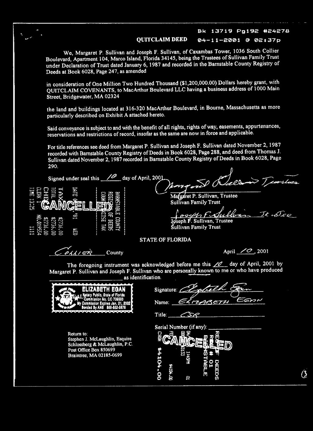
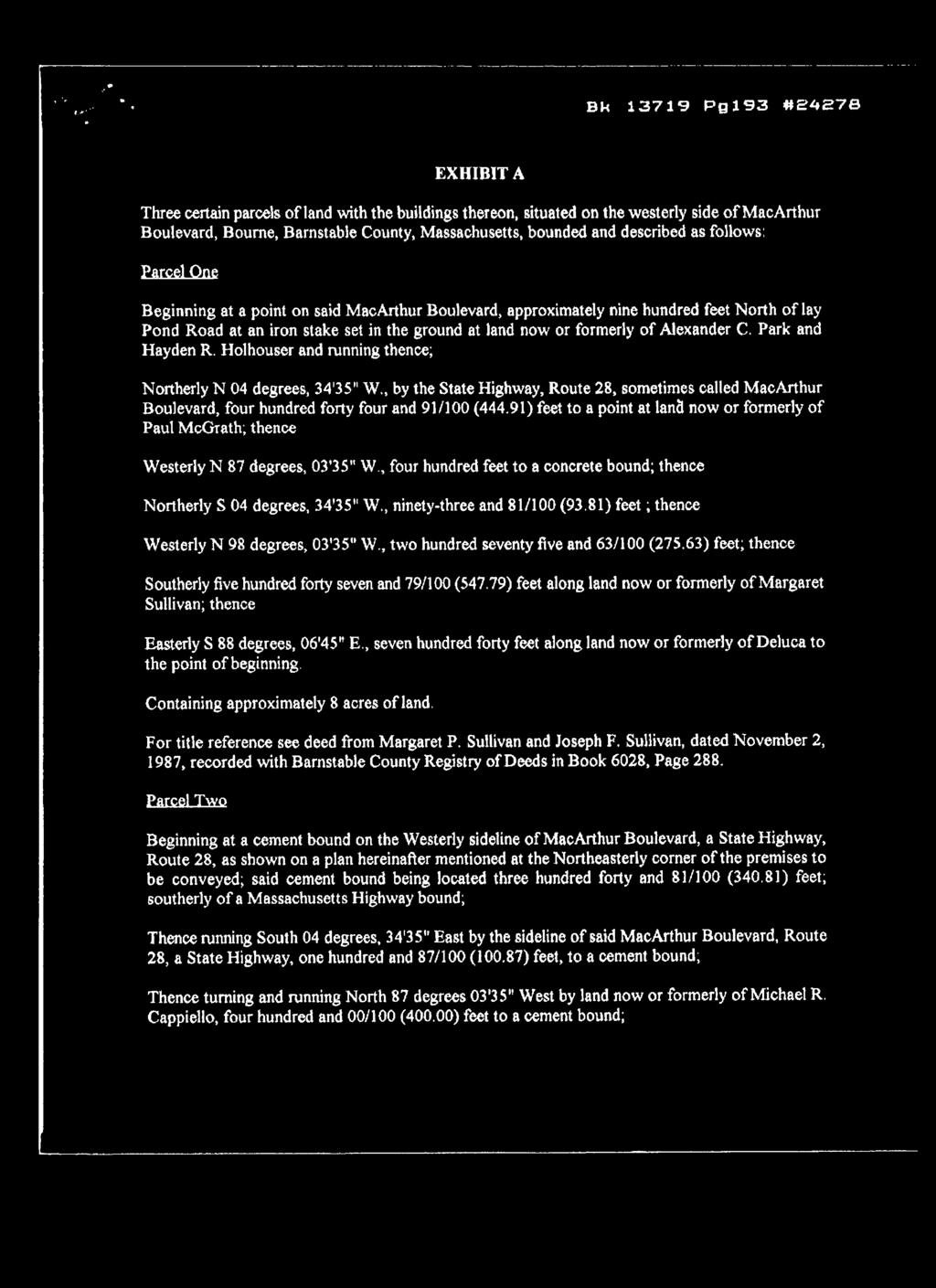
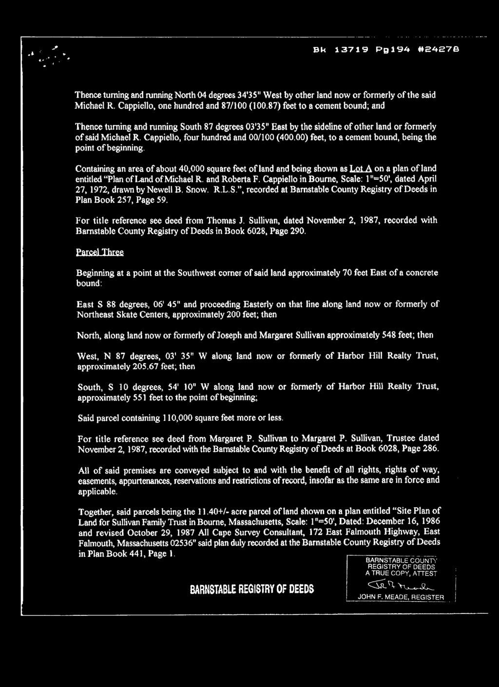
11.3 Acres of Commercial Land MacArthur Blvd., Bourne, MA
|
|
|
- Lucas Payne
- 6 years ago
- Views:
Transcription

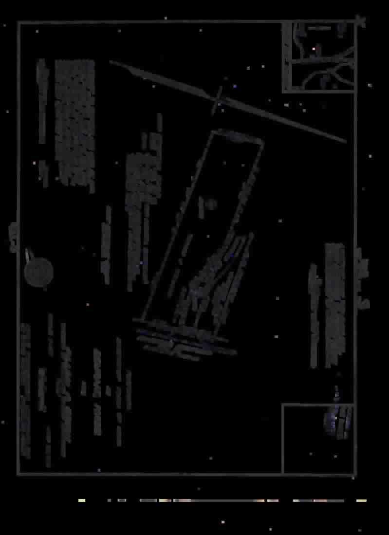
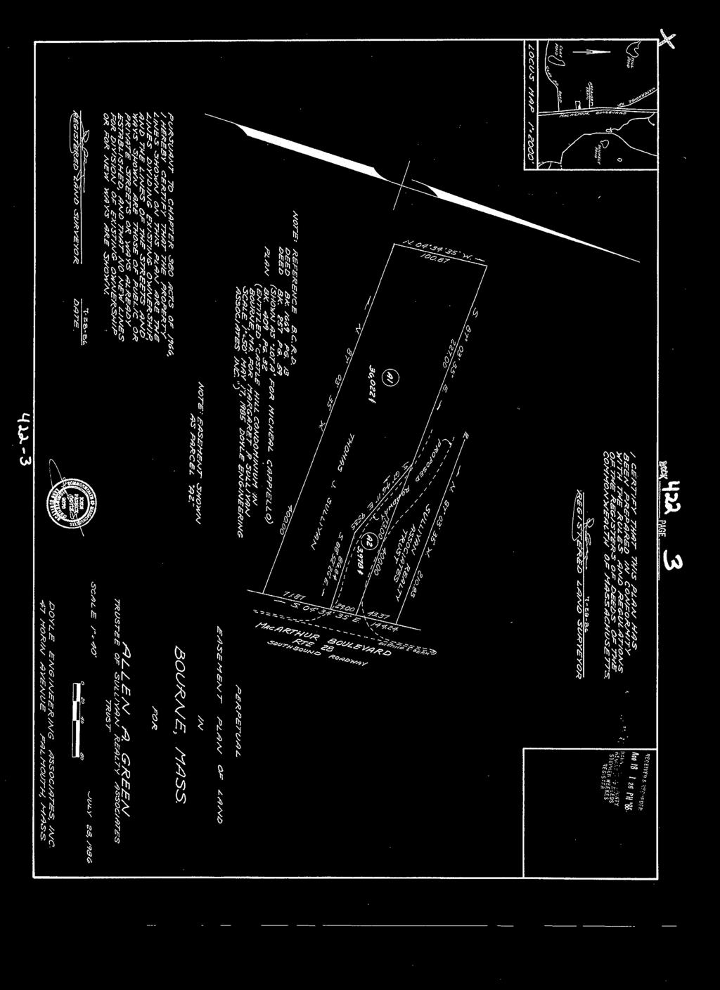
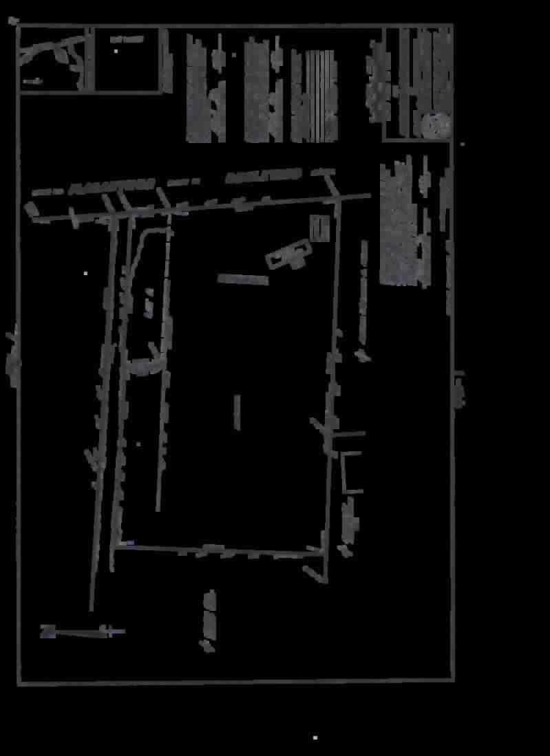
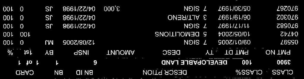
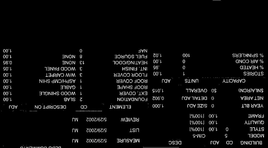
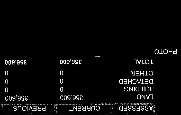
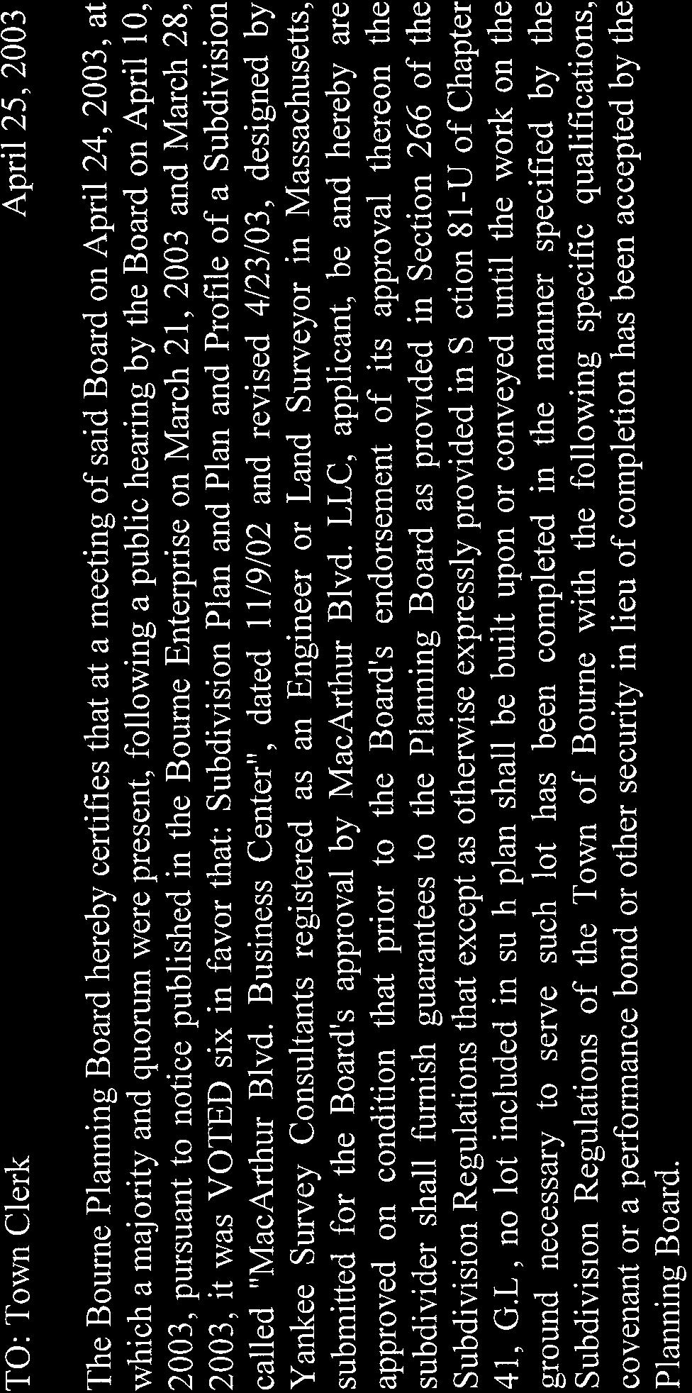
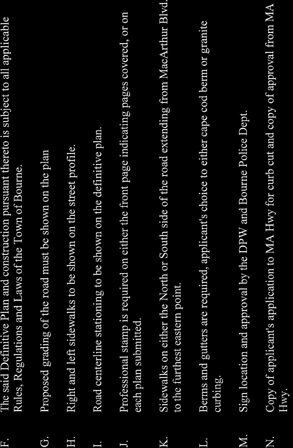
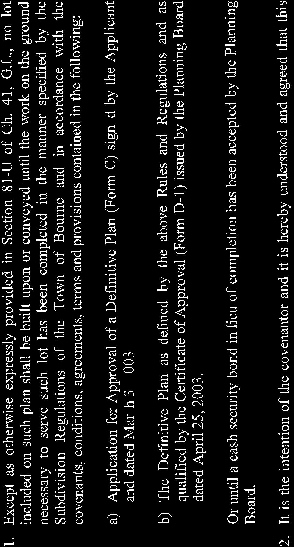
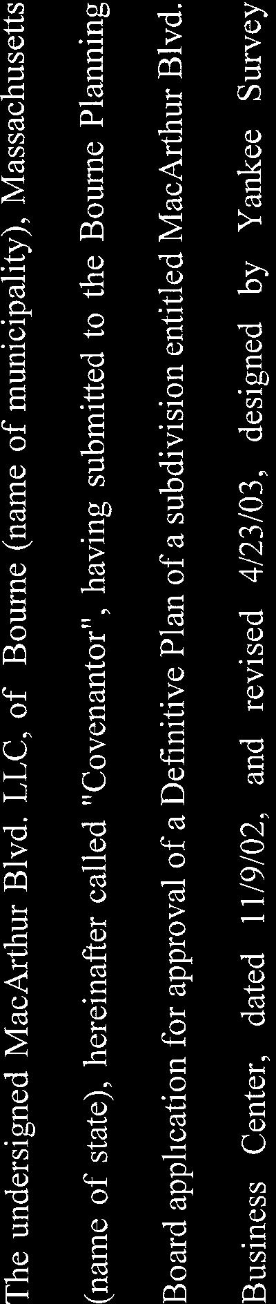
1 11.3 Acres of Commercial Land MacArthur Blvd., Bourne, MA Land Area: 11.3 Acres, Previous Subdivision Approval for 9 Lots in Now Expired (Motor Way). Subdivision Possible. Utilities: Electric, Septic, Natural Gas, Municipal Water. Zoning: B-4. Land is Located Outside of Ground Water Protection District. Real Estate Taxes: $20, Traffic Counts: Estimated 23,000+ Cars per Day Southbound on Route 28. For $3,200,000 Contact: Michael Giancola, SIOR mgiancola@ccim.net Largest Land Site Available on the Upper Cape! Buyer can Re-File for the Previous Nine Lot Subdivision With Minor Modifications to the Existing Plans. Automotive, Commercial, Industrial, Retail Uses All Possible. 4 Minutes to the Bourne Bridge. Seller May be Willing to Subdivide. Southeast Commercial Real Estate, Inc. No warranty or representation, express or implied, is made as to the accuracy of the information contained herein, and same is submitted subject to errors, omissions or withdrawals without notice.
2 * Potential Sub-Division Plan. Previous Approvals Have Expired.


3 TOWN OF BOURNE Bourne Town Hall 24 Perry Avenue Buzzards Bay, MA TOWN OF BOURNE ZONING BYLAW As most recently amended at the Special Town Meeting February 2015
4 SECTION II USE AND INTENSITY REGULATIONS ESTABLISHMENT OF DISTRICTS Types of Districts. For purposes of this Bylaw, the Town of Bourne is hereby divided into the following types of districts: RESIDENCE DISTRICT R-80 RESIDENCE DISTRICT R-40 VILLAGE BUSINESS DISTRICT V-B BUSINESS DISTRICT B-1 BUSINESS DISTRICT B-2 BUSINESS DISTRICT B-3 BUSINESS DISTRICT B-4 SCENIC DEVELOPMENT DISTRICT SDD GOVERNMENT DISTRICT GD WATER RESOURCE DISTRICT WR SENSITIVE USE DISTRICT SUD TRAFFIC MANAGEMENT DISTRICT TMD BOURNEDALE OVERLAY DISTRICT BOD DOWNTOWN DISTRICT DTD DEVELOPMENT AGREEMENT OVERLAY DISTRICT DOD MARINE CENTER OVERLAY DISTRICT MCOD SOLAR PHOTOVOLTAIC OVERLAY DISTRICT SPOD FLOODPLAIN OVERLAY DISTRICT FOD The boundaries of these districts are defined and bounded on the map entitled "Zoning Map, Bourne, Mass.", dated June, 1966, on file with the office of the Town Engineer. That map and all explanatory matter thereon is hereby made a part of this Bylaw. Water Resource Districts are hereby created covering the area described on the map entitled Water Resource Districts, dated April 1, 1980, and revised through February 7, 1996, on file with the office of the Town Engineer and Town Clerk. That map and all explanatory matter thereon is hereby made a part of this Bylaw. Sensitive Use and Water Resource Districts shall be considered to be superimposed over any other districts established in this Bylaw. Land in a Water Resource District shall be subject to the requirements of Section 4700 and land in a Sensitive Use District shall be subject to the requirements of Section 4800, as well as to all other requirements of this Zoning Bylaw which apply to the underlying zoning districts. Traffic Management Districts shall be considered to be superimposed over any other districts established in this Bylaw, and comprise the following areas: - all land in the SDD Scenic Development District; and - all land in the R-40 District bounded on the southwest by the Bourne Bridge, on the southeast by the Cape Cod Canal, on the northwest by the B-2 Business District and the SDD Scenic Development District, and on the northeast by the SDD Scenic Development District; and Page 21
5 - all land in the R-40 District bounded on the southwest by the Bourne Bridge, on the northwest by the Cape Cod Canal, on the southeast by Sandwich Road, and on the northeast by the extension of the northeasterly boundary of the Scenic Development District, all as shown on the map entitled 'Traffic Management Districts', dated August 15, The Floodplain Overlay District (FOD) is established as an overlay district. The FOD is comprised of all Special Flood Hazard Areas as designated on the Barnstable County Flood Insurance Rate Map (FIRM) issued by the Federal Emergency Management Agency (FEMA) dated July 16, 2014, on file with the office of the Town Clerk and Engineering Department. Land in the FOD shall be subject to the requirements of Section 3100, as well as to all other requirements of this Zoning Bylaw which apply to the underlying zoning districts District Boundaries. Except when labeled to the contrary, boundary or dimension lines shown approximately following or terminating at street, railroad, or utility easement center or layout lines, boundary or lot lines, or the channel of a stream, shall be construed to be actually at those lines; when shown approximately parallel, perpendicular, or radial to such lines shall be construed to be actually parallel, perpendicular, or radial thereto; when appearing to follow tidal shoreline shall coincide with the mean low water line. When not locatable in any other way, boundaries shall be determined by scale from the map Divided Lot. Where a district boundary line divides any lot existing at the time such line is adopted, the regulations for any district in which the lot has frontage on a street may be extended not more than 30 feet into the other district by Special Permit of the Planning Board District Purposes. District purposes are as follows: RESIDENCE R-80 and RESIDENCE R-40: To ensure continuance of a residential environment, with any development carefully related to environmental capacities and existing character. VILLAGE BUSINESS V-B: To provide for village-oriented business compatible with small scale environs and nearby residences. BUSINESS B-1: To provide high-intensity generally pedestrian-oriented activity concentrations at village centers. BUSINESS B-2: To accommodate general business development in areas serviced by major traffic arteries, and where conflict with residential development will not be substantial. BUSINESS B-3: To reserve areas for business development without single-family residential development, in areas of 10 acres or more well suited by utilities, access, topography, and surroundings for such use. BUSINESS B-4: To provide for business development along arterial routes with careful control over environmental and traffic impacts. Page 22
6 SCENIC DEVELOPMENT DISTRICT SDD: To gain intensive use of land, while at the same time preserving or enhancing highway views of the canal, ocean, or bay, preserving or enhancing landscaping and tree cover, minimizing visibility of parked autos and the intrusion of commercial signs, and avoiding creation of hazards or congestion. Each Scenic Development District created on the Zoning Map shall be not smaller than 40 acres in extent, shall be accessible directly via state-owned highway, and shall be so located that ocean or canal visibility exists or can reasonably be expected to be gained. GOVERNMENT DISTRICT GD: To provide for necessary governmental functions on publicly owned land. WATER RESOURCE DISTRICT WR: To protect the public health by preventing contamination of the ground and surface water resources providing water supply for the Town. SENSITIVE USE DISTRICT SUD: To provide for rarely encountered uses whose consequences for their surroundings warrant Town Meeting consideration of individual sites. BOURNEDALE OVERLAY DISTRICT BOD: To provide for the preservation of resources that are unique to the Bournedale area and which are fundamental to the character of the areas. DOWNTOWN DISTRICT DTD: To provide for a mixed use zone in Downtown Buzzards Bay that fulfills the goals, objectives and action strategies of the Town of Bourne Local Comprehensive Plan 2007 achieves the following purposes: a) To facilitate a higher density mix of commercial, entertainment, civic, educational, recreational, marine and residential uses. b) To create an environment that is a desirable place to live, work and socialize. c) To create a network of attractive streets, intermodal transportation modes and open spaces. d) To create a downtown that serves residents, employees, students and visitors alike. e) To connect the downtown with the waterfront. f) To preserve and enhance the distinctive characteristics of buildings and places significant in their architecture or to the history of Bourne, and to maintain and improve settings for such buildings and places with compatible designs. The Downtown District (DTD) contains four (4) subdistricts including the Downtown Core (DTC), Downtown Waterfront (DTW), Downtown Gateway (DTG) and Downtown Neighborhood (DTN). The Downtown District regulations are contained in Section 2800 of the Zoning Bylaws. DEVELOPMENT AGREEMENT OVERLAY DOD: To enable the Town of Bourne to enter into a consensual binding contract between two or more parties, typically between a land owner/developer and government agency; to allow the Town to gain certain public benefits and to provide protection for land owner/developer against regulatory changes. THE MARINE CENTER OVERLAY DISTRICT shall be considered to be superimposed over any other districts established in this Bylaw, and to apply to those areas as shown on the map entitled Marine Center Overlay District, dated March 22, Page 23
7 SOLAR PHOTOVOLTAIC OVERLAY DISTRICT SPOD: To promote the goals of the Local Comprehensive Plan and the Commonwealth of Massachusetts Green Communities Act, by providing expedited project plan review and design standards for large-scale, ground-mounted solar photovoltaic systems. FLOODPLAIN OVERLAY DISTRICT FOD: To enable the Town of Bourne to participate in the National Flood Insurance Program (NFIP) and ensure compliance with the NFIP regulations in all areas as defined as 100-yr floodplain on the Flood Insurance Rate Map (FIRM) provided by FEMA, and further defined by the Flood Insurance Study (FIS) and as regulatedinsection3110ofthisbylaw USE REGULATIONS Application. Uses shall be permitted in any district only in accordance with the following table. For uses allowed on Special Permit for an exception, the Special Permit Granting Authority is indicated as follows: "BA" - Board of Appeals "SP*" - Board of Appeals, except Planning Board for development requiring site plan review under Section 1230 ". "S" PB - Board of Selectmen - Planning Board SPR/SP Planning Board, a use authorized after review under Site Plan Special Permit as provided in Section SPR Planning Board, a use authorized after site plan review by the Planning Board. See Section 2230 for uses allowed in the Scenic Development District. Page 24
8 2220. Use Regulation Schedule DISTRICT R-40 R-80 V-B B-1 B-2 B-4 B-3 GD PRINCIPAL USES RESIDENTIAL USES Single-family dwelling Yes Yes Yes No No Two-family dwelling 3 Yes 5 Yes Yes No No Conversion of single-family into two-family without substantial alteration in exterior appearance 3 BA BA BA BA No Multifamily dwelling 3 No 2 No 2,11 No 2,11 No No Taking not more than six persons as boarders or lodgers in a dwelling by a family resident therein 3 Yes Yes Yes Yes No Mobile home parks, subject to Section 4200 No No SPR/SP No No Campgrounds, subject to Section 4200 No No SPR/SP No No Residential Social Service Facility 1,3 BA BA BA No BA Transient dwelling No 2 SP 2 SP 2 No No OPEN USES Farm or nursery without retailing Yes Yes Yes Yes Yes Farm or nursery with retailing SPR 12 SPR 12 SPR 12 SPR 12 SPR 12 Standard or Par-3 golf courses SPR/SP SPR/SP SPR/SP SPR/SP No INSTITUTIONAL USES Patriotic, fraternal organizations, clubs, if not conducted for profit Religious purposes, non-profit educational uses; philanthropic institutions Municipal use voted at Town Meeting, or other public use not more specifically cited Hospital, nursing home SPR 12 SPR 12 SPR 12 SPR 12 No SPR 12 SPR 12 SPR 12 SPR 12 SPR 12 SPR 12 SPR 12 SPR 12 SPR 12 SPR 12 SPR/SP SPR/SP SPR/SP SPR/SP No TRANSITIONAL USES Use of dwelling as temporary real estate office 4 Yes Yes Yes Yes No Open Space Community, subject to Section 4600 PB 5 PB PB PB No Page 25
9 DISTRICT COMMERCIAL USES R-40 R-80 V-B B-1 B-2 B-4 B-3 GD Technology Campus No 10 No SPR/SP SPR/SP No Motor vehicle service stations, subject to Section 4500 No SPR/SP SPR/SP No No Commercial recreation No SPR/SP SPR/SP 7 SPR/SP No Adult uses, subject to Section 4800 No No SP* 6 No No Bank No SPR/SP SPR/SP SPR/SP No Restaurant No SPR/SP SPR/SP SPR/SP No Restaurant Fast Food, Takeout No SPR/SP SPR/SP SPR/SP No Professional or Business Office No SPR/SP SPR/SP SPR/SP No Retail Sales If having service to patrons while in motor vehicles No SPR/SP SPR/SP SPR/SP No If gasoline sales occur on the same premises No SPR/SP SPR/SP SPR/SP No Under 1,600 square feet gross floor area, and also fewer than 200 vehicle trip ends per average No SPR 12 SPR 12 SPR 12 No business day 8 More floor area or trip ends No SPR/SP 9 SPR/SP SPR/SP No Animal kennels or animal hospitals, funeral homes BA BA BA BA No Hotels 3,Motels 3, or similar establishments No SPR/SP SPR/SP SPR/SP No Flea Market No No S S No Manufacturing, processing, research No No SPR/SP SPR/SP No Contractor s Yard No No SPR/SP SPR/SP No Junkyards, earth removal, subject to Section 4400 No No SP* SP* No Wholesaling, bulk storage, or other business use meeting requirements of Section 3400 Extensive resort development, subject to Section 4600 Village Mixed Use Development, subject to Section 4250 Commercial Wind Energy System (CWES) per Section 3460 Neighborhood Wind Energy System (NWES) per Section 3460 No SPR/SP SPR/SP SPR/SP No SPR/SP 5 SPR/SP SPR/SP No No No PB PB No No No 10 No SPR/SP SPR/SP SPR/SP SPR/SP SPR/SP SPR/SP No No Page 26
10 DISTRICT R-40 R-80 V-B B-1 B-2 B-4 B-3 GD OTHER PRINCIPAL USES Seasonal Conversion (See Section 4900) Other use having externally observable attributes similar to one above As regulated above No All other uses No No No No No Solar Photovoltaic Systems Ground-Mounted No 13 No No 13 SPR 12 No ACCESSORY USES Accessory dwelling (See Section 4120) BA BA BA No No Home occupation, subject to Section 4100 Yes Yes Yes Yes No Roadside stand for sale of produce largely raised on the premises Yes Yes Yes Yes No Up to three guest houses 3 Yes Yes Yes Yes No Signs, subject to Section 3200 Yes Yes Yes Yes No Fishing-related activities SP* Yes Yes Yes No Residential Wind Energy System (RWES) per Section 3460 SPR/SP SPR/SP SPR/SP No No Other customary accessory uses Yes Yes Yes Yes No FOOTNOTES TO SECTION 2220 Use Regulation Schedule. 1. Provided that all Building Code, Health, and Zoning Bylaw requirements are met, and that the specific premises are not unsuitable in relation to the needs of the persons being cared for, and in consideration of avoidance of undue concentration of such facilities in any neighborhood. 2. Except PB in an Open Space Community (see Sections 4610 and 4642). 3. Special lot area rules apply: see Section 2500 and its footnotes. 4. If serving exclusively the subdivision or apartment complex in which it is located. Occupancy permits for such use shall be issued only for six-month periods, renewable only while development is being completed. 5. Except "NO" in R In Sensitive Use District only. 7. In so much of the B-4 district as lies between Clay Pond Road and Barlow s Landing Road no commercial recreation is allowed except for indoor exercise and health accommodations. (No coin or token operated amusement devices shall be permitted as a principal use.) Page 27
11 Bourne Zoning Bylaw Page 28
12 8. Trip ends (a trip beginning or ending) to be estimated based upon the most recent edition of the Institute of Transportation Engineers Trip Generation Manual. 9. Except "Yes" in B Except "PB" in the Bournedale Overlay District, to be permitted only under provisions of Section 2700 Flexible Resource Development. 11. Development subject to Section Village Mixed Use developments 12. Site Plan Review (SPR) shall adhere to the same requirements of Section 1230 excluding special permit criteria. 13. Except Yes in the Solar Photovoltaic Overlay District, as permitted under the provisions of Section Scenic Development District Any use permitted in an R-40 District is permitted in a Scenic Development District In addition, the Planning Board acting under Section 2233 may grant a Special Permit for an exception to allow hotels, motels, or professional offices and if operated accessory to and in the same structure as one of the above, restaurants, gift shops, or other retailing oriented to tourist trade Special Permits for uses allowed under Section 2232 shall be granted only for development conforming with the following: a) Lot area shall equal at least five acres for all uses requiring a Special Permit, and if more demanding, lot area shall be not less than 40,000 square feet per "activity unit", where one dwelling unit, one guest unit, or 150 square feet gross floor area in any other commercial use equals one activity unit. b) Lot coverage by building and other impervious surfaces shall be not more than 20%. c) Front yard not less than 200 feet, and contain no parking area within 100 feet of the street line. d) The required side and rear yards shall be 50 feet to contain no parking or signs. e) Lot frontage for all uses requiring Special Permits shall be not less than 400 feet. f) Building height not in excess of 35 feet. g) No outdoor storage, waste receptacles, or outdoor display of goods shall be visible from a public way. h) No buildings shall be floodlit, and parking areas shall be illuminated only by shielded lights not higher than 15 feet. i) All other requirements of the Bylaw (signs, parking, etc.) must be observed. Bourne Zoning Bylaw Page 29
13


14


15


16


17
18

19
20
21
22

23

24


25


26


27


28


29


30


31


32


33

34
35
36


37


38
39

40
41
3,430 SF - Office Building 1 Carver Square, Carver, MA
 3,430 SF - Office Building 1 Carver Square, Carver, MA Space Size: Lot Size: Year Built: Construction: Utilities: Parking: 3,430 SF Total, Plus Full Basement. 1,960 SF per Floor. 1.46 +/- Acres. 1986 -
Mini Lube Station FOR SALE Babcock St NE, Palm Bay, FL $499,000
 FOR SALE $499,000 Property Details PRICE $499,000 BUILDING SIZE 1,950 sf BUILDING TYPE Mini-Lube Service ACREAGE 0.64 AC FRONTAGE 529.26 Excellent auto lube station now available for purchase on Babcock
TOWN OF EPPING, NH ZONING ORDINANCES
 TOWN OF EPPING, NH ZONING ORDINANCES 2017 Contents ARTICLE 1: Preamble, Title & Purpose 3 ARTICLE 2: Zoning 4 1. Highway-Commercial 7 2.Residential-Commercial 11 3. West Epping Commercial Business Zone
1.300 ZONING DISTRICT REGULATIONS
 1.205 VACANT LOT SPECIAL REQUIREMENTS: On lots less than 1.5 acres, only one garage allowed with a maximum size of 672 square feet in area. 1.300 ZONING DISTRICT REGULATIONS 1.301 ESTABLISHMENT OF DISTIRCTS:
ARTICLE 2 ZONING DISTRICTS AND MAPS
 ARTICLE 2 ZONING DISTRICTS AND MAPS SECTION 2.100 PURPOSE OF DISTRICTS Section 2.101. For the purpose of this Ordinance, Billings Township is hereby divided into districts as follows: DISTRICT NAME SYMBOL
(B) On lots less than 1.5 acres, accessory buildings shall have a maximum size of 672 square feet in area.
 On lots less than 1.5 acres, accessory buildings shall have a maximum size of 672 square feet in area.") Setbacks in Commercial Districts: (1) Downtown Business District: Setbacks from State Highways 70 and 155 shall be the lesser of a minimum of 100 feet or the footprint of the present principal building
Setbacks in Commercial Districts: (1) Downtown Business District: Setbacks from State Highways 70 and 155 shall be the lesser of a minimum of 100 feet or the footprint of the present principal building
TOWNSHIP OF SOLON COUNTY OF KENT, MICHIGAN. Members: Robert Ellick, Fred Gunnell, Mark Hoskins, Mary Lou Poulsen
 As recommended by Planning Commission at its December 27, 2017 meeting TOWNSHIP OF SOLON COUNTY OF KENT, MICHIGAN At a regular meeting of the Township Board of the Township of Solon, Kent County, Michigan,
Sebastian Inn Suites FOR SALE US Hwy 1 Sebastian, FL $2,499,000
 FOR SALE $2,499,000 Property Details PRICE $2,499,000 Price Reduction $2,600,000 GROSS INCOME $408,000 EXPENSES $116,819 CAP RATE 11 NOI $291,181 BUILDING SIZE 18,365 SF BUILDING TYPE Hotel & Motel ACREAGE
301. Zoning Districts. C-D A-1 R-1 R-V B-1 I-1
 301. Zoning Districts. The Township is divided into the districts set forth by this chapter and as shown by the district boundaries on the Official Zoning District Map. The zoning districts are: C-D Conservation
Town of Windham Land Use Ordinance Sec. 400 Zoning Districts SECTION 400 ZONING DISTRICTS
 Town of Windham Land Use Ordinance Sec. 400 Zoning Districts Sections SECTION 400 ZONING DISTRICTS SECTION 400 ZONING DISTRICTS 4-1 401 Districts Enumerated 4-2 402 Location of districts; Zoning Map 4-2
GENERAL PROVISIONS, DISTRICTS, AND DISTRICT MAPS
 4-1 ARTICLE 4. GENERAL PROVISIONS, DISTRICTS, AND DISTRICT MAPS Section 4-1. Organization of the Regulations Permitted uses by right and by special exception are listed for each district. Along with these
Appendix A: Guide to Zoning Categories Prince George's County, Maryland
 Appendix A: Guide to Zoning Categories Prince George's County, Maryland RESIDENTIAL ZONES 1 Updated November 2010 R-O-S: Reserved Open Space - Provides for permanent maintenance of certain areas of land
ZONING ORDINANCE. for the. City of Rainbow City, Alabama. Ordinance #360 Adopted June 28, 1999
 ZONING ORDINANCE for the City of Rainbow City, Alabama Ordinance #360 Adopted June 28, 1999 Amended by Ordinance # 361 on July 12, 1999 Amended by Ordinance #386 on November 13, 2000 Amended by Ordinance
TABLE OF CONTENTS. Township of Clyde i
 TABLE OF CONTENTS ARTICLE 1 - TITLE, PURPOSE, SCOPE, AND LEGAL BASIS... 1-1 1.01 TITLE...1-1 1.02 PURPOSE... 1-1 1.03 SCOPE AND INTERPRETATION...1-1 1.04 THE EFFECT OF ZONING... 1-2 1.05 LEGAL BASIS...1-2
TO WN O F WESTFO RD ZONING REGULATIONS
 TO WN O F WESTFO RD ZONING REGULATIONS FIRST Ado pted: No vem ber 1972 LASTADO PTED: FEBRUARY 2011 C:\Users\Melissa\Desktop\planning\regulations\adopted zoning\2011\2011_zoning.doc TABLE OF CONTENTS 1.0
ARTICLE I ZONE BASED REGULATIONS
 ARTICLE I ZONE BASED REGULATIONS RZC 21.08 RESIDENTIAL REGULATIONS 21.08.290 Cottage Housing Developments A. Purpose. The purpose of the cottage housing requirements is to: 1. Provide a housing type that
d. DWELLING, GROUP QUARTERS (no more than sixteen [16] persons, including domestic servants and resident staff).
![d. DWELLING, GROUP QUARTERS (no more than sixteen [16] persons, including domestic servants and resident staff).](/thumbs/93/113051450.jpg "d. DWELLING, GROUP QUARTERS (no more than sixteen [16] persons, including domestic servants and resident staff).") SEC. 37-7.5. R-5 GENERAL RESIDENCE DISTRICT The R-5 General Residence District is established to provide for a range of low density residential accommodations and life styles representing a compatible
SEC. 37-7.5. R-5 GENERAL RESIDENCE DISTRICT The R-5 General Residence District is established to provide for a range of low density residential accommodations and life styles representing a compatible
Chapter 1107: Zoning Districts
 Chapter 1107: Zoning Districts 1107.01 Establishment of Zoning Districts (a) Districts Established In order to carry out the purpose of this code, the City is hereby divided into the zoning districts established
ARTICLE 5 ZONING DISTRICT REGULATIONS
 ARTICLE 5 ZONING DISTRICT REGULATIONS SECTION 501 - C-1 CONSERVATION DISTRICT 501.1 PERMITTED USES Agriculture, (as defined in Article 2) but excluding concentrated animal feeding operations as defined
The minimum useable open space required for multi-family dwellings in this district shall be twenty-five (25) percent.
 percent.") Sec. 9.10. Minimum useable open space. The minimum useable open space required for multi-family dwellings in this district shall be twenty-five (25) percent. Sec. 9.11. Finish. All structures, including
Sec. 9.10. Minimum useable open space. The minimum useable open space required for multi-family dwellings in this district shall be twenty-five (25) percent. Sec. 9.11. Finish. All structures, including
ARTICLE 3: Zone Districts
 ARTICLE 3: Zone Districts... 3-1 17.3.1: General...3-1 17.3.1.1: Purpose and Intent... 3-1 17.3.2: Districts and Maps...3-1 17.3.2.1: Applicability... 3-1 17.3.2.2: Creation of Districts... 3-1 17.3.2.3:
Subchapter 5 Zoning Districts and Limitations
 Subchapter 5 Zoning Districts and Limitations 35.5.1 Rural Districts Sections: 35.5.1.1 Purpose. 35.5.1.2 Permitted Uses. 35.5.1.3 General Regulations. 35.5.1.1 Purpose. The purpose of a Rural District
MISSOULA COUNTY ZONING REGULATIONS Effective April 11, Chapter 2 Zoning Districts
 MISSOULA COUNTY ZONING REGULATIONS Effective April 11, 2017 Chapter 2 Zoning Districts 25 26 MISSOULA COUNTY ZONING REGULATIONS Effective April 11, 2017 SECTION 2.01 PURPOSES CHAPTER 2 ZONING DISTRICTS
DIVISION 1 PURPOSE OF DISTRICTS
 ARTICLE 2 ZONING DISTRICTS AND MAP DIVISION 1 PURPOSE OF DISTRICTS Section 2.101 Zoning Districts. For the purpose of this Ordinance, the City of Richmond is hereby divided into districts as follows: DISTRICT
PROPOSED AMENDMENTS TO THE DERBY ZONING REGULATIONS AUGUST 12, 2008
 ARTICLE II Definitions and word usage 195-7. Definitions and word usage. Modify the following: HOUSING FOR THE ELDERLY OLDER PERSONS Housing in accordance with and as defined in the United States Fair
ARTICLE III District Regulations. A map entitled "Franklin Zoning Map" is hereby adopted as part of this chapter 1.
 ARTICLE III District Regulations ~ 305-8. Adoption of Zoning Map. A map entitled "Franklin Zoning Map" is hereby adopted as part of this chapter 1. ~ 305-9. Official Zoning Map; amendments. Regardless
Town of Berlin, Vermont Zoning Regulations. March 6, 1973
 Town of Berlin, Vermont Zoning Regulations March 6, 1973 Revised August 1980 Revised March 1985 Revised March 1987 Revised March 1988 Revised March 1989 Revised March 1998 Revised March 2002 Revised October
5.0 Specific Use Regulations
 5.0 Specific Use Regulations SPECIFIC 5.1 Application 5.1.1 In addition to the Regulations for the specific zones where the specific uses are allowed, the Specific Use Regulation shall apply to all development
2425 POST ROAD, SUITE 303, SOUTHPORT, CT TEL FAX
 Freestanding Industrial Building Near Major Thoroughfares for Sale or Lease 1406 State Street Bridgeport, 06605 For Sale at $1,200,000.00 or for Lease at $10.00/SF NNN u u u u u Situated on 0.38 acres
Article 2. Zoning Districts and Regulations
 Article 2. Zoning Districts and Regulations Section 2.01 Zoning Districts, Map, Boundaries and changes Section 2.01.1 - Districts For the purpose of this Ordinance, the following Zoning Districts shall
ORDINANCE NO. 15,060
 ORDINANCE NO. 15,060 AN ORDINANCE to amend the Municipal Code of the City of Des Moines, Iowa, 2000, adopted by Ordinance No. 13,827, passed June 5, 2000, as heretofore amended, is hereby amended by adding
Midwest City, Oklahoma Zoning Ordinance
 2010 Midwest City, Oklahoma Zoning Ordinance 9/2/2010 Table of Contents Section 1. General Provisions... 5 1.1. Citation... 5 1.2. Authority... 5 1.3. Purpose... 5 1.4. Nature and Application... 5 1.5.
ZONING BY-LAW APPROVAL DATES
 ZONING BY-LAW APPROVAL DATES SECTION 1 PREAMBLE Create Preamble 11-17-87 12-28-87 01-08-88 05-28-96 06-17-96 07-01-96 New 2007 Master Plan 10-16-07 10-30-07 11-05-07 SECTION 2 EXPLANATION AND PURPOSE OF
ARTICLE 8 R-2 MULTIPLE FAMILY RESIDENTIAL DISTRICT
 ARTICLE 8 R-2 MULTIPLE FAMILY RESIDENTIAL DISTRICT SECTION 800 STATEMENT OF PURPOSE This district classification is designed to permit the greatest density of residential uses allowed within the Township,
CHAPTER COMMERCIAL ZONING DISTRICTS
 CHAPTER 27.10 - COMMERCIAL ZONING DISTRICTS 27.10.010 - Purpose of Chapter This Chapter lists the land uses that may be allowed within the commercial zoning districts established by Section 27.04.020 (Zoning
SEC R-3 SINGLE FAMILY RESIDENCE DISTRICT
 SEC. 37-7.3. R-3 SINGLE FAMILY RESIDENCE DISTRICT The R-3 Single Family Residence District is established to preserve and maintain existing single family areas of the County and permit the continued development
GC General Commercial District
 Section 712. GC General Commercial District 712.1 Intent of District. It is the intent of this section that the GC Zoning District be developed and reserved for general business purposes. The regulations
Day care centers: Such uses shall require a Special Permit under the terms of Article VIII of this chapter.
 Page 1 of 12 DIVISION 1. - R-1 RESIDENTIAL ZONE Sec. 38-41. - Permitted uses. Single-family dwellings, excluding factory manufactured homes constructed as a single selfcontained unit and mounted on a single
SUBDIVISION REGULATIONS for Lawrence and the Unincorporated Areas of Douglas County, KS
 SUBDIVISION REGULATIONS for Lawrence and the Unincorporated Areas of Douglas County, KS December 19, 2006 Edition Amended: 09/11/07; 12/04/07; 03/25/08; 09/10/08 Amended: January 6, 2009 Article 8 Subdivision
5 ft. When adjacent to MF 9 and MF 18: 20 ft. MAXIMUM SETBACKS Frontage Ground Floor Above Ground Floor State Road 7 30 ft. N/A MINIMUM ACTIVE USES
 7 8 9 0 7 8 9 0 (ii) C MU Central Mixed Use District Development Regulations Table. C MU SR7 Central Mixed Use District Development Regulations MAXIMUM DENSITY Vertical Mixed Use Building Bonus Dwelling
Article XII. R-1 Agricultural-Low Density Residential District
 Article XII R-1 Agricultural-Low Density Residential District Section 1200. Declaration of Legislative Intent In expansion of the Declaration of Legislative Intent and Statement of Community Development
ORD Sections Added: City Zoning Ordinance Sections and 241.2
 ORD-3578 1 2 3 4 5 6 7 8 9 10 11 12 13 14 15 16 17 18 19 20 21 22 23 24 25 26 27 28 29 30 31 32 33 34 35 36 37 38 39 40 41 42 43 AN ORDINANCE TO AMEND SECTIONS 102, 111, 401, 501, 601, 901, 1110, 1125,
ARTICLE 6 RU, RURAL ZONING DISTRICTS. RU (Rural) Zoning Districts are established to achieve the following purposes:
 Zoning Districts are established to achieve the following purposes:") ARTICLE 6 RU, RURAL ZONING DISTRICTS 601 Purpose RU (Rural) Zoning Districts are established to achieve the following purposes: 601.01 To preserve the character of areas designated as "Rural" in the Cochise
ARTICLE 6 RU, RURAL ZONING DISTRICTS 601 Purpose RU (Rural) Zoning Districts are established to achieve the following purposes: 601.01 To preserve the character of areas designated as "Rural" in the Cochise
Residential-1 District
 Residential-1 District City of Barnum, Minnesota Zoning District Information Sheet It is the purpose of the R-1 District to encourage the establishment and the preservation of residential neighborhoods
Restaurant w/ Drive-Thru
 FOR LEASE $75,000/yr. NNN Property Details LEASE RATE BUILDING SIZE BUILDING TYPE ACREAGE $75,000/yr. NNN 1,690 SF Restaurant / Franchise 0.55 AC Exceptional leasing opportunity for ideal for a quick service
TC- Districts TC-1 TC-2 Standards Key: = Permitted = Subject to Special Use Review RESIDENTIAL USES Single-family detached, semi-detached or endrow,
 Sec. 8-3216. Traditional Commercial Districts (TC-). (1) Purpose. (a) Traditional Commercial Neighborhood (TC-1). The TC-1 District is intended to ensure the vibrancy of historic mixed use neighborhoods
ARTICLE VI BUSINESS DISTRICTS
 ARTICLE VI BUSINESS DISTRICTS 6.1 BUSINESS DISTRICT PURPOSE STATEMENTS 1. Purpose of B1-T Downtown Transition Overlay District The purpose of the B1-T Downtown Transition Overlay District is to provide
WASCO COUNTY PRELIMINARY SUBDIVISION APPLICATION
 WASCO COUNTY PRELIMINARY SUBDIVISION APPLICATION DETAILED SPECIFIC WRITTEN REQUEST File Number: SDV- Number of Proposed Lots & their Dimensions: PRELIMINARY SUBDIVISION PLAN REQUIREMENTS The approval of
ORDINANCE NO. An Amending Ordinance
 1 2 3 4 5 6 7 8 9 10 11 12 13 14 15 16 17 18 19 20 21 22 23 24 25 26 27 28 29 SYNOPSIS: ORDINANCE NO. An Amending Ordinance AMEND TITLE 16 CHAPTER 100 OF THE COLUMBIA COUNTY CODE OF ORDINANCE INTRODUCED
UPPER MOUNT BETHEL TOWNSHIP NORTHAMPTON COUNTY, PENNSYLVANIA
 UPPER MOUNT BETHEL TOWNSHIP NORTHAMPTON COUNTY, PENNSYLVANIA JOINDER DEED / LOT CONSOLIDATION TOWNSHIP REVIEW PROCESS When accepting proposed Joinder Deeds / Lot Consolidations, review the Joinder Deed
7 N Main Street. 822 South 1 st Street E
 For Sale Baker Commercial Properties and Land 7 N Main Street 8203 US Highway 12 908 E Montana 912 E Montana 822 South 1 st Street E Baker, Montana 7 N Main Street 21,560 SF development lot 908 E Montana
Conditional Use Permit case no. CU 14-06: Bristol Village Partners, LLC
 PLANNING AND ZONING COMMISSION STAFF REPORT August 7, 2014 Conditional Use Permit case no. CU 14-06: Bristol Village Partners, LLC CASE DESCRIPTION: LOCATION: LEGAL DESCRIPTION: EXISTING LAND USE: ZONING:
Table 1: Table of Uses by District
 Table 1: Table of Uses by District P = Permitted Use with No Planning Commission Review Required. A Building Permit may be required. = Site Plan Review and Approval by the Planning Commission required.
Section 14 Commercial Zones
 Section 14 Commercial Zones 14.1 C1 Local Commercial 14.1.1 Purpose The purpose is to provide a zone for a limited range of local convenience services required by both the urban and rural population. 14.1.2
Prince Edward County Zoning Ordinance. Effective October 1, 2007
 Prince Edward County Zoning Ordinance Effective October 1, 2007 ARTICLE I GENERAL PROVISIONS...6 SEC. 1-100 TITLE AND AUTHORITY...6 SEC. 1-102 JURISDICTION...6 SEC. 1-104 PURPOSE...6 SEC. 1-106 EFFECTIVE
ARTICLE 5 ZONING DISTRICTS, MAPS, AND BOUNDARIES
 ARTICLE 5 ZONING DISTRICTS, MAPS, AND BOUNDARIES 501 Establishment of Zoning Districts The following Zoning Districts are re-established or established: 501.01 RU-36, Rural District 501.02 RU-18, Rural
PLANNING & ZONING DEPARTMENT Town Hall Annex, 66 Prospect St., Ridgefield, CT Fax
 PLANNING & ZONING DEPARTMENT Town Hall Annex, 66 Prospect St., Ridgefield, CT 06877 203-431-2766 Fax 203-431-2737 ADOPTED AMENDMENT TO THE ZONING REGULATIONS NEW Section 5.6 Neighborhood Business Zone
IRS FORM 8283 SUPPLEMENTAL STATEMENT DONATION OF CONSERVATION EASEMENT
 Name(s) shown on income tax return Identifying Number Robert T. Landowner 021-34-1234 Susan B. Landowner 083-23-5555 IRS FORM 8283 SUPPLEMENTAL STATEMENT DONATION OF CONSERVATION EASEMENT On November 12,
Commercial Property with Great Visibility for Sale or Lease. For Sale at $1,500, or For Lease at $12.00/SF NNN
 EXECUTIVE SUMMARY Commercial Property with Great Visibility for Sale or Lease Monroe, Connecticut 06468 For Sale at $1,500,000.00 or For Lease at $12.00/SF NNN! 8,064 SF freestanding building on 0.95 acres
CHAPTER 7 WR WATERFRONT RESIDENTIAL DISTRICT
 SECT ION 7.01 SECT ION 7.02 SECT ION 7.03 SECT ION 7.04 CHAPTER 7 WR WATERFRONT RESIDENTIAL DISTRICT DESCRIPTION AND PURPOSE This District is intended for medium density single family residential development
Bedford Zoning - A Regulatory Diagnostic and Future Options, prepared by Community Planning Solutions
 Appendix C Bedford Zoning - A Regulatory Diagnostic and Future Options, prepared by New Hampshire Route 101 Corridor Study ROUTE 101 CORRIDOR STUDY BEDFORD ZONING: A REGULATORY DIAGNOSTIC AND FUTURE OPTIONS
Downtown District LDRs as adopted
 Downtown District LDRs as adopted REVISION: 04-30-15 Sec. 101-3. Definitions. Building Mass. The three-dimensional bulk of a building: height, width, and depth. Impervious surface. Any surface or material
ARTICLE PERMISSIVE USES. A building or premises shall be permitted to be used for the following purposes in the A-1 Agricultural District:
 ARTICLE 3.00 A-1 AGRICULTURAL SECTIONS: 3.01 Intent 3.02 Permissive Uses 3.03 Permitted Special Uses 3.04 Conditional Uses 3.05 Accessory Uses 3.06 Parking Regulations 3.07 Sign Regulations 3.08 Density,
Part 4, C-D Conservation District
 The Township is divided into the districts set forth by this chapter and as shown by the district boundaries on the Official Zoning District Map. The zoning districts are: C-D Conservation District A-1
CHAPTER XX ZONING PART 1 GENERAL PROVISIONS PART 2 RESIDENTIAL DISTRICTS
 CHAPTER XX ZONING PART 1 GENERAL PROVISIONS 101 Titles 102 General Intent 103 General Goals 104 General Provisions 105 Relationship to the Comprehensive Plan 106 Establishment of Controls and Districts
PLANNING COMMISSION REPORT Regular Agenda Public Hearing Item
 CUP-15-00474 Item No. 5-1 PC Staff Report 11/16/15 ITEM NO. 5 PLANNING COMMISSION REPORT Regular Agenda Public Hearing Item CONDITIONAL USE PERMIT FOR PUBLIC WHOLESALE WATER SUPPLY DISTRICT NO. 25; E 1300
ARTICLE 10 SPECIAL PURPOSE DISTRICTS
 ARTICLE 10 SPECIAL PURPOSE DISTRICTS Sec. 29.1000. SPECIAL PURPOSE DISTRICTS. (1) Purpose. Each Special Purpose District will appear on the City's Zoning Map as a Base Zone. The Special Purpose Districts
ZONING ORDINANCE, ARTICLE 5: SITE DEVELOPMENT REGULATIONS PAGE
 ZONING ORDINANCE, ARTICLE 5: SITE DEVELOPMENT REGULATIONS PAGE 5:1 ARTICLE 5 SITE DEVELOPMENT REGULATIONS 3-100 Purpose of this Article This Article establishes minimum site development regulations and
MONROE WARD REZONING SUMMARY. October 2018
 MONROE WARD REZONING SUMMARY October 2018 WHY IS THE CITY REZONING MONROE WARD? In July of 2017 Richmond City Council adopted The Pulse Corridor Plan, a corridor-long planning document that outlines steps
ARTICLE 23 CONDOMINIUM STANDARDS
 ARTICLE 23 CONDOMINIUM STANDARDS Section 23.01 Intent. The intent of this Article is to provide regulatory standards for condominiums and site condominiums similar to those required for projects developed
2.35 BVT G Bow Valley Trail General Commercial District [ ]
![2.35 BVT G Bow Valley Trail General Commercial District [ ]](/thumbs/94/119006025.jpg "2.35 BVT G Bow Valley Trail General Commercial District [ ]") 2.35 BVT G Bow Valley Trail General Commercial District [2014 07] 2.35.1 Purpose This district is intended to form the core of Canmore s visitor accommodation outside the resorts and provide a variety
2.35 BVT G Bow Valley Trail General Commercial District [2014 07] 2.35.1 Purpose This district is intended to form the core of Canmore s visitor accommodation outside the resorts and provide a variety
~ FOR LEASE ~ RESTAURANT SITE WITH TRAFFIC LIGHT FULLY APPROVED PAD SITE WITH DRIVE-THRU. 68 Danbury Road, (Route 7), New Milford, CT
, New Milford, CT") TOWER REALTY CORP. SPECIALISTS IN COMMERCIAL AND INDUSTRIAL REAL ESTATE ~ FOR LEASE ~ RESTAURANT SITE WITH TRAFFIC LIGHT FULLY APPROVED PAD SITE WITH DRIVE-THRU 68 Danbury Road, (Route 7), New Milford,
TOWER REALTY CORP. SPECIALISTS IN COMMERCIAL AND INDUSTRIAL REAL ESTATE ~ FOR LEASE ~ RESTAURANT SITE WITH TRAFFIC LIGHT FULLY APPROVED PAD SITE WITH DRIVE-THRU 68 Danbury Road, (Route 7), New Milford,
RAE EXCLUSIVE RESIDENTIAL ZONE A residential district exclusively for low density single family housing and accessory uses.
 KNOX COUNTY ZONING ORDINANCE DISTRICT SUMMARY REQUIREMENTS 2/11/2009 RAE EXCLUSIVE RESIDENTIAL ZONE A residential district exclusively for low density single family housing and accessory uses. 10,000 sq.
HUERFANO COUNTY SIGN REGULATIONS SECTION 14.00
 TABLE OF CONTENTS Section Title Page 14.01 SIGN CODE... 14-1 14.01.01 Intent and Purpose... 14-1 14.02 GENERAL PROVISIONS... 14-1 14.02.01 Title... 14-1 14.02.02 Repeal... 14-1 14.02.03 Scope and Applicability
ATTACHMENT C. Development Requirements
 ATTACHMENT C Development Requirements Development Codes, also known as Municipal Codes, were reviewed for each station and compiled by jurisdiction. Only those zoning designations located within 0.5 mile
Industrial Business Park Lease Space
 FOR LEASE $10.00/sf + $2.50 CAM Industrial Business ark Lease Space roperty Details Industrial Business ark Lease Space LEASE RATE LEASE SACE(S) BUILDING TYE $10.00/sf + $2.50 CAM 2,000 sf / 8,400 sf*
PLANNED RESIDENTIAL DEVELOPMENT (PRD)
") PLANNED RESIDENTIAL DEVELOPMENT SECTION 10. PLANNED RESIDENTIAL DEVELOPMENT (PRD) 10.1 Purpose Planned Residential Development allows by special permit from the Board an alternative pattern of residential
PLANNED RESIDENTIAL DEVELOPMENT SECTION 10. PLANNED RESIDENTIAL DEVELOPMENT (PRD) 10.1 Purpose Planned Residential Development allows by special permit from the Board an alternative pattern of residential
1 AC Land (Multifamily)
") FOR SALE $599,000 Property Details LOCATION PRICE $599,000 BUILDING SIZE -- BUILDING TYPE -- Excellent 1 acre land just got rezoned from RS-2 (Single Family Residential) to RM-5 (Multifamily Residential)
FOR SALE $599,000 Property Details LOCATION PRICE $599,000 BUILDING SIZE -- BUILDING TYPE -- Excellent 1 acre land just got rezoned from RS-2 (Single Family Residential) to RM-5 (Multifamily Residential)
DISTRICT OF CRITICAL PLANNING CONCERN (DCPC) PUBLIC HEARING. March 28, 2018
 PUBLIC HEARING. March 28, 2018") DISTRICT OF CRITICAL PLANNING CONCERN (DCPC) PUBLIC HEARING March 28, 2018 WHAT IS A DCPC? A DCPC designation allows for creation of special regulations to govern development and land use within a designated
DISTRICT OF CRITICAL PLANNING CONCERN (DCPC) PUBLIC HEARING March 28, 2018 WHAT IS A DCPC? A DCPC designation allows for creation of special regulations to govern development and land use within a designated
310 CMR 9.00: DEPARTMENT OF ENVIRONMENTAL PROTECTION
 310 CMR 9.00: DEPARTMENT OF ENVIRONMENTAL PROTECTION PROPOSED CHANGES RELATED TO FACILITIES OF PUBLIC ACCOMODATION 12-19-16 9.02 * * * SKIPPED TEXT * * * [9.02 continued] Development Site means the area
a. To insure compatible relationships between land use activities;
 PART B SECTION VIII INSTITUTIONAL DISTRICTS Article 1 Planned Institutional District 1. Purpose and Intent: It is the purpose and intent of this district to permit and encourage the orderly, cooperative
Zoning Articles Proposed for 2019 Annual Town Meeting
 February 19, 2019 Zoning Articles Proposed for 2019 Annual Town Meeting The proposed zoning changes described in this document have been submitted into the 2019 annual town meeting warrant. The Planning
Division 5 Residential Low Density Zone: Assessment Criteria and Assessment Tables
 Division 5 Residential Low Density Zone: Assessment Criteria and Assessment Tables 4.5.1 Residential Low Density Zone The provisions in this division relate to the Residential Low Density Zone as follows
ARTICLE XI CSC COMMUNITY SERVICE COMMERCIAL DISTRICT
 ARTICLE XI CSC COMMUNITY SERVICE COMMERCIAL DISTRICT SECTION 11.01 PURPOSE This district is intended to provide areas where retail trades and service outlets can be located that are convenient to the residents
Chapter 210 CONDITIONAL USES
 Chapter 210 CONDITIONAL USES 210.01 Purpose 210.02 Authorization 210.03 Process Type 210.04 Determination of Major or Minor Conditional Use Review 210.05 Approval Criteria 210.06 Conditions of Approval
Commercial Condominium for Sale or Lease. For Sale at $1,955, or Lease at $25.00/SF Gross + Electric
 EXECUTIVE SUMMARY Commercial Condominium for Sale or Lease Wilton, Connecticut 06897 For Sale at $1,955,000.00 or Lease at $25.00/SF Gross + Electric u u u 9,055 SF Office Condominium in Modern Building
SECTION CLASSIFICATION OF ZONES For the purpose of this Code the following primary land use zoning districts are hereby established:
 ARTICLE 4 ZONING DISTRICTS SECTION 4.010 CLASSIFICATION OF ZONES For the purpose of this Code the following primary land use zoning districts are hereby established: Primary Zones Abbreviated Designation
WHEREAS, currently the R-2 zoning district does not have a minimum required density; and
 ORDINANCE NO. 1130 AN ORDINANCE OF THE CITY COUNCIL OF THE CITY OF GIG HARBOR, WASHINGTON, RELATING TO LAND USE AND ZONING, ADDING TRIPLEXES AND FOURPLEXES AS CONDITIONAL USES IN THE R-2 ZONING DISTRICT;
H6 Residential Terrace Housing and Apartment Buildings Zone
 H6. Residential Terrace Housing and Apartment Buildings Zone [CIV-2016-404-002333: Franco Belgiorno-Nettis]-Note: The properties affected by this appeal are identified on the Auckland Unitary Plan viewer.
FREQUENTLY USED PLANNING & ZONING TERMS
 City Of Mustang FREQUENTLY USED PLANNING & ZONING TERMS Abut: Having property lines, street lines, or zoning district lines in common. Accessory Structure: A structure of secondary importance or function
The following uses may be allowed in the CL zone with administrative approval, subject to section of this ordinance:
 Sec. 4-100 - CL/Commercial low zone. 4-101 - Purpose. The CL zone is intended to provide for small scale retail and service uses offering pedestrian oriented shopping and services for individual consumers
ZONING. 145 Attachment 1
 ZOIG 145 Attachment 1 Town of Belchertown Schedule of Use Regulations [Amended 3-20-1995 STM by Art. 15; 3-3-1997 STM by Art. 25; 11-17-1997 STM by Art. 19; 11-17-1997 STM by Art. 21; 3-16-1998 STM by
ARTICLE V Section Age Restricted Housing Community
 ARTICLE V Section 5-75 Age Restricted Housing Community Section 5-75.1 Purpose. This ordinance is established by the City of Westfield to achieve the following public purposes: to encourage the development
2.110 COMMERICAL MIXED USE (CM)
") CITY OF KEIZER DEVELOPMENT BULLETIN 2.110.01 Purpose 2.110 COMMERICAL MIXED USE (CM) The Commercial Mixed Use (CM) zone is the primary commercial zone within the City. The zone is specifically designed
CITY OF KEIZER DEVELOPMENT BULLETIN 2.110.01 Purpose 2.110 COMMERICAL MIXED USE (CM) The Commercial Mixed Use (CM) zone is the primary commercial zone within the City. The zone is specifically designed
Glades County Staff Report and Recommendation Unified Staff Report for Small Scale Plan Amendment and Rezoning
 Glades County Staff Report and Recommendation Unified Staff Report for Small Scale Plan Amendment and Rezoning CASE NUMBERS: COMP17-02 and RZ17-02 DATE of STAFF REPORT: May 1, 2017 CASE TYPE: Application
CCC XXX Rural Neighborhood Conservation (NC)
") CCC 33.10.XXX Rural Neighborhood Conservation (NC) Purpose: Maintain low density rural residential areas and associated uses commonly found in rural areas consistent with the local character of the distinctive
CCC 33.10.XXX Rural Neighborhood Conservation (NC) Purpose: Maintain low density rural residential areas and associated uses commonly found in rural areas consistent with the local character of the distinctive
Approved 58 Unit Residential Condo Development for Sale. For Sale: Price Upon Request
 Approved 58 Unit Residential Condo Development for Sale 185 Thorpe Street Fairfield, 06824 For Sale: Price Upon Request u u u u Approved 58 Unit Residential Condo Development For Sale on 6.7 Acres in Fairfield
Article 04 Single Family Residential Districts
 Article 04 Article 04 Section 04.01 Intent (a) R1A Residence District. The R1A Single Family Residential District is established to include areas of low density single-family residences and limited agricultural
Prime Development Land
 FOR SALE $500,000 Property Details Two parcels of land located on prime location of Port St. Lucie. PRICE $500,000 3420-585-1269-000-7 PARCEL ID 3420-585-1268-000-0 ACREAGE 0.23 AC (0.46 AC) Permitted
CHAPTER 5 ZONING SECTION 5.1 PURPOSE
 CHAPTER 5 ZONING SECTION 5.1 PURPOSE The purpose of this Chapter is to regulate the nature and extent of uses of land, and of buildings and structures thereon, in order to promote the purposes of this