TOWN OF ST. ALBANS UNIFIED DEVELOPMENT BYLAWS
|
|
|
- Juniper Williamson
- 6 years ago
- Views:
Transcription

1 TOWN OF ST. ALBANS UNIFIED DEVELOPMENT BYLAWS ADOPTED: February 22 nd, 2016 EFFECTIVE: March 14 th, 2016 STATUTORY REFERENCE: 24 V.S.A. CHAPTER 117 THE VERMONT PLANNING AND DEVELOPMENT ACT SELECTBOARD: Brent Palmer, Chair Stan Dukas, Vice Chair Bruce Cheeseman David McWilliams Sam Smith 1
2 2
3 UNIFIED DEVELOPMENT BYLAWS TABLE OF CONTENTS ARTICLE I: ESTABLISHMENT OF ZONING AND SUBDIVISION BYLAWS ENACTMENT PURPOSE & GOALS AMENDMENTS SEVERABILITY INTERPRETATION REVIEW OF APPLICATIONS DURING ADOPTION AND AMENDMENTS OF BYLAWS AND SUBDIVISION REGULATIONS... 2 ARTICLE II: SUBDIVISION REGULATIONS APPLICABILITY ADMINISTRATION AND ENFORCEMENT FEES ADMINISTRATIVE REVIEW FOR TWO LOT SUBDIVISION ADMINISTRATIVE REVIEW OF BOUNDARY LINE ADJUSTMENT ADMINISTRATIVE PRELIMINARY REVIEW DEVELOPMENT REVIEW BOARD (DRB) PROCEDURES FOR THE SUBDIVISION OF LAND PLAT MAP REQUIREMENTS PROCEDURAL DEVELOPMENT REVIEW BOARD INFORMATION FOR ALL SUBDIVISIONS CONDITIONS OF FINAL PLAT APPROVAL... 9 ARTICLE III: GENERAL PLANNING AND DESIGN STANDARDS GENERAL PLANNING STANDARDS REQUIRED IMPROVEMENTS AND DESIGN STANDARDS LOT REQUIREMENTS PERFORMANCE STANDARDS STEEP SLOPES
4 305 WATER COURSE SETBACKS ARTICLE IV: ZONING DISTRICTS, OVERLAYS, AND STANDARDS FOR EACH DISTRICT DIMENSIONAL STANDARDS FOR STRUCTURES AND LOTS LAKESHORE DISTRICT CONSERVATION DISTRICT RURAL DISTRICT RESIDENTIAL DISTRICT MIXED RESIDENTIAL/COMMERCIAL DISTRICT COMMERCIAL DISTRICT INDUSTRIAL DISTRICT FLOOD HAZARD OVERLAY ST. ALBANS BAY OVERLAY GROWTH CENTER OVERLAY (NORTH & SOUTH) CORRECTIONS FACILITY OVERLAY ARTICLE V: ZONING PERMITS DEVELOPMENT NOT REQUIRING A ZONING PERMIT outside of the Flood Hazard Overlay DEVELOPMENT REQUIRING A ZONING PERMIT CERTIFICATE OF COMPLIANCE CERTIFICATE OF COMPLIANCE UPDATE DWELLING CONVERSION PERMIT ARTICLE VI: ZONING ADMINISTRATION AND ENFORCEMENT ZONING ADMINISTRATOR (ZA) ACTING ZONING ADMINISTRATOR (ZA) ZONING PERMIT NOTICE AND PROCEDURE RECORDING REQUIREMENTS VIOLATIONS AND ENFORCEMENT ZA CONFLICT OF INTEREST ARTICLE VII: GENERAL REGULATIONS ABANDONMENT, DEMOLITION, OR DESTRUCTION OF A STRUCTURE ABANDONMENT OF A USE ACCESS MANAGEMENT NONCONFORMITIES USE AND STRUCTURES
5 704 PRE-EXISTING SMALL LOTS USES TEMPORARY USES PART VIII: DEVELOPMENT REVIEW BOARD (DRB) DRB POWERS AND DUTIES RIGHT OF WAY OR EASEMENT REVIEW FOR LAND DEVELOPMENT WITHOUT FRONTAGE OR WITH FRONTAGE VIA PUBLIC WATERS CONDITIONAL USE APPROVAL SITE PLAN REVIEW PLANNED UNIT DEVELOPMENT REVIEW VARIANCE REVIEW APPEALS FROM THE DECISION OF THE ZA APPEALS FROM THE DECISION OF THE DEVELOPMENT REVIEW BOARD.56 ARTICLE IV: SPECIFIC USE STANDARDS ACCESSORY DWELLING UNITS CAMPING VEHICLES AND CAMPGROUNDS HOME OCCUPATIONS LANDFILLING, SITE EXCAVATION, UNDERGROUND SERVICES AND DRAINAGE MARINA MINING AND EXTRACTION OF EARTH RESOURCES MOBILE HOMES, MODULAR HOUSING OR OTHER FORMS OF PREFABRICATED HOUSING MOBILE HOME PARKS PARKING STANDARDS PUBLIC FACILITIES RESIDENTIAL CARE AND/OR GROUP HOMES SIGNS SMALL OFF-GRID WIND ENERGY SYSTEMS ARTICLE IX: DEFINITIONS TOWN OF ST ALBANS ZONING MAP CHART OF USES BY DISTRICT & ASSOCIATED PARKING REQUIREMENTS 5
6 6
7 TOWN OF ST. ALBANS (UNIFIED DEVELOPMENT BYLAWS) ARTICLE I: ESTABLISHMENT OF ZONING AND SUBDIVISION BYLAWS 100- ENACTMENT In accordance with the Vermont Planning and Development Act (24 VSA Chapter 117), hereinafter referred to as the Act, there are hereby established Unified Development Bylaws for the Town of St. Albans, Vermont. These Bylaws and Subdivision regulations, upon adoption, and while in effect, shall amend in their entirety the Bylaws and Subdivision Regulations adopted July 27, PURPOSE & GOALS It is the intent and purpose of these Bylaws and Subdivision regulations to encourage the appropriate development of all lands in a manner which will promote the public health, safety, to promote prosperity, convenience, efficiency, economy and general welfare of the Town of St. Albans. No provisions of these regulations shall have the effect of excluding the equal treatment of housing in accordance with 4412(1) of the Act. It is the goal of these Bylaws and Subdivision regulations to implement the Town Plan approved on August 13, AMENDMENTS Bylaws may be amended according to the requirements and procedures established the Act. Mandatory requirements enacted by the State of Vermont will automatically become a part of the Zoning Bylaws and Subdivision Regulations SEVERABILITY If any section, paragraph, sentence, clause, provision or phrase of these Unified Development Bylaws is held to be unconstitutional or invalid by a court of competent jurisdiction, the unaffected Bylaws and Subdivision Regulations shall remain in force, and for this purpose the provisions of the Unified Development Bylaws are severable. 1
8 104 - INTERPRETATION These Unified Development Bylaws shall not repeal, abrogate or impair any other applicable land use controls (including statutes, regulations, rules, ordinances, permits, easements, deed restrictions, covenants or similar devices). However, in their interpretation and application, the provisions of these Unified Development Bylaws shall be held to be minimum requirements, which shall take precedence over any concurrent and less restrictive controls REVIEW OF APPLICATIONS DURING ADOPTION AND AMENDMENTS OF BYLAWS AND SUBDIVISION REGULATIONS If a public notice for a first public hearing pursuant to 4442(a) of the Act is issued under this chapter by the Selectboard with respect to the adoption or amendment of a bylaw, or an amendment to an ordinance adopted under prior enabling laws, the ZA, for a period of 150 days following that notice, shall review any new application filed after the date of the notice under the proposed bylaw or amendment and applicable existing bylaws and ordinances. If the new bylaw or amendment has not been adopted by the conclusion of the 150 day period or if the proposed bylaw or amendment is rejected, the permit shall be reviewed under existing bylaws and ordinances. An application that has been denied under a proposed bylaw or amendment that has been rejected or that has not been adopted within the 150 day period shall be reviewed again, at no cost, under the existing bylaws and ordinances, upon request of the applicant. Any determination by the ZA under this section shall be subject to appeal as provided in 4465 of the Act. 2
9 ARTICLE II: SUBDIVISION REGULATIONS 200 APPLICABILITY Any land development that would involve any of the following shall be subject to the subdivision regulations herein. 1. Subdivision of any tract of land into two or more lots, including Leased Lots for the purpose of development or transfer of ownership, within any continuous period of two years after the effective date of these Unified Development Bylaws. 2. Construction, extension or relocation of a road or right-of-way to serve more than two single dwelling units/lots (including leased lots). 201 ADMINISTRATION AND ENFORCEMENT The Development Review Board, as authorized and empowered by the Act, shall administer these subdivision regulations. Specifically excluded from Development Review Board approval are two lot subdivisions and boundary line adjustments meeting the requirements of Sections 203 and 204 of these regulations. Any decisions of the Development Review Board may be appealed to the Vermont Superior Court, Environmental Division as provided in 4471 and 4472 of the Act. 202 FEES The application for subdivision approval shall be accompanied by a fee established by the St. Albans Town Selectboard. 3
10 203 ADMINISTRATIVE REVIEW FOR TWO LOT SUBDIVISION The ZA may grant an administrative subdivision permit of a tract of land into no more than two lots upon making the following findings: 1. That both lots meet the minimum dimensional requirements of the District(s) in which the lots are located; and 2. That all structures on the lots meet setback requirements of the Zoning District(s) in which the lots are located either by: a) Meeting the setbacks required by the District(s); or, b) Having been in place for 15 years or more and no longer considered to be in violation; or, c) Having received a variance for the subject structure(s); and 3. That the tract of land has not been granted a subdivision permit within two years prior to the date the application is submitted; and 4. The proposed change does not violate any conditions imposed by prior Town of St. Albans municipal approvals. Any administrative permits may be appealed to the Town of St. Albans Development Review Board. A Plat Map must be filed in accordance with State statutes. 204 ADMINISTRATIVE REVIEW OF BOUNDARY LINE ADJUSTMENT The ZA may grant an administrative boundary line adjustment permit upon making the following findings: 1. No new or additional lots will be created; and, 2. No more than two lots are involved; and, 3. Will not make complying lots nonconforming; and, 4. Will not increase the nonconformance of any existing lot; and, 5. The proposed change does not violate any conditions imposed by prior Town of St. Albans municipal approvals. Any administrative permits may be appealed to the Town of St. Albans Development Review Board. A Plat Map must be filed in accordance with State statutes. 4
11 205 ADMINISTRATIVE PRELIMINARY REVIEW The ZA shall do a preliminary review of all subdivision applications prior to referring applications to the Development Review Board for public hearing. Applications deemed by the ZA as complete shall be referred within 30 days to the first available agenda of the Development Review Board. Applications lacking information and therefore incomplete shall be amended by the applicant/owner of record prior to being referred for public hearing. The ZA decision of an incomplete application may be appealed to the DRB. The ZA shall follow the Development Review Board procedures for the subdivision of lands in reviewing applications as complete DEVELOPMENT REVIEW BOARD (DRB) PROCEDURES FOR THE SUBDIVISION OF LAND A. SKETCH PLAN REVIEW 1. Within 30 days of receiving a complete application for a subdivision involving three or more lots, the ZA shall refer the matter to the first available agenda of the Development Review Board. 2. Each sketch plan application must include as a minimum the following information: A. Written statement to include, as a minimum, the following: 1) Conformance with the Town Plan (reference to page and section of Town Plan required). 2) Current use of land to be developed. 3) Easements and Zoning District (Easements must be shown on sketch) 4) Existing and proposed restrictions on land. 5) Impact of the development on the community, including traffic, schools, water, sewer treatment, fire and police protection, etc. 6) Name and address of the owner of record of the tract to be subdivided and of all adjoining property owners. a) At least 15 days prior to hearing, all adjoining property owners and property owners directly across roadway, water course, excluding Lake Champlain, or shared private access road from applicant s property, must be notified via certified mail of the subdivision application. 7) Names and addresses of all participants with a financial interest in the development. 8) If application is signed by someone other than the owner of record, a Power of Attorney or letter of authorization for that applicant shall be submitted to the Development Review Board. 9) Rights of way upon the property to be developed. 10) Variances/waivers requested. 5
12 B. Drawings (with scale and north arrow) and description of: 1) Key features of the site, including water courses (drainage), wetlands, significant topography (slopes, soil), open and wooded lands, and unique natural or cultural features and the manner in which such site elements are to be conserved, in what land use district(s) project is located. 2) General type, layout and dimensions of lots (including leased lots), roads to be built to existing Town ordinances and Town bylaws, utilities, drainage systems, streetlights, landscaping, existing and proposed restrictions on land (easement, zoning, etc.), screening to be planted or retained, sidewalks as per the most recent St. Albans Town Sidewalk Policy. 3) General site location, in relation to public roads and the nearest intersections. 4) Approximate boundaries and areas of all contiguous land of the owner(s) of record, and of the proposed subdivision The applicant or their duly authorized representative(s) shall attend the meeting of the Development Review Board on the sketch plan to discuss the proposal and the requirements of these Unified Development Bylaws. The DRB shall study the sketch plan and may reasonably continue the sketch plan review to subsequent meetings in order to visit the site, consult with appropriate agencies, organizations and officials, and make recommendations to the applicant regarding required improvements or changes needed for conformance with the planning standards and zoning regulations herein. The DRB may reasonably require submission of such additional information as it deems necessary to determine conformance with the Bylaws, including but not limited to a property survey, contour map and engineering details of proposed improvements by licensed engineers. Within 45 days of conclusion of the sketch plan review process, the Development Review Board shall issue and mail its written decision to the applicant via certified mail with return receipt requested, either accepting the sketch plan as proposed, accepting it with stated conditions, or denying it. Eight (8) copies of the sketch plan shall be provided to the ZA and shall include at a minimum the information requested above. 6
13 B. FINAL PLAT REVIEW Within six (6) months of Sketch Plan approval, the applicant shall submit to the DRB an application for Final Plat Review. Final Plat Review applications for the subdivision of land shall include as a minimum the following information for DRB hearing: 1. A final plat to include: a) Date b) Scale c) North arrow d) Owner(s) of record of the lands to be subdivided e) Adjoining owners of record f) Name of survey plat designer (including license numbers and seals) g) Site locus h) Surveyed boundaries of the subdivision with each lot consecutively numbered i) Lot area and dimensions showing existing structures j) Proposed structure envelopes showing consideration of setbacks required for the zoning district(s), streams and wetlands k) Proposed roads and/or shared driveways l) Easements m) Information required by Sketch Plan Review decision of the DRB n) Proposed sidewalks and bike paths o) Proposed stormwater treatment and conveyances 2. All information and exhibits used in the approval process of Sketch Plan Review. 3. Cost estimate of all project infrastructure (broken down into specific elements (i.e., roads, landscaping, storm water system, lighting, sidewalks, recreation paths, municipal water and sewer lines) 4. A traffic study, stormwater study or erosion and sediment control plan may be required. 7
14 5. Site Plan Approval is required as part of subdivision approval if any or all of the following improvements are planned: a) all subdivisions utilizing a proposed sixty (60) foot wide ROW to access lots and/or provide frontage to meet district dimensions requirements b) all subdivisions requiring common or shared stormwater systems within the development which will require maintenance by a Homeowner s Association; c) subdivisions within a Planned Unit Development Eight (8) copies of the final plat shall be provided to the ZA. Decisions of the DRB shall be issued within 45 days of closing the evidence and adjourning the hearing on the application for Final Plat Review. The DRB approved plat which shall be provided by the applicant shall be recorded in the St. Albans Town land records in the form prescribed in Title 27 VSA The plat shall be filed within 180 days of the signed decision of the DRB once signed by the Chair or Vice-Chair of the Development Review Board and once all Town of St. Albans fees have been paid. Once appropriately signed by the DRB Chair or Vice Chair and filed within the land records of the Town of St. Albans, no expiration of that approval shall be applicable. If final local or state approvals are still pending beyond 180 days, the ZA may extend the deadline for filing the Plat in the Land Records of the Town of St. Albans by 90 days. Approval of plats containing proposed roads, easements, utilities, open space or other required public improvements shall not constitute evidence of acceptance of those improvements by the Town of St. Albans; Selectboard resolution is required for acceptance and must be applied for separately. 207 PLAT MAP REQUIREMENTS A Plat Map and two paper copies of the plat must be provided to the ZA and shall meet all current statutory requirements of filing of plats in the land records of the Town of St. Albans along with any associated fees (including recording fees) for all subdivisions and boundary line adjustments. 8
15 208 PROCEDURAL DEVELOPMENT REVIEW BOARD INFORMATION FOR ALL SUBDIVISIONS The DRB may, where it deems necessary and with the consent of the Selectboard and/or Town Manager, retain legal or engineering professionals to review aspects of a Final Plat application requiring a more in-depth technical review. The cost of a professional review shall be shared by the Town at 25% and the owner(s) of record or developer at 75%. All roads, drainage, water, sewer, landscaping, lighting, monumentation, or any other improvements within the Town approved subdivision shall be installed at the sole expense of the owner(s) of record/developer. A letter of credit to secure completion of the project, adequate stabilization or protection of public facilities that may be affected by a project may be required by the DRB for a term not to exceed 3 years. 1. The developer shall provide the DRB with a reasonable cost estimate of all infrastructure and landscaping. 2. The DRB may require a letter of credit up to 30% of infrastructure costs as detailed in the Final Plat Review and up to 50% of landscaping costs CONDITIONS OF FINAL PLAT APPROVAL Final plat approval shall be effective for a period of one hundred eighty days from the date of the decision, as provided in 4463(b) of the Act. No plan may be filed or recorded in the Town Clerk s Office except as prepared in accordance with the requirements under 27 V.S.A. Chapter 17, 1403, and as approved by endorsement of the Development Review Board thereon, in accordance with its decision, and within such one hundred eighty day period. After an approved plat is filed, no expiration of that approval shall be applicable. If final local or state permits or approvals are still pending, the Administrative Officer may extend by 90 days the deadline for filing the Plat with the Town Clerk. All roads, drainage, water, sewer, and other required improvements shall be provided and installed at the sole expense of the applicant as a condition of plat approval. The Development Review Board may require a performance bond/letter of credit to secure completion of such improvements and their maintenance for a period of two years, with a certificate from the Selectboard that it is satisfied either with the bonding or surety company, or with the security furnished by the subdivider. The amount and terms of the bond/letter of credit shall be determined by the Development Review Board, but in no case shall the terms run longer than three years. 9
16 ARTICLE III: GENERAL PLANNING AND DESIGN STANDARDS GENERAL PLANNING STANDARDS Land to be developed shall be physically suitable for the purpose with particular regard to the adequacy of water and sewer/septic disposal, flood hazard, drainage, slopes, soils and other natural conditions. Lot size, lot dimensions, frontage requirements, setbacks and structure, parking and lot coverage are found within the individual Zoning and Overlay Districts. Proposed development should demonstrate due regard for the protection of existing trees, scenic points, brooks and water bodies and other natural and cultural feature of the area and be compatible with adjoining uses. The proposed development shall not cause undue adverse congestion or unsafe conditions on the affected public or private roads, nor shall it place an undue adverse burden on the ability of the Town of St. Albans to provide public facilities and services. Considerations shall include the capacity of existing facilities and services and public cost of improvements relative to the anticipated tax return from the proposed development. The proposed development shall be in conformance with the Town of St. Albans Unified Development Bylaws and Town of St. Albans Ordinances then in effect REQUIRED IMPROVEMENTS AND DESIGN STANDARDS Layout of lots shall be in conformance with the Unified Development Bylaws and wherever feasible shall: 1. Access onto side roads and minimize direct access to highway. 2. Produce safe structure sites for the topography, drainage, soils, vegetation and other natural features on the property. 3. Roads and driveway access shall comply with the most recent St. Albans Town Road Standards Ordinance then in effect as well as coordinate with existing and future appropriate development of adjoining tracts; utilize intersections that provide the highest Level of Service (LOS) and safety. 4. Enable safe access for people walking and people on bikes. 5. Utilities including electric and telephone shall be underground from the street to the structure. 6. Coordinating infrastructure with adjoining tracts of land shall be encouraged. 10
17 7. Storm water drainage in developments not affected by the MS4 State designation within the Town of St. Albans and not requiring a State permit shall accommodate the twenty-five (25) year storm event for all drainage of the site. Post development volume and flow of storm water runoff shall not exceed pre development volume and flow and may require a reduction in volume. Low Impact Development techniques are encouraged. 8. Where appropriate, all storm water controls, infrastructure and drainage shall require an easement granting access for the maintenance, repair, replacement or inspection of all such drainage infrastructure and improvements to all persons or parties intended to own or control the drainage infrastructure and improvements, including but not limited to the Town or Homeowners Association. 9. Soil stability shall be maintained by the use of proper erosion and sediment controls during and after construction. Those areas designated within an MS4 area are subject to requirements regulated by the State issued MS4 permit LOT REQUIREMENTS No lot shall be created that does not meet the minimum dimensional and frontage requirements of the district in which it is located unless it is in an approved Planned Unit Development or has been reviewed by the DRB under Right of Way or Easement Review for Land Development Without Frontage or with frontage via public waters. Only one principal use or structure shall be located on a single lot, unless otherwise approved by the DRB as a part of a Planned Unit Development PERFORMANCE STANDARDS The following standards of performance must be met and maintained by all uses in all districts that would require site plan approval. No use of land or structures shall: 1. Emit odors, noise, dust, dirt, noxious smoke or gases or other disturbances which are offensive and uncharacteristic of the area, or which cause damage to any home, business, vegetation or other property, or which endangers the health, safety or welfare of the neighborhood. 2. Present an unreasonable risk of fire, explosion, or hazard to any adjoining property or vehicular traffic. 3. Cause sewage, toxic materials, heated water, sediments or other harmful wastes to be discharged into any watercourse, which results in a degradation of the water quality. All local, state and federal health standards shall be met. 11
18 304 STEEP SLOPES All excavation, filling, or regrading of land having a slope of fifteen percent (15%) or more shall be subject to review by the DRB under Site Plan Review procedures. Under this provision, the DRB may also require for review and approval the submission of erosion control and stormwater management plans prepared by a licensed professional engineer which: 1. Cover all phases of development, including site preparation, construction and post construction. 2. Incorporate accepted or best management practices for erosion control and stormwater management. 3. Identify related long-term maintenance and management requirements. 305 WATER COURSE SETBACKS All structures, impervious roadways and parking, and permeable roadways and parking shall have a minimum setback of 50 feet from the center of all watercourses. 12

 Rear Yard Setback: The required minimum horizontal distance between a structure and the rear property line.")
19 ARTICLE IV: ZONING DISTRICTS, OVERLAYS, AND STANDARDS FOR EACH DISTRICT The purpose of zoning regulations is to create compatible land uses, ensure proper design and construction standards, and promote the overall public good. DIMENSIONAL STANDARDS FOR STRUCTURES AND LOTS Measuring Setbacks. Front Yard Setback: The required minimum horizontal distance between a structure and the road right- of- way. (Only one front yard setback is required at the access point) Rear Yard Setback: The required minimum horizontal distance between a structure and the rear property line. Side Yard Setback: The required minimum horizontal distance between a structure and the related side property line Accessory structures which are no larger than two hundred (200) square feet and no taller than twelve (12) feet in height and have at least a 10 foot separation from the closest parts of the principal structure shall have minimum side yard and rear yard setbacks of ten (10) feet. If this separation does not exist, then the accessory structure shall meet setbacks for the principal structure. All other accessory structures under two hundred (200) square feet shall meet the setback requirements of these Regulations. 13

20 Example Of Measuring Interior Lot Setbacks 14

21 Examples of Measuring Corner Lot Setbacks OR 15

22 Examples of Measuring Corner Lot Setbacks OR 16
23 Examples of Measuring Corner Lot Setbacks OR 17

24 Examples of Measuring Corner Lot Setbacks OR 18
25 Setbacks Setbacks from the Lakeshore shall be measured from the 95.5 elevation (mean water mark for Lake Champlain). 19
26 400 LAKESHORE DISTRICT The purpose of the Lakeshore District is to protect the shoreline of Lake Champlain from erosion, clearing, and hazardous development and to maintain its character of seasonal and year-round homes, open space, access to the Lake and commercial uses that support lakeshore recreational activities. Permitted Uses Accessory Dwelling Unit Agricultural Structures Dwelling, Farm Labor Dwelling, Seasonal Dwelling, Single-Unit Seawall (exempt from setbacks) Conditional Uses Accessory Structures Artist Studio Campground Community Garden Convenience Store Day Care Center/Residential Care or Group Home Dwelling, Multi-Unit Small Dwelling, Two-Unit Family Child Care Facility Farming, Onsite Sales Lodging Establishment Marina Recreation Center Professional Office Public Facilities Rental of Outdoor Recreation Equipment Restaurant Social Services Theater Dimensional Requirements Minimum lot size Minimum lot size with offsite community, or, public water and sewer Front Setback Side & Rear Setbacks Lakeside Setback Height 20,000 sq. ft. 15,000 sq. ft. 25 ft. 10 ft. 75 ft. 35 ft. 20
27 401 CONSERVATION DISTRICT The purpose of the Conservation Overlay is to limit development in order to protect sensitive natural areas such as wetlands and to provide habitat to wildlife sufficient to provide food, shelter and corridors for wildlife migration. Permitted Uses Accessory Dwelling Unit Agricultural Structures Dwelling, Farm Labor Dwelling, Single Unit Conditional Uses Forestry Seawall (exempt from setbacks) Community Garden Day Care Center/Residential Care Or Group Home Essential Public Services Recreation Center Planned Unit Development Rental of Outdoor Recreation Equipment Dimensional Requirements Minimum Lot size 120,000 sq. ft. Front Setback 30 ft. Side & Rear Setbacks 30 ft. Frontage 200 ft. PUD Perimeter 50 ft. Height 35 ft. Maximum Lot Coverage 10% 21
28 402- RURAL DISTRICT The purpose of the Rural District is to maintain the rural landscape by encouraging agricultural, forestry, recreation and single family (as opposed to multi-family) residences as the primary uses in the district. Permitted Uses Accessory Dwelling Unit Agricultural or Farming Dwelling, Farm Labor Dwelling, Seasonal Dwelling, Single Unit Dwelling, Two-Unit Efficiency Apartment Farm Stand Forestry Seawall (exempt from setbacks) Conditional Uses Agribusiness Convenience Store with Fuel Pumps Day Care Center Educational Facility Farming Onsite Sales Indoor Storage Kennel, Animal Shelter, Animal Boarding, Veterinary Office Mobile Home Park Place of Worship Planned Unit Development Public Facilities Recreation Center Sawmill Dimensional Requirements Minimum Lot size: single unit dwelling Minimum Lot size: single unit dwelling with off-site community, or, public water and sewer Minimum Lot size: All other uses Minimum Lot size: All other uses with off-site community, or, public water and sewer Front Setback Side & Rear Setbacks PUD Perimeter Frontage (Agricultural Uses) Frontage Single Unit Dwelling Frontage Two Unit dwelling + all other uses Height 40,000 sq. ft. 30,000 sq. ft. 40,000 sq. ft. 30,000 sq. ft. 40 ft. 25 ft. 50 ft. 150 ft. 175 ft. 200 ft. 35 ft. 22
29 403 RESIDENTIAL DISTRICT The purpose of the Residential District is to provide areas for residential development that maintains the characteristics of existing neighborhoods and sets aside areas for new residential-only development. Permitted Uses Accessory Dwelling Unit Accessory Structures Agriculture or Farming Community Garden Dwelling, Farm Labor Dwelling, Single-Unit Dwelling, Two-Unit Seawall (exempt from setbacks) Conditional Uses Convenience Store Day Care Center Dwelling, Multi-Unit Small Dwelling, Seasonal Educational Facility Efficiency Apartment Farm Stand Farming, Onsite Sales Mobile Home Park Recreation Center Place of Worship Planned Unit Development Dimensional Requirements Minimum Lot size: single unit dwelling Minimum Lot Size: Single Unit Dwelling with off-site community, or, public water & sewer Minimum Lot size: multi-unit dwelling (per dwelling unit) Minimum Lot Size: Multi-unit with off-site community, or, public water & sewer Multi-Unit in growth center Minimum Lot size: other uses Front Setback Side & Rear Setbacks PUD Perimeter Frontage (Agricultural Uses) Frontage Multi-Family Frontage Single family Frontage Two family dwelling + other uses Height 30,000 sq. ft. 20,000 sq. ft. 20,000 sq. ft. 7,500 sq. ft. 5,000 sq. ft. 20,000 sq. ft. 30 ft. 25 ft. 50 ft. 125 ft. 150 ft. 125 ft. 150 ft. 35 ft. 23
30 404 MIXED RESIDENTIAL/COMMERCIAL DISTRICT The purpose of the Residential/Mixed Commercial District is to provide for residential development and certain commercial uses that enhance residential living by the provision of shopping facilities, personal services and professional services. Permitted Uses Accessory Dwelling Unit Agricultural or Farming Community Garden Dwelling, Farm Labor Dwelling, Single-Unit Dwelling, Two-Unit Efficiency Apartment Seawall (exempt from setbacks) Conditional Uses Agribusiness Artist Studio Assisted Living Bank Business Services Club Convenience Store Convenience Store with fuel pumps Day Care Facility Dwelling, Multi-Unit-Small Dwelling, Multi-Unit Large Educational Facility Equipment Sales and Services (Small) Essential Public Services Farming, Onsite Sales Funeral Home Indoor Storage Lodging Establishment Mobil Home Park Recreation Center Place of Worship Planned Unit Development Professional Office Restaurant Retail Business Skilled Nursing Facility 24
31 Dimensional Requirements Commercial Residential Growth Center Minimum Lot size: single unit dwelling 30,000 sq. ft. 30,000 sq. ft. With off-site community, or, public water and sewer 20,000 sq. ft. 20,000 sq. ft. Minimum Lot size: multi- dwelling (per unit) 10,000 sq. ft. 5,000 sq. ft. With off-site community, or, public water and sewer 7,500 sq. ft. 5,000 sq. ft. Minimum Lot size: Other Uses 30,000 SF 30,000 sq. ft. Minimum Lot size: Other Uses With off-site community, or, public water and sewer 20,000 sq. ft. 20,000 sq. ft. Front Setback 30 ft. 30 ft. Side & Rear Setbacks 25 ft. 25 ft. Frontage (Agricultural Uses) 175 ft. 175 ft. Frontage Multi-Family 125 ft. 125 ft. Frontage Single family 100 ft. 100 ft. Frontage Two family dwelling + other uses 125 ft. 125 ft. Maximum Lot Coverage (building + parking) 60% 65% Height 35 ft. 50 ft. 25
32 405 COMMERCIAL DISTRICT The purpose of the Commercial District is to provide an area for primarily commercial development with Conditional Use Review of multi-family residential uses (in Growth Center Overlay only) that clusters development. These Zoning Districts are in areas that have access to public services and facilities, including major thoroughfares. The land developments in this Zoning District serve the needs of the Town of St. Albans as a whole by providing services, a tax base and employment opportunities. Conditional Uses Agribusiness Agricultural or Farming Agricultural Structures Bank Building Contractor Shop Business Services Club Community Garden Convenience Store Convenience Store with fuel pumps Day Care Center Dwelling, Multi-Unit- Small Dwelling, Multi-Unit - Large Equipment Sales and Service Essential Public Services Fast Food Restaurant Funeral Home Indoor Storage Indoor Theater Kennel, Animal Shelter, Animal Boarding, Veterinary Office Light Industry Lodging Establishment Mobile Home Park Modular or Mobile Home Sales Motor Vehicle Repair, Service or Sales Place of Worship Planned Unit Development Professional Office Public Facilities Publisher/Printer Recreation Center Research and Testing Facility Restaurant Retail Business Seawall (exempt from setbacks) Service Station Skilled Nursing Facility Storage and Distribution Facility Supermarket Transportation Terminal Warehousing 26
33 Dimensional Requirements Commercial District Growth Center Minimum Lot Size: multi-family dwelling (per dwelling unit) 7500 sq. ft. 6,000 sq. ft. With off-site community or, public water and sewer (per dwelling unit) 5,000 sq. ft. 3,000 sq. ft. Minimum Lot size: Other Uses 40,000 sq. ft. 40,000 sq. ft. Minimum Lot size: Other Uses With off-site community, or, public water and sewer 30,000 sq. ft. 20,000 sq. ft. Front Setback 30 ft. 25 ft. Side Setback 25 ft. 20 ft. Rear Setback 20 ft. 20 ft. Frontage (all uses 125 ft. 100 ft. Maximum Lot Coverage 70% 75% Maximum Height 35 ft. 65 ft. 27
34 406 INDUSTRIAL DISTRICT The purpose of the Industrial District is to provide an area for intensive industrial uses. Conditional Uses Adult Oriented Business Agribusiness Building Contractor Shop Essential Public Services Heavy Industry Junk Yard Light Industry Material Recovery Facility Planned Unit Development Research and Testing Facility Sawmill Storage and Distribution Facility Storage Facility Supermarket Transportation Terminal Dimensional Requirements Minimum Lot Size 80,000 sq. ft. Front, Side, and Rear Setbacks 75 ft. Frontage 200 ft. Maximum Lot Coverage (building + parking) 70% Maximum Building Height 65 ft. 28
35 407 FLOOD HAZARD OVERLAY The purpose of the Flood Hazard Overlay is to assure compliance with the minimum National Flood Insurance Program (NFIP) standards, which limits increases in flood damage caused by development in the flood hazard areas, to minimize future public and private losses due to floods, and promotes the public health, safety, and general welfare (see also 24 V.S.A. 4411, 4414(1D) and 4424). Designation of this District is also required for continued eligibility of the Town of St. Albans in the National Flood Insurance Program. Included are all areas subject to a 1% or greater chance of flooding in any given year (i.e.: the 100 year flood plains). Application of Flood Hazard Area Regulations The flood hazard area overlaps other zoning districts in this bylaw. Permits shall be subject to the requirements of any overlapping district and other specific provisions of this by-law as well as the requirements of this section. Where other provisions of this bylaw differ or conflict with the requirements of this section, the more restrictive shall apply. Conditional Uses: Accessory Dwelling Accessory Structures Agricultural or Farming Agricultural Structures Day Care Center Excavation and Landfilling Marina Recreation Center Residential Care or Group Home Seawall (exempt from setbacks) Dwelling, Single Unit Dwelling, Seasonal Dimensional Requirements The dimensional requirements are the same as underlying district(s) area and dimensional requirements. 29
36 Lands to Which These Regulations Apply 1. These regulations shall apply in all areas in the Town identified as areas of special flood hazard on the National Flood Insurance Program maps that are hereby adopted by reference and declared to be part of these regulations. 2. The Flood Hazard Overlay overlaps other districts established in the Unified Development Bylaws. Where the provisions of the underlying district differ with the Flood Hazard Overlay provisions, the more restrictive shall govern. 3. The mandatory provisions of State and Federal law for continued eligibility in the National Flood Insurance Program are adopted by reference and shall be applied in this district. 24 V.S.A. 4411, 4414, 4424 and 44 C.F.R. 60. Conditional Use Permit Required In addition to the uses listed in this overlay district, conditional use approval by the Development Review Board is required for: 1. Construction of new buildings. 2. Substantial structural improvement(s). 3. Floodway development. 4. Fill. 5. Excavation. 6. Grading. 7. Storage of equipment and material within areas of special flood hazard. Conditional Use Review Procedures The applicant must provide the following information for consideration by the Development Review Board for Conditional Use Review. 1. The elevation, in relation to mean sea level, of the lowest floor, including basement, of all new or substantially improved buildings, and 2. The elevation, in relation to mean sea level, to which buildings have been flood proofed. 3. Plans drawn to scale showing the existing and proposed land contours, buildings, structures, streams, roads, utilities and other pertinent physical features, and 4. All proposed land alterations. 5. A certified plan for flood proofing and a description of any proposed storage of materials. 6. Other information deemed necessary by the Development Review Board for determining the suitability of the site for the proposed development, to include but not be limited to the following: a) The availability of alternative locations not subject to flooding for the proposed use. b) The safety of access to the property in times of flood of ordinary and emergency vehicles. c) The potential for damage to the property caused by erosion. d) An evacuation plan indicating alternate vehicular access and escape routes. 30
37 No permit for new construction or substantial improvement shall be granted for a flood or other special flood hazard area until both of the following have occurred. 1. A copy of the application is mailed or delivered by the administrative officer or by the appropriate municipal panel to the agency of natural resources. 2. Either 30 days have elapsed following the mailing or the agency delivers comments on the application. Adjacent communities and the Vermont Agency of Natural Resources must be notified at least 15 days prior to issuing any permit for the alteration or relocation of a watercourse and copies of such notification must be submitted to the Administrator of the Federal Insurance Administration. Proposed development shall be reviewed to assure that all necessary permits have been received from those governmental agencies from which approval is required by Federal, State or Municipal Law. Base Flood Elevations and Floodway Limits Where available the base flood elevations and floodway limits provided by the National Flood Insurance Program in the Flood Insurance Study and accompanying maps shall be used to administer and enforce these regulations. In areas where base flood elevations and floodway limits have not been provided by the National Flood Insurance Program, base flood elevations and floodway information available from State or Federal agencies or other sources, shall be obtained and reasonably utilized to administer and enforce these regulations. It is the applicant s responsibility to develop the necessary data. Development Standards Within Areas of Special Flood Hazard 1. Floodway Areas: a) Development within the floodway is prohibited unless a registered professional engineer certifies that the proposed development will not result in any increase in flood levels during the occurrence of the base flood. b) Junkyards and storage facilities for floatable materials, chemicals, explosives, flammable liquids, or other hazardous or toxic materials, are prohibited within the floodway. 31
38 2. Fringe Areas (i.e. flooded areas outside of the floodway): a) All development shall be designed to: b) i. minimize flood damage to the proposed development and to the public facilities and utilities, and ii. provide adequate drainage to reduce exposure to flood hazards. c) Structures shall: i. Be designed (or modified) and adequately anchored to prevent floatation, collapse, or lateral movement of the structure during the occurrence of the base flood, and ii. Be constructed with materials resistant to flood damage, and iii. Be constructed by methods and practices that minimize flood damage, and iv. Be constructed with electrical, heating, ventilation, plumbing, and air conditioning equipment and other service facilities that are designed and/or located so as to prevent water from entering or accumulating within the components during conditions of flooding. d) The flood carrying capacity within any altered or relocated portion of a watercourse shall be maintained. e) New and replacement water supply systems and sanitary sewage systems shall be designed to minimize or eliminate infiltration of flood waters into the systems and discharges from the systems into flood waters. f) On-site waste disposal systems shall be located to avoid impairment to them or contamination from them during flooding. g) New and replacement manufactured homes shall be elevated on properly compacted fill such that the top of the fill (the pad) under the entire manufactured home is above the base flood elevation. Mobile homes shall be anchored as follows; i. Over-the-top and frame ties shall be provided at each of the four corners; ii. Two additional intermediate over-the-top ties and five additional intermediate frame ties per side shall be provided; iii. All components of the anchoring system shall be capable of carrying a force of 4800 pounds; iv. Any additions to the mobile home shall be similarly anchored. v. When piling foundations are used the pilings shall be placed in stable soil no more than 10 feet apart and piers more than six feet above the ground level shall be reinforced. 32
39 h) The lowest floor, including basement, of all new buildings shall be at or above the base flood elevation. i) Existing residential buildings undergoing substantial structural improvements shall be modified or elevated so that the lowest floor, including basement, of shall be at or above the base flood elevation. j) Existing buildings undergoing substantial structural improvements for nonresidential purposes shall either; i. Be modified or elevated so that the lowest floor, including basement, of shall be at or above the base flood elevation. ii. Be designed to be watertight below the base flood elevation with walls substantially impermeable and with structural components capable of resisting hydrostatic and hydrodynamic loads and effects of buoyancy. A permit for a building proposed to be flood proofed shall not be issued until a registered professional engineer has reviewed the structural design, specifications and plans, and has certified that the design and proposed methods of construction are in accordance with accepted standards of practice for meeting the provisions of this subsection. k) All new construction and substantial structural improvements with fully enclosed areas below the lowest floor that are subject to flooding shall be designed to automatically equalize hydrostatic flood forces on exterior walls by allowing for the entry and exit of floodwaters. Designs for meeting this requirement must either be certified by a registered professional engineer or architect or meet or exceed the following minimum criteria; i. A minimum of two openings having a total net area of not less than one square inch for every square foot of enclosed area subject to flooding shall be provided, and ii. The bottom of all openings shall be no higher than one foot above grade, and iii. Openings may be equipped with screens, louvers, valves, or other coverings or devices provided that they permit the automatic entry and exit of floodwaters. l) Recreational Vehicles placed on sites within Zones A1-A30, AH and AE shall either; i. Be on the site for fewer than 180 consecutive days, or ii. Be fully licensed and ready for highway use, or iii. Meet all standards of Section 60.3(b) (1) of the National Flood Insurance Program Regulations and the elevation and anchoring requirements for manufactured homes of Section 60.3(c) (6). 33
40 Duties and Responsibilities of the ZA The ZA shall maintain records of: 1. All permits issued for developments within areas of special flood hazard; and 2. The elevation (in relation to mean sea level) of the lowest floor, including basement, of all new buildings or those undergoing substantial structural improvements; and 3. The elevation (in relation to mean sea level) to which buildings have been flood proofed; 4. All flood proofing certifications required under this regulation; 5. All variance actions, including justification for their issuance. Variances to the Development Standards 1. A variance shall be granted by the Development Review Board only; a) In accordance with the provisions of 24 V.S.A and 4414(D) and in accordance with the criteria for granting variances found in 44 CFR, 60.6 of the National Flood Insurance Regulations. b) Upon a determination that during the base flood discharge the variance will not result in increased flood levels, threats to public safety, extraordinary public expense, or create nuisances, cause fraud on or victimization of the public, or conflict with existing local laws or Ordinances. 2. The secretary of the Development Review Board shall notify the applicant that the issuance of a variance to construct a structure below the base flood level: a) Will result in increased premium rates for flood insurance commensurate with the resulting increase in risk; and b) Increase risks to life and property. Warning of Disclaimer of Liability These regulations do not imply that land outside the areas of special flood hazard or land uses permitted within such districts will be free from flooding or flood damage. These regulations shall not create liability on the part of Saint Albans Town or any Town Official or employee thereof for any flood damage that result from reliance on this Ordinance or any administrative decision lawfully made thereunder. Definitions The National Flood Insurance Program definitions contained in 44 CFR 59.1 are hereby adopted by reference and shall be used to interpret and enforce these regulations. 34
41 409 ST. ALBANS BAY OVERLAY The purpose of the St Albans Bay Overlay is to allow for new residential and commercial development that maintains the historic village character of this area. Zoning in this district will support the Bay District as a center of social and economic activities in traditional development patterns. Permitted Uses Accessory Dwelling Unit Agricultural or Farming Community Garden Dwelling, Single-Unit Dwelling, Two-Unit Efficiency Apartment Seawall (exempt from setbacks) Conditional Uses Agribusiness Artist Studio Assisted Living Bank Business Services Club Convenience Store Day Care Facility Dwelling, Farm Labor Dwelling, Small Multi-Unit Educational Facility Equipment Sales and Services (Small) Essential Public Services Farming, Onsite Sales Funeral Home Indoor Recreation Indoor Storage Lodging Establishment Marina Place of Worship Planned Unit Development Professional Office Recreation Center Restaurant Retail Business Skilled Nursing Facility Dimensional Requirements Minimum Lot size 30,000 sq. ft. With off-site community, or, public water and sewer 20,000 sq. ft. Front Setback 20 ft. Side & Rear Setbacks 10 ft. Lakeside Setback 0 Planned Unit Development Perimeter 0 Frontage Single family 100 ft. Frontage Two family dwelling + other uses 100 ft. Maximum Lot Coverage (building + parking) 60% Height 35 ft. 35
42 410 GROWTH CENTER OVERLAY (NORTH & SOUTH) The purpose of the Growth Center Overlay is to provide incentives to encourage dense, clustered and concentrated residential and commercial development in designated areas where public utilities and access to major thoroughfares is available. The Growth Center Overlays overlap other districts established in this bylaw. The underlying District s rules and regulations apply unless otherwise noted in the District section of these bylaws. All development within the Growth Center Overlay shall provide sidewalks as per the most recent St. Albans Town Sidewalk Policy as may be amended from time to time. Standards for Mixed Residential/Commercial District The number of curb cuts and their widths may be minimized and may integrate entries with other access points and streets wherever possible. When possible, the DRB may require shared access to adjoining properties and may limit access to the property to the lesser traveled street. Shared access shall be possible when it can be implemented without removal of any existing buildings; shared access is feasible based on subsurface conditions; and shared access will not have an adverse effect on one of the uses of the property in question. An Applicant that gives up an existing access point on Route 7, 36, 104,105, or 207 may receive a 3% bonus on building and parking coverage. An Applicant that shares an entry point may receive a 3% bonus on building and parking coverage. An Applicant that hosts a transit area such as a bus stop or Vermont State Park and Ride may receive a 3% bonus on building and parking coverage. An Applicant that builds a sidewalk identified in the most recent St. Albans Town Sidewalk Policy as amended from time to time or expands on an existing sidewalk may receive a 3% bonus on building and parking coverage. Under no circumstances can the accumulation of bonuses result in a property attaining higher than 77% building and parking coverage unless the DRB approves the development is a Planned Unit Development. 36
43 Standards for Commercial District The number of curb cuts and their widths may be minimized and may integrate entries with other access points and streets wherever possible. When possible, the DRB may require shared access to adjoining properties and may limit access to the property to the lesser traveled street. Shared access shall be possible when it can be implemented without removal of any existing buildings; shared access is feasible based on subsurface conditions; and shared access will not have an adverse effect on one of the uses of the property in question. An Applicant that gives up an existing access point on Route 7, 36, 104,105, or 207 may receive a 5% bonus on building and parking coverage. An Applicant that shares an entry point may receive a 5% bonus on building and parking coverage. An Applicant that hosts a transit area such as a bus stop or Vermont State Park and Ride may receive a 5% bonus on building and parking coverage. An Applicant that builds a sidewalk identified in the most recent St. Albans Town Sidewalk Policy as amended from time to time or expands on an existing sidewalk may receive a 5% bonus on building and parking coverage. Under no circumstances can the accumulation of bonuses result in a property attaining higher than 85% building and parking coverage unless the DRB approves the development is a Planned Unit Development. 37
44 411 CORRECTIONS FACILITY OVERLAY The purpose of the Corrections Facility Overlay is to allow for the housing and rehabilitation of individuals who are being detained by members of the corrections community (Local, State and/or Federal). Designation of this Overlay was made to include the existing correctional facility and surrounding lands for safety concerns. The Corrections Facility Overlay overlaps other districts established in this Bylaw. Where the provisions of the underlying district differ with the Corrections Facility Overlay provisions, the more restrictive shall apply None Permitted Uses Conditional Uses Correctional Facilities (minimum, medium and maximum level) Jails Juvenile Detention Facilities Dimensional Requirements Minimum Lot size: single unit dwelling 160,000 sq. ft. Maximum Lot Coverage: Building 30% Maximum Lot Coverage: Building, Parking and Outside Storage 70% Lot Size to Gross Floor Ratio 2:1 Front Setback 200 ft. Side & Rear Setbacks 200 ft. Height 35 ft. Frontage (Agricultural Uses) 200 ft. 38
45 ARTICLE V: ZONING PERMITS No land development shall commence without a valid Zoning Permit issued by the ZA that specifically authorizes the action except as specifically exempted by these regulations in Section 500 below. Zoning permits shall remain in effect for twenty-four (24) months at which time the ZA may grant an extension if no development has commenced and no changes in the development s plans, or more restrictive zone requirements, has occurred since originally permitted. The ZA may grant the applicant two (2) zoning permit extensions. Each extension shall be for two (2) years. Any further extension requests shall be reviewed by the Development Review Board. 500 DEVELOPMENT NOT REQUIRING A ZONING PERMIT (outside of the Flood Hazard Overlay) 1. Maintenance, repair or renovations that do not structurally alter the exterior dimensions of the structure or change of use. 2. Interior maintenance, repair or improvements which do not change the use of property. 3. Detached construction no larger than 50 square feet in area and eight feet in height provided the construction is not within the Flood Hazard Overlay District. 4. Handicapped accessibility improvements located solely on the property for ingress and egress. 5. Fences. 6. Landscape features such as pergolas, flag poles or arbors. 7. Pools under 5000 gallon capacity. 8. Required agricultural and silvicultural practices regulated by the Secretary of Agriculture or Commissioner of Forests, Parks, and Recreation. 9. Public utility power generating plants and transmission facilities that are regulated by the Vermont Public Service Board under 30 VSA Other mandatory exemptions as put in place by the Vermont State Statutes. 39
46 501 DEVELOPMENT REQUIRING A ZONING PERMIT It shall be the responsibility of the owner(s) of record to obtain a zoning permit prior to the commencement of any land development. Zoning Permits run with the land, valid and binding upon any heir or successor. Any change in the original permit requires prior approval of the ZA and/or the DRB. 502 CERTIFICATE OF COMPLIANCE Any land development or change of use of a structure or land requires a Certificate of Compliance. Conditions attached to any issued Zoning or Development Review Board permits will be addressed before a Certificate of Compliance is issued. 503 CERTIFICATE OF COMPLIANCE UPDATE If a Certificate of Occupancy or Certificate of Compliance has previously been issued for a property, an update may be issued for any additional land development. 504 DWELLING CONVERSION PERMIT A zoning permit is required prior to the conversion of any seasonal dwelling unit (camp) into a yearround dwelling. The following conditions shall be met prior to the issuance of a permit to convert: 1. There shall be proof from the State of Vermont Department of Environmental Conservation that the wastewater system is: a) already considered by the State to be for year round use, or b) that the existing system is adequate for year round use, or c) that a new Wastewater/Potable Water Supply Permit is issued by the State of Vermont Department of Environmental Conservation for a new system capable of year round use, the system has been installed and the Town is provided a copy of the certification of installation provided to the State of Vermont; and 2. All applicable local permits are obtained by the applicant, and 3. All applicable Impact Fees are paid. 40
47 ARTICLE VI: ZONING ADMINISTRATION AND ENFORCEMENT ZONING ADMINISTRATOR (ZA) These regulations shall be administered and enforced by a ZA according to statute. The ZA shall administer and enforce these regulations literally, and shall not have the power to permit any land development that is not in conformance with them. The ZA may make reasonable inspections that they deem necessary to determine compliance, and shall maintain a full and accurate record, available to the public, of all applications and fees received, permits issued and denied, and violations reported. In the absence or disability of the ZA, an acting ZA may be appointed and empowered in the same manner as provided in the above paragraphs. 601 ACTING ZONING ADMINISTRATOR (ZA) The Planning Commission may nominate and the legislative body may appoint an acting administrative officer who shall have the same duties and responsibilities as the administrative officer (ZA) in the absence of the administrative officer ZONING PERMIT NOTICE AND PROCEDURE Within thirty (30) days of receiving a completed application and fees as set out in the schedule of fees established and amended from time to time by the Selectboard, the ZA shall either issue the Zoning Permit, refer the application to the DRB or send a notice of denial (including the reasons for denial) to the applicant. If the ZA fails to act within the thirty (30) day period, the Zoning Permit shall be deemed approved on the thirty-first (31) day. The ZA may not issue a Zoning Permit for any development that does not strictly comply with the provisions of these regulations unless specifically authorized by a DRB decision. Permits shall run with the land, valid and binding upon any heir or successor and are not transferrable to any alternate parcel. A Zoning Permit issued following a public hearing through the DRB shall take effect immediately after the written decision is issued. More than one pending application per parcel will not be allowed if the proposed projects are mutually exclusive. Applicants must withdraw any pending applications before submitting a new one if the approval and construction of the pending application may impact completion of the new application. 41
48 Within three (3) days of issuing a Zoning Permit, the ZA shall: 1. Deliver a copy of the Zoning Permit to the Lister s of the municipality; and 2. Post a copy of the Zoning Permit in the Town Hall until the expiration of fifteen (15) days from the date of issuance of the Zoning Permit 3. When receiving a Zoning Permit, the applicant shall post a Permit Notice on the subject premises which shall be clearly visible from the public way. Notice shall be displayed once approved and shall not be removed until after the appeals expiration date. If such Zoning Permit is not within view during the appeal period, the ZA may order construction to cease until the Zoning Permit is properly posted RECORDING REQUIREMENTS Within thirty (30) days after a municipal land use permit or notice of violation has been issued, the ZA shall deliver a municipal memorandum for recording in the form specified in Title 24 Chapter 35 subsection 1154(c) to the Town Clerk for recording within the land records. 604 VIOLATIONS AND ENFORCEMENT 1. Violations of these Regulations will be prosecuted in accordance with 24 V.S.A and If any street, building, structure, or land is or is proposed to be erected, constructed, reconstructed, altered, converted, maintained, or used in violation of any bylaw adopted under this chapter, the administrative officer shall institute in the name of the municipality any appropriate action, injunction, or other proceeding to prevent, restrain, correct, or abate that construction or use, or to prevent, in or about those premises, any act, conduct, business, or use constituting a violation. A court action under this section may be initiated in the Environmental Division, or as appropriate, before the judicial bureau, as provided under section in accordance with 24 V.S.A The commencement or continuation of land development to which these Regulations are applicable which is not in conformance with these Regulations, will constitute a violation of these Regulations. 605 ZA CONFLICT OF INTEREST It shall be a conflict of interest for a ZA to permit development in the case of an application received from an immediate family member or projects where the ZA either has an interest in the project or is the record owner of the lands to be developed. All such applications shall be referred to the Acting ZA appointed to handle this application. 42
49 ARTICLE VII: GENERAL REGULATIONS 700 ABANDONMENT, DEMOLITION, OR DESTRUCTION OF A STRUCTURE Within eighteen (18) months of a structure s abandonment, demolition, or destruction, the owner shall rebuild, repair, or demolish and remove all debris from the site, restoring the site to the customary character of the surrounding area. 701 ABANDONMENT OF A USE No nonconforming use may be resumed if such use has been abandoned for a period of at least eighteen (18) months. A nonconforming use shall be considered abandoned when it is replaced by any other conforming use. In the event that the structure is damaged, abandonment shall occur after the twenty fourth (24 th ) month that the damage was sustained unless proof is provided of an ongoing insurance, litigation, or criminal investigation at which time, the abandonment shall occur after the twenty fourth (24 th ) months after the claim or investigation is completed. A conforming use that has been abandoned for three (3) years which would require Conditional Use Approval by the DRB must first obtain that Conditional Use Approval prior to reestablishment. A conforming use that has been abandoned for three (3) years which would require a Zoning Permit by the ZA shall first obtain said zoning permit prior to reestablishment. 702 ACCESS MANAGEMENT Access management onto any road adopted by the Town of St. Albans shall be administered by the St. Albans Town Public Works Director utilizing the Town of St. Albans Road Standards Ordinance as may be amended from time to time. Any new roads, whether or not that road is proposed to be conveyed to the Town, shall be constructed according to the minimums of the Town of St. Albans Road Standards Ordinance. All commercial drives and all residential drives that serve six (6) or more properties are considered roads for the purposes of the Town of St. Albans Road Standards Ordinance. An exception to the Ordinance may be made by the DRB after consultation with the Public Works Director as found in Section 3.1 of the Town of St. Albans Road Standards Ordinance, page 1. 43
50 703 NONCONFORMITIES USE AND STRUCTURES Nonconformities include uses and structures existing on the effective date of these Regulations, which to do not conform to the requirements set forth in these Regulations. The following provisions shall apply to all nonconformities existing on the effective date of these Regulations. No provision of these Regulations shall prevent the normal maintenance and repair of nonconformity provided that such action does not increase the degree of non-compliance. (For Pre-Existing Nonconforming Mobile Home Parks See Section 908.) Use 1. Any pre-existing use of land or use of structure which does not conform to the zoning district allowable use provisions (could not now be established in the district(s) in which it is located) shall be deemed a nonconforming use. 2. Upon approval by the Development Review Board utilizing conditional use criteria, any nonconforming use may be altered or expanded, but not to exceed 50% of its area as it existed on the effective date of these Bylaws. 3. A nonconforming use shall not be reestablished after being abandoned or discontinued. (See Section 701 Abandonment of a Use) 4. A nonconforming use shall not be changed to another nonconforming use. 5. A nonconforming use that is changed to a conforming use shall not be resumed. Structures In accordance with the Act, a nonconforming structure may be continued indefinitely unless otherwise considered Abandoned and are subject to the following provisions: 1. Any pre-existing structure or part thereof which is not in compliance with regulations concerning setbacks, height, lot size or other dimensions, or which does not meet parking area requirements, shall be deemed a nonconforming structure. 2. Upon approval by the Development Review Board utilizing conditional use criteria, a nonconforming structure may be altered or expanded, providing such action will not increase the aspect or degree of nonconformity. Damaged or destroyed nonconforming structures shall be reconstructed to conform to the standards of these Unified Development Bylaws wherever practical. 3. Under no circumstances can a structure be reconstructed or expanded so that any part of the structure (including eaves, balconies, decks, etc.) extends beyond the lot lines. 4. If replacing a structure on the exact footprint, which will result in no increase in the size or dimension of the existing structure which was in compliance at one time, a variance need not be obtained from the Development Review Board. The ZA shall have the authority to issue a building permit. 44
51 704 PRE-EXISTING SMALL LOTS Any lot that is legally subdivided and is in existence on the effective date of these Regulations (including interim zoning) may be developed for the purpose(s) permitted in the district in which it is located even though not conforming to minimum lot dimensional requirements provided such lot is not less than one-eighth (1/8) acres in area with a minimum width or depth dimension of forty (40) feet. Pre-existing small lots do not automatically merge for zoning purposes under common ownership with one or more contiguous lots. 705 USES Permitted Uses Uses listed as Permitted within the zoning districts and zoning overlays shall be allowed with the granting of a zoning permit by the ZA except where approval from other bodies is required. Conditional Uses Uses listed as Conditional within the zoning districts and zoning overlays shall require Conditional Use approval from the DRB. General Use Information Uses that are not listed as Permitted or Conditional in a zoning district or zoning overlay shall be prohibited in that district or overlay. Uses that are not listed as Permitted or Conditional in any zoning district or zoning overlay shall be subject to review by the DRB utilizing conditional use criteria. Existing uses that do not conform to the Unified Development Bylaws but were in full compliance with all applicable regulations prior to the enactment of the Zoning Bylaws and Subdivision Regulations may remain indefinitely. Such pre-existing uses are regulated under ARTICLE VII Sections 700, 701 & 703 above. 45
52 706 TEMPORARY USES 1. Temporary mobile homes or trailers are permitted as an accessory use to any residential structure under construction or renovation. These structures are subject to district dimensional requirements and, upon completion of the primary structure, shall be removed. On small lots where space is limited, they may be placed within the setbacks for a 12 month period. 2. Detached temporary storage units, greater than fifty square feet, that remain on a site for more than 180 days require a zoning permit that shall state as a condition of its being issued that the structure shall be removed within 365 days of the date that it was placed upon the site. 46
53 PART VIII: DEVELOPMENT REVIEW BOARD (DRB) The Development Review Board (DRB) shall consist of seven (7) members, whose appointment and removal by the Selectboard shall be in accordance with 4460 of the Act, shall elect its own officers, and shall adopt a Rules of Ethics, Procedure, and Conflict of Interest policy. Alternate(s) may be appointed by the Selectboard in accordance with 4460 of the Act. 800 DRB POWERS AND DUTIES The DRB shall have the following powers and duties as authorized by 4460 of the Act as well as the St. Albans Town Unified Development Bylaws 1. Right of Way or Easement Review for land development without frontage. 2. Conditional Use Review. 3. Site Plan Review. 4. Planned Unit Development Review. 5. Waiver Review. 6. Subdivision Review. 7. Variance Review. 8. Appeals from the decision of the ZA. 9. Any other review specifically designated to the DRB and required by the St. Albans Town Unified Development Bylaws. The DRB may hear a Combined Review where a development will require multiple types of development review. The ZA shall identify where a combined review is appropriate and list each type of review within the warning required for all hearings. All meetings and hearings of the DRB except deliberative and executive sessions shall be open to the public. The DRB shall keep minutes of its proceedings showing the vote of each member upon each question, or, if absent or failing to vote, indicating this, records of its examinations and other official actions which shall be filed in the office of the clerk of the municipality as a public record. Any of the powers granted to the DRB may be delegated by it to a specifically authorized agent or representative as per 24 VSA Decisions and actions taken by the DRB shall be by a majority of the members of the Board and any action shall be taken by the concurrence of a majority of the Board and shall require findings of fact and conclusions of law. 47
54 801 - RIGHT OF WAY OR EASEMENT REVIEW FOR LAND DEVELOPMENT WITHOUT FRONTAGE OR WITH FRONTAGE VIA PUBLIC WATERS Lands with no frontage and proposed subdivision of lands allowing lots with no frontage shall provide an easement or right of way of at least 20 feet in width to no more than two residential lots. Such lots shall be utilized for one (1) single dwelling unit use per lot. Lands with frontage via or on public waters, requires adequate access by boat or other water transport. Such frontage shall be of sufficient size to allow emergency services personnel to access the site in case of emergency (i.e., fire, medical emergency, flood rescue). Access to Land Development 1. Except as provided above, no land development may be permitted unless it has an adequate means of access defined as either: a) Frontage, as determined by the zoning district, on a maintained public road, private road; or b) By means of a DRB approved permanent easement at least 60 feet wide to a maintained public road or public waters. 2. All driveways entering onto public roads must meet the Town Road Ordinance or Agency of Transportation standards for grade, culverts and ditching. 3. Access roads and driveways shall not, in the first 50 foot section exceed an average grade of 10% from the public right of way (i.e.: Maximum of 5 foot rise in any 50 foot stretch), unless approved by the Selectboard CONDITIONAL USE APPROVAL The DRB may grant Conditional Use Approval if the DRB determines that the proposed use will conform to the following standards. Review Standards 1. The use shall not result in an undue adverse effect on: a) The capacity of existing or planned community facilities or services; b) The character of the area affected as defined by the purpose(s) of the zoning district within which the project is located and the specifically stated goals and policies of the Town Plan as set forth in these Unified Development Bylaws; c) Traffic generated on roads and highways in the vicinity (i.e., unsafe conditions for vehicles or pedestrians, congestion or traffic hazards that alter the character of the area); d) Bylaws, Subdivision Regulations and Ordinances in effect; and e) The utilization of renewable energy resources. 48
55 2. The DRB may also consider the following standards and may impose conditions as appropriate to reduce or mitigate undue adverse effects of a proposed project in relation to the current goals and policies of the current Town Plan. a) The scale or dimensions of the proposed project; b) The distance of the proposed project from adjoining or nearby properties and uses; c) Significant natural, cultural, historic or scenic features identified in the current Town Plan; d) Truck traffic; e) Hours of operation; f) Outdoor storage of materials, goods and equipment; g) Adequate maintenance agreements for easements, rights of way or other common elements of the proposed project; and h) Any other standards necessary to ensure compliance with the current Bylaws, Subdivision Regulations and Ordinances in effect. i) 803 SITE PLAN REVIEW Application Requirements An application for site plan approval shall include: 1. An application and eight (8) copies of the site plan drawn to scale, including associated fees. 2. The site plan shall include: a) Features of the existing site including contours, watercourses and wetlands, vegetation and natural features, structures, access points, easements, exterior lighting, size, design and location of signs, and property and zone boundaries. b) Proposed improvements including structures, locations or structure envelopes, parking areas, access points, sidewalks and other walkways, loading docks, outside storage areas, sewage disposal areas, landscaping, screening, artificial lighting, drainage and site grading. Structure information including elevations and floor plans are required. c) Proposed protections and/or enhancements of watercourses, wetlands and other natural features to be utilized during and after construction. d) Detailed specifications of the planting and landscaping materials to be used. e) Period of time in which all site improvements will be completed. f) Cost estimate of all site improvements g) Estimate of daily and peak hour traffic generation. h) Drawings showing on-site circulation for pedestrians and vehicles. 1) Provisions for sidewalks shall be made in accordance with the most recent St. Albans Town Sidewalk Policy in developments along all proposed 60 wide roads within the lands of the proposed development. 2) For development within the Growth Center Overlay, sidewalks shall be constructed in accordance with the most recent St. Albans Town Sidewalk Policy along all proposed 60 wide roads within the lands of the proposed development. 49
56 3. Letters addressing the impacts and/or proposed conditions of approval by the St. Albans Town Fire Department and the police agency providing services to the Town. 4. A letter of intent from the Vermont Agency of Transportation for any project proposing access to a State Highway confirming the Agency has reviewed the proposed site plan and is prepared to issue a permit. 5. Compatibility with existing, adjoining uses and structures and the character of the area affected, as defined by the purpose or purposes of the zoning district within which the project is located. Review Standards In reviewing site plans, the DRB may impose appropriate conditions and safeguards with respect to the adequacy of parking, traffic access, and circulation for pedestrians and vehicles; landscaping and screening; the protection of the utilization of renewable energy resources; exterior lighting; the size, location, and design of signs; and other matters specified in the bylaws. 1. Adequacy of vehicular access onto the street network including safe sight distance, traffic flow and control, pedestrian safety, and location. 2. Adequacy of vehicular circulation, parking and loading facilities with particular attention to safety. 3. Provisions for safe and convenient pedestrian facilities, including connections to the street network, on-site circulation, and sidewalks. 4. Adequacy of landscaping, screening, and setbacks with regard to achieving compatibility and protection to adjoining property and existing natural features. Particular consideration may be given to preservation of existing vegetation and important features of the site, including trees and hedge rows, scenic views, and stone walls. 5. Compatibility with existing, adjoining uses and structures and the character of the area. 6. Adequacy of provisions for erosion control, runoff, refuse removal, snow removal, water supply, sewage disposal and storm drainage & control systems. Particular consideration may be given to the use of low impact development and best management practices. 7. Effect of noise, glare or odors on adjoining properties. 8. Impact on significant natural features located on the parcel. 9. The utilization of renewable energy resources and energy efficiency. Expiration of Approval If the applicant fails to obtain all required non-local permits within 8 years, the applicant may request an extension from the Development Review Board, prior to the expiration date. If an extension is denied by the Development Review Board or if after an approved extension expires, and the non-local permits have still not been attained, the site plan approval expires. 50
57 804 PLANNED UNIT DEVELOPMENT REVIEW Purpose The purpose of a PUD is to provide for flexibility in site and lot layout, density or intensity of land uses, building design, placement and clustering of buildings, use of open areas, and parking as well as to enable clustering, more efficient uses of land, facilitate the adequate and economic provision of roads and utilities, and to preserve the natural and scenic qualities of the Town. When applicable a PUD shall be reviewed simultaneously with the application for subdivision review, conditional use review, and site plan review. In order to qualify as a PUD a project shall: 1. Contain at least 3 contiguous acres, and; 2. Conform to the definitions herein and to the requirements of 4417 of the Act. A Planned Unit Development shall: 1. Be permitted to vary the density or intensity of land use otherwise applicable under the provisions of these regulations in consideration of and with respect to any of the following: a) The location and physical characteristics of the proposed planned unit development. b) The location, design, type and use of the lots and structures proposed. c) The amount, location, and proposed use of open space. 2. Be completed in reasonable phases in accordance with the Town Plan and any Capital Budget Program. Application Requirements In addition to application requirements for subdivision, site plan review and conditional use approval, applications for PUDs must include the following: 1. A brief summary of the project that explains how it meets the goals and purposes of a PUD. 2. A statement setting forth the nature of all requested modifications, changes or supplementations to the zoning provisions of these Regulations including but not limited to proposed increases in allowed density and differences from district dimensional requirements. 3. A description of any deed covenants, homeowner s association articles and bylaws, and maintenance or management plans. 4. Any additional information required by the DRB to determine whether the proposed mix of uses, density, scale, and intensity of uses will meet the standards of these regulations. 51
58 Review Standards In addition to all applicable subdivision, site plan and conditional use standards as outlined in these Regulations, a PUD shall meet the following: General Standards: 1. The proposed PUD shall conform to the purposes of the Town Plan and the requirements of these regulations. 2. Streets and highways shall follow the standards of the St. Albans Town Road Ordinance and Fire Department Policy and be located in order to facilitate fire protection 3. The land shown on such plats shall be of such a character that it can be used safely for building purposes without danger to health or peril from fire, flood or other menace. 4. Suitable survey monuments shall be placed at street intersections and other necessary points as may be required, and the location thereof is shown on the map of such plat. Allowed Uses: A PUD may include any mix of uses allowed within the district(s) in which it is located, including permitted or conditional uses. More than one principal use per lot may be approved by the DRB. Density: The maximum number of units or lots within a PUD shall not exceed the number which could be developed on a parcel under applicable zoning regulations unless a waiver is granted by the DRB in accordance with the next section entitled Density Bonus. For projects within two or more zoning districts, the allowed overall density of development shall be the sum of the allowed density calculated for each area of the PUD within a particular zoning district, using the dimensional standards for that district; however, lots or units may be transferred from that portion of the parcel to any area within the PUD. 52
59 Density Bonus The DRB may grant a density bonus according to the criteria below. The density bonus shall be applied to the density calculated according to the section entitled Density above. The DRB may grant a density bonus for the development of senior housing, housing for people with disabilities, or affordable housing units. All elderly housing, housing for people with disabilities, or affordable housing units shall be protected in perpetuity through deed restriction, covenants or other accepted legal mechanism if a density bonus is granted. 1. A density bonus of up to thirty (30) percent shall be granted for PUDs with all applicable units of elderly housing, housing for people with disabilities, or affordable housing. 2. The DRB may grant a density bonus of five percent (5%) for each of the criteria listed below that are proposed by the project; not to exceed an aggregate of 30%. a) The project uses infill development and/or reuse of existing structures. b) The project streets connect to adjoining properties and developments and includes no deadend or cul-de-sac roads. c) The project provides publicly accessible recreational amenities such as sidewalks, paths, playgrounds, parks, benches, or other amenities. d) The project provides pedestrian sidewalk/path system that connects with existing sidewalks/paths. e) The project maintains or proposes public access to a scenic view, lake, river, park, trail or other recreational resource. f) Streets shall be laid out, structures oriented, and vegetation controlled so as to promote the conservation of energy and to permit the utilization of renewable energy resources. g) Lots and structures shall be clustered. h) The proposed PUD shall prioritize pedestrian accessibility based on the scale and scope of the development. The DRB may grant a density bonus according to the criteria below. The density bonus shall be applied to the density calculated according to the section entitled Density above. The DRB may grant a density bonus for the development of elderly housing, housing for people with disabilities, or affordable housing units. All elderly housing, housing for people with disabilities, or affordable housing units shall be protected in perpetuity through deed restriction, covenants or other accepted legal mechanism if a density bonus is granted. 53
60 Open Space A PUD should make adequate provision for appropriate protection of open space and/or common land. In determining the appropriateness of the open space and/or common land the DRB shall consider the following: 1. The location, shape, size and character of the designated open space and/or common land relative to the size, density, topography, number, and type of units proposed in the PUD. 2. Designated open space and/or common land should encompass land characterized by greens, parks or playgrounds, fragile or significant natural features, wildlife habitat, slopes in excess of twenty (20) percent, buffers, path and trail corridors, views and vistas, and productive farm or forest land. Sewage disposal areas, utility and road rights of way or easements shall not be considered open space and/or common land for the purposes of granting density bonuses. 3. The open space should be contiguous with existing or potential open space on adjoining properties. Provisions for the maintenance of any infrastructure, greens, parks or playgrounds must be provided with an application including open space and/or common land. The DRB may make specific conditions of approval (i.e., requirement to establish an organization or trust for the ownership & maintenance of any common facilities or open space) to assure the preservation of such lands for their intended purpose(s). All costs associated with administering and maintaining open space and/or common land shall run with the record owner(s) of the land. 54
61 805 VARIANCE REVIEW The DRB shall hear and grant requests for variances if all of the following conditions are found to exist and are specified in its decision according to 4469 of the Act. 1. That there are unique physical circumstances or conditions, including irregularity, narrowness, or shallowness of lot size or shape, or exceptional topographical or other physical conditions peculiar to the property, and that the unnecessary hardship is due to such conditions, and not the circumstances or conditions generally created by the provisions of these regulations in the neighborhood or district in which the property is located; 2. That because of such physical circumstances or conditions, there is no possibility that the property can be developed in strict conformity with these regulations and that the authorization of a variance is therefore necessary to enable the reasonable use of the property; 3. That such unnecessary hardship has not been created by the applicant; 4. That the variance, if authorized, will not alter the essential character of the neighborhood or district in which the property is located, nor substantially or permanently impair the appropriate use or development of adjoining property, or be detrimental to the public welfare; and 5. That the variance, if authorized, will represent the minimum variance that will afford relief and will represent the least deviation possible from the Bylaw and from the Plan. The DRB shall hear and grant requests for variances for a structure that is primarily a renewable energy resource if all of the following facts are found and the finding is specified in its decision: 1. It is unusually difficult or unduly expensive for the appellant to build a suitable renewable energy resource structure in conformance with the bylaws. 2. The hardship is not created by the applicant. 3. The variance, if authorized, will not alter the essential character of the neighborhood or district in which the property is located, substantially or permanently impair the appropriate use or development of the adjacent property, reduce access to renewable energy resources, or be detrimental to the public welfare. 4. The variance, if authorized, will represent the minimum variance that will afford relief and will represent the least deviation possible from the bylaws and from the plan. 55
62 806 APPEALS OF THE DECISION OF THE ZA In addition to the applicant, any interested person may appeal any decision or action taken by the ZA by filing a written notice of appeal with the clerk/secretary of the DRB within fifteen (15) days of such decision or act. The written notice of appeal shall include the name and address of the appellant, a brief description of the property or action with respect to which the appeal is taken, a reference to the regulatory provisions applicable, the relief requested by the appellant, and the alleged grounds why the relief requested is believed proper under the circumstances. The DRB shall set a date and place for a public hearing of an appeal under this chapter that shall be within 60 days of the filing of the notice of appeal. The DRB shall give public notice of the hearing and shall mail to the appellant a copy of that notice at least 15 days prior to the hearing date. The DRB shall render a decision on the appeal within forty-five (45) days of the date of the final public hearing on the matter. The decision shall be sent by certified mail to the appellant within the 45 day period. Copies of the decision also shall be mailed to every person or body appearing and having been heard at the hearing, and filed with the ZA and Town Clerk as part of the public records of the municipality. 807 APPEALS FROM THE DECISION OF THE DEVELOPMENT REVIEW BOARD A person who has been granted interested person status and who has participated in a DRB proceeding may appeal a decision or act of the Board rendered in that proceeding to the Vermont Superior Court, Environmental Division following the rules set forth in 4471 of the Act. Participation in a DRB proceeding shall consist of offering, through oral or written testimony, evidence or a statement of concern related to the subject of the proceeding. Notice of appeal shall be filed by certified mailing within thirty (30) days of such DRB decision or act, with fees, to the Environmental Division and by mailing a copy to the ZA, who shall supply a list of interested persons to the appellant within five (5) working days. 56
63 ARTICLE IV: SPECIFIC USE STANDARDS ACCESSORY DWELLING UNITS An accessory dwelling unit that is located within or appurtenant to an owner occupied single family dwelling shall be a permitted use provided there is compliance with all of the following: 1. The owner occupies either the primary dwelling or accessory dwelling. 2. The property has sufficient wastewater capacity as allowed by the Department of Environmental Conservation. 3. The unit does not exceed 40% of the total habitable floor area of the singe family dwelling. 4. Applicable setback, coverage and parking requirements specified in these regulations are met for the creation of a new accessory structure or the increase in height or floor area of the existing dwelling. Conditional use review shall be required if one or more of the following is involved in the creation of an accessory dwelling unit: 1. The development requires an increase in the dimensions of the parking area (s); 2. The accessory dwelling is proposed to be larger than 40 percent of the habitable area of the dwelling. 3. The accessory dwelling unit is to be located in the Flood Hazard Overlay CAMPING VEHICLES AND CAMPGROUNDS Any camping vehicle used for living quarters and sited so as not to be readily movable shall be deemed a dwelling and shall be subject to all zoning regulations applicable to dwellings. A camping vehicle may be parked on the property of its owner or with the permission of the land owner provided the vehicle meets all district setback requirements and the period of occupancy does not exceed one hundred fifty (150) days in any consecutive twelve (12) month period. New campgrounds and any addition or alteration to an existing campground shall be subject to the following regulations: 1. Conditional Use approval is required. 2. Campgrounds shall provide for lavatory, shower and toilet facilities and individual camping vehicle or tent spaces. All campgrounds shall comply with State regulations. 3. A buffer zone of land at least twenty-five (25) feet wide shall be maintained as a landscaped area abutting all campground property lines. No camping vehicle, tent or structure(s) shall be located within this buffer area. 57
64 4. Collector roads within the campground shall meet the following minimum standards: a) One way roads shall have a right of way at least 18 feet wide with a gravel depth of 12 inches and a gravel width of at least 10 feet. b) Two way roads shall have a right of way at least 33 feet wide with a gravel depth of 12 inches and a gravel width of at least 20 feet. 5. Every campground operator(s) shall maintain a register, available to any authorized person inspecting the facility or emergency official(s) that includes the names and address of all campground guests HOME OCCUPATIONS Pursuant to the requirements of 24 V.S.A (4), these regulations provide for the use of a minor portion of a dwelling unit for a home occupation and to ensure compatibility with other permitted uses and with the residential character of the neighborhood. Home occupations require administrative approval from the ZA and are permitted as an accessory use provided: 1. The business shall be operated by a member or members of the family residing in the principal structure. One (1) additional employee who is not a member of the family is permitted. 2. The home occupation shall be clearly incidental and secondary to the residential use of the property. 3. Exterior displays except for a six (6) square foot sign as per Section 912 other than those normally permitted in the district, exterior storage of materials or variation from the residential character of the area shall be prohibited. 4. Off-street parking for any home-based business shall be provided on the premises. While adequate parking must be provided for the employee, visitors, and clients, the property owner is urged to minimize providing excessive parking areas and is encouraged to utilize porous pavers (i.e.: gravel, brick, permeable interlocking concrete pavements). 5. No substantial additional traffic, noise, vibration, smoke, dust or other undue adverse effects in the area due to the home occupation shall be allowed LANDFILLING, SITE EXCAVATION, UNDERGROUND SERVICES AND DRAINAGE All installations of commercial or municipal underground services (gas lines, water lines, sewer lines, power lines, petroleum product delivery lines and the like require Site Plan approval prior to commencing any site work unless otherwise exempted by State Statue or constructed within existing Town of St. Albans or State of Vermont road rights-of-way. Any land alteration or excavation that would cause a substantial change in the volume, velocity or direction of drainage of any property or use requires Site Plan approval. Accepted agricultural drainage practices are exempt from this regulation. One and two-unit dwellings on single lots are exempt. 58
65 904 MARINA Marinas shall meet all state and federal standards and obtain all required permits including, but not limited to, those referenced in 10 V.S.A and 29 VSA In addition to state and federal permitting requirements, all marinas shall meet the following standards: 1. A minimum lot size of 40,000 square feet and 150 feet of shoreline frontage shall be required for marinas. 2. All marinas related uses, including parking, shall comply with all setback requirements for the district in which the marina is located. 3. Marinas shall have sufficient upland area to provide all necessary parking, stormwater best management practices (BMPs), fuel, and sanitary facilities without filling wetlands or subaqueous bottom. Upland areas can include contiguous lots separated by a road right-ofway. If upland areas are separated, they must have sufficient and safe access to marina facilities. 4. Applicant must demonstrate how BMPs will be incorporated into the project. A bond or letter of credit may be required to ensure proper installation, erosion control and maintenance of any vegetative or structural BMP measures. 5. All fuel facilities must have a spill contingency plan. 6. Marinas incorporating boat maintenance operations shall include plans for the efficient collection and removal of sand blasting, paint chips, and other by-products of maintenance operations. 7. Parking and parking for trailers shall be required in accordance with Section Parking Regulations. 8. A landscape plan shall be provided to minimize off-site visual impacts. 9. No paved area, parking area, driveway or internal road, with the exception of boat launching ramps, may be located within 25 feet of the base flood elevation. 10. Lights from the marina may not illuminate the water body or produce undue glare or cast direct light upon adjacent properties, waterfront areas of adjacent properties or upon any public right-of-way. No light source shall be higher than twenty (20) feet. 11. The DRB shall require a plan that shows dockage and travel lift. 12. The DRB shall require a plan to prevent the introduction or spread of invasive species. 13. The DRB may require additional measures to protect the public s safety and the environment from impacts associated with an increase in boat activities. 14. Applicants shall be responsible for obtaining all applicable state and federal permits, approvals or authorizations applicable to construction, modification, enlargement, reconstruction, repair, etc. of marine facilities MINING AND EXTRACTION OF EARTH RESOURCES Any extraction of earth resources or gas exploration requires Site Plan Approval MOBILE HOMES, MODULAR HOUSING OR OTHER FORMS OF PREFABRICATED HOUSING Mobile homes, modular housing or other forms of prefabricated housing when placed on its own lot or part of a Planned Unit Development shall be treated as any other residential housing unit unless unoccupied and displayed in a mobile home sales establishment or allowed as a temporary use under Section 706 of these Regulations. 59
66 907 - MOBILE HOME PARKS New Mobile Home Parks Mobile home parks may be permitted subject to the following requirements as well as all applicable State laws. 1. New mobile home parks, and any addition or alteration to an existing mobile home park shall require Conditional Use and Site Plan Approval/Amendment by the DRB. 2. A mobile home park shall have a contiguous area of not less than five (5) acres 3. A buffer of land at least fifty (50) feet wide shall be maintained as a landscaped area abutting all mobile home park exterior boundary lines; no structures are allowed in this buffer area. 4. The minimum mobile home lot size shall be 10,000 sq. feet. 5. Each mobile home lot shall have at least one hundred (100) feet of frontage on a mobile home park road; said roads shall be constructed as per the current St. Albans Town Road Ordinance in effect. 6. A suitable non-porous pad at least four (4) inches thick shall be provided for each mobile home lot. A minimum front set back of thirty (30) feet, side setback of ten (10) feet, and a rear setback of fifteen (15) feet shall apply to each lot. 7. Mobile home parks shall have single or common ownership or control. Defined in 10 V.S.A 6201 single or common ownership or control by any person or persons and includes affiliations of individuals or entities, or both, that are formed in order to derive profit, consideration, or any other beneficial interest. Pre-Existing Nonconforming Mobile Home Parks The entire mobile home park shall be treated as a nonconformity, and the individual lots shall not be considered to be a nonconformity under these bylaws, except as provided below. No preexisting nonconforming mobile home park may be resumed if such use has been abandoned for a period of six months or more. Mobile home parks shall be considered abandoned when the whole park is vacant for a period of six months or more. An individual mobile home lot that is vacated shall not be considered abandoned. In accordance with 24 VSA 4412(1) (B) & (7) (B), existing, nonconforming mobile home parks shall comply with this section. 1) Any mobile home within the nonconforming mobile home park may be altered, expanded, or replaced, providing: a) The applicant provides proof of adequate water and wastewater, and; b) A suitable non-porous pad or pad extension at least four (4) inches thick shall be provided for each mobile home or mobile home extension (excluding porches, decks, stairs, ramps), and; c) The expansion or replacement will not: i.) be located less than fifteen (15) feet from any other primary structure(s) ii.) be located less than fifteen (15) feet from all access roads ; iii.) obstruct or prohibit ingress or egress for any primary structure; 60
67 iv.) obstruct or prohibit mobility or replacement of any primary structure; v.) obstruct or prohibit the provision of emergency services; vi.) obstruct existing utilities or rights of way; nor vii.) threaten or unduly degrade public health, safety or welfare. d) Should the mobile home be required to be placed less than fifteen (15) feet from another primary structure(s) to allow for replacement, the replacement shall be the smallest size most commonly manufactured that will afford relief. 908 PARKING STANDARDS Sites should provide adequate parking to ensure the availability and safe use of parking areas. It is intended that any land use involving the arrival, departure, or storage of motor vehicles, and all structures and uses requiring the delivery or shipment of goods as part of their function, should be designed and operated to: 1. Promote traffic safety by assuring adequate places for storing of motor vehicles off the street, and for their orderly access to and egress from the public street; 2. Reduce hazards to people on foot and on bikes; 3. Minimize unnecessary impervious surfaces 4. Share parking if multiple uses with different peak occupancies (e.g.: church and office building) can cooperatively establish and operate facilities. A reduction in the required number of parking spaces may be approved by the DRB. 5. Incorporate low impact development practices to reduce the impacts of stormwater runoff. Siting Commercial parking lots should be located behind, beside or below buildings. Parking lots should link to adjacent parking lots. General Standards Parking requirement calculations shall be made in the amounts specified in the Parking Schedule per 1,000 square foot (sf) of Gross Floor Area (GFA) unless otherwise indicated or if the calculation results in a total of fewer than three (3) parking spaces. All non-residential structures shall have a minimum of three (3) parking spaces. Where mixed use developments are proposed, the baseline parking requirement shall be calculated as the sum of the requirements for each use. If a use is not specifically identified, DRB will determine parking standards based on comparable use. When the calculated sum of the minimum is a fraction of a number the total number of spaces shall be rounded up to the greater of the closest integers. 61
68 Parking Schedule Use Minimum spaces per 1,000 GFA Industrial Industrial, warehousing, and manufacturing.5 Institutional Place of Worship or Funeral Home 1 space per 5 seats in portion of the building used for services Day Care Center or elementary school 1 space per 8 children at max. capacity Public and Private Educational Institutions 1 per 6 students Libraries or Museums 1 Medical Clinic 2 Hospital 2 Vet Clinic/Animal Hospital 1 Medical-Dental Building 2 Office Office Building 2 United States Post Office 2 Recreational Social and community clubs, organizations, or establishments Theater Marina (not including additional uses) Outdoor recreation areas per 6 seats.5 per berth.25 per acre Residential Assisted Living Multi-family Condominium/Townhouse Senior Adult Housing Attached.5 per dwelling unit 1 per dwelling unit 1 per dwelling unit 0.5 per dwelling unit Retail Convenience stores 1 Free-standing retail 1.5 Large Scale retail 2.5 (over 20,000 GFA) Shopping Center 2.5 Supermarket 2 62

69 Use Minimum spaces per 1,000 GFA Services Bank 2 Personal services 1.5 Restaurant with Drive-Through Window 2 Restaurant 4 Hotel 0.75 per room Bars 2 Other Transportation Terminal 20 spaces per 100 daily boarding s Pedestrian Access All commercial and industrial sites shall provide a safe pedestrian access from the parking lot to the structure. Bicycle Parking For all commercial and industrial sites, bicycle parking facilities shall be shown on the site plans, and shall meet the following requirements: 1. One (1) bicycle parking space shall be provided for every ten (10) required vehicle spaces, or fraction thereof, of up to a total of 10 bicycle parking spaces. 2. Bicycle parking facilities shall consist of an inverted U, post and loop, or A design securely anchored to the ground and shall be sufficiently separated from motor vehicle areas to protect parked bicycles from damage. Shared Parking Post and Loop, Inverted U and A bike rack designs support two bike spaces per rack. A conditional use permit may be approved by the DRB for shared parking facilities serving more than one use on a site. A use permit for shared off-street parking may reduce the total number of spaces required by this section if the following findings are met: 1. The spaces to be provided will be available as long as the uses requiring the spaces are in operation; 2. The peak hours of parking demand from all uses do not coincide so that peak demand is greater than the parking provided; 3. The adequacy of the quantity and efficiency of parking provided will equal or exceed the level that can be expected if shared parking is not provided; and 63
70 4. A written agreement between the property owners that includes: a) An agreement that there will be no substantial alteration in the uses that will create a greater demand for parking unless approved by the Town; b) A binding contract between the property owner(s) for access to and use of the shared parking facilities; c) As an automatic condition of approval of shared parking, the DRB may require parking facilities in addition to those originally approved upon finding by the DRB that adequate parking to serve the use(s) has not been met d) An applicant for a use permit for shared parking may be required to submit survey data substantiating a request for reduced parking requirements. A use permit for shared parking shall describe the limits of any area subject to reduced parking requirements and the reduction applicable to each use. Parking Lot Design Standards Recommended Parking Lot Stall and Aisle Dimensions Parking Stall Type Width for Stall Access Stall Dimensions Aisle Width Length Two Way One Way Standard 30 9 ft. 18 ft. 20 ft. 10 ft. Standard 45 9 ft. 18 ft. 20 ft. 13 ft. Standard 60 9 ft. 18 ft. 20 ft. 18 ft. Standard 90 9 ft. 18 ft. 20 ft. 20 ft. Accessible 9. 5 ft. 18 ft. 25 ft ft. 64

71 Handicapped Parking 9 For other than single or two unit dwellings, if parking spaces are provided for employees or visitors, or both, the number of accessible spaces provided shall be determined by the following table or the current ADA Handicap. Handicapped Parking Requirements Lots containing: Number of accessible spaces 5 to 25 spaces 1 26 to 50 spaces 2 51 to 75 spaces 3 76 to 100 spaces to 150 spaces to 200 spaces to 300 spaces to 400 spaces to 500 spaces or more 2% of total number of spaces 65
72 1. Accessible spaces shall be located as near as possible to the main public entrance of a single building and centrally located where practical in parking lots that serve more than one building. 2. Routes accessible to wheelchair bound and other handicapped individuals shall be shown on site plans. Reserve Parking If the number of spaces required by this section is substantially larger than the number anticipated by the applicant, reserve parking may be used in accordance with the following criteria: 1. Up to 25% of the number of spaces required under this chapter may be placed in reserve. 2. A sufficient area must be set aside for construction of the reserved spaces, if and when they are deemed necessary by the DRB. All stormwater engineering shall be designed based on total parking requirements, including the reserve. 3. As an automatic condition of DRB approval, should the DRB subsequently decide on the basis of actual usage, or as a result of any change in the use, ownership, size of building or number of residents or employees that the parking as built is inadequate, the DRB shall require that the parking required to resolve the inadequacy shall be taken out of reserve and constructed in accordance with Town specifications. 4. An engineer s review ad recommendation justifying the reserve parking shall be incorporated as a condition of site plan approval PUBLIC FACILITIES In accordance with 24 VSA Chapter , the following public facilities may be regulated, subject to Site Plan Review, with respect to location, size, height, structure bulk, yards, courts, setbacks, density of structures, off-street parking, loading facilities, traffic, noise, lighting, landscaping, and screening requirements, and only to the extent that regulations do not have the effect of interfering with the intended functional use: 1. State or community owned and operated institutions and facilities; 2. Public and private schools and other educational institutions certified by the State Department of Education; 3. Churches and other places of worship, convents, and parish houses; 4. Public and private hospitals; and/or, 5. Regional solid waste management facilities certified under10 VSA Chapter Hazardous waste management facilities for which a notice of intent to construct has been received under 10 VSA
73 Specifically exempted from local zoning review are: 1. The installation, operation and maintenance on a flat roof (a roof having a slope less than or equal to five (5) degrees of an otherwise complying structure of a solar energy device that heats water or space or generates electricity; 2. An ancillary improvement that does not exceed a footprint of three hundred (300) square feet and a height of ten (10) feet. 3. The attachment of a new or replacement cable or wire to an existing electrical distribution or communications distribution pole RESIDENTIAL CARE AND/OR GROUP HOMES In accordance with 24 VSA (G) A state licensed or registered residential care and/or group homes serving not more than eight (8) persons with a handicap or disability as defined by 9 V.S.A shall be considered a single dwelling unit use in any district allowing single family dwelling units unless located within one thousand (1000) feet from another such home. 911 SIGNS Applicability A zoning permit shall be required prior to the erection, construction, placement, enlargement of any flag, outdoor sign, or window sign. Prohibited No sign may: 1. Impair highway safety. 2. Extend above the roof line. 3. Project over public rights-of-way or property lines. 4. Be painted or placed on rock outcrops or similar natural features. 5. Interfere with, imitate or resemble any official traffic control sign, signal or device, or attempt or appear to attempt to direct the movement of traffic. 6. Prevent the driver of a motor vehicle from having a clear and unobstructed view of official traffic control signs and approaching or merging traffic. 7. Contain or include flashing intermittent or moving lights or moveable reflective materials. This restriction shall not apply to a traffic control sign, barber poles, theatre marquees, or signs of a public service nature. 67
74 Exemptions The following signs do not require a permit as long as they comply with the prohibitions set forth in this section. 1. Signs erected by the Town or State on public roads. 2. Non-advertising signs placed for directional or safety purposes. 3. Residential signs (i.e.; an individual home sign such as The Jones ) not exceeding four (4) square feet in size and six (6) feet height. 4. Farm signs. 5. Historic markers not exceeding four (4) square feet in size and six (6) feet in height. 6. Temporary auction, lawn sale or real estate for sale signs, provided they do not exceed twelve (12) square feet in size and eight (8) feet in height and are removed promptly when the property has been sold, leased or developed. All such signs shall be promptly removed when they have fulfilled their function. 7. Temporary window signage, posted for thirty (30) days or less once within a three (3) month period 8. Signs indicating a business is open or the hours of operation, provided such signs or flags are: a) Limited to one (1) per use one for hours of operation and one for open/close or one for both. b) Are located on the premises of the use for which the sign is advertising. c) Do not exceed ten (10) square feet for a flag or four (4) square feet for a sign. 9. Repair or replacement of previously permitted signs if identical in placement, and of the same or lesser size. 10. Bulletin boards on the premises of any church, school, or similar public structure provided that they do not exceed twenty-four (24) square feet and ten (10) feet in height 11. Up to two (2) commercial flags or banners that are no more than fifteen (15) square feet in area each and are displayed for not more than ninety (90) days in one six (6) month cycle. 12. Temporary signs displayed for events sponsored by not-for-profit organizations, which shall not exceed thirty-two (32) square feet, and shall be displayed for not more than ten consecutive days and more than twenty days per year. 13. One decorative flag with no commercial markings not to exceed fifteen (15) square feet in area. Number of Signs Permitted Up to two (2) signs may be permitted for any non-residential use provided that the signs are located on the premises of the use. Only one of the two permitted signs may be freestanding. One (1) sign may be permitted for residential developments. 68
75 Sign placement All signs must be located on the same lot as the permitted use or be clearly incidental, customary and commonly associated with the operation of the permitted use, or be in the same ownership as the principal use, except official business directional signs and sign plazas as defined in and erected pursuant to V.S.A. 10 Chapter 21. Commercial properties located on a private road with no frontage on a municipal road or state highway may apply for a permit from the ZA for one shared sign at the intersection of the private road and the closest public road. The sign must be within the private road right of way. The applicant must submit a letter signed by the private road owner granting construction of the sign. The sign may be no more than 10 square feet in area per business listed or no more than 75 square feet total, whichever is less, and no more than 10 feet in height. Home Business and Home Occupation A sign advertising a home business or a home occupation is permitted only if it does not exceed six (6) square feet and four (4) feet in height and it is limited to the name, address, phone, profession, or home business or home occupation of the occupant of the premises on which said sign is located. Such signs shall not be illuminated. 69

76 Standards for Specific Sign Types 70
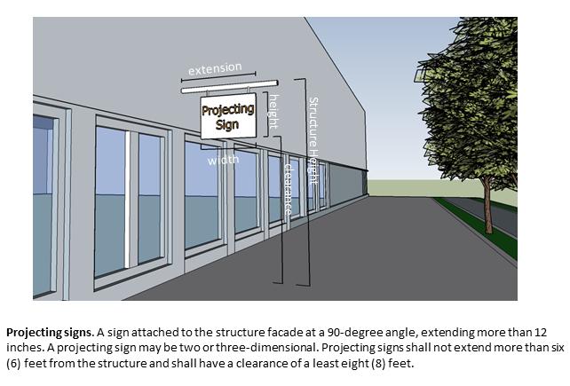
77 71
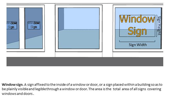
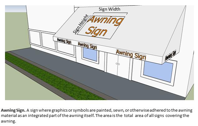
78 72
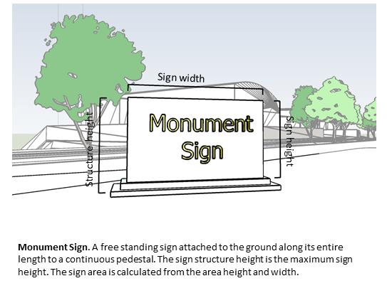
79 73
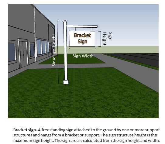
80 74
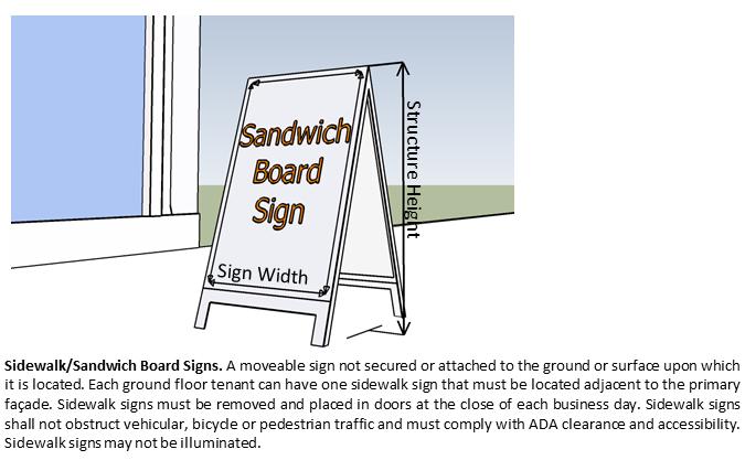
81 75
82 Maximum Sign Area The area of supporting framework shall not be included in the area calculation if such framework is incidental to the display and does not bear any copy or graphics. Maximum Sign Area by Zoning District R RES C/R COM IND CONS SAB Wall Signs (1) Awning Signs (2) 2% 2% 5% 2% 2% Window Signs (3) Projecting Signs 8 sf 6 sf 10 sf 12 sf 12 sf Bracket Sign 12 sf 9 sf 16 sf 16 sf 24 sf 9 sf Monument Sign 24 sf 12 sf 36 sf 50 sf 50 sf 24 sf Sandwich Board Signs 6 sf 6 sf 6 sf 6 sf 6 sf Total maximum sign area (Structures under 10,000 sf in 75 sf 20 sf 50 sf 100 sf 100 sf 50 sf floor area) Total maximum sign area (Structures 10,000-20,000 sf 100 sf 20 sf 75 sf 200 sf 150 sf 75 sf in floor area) Total maximum sign area (Structures 20,000-50,000 sf 125 sf 20 sf 100 sf 350 sf 150 sf 100 sf in floor area) Total maximum sign area (Structures over 50,000 sf in floor area) 150 sf 20 sf 200 sf 500 sf 200 sf 200 sf NOTES: (1) Sign area allocation applies to the side of a structure where the sign will be located. (2) Sign area allocation is based on the total surface area of the awning. (3) Sign area allocation applies to windows on the side of a structure where the signs will be located Maximum Sign Height Maximum Sign Height (1) by Zoning District R RES C/R COM IND CONS LS Wall Signs 4 feet 8 feet 12 feet 12 feet 4 feet Projecting Signs 4 feet 4 feet 6 feet 6 feet 4 feet Awning 2 feet 2 feet 2 feet 2 feet 2 feet Window Signs Bracket Sign 8 feet 6 feet 8 feet 10 feet 10 feet 8 feet Monument Sign 6 feet 6 feet 8 feet 12 feet 10 feet 8 feet Sandwich Board Signs 3 feet 3 feet 3 feet 3 feet NOTES: (1) Sign Height refers to the sign area height or the height of sign components. 76
83 Maximum Structure Height (1) by Zoning District R RES C/R COM IND CONS LS Wall Signs Projecting Signs Awning Window Signs Bracket Sign 8 feet 6 feet 8 feet 10 feet 10 feet 8 feet Monument Sign 6 feet 6 feet 8 feet 12 feet 10 feet 8 feet Sandwich Board Signs 3 feet 3 feet 3 feet 3 feet NOTES: (1) Structure height refers to the distance from the ground to the top of the sign. Non-Residential PUD s within the Growth Center are allowed a free standing sign of up to seventy (75) square feet in area at one entrance to the PUD or one free standing sign of up to 50 square feet in area at two entrances to the PUD with the provision that all businesses within the PUD must waive the individual free standing signage SMALL OFF-GRID WIND ENERGY SYSTEMS Purpose and Applicability The purpose of this Section is to promote the safe, effective and efficient use of small off-grid wind energy systems which are not regulated by the Vermont Public Service Board. Small wind energy systems are a permitted use in all Zoning Districts; subject to certain requirements as set forth below. Application Requirements Small off-grid wind energy systems require a Zoning Permit Application Form, which shall include: 1. Standard drawings of the wind turbine structure to include: a) tower b) base c) footings 2. An engineering analysis of the tower showing compliance with the Uniform Building Code and certified by a Vermont Licensed Engineer shall be submitted. This analysis is frequently supplied by the manufacturer. Review Standards The Zoning Administrator shall find that proposed small off-grid wind energy systems comply with the following standards before issuing a Zoning Permit. 77
84 Tower Height 1. For property sizes between one (1) acre and (3) three acres, the total height of the system (including tower and turbine blades) may be up to eighty (80) feet. 2. For properties three (3) acres or more in size, the total height of the system (including tower and turbine blades) shall not be more than one hundred fifty (150) feet. Setback 1. The tower base shall be setback a distance no less than the tower height (including blade, rotor, or other vertical elements), which shall create a fall zone entirely on the landowner s property. 2. Guy wire anchors and other accessory elements may extend to the setback for the Zoning District in which it is located. Noise 1. Small off-grid wind energy systems shall not exceed 60.0 dba, as measured at the closest neighboring inhabited dwelling. The level, however, may be exceeded during short-term events such as utility outages and/or severe windstorms. Illumination 1. The system shall not be illuminated unless otherwise mandated by the FAA. Abandonment 1. The system shall be considered abandoned if it is out of service or otherwise unused for a continuous one (1) year period. This one (1) year period may be extended by the ZA if evidence is provided to demonstrate that repairs or maintenance is actively underway, or if an insurance claim for damage to the system has not been settled. 2. If the system is determined to be abandoned, the ZA shall notify the owner in writing and the owner shall take the system down within three (3) months of the notification at the owner s expense. Compliance with State and Federal Codes and Regulations 1. Small off-grid wind energy systems must comply with all required state and federal codes and regulations, including the FAA Regulations and National Electrical Code. The manufacturer frequently supplies this information. 78
85 ARTICLE IX: DEFINITIONS Accessory Dwelling Unit: An efficiency or one-bedroom apartment that is clearly subordinate to a single unit dwelling and has facilities and provisions for independent living, including food preparation and sanitation provided there is compliance with standards set forth in Section 900. Accessory Structure: A structure on the same lot with and of a nature which is incidental and subordinate to the principal structure on the lot and which is typically associated with that principal structure. Accessory Use: A use of land or of a structure or portion thereof incidental and subordinate to the principal use of the land or structure and located on the same lot with the principal use. Adjoining/Adjacent: Contiguous parcels or parcels separated only by a public road or right-of-way. Administrative Permit: A permit granted by the ZA without Development Review Board prior review. Adult Oriented Business: A social, fraternal or similar establishment or a business (whether for profit or not-for profit and whether open to the public at large or where entrance is limited by a cover charge or membership requirement) in which any person appears in a state of nudity, in the presence of another person, other than the following; an enclosed single sex lavatory, an enclosed single sex shower, locker and/or dressing room facility, an enclosed motel/hotel room designed and intended for sleeping accommodations, a doctor s office, hospital room or similar place. Affordable Housing: Housing that is owned either: 1. By its inhabitants whose gross annual household income does not exceed eighty percent (80%) of the county median income, or eighty percent (80%) of the standard metropolitan statistical area income if the municipality is located in such an area, as defined by the United States Department of Housing and Urban Development, and the total annual cost of the housing including principal, interest, taxes, insurance, and condominium association fees is not more than thirty percent (30%) of the household s gross annual income; or 2. Is rented by its inhabitants whose gross annual household income does not exceed eighty percent (80%) of the county median income or eighty percent (80%) of the standard metropolitan statistical area income if the municipality is located in such an area, as defined by the United States Department of Housing and Urban Development, and the total annual cost of the housing including rent, utilities and condominium association fees, is not more than thirty percent (30%) of the household s gross annual income. 79
86 Agriculture: Commercial production of crops (including, but not limited to horticultural, viticultural, floricultural, vegetable, berries, grain, hay and straw), dairy, maple, apiary, animal products, seed, Christmas trees and livestock, or any combination thereof, when not exempt from zoning review by 24 VSA 4413(d) or 10 VSA 6001 (22) Agricultural Structures: A building, enclosure, or fence for housing livestock, raising horticultural or agronomic plants, or carrying out other practices associated with accepted agricultural or farming practices, including a silo, as "farming" is defined in 10 V.S.A. 6001(22), but excludes a dwelling for human habitation. Agribusiness: Any individual, partnership, corporation, or organization primarily supplying services or goods (such as equipment, feeds, livestock or supplies) to producers or marketable agricultural products, including greenhouses, nurseries, farm cooperatives, small-scale landscaping and the like. Applicant: Any person, firm, corporation, partnership, or association, or any of these entities working in cooperation, or their authorized agent seeking a permit, conditional use approval, site plan review, or other Town approval. Artist Studio: Work space for artists or artisans, including individuals engaged in the application, teaching or performance of one of the fine or applied arts or crafts. Assisted Living Facility: Residential complexes that provide either routine general protective oversight or assistance with activities necessary for independent living to people who are mentally or physically limited or to people who are unable to care for themselves. May have separate living quarters for residents and services include dining, housekeeping, social and physical activities, medication administration and transportation. Banks: Free standing structures providing banking facilities which may include bank tellers, drive-in lanes and ATMs. Banner: Any sign of lightweight fabric or similar material that is permanently mounted to a pole or a building by a permanent frame at one or more edges. National flags, state or municipal flags, or the official flag of any public institution shall not be considered banners. Bar: An establishment used primarily for the sale or dispensing of alcoholic beverages for on-site consumption, where the sale of prepared food is secondary to the consumption of such beverages. Base Flood: A flood having a one percent (1%) chance of being equaled or exceeded in any given year. This is the regulatory standard also referred to as the "100-year flood." Boundary Line Adjustment: A change in location of the property line granted by the DRB between two or more existing adjoining parcels, where the land taken from one parcel is added to an adjoining parcel, and where a greater number of parcels than originally existed is not thereby created. The adjustment cannot create a new nonconforming parcel or increase the degree of nonconformity of an existing nonconforming parcel. 80
87 Boundary Line Adjustment, Administrative: A change in location of the property line granted by the ZA between not more than two existing adjoining parcels, where the land taken from one parcel is added to an adjoining parcel, and where a greater number of parcels than originally existed is not thereby created. The adjustment cannot create a new nonconforming parcel or increase the degree of nonconformity of an existing nonconforming parcel. Buffer: An area of land used to visually separate one use from another, to shield or block noise, lights, or other nuisances, or to protect a natural resource. Building Contractor Shop: A shop wherein a building contractor may have an office and/or stock materials and equipment pertinent to that contractor s business. The use of this structure does not allow wholesale or retail trade of materials. Building Envelope: A defined two-dimensional (length, width) space, precisely located on a parcel of land and depicted on a relevant plan or plans, within which all structures on that parcel must be located. Business Services: Establishments providing services (not goods or manufacture) to institutions, farms, industries, other businesses, or the general public. Bylaws: Municipal regulations applicable to land development adopted under the authority of Title 24 Chapter 117 of the Act. Campground: Any lot of land containing more than three commercial campsites occupied for vacation or recreational purposes by camping units, such as: tents, yurts, tepees, lean-tos, camping cabins, and recreational vehicles, including motor homes, folding camping trailers, conventional travel trailers, fifth wheel travel trailers, truck campers, van campers, and conversion vehicles designed and used for travel, recreation and camping. Certificate of Compliance: An official document issued by the Zoning Administrator verifying compliance with the Unified Development Bylaws of the Town of St. Albans. Clinic: A facility that provides limited diagnostic and outpatient care, but is unable to provide prolonged in-house medical and surgical care. Clinics may have lab facilities, supporting pharmacies and a wide range of medical services. Club: A building or use catering exclusively to members and their guests for recreational, educational, civic, religious or fraternal purposes. Convention Center: A facility that provides spaces for conventions, trade shows, consumer shows, meetings and special events. Convenience Store: A store that sells convenience foods, newspapers, magazines and often beer and wine. 81
88 Convenience Store with fuel pumps: A store that sells convenience foods, newspapers, magazines, often beer and wine, has fuel pump facilities on the premise and which may include facilities for the installation of lubricants, tires, batteries, etc. and routine maintenance of vehicles. Common Land: Land that is owned collectively or by one person to be used in common with others. Community Facilities or Services: Structures, equipment or infrastructure provided for a community. Community Garden: Any piece of land, public or private, where plants are grown and maintained by a group of individuals in the community. Community gardens may produce food for individual consumption or food for sale, may be designed for beautification of the community, and/or may be used for educational purposes. Condominium Ownership: A form of ownership of real property consistent with the Condominium Ownership Act (27A Chapter 127) which individual owners have title to individual dwelling units and the common areas and facilities are owned by all the owners on a proportional, undivided basis. Correctional Facility: A Federal, State, County, Town or privately run facility used to house, treat or rehabilitate persons remanded to these facilities through the judicial process. Included in this definition are prisons, jails, juvenile detention centers and medical facilities for the correctional authorities. Coverage, Building: The percentage of a lot's area which is occupied or covered by buildings or other structures including accessory structures. Coverage, Lot: The percentage of a lot's area which is covered by buildings, structures, parking areas, loading areas, paved or graveled driveways or other impervious surfaces. Day Care Center: a facility where care is provided for children or adults who require supervision or assistance during the day. The facilities may include classrooms, dining and recreation areas, counseling/physical therapy area Density Bonus: A bonus awarded by the DRB as provided in these bylaws allowing a particular development to exceed the maximum allowable density for the district in exchange for the provision of some other amenity. Development: Consistent with 24 V.S.A., 4303(10), land development shall mean the division of a parcel into two or more parcels, the construction, reconstruction, conversion, structural alteration, relocation, or enlargement of any building or other structure, or of any mining, excavation, or landfill, and any change in the use of any building or other structure, or land, or extension of use of land. Disabled Person: Any person who has a physical or mental impairment that substantially limits one or more major life activities; has a record of such impairment; or is regarded as having such an impairment. 82
89 Dry Cleaners: Provide laundry and tailoring services for clothing and other items. Driveway: A private travel way serving up to two adjoining parcels, which provides access for vehicles to a parking space, garage, dwelling or other structure Dwelling Unit: A structure or self-contained portion thereof, containing complete housekeeping (cooking, sleeping, and bath) facilities that are not in common with any other dwelling unit. Separate Dwelling units may be in the same structure as other dwelling units and share common space. Dwelling, Farm Labor: A dwelling unit, located on an active farm operation, used as housing for a farm employee working on the farm but accessory to the farm use, and members of the employee s immediate family. Dwelling, Single-Unit: A detached structure that contains a single dwelling unit. Dwelling, Two-Unit: A structure containing two dwelling units Dwelling, Multi-Unit Small: A residential structure with three (3) to twelve (12) dwelling units. Dwelling, Multi-Unit Large: A residential building with more than (12) twelve dwelling units. Dwelling, Seasonal: A dwelling unit that is used or approved for use for no more than 200 days in a calendar year. Easement: The right to use the real property of another for a specific purpose. The easement is itself a real property interest, but legal title to the underlying land is retained by the original owner for all other purposes. Typical easements are for access to another property such access and egress, for utility or sewer lines both under and above ground, use of spring water, entry to make repairs on a fence or slide area, drive cattle across, and other uses. Easements can be created by a deed to be recorded just like any real property interest. Educational Facility: Facilities utilized for providing state mandated education for grades kindergarten up to or through 12 th grade, including private and technical schools; and additionally non-mandated colleges, universities and similar institutions of higher education. Efficiency Apartment: A one-room apartment with a private bathroom. Room includes areas for sleeping, eating and living, and a small kitchen. Equipment Sales: An establishment providing sales and/or servicing of farm, construction equipment, snowmobiles, 4-Wheelers, lawn mowers, roto-tillers, chainsaws and other like mechanical equipment. Erosion: The process of which the ground surface is diminished or worn due to wind, water, gravity, ice, or a combination thereof; or the detachment and movement of soil or rock fragments. 83
90 Erosion and sediment control plan: A plan that indicates the specific measures and their sequencing for use to control sediment and erosion on a development site during and after construction Essential Public Services: Includes the construction or installation (by public utilities, municipal or other governmental agencies) of sewer, water, and facilities for fire, police, highway and health services to the Town, or other similar equipment and accessories necessary for the furnishing of essential services. Excavation: Any breaking of ground or movement of earth or rock, or any alteration of existing drainage patterns, excluding common agricultural tillage, ground care, gardening and excavations in cemeteries. Extraction: Any breaking of ground and extraction of earth, rock or raw materials. Family Child Care Facility: As defined by 33 V.S.A. 4902(3)(A), a home or facility caring for more than six (6) full time and four (4) part time children Farm Stand: An area for the temporary or seasonal sales and promotion of agricultural products, excluding alcoholic products. Farming: see Agriculture Farming, Onsite Sales: A small scale retail facility for year-round sales of agricultural products grown or raised on the site or other properties owned or leased by the farm operator, and prepackaged goods, excluding alcoholic products. Fast-Food Restaurant with or without Drive-Through Window: An establishment engaged in the sale of rapidly prepared foods and beverages directly to carryout clientele and/or high turnover rates for eat-in customers. Finished Grade: The final elevation of the ground surface, after all man-made alterations such as grading, filling or excavating have been made. Flood Hazard Area: The land subject to flooding from the base flood. Flood Hazard Area New Construction: Construction of structures or filling commenced on or after the effective date of the adoption of a community s flood hazard bylaws (1988). Flood Hazard Area Substantial Improvement: Any repair, reconstruction, or improvement of a structure, the cost of which equals or exceeds fifty percent (50%) of the market value of the structure either before the improvement or repair is started or, if the structure has been damaged and is being restored, before the damage occurred. 84
91 Flood Proofing: Any combination of structural and non-structural additions, changes, or adjustments to properties and structures that substantially reduce or eliminate flood damage to any combination of real estate, improved real property, water or sanitary facilities, structures, and the contents of structures. Floodway: The channel of a river or other watercourse and the adjoining land areas that must be reserved in order to discharge the base flood without cumulatively increasing the water surface elevation more than one foot. Forestry: The growing and harvesting of trees or timber under proper forest management for purposes other than their fruit. For the purposes of these regulations, the term Forestry shall also include the temporary use of processing equipment such as chippers and portable sawmills, which are used in association with harvesting operations, not exceeding a maximum of one year, and are removed from the site once harvesting operations are complete. This definition specifically excludes permanent sawmills, lumber yards and other similar facilities used for the processing, manufacturing and/or storage of wood and wood products. Frontage: The length of the boundary of a lot which fronts a public street, waterway, or (when approved by the Development Review Board) a private road or right of way, from which primary access to the principal structure on the lot is obtained. Funeral Home: A place of business devoted to the care and preparation for burial or transportation of deceased human bodies, including the selling of funeral services or merchandise. Government Office Building: An individual structure containing either the entire function or simply one agency of a city, county, state, federal or other governmental unit. Grandfathered: Structures, conditions, or uses that pre-exist land use regulations or parts thereof and are allowed to continue in their current state even though they may not meet existing regulations. Height: As applied to a structure, the vertical distance measured from the finished grade to the peak of the roof. Where a structure is located on sloping terrain, the height may be measured from the average ground level along the wall of the structure. Health/Fitness Club: Privately owned facilities that primarily focus on individual fitness or training which may provide exercise classes, weightlifting, fitness and gymnastics equipment, spas, locker rooms and small restaurants or snack bar; may also contain swimming pools, whirlpools, saunas, tennis, racquetball and handball courts and limited retail. Heavy industry: The processing and manufacturing of certain materials and products not having the characteristics of "Light Industry" Home Occupation: An occupation carried on in a dwelling which is customarily incidental and secondary to the use of that building for dwelling purposes 85
92 Homeowner s Association (HOAs): An organization in a subdivision, planned community or condominium that makes and enforces rules for the properties in its jurisdiction. Hospital: Any institution where medical or surgical care and overnight accommodations are provided to non-ambulatory and ambulatory patients. (Does not refer to medical clinics or nursing homes) Housing for Persons with Disabilities: Any housing development or facility of which one hundred (100%) of units are occupied by persons with disabilities and, when applicable, resident staff or personnel. Immediate Family Member: Parents, spouses, siblings, child, stepchild, grandparent, grandchild, aunt or uncle, brother or sister in law, mother or father in law Impact Fees: A fee as per Ordinance of the Selectboard. Impervious Surface/Cover: Manmade surfaces, including paved and unpaved roads, parking areas, structures, roofs, driveways, and walkways, from which precipitation runs off rather than infiltrates. Incidental: That is both in relationship to and in consequence of some other object, action, or state; and where, in the absence of the other object, action, or state, that thing which is incidental would not occur independently. Indoor Storage: A facility utilized for storage for the public e.g. furniture, boats, vehicles, personal belongings. Industrial Park: Means an area of land planned and designed as a location for one or more industrial buildings, including adequate access roads, utilities, and other services necessary for eligible facilities; Industrial Uses: Include both manufacturing and warehousing; specifically the processing, fabrication, and/or temporary storage of materials and products. Infill Development: The use of vacant land or property within a built-up area for further construction or development. 86
93 Interested Person: As prescribed by the Act, an interested person means any one of the following: 1. A person owning title to property, or a municipality or solid waste management district empowered to condemn it or an interest in it, affected by a bylaw, who alleges that the bylaw imposes on the property unreasonable or inappropriate restrictions of present or potential use under the particular circumstances. 2. The municipality that has a plan or a bylaw at issue in an appeal brought under this chapter or any municipality that adjoins that municipality. 3. A person owning or occupying property in the immediate neighborhood of a property that is the subject of any decision or act taken under this chapter, who can demonstrate a physical or environmental impact on the person s interest under the criteria reviewed, and who alleges that the decision or act, if confirmed, will not be in accord with the policies, purposes, or terms of the plan or bylaw of that municipality. 4. Any ten (10) persons who may be any combination of voters or real property owners within a municipality listed in subdivision (2) of this subsection who, by signed petition to the appropriate municipal panel of a municipality, the plan or a bylaw of which is at issue in any appeal brought under this title, allege that any relief requested by a person under this title, if granted, will not be in accord with the policies, purposes, or terms of the plan or bylaw of the Town of St. Albans. This petition to the DRB must designate one person to serve as the representative of the petitioners regarding all matters related to the appeal. 5. Any department and administrative subdivision of this state owning property or any interest in property within St. Albans Town, and the agency of commerce and community development. Judicial Complex: A group of government structures with uses limited to public safety (police, sheriff) and court activity. These facilities can include courtrooms, jails, public safety offices and community corrections uses. Junk yard: Land used for the outdoor collection, storage, or sale of waste metal or other discarded materials, or for the collection, wrecking, dismantling, storage, salvage or sale of machinery or vehicles which are not inspected and not in operating condition (vehicles used in farm operation exempt). An area in excess of two hundred (200) square feet shall be deemed a junk yard if so used. Kennel, Animal Shelter, Animal Boarding, Veterinary Office: An establishment in which dogs or other domesticated animals are medically treated, housed, groomed, bred, boarded, trained, or sold, for fee or compensation. Land Development: The division of a parcel into two or more parcels, the construction, reconstruction, conversion, structural alteration, relocation or enlargement of any structure or other structure, or of any mining, excavation, or landfill and any change in the use of any structure or other structure or land, or extension of the use of land. 87
94 Landscaping: The improvement of a lot, parcel or tract of land with grass and shrubs and/or trees. Landscaping may include flower beds, pedestrian walks, retaining walls, statues and other similar ornamental objects. Legislative Body: The Selectboard of the Town of St. Albans Letter of Credit: A letter addressed by a banker to a correspondent certifying that a person/entity named therein is entitled to draw on the writer s credit up to a certain sum. Library: A building, or portion thereof, used for the storage, display, and lending of books and other audio/visual media. A library may include, among other spaces, reading space, meeting space, study rooms, shelving areas, work areas, and administrative areas. Light Industry: The processing and/or fabrication of certain materials and products where no process involved produces noise, vibration, air pollution, fire hazard, or noxious emission which will adversely disturb or endanger neighboring properties. Non-inclusive examples are: home appliances; electrical instruments; jewelry; printed material; apparel; pharmaceutical goods; and like uses. Liquor Store: A store for the sale of an assortment of products, focusing sales on alcoholic beverages which may be privately owned, discount/wholesale facilities. Lodging Establishment: A building or buildings containing rooms that are rented (for commercial purposes) as a sleeping unit or accommodation for transients, each sleeping unit consisting of, at least, a bedroom and use of a bathroom. Included are hotels, motels, tourist courts, cabins, motor lodges, bed & breakfasts and the like. Lot: A designated parcel, tract, or area of land established by plat, subdivision, or as otherwise allowed by law, to be separately owned, used, developed, or built upon. A lot divided by a Class I, II, or III public road shall be considered separate lots for zoning purposes. Low Impact Development (LID): An innovative stormwater management approach with a basic principle that is modeled after nature: manage rainfall at the source using uniformly distributed decentralized micro-scale controls. Manufacturing: Areas where the primary activity is the conversion of raw materials or parts into finished products. In addition to the actual production of goods, manufacturing facilities generally also have office, warehouse, research and associated functions Marina: Any shoreline property used to provide one (1) or more of the following: a) Access to public waters for docking or mooring of five (5) or more boats with or without other services; or, b) A small-craft harbor complex providing access to public water characterized by such activities as boat manufacture, construction or repairs, sales, rentals, chartering, derricks, docks, wharves, moorings, marine railways, boat storage and other marine-type facilities and commercial services which may include the sale of food or other services clearly incidental to the operation of the marine based activities 88
95 Material Recovery Facility: A facility that functions as a collection point for solid waste that will subsequently be transported to a State approved landfill or other type of disposal facility. Mean Water Level: The mean water level of a lake as defined in the Mean Water Level Rules of the Agency of Natural Resources adopted under 29 V.S.A. 401, which for Lake Champlain is 95.5 feet above the mean sea level. Medical/Dental Building: A structure that provides diagnoses and outpatient care on a routine basis but is unable to provide prolonged in-house medical and surgical care. Minimum Lot Size: The smallest lot area on which any land or building development, construction, alteration, addition to an existing structure, or change in use is permitted if also in conformance with all other provisions of this Bylaw. Modular and Mobile Home Sales: An establishment providing sales, servicing and transport of modular or mobile homes. Motor Vehicle Repair, Service: An establishment providing repair or servicing of automobiles, trucks, farm and other motorized vehicles. Motor Vehicle Sales: An establishment selling new or used automobiles, trucks, farm or other motorized vehicles. Municipal Separate Storm Sewer Systems (MS4): A conveyance or system of conveyances including roads with drainage systems, municipal streets, catch basins, curbs, gutters, ditches, manmade channels, or storm drains. Museum: Facilities that include displays, shows, exhibits and/or demonstrations of historical, scientific, natural, artistic, entertaining, or other cultural significance. MS4 Impaired Areas: Geographic areas in the town that discharge stormwater runoff to Vermont State designated impaired waterways. Mobile Home Park: Any parcel of land under a single or common ownership or control, which contains, or is designed, laid out or adapted to accommodate, two or more mobile homes, but not including premises for the display or storage of mobile homes. Municipal Land Use Permit: A zoning, subdivision, site plan or building permit or approval, any of which relate to land development that has received final approval from the DRB or ZA; Certificate of Occupancy, Certificate of Compliance. Nonconforming Lots or Parcels: Lots or parcels that do not conform to the present bylaws covering dimensional requirements but were in conformance with all applicable laws, ordinances, and regulations prior to the enactment of the present bylaws, including a lot or parcel improperly authorized as a result of error by the ZA. 89
96 Nonconforming Structure: A structure or part of a structure that does not conform to the present bylaws but was in conformance with all applicable laws, ordinances, and regulations prior to the enactment of the present bylaws, including a structure improperly authorized as a result of error by the ZA. Nonconforming Use: A use of land that does not conform to the present bylaws but did conform to all applicable laws, ordinances, and regulations prior to the enactment of the present bylaws including a use improperly authorized as a result of error by the ZA. Nonconformity: A nonconforming use, structure, lot or parcel. Open Space: Land which, in connection with a development proposal, is set aside from development and designated to remain in its natural state (woodland, meadow land, wetland, etc.), agricultural use, or for active or passive outdoor recreation uses. Outdoor Recreation Equipment: Kayaks, boats, skis, skates, fishing gear, bicycles, etc. Owner(s) of Record: The person(s) or entity(s) listed on the deed(s) for the subject property. Parcel: A tract of land that is capable of being described in definitive terms with respect to its location and boundaries. An area of land that is traversed by a public road or water body (stream, river) shall be considered as two parcels. Park: Land that may contain athletic fields, outdoor group areas, children play areas/structures and pathways. Park administrative office may also be located on-site. Parking Space: An area of land suitable and available for the parking of one motor vehicle as defined by IV.910 of these bylaws Place of Worship: One or more structures or a portion of a structure, used for the conduct of organized religious services, and associated accessory uses. Planned Unit Development (PUD): A PUD, in accordance with 24 VSA 4417, may consist of one or more lots, tracts or parcels of land to be developed as a single entity. The project may propose any DRB authorized combination of density or intensity transfers or increases, as well as the mixing of land uses. This plan, as authorized, may deviate from bylaw requirements that are otherwise applicable to the area in which it is located with respect to lot size, bulk, or type of dwelling or building, use, density, intensity, lot coverage, parking, required common open space, or other standards. Plat Map: A map representing a tract of land, showing the boundaries and location of individual properties and streets or a map of a subdivision or site plan. A map prepared for filing in the land records in accordance with 27 V.S.A or any subsequent revisions thereof. Post Office: A federal structure that contains service windows for mailing packages and letters, post office boxes, office, sorting and distributing facilities for mail and vehicle storage areas. 90
97 Professional Office: A place where a particular kind of business is performed, such as real estate, government, architecture, lawyer or insurance services. Public Facilities: 1. State or community owned and operated institutions and facilities; 2. Public and private schools and other educational institutions certified by the State Department of Education; 3. Churches and other places of worship, convents, and parish houses; 4. Public and private hospitals; and/or, 5. Regional solid waste management facilities certified under10 VSA Chapter Hazardous waste management facilities for which a notice of intent to construct has been received under 10 VSA Public Notice: The form of notice prescribed by sections 4444, 4449, or 4464 of 24 VSA, as the context requires. Public Road: A state highway as defined in 19 V.S.A. 1 or a class 1, 2, or 3 town highway as defined in 19 V.S.A. 302(a) Publisher/Printer: A facility that is used for the publication or printing of newspapers, magazines, books, periodicals, leaflets or other such products. Bookbinders and engravers are also to be included in this definition. Qualified Professional: A licensed professional engineer. Recording Fees: Fees collected in connection with the filing of land records. Recreational Center: Indoor and outdoor stand-alone facilities that often include classes and clubs for adults and children, a day care or nursery school, meeting rooms, swimming pools and whirlpools, saunas, tennis, racquetball, handball, basketball and volleyball courts, outdoor athletic fields/courts, exercise classes, weightlifting and gymnastics equipment, locker rooms and restaurant or snack bar. Public access is typically allowed but a fee may be charged. Renewable Energy Resources: Energy available for collection or conversion from direct sunlight, wind, running water, organically derived fuels, including wood and agricultural sources, waste heat, and geothermal sources. Research and Testing Facility: A specialized commercial/industrial activity where the land use impact is characteristic in nature to that of Light Industry as defined in this Bylaw. Residential Care or Group Home: A residential care home or group home to be operated under state licensing or registration, serving not more than eight persons who have a disability as defined in 9 V.S.A. 4501, shall be considered by right to constitute a permitted single-family residential use of property, except that no such home shall be so considered if it is located within 1,000 feet of another existing or permitted such home. 91
98 Restaurant: An establishment whose principal business is the sale of foods or beverages for consumption. Retail Business: Includes shops and stores for the sale of small retail goods, such as grocery, hardware, general stores, and clothing and like items; it includes small repair shops, but excludes vehicle and modular or mobile home sales and service. Retaining Wall: A vertical or nearly vertical structure, designed and built for the purpose of preventing erosion, or to transition from one elevation to another, which requires excavation and anchorage, and is substantial in design and construction, unlike the type and nature of a wall used only for landscaping purposes. Examples of a Retaining Wall include a seawall on a lakeshore or stream bank. Sawmill: Fixed equipment set up for the process of commercially turning logs into finished lumber. Screening: A method of shielding or obscuring one abutting or nearby structure or parcel from another. Screening may be achieved by the use of one or a combination of fencing, walls, berms/mounds, or densely planted vegetation. Seawall: A wall or embankment to protect the shore from erosion or to act as a breakwater. Senior Housing: A dwelling unit that is to be occupied by a person fifty-five (55) years or older. Senior Housing shall be subject to covenants or restrictions that preserve their status. Service Station: A building or land containing at least one fuel pump, used for the commercial sale of vehicular fuel (gasoline, diesel, etc.) to private vehicle owners, and which may include facilities for installation of lubricants, tires, batteries, etc., and routine maintenance of vehicles. Shopping Center: An integrated group of commercial establishments that is planned and developed as a unit. Skilled Nursing Facility : An institution or part of an institution that provides licensed, skilled, fulltime nursing care and related services for patients who require medical, nursing, and/or rehabilitative services. The facility may provide extended and/or intermediate care for those who by reason of advanced age, illness, infirmity, or mental impairments need acute, chronic, or convalescent care. Such facility may also be known as a nursing home, convalescent facility, or long-term care facility. Small-Scale Wind Energy System (SSWES): A wind energy conversion system consisting of a wind turbine, a tower, and associated control of conversion electronics, which has a rated capacity of not more than 50kW and which is intended to primarily reduce on-site consumption of power. 92
99 Setbacks: The minimum distance between any point on the nearest structure and any lot line. Including decks but excluding: 1. Eaves, sills, pilasters, gutters, leaders, cornices, chimneys, and roof overhangs provided such features do not extend more than three (3) feet from the remainder of the structure; 2. Uncovered steps to first floor entries provided such features do not extend more than five (5) feet from the remainder of the structure; (C) and handicapped ramps Shall: Means that an activity is mandatory Should: Means an activity is encouraged but not mandatory Social Services: Includes day-care centers, medical clinics, nursing homes, and similar human service/health care facilities, and group or community care homes serving more than six (6) persons. State Highway: Pursuant to 19 V.S.A. 1 are those highways maintained exclusively by the Agency of Transportation. Storage Facility: A parcel of land with or without buildings thereon to be used for storage of vehicles, equipment and/or materials used in the commercial operation of a trucking, construction or construction related trades. Storage and Distribution Facility: Any facility used for warehousing but excludes retail activity on the premises. Stormwater: Any surface flow, runoff, and drainage consisting entirely of water from any form of natural precipitation, and resulting from such precipitation. Stormwater Impaired Waters: A water body currently identified by the Vermont Department of Environmental Conservation following the requirements of the Clean Water Act Section 303(d) Stormwater Management: The use of structural or non-structural practices that are designed to reduce stormwater runoff pollutant loads, discharge volumes, and/or peak flow discharge rates. Structure: An assembly of materials for occupancy or use, including a building, modular or mobile home or trailer or sign. Subaqueous Bottom: Soils that form sediment found in shallow, permanently flooded environments. Excluded from the definition of these soils are any areas permanently covered by water too deep for the growth of rooted plants. Subordinate: Being of markedly less or of secondary importance relative to another object, action, or state. 93
100 Supermarket: A free standing retail store selling a complete assortment of food, food preparation and wrapping materials and household cleaning items which may also contain goods and services such as ATM s, automobile supplies, bakeries, books and magazines, dry cleaning, floral arrangements, greeting cards, limited-service banks, photo centers, pharmacies and video rental areas. Tavern: An establishment used primarily for the sale or dispensing of alcoholic beverage by the drink for on-site consumption and where food may be available for consumption on the premises as accessory to the principal use. Includes bar, lounge, nightclub, and similar establishments Telecommunications Facility: A tower or other support structure, including antennae, which will extend twenty (20) or more feet vertically, and related equipment and base structures to be used primarily for communication or broadcast purposes to transmit or receive communication or broadcast signals. Ten Year Storm Event: A 10-year event is an event of such size that over a long period of time, the average time between events of equal or greater magnitude is 10 years. Theater: A structure or open air setting which includes audience seating area and screens or stages; may include a lobby, refreshment stand, dressing rooms. Town Acre: Forty thousand (40,000) square feet. Town Highway: Class 1, 2, 3, and 4 highways that the Town has authority to exclusively or cooperatively maintain or that are maintained by the Town except for scheduled surface maintenance performed by the State. Transportation Terminal: A site including structures which is used for the parking, storage, dispatching and/or servicing of buses, trains and/or trucks. Not included would be the commercial servicing of vehicles not part of the terminal s fleet. True Acre: Forty-three thousand five hundred sixty (43,560) square feet Two Year Storm Event: A 2-year event is an event of such size that over a long period of time, the average time between events of equal or greater magnitude is 2 years. University/College: Includes four (4) year universities or colleges that may or may not offer graduate programs. Use: The specific purpose for which land or a building or a portion thereof is designated, arranged, or intended, or for which it is or may be occupied or maintained. Variance: An allowed deviation from specific requirements pertaining to this zoning code, granted by the DRB to an Applicant pursuant to Section 805 of these Bylaws 94
101 Vet Clinic/Animal Hospital: An animal hospital or veterinary clinic that specializes in the medical care and treatment of animals. Waiver: An allowed deviation from specific requirements pertaining to this zoning code, granted by the DRB to an Applicant. Water Courses: Streams, brooks, and other bodies of water that flow year-round. Wetlands: An area that is inundated or saturated by surface water or groundwater at a frequency and duration to support vegetation adapted for life in such conditions and is designated on National Wetlands Inventory Maps or Vermont Wetlands Maps, or is determined to be a wetland as a result of field inspection by the Vermont Agency of Natural Resources, the US Army Corps of Engineers, or a qualified professional. Zoning Administrator (ZA): An administrative officer who shall administer the bylaws literally. Zoning/Building Permit: A permit issued by the ZA in accordance with the provisions of these regulations, which authorizes specified land development and which may contain conditions which must be met in order for the land development to comply with the provisions of these regulations and any applicable approvals. 95
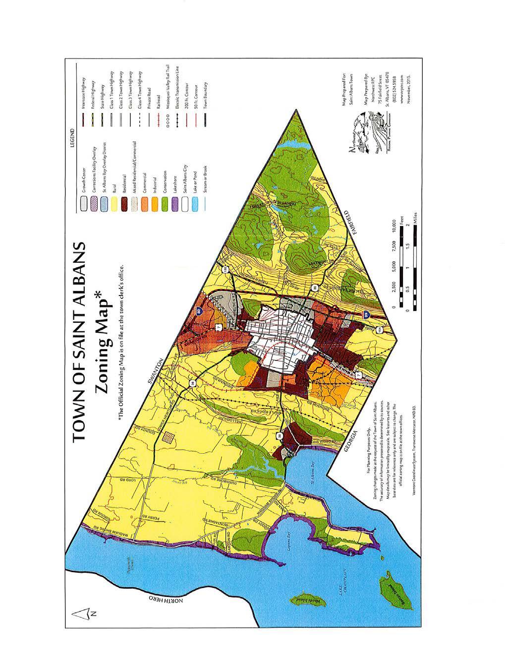
102 96
CHAPTER 24 F FLOOD ZONE OVERLAY DISTRICT
 CHAPTER 24 OVERLAY DISTRICT SECTION 24.01 PURPOSE It is the intent of this district to apply special regulation to the use of land in those areas subject to periodic inundation. Such regulation is deemed
(Chapter Flood Damage Prevention)
") Chapter 13.10 Flood Damage Prevention Section: 13.10.010 Purpose and Policy 13.10.020 Definitions 13.10.030 Applicability and Areas of Special Flood Hazard 13.10.040 Administration 13.10.050 Provisions
Chapter 13.10 Flood Damage Prevention Section: 13.10.010 Purpose and Policy 13.10.020 Definitions 13.10.030 Applicability and Areas of Special Flood Hazard 13.10.040 Administration 13.10.050 Provisions
Town of Alexandria. Floodplain Management Ordinance
 1 of 7 8/8/2009 4:56 PM Town of Alexandria Floodplain Management Ordinance SECTION 1 PURPOSE Certain areas of the Town of Alexandria, New Hampshire are subject to periodic flooding, causing serious damages
CHAPTER XIX FLOOD DAMAGE PROTECTION. Article. 1 Definitions 2 General Provisions 3 Administration 4 Provisions for Flood Hazard Reduction
 CHAPTER XIX FLOOD DAMAGE PROTECTION Article 1 Definitions 2 General Provisions 3 Administration 4 Provisions for Flood Hazard Reduction CHAPTER XIX FLOOD DAMAGE PROTECTION Article 1 Definitions 19.0101
LINCOLN COUNTY FLOOD DAMAGE PREVENTION ORDINANCE
 LINCOLN COUNTY FLOOD DAMAGE PREVENTION ORDINANCE SECTION 1.0 STATUTORY AUTHORIZATION, FINDINGS OF FACT, PURPOSE AND OBJECTIVES SECTION 2 DEFINITIONS SECTION 3.0 GENERAL PROVISIONS SECTION 4.0 ADMINISTRATION
Section SKETCH PLAN REVIEW
 Section 210 - SKETCH PLAN REVIEW 1. Within 30 days of receiving a complete application for a subdivision involving three or more lots, the Zoning Administrator shall refer the matter to the first available
Floodplain Development Land Use Review
 PUBLIC WORKS - COMMUNITY DEVELOPMENT 333 Broadalbin Street SW, PO Box 490, Albany, Oregon 97321-0144 BUILDING 541-917-7553 PLANNING 541-917-7550 Floodplain Development Land Use Review Application Information
ARTICLE 7. SPECIFIC USE STANDARDS
 ARTICLE 7. SPECIFIC USE STANDARDS Section 7.1 Applicability The following standards apply to specified uses in all zoning districts in which such uses are allowed. Section 7.2 Accessory Apartments (A)
CHAPTER XVII. REGULATION OF FLOOD PLAIN STATUTORY AUTHORIZATION, FINDINGS OF FACT, PURPOSE AND OBJECTIVES
 CHAPTER XVII. REGULATION OF FLOOD PLAIN ARTICLE 1.0 STATUTORY AUTHORIZATION, FINDINGS OF FACT, PURPOSE AND OBJECTIVES 17.0101 STATUTORY AUTHORIZATION The Legislature of the State of North Dakota has in
ARTICLE 14 FLOODPLAIN MANAGEMENT
 ARTICLE 14 FLOODPLAIN MANAGEMENT 14.1 Purpose and Establishment Certain areas of the Town of Buxton, Maine are subject to periodic flooding, causing serious damages to properties within these areas. Relief
ORDINANCE NO (1123)
") ORDINANCE NO. 2013-08 (1123) ORDINANCE OF THE BOROUGH OF LAVALLLETTE, COUNTY OF OCEAN, STATE OF NEW JERSEY, AMENDING AND SUPPLEMENTING CHAPTER 31, ENTITLED FLOOD HAZARD AREAS, OF THE REVISED GENERAL ORDINANCES
ORDINANCE NO. 2013-08 (1123) ORDINANCE OF THE BOROUGH OF LAVALLLETTE, COUNTY OF OCEAN, STATE OF NEW JERSEY, AMENDING AND SUPPLEMENTING CHAPTER 31, ENTITLED FLOOD HAZARD AREAS, OF THE REVISED GENERAL ORDINANCES
The Onekama Township Flood Damage Prevention Ordinance of Onekama Township, Manistee County, Michigan was adopted by the Onekama ORDINANCE #4
 AN ORDINANCE The Onekama Township Flood Damage Prevention Ordinance of Onekama Township, Manistee County, Michigan was adopted by the Onekama Township Board at a regular meeting of its Township Board held
Special Use Permit - Planned Unit Development Checklist. Property Address:
 Special Use Permit - Planned Unit Development Checklist Special Use Permit Number. Parcel Code/s #28-11- - - Property Address: Applicant: ARTICLE VIII Ordinance Reference - Section 8.1.2 Permit Procedures:
Section Floodplain Development Ordinance This ordinance, adopted pursuant to the authority of RSA 674:16, shall be known as the Town of Newport
 Section 212 - Floodplain Development Ordinance This ordinance, adopted pursuant to the authority of RSA 674:16, shall be known as the Town of Newport Floodplain Development Ordinance. The regulations and
Town of Norwich, Vermont SUBDIVISION REGULATIONS
 Town of Norwich, Vermont SUBDIVISION REGULATIONS Adopted: August 6, 2002 Amended: February 8, 2006 Prepared by Norwich Planning Commission with the assistance of: Burnt Rock Inc. A ssociates in Community
FLOOD-RESISTANT CONSTRUCTION
 FLOOD-RESISTANT CONSTRUCTION The provisions contained in this appendix are not mandatory unless specifically referenced in the adopting ordinance. SECTION G101 ADMINISTRATION G101.1 Purpose. The purpose
ARTICLE 15 - PLANNED UNIT DEVELOPMENT
 Section 15.1 - Intent. ARTICLE 15 - PLANNED UNIT DEVELOPMENT A PUD, or Planned Unit Development, is not a District per se, but rather a set of standards that may be applied to a development type. The Planned
Town of Duxbury, Vermont. Zoning Ordinance
 Town of Duxbury, Vermont Zoning Ordinance As Amended January 31, 2011 CONTENTS ARTICLE I PURPOSE AND GENERAL RULES OF APPLICATION... 1 SECTION 1 ENACTMENT AND PURPOSE... 1 SECTION 2 RULES OF APPLICATION...
(b) The location of principal and accessory buildings on the lot and the relationship of each structure to the other.
 The location of principal and accessory buildings on the lot and the relationship of each structure to the other.") ARTICLE XIX SITE PLAN Sec. 20-1900 Site Plan Review Procedure - Intent The site plan review procedures are instituted to provide an opportunity for the Township Planning Commission to review the proposed
ARTICLE XIX SITE PLAN Sec. 20-1900 Site Plan Review Procedure - Intent The site plan review procedures are instituted to provide an opportunity for the Township Planning Commission to review the proposed
THIS ARTICLE HAS BEEN COMPLETELY REWRITTEN. Chapter CRITICAL AREAS. Article XIX. Flood Hazard Areas. Article XIX. Flood Hazard Areas
 THIS ARTICLE HAS BEEN COMPLETELY REWRITTEN Chapter 18.55 CRITICAL AREAS Sections: Article XIX. Flood Hazard Areas 18.55.700 Purpose. 18.55.705 Definitions 18.55.707 Lands to which this article applies.
PLANNING COMMISSION ZONING BYLAW Adopted September 18, 2008 Effective October 4, 2008
 TOWN OF NEWFANE, VERMONT PLANNING COMMISSION ZONING BYLAW Adopted September 18, 2008 Effective October 4, 2008 Funded by a Municipal Planning Grant awarded by the Vermont Agency of Commerce and Community
ARTICLE 24 SITE PLAN REVIEW
 ARTICLE 24 SITE PLAN REVIEW 24.1 PURPOSE: The intent of these Ordinance provisions is to provide for consultation and cooperation between the land developer and the Township Planning Commission in order
201 General Provisions
 201 General Provisions 201.01 Title 201.09 Amendments 201.02 Purpose and Intent 201.10 Public Purpose 201.03 Authority 201.11 Variances and Appeals 201.04 Jurisdiction 201.12 Nonconformances 201.05 Enactment
Meeting Minutes Lodi Township Planning Commission November 27, 2012 Lodi Township Hall 3755 Pleasant Lake Road Ann Arbor, MI 48103
 Meeting Minutes Lodi Township Planning Commission November 27, 2012 Lodi Township Hall 3755 Pleasant Lake Road Ann Arbor, MI 48103 1) Call to Order The meeting was called to order by Chair Jack Steeb at
UPPER MOUNT BETHEL TOWNSHIP NORTHAMPTON COUNTY, PENNSYLVANIA
 UPPER MOUNT BETHEL TOWNSHIP NORTHAMPTON COUNTY, PENNSYLVANIA JOINDER DEED / LOT CONSOLIDATION TOWNSHIP REVIEW PROCESS When accepting proposed Joinder Deeds / Lot Consolidations, review the Joinder Deed
SECTION 10.7 R-PUD (RESIDENTIAL PLANNED UNIT DEVELOPMENT) ZONE
 ZONE") Article X Zones 10-20 SECTION 10.7 R-PUD (RESIDENTIAL PLANNED UNIT DEVELOPMENT) ZONE A. PURPOSE AND INTENT: The R-PUD Residential PUD Zone is intended to provide alternative, voluntary zoning procedures
Article X Zones 10-20 SECTION 10.7 R-PUD (RESIDENTIAL PLANNED UNIT DEVELOPMENT) ZONE A. PURPOSE AND INTENT: The R-PUD Residential PUD Zone is intended to provide alternative, voluntary zoning procedures
THE COUNTY BOARD OF SUPERVISORS OF THE COUNTY OF DOUGLAS DOES ORDAIN AS FOLLOWS:
 8.1 SUBDIVISION CONTROL ORDINANCE THE COUNTY BOARD OF SUPERVISORS OF THE COUNTY OF DOUGLAS DOES ORDAIN AS FOLLOWS: SECTION I. GENERAL INTERPRETATION This ordinance shall not repeal, impair or modify private
Zoning Regulations. Town of Norton, Vermont
 Zoning Regulations Town of Norton, Vermont Revised Bylaw Adopted July 1, 2014 Bylaw Amendments Date Description Section Affected NORTON ZONING BYLAW Page i TABLE OF CONTENTS SECTION PAGE NUMBER ARTICLE
CHAPTER 3 PRELIMINARY PLAT
 10-3-1 10-3-3 SECTION: CHAPTER 3 PRELIMINARY PLAT 10-3-1: Consultation 10-3-2: Filing 10-3-3: Requirements 10-3-4: Approval 10-3-5: Time Limitation 10-3-6: Grading Limitation 10-3-1: CONSULTATION: Each
Chapter 100 Planned Unit Development in Corvallis Urban Fringe
 100.100 Scope and Purpose. Chapter 100 Planned Unit Development in Corvallis Urban Fringe (1) All applications for land divisions in the Urban Residential (UR) and Flood Plain Agriculture (FPA) zones within
SPECIAL PURPOSE FLOOD DAMAGE PREVENTION REGULATIONS for FAIRFIELD COUNTY
 SPECIAL PURPOSE FLOOD DAMAGE PREVENTION REGULATIONS for FAIRFIELD COUNTY Adopted September 7, 1995 Effective October 9, 1995 Flood Maps are available in the Fairfield County Regional Planning Commission
ARTICLE 8C SITE CONDOMINIUM DEVELOPMENT ORDINANCE
 ARTICLE 8C SITE CONDOMINIUM DEVELOPMENT ORDINANCE SECTION 8C.01 PURPOSE It is the purpose of this Ordinance to insure that plans for development within Oceola Township proposed under the provisions of
MULTI-FAMILY DWELLING UNIT SUBDIVISION ORDINANCE TOWN OF SIDNEY, MAINE
 MULTI-FAMILY DWELLING UNIT SUBDIVISION ORDINANCE TOWN OF SIDNEY, MAINE I. GENERAL A. Title B. Purpose C. Administration D. Scope II. DEFINITIONS A. Building Height B. Dwelling Unit C. Family D. Multi-Unit
ARTICLE SINGLE FAMILY SITE CONDOMINIUM DEVELOPMENT STANDARDS
 ARTICLE 28.00 SINGLE FAMILY SITE CONDOMINIUM DEVELOPMENT STANDARDS Section 28.01 PURPOSE The purpose of this Article is to recognize that conventional single family developments, traditionally developed
COMMERCIAL SITE DEVELOPMENT GUIDE FOR UNINCORPORATED ST. CHARLES COUNTY
 COMMERCIAL SITE DEVELOPMENT GUIDE FOR UNINCORPORATED ST. CHARLES COUNTY GENERAL INFORMATION: This brochure is to be used as a guide and is not intended to amend or supersede the corresponding County ordinances
TOWN OF GUILDHALL, VERMONT ZONING BYLAW. Adopted March 5, 1985 Amended March 23, 1987 Amended November 4, 2004 APPROVED 03/01/05
 TOWN OF GUILDHALL, VERMONT 1 ZONING BYLAW Adopted March 5, 1985 Amended March 23, 1987 Amended November 4, 2004 APPROVED 03/01/05 Amended and APPROVED 08/19/2013 Effective 09/10/2013 Re-edited 9/21/2012
ORDINANCE NO. 13 Series 2001
 ORDINANCE NO. 13 Series 2001 AN ORDINANCE REPEALING AND READOPTING WITH CHANGES CHAPTER 3 OF TITLE 10 OF THE BRECKENRIDGE TOWN CODE. KNOWN AS THE "BRECKENRIDGE FLOOD DAMAGE PREVENTION ORDINANCE" BE IT
Article 7: Residential Land Use and Development Requirements
 Article 7: Residential Land Use and Section 701: Statement of Intent (A) (B) (C) The intent of Article 7 is to develop certain land use and development requirements for the residential uses within Cumru
ARTICLE VII. NONCONFORMITIES. Section 700. Purpose.
 ARTICLE VII. NONCONFORMITIES. Section 700. Purpose. The purpose of this chapter is to regulate and limit the development and continued existence of legal uses, structures, lots, and signs established either
FLOOD DAMAGE PREVENTION
 ARTICLE 30 FLOOD DAMAGE PREVENTION 30.01 General Provisions... 30-1 30.02 Administration... 30-2 30.03 Provisions for Flood Hazard Reduction... 30-7 30.01 General Provisions 30.01.01 Lands to Which This
Town of Scarborough, Maine
 Town of Scarborough, Maine Miscellaneous Appeal INFORMATION REQUIRED FOR ALL APPEALS Before any appeal can be processed, the following material must be submitted to the Code Enforcement Office: 1. A fee
SECTION 30- FP FLOOD PLAIN DISTRICT
 SECTION 30- FP FLOOD PLAIN DISTRICT This zoning district is created to be appended to or overlaid on another primary zoning district for the purpose of meeting the needs of the watercourses and drain ways
CHAPTER XVIII SITE PLAN REVIEW
 CHAPTER XVIII SITE PLAN REVIEW Section 18.1 Section 18.2 Description and Purpose. The purpose of this chapter is to provide standards and procedures under which applicants would submit, and the Township
CHAPTER 14 PLANNED UNIT DEVELOPMENTS
 9-14-1 9-14-1 CHAPTER 14 PLANNED UNIT DEVELOPMENTS SECTION: 9-14-1: Purpose 9-14-2: Governing Provisions 9-14-3: Minimum Area 9-14-4: Uses Permitted 9-14-5: Common Open Space 9-14-6: Utility Requirements
Adopted by the Stockbridge Selectboard (April 21, 2011) Effective 5/13/11
 Effective 5/13/11") STOCKBRIDGE ZONING BYLAWS Adopted by the Stockbridge Selectboard (April 21, 2011) Effective 5/13/11 Prepared and Presented By Stockbridge Planning Commission Kyle Kershner, Chair Jon Benson Bill Edgerton
STOCKBRIDGE ZONING BYLAWS Adopted by the Stockbridge Selectboard (April 21, 2011) Effective 5/13/11 Prepared and Presented By Stockbridge Planning Commission Kyle Kershner, Chair Jon Benson Bill Edgerton
Title 15. Buildings, Construction, Addressing and Land Use
 Chapters: 15.05 Land Use Fees 15.10 Flood Damage Prevention 15.15 Building Numbering Title 15 Buildings, Construction, Addressing and Land Use 15-1 Lyons Municipal Code 15.05.040 Chapter 15.05 Land Use
Attached is a Clinton Township Zoning Permit Application and requirements for issuance of a permit.
 To Whom It May Concern: Attached is a Clinton Township Zoning Permit Application and requirements for issuance of a permit. The fee for the permit application is $75.00, which shall be made payable to
SPECIAL PURPOSE FLOOD DAMAGE PREVENTION ORDINANCE. Adopted: June 24th, 1998
 SPECIAL PURPOSE FLOOD DAMAGE PREVENTION ORDINANCE Adopted: June 24th, 1998 SECTION 1.0 STATUTORY AUTHORIZATION, FINDINGS OF FACT PURPOSE AND OBJECTIVES 1.1 STATUTORY AUTHORIZATION ARTICLE XVIII, Section
TOWN OF TROY, VERMONT ZONING BYLAW Adopted March 5, 1985 Amended June 25, 1987 Amended October 18, 2010
 TOWN OF TROY, VERMONT ZONING BYLAW Adopted March 5, 1985 Amended June 25, 1987 Amended October 18, 2010 The 2010 update of the Town of Troy Zoning Bylaw was made possible by a Municipal Planning Grant
I. Requirements for All Applications. C D W
 108-16.1. Application checklists. Checklist for Required Submissions to the Planning Board or Zoning Board of Adjustment of Monroe Township All required submissions are to be made to the Administrative
Date of Review: 11/6/2015 Reviewer: RCQ/LMC STATE
 FINAL Florida Review Checklist: NFIP & FBC & Revised Model Ordinance (January 15, 2013d) Ordinance Citation: Model FPM regulations and 5 th Edition FBC : All Zones Date of Review: 11/6/2015 Reviewer: RCQ/LMC
Town of Berlin, Vermont Zoning Regulations. March 6, 1973
 Town of Berlin, Vermont Zoning Regulations March 6, 1973 Revised August 1980 Revised March 1985 Revised March 1987 Revised March 1988 Revised March 1989 Revised March 1998 Revised March 2002 Revised October
FINAL DRAFT 12/1/16, Rev. to 7/18/17
 FINAL DRAFT 12/1/16, Rev. to 7/18/17 (As Adopted 8/8/17 Effective 9/1/17) SHELTON PLANNING AND ZONING COMMISSION Proposed Amendments to Zoning Regulations I. Amend Section 23 PERMITTED USES by inserting
Town of Lisbon, Maine SUBDIVISION REVIEW APPLICATION
 Date Received: Fee Paid (amount): Applicant: Town of Lisbon, Maine SUBDIVISION REVIEW APPLICATION Subdivision Name/Title: This application must be received at the Town Office by close of business on the
ARTICLE 14 PLANNED UNIT DEVELOPMENT (PUD) DISTRICT
 DISTRICT") ARTICLE 14 PLANNED UNIT DEVELOPMENT (PUD) DISTRICT Section 14.01 Intent. It is the intent of this Article to allow the use of the planned unit development (PUD) process, as authorized by the Michigan Zoning
ARTICLE 14 PLANNED UNIT DEVELOPMENT (PUD) DISTRICT Section 14.01 Intent. It is the intent of this Article to allow the use of the planned unit development (PUD) process, as authorized by the Michigan Zoning
MANSFIELD TOWNSHIP BURLINGTON COUNTY ORDINANCE
 MANSFIELD TOWNSHIP BURLINGTON COUNTY ORDINANCE 2017-15 AN ORDINANCE TO AMEND THE CODE OF THE TOWNSHIP OF MANSFIELD BY DELETING AND REPEALING CHAPTER 22 THEREOF, ENTITLED FLOOD DAMAGE PREVENTION, AND REPLACING
TOWN OF WATERVILLE VALLEY NEW HAMPSHIRE SITE PLAN REVIEW REGULATIONS
 TOWN OF WATERVILLE VALLEY NEW HAMPSHIRE Effective date March 17, 1981 Revised March 16, 1982 Revised March 13, 1986 Revised March 10, 1987 Revised March 14, 2013 Revised March 8, 2016 TOWN OF WATERVILLE
MAJOR RESIDENTIAL AND NONRESIDENTIAL SUBDIVISIONS
 Lawrence-Douglas County MAJOR RESIDENTIAL AND NONRESIDENTIAL SUBDIVISIONS Preliminary Plats The applicant shall schedule a Pre-Application meeting with Planning Staff at least seven (7) working days prior
1105 SUBDIVISIONS, PARTITIONS, REPLATS, CONDOMINIUM PLATS, AND VACATIONS OF RECORDED PLATS
 1105 SUBDIVISIONS, PARTITIONS, REPLATS, CONDOMINIUM PLATS, AND VACATIONS OF RECORDED PLATS 1105.01 PURPOSE AND APPLICABILITY Section 1105 is adopted to provide standards, criteria, and procedures under
Town of Truckee. Contents. Article I - Development Code Enactment and Applicability. Chapter Purpose and Effect of Development Code...
 Town of Truckee TITLE 18 - DEVELOPMENT CODE Article I - Development Code Enactment and Applicability Chapter 18.01 - Purpose and Effect of Development Code... I-3 18.01.010 - Title... I-3 18.01.020 - Purposes
ORDINANCE NO TOWNSHIP OF EAST WINDSOR COUNTY OF MERCER
 ORDINANCE NO. 2016-07 TOWNSHIP OF EAST WINDSOR COUNTY OF MERCER AN ORDINANCE REPEALING SECTION 22-4: FLOOD DAMAGE PREVENTION CODE, OF THE REVISED GENERAL ORDINANCES OF THE TOWNSHIP OF EAST WINDSOR AND
STATE OF MICHIGAN COUNTY OF MARQUETTE, TOWNSHIP OF NEGAUNEE LAND DIVISION, SUBDIVISION AND CONDOMINIUM ORDINANCE
 STATE OF MICHIGAN COUNTY OF MARQUETTE, TOWNSHIP OF NEGAUNEE LAND DIVISION, SUBDIVISION AND CONDOMINIUM ORDINANCE Adopted: August 8 th, 2008 Effective: August 28 th, 2008 Sec.100. Title ARTICLE I GENERAL
Flood Hazard Zone. [Amended effective ; ; ; ; ; ]
![Flood Hazard Zone. [Amended effective ; ; ; ; ; ]](/thumbs/82/86423647.jpg "Flood Hazard Zone. [Amended effective ; ; ; ; ; ]") ARTICLE 110, Flood Hazard Zone [Added effective 4-24-1978] 118-1100. Flood Hazard Zone. [Amended effective 8-19-1986; 2-26-1993; 6-18-2010; 12-24- 2010; 7-8-2013; 7-25-2014] A. Purpose and intent. (1)
ARTICLE 110, Flood Hazard Zone [Added effective 4-24-1978] 118-1100. Flood Hazard Zone. [Amended effective 8-19-1986; 2-26-1993; 6-18-2010; 12-24- 2010; 7-8-2013; 7-25-2014] A. Purpose and intent. (1)
CCC XXX Rural Neighborhood Conservation (NC)
") CCC 33.10.XXX Rural Neighborhood Conservation (NC) Purpose: Maintain low density rural residential areas and associated uses commonly found in rural areas consistent with the local character of the distinctive
CCC 33.10.XXX Rural Neighborhood Conservation (NC) Purpose: Maintain low density rural residential areas and associated uses commonly found in rural areas consistent with the local character of the distinctive
PICKENS COUNTY UNIFIED DEVELOPMENT STANDARDS ORDINANCE. Organization of the Ordinance
 PICKENS COUNTY UNIFIED DEVELOPMENT STANDARDS ORDINANCE Organization of the Ordinance Article 1. Article 2. Article 3. Article 4. Article 5. Article 6. Article 7. Adoption, Applicability and Interpretation
CHAPTER 10 Planned Unit Development Zoning Districts
 CHAPTER 10 Planned Unit Development Zoning Districts Section 10.1 Intent and Purpose The Planned Unit Development (PUD) districts are intended to offer design flexibility for projects that further the
ARTICLE V AGRICULTURAL PRESERVATION AND RURAL RESIDENTIAL DISTRICT
 ARTICLE V AP AGRICULTURAL PRESERVATION AND RURAL RESIDENTIAL DISTRICT Section 500. PURPOSE It is the purpose of the AP, Agricultural Preservation and Rural Residential District, to foster the preservation
OUTLINE STATUTORY AUTHORIZATION. FINDINGS OF FACT. PURPOSE AND METHODS... 1B
 MASTER FLOOD HAZARD PREVENTION ORDINANCE OUTLINE ARTICLE I Section A Section B Section C Section D STATUTORY AUTHORIZATION. FINDINGS OF FACT. PURPOSE AND METHODS... 1B Statutory Authorization... 1B Findings
SIOUX COUNTY IOWA FLOODPLAIN MANAGEMENT ORDINANCE
 SIOUX COUNTY IOWA FLOODPLAIN MANAGEMENT ORDINANCE SIOUX COUNTY FLOODPLAIN MANAGEMENT ORDINANCE SECTION I Statutory Authority, Findings of Fact and Purpose A. The Legislature of the State of Iowa has in
EXCERPTS FROM HALIFAX REGIONAL MUNICIPALITY CHARTER
 EXCERPTS FROM HALIFAX REGIONAL MUNICIPALITY CHARTER Municipal planning strategy 227 The Council may adopt a municipal planning strategy for all, or part, of the Municipality and there may be separate strategies
Understanding the Conditional Use Process
 Understanding the Conditional Use Process The purpose of this document is to explain the process of applying for and obtaining a conditional use permit in the rural unincorporated towns of Dane County.
CONDOMINIUM REGULATIONS
 ARTICLE 37 CONDOMINIUM REGULATIONS SECTION 37.01. Purpose The purpose of this Article is to regulate projects that divide real property under a contractual arrangement known as a condominium. New and conversion
TOWN OF WATERFORD, VERMONT ZONING BYLAW
 TOWN OF WATERFORD, VERMONT ZONING BYLAW Adopted March 4, 1986 Amended March 3, 1987 Amended March 7, 1989 Amended March 7, 2000 Interim April 8, 2002 Amended March 5, 2013 A Message From The Planning Commission
A. ARTICLE 16 - STEEP SLOPE CONSERVATION DISTRICT
 1600. 1601.A. ARTICLE 16 - STEEP SLOPE CONSERVATION DISTRICT SECTION 1600 PURPOSE The purpose of this Article is to expand upon the Community Development Objectives associated with environmental protection
TITLE 14 ZONING AND LAND USE CONTROL CHAPTER 1 MUNICIPAL PLANNING COMMISSION
 14-1 TITLE 14 ZONING AND LAND USE CONTROL CHAPTER 1. MUNICIPAL PLANNING COMMISSION. 2. ZONING ORDINANCE. 3. FLOOD DAMAGE PREVENTION ORDINANCE. CHAPTER 1 MUNICIPAL PLANNING COMMISSION SECTION 14-101. Creation
Memorandum: October 13, 2008 REVISED To: Trowbridge Township Planning Commission From: P. Hudson, AICP Re: Suggested New Ordinance
 1 Memorandum: October 13, 2008 REVISED 2-11-09 To: Trowbridge Township Planning Commission From: P. Hudson, AICP Re: Suggested New Ordinance Because of changes in both the Michigan Planning Enabling Act
PLANNED UNIT DEVELOPMENTS
 PLANNED UNIT DEVELOPMENTS SECTION 9.01 DESCRIPTION AND PURPOSE. A. The purpose of a planned unit development (PUD) is to permit greater flexibility in development than is generally possible under standard
Town of Shelburne, Vermont
 Town of Shelburne, Vermont CHARTERED 1763 P.O. BOX 88 5420 SHELBURNE ROAD SHELBURNE, VT 05482 www.shelburnevt.org 802-985-5118 * * Also available in alternate formats in accordance with the Americans With
Conditional Use Permit / Standard Subdivision Application
 Conditional Use Permit / Standard Subdivision Application Name of Proposed Subdivision: Total Area (Acres) Is Proposed Subdivision to be built in phases? Number of Lots If yes, how many phases? Applicant/Owner
Waseca County Planning and Zoning Office
 Waseca County Planning and Zoning Office 300 North State Street Waseca, Minnesota 56093 Phone: 507-835-0650 Fax: 507-837-5310 Form no. PZ 081009 Web Site: www.co.waseca.mn.us FEES: 1) CUP FEE- $400.00
E L M E R B O R O U G H L A N D U S E B O A R D APPLICATION COVER SHEET (to be completed for all applications and appeals)
") E L M E R B O R O U G H L A N D U S E B O A R D APPLICATION COVER SHEET (to be completed for all applications and appeals) 1. Name(s): 2. Address: 3. Telephone Number(s): 4. E-mail: 5. Owner Name(s) (if
E L M E R B O R O U G H L A N D U S E B O A R D APPLICATION COVER SHEET (to be completed for all applications and appeals) 1. Name(s): 2. Address: 3. Telephone Number(s): 4. E-mail: 5. Owner Name(s) (if
TOWN OF WILMINGTON FLOOD AND FLUVIAL EROSION HAZARD REGULATIONS
 Draft Wilmington Flood Hazard Regulation February 2019 TOWN OF WILMINGTON FLOOD AND FLUVIAL EROSION HAZARD REGULATIONS Contents 600. Statutory Authorization and Effect... 1 601. Statement of Purpose...
ELK RAPIDS TOWNSHIP ANTRIM COUNTY, MICHIGAN ORDINANCE NO
 ELK RAPIDS TOWNSHIP ANTRIM COUNTY, MICHIGAN ORDINANCE NO. 3-2011 AN ORDINANCE TO REPLACE THE SUBDIVISION CONTROL ORDINANCE WITH A NEW SUBDIVISION DEVELOPMENT ORDINANCE, IN ACCORD WITH THE LAND DIVISION
ORDINANCE NO
 ORDINANCE NO. 2017-01 AN ORDINANCE TO ADOPT THE GUTHRIE COUNTY, IOWA FLOODPLAIN MANAGEMENT ORDINANCE SETTING FORTH THE REGULATIONS GOVERNING THE ORDERLY LAND DEVELOPMENT FOR ALL THE UNINCORPORATED AREA
RENVILLE COUNTY LAND USE ORDINANCE CHAPTER NINE FLOOD PLAIN REGULATIONS SECTION 1. STATUTORY AUTHORIZATION, FINDINGS OF FACT, AND STATEMENT OF PURPOSE
 RENVILLE COUNTY LAND USE ORDINANCE CHAPTER NINE FLOOD PLAIN REGULATIONS SECTION 1. STATUTORY AUTHORIZATION, FINDINGS OF FACT, AND STATEMENT OF PURPOSE 1. Statutory Authorization. The legislature of the
** If your lot does not meet the requirements above, please read Sec below
 Sec. 13-1-60 Zoning District Dimensional Requirements. For the Zoning Dept To Issue a Land Use Permit The Following Dimensions are Required. Minimum Side and Rear Yards s Lakes Classification Minimum Class
CHAPTER 3 PERMITS, PLANS AND ANNEXATION
 CHAPTER 3 PERMITS, PLANS AND ANNEXATION SECTION: 10-3-1: General Regulations 10-3-2: Building Permit 10-3-3: Plans 10-3-4: Certificate of Compliance and Occupancy 10-3-5: Conditional Use Permits 10-3-6:
STATE OF MICHIGAN COUNTY OF BERRIEN ORONOKO CHARTER TOWNSHIP PRIVATE ROAD ORDINANCE ORDINANCE NO. 65
 STATE OF MICHIGAN COUNTY OF BERRIEN ORONOKO CHARTER TOWNSHIP PRIVATE ROAD ORDINANCE ORDINANCE NO. 65 AN ORDINANCE TO REQUIRE THAT ALL LOTS OR PARCELS OF LAND WHICH DO NOT ABUT PUBLIC STREETS ABUT A PRIVATE
ORDINANCE NO
 ORDINANCE NO. 161-95 AN ORDINANCE ENACTING A DOÑA ANA COUNTY FLOOD DAMAGE PREVENTION ORDINANCE, CITING STATUTORY AUTHORIZATION AND FINDINGS OF FACT, ESTABLISHING THE PURPOSE, METHODS, SHORT TITLE, DEFINITIONS,
ARTICLE 7: PLOT PLANS AND SITE PLAN REQUIREMENTS AND REVIEW
 ARTICLE 7: PLOT PLANS AND SITE PLAN REQUIREMENTS AND REVIEW Section 7.0 - Purpose The purpose of this article is to specify the documents and/or drawings required for a Site Plan Review or a Plot Plan
(Ord. No. 743, )
") CHAPTER 330. - FLOODPLAIN MANAGEMENT Section 330-1. - Purpose. (a) (b) (c) (d) It is hereby determined that the flood hazard areas of the City of Chamblee are subject to periodic inundation which may result
CHAPTER 330. - FLOODPLAIN MANAGEMENT Section 330-1. - Purpose. (a) (b) (c) (d) It is hereby determined that the flood hazard areas of the City of Chamblee are subject to periodic inundation which may result
FREQUENTLY USED PLANNING & ZONING TERMS
 City Of Mustang FREQUENTLY USED PLANNING & ZONING TERMS Abut: Having property lines, street lines, or zoning district lines in common. Accessory Structure: A structure of secondary importance or function
Planned Residential Development Zone
 SECTION 55 Planned Residential Development Zone 55.0 [Reserved] 55.1 General The Planned Residential Development (PRD) Zone is a class of zone in addition to and overlapping a portion or portions of the
Midwest City, Oklahoma Zoning Ordinance
 2010 Midwest City, Oklahoma Zoning Ordinance 9/2/2010 Table of Contents Section 1. General Provisions... 5 1.1. Citation... 5 1.2. Authority... 5 1.3. Purpose... 5 1.4. Nature and Application... 5 1.5.
FLOODPLAIN MANAGEMENT ORDINANCE
 FLOODPLAIN MANAGEMENT ORDINANCE FOR THE TOWN OF MARIAVILLE, MAINE Enacted April 4. 1997 STATEMENT OF PURPOSE AND INTENT Certain areas of the Town of Mariaville, Maine are subject to periodic flooding.
DEPARTMENT OF NATURAL RESOURCES FLOOD PLAIN CHAPTER 31, ARTICLE 10
 STATE OF NEBRASKA DEPARTMENT OF NATURAL RESOURCES FLOOD PLAIN CHAPTER 31, ARTICLE 10 DECEMBER 2003 TABLE OF CONTENTS CHAPTER 31, ARTICLE 10 FLOOD PLAIN Section Page 31-1001 Legislative findings; purpose
4. facilitate the construction of streets, utilities and public services in a more economical and efficient manner;
 PVPC MODEL BYLAW BY-RIGHT CLUSTER ZONING BYLAW Prepared by Pioneer Valley Planning Commission Revised: October 2001 1.00 Development 1.01 Development Allowed By Right Development in accordance with this
Preliminary Subdivision Application (Minor) (Three (3) lots or less)
 (Three (3) lots or less)") Gunnison City Offices www.gunnisoncity.org 38 West Center Gunnison, Utah 84634 (435) 528 7969 Date of Application: Preliminary Subdivision Application (Minor) (Three (3) lots or less) APPLICANT INFORMATION
Gunnison City Offices www.gunnisoncity.org 38 West Center Gunnison, Utah 84634 (435) 528 7969 Date of Application: Preliminary Subdivision Application (Minor) (Three (3) lots or less) APPLICANT INFORMATION
FINAL PLAT CHECKLIST
 FINAL PLAT CHECKLIST Project Name: Tax ID #: Project Number: Date: _ Reviewed By: Telephone: Please address all items marked with an "X" Please return redline comments with corrected plan, original mylar,
Flood Plain Management
 Ordinance No. 40 AN ORDINANCE establishing Flood Plain Management regulations in the un-incorporated area of Monroe County. The Legislature of the State of Iowa has in Chapter 335 Code of Iowa, as amended,