Site Context Plan Pound Road, Clyde North Parkworth Pty Ltd CLYDE NORTH PSP SUBJECT SITE FUTURE CRANBOURNE EAST RAIL STATION CRANBOURNE EAST PSP
|
|
|
- Duane Shields
- 5 years ago
- Views:
Transcription


 SL Powerline Easement AN D HW")
 (A3) C.")
1 CLYDE NORTH PSP SUBJECT SITE HARDY S FUTURE CRANBOURNE EAST RAIL STATION ROAD CRANBOURNE EAST PSP CLYDE RECREATION RESERVE TUCKER S ROAD SELANDRA RISE Subject site Highway Major Road CASEY FIELDS Desal Pipeline Railway line & future station CRANBOURNE EAST PSP Urban Growth Boundary Unencumbered Active Open Space Unencumbered Passive Open Space Water courses SO UT H GI PP Land Subject to Inundation Overlay (LSIO) SL Powerline Easement AN D HW Neighbourhood Activity Centre (NAC) Y Site Context Plan Drafted by. Drawing Ref. Version No. Date Scale (A1) (A3) C.B _SC n/a 1:,000


: (A3): 1:00 1:5000 K:\JOBS DATA\1200683 50")
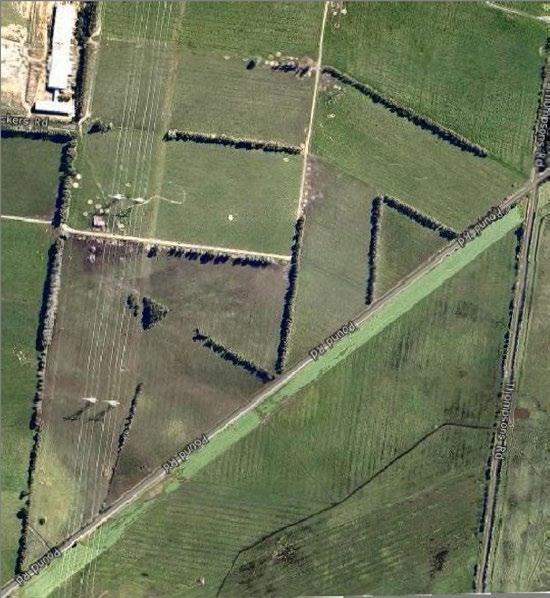
2 Subject site Unsealed C A Powerlines Gas Pipeline Easement RL. THOMPSONS ROAD Planted vegetation 1m contours Direction of slope A - Native trees to western boundary High point Low point Views Desalination pipe POUND ROAD FZ2 Quarry buffer A Location & direction of photo B B - View from Pound Rd RL. 47 D C- View from Thompsons Rd Gas pipe easement Existing Shed Powerline easement Existing Quarry D - Along powerline easement from Pound Rd m Site Analysis Beveridge Williams development & environment consultants Drafted By: Checked By: Drawing Ref: Version No: Date: A.G. H.V SA N Melbourne ph : Version Date Description Scale (A1): (A3): 1:00 1:5000 K:\JOBS DATA\ POUND RD CLYDE NORTH PARKWORTH PTY LTD\_LAN\00\CAD\ RHP ETC DWG
3
 Industrial Low Point Passive Open Space adjacent to drainage reserve High Point Views li sa de Opportunity to link shared path/green links Green Link ROAD Mixed")
4 Subject site Arterial Road Secondary Arterial Road 1 Connector St PSP 53 BOU NDARY Connector St - boulevard Connector St - industrial Major town centrehigh st THOMP SONS Higher density housing adjacent Major Contour (1m intervals) Industrial Low Point Passive Open Space adjacent to drainage reserve High Point Views li sa de Opportunity to link shared path/green links Green Link ROAD Mixed Use tio na Gas Pipeline Easement n 0m Park Radius pip ne Road Connection eli Site Ingress/Engress ea Gas Pipeline Easement se PSP Boundary en Drainage t Utilise views across the site from high point Medium Density Residential Powerline Easement Passive Open Space 3x Bowls Active Open Space Industrial Higher density housing adjacent Public Open Space m Conventional Density Residential Netball Nearby Major Town Centre (MTC) n tio a lin sa Primary School pip Existing Quarry. Opportunity for drainage reserve de Nearby Local Town Centre Indoor Sports ne eli MTC < 500m from development en m se ea t Drafted By: Checked By: Drawing Ref: Version No: Date: Design Response HARDYS ROAD (ARTERIA L) 0 A.G H.V DR Scale (A1) N/A (A3) 1:7, m
 7.3ha Arterial Roads 0.0ha 15 Existing Powerline Easement, Gas Easement (incl. local portion) Tree 0.455ha.483ha 0.0ha 2.ha within Drainage 2.")
5 Site boundary THOMPSONS ROAD Site (approximate only) Standard Residential Lots (>0m²) Medium Density Lots (<0m²) 41.4ha.723ha 0.765ha Medium Density Sites (1 site) 0.642ha Non-Arterial Roads (excl. gas easement) 7.3ha Arterial Roads 0.0ha 15 Existing Powerline Easement, Gas Easement (incl. local portion) Tree 0.455ha.483ha 0.0ha 2.ha within Drainage 2.4ha Medium Density Site A 6415m² title boundary ( Total 3.ha) Active Open Space Unencumbered Passive Open Space 0.1ha 1.420ha Net Developable Area (excluding ) ha Primary arterial gas pipeline easement 1.08ha Lot Yield (Conventional Lots only) Lot Yield (Medium Density Lots only) Estimated Lot Yield (1 Medium Density Site) lots per ha 450m² average lot size 23.3 lots per ha 4m² average lot size 23 lots per ha 9m² average lot size Connector street 60 Estimated Lot Yield (Overall Site) 6 lots per ha 4m² average lot size POUND ROAD gas pipeline easement desalination pipeline easement ha within title boundary ( Total 0.61ha) 23.5 Notes This plan is indicative only and is intended for discussion purposes only This plan is subject to change during the Council - GAA precinct structure plan preparation process All dimensions and areas are subject to survey and final computations Title boundaries are indicative only This plan has yet to take into consideration native flora, native fauna or Aboriginal cultural heritage, which may require further investigation Wetland / Drainage areas are approximate only and subject to detailed engineering design and may be subject to change during the precinct structure plan preparation process Access/egress to the site is subject to Council / Vics approval Road pavement is indicative only and subject to engineering design All public open space areas are conceptual only and subject to change during the precinct structure plan preparation process This plan assumes that rezoning of the land to Urban Growth Zone will occur in the future It is anticipated that a contribution will be required in lieu of providing active open space The commercial strip of land is as shown on the Draft PSP ha pylons Active open space Powerline Easement.08ha 0.01ha 0.08ha 0.ha TUCKERS ROAD pylons m Indicative Development Plan Beveridge Williams development & environment consultants Drafted By: Checked By: Drawing Ref: Version No: Date: T.GUY / HV N.FAULKNER IDP V2A Opt 1 02A N Melbourne ph : Version Date Description Scale (A1): (A3): 1:2000 1:00 K:\JOBS DATA\ POUND RD CLYDE NORTH PARKWORTH PTY LTD\_LAN\00\CAD\ IDP01 V2A DWG
6 .71 THOMPSONS ROAD Lot Mix Number % Site boundary >m Frontage 4.0 m Frontage m Frontage 1.7 Lots m Frontage m Frontage m Frontage Total Medium Density Site A 6415m² 2.ha within title boundary ( Total 3.ha) Site (approximate only) Standard Residential Lots (>0m²) Medium Density Lots (<0m²) Medium Density Sites (1 site) 41.4ha.723ha 0.765ha 0.642ha Primary arterial Connector street m² 0m² 0m² 5m².87 0m² 591m² 0m² 0m² m² m² 424m² 422m² 4m² 4m² 424m² 647m² 481m² m² m² 431m² 4m² 494m² 524m² m² m² 0m² m² 2m² 2m² m² m² 0m² 0m² 0m² 350m² 2m² 2m² m² 5m² 2m² m² m² m². 2m² 2m² 2m² 2m² 473m² 468m² 463m² 431m² 4m² 4m² 4m² 477m² m² 4m² 550m².6 462m² m² m² m² m². 412m² m² m².65 gas pipeline easement m² gas pipeline easement m² 4m² 4m² 4m² 4m² 4m² 4m² 4m² 5m² m² 1m² 319m² 1m² 7m² 6m² m² m² 9. 5m² 464m² m² 6m² 450m².9 3m² m² 3m² 0m² 0m² m² 3m² ha 0m² 4m² 4m² 4m² 4m² 453m² m² 0m² 551m² m² m² m².8 569m² 567m² 1 411m² 1 411m² 4m² 0m² 0m² 3m² 3m² 0m² 459m² m² m² 31. 5m² 5m² 5m² 5m² 5m² 5m² 4m² m² 4m² m² m² m² m² m² 452m² m² m² 488m² m² m² 0m² 3m² m² 4m² 31. 4m² 3m² 5m².51 0m² 4m² 506m² 624m² 3m² 3m² m² m² m² 0m² 4m² m² m² 4m² 5m² 5m² 449m² m² 5m² m² 480m² m² m² m² 0 460m² 555m² 3m² m² 3m² m² 0m² 0m² 3m² 3m² m² 431m² 6m² m² m² 477m² 0m² 507m² 457m² 0m² 3m² 3m² 0m² m² 0m² m² 0m² 0m² POUND ROAD m² 475m² 6m² 500m² m² 505m² 505m² m² m² 0m² 0m² 350m² 0m² 0m² 4m² 4m² 476m².6 2m² m² 0m² 0m² 2m² 0m² 0m².6 4m² 0m² 0m² 676m² 4m² 53. 4m² 5m² 4m² 0m² 0m² desalination pipeline easement 0m² 4m² 0m² m² m² m² m² 0m² 622m² 511m² 449m² m² m² 4m² 4m² 7m² 7m² 8m² Non-Arterial Roads (excl. gas easement) Arterial Roads Existing Powerline Easement, Gas Easement (incl. local portion) Tree Drainage Active Open Space Unencumbered Passive Open Space Net Developable Area (excluding ) Lot Yield (Conventional Lots only) Lot Yield (Medium Density Lots only) Estimated Lot Yield (1 Medium Density Site) Estimated Lot Yield (Overall Site) 0.ha within title boundary ( Total 0.61ha) 7.3ha 0.0ha 0.455ha.483ha 0.0ha 2.4ha 0.1ha 1.420ha ha lots per ha 450m² average lot size 23.3 lots per ha 4m² average lot size 23 lots per ha 9m² average lot size 6 lots per ha 4m² average lot size Notes This plan is indicative only and is intended for discussion purposes only This plan is subject to change during the Council - GAA precinct structure plan preparation process All dimensions and areas are subject to survey and final computations Title boundaries are indicative only This plan has yet to take into consideration native flora, native fauna or Aboriginal cultural heritage, which may require further investigation Wetland / Drainage areas are approximate only and subject to detailed engineering design and may be subject to change during the precinct structure plan preparation process Access/egress to the site is subject to Council / Vics approval Road pavement is indicative only and subject to engineering design All public open space areas are conceptual only and subject to change during the precinct structure plan preparation process This plan assumes that rezoning of the land to Urban Growth Zone will occur in the future It is anticipated that a contribution will be required in lieu of providing active open space The commercial strip of land is as shown on the Draft PSP pylons 0.01ha 0.08ha 0.ha 0.ha TUCKERS ROAD Active open space Powerline Easement.08ha pylons m Indicative Subdivision Plan - Lot Mix Beveridge Williams development & environment consultants Melbourne ph : Version Date Description Drafted By: Checked By: T.GUY N.FAULKNER Drawing Ref: ISP V1 Opt 1 Version No: Date: IDP : IDP V2A Opt 1 Scale (A1): 1:2000 (A3): 1:00 N K:\JOBS DATA\ POUND RD CLYDE NORTH PARKWORTH PTY LTD\_LAN\00\CAD\ IDP01 V2A DWG
7 .71 THOMPSONS ROAD Site boundary Lots 8 Stage boundaries Stage numbers Primary arterial Connector street A 6415m² POUND ROAD desalination pipeline easement Notes This plan is indicative only and is intended for discussion purposes only This plan is subject to change during the Council - GAA precinct structure plan preparation process All dimensions and areas are subject to survey and final computations Title boundaries are indicative only This plan has yet to take into consideration native flora, native fauna or Aboriginal cultural heritage, which may require further investigation Wetland / Drainage areas are approximate only and subject to detailed engineering design and may be subject to change during the precinct structure plan preparation process Access/egress to the site is subject to Council / Vics approval Road pavement is indicative only and subject to engineering design All public open space areas are conceptual only and subject to change during the precinct structure plan preparation process This plan assumes that rezoning of the land to Urban Growth Zone will occur in the future It is anticipated that a contribution will be required in lieu of providing active open space The commercial strip of land is as shown on the Draft PSP53 Lot Mix Number % >m Frontage 4.0 m Frontage m Frontage 1.7 m Frontage 96.2 m Frontage m² 0m² 0m² 0m² 5m².87 0m² m² 0m² 653m² m² 424m² 422m² 4m² 490m² 431m² 4m² 424m² 647m² 481m² m² 443m² m² m² 4m² 4m² 494m² m² m² 5m² 480m² 350m² 350m² 2m² 2m² 2m² 2m² 2m² 0m² 0m² 507m² 0m² 0m² 501m² m². 463m² 2m² 2m² 2m² 2m² 473m² 468m² 431m² 4m² 4m² 4m² 477m² gas pipeline easement.73 4m² 4m² 550m².6 462m² 462m² 412m² 412m² 5m² m² m² Medium Density Site gas pipeline easement 3m² 3m² 3m² 2.ha within title boundary ( Total 3.ha) 1.08ha 3m² 3m² m² 444m² 4m² 5m² 4m² 554m² 4m² 0m² 3m² 449m² 4m² 4m² 535m² 507m² 411m² 411m² 559m² 4m² 4m² 550m² 4m² 6m² 4m² 4m² 4m² 0m² 4m² 4m² 488m² 0m² 4m² 456m² 4m² 5m² 515m² 4m² 5m² 453m² 5m² 5m² 572m² 5m² 5m² 569m² 521m² 555m² 5m² 588m² 488m² 464m² 5m² 4m² 551m² 0m² 5m² 4m² 410m² 477m² 0m² 4m² 5m² 431m² 6m² 6m² 4m² 5m² 0m² 6m² 574m² 457m² 450m² 871m² 0m² 5m² 506m² 583m² 6m² 0m² 4m² 5m² 5m² 501m² 475m² 544m² 6m² 774m² 676m² 0m² 567m² 4m² 624m² 5m² 0m² 1m² 3m² 5m² 319m² 480m² 5m² 3m² 0m² 3m² 0m² 4m² 4m² 0m² 476m² 0m² 3m² 0m² 672m² 0m² 1m² 5m² 0m² 879m² 0m² 0m² 622m² 7m² 5m² 0m² 0m² 3m² 350m² 350m² 5m² 3m² 2m² 6m² 2m² 3m² 3m² 0m² 3m² 5m² 511m² 3m² 480m² 500m² 466m² 0m² 441m² 5m² 459m² 505m² 4m² 0m² 452m² 0m² 0m² 0m² 0m² 452m² 0m² 505m² 0m² 460m² 449m² 0m² 500m² 0m² 0m² 0m² 0m² 0m² 0m² m² m² 4m² 4m² 4m² 4m² m² m² m² 4m² 4m² 7m² 7m² 8m² ha within title boundary ( Total 0.61ha) Medium Density Lots (<0m²) Non-Arterial Roads (excl. gas easement) Arterial Roads Tree 8.5m Frontage Total Site (approximate only) Standard Residential Lots (>0m²) Medium Density Sites (1 site) Existing Powerline Easement, Gas Easement (incl. local portion) Drainage Active Open Space Unencumbered Passive Open Space Net Developable Area (excluding ) Lot Yield (Conventional Lots only) Lot Yield (Medium Density Lots only) Estimated Lot Yield (1 Medium Density Site) Estimated Lot Yield (Overall Site) 41.4ha.723ha ha 0.642ha 7.3ha 0.0ha 0.455ha.483ha 0.0ha 2.4ha 0.1ha 1.420ha ha lots per ha 450m² average lot size 23.3 lots per ha 4m² average lot size 23 lots per ha 9m² average lot size 6 lots per ha 4m² average lot size pylons 0.01ha 0.08ha 0.ha 0.ha TUCKERS ROAD Active open space Powerline Easement.08ha pylons m Staging Plan Beveridge Williams development & environment consultants Melbourne ph : Version Date Description Drafted By: Checked By: T.GUY N.FAULKNER Drawing Ref: ISP V1 Opt 1 Version No: Date: IDP : IDP V2A Opt 1 Scale (A1): 1:2000 (A3): 1:00 N K:\JOBS DATA\ POUND RD CLYDE NORTH PARKWORTH PTY LTD\_LAN\00\CAD\ IDP01 V2A DWG


8 S1 Access Street Level 1 adjacent to reserve S2 Access Street Level 1


9 S3 Access Street with 6m wide Gas Pipeline Easement Level 1 S4 Connector Street


10 Drainage Powerline Easement
11 Primary Arterial - 41m Connector Street - m Connector Street m Connector Street - m Access Street Level 1 - m Access Street Level 1 - m Drainage Access Street level 1 - m (Gas pipeline easement) Shared path S1 Street Section (see street section page for more detail) Desalination Easement Standard density lots Medium density lots S4 S3 S2 S1 Powerline Easement m Road Heirarchy Drafted By: Checked By: Drawing Ref: Version No: Date: IDP: Scale (A1) (A3) A.G H.V _RH ISP_01 V2A N/A 1:00


12 Acer rubrum October Glory Corymbia maculata Eucalyptus scoparia Lagerstroemia indica x L fauirei Yuma Platanus x acerifolia Ulmus parvifolia Todd Tristanioposis laurina Pyrus calleryana Chanticleer Drainage Standard density lots Medium density lots Desalination Easement Acer rubrum October Glory Corymbia maculata Eucalyptus scoparia Lagerstroemia indica x L. fauriei Yuma Tristaniopsis laurina Powerline Easement Platanus x acerifolia Pryus calleryana Chanticleer Ulmus parvifolia Todd Street Trees m Drafted By: Checked By: Drawing Ref: Version No: Date: IDP: Scale (A1) (A3) A.G H.V _SP ISP_01 V2A N/A 1:00


13 concept Fitness stations and seating located at intervals along shared path with pedestrian path and seating area Shared path to provide a exercise circuit for the local community Small tree planting with in easment to relevant authorities guidelines


14 Shared path to link with shared path along Thompsons Road Gas Pipeline Easement Shared path Wetland Seat in concrete Shelter, picnic tables & BBQ facilities Modern-style junior playground with hopscotch Rebound wall and netball hoop Acer Rubrum October Glory avenue continued to wetland Desalination pipeline with shared path and informal planting Title boundary Timber platform with seating and informative wetland signage Drainage reserve boundary Modern-style senior playground & fitness equipment Treed grassed mounds for informal play THOMPSONS ROAD
PLANNING SUBMISSION & CLAUSE 56 ASSESSMENT RESIDENTIAL SUBDIVISION OF LAND 1525 POUND ROAD, CLYDE NORTH (LOT 2 PS F, SIENNA PARK ESTATE)
") PLANNING SUBMISSION & CLAUSE 56 ASSESSMENT RESIDENTIAL SUBDIVISION OF LAND 1525 POUND ROAD, CLYDE NORTH (LOT 2 PS 327975F, SIENNA PARK ESTATE) DFC (PROJECT MANAGEMENT) PTY LTD (A DENNIS FAMILY CORPORATION
PLANNING SUBMISSION & CLAUSE 56 ASSESSMENT RESIDENTIAL SUBDIVISION OF LAND 1525 POUND ROAD, CLYDE NORTH (LOT 2 PS 327975F, SIENNA PARK ESTATE) DFC (PROJECT MANAGEMENT) PTY LTD (A DENNIS FAMILY CORPORATION
Clyde Precinct Development Contributions Plan (DCP) Land Assessments
 Land Assessments") VALUATION REPORT. Clyde Precinct Development Contributions Plan (DCP) Land Assessments Thompsons Road Precinct Structure Plan No. 1053 Clyde Creek Precinct Structure Plan No. 1054 Casey Fields South South
VALUATION REPORT. Clyde Precinct Development Contributions Plan (DCP) Land Assessments Thompsons Road Precinct Structure Plan No. 1053 Clyde Creek Precinct Structure Plan No. 1054 Casey Fields South South
Pakenham East Precinct Structure Plan Design Response options for the Transmission Easement
 Pakenham East Precinct Structure Plan Design Response options for the Transmission Easement urban design planning engineering surveying landscape architecture project management Quality Assurance Report
SCHEDULE 12 TO THE URBAN GROWTH ZONE. Shown on the planning scheme map as UGZ12. Kororoit Precinct Structure Plan
 SCHEDULE 12 TO THE URBAN GROWTH ZONE Shown on the planning scheme map as UGZ12. Kororoit Precinct Structure Plan 1.0 The plan Map 1 below shows the future urban structure proposed in the Kororoit Precinct
Flinders Avenue, Lara Planning Scheme Amendment Combined Application for Rezoning and Multi-Lot Subdivision Reference : Decembe
 143-179 Flinders Avenue, Lara Planning Scheme Amendment Combined Application for Rezoning and Multi-Lot Subdivision Reference: 14134-03 TGM Group Geelong Melbourne Ballarat 1/27-31 Myers Street (PO Box
Kelly Street. Rankin Street
 Spring Street Kelly Street State Primary School P-6 State Secondary School 7-12 POTE BEVER Hume Freeway Rankin Street Stewart Street Non Government School State Primary School LOCKERBIE NORTH DEVELOPMENT
Valuation Report Land Assessment
 Valuation Report Land Assessment Brompton Lodge (PSP1209) Precinct Structure Plan Development Contributions Plan (DCP) Land Assessments As at 14 October 2015. Prepared for Metropolitan Planning Authority
GWINNETT COUNTY CSO CONSERVATION SUBDIVISION OVERLAY DISTRICT REQUIREMENTS
 GWINNETT COUNTY CSO CONSERVATION SUBDIVISION OVERLAY DISTRICT REQUIREMENTS Section 1316. CSO Conservation Subdivision Overlay District. 1. Purposes. The purposes of this overlay district are as follows:
PLANNING PERMIT. Permit No.: PlnE00409/13. Signature for the Responsible Authority
 by Parkworth Pty Ltd at 1350 Pound Road, Clyde North PLANNING PERMIT GRANTED UNDER DIVISION 5 OF PART 4 OF THE PLANNING AND ENVIRONMENT ACT 1987 Permit No.: Planning Scheme: Responsible : PlnE00409/13
SCHEDULE 3 TO THE URBAN GROWTH ZONE. Shown on the planning scheme map as UGZ3 QUARRY HILLS PRECINCT STRUCTURE PLAN. 1.0 The Plan
 SCHEDULE 3 TO THE URBAN GROWTH ZONE 1.0 The Plan Shown on the planning scheme map as UGZ3 QUARRY HILLS PRECINCT STRUCTURE PLAN Map 1 to Schedule 3 to Clause 37.07 shows the Future Urban Structure for Quarry
Bylaw No , being "Official Community Plan Bylaw, 2016" Schedule "A" DRAFT
 Bylaw No. 2600-2016, being "Official Community Plan Bylaw, 2016" Schedule "A" Urban Structure + Growth Plan Urban Structure Land use and growth management are among the most powerful policy tools at the
Kororoit Precinct Structure Plan Statement of Evidence Mark Woodland November 2016
 1 P a g e Contents 1.0 Introduction... 3 2.0 Expert Witness Statement... 4 3.0 Summary of Evidence... 6 4.0 Subject site and surrounding context... 9 4.1 Subject site... 9 4.3 Surrounding context... 9
GREENVALE CENTRAL DEVELOPMENT CONTRIBUTIONS PLAN SOMERTON ROAD BONDS LANE SECTION ROAD MICKLEHAM ROAD OVIDENCE ROAD ROLL LANE
 SOMERTON ROAD BONDS LANE LE N SECTION ROAD OVIDENCE ROAD GREENVALE CENTRAL DEVELOPMENT CONTRIBUTIONS PLAN November 2013 (amended August 2017) ROLL LANE MICKLEHAM ROAD CONTENTS 1.0 INTRODUCTION 3 1.1 Purpose
PLANNED DEVELOPMENT DISTRICT STANDARDS. Cadence Site
 PLANNED DEVELOPMENT DISTRICT STANDARDS Cadence Site A Planned Development District 1. Statement of General Facts, Conditions and Objectives Property Size: Approximately 57.51 Acres York County Tax Map
Authors Matt Ainsaar Paul Shipp Jojo Chen
 Authors Matt Ainsaar Paul Shipp Jojo Chen Copyright, Urban Enterprise Pty Ltd, September 2011. This work is copyright. Apart from any use as permitted under Copyright Act 1963, no part may be reproduced
Greenvale North [R1] - Precinct Structure Plan DEVELOPMENT CONTRIBUTIONS PLAN
![Greenvale North [R1] - Precinct Structure Plan DEVELOPMENT CONTRIBUTIONS PLAN](/thumbs/89/97975288.jpg "Greenvale North [R1] - Precinct Structure Plan DEVELOPMENT CONTRIBUTIONS PLAN") Mount Aitken LYSTERFIELD DRIVE Kolbe College Neighbourhood Activity Centre Active Open Space 10.25 ha Greenvale North [R1] - Precinct Structure Plan DEVELOPMENT CONTRIBUTIONS PLAN JANUARY 2011 (Amended
Mount Aitken LYSTERFIELD DRIVE Kolbe College Neighbourhood Activity Centre Active Open Space 10.25 ha Greenvale North [R1] - Precinct Structure Plan DEVELOPMENT CONTRIBUTIONS PLAN JANUARY 2011 (Amended
I Harris. Melbourne. John Quirk, Member. Merits Review of Refusal
 VICTORIAN CIVIL AND ADMINISTRATIVE TRIBUNAL ADMINISTRATIVE DIVISION PLANNING AND ENVIRONMENT LIST VCAT REFERENCE NO. P382/2005 PERMIT APPLICATION NO. YR-2004/1272 CATCHWORDS 4 lot subdivision of large
SOMERTON ROAD BONDS LANE SECTION ROAD MICKLEHAM ROAD GREENVALE CENTRAL PROVIDENCE ROAD DEVELOPMENT CONTRIBUTIONS PLAN CARROLL LANE
 VALE TION VE SOMERTON ROAD BONDS LANE SECTION ROAD PROVIDENCE ROAD GREENVALE CENTRAL CARROLL LANE MICKLEHAM ROAD DEVELOPMENT CONTRIBUTIONS PLAN November 2013 PLANS Plan 1: Local context 4 Plan 2: Future
Plans shall be drawn at a readable scale, signed, and sealed by a Florida Registered Engineer. The application package shall include:
 CHAPTER 400. SECTION 403. PERMIT TYPES AND APPLICATIONS SITE DEVELOPMENT 403.3. Preliminary Site Plans (PSP) A. Intent and Purpose PSPs are used to identify existing site conditions and demonstrate general
PORT PHILLIP PLANNING SCHEME. Condition
 SCHEDULE 1 TO THE CAPITAL CITY ZONE Shown on the planning scheme map as CCZ1. FISHERMANS BEND URBAN RENEWAL AREA Purpose To use and develop the Fishermans Bend Urban Renewal Area generally in accordance
PLANNING PERMIT GRANTED UNDER DIVISION 5 OF PART 4 OF THE PLANNING AND ENVIRONMENT ACT 1987
 PLANNING PERMIT GRANTED UNDER DIVISION 5 OF PART 4 OF THE PLANNING AND ENVIRONMENT ACT 1987 Permit no.: WYP6211/12 Planning scheme: Wyndham Planning Scheme Responsible : City of Wyndham ADDRESS OF THE
HUME FREEWAY LOCKERBIE DEVELOPMENT CONTRIBUTIONS PLAN. State. Non Government. School. State Primary School P-6. Secondary. School.
 State Primary School P-6 Non Government School HUME FREEWAY State Primary School LOCKERBIE DEVELOPMENT CONTRIBUTIONS PLAN MAY 2012 (Amended June 2017) P-6 State Secondary School 7-12 POTENTIAL LOCKERBIE
CHAPTER34 PRUD - PLANNED RESIDENTIAL UNIT DEVELOPMENT
 CHAPTER34 PRUD - PLANNED RESIDENTIAL UNIT DEVELOPMENT 17-34-1 17-34-2 17-34-3 17-34-4 17-34-5 17-34-6 17-34-7 17-34-8 17-34-9 Purpose Planned Residential Unit Development Defined Planned Residential Unit
Planning and Environment Regulations 2005 Form 9. Draft for exhibition only - v1. Permit no.: WYP6212/12
 PLANNING PERMIT GRANTED UNDER DIVISION 5 OF PART 4 OF THE PLANNING AND ENVIRONMENT ACT 1987 Permit no.: WYP6212/12 Planning scheme: Wyndham Planning Scheme Responsible : City of Wyndham ADDRESS OF THE
CHAPTER 29 ARTICLE 8. 20,000 sf 30,000 sf 100,000 sf (with approval by Special Use Permit according to Sec
 CHAPTER 29 ARTICLE 8 (3) Zone Development Standards. The zone development standards for the NC Zone are set forth in Table 29.81(3) below: Table 29.81(3) Neighborhood Commercial (NC) Zone Development Standards
PLANNING PERMIT GRANTED UNDER DIVISION 5 OF PART 4 OF THE PLANNING AND ENVIRONMENT ACT 1987
 PLANNING PERMIT GRANTED UNDER DIVISION 5 OF PART 4 OF THE PLANNING AND ENVIRONMENT ACT 1987 Permit no.: WYP6217/12 Planning scheme: Wyndham Planning Scheme Responsible authority: City of Wyndham Style
Town of Windham Land Use Ordinance Sec. 400 Zoning Districts SECTION 400 ZONING DISTRICTS
 Town of Windham Land Use Ordinance Sec. 400 Zoning Districts Sections SECTION 400 ZONING DISTRICTS SECTION 400 ZONING DISTRICTS 4-1 401 Districts Enumerated 4-2 402 Location of districts; Zoning Map 4-2
PRELIMINARY PLATS. The following documents are provided as required by the City of Conroe for use in the above titled platting submittals:
 Public Works Engineering Division CITY OF CONROE PRELIMINARY PLATS The following documents are provided as required by the City of Conroe for use in the above titled platting submittals: Submittal Questionnaire
EAST WERRIBEE EMPLOYMENT PRECINCT
 DERRIMUT ROA Mercy Hospital POINT COOK WEST PSP PRINCES HIGHWAY University of Melbourne Victoria University Local Town Centre Melbourne Water Pumping Station LAKESIDE AVENUE DUNNINGS ROAD Suzanne Cory
Chapter Planned Residential Development Overlay
 Chapter 19.29 Planned Residential Development Overlay Sections 010 Purpose 020 Scope 030 Definitions 030 Minimum Size 040 Allowable Uses 050 Minimum Development Standards 060 Density Bonus 070 Open Space
Cranbourne West Economic and Planning Analysis. Prepared for Leighton Properties
 Cranbourne West Economic and Planning Analysis Prepared for Leighton Properties February 2015 STAFF RESPONSIBLE FOR THIS REPORT WERE: Director Consultant Job Code Rhys Quick Dene MacLeod MPE1-2263 Urbis
Technology Park Planned Unit Development Technology Park PUD-IP
 Technology Park Planned Unit Development Technology Park PUD-IP Rob Anderson Community Development Director Planned Unit Development Background 2 Planned Unit Development (PUD) means a mixed use redevelopment
3.0 SITES INVENTORY AND ANALYSIS
 3.1 OVERVIEW This section of the Housing Element addresses the Table 46 2014-2022 RHNA requirements of Government Code Sections 65583 and Income Category Units 65583.2. Like every other city and county
LAND DEVELOPMENT APPLICATION SUBDIVISION SUBMISSION
 LAND DEVELOPMENT APPLICATION SUBDIVISION SUBMISSION CITY PLANNING BRANCH NOVEMBER 2017 TABLE OF CONTENTS SUBDIVISION PROCESS CHART...3 SUBMISSION OF APPLICATION...4 REMOVE CONDITIONS SUBMISSIONS...7 CONDOMINIUM
CITY OF BONITA SPRINGS ZONING ORDINANCE NO
 CITY OF BONITA SPRINGS ZONING ORDINANCE NO. 06-05 A ZONING ORDINANCE OF THE CITY OF BONITA SPRINGS, FLORIDA; APPROVING A REQUEST BY NAPITA HOLDINGS, LLC IN REFERENCE TO BONITA ROAD LOCKUP CPD; TO REZONE
2. Rezone a portion of the lot from R2 (Small Lot Residential) to RD2 (Duplex: Housing Lane).
 to RD2 (Duplex: Housing Lane).") Public Notice September 6, 2018 Subject Property Subject Property: 337 Hastings Ave Lot 24, District Lot 1, Group 7, Similkameen Division Yale (Formerly Yale-Lytton) District, Plan 932 Application: The
Public Notice September 6, 2018 Subject Property Subject Property: 337 Hastings Ave Lot 24, District Lot 1, Group 7, Similkameen Division Yale (Formerly Yale-Lytton) District, Plan 932 Application: The
B. Subarea Provisions, including the Design Elements and Area of Special Concern and Potential Park/Open Space/Recreation Requirements;
 ARTICLE III: LAND USE DISTRICTS III-1 300 INTRODUCTION Article III of the Washington County Community Development Code consists of the primary and overlay districts which apply to the unincorporated areas
ORDINANCE NO. 208 BE IT ORDAINED BY THE CITY COUNCIL OF THE CITY OF UNIVERSITY HEIGHTS, JOHNSON COUNTY, IOWA:
 ORDINANCE NO. 208 AN ORDINANCE AMENDING ORDINANCE NO. 79 (ZONING) TO CREATE A COMMERCIAL HOTEL ZONE AND PERMIT DEVELOPMENT PURSUANT TO A COMMERCIAL HOTEL PUD BE IT ORDAINED BY THE CITY COUNCIL OF THE CITY
Parkland-Spanaway-Midland LUAC - Agenda
 1. 6:30 P.M. Parkland-Spanaway-Midland LUAC - Agenda Documents: 8 2 17 PSMAC Agenda.pdf 2. Parkland-Spanaway-Midland LUAC Initial Project Review Documents: Lincoln Court PP IPR PSMAC-RJ.pdf Department
TOWN OF LEWISTON PLANNING BOARD APPLICATION
 TOWN OF LEWISTON PLANNING BOARD APPLICATION DESCRIPTION OF PROPOSED REQUEST: Name of Property Owner: Phone #: Name of Applicant:Phone #: Address or Location of Proposal:_SBL# Size of Parcel or Structure:Existing
Gisborne District Council
 12.0 SUBDIVISION... 1 12.1 INTRODUCTION... 1 12.2 ISSUE... 1 12.3 OBJECTIVE (SUBDIVISION)... 1 12.4 POLICIES (SUBDIVISION)... 2 12.5 METHODS OF IMPLEMENTATION... 4 12.5.1 REGULATION... 4 12.6 RULES FOR
PRELIMINARY PLAN CHECKLIST Major Land Development Projects. To initiate the application, the applicant shall submit to the Administrative Officer:
 PRELIMINARY PLAN CHECKLIST Major Land Development Projects To initiate the application, the applicant shall submit to the Administrative Officer: 1. The application review fee, as established by the South
Planned Unit Development (PUD). Sections:
. Sections:") Chapter 19.07. Planned Unit Development (PUD). Sections: 19.07.01. Purpose. 19.07.02. PUD Definition and Design Compatibility. 19.07.03. General PUD Standards. 19.07.04. Underlying Zones. 19.07.05. Permitted
Chapter 19.07. Planned Unit Development (PUD). Sections: 19.07.01. Purpose. 19.07.02. PUD Definition and Design Compatibility. 19.07.03. General PUD Standards. 19.07.04. Underlying Zones. 19.07.05. Permitted
A. Preserve natural resources as identified in the Comprehensive Plan.
 1370.08 Conservation Residential Overlay District. Subd. 1 Findings. The City finds that the lands and resources within the Conservation Residential Overlay District are a unique and valuable resource
TREASURE COAST REGIONAL PLANNING COUNCIL M E M O R A N D U M. To: Council Members AGENDA ITEM 9D
 TREASURE COAST REGIONAL PLANNING COUNCIL M E M O R A N D U M To: Council Members AGENDA ITEM 9D From: Date: Subject: Staff May 15, 2015 Council Meeting Local Government Comprehensive Plan Review Draft
Section Preliminary Plat Checklist and Application Forms
 Section 201 - Preliminary Plat Checklist and Application Forms PRELIMINARY SUBDIVISION PLAT REVIEW PROCESS CHART PRELIMINARY SUBDIVISION PLAT APPLICATION PRELIMINARY PLAT REVIEW CHECKLIST CITY OF NAMPA
What is a Neighbourhood Plan?
 What is a Neighbourhood Plan? A Neighbourhood Plan determines the location and design of new transit-oriented land uses, like: Council adopts a Neighbourhood Plan following public consultation and technical
CHAPTER 10 Planned Unit Development Zoning Districts
 CHAPTER 10 Planned Unit Development Zoning Districts Section 10.1 Intent and Purpose The Planned Unit Development (PUD) districts are intended to offer design flexibility for projects that further the
Condominium Unit Requirements.
 ARTICLE 19 CONDOMINIUM REGULATIONS Section 19.01 Purpose. The purpose of this Article is to regulate projects that divide real property under a contractual arrangement known as a condominium. New and conversion
Open Space Model Ordinance
 Open Space Model Ordinance Section I. Background Open space development has numerous environmental and community benefits, including: 1) Reduces the impervious cover in a development. Impervious cover
EXHIBIT A FOR HAMILTON PLACE RPUD
 EXHIBIT A Regulations for development of the Hamilton Place RPUD shall be in accordance with the contents of this RPUD Document and applicable sections of the LDC and Growth Management Plan (GMP) in effect
Chapter. Subdivision Regulations Porter County Unified Development Ordinance. website Bradley E.
 Subdivision Regulations Porter County Unified Development Ordinance 2007 Bradley E. Johnson, AICP website www.groundrulesinc.com Conventional Subdivision (CV) 6.01 Conventional Subdivision Intent The Conventional
Tentative Map Application Review Procedures
 FOR REFERENCE ONLY This page is not part of the application. Tentative Map Application Review Procedures The tentative map process in Churchill County is designed to provide a mechanism in order to divide
CITY CLERK. Phase 4 Scarborough Transportation Corridor Land Use Study - SC-W (Ward 36 - Scarborough Southwest)
") CITY CLERK Clause embodied in Report No. 4 of the, which was before the Council of the City of Toronto at its meeting held on May 21, 22 and 23, 2002. 14 Phase 4 Scarborough Transportation Corridor Land
CITY CLERK Clause embodied in Report No. 4 of the, which was before the Council of the City of Toronto at its meeting held on May 21, 22 and 23, 2002. 14 Phase 4 Scarborough Transportation Corridor Land
DEVELOPMENT PLAN REVIEW CHECKLIST. To initiate the application, the applicant shall submit to the Administrative Officer:
 DEVELOPMENT PLAN REVIEW CHECKLIST To initiate the application, the applicant shall submit to the Administrative Officer: 1. Sixteen (16) copies of the Project Review Application Form, printed double-sided;
Staff Report: Date: Applicant: Property Identification: Acreage of Request: Current Zoning of Requested Area: Requested Action: Attached:
 Staff Report: Completed by Jeff Palmer Director of Planning & Zoning Date: November 7, 2018, Updated November 20, 2018 Applicant: Greg Smith, Oberer Land Developer agent for Ronald Montgomery ET AL Property
CONCEPTUAL MASTER PLAN CHECKLIST Major Land Development Project
 CONCEPTUAL MASTER PLAN CHECKLIST Major Land Development Project To initiate the application, the applicant shall submit to the Administrative Officer: 1. The application review fee, as established by the
Explanation The policies ensure that land is suitable for subdivision and will not increase risks to people, the environment and property.
 23 Subdivision 23.1 Purpose a) Subdivision is essentially the process of dividing a parcel of land or a building into one or more further parcels, or changing an existing boundary location. Subdivision
APPLICATIONS FOR OFFICIAL PLAN AMENDMENT AND ZONE CHANGE
 COMMUNITY AND STRATEGIC PLANNING P. O. Box 1614, Court House, Woodstock Ontario N4S 7Y3 Phone: 519-539-9800 Fax: 519-537-5513 Web Site: www.county.oxford.on.ca Our Files: OP 11-153 & ZON 3-07-18 APPLICATIONS
DEVELOPMENT STANDARDS
 Chapter 5 DEVELOPMENT STANDARDS 501 Residential Development Standards 502 Neighborhood Commercial Standards 503 Mixed Use Standards 504 Industrial Development Standards 505 Public Use Standards 506 Open
LAND USE, ZONING, & DEVELOPMENT STANDARDS
 02 LAND USE, ZONING, & DEVELOPMENT STANDARDS CHAPTER 2: LAND USE, ZONING, & DEVELOPMENT STANDARDS 2.1 Introduction The City s General Plan Land Use Map (LUE Figure 3) designates the Froom Ranch Area as
P. H. Robinson Consulting Urban Planning, Consulting and Project Management
 P. H. Robinson Consulting Urban Planning, Consulting and Project Management PLANNING RATIONALE REPORT 99-101 AND 103 PINHEY - SITE PLAN APPLICATION CITY OF OTTAWA PREPARED BY: P H ROBINSON CONSULTING SEPTEMBER
Plan Commission Staff Report Reserve PUD Site Plan Land Use Thursday, January 4, 2018 Plan Commission Wednesday, January 17, 2018
 Reserve - PUD Site Plan Report 1 Plan Commission Staff Report Reserve PUD Site Plan Land Use Thursday, January 4, 2018 Plan Commission Wednesday, January 17, 2018 Development name: Reserve Planned Unit
SUBDIVISION FEASIBILITY REPORT
 SUBDIVISION FEASIBILITY REPORT for 101 We Subdivide Avenue, Auckland 28 th September 2017 1 28 th September 2017 Our Clients 101 We Subdivide Avenue Auckland 1010 Hi Our Clients, The following report is
Lake Narracan. Development Contributions Plan. March 2015 (Amended June 2017)
") Lake Narracan Development Contributions Plan March 2015 (Amended June 2017) CONTENTS 1.0 INTRODUCTION 4 1.1 Report Structure 5 1.2 Strategic Basis 5 1.3 Planning & Environment Act 1987 5 1.4 Strategic
Lake Narracan Development Contributions Plan March 2015 (Amended June 2017) CONTENTS 1.0 INTRODUCTION 4 1.1 Report Structure 5 1.2 Strategic Basis 5 1.3 Planning & Environment Act 1987 5 1.4 Strategic
SUBMITTAL REQUIREMENTS: The number indicates the number of copies for submittal (if applicable).
.") Office Use Only Preliminary Long Plat Long Subdivision Applicant Checklist PLANNING, COMMUNITY, & ECONOMIC DEVELOPMENT DEPARTMENT PRELIMINARY LONG PLAT LONG SUBDIVISION CHECKLIST Mailing Address: P.O.
Office Use Only Preliminary Long Plat Long Subdivision Applicant Checklist PLANNING, COMMUNITY, & ECONOMIC DEVELOPMENT DEPARTMENT PRELIMINARY LONG PLAT LONG SUBDIVISION CHECKLIST Mailing Address: P.O.
GOALS, OBJECTIVES, AND STRATEGIES
 GOALS, OBJECTIVES, AND STRATEGIES What follows is a series of goals, recommendations and actions that reflect the themes outlined in the Mineral Springs Vision Plan (incorporated into this document as
Development Permit. Development Permit to permit the construction of an industrial building. Approval
 City of Surrey PLANNING & DEVELOPMENT REPORT Development Permit Proposal: Development Permit to permit the construction of an industrial building. Recommendation: Approval Location: 18485-53 Avenue Zoning:
KNOXVILLE/KNOX COUNTY METROPOLITAN PLANNING COMMISSION SUBDIVISION REPORT - CONCEPT/USE ON REVIEW
 KNOXVILLE/KNOX COUNTY METROPOLITAN PLANNING COMMISSION SUBDIVISION REPORT - CONCEPT/USE ON REVIEW FILE #: 10-SA-15-C 10-A-15-UR AGENDA ITEM #: 10 AGENDA DATE: 10/8/2015 SUBDIVISION: APPLICANT/DEVELOPER:
Bowie Marketplace Residential Detailed Site Plan Statement of Justification January 13, 2017 Revised February 2, 1017
 Bowie Marketplace Residential Detailed Site Plan Statement of Justification January 13, 2017 Revised February 2, 1017 Submitted on behalf of: BE Bowie LLC 5410 Edson Lane, Suite 220 Rockville, MD 20852
2401 Wilson Boulevard General Land Use Plan Amendment Study
 2401 Wilson Boulevard General Land Use Plan Amendment Study Long Range Planning Committee Meeting Presentation Compendium March 29, 2011 Department of Community Planning, Housing and Development GLUP Amendment
SCHEDULE 5 TO THE URBAN GROWTH ZONE Shown on the planning scheme map as UGZ5 WOLLERT PRECINCT STRUCTURE PLAN. 1.0 The plan
 SCHEDULE 5 TO THE URBAN GROWTH ZONE Shown on the planning scheme map as UGZ5 1.0 The plan WOLLERT PRECINCT STRUCTURE PLAN Map 1 below shows the future urban structure proposed in the Wollert Precinct Structure
Title 2: Land Use and Zoning
 Title 2: Land Use and Zoning Chapter 200. General Provisions. Section 200-10. Purpose. This Title 2 is intended to implement the purposes set forth in Section 100-20, and further is enacted for the purposes
Truganina Employment Precinct Development Contributions Plan
 Amendment C124 to the Wyndham Planning Scheme Truganina Employment Precinct Development Contributions Plan December 2009 SM 20091202 11:05 CONTENTS PURPOSE 3 REPORT STRUCTURE 3 1.0 STRATEGIC BASIS 5 1.1
COMMUNITY DEVELOPMENT DEPARTMENT 333 Broadalbin Street SW, P.O. Box 490 Albany, OR 97321
 COMMUNITY DEVELOPMENT DEPARTMENT 333 Broadalbin Street SW, P.O. Box 490 Albany, OR 97321 STAFF REPORT Application for Site Plan Review (SP-02-18) Residential Accessory Building Ph: 541-917-7550 Fax: 541-917-7598
APPLICATIONS CLOSE FOR THE CURRENT FINANCIAL YEAR ON 31 MARCH PLEASE RETURN TO
 Permanent or Temporary Water Trade Application form Water Act 1989 Sections 62 APPLICATIONS CLOSE FOR THE CURRENT FINANCIAL YEAR ON 31 MARCH PLEASE RETURN TO Regional Services Melbourne Water Corporation
4. facilitate the construction of streets, utilities and public services in a more economical and efficient manner;
 PVPC MODEL BYLAW BY-RIGHT CLUSTER ZONING BYLAW Prepared by Pioneer Valley Planning Commission Revised: October 2001 1.00 Development 1.01 Development Allowed By Right Development in accordance with this
APPLICATION FOR PLAN OF SUBDIVISION/CONDOMINIUM
 The Corporation of the County of Wellington APPLICATION FOR PLAN OF SUBDIVISION/CONDOMINIUM Please review the following application guidelines PRE-CONSULTATION: The County of Wellington strongly encourages
CITY OF SANTA ROSA COMMUNITY DEVELOPMENT DEPARTMENT STAFF REPORT FOR PLANNING COMMISSION SEPTEMBER 10, 2015 APPLICANT FILE NUMBER MJP
 ITEM NO. 9 CITY OF SANTA ROSA COMMUNITY DEVELOPMENT DEPARTMENT STAFF REPORT FOR PLANNING COMMISSION SEPTEMBER 10, 2015 PROJECT TITLE Yogurt Time Center ADDRESS/LOCATION 3093 Marlow Road ASSESSOR S PARCEL
Draft Model Access Management Overlay Ordinance
 Draft Model Access Management Overlay Ordinance This model was developed using the City of Hutchinson and the Trunk Highway 7 corridor. The basic provisions of this model may be adopted by any jurisdiction
619. Planned Development District (PD)
") 619. Planned Development District (PD) Intent. The purpose of the Planned Development District (sometimes hereinafter referred to as PD) is to provide opportunities to create more desirable environments
619. Planned Development District (PD) Intent. The purpose of the Planned Development District (sometimes hereinafter referred to as PD) is to provide opportunities to create more desirable environments
ARTICLE 9 SPECIFICATIONS FOR DOCUMENTS TO BE SUBMITTED
 ARTICLE 9 SPECIFICATIONS FOR DOCUMENTS TO BE SUBMITTED SECTION 950 GENERALLY All applications shall be properly signed and filed by the owner or, with the owner s specific written consent, a contract purchaser
RULE C2 ZONE STANDARDS - SUBDIVISION
 RULE C SUBDIVISION 1 RULE C2 ZONE STANDARDS - SUBDIVISION NB Words outlined in bold type below have a specific definition contained in Chapter 2 (Definitions). 2.1 STANDARDS RESIDENTIAL ZONE (Refer Part
ARTICLE 13 CONDOMINIUM REGULATIONS
 ARTICLE 13 CONDOMINIUM REGULATIONS Section 13.01 Purpose. The purpose of this Article is to regulate projects that divide real property under a contractual arrangement known as a condominium. New and conversion
Conceptual Scheme SE W4
 Conceptual Scheme September 2014 Conceptual Scheme 1. PURPOSE 1.1. The purpose of a Conceptual Scheme (CS) is as follows: a) To provide a framework for the subsequent subdivision and/or development of
North Qu Appelle No. 187 Bylaw Basic Planning Statement - Table of Contents
 - Table of Contents Section1 Introduction 2 Section 2 - The Rural Municipality of North Qu Appelle No. 187 3 Section 3 Municipal Goals.... 3 Section 4 Agriculture and Natural Resources.. 4 Section 5 Residential
Policy and Standards for Public Local Residential Streets And Private Streets
 Appendix A City of Toronto Development Infrastructure Policy & Standards Policy and Standards for Public Local Residential Streets And Private Streets November 2005 Policy and Standards For Public Local
Town of Waxhaw Board of Commissioners. Waxhaw Police Department Community Meeting Room Tuesday January 12, 2016
 Town of Waxhaw Board of Commissioners Waxhaw Police Department Community Meeting Room Tuesday January 12, 2016 Petition RZ-003994-2015 A request by the Town of Waxhaw Planning & Community Development Department,
AGENDA STATEMENT NO BUSINESS OF THE PLANNING COMMISSION City of Victoria, Minnesota STAFF REPORT. Casco Ventures (Developer)
") AGENDA STATEMENT NO. 17-1 BUSINESS OF THE PLANNING COMMISSION City of Victoria, Minnesota STAFF REPORT TO: Planning Commission PREPARED BY: Erin Smith, Senior Planner RE: Waterford Landing Project Rezoning
AGENDA STATEMENT NO. 17-1 BUSINESS OF THE PLANNING COMMISSION City of Victoria, Minnesota STAFF REPORT TO: Planning Commission PREPARED BY: Erin Smith, Senior Planner RE: Waterford Landing Project Rezoning
CHAPTER 25 REVIEW AND APPROVAL OF SITE CONDOMINIUM AND CONDOMINIUM PROJECTS
 CHAPTER 25 REVIEW AND APPROVAL OF SITE CONDOMINIUM AND CONDOMINIUM PROJECTS Section 25.1. Purpose and Scope. 1. Tracts of land that are developed and sold as site condominium developments and condominium
P. H. Robinson Consulting Urban Planning, Consulting and Project Management
 PLANNING RATIONALE REPORT FOR SITE PLAN AND DRAFT PLAN OF CONDOMINIUM APPLICATIONS 73-75 HARVEY STREET CITY OF OTTAWA PREPARED BY: P H ROBINSON CONSULTING AUGUST 2012 1 This report has been prepared on
16 February 9, 2011 Public Hearing APPLICANT: GEO I, L.L.C.
 16 February 9, 2011 Public Hearing APPLICANT: GEO I, L.L.C. PROPERTY OWNER: GEO I, L.L.C., DONALD K. PILAND, AND BOOTSIE LORAINE TERRY STAFF PLANNER: Faith Christie REQUEST: Conditional Change of Zoning
ARTICLE XXI GENERAL SITE DEVELOPMENT PLAN REQUIREMENTS
 1 2 3 4 5 6 7 8 9 10 11 12 13 14 15 16 17 18 19 20 21 22 23 24 25 ARTICLE XXI GENERAL SITE DEVELOPMENT PLAN REQUIREMENTS Section 21.1 Purpose and Intent... 2 Section 21.2 Administrative Site Plan Review
250 Lawrence Avenue West - Official Plan and Zoning By-law Amendment Applications Preliminary Report
 STAFF REPORT ACTION REQUIRED 250 Lawrence Avenue West - Official Plan and Zoning By-law Amendment Applications Preliminary Report Date: April 22, 2015 To: From: Wards: Reference Number: North York Community
YMCA Property Discussion. City Council Study Session April 10,
 YMCA Property Discussion City Council Study Session April 10, 2018 1 Council Discussion Items Questions for City Council: 1. Shall the City Council authorize staff to re-negotiate the terms of the Recreational
CHARTER TOWNSHIP OF CALEDONIA COUNTY OF KENT, MICHIGAN. at the Township and Village Hall, 8196 Broadmoor Avenue, Caledonia, Michigan on the
 First Reading CHARTER TOWNSHIP OF CALEDONIA COUNTY OF KENT, MICHIGAN At a regular meeting of the Township Board of the Charter Township of Caledonia, held at the Township and Village Hall, 8196 Broadmoor
MANDATORY HOA DISCLOSURE SUMMARY FOR LONE STAR RANCH SINGLE FAMILY HOMES
 MANDATORY HOA DISCLOSURE SUMMARY FOR LONE STAR RANCH SINGLE FAMILY HOMES The following notice is required by Florida Statue 720.401: 1. AS A PURCHASER OF PROPERTY IN THIS COMMUNITY, YOU WILL BE OBLIGATED
STAFF REPORT. March 14, Toronto and East York Community Council. Director, Community Planning, South District
 STAFF REPORT March 14, 2005 To: From: Subject: Toronto and East York Community Council Director, Community Planning, South District Preliminary Report Official Plan Amendment and Rezoning Application 05
Report to: Development Services Committee Report Date: April 21, 2015
 SUBJECT: Preliminary Report Applications for Draft Plan of Subdivision, Zoning By-law Amendment, Plan of Condominium and Site Plan Approval by Urbancorp Inc. 9064-9110 Woodbine Avenue File No s: SU/ZA/CU/SC
3 NOVEMBER 9, 2011 Public Hearing APPLICANT:
 REQUEST: Conditional Change of Zoning (B-2 & I-1 to Conditional A-18) 3 NOVEMBER 9, 2011 Public Hearing APPLICANT: S.L. NUSBAUM REALTY COMPANY PROPERTY OWNER: USF PROPCO II, LLC STAFF PLANNER: Leslie Bonilla