CLEARFIELD CITY COUNCIL AGENDA AND SUMMARY REPORT October 22, 2013 REGULAR SESSION
|
|
|
- Isabel Greer
- 5 years ago
- Views:
Transcription
1 CLEARFIELD CITY COUNCIL AGENDA AND SUMMARY REPORT October 22, 2013 REGULAR SESSION City Council Chambers 55 South State Street Third Floor Clearfield, Utah Mission Statement: To provide leadership in advancing core community values; sustain safety, security and health; and provide progressive, caring and effective services. We take pride in building a community where individuals, families and businesses can develop and thrive. 7:00 P.M. REGULAR SESSION CALL TO ORDER: OPENING CEREMONY: Mayor Wood Councilmember Young PRESENTATIONS: 1. PRESENTATIONS TO CHRISTIAN CARLSON, TRISTEN HOWE AND TANNER POE FOR RECOGNITION OF RECEIVING THE RANK OF EAGLE SCOUT BACKGROUND: Christian Carlson, Tristen Howe and Tanner Poe have completed the requirements to receive the rank of Eagle Scout. Mayor Wood and the City Council desire to recognize Christian and acknowledge his achievement. **ADJOURN AS THE CITY COUNCIL AND RECONVENE AS THE CDRA** 1. APPROVAL OF THE CLEARFIELD COMMUNITY DEVELOPMENT AND RENEWAL AGENCY (CDRA) MINUTES FROM THE AUGUST 20, 2013 REGULAR SESSION, THE SEPTEMBER 10, 2013 WORK SESSION AND THE OCTOBER 16, 2013 WORK SESSION PUBLIC HEARING: 2. PUBLIC HEARING FOR CONSIDERATION OF THE DRAFT PROJECT AREA PLAN AND DRAFT PROJECT AREA BUDGET FOR THE CLEARFIELD STATION COMMUNITY DEVELOPMENT AREA (CDA) BACKGROUND: The Clearfield Station Community Development Area (CDA) and its subsequent Draft Project Area Plan and Budget contemplate and facilitate the development of the Utah Transit Authority s property located at approximately 1250 South State Street as well as the development and redevelopment of surrounding properties. Clearfield Station is expected to be a mixed use development that enhances job creation, provides housing and fosters the development of a variety of business and commercial uses. Notice of the proposed project area was provided to required affected entities. It was also published in the Standard Examiner on October 6, RECOMMENDATION: Receive public comment.
2 SCHEDULED ITEMS: 3. CONSIDER APPROVAL OF RESOLUTION 2013R-03 APPROVING THE OFFICIAL PROJECT AREA PLAN FOR CLEARFIELD STATION COMMUNITY DEVELOPMENT AREA RECOMMENDATION: Approve Resolution 2013R-03 approving the official project area plan for the Clearfield Station Community Development Area and authorize the Chair s signature to any necessary documents. 4. CONSIDER APPROVAL OF RESOLUTION 2013R-04 APPROVING THE PROPOSED DRAFT OF THE COMMUNITY DEVELOPMENT PROJECT AREA BUDGET FOR THE CLEARFIELD STATION COMMUNITY DEVELOPMENT AREA RECOMMENDATION: Approve Resolution 2013R-04 approving the proposed draft of the Community Development Project Area budget for the Clearfield Station Community Development Area and authorize the Chair s signature to any necessary documents. **ADJOURN AS THE CDRA AND RECONVENE AS THE CITY COUNCIL** 2. CONSIDER APPROVAL OF ORDINANCE ADOPTING THE CLEARFIELD STATION COMMUNITY DEVELOPMENT PROJECT AREA PLAN, AS APPROVED BY THE CLEARFIELD COMMUNITY DEVELOPMENT AND RENEWAL AGENCY (CDRA), AS THE OFFICIAL COMMUNITY DEVELOPMENT PROJECT AREA PLAN FOR THE CLEARFIELD STATION COMMUNITY DEVELOPMENT AREA AND DIRECTING THAT NOTICE OF THE ADOPTION BE GIVEN AS REQUIRED BY STATE STATUTE BACKGROUND: Clearfield City can best serve the needs of its residents and business owners by continuing to foster and support quality economic development within its borders. The development of the Utah Transit Authority s property located at approximately 1250 South State Street, also known as Clearfield Station, will be a mixed use development that enhances job creation, provides housing and fosters the development of a variety of business and commercial uses. This ordinance formally adopts the community development project area plan for the Clearfield Station Community Development Area as approved by the Board of the Clearfield Community Development and Renewal Agency (CDRA) pursuant to State Statute. RECOMMENDATION: Approve Ordinance adopting the Clearfield Station Community Development Project Area Plan, as approved the Clearfield Community Development and Renewal Agency (CDRA), as the official Community Development Project Area Plan for the Clearfield Station Community Development Area and directing that notice of the adoption be given as required by State Statute and authorize the Mayor s signature to any necessary documents.
3 3. CONSIDER APPROVAL OF RESOLUTION 2013R-18 APPROVING AN INTERLOCAL COOPERATION AGREEMENT BETWEEN THE CITY AND THE CLEARFIELD COMMUNITY DEVELOPMENT AND RENEWAL AGENCY RELATING TO THE CLEARFIELD STATION COMMUNITY DEVELOPMENT AREA (CDA) BACKGROUND: The City desires to enter into this agreement with the Clearfield Community Development and Renewal Agency (CDRA) to remit a portion of property tax increment generated within the Clearfield Station Community Development Area back to the Agency. The funds will be used to pay for public infrastructure, land assembly and other uses that may benefit the Project Area. RECOMMENDATION: Approve Resolution 2013R-18 approving an Interlocal Cooperation Agreement between the City and the Clearfield Community Development and Renewal Agency (CDRA) and authorize the Mayor s signature to any necessary documents. 4. CONSIDER APPROVAL OF THE CDBG (COMMUNITY DEVELOPMENT BLOCK GRANT) ONE YEAR ACTION PLAN AMENDMENTS FOR PROGRAM YEAR AND BACKGROUND: Attached is a copy of the proposed CDBG (Community Development Block Grant amendments for the and program years. A work session was held on October 8, 2013 to discuss the proposed amendments. A 30-day comment period will run until November 22, 2013 and a public hearing will be held on December 10, 2013 to finalize the amendments. RECOMMENDATION: Discuss the CDBG Amendments and begin the 30-day comment period. 5. CONSIDER APPROVAL OF THE AWARD OF BID TO SHEARER AND ASSOCIATES, INC. TO CONSTRUCT A REPLACEMENT 1.5 MILLION GALLON WATER STORAGE TANK AT THE FREEPORT CENTER BACKGROUND: Bids were received from two construction companies to construct a replacement water storage tank at the Freeport Center. The proposed project would consist of removing the old above grade concrete water storage tank, re-grading the site and constructing a new above grade glass-fused-to-steel water storage tank at the location of the old water tank. The lowest responsible bid was received from Shearer and Associates, Inc. with the bid of $983, RECOMMENDATION: Approve the award of bid to Shearer and Associates, Inc. to construct a replacement 1.5 Million Gallon Water Storage Tank at the Freeport Center for the bid amount of $983, and approve funding for the bid amount of $983, with contingency and engineering costs of $149,745.60, for a total project cost of $1,133,000.00; and authorize the Mayor s signature to any necessary documents.
4 6. CONSIDER APPROVAL OF A MEMORANDUM OF UNDERSTANDING (MOU) WITH NORTH DAVIS JUNIOR HIGH SCHOOL FOR USE OF THE CLEARFIELD AQUATIC CENTER BACKGROUND: North Davis Junior High School (NDJHS) has again received Title I grant funding for the upcoming school year. NDJHS Principal, Ryan Hansen, would like to use those grant funds to purchase annual passes to the Clearfield Aquatic Center (CAC) for teachers at the junior high school. The total grant awarded to NDJHS is $10,000 and the request is to purchase passes for sixty (60) teachers at a reduced cost. Last year s agreement with NDJHS proved to be a mutually beneficial arrangement and the program is likely to continue on an annual basis should the school continue to receive Title I grant funding in future years. RECOMMENDATION: Approve a Memorandum of Understanding (MOU) with North Davis Junior High School for use of the Clearfield Aquatic Center and authorize the Mayor s signature to any necessary documents. COMMUNICATION ITEMS: Mayor s Report City Councils Reports City Manager s Report Staffs Reports **ADJOURN AS THE CITY COUNCIL AND RECONVENE AS THE CDRA** SCHEDULED ITEM: 5. CONSIDER APPROVAL RESOLUTION 2013R-05 APPROVING AN INTERLOCAL COOPERATION AGREEMENT BETWEEN THE CLEARFIELD COMMUNITY DEVELOPMENT AND RENEWAL AGENCY (CDRA) AND THE CITY RELATING TO THE CLEARFIELD STATION COMMUNITY DEVELOPMENT AREA BACKGROUND: The Clearfield Community Development and Renewal Agency (CDRA) desires to enter into this agreement to receive a portion of property tax increment generated within the Clearfield Station Community Development Area back from the City. The funds will be used to pay for public infrastructure, land assembly and other uses that may benefit the Project Area. RECOMMENDATION: Approve Resolution 2013R-05 approving an Interlocal Cooperation Agreement between the Clearfield Community Development and Renewal Agency (CDRA) and the City and authorize the Chair s signature to any necessary documents. Dated this 17 th day of October, /s/nancy R. Dean, City Recorder **ADJOURN AS THE CDRA**
5 The City of Clearfield, in accordance with the Americans with Disabilities Act provides accommodations and auxiliary communicative aids and services for all those citizens needing assistance. Persons requesting these accommodations for City sponsored public meetings, service programs or events should call Nancy Dean at , giving her 48-hour notice.
6 CLEARFIELD CITY COMMUNITY DEVELOPMENT AND RENEWAL AGENCY MEETING MINUTES 7:00 P.M. SPECIAL SESSION August 20, 2013 (This meeting was held following a special City Council meeting.) PRESIDING: Kathryn Murray Chair PRESENT: Kent Bush Director Mark Shepherd Director Don Wood Director Bruce Young Director EXCUSED: Mike LeBaron Director STAFF PRESENT: Adam Lenhard City Manager JJ Allen Assistant City Manager Brian Brower City Attorney Greg Krusi Police Chief Summer Palmer Acting Administrative Services Dir. Scott Hodge Public Works Director Eric Howes Community Services Director Curtis Dickson Deputy Community Services Dir. Nancy Dean City Recorder Kim Read Deputy City Recorder VISITORS: Beverly Bradley Standard Examiner. Chair Murray called the meeting to order at 7:25 p.m. APPROVAL OF THE CLEARFIELD COMMUNITY DEVELOPMENT AND RENEWAL AGENCY (CDRA) MINUTES FROM THE JUNE 11, 2013 REGULAR SESSION, THE JUNE 25, 2013 REGULAR SESSION AND THE JULY 30, 2013 WORK SESSION Director Wood moved to approve the minutes from the June 11, 2013 Clearfield Community Development and Renewal Agency (CDRA) regular session, the June 25, 2013 regular session and the July 30, 2013 work session, as written, seconded by Director Bush. The motion carried upon the following vote: Voting AYE Directors Bush, Shepherd, Wood and Young. Voting NO None. Director LeBaron was not present for the vote. APPROVE THE PROPOSED LEASE AGREEMENT WITH ROCKET FUEL COFFEE COMPANY LLC FOR THE BUILDING LOCATED AT 50 SOUTH DEPOT STREET, CLEARFIELD Brian Brower, City Attorney, pointed out a change in Section 11 on Page 2 regarding utilities and indicated verbiage would be modified to reflect that the tenant would be responsible for all 1
7 utility expenses. Adam Lenhard, City Manager, pointed out the verbiage in the lease agreement reflected a notice period of 60 days for cancellation of the lease and proposed changing that to a 90 day notice. He believed the 90 days would be appropriate and suggested that issue be amended in the lease agreement. A discussion took place. Matt Jones, Rocket Fuel Coffee Company, commented if something were to happen quickly with the property he believed meeting the 60 day timeframe would be difficult and therefore had requested a notice period of 90 days. Mr. Lenhard also referred to the agreement addressing alterations to the building. He explained the verbiage indicated any alterations to the property would need to come before the CDRA for approval and suggested staff could address those issues. Brian Brower, City Attorney, suggested the Board could approve the lease agreement as it currently read and delegate authority to staff to approve any alterations or improvements to the property. Chair Murray clarified the following amendments to the lease agreement: Utilities would be in the name of Rocket Fuel Coffee Company. 90 day noticing period for cancellation of the lease as opposed to 60. Delegating authority to staff to authorize alterations to the property. Director Young moved to approve the proposed lease agreement with Rocket Fuel Coffee Company LLC for the building located at 50 South Depot Street, Clearfield with the inclusion of 90 days noticing period, the business to pay directly for all utilities and the delegation to staff to authorize any alterations to the property, and authorize the Chair s signature to any documents, seconded by Director Shepherd. The motion carried upon the following vote: Voting AYE Directors Bush,, Shepherd, Wood and Young. Voting NO None. Director LeBaron not present for the vote. There being no further business to come before the Community Development and Renewal Agency, Director Bush moved to adjourn as the Community Development and Renewal Agency at 7:33 p.m., and reconvene as the City Council in a work session seconded by Director Wood. All voting AYE. Director LeBaron not present for the vote. 2
8 CLEARFIELD CITY COMMUNITY DEVELOPMENT AND RENEWAL AGENCY MEETING MINUTES 6:00 P.M. WORK SESSION September 10, 2013 (This meeting was held prior to City Council work session.) PRESIDING: Kathryn Murray Chair PRESENT: Kent Bush Director Mike LeBaron Director Don Wood Director Bruce Young Director EXCUSED: Mark Shepherd Director STAFF PRESENT: Adam Lenhard City Manager JJ Allen Assistant City Manager Brian Brower City Attorney Scott Hodge Public Works Director Kim Dabb Operations Manager Greg Krusi Police Chief Eric Howes Community Services Director Summer Palmer Acting Administrative Services Dir. Steve Guy City Treasurer Jessica Hardy Accountant Nancy Dean City Recorder Kim Read Deputy City Recorder VISITORS: Keri Benson City Council Candidate, Gary Baldwin Mayoral Candidate, Amber Huntsman Thackeray Garn Company, Mike Christensen Thackeray Garn Company, Jason Burningham (LYRB) Lewis Young Robertson & Burningham, Randy Sant CDRA Consultant, Kelly Pfost - LYRB Chair Murray called the meeting to order at 6:04 p.m. DISCUSSION ON THE CREATION OF A COMMUNITY DEVELOPMENT AREA (CDA) FOR THE AREA INCLUDING AND SURROUNDING CLEARFIELD STATION JJ Allen, Assistant City Manager, reminded the Council of previous discussions regarding the proposed site plan for Clearfield Station and informed the Council the evening s discussion would be relative to the financing of the project. He stated it had been well known that the creation of a Community Development Area (CDA) would be necessary in order to use tax increment to help fund the project. Jason Burningham, LYRB, stated they were excited to present information specific to the project area plan in order to identify the necessary improvements needed to support the proposed 1
9 development. He indicated the intent of the meeting was to present a draft budget which would identify the needed property tax increment to fund designated infrastructure. He mentioned it was anticipated the Agency would conduct a public hearing sometime in October. Mr. Burningham shared a visual presentation reviewing specifics associated with the proposed development. He pointed out the proposed project area would consist of approximately 126 acres and stated UTA currently owned 70 acres. He shared an illustration identifying the 70 acres, also known as the TOD site. He commented additional acreage along State Street and surrounding parcels would be included in the final project. Director Bush inquired if the CDA could expand beyond the 126 acres. Mr. Burningham responded there were no limitations on the designated number of acreage used in the development. Director Bush inquired if a need to expand the project area was determined in the future could the boundary of the CDA be expanded or would a new area need to be created. Mr. Burningham responded the project area plan could be amended to include additional acreage, but expressed his opinion it would be more advantageous for the City to create a new CDA for any future development in the area. Mr. Burningham pointed out the Clearfield Station CDA Objectives: Provide public infrastructure and parking needed to develop the UTA TOD site; Realign traffic intersections to a right-angle configuration to increase motor safety; and Promote job growth in the area. He shared an illustration which identified the proposed phasing of the project and its corresponding taxable value. He emphasized most of the 70 acres currently owned by UTA was not on the tax rolls because of its tax exempt status; however, if approved with the CDA status it would gradually become taxable. He pointed out projects similar to the TOD were subject to market timing and reviewed the complete total development pointing out the light industrial space, office and retail space, multi-family housing, the charter school and parking structure. A discussion took place relative to the phasing of the parking structure. Mr. Burningham explained the Tax Value Generation associated with the creation of the CDA and emphasized the structures or phased projects would then be sold by UTA and would then be placed on the tax roles. Mike Christensen, Thackeray Garn, explained the project was a joint venture between UTA and the developer, Thackery Garn. He continued explaining how the properties would be sold by UTA. Randy Sant, consultant, pointed out public hearings would take place later in October in which impacted property owners would be allowed to share their concerns, additionally he would provide educational information on how the CDA would benefit or improve the community. Mr. Burningham shared anticipated benefits to the City from the development of the TOD site. A discussion took place regarding any potential failure of the project and how that could impact the City. Director Wood emphasized it would be the developer s responsibility to make sure the development was acceptable to the marketplace. Mr. Burningham explained how creation of the CDA was needed to help facilitate the project. Director LeBaron pointed out how the phasing of the project would contribute to the success of the project. Mr. Burningham shared the project budget modeled with 3 tranches, individually triggered at separate times. He mentioned this 2
10 concept had been successfully used for projects in Salt Lake; however, this would be the first time the concept would be used in Davis County. He shared an illustration explaining the timing of the 3 tranches. Director Wood inquired if Mr. Burningham was aware of the thoughts on behalf of Davis County and the School District regarding the creation of the CDA. Mr. Burningham reported on previous discussions with Davis County specific to the tranches philosophy associated with the funding of the TOD site and indicated individuals had expressed support. He added the County had adopted a matrix to be used as a guideline when approving developments in CDAs and mentioned this development didn t currently meet the identified criteria. He indicated that issue would need to be addressed in future discussions. Mr. Sant emphasized future discussions would also need to take place with the additional affected taxing entities and emphasized the risk of the development was solely placed upon the developer and indicated the CDA would be protected by the development agreement. He clarified the proposed budget was at 75 percent for 20 years, of three phases not to exceed 35 years or a specific dollar amount, whichever came first. Mr. Burningham briefly reviewed the infrastructure improvements which would need to be completed in conjunction with the proposed development. Mr. Burningham shared an illustration identifying the financial benefit specific to each of the taxing entities. He reviewed the next steps required to proceed and move forward with the creation of the CDA specific to discussions, public hearings and formal approvals with taxing entities which would allow the project to proceed. Director Young moved to adjourn as the CDRA work session and reconvene as a City Council at 6:58 p.m., seconded by Director LeBaron. All voting AYE. 3
11 CLEARFIELD CITY COMMUNITY DEVELOPMENT AND RENEWAL AGENCY MEETING MINUTES 6:30 P.M. WORK SESSION October 16, 2013 (This meeting was held prior to joint City Council and Planning Commission work session.) PRESIDING: Kathryn Murray Chair PRESENT: Kent Bush Director Mike LeBaron Director Mark Shepherd Director Don Wood Director Bruce Young Director STAFF PRESENT: Adam Lenhard City Manager JJ Allen Assistant City Manager Brian Brower City Attorney Rich Knapp Administrative Services Director Nancy Dean City Recorder VISITORS: There were no visitors. Chair Murray called the meeting to order at 6:33 p.m. Director Bush moved to adjourn to a Closed Session for the purpose of a strategy session to discuss the purchase, exchange, or lease of real property. Utah Code Ann and (1)(d), seconded by Director LeBaron. The motion carried upon the following vote: Voting AYE Directors Bush, LeBaron, Shepherd, Wood and Young. Voting NO None. The minutes for the closed session are kept in a separate location.
12 Memo To: From: Clearfield CDRA Board Members JJ Allen, Assistant City Manager Date: October 18, 2013 Re: Clearfield Station Community Development Area Project Area Plan and Budget I. RECOMMENDED ACTION Approve Resolution 2013R-03, approving the official project area plan for the Clearfield Station Community Development Area, and authorize the Chair s signature to any necessary documents. Approve Resolution 2013R-04, approving the proposed draft of the Community Development Project Area budget for the Clearfield Station Community Development Area, and authorize the Chair s signature to any necessary documents. II. DESCRIPTION / BACKGROUND The Clearfield Station Community Development Area (CDA) and its corresponding Draft Project Area Plan and Draft Budget contemplate and facilitate the development of the Utah Transit Authority s property located at approximately 1250 South State Street, as well as the development and redevelopment of surrounding properties. Clearfield Station is expected to be a mixed use development that enhances job creation, provides housing, and fosters the development of a variety of businesses and commercial uses. Authorized by the Utah Community Development and Renewal Agencies Act, a CDA can be utilized to facilitate a broad variety of development. It accomplishes this by capturing from all taxing entities a portion of the increase in property tax revenues that result from development / investment (i.e. tax increment), and using that revenue stream to help finance the project. Unlike an Urban Renewal Area (URA; formerly known as RDA) and an Economic Development Area (EDA) both of which require that a Taxing Entity Committee approve a project area plan and budget a CDA operates based on Interlocal Agreements between the taxing entities and the Agency. Resolution 2013R-03 would approve the Project Area Plan for the Clearfield Station CDA, which generally describes the objectives of the Project Area, including the development of the UTA property. Attached to the Resolution is a redlined copy of the 1
13 Project Area Plan. After public notice had been given, additional reviews resulted in some recommended changes to the Plan. Resolution 2013R-04 would approve on behalf of the CDRA only the Draft Project Area Budget for the Clearfield Station CDA. The proposed budget would capture 75% of the tax increment in staggered 20-year tranches, with the maximum Project Area duration of 35 years. However, the CDA hinges on the participation of other taxing entities (Davis School District, Davis County, and Clearfield City being the most significant in terms of tax rate), which is formalized in Interlocal Agreements. Because other taxing entities have not yet considered approval, it is possible that the budget could change. For this reason, we are proposing that the budget be adopted in draft form at this time. As with the Plan, after public notice had been given, additional reviews resulted in some recommended changes to the Budget. Therefore, a redlined copy of the Budget is attached, to identify the changes recommended. Notice of the proposed project area was provided as required to the affected entities (property owners within the Project Area). It was also published in the Standard Examiner on October 6, 2013, and the Plan and Budget have been available on the City s website for the past few weeks. III. IMPACT a. Fiscal Projecting tax increment revenues and CDA and other governmental expenditures over the course of 35 years requires that certain assumptions be made. That said, the consultant who prepared the Project Area Budget has been very thorough. The estimate is that the CDA will capture and utilize nearly $35 million in tax increment over the life of the project. This is based on all taxing entities participating by contributing 75% of the tax increment. New development brings with it demands for services (from all taxing entities), and the consultant estimates that the total increase in general government operations caused by the new development will be nearly $25 million over the life of the project. To offset this cost, the taxing entities will benefit from the 25% of the tax increment that will not be diverted to the CDA. Some of the taxing entities will also benefit from increases in sales taxes and franchise taxes. This cost-benefit analysis is detailed in the Draft Budget, and it shows that all taxing entities are benefitted by the creation of the CDA. b. Operations / Service Delivery The Clearfield Station CDA will enable the development and redevelopment of a key area in Clearfield s State Street corridor. The TOD development will add some infrastructure to the City s systems, which will require ongoing maintenance, but those demands should be met with enhanced revenue generated by the development. Page 2
14 IV. SCHEDULE / TIME CONSTRAINTS Once the CDRA and City have acted on the Project Area Plan and Budget, the documents can be presented to the other taxing entities for their consideration. We anticipate that the meetings with other taxing entities will be held in the November to January timeframe. V. LIST OF ATTACHMENTS Clearfield Station CDA Plan: Resolution 2013R-03 o Project Area legal description o Project Area map o Project Area Plan (redlined) Clearfield Station CDA Budget: Resolution 2013R-04 o Project Area Draft Budget (redlined) Page 3
15 CLEARFIELD COMMUNITY DEVELOPMENT AND RENEWAL AGENCY RESOLUTION 2013R-03 A RESOLUTION APPROVING THE PROJECT AREA PLAN FOR THE CLEARIFELD STATION COMMUNITY DEVELOPMENT PROJECT AREA. WHEREAS, pursuant to the provisions of the Utah Community Development and Renewal Agencies Act (the Act ) as set forth in Title 17C, Chapter 4 of the Utah Code, the Clearfield Community Development Renewal Agency (the Agency ) adopted a resolution authorizing the preparation of a Draft Community Development Project Area Plan for the Clearfield Station Community Development Project Area (the Draft Plan and Project Area respectively); and WHEREAS, the Draft Plan having been prepared for the Project Area pursuant to the Act, the Agency made such available to the public for review and held a duly noticed public hearing to allow public comment on the Draft Plan and whether it should be revised, approved, or rejected, as well as to receive all written and hear all oral objections to the Draft Plan; and WHEREAS, having received and heard all comments on and objections to the Draft Plan submitted for its consideration, the Agency having reviewed and considered any such comments and/or objections to the Draft Plan it received or heard; NOW THEREFORE BE IT RESOLVED BY THE CLEARFIELD COMMUNITY DEVELOPMENT RENEWAL AGENCY AS FOLLOWS: SECTION 1 LEGAL DESCRIPTION. The legal description of the boundaries and map of the Project Area are attached as Attachment No. 1 and Attachment No. 2 respectively, and are incorporated herein by this reference. SECTION 2 AGENCY PURPOSES AND INTENT WITH RESPECT TO THE PROJECT AREA. 2.1 To satisfy the purposes of the Act, as defined herein, by encouraging, prompting, and providing for economic development within the Project Area, including specifically the promotion of job creation therein, as well as the provision of other improvements that benefit the community. 2.2 To increase the tax base of the City in order to improve both the economic opportunities and quality of life for all its citizens.
16 2.3 To take any and all additional steps which may be appropriate or necessary to promote or further the aim of improving the Project Area and the surrounding community. SECTION 3 DESIGNATION, APPROVAL, AND INCORPORATION OF THE PLAN. 3.1 The Project Area Plan for the Clearfield Station Community Development Project Area, attached hereto as Attachment No. 3, and incorporated herein by this reference is hereby designated as the official Community Development Project Area Plan for the Clearfield Station Community Development Project Area (the Project Area Plan ). 3.2 The Agency hereby officially approves the Project Area Plan for the Clearfield Station Community Development Project Area. SECTION 4 REQUIRED FINDINGS 4.1 The Project Area Plan serves and satisfies the public purpose of encouraging, promoting and providing for economic development within the Project Area as authorized by law. 4.2 Pursuant to Utah Code Ann. 17C (11) (2013), the Project Area Plan provides a public benefit by increasing property tax revenues which can then be used to enhance the community and by promoting job growth in the community. 4.3 The adoption and execution of the Project Area Plan is economically sound and feasible. 4.4 The Project Area Plan conforms to the Clearfield City General Plan. 4.5 Implementation of the Project Area Plan will promote the public peace, health, safety, and welfare of Clearfield s community. SECTION 5 SUBMISSION OF THE PROJECT AREA PLAN TO THE CLEARFIELD CITY COUNCIL FOR ADOPTION BY ORDINANCE. 5.1 Pursuant to Utah Code Ann. 17C (2013), the Agency Board hereby submits the Project Area Plan to Clearfield City Council for review and consideration for adoption by ordinance. SECTION 6 RECORDING AND TRANSMITTAL. 6.1 Pursuant to Utah Code Ann. 17C-4-106, the City staff is hereby directed to make the approved Official Plan available for general public inspection at its offices during normal business hours (8:00 a.m. 5:00 p.m., Monday thru Friday, excluding holidays). 2
17 6.2 Pursuant to Utah Code Ann. 17C-4-107, the Agency staff is hereby directed and authorized to take the following actions within 30 days after adoption of the Project Area Plan by the City Council: a. record with the Davis County Recorder a document containing a description of the land within the Project Area, a statement that the Project Area Plan for the Project Area has been adopted, and the date of its adoption by the City Council; b. transmit a copy of the description of the land within the Project Area and an accurate map or plat indicating the boundaries of the Project Area to the Automated Geographic Reference Center created under 63F of the Utah Code; c. transmit a copy of the description of the land within the Project Area, a copy of the City Council ordinance adopting the Project Area Plan, and a map or plat indicating the boundaries of the Project Area to each of the following: (1) the Davis County Auditor, Assessor, Recorder, Attorney and Surveyor; (2) the officer or officers performing the function of auditor or assessor for each taxing entity, if any, that does not use the county assessment roll or collect its taxes through the county; (3) the legislative body or governing board of each taxing entity; (4) the State Tax Commission; and (5) the State Board of Education; and d. In conjunction with the City Staff, publish or cause to be published the notice required pursuant to Utah Code Ann. 17C (2013). SECTION 7 EXECUTION OF THE PLAN 7.1 Following adoption of the Project Area Plan by the City Council, the Agency shall proceed to carry out the Plan. 7.2 The Agency Staff is hereby directed and authorized to take all such actions as necessary to effectuate the purpose and aims of this resolution. SECTION 8 EFFECTIVE DATE 8.1 This Resolution shall take effect upon its approval and adoption. 3
18 APPROVED AND ADOPTED by the CDRA Board on October 22, CLEARFIELD COMMUNITY DEVELOPMENT AND RENEWAL AGENCY Kathryn Murray, Chair ATTEST: Nancy R. Dean, Secretary AYE: NAY: EXCUSED: VOTE OF THE BOARD 4
19
20 Clearfield Station Community Development Project Area Boundary Description A PARCEL OF LAND SITUATE IN THE EAST HALF OF SECTION 12, THE NORTHEAST QUARTER OF SECTION 13, TOWNSHIP 4 NORTH, RANGE 2 WEST, AND THE SOUTHWEST QUARTER OF SECTION 6, TOWNSHIP 4 NORTH, RANGE 1 WEST, SALT LAKE BASE AND MERIDIAN. THE BOUNDARIES OF SAID PARCEL ARE DESCRIBED AS FOLLOWS: BEGINNING AT A POINT WHICH IS THE EAST QUARTER CORNER OF SECTION 12 TOWNSHIP 4 NORTH, RANGE 2 WEST, SALT LAKE BASE AND MERIDIAN (BASIS OF BEARING BEING NORTH 00 05'06" EAST FEET ALONG THE EAST SECTION LINE OF THE NORTHEAST QUARTER OF SAID SECTION 12) AND RUNNING THENCE NORTH 89 42'54" EAST FEET TO THE MOST NORTHERLY WEST CORNER OF FALCON MEADOWS SUBDIVISION; THENCE SOUTH 0 00'40" EAST FEET; THENCE CONTINUING ALONG SAID SUBDIVSION THE NEXT THREE COURSES: 1) NORTH 89 42'50" EAST FEET; 2) SOUTH 0 03'50" WEST FEET; 3) NORTH 89 59'14" EAST FEET; THENCE LEAVING SAID SUBDIVISION SOUTH 0 00'46" EAST FEET; THENCE SOUTH 89 59'18" WEST FEET; THENCE SOUTH 0 32'39" EAST FEET MORE OR LESS TO THE SOUTH RIGHT OF WAY LINE OF 1450 SOUTH STREET; THENCE CONTINUING ALONG SAID RIGHT OF WAY NORTH 89 27'21" EAST FEET; THENCE LEAVING SAID RIGHT OF WAY SOUTH 0 08'38" EAST FEET; THENCE NORTH 89 27'24" EAST FEET; THENCE SOUTH 0 08'38" EAST FEET; THENCE NORTH 89 30'22" EAST FEET; THENCE SOUTH 0 08'38" EAST FEET MORE OR LESS TO THE SOUTHERLY BOUNDARY LINE OF CLEARFIELD CITY; THENCE CONTINUING ALONG SAID CITY LIMITS THE NEXT THREE COURSES: 1) SOUTH 89 27'22" WEST FEET MORE OR LESS TO THE WESTERLY RIGHT OF WAY LINE OF WAY LINE OF STATE ROUTE 126; 2) THENCE ALONG SAID RIGHT OF WAY SOUTH 36 55'38" EAST FEET; 3) SOUTH 72 21'46" WEST FEET; THENCE LEAVING SAID CITY LIMITS NORTH 36 55'38" WEST FEET; THENCE NORTH 39 20'47" WEST FEET; THENCE SOUTH 89 37'26" WEST FEET; THENCE NORTH 0 22'34" WEST FEET; THENCE NORTH 51 35'21" EAST FEET; THENCE NORTH 36 55'38" WEST FEET TO A POINT ON THE SOUTHERLY LINE OF CHELEMES BROTHERS SUBDIVISION; THENCE NORTH 89 55'54" WEST 1, FEET; THENCE SOUTH 89 47'49" WEST FEET; THENCE SOUTH 0 39'37" EAST FEET TO THE EASTERLY LINE OF THE UTAH TRANSIT AUTHORITY RIGHT OF WAY; THENCE CONTINUING ALONG SAID RIGHT OF WAY THE NEXT TWO COURSES: 1) SOUTH 0 45'07" EAST FEET; 2) SOUTH 29 58'32" EAST FEET; THENCE LEAVING SAID RIGHT OF WAY SOUTH 89 53'09" EAST 1, FEET MORE OR LESS TO THE WESTERLY RIGHT OF WAY LINE OF 1000 EAST STREET; THENCE CONTINUING ALONG SAID RIGHT OF WAY SOUTH 0 05'19" WEST 1, FEET MORE OR LESS TO THE INTERSECTION OF SAID RIGHT OF WAY AND THE WESTERLY LINE OF THE UTAH TRANSIT AUTHORITY RIGHT OF WAY; THENCE CONTINUING ALONG SAID RIGHT OF WAY THE NEXT TEN COURSES: 1) NORTH 29 32'09" WEST FEET; 2) NORTH 29 05'15" WEST 1, FEET; 3) NORTH 29 17'29" WEST FEET; 4) NORTH 29 57'27" WEST FEET; 5) NORTH 30 54'35" WEST FEET; 6) NORTH 29 48'11" WEST FEET; 7) NORTH 30 59'27" WEST FEET; 8) NORTH 31 05'32" WEST FEET; 9) NORTH 30 31'29" WEST FEET; 10) NORTH 29 57'27" WEST 2, FEET MORE OR LESS TO THE INTERSECTION OF SAID RIGHT OF WAY AND THE CENTER SECTION LINE OF SAID SECTION 12; THENCE NORTH 0 07'57" WEST FEET; THENCE SOUTH 32 38'36" EAST FEET; THENCE SOUTH 44 58'33" EAST FEET; THENCE NORTH 86 50'34" EAST FEET; THENCE NORTH 0 06'58" EAST FEET; THENCE SOUTH 89 53'02" EAST FEET; THENCE NORTH 0 9'03" EAST FEET; THENCE SOUTH 89 53'03" EAST FEET; THENCE SOUTH 0 9'03" WEST FEET; THENCE SOUTH 89 53'02" EAST FEET MORE OR LESS TO THE WESTERLY RIGHT OF WAY LINE OF STATE ROUTE 126; THENCE CONTINUING ALONG SAID RIGHT OF WAY SOUTH 36 55'38" EAST FEET; THENCE LEAVING SAID RIGHT OF WAY EAST FEET; THENCE SOUTH 0 00'40" WEST FEET TO THE POINT OF BEGINNING. CONTAINS: 6,171,933 SQ. FT. OR ACRES MORE OR LESS
21

22 Proposed Clearfield Station Community Development Project Area Map
23
24 DRAFT PROJECT AREA PLAN CLEARFIELD STATION COMMUNITY DEVELOPMENT AREA (CDA) CLEARFIELD CITY COMMUNITY DEVELOPMENT AND RENEWAL AGENCY, UTAH OCTOBER 2013
25 DRAFT PROJECT AREA PLAN OCTOBER 2013 Table of Contents TABLE OF CONTENTS... 2 INTRODUCTION... 3 DEFINITIONS... 4 DESCRIPTION OF THE BOUNDARIES OF THE PROPOSED PROJECT AREA... 5 GENERAL STATEMENT OF LAND USES, LAYOUT OF PRINCIPAL STREETS, POPULATION DENSITIES, BUILDING INTENSITIES AND HOW THEY WILL BE AFFECTED BY THE COMMUNITY DEVELOPMENT... 5 IMPACT OF COMMUNITY DEVELOPMENT ON LAND USE, LAYOUT OF PRINCIPAL STREETS, POPULATION DENSITIES AND BUILDING INTENSITIES... 6 STANDARDS GUIDING THE COMMUNITY DEVELOPMENT... 7 HOW THE PURPOSES OF THIS TITLE WILL BE ATTAINED BY COMMUNITY DEVELOPMENT... 8 CONFORMANCE OF THE PROPOSED DEVELOPMENT TO THE COMMUNITY'S GENERAL PLAN... 8 DESCRIBE ANY SPECIFIC PROJECT OR PROJECTS THAT ARE THE OBJECT OF THE PROPOSED COMMUNITY DEVELOPMENT... 9 METHOD OF SELECTION OF PRIVATE DEVELOPERS TO UNDERTAKE THE COMMUNITY DEVELOPMENT AND IDENTIFICATION OF DEVELOPERS CURRENTLY INVOLVED IN THE PROCESS... 9 REASON FOR SELECTION OF THE PROJECT AREA DESCRIPTION OF PHYSICAL, SOCIAL AND ECONOMIC CONDITIONS EXISTING IN THE PROJECT AREA DESCRIPTION OF ANY TAX INCENTIVES OFFERED PRIVATE ENTITIES FOR FACILITIES LOCATED IN THE PROJECT AREA ANTICIPATED PUBLIC BENEFIT TO BE DERIVED FROM THE COMMUNITY DEVELOPMENT OTHER INFORMATION THAT THE AGENCY DETERMINES TO BE NECESSARY OR ADVISABLE EXHIBIT A EXHIBIT B EXHIBIT C Page 2
26 DRAFT PROJECT AREA PLAN OCTOBER 2013 Introduction The Clearfield City Community Development and Renewal Agency, Utah (the Agency ), following thorough consideration of the needs and desires of Clearfield City (the City ) and its residents, as well as the City s capacity for new development, has carefully crafted this draft Project Area Plan (the Plan ) for the Clearfield Station Community Development Project Area (the Project Area ). This Plan is the end result of a comprehensive evaluation of the types of appropriate land-uses and economic development for the land encompassed by the Project Area which is located around the UTA Frontrunner stop, near State Street between 1000 South and 1500 South. The Plan is envisioned to define the method and means of development for the Project Area from its current state to a higher and better use. The City and Agency has have determined that it is in the best interest of its citizens residents to assist in the development of the Project Area. It is the purpose of this Plan to clearly set forth the aims and objectives of this development, its scope, its mechanism, and its value to the residents of the City and other taxing districts. UTAH CODE 17C Utah Code 17C The Project is being undertaken as a community development project pursuant to certain provisions of Chapters 1 and 4 of the Utah Community Development and Renewal Agencies Act (the Act, Utah Code Annotated ( UCA ) Title 17C). The requirements of the Act, including notice and hearing obligations, have been scrupulously observed at all times throughout the establishment of the Project Area. Resolution Authorizing the Preparation of a Draft Community Development Project Area Plan Pursuant to the provisions of 17C of the Community Development and Renewal Agencies Act ( Act ), the governing body of the Agency adopted a resolution authorizing the preparation of a draft community development project area plan on December 11, Recitals of Prerequisites for Adopting a Community Development Project Area Plan In order to adopt a community development project area plan, the agency shall; Pursuant to the provisions of 17C-4-102(2)(a) and (b) of the Act, the Clearfield City has a planning commission and general plan as required by law; and Pursuant to the provisions of 17C of the Act, the Agency has conducted one or more public hearings for the purpose of informing the public about the Project Area, and allowing public input into the Agency s deliberations and considerations regarding the Project Area; and. Pursuant to the provisions of 17C of the Act, the Agency has allowed opportunity for input on the draft Project Area plan and has made a draft Project Area plan available to the public at the Agency s offices during normal business hours, provided notice of the plan hearing, sent copies of the draft Project Area Plan to all required entities prior to the hearing, and provided opportunities for affected entities to provide feedback. The Agency held a public hearing on the draft plan on October 22, Page 3
27 DRAFT PROJECT AREA PLAN OCTOBER 2013 Definitions As used in this Community Development Project Area Plan: The term "Act" shall mean and include the Limited Purpose Local Government Entities Community Development and Renewal Agencies Act in Title 17C, Chapters 1 through 4, Utah Code Annotated 1953, as amended, or such other amendments as shall from time to time be enacted or any successor or replacement law or act. The term Agency shall mean the Clearfield City Community Development and Renewal Agency, which is a separate body corporate and politic created by the City pursuant to the Act. The term "Base ttaxable vvalue" shall mean the agreed value specified in a resolution or interlocal agreement under Subsection 17C-4-201(2) from which tax increment will be collected. The terms City or Community shall mean the Clearfield City. The term Legislative bbody shall mean the City Council of Clearfield which is the legislative body of the Communityfor the City. The term Plan Hearing shall mean the public hearing on the draft Project Area Plan required under Subsection 17C The term Project Area shall mean the geographic area described in the Project Area Plan or draft Project Area Plan where the community development set forth in this Project Area Plan or draft Project Area Plan takes place or is proposed to take place (Exhibits A & B). The term Project Area Budget shall mean the multi-year projection of annual or cumulative revenues, other expenses and other fiscal matters pertaining to the Project Area that includes: the base taxable value of property in the Project Area; the projected ttax iincrement expected to be generated within the Project Area; the amount of ttax iincrement expected to be shared with other ttaxing eentities; the amount of ttax iincrement expected to be used to implement the Project Area plan; the ttax iincrement expected to be used to cover the cost of administering the Project Area plan; if the area from which ttax iincrement is to be collected is less than the entire Project Area: the tax identification number of the parcels from which ttax iincrement will be collected; or a legal description of the portion of the Project Area from which ttax iincrement will be collected; and for property that the Agency owns and expects to sell, the expected total cost of the property to the Agency and the expected selling price. The term Project Area Plan shall mean the written plan that, after its effective date, guides and controls the community development activities within the Project Area. Project Area Plan refers to this document and all of the attachments to this document, which attachments are incorporated by this reference. The term Taxes includes all levies on an ad valorem basis upon land, real property, personal property, or any other property, tangible or intangible. Page 4
28 DRAFT PROJECT AREA PLAN OCTOBER 2013 The term Taxing Entity shall mean any public entity that levies a tax on any property within the Project Area. The term Tax iincrement shall mean the difference between the amount of property tax revenues generated each tax year by all ttaxing eentities from the Project Area designated in the Project Area Budget as the area from which ttax iincrement is to be collected, using the current assessed value of the property and the amount of property tax revenues that would be generated from the same area using the bbase ttaxable vvalue of the property. The ttax iincrement will be calculated using the current year s tax rate adopted by each ttaxing eentity. In accordance with UCA 17C (2)(a), the taxing entities approve payment of the increased taxes to the agency which result from an increase in the taxing entity s tax rate. UTAH CODE 17C-4-103(1) Description of the Boundaries of the Proposed Project Area A legal description of the Project Area along with a detailed map of the Project Area is attached as, respectively, Exhibit A and Exhibit B and incorporated herein. The Project Area is located around the UTA Frontrunner stop, near State Street between 1000 South and 1500 South. Approximately 70 acres of the Project Area will be a master planned Transit-Oriented Development (TOD), including residential, office, and flex space uses. A small amount of retail (10,500 SF) is also planned. The remaining 56 acres is a mix of residential and commercial properties which are generally in need of re-investment and/or conversion to higher and better uses. The Project Area is comprised of acres total, including approximately 64 affected parcels, equaling acres of property (15.28 acres are rights of way). As delineated in the office of the Davis County Recorder, the Project Area encompasses all of the parcels detailed in Exhibit C. UTAH CODE 17C-4-103(2) General Statement of Land Uses, Layout of Principal Streets, Population Densities, Building Intensities and How They Will be Affected by the Community Development General Land Uses A significant amount of property within the Project Area consists of vacant and underutilized property not generating full beneficial tax base to the City or other taxing entities. Table 1 and Figure 1 summarize the approximate acreage of existing land uses by land use type. TABLE 1: LAND USES Type Acres % of Area Commercial % Residential % Agricultural % Other* % Total % *Other includes land currently owned by UTA, Clearfield City, and religious groups. FIGURE 1: LAND USES Page 5
29 DRAFT PROJECT AREA PLAN OCTOBER 2013 Current zoning in the Project Area is primarily C-2 and M-1, and allows general commercial and manufacturing uses. The Mixed Use (MU) zoning sought for the TOD allows the contemplated uses which include flex space/light manufacturing, office buildings, retail, and residential uses. This Plan is consistent with the General Plan of the City and promotes economic activity by virtue of the land uses contemplated. Any zoning change, amendment or conditional use permit necessary to the successful development contemplated by this Plan shall be undertaken in accordance with the requirements of the City s Code and all other applicable laws including all the goals and objectives in the City s General Plan. Layout of Principal Streets The principal streets are State Street (going northwest to southeast), 1000 East (going north to south), and Antelope Drive (going east to west). The Project Area map, provided in Exhibit A, shows the principal streets in the area. Population Densities Currently, there is very limited residential development within the Project Area which mostly consists of older homes on half- to third-acre lots and a mobile home park with about 25 units. Building Intensities Buildings in the area are generally commercial and industrial structures. The largest parcel (68 acres owned by UTA) is mostly undeveloped and used as parking for the FrontRunner UTA station. UTAH CODE 17C-4-103(2) Impact of Community Development on Land Use, Layout of Principal Streets, Population Densities and Building Intensities Community development activities within the Project Area will mostly consist of development and redevelopment of underutilized areas. The types of land uses will include: commercial/retail, office, light industrial, and residential. In order to redevelop the Project Area the Agency along with property owners, developers, and/or businesses will need to construct infrastructure improvements that enhance transportation and create better utilization of land. General Land Uses A majority of the land in the Project Area is owned by UTA and is planned to develop as a Transit- Oriented Development (TOD) around the existing FrontRunner station. It is anticipated estimated that the following development will be constructed as part of the TOD: 423,200 SF of flex space 488,700 SF of office 10,500 SF of retail 550 apartment units a 41,000 SF Charter School, and two parking decks containing 1,469 parking stalls total. It is believed that this development will spark investment and renovation in the surrounding business community. Layout of Principal Streets The Agency anticipates that the development will require new roadways, most notably an east/west Page 6
30 DRAFT PROJECT AREA PLAN OCTOBER 2013 street through the middle of the 68-acre UTA parcel which will provide access to the mass transit Page 7
31 DRAFT PROJECT AREA PLAN OCTOBER 2013 site and to the new commercial and residential developments in the area. Realignment of two intersections along State Street are also planned to provide right-angle traffic light stops. All improvements along these streets are anticipated to spur development within all parts of the Project Area. Population Densities The Project Area will include some additional residential development, thus the population density is anticipated to increase. Approximately A maximum of 550 apartment units are planned within the TOD site. It is possible that as land around the TOD site becomes more desirable for commercial purposes, some of the existing homes may be demolished or otherwise convert to business uses, but no specific plans have been made at this point. Building Densities Building densities will increase as some of the planned development will be multi-story structures. Also, the intent of this plan is to promote higher occupancy levels within current buildings and greater economic utilization of the land area. UTAH CODE 17C-4-103(3) Standards Guiding the Community Development In order to provide maximum flexibility in the development and redevelopment of the Project Area, and to encourage and obtain the highest quality in development and design, specific development controls for the uses indentified above are not set forth herein. Each development proposal in the Project Area will be subject to appropriate elements of the City s proposed General Plan; the Zoning Land Use Ordinances of the City, including adopted Design Guidelines pertaining to the area; institutional controls, deed restrictions if the property is acquired and resold by the CDRA, other applicable building codes and ordinances of the City; and, as required by ordinance or agreement, review and recommendation of the Planning Commission and approval by the Agency. Each development proposal by an owner, tenant, participant or a developer shall be accompanied by site plans, development data and other appropriate material that clearly describes the extent of proposed development, including land coverage, setbacks, height and massing of buildings, off-street parking and loading, use of public transportation, and any other data determined to be necessary or requested by the Agency or the City. The general standards that will guide community development within the Project Area, adopted from the City s proposed General Plan are as follows: Business attraction and expansion. Clearfield City staff and community leaders should focus their marketing and recruitment efforts on a few "high yield" targets that will make a significant difference to the local economy. Recruit, retain and expand employers. Clearfield encourages existing firms to grow and expand their business operations, and focus business attraction efforts on established firms within the region that may need larger facilities or a new location within the region. Spur revitalization. It is anticipated that development within the CDA Project Area and the improvements along State Street will be the catalyst to all future development and re-investment in the surrounding area. Page 7
32 DRAFT PROJECT AREA PLAN OCTOBER 2013 UTAH CODE 17C-4-103(4) How the Purposes of this Title Will Be Attained By Community Development It is the intent of the Agency, with the assistance and participation of private developers and property owners, to facilitate new quality development and improve existing private and public structures and spaces. This enhancement to the overall living environment and the restoration of economic vitality to the Project Area will benefit the community, the City, the County and the State. The purposes of the Act will be attained as a result of the proposed Community Development Project Area by accomplishing the following items: Provision for Commercial, Industrial, Public, Residential or Any Combination of These Uses The Project Area Plan allows for commercial, retail, office, light manufacturing, and residential uses. Increased employment in the Project Area will create new jobs that will benefit residents throughout the City and the County. Provision of Private or Public Infrastructure The proposed community development projectproject Area will provide infrastructure in an area that has inadequateto support significant development in the area, to include street, culinary water, sanitary sewer, and storm water infrastructure, and property acquisition. It is anticipated that the proposed infrastructure will spur additional development within the Project Area and the new traffic signal alignment with right-angle configurations will increase motor safety. Furthermore, the parking decks will provide for the necessary parking while accommodating a higher density development which will benefit the local taxing entities. UTAH CODE 17C-4-103(5) Conformance of the Proposed development to the Community's General Plan This Plan and the development contemplated thereby conform to the City s General Plan and City Code in the following respects: Zoning Ordinances Any development contemplated within the Project Area shall conform to the City s land use ordinances, including Title 11- Land Use of the Clearfield City Code. Additionally, any development must be in harmony with the City s General Plan, including Chapter 2 Land Use of the City s General Plan. The current designation for the TOD property on the General Plan s Future Land Use Map is mixed use. Moreover, the Project Area Plan does not propose any development inconsistent with the City s General Plan, and all proposed development conforms thereto. Building Codes The Project will conform to all building codes that are currently imposed by the City including Title 10 Building Regulations of the City Code Building Regulations, as well as Title 11- Land Use. Planning Commission The Planning Commission will review any future development proposals contemplated in the Project Area and make such recommendation thereon to the City Council as may be needed to facilitate development in the Project Area.
33 Page 8
34 DRAFT PROJECT AREA PLAN OCTOBER 2013 UTAH CODE 17C-4-103(6) Describe any Specific Project or Projects that are the object of the Proposed Community Development The primary objectives of the community development include: 1) provide public infrastructure and parking deck capacity needed to develop the UTA TOD site; 2) realign traffic intersections to a rightangle configuration that will increase motor safety; and 3) create jobs. UTAH CODE 17C-4-103(7) Method of Selection of Private Developers to undertake the Community Development and Identification of Developers Currently Involved in the Process Qualified Owners This Project Area plan provides reasonable opportunities for owners of property in the Project Area to participate in the development and/or redevelopment of property in the Project Area through tax increment if they enter into a participation agreement with the Agency. The following general guidelines, which are all subject to final review, modification, and approval by the Agency, will apply in the Project Area: Owners may retain, maintain, and if necessary rehabilitate, all or portions of their properties; Owners may acquire adjacent or other properties in the Project Area; Owners may sell all or portions of their improvements to the Agency, but may also retain the land, and develop their properties; Owners may sell all or portions of their properties to the Agency and purchase other properties in the Project Area; Owners may sell all or portions of their properties to the Agency and obtain preferences to re-enter the Project Area; Tenants may have opportunities to become owners of property in the Project Area, subject to the opportunities of provided by owners of property in the Project Area; and Other methods as may be approved by the Agency. The Agency may extend reasonable preferential opportunities to owners and tenants in the Project Area ahead of persons and entities from outside the Project Area, to be owners and tenants in the Project Area during and after the completion of the community development. To the extent the Agency determines that it is beneficial to have owners or tenants remain within the Project Area, plans for enhancing and promoting the concepts outlined in this Plan will be mutually discussed and agreed upon. Developers Currently Involved Approximately 70 acres of the project area is owned by UTA. Clearfield Station, LLC (1165 E Wilmington Ave,. Suite 275, Salt Lake City, Utah 84106), a joint venture company established between UTA and the Thackeray Garn Company, has been created to design and oversee the development of that property. Page 9
35 DRAFT PROJECT AREA PLAN OCTOBER 2013 Other Parties If no owner or tenant in the Project Area, as described above, who possesses the skill, experience and financial resources necessary to become a developer in the Project Area, is willing to become a developer, the Agency may identify other persons who may be interested in developing all or part of the Project Area. Potential developers will be identified by one or more of the following processes: public solicitation, requests for proposal (RFP) and requests for qualifications (RFQ), private negotiation, or some other method of identification approved by the Agency. All developers which are selected to develop within the Project Area will be subject to an Agreement for the Disposition of Land (ADL), Development Agreement, Participation Agreement, or any combination of these performance agreements and obligations. Persons Expressing an Interest to Become a Developer The Agency has not entered, nor does it intend to enter, into any owner participation agreement or agreements with developers to develop all or part of the Project Area until after the Agency and the City have approved this Project Area plan. UTAH CODE 17C-4-103(8) Reason for Selection of the Project Area In 2013As of currently, substantial vacant and underutilized land exists between State Street and the UTA FrontRunner station. Financial assistance is needed to incentivize the use of parking decks in place of the current acres of asphalt surface parking. Higher density parking structures will allow for additional office, business, and residential density in the area. Furthermore, it is anticipated that the development of this area will encourage re-investment and revitalization in the surrounding businesses along State Street. UTAH CODE 17C-4-103(9) Description of Physical, Social and Economic Conditions Existing in the Project Area Physical Conditions The Project Area consists of approximately parcel acres ( total acres) of relatively flat, publicly and privately owned land as shown on the Project Area map. The majority of the property is underutilized. Social Conditions The Project Area suffers from a lack of social connectivity and vitality. There are very few residential units. There are currently no parks, libraries, or other social gathering places in the Project Area. Economic Conditions The area has suffered from a lack of reinvestment related to: 1) physical dilapidation and overall unattractive appearance of the area; 2) lack of cohesiveness; 3) the need for additional and adequate infrastructure in the area; and 4) lack of economic density and land utilization. Page 10
36 DRAFT PROJECT AREA PLAN OCTOBER 2013 UTAH CODE 17C-4-103(10) Description of any Tax Incentives Offered Private Entities for Facilities Located in the Project Area Tax iincrement arising from the development of the Project shall may be used for public infrastructure improvements, Agency requested improvements and upgrades, both off-site and on-site improvements, land incentives, desirable Project Area improvements, and other items as approved by the Agency. Subject to provisions of the Act, the Agency may agree to pay for eligible costs and other items from taxes for any period of time the Agency may deem to be appropriate under the circumstances. In general, tax incentives may be offered to achieve the community development goals and objectives of this plan, specifically to: Foster and accelerate economic development; Stimulate job development; Promote the use of transit and the walkability of the area; Make needed infrastructure improvements to roads, street lighting, water, storm water, sewer, and parks and open space; Promote an urban environment where residents can live, work, and play; Assist with property acquisition and/or land assembly; and Provide attractive development for high-quality commercial/light industrial tenants. The Project Area Budget will include specific participation percentages and timeframes for each taxing entity. Furthermore, a resolution and iinterlocal aagreement will formally establish the participation percentage and timeframe for each taxing entity. With this understanding, the following represents an estimate of the total sources and uses of tax increment based on initial development assumptions. TABLE 3: SOURCES OF TAX INCREMENT FUNDS Entity Percentage Length Amount Davis County 75% 20-Year $5,073,371 Davis County School District 75% Tranches $18,957,125 Clearfield City 75% Triggered $3,917,661 Weber Basin Water Conservancy District 75% Individually, $457,060 Davis County Mosquito Abatement District 75% 35-Year Total $224,177 North Davis Sewer District 75% Project Life $2,230,890 North Davis Fire District 75% Maximum $3,142,834 County Library 75% $846,650 Total Sources of Tax Increment Funds $34,849,768 TABLE 4: USES OF TAX INCREMENT Uses Amount CDA 5% $4,665,344$ CDRA Development Incentive Fund (From Parcels Outside the TOD Site) 1$1,742,488$ 488 Project Area Infrastructure and Improvements (From Parcels Inside the TOD Site) $28,441, Total Uses of Tax Increment Funds $34,849,768 Comment [JA1]: These need to be swapped. Page 11
37 DRAFT PROJECT AREA PLAN OCTOBER 2013 UTAH CODE 17C-4-103(11) UTAH CODE 17C-4-103(11)(a) Anticipated Public Benefit to be Derived from the Community Development The Beneficial Influences Upon the Tax Base of the Community The beneficial influences upon the tax base of the City and the other ttaxing eentities will include increased property tax revenues and job growth. The increased revenues will come from the property values associated with new construction in the area, as well as increased land values that may occur, over time, in the area generally. Property values include land, buildings and personal property (machines, equipment, etc.). It is estimated that the development of the area will result in approximately 940 new jobs. These jobs will likely result in an average annual wage of approximately $41, Job growth in the Project Area will result in increased wages, increasing local purchases and benefiting existing businesses in the area. Job growth will also result in increased income taxes paid. Business growth will generate corporate income taxes. There will also be a beneficial impact on the community through increased construction activity in the area, especially at a time when the construction sector of the economy is struggling. Positive impacts will be felt through construction wages paid, as well as construction supplies purchased locally. UTAH CODE 17C-4-103(11)(b) The Associated Business and Economic Activity Likely to be Stimulated Other business and economic activity likely to be stimulated includes increased spending by new and existing residents within the City and employees in the Project Area and in surrounding areas. This includes both direct and indirect purchases that are stimulated by the spending of the additional employees in the area. Businesses will likely make purchases that may eventually result in increased employment opportunities in areas such as the following: office equipment, furniture and furnishings, office supplies, computer equipment, communication, security, transportation and delivery services, maintenance, repair and janitorial services, packaging supplies, and office and printing services. Employees may make some purchases in the local area, such as convenience shopping for personal services (haircuts, banking, dry cleaning, etc.). The employees will not make all of their convenience or personal services purchases near their workplace and each employee s purchasing patterns will be different. However, it is reasonable to assume that a percentage of these annual purchases will occur within close proximity of the workplace (assuming the services are available). 1 Based on Utah Department of Workforce Services, Wage and Occupational Openings Report, Ogden-Clearfield Metro, 2012 Page 12
38 DRAFT PROJECT AREA PLAN OCTOBER 2013 UTAH CODE 17C-4-103(12) Other Information that the Agency Determines to be Necessary or Advisable Cost/Benefit Analysis Based on the land use assumptions, current economic and market demand factors, ttax iincrement participation levels, and as well as public infrastructure, land assemblage and incentive needs, the following table outlines the benefits (revenues) and costs (expenditures) anticipated within the Project Area. This does not factor in the benefit of other multipliers such as job creation, disposable income for retail consumption, etc. As shown below, the proposed community developmentproject Area will create a net benefit for the Clearfield City. TABLE 5: COST/BENEFIT ANALYSIS REVENUES Total 4% Property Tax $7,725,069 $3,247,654 Sales Tax $3,419,570 $1,533,056 Energy Sales & Use Tax (Natural Gas) $2,812,819 $1,099,780 Energy Sales and Use Tax (Electric) $13,049,834 $5,004,410 TOTAL REVENUES $27,007,291 $10,884,900 EXPENDITURES Total 4% Estimated CDA Budget $3,917,661 $1,931,425 General Government $3,752,240 $1,574,521 Public Safety $5,422,584 $2,275,434 Highways & Public Improvements $1,960,143 $822,519 Community Services $5,408,514 $2,269,530 Community Development $716,280 $300,567 TOTAL EXPENDITURES $21,177,422 $9,173,995 TOTAL REVENUE minus TOTAL EXPENDITURES $6,546,150 $1,710,905 Page 13
39 DRAFT PROJECT AREA PLAN OCTOBER 2013 EXHIBIT A Legal Description of Project Area: Clearfield Station CDA A PARCEL OF LAND SITUATE IN THE EAST HALF OF SECTION 12, THE NORTHEAST QUARTER OF SECTION 13, TOWNSHIP 4 NORTH, RANGE 2 WEST, AND THE SOUTHWEST QUARTER OF SECTION 6, TOWNSHIP 4 NORTH, RANGE 1 WEST, SALT LAKE BASE AND MERIDIAN. THE BOUNDARIES OF SAID PARCEL ARE DESCRIBED AS FOLLOWS: BEGINNING AT A POINT WHICH IS THE EAST QUARTER CORNER OF SECTION 12 TOWNSHIP 4 NORTH, RANGE 2 WEST, SALT LAKE BASE AND MERIDIAN (BASIS OF BEARING BEING NORTH 00 05'06" EAST FEET ALONG THE EAST SECTION LINE OF THE NORTHEAST QUARTER OF SAID SECTION 12) AND RUNNING THENCE NORTH 89 42'54" EAST FEET TO THE MOST NORTHERLY WEST CORNER OF FALCON MEADOWS SUBDIVISION; THENCE SOUTH 0 00'40" EAST FEET; THENCE CONTINUING ALONG SAID SUBDIVSION THE NEXT THREE COURSES: 1) NORTH 89 42'50" EAST FEET; 2) SOUTH 0 03'50" WEST FEET; 3) NORTH 89 59'14" EAST FEET; THENCE LEAVING SAID SUBDIVISION SOUTH 0 00'46" EAST FEET; THENCE SOUTH 89 59'18" WEST FEET; THENCE SOUTH 0 32'39" EAST FEET MORE OR LESS TO THE SOUTH RIGHT OF WAY LINE OF 1450 SOUTH STREET; THENCE CONTINUING ALONG SAID RIGHT OF WAY NORTH 89 27'21" EAST FEET; THENCE LEAVING SAID RIGHT OF WAY SOUTH 0 08'38" EAST FEET; THENCE NORTH 89 27'24" EAST FEET; THENCE SOUTH 0 08'38" EAST FEET; THENCE NORTH 89 30'22" EAST FEET; THENCE SOUTH 0 08'38" EAST FEET MORE OR LESS TO THE SOUTHERLY BOUNDARY LINE OF CLEARFIELD CITY; THENCE CONTINUING ALONG SAID CITY LIMITS THE NEXT THREE COURSES: 1) SOUTH 89 27'22" WEST FEET MORE OR LESS TO THE WESTERLY RIGHT OF WAY LINE OF WAY LINE OF STATE ROUTE 126; 2) THENCE ALONG SAID RIGHT OF WAY SOUTH 36 55'38" EAST FEET; 3) SOUTH 72 21'46" WEST FEET; THENCE LEAVING SAID CITY LIMITS NORTH 36 55'38" WEST FEET; THENCE NORTH 39 20'47" WEST FEET; THENCE SOUTH 89 37'26" WEST FEET; THENCE NORTH 0 22'34" WEST FEET; THENCE NORTH 51 35'21" EAST FEET; THENCE NORTH 36 55'38" WEST FEET TO A POINT ON THE SOUTHERLY LINE OF CHELEMES BROTHERS SUBDIVISION; THENCE NORTH 89 55'54" WEST 1, FEET; THENCE SOUTH 89 47'49" WEST FEET; THENCE SOUTH 0 39'37" EAST FEET TO THE EASTERLY LINE OF THE UTAH TRANSIT AUTHORITY RIGHT OF WAY; THENCE CONTINUING ALONG SAID RIGHT OF WAY THE NEXT TWO COURSES: 1) SOUTH 0 45'07" EAST FEET; 2) SOUTH 29 58'32" EAST FEET; THENCE LEAVING SAID RIGHT OF WAY SOUTH 89 53'09" EAST 1, FEET MORE OR LESS TO THE WESTERLY RIGHT OF WAY LINE OF 1000 EAST STREET; THENCE CONTINUING ALONG SAID RIGHT OF WAY SOUTH 0 05'19" WEST 1, FEET MORE OR LESS TO THE INTERSECTION OF SAID RIGHT OF WAY AND THE WESTERLY LINE OF THE UTAH TRANSIT AUTHORITY RIGHT OF WAY; THENCE CONTINUING ALONG SAID RIGHT OF WAY THE NEXT TEN COURSES: 1) NORTH 29 32'09" WEST FEET; 2) NORTH 29 05'15" WEST 1, FEET; 3) NORTH 29 17'29" WEST FEET; Page 14
40 DRAFT PROJECT AREA PLAN OCTOBER ) NORTH 29 57'27" WEST FEET; 5) NORTH 30 54'35" WEST FEET; 6) NORTH 29 48'11" WEST FEET; 7) NORTH 30 59'27" WEST FEET; 8) NORTH 31 05'32" WEST FEET; 9) NORTH 30 31'29" WEST FEET; 10) NORTH 29 57'27" WEST 2, FEET MORE OR LESS TO THE INTERSECTION OF SAID RIGHT OF WAY AND THE CENTER SECTION LINE OF SAID SECTION 12; THENCE NORTH 0 07'57" WEST FEET; THENCE SOUTH 32 38'36" EAST FEET; THENCE SOUTH 44 58'33" EAST FEET; THENCE NORTH 86 50'34" EAST FEET; THENCE NORTH 0 06'58" EAST FEET; THENCE SOUTH 89 53'02" EAST FEET; THENCE NORTH 0 9'03" EAST FEET; THENCE SOUTH 89 53'03" EAST FEET; THENCE SOUTH 0 9'03" WEST FEET; THENCE SOUTH 89 53'02" EAST FEET MORE OR LESS TO THE WESTERLY RIGHT OF WAY LINE OF STATE ROUTE 126; THENCE CONTINUING ALONG SAID RIGHT OF WAY SOUTH 36 55'38" EAST FEET; THENCE LEAVING SAID RIGHT OF WAY EAST FEET; THENCE SOUTH 0 00'40" WEST FEET TO THE POINT OF BEGINNING. CONTAINS: 6,171,933 SQ. FT. OR ACRES MORE OR LESS Page 15
41 LVRB rrrrrn DRAFT PROIECT AREA PLAN OCTOBER2013 EXHIBIT B PROJECT AREA MAP CLEARFIELD STATION PROPOSED CDA [:zjclearfield STATION CDA BOUNDARY D CDA PARCELS Oearf#.E'ly LEWIS fl VOUNG ROBERTSON & BVRNINGHAM DCLEARFIELD MUNICIPAL BOUNDARIES ,000Feet n AGE 116 WE PROVIDE SOLUTIONS
42 DRAFT PROJECT AREA PLAN OCTOBER 2013 EXHIBIT C Parcel List Parcel Number Owner Acres CLEARFIELD CITY LAYTON, LARRY W MIRAGLIOTTA, SHERRY D - TRUSTEE AND MIRAGLIOTTA, VITO GOLDEN SPRING HOMES LLC ARNDT, RICHARD D & PATSY A LAYTON, ZACHERY & MARILYN BENNION, KIM-OANH T HAMILTON, WILLIAN DONALD & MARY LAYTON, ORSON RAY - TRUSTEE CHELEMES, CHRIS J & MAGADALINE S--TRUSTEES LAYTON, ORSON RAY - TRUSTEE COMMUNITY TREATMENT ALTERNATIVES COMMUNITY TREATMENT ALTERNATIVES LAYTON, HATTIE W - TRUSTEE LAYTON, KENT B & PEGGY CLEARFIELD CENTER LLC CORPORATION OF THE EPISCOPAL CHURCH IN UTAH WINWARD, RICHARD B & PAULINE K - TRUSTEES FONG ENTERPRISES, L C - ETAL KEYPERS L L C CHELEMES, SAM J & ELSIE M --TRUSTEES CHELEMES, SAM J & CHRIS J LAKELINE PROPERTIES LC D VIII FAMILY LLC LAYTON, JEFF LAYTON, JEFF FOWERS, DON E. & JANETTE J. -ETAL DOMINGUEZ, PABLO F & MARIA F WENDYS OLD FASHIONED HAMBURGERS OF NEW YORK, INC CHELEMES, CHRIS J--ETAL-TRUSTEES MADEC ENTERPRISES LC CHELEMES ENTERPRISES LLC THOMASON, DAVID B & GILENE M JACOB, JEFFEREY L & YE S JACOB, JEFFEREY L & YE S JACOB, JERREREY L & YE S ASSOCIATION OF UNIT OWNERS OF FALCON PLAZA COMMERCIAL CONDOs WOOD, LYNN W & SHIRLEE F - TRUSTEES - ETAL SANDERS, AMY JEAN WOOD DODART - ETAL UTAH TRANSIT AUTHORITY UTAH TRANSIT AUTHORITY CLEARFIELD CITY A MUNICIPAL CORPORATION CLEARFIELD CITY CORPORATION UTAH TRANSIT AUTHORITY 0.51 Page 17
43 DRAFT PROJECT AREA PLAN OCTOBER 2013 Parcel Number Owner Acres KALLAS, GUS J - TRUSTEE KALLAS, GUS J - TRUSTEE KALLAS, GUS J - TRUSTEE MARJAN PROPERTIES INC CLEARFIELD CITY CLEARFIELD CITY STEVEN H & BARBARA J COOMBS FAMILY LIMITED PARTNERSHIP MARJAN PROPERTIES INC UTAH TRANSIT AUTHORITY UTAH TRANSIT AUTHORITY UTAH TRANSIT AUTHORITY BOATRIGHT, JESSICA L LEYBA, JAKE D MURRAY, DEE A GRAHAM, BEN RICHARD GRAHAM, BEN RICHARD GRAHAM, BEN L & SIDNEY LYNN OR DAVIS, REBECCA ALICE GRAHAM - TR GRAHAM, BEN L & SIDNEY LYNN OR DAVIS, REBECCA ALICE GRAHAM - TR JOHNSON, DON K & ROSEMARIE - TRUSTEES UTAH DEPARTMENT OF TRANSPORTATION 0.71 Total Page 18
44 CLEARFIELD COMMUNITY DEVELOPMENT AND RENEWAL AGENCY RESOLUTION 2013R-04 A RESOLUTION APPROVING THE DRAFT COMMUNITY DEVELOPMENT PROJECT AREA BUDGET FOR THE CLEARFIELD STATION COMMUNITY DEVELOPMENT PROJECT AREA. Whereas; pursuant to the provisions of the Utah Community Development and Renewal Agencies Act (the "Act") the Clearfield Community Development Renewal Agency (the "Agency") adopted a resolution authorizing the preparation of the Draft Project Area Budget for the Clearfield Station Community Development Project Area (the "Draft Budget" and "Project Area" respectively); and Whereas, the Draft Budget having been prepared for the Project Area, the Agency held a duly noticed public meeting to consider the Draft Budget as to whether it should be revised, approved, or rejected; NOW THEREFORE BE IT RESOLVED BY THE BOARD OF THE CLEARFIELD COMMUNITY DEVELOPMENT RENEWAL AGENCY AS FOLLOWS: 1. The Draft Budget (a substantially final copy which is attached hereto as Attachment No. 1 and incorporated herein by this reference) is approved and adopted as the official Draft Budget of the Clearfield Station Community Development Project Area. 2. After adoption of this Resolution, pursuant to Utah Code Ann. 17C (2013), the Agency staff is authorized to negotiate with taxing entities for consent to receive a portion of the entities tax increment from the Project Area to provide funds for the Agency to carry out the Clearfield Station Community Development Project Area Plan and to prepare Interlocal Agreements with said taxing entities to accomplish said funding for submission to the Agency Board for consideration and approval. 3. This Resolution shall take effect upon its adoption Approved and adopted on October 22, 2013 ATTEST CLEARFIELD COMMUNITY DEVELOPMENT AND RENEWAL AGENCY Nancy R. Dean, Secretary Kathryn Murray, Chair
45 VOTE OF THE BOARD AYE: NAY: EXCUSED:
46
47 PROJECT AREA BUDGET CLEARFIELD STATION COMMUNITY DEVELOPMENT AREA (CDA) CLEARFIELD CITY COMMUNITY DEVELOPMENT AND RENEWAL AGENCY, UTAH OCTOBER 2013
48 DRAFT PROJECT AREA BUDGET OCTOBER 2013 Table of Contents SECTION 1: INTRODUCTION...3 SECTION 2: DESCRIPTION OF COMMUNITY DEVELOPMENT PROJECT AREA...3 SECTION 3: GENERAL OVERVIEW OF PROJECT AREA BUDGET...4 SECTION 4: PROPERTY TAX INCREMENT...5 SECTION 5: COST/BENEFIT ANALYSIS...8 APPENDIX A: PARCEL LIST APPENDIX B: MAP AND LEGAL DESCRIPTION APPENDIX C: MULTI-YEAR BUDGET AND DEVELOPMENT ASSUMPTIONS Page 2
49 DRAFT PROJECT AREA BUDGET OCTOBER 2013 Section 1: Introduction The Clearfield City Community Development and Renewal Agency, Utah (the Agency ), following thorough consideration of the needs and desires of Clearfield City (the City ) and its residents, as well as understanding the City s capacity for new development, has carefully crafted the Project Area Plan (the Plan ) for the Clearfield Station Community Development Project Area (the Project Area ). The Plan and Project Area Budget (the Budget ) are the end result of a comprehensive evaluation of the types of appropriate land-uses and economic development opportunities for the land encompassed byproperty within the Project Area which is located around the UTA Frontrunner stop, near State Street between 1000 South and 1500 South. This Project Area Budget document (the Budget ) is predicated upon certain elements, objectives and conditions outlined in the Plan and is intended to be used as a financing tool to assist the Agency in meeting Plan objectives discussed herein and more specifically referenced and identified in the Plan. The Budget outlines the proposed sources and uses of funds needed to make the Plan successful. The Project is being undertaken as a community development project pursuant to certain provisions of Chapters 1 and 4 of the Utah Community Development and Renewal Agencies Act (the Act, Utah Code Annotated ( UCA ) Title 17C). The requirements of the Act, including notice and hearing obligations, have been observed at all times throughout the establishment of the Project Area. Terms defined in the Plan will have the same definition applied where said terms are used in this Budget. Section 2: Description of Community Development Project Area The Project Area is located around the UTA Frontrunner stop, near State Street between 1000 South and 1500 South. Approximately 70 acres of the Project Area will be a master planned Transit-Oriented Development (TOD), including residential, office, charter school, and flex space uses. A small amount of retail (10,500 SF) is also planned. The Project Area is comprised of acres total, including approximately 64 affected parcels, equaling acres of property (15.28 acres are rights of way). The Project Area encompasses all of the parcels detailed in APPENDIX A. A map and legal description of the Project Area are attached hereto in APPENDIX B. TABLE 2.1: DESCRIPTION OF PROJECT AREA Existing Land Uses % of Area Commercial 15% Residential 8% Agricultural 12% Other 64% Page 3
50 DRAFT PROJECT AREA BUDGET OCTOBER 2013 Section 3: General Overview of project area budget The purpose of the Project Area this Budget is to provide the financial framework necessary to implement the Project Area Plan. The following information will detail the sources and uses of tax increment and other necessary details needed for public officials, interested parties, and the public in general to understand the mechanics of the Project Areathis Budget. Base Year Value The Agency has determined that the base year property tax value for the Project Area Budget will be the total taxable value (including real and personal property) for the 2013 tax year which is currently estimated to be $9,977,882. Using the 2013 tax rates established within the Project Area the property taxes levied equate to $158,551 annually. Accordingly, this amount will continue to flow thru to each taxing entity proportional to the amount of the tax rate being levied. Payment Trigger This Budget will have a thirty-five year (35) duration from the date of the first tax increment receipt. Parcels will be triggered in groupings within the 35-year period. Each grouping or tranche will have a maximum duration of 20 years. No parcel may be triggered more than once and no parcel will contribute tax increment for more than 20 years. The collection of tax increment will be triggered at the discretion of the Agency prior to March 1 of the tax year in which they intend to begin the collection of increment. The following year in which this increment will be remitted to the Agency will be Year 1. In no case will the Agency trigger increment collection from the first tranche after March 1, Triggering the first tranche will start commence the 35-year, maximum duration time clockperiod. Projected Tax Increment Revenue Total Generation Development within the Project Area will commence upon favorable market conditions which will include both horizontal and vertical infrastructure and development. The Agency anticipates that development will begin in the Project Area in 2013 or The contemplated development will generate significant additional property and sales and use tax above what is currently generated within the Project Area. Property Tax Increment will begin to be generated in the tax year (ending Dec 31 st ) following construction completion and Tax Increment will actually be paid to the Agency in March or April after collection. It is projected that property Tax Increment generation within the Project Area could begin as early as tax year 2015 or as late as It is currently estimated that during the 35-year life of the Budget, property Tax Increment could be generated within the Project Area in the approximate amount of $68.7 million or $28.9 million in terms of net present value (NPV). 1 This amount is over and above the $5.5 million of base taxes that the property would generate over 35 years at the $158,551 annual amount it currently generates. 1 Net Present Value of future cash flows assumes a 4% discount rate. The same 4% discount rate is used in all remaining NPV Page 4
51 DRAFT PROJECT AREA BUDGET calculations. This total is prior to accounting for the flow-through of tax increment to the respective taxing entities. OCTOBER 2013 Page 5
52 DRAFT PROJECT AREA BUDGET OCTOBER 2013 Section 4: Property Tax Increment Property Tax Increment Shared with CDRA While property Tax Increment generated within the Project Area is expected to be approximately $68.7 million over 35 years, only a portion of this increment will be shared with the Agency. It is anticipated that all taxing entities that receive property tax generated within the Project Area, as detailed above, will share at least a portion of that increment generation with the Agency. It is anticipated that all taxing entities will contribute 75% of their respective tax increment for 20 years during each tranche with a maximum project life not to exceed 35 years. The City, County and the State will not contribute any portion of their incremental sales tax to implement the Project Area Plan. Table 4.1 shows the amount of tax increment shared with the Agency assuming the participation levels discussed above. The tax increment will be calculated using the current year s tax rate adopted by each taxing entity. In accordance with UCA 17C (2)(a), the taxing entities approve payment of the increased taxes to the agency which result from an increase in the taxing entity s tax rate. TABLE 4.1: SOURCES OF TAX INCREMENT FUNDS Entity Percentage Length Total NPV at 4% Davis County 75% 20-Year $5,073,371 $2,501,196 Davis County School District 75% Tranches $18,957,125 $9,345,952 Clearfield City 75% Triggered $3,917,661 $1,931,425 Weber Basin Water Conservancy District 75% Individually, $457,060 $225,333 Davis County Mosquito Abatement District 75% 35-Year Total $224,177 $110,520 North Davis Sewer District 75% Project Life $2,230,890 $1,099,839 North Davis Fire District 75% Maximum $3,142,834 $1,549,432 County Library 75% $846,650 $417,402 Total Sources of Tax Increment Funds $34,849,768 $17,181,101 Uses of Tax Increment The majority of the tax increment collected by the Agency will be used to offset certain public infrastructure costs necessary to accommodate development in the Project Area. Approximately 5% will be used to offset the administration costs of the Agency, with the remaining funds to be used for development incentives, infrastructure and improvements. Public infrastructure costs will include improvements to transportation, parking, culinary water, sanitary sewer, and storm drain systems. TABLE 4.2: USES OF TAX INCREMENT Uses Total NPV at 4% CDA 5% $4,665,344 $2,006,046 CDRA Development Incentive Fund (From Parcels Outside the TOD Site) $1,742,488 $859,055 Project Area Infrastructure and Improvements (From Parcels Inside the TOD Site) $28,441,936 $14,316,000 Total Uses of Tax Increment Funds $34,849,768 $17,181,101 Comment [JA1]: These numbers correspond to the Development Incentive Fund. Comment [JA2]: These numbers correspond to the 5% for CDA administration. Page 6
53 DRAFT PROJECT AREA BUDGET OCTOBER 2013 Projected Tax Increment Remaining with Taxing Entities It is anticipated that all taxing entities will receive 25% of their respective property tax increment generated within the Project Area during the duration of the Budget and all tax increment thereafter. Taxing entities will also receive 100% of their respective property tax increment on parcels within a tranche before they are triggered and after the 20-year collection period for those parcels has been completed (or until the 35 year period expires or $35 million in increment is paid to the Agency). The City, County and the State will retain their entire portion of incremental sales tax. The table below describes the forecasted property tax benefit that each taxing entity will retain during the duration of the Project Area Budget. This is in addition to the base taxes currently being generated within the Project Area. TABLE 4.3: RETAINED PROPERTY TAX INCREMENT Entity Total NPV at 4% Davis County $4,930,593 $1,704,517 Davis County School District $18,423,625 $6,369,086 Clearfield City $3,807,408 $1,316,229 Weber Basin Water Conservancy District $444,198 $153,560 Davis County Mosquito Abatement District $217,868 $75,318 North Davis Sewer District $2,168,107 $749,519 North Davis Fire District $3,054,387 $1,055,908 County Library $822,823 $284,452 Total Revenue $33,869,010 $11,708,588 A multi-year projection of tax increment along with development assumptions is including in APPENDIX C. Base Year Property Tax Revenue The taxing entities are currently receiving - and will continue to receive - property tax revenue from the current assessed value of the property within the Project Area ( Base Taxes ). The current assessed value is estimated to be $9,902,001. Based upon the 2013 tax rates in the area, the collective taxing entities are receiving $158,551 in property tax annually from this Project Area. This equates to approximately $5.5 million over the 35 year life of the Project Area. In addition to the Base Taxes received by the taxing entities, an additional $33.9 million of property tax increment is expected to be retained by the taxing entities over 35 years, totaling approximately $39.4 million of property tax revenue. TABLE 4.4: TOTAL BASE YEAR AND PROPERTY TAX INCREMENT TO TAXING ENTITIES (OVER 35 YEARS) Entity Total Base and Total Base Year Total Retained Retained Property Tax Tax Increment Taxes Davis County $807,855 $4,930,593 $5,738,448 Davis County School District $3,018,625 $18,423,625 $21,442,250 Clearfield City $623,826 $3,807,408 $4,431,234 Weber Basin Water Conservancy District $72,780 $444,198 $516,977 Davis County Mosquito Abatement District $35,697 $217,868 $253,565 North Davis Sewer District $355,234 $2,168,107 $2,523,342 North Davis Fire District $500,447 $3,054,387 $3,554,835 County Library $134,816 $822,823 $957,639 Total Revenue $ 5,549,279 $33,869,010 $ 39,418,290 Page 7
54 DRAFT PROJECT AREA BUDGET OCTOBER 2013 Total Annual Property Tax Revenue for Taxing Entities at Conclusion of Project As described above, the collective taxing entities are currently receiving approximately $158,551 in property taxes annually from this Project Area. At the end of the life of the project area, the taxing entities will receive all of their respective tax increment thereafter. At the end of 35 years an additional $2,653,047 in property taxes annually is anticipated, totaling approximately $2,811,598 in property taxes annually for the area. But for the assistance provided by the CDRA through tax increment revenues, this increase of approximately 1,673 percent in property taxes generated for the taxing entities would not be possible. TABLE 4.5: TOTAL BASE YEAR AND END OF PROJECT LIFE ANNUAL PROPERTY TAXES Entity Annual Base Annual Property Tax Total Annual Year Increment at Property Property Conclusion of Project Taxes Taxes Davis County $23,082 $386,226 $409,308 Davis County School District $86,246 $1,443,170 $1,529,416 Clearfield City $17,824 $298,244 $316,068 Weber Basin Water Conservancy District $2,079 $34,795 $36,875 Davis County Mosquito Abatement District $1,020 $17,066 $18,086 North Davis Sewer District $10,150 $169,833 $179,983 North Davis Fire District $14,298 $239,258 $253,557 County Library $3,852 $64,454 $68,306 Total Revenue $158,551 $2,653,047 $2,811,598 Page 8
55 DRAFT PROJECT AREA BUDGET OCTOBER 2013 Section 5: Cost/Benefit Analysis Additional Revenues Sales tax Incremental sales and use tax will flow more quickly to the Agency considering sales tax is generated as soon as an entity begins transacting business. In addition, the sales and use tax is paid either monthly or quarterly to the City, County, and State. It is estimated that incremental sales tax would begin flowing to the City, County, and State as early as 2014 and as late as The estimated new incremental sales tax generated within the project 2 for the 35-year life of this Master Budget for the City, County and State is approximately $9.8 million. The sales tax benefit to the City over the life of the project is approximately $3.4 million or $1.5 million NPV. Other Tax Revenues The development within the Project Area will also generate energy sales and use taxes for natural gas and electric. Table 5.1 shows the total revenues generated by the project. This total includes the anticipated property tax increment shared with the Agency by the taxing entities, the City s portion of incremental property tax, and the City s portion of sales tax, and energy sales and use tax. TABLE 5.1: TOTAL REVENUES Incremental Revenues (above Base) Entity Property Sales Tax Franchise Tax Taxes Total Davis County (including Library) $11,673,437 $1,538,807 $0 $13,212,244 Davis County School District $37,380,749 $0 $0 $37,380,749 Clearfield City $7,725,069 $3,419,570 $15,862,652 $27,007,291 Weber Basin Water Conservancy District $901,258 $0 $0 $901,258 Davis County Mosquito Abatement District $442,046 $0 $0 $442,046 North Davis Sewer District $4,398,997 $0 $0 $4,398,997 North Davis Fire District $6,197,222 $0 $0 $6,197,222 State of Utah $0 $4,872,887 $0 $4,872,887 Total Revenue $68,718,778 $9,831,264 $15,862,652 $94,412,695 Additional Costs The development anticipated within the Project Area will also likely result in additional costs to general government operations. These costs, along with the estimated budget to implement the Project Area Plan are identified below. 2 Includes only the estimated new sales to the City, County, and State, Respectively. Page 9
56 DRAFT PROJECT AREA BUDGET OCTOBER 2013 TABLE 5.2: TOTAL EXPENDITURES Incremental Expenditures (above Base) CDA Budget General Entity Net Incremental Government Total Benefit Operations Davis County (including Library) $5,920,021 $4,060,331 $9,980,351 $3,231,893 Davis County School District $18,957,125 $2,821,283 $21,778,408 $15,602,342 Clearfield City $3,917,661 $17,259,761 $21,177,422 $5,829,870 Weber Basin WCD $457,060 $281,340 $738,400 $162,858 Davis County Mosquito $224,177 $15,377 $239,554 $202,491 North Davis Sewer District $2,230,890 $38,764 $2,269,655 $2,129,343 North Davis Fire District $3,142,834 $386,386 $3,529,220 $2,668,001 State of Utah $0 $0 $0 $4,872,887 Total Revenue $34,849,768 $24,863,242 $59,713,010 $34,699,685 The total net benefit to the taxing entities of implementing the project area is approximately $34.7 million. Page 10
57 DRAFT PROJECT AREA BUDGET OCTOBER 2013 Appendix A: Parcel List Parcel Number Owner Acres CLEARFIELD CITY LAYTON, LARRY W MIRAGLIOTTA, SHERRY D - TRUSTEE AND MIRAGLIOTTA, VITO GOLDEN SPRING HOMES LLC ARNDT, RICHARD D & PATSY A LAYTON, ZACHERY & MARILYN BENNION, KIM-OANH T HAMILTON, WILLIAN DONALD & MARY LAYTON, ORSON RAY - TRUSTEE CHELEMES, CHRIS J & MAGADALINE S--TRUSTEES LAYTON, ORSON RAY - TRUSTEE COMMUNITY TREATMENT ALTERNATIVES COMMUNITY TREATMENT ALTERNATIVES LAYTON, HATTIE W - TRUSTEE LAYTON, KENT B & PEGGY CLEARFIELD CENTER LLC CORPORATION OF THE EPISCOPAL CHURCH IN UTAH WINWARD, RICHARD B & PAULINE K - TRUSTEES FONG ENTERPRISES, L C - ETAL KEYPERS L L C CHELEMES, SAM J & ELSIE M --TRUSTEES CHELEMES, SAM J & CHRIS J LAKELINE PROPERTIES LC D VIII FAMILY LLC LAYTON, JEFF LAYTON, JEFF FOWERS, DON E. & JANETTE J. -ETAL DOMINGUEZ, PABLO F & MARIA F WENDYS OLD FASHIONED HAMBURGERS OF NEW YORK, INC CHELEMES, CHRIS J--ETAL-TRUSTEES MADEC ENTERPRISES LC CHELEMES ENTERPRISES LLC THOMASON, DAVID B & GILENE M JACOB, JEFFEREY L & YE S JACOB, JEFFEREY L & YE S JACOB, JERREREY L & YE S ASSOCIATION OF UNIT OWNERS OF FALCON PLAZA COMMERCIAL CONDOs WOOD, LYNN W & SHIRLEE F - TRUSTEES - ETAL SANDERS, AMY JEAN WOOD DODART - ETAL UTAH TRANSIT AUTHORITY UTAH TRANSIT AUTHORITY CLEARFIELD CITY A MUNICIPAL CORPORATION CLEARFIELD CITY CORPORATION UTAH TRANSIT AUTHORITY KALLAS, GUS J - TRUSTEE KALLAS, GUS J - TRUSTEE KALLAS, GUS J - TRUSTEE MARJAN PROPERTIES INC CLEARFIELD CITY 1.09 Page 11
58 DRAFT PROJECT AREA BUDGET OCTOBER 2013 Parcel Number Owner Acres CLEARFIELD CITY STEVEN H & BARBARA J COOMBS FAMILY LIMITED PARTNERSHIP MARJAN PROPERTIES INC UTAH TRANSIT AUTHORITY UTAH TRANSIT AUTHORITY UTAH TRANSIT AUTHORITY BOATRIGHT, JESSICA L LEYBA, JAKE D MURRAY, DEE A GRAHAM, BEN RICHARD GRAHAM, BEN RICHARD GRAHAM, BEN L & SIDNEY LYNN OR DAVIS, REBECCA ALICE GRAHAM - TR GRAHAM, BEN L & SIDNEY LYNN OR DAVIS, REBECCA ALICE GRAHAM - TR JOHNSON, DON K & ROSEMARIE - TRUSTEES UTAH DEPARTMENT OF TRANSPORTATION 0.71 Total Page 12
59 DRAFT PROJECT AREA BUDGET OCTOBER 2013 Appendix B: Map and Legal Description The following described real property is located in Davis County, Utah: A PARCEL OF LAND SITUATE IN THE EAST HALF OF SECTION 12, THE NORTHEAST QUARTER OF SECTION 13, TOWNSHIP 4 NORTH, RANGE 2 WEST, AND THE SOUTHWEST QUARTER OF SECTION 6, TOWNSHIP 4 NORTH, RANGE 1 WEST, SALT LAKE BASE AND MERIDIAN. THE BOUNDARIES OF SAID PARCEL ARE DESCRIBED AS FOLLOWS: BEGINNING AT A POINT WHICH IS THE EAST QUARTER CORNER OF SECTION 12 TOWNSHIP 4 NORTH, RANGE 2 WEST, SALT LAKE BASE AND MERIDIAN (BASIS OF BEARING BEING NORTH 00 05'06" EAST FEET ALONG THE EAST SECTION LINE OF THE NORTHEAST QUARTER OF SAID SECTION 12) AND RUNNING THENCE NORTH 89 42'54" EAST FEET TO THE MOST NORTHERLY WEST CORNER OF FALCON MEADOWS SUBDIVISION; THENCE SOUTH 0 00'40" EAST FEET; THENCE CONTINUING ALONG SAID SUBDIVSION THE NEXT THREE COURSES: 1) NORTH 89 42'50" EAST FEET; 2) SOUTH 0 03'50" WEST FEET; 3) NORTH 89 59'14" EAST FEET; THENCE LEAVING SAID SUBDIVISION SOUTH 0 00'46" EAST FEET; THENCE SOUTH 89 59'18" WEST FEET; THENCE SOUTH 0 32'39" EAST FEET MORE OR LESS TO THE SOUTH RIGHT OF WAY LINE OF 1450 SOUTH STREET; THENCE CONTINUING ALONG SAID RIGHT OF WAY NORTH 89 27'21" EAST FEET; THENCE LEAVING SAID RIGHT OF WAY SOUTH 0 08'38" EAST FEET; THENCE NORTH 89 27'24" EAST FEET; THENCE SOUTH 0 08'38" EAST FEET; THENCE NORTH 89 30'22" EAST FEET; THENCE SOUTH 0 08'38" EAST FEET MORE OR LESS TO THE SOUTHERLY BOUNDARY LINE OF CLEARFIELD CITY; THENCE CONTINUING ALONG SAID CITY LIMITS THE NEXT THREE COURSES: 1) SOUTH 89 27'22" WEST FEET MORE OR LESS TO THE WESTERLY RIGHT OF WAY LINE OF WAY LINE OF STATE ROUTE 126; 2) THENCE ALONG SAID RIGHT OF WAY SOUTH 36 55'38" EAST FEET; 3) SOUTH 72 21'46" WEST FEET; THENCE LEAVING SAID CITY LIMITS NORTH 36 55'38" WEST FEET; THENCE NORTH 39 20'47" WEST FEET; THENCE SOUTH 89 37'26" WEST FEET; THENCE NORTH 0 22'34" WEST FEET; THENCE NORTH 51 35'21" EAST FEET; THENCE NORTH 36 55'38" WEST FEET TO A POINT ON THE SOUTHERLY LINE OF CHELEMES BROTHERS SUBDIVISION; THENCE NORTH 89 55'54" WEST 1, FEET; THENCE SOUTH 89 47'49" WEST FEET; THENCE SOUTH 0 39'37" EAST FEET TO THE EASTERLY LINE OF THE UTAH TRANSIT AUTHORITY RIGHT OF WAY; THENCE CONTINUING ALONG SAID RIGHT OF WAY THE NEXT TWO COURSES: 1) SOUTH 0 45'07" EAST FEET; 2) SOUTH 29 58'32" EAST FEET; THENCE LEAVING SAID RIGHT OF WAY SOUTH 89 53'09" EAST 1, FEET MORE OR LESS TO THE WESTERLY RIGHT OF WAY LINE OF 1000 EAST STREET; THENCE CONTINUING ALONG SAID RIGHT OF WAY SOUTH 0 05'19" WEST 1, FEET MORE OR LESS TO THE INTERSECTION OF SAID RIGHT OF WAY AND THE WESTERLY LINE OF THE UTAH TRANSIT AUTHORITY RIGHT OF WAY; THENCE CONTINUING ALONG SAID RIGHT OF WAY THE NEXT TEN COURSES: 1) NORTH 29 32'09" WEST FEET; 2) NORTH 29 05'15" WEST 1, FEET; 3) NORTH 29 17'29" WEST FEET; 4) NORTH 29 57'27" WEST FEET; 5) NORTH 30 54'35" WEST FEET; 6) NORTH 29 48'11" WEST FEET; 7) NORTH 30 59'27" WEST FEET; 8) NORTH 31 05'32" WEST FEET; 9) NORTH 30 31'29" WEST FEET; Page 13

60 DRAFT PROJECT AREA BUDGET OCTOBER ) NORTH 29 57'27" WEST 2, FEET MORE OR LESS TO THE INTERSECTION OF SAID RIGHT OF WAY AND THE CENTER SECTION LINE OF SAID SECTION 12; THENCE NORTH 0 07'57" WEST FEET; THENCE SOUTH 32 38'36" EAST FEET; THENCE SOUTH 44 58'33" EAST FEET; THENCE NORTH 86 50'34" EAST FEET; THENCE NORTH 0 06'58" EAST FEET; THENCE SOUTH 89 53'02" EAST FEET; THENCE NORTH 0 9'03" EAST FEET; THENCE SOUTH 89 53'03" EAST FEET; THENCE SOUTH 0 9'03" WEST FEET; THENCE SOUTH 89 53'02" EAST FEET MORE OR LESS TO THE WESTERLY RIGHT OF WAY LINE OF STATE ROUTE 126; THENCE CONTINUING ALONG SAID RIGHT OF WAY SOUTH 36 55'38" EAST FEET; THENCE LEAVING SAID RIGHT OF WAY EAST FEET; THENCE SOUTH 0 00'40" WEST FEET TO THE POINT OF BEGINNING. CONTAINS: 6,171,933 SQ. FT. OR ACRES MORE OR LESS Page 13
61 LVRB rrrrrn APPENDIX C: MULTI-YEAR BUDGET AND DEVELOPMENT ASSUMPTIONS DRAFT PROIECT AREA BUDGET OCTOBER2013 PAGEI14 WE PROVIDE SOLUTIONS
62 Clearfield Redevelopment Agency Clearfield Station CDA 35 Yr. Tax Increment Budget 15 Year Project Area Budget Table A.3: Multi-Year Tax Increment Budget (Project Area Forecast) Payment Year INCREMENTAL PROPERTY TAX ANALYSIS: Tax Year Cumulative Taxable Value Year Year 1 Year 2 Year 3 Year 4 Year 5 Year 6 Year 7 Year 8 Year 9 Year 10 Year 11 Year 12 Year 13 Year 14 Year 15 Year 16 Year 17 Year 18 Year 19 Year 20 Year 21 Year 22 Year 23 Year 24 Year 25 Year 26 Year 27 Year 28 Year 29 Year 30 Year 31 Year 32 Year 33 Year 34 Year 35 Tranche Triggered? (0=No, 1=Yes Phase 1A&C: Flex Space - - 3,819,277 7,638,555 7,638,555 7,638,555 7,638,555 7,638,555 7,638,555 7,638,555 7,638,555 7,638,555 7,638,555 7,638,555 7,638,555 7,638,555 7,638,555 7,638,555 7,638,555 7,638,555 7,638,555 7,638,555 7,638,555 7,638,555 7,638,555 7,638,555 7,638,555 7,638,555 7,638,555 7,638,555 7,638,555 7,638,555 7,638,555 7,638,555 7,638,555 7,638,555 7,638, Phase 1B: Apartments - - 5,926,497 5,926,497 5,926,497 5,926,497 5,926,497 5,926,497 5,926,497 5,926,497 5,926,497 5,926,497 5,926,497 5,926,497 5,926,497 5,926,497 5,926,497 5,926,497 5,926,497 5,926,497 5,926,497 5,926,497 5,926,497 5,926,497 5,926,497 5,926,497 5,926,497 5,926,497 5,926,497 5,926,497 5,926,497 5,926,497 5,926,497 5,926,497 5,926,497 5,926,497 5,926, Phase 1D: Charter Schoo Tranche Triggered? (0=No, 1=Yes Phase 2A: Flex Space ,543,824 10,175,298 10,175,298 10,175,298 10,175,298 10,175,298 10,175,298 10,175,298 10,175,298 10,175,298 10,175,298 10,175,298 10,175,298 10,175,298 10,175,298 10,175,298 10,175,298 10,175,298 10,175,298 10,175,298 10,175,298 10,175,298 10,175,298 10,175,298 10,175,298 10,175,298 10,175,298 10,175,298 10,175,298 10,175,298 10,175,298 10,175,298 10,175,298 10,175,298 Tranche Triggered? (0=No, 1=Yes Phase 2B: Apartments ,444 3,429,777 3,429,777 3,429,777 3,429,777 3,429,777 3,429,777 3,429,777 3,429,777 3,429,777 3,429,777 3,429,777 3,429,777 3,429,777 3,429,777 3,429,777 3,429,777 3,429,777 3,429,777 3,429,777 3,429,777 3,429,777 3,429,777 3,429,777 3,429,777 3,429,777 3,429,777 3,429,777 3,429,777 3,429,777 3,429,777 3,429,777 3,429,777 3,429,777 Tranche Triggered? (0=No, 1=Yes) Phase 3: Flex Space ,514,026 6,056,105 6,056,105 6,056,105 6,056,105 6,056,105 6,056,105 6,056,105 6,056,105 6,056,105 6,056,105 6,056,105 6,056,105 6,056,105 6,056,105 6,056,105 6,056,105 6,056,105 6,056,105 6,056,105 6,056,105 6,056,105 6,056,105 6,056,105 6,056,105 6,056,105 6,056,105 6,056,105 6,056,105 6,056,105 6,056,105 6,056, Phase 4: Apartments ,129,210 4,516,839 4,516,839 4,516,839 4,516,839 4,516,839 4,516,839 4,516,839 4,516,839 4,516,839 4,516,839 4,516,839 4,516,839 4,516,839 4,516,839 4,516,839 4,516,839 4,516,839 4,516,839 4,516,839 4,516,839 4,516,839 4,516,839 4,516,839 4,516,839 4,516,839 4,516,839 4,516,839 4,516,839 4,516,839 4,516,839 Tranche Triggered? (0=No, 1=Yes Phase 4: Parking Structure/Kiss and Ride ,043,355 8,173,418 8,173,418 8,173,418 8,173,418 8,173,418 8,173,418 8,173,418 8,173,418 8,173,418 8,173,418 8,173,418 8,173,418 8,173,418 8,173,418 8,173,418 8,173,418 8,173,418 8,173,418 8,173,418 8,173,418 8,173,418 8,173,418 8,173,418 8,173,418 8,173,418 8,173,418 8,173,418 8,173,418 8,173,418 Tranche Triggered? (0=No, 1=Yes Phase 5: Office ,800,921 15,203,682 15,203,682 15,203,682 15,203,682 15,203,682 15,203,682 15,203,682 15,203,682 15,203,682 15,203,682 15,203,682 15,203,682 15,203,682 15,203,682 15,203,682 15,203,682 15,203,682 15,203,682 15,203,682 15,203,682 15,203,682 15,203,682 15,203,682 15,203,682 15,203,682 15,203,682 15,203,682 15,203,682 15,203, Phase 6: Parking Structure Phase 6: Apartments ,090,780 4,363,120 4,363,120 4,363,120 4,363,120 4,363,120 4,363,120 4,363,120 4,363,120 4,363,120 4,363,120 4,363,120 4,363,120 4,363,120 4,363,120 4,363,120 4,363,120 4,363,120 4,363,120 4,363,120 4,363,120 4,363,120 4,363,120 4,363,120 4,363,120 4,363,120 4,363,120 4,363,120 4,363,120 4,363, Phase 7: Office ,883,541 19,534,165 19,534,165 19,534,165 19,534,165 19,534,165 19,534,165 19,534,165 19,534,165 19,534,165 19,534,165 19,534,165 19,534,165 19,534,165 19,534,165 19,534,165 19,534,165 19,534,165 19,534,165 19,534,165 19,534,165 19,534,165 19,534,165 19,534,165 19,534,165 19,534,165 19,534,165 19,534,165 19,534, Phase 8: Office ,707,180 18,828,718 18,828,718 18,828,718 18,828,718 18,828,718 18,828,718 18,828,718 18,828,718 18,828,718 18,828,718 18,828,718 18,828,718 18,828,718 18,828,718 18,828,718 18,828,718 18,828,718 18,828,718 18,828,718 18,828,718 18,828,718 18,828,718 18,828,718 18,828,718 18,828,718 18,828, Phase 9: Office ,756,161 15,024,646 15,024,646 15,024,646 15,024,646 15,024,646 15,024,646 15,024,646 15,024,646 15,024,646 15,024,646 15,024,646 15,024,646 15,024,646 15,024,646 15,024,646 15,024,646 15,024,646 15,024,646 15,024,646 15,024,646 15,024,646 15,024,646 15,024, Phase 7: Retail ,586 2,086,342 2,086,342 2,086,342 2,086,342 2,086,342 2,086,342 2,086,342 2,086,342 2,086,342 2,086,342 2,086,342 2,086,342 2,086,342 2,086,342 2,086,342 2,086,342 2,086,342 2,086,342 2,086,342 2,086,342 2,086,342 2,086,342 2,086,342 2,086,342 2,086,342 2,086,342 2,086, Phase 8: Retail ,596 1,230,382 1,230,382 1,230,382 1,230,382 1,230,382 1,230,382 1,230,382 1,230,382 1,230,382 1,230,382 1,230,382 1,230,382 1,230,382 1,230,382 1,230,382 1,230,382 1,230,382 1,230,382 1,230,382 1,230,382 1,230,382 1,230,382 1,230,382 1,230,382 1,230,382 1,230,382 Tranche Triggered? (0=No, 1=Yes Other Development Outside TOD Site Other Development 9,902,001 9,902,001 9,902,001 9,902,001 9,902,001 10,337,037 11,207,110 12,077,182 12,947,254 14,252,363 15,557,472 17,297,616 18,602,725 20,342,870 22,083,014 23,823,159 25,563,304 27,303,449 29,043,594 30,783,738 32,523,883 34,264,028 36,004,173 37,744,318 39,484,462 41,224,607 42,964,752 44,704,897 46,445,041 48,185,186 49,925,331 51,665,476 53,405,621 53,405,621 53,405,621 53,405,621 53,405,621 Value of Current Property Total Assessed Value: 9,902,001 9,902,001 19,647,775 26,868,321 37,072,128 39,021,190 45,562,551 56,755,307 83,314,086 99,791, ,676, ,460, ,765, ,261, ,270, ,010, ,750, ,490, ,231, ,971, ,711, ,451, ,191, ,931, ,672, ,412, ,152, ,892, ,632, ,372, ,112, ,853, ,593, ,593, ,593, ,593, ,593,165 LESS BASE YEAR VALUE (2012): (9,902,001) (9,902,001) (9,902,001) (9,902,001) (9,902,001) (9,902,001) (9,902,001) (9,902,001) (9,902,001) (9,902,001) (9,902,001) (9,902,001) (9,902,001) (9,902,001) (9,902,001) (9,902,001) (9,902,001) (9,902,001) (9,902,001) (9,902,001) (9,902,001) (9,902,001) (9,902,001) (9,902,001) (9,902,001) (9,902,001) (9,902,001) (9,902,001) (9,902,001) (9,902,001) (9,902,001) (9,902,001) (9,902,001) (9,902,001) (9,902,001) (9,902,001) (9,902,001) LESS UNTRIGGERED TRANCHES (1,949,062) (8,490,423) (7,066,882) (27,495,597) 9,902,001 9,902,001 9,902,001 9,902,001 9,902,001 9,902,001 9,902,001 9,902,001 9,902,001 9,902,001 9,902,001 9,902,001 9,902,001 (17,268,126) (17,268,126) (17,268,126) (17,268,126) (17,268,126) (36,014,488) (36,014,488) (160,470,730) (162,210,874) (163,951,019) (165,691,164) (165,691,164) (165,691,164) (165,691,164) (165,691,164) TOTAL INCREMENTAL VALUE: - - 9,745,774 16,966,320 27,170,127 27,170,127 27,170,127 39,786,425 45,916,489 99,791, ,676, ,460, ,765, ,261, ,270, ,010, ,750, ,490, ,231, ,971, ,711, ,451, ,021, ,761, ,501, ,242, ,982, ,975, ,716, TAX RATE & INCREMENT ANALYSIS: 2013 RATES TOTALS NPV Davis County ,717 39,548 63,334 63,334 63,334 92, , , , , , , , , , , , , , , , , , , , , , ,764,494 3,334,928 Davis County School District , , , , , , , , ,858 1,084,051 1,095,419 1,143,291 1,256,597 1,271,753 1,286,910 1,302,067 1,317,223 1,332,380 1,347,537 1,362,693 1,141,198 1,156,355 1,171,511 1,186,668 1,201,825 1,053,701 1,068, ,276,166 12,461,270 Clearfield City ,542 30,539 48,906 48,906 48,906 71,616 82, , , , , , , , , , , , , , , , , , , , , ,223,548 2,575,234 Weber Basin Water Conservancy District ,047 3,563 5,706 5,706 5,706 8,355 9,642 20,956 22,612 26,137 26,411 27,565 30,297 30,662 31,028 31,393 31,759 32,124 32,489 32,855 27,515 27,880 28,245 28,611 28,976 25,405 25, , ,444 Davis County Mosquito Abatement District ,004 1,748 2,799 2,799 2,799 4,098 4,729 10,279 11,091 12,819 12,954 13,520 14,860 15,039 15,218 15,398 15,577 15,756 15,935 16,115 13,495 13,674 13,854 14,033 14,212 12,461 12, , ,361 North Davis Sewer District ,989 17,390 27,849 27,849 27,849 40,781 47, , , , , , , , , , , , , , , , , , , , , ,974,520 1,466,453 North Davis Fire District ,073 24,499 39,234 39,234 39,234 57,452 66, , , , , , , , , , , , , , , , , , , , , ,190,446 2,065,910 County Library ,791 6,600 10,569 10,569 10,569 15,477 17,862 38,819 41,886 48,415 48,923 51,061 56,121 56,798 57,475 58,152 58,829 59,506 60,183 60,860 50,967 51,644 52,321 52,998 53,675 47,060 47, ,128, ,537 Totals: , , , , , , ,215 1,597,860 1,724,109 1,992,862 2,013,759 2,101,766 2,310,060 2,337,923 2,365,787 2,393,650 2,421,513 2,449,376 2,477,239 2,505,103 2,097,918 2,125,781 2,153,644 2,181,507 2,209,370 1,937,067 1,964, ,466,358 22,908,135 TOTAL INCREMENTAL REVENUE WITHIN CDA: , , , , , , ,215 1,597,860 1,724,109 1,992,862 2,013,759 2,101,766 2,310,060 2,337,923 2,365,787 2,393,650 2,421,513 2,449,376 2,477,239 2,505,103 2,097,918 2,125,781 2,153,644 2,181,507 2,209,370 1,937,067 1,964, ,466,358 22,908,135 TOTAL REVENUE FROM BASE YEAR VALUE: , , , , , , , , , , , , , , , , , , , , , , , , , , , , , , , , , , ,551 5,549,279 2,736,030 CDA PROJECT AREA BUDGET Sources of Funds: Property Tax Participation Rate for Budget Davis County 75% 75% 75% 75% 75% 75% 75% 75% 75% 75% 75% 75% 75% 75% 75% 75% 75% 75% 75% 75% 75% 75% 75% 75% 75% 75% 75% 75% 75% 75% 75% 75% 75% 75% 75% Davis County School District 75% 75% 75% 75% 75% 75% 75% 75% 75% 75% 75% 75% 75% 75% 75% 75% 75% 75% 75% 75% 75% 75% 75% 75% 75% 75% 75% 75% 75% 75% 75% 75% 75% 75% 75% Clearfield City 75% 75% 75% 75% 75% 75% 75% 75% 75% 75% 75% 75% 75% 75% 75% 75% 75% 75% 75% 75% 75% 75% 75% 75% 75% 75% 75% 75% 75% 75% 75% 75% 75% 75% 75% Weber Basin Water Conservancy District 75% 75% 75% 75% 75% 75% 75% 75% 75% 75% 75% 75% 75% 75% 75% 75% 75% 75% 75% 75% 75% 75% 75% 75% 75% 75% 75% 75% 75% 75% 75% 75% 75% 75% 75% Davis County Mosquito Abatement District 75% 75% 75% 75% 75% 75% 75% 75% 75% 75% 75% 75% 75% 75% 75% 75% 75% 75% 75% 75% 75% 75% 75% 75% 75% 75% 75% 75% 75% 75% 75% 75% 75% 75% 75% North Davis Sewer District 75% 75% 75% 75% 75% 75% 75% 75% 75% 75% 75% 75% 75% 75% 75% 75% 75% 75% 75% 75% 75% 75% 75% 75% 75% 75% 75% 75% 75% 75% 75% 75% 75% 75% 75% North Davis Fire District 75% 75% 75% 75% 75% 75% 75% 75% 75% 75% 75% 75% 75% 75% 75% 75% 75% 75% 75% 75% 75% 75% 75% 75% 75% 75% 75% 75% 75% 75% 75% 75% 75% 75% 75% County Library 75% 75% 75% 75% 75% 75% 75% 75% 75% 75% 75% 75% 75% 75% 75% 75% 75% 75% 75% 75% 75% 75% 75% 75% 75% 75% 75% 75% 75% 75% 75% 75% 75% 75% 75% Property Tax Increment for Budget TOTALS NPV Davis County ,038 29,661 47,500 47,500 47,500 69,557 80, , , , , , , , , , , , , , , , , , , , , ,073,371 2,501,196 Davis County School District , , , , , , , , , , , , , , , , , ,285 1,010,652 1,022, , , , , , , , ,957,125 9,345,952 Clearfield City ,157 22,905 36,680 36,680 36,680 53,712 61, , , , , , , , , , , , , , , , , , , , , ,917,661 1,931,425 Weber Basin Water Conservancy District - - 1,535 2,672 4,279 4,279 4,279 6,266 7,232 15,717 16,959 19,603 19,808 20,674 22,723 22,997 23,271 23,545 23,819 24,093 24,367 24,641 20,636 20,910 21,184 21,458 21,732 19,054 19, , ,333 Davis County Mosquito Abatement District ,311 2,099 2,099 2,099 3,074 3,547 7,709 8,318 9,615 9,715 10,140 11,145 11,279 11,414 11,548 11,683 11,817 11,951 12,086 10,121 10,256 10,390 10,525 10,659 9,345 9, , ,520 North Davis Sewer District - - 7,492 13,043 20,887 20,887 20,887 30,586 35,298 76,715 82,776 95,679 96, , , , , , , , , , , , , , ,074 93,000 94, ,230,890 1,099,839 North Davis Fire District ,555 18,375 29,425 29,425 29,425 43,089 49, , , , , , , , , , , , , , , , , , , , , ,142,834 1,549,432 County Library - - 2,843 4,950 7,927 7,927 7,927 11,608 13,396 29,114 31,414 36,311 36,692 38,296 42,091 42,599 43,106 43,614 44,122 44,629 45,137 45,645 38,226 38,733 39,241 39,749 40,256 35,295 35, , ,402 Total Property Tax Increment for Budget: , , , , , , ,411 1,198,395 1,293,082 1,494,646 1,510,319 1,576,325 1,732,545 1,753,443 1,774,340 1,795,237 1,816,135 1,837,032 1,857,930 1,878,827 1,573,438 1,594,336 1,615,233 1,636,130 1,657,028 1,452,800 1,473, ,849,768 17,181,101 Total Sources , , , , , , ,411 1,198,395 1,293,082 1,494,646 1,510,319 1,576,325 1,732,545 1,753,443 1,774,340 1,795,237 1,816,135 1,837,032 1,857,930 1,878,827 1,573,438 1,594,336 1,615,233 1,636,130 1,657,028 1,452,800 1,473, ,849,768 17,181,101 Uses of Tax Increment Funds: TOTALS NPV RDA Development Incentive Fund 4,963 14,889 24,816 34,742 49,631 64,521 84,373 99, , , , , , , , , , , , , , , , , ,665,344 2,006,046 rcels Outside TOD CDA 5% 5.0% - - 5,852 10,187 16,314 16,314 16,314 23,890 27,571 59,920 64,654 74,732 75,516 78,816 86,627 87,672 88,717 89,762 90,807 91,852 92,896 93,941 78,672 79,717 80,762 81,807 82,851 72,640 73,685 1,742, , Public Infrastructure (Roads, Parcels , , , , , , ,099 1,088,844 1,163,907 1,335,541 1,335,541 1,378,393 1,506,950 1,506,950 1,506,950 1,506,950 1,506,950 1,506,950 1,506,950 1,506,950 1,196,978 1,196,978 1,196,978 1,196,978 1,196, , ,110 28,441,936 14,316,000 Utilities, etc) *TOD Other Projects 0.0% Total Uses 5% , , , , , , ,411 1,198,395 1,293,082 1,494,646 1,510,319 1,576,325 1,732,545 1,753,443 1,774,340 1,795,237 1,816,135 1,837,032 1,857,930 1,878,827 1,573,438 1,594,336 1,615,233 1,636,130 1,657,028 1,452,800 1,473, ,849,767 17,181,101 REMAINING PROPERTY TAX INCREMENTAL REVENUES FOR TAXING ENTITIES TOTALS NPV Davis County - - 5,679 9,887 15,833 20,377 35,625 39,658 90,850 35,072 39,667 49,448 50,208 53,411 60,992 62,006 63,020 64,034 65,048 66,062 67,077 68, , , , , , , , , , , , , , , ,226 4,930,593 1,704,517 Davis County School District ,221 36,944 59,163 76, , , , , , , , , , , , , , , , , , , , , , , ,900 1,397,700 1,412,857 1,428,013 1,443,170 1,443,170 1,443,170 1,443,170 1,443,170 18,423,625 6,369,086 Clearfield City - - 4,386 7,635 12,227 15,735 27,509 30,624 70,154 27,083 30,631 38,184 38,771 41,244 47,098 47,881 48,664 49,447 50,230 51,013 51,797 52,580 90,042 90,825 91,608 92,392 93, , , , , , , , , , ,244 3,807,408 1,316,229 Weber Basin Water Conservancy District ,426 1,836 3,209 3,573 8,185 3,160 3,574 4,455 4,523 4,812 5,495 5,586 5,677 5,769 5,860 5,952 6,043 6,134 10,505 10,596 10,688 10,779 10,870 13,914 14,006 33,699 34,064 34,430 34,795 34,795 34,795 34,795 34, , ,560 Davis County Mosquito Abatement District ,574 1,752 4,014 1,550 1,753 2,185 2,219 2,360 2,695 2,740 2,785 2,829 2,874 2,919 2,964 3,009 5,152 5,197 5,242 5,287 5,332 6,825 6,869 16,528 16,708 16,887 17,066 17,066 17,066 17,066 17, ,868 75,318 North Davis Sewer District - - 2,497 4,348 6,962 8,960 15,665 17,439 39,949 15,422 17,442 21,743 22,078 23,486 26,820 27,266 27,712 28,158 28,603 29,049 29,495 29,941 51,274 51,720 52,166 52,612 53,058 67,915 68, , , , , , , , ,833 2,168, ,519 North Davis Fire District - - 3,518 6,125 9,808 12,623 22,069 24,567 56,279 21,726 24,573 30,632 31,103 33,087 37,783 38,411 39,040 39,668 40,296 40,924 41,552 42,181 72,234 72,862 73,490 74,119 74,747 95,677 96, , , , , , , , ,258 3,054,387 1,055,908 County Library ,650 2,642 3,400 5,945 6,618 15,161 5,853 6,620 8,252 8,379 8,913 10,178 10,348 10,517 10,686 10,855 11,025 11,194 11,363 19,459 19,628 19,798 19,967 20,136 25,775 25,944 62,423 63,100 63,777 64,454 64,454 64,454 64,454 64, , ,452 Total: ,012 67, , , , , , , , , , , , , , , , , , , , , , , ,840 1,060,931 1,067,897 2,569,457 2,597,321 2,625,184 2,653,047 2,653,047 2,653,047 2,653,047 2,653,047 33,869,010 11,708,588 Assumptions Discount Rate 4.0% Inflation Rate 2.0% Sales Tax Rate 0.5% A.3 - Budget Clearfield Station CDA Anaysis ( ) 20 yr Tranche 35 yr Master Budget 2013 Base Yr.xlsx
63 Clearfield Redevelopment Agency Clearfield Station CDA Table A.4.1: Development Absorption Schedule and Assumptions 2012 SF Conversion Base Land Total Finished Land Value Assumptions Acreage Per SF Land Value Value Land Value Unit 1. Phase 1A&C: Flex Space ,439,229 per square foot 2. Phase 1B: Apartments ,987 per square foot 3. Phase 1D: Charter School ,719 per square foot 4. Phase 2A: Flex Space ,406,207 per square foot 5. Phase 2B: Apartments ,838 per square foot 6. Phase 3: Flex Space ,179,177 per square foot 7. Phase 4: Apartments ,114 per square foot 8. Phase 4: Parking Structure/Kiss and Ride ,018 per square foot 9. Phase 5: Office ,940 per square foot 10. Phase 6: Parking Structure ,702 per square foot 11. Phase 6: Apartments ,007 per square foot 12. Phase 7: Office ,669 per square foot 13. Phase 8: Office ,291 per square foot 14. Phase 9: Office ,904 per square foot 15. Phase 7: Retail ,297,869 per square foot 16. Phase 8: Retail ,027 per square foot 17. Other - - per square foot 18. OTHER/ROADS/ETC TOTAL ,060,608 Property Tax Exemption 0% 45% 100% 0% 45% 0% 45% 0% 0% 100% 45% 0% 0% 0% 0% 0% 0% 0% Market Value Taxable Value TOD Land $8,060,608 $6,466,962 TOD Buildings $136,117,568 $101,731,155 Outside TOD (less ba $43,684,577 $43,503,620 Total $187,862,752 $151,701,736 Units or Building Value Per Unit or Per Total Finished Building Value Assumptions SF SF Value 1. Phase 1A&C: Flex Space 132, ,390, Phase 1B: Apartments 159, ,905, Phase 1D: Charter School 41, ,741, Phase 2A: Flex Space 187, ,625, Phase 2B: Apartments 94, ,876, Phase 3: Flex Space 104, ,240, Phase 4: Apartments 124, ,763, Phase 4: Parking Structure/Kiss and Ride 48,947 7,862, Phase 5: Office 108, ,871, Phase 6: Parking Structure 33,317 15,600, Phase 6: Apartments 123, ,666, Phase 7: Office 137, ,411, Phase 8: Office 135, ,089, Phase 9: Office 108, ,871, Phase 7: Retail 6, , Phase 8: Retail 4, , Other OTHER/ROADS/ETC. TOTAL 136,117,568 Total SF Flex Space 423,200 Office 488,700 Retail 10,500 Multifamily 550 Units Additional Assumptions Annual Inflation 2% Personal Property Rate Discount Rate 4% Office 22.0% Personal Property Rate 15.0% Industrial 15.0% Sales Tax Rate 0.50% Average 18.5% New construction value includes tenant improvements. Year of Construction Absorption Schedule (SF) Year Year Year Year 1 Year 2 Year 3 Year 4 Year 5 Year 6 Year 7 Year 8 Year 9 Year 10 Year 11 Year 12 Year 13 Year 14 Year 15 Year 16 Year 17 Year 18 Year 19 Year 20 Year 21 Year 22 Year 23 Year Phase 1A&C: Flex Space ,100 66, Phase 1B: Apartments , Phase 1D: Charter School ,250 30, Phase 2A: Flex Space , , Phase 2B: Apartments ,625 70, Phase 3: Flex Space ,000 78, Phase 4: Apartments ,213 93, Phase 4: Parking Structure/Kiss and Ride ,237 36, Phase 5: Office ,000 81, Phase 6: Parking Structure ,329 24, Phase 6: Apartments ,825 92, Phase 7: Office , , Phase 8: Office , , Phase 9: Office ,000 81, Phase 7: Retail ,500 4, Phase 8: Retail ,125 3, Other Absorption Schedule Year Year Year Year 1 Year 2 Year 3 Year 4 Year 5 Year 6 Year 7 Year 8 Year 9 Year 10 Year 11 Year 12 Year 13 Year 14 Year 15 Year 16 Year 17 Year 18 Year 19 Year 20 Year 21 Year 22 Year 23 Year 24 Construction Completion Year 1. Phase 1A&C: Flex Space Land Values ,615 1,439,229 1,439,229 1,439,229 1,439,229 1,439,229 1,439,229 1,439,229 1,439,229 1,439,229 1,439,229 1,439,229 1,439,229 1,439,229 1,439,229 1,439,229 1,439,229 1,439,229 1,439,229 1,439,229 1,439,229 1,439,229 1,439,229 1,439,229 1,439,229 Building Value - - 2,695,359 5,390,718 5,390,718 5,390,718 5,390,718 5,390,718 5,390,718 5,390,718 5,390,718 5,390,718 5,390,718 5,390,718 5,390,718 5,390,718 5,390,718 5,390,718 5,390,718 5,390,718 5,390,718 5,390,718 5,390,718 5,390,718 5,390,718 5,390,718 5,390,718 Personal Property Values , , , , , , , , , , , , , , , , , , , , , , , , ,608 Site Improvements Less Residential Exemption Total 1. Phase 1A&C: Flex Space - - 3,819,277 7,638,555 7,638,555 7,638,555 7,638,555 7,638,555 7,638,555 7,638,555 7,638,555 7,638,555 7,638,555 7,638,555 7,638,555 7,638,555 7,638,555 7,638,555 7,638,555 7,638,555 7,638,555 7,638,555 7,638,555 7,638,555 7,638,555 7,638,555 7,638, Phase 1B: Apartments Land Values , , , , , , , , , , , , , , , , , , , , , , , , ,987 Building Value - - 9,905,461 9,905,461 9,905,461 9,905,461 9,905,461 9,905,461 9,905,461 9,905,461 9,905,461 9,905,461 9,905,461 9,905,461 9,905,461 9,905,461 9,905,461 9,905,461 9,905,461 9,905,461 9,905,461 9,905,461 9,905,461 9,905,461 9,905,461 9,905,461 9,905,461 Personal Property Values Site Improvements Less Residential Exemption - - (4,848,952) (4,848,952) (4,848,952) (4,848,952) (4,848,952) (4,848,952) (4,848,952) (4,848,952) (4,848,952) (4,848,952) (4,848,952) (4,848,952) (4,848,952) (4,848,952) (4,848,952) (4,848,952) (4,848,952) (4,848,952) (4,848,952) (4,848,952) (4,848,952) (4,848,952) (4,848,952) (4,848,952) (4,848,952) Total 2. Phase 1B: Apartments - - 5,926,497 5,926,497 5,926,497 5,926,497 5,926,497 5,926,497 5,926,497 5,926,497 5,926,497 5,926,497 5,926,497 5,926,497 5,926,497 5,926,497 5,926,497 5,926,497 5,926,497 5,926,497 5,926,497 5,926,497 5,926,497 5,926,497 5,926,497 5,926,497 5,926, Phase 1D: Charter School Land Values , , , , , , , , , , , , , , , , , , , , , , , , ,719 Building Value - - 1,185,271 4,741,084 4,741,084 4,741,084 4,741,084 4,741,084 4,741,084 4,741,084 4,741,084 4,741,084 4,741,084 4,741,084 4,741,084 4,741,084 4,741,084 4,741,084 4,741,084 4,741,084 4,741,084 4,741,084 4,741,084 4,741,084 4,741,084 4,741,084 4,741,084 Personal Property Values Site Improvements Less Residential Exemption - - (1,311,951) (5,247,803) (5,247,803) (5,247,803) (5,247,803) (5,247,803) (5,247,803) (5,247,803) (5,247,803) (5,247,803) (5,247,803) (5,247,803) (5,247,803) (5,247,803) (5,247,803) (5,247,803) (5,247,803) (5,247,803) (5,247,803) (5,247,803) (5,247,803) (5,247,803) (5,247,803) (5,247,803) (5,247,803) Total 3. Phase 1D: Charter School Phase 2A: Flex Space Land Values ,552 1,406,207 1,406,207 1,406,207 1,406,207 1,406,207 1,406,207 1,406,207 1,406,207 1,406,207 1,406,207 1,406,207 1,406,207 1,406,207 1,406,207 1,406,207 1,406,207 1,406,207 1,406,207 1,406,207 1,406,207 1,406,207 1,406,207 1,406,207 Building Value ,906,324 7,625,296 7,625,296 7,625,296 7,625,296 7,625,296 7,625,296 7,625,296 7,625,296 7,625,296 7,625,296 7,625,296 7,625,296 7,625,296 7,625,296 7,625,296 7,625,296 7,625,296 7,625,296 7,625,296 7,625,296 7,625,296 7,625,296 7,625,296 Personal Property Values ,949 1,143,794 1,143,794 1,143,794 1,143,794 1,143,794 1,143,794 1,143,794 1,143,794 1,143,794 1,143,794 1,143,794 1,143,794 1,143,794 1,143,794 1,143,794 1,143,794 1,143,794 1,143,794 1,143,794 1,143,794 1,143,794 1,143,794 1,143,794 Site Improvements Less Residential Exemption Total 4. Phase 2A: Flex Space ,543,824 10,175,298 10,175,298 10,175,298 10,175,298 10,175,298 10,175,298 10,175,298 10,175,298 10,175,298 10,175,298 10,175,298 10,175,298 10,175,298 10,175,298 10,175,298 10,175,298 10,175,298 10,175,298 10,175,298 10,175,298 10,175,298 10,175,298 10,175, Phase 2B: Apartments Land Values , , , , , , , , , , , , , , , , , , , , , , , ,838 Building Value ,469,030 5,876,121 5,876,121 5,876,121 5,876,121 5,876,121 5,876,121 5,876,121 5,876,121 5,876,121 5,876,121 5,876,121 5,876,121 5,876,121 5,876,121 5,876,121 5,876,121 5,876,121 5,876,121 5,876,121 5,876,121 5,876,121 5,876,121 5,876,121 Personal Property Values Site Improvements Less Residential Exemption (701,545) (2,806,182) (2,806,182) (2,806,182) (2,806,182) (2,806,182) (2,806,182) (2,806,182) (2,806,182) (2,806,182) (2,806,182) (2,806,182) (2,806,182) (2,806,182) (2,806,182) (2,806,182) (2,806,182) (2,806,182) (2,806,182) (2,806,182) (2,806,182) (2,806,182) (2,806,182) (2,806,182) Total 5. Phase 2B: Apartments ,444 3,429,777 3,429,777 3,429,777 3,429,777 3,429,777 3,429,777 3,429,777 3,429,777 3,429,777 3,429,777 3,429,777 3,429,777 3,429,777 3,429,777 3,429,777 3,429,777 3,429,777 3,429,777 3,429,777 3,429,777 3,429,777 3,429,777 3,429,777 U:\CLIENT FOLDERS\CLEARFIELD CITY\ CDA CLEARFIELD STATION\Models\ Clearfield Station CDA Anaysis ( ) 20 yr Tranche 35 yr Master Budget 2013 Base Yr.xls
64 Clearfield Redevelopment Agency Clearfield Station CDA 6. Phase 3: Flex Space Land Values ,794 1,179,177 1,179,177 1,179,177 1,179,177 1,179,177 1,179,177 1,179,177 1,179,177 1,179,177 1,179,177 1,179,177 1,179,177 1,179,177 1,179,177 1,179,177 1,179,177 1,179,177 1,179,177 1,179,177 1,179,177 1,179,177 Building Value ,060,202 4,240,807 4,240,807 4,240,807 4,240,807 4,240,807 4,240,807 4,240,807 4,240,807 4,240,807 4,240,807 4,240,807 4,240,807 4,240,807 4,240,807 4,240,807 4,240,807 4,240,807 4,240,807 4,240,807 4,240,807 4,240,807 Personal Property Values , , , , , , , , , , , , , , , , , , , , , ,121 Site Improvements Less Residential Exemption Total 6. Phase 3: Flex Space ,514,026 6,056,105 6,056,105 6,056,105 6,056,105 6,056,105 6,056,105 6,056,105 6,056,105 6,056,105 6,056,105 6,056,105 6,056,105 6,056,105 6,056,105 6,056,105 6,056,105 6,056,105 6,056,105 6,056,105 6,056,105 6,056, Phase 4: Apartments Land Values , , , , , , , , , , , , , , , , , , , , ,114 Building Value ,940,830 7,763,320 7,763,320 7,763,320 7,763,320 7,763,320 7,763,320 7,763,320 7,763,320 7,763,320 7,763,320 7,763,320 7,763,320 7,763,320 7,763,320 7,763,320 7,763,320 7,763,320 7,763,320 7,763,320 7,763,320 Personal Property Values Site Improvements Less Residential Exemption (923,899) (3,695,595) (3,695,595) (3,695,595) (3,695,595) (3,695,595) (3,695,595) (3,695,595) (3,695,595) (3,695,595) (3,695,595) (3,695,595) (3,695,595) (3,695,595) (3,695,595) (3,695,595) (3,695,595) (3,695,595) (3,695,595) (3,695,595) (3,695,595) Total 7. Phase 4: Apartments ,129,210 4,516,839 4,516,839 4,516,839 4,516,839 4,516,839 4,516,839 4,516,839 4,516,839 4,516,839 4,516,839 4,516,839 4,516,839 4,516,839 4,516,839 4,516,839 4,516,839 4,516,839 4,516,839 4,516,839 4,516, Phase 4: Parking Structure/Kiss and Ride Land Values , , , , , , , , , , , , , , , , , , , ,018 Building Value ,965,600 7,862,400 7,862,400 7,862,400 7,862,400 7,862,400 7,862,400 7,862,400 7,862,400 7,862,400 7,862,400 7,862,400 7,862,400 7,862,400 7,862,400 7,862,400 7,862,400 7,862,400 7,862,400 7,862,400 Personal Property Values Site Improvements Less Residential Exemption Total 8. Phase 4: Parking Structure/Kiss and Ride ,043,355 8,173,418 8,173,418 8,173,418 8,173,418 8,173,418 8,173,418 8,173,418 8,173,418 8,173,418 8,173,418 8,173,418 8,173,418 8,173,418 8,173,418 8,173,418 8,173,418 8,173,418 8,173,418 8,173, Phase 5: Office Land Values , , , , , , , , , , , , , , , , , , , ,940 Building Value ,217,987 12,871,949 12,871,949 12,871,949 12,871,949 12,871,949 12,871,949 12,871,949 12,871,949 12,871,949 12,871,949 12,871,949 12,871,949 12,871,949 12,871,949 12,871,949 12,871,949 12,871,949 12,871,949 12,871,949 Personal Property Values ,698 1,930,792 1,930,792 1,930,792 1,930,792 1,930,792 1,930,792 1,930,792 1,930,792 1,930,792 1,930,792 1,930,792 1,930,792 1,930,792 1,930,792 1,930,792 1,930,792 1,930,792 1,930,792 1,930,792 Site Improvements Less Residential Exemption Total 9. Phase 5: Office ,800,921 15,203,682 15,203,682 15,203,682 15,203,682 15,203,682 15,203,682 15,203,682 15,203,682 15,203,682 15,203,682 15,203,682 15,203,682 15,203,682 15,203,682 15,203,682 15,203,682 15,203,682 15,203,682 15,203, Phase 6: Parking Structure Land Values , , , , , , , , , , , , , , , , , , , ,702 Building Value ,900,000 15,600,000 15,600,000 15,600,000 15,600,000 15,600,000 15,600,000 15,600,000 15,600,000 15,600,000 15,600,000 15,600,000 15,600,000 15,600,000 15,600,000 15,600,000 15,600,000 15,600,000 15,600,000 15,600,000 Personal Property Values Site Improvements Less Residential Exemption (3,952,925) (15,811,702) (15,811,702) (15,811,702) (15,811,702) (15,811,702) (15,811,702) (15,811,702) (15,811,702) (15,811,702) (15,811,702) (15,811,702) (15,811,702) (15,811,702) (15,811,702) (15,811,702) (15,811,702) (15,811,702) (15,811,702) (15,811,702) Total 10. Phase 6: Parking Structure Phase 6: Apartments Land Values , , , , , , , , , , , , , , , , , , , ,007 Building Value ,916,735 7,666,939 7,666,939 7,666,939 7,666,939 7,666,939 7,666,939 7,666,939 7,666,939 7,666,939 7,666,939 7,666,939 7,666,939 7,666,939 7,666,939 7,666,939 7,666,939 7,666,939 7,666,939 7,666,939 Personal Property Values Site Improvements Less Residential Exemption (892,456) (3,569,826) (3,569,826) (3,569,826) (3,569,826) (3,569,826) (3,569,826) (3,569,826) (3,569,826) (3,569,826) (3,569,826) (3,569,826) (3,569,826) (3,569,826) (3,569,826) (3,569,826) (3,569,826) (3,569,826) (3,569,826) (3,569,826) Total 11. Phase 6: Apartments ,090,780 4,363,120 4,363,120 4,363,120 4,363,120 4,363,120 4,363,120 4,363,120 4,363,120 4,363,120 4,363,120 4,363,120 4,363,120 4,363,120 4,363,120 4,363,120 4,363,120 4,363,120 4,363,120 4,363, Phase 7: Office Land Values , , , , , , , , , , , , , , , , , , ,669 Building Value ,102,934 16,411,735 16,411,735 16,411,735 16,411,735 16,411,735 16,411,735 16,411,735 16,411,735 16,411,735 16,411,735 16,411,735 16,411,735 16,411,735 16,411,735 16,411,735 16,411,735 16,411,735 16,411,735 Personal Property Values ,440 2,461,760 2,461,760 2,461,760 2,461,760 2,461,760 2,461,760 2,461,760 2,461,760 2,461,760 2,461,760 2,461,760 2,461,760 2,461,760 2,461,760 2,461,760 2,461,760 2,461,760 2,461,760 Site Improvements Less Residential Exemption Total 12. Phase 7: Office ,883,541 19,534,165 19,534,165 19,534,165 19,534,165 19,534,165 19,534,165 19,534,165 19,534,165 19,534,165 19,534,165 19,534,165 19,534,165 19,534,165 19,534,165 19,534,165 19,534,165 19,534,165 19,534, Phase 8: Office Land Values , , , , , , , , , , , , , , , , ,291 Building Value ,022,484 16,089,937 16,089,937 16,089,937 16,089,937 16,089,937 16,089,937 16,089,937 16,089,937 16,089,937 16,089,937 16,089,937 16,089,937 16,089,937 16,089,937 16,089,937 16,089,937 Personal Property Values ,373 2,413,490 2,413,490 2,413,490 2,413,490 2,413,490 2,413,490 2,413,490 2,413,490 2,413,490 2,413,490 2,413,490 2,413,490 2,413,490 2,413,490 2,413,490 2,413,490 Site Improvements Less Residential Exemption Total 13. Phase 8: Office ,707,180 18,828,718 18,828,718 18,828,718 18,828,718 18,828,718 18,828,718 18,828,718 18,828,718 18,828,718 18,828,718 18,828,718 18,828,718 18,828,718 18,828,718 18,828,718 18,828, Phase 9: Office Land Values , , , , , , , , , , , , , ,904 Building Value ,217,987 12,871,949 12,871,949 12,871,949 12,871,949 12,871,949 12,871,949 12,871,949 12,871,949 12,871,949 12,871,949 12,871,949 12,871,949 12,871,949 Personal Property Values ,698 1,930,792 1,930,792 1,930,792 1,930,792 1,930,792 1,930,792 1,930,792 1,930,792 1,930,792 1,930,792 1,930,792 1,930,792 1,930,792 Site Improvements Less Residential Exemption Total 14. Phase 9: Office ,756,161 15,024,646 15,024,646 15,024,646 15,024,646 15,024,646 15,024,646 15,024,646 15,024,646 15,024,646 15,024,646 15,024,646 15,024,646 15,024, Phase 7: Retail Land Values ,467 1,297,869 1,297,869 1,297,869 1,297,869 1,297,869 1,297,869 1,297,869 1,297,869 1,297,869 1,297,869 1,297,869 1,297,869 1,297,869 1,297,869 1,297,869 1,297,869 1,297,869 Building Value , , , , , , , , , , , , , , , , , ,629 Personal Property Values , , , , , , , , , , , , , , , , , ,844 Site Improvements Less Residential Exemption Total 15. Phase 7: Retail ,586 2,086,342 2,086,342 2,086,342 2,086,342 2,086,342 2,086,342 2,086,342 2,086,342 2,086,342 2,086,342 2,086,342 2,086,342 2,086,342 2,086,342 2,086,342 2,086,342 2,086, Phase 8: Retail Land Values , , , , , , , , , , , , , , , , ,027 Building Value , , , , , , , , , , , , , , , , ,222 Personal Property Values ,283 77,133 77,133 77,133 77,133 77,133 77,133 77,133 77,133 77,133 77,133 77,133 77,133 77,133 77,133 77,133 77,133 Site Improvements Less Residential Exemption Total 16. Phase 8: Retail ,596 1,230,382 1,230,382 1,230,382 1,230,382 1,230,382 1,230,382 1,230,382 1,230,382 1,230,382 1,230,382 1,230,382 1,230,382 1,230,382 1,230,382 1,230,382 1,230, Other Land Values #DIV/0! #DIV/0! #DIV/0! #DIV/0! #DIV/0! #DIV/0! #DIV/0! #DIV/0! #DIV/0! #DIV/0! #DIV/0! #DIV/0! #DIV/0! #DIV/0! #DIV/0! #DIV/0! #DIV/0! #DIV/0! #DIV/0! #DIV/0! #DIV/0! #DIV/0! #DIV/0! #DIV/0! #DIV/0! #DIV/0! #DIV/0! Building Value #DIV/0! #DIV/0! #DIV/0! #DIV/0! #DIV/0! #DIV/0! #DIV/0! #DIV/0! #DIV/0! #DIV/0! #DIV/0! #DIV/0! #DIV/0! #DIV/0! #DIV/0! #DIV/0! #DIV/0! #DIV/0! #DIV/0! #DIV/0! #DIV/0! #DIV/0! #DIV/0! #DIV/0! #DIV/0! #DIV/0! #DIV/0! Personal Property Values #DIV/0! #DIV/0! #DIV/0! #DIV/0! #DIV/0! #DIV/0! #DIV/0! #DIV/0! #DIV/0! #DIV/0! #DIV/0! #DIV/0! #DIV/0! #DIV/0! #DIV/0! #DIV/0! #DIV/0! #DIV/0! #DIV/0! #DIV/0! #DIV/0! #DIV/0! #DIV/0! #DIV/0! #DIV/0! #DIV/0! #DIV/0! Site Improvements Less Residential Exemption #DIV/0! #DIV/0! #DIV/0! #DIV/0! #DIV/0! #DIV/0! #DIV/0! #DIV/0! #DIV/0! #DIV/0! #DIV/0! #DIV/0! #DIV/0! #DIV/0! #DIV/0! #DIV/0! #DIV/0! #DIV/0! #DIV/0! #DIV/0! #DIV/0! #DIV/0! #DIV/0! #DIV/0! #DIV/0! #DIV/0! #DIV/0! Total 17. Other Grand Total Property Values - - 9,745,774 16,966,320 27,170,127 28,684,153 34,355,441 44,678,125 70,366,832 85,539,041 92,118, ,162, ,162, ,919, ,187, ,187, ,187, ,187, ,187, ,187, ,187, ,187, ,187, ,187, ,187, ,187, ,187,544 U:\CLIENT FOLDERS\CLEARFIELD CITY\ CDA CLEARFIELD STATION\Models\ Clearfield Station CDA Anaysis ( ) 20 yr Tranche 35 yr Master Budget 2013 Base Yr.xls
65 Clearfield Redevelopment Agency Clearfield Station CDA Table A.4.2: Pro Forma for Parcels Outside UTA Site Taxable Property Schedule (2012) Total Future Taxable Parcel_ID Owner Acres Building SF Land Value Building Value Total Real Property Taxable Value Tax District Current Use Change Future Use Future Building SF Future Land Future Building Future Personal Property Exemption Value Difference CLEARFIELD CITY $10,019 $0 $10,019 $0 13 Roadway No Change Roadway 0 $0 0% $0 $ LAYTON, LARRY W $48,800 $0 $48,800 $48, Residential Redeveloped CommeLand Assemble with 2068 $66,749 $169,588 $25,438 0% $261,775 $212, MIRAGLIOTTA, SHERRY D - TRUST , $24,880 $26,437 $51,317 $51, Residential Redeveloped Comm Land Assemble with L 1703 $54,970 $139,661 $20,949 0% $215,579 $164, GOLDEN SPRING HOMES LLC $19,421 $32,375 $51,796 $51, Residential Redeveloped Comm Land Assemble with L 973 $31,411 $79,806 $11,971 0% $123,188 $71, ARNDT, RICHARD D & PATSY A $24,880 $30,601 $55,481 $55, Residential Redeveloped Comm Land Assemble with L 1946 $62,822 $159,612 $23,942 0% $246,376 $190, LAYTON, ZACHER Y & MARILYN $33,646 $17,350 $50,996 $50, Residential Redeveloped Comm Land Assemble with L 5912 $190,823 $484,822 $72,723 0% $748,369 $697, MOORE, RICHARD $30,172 $28,481 $58,653 $58, Residential Redeveloped Comm Land Assemble with L 4050 $130,749 $332,193 $49,829 0% $512,771 $454, HAMILTON, WILLIAN DONALD & M , $30,172 $35,768 $65,940 $65, Residential Redeveloped CommeLand Assemble with 4038 $130,356 $331,196 $49,679 0% $511,231 $445, LAYTON, ORSON RAY - TRUSTEE , $20,680 $43,558 $64,238 $64, Residential Redeveloped CommeLand Assemble for B 3041 $98,160 $249,394 $37,409 0% $384,963 $320, CHELEMES, CHRIS J & MAGADALI , $20,861 $64,191 $85,052 $85, Residential Redeveloped Comm Land Assemble for Bu 3138 $101,301 $257,375 $38,606 0% $397,282 $312, LAYTON, ORSON RAY - TRUSTEE $87,200 $0 $87,200 $87, Residential Redeveloped Comm Land Assemble for Bu 3406 $109,939 $279,322 $41,898 0% $431,159 $343, COMMUNITY TREATMENT ALTER $0 $0 $0 $0 13 Residential Redeveloped Commercial 3041 $98,160 $249,394 $37,409 0% $384,963 $384, COMMUNITY TREATMENT ALTERN , $0 $0 $0 $0 13 Residential Redeveloped Commercial 3406 $109,939 $279,322 $41,898 0% $431,159 $431, LAYTON, HATTIE W - TRUSTEE $6,191 $0 $6,191 $6, Tree Farm Redeveloped Comm Land Assemble with L $6,191 $3,845,660 $576,849 0% $4,428,699 $4,422, LAYTON, KENT B & PEGGY , $23,575 $46,533 $70,108 $70, Residential Redeveloped Comm Land Assemble for Bu 4987 $160,982 $409,007 $61,351 0% $631,340 $561, CLEARFIELD CENTER LLC , $243,936 $486,264 $730,200 $730, Commercial No Change Sew and Save 7246 $243,936 $486,264 0% $730,200 $ CORPORATION OF THE EPISCOP $0 $0 $0 $0 13 Church No Change Church 0 $0 0% $0 $ WINWARD, RICHARD B & PAULINE , $330,221 $155,679 $485,900 $485, Commercial Redeveloped Comm Improve Vet Clinic, Ex 0 $396,265 $0 $0 0% $396,265 -$89, FONG ENTERPRISES, L C - ETAL , $219,544 $222,956 $442,500 $442, Commercial Face Lift Rennovate Existing B 3675 $219,544 $267,547 0% $487,091 $44, KEYPERS L L C , $174,240 $152,960 $327,200 $327, Commercial Face Lift 4000 $174,240 $183,552 0% $357,792 $30, CHELEMES, SAM J & ELSIE M --TR $18,384 $26,686 $45,070 $45, Residential Redeveloped Comm Land Assemble for Bu 2068 $66,749 $169,588 $25,438 0% $261,775 $216, CHELEMES, SAM J & CHRIS J $6,968 $0 $6,968 $6, Residential Redeveloped Comm Land Assemble for Bu 243 $7,853 $19,952 $2,993 0% $30,797 $23, LAKELINE PROPERTIES LC , $522,720 $1,248,980 $1,771,700 $1,771, Commercial Face Lift Rennovate Existing B $522,720 $1,498,776 0% $2,021,496 $249, D VIII FAMILY LLC $175,000 $0 $175,000 $175, Commercial Face Lift Rennovate Existing B 0 $175,000 $0 0% $175,000 $ LAYTON, JEFF $91,500 $0 $91,500 $91, Residential Redeveloped Comm Land Assemble with L 3649 $117,792 $299,273 $44,891 0% $461,956 $370, LAYTON, JEFF $48,800 $0 $48,800 $48, Residential Redeveloped Comm Land Assemble with L 1983 $64,000 $162,605 $24,391 0% $250,996 $202, FOWERS, DON E. & JANETTE J. -E , $393,784 $253,116 $646,900 $646, Commercial Face Lift Rennovate Existing B 4784 $393,784 $303,739 0% $697,523 $50, DOMINGUEZ, PABLO F & MARIA F $30,172 $11,824 $41,996 $41, Residential Redeveloped Comm Land Assemble with L 4063 $131,142 $333,191 $49,979 0% $514,311 $472, WENDYS OLD FASHIONED HAMB , $421,664 $254,336 $676,000 $676, Commercial No Change Commercial 3130 $676,000 0% $676,000 $ CHELEMES, CHRIS J--ETAL-TRUST $146,360 $23,840 $170,200 $104, Residential Traffic Light New Traffic Lilght 0 $104, % $0 -$104, MADEC ENTERPRISES LC $70 $0 $70 $70 13 Residential Redeveloped Comm Land Assemble for Bu $446,156 $1,133,547 $170,032 0% $1,749,735 $1,749, CHELEMES ENTERPRISES LLC $70 $0 $70 $70 13 Residential Redeveloped Comm Land Assemble for Bu $446,156 $1,133,547 $170,032 0% $1,749,735 $1,749, THOMASON, DAVID B & GILENE M - 12, $3,488 $360,212 $363,700 $363, Commercial Face Lift Rennovate Existing B $3,488 $432,254 0% $435,742 $72, JACOB, JEFFEREY L & YE S - 12, $3,488 $202,012 $205,500 $205, Commercial Face Lift Rennovate Existing B $3,488 $242,414 0% $245,902 $40, JACOB, JEFFEREY L & YE S - 12, $3,488 $156,412 $159,900 $159, Commercial Face Lift Rennovate Existing B $3,488 $187,694 0% $191,182 $31, JACOB, JERREREY L & YE S - 12, $3,488 $190,512 $194,000 $194, Commercial Face Lift Rennovate Existing B $3,488 $228,614 0% $232,102 $38, ASSOCIATION OF UNIT OWNERS $0 $0 $0 $0 13 Commercial Face Lift Rennovate Existing B 0 $0 $0 0% $0 $ WOOD, LYNN W & SHIRLEE F - TR $152,500 $0 $152,500 $152, Commercial Traffic Light New Traffic Lilght 0 $152, % $0 -$152, SANDERS, AMY JEAN WOOD DOD , $175,000 $37,000 $212,000 $212, Commercial Face Lift Rennovate Existing B 1256 $175,000 $44,400 0% $219,400 $7, CLEARFIELD CITY A MUNICIPAL C $0 $0 $0 $0 13 Agricultural Redeveloped Commercial $539,879 $1,371,668 $205,750 0% $2,117,298 $2,117, CLEARFIELD CITY CORPORATION $0 $0 $0 $0 13 Agricultural Redeveloped Commercial $928,199 $2,358,272 $353,741 0% $3,640,212 $3,640, UTAH TRANSIT AUTHORITY $0 $0 $0 $0 13 No Change 0 $0 0% $0 $ KALLAS, GUS J - TRUSTEE $28,008 $26,083 $54,091 $54, Residential Redeveloped Commercial 6508 $210,062 $533,704 $80,056 0% $823,821 $769, KALLAS, GUS J - TRUSTEE , $22,402 $30,117 $52,519 $52, Agricultural Redeveloped Commercial 3333 $107,583 $273,336 $41,000 0% $421,920 $369, KALLAS, GUS J - TRUSTEE $6,241 $0 $6,241 $6, Agricultural Redeveloped Commercial $2,680,942 $6,811,456 $1,021,718 0% $10,514,116 $10,507, MARJAN PROPERTIES INC $24,299 $56,451 $80,750 $80, Commercial Face Lift Rennovate Existing B 755 $24,299 $67,741 0% $92,040 $11, CLEARFIELD CITY $0 $0 $0 $0 13 Cemetery Redeveloped Commercial $427,977 $1,087,359 $163,104 0% $1,678,440 $1,678, CLEARFIELD CITY $0 $0 $0 $0 13 Cemetery Redeveloped Commercial $518,284 $1,316,802 $197,520 0% $2,032,606 $2,032, STEVEN H & BARBARA J COOMBS , $383,328 $61,347 $444,675 $444, Residential/Shady Gr Redeveloped Commercial $785,279 $1,995,154 $299,273 0% $3,079,706 $2,635, MARJAN PROPERTIES INC , $195,152 $85,048 $280,200 $280, Commercial Face Lift Rennovate Existing B 5056 $195,152 $102,058 0% $297,210 $17, UTAH DEPARTMENT OF TRANSPO $0 $0 $0 $0 12 No Change 0 $0 0% $0 $ BOATRIGHT, JESSICA L , $18,095 $36,096 $54,191 $54, Residential Redeveloped Commercial 1898 $61,252 $155,622 $23,343 0% $240,217 $186, LEYBA, JAKE D $18,095 $23,864 $41,959 $41, Residential Redeveloped Commercial 1873 $60,466 $153,627 $23,044 0% $237,137 $195, MURRAY, DEE A , $18,095 $50,410 $68,505 $68, Residential Redeveloped Commercial 1873 $60,466 $153,627 $23,044 0% $237,137 $168, GRAHAM, BEN RICHARD $39,200 $0 $39,200 $39, Residential Redeveloped Commercial 1873 $60,466 $153,627 $23,044 0% $237,137 $197, GRAHAM, BEN RICHARD $52,272 $10,465 $62,737 $62, Residential Redeveloped Commercial 1873 $60,466 $153,627 $23,044 0% $237,137 $174, GRAHAM, BEN L & SIDNEY LYNN $39,200 $0 $39,200 $39, Residential Redeveloped Commercial 1873 $60,466 $153,627 $23,044 0% $237,137 $197, GRAHAM, BEN L & SIDNEY LYNN O , $41,816 $110,184 $152,000 $152, Residential Redeveloped Commercial 1508 $48,687 $123,700 $18,555 0% $190,942 $38, JOHNSON, DON K & ROSEMARIE , $936,975 $11,174 $948,149 $948, Commercial Redeveloped CommeChange Use from Storage to Retail/Other C $1,124,370 $3,802,764 $570,415 0% $5,497,548 $4,549, UTAH DEPARTMENT OF TRANSPO $0 $0 $0 $0 13 No Change 0 $0 0% $0 $0 0% $0 $0 0% $0 $0 0% $0 $0 0% $0 $0 0% $0 $0 0% $0 $0 0% $0 $0 Total $5,368,560 $4,609,322 $9,977,882 $9,902,001 $53,405,621 $43,503,620 Source: Clearfield GIS and Davis County Parcel Data Excluded because covered in greater detail in the developer pro forma: Acres Market Value Taxable Value Tax District $0.00 $ UTAH TRANSIT AUTHORITY 13 0% $0 $ UTAH TRANSIT AUTHORITY 0.08 $0.00 $ UTAH TRANSIT AUTHORITY 0.03 $0.00 $ % $0 $ UTAH TRANSIT AUTHORITY 1.81 $0.00 $ % $0 $0 Assumptions: Tax Rate 20% Face lift reinvestment value increase $82.01 Redeveloped commercial building value per SF $9.01 Redeveloped commercial land value per SF 0.28 Redeveloped commercial FAR SF per Acre 15% Personal property is x% of building value Absorption Schedule Year Year Year 1 Year 2 Year 3 Year 4 Year 5 Year 6 Year 7 Year 8 Year 9 Year 10 Year 11 Year 12 Year 13 Year 14 Year 15 Year 16 Year 17 Year 18 Year 19 Year 20 Year 21 Year 22 Year 23 Year 24 Year 25 Year 26 Year 27 Year 28 Year 29 Year 30 Year 31 Year 32 Year 33 Year 34 Year Development Ouside the TOD 0% 0% 1% 76% 80% 84% 88% 92% 96% 100% 100% 100% 100% 100% Site ( 0% 0% 0% 3% 5% 7% 10% 13% 17% 20% 24% 28% 32% 36% 40% 44% 48% 52% 56% 60% 64% 68% 72% Development Ouside the TOD Site (T ###### 9,902,001 9,902,001 9,902,001 9,902,001 10,337,037 11,207,110 12,077,182 12,947,254 14,252,363 15,557,472 17,297,616 18,602,725 20,342,870 22,083,014 23,823,159 25,563,304 27,303,449 29,043,594 30,783,738 32,523,883 34,264,028 36,004,173 37,744,318 39,484,462 41,224,607 42,964,752 44,704,897 46,445,041 48,185,186 49,925,331 51,665,476 53,405,621 53,405,621 53,405,621 53,405,621 53,405,621
66 CLEARFIELD CITY ORDINANCE AN ORDINANCE APPROVING AND ADOPTING THE CLEARIFELD STATION COMMUNITY DEVELOPMENT PROJECT AREA PLAN, AS APPROVED BY THE CLEARFIELD COMMUNITY DEVELOPMENT AND RENEWAL AGENCY, AS THE OFFICIAL COMMUNITY DEVELOPMENT PROJECT AREA PLAN FOR THE CLEARFIELD STATION COMMUNITY DEVELOPMENT PROJECT AREA AND DIRECTING NOTICE OF SAID ADOPTION BE GIVEN AS REQUIRED BY STATUTE. PREAMBLE: Clearfield City can best serve the needs of its residents and business owners by continuing to foster and support quality economic development within its borders. Development of the Clearfield Station Community Development Project Area will promote job growth and increase tax revenues which can then be used to benefit the public. Pursuant to Title 17C, Chapter 4 of the Utah Code, this Ordinance formally adopts the Clearfield Station Community Development Project Area Plan as approved by the Board of the Clearfield Community Development and Renewal Agency. RECITALS WHEREAS, the Clearfield Community Development and Renewal Agency (the Agency ) having prepared a Draft Project Area Plan (the Draft Plan ) for the Clearfield Station Community Development Project Area pursuant to the Utah Community Development and Renewal Agencies Act (the Act ) as set forth in Title 17C, Chapter 4 of the Utah Code, and having held the required public hearing on the Draft Plan, has approved on this same date the proposed Draft Plan as the official Community Development Plan for the Clearfield Station Community Development Project Area; and WHEREAS, 17C of the Act mandates that before a community development project area plan approved by resolution of an agency may take effect, said plan must be adopted by ordinance of the legislative body of the community that created the agency; and WHEREAS, the Act also requires that certain notice be given by the community legislative body upon its adoption of a community development project area plan; ENACTMENT BE IT THEREFORE ORDAINED BY THE CLEARFIELD CITY COUNCIL that: 1. The Clearfield City Council hereby adopts and designates the proposed Clearfield Station Community Development Project Area Plan (attached hereto as Attachment No. 1 and incorporated herein by this reference), as approved by the Agency, as the official Community Development Plan for the Clearfield Station Community Development Project Area;
67 2. City staff is hereby authorized and directed to publish or cause to be published the notice required by Utah Code Ann. 17C (2013), substantially in the form attached hereto as Attachment No. 2, whereupon the Clearfield Station Community Development Project Area Plan shall become effective pursuant to Utah Code Ann. 17C (2013); and 3. Pursuant to Utah Code Ann. 17C (2013), the Agency may proceed to carry out the official Clearfield Station Community Development Project Area Plan as of the effective date of this ordinance. EFFECTIVE DATE: This ordinance takes effect immediately upon publication and recording. DATED this 22 nd day of October, CLEARFIELD CITY CORPORATION ATTEST Donald W. Wood, Mayor Nancy R. Dean, City Recorder VOTE OF THE COUNCIL AYE: NAY: EXCUSED: 2
68
69 DRAFT PROJECT AREA PLAN CLEARFIELD STATION COMMUNITY DEVELOPMENT AREA (CDA) CLEARFIELD CITY COMMUNITY DEVELOPMENT AND RENEWAL AGENCY, UTAH OCTOBER 2013
70 DRAFT PROJECT AREA PLAN OCTOBER 2013 Table of Contents TABLE OF CONTENTS... 2 INTRODUCTION... 3 DEFINITIONS... 4 DESCRIPTION OF THE BOUNDARIES OF THE PROPOSED PROJECT AREA... 5 GENERAL STATEMENT OF LAND USES, LAYOUT OF PRINCIPAL STREETS, POPULATION DENSITIES, BUILDING INTENSITIES AND HOW THEY WILL BE AFFECTED BY THE COMMUNITY DEVELOPMENT... 5 IMPACT OF COMMUNITY DEVELOPMENT ON LAND USE, LAYOUT OF PRINCIPAL STREETS, POPULATION DENSITIES AND BUILDING INTENSITIES... 6 STANDARDS GUIDING THE COMMUNITY DEVELOPMENT... 7 HOW THE PURPOSES OF THIS TITLE WILL BE ATTAINED BY COMMUNITY DEVELOPMENT... 8 CONFORMANCE OF THE PROPOSED DEVELOPMENT TO THE COMMUNITY'S GENERAL PLAN... 8 DESCRIBE ANY SPECIFIC PROJECT OR PROJECTS THAT ARE THE OBJECT OF THE PROPOSED COMMUNITY DEVELOPMENT... 9 METHOD OF SELECTION OF PRIVATE DEVELOPERS TO UNDERTAKE THE COMMUNITY DEVELOPMENT AND IDENTIFICATION OF DEVELOPERS CURRENTLY INVOLVED IN THE PROCESS... 9 REASON FOR SELECTION OF THE PROJECT AREA DESCRIPTION OF PHYSICAL, SOCIAL AND ECONOMIC CONDITIONS EXISTING IN THE PROJECT AREA DESCRIPTION OF ANY TAX INCENTIVES OFFERED PRIVATE ENTITIES FOR FACILITIES LOCATED IN THE PROJECT AREA ANTICIPATED PUBLIC BENEFIT TO BE DERIVED FROM THE COMMUNITY DEVELOPMENT OTHER INFORMATION THAT THE AGENCY DETERMINES TO BE NECESSARY OR ADVISABLE EXHIBIT A EXHIBIT B EXHIBIT C Page 2
71 DRAFT PROJECT AREA PLAN OCTOBER 2013 Introduction The Clearfield City Community Development and Renewal Agency, Utah (the Agency ), following thorough consideration of the needs and desires of Clearfield City (the City ) and its residents, as well as the City s capacity for new development, has carefully crafted this draft Project Area Plan (the Plan ) for the Clearfield Station Community Development Project Area (the Project Area ). This Plan is the end result of a comprehensive evaluation of the types of appropriate land-uses and economic development for the land encompassed by the Project Area which is located around the UTA Frontrunner stop, near State Street between 1000 South and 1500 South. The Plan is envisioned to define the method and means of development for the Project Area from its current state to a higher and better use. The City and Agency has have determined that it is in the best interest of its citizens residents to assist in the development of the Project Area. It is the purpose of this Plan to clearly set forth the aims and objectives of this development, its scope, its mechanism, and its value to the residents of the City and other taxing districts. UTAH CODE 17C Utah Code 17C The Project is being undertaken as a community development project pursuant to certain provisions of Chapters 1 and 4 of the Utah Community Development and Renewal Agencies Act (the Act, Utah Code Annotated ( UCA ) Title 17C). The requirements of the Act, including notice and hearing obligations, have been scrupulously observed at all times throughout the establishment of the Project Area. Resolution Authorizing the Preparation of a Draft Community Development Project Area Plan Pursuant to the provisions of 17C of the Community Development and Renewal Agencies Act ( Act ), the governing body of the Agency adopted a resolution authorizing the preparation of a draft community development project area plan on December 11, Recitals of Prerequisites for Adopting a Community Development Project Area Plan In order to adopt a community development project area plan, the agency shall; Pursuant to the provisions of 17C-4-102(2)(a) and (b) of the Act, the Clearfield City has a planning commission and general plan as required by law; and Pursuant to the provisions of 17C of the Act, the Agency has conducted one or more public hearings for the purpose of informing the public about the Project Area, and allowing public input into the Agency s deliberations and considerations regarding the Project Area; and. Pursuant to the provisions of 17C of the Act, the Agency has allowed opportunity for input on the draft Project Area plan and has made a draft Project Area plan available to the public at the Agency s offices during normal business hours, provided notice of the plan hearing, sent copies of the draft Project Area Plan to all required entities prior to the hearing, and provided opportunities for affected entities to provide feedback. The Agency held a public hearing on the draft plan on October 22, Page 3
72 DRAFT PROJECT AREA PLAN OCTOBER 2013 Definitions As used in this Community Development Project Area Plan: The term "Act" shall mean and include the Limited Purpose Local Government Entities Community Development and Renewal Agencies Act in Title 17C, Chapters 1 through 4, Utah Code Annotated 1953, as amended, or such other amendments as shall from time to time be enacted or any successor or replacement law or act. The term Agency shall mean the Clearfield City Community Development and Renewal Agency, which is a separate body corporate and politic created by the City pursuant to the Act. The term "Base ttaxable vvalue" shall mean the agreed value specified in a resolution or interlocal agreement under Subsection 17C-4-201(2) from which tax increment will be collected. The terms City or Community shall mean the Clearfield City. The term Legislative bbody shall mean the City Council of Clearfield which is the legislative body of the Communityfor the City. The term Plan Hearing shall mean the public hearing on the draft Project Area Plan required under Subsection 17C The term Project Area shall mean the geographic area described in the Project Area Plan or draft Project Area Plan where the community development set forth in this Project Area Plan or draft Project Area Plan takes place or is proposed to take place (Exhibits A & B). The term Project Area Budget shall mean the multi-year projection of annual or cumulative revenues, other expenses and other fiscal matters pertaining to the Project Area that includes: the base taxable value of property in the Project Area; the projected ttax iincrement expected to be generated within the Project Area; the amount of ttax iincrement expected to be shared with other ttaxing eentities; the amount of ttax iincrement expected to be used to implement the Project Area plan; the ttax iincrement expected to be used to cover the cost of administering the Project Area plan; if the area from which ttax iincrement is to be collected is less than the entire Project Area: the tax identification number of the parcels from which ttax iincrement will be collected; or a legal description of the portion of the Project Area from which ttax iincrement will be collected; and for property that the Agency owns and expects to sell, the expected total cost of the property to the Agency and the expected selling price. The term Project Area Plan shall mean the written plan that, after its effective date, guides and controls the community development activities within the Project Area. Project Area Plan refers to this document and all of the attachments to this document, which attachments are incorporated by this reference. The term Taxes includes all levies on an ad valorem basis upon land, real property, personal property, or any other property, tangible or intangible. Page 4


73 DRAFT PROJECT AREA PLAN OCTOBER 2013 The term Taxing Entity shall mean any public entity that levies a tax on any property within the Project Area. The term Tax iincrement shall mean the difference between the amount of property tax revenues generated each tax year by all ttaxing eentities from the Project Area designated in the Project Area Budget as the area from which ttax iincrement is to be collected, using the current assessed value of the property and the amount of property tax revenues that would be generated from the same area using the bbase ttaxable vvalue of the property. The ttax iincrement will be calculated using the current year s tax rate adopted by each ttaxing eentity. In accordance with UCA 17C (2)(a), the taxing entities approve payment of the increased taxes to the agency which result from an increase in the taxing entity s tax rate. UTAH CODE 17C-4-103(1) Description of the Boundaries of the Proposed Project Area A legal description of the Project Area along with a detailed map of the Project Area is attached as, respectively, Exhibit A and Exhibit B and incorporated herein. The Project Area is located around the UTA Frontrunner stop, near State Street between 1000 South and 1500 South. Approximately 70 acres of the Project Area will be a master planned Transit-Oriented Development (TOD), including residential, office, and flex space uses. A small amount of retail (10,500 SF) is also planned. The remaining 56 acres is a mix of residential and commercial properties which are generally in need of re-investment and/or conversion to higher and better uses. The Project Area is comprised of acres total, including approximately 64 affected parcels, equaling acres of property (15.28 acres are rights of way). As delineated in the office of the Davis County Recorder, the Project Area encompasses all of the parcels detailed in Exhibit C. UTAH CODE 17C-4-103(2) General Statement of Land Uses, Layout of Principal Streets, Population Densities, Building Intensities and How They Will be Affected by the Community Development General Land Uses A significant amount of property within the Project Area consists of vacant and underutilized property not generating full beneficial tax base to the City or other taxing entities. Table 1 and Figure 1 summarize the approximate acreage of existing land uses by land use type. TABLE 1: LAND USES Type Acres % of Area Commercial % Residential % Agricultural % Other* % Total % *Other includes land currently owned by UTA, Clearfield City, and religious groups. FIGURE 1: LAND USES Page 5
74 DRAFT PROJECT AREA PLAN OCTOBER 2013 Current zoning in the Project Area is primarily C-2 and M-1, and allows general commercial and manufacturing uses. The Mixed Use (MU) zoning sought for the TOD allows the contemplated uses which include flex space/light manufacturing, office buildings, retail, and residential uses. This Plan is consistent with the General Plan of the City and promotes economic activity by virtue of the land uses contemplated. Any zoning change, amendment or conditional use permit necessary to the successful development contemplated by this Plan shall be undertaken in accordance with the requirements of the City s Code and all other applicable laws including all the goals and objectives in the City s General Plan. Layout of Principal Streets The principal streets are State Street (going northwest to southeast), 1000 East (going north to south), and Antelope Drive (going east to west). The Project Area map, provided in Exhibit A, shows the principal streets in the area. Population Densities Currently, there is very limited residential development within the Project Area which mostly consists of older homes on half- to third-acre lots and a mobile home park with about 25 units. Building Intensities Buildings in the area are generally commercial and industrial structures. The largest parcel (68 acres owned by UTA) is mostly undeveloped and used as parking for the FrontRunner UTA station. UTAH CODE 17C-4-103(2) Impact of Community Development on Land Use, Layout of Principal Streets, Population Densities and Building Intensities Community development activities within the Project Area will mostly consist of development and redevelopment of underutilized areas. The types of land uses will include: commercial/retail, office, light industrial, and residential. In order to redevelop the Project Area the Agency along with property owners, developers, and/or businesses will need to construct infrastructure improvements that enhance transportation and create better utilization of land. General Land Uses A majority of the land in the Project Area is owned by UTA and is planned to develop as a Transit- Oriented Development (TOD) around the existing FrontRunner station. It is anticipated estimated that the following development will be constructed as part of the TOD: 423,200 SF of flex space 488,700 SF of office 10,500 SF of retail 550 apartment units a 41,000 SF Charter School, and two parking decks containing 1,469 parking stalls total. It is believed that this development will spark investment and renovation in the surrounding business community. Layout of Principal Streets The Agency anticipates that the development will require new roadways, most notably an east/west Page 6
75 DRAFT PROJECT AREA PLAN OCTOBER 2013 street through the middle of the 68-acre UTA parcel which will provide access to the mass transit Page 7
76 DRAFT PROJECT AREA PLAN OCTOBER 2013 site and to the new commercial and residential developments in the area. Realignment of two intersections along State Street are also planned to provide right-angle traffic light stops. All improvements along these streets are anticipated to spur development within all parts of the Project Area. Population Densities The Project Area will include some additional residential development, thus the population density is anticipated to increase. Approximately A maximum of 550 apartment units are planned within the TOD site. It is possible that as land around the TOD site becomes more desirable for commercial purposes, some of the existing homes may be demolished or otherwise convert to business uses, but no specific plans have been made at this point. Building Densities Building densities will increase as some of the planned development will be multi-story structures. Also, the intent of this plan is to promote higher occupancy levels within current buildings and greater economic utilization of the land area. UTAH CODE 17C-4-103(3) Standards Guiding the Community Development In order to provide maximum flexibility in the development and redevelopment of the Project Area, and to encourage and obtain the highest quality in development and design, specific development controls for the uses indentified above are not set forth herein. Each development proposal in the Project Area will be subject to appropriate elements of the City s proposed General Plan; the Zoning Land Use Ordinances of the City, including adopted Design Guidelines pertaining to the area; institutional controls, deed restrictions if the property is acquired and resold by the CDRA, other applicable building codes and ordinances of the City; and, as required by ordinance or agreement, review and recommendation of the Planning Commission and approval by the Agency. Each development proposal by an owner, tenant, participant or a developer shall be accompanied by site plans, development data and other appropriate material that clearly describes the extent of proposed development, including land coverage, setbacks, height and massing of buildings, off-street parking and loading, use of public transportation, and any other data determined to be necessary or requested by the Agency or the City. The general standards that will guide community development within the Project Area, adopted from the City s proposed General Plan are as follows: Business attraction and expansion. Clearfield City staff and community leaders should focus their marketing and recruitment efforts on a few "high yield" targets that will make a significant difference to the local economy. Recruit, retain and expand employers. Clearfield encourages existing firms to grow and expand their business operations, and focus business attraction efforts on established firms within the region that may need larger facilities or a new location within the region. Spur revitalization. It is anticipated that development within the CDA Project Area and the improvements along State Street will be the catalyst to all future development and re-investment in the surrounding area. Page 7
77 DRAFT PROJECT AREA PLAN OCTOBER 2013 UTAH CODE 17C-4-103(4) How the Purposes of this Title Will Be Attained By Community Development It is the intent of the Agency, with the assistance and participation of private developers and property owners, to facilitate new quality development and improve existing private and public structures and spaces. This enhancement to the overall living environment and the restoration of economic vitality to the Project Area will benefit the community, the City, the County and the State. The purposes of the Act will be attained as a result of the proposed Community Development Project Area by accomplishing the following items: Provision for Commercial, Industrial, Public, Residential or Any Combination of These Uses The Project Area Plan allows for commercial, retail, office, light manufacturing, and residential uses. Increased employment in the Project Area will create new jobs that will benefit residents throughout the City and the County. Provision of Private or Public Infrastructure The proposed community development projectproject Area will provide infrastructure in an area that has inadequateto support significant development in the area, to include street, culinary water, sanitary sewer, and storm water infrastructure, and property acquisition. It is anticipated that the proposed infrastructure will spur additional development within the Project Area and the new traffic signal alignment with right-angle configurations will increase motor safety. Furthermore, the parking decks will provide for the necessary parking while accommodating a higher density development which will benefit the local taxing entities. UTAH CODE 17C-4-103(5) Conformance of the Proposed development to the Community's General Plan This Plan and the development contemplated thereby conform to the City s General Plan and City Code in the following respects: Zoning Ordinances Any development contemplated within the Project Area shall conform to the City s land use ordinances, including Title 11- Land Use of the Clearfield City Code. Additionally, any development must be in harmony with the City s General Plan, including Chapter 2 Land Use of the City s General Plan. The current designation for the TOD property on the General Plan s Future Land Use Map is mixed use. Moreover, the Project Area Plan does not propose any development inconsistent with the City s General Plan, and all proposed development conforms thereto. Building Codes The Project will conform to all building codes that are currently imposed by the City including Title 10 Building Regulations of the City Code Building Regulations, as well as Title 11- Land Use. Planning Commission The Planning Commission will review any future development proposals contemplated in the Project Area and make such recommendation thereon to the City Council as may be needed to facilitate development in the Project Area.
78 Page 8
79 DRAFT PROJECT AREA PLAN OCTOBER 2013 UTAH CODE 17C-4-103(6) Describe any Specific Project or Projects that are the object of the Proposed Community Development The primary objectives of the community development include: 1) provide public infrastructure and parking deck capacity needed to develop the UTA TOD site; 2) realign traffic intersections to a rightangle configuration that will increase motor safety; and 3) create jobs. UTAH CODE 17C-4-103(7) Method of Selection of Private Developers to undertake the Community Development and Identification of Developers Currently Involved in the Process Qualified Owners This Project Area plan provides reasonable opportunities for owners of property in the Project Area to participate in the development and/or redevelopment of property in the Project Area through tax increment if they enter into a participation agreement with the Agency. The following general guidelines, which are all subject to final review, modification, and approval by the Agency, will apply in the Project Area: Owners may retain, maintain, and if necessary rehabilitate, all or portions of their properties; Owners may acquire adjacent or other properties in the Project Area; Owners may sell all or portions of their improvements to the Agency, but may also retain the land, and develop their properties; Owners may sell all or portions of their properties to the Agency and purchase other properties in the Project Area; Owners may sell all or portions of their properties to the Agency and obtain preferences to re-enter the Project Area; Tenants may have opportunities to become owners of property in the Project Area, subject to the opportunities of provided by owners of property in the Project Area; and Other methods as may be approved by the Agency. The Agency may extend reasonable preferential opportunities to owners and tenants in the Project Area ahead of persons and entities from outside the Project Area, to be owners and tenants in the Project Area during and after the completion of the community development. To the extent the Agency determines that it is beneficial to have owners or tenants remain within the Project Area, plans for enhancing and promoting the concepts outlined in this Plan will be mutually discussed and agreed upon. Developers Currently Involved Approximately 70 acres of the project area is owned by UTA. Clearfield Station, LLC (1165 E Wilmington Ave,. Suite 275, Salt Lake City, Utah 84106), a joint venture company established between UTA and the Thackeray Garn Company, has been created to design and oversee the development of that property. Page 9
80 DRAFT PROJECT AREA PLAN OCTOBER 2013 Other Parties If no owner or tenant in the Project Area, as described above, who possesses the skill, experience and financial resources necessary to become a developer in the Project Area, is willing to become a developer, the Agency may identify other persons who may be interested in developing all or part of the Project Area. Potential developers will be identified by one or more of the following processes: public solicitation, requests for proposal (RFP) and requests for qualifications (RFQ), private negotiation, or some other method of identification approved by the Agency. All developers which are selected to develop within the Project Area will be subject to an Agreement for the Disposition of Land (ADL), Development Agreement, Participation Agreement, or any combination of these performance agreements and obligations. Persons Expressing an Interest to Become a Developer The Agency has not entered, nor does it intend to enter, into any owner participation agreement or agreements with developers to develop all or part of the Project Area until after the Agency and the City have approved this Project Area plan. UTAH CODE 17C-4-103(8) Reason for Selection of the Project Area In 2013As of currently, substantial vacant and underutilized land exists between State Street and the UTA FrontRunner station. Financial assistance is needed to incentivize the use of parking decks in place of the current acres of asphalt surface parking. Higher density parking structures will allow for additional office, business, and residential density in the area. Furthermore, it is anticipated that the development of this area will encourage re-investment and revitalization in the surrounding businesses along State Street. UTAH CODE 17C-4-103(9) Description of Physical, Social and Economic Conditions Existing in the Project Area Physical Conditions The Project Area consists of approximately parcel acres ( total acres) of relatively flat, publicly and privately owned land as shown on the Project Area map. The majority of the property is underutilized. Social Conditions The Project Area suffers from a lack of social connectivity and vitality. There are very few residential units. There are currently no parks, libraries, or other social gathering places in the Project Area. Economic Conditions The area has suffered from a lack of reinvestment related to: 1) physical dilapidation and overall unattractive appearance of the area; 2) lack of cohesiveness; 3) the need for additional and adequate infrastructure in the area; and 4) lack of economic density and land utilization. Page 10
81 DRAFT PROJECT AREA PLAN OCTOBER 2013 UTAH CODE 17C-4-103(10) Description of any Tax Incentives Offered Private Entities for Facilities Located in the Project Area Tax iincrement arising from the development of the Project shall may be used for public infrastructure improvements, Agency requested improvements and upgrades, both off-site and on-site improvements, land incentives, desirable Project Area improvements, and other items as approved by the Agency. Subject to provisions of the Act, the Agency may agree to pay for eligible costs and other items from taxes for any period of time the Agency may deem to be appropriate under the circumstances. In general, tax incentives may be offered to achieve the community development goals and objectives of this plan, specifically to: Foster and accelerate economic development; Stimulate job development; Promote the use of transit and the walkability of the area; Make needed infrastructure improvements to roads, street lighting, water, storm water, sewer, and parks and open space; Promote an urban environment where residents can live, work, and play; Assist with property acquisition and/or land assembly; and Provide attractive development for high-quality commercial/light industrial tenants. The Project Area Budget will include specific participation percentages and timeframes for each taxing entity. Furthermore, a resolution and iinterlocal aagreement will formally establish the participation percentage and timeframe for each taxing entity. With this understanding, the following represents an estimate of the total sources and uses of tax increment based on initial development assumptions. TABLE 3: SOURCES OF TAX INCREMENT FUNDS Entity Percentage Length Amount Davis County 75% 20-Year $5,073,371 Davis County School District 75% Tranches $18,957,125 Clearfield City 75% Triggered $3,917,661 Weber Basin Water Conservancy District 75% Individually, $457,060 Davis County Mosquito Abatement District 75% 35-Year Total $224,177 North Davis Sewer District 75% Project Life $2,230,890 North Davis Fire District 75% Maximum $3,142,834 County Library 75% $846,650 Total Sources of Tax Increment Funds $34,849,768 TABLE 4: USES OF TAX INCREMENT Uses Amount CDA 5% $4,665,344$ CDRA Development Incentive Fund (From Parcels Outside the TOD Site) 1$1,742,488$ 488 Project Area Infrastructure and Improvements (From Parcels Inside the TOD Site) $28,441, Total Uses of Tax Increment Funds $34,849,768 Comment [JA1]: These need to be swapped. Page 11
82 DRAFT PROJECT AREA PLAN OCTOBER 2013 UTAH CODE 17C-4-103(11) UTAH CODE 17C-4-103(11)(a) Anticipated Public Benefit to be Derived from the Community Development The Beneficial Influences Upon the Tax Base of the Community The beneficial influences upon the tax base of the City and the other ttaxing eentities will include increased property tax revenues and job growth. The increased revenues will come from the property values associated with new construction in the area, as well as increased land values that may occur, over time, in the area generally. Property values include land, buildings and personal property (machines, equipment, etc.). It is estimated that the development of the area will result in approximately 940 new jobs. These jobs will likely result in an average annual wage of approximately $41, Job growth in the Project Area will result in increased wages, increasing local purchases and benefiting existing businesses in the area. Job growth will also result in increased income taxes paid. Business growth will generate corporate income taxes. There will also be a beneficial impact on the community through increased construction activity in the area, especially at a time when the construction sector of the economy is struggling. Positive impacts will be felt through construction wages paid, as well as construction supplies purchased locally. UTAH CODE 17C-4-103(11)(b) The Associated Business and Economic Activity Likely to be Stimulated Other business and economic activity likely to be stimulated includes increased spending by new and existing residents within the City and employees in the Project Area and in surrounding areas. This includes both direct and indirect purchases that are stimulated by the spending of the additional employees in the area. Businesses will likely make purchases that may eventually result in increased employment opportunities in areas such as the following: office equipment, furniture and furnishings, office supplies, computer equipment, communication, security, transportation and delivery services, maintenance, repair and janitorial services, packaging supplies, and office and printing services. Employees may make some purchases in the local area, such as convenience shopping for personal services (haircuts, banking, dry cleaning, etc.). The employees will not make all of their convenience or personal services purchases near their workplace and each employee s purchasing patterns will be different. However, it is reasonable to assume that a percentage of these annual purchases will occur within close proximity of the workplace (assuming the services are available). 1 Based on Utah Department of Workforce Services, Wage and Occupational Openings Report, Ogden-Clearfield Metro, 2012 Page 12
83 DRAFT PROJECT AREA PLAN OCTOBER 2013 UTAH CODE 17C-4-103(12) Other Information that the Agency Determines to be Necessary or Advisable Cost/Benefit Analysis Based on the land use assumptions, current economic and market demand factors, ttax iincrement participation levels, and as well as public infrastructure, land assemblage and incentive needs, the following table outlines the benefits (revenues) and costs (expenditures) anticipated within the Project Area. This does not factor in the benefit of other multipliers such as job creation, disposable income for retail consumption, etc. As shown below, the proposed community developmentproject Area will create a net benefit for the Clearfield City. TABLE 5: COST/BENEFIT ANALYSIS REVENUES Total 4% Property Tax $7,725,069 $3,247,654 Sales Tax $3,419,570 $1,533,056 Energy Sales & Use Tax (Natural Gas) $2,812,819 $1,099,780 Energy Sales and Use Tax (Electric) $13,049,834 $5,004,410 TOTAL REVENUES $27,007,291 $10,884,900 EXPENDITURES Total 4% Estimated CDA Budget $3,917,661 $1,931,425 General Government $3,752,240 $1,574,521 Public Safety $5,422,584 $2,275,434 Highways & Public Improvements $1,960,143 $822,519 Community Services $5,408,514 $2,269,530 Community Development $716,280 $300,567 TOTAL EXPENDITURES $21,177,422 $9,173,995 TOTAL REVENUE minus TOTAL EXPENDITURES $6,546,150 $1,710,905 Page 13
84 DRAFT PROJECT AREA PLAN OCTOBER 2013 EXHIBIT A Legal Description of Project Area: Clearfield Station CDA A PARCEL OF LAND SITUATE IN THE EAST HALF OF SECTION 12, THE NORTHEAST QUARTER OF SECTION 13, TOWNSHIP 4 NORTH, RANGE 2 WEST, AND THE SOUTHWEST QUARTER OF SECTION 6, TOWNSHIP 4 NORTH, RANGE 1 WEST, SALT LAKE BASE AND MERIDIAN. THE BOUNDARIES OF SAID PARCEL ARE DESCRIBED AS FOLLOWS: BEGINNING AT A POINT WHICH IS THE EAST QUARTER CORNER OF SECTION 12 TOWNSHIP 4 NORTH, RANGE 2 WEST, SALT LAKE BASE AND MERIDIAN (BASIS OF BEARING BEING NORTH 00 05'06" EAST FEET ALONG THE EAST SECTION LINE OF THE NORTHEAST QUARTER OF SAID SECTION 12) AND RUNNING THENCE NORTH 89 42'54" EAST FEET TO THE MOST NORTHERLY WEST CORNER OF FALCON MEADOWS SUBDIVISION; THENCE SOUTH 0 00'40" EAST FEET; THENCE CONTINUING ALONG SAID SUBDIVSION THE NEXT THREE COURSES: 1) NORTH 89 42'50" EAST FEET; 2) SOUTH 0 03'50" WEST FEET; 3) NORTH 89 59'14" EAST FEET; THENCE LEAVING SAID SUBDIVISION SOUTH 0 00'46" EAST FEET; THENCE SOUTH 89 59'18" WEST FEET; THENCE SOUTH 0 32'39" EAST FEET MORE OR LESS TO THE SOUTH RIGHT OF WAY LINE OF 1450 SOUTH STREET; THENCE CONTINUING ALONG SAID RIGHT OF WAY NORTH 89 27'21" EAST FEET; THENCE LEAVING SAID RIGHT OF WAY SOUTH 0 08'38" EAST FEET; THENCE NORTH 89 27'24" EAST FEET; THENCE SOUTH 0 08'38" EAST FEET; THENCE NORTH 89 30'22" EAST FEET; THENCE SOUTH 0 08'38" EAST FEET MORE OR LESS TO THE SOUTHERLY BOUNDARY LINE OF CLEARFIELD CITY; THENCE CONTINUING ALONG SAID CITY LIMITS THE NEXT THREE COURSES: 1) SOUTH 89 27'22" WEST FEET MORE OR LESS TO THE WESTERLY RIGHT OF WAY LINE OF WAY LINE OF STATE ROUTE 126; 2) THENCE ALONG SAID RIGHT OF WAY SOUTH 36 55'38" EAST FEET; 3) SOUTH 72 21'46" WEST FEET; THENCE LEAVING SAID CITY LIMITS NORTH 36 55'38" WEST FEET; THENCE NORTH 39 20'47" WEST FEET; THENCE SOUTH 89 37'26" WEST FEET; THENCE NORTH 0 22'34" WEST FEET; THENCE NORTH 51 35'21" EAST FEET; THENCE NORTH 36 55'38" WEST FEET TO A POINT ON THE SOUTHERLY LINE OF CHELEMES BROTHERS SUBDIVISION; THENCE NORTH 89 55'54" WEST 1, FEET; THENCE SOUTH 89 47'49" WEST FEET; THENCE SOUTH 0 39'37" EAST FEET TO THE EASTERLY LINE OF THE UTAH TRANSIT AUTHORITY RIGHT OF WAY; THENCE CONTINUING ALONG SAID RIGHT OF WAY THE NEXT TWO COURSES: 1) SOUTH 0 45'07" EAST FEET; 2) SOUTH 29 58'32" EAST FEET; THENCE LEAVING SAID RIGHT OF WAY SOUTH 89 53'09" EAST 1, FEET MORE OR LESS TO THE WESTERLY RIGHT OF WAY LINE OF 1000 EAST STREET; THENCE CONTINUING ALONG SAID RIGHT OF WAY SOUTH 0 05'19" WEST 1, FEET MORE OR LESS TO THE INTERSECTION OF SAID RIGHT OF WAY AND THE WESTERLY LINE OF THE UTAH TRANSIT AUTHORITY RIGHT OF WAY; THENCE CONTINUING ALONG SAID RIGHT OF WAY THE NEXT TEN COURSES: 1) NORTH 29 32'09" WEST FEET; 2) NORTH 29 05'15" WEST 1, FEET; 3) NORTH 29 17'29" WEST FEET; Page 14
85 DRAFT PROJECT AREA PLAN OCTOBER ) NORTH 29 57'27" WEST FEET; 5) NORTH 30 54'35" WEST FEET; 6) NORTH 29 48'11" WEST FEET; 7) NORTH 30 59'27" WEST FEET; 8) NORTH 31 05'32" WEST FEET; 9) NORTH 30 31'29" WEST FEET; 10) NORTH 29 57'27" WEST 2, FEET MORE OR LESS TO THE INTERSECTION OF SAID RIGHT OF WAY AND THE CENTER SECTION LINE OF SAID SECTION 12; THENCE NORTH 0 07'57" WEST FEET; THENCE SOUTH 32 38'36" EAST FEET; THENCE SOUTH 44 58'33" EAST FEET; THENCE NORTH 86 50'34" EAST FEET; THENCE NORTH 0 06'58" EAST FEET; THENCE SOUTH 89 53'02" EAST FEET; THENCE NORTH 0 9'03" EAST FEET; THENCE SOUTH 89 53'03" EAST FEET; THENCE SOUTH 0 9'03" WEST FEET; THENCE SOUTH 89 53'02" EAST FEET MORE OR LESS TO THE WESTERLY RIGHT OF WAY LINE OF STATE ROUTE 126; THENCE CONTINUING ALONG SAID RIGHT OF WAY SOUTH 36 55'38" EAST FEET; THENCE LEAVING SAID RIGHT OF WAY EAST FEET; THENCE SOUTH 0 00'40" WEST FEET TO THE POINT OF BEGINNING. CONTAINS: 6,171,933 SQ. FT. OR ACRES MORE OR LESS Page 15

86 LVRB rrrrrn DRAFT PROIECT AREA PLAN OCTOBER2013 EXHIBIT B PROJECT AREA MAP CLEARFIELD STATION PROPOSED CDA [:zjclearfield STATION CDA BOUNDARY D CDA PARCELS Oearf#.E'ly LEWIS fl VOUNG ROBERTSON & BVRNINGHAM DCLEARFIELD MUNICIPAL BOUNDARIES ,000Feet n AGE 116 WE PROVIDE SOLUTIONS
87 DRAFT PROJECT AREA PLAN OCTOBER 2013 EXHIBIT C Parcel List Parcel Number Owner Acres CLEARFIELD CITY LAYTON, LARRY W MIRAGLIOTTA, SHERRY D - TRUSTEE AND MIRAGLIOTTA, VITO GOLDEN SPRING HOMES LLC ARNDT, RICHARD D & PATSY A LAYTON, ZACHERY & MARILYN BENNION, KIM-OANH T HAMILTON, WILLIAN DONALD & MARY LAYTON, ORSON RAY - TRUSTEE CHELEMES, CHRIS J & MAGADALINE S--TRUSTEES LAYTON, ORSON RAY - TRUSTEE COMMUNITY TREATMENT ALTERNATIVES COMMUNITY TREATMENT ALTERNATIVES LAYTON, HATTIE W - TRUSTEE LAYTON, KENT B & PEGGY CLEARFIELD CENTER LLC CORPORATION OF THE EPISCOPAL CHURCH IN UTAH WINWARD, RICHARD B & PAULINE K - TRUSTEES FONG ENTERPRISES, L C - ETAL KEYPERS L L C CHELEMES, SAM J & ELSIE M --TRUSTEES CHELEMES, SAM J & CHRIS J LAKELINE PROPERTIES LC D VIII FAMILY LLC LAYTON, JEFF LAYTON, JEFF FOWERS, DON E. & JANETTE J. -ETAL DOMINGUEZ, PABLO F & MARIA F WENDYS OLD FASHIONED HAMBURGERS OF NEW YORK, INC CHELEMES, CHRIS J--ETAL-TRUSTEES MADEC ENTERPRISES LC CHELEMES ENTERPRISES LLC THOMASON, DAVID B & GILENE M JACOB, JEFFEREY L & YE S JACOB, JEFFEREY L & YE S JACOB, JERREREY L & YE S ASSOCIATION OF UNIT OWNERS OF FALCON PLAZA COMMERCIAL CONDOs WOOD, LYNN W & SHIRLEE F - TRUSTEES - ETAL SANDERS, AMY JEAN WOOD DODART - ETAL UTAH TRANSIT AUTHORITY UTAH TRANSIT AUTHORITY CLEARFIELD CITY A MUNICIPAL CORPORATION CLEARFIELD CITY CORPORATION UTAH TRANSIT AUTHORITY 0.51 Page 17
88 DRAFT PROJECT AREA PLAN OCTOBER 2013 Parcel Number Owner Acres KALLAS, GUS J - TRUSTEE KALLAS, GUS J - TRUSTEE KALLAS, GUS J - TRUSTEE MARJAN PROPERTIES INC CLEARFIELD CITY CLEARFIELD CITY STEVEN H & BARBARA J COOMBS FAMILY LIMITED PARTNERSHIP MARJAN PROPERTIES INC UTAH TRANSIT AUTHORITY UTAH TRANSIT AUTHORITY UTAH TRANSIT AUTHORITY BOATRIGHT, JESSICA L LEYBA, JAKE D MURRAY, DEE A GRAHAM, BEN RICHARD GRAHAM, BEN RICHARD GRAHAM, BEN L & SIDNEY LYNN OR DAVIS, REBECCA ALICE GRAHAM - TR GRAHAM, BEN L & SIDNEY LYNN OR DAVIS, REBECCA ALICE GRAHAM - TR JOHNSON, DON K & ROSEMARIE - TRUSTEES UTAH DEPARTMENT OF TRANSPORTATION 0.71 Total Page 18
89 Memo To: From: Mayor Wood and City Council Members JJ Allen, Assistant City Manager Date: October 18, 2013 Re: Clearfield Station CDA Project Area Plan I. RECOMMENDED ACTION Approve Ordinance , adopting the Clearfield Station Community Development Project Area Plan, as approved by the Clearfield Community Development and Renewal Agency (CDRA), as the official Community Development Project Area Plan for the Clearfield Station Community Development Area and directing that notice of the adoption be given as required by State Statute and authorize the Mayor s signature to any necessary documents. Approve Resolution 2013R-18, approving an Interlocal Cooperation Agreement between the City and the Clearfield Community Development and Renewal Agency (CDRA) and authorize the Mayor s signature to any necessary documents. II. DESCRIPTION / BACKGROUND With the Clearfield Community Development and Renewal Agency (CDRA) having approved the Clearfield Station CDA Project Area Plan and Budget (see the corresponding staff report on those items), the City now needs to take similar action. This Ordinance formally adopts the community development project area plan for the Clearfield Station CDA as approved by the CDRA Board. Utah Code 17C requires that before a CDA can take effect, the Plan must be adopted by ordinance by the City. The Ordinance also authorizes notice of the adoption to be published. The Resolution approves an Interlocal Cooperation Agreement with the CDRA, implementing the Clearfield Station CDA Plan and Budget. This Interlocal Agreement is the instrument that authorizes the CDRA to capture, for the terms and purposes specified in the Project Area Plan and Budget, tax increment that would otherwise go to the City. 1
90 III. IMPACT a. Fiscal As detailed in the Clearfield Station CDA Project Area Budget, the net financial impact to the City is positive. Over the course of the 35-year Project Area life, Clearfield City is estimated to have a net incremental benefit of $5.8 million. After the CDA expires, the City will benefit from all of the increased tax revenue generated within the Project Area. b. Operations / Service Delivery Development within the CDA will enhance Clearfield s economy and provide assets and amenities for the community s benefit (e.g. employment, transit access, housing, education, civic space, etc.). Implementation of the CDA is a step toward accomplishing the vision set forth in the City s Vision 2020 Strategic Plan. IV. SCHEDULE / TIME CONSTRAINTS After City approval, the CDRA can then move forward with entering similar Interlocal Agreements with the other taxing entities. Those efforts would unfold over the next few months. As described in the Budget, the first tranche of tax increment collection would be triggered no later than V. LIST OF ATTACHMENTS Ordinance o Clearfield Station Community Development Project Area Plan o Notice required to be published by Utah Code Resolution 2013R-18 o Interlocal Cooperation Agreement with the Clearfield CDRA Page 2
91 CLEARFIELD CITY RESOLUTION 2013R-18 RESOLUTION OF THE LEGISLATIVE BODY OF CLEARFIELD CITY APPROVING AN INTERLOCAL COOPERATION AGREEMENT BETWEEN THE CITY AND CLEARFIELD COMMUNITY DEVELOPMENT AND RENEWAL AGENCY. WHEREAS pursuant to the provisions of the Interlocal Cooperation Act, Title 11, Chapter 13, Utah Code Annotated 1953, as amended (the Interlocal Act ), and the provisions of the Community Development and Renewal Agencies Act, Title 17C, Utah Code Annotated 1953, as amended (the CDRA Act ), public agencies, including political subdivisions of the State of Utah as therein defined, are authorized to enter into mutually advantageous agreements for joint and cooperative actions, including the sharing of tax and other revenues; and WHEREAS Clearfield City, Utah (the City ) and Clearfield Community Development and Renewal Agency (the Agency ) are public agencies for purposes of the Act; and WHEREAS after careful analysis and consideration of relevant information, the City desires to enter into an Interlocal Agreement with the Agency whereby the City would remit to the Agency a portion of the property tax increment generated within the Clearfield Station Community Development Project Area, (the Project Area ) which would otherwise flow to the City, for the purpose of encouraging development activities through the payment for certain public infrastructure, land assembly, and other uses that directly benefit the Project Area as permitted under the CDRA Act; and WHEREAS Section of the Interlocal Act requires that certain Interlocal Agreements be approved by resolution of the legislative body of a public agency. NOW, THEREFORE, IT IS HEREBY RESOLVED BY THE LEGISLATIVE BODY of the City as follows: 1. The Interlocal Cooperation Agreement between the City and the Agency, substantially in the form attached hereto as Exhibit A (the Agreement ), is approved in substantially final form and shall be executed for and on behalf of the City by the Mayor and countersigned by the City Recorder. 2. Pursuant to Section of the Interlocal Act, the Agreement has been submitted to legal counsel of the City for review and approval as to form and legality. 3. Pursuant to Section of the Interlocal Act, a duly executed original counterpart of the Agreement shall be filed immediately with the City Recorder, the keeper of records of the City. 4. The City is hereby directed to publish or cause to be published a notice of the Agreement in accordance with Section of the Interlocal Act and make a copy of the Agreement available for public inspection and copying at the City s offices during regular business hours for a period of at least 30 days following publication of the notice. 1
92 5. The Agreement shall be effective immediately upon execution. 6. This Resolution shall take effect upon adoption. Passed and adopted by the City Council at its regular meeting on the 22 nd day of October, ATTEST CLEARFIELD CITY CORPORATION Nancy R. Dean, City Recorder Donald W. Wood, Mayor VOTE OF THE COUNCIL AYE: NAY: 2
93 EXHIBIT A INTERLOCAL COOPERATION AGREEMENT 3
94 INTERLOCAL COOPERATION AGREEMENT THIS INTERLOCAL COOPERATION AGREEMENT is made and entered into this day of, 2013, by and between CLEARFIELD COMMUNITY DEVELOPMENT AND RENEWAL AGENCY, a community development and renewal agency and political subdivision of the State of Utah (the Agency ), and CLEARFIELD CITY CORPORATION, a political subdivision of the State of Utah (the City ) in contemplation of the following facts and circumstances: A. WHEREAS, the Agency was created and organized pursuant to the provisions of the Utah Neighborhood Development Act, Utah Code Annotated ( UCA ) 17A et seq. (2000), and continues to operate under the provisions of its extant successor statute, the Community Development and Renewal Agencies Act, Title 17C of the UCA (the Act ), and is authorized and empowered under the Act to undertake, among other things, various community development activities pursuant to the Act, including, among other things, assisting the City in development activities that are likely to advance the policies, goals and objectives of the City s general plan, contributing to capital improvements which substantially benefit the City, creating economic benefits to the City, and improving the public health, safety and welfare of its citizens; and B. WHEREAS, this Agreement is made pursuant to the provisions of the Act and the Interlocal Cooperation Act (UCA Title 11, Chapter 13) (the Cooperation Act ); and C. WHEREAS, the Agency has created the Clearfield Station Community Development Project Area (the Project Area ), through the adoption of the Clearfield Station Community Development Project Area Plan (the Project Area Plan ), located within the City, which Project Area is described in Exhibit A attached hereto and incorporated herein by this reference; and D. WHEREAS, the Project Area contains a significant amount of vacant and underutilized parcels, which are anticipated to be developed, with encouragement and planning by the Agency, into industrial/flex space, high density residential, retail, office uses, and a charter school. The Agency has not entered into any participation or development agreements with developers but anticipates that prior to development of the Project Area, the City and the Agency may enter into one or more Development/Participation Agreements with one or more developer(s) which will provide certain terms and conditions upon which the Project Area will be developed using, in part, increased property tax revenues, referred to as Tax Increment (as that term is defined in the Act), generated from the Project Area; and E. WHEREAS, as explained further in the Project Area Plan, the City and or developer(s) will incur significant costs and expenses to provide infrastructure improvements, including but not limited to structured parking, site remediation, system improvements, sewer, water, storm drain, and transportation; and the Agency may assemble land within the Project Area to incentivize development activity and to promote higher and more beneficial uses of land within the Project Area; and F. WHEREAS, historically, the 140-acre Project Area has generated a total of $158,551 per year in property taxes for the various taxing entities, including the City, Davis County (the County ), Davis School District (the School District ), and other Special Service Districts ( SSD ); and G. WHEREAS, upon full development as contemplated in the Project Area Plan, property taxes produced by the Project Area for the City, the County, the School District, and other SSDs are projected to total approximately $2,811,598 per year at full contemplated build-out; and H. WHEREAS, the Agency has requested the City, the County, the School District, and other taxing entities to participate in the promotion of development in the Project Area by agreeing to remit to the Agency for a specified period of time specified portions of the increased property tax revenue ( Tax Increment ) which will be generated by the Project Area; and
95 I. WHEREAS, the City has determined to remit such payments to the Agency, as specified herein, in order to permit the Agency to provide assistance as an incentive for the construction and development of the Project Area; and J. WHEREAS, Lewis Young Robertson & Burningham, Inc., an independent financial consulting firm with substantial experience regarding community development and tax increment projects across the State of Utah, has been retained to prepare the Project Area Plan and to provide a report regarding the need and justification for the remittance of tax increment revenues within the Project Area. A copy of the report is included in the Project Area Plan attached as Exhibit B ; and K. WHEREAS, the Clearfield Station Community Development Draft Project Area Budget (the Project Area Budget ) has been created, a copy of which is attached as Exhibit C, which Project Area Budget, generally speaking, outlines the anticipated generation, payment and use of Tax Increment within the Project Area; and L. WHEREAS, the parties desire to set forth in writing their agreements regarding the nature and timing of such assistance; NOW, THEREFORE, the parties agree as follows: 1. Additional Tax Revenue. The City has determined that significant additional property tax revenue (i.e., Tax Increment) will likely be generated by the development of the Project Area as described in further detail in the Project Area Plan and Project Area Budget. Each of the parties acknowledge, however, that the development activity required for the generation of the Tax Increment is not likely to occur within the foreseeable future or to the degree possible or desired without Tax Increment participation in order to facilitate and encourage such development activity. 2. Offset of Development Costs and Expenses. The City has determined to pay specified portions of the Tax Increment to the Agency in order for the Agency to offset costs and expenses which will be incurred by the Agency and/or the developer(s) in the construction and installation of infrastructure improvements and other development related costs needed to serve the Project Area, to the extent permitted by the Act, as amended from time to time. 3. Base Year and Base Year Value. The base year, for purposes of calculation of the Base Taxable Value (as that term is defined in the Act), shall be 2013, meaning the Base Taxable Value shall, to the extent and in the manner defined by the Act, be equal to the equalized taxable value shown on the 2013 Davis County assessment rolls for all property located within the Project Area (which is currently estimated to be $9,977,882, but is subject to final adjustment and verification by the County and Agency). 4. Agreement with Developers. The Agency is authorized to enter into one or more agreements with developers which may provide for the payment of certain amounts of Tax Increment to the Developer based upon the Developer s meeting of certain performance measures as outlined in said agreement. Any such agreement shall be consistent with the terms and conditions of this Agreement and shall require as a condition of payment to the Developer that the Developer, or other owner(s) of the Property, as applicable, shall pay any and all taxes and assessments which shall be assessed against the Property in accordance with levies made by applicable municipal entities in accordance with the laws of the state of Utah applicable to such levies. 5. Payment Trigger. The first year ( Year One ) of payment of Tax Increment from the City to the Agency shall be determined by the Agency, but shall be no later than Each subsequent year, beginning with the first year after Year One, shall be defined in sequence as Year Two through Year Thirtyfive. Parcels will be triggered to contribute Tax Increment in up to three groupings within the 35-year period. Each grouping or tranche will have a maximum duration of twenty years. No parcel may be triggered more than once and no parcel will contribute Tax Increment for more than a twenty year period of time.
96 6. Total Payment to Agency. The City shall remit to the Agency, beginning with property tax receipts in Year One, and continuing through Year Thirty-five (or until the total value of tax increment collected by the Agency reaches $35,000,000), 75% of the annual Tax Increment generated from triggered tranches within the Project Area. The City is authorized and instructed to pay 75% of the Tax Increment to the Agency annually on the triggered tranches. The remaining 25% portion of the Tax Increment will remain with the City. The City will also maintain 100% of the Tax Increment on parcels within tranches that have not yet been triggered and 100% of the Tax Increment on parcels within tranches that have been triggered for more than twenty years. 7. Property Tax Revenue Increase. This Agreement provides for the payment of the increase in real and personal property tax revenues collected from the Project Area by the County acting as the tax collection agency for the City. Real and personal property taxes which are the subject of this Agreement shall not include taxes collected from the Project Area by the County, acting in its capacity as the tax collection agency for the City, which are to be paid to or utilized by abatement districts, special service or improvement districts or other entities for which the County acts as the tax collection agency, nor shall it include any component of real property taxes retained by the County as payment for costs incurred in the collection of real property taxes for itself or other applicable agencies. It is expressly understood that the real property taxes which are the subject of this Agreement are only those real and personal property taxes actually collected by the County from the Project Area. 8. No Independent Duty. The City shall be responsible to remit to the Agency only Tax Increment actually received by the County. The City shall have no independent duty to pay any amount to the Agency other than the Tax Increment actually received by the City on an annual basis from and including Year One through and including Year Thirty-five. 9. Authority to Bind. Each individual executing this Agreement represents and warrants that such person is authorized to do so, and, that upon executing this Agreement, this Agreement shall be binding and enforceable in accordance with its terms upon the party for whom such person is acting. 10. Further Documents and Acts. Each of the parties hereto agrees to cooperate in good faith with the others, and to execute and deliver such further documents and perform such other acts as may be reasonably necessary or appropriate to consummate and carry into effect the transactions contemplated under this Agreement. 11. Notices. Any notice, request, demand, consent, approval or other communication required or permitted hereunder or by law shall be validly given or made only if in writing and delivered to an officer or duly authorized representative of the other party in person or by Federal Express, private commercial delivery or courier service for next business day delivery, or by United States mail, duly certified or registered (return receipt requested), postage prepaid, and addressed to the party for whom intended, as follows: If to City: Clearfield City Attn: City Manager 55 South State Street Clearfield, UT Facsimile: (801) If to Agency: Clearfield Community Development and Renewal Agency Attn: CDRA Board 55 South State Street Clearfield, UT Facsimile: (801)
97 Any party may from time to time, by written notice to the others as provided above, designate a different address which shall be substituted for that specified above. Notice sent by mail shall be deemed served or delivered seventy-two (72) hours after mailing. Notice by any other method shall be deemed served or delivered upon actual receipt at the address or facsimile number listed above. Delivery of courtesy copies noted above shall be as a courtesy only and failure of any party to give or receive a courtesy copy shall not be deemed to be a failure to provide notice otherwise properly delivered to a party to this Agreement. 12. Entire Agreement. This Agreement is the final expression of and contains the entire agreement between the parties with respect to the subject matter hereof and supersedes all prior understandings with respect thereto. This Agreement may not be modified, changed, supplemented or terminated, nor may any obligations hereunder be waived, except by written instrument signed by both parties, executed by an agent duly authorized to do so, or as otherwise expressly permitted herein. This Agreement and its exhibits constitute the entire agreement between the parties hereto pertaining to the subject matter hereof, and the final, complete and exclusive expression of the terms and conditions thereof. All prior agreements, representations, negotiations and understandings of the parties hereto, oral or written, express or implied, are hereby superseded and merged herein. 13. No Third Party Benefit. The parties do not intend to confer any benefit hereunder on any person, firm or corporation other than the parties hereto. There are no intended third party beneficiaries to this Agreement. 14. Construction. Headings at the beginning of each paragraph and subparagraph are solely for the convenience of the parties and are not a part of the Agreement. Whenever required by the context of this Agreement, the singular shall include the plural and the masculine shall include the feminine and vice versa. Unless otherwise indicated, all references to paragraphs and subparagraphs are to this Agreement. In the event the date on which any of the parties is required to take any action under the terms of this Agreement is not a business day, the action shall be taken on the next succeeding business day. 15. Partial Invalidity. If any term or provision of this Agreement or the application thereof to any person or circumstance shall, to any extent, be invalid or unenforceable, the remainder of this Agreement, or the application of such term or provision to persons or circumstances other than those as to which it is held invalid or unenforceable, shall not be affected thereby, and each such term and provision of this Agreement shall be valid and shall be enforced to the fullest extent permitted by law. 16. Amendments. No addition to or modification of any provision contained in this Agreement shall be effective unless fully set forth in writing executed by each of the parties hereto. 17. Counterparts. This Agreement may be executed in one or more counterparts, each of which shall be deemed an original, but all of which together shall constitute but one and the same instrument. 18. Waivers. No waiver of any breach of any covenant or provision herein contained shall be deemed a waiver of any preceding or succeeding breach thereof or of any other covenant or provision herein contained. No extension of time for performance of any obligation or act shall be deemed an extension of the time for performance of any other obligation or act. 19. Governing Law. This Agreement and the exhibits attached hereto shall be governed by and construed under the laws of the State of Utah. In the event of any dispute hereunder, it is agreed that the sole and exclusive venue shall be in a court of competent jurisdiction in Davis County, Utah, and the parties hereto agree to submit to the jurisdiction of such court. 20. Declaration of Invalidity. In the event that a court of competent jurisdiction declares that the City cannot pay and/or that the Agency cannot receive payments of the Project Area Property Tax, declares that the Agency cannot pay the Project Area Property Tax to developers, or takes any other action which has the effect of eliminating or reducing the payments of Project Area Property Tax received by the Agency, then
98 the Agency, and the City shall take such steps as are reasonably required to not permit the payment and/or receipt of the Property Tax to be declared invalid and to otherwise preserve the intent and effect of this Agreement to the maximum extent possible. 21. No Separate Legal Entity. No separate legal entity is created by this Agreement. 22. Duration. This Agreement shall terminate after the final payment of Tax Increment to the Agency for Year Thirty-five. 23. Assignment. No party may assign its rights, duties or obligations under this Agreement without the prior written consent first being obtained from all parties. Notwithstanding the foregoing, such consent shall not be unreasonably withheld or delayed so long as the assignee thereof shall be reasonably expected to be able to perform the duties and obligations being assigned. 24. Termination. Upon any termination of this Agreement resulting from the uncured default of any party, the order of any court of competent jurisdiction or termination as a result of any legislative action requiring such termination, then any funds received as a result of Tax Increment generated from the Project Area and held by the Agency and for which the Agency shall not be required to disburse to developers in accordance with the agreements which govern such disbursement, then such funds shall be returned to the party originally remitting same to the Agency and upon such return this Agreement shall be deemed terminated and of no further force or effect. At the latest, this Agreement shall be fully fulfilled and thus terminate by December 31, Interlocal Cooperation Act. In satisfaction of the requirements of the Cooperation Act in connection with this Agreement, the Parties agree as follows: a. This Agreement shall be authorized and adopted by resolution of the legislative body of each Party pursuant to and in accordance with the provisions of Section of the Cooperation Act; b. This Agreement shall be reviewed as to proper form and compliance with applicable law by a duly authorized attorney on behalf of each Party pursuant to and in accordance with the provisions of Section (3) of the Cooperation Act; c. A duly executed original counterpart of this Agreement shall be filed immediately with the keeper of records of each Party pursuant to Section of the Cooperation Act; d. The Chair of the Agency is hereby designated the administrator for all purposes of the Cooperation Act, pursuant to Section of the Cooperation Act; and e. Should a party to this Agreement desire to terminate this Agreement, in part or in whole, each party to the Agreement must adopt, by resolution, an amended Interlocal Cooperation Agreement stating the reasons for such termination. Any such amended Interlocal Cooperation Agreement must be in harmony with any development/participation agreement(s) entered into by the Agency as described in this Agreement. f. Immediately after execution of this Agreement by both Parties, each of the Parties shall cause to be published notice regarding this Agreement pursuant to Section of the Cooperation Act. g. This Agreement makes no provision for the parties acquiring, holding and disposing of real and personal property used in the joint undertaking as such action is not contemplated as part of this Agreement nor part of the undertaking. Any such provision would be outside the parameters of the current undertaking. However, to the extent that this Agreement may be construed as providing for the acquisition, holding or disposing of real
99 and/or personal property, all such property shall be owned by the Agency upon termination of this Agreement. IN WITNESS WHEREOF, the parties have executed this Agreement on the day specified above. City: CLEARFIELD CITY CORPORATION Attest: City Recorder By: Mayor Don Wood Approved and reviewed as to proper form and compliance with applicable law: Attorney for Clearfield City Agency: CLEARFIELD COMMUNITY DEVELOPMENT AND RENEWAL AGENCY Attest: By: Its: Chair Secretary Approved and reviewed as to proper form and compliance with applicable law: Attorney for Agency
100 EXHIBIT A to INTERLOCAL AGREEMENT Legal Description of Project A PARCEL OF LAND SITUATE IN THE EAST HALF OF SECTION 12, THE NORTHEAST QUARTER OF SECTION 13, TOWNSHIP 4 NORTH, RANGE 2 WEST, AND THE SOUTHWEST QUARTER OF SECTION 6, TOWNSHIP 4 NORTH, RANGE 1 WEST, SALT LAKE BASE AND MERIDIAN. THE BOUNDARIES OF SAID PARCEL ARE DESCRIBED AS FOLLOWS: BEGINNING AT A POINT WHICH IS THE EAST QUARTER CORNER OF SECTION 12 TOWNSHIP 4 NORTH, RANGE 2 WEST, SALT LAKE BASE AND MERIDIAN (BASIS OF BEARING BEING NORTH 00 05'06" EAST FEET ALONG THE EAST SECTION LINE OF THE NORTHEAST QUARTER OF SAID SECTION 12) AND RUNNING THENCE NORTH 89 42'54" EAST FEET TO THE MOST NORTHERLY WEST CORNER OF FALCON MEADOWS SUBDIVISION; THENCE SOUTH 0 00'40" EAST FEET; THENCE CONTINUING ALONG SAID SUBDIVSION THE NEXT THREE COURSES: 1) NORTH 89 42'50" EAST FEET; 2) SOUTH 0 03'50" WEST FEET; 3) NORTH 89 59'14" EAST FEET; THENCE LEAVING SAID SUBDIVISION SOUTH 0 00'46" EAST FEET; THENCE SOUTH 89 59'18" WEST FEET; THENCE SOUTH 0 32'39" EAST FEET MORE OR LESS TO THE SOUTH RIGHT OF WAY LINE OF 1450 SOUTH STREET; THENCE CONTINUING ALONG SAID RIGHT OF WAY NORTH 89 27'21" EAST FEET; THENCE LEAVING SAID RIGHT OF WAY SOUTH 0 08'38" EAST FEET; THENCE NORTH 89 27'24" EAST FEET; THENCE SOUTH 0 08'38" EAST FEET; THENCE NORTH 89 30'22" EAST FEET; THENCE SOUTH 0 08'38" EAST FEET MORE OR LESS TO THE SOUTHERLY BOUNDARY LINE OF CLEARFIELD CITY; THENCE CONTINUING ALONG SAID CITY LIMITS THE NEXT THREE COURSES: 1) SOUTH 89 27'22" WEST FEET MORE OR LESS TO THE WESTERLY RIGHT OF WAY LINE OF WAY LINE OF STATE ROUTE 126; 2) THENCE ALONG SAID RIGHT OF WAY SOUTH 36 55'38" EAST FEET; 3) SOUTH 72 21'46" WEST FEET; THENCE LEAVING SAID CITY LIMITS NORTH 36 55'38" WEST FEET; THENCE NORTH 39 20'47" WEST FEET; THENCE SOUTH 89 37'26" WEST FEET; THENCE NORTH 0 22'34" WEST FEET; THENCE NORTH 51 35'21" EAST FEET; THENCE NORTH 36 55'38" WEST FEET TO A POINT ON THE SOUTHERLY LINE OF CHELEMES BROTHERS SUBDIVISION; THENCE NORTH 89 55'54" WEST 1, FEET; THENCE SOUTH 89 47'49" WEST FEET; THENCE SOUTH 0 39'37" EAST FEET TO THE EASTERLY LINE OF THE UTAH TRANSIT AUTHORITY RIGHT OF WAY; THENCE CONTINUING ALONG SAID RIGHT OF WAY THE NEXT TWO COURSES: 1) SOUTH 0 45'07" EAST FEET; 2) SOUTH 29 58'32" EAST FEET; THENCE LEAVING SAID RIGHT OF WAY SOUTH 89 53'09" EAST 1, FEET MORE OR LESS TO THE WESTERLY RIGHT OF WAY LINE OF 1000 EAST STREET; THENCE CONTINUING ALONG SAID RIGHT OF WAY SOUTH 0 05'19" WEST 1, FEET MORE OR LESS TO THE INTERSECTION OF SAID RIGHT OF WAY AND THE WESTERLY LINE OF THE UTAH TRANSIT AUTHORITY RIGHT OF WAY; THENCE CONTINUING ALONG SAID RIGHT OF WAY THE NEXT TEN COURSES: 1) NORTH 29 32'09" WEST FEET; 2) NORTH 29 05'15" WEST 1, FEET; 3) NORTH 29 17'29" WEST FEET; 4) NORTH 29 57'27" WEST FEET; 5) NORTH 30 54'35" WEST FEET; 6) NORTH 29 48'11" WEST FEET; 7) NORTH 30 59'27" WEST FEET; 8) NORTH 31 05'32" WEST FEET; 9) NORTH 30 31'29" WEST FEET; 10) NORTH 29 57'27" WEST 2, FEET MORE OR LESS TO THE INTERSECTION OF SAID RIGHT OF WAY AND THE CENTER SECTION LINE OF SAID SECTION 12; THENCE NORTH 0 07'57" WEST FEET; THENCE SOUTH 32 38'36" EAST FEET; THENCE SOUTH 44 58'33" EAST FEET; THENCE NORTH 86 50'34" EAST FEET; THENCE NORTH 0 06'58" EAST FEET; THENCE SOUTH 89 53'02" EAST FEET; THENCE NORTH 0 9'03" EAST FEET; THENCE SOUTH 89 53'03" EAST FEET; THENCE SOUTH 0 9'03" WEST FEET; THENCE SOUTH 89 53'02" EAST FEET MORE OR LESS TO THE WESTERLY RIGHT OF WAY LINE OF STATE ROUTE 126; THENCE CONTINUING ALONG SAID RIGHT OF WAY SOUTH 36 55'38" EAST FEET; THENCE LEAVING SAID RIGHT OF WAY EAST FEET; THENCE SOUTH 0 00'40" WEST FEET TO THE POINT OF BEGINNING. CONTAINS: 6,171,933 SQ. FT. OR ACRES MORE OR LESS
101
102 EXHIBIT B To INTERLOCAL AGREEMENT Project Area Plan
103 EXHIBIT C To INTERLOCAL AGREEMENT Draft Project Area Budget
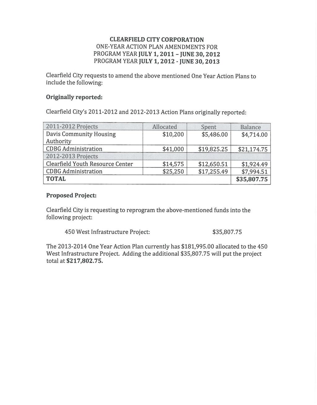
104
105 16 October South 1500 West Riverdale City, Utah Clearfield City 55 South State Street Clearfield, Utah Attn: Proj: Subj: Mayor Don Wood and City Council Freeport Tank Replacement Project Freeport Center Bid Results, Bid Proposal Tabulation & Recommendation Dear Mayor Wood and Council Members, The Bid Opening for the above referenced project was conducted on the 8 th of October The lowest responsible bidder is Shearer & Associates, Inc., of Vancouver, Washington. Enclosed are the Bid Results and Bid Proposal Tabulation. Shearer & Associates, Inc. s bid was reviewed and found to meet the bidding conditions required in the Contract Documents. Since Shearer & Associates, Inc. s bid is the low bid for the advertised project, and their bid meets the conditions of the Contract Documents, I herewith recommend award of the above referenced project in the amount of $983,254.40, to Shearer & Associates, Inc. Should you have any questions or desire additional information concerning the contractor or his bid, please feel free to contact our office at your earliest convenience. Sincerely, CEC, Civil Engineering Consultants, PLLC. N. Scott Nelson, P.E. City Engineer Cc: Scott Hodge Clearfield Public Works Director Kim Dabb Clearfield City Operations Manager
106 5141 South 1500 West Riverdale City, Utah BID RESULTS Freeport Tank Replacement Project Freeport Center OWNER: CLEARFIELD CITY ENGINEER: CEC, CIVIL ENGINEERING CONSULTANTS, PLLC. BID DATE: October 8 th, 2013 TIME: 10:00 am. BID LOCATION: Clearfield City Offices 55 South State Street; 3 rd Floor Clearfield, Utah PLAN HOLDER NAME ADDENDUM BID BOND BID AMOUNT Engineering America Yes Yes $1,097,000 Shearer Tanks Yes Yes $983, CEC, Civil Engineering Consultants, PLLC Page 1 of 1 Bid Results
107 BID PROPOSAL TABULATION FREEPORT TANK REPLACEMENT PROJECT - FREEPORT CENTER BID DATE: 8 OCTOBER 2013 OWNER: CLEARFIELD CITY PUBLIC WORKS DIRECTOR: SCOTT HODGE Bid Item Description Quantity Unit Shearer & Associates 1404 NE 134th St. Suite 200 Vancouver, Washington, Engineering America, Inc. 647 Hale Ave. N Oakdale, MN, Unit Price Total Amount Unit Price Total Amount 1. Mobilization, bonds & insurance. 1 ls. $80, $80, $45, $45, Demolition, removal and disposal of the existing reinforced concrete tank and site grubbing. 1 ls. $72, $72, $78, $78, Preparation of the tank foundation base and the installation of structural fill material (roadbase) for the tank foundation. 6,100 tons $31.15 $190, $31.83 $194, Furnish and install a glass-fused-to-steel culinary water storage tank. 1 ls. $622, $622, $761, $761, Size of tank (diameter X total height): Capacity of tank: 109' - 3" X 26' - 2" 1,584,008 gallons 92' - 4" X 33' - 0" 1,489,902 gallons 5. Furnish and install 7' tall chain link fencing with 20' access gate. 520 lf. $23.07 $11, $25.71 $13, Replace all site landscaping surface improvements damaged during construction. 1 ls. $5, $5, $4, $4, TOTAL BID: $983, $1,097, Surety Company Travelers Western Surety Company City, State Springfield, Oregon South Dakota Bid Security - Bid Bond Amount 5% 5% Contractor's License Number CEC, Civil Engineering Consultants, PLLC. Page 1 of 1 Bid Tabulation
108


109 15 October South 1500 West Riverdale City, Utah Shearer & Associates, Inc NE 134 th Street, Suite 200 Vancouver, Washington Attn: Proj: Subj: Ryan Weaver, Project Manager Freeport Tank Replacement Project Freeport Center Contract Documents and Specifications Dear Ryan, I appreciate the response to our calls and questions, as we have reviewed your recently submitted Bid Documents and preliminary design calculations that were submitted on October 8 th, 2013 for the proposed new Clearfield City Culinary Water Tank in the Freeport Center. A number of issues came to our attention as we reviewed your Bid Documents. As per our telephone conversation, the following items will need to be reviewed by your company staff and a Letter of Commitment provided to the City indicating that these items will be corrected in your Bid Documents, that any additional labor/materials needed to address these items will be furnished at no additional cost to Clearfield City, and that your line-item as well as overall project bid costs remain constant as previously submitted: All furnished construction items must comply fully with the Contract Documents and with current City Standards as well as with National codes. The Tank and Aluminum Dome shall not exceed 45-feet in height when measured from the top of the concrete floor to the peak of the dome (See Chapter 11, Title 13, Paragraph 11 of the Height Limitations Exceptions of the Clearfield City Zoning Ordinance, for the M-1 Zone). All structural design must comply fully with the Contract Documents and review comments from our office and from ARW Engineers ( Structural Consultant ). Attached are the review comments from ARW Engineers of your preliminary Foundation Design Calculations for Embedded Shell Rings recently submitted as well as the comments herein from our office. A final set of design calculations must be stamped by a licensed Utah Structural Engineer, and submitted for review and approval by our office and our Structural Consultant prior to construction. All review comments must be fully adhered to. The minimum approved concrete floor thickness is 8-inches. The Contract Documents indicated the anticipated floor thickness of 12-inches thick. Construction experience shows
DRAFT PROJECT AREA PLAN UNIVERSITY PLACE COMMUNITY DEVELOPMENT AREA (CDA) OREM REDEVELOPMENT AGENCY, UTAH
 OREM REDEVELOPMENT AGENCY, UTAH") UNIVERSITY PLACE COMMUNITY DEVELOPMENT AREA (CDA) OREM REDEVELOPMENT AGENCY, UTAH Table of Contents TABLE OF CONTENTS... 2 INTRODUCTION... 3 DEFINITIONS... 4 DESCRIPTION OF THE BOUNDARIES OF THE PROPOSED
UNIVERSITY PLACE COMMUNITY DEVELOPMENT AREA (CDA) OREM REDEVELOPMENT AGENCY, UTAH Table of Contents TABLE OF CONTENTS... 2 INTRODUCTION... 3 DEFINITIONS... 4 DESCRIPTION OF THE BOUNDARIES OF THE PROPOSED
FILLMORE COMMUNITY REINVESTMENT AREA (CRA)
") DRAFT PROJECT AREA PLAN FILLMORE COMMUNITY REINVESTMENT AREA (CRA) REDEVELOPMENT AGENCY OF FILLMORE CITY, UTAH FEBRUARY 2018 Table of Contents DEFINITIONS... 3 INTRODUCTION... 5 DESCRIPTION OF THE BOUNDARIES
DRAFT PROJECT AREA PLAN FILLMORE COMMUNITY REINVESTMENT AREA (CRA) REDEVELOPMENT AGENCY OF FILLMORE CITY, UTAH FEBRUARY 2018 Table of Contents DEFINITIONS... 3 INTRODUCTION... 5 DESCRIPTION OF THE BOUNDARIES
CLEARFIELD CITY COUNCIL MEETING MINUTES 7:00 P.M. WORK SESSION September 10, PRESENT: Kent Bush Councilmember
 CLEARFIELD CITY COUNCIL MEETING MINUTES 7:00 P.M. WORK SESSION September 10, 2013 PRESIDING: Don Wood Mayor PRESENT: Kent Bush Councilmember Mike LeBaron Councilmember Kathryn Murray Councilmember Bruce
DRAFT PROJECT AREA PLAN 700 WEST COMMUNITY DEVELOPMENT AREA (CDA) REDEVELOPMENT AGENCY OF RIVERDALE CITY, UTAH
 REDEVELOPMENT AGENCY OF RIVERDALE CITY, UTAH") DRAFT PROJECT AREA PLAN 700 WEST COMMUNITY DEVELOPMENT AREA (CDA) REDEVELOPMENT AGENCY OF RIVERDALE CITY, UTAH JULY 2016 Table of Contents TABLE OF CONTENTS... 2 DEFINITIONS... 3 INTRODUCTION... 5 DESCRIPTION
DRAFT PROJECT AREA PLAN 700 WEST COMMUNITY DEVELOPMENT AREA (CDA) REDEVELOPMENT AGENCY OF RIVERDALE CITY, UTAH JULY 2016 Table of Contents TABLE OF CONTENTS... 2 DEFINITIONS... 3 INTRODUCTION... 5 DESCRIPTION
CITY OF LOGAN REDEVELOPMENT AGENCY. A Resolution approving the Auto Mall Community Development Project Area Plan
 -~ LOGAN CITY UNITED IN HRVICE fstt,blished 18t6 CITY OF LOGAN REDEVELOPMENT AGENCY Resolution No. IS-03 RDA A Resolution approving the Auto Mall Community Development Project Area Plan WHEREAS, the Redevelopment
OFFICIAL PROJECT AREA PLAN
 LYRB OFFICIAL PROJECT AREA PLAN BARNARD CREEK COMMUNITY DEVELOPMENT AREA (CDA) CENTERVILLE CITY REDEVELOPMENT AGENCY, UTAH ADOPTED: JULY 16, 2013 PREPARED BY: LEWIS YOUNG ROBERTSON & BURNINGHAM, INC. TABLE
CLEARFIELD CITY COUNCIL AGENDA AND SUMMARY REPORT July 31, 2018 SPECIAL POLICY SESSION
 CLEARFIELD CITY COUNCIL AGENDA AND SUMMARY REPORT July 31, 2018 SPECIAL POLICY SESSION Meetings of the City Council of Clearfield City may be conducted via electronic means pursuant to Utah Code Ann. 52-4-207
AGENDA. A. CALL TO ORDER 1:00 PM B. PLEDGE OF ALLEGIANCE C. DISCLOSURES D. APPROVAL OF THE MINUTES: October 13, 2015 Town Council Meeting
 The Regular Meeting of the Brian Head Town Council acting as the Governing Body of the Brian Head Redevelopment Agency Town Hall - 56 North Highway 143 Brian Head, UT 84719 TUESDAY, OCTOBER 27, 2015 @
RESOLUTION NO. RD:EEH:LCP
 RESOLUTION NO. A RESOLUTION OF THE COUNCIL OF THE CITY OF SAN JOSE CONDITIONALLY VACATING A PORTION OF MERIDIAN AVENUE, SOUTH OF FRUITDALE AVENUE, AND RESERVING A PUBLIC SERVICE EASEMENT OVER THE VACATED
PALM BEACH COUNTY BOARD OF COUNTY COMMISSIONERS AGENDA ITEM SUMMARY. September 10, 2013 [ ] Consent [X] Regular [ ] Ordinance [ ] Public Hearing
![PALM BEACH COUNTY BOARD OF COUNTY COMMISSIONERS AGENDA ITEM SUMMARY. September 10, 2013 [ ] Consent [X] Regular [ ] Ordinance [ ] Public Hearing](/thumbs/88/117540312.jpg "PALM BEACH COUNTY BOARD OF COUNTY COMMISSIONERS AGENDA ITEM SUMMARY. September 10, 2013 [ ] Consent [X] Regular [ ] Ordinance [ ] Public Hearing") Agenda Item#: 50 \ PALM BEACH COUNTY BOARD OF COUNTY COMMISSIONERS AGENDA ITEM SUMMARY Meeting Date: Department: September 10, 2013 [ ] Consent [X] Regular [ ] Ordinance [ ] Public Hearing Department of
Agenda Item#: 50 \ PALM BEACH COUNTY BOARD OF COUNTY COMMISSIONERS AGENDA ITEM SUMMARY Meeting Date: Department: September 10, 2013 [ ] Consent [X] Regular [ ] Ordinance [ ] Public Hearing Department of
Successor Agency to the Paradise Redevelopment Agency Meeting Agenda. 7:00 PM June 11, 2013
 Management Staff: Lauren Gill, Interim Town Manager Dwight L. Moore, Town Attorney Joanna Gutierrez, Town Clerk Craig Baker, Community Development Director Gabriela Tazzari-Dineen, Police Chief George
DOWNTOWN JANESVILLE. Business Improvement District Operating Plan
 DOWNTOWN JANESVILLE Business Improvement District Operating Plan 2019 TABLE OF CONTENTS Introduction..1 District Boundaries. 1 Proposed Operating Plan...1 Method of Assessment 4 Future Year Operating Plans...6
Town of Onalaska. A scale map depicting the portion of Pineview Drive to be officially laid out as a Town highway is attached hereto as Exhibit A.
 Town of Onalaska Special Meeting Minutes for March 31, 2011 The Town Board met on site of the Pineview Road and County OT in Onalaska for the purpose of viewing the lay out of the road as required by law.
OPERATIONAL PLAN BUSINESS IMPROVEMENT DISTRICT DOWNTOWN SUN PRAIRIE
 2016 OPERATIONAL PLAN BUSINESS IMPROVEMENT DISTRICT DOWNTOWN SUN PRAIRIE December 3 rd, 2015 1 A. Introduction The following is the 2016 operating plan for the Business Improvement District (BID) in downtown
SERVICE & IMPROVEMENT PLAN AND ASSESSMENT PLAN:
 DOWNTOWN MIDLAND MANAGEMENT DISTRICT SERVICE & IMPROVEMENT PLAN AND ASSESSMENT PLAN: 2010-2019 August 25, 2009 Table of Contents 1. Introduction...1 2. Background: The First Five Years...2 3. Service &
AGENDA COLLETON COUNTY COUNCIL REGULAR MEETING TUESDAY, FEBRUARY 5, :00 P.M. COUNTY COUNCIL CHAMBERS, OLD JAIL BUILDING
 AGENDA COLLETON COUNTY COUNCIL REGULAR MEETING TUESDAY, FEBRUARY 5, 2013 6:00 P.M. COUNTY COUNCIL CHAMBERS, OLD JAIL BUILDING 1. Call to Order 2. Invocation 3. Present Colors and Lead Pledge of Allegiance-
Legislation Passed March 28, 2017
 Legislation Passed March, The Tacoma City Council, at its regular City Council meeting of March,, adopted the following resolutions and/or ordinances. The summary of the contents of said resolutions and/or
Transfers of Property Q Sound Transit did not transfer any properties subject to RCW (1)(b) during the first quarter of 2018.
(b) during the first quarter of 2018.") Sound Transit s Office of Land Use Planning & Development Transit Oriented Development Quarterly Status Report Q1 2018 Background RCW 81.112.350 requires Sound Transit to provide quarterly reports of any
Sound Transit s Office of Land Use Planning & Development Transit Oriented Development Quarterly Status Report Q1 2018 Background RCW 81.112.350 requires Sound Transit to provide quarterly reports of any
ALVA ARENA ECONOMIC DEVELOPMENT PROJECT PLAN
 ALVA ARENA ECONOMIC DEVELOPMENT PROJECT PLAN A JOINT PROJECT OF: THE CITY OF ALVA WOODS COUNTY IN COOPERATION WITH: ALVA ARENA AUTHORITY WOODS COUNTY ECONOMIC DEVELOPMENT COMMITTEE WITH THE ASSISTANCE
City Recorder s Office
 City Recorder s Office PUBLIC NOTICE Notice is Hereby Given that the Tooele City Council & Tooele City Redevelopment Agency will meet in a Work Session, on Wednesday, September 19, 2018 at the hour of
AGENDA SPECIAL CITY COUNCIL MEETING August 9, nd Floor, City Hall 6:30 p.m.
 IF YOU WISH TO ADDRESS THE CITY COUNCIL, PLEASE COMPLETE FORM LOCATED ON DESK AT ENTRANCE AND PASS TO MAYOR. AGENDA SPECIAL CITY COUNCIL MEETING August 9, 2016 2 nd Floor, City Hall 6:30 p.m. 1. CALL TO
CITY COUNCIL AGENDA MEMO
 CITY COUNCIL AGENDA MEMO To: Mayor Lioneld Jordan and City Council Thru: Don Marr, Chief of Staff Jeremy Pate, Development Services Director Chris Brown, City Engineer From: Peter Nierengarten, Sustainability
AGENDA UPDATE ECONOMIC DEVELOPMENT & FINANCE STANDING COMMITTEE MEETING MONDAY, AUGUST 10, 2015 III. COMMITTEE AGENDA
 AGENDA UPDATE ECONOMIC DEVELOPMENT & FINANCE STANDING COMMITTEE MEETING MONDAY, AUGUST 10, 2015 III. COMMITTEE AGENDA REVISED ITEM NO. 4 150217.ORDINANCE: VACATION VILLAGE AREAS 1 AND 2A Synopsis: A revised
SOUTH DAVIS METRO FIRE AGENCY FIRE IMPACT FEE FACILITIES PLAN (IFFP) AND IMPACT FEE ANALYSIS (IFA)
 AND IMPACT FEE ANALYSIS (IFA)") SOUTH DAVIS METRO FIRE AGENCY FIRE IMPACT FEE FACILITIES PLAN (IFFP) AND IMPACT FEE ANALYSIS (IFA) JULY 2012 PREPARED BY LEWIS YOUNG ROBERTSON & BURNINGHAM, INC. IMPACT FEE FACILITIES PLAN AND IMPACT FEE
SOUTH DAVIS METRO FIRE AGENCY FIRE IMPACT FEE FACILITIES PLAN (IFFP) AND IMPACT FEE ANALYSIS (IFA) JULY 2012 PREPARED BY LEWIS YOUNG ROBERTSON & BURNINGHAM, INC. IMPACT FEE FACILITIES PLAN AND IMPACT FEE
CITY OF HIAWATHA, IOWA TOWN VILLAGE CENTER URBAN REVITALIZATION PLAN. for the TOWN VILLAGE CENTER URBAN REVITALIZATION AREA
 CITY OF HIAWATHA, IOWA TOWN VILLAGE CENTER URBAN REVITALIZATION PLAN for the TOWN VILLAGE CENTER URBAN REVITALIZATION AREA 2018 1 INTRODUCTION The Urban Revitalization Act, Chapter 404 of the Code of Iowa,
Sound Transit s Office of Land Use Planning & Development Transit Oriented Development Quarterly Status Report Q2 2018
 Sound Transit s Office of Land Use Planning & Development Transit Oriented Development Quarterly Status Report Q2 2018 Background RCW 81.112.350 requires Sound Transit to provide quarterly reports of any
in Book 10019, at Page 9432, 352 feet, more, or less, to the North right of way of 3350 South Street; thence West along said right of way 93 feet,
 Public notice is hereby given that the Millcreek Community Reinvestment Agency (the Agency ) will hold a public hearing on Tuesday, November 13, 2018, commencing at 7:30 p.m. or as soon thereafter as the
Planning Commission Work Meeting Minutes Thursday, October 18, 2018 City Council Chambers 220 East Morris Avenue Time 6:45 p.m.
 Planning Commission Work Meeting Minutes Thursday, October 18, 2018 City Council Chambers 220 East Morris Avenue Time 6:45 p.m. Commission Members Present: Jeremy Carter Susan Dickstein Chad Ewell Beth
CITY COUNCIL AND BURA AGENDA MEMORANDUM
 City and County of Broomfield, Colorado CITY COUNCIL AND BURA AGENDA MEMORANDUM To: From: By: Agenda Title Mayor, City Council, and Broomfield Urban Renewal Authority Charles Ozaki, City and County Manager
DEVELOPMENT AGREEMENT
 DEVELOPMENT AGREEMENT This Agreement is entered into between the City of University Heights, Iowa (the City ) and Jeff Maxwell (the Developer ) as of the day of, 2011. WHEREAS, the City has established
NOVEMBER 14, :30 P.M.
 A QUORUM OF THE VAN ALSTYNE COMMUNITY AND ECONOMIC DEVELOPMENT CORPORATION BOARD MEMBERS MAY OR MAY NOT BE IN ATTENDANCE. NO ACTION BY EITHER BOARD WILL BE TAKEN AT THIS MEETING. CITY OF VAN ALSTYNE AGENDA
DEWITT CHARTER TOWNSHIP 1401 W. HERBISON ROAD, DeWITT, MI PLANNING COMMISSION MINUTES MONDAY, APRIL 7, 2008
 DEWITT CHARTER TOWNSHIP 1401 W. HERBISON ROAD, DeWITT, MI PLANNING COMMISSION MINUTES MONDAY, APRIL 7, 2008 The regularly scheduled meeting of the DeWitt Charter Township Planning Commission was called
MIDWAY CITY Municipal Code
 MIDWAY CITY Municipal Code TITLE 9 ANNEXATION CHAPTER 9.01 PURPOSE CHAPTER 9.02 GENERAL REQUIREMENTS CHAPTER 9.03 PROPERTY OWNER INITIATION OF ANNEXATION CHAPTER 9.04 PROCEDURES FOR CONSIDERATION OF PETITION
ORDINANCE WHEREAS, this title is intended to implement and be consistent with the county comprehensive plan; and
 ORDINANCE 2005-015 AN ORDINANCE OF THE BOARD OF COUNTY COMMISSIONERS OF INDIAN RIVER COUNTY, FLORIDA, ADOPTING TITLE X, IMPACT FEES, AND AMENDING CODE SECTION 953, FAIR SHARE ROADWAY IMPROVEMENTS, OF THE
550 North 800 West West Bountiful, Utah Phone (801) FAX (801) PLANNING COMMISSION MEETING
 FAX (801) PLANNING COMMISSION MEETING") Mayor Kenneth Romney City Council James Ahlstrom James Bruhn Kelly Enquist Debbie McKean Mark Preece WEST BOUNTIFUL CITY 550 North 800 West West Bountiful, Utah 84087 Phone (801) 292-4486 FAX (801) 292-6355
Mayor Kenneth Romney City Council James Ahlstrom James Bruhn Kelly Enquist Debbie McKean Mark Preece WEST BOUNTIFUL CITY 550 North 800 West West Bountiful, Utah 84087 Phone (801) 292-4486 FAX (801) 292-6355
CITY OF PALMDALE COUNTY OF LOS ANGELES, CALIFORNIA RESOLUTION NO. CC
 CITY OF PALMDALE COUNTY OF LOS ANGELES, CALIFORNIA RESOLUTION NO. CC 2011-118 A RESOLUTION OF THE CITY COUNCIL OF THE CITY OF PALMDALE, CALIFORNIA, UPHOLDING THE PLANNING COMMISSION APPROVAL OF CONDITIONAL
RECITALS STATEMENT OF AGREEMENT. Draft: November 30, 2018
 MEMORANDUM OF AGREEMENT TO FACILITATE THE EXPANSION, RENOVATION, AND EFFICIENT AND SAFE OPERATION OF THE ALBEMARLE CIRCUIT COURT, THE ALBEMARLE GENERAL DISTRICT COURT, AND THE CHARLOTTESVILLE GENERAL DISTRICT
SUBJECT: APPROVAL OF DOWNTOWN HIGH-RISE RESIDENTIAL INCENTIVE FOR POST STREET TOWER AT 171 POST STREET
 COUNCIL AGENDA FILE ITEM 11/6/18 CITY OF San Jose CAPITAL OF SILICON VALLEY TO: HONORABLE MAYOR AND CITY COUNCIL SUBJECT: SEE BELOW Memorandum FROM: Kim Walesh DATE: October 9, 2018 Approved Date /o/f//a
Staff Report. Victoria Walker, Director of Community and Economic Development
 10.c Staff Report Date: April 25, 2017 To: From: Reviewed by: Prepared by: Subject: City Council Valerie J. Barone, City Manager Victoria Walker, Director of Community and Economic Development John Montagh,
Regular Agenda Public Hearing D
 BOARD OF COUNTY COMMISSIONERS DATE: October 21, 2014 AGENDA ITEM NO. dj6 Consent Agenda D Regular Agenda Public Hearing D Subject: Declare Certain Economic Development Parcels As Surplus And Grant the
1. Roll Call. 2. Minutes a. September 26, 2016 Regular Meeting. 3. Adoption of the Agenda. 4. Visitors to Be Heard
 1. Roll Call City of Vermillion Planning Commission Agenda 5:30 p.m. Regular Meeting Tuesday, October 11, 2016 Large Conference Room 2 nd Floor City Hall 25 Center Street Vermillion, SD 57069 2. Minutes
Staff Report. Victoria Walker, Director of Community and Economic Development
 7.a Staff Report Date: July 11, 2017 To: From: Reviewed by: Prepared by: Subject: City Council Valerie J. Barone, City Manager Victoria Walker, Director of Community and Economic Development John Montagh,
CHAPTER House Bill No. 1453
 CHAPTER 2004-451 House Bill No. 1453 An act relating to the North Sumter County Hospital District; providing a popular name; providing district purpose; providing district boundaries; providing for a board
City of Apache Junction, Arizona Page 1
 Monday, November 16, 2015 City of Apache Junction, Arizona Agenda City Council Work Session 7:00 PM Meeting location: City Council Chambers at City Hall 300 E Superstition Blvd Apache Junction, AZ 85119
RESOLUTION NO. OB 14-02
 RESOLUTION NO. OB 14-02 A RESOLUTION OF THE OVERSIGHT BOARD OF THE SUCCESSOR AGENCY TO THE RANCHO CUCAMONGA REDEVELOPMENT AGENCY APPROVING THE AMENDED LONG-RANGE PROPERTY MANAGEMENT PLAN PREPARED BY THE
PLANNING COMMISSION STAFF REPORT
 PLANNING COMMISSION STAFF REPORT West Capitol Hill Zoning Map Amendment Petition No. PLNPCM2011-00665 Located approximately at 548 W 300 North Street, 543 W 400 North Street, and 375 N 500 West Street
2015 Proposed Operating Plan Approved by the Racine Common Council on DOWNTOWN RACINE BUSINESS IMPROVEMENT DISTRICT OPERATING PLAN 2015
 2015 Proposed Operating Plan Approved by the Racine Common Council on DOWNTOWN RACINE BUSINESS IMPROVEMENT DISTRICT OPERATING PLAN 2015 Recommended by the Board of the Business Improvement District: September
OFFICE OF THE CITY ADMINISTRATIVE OFFICER
 REPORT FROM OFFICE OF THE CITY ADMINISTRATIVE OFFICER Date: To: From: Reference: October 28, 2014 The Honorable Members of the City Council Miguel A. Santana, City Administrative Officer Chair Municipal
Uptown Business Improvement District. Operating Plan. Approved by the City of Racine Common Council:
 Uptown Business Improvement District Operating Plan 2010 Approved by the City of Racine Common Council: Uptown Business Improvement District Operating Plan - 2010 Table of Contents I. Preface Page 3 II.
TAX ABATEMENT GUIDELINES SUMMARY
 TAX ABATEMENT GUIDELINES SUMMARY OBJECTIVES Primary job creation -- target industries. Amount abatement -- minimum to be competitive. Fair to taxing jurisdictions -- It is a local option. Fair to existing
GULFSTREAM POLO COMMUNITY DEVELOPMENT DISTRICT PALM BEACH COUNTY REGULAR BOARD MEETING APRIL 19, :00 P.M.
 GULFSTREAM POLO COMMUNITY DEVELOPMENT DISTRICT PALM BEACH COUNTY REGULAR BOARD MEETING APRIL 19, 2017 4:00 P.M. Special District Services, Inc. The Oaks Center 2501A Burns Road Palm Beach Gardens, FL 33410
ORDINANCE City of DeBary Comprehensive Plan Amendments Page 1 of 3
 ORDINANCE 01-15 AN ORDINANCE OF THE CITY COUNCIL OF DEBARY, FLORIDA, AMENDING THE CITY S COMPREHENSIVE PLAN FUTURE LAND USE ELEMENT TEXT AMENDING COMPREHENSIVE PLAN POLICY 5.406 CONCERNING THE SOUTHEAST
Village of Palm Springs
 Village of Palm Springs Executive Brief AGENDA DATE: September 28, 2017 DEPARTMENT: Finance ITEM #16: Ordinance No. 2017-23 - (SECOND READING) Establish FY 2017-2018 Millage Rates - Operating & Debt Service
Chapter 1 OVERVIEW OF THE PROGRAM AND PLAN
 INTRODUCTION Chapter 1 OVERVIEW OF THE PROGRAM AND PLAN The PHA receives its operating subsidy for the public housing program from the Department of Housing and Urban Development. The PHA is not a federal
City of Boerne, Texas Incentives Policy
 City of Boerne, Texas Incentives Policy WHEREAS, upon full review and consideration of this Policy, the City Council of the City of Boerne is of the opinion that this Policy will assist in implementing
AVENIR COMMUNITY DEVELOPMENT DISTRICT CITY OF PALM BEACH GARDENS SPECIAL BOARD MEETING JANUARY 11, :00 A.M.
 AVENIR COMMUNITY DEVELOPMENT DISTRICT CITY OF PALM BEACH GARDENS SPECIAL BOARD MEETING JANUARY 11, 2018 11:00 A.M. Special District Services, Inc. The Oaks Center 2501A Burns Road Palm Beach Gardens, FL
A Guide to Establishing Additional Service Areas in Rural Municipalities
 A Guide to Establishing Additional Service Areas in Rural Municipalities February 2014 Contents Introduction... 3 Purpose of this Guide... 3 Background... 3 What are the benefits to Rural Municipalities
Walworth County Farmland Preservation Plan Update, Chapter 1 Plan Summary (Cover Document)
") Background Walworth County Farmland Preservation Plan Update, 2012 Chapter 1 Plan Summary (Cover Document) For over 30-years, the Wisconsin Farmland Preservation Program has served to preserve Walworth
Background Walworth County Farmland Preservation Plan Update, 2012 Chapter 1 Plan Summary (Cover Document) For over 30-years, the Wisconsin Farmland Preservation Program has served to preserve Walworth
Charter Township of Lyon P.A. 198 Industrial Facilities Tax Exemption Tax Abatement Guidelines
 1 Charter Township of Lyon P.A. 198 Industrial Facilities Tax Exemption Tax Abatement Guidelines A company that is in the planning phase of a major business attraction or expansion project that will include
Proposed Brownfield Area
 NOTICE OF BROWNFIELD AREA DESIGNATION PUBLIC HEARING The Board of County Commissioners of Indian River County, Florida gives notice of its intent to consider adopting a resolution establishing a Brownfield
PUD, HPUD, OSC Rezoning & Conceptual Plan Application (Planned Unit Development, Haggerty Road Planned Unit Development, Open Space Community)
") Township Use Only RZ #: Date: Hearing Date: Fee Paid: PUD, HPUD, OSC Rezoning & Conceptual Plan Application (Planned Unit Development, Haggerty Road Planned Unit Development, Open Space Community) Project
Township Use Only RZ #: Date: Hearing Date: Fee Paid: PUD, HPUD, OSC Rezoning & Conceptual Plan Application (Planned Unit Development, Haggerty Road Planned Unit Development, Open Space Community) Project
PRELIMINARY PROJECT PLAN AND REINVESTMENT ZONE FINANCING PLAN FOR PROPOSED TAX INCREMENT REINVESTMENT ZONE NO. 1, CITY OF OAK RIDGE NORTH
 PRELIMINARY PROJECT PLAN AND REINVESTMENT ZONE FINANCING PLAN FOR PROPOSED TAX INCREMENT REINVESTMENT ZONE NO. 1, CITY OF OAK RIDGE NORTH DECEMBER 15, 2014 TABLE OF CONTENTS 1. Overview 1.1 Background...
STAFF REPORT. Meeting Date: April 25, 2017
 Meeting Date: April 25, 2017 Agency: City of Belmont Staff Contact: Damon DiDonato, Community Development Department, (650) 637-2908; ddidonato@belmont.gov Agenda Title: Amendments to Sections 24 (Secondary
AGENDA BURLESON PLANNING AND ZONING COMMISSION February 10, 2015 BURLESON CITY HALL 141 W. RENFRO BURLESON, TX 76028
 AGENDA BURLESON PLANNING AND ZONING COMMISSION BURLESON CITY HALL 141 W. RENFRO BURLESON, TX 76028 REGULAR SESSION 6:00 p.m. Call to Order Invocation Pledge of Allegiance 1. Consent Agenda All items listed
TOWN OF AVON, COLORADO ORDINANCE NO SERIES OF 2014
 TOWN OF AVON, COLORADO ORDINANCE NO. 14-17 SERIES OF 2014 AN ORDINANCE AUTHORIZING THE FINANCING OF CERTAIN PUBLIC IMPROVEMENTS OF THE TOWN, AND IN CONNECTION THEREWITH AUTHORIZING THE LEASING OF CERTAIN
WORK SESSION DOCUMENT
 WORK SESSION DOCUMENT Legislative Commission s Subcommittee to Study the Availability and Inventory of Affordable Housing (Assembly Concurrent Resolution No. 11, File No. 97, Statutes of Nevada 2005) June
COUNTY OF SONOMA PERMIT AND RESOURCE MANAGEMENT DEPARTMENT 2550 Ventura Avenue, Santa Rosa, CA (707) FAX (707)
 FAX (707)") COUNTY OF SONOMA PERMIT AND RESOURCE MANAGEMENT DEPARTMENT 2550 Ventura Avenue, Santa Rosa, CA 95403 (707) 565-1900 FAX (707) 565-1103 MEMO Date:, 1:05 p.m. To: Sonoma County Planning Commission From:
COUNTY OF SONOMA PERMIT AND RESOURCE MANAGEMENT DEPARTMENT 2550 Ventura Avenue, Santa Rosa, CA 95403 (707) 565-1900 FAX (707) 565-1103 MEMO Date:, 1:05 p.m. To: Sonoma County Planning Commission From:
SPECIAL COUNCIL MEETING AND WORK SESSION AGENDA #23
 Monday, May 21, 2018 Council Chambers and Steve Lampi Room 7:00 p.m. 5200 85 th Avenue North SPECIAL COUNCIL MEETING AND WORK SESSION AGENDA #23 If due to a disability, you need auxiliary aids or services
CHAPTER Committee Substitute for Committee Substitute for House Bill No. 437
 CHAPTER 2013-83 Committee Substitute for Committee Substitute for House Bill No. 437 An act relating to community development; amending s. 159.603, F.S.; revising the definition of qualifying housing development
ORDINANCE NO (PROPOSED)
") ORDINANCE NO. 1603 (PROPOSED) AN ORDINANCE OF THE CITY OF COCOA BEACH, BREVARD COUNTY, FLORIDA; AMENDING THE COCOA BEACH COMPREHENSIVE PLAN BY AMENDING THE FUTURE LAND USE MAP 2025 (FLUE 2) BY CHANGING
ORDINANCE NO. 1603 (PROPOSED) AN ORDINANCE OF THE CITY OF COCOA BEACH, BREVARD COUNTY, FLORIDA; AMENDING THE COCOA BEACH COMPREHENSIVE PLAN BY AMENDING THE FUTURE LAND USE MAP 2025 (FLUE 2) BY CHANGING
Magna Commerce Park COMMUNITY DEVELOPMENT AREA PROJECT PLAN. May 24, 2016
 Magna Commerce Park COMMUNITY DEVELOPMENT AREA PROJECT PLAN May 24, 2016 By: GSBS Consulting REDEVELOPMENT AGENCY OF SALT LAKE COUNTY TABLE OF CONTENTS 1. Introduction & Overview 1 2. Recitals of Preconditions
COOPERATIVE AGREEMENT BETWEEN THE REDEVELOPMENT AGENCY OF THE CITY OF RIO VISTA AND THE CITY OF RIO VISTA
 COOPERATIVE AGREEMENT BETWEEN THE REDEVELOPMENT AGENCY OF THE CITY OF RIO VISTA AND THE CITY OF RIO VISTA This Cooperative Agreement (this Agreement ) is entered into effective as of March 17, 2011 ( Effective
INTERLOCAL AGREEMENT BETWEEN LAKE COUNTY AND THE LAKE COUNTY TAX COLLECTOR FOR THE GREATER GROVES MUNICIPAL SERVICE BENEFIT UNIT
 INTERLOCAL AGREEMENT BETWEEN LAKE COUNTY AND THE LAKE COUNTY TAX COLLECTOR FOR THE GREATER GROVES MUNICIPAL SERVICE BENEFIT UNIT FOR NON-AD VALOREM ASSESSMENT SERVICES 1 INTERLOCAL AGREEMENT BETWEEN LAKE
REPORT Peel Living. ~ecember 16,2010 REPORT TITLE: TWIN PINES REVIEW FROM: Mwarigha MS., General Manager, Peel Living RECOIMIMENDATION
 REPORT Peel Living DATE: ~ecember 16,2010 REPORT TITLE: FROM: Mwarigha MS., General Manager, Peel Living RECOIMIMENDATION That staff review the request by the Cedar Grove Residents' Community Corporation
7. IMPLEMENTATION STRATEGIES
 7. IMPLEMENTATION STRATEGIES A. GENERAL APPROACH FOR IMPLEMENTATION Implementing the plan will engage many players, including the Municipality of Anchorage (MOA), the Government Hill Community Council,
;:ft{n Siegel, City Manager
 5/17/2016 03 City of San Juan Capistrano Agenda Report TO: FROM: Honorable Mayor and Members of the City Council ;:ft{n Siegel, City Manager SUBMITTED BY: Steve May, Public Works and Utilities Director
AGENDA CALL THE MEETING TO ORDER SALUTE TO FLAG SUNSHINE LAW STATEMENT. ROLL CALL 1. Township Council 2. Municipal Officials Present
 AGENDA Regular Meeting of the Township Council Monday, April 23, 2018 8:00pm Mayor Glen Jasionowski Council President Mark Bromberg, Council Vice President Paul Criscuolo, Councilman Ari Ben-Yishay, Councilman
2011 AICP Review Course
 2011 AICP Review Course March 2011 Alex Dambach, AICP, PP Director of Policy, Planning, and Development City of East Orange Exam Content A. Strategic planning/visioning B. Goal setting C. Research methods
CITY OF ANDOVER NEIGHBORHOOD REVITALIZATION PLAN
 CITY OF ANDOVER NEIGHBORHOOD REVITALIZATION PLAN Adopted August 28, 2018 Expires December 31, 2021 Attorney General Office Approved, 2019 CITY OF ANDOVER, KANSAS NEIGHBORHOOD REVITALIZATION PLAN PURPOSE
SAN JOSE CAPITAL OF SILICON VALLEY
 CITY OF C YA SAN JOSE CAPITAL OF SILICON VALLEY TO: HONORABLE MAYOR AND CITY COUNCIL SUBJECT: SEE BELOW COUNCIL AGENDA: 04/19/16 ITEM: il.tcb') Memorandum FROM: Planning Commission DATE: March 28, 2016
NEW YORK CITY ECONOMIC DEVELOPMENT CORPORATION POLICY REGARDING THE ACQUISITION AND DISPOSITION OF REAL PROPERTY
 NEW YORK CITY ECONOMIC DEVELOPMENT CORPORATION POLICY REGARDING THE ACQUISITION AND DISPOSITION OF REAL PROPERTY I. Introduction In accordance with the requirements of Title 5-A of Article 9 and Section
RESOLUTION NO. A RESOLUTION OF THE COUNCIL OF THE CITY OF SAN JOSE APPROVING A NEW COUNCIL POLICY No ENTITLED SURPLUS SALES
 RD:PAD:LCP 1/20/2016 RESOLUTION NO. A RESOLUTION OF THE COUNCIL OF THE CITY OF SAN JOSE APPROVING A NEW COUNCIL POLICY No. 7-13 ENTITLED SURPLUS SALES WHEREAS, the City of San José ( City ) has an interest
BUSINESS INCENTIVES POLICY June 17, 2008
 BUSINESS INCENTIVES POLICY June 17, 2008 The City of Starkville, Mississippi recognizes the need for encouraging appropriate commercial growth in our community. Through the use of tax abatements, the City
CITY OF ALBERT LEA PLANNING COMMISSION ADVISORY BOARD
 CITY OF ALBERT LEA PLANNING COMMISSION ADVISORY BOARD 9/1/2015, 5:30 p.m. City Council Chambers AGENDA A. CALL TO ORDER AND ROLL CALL B. APPROVAL OF THE AGENDA C. APPROVAL OF MINUTES 1. PC Minutes from
Stenberg Annexation Legal Diagram Exhibit "B" W Subject Property Annexed to the City of Red Bluff VICINITY MAP "1:3:
 Stenberg Annexation Legal Diagram Exhibit "B" W Subject Property Annexed to the City of Red Bluff VICINITY MAP "1:3: ORDINANCE NO. 991 REZONE NO. 210 AN ORDINANCE AMENDING SECTION 25.13 OF THE RED BLUFF
DEVELOPMENT AGREEMENT
 DEVELOPMENT AGREEMENT This Agreement is entered into between the City of University Heights, Iowa (the City ) and Jeffrey L. Maxwell, (the Developer ) as of the day of, 2015 (the Commencement Date ). WHEREAS,
1 ORDINANCE 4, AN ORDINANCE OF THE CITY COUNCIL OF THE CITY OF PALM 5 BEACH GARDENS, FLORIDA AMENDING CHAPTER TAXATION.
 1 ORDINANCE 4, 2013 2 3 4 AN ORDINANCE OF THE CITY COUNCIL OF THE CITY OF PALM 5 BEACH GARDENS, FLORIDA AMENDING CHAPTER 66. 6 TAXATION. BY CREATING A NEW ARTICLE VI. ENTITLED 7 ECONOMIC DEVELOPMENT AD
Understanding Mississippi Property Taxes
 Understanding Mississippi Property Taxes Property tax revenues are a vital component of the budgets of Mississippi s local governments. Property tax revenues allow these governments to provide important
TO MEMBERS OF THE FINANCE AND CAPITAL STRATEGIES COMMITTEE: DISCUSSION ITEM
 F13 Office of the President TO MEMBERS OF THE FINANCE AND CAPITAL STRATEGIES : For Meeting of DISCUSSION ITEM ORCHARD PARK FAMILY HOUSING AND GRADUATE STUDENT HOUSING REDEVELOPMENT PROJECT AND WEST VILLAGE
BASTROP COUNTY TAX ABATEMENT POLICY. (Guidelines and Procedures)
") BASTROP COUNTY TAX ABATEMENT POLICY (Guidelines and Procedures) BASTROP COUNTY POLICY: Minimum investment - New business: $5,000,000 Expansion: $3,000,000. 1. Applicable to new construction and expansions/modernization.
BASTROP COUNTY TAX ABATEMENT POLICY (Guidelines and Procedures) BASTROP COUNTY POLICY: Minimum investment - New business: $5,000,000 Expansion: $3,000,000. 1. Applicable to new construction and expansions/modernization.
Affordable Housing Advisory Committee Review of Recommendations. Planning and Development Department Community Development Division March 10, 2015
 Affordable Housing Advisory Committee Review of Recommendations Planning and Development Department Community Development Division March 10, 2015 History of the State Housing Initiatives Partnership Program
RECITALS. WHEREAS, the GMA requires counties to adopt county-wide planning policies in cooperation with cities within the County; and
 AN INTERLOCAL AGREEMENT FOR THE IMPLEMENTATION OF A DEMONSTRATION PROJECT TO TRANSFER DEVELOPMENT RIGHTS FROM RURAL UNINCORPORATED KING COUNTY TO THE DENNY TRIANGLE IN DOWNTOWN SEATTLE This Agreement is
COLUMBIA COUNTY EVENTS CENTER PLANNING COMMITTEE REPORT (FINAL)
") COLUMBIA COUNTY EVENTS CENTER PLANNING COMMITTEE REPORT (FINAL) OCTOBER 9, 2012 1 INTRODUCTION The purpose of this report is to provide both elected officials and citizens with the information necessary
COLUMBIA COUNTY EVENTS CENTER PLANNING COMMITTEE REPORT (FINAL) OCTOBER 9, 2012 1 INTRODUCTION The purpose of this report is to provide both elected officials and citizens with the information necessary
Okaloosa County BCC. Okaloosa County BCC. MSBU / MSTU Policy. Municipal Service Benefit Units Municipal Service Taxing Units.
 Okaloosa County BCC Okaloosa County BCC MSBU / MSTU Policy Municipal Service Benefit Units Municipal Service Taxing Units Revised 5/6/2014 Table of Contents INTRODUCTION... 1 MSBU CALENDAR YEAR SCHEDULE...
Development Opportunity: Priority Development Site
 Development Opportunity: Priority Development Site NORTHBRIDGE, MASSACHUSETTS Super Wal Mart National Grid Distribution Facility Route 146 Subject property: Assessor Map 1 Parcels 113, 114, 115, (117),
TRANSFER OF DEVELOPMENT RIGHTS
 STEPS IN ESTABLISHING A TDR PROGRAM Adopting TDR legislation is but one small piece of the effort required to put an effective TDR program in place. The success of a TDR program depends ultimately on the
CHAPTER House Bill No. 963
 CHAPTER 2000-401 House Bill No. 963 An act relating to Manatee County; merging the Anna Maria Fire Control District and Westside Fire Control District to create a new district; creating and establishing
There is no fiscal impact associated with this Individual Development Approval.
 CRP-06-01 R2/13-97500005 Citibank Temporary Drive-Through 700-998 South Federal Highway The Via Mizner property is approximately 6.8 acres in area and is situated on the north side of Camino Real, east
CHAIRMAN WOLPERT AND MEMBERS OF THE HOUSE LOCAL AND MUNICIPAL GOVERNMENT AND URBAN REVITALIZATION COMMITTEE
 TO: FROM: SUBJECT: CHAIRMAN WOLPERT AND MEMBERS OF THE HOUSE LOCAL AND MUNICIPAL GOVERNMENT AND URBAN REVITALIZATION COMMITTEE LARRY LONG, EXECUTIVE DIRECTOR COUNTY COMMISSIONERS ASSOCIATION OF OHIO (CCAO)
Infill Development Incentive Policy
 Infill Development Incentive Policy PURPOSE It is the policy of the City of El Paso to provide incentives to promote infill development, reduce sprawl, increase the availability of attainable housing and