HENDRY COUNTY PLANNING & ZONING DEPARTMENT POST OFFICE BOX SOUTH MAIN STREET LABELLE, FLORIDA (863) FAX: (863)
|
|
|
- Magdalen Matthews
- 5 years ago
- Views:
Transcription

1 HENDRY COUNTY PLANNING & ZONING DEPARTMENT POST OFFICE BOX SOUTH MAIN STREET LABELLE, FLORIDA (863) FAX: (863) HENDRY COUNTY LOCAL PLANNING AGENCY October 8, 2015 Hendry County Courthouse LaBelle, FL 6:00 P.M. Meeting Agenda I II III IV V Call to Order Pledge of Allegiance Roll call Staff Comments Quorum for LPA meetings scheduled for October 29, November 12, & December 10 Information regarding changes to the Fee Schedule Public Hearings A. Petition Number: SE Applicant: Location: Project size: Miguel A. Santana, Sr. & Miguel A. Santana, Jr., represented by H.L. Bennett, P.E., P.L.S 354, 360, & 366 Horse Club Ave, Clewiston, FL 3.3 +/- acres Request: The applicant is requesting to amend the Special Exception granted in 2009, for lots 1 and 2, to include lot 15, to expand an existing church. B. Petition: Hendry County Land Development Code Applicant: Hendry County, represented by Margaret Emblidge, AICP 1
2 Request: The applicant is requesting to amend the Hendry County Land Development Code, more specifically, section , Declaration of Intent to Exercise Authority of Local Government Comprehensive Planning Act; Section , Comprehensive Plan; Section , Public participation in Comprehensive Planning Process; Section , Amendments to Comprehensive Plan. C. Petition: Hendry County Land Development Code Applicant: Request: Hendry County, represented by Margaret Emblidge, AICP The applicant is requesting to amend the Hendry County Land Development Code, Section , Administrative waivers; Section , Dimensional and density regulations; Section , PUD development application procedures; Section , Access/private roads; Section , Landscaping and buffering; and Section , Required buffer type; and Section , Submittal requirements; and creating new sections concerning PUD Administrative Amendments and concerning property maintenance. D. Petition: Hendry County Land Development Code Applicant: Request: Hendry County, represented by Margaret Emblidge, AICP The applicant is requesting to amend the Hendry County Code of Ordinances, to add Sector Plans and Detailed Specific Area Plans in existing sections and creating new sections, more specifically, Section , Establishment of districts; Section , Land use classifications; Table 53-2, Table of dimensional and density regulations; and creating new sections concerning Detailed Specific Area Plan (DSAP) District and Rural Detailed Specific Area Plan (RDSAP) District. E. Petition Number: CPA Applicant: Request: Hendry County, represented by Margaret Emblidge, AICP The applicant is requesting to amend the Hendry County Comprehensive Plan relating to the Future Land Use Element, definitions, policies referring to development orders, and the West Hendry Planning Overlay. VI VII Public Comments LPA Comments 2
3 VIII Adjourn PUBLIC COMMENT WILL BE ALLOWED AT THE TIME EACH AGENDA ITEM IS BEING CONSIDERED. IF YOU WISH TO SPEAK, YOU WILL NEED TO MAKE THE CHAIR AWARE. BE ADVISED THAT THE BOARD MAY TAKE ACTION ON ITEMS NOT LISTED ON THE AGENDA. IF THIS OCCURS, PUBLIC COMMENT WILL BE RECEIVED AT THE TIME THE ITEM IS CONSIDERED IF YOU MAKE THE CHAIR AWARE OF YOUR DESIRE TO SPEAK. COMMENT FOR NON-AGENDA GENERAL DISCUSSION BY MEMBERS OF THE PUBLIC WILL BE ALLOWED AT THE END OF THE REGULAR AGENDA IF ANY MEMBER OF THE PUBLIC WISHES TO SPEAK. INTERESTED PARTIES MAY APPEAR AT THE MEETINGS AND BE HEARD WITH RESPECT TO ANY ITEM. IF A PERSON DECIDES TO APPEAL ANY DECISION MADE BY THE BOARD, AGENCY, OR COMMISSION WITH RESPECT TO ANY MATTER CONSIDERED AT SUCH MEETING OR HEARING, HE OR SHE WILL NEED A RECORD OF THE PROCEEDINGS, AND THAT, FOR SUCH PURPOSE, HE OR SHE MAY NEED TO ENSURE THAT A VERBATIM RECORD OF THE PROCEEDINGS IS MADE, WHICH RECORD INCLUDES THE TESTIMONY AND EVIDENCE UPON WHICH THE APPEAL IS TO BE BASED. 3
4
5 COUNTY OF HENDRY, STATE OF FLORIDA RESOLUTION RECORDED IN RESOLUTION BOOK, PAGE A RESOLUTION OF THE BOARD OF COUNTY COMMISSIONERS OF HENDRY COUNTY, FLORIDA, SETTING FORTH BUILDING PERMIT, PLAN REVIEW, INSPECTION, AND LAND USE AND ZONING APPLICATION FEES; RESCINDING ALL RESOLUTIONS IN CONFLICT WITH THIS RESOLUTION, AND PROVIDING AN EFFECTIVE DATE. WHEREAS, the Board of County Commissioners maintains a schedule of fees for issuance of permits, plan review, and inspections; and WHEREAS, the Board of County Commissioners maintains a schedule of fees for land use and zoning applications; and WHEREAS, such fees are necessary to offset, in whole or in part, the costs of plan review, clerical activities, inspection, employee salaries, and other costs inherent to the permitting, licensing, and planning and development process; and WHEREAS, the Board of County Commissioners wishes to revise the Schedule of Fees adopted on July 24, 2012; NOW THEREFORE, BE IT RESOLVED BY THE BOARD OF COUNTY COMMISSIONERS OF HENDRY COUNTY, FLORIDA, that : SECTION 1. The Board hereby finds that the Schedule of Fees attached hereto and incorporated herein, represents fair and reasonable sums to be assessed against those who receive the benefits of plan review, clerical activities, inspections, and other benefits provided by the permitting, licensing, and planning and development process. The Schedule of Fees, attached hereto and incorporated herein, is hereby adopted and established in its entirety. SECTION 2. All Resolutions in conflict with this Resolution are hereby rescinded.
6 SECTION 3. This Resolution shall become effective immediately upon adoption. Done and adopted this Xth day of XX BOARD OF COUNTY COMMISSIONERS OF HENDRY COUNTY, FLORIDA ATTEST: Karson Turner, Chairman Barbara Butler, Clerk of Court 2
7 I. BUILDING PERMITS AND INSPECTIONS A. RESIDENTIAL BUILDING Permit fees for residential construction shall be based on a bona fide contract price, and the Building Official shall require a copy of such contract, or the following unit prices to determine a value shall be used. Where a value is determined for the permit, the permit fee shall be based upon the valuation calculation to determine the applicable base permit fee(s). 1. Living and other completely enclosed finished areas (excluding screened areas) 2. Roofed areas unfinished/unconditioned space (Carports, Garages, Lanais, Porches, etc) $ 60.00/sq.ft. $ 35.00/sq.ft. 3. Electrical - Minimum fee $65.00 See Worksheet 4. Plumbing - Minimum fee $65.00 See Worksheet 5. Mechanical - Minimum fee $65.00 See Worksheet 6. Miscellaneous Any item covered under miscellaneous permit fees B. COMMERCIAL AND INDUSTRIAL USES Permit fees for commercial and/or industrial construction shall be based on a bona fide contract price, and the Building Official shall require a copy of such contract, or the following unit prices shall be used. Where a value is determined for the permit, the permit fee shall be based upon the valuation calculation to determine the applicable base permit fee(s). 1. Masonry and/or frame constructed buildings with interiors FINISHED 2. Masonry and/or frame constructed buildings with interiors UNFINISHED 3. Metal, pre-engineered buildings with interiors FINISHED 4. Metal, pre-engineered buildings with interiors UNFINISHED $ /sq.ft. $ /sq.ft. $ /sq.ft. $ / sq.ft. 3
8 C. MOBILE HOME, MANUFACTURED UNIT, MODULAR HOME, MODULAR UNIT Mobile Homes, Manufactured Units, Modular Homes, Modular Units, (does not include concrete slabs or foundations, additions such as carports, utility rooms, screen porches, Florida rooms, and the like or any areas not included from the manufacturer and sold as a complete unit. For these additions see Section D.) 1. Single Wide Units (16' or less in width) $ Double Wide Units $ Triple Wide Units $ Each additional fractional portion (In addition to the triple wide fee) $ Pre-Moving Structural Inspections $45.00 per hour ($ minimum) plus $2.50 per mile if unit is outside Hendry County. 6. Plan review fee for Modular or similar structure foundation systems $45.00 Items contained in Section C, 1-3 above, include all required inspections to complete permit D. MISCELLANEOUS FEES 1. The following fees shall be based on a bona fide contract price (contract to be furnished) or unit prices to determine a value. Where a value is determined for the permit, the permit fee shall be based upon the Valuation of Permit Fees to determine the applicable base permit fee(s): a. Concrete Slab (drive, stoops, patios, etc.) $ 4.00 / sq.ft. b. Asphalt Pavement (drives, parking area, etc.) $ 3.00 / sq.ft. c. Roof Over Existing Structure $ 8.00 / sq.ft. d. Swimming Pool (water surface area, excluding electric and plumbing) $ / sq.ft. a. Above Ground Pools (Flat fee) $ e. Screened Cage Area (Enclosure Only) $ 6.00 / sq.ft. f. Seawall $ 3.00 / sq.ft. g. Boat Docks, Piers, Wharfs, Wood Decks $ /sq.ft. a. With Roof $ /sq. ft. h. Carport / Aluminum Roof and Screen Porch Aluminum Roof a. Slab Excluded $ 9.00 / sq.ft. b. Slab included $ /sq.ft. i. Carport / Conventional and/or Screen Porch / Conventional wood frame a. Slab Excluded $ / sq.ft. 4
9 b. Slab included $ / sq.ft. j. Utility Sheds / Site Built a. Slab Excluded $ / sq.ft. b. Slab included $ / sq.ft. k. Renovation and Remodeling, interior or exterior structural (Major) $ / sq.ft. l. Pole Barns - Residential/Commercial (At least 3 open sides) a. Slab Excluded $ / sq.ft. b. Slab included $ / sq.ft. m. Re-Roof Existing Structure $ 3.00 / sq.ft. (Minimum $65.00) 2. Pre-engineered utility shed (slab excluded) $ Fences $ Renovation and remodeling interior or exterior non-structural (minor) Flat fee (Less than $2500 Value) $ Demolition Permit $ Renewal of Expired Permit 50% of original fee 7. Reinspection Fee $ Duplicate permit card (lost, stolen, etc.) $ Tent fee (Under 200 square feet) $65.00 Over 200 square feet $ Personalized Inspections $45.00 per hour ($ minimum) plus $2.50 per mile if outside Hendry County. 11. Tank/Containment Area $.03 / gallon 12. Solar, Wind and Water Energy Generating Devices (Ground, Wall, or Roof Mounted) $ Energy Code Review $ Sewer (connection inspection) Permit $ Plan review fee 30% of the base building permit fee 16. Elevators (per floor) $
10 17. Research fees (2 hour minimum) $20.00 per hour 18. Copy and faxing fees a. Black and white 8.5 x 11 $0.15 per copy b. Black and white 8.5 x 14 $0.20 per copy c. Black and white 11x17 $0.50 per copy d. Black and white 24x36 $5.00 per copy e. Color up to 8.5 x 14 $1.00 per copy f. Color 11x17 $2.50 per copy g. Color 24x36 $15.00 per copy h. Faxing fees $1.00 per page 19. Building Permit Certification Surcharge 1.5% of permit fee min. $ Construction Industry Recovery Fund 1.5% of permit fee min. $ Training Surcharge (all permits with measurable sq ft) $0.02 / sq.ft. 22. Electric Fees (minimum fee) $65.00 a. Temporary electric for construction trailers $65.00 b. Change of Service or Reactivation of inactive service $65.00 c. New Electrical Services First 100 Amps $0.90 per amp 101 Amps and above $0.60 per amp d. 3-phase electrical service (in addition to fees above) multiplied by a factor 1.73 (A 3-phase electrical service shall be multiplied by a factor of 1.73 and figured at a rate of $.86 for the first 100 amps and $.43 for each additional amp up to 200 amps. No multiplier used for commercial pump services.) 23. Change of Occupancy (Change in Use) Inspection $ Certificate of Occupancy/ $30.00 Certificate of Completion 25. Temporary buildings (other than office trailers) $60.00 (not to exceed 365 days) 26. Move Building inside of the county (Minimum fee-under 600 square feet) $60.00 (Over 600 square feet, less than 2000 square feet) $ (Over 2000 square feet) $ (Price does not include electric, mechanical or plumbing inspections) 27. Signs (erection or alteration) up to 100 sq ft excluding electric and concrete $ Over 100 sq ft $ Temporary Signs $ Event (Gateway Overlay) $ Directional (Gateway Overlay) $75.00 Promotional (Gateway Overlay) $
11 28. Plans Revision fee $ Lien Search fee $40.00 per parcel 30. Land Clearing $ Spoil Removal (1500 cubic yards or less) $ Permit Extensions $ II. VALUATION OF PERMIT FEES Minimum fee is $65.00 per permit paid at time of application to be credited at issuance of permit. A permit application shall be provided with a signed copy of the contract between the owner and contractor. If a contract price has not been provided on the signed proposal or contract, the values assigned in Section I shall be used to determine the base permit fee(s). A. 1. Permit fees based upon valuation shall be calculated based upon the following: Values of $1 to $1999 (base fee) $65.00 a. Each fraction of $1,000 (up to $149,999) shall be an additional $4, added to the base fee 2. For a project valued at $150,000, the base permit fee shall be $ a. Each additional fraction thereof (increments of $1,000) shall be an additional $5, added to the base fee. 7
12 III. Permit Fee Work Sheet Owner: Contractor: Date: Occupancy Type: Const Type: Contract Price: Area Name Square Footage Valuation Totals BCAIF Sq Ft TF Sq Ft Total Valuation Base Bldg Fee $ Energy Code Review $ Training Surcharge $ Certificate of Occupancy $ Electrical Base Fee $ Plan Review (30% of Base) $ Plumbing Base Fee $ BCAIF $ Mechanical Base Fee $ $ Fire Inspection Fee(s) $ Misc $ Misc $ Misc $ TOTAL PERMIT COST: $ Base Plumbing Fee (Based Upon Drain Size) Base Mechanical System(s) Fee Conditioned $.07/Sqft (Sqft ) $ 3" $90.00 Walk-In $.08/sqft $ 4" $ Display $5.00 Each $ 6" $ $ 8" $ Cooling $ 10" $ $ TOTAL PLUMBING $ TOTAL MECHANICAL $ Base Electrical Fee Total Amperes of Service: First 100 Amps at $.90 per AMP = $ 101 AMPS $.60 per AMP =$ Total Electric Cost $ X $1.73 = $ for 3 Phase SVC A Three (3) Phase Electrical Service (New Residential/Commercial Only) shall be multiplied by a factor of 1.73 and figured at a rate of 90 cents for the first 100 amps and 60 cents for each additional ampere up to 200 amperes. No multiplier will be used on a three-phase pump service (Commercial or Residential). 8
13 IV. LAND USE AND ZONING All charges include time for staff and/or consultant review with the exception of Final Plats. Costs incurred by the County by professional surveyors will be paid by the applicant. The Final Plat public hearing will not be scheduled until this (these) fee(s) have been paid. Charges for advertisement and notification to adjoining property owners are to be paid by the applicant prior to all public hearings. Signs must be placed on properties under review by the applicant. Proof of sign placement shall be furnished by the applicant to the Hendry County Planning and Zoning Department prior to all public hearings. ZONING DISTRICT BOUNDARY CHANGE (NOT PUD) All Zoning Districts $ 2, (less than 10 acres) $ 3, (10 acres or greater) Plus $ (each additional acre) Additional review fees 2 nd review of documents by staff $ rd review of documents by staff $ th review of documents by staff $ th review of documents by staff and beyond $ PLANNED UNIT DEVELOPMENT (PUD) REZONING Regular PUD $3, (less than 10acres) $4, (10 acres or greater) Plus $ (each additional acre) Additional review fees 2 nd review of documents by staff $ rd review of documents by staff $ th review of documents by staff $ th review of documents by staff and beyond $ Amendments to an approved PUD $1,000 plus $20.00 per acre affected Mining and Excavation PUD $3,000.00(two acre minimum less than 25 acres) Plus $ (each additional acre) Additional review fees 2 nd review of documents by staff $ rd review of documents by staff $ th review of documents by staff $ th review of documents by staff and beyond $1,000.00
14 Detailed Specific Area Plan $5, plus $20.00 per acre over 1,000 acres Rural Detailed Specific Area Plan $3, SUBDIVISIONS Preliminary Plat Approval 3 rd review of documents by staff $ th review of documents by staff $ th review of documents by staff and beyond $ Final Plat Approval (includes Construction Plan review) $ 4, plus $20.00 per acre 2 nd review of documents by staff $ $4, plus $10 per acre and surveyor s costs Construction Plan Review Condominium Ownership $1, Large Lot Approval $ plus $10 per acre Lot split review $ COMPREHENSIVE PLAN AMENDMENTS Large Scale $ 5, (20 acres or greater) Small Scale $ 2, (less than 20 acres) Text Amendment $ 5, Additional review fees (apply to all three 2 nd review of documents by staff $ types of amendment petitions) 3 rd review of documents by staff $ th review of documents by staff $ th review of documents by staff and beyond $ PETITIONS Variance $ 1, Special Exceptions $ 3, Additional review fees 2 nd review of documents by staff $ (apply to both types of petitions) 3 rd review of documents by staff $ th review of documents by staff $ th review of documents by staff and beyond $ Mobile Home Park Master Plans $ 2,
15 Additional review fees 2 nd review of documents by staff $ rd review of documents by staff $ th review of documents by staff $ th review of documents by staff and beyond $ Vacation of easement, ROW, or plat $ 2, Text Amendments to the Code of Ordinances $ 3, Administrative Waivers $ 2, Special Permits $ Medical Hardship $ Special Event $ Vested Rights Petition East Lehigh Acres $ ADMINISTRATIVE REVIEWS Letter of Zoning or Land Use verification $ Appeal to Board of County Commissioners: Zoning or Comprehensive Plan interpretation $ Code enforcement violation $ Administrative Approvals $ Official interpretation of Land Development $ Code or Comprehensive Plan Administrative Amendments to a PUD $ SITE DEVELOPMENT AND IMPROVEMENT PLANS Site Development Plans within 1000 feet of the right-of-way of SR 80 and US 27 $ 2,0001, All other Site Development Plans $ 7501, Site Improvement Plans $ nd review of SDP or SIP by staff $ rd review of SDP or SIP by staff $ th review of SDP or SIP by staff $ th review of SDP or SIP by staff and beyond $ for each
16 A. Registered State Contractors V. CONTRACTOR LICENSING FEES Application Fee State Registered Contractors $ (includes up to two (2) examination sponsor fees) State Registered Contractor Initial Registration Fee (after CLB approval for Certificate of Competency) $ State Registered Contractor Renewal Fee (all disciplines) $ Reactivate License (plus applicable renewal fees) $90.00 Inactive License (normal renewal cycle) $30.00 B. Specialty Contractors Application Fee Hendry County Specialty Contractors $ (includes up to two (2) examination sponsor fees) Hendry County Specialty Contractor Initial Registration Fee (after CLB approval for Certificate of Competency) $ Hendry County Specialty Contractor Renewal Fee (all disciplines) $ Reactivate License (plus applicable renewal fees) $90.00 Inactive License (normal renewal cycle) $30.00 C. State Certified Contractors State certified registration and renewal fee $30.00 D. Miscellaneous Contractor Fees Business Name Change $30.00 Examination Sponsor Fee $20.00 Change of Qualifier $30.00 Letter of Reciprocity $30.00 Letter of Good Standing $30.00 Change of Contractor $
17 A. Construction Inspection Fees VI. FIRE PREVENTION AND INSPECTION FEES 1. Hydrant Flow Test $ Dry Hydrant Test $ Fire Main Underground Test $ Fire Sprinkler (per Zone), per hour $ Fire Pump Flow/Acceptance Test $ Hood Suppression System $ Fire Detection (Alarm System). Minimum Fee $65.00 ($ 2.00 per device ) 8. Building Permit Final $ Carnival / Amusement Inspection (per inspection) $ Burn Site Inspections $ LP Gas Lines $ Temporary Structures $ Fuel Tanks (each per inspection) $ Reinspection Fee $ Plan Reviews Building and Site plans each $ Licensing, approvals and inspection $65.00 B. Requested Inspection Fees 1. Certificate of Occupancy / Change of Use / Requested Annual Inspection $
18
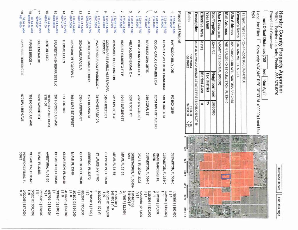
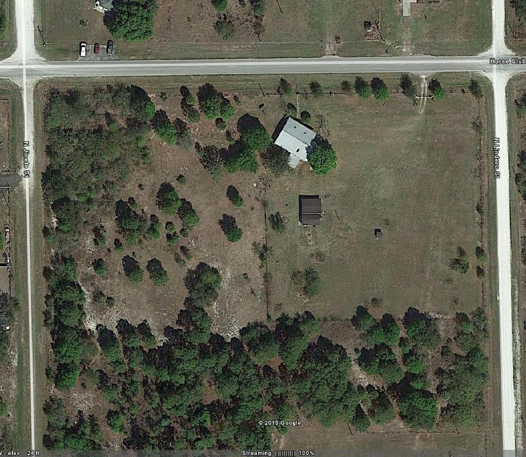
19 HENDRY COUNTY PLANNING & ZONING DEPARTMENT POST OFFICE BOX S. MAIN STREET LABELLE, FLORIDA (863) FAX: (863) STAFF REPORT SE Amending Special Exception Local Planning Agency 10/8/2015 Application Information Applicant: Owner(s): Agent: Request action: Location: Zoning: Future Land Use Map: Size: Existing use on the site: MIGUEL A. SANTANA, SR. & MIGUEL A. SANTANA, JR. MIGUEL A & AIDA SANTANA H.L. BENNETT, P.E., P.L.S Amend a Special Exception granted in 2009, for lots 1 and 2, to include lot 15. The purpose of the Special Exception is to expand the existing church. 354, 360, and 366 HORSE CLUB AVE Rural-Residential Farm (RRF) Residential, Pre-Existing Rural Estates 3.3 +/- acres Church/vacant All required application material has been received. All required notices have been made. Surrounding Area Information Adjacent existing uses Adjacent zoning Adjacent Future Land Use Map Category North Residential RR-F Residential, Pre- Existing Rural Estates South Vacant RR-F Residential, Pre- Existing Rural Estates East Vacant RR-F Residential, Pre- Existing Rural Estates West Vacant RR-F Residential, Pre- Existing Rural Estates Summary of Request and Background Information The applicant is requesting an amendment to an approved Special Exception Resolution No The applicant is adding 1.09 acres to the approved church property resulting in a 3.3 +/- acre parcel. The 1
20 applicant is proposing a new church assembly building, a fellowship hall in the existing building, church classrooms/school, playground, picnic shelters and outdoor recreational facilities including a basketball court. A variance was also previously approved in conjunction with the Special Exception pursuant to Resolution No The variance permitted a /- feet setback from Horse Club Avenue instead of the required 150 feet setback for the existing structure. No changes are proposed with regards to the approved variance. Consistency with the Comprehensive Plan The subject property is located in Montura Ranch Estates and is designated Residential Pre-existing Rural Estates per the Comprehensive Plan Future Land Use Element. This land use category was established to provide regulations for rural subdivisions that were established prior to the adoption of the Hendry County Future Land Use Categories. Uses permitted within the Residential Pre-existing Rural Estates are a combination of residential and, in certain situations, non-residential uses and recreation uses. The maximum Floor Area Ratio (FAR) permitted in this category is.25. The subject property is 3.3+/- acres which would permit a maximum of 32,670 +/- sq. ft. The Assembly building and the Fellowship building total 5,975+/- sq.ft. The church facility is consistent the land uses anticipated in this category and is within the permitted FAR. Consistency with the Land Development Code The property is zoned Rural Residential Farm (RR-F). Churches are considered an institution along with other public and private facilities such as community centers, hospitals, and schools in accordance with the Hendry County Land Development Code (LDC), Section , and are allowed in any zoning district via Special Exception approval. The expansion of the church facility complies with the definition of Institution. The site plan depicts a Type B Buffer for the entire perimeter. Section requires a Type D Buffer for all special exceptions. A Type D Buffer requires a 30 wide buffer with ten trees and 60 inch tall hedge per 100 linear feet or 5 trees and a wall plus 18 shrubs. A Type D Buffer is intended to address high intensity uses that can potentially produce excessive external impacts including noise, dust and lighting, etc. A Type B Buffer requires a 15 wide buffer with 5 trees and 18 shrubs or a hedge per 100 linear feet. Staff s position is that a Type D Buffer is excessive for a church due to its limited impacts and finds that the Type B Buffer will provide adequate buffering for the adjacent properties. Section (5) allows the Zoning Director to approve a reduction in buffers by no more than two types. The reduction was included in the request so that it could be considered with the overall project review. SPECIAL EXCEPTION STANDARDS (Staff comments in bold) The Church facility was previously found in compliance with the Special Exception Standards. The following is a reaffirmation of that finding. Section (1) of the LDC, Standards for action by board of county commissioners (for special exceptions), contains a requirement that any approved special exception would not violate the land uses, densities, or other directives of the adopted comprehensive plan or of this code. The institution use as described in the application is an allowable use in Residential Pre-existing Rural Estates Future Land Use Category and is consistent with the directives of the adopted comprehensive plan for this land use category. 2
21 Section (2) of the LDC, Standards for action by board of county commissioners (for special exceptions), contains a requirement that any approved special exception not be incompatible with the uses, structures and activities on adjacent and nearby lands. Compatibility is defined in the Definition Section of the Comprehensive Plan as a condition in which land uses or conditions can coexist in relative proximity to each other in a stable fashion over time such that no use or condition is unduly negatively impacted directly or indirectly by another use or condition. The approved Special Exception for a Church Facility was found to compatible with the surrounding area. The proposed amendment would allow the expansion of the church facility that would increase the usage and overall development, however, with the layout of the facilities oriented away from the adjacent properties and the recommended conditions, the facility would not unduly negatively impact the adjacent properties. In addition, Section (3) of the LDC contains criteria pertaining to the health, safety, welfare, and/or convenience of those residing, working or owning land in the vicinity of the proposed use or structure. The requested use is consistent with the following criteria: A) the use or structure would not exceed the applicable density or bulk regulations except as specifically authorized, nor shall the use or structure result in overcrowding of land or buildings. The applicant does not propose any uses or structures that would exceed the accepted density on the subject property, nor will the use or structures overcrowd the land any further than the existing use. B) the use or structure would not impair pedestrian or vehicular movement in adjoining streets so as to violate the adopted level of service standards (LOS). The proposal will not affect or violate the adopted level of service standards. C) the use or structure would not create a fire hazard. The proposed use(s) are not anticipated to create a fire hazard. The Fire Inspector did not have any comments on the request. D) the use or structure would not result in noise, odor, glare, vibration or other similar characteristic which is detectable at the property line and which exceeds the level which will result from permitted uses. Based on the information provided in the application, it is not anticipated that the proposed uses will result in noise, odor, glare, vibration, or other similar characteristic detectable at the property line. Approval of the Special Exception does not authorize any violation of the County s noise ordinance. E) the use or structure would not prevent an adjoining landowner from the legal use of her/his property pursuant to the LDC. 3
22 The proposed uses will not prevent an adjoining landowner from the legal use of his/her property pursuant to the LDC. F) the use or structure would not violate a requirement or limitation of any applicable state or federal law or regulation. Staff is not aware that any of the proposed use(s) would violate any requirement or limitation of any applicable state or federal law or regulation. G) the use or structure would not result in the inadequacy or inability of any public facility or service to meet adopted standards. Conclusion Based on the information provided by the applicant, and Staff s review, the proposed use(s) will not result in the inadequacy or inability of any public facility or service to meet adopted standards. Based upon staff s review of the application, supporting documentation and a review in accordance with Section of the LDC, staff finds the petition consistent with the Hendry County Comprehensive Plan and LDC. Recommendation Staff recommends the LPA forward the petition to the Board of County Commissioners with a recommendation of approval for the expansion of the church facility subject to the following conditions including those previously required: 1. This Special Exception is limited to one access connection to Avenida Del Norte (Horse Club Ave) and one access connection to Lindero Street. 2. A site development plan must be approved by the County prior to any improvements to the properties in the future. 3. No cooking or living in the existing dwelling unit is allowed as long as the Special Exception is in effect. 4. All outdoor lighting shall be shielded to avoid spillage onto adjacent properties. 5. No lighting is permitted on the basketball court. 6. Outdoor PA systems are not permitted. 7. Development shall be in accordance with the Special Exception site plan signed and dated by H.L. Bennett on 8/19/15. 4
23 8. Impervious parking may be utilized as depicted on the Special Exception site plan dated 8/19/ A Type B Buffer is permitted for the perimeter buffer. 10. The following uses are permitted: church assembly building, a fellowship hall in the existing building, church classrooms/school, playground, picnic shelters and outdoor recreational facilities including a basketball court. 5
24
25
26
27
28
29
30
31
32
33
34
35
36
37
38
39
40
41
42
43
44

45
46
47
48
49
50
51
52
53
54
55
56
57
58
59
60
61
62
63

64
65
66
67
68
69
70 HENDRY COUNTY PLANNING & ZONING DEPARTMENT POST OFFICE BOX SOUTH MAIN STREET LABELLE, FLORIDA (863) FAX: (863) MEMORANDUM TO: FR: RE: Hendry County Local Planning Agency Margaret Emblidge, AICP Land Development Code Amendments Sections , , and MEETING DATE: October 8, 2015 BACKGROUND On June 9, 2015, Staff received authorization from the Board of County Commissioners to prepare amendments to the Land Development Code (LDC). The attached documents include a portion of the first phase of recommended changes to the LDC. ANALYSIS Section , declaration of intent to exercise authority of local government comprehensive planning act; Section , comprehensive plan; Section , public participation in comprehensive planning process; Section , amendments to comprehensive plan Staff is recommending repealing the entire LDC Chapter 1-16 and combining it into LDC Section The new language updates and clarifies the process for amending the comprehensive plan. RECOMMENDATION Conduct a public hearing and make a recommendation to the Board of County Commissioners. 1
71 2015 LDC Amendments Sections 1-16 and /11/2015 Chapter 1-16 is repealed in its entirety. Sec Amendments to comprehensive plan. (a) Adoption of Plan. The "Hendry County Comprehensive Plan (Comprehensive Plan), as amended, is hereby adopted as the comprehensive plan of the county in accordance with the Community Planning Act, Section , F.S. The Comprehensive Plan was originally adopted in The Comprehensive Plan is the document adopted by the Board of County Commissioners (BCC) in accordance with Chapter 163, F.S., to guide all land development activities within Hendry County. All development orders, as may be conditioned, shall be consistent with the applicable goals, objectives, and polices in the Comprehensive Plan. Where there are apparent conflicts between the Comprehensive Plan and any regulations in the Land Development Code (LDC), the Comprehensive Plan will prevail. (ab) Public Notice of Amendments. Public notice shall be provided as required by Section , F.S. All workshops and meetings conducted by the local planning agency (LPA) and the Board of County Commissioners (BOCC) regarding the review and approval for the transmittal of amendments to the comprehensive plan shall be advertised in a newspaper(s) of general circulation or other media (if legally permitted by state law) and posted on the calendar on the County website. A display advertisement shall be utilized which will not be placed in the legal notice section. (bc) Public Participation in Amendments. In addition to the advertisements, the following process shall be utilized to encourage public participation in workshops and meetings related to Comprehensive Plan amendments., Pprior to the LPA and BCC closing the agenda item on a Comprehensive Plan amendment, the chairperson shall invite members of the public to speak and any written comments submitted will be entered into the record. (cd) Initiation of Amendments. tthe general requirements to initiate an amendment to the county County Ccomprehensive plan, or one of its elements are as follows: (1) An amendment may be proposed by the board of county commissioners BCC, the local planning agency LPA pursuant to F.S , any department or agency of the county, or any person other than those listed above; provided, however, that none other than thelandowner in the county. board of county commissioners Generally, none other than the BCC or the LPA shall propose an amendment for a land use designation change for property which hethe applicant does not own, except upon BCC approval, a landownerperson may request Page 1 of 5
72 2015 LDC Amendments Sections 1-16 and /11/2015 an amendment that includes properties not owned by that landowner if it is found to be in the best interests of Hendry County and appropriate notice, as detailed below, is provided to the affected property owner(s). (except as an agent or attorney for the owner). The planning and zoning department will be the agency responsible for processing the application and preparing a recommendation to the LPA and BCC. (2) For a privately initiated Comprehensive Plan amendment that includes properties not owned by the applicant, the applicant must submit a written request to the County for BCC approval to proceed. A total of three notices shall be mailed by way of certified United States Mail with return receipt requested. The first notice shall be mailed no more than ninety (90) days prior to the submittal of the application and copies of the letters and receipts shall be submitted with the application. The notice shall include a description of the land use change, including changes in property rights, a land use map depicting the designation of the properties within the proposed land use category and the right of property owners to object to or opt out of the amendment by submitting written comments to the County planning and zoning department. The second notice shall be provided at least ten (10) days, but not more than thirty (30) days prior to the transmittal public hearing before the LPA and shall provide the dates, times and locations for the transmittal public hearings before the LPA and the BOCC, and shall advise the property owners of any changes that have occurred since the original application and their right to submit written comments on the amendment and to appear at the public hearings and make oral comments. Prior to the transmittal public hearing before the LPA, the applicant shall submit to the County copies of the letter and receipts providing written proof that the notices required by this subsection have been provided. The third notice shall be provided for the adoption hearing before the BOCC applying the same requirements described above for the transmittal hearing. (3) There are no limitations to when or how many comprehensive plan amendments may be submitted and processed. (2) The procedures provided herein shall apply to all comprehensive plan amendments. (3) One complete copy of the application to amend the county comprehensive plan and supporting documentation along with a filing fee as established by resolution of the board of county commissioners must be submitted to the planning and zoning department prior to 12:00 noon on the fourth Friday of January, or the fourth Friday of April. The planning and zoning department will be the agency responsible for processing the application and preparing a recommendation. Page 2 of 5
73 2015 LDC Amendments Sections 1-16 and /11/2015 (b)(de) Procedure for Amendments. The procedure to amend the county County comprehensive Comprehensive plan Plan or one of its elements is as follows: (1) A pre-application conference shall occur between the petitionerapplicant, the planning and zoning department and other appropriate county staff to ensure that the procedure set out herein is understood and to review the conceptual basis for the proposed amendment. (2) The applicant shall submit one copy of the application for a completeness review. Once found complete, the applicant shall submit the required number of hard copies and a CD to the County along with a filing fee. The application form and fees shall be as approved by the BCC. (23) Staff shall perform an initial review of the proposed amendment application to determine whether the application meets the minimum requirements for internal consistency of the planpursuant to the adopted application form. Within 30 days, Sstaff shall notify the petitionerapplicant, in writing, that: a. The staff has determined that the petition application is adequate for formal review; or b. The petition application is inadequate for formal review, which notice shall set forth in detail the additional information deemed necessary for formal review of the petitionapplication. (34) The petitionerapplicant shall have 30 calendar days, not including county, state or national holidays, to supplement the application in response to the initial reviewrequest for additional information. If the petitionerapplicant does not submit additional information that is required by the county staff within the 30-days -day period or if the applicant does not request in writing and obtain an extension, the application will be deemed withdrawn additional information is still deemed insufficient, the county will consider the amendment in the next cycle of comprehensive plan amendments. (5) Once the application is deemed sufficient for review, the applicant shall submit five (5) hard copies and one CD of all documents (unless otherwise stated in the approved application) for formal review. (4(6) The planning and zoning department shall review the completed application and supplemental information and may consult with other county departments or agencies as it deems necessary to evaluate the proposed amendment. Within 30 calendar days staff shall inform the Page 3 of 5
74 2015 LDC Amendments Sections 1-16 and /11/2015 applicant if additional information is necessary or if the application can be scheduled for the transmittal hearing. If additional information is requested the timeframes described in (4) above shall apply. (7) Additional review fees may be required for additional series of reviews. These fees may include actual staff costs, including direct and indirect overhead costs plus any consultant costs. (The applicant will submit the required number of copies for all public hearings and staff review. The department shall prepare a report with a preliminary recommendation and shall advertise the petition for a public hearing to be conducted by the local planning agency (8) The public hearings, transmission requirements and State Agency reviews and time frames will be those established by Section F.S. for the State Coordinated Review Amendment Process and the Expedited State Review Amendment Process and Section F.S. for the Small Scale Amendment Process. (9) Administrative challenges shall proceed in accordance with Section F.S. (5) The local planning agency shall hold a public hearing after public notice as defined in F.S. Ch. 163, during which staff will present their review and make a recommendation to the local planning agency whether or not to transmit the amendment to the Florida Department of Community Affairs. All interested parties may appear and be heard. Written comments of the general public filed with the planning and zoning department and testimony will be considered at the public hearing. Following the local planning agency public hearing, the proposed amendment shall be forwarded to the board of county commissioners with the recommendation of the local planning agency. The boardshall conduct a public hearing in accordance with Florida law and consider all written and verbal comments and then determine whether or not to transmit the amendment to the Florida Department of Community Affairs. (6) After transmittal and receipt of the review comments (objections, recommendations, and comments) for the proposed amendments from the department of community affairs, the board of county commissioners shall hold a second public hearing pursuant to the notice required by Florida Statutes at which the board may adopt the amendment(s), adopt the amendment(s) with changes, or determine that it will not adopt the amendment(s). Page 4 of 5
75 2015 LDC Amendments Sections 1-16 and /11/2015 (7) Adoption of an amendment to the comprehensive plan shall be by ordinance. (8) The adopted amendment(s) to the comprehensive plan will be transmitted to the department of community affairs within the time allotted by state statute. (Ord. No , 1(50-8), ; Ord. No , 1, ; Ord. No , 1, ) Page 5 of 5
76
77 HENDRY COUNTY PLANNING & ZONING DEPARTMENT POST OFFICE BOX SOUTH MAIN STREET LABELLE, FLORIDA (863) FAX: (863) MEMORANDUM TO: FR: RE: Hendry County Local Planning Agency Margaret Emblidge, AICP Land Development Code Amendments - Various DATE: October 8, 2015 BACKGROUND On June 9, 2015, Staff received authorization from the Board of County Commissioners to prepare amendments to the Land Development Code. The attached documents reflect a portion of the first phase of recommended changes and additions to the current regulations in response to ongoing obstacles to ordinary permit requests, and changes to the Florida Statutes. Specifically, the changes include the following sections: Section , administrative waivers; Section , dimensional and density regulations; Section , PUD development application procedures; New Section allowing for PUD administrative amendments; Section , access/private roads; Section , landscaping and buffering; Section , required buffer type; Section , site development plan submittal requirements; New Article X, Property Maintenance. ANALYSIS Section , administrative waivers 1
78 This section is amended to allow the Planning and Community Development Director to approve administrative waivers instead of requiring a $2, application fee and notice to adjacent property owners. The new process would require the same limited criteria to base a waiver on and provides an appeal process to the Board if the Director denies the request. Section , dimensional and density regulations Table 53-2 Table of Dimensional and Density Regulations footnote #2 eliminated the requirement for side yard setbacks for commercial and industrial zoning districts. This does not properly accommodate the requirements for fill slopes, drainage systems, or buffers. Staff is recommending deleting the footnote in the table and the footnote itself. New Section Dimensional Measurements This section is added to provide clarification and definition for dimensional measurements for corner lots, home sizes, flaglots, lot coverage, rear lot line, lot depth measurement, and lot width measurement. Section , PUD development application procedures The proposed revisions include minor clarifications and explanation of application requirements. Creating new section allowing for PUD administrative amendments In order to provide flexibility in accommodating changes in the real estate market and regulatory changes that may impact the strict application of an approved PUD, staff is proposing an administrative process to allow minor changes to the PUD. Specific criteria must be met to insure there are no additional external impacts not previously considered in the original review process. The Planning and Community Development Director will be able to approve any change to the PUD development that does not change the use or increase height, density or intensity (i.e., number of dwelling units or quantity of commercial or industrial floor area). Similar to Administrative Waivers, an appeal process is available to the applicant if the Director denies the request. Section , access/private roads This section creates specific standards for private roads and private driveways. Private roads will now not be required to meet the width of the adjoining public road and private driveways will be allowed to access up to three residential parcels making this consistent with Section that allows the subdivision of land up to three discrete parcels of less than ten acres without requiring a plat. The driveway regulations will also accommodate the requests for lot splits that create a flaglot. Section , landscaping and buffering These sections apply to the Gateway Overlay Corridor. The Gateway Overlay Corridor applies to properties along SR 80 from the Lee County county line east to the Palm Beach County county line. Section regarding the landscaping and buffering requirements for the corridor has language proposed that will allow an alternative 2
79 corridor buffer to allow appropriate viewsheds for commercial development. This is not intended to allow deviations from the required location and screening of outdoor storage areas pursuant to Section (3). Section , required buffer type Staff is recommending deleting the automatic Type D Buffer requirements for Special Exceptions. Type D buffers are oriented towards industrial or high intensity type uses which do not apply to all Special Exceptions, etc. A right-of-way buffer is being proposed where a commercial or industrial use is adjacent to a right-of-way. Agriculture uses requiring a site development plan review will be required to provide a buffer depending on the intensity and location of the use and the proximity to less intense uses such as residential. This would apply to processing and retail type uses and level two type uses enumerated in the comprehensive plan AG Land Use Category. Section , site development plan submittal requirements Staff is recommending changes to relocate the requirements for silt fencing into a more appropriate section regarding drainage plans. The requirement for buffers to be shown on the site development plans has been revised to address requirements for agricultural uses/activities that would require buffering e.g. industrial type activity. New Article X. Property Maintenance The new Property Maintenance Article X. is proposed to address exterior surfaces of buildings. The intent is to require property owners to correct conditions that can impact surrounding property values. Examples include peeling paint, broken fences, and dilapidated architectural finishes such as shutters and porch railings. Also proposed are regulations that address the uses and structures on the property surrounding the principal buildings including exterior storage, accessory structures, walls and fences. Again, these regulations are intended to maintain property values and avoid negative impacts to surrounding properties. RECOMMENDATION Conduct a public hearing and make a recommendation to the Board of County Commissioners. 3
80 Sec Administrative waivers. (a) Intent. It is recognized that certain conditions exist or are created which are not recognized as selfimposed hardships, but which may be caused by a parcel of land or a structure having an irregular shape, or other peculiar physical characteristic, or which are not addressed in the zoning code due to their unusual or unforeseen nature. It is the intent of the board Board of County commissioners Commissioners to provide a remedy for these situations and to prevent undue expenses and time delays by permitting the planning Planning and Community development Development director Director to grant waivers under the following specific guidelines: (1) The director's Director's granting of a waiver contemplates an exception to existing zoning rules and regulations in a specific instance to alleviate undue burden or unnecessary hardship upon the property owner which the zoning rules and regulations otherwise impose; (2) The waiver is a modification which is ordinarily forbidden in a given zoning area, but may be granted upon a finding that a literal enforcement of rules and regulations would inflict an unnecessary hardship on an individual landowner either in a time or monetary concept; and (3) It is determined that the owner of the land has not purchased the property on a gamble to increase its value by virtue of the waiver, that granting the waiver would not harm the zoning plan, and that the adjoining property owners have no objection to the granting of the waiver. (b) Waivers permitted. Waivers may be considered for the following: (1) Setbacks, area lot coverage, lot width, lot depth and building height. a. The Planning and Community Development Director community development director may approve waivers to the required setbacks, area lot coverage, lot width, lot depth and height/size of buildings by no more than ten percent in all single-family and business districts. b. The community development directorplanning and Community Development Director may approve waivers to the required setbacks, area lot coverage, lot width, lot depth and height/size of buildings by no more than 15 percent in rural family and agriculture districts. (2) Special uses. When a use is not covered in any zoning district, but is similar in nature in all its components to permitted or permissible uses, the use may be considered either permitted or permissible by the director. (3) Off-street parking. The Planning and ccommunity Ddevelopment director may approve waivers of no more than ten percent for the required parking spaces (areas) in business and industrial zoned districts. (4) Nonconforming uses. The extension of a nonconforming structure, when in the best interest of the area, may be approved by the director. (c) Procedures. (1) The community development director shall notify the building official, county engineer, county administrator, county attorney, and the county commissioner in whose district the subject property is situated that a request has been made. (2) The community development director shall notify persons owning land within 750 feet of the subject property for which a waiver is being requested. Notification shall be by first class mail. (3) Landowners have 15 days from the date of the postmark of the letter they receive from the county in which to file an objection. (4) If there are no written objections from landowners receiving notice, the building official, county engineer, county administrator, county attorney, or the county commissioner receiving the notice, the waiver shall be granted. (5) If a written objection is received, the matter shall be presented to the county commission for final decision at a public hearing. No less than ten days prior to the hearing, the community development
81 director shall notify, by first class mail, all persons who previously received written notice of the hearing date and time. An application shall be submitted on standard forms provided by the County. A fee and application supporting documents shall be required as specified in the application instructions. The application fee shall be as authorized by the Board of County Commissioners. (d) Procedures for granting of administrative waiver by the Planning and Community Development Director. The Director may, after determining that the proposed waiver would meet the requirements of subsection (a) and (b), issue an approval or approval with conditions. (e) Appeal to Board of County Commissioners. (1) In the event the Planning and Community Development Director denies a request after an application is made hereunder, the applicant may, within 15 days from the date of the postmark of the letter he/she receives from the county, appeal the denial to the Board of County Commissioners by filing an appeal letter explaining how the Director s decision was in error. (2) An appeal filed under this section shall be decided by the Board of County Commissioners after a public hearing (3) At or after such public hearing the Board of County Commissioners may grant approval to the applicant, grant approval with conditions, or deny the request. (6)The applicant shall pay a fee as set by the board of county commissioners, for each separate request, to defray the cost of processing.
82 PART I - CODE OF ORDINANCES Chapter 1-53 ZONING Chapter 1-53 ZONING Sec Dimensional and density regulations Table of dimensional and density regulations. Table 53-2 sets forth criteria for minimum lot sizes, front, side and rear setback requirements, lot dimensions, and minimum square footage for dwelling units and maximum building heights for the location of structures within the several zoning districts established in this code. Except as specifically allowed elsewhere in this code, no structure may be hereafter built, located, or erected in any zoning district on a lot which does not meet the minimum lot size or minimum lot dimensions set forth in table Table 53-2 for the respective zoning districts, or which is located closer to a lot line than the minimum setback distances set forth in table Table 53-2 for the respective zoning districts, or which has fewer than the minimum square feet of living area (dwelling units only, not including porches, sheds or garages) or which exceeds the maximum building heights set forth in table Table Mobile homes, when allowed in a zoning district, must have a minimum of 500 square feet of floorspace as manufactured Dimensional Measurements. (a) Corner lots: means a lot located at an intersection of two streets resulting in two front yards. The primary front yard is the side of a lot where the front of the building is facing. The rear yard shall be opposite of the primary front yard and the remaining yard shall be considered a side yard. (b) Dwelling/Mobile Home size is measured by the amount of air conditioned square footage. (c) Flaglot measurements: Flaglots consist of a flag which is the lot minus the pole and a pole which is the access right-of-way or easement. For setback purposes, the front yard of a flaglot shall be along the access right-of-way or easement. The access right-of-way or easement shall be a minimum of 25 feet with a minimum driveway width of 20 feet. (d) Lot coverage means that portion of the lot area, expressed as a percentage, covered by buildings and structures. (e) Lot line, rear means that lot line which is opposite and most distant from the front lot line. (f) Lot measurement, depth: The distance measured from the front lot line to the rear lot line. For lots where the front or rear lot lines are not parallel, the lot depth is the average of the lines drawn from the front lot line to the rear lot line. (g) Lot measurement, width: The following shall apply to lot width: (1) On straight streets where side lot lines are perpendicular to the street right-of-way line, the terms lot width and street frontage are synonymous. (2) On streets where lots may not have parallel side lot lines, a lesser street frontage may be permitted provided that the required lot width is met at the midpoints of the side lot lines. (3) On cul-de-sacs where irregularly shaped lots with nonparallel side lot lines occur, the street frontage may be less than the minimum required width provided that the side lot lines are radial to the center point of the cul-de-sac. Hendry County, Florida, Code of Ordinances Page 1
83 PART I - CODE OF ORDINANCES Chapter 1-53 ZONING TABLE TABLE OF DIMENSIONAL AND DENSITY REGULATIONS Minim um Setbac ks Minim um Lot Dimen sions Distric t/use Minimum Lot Size (1) Fro nt (fee t) Side (feet) Rear (feet) Width (feet) Depth (feet) Cover (perce nt) Maxim um Buildi ng Height (feet) Minim um Dwelli ng Size (square feet) Minim um Mobile Home Size (square feet) A-1, all uses 20 acres A-2, all uses 5 acres A-3, Reside ntial Uses Lot not less than 5 acres, except for nonconformin g lots of record of not less than 1.10 acres A-3, Agricu lture Uses 1 acre Hendry County, Florida, Code of Ordinances Page 2
84 PART I - CODE OF ORDINANCES Chapter 1-53 ZONING RR: Flagho le 1 acre Pionee r Plantat ion 2 acres Fort Denau d 2 acres Big Oak Acres Units 1 and 2 5 acres All others 2 acres RR-F: Montu ra 1.10 acres RG-1 and RG- 1M, all uses 1 acre Hendry County, Florida, Code of Ordinances Page 3
85 PART I - CODE OF ORDINANCES Chapter 1-53 ZONING RG-2 and RG- 2M: a. Single - family dwelli ng or mobil e home 21,78 0 sf b. All other uses 1 acre RG-3 and RG- 3M: a. Single - family dwelli ng or mobil e home 7,500 sf b. All other uses 1 acre RG-4: Hendry County, Florida, Code of Ordinances Page 4
86 PART I - CODE OF ORDINANCES Chapter 1-53 ZONING a. Single - family dwelli ng 7,500 sf b. Twofamily dwelli ng 10,00 0 sf c. Town house dwelli ng: Interi or unit 1,500 sf End unit 2,500 sf d. Multif amily 1 acre e. All other uses 1 acre C-1, all uses 10,000 sf (2) C-2, all uses 10,000 sf (2) Hendry County, Florida, Code of Ordinances Page 5
87 PART I - CODE OF ORDINANCES Chapter 1-53 ZONING C-3, all uses 10,000 sf (2) I-1, all uses 10,000 sf (2) I-2, all uses 10,000 sf (2) PUD See section Section Notes: (1) Minimum lot size for individual use.; ooverall residential density and minimum lot sizes may vary pursuant pertinent provisions of the comprehensive plan and LDCis regulated by the comprehensive plan. (2) No side setback required unless adjacent to residential zone Supplemental dimensional regulations. Because of the need to protect uses from noise, traffic, and other impacts generated by major highways, and notwithstanding the provisions of table Table 53-2, above, no permanent residential structure shall be located closer than 100 feet from the rightof-way line of a state or federal highway. Sec PUD district Purpose. No Change PUD development application procedures. (a) Pre-application conference. Prior to filing an application for PUD development, the applicant or his authorized representative shall confer with the planning and zoning department, as well as such other county officials and representatives of other agencies as may be requested by them to participate. The purpose of this conference is for shall be to permit the applicant to present his the initial concept of the proposed PUD development, to permit county officials to make preliminary comments on the proposal, and to provide a detailed explanation of application requirements and review procedures. Potential waivers for application requirements and other materials that may be necessary for the review of the development will be discussed. (b) Application. A petition for PUD zoning shall be submitted in accordance with the general requirements for amendments to the official zoning map as set forth in chapter 1-51sSection In addition to other required application materials, the application shall include the following: Hendry County, Florida, Code of Ordinances Page 6
88 PART I - CODE OF ORDINANCES Chapter 1-53 ZONING (1) A statement identifying the all owners of all the property within the area of the proposed development, together with evidence of the unified control of said area. If submitted by other than the current owner(s) of the property, the statement shall be accompanied by satisfactory evidence of the existence of purchase or lease agreement(s) or other appropriate instrument(s) to indicate current or future unified control of the property. The statement shall include a certification by the applicant: a. That the proposed development shall be in accordance with the provisions of the application and all materials submitted therewith and supplied upon request, and in accordance with such specified modifications thereof as may be required by the board of county commissioners and agreed to by the applicant; b. That the applicant will provide any required acceptable surety bond, or letter of credit, or similar security to the county for each phase of the proposed development prior to the commencement of construction of such phase as to assure completion of water lines, sewer lines, streets, stormwater management system facilities, and other improvements required by the approval of the PUD development; c. If applicable, That the applicant will file with the county copies of any condominium prospectusdocuments for a homeowners association, condominium association, commercial property owners association, community development district or similar entity and the corresponding letter of approval from the stateflorida ddepartment of bbusiness and Professional rregulation, if appropriate, in order to ensure that provision will be made for the continuing operation and maintenance of all common facilities and open areas; and d. That the applicant will bind all successors of the applicant to such agreement. (2) A general concept plan at an appropriate scale showing the character, extent, and general location of buildings and outdoor uses, including open space and recreation areas, parking areas, public facilities, and buffers, and showing the uses of buildings. (3) An itemization of the number and types of dwelling units and square footages of nonresidential uses,dwelling or other units of different types and of the quantity (floor area) of space devoted to accessory uses, and a schedule showing the expected phasing plan (including the approximate starting and ending dates of each phase) andspecifying the number of dwelling units and/or quantity of space nonresidential uses to be included within each phase. (4) Unless waived at the pre-application meeting, a Traffic Impact Statement (TIS) must be submitted..a schematic traffic flow plan showing estimated volumes (peak hour) of traffic on collector and arterial roads within the site and at all entrances to the site. (5) A report indicating how the proposed project will conform to the adopted comprehensive plan. (6) Such other materials as may be determined by the Planning and community Community development Development director Director as being necessary for the review of the development based on its unique location, character or extent. Such materials shall may include an identification of areas on the site characterized by floodplains, known archaeological and historical sites, wetlands and habitats for threatened or endangered species of special concern No Change Reserved PUD Administrative Amendments. Hendry County, Florida, Code of Ordinances Page 7
89 PART I - CODE OF ORDINANCES Chapter 1-53 ZONING Administrative Aamendments to an approved PUD may be requested at any time during the development of or useful life of a planned unit development. (a) The Planning and Community Development Director may approve any change to the development that does not change the permitted uses or increase height, density or intensity (i.e., number of dwelling units or quantity of commercial or industrial floor area). The Director may not approve a change that will: (1) Result in a reduction of the amount of indigenous native vegetation preservation or open space required by the Code unless the following factors exist: a. A right-of-way or easement dedication is required as a result of a governmental action; b. A State or Federal permit so requires; (2) Change the buffer or landscaping areas such that, by comparison with the approved site plan, the landscaping or buffering is inferior; or (3) Increase the number of trips, resulting in not meeting concurrency requirements. (b) Appeal to Board of County Commissioners. (1) In the event the Planning and Community Development Director denies a request after an application is made hereunder, the applicant may, within 15 days from the date of the postmark of the letter they receive from the county, appeal the denial to the Board of County Commissioners by filing an appeal letter explaining how the Director s decision was in error. (2) An appeal filed under this section shall be decided by the Board of County Commissioners after a public hearing (3) At or after such public hearing the Board of County Commissioners may grant approval to the applicant, grant approval with conditions, or deny the request. Hendry County, Florida, Code of Ordinances Page 8
90 Access/private roads/private driveways. (a) Private Roads. Except for large lot subdivisions (section ), the following criteria are established for construction of a private road in the county, to wit: (1) All approved private roads shall have a minimum of a 6050-foot right-of-way with open drainageby means of a granted easement or deed parcel., where the approved private road would become a natural extension of an existing county-maintained road, or part of the area infrastructure. The board of county commissioners may, upon demonstrated and verifiable hardship, reduce the right-of-way width may be reduced requirement, but in no case shall the required right-of-way be less than to 30 feet if closed drainage, or inverted crown design is used. The right-of-way itself shall not be constituted as the private road, but rather the area in which the private road shall be placed. (2) No said right-of-way shall utilize any portion of the minimum lot width required within any zoning district other than an A-1 or A-2 zoning district. (3) All approved privately maintained roads abutting in [on] an approved public street or county-maintained road shall meet or exceed the type of construction of said approved public street or county-maintained road. In no case shall the approved private road be of a lesser type surface than the abutting approved public street or county-maintained road, unless a variance is granted by the board of county commissioners. (4) The applicant shall be required to pay the fee approved by the board of county commissioners in order to defray processing costs relating to the review, inspection, and approval of the private road by the county engineer. (b) Private Driveways. Nothing in this section shall be construed to mean that private driveways located on an individual parcel, lot, or tract or roadways serving lands used for bona fide commercial agricultural purposes, with or without residential structures occupied in conjunction therewith, shall be paved or improved to meet the requirements above. Private driveways shall be classified as legal access on or over private property to a building or structure from an approved private road, public street, or countymaintained road. Private driveways may serve no more than two three primary structures residential parcels, plus their attendant or secondary accessory structures. Furthermore, this section shall not prevent the reasonable use of existing parcels having access only by public waterway. (1) Private driveways shall have a minimum improved width of 20 feet. (2) Private driveways that have dead-ends shall provide a turnaround that will accommodate emergency vehicles. (3) Private driveways shall be constructed with a stabilized surface in order to accommodate emergency vehicles. (bc)use of residentially zoned lot for access. No lot which is residentially zoned shall be used for a private driveway, approved private road, walkway, or access purposes to any lot which is nonresidentially zoned, or used for any purpose not permitted within the applicable residential zoning district. (cd) Large lot subdivisions. Access roadways for large lot subdivisions are not subject to the provisions of this section and shall, instead, be subject to the provisions of the large lot subdivision section of the Code.
91 (e) Nothing in this section shall be construed to mean that private driveways located on an individual parcel, lot, or tract or roadways serving lands used for bona fide commercial agricultural purposes, with or without residential structures occupied in conjunction therewith, shall be paved or improved to meet the requirements above.
92 ARTICLE II. - GATEWAY OVERLAY CORRIDOR FOOTNOTE(S): --- (2) --- Editor's note Ord. No , adopted June 24, 2003, did not specifically amend the Code and has been included herein as Art. II at the discretion of the editor. Sec Properties included. No Change Sec Purpose and intent. No Change Sec (b) (h) - No Change Sec Landscaping and buffering. (a) No Change (b) Landscape standards. Landscape standards shall consist of the following: (1) Corridor buffer. A 20-foot-wide landscape buffer shall be provided by the developer/property owner along the property's frontage on S.R. 80. An alternative corridor buffer may be approved per Section (2). a. The buffer shall be planted with live trees of a minimum five-inch diameter at breast height (DBH), and ten feet in height at planting, along a line ten feet back from the right-of-way line. The trees shall be planted every 40 feet. A minimum of four understory trees, of a minimum two-inch diameter at breast height and a minimum of eight feet in height, per 100 linear feet of frontage or fraction thereof shall be planted in and about access points and intersections. b. Where parking abuts the buffer, a continuous shrub hedge shall be arranged or planted on 24-inch centers, unless exempted by the county, so that a height of three feet will be attained within one year of planting and so as to screen a minimum of 75 percent of the parking area, to that height, as viewed from the right-of-way. c. Where parking abuts the buffer, a minimum of 15 percent of the required buffer area shall be covered with shrubs or groundcover in addition to the hedge requirement. The trees shall be placed in the groundcover beds where possible. The planting of flowering annuals within the buffer area is required. d. Existing vegetation shall be used where possible to meet these requirements. Xeriscaping is encouraged in order to minimize water usage for irrigation. e. An automatic irrigation system shall be designed and installed to irrigate 100 percent of the landscaped area. Such irrigation system shall be operated and maintained by the developer/property owner in such a manner as to ensure continued irrigation to the landscaped area. The irrigation system shall be equipped with a rain sensor devise in order to minimize the potential for irrigation during rain events. Irrigation systems shall be required to make use of reclaimed water when such water is made available to the developer/property owner. Page 1 of 2
93 f. Landscaping shall be maintained in excellent condition at all times and shall be replaced in the event of disease or death of plant materials. g. Landscape materials shall be pruned only to promote healthy, uniform, natural growth of the vegetation. Trees shall not be pruned severely in order to permanently maintain growth at a reduced height or spread. Severely pruned trees shall be replaced by the owner. Page 2 of 2
94 Sec Required buffer type. The table below describes the required buffer type when a proposed use is abutting a different existing use or, in the absence of an existing use, the existing zoning, except that: (1) For all uses permitted as special exceptions, a type D buffer with a solid Wall is required; (2) All uses that generate noise, dust, odor, heat, glare or other similar impacts, must provide a type D buffer with a wall; (3) If roads, drives, or parking areas are located within 125 feet of existing residential lots, a type D buffer with a wall must be installed, with the wall placed not less than 25 feet from the abutting residential property with the required trees and shrubs located between the wall and the residential property, but if residences will be constructed between the road, drive, or parking area and the existing residential property, the buffer is not required; (4) All public and quasi-public facilities, including, but not limited to, places of worship, parks, utility facilities, government offices, neighborhood recreational facilities, and private schools, must install a type D buffer; (51) The zoning Planning and Community Development director Director may reduce any buffer required in this section upon receipt of evidence that the abutting property will be unaffected if a lesser buffer type is installed; however, the zoning ddirector may reduce the required buffer by no more than two types (e.g. from D to B, or C to A) and the director Director may not entirely eliminate a required buffer. (2) The Planning and Community Development Director may approve an alternative buffer if it can be demonstrated how the applicable buffer requirements can be effectively accomplished through an alternate buffer plan. The approval of the alternate buffer is at the Director's discretion and may include conditions to ensure that the overall buffer design complies with the intent of this section. Buffer Requirements Permitted or Existing Uses Permitted or Existing Uses Proposed Uses Proposed use Ag R Com Ind ROW Ag(1) None A None None None None R ANone None B B None Com C C A B B Ind C D D A C
95 Special exception D (see section subsection (1) above) D (see subsection (1) above) D (see subsection (1) above) D (see subsection (1) above) (1) Agriculture uses that require a site development plan will be required to provide a buffer based on the intensity of the use and the potential impacts to the adjacent uses. The required buffer shall be determined by the Planning and Community Development Director. (Ord. No , 6, )
96 ARTICLE IV. - SITE PLAN REQUIREMENTS Sec Submittal requirements. (a) Submittal requirements. (1) The site plan shall be prepared on durable material with permanent writings and markings thereon showing to accurate scale all existing and proposed development on the property. The scale shall be no smaller than one inch equals 200 feet. The plan shall show property boundaries with a legal or a metes and bounds description, references to section, township, and range, and subdivision name and lot numbers, if applicable. The area of the property shall be noted in square feet and acres. The plan shall show all proposed physical improvements including, but not limited to: existing and proposed buildings, off-street parking areas, pavements, landscaping, utilities, on-site recreation, stormwater management facilities, water bodies, wellheads, walls, poles, towers, signs, and the distances of all these improvements from the boundaries of the property. (2) Copies shall be submitted to the planning and zoning department as prescribed on application forms prepared by the county. The plan drawings shall be prepared by a registered architect, landscape architect, or civil engineer licensed in the State of Florida, each certifying to their field of expertise by signing and sealing the drawings, and shall include the following information: a. Name, address, and telephone number of the owner(s) and/or developer of the property, the drawing scale used, number of sheets per set of plans, north indicator, and complete dimensions. All dimensions shall be in feet and decimal fractions of a foot. The plan shall be prepared on a 22-inch by 34-inch sheet drawn to scale. b. A site location inset shall be included on the top page of each set of plans to indicate the location of the project relative to surrounding areas and including at least the nearest arterial or collector roadway. c. A complete legal description of the property. d. A boundary survey (11 inches 17 inches), less than one year old, signed, sealed, and prepared by a Florida registered land surveyor, showing the location and dimensions of all property lines, existing streets or roads, easements, rights-of-way, and areas dedicated to the public. In the case of improved property, the survey is to show all vertical improvements. e. The land use districts of all abutting properties shall be shown. Where the property abuts a right-ofway, the street name shall be indicated. f. The location of all streams, floodplains, water bodies, and wetlands lying within, adjacent to, or affecting the site shall be clearly delineated. g. Total area and percentages of the total site area shall be given for impervious surface. h. If a residential development is proposed, the total number and type of residential units shall be given. The total number of units (all types) and units per acre shall be included. Construction phase lines, if proposed, shall be shown. i. Locations of all proposed permanent signs and exterior lights shall be shown. Sign face area with dimensions shall also be provided. j. Exact locations of the nearest existing and all proposed fire hydrants shall be shown. k. The layout of any proposed sanitary sewer and water main construction shall be given including the locations of proposed connection to existing facilities. l. If a garbage dumpster is proposed, show pad location and specifications. m. A traffic impact study shall be submitted in accordance with the county's guidelines. n. The plans shall show the total number of proposed parking spaces, spaces reserved for handicapped parking, loading areas, wheel stops, proposed ingress and egress (including proposed public street Page 1
97 modifications), and projected on-site traffic flow. The full dimensions of parking spaces, travel lanes, and driveways shall be labeled. o. Cross sections and specifications shall be shown for all proposed pavement. p. A complete drainage, grading, and water retention plan is required with supporting calculations indicating existing and proposed runoff. The location of silt fencing shall be indicated on the plan. q. Proposed landscaping, including a plant legend, shall be shown. The locations and names of any existing trees shall also be shown with labels as to which trees are to be removed or relocated and which will remain. Buffer areas and/or silt fencing shall be indicated. r. Buffers shall be shown including the required materials. Agriculture uses that require a site development plan will be required to provide a buffer based on the intensity of the use and compatibility with the adjacent uses. The required buffer shall be determined by the Planning and Community Development Director based on Section with the required buffer being based on the intensity of the use on the agricultural land (e.g., an industrial-type activity on the agricultural land will be treated as if it were an industrial use). rs. st. tu. Submission shall indicate provisions to be made for adequate control of erosion, sedimentation, dust, and debris during all phases of clearing, grading, and construction. Provisions for protection of historic and/or archaeological resources shall be indicated, if applicable. Provisions for protection of habitat and endangered or threatened species, including land area set aside, shall be indicated. uv. A space measuring at least four inches in width and three inches in height shall be provided in the title block on the top page of each set of plans. This space will be reserved for the county's development approval stamp. vw. Copy of warranty deed for property. wx. Any additional data, materials or information deemed necessary by the County to make a determination. (b) Staff review. Within ten days of the applicant submitting an application to Hendry County, the county shall advise the applicant what information, if any, is needed to deem the application properly completed in compliance with the filing requirements prescribed by the county. A properly completed application is one that contains all the required materials prescribed by the county. If the county does not provide written notice that the applicant has not submitted a properly completed application, the application shall be deemed properly completed and accepted. This does not imply the application will be approved. Within 30 days after receiving a completed application, the county must notify an applicant if additional information is required for the county to determine the sufficiency of the application, and shall specify the additional information that is required. Each time an applicant responds to a request for additional information, the 30-day review period begins anew. (Ord. No , 3, ; Ord. No , 13, ) Page 2
98 ARTICLE X. PROPERTY MAINTENANCE Sec Title. The provisions included within this article shall constitute and be known and may be cited as "The Property Maintenance Standards," hereinafter referred to as "this article." Sec Purpose. (a) The purpose of this article is to protect the comfort, health, repose, safety, and general welfare of residents of the county by establishing minimum property and building maintenance standards; and providing for the abatement of nuisances affecting the general public. (b) The maintenance and nuisance standards in this article are supplemental to standards that are found in portions of the Land Development Code (LDC) and in other ordinances adopted by the county. Sec Exterior surfaces of buildings. (a) All building walls and roofs shall be maintained in a secure and attractive manner. Deteriorated structural and decorative elements of any building wall or roof shall be repaired or replaced in a workmanlike manner to match as closely as possible the materials and construction of the building. (b) All exterior surfaces other than decay-resistant wood and other weather durable finishes shall be protected from the elements by use of paint, stain, or other wood or surface preservatives. Loose material, including peeling paint, shall be removed and replaced. (c) Doors and windows shall be maintained as follows: (1) All doors and windows shall be secured in a tight-fitting and weatherproof manner. (2) Sashes with visibly rotten wood must be repaired or replaced. (d) Ground level storefront windows facing a public right-of-way shall be maintained in an unbroken and clean state. (e) (f) (1) No window facing a public right-of-way shall be changed, removed, enclosed, or covered without a building permit, if applicable, except that damaged windows may be boarded up for a reasonable temporary period, not to exceed 30 days, while repairs are being arranged. Any building renovations approved under this Code must treat such windows as an integral part of the building facade. (2) All awnings or canopies facing or visible from the public rights-of-way shall be maintained in good condition. Torn or loose awnings shall be promptly repaired or replaced. All roofs shall be maintained in a secure and watertight condition. Any mechanical equipment for commercial buildings, as defined by the state building code, placed after the effective date of the ordinance from which this article is derived, shall, be placed in such a manner so as to be screen from view from ground level of adjoining residential properties and public rights-of-way. This section shall not apply to properly installed solar panels. Sec Exterior storage, accessory structures and fences. (a) No temporary or permanent storage of materials or equipment, including fence material, shall be allowed on any vacant property except in conjunction with an active building permit. Page 1
99 (b) Equipment, materials, and furnishings not designed for use outdoors, such as automotive parts and tires, building materials, and interior furniture, may not be stored outdoors, except in compliance with the regulations for the use of the property as set forth in Sec Zoning. (c) Accessory structures, including sheds, shall be structurally sound and maintained in good repair in accordance with Sec Sheds shall be secured pursuant to the manufacturer's requirements. (d) The term "temporary storage units, shipping or sea containers" (referred to as "TSU" collectively) shall mean a transportable unit designed and used primarily for temporary storage of building materials (before they are utilized for building purposes), household goods, and other such materials for use on a limited basis on residential property. (e) (1) The TSU unit shall be located at such address for a maximum of 14 consecutive days on residential property, including the days of delivery and removal, except when there is an active building permit, in which case the TSU unit may stay on the property until the permit expires or a certificate of occupancy is issued, whichever occurs earlier. An extension may be granted to the landowner by code enforcement, subject to conditions, for a reasonable additional time period in an amount not to exceed 30 days. (2) Each residential property may utilize a TSU unit no more than four times per calendar year. A minimum of 15 days shall elapse between the end of one time period and the beginning of another. (3) The landowner shall be responsible for ensuring that the TSU unit is maintained in good condition, free from evidence of deterioration, weathering, discoloration, graffiti, rust, ripping, tearing or other holes or breaks, at all times. (4) No TSU unit shall be used to store solid waste, construction debris, demolition debris, recyclable materials, business inventory, commercial goods, goods for property other than at the residential property where the TSU unit is located (i.e., used for retail sales), hazardous material or illegal material. Upon reasonable notice, the landowner shall not unreasonably withhold consent to the county to inspect the contents of any TSU unit at any reasonable time to ensure that it is not being used to store said materials. The term "reasonable notice," for the purpose of inspection, is notice given at least 12 hours prior to the entry, and reasonable time for the purpose of inspection shall be between the hours of 7:30 a.m. and 6:00 p.m. Fences and walls shall be maintained in good condition and secured. Materials, other than decay resistant varieties, shall be protected against decay and/or mildew by use of paint, stain, or other wood or surface preservatives. Sec Enforcement. Enforcement of this article shall occur pursuant to Section , or of this LDC. Page 2
100
101 HENDRY COUNTY PLANNING & ZONING DEPARTMENT POST OFFICE BOX SOUTH MAIN STREET LABELLE, FLORIDA (863) FAX: (863) MEMORANDUM TO: FR: RE: Hendry County Local Planning Agency Margaret Emblidge, AICP Land Development Code Amendments Detailed Specific Area Plans and Rural Detailed Specific Area Plans MEETING DATE: October 8, 2015 BACKGROUND On June 9, 2015, Staff received authorization from the Board of County Commissioners to prepare amendments to the Land Development Code. The attached document includes the implementing regulations for the approved Sector Plans. Specifically, the changes to the LDC include the following sections: Section , establishment of districts; Section , land use classifications; Section table of dimensional and density regulations; New Section Detailed Specific Area Plan (DSAP) district; New Section Rural Detailed Specific Area Plan (RDSAP) district. In accordance with Section (4)(b)2 F.S. any proposed ordinance or resolution that changes the actual list of permitted, conditional, or prohibited uses within a zoning category two public hearings must be held before the Board of County Commissioners. Since the DSAP and RDSAP are new districts the recommendation for these LDC amendments will first be heard by the Board on October 13 th with the second hearing to be determined. 1
102 ANALYSIS The purpose of these amendments is to establish implementing regulations for the Sector Plans including Detailed Specific Area Plans (DSAP) that would apply to the Rodina and Southwest Hendry County Sector Plan and any other Sector Plans that may be adopted. The Rural Detailed Specific Area Plan (RDSAP) only applies to the Southwest Hendry County Sector Plan. Both districts are processed similar to a PUD and are added to the Establishment of Districts Table as new zoning districts. Definitions of Sector Plans, DSAPs and RDSAPs are added to the Land Use Classifications section. Both DSAP districts are added to the Dimensional and Density Regulations Table. New Section The Detailed Specific Area Plan (DSAP) district is established to meet the requirements of Section , F.S., for development located within a Sector Plan. A DSAP is the implementing instrument for a Sector Plan that has been adopted into the Comprehensive Plan. A DSAP must be processed in accordance with Section , F.S. A DSAP must address the same issues as the Sector Plan, although in greater detail. A DSAP must identify the distribution, extent, and location of future uses, public facilities, including those outside the jurisdiction and those necessary for the short term development. As with the Sector Plan, the DSAP must also include guidelines and principles that address urban form and procedures for intergovernmental coordination. New Section creates the criteria for establishing and processing a Rural DSAP in the Southwest Hendry County Sector Plan. Rural DSAPs are intended to provide the continuation of rural development areas surrounding and adjacent to the compact urban development form of the Employment, Village, and Neighborhood Districts within the Southwest Hendry County Sector Plan. RECOMMENDATION Conduct a public hearing and make a recommendation to the Board of County Commissioners. 2
103 PART I - CODE OF ORDINANCES Chapter 1-53 ZONING Chapter 1-53 ZONING Sec Zoning districts Establishment of districts. For the purposes of this chapter, the following zoning districts are hereby established for use within the county: A-1 Agriculture/Conservation A-2 General Agriculture A-3 Agriculture Transitional RR RR-F RG-1 RG-1M RG-2 RG-2M RG-3 RG-3M RG-4 Rural Residential Rural Residential Farm Residential/Low Density Residential/Low Density Mobile Home Residential/Medium Density Residential/Medium Density Mobile Home Residential/High Density Residential/High Density Mobile Home Residential/Multifamily C-1 Convenience Commercial C-2 General Commercial C-3 High Intensity Commercial I-1 Light Industrial Hendry County, Florida, Code of Ordinances Page 1
104 PART I - CODE OF ORDINANCES Chapter 1-53 ZONING I-2 Heavy Industrial PUD DSAP RDSAP Planned Unit Development Detailed Specific Area Plan Rural Specific Area Plan A. No Change Land use classifications. For the purpose of this chapter, the following land uses and activities shall be permitted in the respective districts as provided in table 53-1 (Table of Use Regulations) in section , below. The following definitions are hereby established: Accessory use or structure means a use or structure of a nature customarily incidental and subordinate to the principal use or structure and unless otherwise provided, on the same premises. "On the same premises," with respect to accessory uses and structures shall be construed as meaning on the same lot in the same ownership. Where a building is attached to the principal building, it shall be considered a part thereof, and not an accessory building. Adult congregate living facility (ACLF) means a type of residential care facility, defined in F.S. ch. 400, pt. II. Agricultural processing means an industrial use specifically associated with producing, harvesting, processing or marketing of agricultural products. Agricultural worker housing means dwelling units intended for occupancy by persons engaged in agriculture or agricultural processing activities and by families of workers. Agriculture means the use of land for agricultural purposes, including farming, dairying, pasturage, apiculture (beekeeping), horticulture (plants), floriculture (flowers), silviculture (trees), orchards, groves, viticulture (grapes), animal and poultry husbandry, specialty farms, confined feeding operations and the necessary accessory uses for packing, processing, treating or storing the produce; provided, however, that the operation of any such accessory uses shall be secondary to that of the normal agricultural activities. Apartment building means a building that is used or intended to be used as a home or residence for three or more families living in separate quarters with at least one common wall between units. Units are commonly arranged in multi-story buildings and all do not have ground floor or individual entries to the outside. Auto salvage/junkyard means a place where the principal activity is the outside storage and/or processing of wrecked or derelict property having no value other than the nominal salvage value, including wrecked, inoperative, or partially dismantled motor vehicles, trailers, boats, machinery, appliances, furniture, and any other similar article. Storage of more than three inoperable vehicles constitutes a junkyard. In addition, an individual who is restoring, not for profit, a classic or antique vehicle, may have three inoperable vehicles parked on his premises in a fully enclosed building or a back yard completely enclosed by opaque fencing, as long as they are of the same make and model of the vehicle he is restoring. Hendry County, Florida, Code of Ordinances Page 2
105 PART I - CODE OF ORDINANCES Chapter 1-53 ZONING B and B means bed and breakfast inn. These type lodgings are single-family homes converted to inns with one or more rooms to rent for an overnight stay for the traveling public; and, are typically found in historic districts or in homes that are historic in nature. The proprietors live on the premises and include breakfast in the price of an overnight stay. Big box retailers or wholesalers means large stores (e.g. Target, WalMart, Costco, and Sam's Club) that sell a variety of goods and services all in one building that may include a combination of goods traditionally sold at retail general stores, hardware stores, plant nurseries, grocery stores, office supply stores, sewing and hobby shops, appliance and stereo stores; and may include selling services such as photography studios, optical centers, barber/beauty shops, travel agencies, and restaurants. These stores can be retail sales only or wholesale sales that require a membership. Boardinghouse and rooming house means a building other than a hotel, motel, or restaurant, where meals or lodging are provided for a fee for three or more unrelated persons and where no cooking or dining facilities are provided in individual rooms. These type facilities differ from B and B's because they are typically rented to semi-permanent residents rather than the traveling public and for longer stays than one or two nights. Community residential home, major, means a dwelling unit licensed to serve clients of the state department of health and rehabilitative services, which provides a living environment for seven to 14 unrelated residents who operate as the functional equivalent of a family, including such supervision and care by supportive staff as may be necessary to meet the physical, emotional, and social needs of the residents. Community residential home, minor, means a community residential home designed to serve fewer than seven residents. Conservation means a use intended to preserve the natural condition of land or water, including buffering of natural areas from other uses. Conservation uses include, but are not limited to, preserves for vegetation and wildlife habitat, habitats for threatened and endangered species or species of special concern, wetlands, sensitive shorelines, and archaeological and historical sites. The definition includes certain activities and improvements which are consistent with the use and protection of conservation areas, including, but not limited to, facilities for scientific and educational study and passive recreation (such as hiking and nature trails). Convenience commercial means a retail establishment having an enclosed building area of less than 5,000 square feet, or a group of such establishments not exceeding 15,000 square feet in the aggregate, designed to serve the immediate shopping and service needs of persons within a very small area, including convenience stores (with or without gasoline sales), coin laundries, restaurants, and similar facilities. Detailed Specific Area Plan (DSAP) is a planned development that implements a Sector Plan pursuant to Section (3)(b), F.S. Duplex or two-family dwelling unit means a building consisting of two separate dwelling units, each with its own outside entrance. Dwelling, multifamily, means a residential structure containing two or more separate dwelling units. Dwelling, single-family, means a residential structure built on- or off-site pursuant to standards of construction set forth in chapter 1-58 of this code and consisting of one dwelling unit. Dwelling, townhouse, means a group of three or more but not more than eight dwelling units which are arranged in a row and each of which is joined to the adjacent unit by a common party wall, and each of which shall have its own outside entrance. Dwelling, two-family, means a building consisting of two separate dwelling units, each with its own outside entrance. Hendry County, Florida, Code of Ordinances Page 3
106 PART I - CODE OF ORDINANCES Chapter 1-53 ZONING Entertainment establishment means any tavern, bar, lounge, dancehall, live or motion picture theater, establishment offering live entertainment of any kind, or any establishment the primary activity of which is the sale or rental of sexually oriented books, magazines, videotapes, or devices. Essential public or utility facility means a component of the distribution or collection system for a utility or communication system, such as water and sewer lines, electric lines, telephone or cable television lines, but not including substations, switching stations, or treatment facilities which are defined as "public service/public utility uses." Family means: (a) An individual, or two or more persons related by blood, marriage, or adoption; which include only spouse, children, stepchildren, foster children, parents, stepparents, foster-parents, brothers, sisters, grandparents, and step grandparents; living together as a single household unit, or; (b) a group of not more than five persons, who need not be related by blood, marriage, or adoption, living together as a single household unit. Floriculture means the cultivation of flowering plants. General commercial includes a variety of general commercial, commercial recreational, entertainment, and related activities. This category includes the following specific uses, and all substantially similar uses: (1) Arcades, billiards/pool parlors, bowling alleys, indoor recreation centers and gymnasiums/spas/health clubs. (2) Commercial or trade schools, including dance and marital arts studios. (3) Department stores and other retail stores. (4) Funeral homes and mortuaries. (5) Automobile accessory and parts stores and hardware stores without outside storage. (6) Grocery stores, supermarkets, convenience stores and specialty food stores (such as meat markets and bakeries). (7) Hotels and motels. (8) Service businesses such as blueprint, printing, catering, tailoring, travel agencies, upholstery shops, laundries/dry cleaners, and light mechanical repair stores (such as camera, TV, or bicycle repair shops). (9) Restaurants, other than those with drive-through facilities. (10) Shopping centers. (11) Theaters and auditoriums. (12) Retail plant nurseries. (13) Veterinary offices and animal hospitals, provided the facility has no outside kennels. (14) Financial institutions. General recreation means an outdoor recreational activity such as: golf courses, miniature golf courses, golf driving ranges, stables and horse riding areas, marinas, boat docks, boat ramps, fishing piers, community swimming pools, and similar recreational activities, along with community halls, and structures associated with these activities. Specifically excluded are firing ranges and facilities associated with motor sports. Heavy industry means those businesses and activities involving manufacturing, processing, storage, warehousing, and distribution of goods, including outdoor storage and any industrial activity which is conducted outdoors. Hendry County, Florida, Code of Ordinances Page 4
107 PART I - CODE OF ORDINANCES Chapter 1-53 ZONING Heavy recreation means an outdoor recreational activity which is noisy, creates dust or fumes, and/or creates dangers to others in the area, and specifically includes firing ranges and facilities for motor sports. High intensity commercial means those activities which require outdoor storage, have higher trip generations than general commercial uses listed above, or have the potential for greater nuisance to adjacent properties due to noise, light and glare, or typical hours of operation. This group of uses includes the following list of specific uses and all substantially similar activities: (1) Vehicle sales, rental, service, and repair, including truckstops, body shops, road services, carwash facilities, and the sales, rental, repair and service of new or used automobiles, boats, buses, farm equipment, motorcycles, trucks, recreational vehicles, and mobile homes. (2) Gasoline sales and service, combination gasoline sale and food marts, and similar facilities. (3) Restaurants with drive-through facilities. (4) Roadside produce stands, temporary or permanent. (5) Veterinary offices and animal hospitals with outside kennels. (6) Storage yards for equipment, machinery, and supplies for building and trades contractors. (7) Flea markets or similar outdoor or indoor/outdoor sales complexes. (8) Garbage hauler garage and storage facilities. (9) Building, farm, and garden supply facilities. Home occupation means an occupation for gain or support conducted primarily by immediate members of a family residing in a dwelling. In general, home occupation shall include, but not be limited to: professional and personal services, such as are furnished by a dentist, lawyer, artist, sculptor, painter, beauty operator (not a beauty parlor), seamstress, music instructor, telephone answering service, an individual designer's studio, mail order business or millinery activities and the like. The following uses are not home occupations: medical clinics; financial institutions; sales offices or industrial uses; commercial daycares or commercial childcare. Horticulture means the growing of flowers, fruits and vegetables for commercial purposes. Institution includes educational facilities (public or private), preschool and day care facilities, churches, cemeteries without funeral homes, community centers, fraternal lodges, hospitals and all other similar uses. Light industrial means those businesses involving manufacturing, processing, storing, warehousing, or distributing goods, and not involving uses that primarily require outdoor storage or industrial activity which is conducted outdoors. Included in this category are uses that primarily require indoor storage or industrial activity, which is conducted indoors. Manufactured home refers to any home factory-built in the United States to the federally regulated HUD Title 6 construction standards (commonly known as "the HUD Code"). The HUD Code took effect June 15, 1976 and provides the design and construction requirements for the complete production of the entire home in the factory, with some modifications permitted for on-site completion. A HUD coded home will display documentation called the certification label and the data plate. Removal of these documents is illegal, as per the HUD Title 6 regulations. They are not replaceable. The data plate contains the manufacturer's name and address, the style, design conditions, appliance installation system identification, and other pertinent information. It must be permanently affixed inside the home in a readily visible/accessible location. Medical or dental office means an establishment where patients, who are not lodged overnight, are admitted for examination or treatment by persons practicing any form of healing or health-building services whether such persons be medical doctors, chiropractors, osteopaths, chiropodists, naturopaths, Hendry County, Florida, Code of Ordinances Page 5
108 PART I - CODE OF ORDINANCES Chapter 1-53 ZONING optometrists, dentists, or any such profession, the practice of which is lawful in the State of Florida. A pain management clinic shall not be considered a medical or dental office. Mining means surface mining, rock quarries, strip mining, borrow pits, and any other natural resource extraction activities. Buildings and businesses for the refinement, processing, packaging, and transportation of extracted materials are included in this group of uses. Pre-production and exploratory drilling activities are not included. Mini-warehouse means a self-service facility consisting of individual self-contained units used for storage and no other purpose, plus an office/residence for a manager. Mixed-use development means a type of development that includes both residential and nonresidential uses. Mobile home commonly refers to a factory-built home produced before June 15, 1976, or pre-hud Code, and not built to a uniform construction code. Modular building is defined in Rule 9B-1, Florida Administrative Code (FAC) as a "closed construction" structure, building assembly, or system of subassemblies, manufactured for installation or erection, as a finished building or as part of a finished building, which shall include, but not be limited to, residential, commercial, institutional, storage, and industrial structures. These sectional, prefabricated units consist of multiple modules or sections which are factory-built and constructed to standards promulgated by the Florida Building Commission, bearing a Department of Community Affairs Insignia. Modular buildings constructed on or after March 1, 2002 are required to comply with all technical and applicable administrative sections of the 2001 Florida Building Code and all subsequent revisions and supplements in effect at the time of construction. Buildings built prior to March 1, 2002 must comply with the applicable code in effect at the time of construction. The term also includes buildings not intended for human habitation, such as lawn storage buildings and storage sheds. Neighborhood recreation means any outdoor recreational activity which is oriented to the needs of persons living in fairly close proximity and specifically includes playgrounds, playfields, ball parks, tennis and basketball courts, and facilities for jogging and cycling. Nursing home means a facility for extended care at a level of medical care less than that delivered in a hospital, but greater than is available in an assisted living facility. Open space means undeveloped lands suitable for passive recreation or conservation uses. Pain management clinic shall mean the same as the definition found in F.S.(2011) (1)(a), as may be amended from time to time. Notwithstanding this definition, the use of the words "wellness center" and "detox center" shall not exempt clinics, facilities or offices which advertise in any medium for any type of pain management services, or employ a medical or osteopathic physician who is primarily engaged in the treatment of pain by prescribing or dispensing controlled substance medications, from this definition. Such definition shall not include any of the following: (1) A clinic that is licensed as a facility pursuant to F.S. ch. 395; or (2) A clinic where a majority of the physicians who provide services in the clinic primarily provide surgical services; or (3) A clinic that is owned by a publicly held corporation whose shares are traded on a national exchange or on the over-the-counter market and whose total assets at the end of the corporation's most recent fiscal quarter exceeded $50.00 million; or (4) A clinic that is owned by, leased by or contractually affiliated with an accredited medical school at which training is provided for medical students, residents, or fellows; or (5) A clinic that does not prescribe or dispense controlled substances for the treatment of pain; or (6) A clinic that is owned by a corporate entity exempt from federal taxation under 26 U.S.C. 501(c)(3); or Hendry County, Florida, Code of Ordinances Page 6
109 PART I - CODE OF ORDINANCES Chapter 1-53 ZONING (7) A facility that is owned or operated by a chiropractic physician licensed under F.S. ch. 460, and does not contract or employ a physician licensed under F.S. ch. 458 or 459, who is primarily engaged in the treatment of pain by prescribing or dispensing controlled substance medications for the treatment of chronic nonmalignant pain: or (8) A clinic that is associated with a not-for-profit hospice care provider; Parcel of land means any quantity of land capable of being described with such definiteness that its location and boundaries may be established, which is designated by its owner or developer as land to be used or developed as a unit or which has been used or developed as a unit. Planned unit development (PUD) means a form of development, usually characterized by a unified site design, for any combination of the following: a number of housing units; clustering buildings; commercial buildings; industrial uses; and common open space. It permits the planning of a project and the calculation of densities over the entire development, rather than on an individual lot-by-lot basis. It also refers to a process, mainly revolving around site-plan review, in which public officials have considerable involvement in determining the nature of the development. Plat means a map or drawing depicting the division of land into lots, blocks, parcels, tracts, sites, or other divisions set forth in F.S. ch. 177, or its successor. Professional service and office means business and professional offices, medical and dental offices, government offices, and financial institutions without drive-through facilities. Public service/utility facility means those facilities from which essential or important public services are provided and include the following and substantially similar activities: (1) Emergency service activities such as buildings, garages, parking and/or dispatch centers for ambulances, fire, police and rescue. (2) Transmission towers. (3) Utility facilities, such as water plants, wastewater treatment plants, and electricity substations serving 230 kv or greater. (4) Maintenance facilities and storage yards for schools, government agencies, and telephone and cable companies. (5) LP gas storage and/or distribution facility for over 1,000 gallons. (6) Airports, airfields, and truck or bus terminals. Recreational vehicle park means a development designed specifically to allow temporary living accommodations for recreation, camping, or travel use. The definition does not include a mobile home development. Rural Detailed Specific Area Plan (RDSAP) is a planned development that provides for the continuation of rural development areas surrounding and adjacent to the compact urban development form of the Employment, Village, and Neighborhood Districts within the Southwest Hendry County Sector Plan. Sector Plan is a Comprehensive Plan future land use category approved pursuant to Section , F.S., which encourages long term planning for a large defined area. A Sector Plan provides a framework for opportunities for economic development, agriculture and conservation on a landscape scale. Silviculture means a branch of the science of forestry dealing with the development, cultivation, and harvesting of forest products. Viticulture means the science of growing grapes and the cultivation of grapevines. Hendry County, Florida, Code of Ordinances Page 7
110 PART I - CODE OF ORDINANCES Chapter 1-53 ZONING Warehousing/distribution means an activity involving the storage of goods or materials before or after manufacture and before final sale or use, and includes trans-shipment of such goods or materials (loading and unloading) but excludes manufacture and processing. Sec No Change Sec Dimensional and density regulations Table of dimensional and density regulations. Table 53-2 sets forth criteria for minimum lot sizes, front, side and rear setback requirements, lot dimensions, and minimum square footage for dwelling units and maximum building heights for the location of structures within the several zoning districts established in this code. Except as specifically allowed elsewhere in this code, no structure may be hereafter built, located, or erected in any zoning district on a lot which does not meet the minimum lot size or minimum lot dimensions set forth in table 53-2 for the respective zoning districts, or which is located closer to a lot line than the minimum setback distances set forth in table 53-2 for the respective zoning districts, or which has fewer than the minimum square feet of living area (dwelling units only, not including porches, sheds or garages) or which exceeds the maximum building heights set forth in table Mobile homes, when allowed in a zoning district, must have a minimum of 500 square feet of floorspace as manufactured. TABLE TABLE OF DIMENSIONAL AND DENSITY REGULATIONS Minimum Setbacks Minimum Lot Dimensions District/Use Minimum Lot Size (1) Fron t (feet ) Side (feet ) Rear (feet ) Widt h (feet) Dept h (feet) Cover (percent ) Maximu m Building Height (feet) Minimu m Dwelling Size (square feet) Minimu m Mobile Home Size (square feet) A-1, all uses 20 acres A-2, all uses 5 acres A-3, Residential Uses Lot not less than 5 acres, except for nonconformin g lots of record of not less than Hendry County, Florida, Code of Ordinances Page 8
111 PART I - CODE OF ORDINANCES Chapter 1-53 ZONING acres A-3, Agriculture Uses 1 acre RR: Flaghole 1 acre Pioneer Plantation 2 acres Fort Denaud 2 acres Big Oak Acres Units 1 and 2 5 acres All others 2 acres RR-F: Montura 1.10 acres RG-1 and RG- 1M, all uses 1 acre RG-2 and RG- 2M: a. Singlefamily dwelling or mobile home 21,780 sf b. All other uses 1 acre RG-3 and RG- Hendry County, Florida, Code of Ordinances Page 9
112 PART I - CODE OF ORDINANCES Chapter 1-53 ZONING 3M: a. Singlefamily dwelling or mobile home 7,500 sf b. All other uses 1 acre RG-4: a. b. Singlefamily dwelling Twofamily dwelling 7,500 sf ,000 sf c. Townhous e dwelling: Interior unit 1,500 sf End unit 2,500 sf d. e. Multifamil y All other uses 1 acre acre C-1, all uses 10,000 sf (2) Hendry County, Florida, Code of Ordinances Page 10
113 PART I - CODE OF ORDINANCES Chapter 1-53 ZONING C-2, all uses 10,000 sf (2) C-3, all uses 10,000 sf (2) I-1, all uses 10,000 sf (2) I-2, all uses 10,000 sf (2) PUD See section DSAP See Section RDSAP See Section Notes: (1) Minimum lot size for individual use; overall density is regulated by the comprehensive plan. (2) No side setback required unless adjacent to residential zone No Change through No Change Sec DSAP District DSAP Purpose. The Detailed Specific Area Plan (DSAP) district is established to meet the requirements of Section , F.S., for development located within a Sector Plan. A DSAP is the implementing instrument for a Sector Plan that has been adopted into the Comprehensive Plan. A DSAP must meet the criteria and be processed in accordance with Section (3)(b),F.S DSAP development application procedures. (a) Pre-application conference. Prior to filing an application for DSAP development, the applicant or his authorized representative shall confer with the planning and zoning department, as well as such other county officials and representatives of other agencies as may be requested by them to participate. The purpose of this conference is for the applicant to present the initial concept of the proposed DSAP development, to permit county officials to make preliminary comments on the proposal, and to provide a detailed explanation of application requirements and review Hendry County, Florida, Code of Ordinances Page 11
114 PART I - CODE OF ORDINANCES Chapter 1-53 ZONING procedures. Waivers for application requirements and other materials that may be necessary for the review of the development will be discussed. (b) Application. A petition for DSAP zoning shall be submitted in accordance with the general requirements for amendments to the official zoning map as set forth in LDC and Section ,F.S., Applications shall include the following: (1) A statement identifying all owners of the property within the proposed DSAP, together with evidence of consent of the affected property owners. If submitted by other than the current owner(s) of the property, the statement shall be accompanied by satisfactory evidence of the existence of consent, purchase or lease agreement(s) or other appropriate instrument. The applicant shall certify the following: a. That the proposed development shall be in accordance with the provisions of the application and all materials submitted therewith and supplied upon request, and in accordance with such specified modifications thereof as may be required by the Board of County Commissioners and agreed to by the applicant; b. That the applicant will provide any required acceptable surety bond, letter of credit, or similar security to the county for each phase of the proposed development prior to the commencement of construction of such phase as to assure completion of water lines, sewer lines, streets, stormwater management system facilities, and other improvements required by the approval of the DSAP development; c. If applicable, the applicant will file with the county copies of any documents for a homeowners association, condominium association, commercial property owners association, community development district or similar entity and the corresponding letter of approval from the Florida Department of Business and Professional Regulation, if appropriate, in order to ensure that provision will be made for the continuing operation and maintenance of all common facilities and open areas; and d. That the applicant will bind all successors of the applicant to such agreement. (2) A general concept plan at an appropriate scale showing the character, extent, and general location of uses, including open space and recreation areas, public facilities, and buffers. Concept plans shall depict individual development areas (i.e. residential, retail, office, manufacturing, etc.) with the boundary of each development area within which buildings, parking or other uses will be located. (3) An itemization of the number and types of dwelling units and square footages of nonresidential uses, and a schedule showing the expected phasing plan (including the approximate starting and ending dates of each phase) specifying the number of dwelling units and/or quantity of nonresidential uses to be included within each phase. (4) A Traffic Impact Statement (TIS) must be submitted. (5) A report indicating how the proposed project will conform to the adopted comprehensive plan, including the applicable Sector Plan. (6) A cumulative report on the amount of development approved to date within the Sector Plan. The report shall include a table that lists the total approved development for the Sector Plan and all approved and proposed development and conservation within Hendry County, Florida, Code of Ordinances Page 12
115 PART I - CODE OF ORDINANCES Chapter 1-53 ZONING DSAPs. The total development approved in the Sector Plan shall not be exceeded unless a comprehensive plan amendment is reviewed and approved. Any subsequent local development approvals for subsets of the DSAP shall provide an accounting of the amount of development assigned to the subject property in comparison to the overall assignment of development for the pertinent DSAP. (7) Such other materials as may be determined by the Planning and Community Development Director as being necessary for the review of the development based on its unique location, character or extent. Such materials shall include an identification of areas on the site characterized by floodplains, known archaeological and historical sites, wetlands and habitats for threatened or endangered species. Waivers of application materials may be considered by the Director DSAP approval procedures. (a) Review and consideration of the DSAP application shall be conducted in the same manner as provided by law for any changes in the zoning map, except as modified below. (b) The applicant shall submit one copy of the application to the County for a completeness review. Once found complete, the applicant shall submit the required number of hard copies and a CD to the County. Following receipt of a completed application, it shall be reviewed by ccounty staff and by other local or state agencies as requested by county staff. Within 30 days after receiving a completed application, the county must notify an applicant if additional information is required for the county to determine the sufficiency of the application, and shall specify the additional information that is required. Each time an applicant responds to a request for additional information, the 30-day review period begins anew. (c) Once the County Sstaff finds the application to be sufficient, the applicant is required to submit a copy of the sufficient application to the State Reviewing Agencies for review and comment. The State Reviewing Agencies have 30 days to provide the County with comments based on consistency with the Sector Plan. (d) The County Sstaff may consider the State Reviewing Agency comments in their recommendations to the Board of County Commissioners. (d) As part of approval of an application for DSAP zoning, the Board of County Commissioners may establish further requirements or limitations applicable to the development. Such conditions shall be based on findings by the Board that they are necessary to ensure compliance with the Comprehensive Plan and this code. (e) Subsequent to Board approval, an approved DSAP must be rendered to the Florida Department of Economic Development (FDEO). Pursuant to State Statute, FDEO s review is solely for the purposes of ensuring consistency with the Sector Plan. Any appeals of the approved DSAP shall be in accordance with Section (3)(e),F.S Amendments to an adopted DSAP. Minor changes to an adopted DSAP may be considered for an administrative waiver in accordance with Section of the LDC. An amendment to an adopted DSAP must demonstrate compliance with the Sector Plan and shall not create new external impacts such as trip generation or incompatible conditions, reduce the committed open space increase density or add additional properties. If the Hendry County, Florida, Code of Ordinances Page 13
116 PART I - CODE OF ORDINANCES Chapter 1-53 ZONING amendment does not meet these criteria then the amendment will be reviewed in accordance with the public hearing process that applies to an initial DSAP General standards for DSAP developments. DSAP developments shall conform to the provisions of the adopted Comprehensive Plan of the county and the Sector Plan.The following additional standards shall apply, unless they conflict with the Sector Plan, in which case the provisions of the Sector Plan shall govern. (a) Only uses which are consistent with the Comprehensive Plan and are deemed by the Board of County Commissioners to be compatible with adjacent land uses may be approved as a DSAP. Notwithstanding the limitations imposed by the preceding sentence, approval or denial of a DSAP is deemed to be a legislative action of the Board of county commissioners, and an applicant for a DSAP shall have no right in the application hereunder beyond the right to have the Board consider same and approve or deny the application based on its legislative discretion. (b) The DSAP shall be consistent with the goals, objectives and policies of the Sector Plan and must include conditions and commitments that meet the stipulations of Section (3)(b), F.S Rural DSAP District Rural DSAP Purpose: Rural DSAPs are intended to provide the continuation of rural development areas surrounding and adjacent to the compact urban development form of the Employment, Village, and Neighborhood Districts within the South Wwest Hendry County Sector Plan Rural DSAP development application procedures. Rural DSAP development is not intended to require the level of design standards as those required for the compact development districts; therefore, the Rural DSAP shall not be required to provide the DSAP information described in Section , F.S. Application and approval procedures shall be the same as Sections (a), (b) and Application materials required for a RDSAP shall include the following: (a) Narrative describing consistency with the Southwest Hendry County Sector Plan and other applicable goals, objectives and policies in the Hendry County Comprehensive Plan. (b) Evaluation of how the RDSAP is compatible with surrounding properties and Long Term Master Plan Districts within the Sector Plan. This shall include a description of how the RDSAP will transition into the compact development districts. (c) Statement providing the maximum number of single family/mobile home residential units permitted through the current Hendry County Comprehensive Plan planning horizon of 2040 and a map depicting the areas where they may be located. Hendry County, Florida, Code of Ordinances Page 14
117 PART I - CODE OF ORDINANCES Chapter 1-53 ZONING (d) An exhibit of the location of the RDSAP in relation to the other Long Term Master Plan districts. (e) Dimensional and density regulations similar to Section (f) Statement concerning the availability and impacts on public facilities and the necessary mitigation, if needed. Hendry County, Florida, Code of Ordinances Page 15

118
Commissioners to enact, amend, and enforce technical construction and building codes; and,
 BY COMMISSIONER RESOLUTION NO. A RESOLUTION BY THE BOARD OF COUNTY COMMISSIONERS OF PASCO COUNTY, FLORIDA, AMENDING RESOLUTION NOS. 01-070, 07-170 AND 07-176 IN THEIR ENTIRETY BY AMENDING THE SCHEDULE
THE BOARD OF COUNTY COMMISSIONERS
 THE BOARD OF COUNTY COMMISSIONERS RESOLUTION NO. A RESOLUTION BY THE BOARD OF COUNTY COMMISSIONERS OF PASCO COUNTY, FLORIDA, AMENDING RESOLUTION NO 08-132 IN ITS ENTIRETY BY AMENDING THE SCHEDULE OF FEES
City of High Point Development Fee Schedule
 City of High Point Development Fee Schedule Effective August 3, 2015 BE IT RESOLVED by the City Council of the City of High Point, North Carolina that pursuant to the provisions of NCGS 160A-414 and Section
ARTICLE 15 - PLANNED UNIT DEVELOPMENT
 Section 15.1 - Intent. ARTICLE 15 - PLANNED UNIT DEVELOPMENT A PUD, or Planned Unit Development, is not a District per se, but rather a set of standards that may be applied to a development type. The Planned
RESOLUTION NO NOW, THEREFORE, BE IT RESOLVED BY THE CITY COUNCIL OF THE CITY OF SATELLITE BEACH, BREVARD COUNTY FLORIDA, as follows:
 RESOLUTION NO. 874 A RESOLUTION OF THE CITY OF SATELLITE BEACH, BREVARD COUNTY, FLORIDA, RESCINDING RESOLUTION NO. 784; ESTABLISHING BUILDING AND ZONING PERMIT AND ASSOCIATED FEES; PROVIDING AN EFFECTIVE
CITY OF GRAND JUNCTION, COLORADO
 CITY OF GRAND JUNCTION, COLORADO ORDINANCE NO. 4778 AN ORDINANCE AMENDING VARIOUS SECTIONS OF THE ZONING AND DEVELOPMENT CODE (TITLE 21 OF THE GRAND JUNCTION MUNICIPAL CODE) REGARDING ADMINISTRATION AND
SPECIAL EXCEPTION APPLICATION LEVY COUNTY, FLORIDA. Fee: (see fee schedule) Validation No.
 Validation No.") Filing Date Petition No. SE Fee: (see fee schedule) Validation No. TO THE LEVY COUNTY PLANNING COMMISSION: Special exceptions are intended to provide for land uses and activities not permitted by right
Filing Date Petition No. SE Fee: (see fee schedule) Validation No. TO THE LEVY COUNTY PLANNING COMMISSION: Special exceptions are intended to provide for land uses and activities not permitted by right
ARTICLE 24 SITE PLAN REVIEW
 ARTICLE 24 SITE PLAN REVIEW 24.1 PURPOSE: The intent of these Ordinance provisions is to provide for consultation and cooperation between the land developer and the Township Planning Commission in order
Planning&Development Fee Standards
 Comprehensive Schedule Standards Payment Due s for applications and plan reviews are due with the submission of the application or plan. In accordance with the city's Development Ordinance, no action shall
6 WHEREAS, Hernando County has established development requirement conditions for
 1 RESOLUTION NO. 2014- j 5 ;1 2 3 A RESOLUTION OF THE HERNANDO COUNTY BOARD OF COUNTY 4 COMMISSIONERS ADOPTING FEES FOR THE OPERATION OF THE BUILDING 5 DIVISION AND PROVIDING FOR AN EFFECTIVE DATE. 6 WHEREAS,
Land Use Determination Procedures
 Article 9 Land Use Determination Procedures Section 9.1 Section 9.2 Section 9.3 Section 9.4 Section 9.5 Section 9.6 Section 9.7 Zoning Amendment Applications Procedures for Public Hearings Planning Commission
CHAPTER 3 PERMITS, PLANS AND ANNEXATION
 CHAPTER 3 PERMITS, PLANS AND ANNEXATION SECTION: 10-3-1: General Regulations 10-3-2: Building Permit 10-3-3: Plans 10-3-4: Certificate of Compliance and Occupancy 10-3-5: Conditional Use Permits 10-3-6:
CITY OF MASCOTTE SERVICE FEES. One or Two Sided Copy not more than 8 ½ x 11 per page.15. One Sided Copy or Two sided 8 ½ x 14 per page.
 GENERAL AMINISTRATIVE FEES Duplication of Public Records One or Two Sided Copy not more than 8 ½ x 11 per page.15 One Sided Copy or Two sided 8 ½ x 14 per page.20 Certified Copy of a public record 1.00
ARTICLE 9: VESTING DETERMINATION, NONCONFORMITIES AND VARIANCES. Article History 2 SECTION 9.01 PURPOSE 3
 ARTICLE 9 VESTING DETERMINATIONS, NONCONFORMITIES, AND VARIANCES Table of Contents Article History 2 SECTION 9.01 PURPOSE 3 SECTION 9.02 LOT OF RECORD AND VESTING DETERMINATIONS FOR NONCONFORMING DEVELOPMENTS
Meeting Date: February 26, 2018 Agenda Item No:
 Meeting Date: February 26, 2018 Agenda Item No: Kitsap County Board of Commissioners Department: Community Development (DCD) Staff Contact: Louisa Garbo, Director (360) 337-5683 Agenda Item Title: Updates
SPECIAL EXCEPTION APPLICATION LEVY COUNTY, FLORIDA
 Filing Date Petition Number SE Fee (See fee schedule) Validation Number TO THE LEVY COUNTY PLANNING COMMISSION: Special Exceptions are intended to provide for land use and activities not permitted By Right
AN ORDINANCE TO AMEND SECTION OF THE RAPID CITY MUNICIPAL CODE TO ALLOW FOR ADMINISTRATIVE DISSOLUTION OF PLANNED DEVELOPMENTS
 Ordinance No. 6231 AN ORDINANCE TO AMEND SECTION 17.50.050 OF THE RAPID CITY MUNICIPAL CODE TO ALLOW FOR ADMINISTRATIVE DISSOLUTION OF PLANNED DEVELOPMENTS WHEREAS, the City of Rapid City has adopted a
CHAPTER 14 SPECIAL DEVELOPMENTS
 10-14-1 10-14-1 CHAPTER 14 SPECIAL DEVELOPMENTS SECTION: 10-14-1: Cluster and Inner Block Development 10-14-2: Planned Unit Development 10-14-1: CLUSTER AND INNER BLOCK DEVELOPMENT: A. Land Use: Cluster
PLANNED UNIT DEVELOPMENT (PUD) AREA PLAN/REZONING REVIEW PROCEDURE
 AREA PLAN/REZONING REVIEW PROCEDURE") PLANNED UNIT DEVELOPMENT (PUD) AREA PLAN/REZONING REVIEW PROCEDURE Professional inquiries will be made to our Township Planning Consultant, Township Engineer, and Township Attorney to get their opinions
PLANNED UNIT DEVELOPMENT (PUD) AREA PLAN/REZONING REVIEW PROCEDURE Professional inquiries will be made to our Township Planning Consultant, Township Engineer, and Township Attorney to get their opinions
RESOLUTION NO
 RESOLUTION NO. 11-2018 A RESOLUTION OF THE CITY OF TITUSVILLE, FLORIDA AMENDING RESOLUTION NO. 31-2016 BY AMENDING THE SCHEDULE OF FEES FOR COMPREHENSIVE PLAN AMENDMENTS, ZONING/REZONING, CONDITIONAL USE
PALM BEACH COUNTY PLANNING, ZONING AND BUILDING DEPARTMENT ZONING DIVISION ZONING COMMISSION VARIANCE STAFF REPORT 07/05/2012
 PALM BEACH COUNTY PLANNING, ZONING AND BUILDING DEPARTMENT ZONING DIVISION ZONING COMMISSION VARIANCE STAFF REPORT 07/05/2012 APPLICATION NO. CODE SECTION REQUIRED PROPOSED VARIANCE ZV-2012-00690 3.D.1.A
Zoning Fee Schedule. Per Chapter Part VIII Administrative Code
 MAKE ALL CHECKS PAYABLE TO: BROWARD COUNTY BOARD OF COUNTY COMMISSIONERS Environmental Protection and Growth Management Department PLANNING AND DEVELOPMENT MANAGEMENT DIVISION 1 N. University Drive, Box
ORDINANCE NO The Town Council of the Town of Yucca Valley does ordain as follows:
 ORDINANCE NO. 141 AN ORDINANCE OF THE TOWN COUNCIL OF THE TOWN OF YUCCA VALLEY, CALIFORNIA, AMENDING TITLE 8, DIVISION 12, CHAPTER 1 RELATING TO DEFINITIONS AND TITLE 8, DIVISION 8, CHAPTER 3, RELATING
Highlands County, Florida Variance Application
 Highlands County, Florida Variance Application SECTION I. THIS SECTION FOR STAFF USE ONLY! Date Received: AMOUNT OF FEE RECEIPT # TAX MAP # CASE B.O.A. # HEARING DATE: B.O.A. - DATE ADOPTED: SECTION II.
LAND USE AND ZONING OVERVIEW
 OVERVIEW OF PLANNING POLICIES LAND USE AND ZONING OVERVIEW The Minneapolis Plan for Sustainable Growth and Other Adopted Plans Community Planning and Economic Development Development Services Division
City of Piedmont COUNCIL AGENDA REPORT
 City of Piedmont COUNCIL AGENDA REPORT DATE: May 15, 2017 TO: FROM: SUBJECT: Mayor and Council Paul Benoit, City Administrator Consideration of the 2 nd Reading of Ordinance 731 N.S. - Amending Division
ARTICLE VII. NONCONFORMITIES. Section 700. Purpose.
 ARTICLE VII. NONCONFORMITIES. Section 700. Purpose. The purpose of this chapter is to regulate and limit the development and continued existence of legal uses, structures, lots, and signs established either
Community Development Fees (as of March 2015)
") Community Development Fees (as of March 2015) Planning Page 2 Engineering Page 3 Building Page 5 Building Use Tax Page 6 Water and Sewer License/Tap Page 7 Additional Building Fees Page 9 Temporary Water/Sewer
Community Development Fees (as of March 2015) Planning Page 2 Engineering Page 3 Building Page 5 Building Use Tax Page 6 Water and Sewer License/Tap Page 7 Additional Building Fees Page 9 Temporary Water/Sewer
Lawrence Township. Mercer County, New Jersey. Working with our Planning and Zoning Boards & A Guide to our Permit Process
 Lawrence Township Mercer County, New Jersey Working with our Planning and Zoning Boards & A Guide to our Permit Process www.lawrencetwp.com Revised January 2019 About This Guide This booklet was developed
13 NONCONFORMITIES [Revises Z-4]
![13 NONCONFORMITIES [Revises Z-4]](/thumbs/87/97238669.jpg "13 NONCONFORMITIES [Revises Z-4]") Dimensional Standards Building Design Standards Sidewalks Tree Protection & Landscaping Buffers & Screening Street Tree Planting Parking Lot Landscaping Outdoor Lighting Signs 13.1 PURPOSE AND APPLICABILITY
Dimensional Standards Building Design Standards Sidewalks Tree Protection & Landscaping Buffers & Screening Street Tree Planting Parking Lot Landscaping Outdoor Lighting Signs 13.1 PURPOSE AND APPLICABILITY
HUERFANO COUNTY SIGN REGULATIONS SECTION 14.00
 TABLE OF CONTENTS Section Title Page 14.01 SIGN CODE... 14-1 14.01.01 Intent and Purpose... 14-1 14.02 GENERAL PROVISIONS... 14-1 14.02.01 Title... 14-1 14.02.02 Repeal... 14-1 14.02.03 Scope and Applicability
Chapter 21 MOBILE HOME PARK REGULATIONS.
 Chapter 21 MOBILE HOME PARK REGULATIONS. Sec. 21.1 SCOPE. For the preservation of the interests of various types of residential developments which should be permitted in every community and for the protection
(b) The location of principal and accessory buildings on the lot and the relationship of each structure to the other.
 The location of principal and accessory buildings on the lot and the relationship of each structure to the other.") ARTICLE XIX SITE PLAN Sec. 20-1900 Site Plan Review Procedure - Intent The site plan review procedures are instituted to provide an opportunity for the Township Planning Commission to review the proposed
ARTICLE XIX SITE PLAN Sec. 20-1900 Site Plan Review Procedure - Intent The site plan review procedures are instituted to provide an opportunity for the Township Planning Commission to review the proposed
Appendix G Fee Schedule
 Appendix G Fee Schedule Sec. 1.1 Annexation Application Fees - In addition to the application fee, a five hundred dollar ($500.00) deposit shall be required. In the event that multiple applications requiring
ARTICLE 14 PLANNED UNIT DEVELOPMENT (PUD) DISTRICT
 DISTRICT") ARTICLE 14 PLANNED UNIT DEVELOPMENT (PUD) DISTRICT Section 14.01 Intent. It is the intent of this Article to allow the use of the planned unit development (PUD) process, as authorized by the Michigan Zoning
ARTICLE 14 PLANNED UNIT DEVELOPMENT (PUD) DISTRICT Section 14.01 Intent. It is the intent of this Article to allow the use of the planned unit development (PUD) process, as authorized by the Michigan Zoning
ORDINANCE NO City Attorney Summary
 ORDINANCE NO. 2882 AN ORDINANCE OF THE CITY COUNCIL OF THE CITY OF GARDEN GROVE APPROVING AMENDMENT NO. A-017-2017 AMENDING PORTIONS OF TITLE 9 (ZONING CODE) AND REPEALING CHAPTER 5.85 OF THE GARDEN GROVE
Medical Marijuana Special Exception Use Information
 Medical Marijuana Special Exception Use Information The Special Exception Use information below is a modified version of the Unified Development Code. It clarifies the current section 5:104 Special Exceptions
Midwest City, Oklahoma Zoning Ordinance
 2010 Midwest City, Oklahoma Zoning Ordinance 9/2/2010 Table of Contents Section 1. General Provisions... 5 1.1. Citation... 5 1.2. Authority... 5 1.3. Purpose... 5 1.4. Nature and Application... 5 1.5.
ARTICLE XI CONDITIONAL USE PERMITS
 ARTICLE XI CONDITIONAL USE PERMITS 11.1 Purpose. The City of Hailey recognizes that certain uses possess unique and special characteristics with respect to their location, design, size, method of operation,
Town of Truckee. Contents. Article I - Development Code Enactment and Applicability. Chapter Purpose and Effect of Development Code...
 Town of Truckee TITLE 18 - DEVELOPMENT CODE Article I - Development Code Enactment and Applicability Chapter 18.01 - Purpose and Effect of Development Code... I-3 18.01.010 - Title... I-3 18.01.020 - Purposes
Permitting Fee Schedule
 Resolutions 18-022, 16-107 & 16-108 Effective - February 27, 2018 Manatee County Building and Development Services Department Permitting Fee Schedule BUILDING FEES ACCESSORY STRUCTURE Commercial or Residential
PALM BEACH COUNTY PLANNING, ZONING AND BUILDING DEPARTMENT ZONING DIVISION ZONING COMMISSION VARIANCE STAFF REPORT 06/07/2012
 PALM BEACH COUNTY PLANNING, ZONING AND BUILDING DEPARTMENT ZONING DIVISION ZONING COMMISSION VARIANCE STAFF REPORT 06/07/2012 APPLICATION NO. CODE SECTION REQUIRED PROPOSED VARIANCE ZV-2009-03300 Variance
AGENDA PLANNING AND ZONING BOARD CITY OF DEERFIELD BEACH, FLORIDA May 2, 2013
 AGENDA PLANNING AND ZONING BOARD CITY OF DEERFIELD BEACH, FLORIDA May 2, 2013 The following is the agenda of a regular meeting of the Planning and Zoning Board of the City of Deerfield Beach, a municipal
CHAPTER 10 Planned Unit Development Zoning Districts
 CHAPTER 10 Planned Unit Development Zoning Districts Section 10.1 Intent and Purpose The Planned Unit Development (PUD) districts are intended to offer design flexibility for projects that further the
Conditional Use Application
 Conditional Use Application City of St. Pete Beach Community Development Department 155 Corey Avenue St. Pete Beach, Florida 33706 (727) 367-2735 www.stpetebeach.org Case Number: PROPERTY OWNER: Name:
BOARD OF ADJUSTMENT MEETING CITY OF ST. PETE BEACH
 BOARD OF ADJUSTMENT MEETING CITY OF ST. PETE BEACH 155 Corey Avenue St. Pete Beach, Florida Wednesday, 11/15/2017 2:00 p.m. Call to Order Pledge of Allegiance Roll Call 1. Changes to the Agenda Agenda
CITY OF CUDAHY CALIFORNIA Incorporated November 10, 1960 P.O. Box Santa Ana Street Cudahy, California
 CITY OF CUDAHY CALIFORNIA Incorporated November 10, 1960 P.O. Box 1007 5220 Santa Ana Street Cudahy, California 90201-6024 PLANNING DIVISION PLANNING APPLICATION FOR MAJOR PROJECTS Appeal Change of Zone
2017 TOWN OF RISING SUN FEE SCHEDULE ADOPTED
 2017 TOWN OF RISING SUN FEE SCHEDULE ADOPTED 2-28-17 SECTION 1 ZONING COMPLIANCE PERMITS (A) Residential Zoning Reviews for Proposed Use & Occupancy; and Work Consisting of: New Construction/Additions/Decks/Porches/
ARTICLE 67. PD 67. Unless otherwise stated, the definitions and interpretations in Chapter 51 apply to this
 ARTICLE 67. PD 67. SEC. 51P-67.101. LEGISLATIVE HISTORY. PD 67 was established by Ordinance No. 15189, passed by the Dallas City Council on May 24, 1976. Ordinance No. 15189 amended Ordinance No. 10962,
City of Harrisburg Variance and Special Exception Application
 City of Harrisburg Variance and Special Exception Application Note: The Planning Bureau will review all applications for completeness; incomplete applications may cause a delay in processing. Contact Ben
Fee Resolution
 Fee Resolution 2016-6 A resolution establishing fees for the filing of applications, permits and licenses for the Township of Leet. WHEREAS, the Board of Commissioners of the Township of Leet has adopted
Highlands County, Florida Special Exception Application
 Highlands County, Florida Special Exception Application SECTION I. THIS SECTION FOR STAFF USE ONLY! Date Received: AMOUNT OF FEE: RECEIPT No.: TAX MAP #: CASE #: B.O.A. # HEARING DATE: B.O.A. - DATE ADOPTED:
Meeting Date: December 3, 2018 Agenda Item No:
 Meeting Date: December 3, 2018 Agenda Item No: Kitsap County Board of Commissioners Department: Community Development (DCD) Staff Contact: Jeff Rimack, Assistant Director (360) 337-4659 Agenda Item Title:
TOWN OF WOODWAY FEE SCHEDULE EFFECTIVE JANUARY 8, 2019
 TOWN OF WOODWAY FEE SCHEDULE EFFECTIVE JANUARY 8, 2019 A. BUILDING/PERMIT FEES FEE 1-A. Building Permit Fee, Based on Total Total Value Fee Valuation (includes swimming pools $1 to $2,000 $85 game courts,
Annexation Procedure
 Annexation Procedure Meet with Planning Department Staff - Recommended Figure 1.9 Submit petition for Annexation, w/ majority of property owner s signature, legal description of proposed property, lot
Cover Letter with Narrative Statement
 Cover Letter with Narrative Statement March 31, 2017 rev July 27, 2017 RE: Rushton Pointe Residential Planned Unit Development Application for Public Hearing for RPUD Rezone PL2015 000 0306 Mr. Eric Johnson,
TOWNSHIP OF ALGOMA. County, Michigan, held in the Algoma Township Hall, Algoma Avenue, N.E., within
 TOWNSHIP OF ALGOMA COUNTY OF KENT, MICHIGAN At a special meeting of the Township Board of the Township of Algoma, Kent County, Michigan, held in the Algoma Township Hall, 10531 Algoma Avenue, N.E., within
APPLICANT NAME SUBDIVISION NAME DEVELOPMENT NAME LOCATION. CITY COUNCIL DISTRICT Council District 4 PRESENT ZONING PROPOSED ZONING
 SUBDIVISION, PLANNED UNIT DEVELOPMENT, PLANNING APPROVAL, ZONING AMENDMENT, & SIDEWALK WAIVER REQUEST STAFF REPORT Date: February 17, 2010 APPLICANT NAME SUBDIVISION NAME DEVELOPMENT NAME LOCATION David
APPLICATION FOR VARIANCE Chapter 50, Land Development Code Levy County, Florida
 Filing Date: Petition Number: Fee: $ 350.00 Validation Number: TO THE LEVY COUNTY BOARD OF ADJUSTMENT AND CODE ENFORCEMENT: A Variance is to grant relief to a person from the requirements of this Ordinance
DESCRIPTION FEE UNIT MINIMUM BLDG FEE¹ New Building or Addition All occupancy classifications except
 INSPECTIONS & PERMITS FEES Commercial (Non-Residential) Building Permit Fees DESCRIPTION FEE UNIT MINIMUM BLDG FEE¹ New Building or Addition All occupancy classifications except $0.11 SQ. FT. $204.00 apartments
HENDRY COUNTY PLANNING & ZONING DEPARTMENT POST OFFICE BOX SOUTH MAIN STREET LABELLE, FLORIDA (863) FAX: (863)
 FAX: (863)") HENDRY COUNTY PLANNING & ZONING DEPARTMENT POST OFFICE BOX 2340 640 SOUTH MAIN STREET LABELLE, FLORIDA 33975 (863) 675-5240 FAX: (863) 674-4194 MEMORANDUM TO: Hendry County Local Planning Agency FROM:
HENDRY COUNTY PLANNING & ZONING DEPARTMENT POST OFFICE BOX 2340 640 SOUTH MAIN STREET LABELLE, FLORIDA 33975 (863) 675-5240 FAX: (863) 674-4194 MEMORANDUM TO: Hendry County Local Planning Agency FROM:
PALM BEACH COUNTY PLANNING, ZONING AND BUILDING DEPARTMENT ZONING DIVISION ZONING COMMISSION VARIANCE STAFF REPORT 06/05/2014
 PALM BEACH COUNTY PLANNING, ZONING AND BUILDING DEPARTMENT ZONING DIVISION ZONING COMMISSION VARIANCE STAFF REPORT 06/05/2014 APPLICATION NO. ZV-2013-03120 CODE SECTION REQUIRED PROPOSED VARIANCE (V1)
CITY OF PALM COAST SUMMARY OF APPLICATION AND IMPACT FEES
 CITY OF PALM COAST SUMMARY OF APPLICATION AND IMPACT FEES Updated May 16, 2017 Table of Contents Type 1 Impact Fees 3 Type 2 Utility Fees..6 Type 3 Land Development Fees..7 Type 4 Building and Building
Attached is a Clinton Township Zoning Permit Application and requirements for issuance of a permit.
 To Whom It May Concern: Attached is a Clinton Township Zoning Permit Application and requirements for issuance of a permit. The fee for the permit application is $75.00, which shall be made payable to
BOARD OF COUNTY COMMISSIONERS ARCHULETA COUNTY, COLORADO RESOLUTION 2018-
 BOARD OF COUNTY COMMISSIONERS ARCHULETA COUNTY, COLORADO RESOLUTION 2018- ARCHULETA COUNTY IMPROPERLY DIVIDED PARCELS EXEMPTION INTERIM RESOLUTION - A RESOLUTION ADDRESSING PARCELS UNDER THE SIZE OF 35
Office of the Zoning Administrator and Planner. Saugatuck Township Planning and Zoning Applicants. Notice of Information for PC and ZBA Applicants
 From: To: Subject: Office of the Zoning Administrator and Planner Saugatuck Township Planning and Zoning Applicants Notice of Information for PC and ZBA Applicants Land developers, engineers, surveyors,
5.03 Type III (Quasi-Judicial) Decisions
 Decisions") 5.03 Type III (Quasi-Judicial) Decisions 5.03 General Requirements A. The purpose of this Section is to identify what types of actions are considered Type III decisions. Type III decisions involve significant
5.03 Type III (Quasi-Judicial) Decisions 5.03 General Requirements A. The purpose of this Section is to identify what types of actions are considered Type III decisions. Type III decisions involve significant
ORDINANCE NO. WHEREAS, the last update to the Chapter 6 Buildings and Building Regulations fees schedule was over a decade ago; and,
 ITEM 7A ORDINANCE NO. AN ORDINANCE OF THE MIAMI SHORES VILLAGE COUNCIL, AMENDING CHAPTER 6 BUILDINGS AND BUILDING REGULATIONS; OF THE VILLAGE S CODE OF ORDINANCES BY REPEALING THE CONTENTS OF SECTION 6-4
ORDINANCE # NOW THEREFORE BE IT ORDAINED BY THE BOARD OF COUNTY COMMISSIONERS OF HERNANDO COUNTY, FLORIDA:
 ORDINANCE #2003-08 AN ORDINANCE AMENDING APPENDIX A, ZONING, ARTICLE IV, SECTION 3. COMMERCIAL DISTRICTS THROUGH MODIFICATION BY ESTABLISHING MAXIMUM DEVELOPMENT THRESHOLDS; BY AMENDING APPENDIX A, ZONING,
Town of Brookeville Zoning Ordinance
 Town of Brookeville Zoning Ordinance Article I. In General Section 10-101. Purpose: The Town of Brookeville has been included on the National Register of Historic Places since 1979 and designated as an
City of Fraser Residential Zoning District
 City of Fraser Residential Zoning District The one-family districts are established to provide principally for one-family dwellings at varying densities. The specific interest of these districts is to
The following regulations shall apply in the R-E District:
 "R-E" RESIDENTIAL ESTATE DISTRICT (8/06) The following regulations shall apply in the R-E District: 1. Uses Permitted: The following uses are permitted. A Zoning Certificate may be required as provided
LINCOLN COUNTY, NORTH CAROLINA PLANNING & INSPECTIONS DEPARTMENT FEE SCHEDULE ADOPTED AUGUST 15, 2016 EFFECTIVE SEPTEMBER 6, 2016
 LINCOLN COUNTY, NORTH CAROLINA PLANNING & INSPECTIONS DEPARTMENT FEE SCHEDULE ADOPTED AUGUST 15, 2016 EFFECTIVE SEPTEMBER 6, 2016 ANDREW C. BRYANT, DIRECTOR BENJAMIN HOLDEN, CHIEF INSPECTOR LINCOLN COUNTY
UPPER MOUNT BETHEL TOWNSHIP NORTHAMPTON COUNTY, PENNSYLVANIA
 UPPER MOUNT BETHEL TOWNSHIP NORTHAMPTON COUNTY, PENNSYLVANIA JOINDER DEED / LOT CONSOLIDATION TOWNSHIP REVIEW PROCESS When accepting proposed Joinder Deeds / Lot Consolidations, review the Joinder Deed
APPENDIX A BUILDING PERMIT AND RELATED FEES
 APPENDIX A BUILDING PERMIT AND RELATED FEES Nothing contained herein shall relieve any person of the responsibility for obtaining any permits and paying any other fees which may be required by other codes
COUNTY OF FREDERICK INSPECTIONS DEPARTMENT FEE SCHEDULE Approved July 14, COMMERCIAL FEES Minimum Fee $ unless stated otherwise
 COUNTY OF FREDERICK INSPECTIONS DEPARTMENT FEE SCHEDULE Approved July 14, 2014 COMMERCIAL FEES Minimum Fee $120.00 - unless stated otherwise 1 Churches and Schools IBC Use Groups A-3 and E.15 cents per
AGENDA. a. Carol Crews Special Exception Hair Salon (Continued from February) b. James Barber Special Exception Horse
 b. James Barber Special Exception Horse") Baker County Land Planning Agency (LPA) Thursday, April 23, 2015 Baker County Administration Building 55 North Third Street Macclenny, FL 32063 (904) 259-3354 AGENDA 5:OO P.M. LDR Mining Workshop A. Draft
Baker County Land Planning Agency (LPA) Thursday, April 23, 2015 Baker County Administration Building 55 North Third Street Macclenny, FL 32063 (904) 259-3354 AGENDA 5:OO P.M. LDR Mining Workshop A. Draft
the conditions contained in their respective Orders until January 1, 2025, at the discretion of the Director of Planning, Property and Development.
 Part 4: Use Regulations Temporary Uses and Structures Purpose the conditions contained in their respective Orders until January 1, 2025, at the discretion of the Director of Planning, Property and Development.
HOW TO APPLY FOR A USE PERMIT
 HOW TO APPLY FOR A USE PERMIT MENDOCINO COUNTY PLANNING AND BUILDING SERVICES What is the purpose of a use permit? Throughout the County, people use their properties in many different ways. They build
PLANNING AND ZONING COMMISSION AGENDA MEMORANDUM
 City and County of Broomfield, Colorado PLANNING AND ZONING COMMISSION AGENDA MEMORANDUM To: Planning and Zoning Commission From: John Hilgers, Planning Director Anna Bertanzetti, Principal Planner Meeting
NEW BRITAIN BOROUGH SCHEDULE OF FEES (Revised April 9, 2019)
") Description NEW BRITAIN BOROUGH SCHEDULE OF FEES (Revised April 9, 2019) TABLE OF CONTENTS Page Building Permits 2-4 Electrical, Mechanical and Plumbing Permits 4-6 Tank Removal Permits 6 Grease Trap 6
Description NEW BRITAIN BOROUGH SCHEDULE OF FEES (Revised April 9, 2019) TABLE OF CONTENTS Page Building Permits 2-4 Electrical, Mechanical and Plumbing Permits 4-6 Tank Removal Permits 6 Grease Trap 6
Fees--Commercial Development (includes Residential 3 units or more) Effective January 1, 2019
 Effective January 1, 2019") Fees--Commercial Development (includes Residential 3 units or more) Effective January 1, 2019 ABL Alcoholic Beverage License Application Review No fee ABN ANX Abandonment Abandonment of Easement $500 Abandonment
Fees--Commercial Development (includes Residential 3 units or more) Effective January 1, 2019 ABL Alcoholic Beverage License Application Review No fee ABN ANX Abandonment Abandonment of Easement $500 Abandonment
In order to permit maximum applicability of the PUD District, PUD-1 and PUD-2 Districts are hereby created.
 ARTICLE III. PUD ned Unit Development Overlay District 205-128. Purpose. The PUD ned Unit Development Overlay District is intended to provide flexibility in the design of planned projects; to encourage
ARTICLE IV DISTRICT REGULATIONS
 PART 1. RESIDENTIAL DISTRICTS 4-101. RS. Single-Family Residential Suburban District. The RS District is designed for single-family dwellings, and compatible uses, at a density no greater than one dwelling
STAFF REPORT. Director Planning, Zoning and Building Department. Longboat Key, Florida
 STAFF REPORT DATE: October 12, 2015 TO: FROM: THROUGH: Planning and Zoning Board Maika Arnold, Planner Planning, Zoning and Building Department Alaina Ray, AICP Director Planning, Zoning and Building Department
Reynoldsburg Code of Ordinances. CHAPTER 1305 Permits and Fees
 Reynoldsburg Code of Ordinances CHAPTER 1305 Permits and Fees 1305.01 Plan review fees. 1305.02 Residential fee schedule. 1305.03 Commercial fee schedule. 1305.04 Plumbing permit. 1305.05 Permit addresses.
APPENDIX A 2018 FEE SCHEDULE
 ADMINISTRATIVE PENALTIES APPENDIX A 2018 FEE SCHEDULE Chapter 4 Animal Regulations $50 Chapter 6 Buildings & Building Regulations Chapter 6, Article V Property Maintenance Code $100 Chapter 8 Business
1. Areas within perimeter boundary of city No fee. 2. Annexation agreements $100.00
 Sec. 8-10. Application processing fees. All applications that require associated with a public hearing shall pay all costs associated with the. A deposit shall be required with the submittal of the application
ORDINANCE NO NOW, THEREFORE, BE IT ENACTED BY THE CITY OF WINTER GARDEN, FLORIDA, AS FOLLOWS:
 ORDINANCE NO. 11-13 AN ORDINANCE OF THE CITY COMMISSION OF THE CITY OF WINTER GARDEN, FLORIDA, AMENDING CHAPTER 118, ARTICLE VI, DIVISION 7, SECTION 118-1297 OF THE WINTER GARDEN CODE OF ORDINANCES RELATING
Silver Lakes Ranch Design Guidelines
 Silver Lakes Ranch Design Guidelines The Declaration of Covenants, Conditions and Restrictions (CCR s) that were provided by the title company to each and every property owner in Silver Lakes Ranch (SLR)
REPORT TO PLANNING & ZONING COMMISSION - CITY OF MARYLAND HEIGHTS
 APPLICATION NUMBER APPLICATION (PROJECT) NAME APPLICANT NAME PROPERTY OWNER NAME CUP16-0003 CENTRAL POWER SYSTEMS & SERVICES, INC. Central Power Systems & Services, Inc. 900 Liberty Drive, Liberty, MO
CHAPTER 2 RELATIONSHIP WITH OTHER LAWS.
 CHAPTER 2 General Provisions 12-2-1 Minimum Requirements 12-2-2 Relationship with Other Laws 12-2-3 Effect on Existing Agreements 12-2-4 Scope of Regulations 12-2-5 Building Permit 12-2-6 Nonconforming
ARTICLE 8: SPECIAL LAND USES
 ARTICLE 8: SPECIAL LAND USES Section 8.0 - Purpose Special Land Use permits are required for proposed activities which are essentially compatible with other uses, or activities permitted in a zoning district,
APPENDIX E FORMS INDEX OF ZONING FORMS
 APPENDIX E FORMS The zoning forms to follow in this appendix are used by Morrow County Zoning on behalf of their zoning resolution. There are two checklist sheets at the front of the forms that will assist
MOBILE HOME PARK ORDINANCE OF THE TOWN OF LIVERMORE FALLS
 1 Section I. TITLE MOBILE HOME PARK ORDINANCE OF THE TOWN OF LIVERMORE FALLS This ordinance shall be known and cited as the Mobile Home Park Ordinance of the Town of Livermore Falls, Maine. Section II.
APPLICATION. Airport Hazard In ETJ - one- and two family dwelling $100 Airport Hazard in ETJ anything other than one- and twofamily
 APPENDIX D. FEE SCHEDULE Section A. Schedule of Development Fees. APPLICATION FEE BUILDING PERMITTING, PLAN REVIEW, INSPECTIONS Permit Application fee (all new construction, additions and substantial alterations)
Village of Glenview Zoning Board of Appeals
 Village of Glenview Zoning Board of Appeals STAFF REPORT January 16, 2017 TO: Chairman and Zoning Board of Appeals Commissioners FROM: Community Development Department CASE #: Z2017-001 LOCATION: PROJECT
CONDOMINIUM REGULATIONS
 ARTICLE 37 CONDOMINIUM REGULATIONS SECTION 37.01. Purpose The purpose of this Article is to regulate projects that divide real property under a contractual arrangement known as a condominium. New and conversion
The City of Daytona Beach Fee Schedule
 Annexation Boat Slips Excess slip(s) request Excess slip per slip One year extension Clear and Grade Permit Land clearing only Comprehensive Plan Amendments Small scale Large scale Concurrency Certificate
The following constitute changes and additions to the previously proposed August 29, 2018 draft Local Law.
 Proposed Changes to Local Law on Public Assembly Uses, Draft 3 The following constitute changes and additions to the previously proposed August 29, 2018 draft Local Law. Note: This draft shows all changes