REDTAIL RANCH. WATER RESOURCES and WATER QUALITY REPORT For Redtail Ranch Subdivision (revised) August 3, Prepared By:
|
|
|
- Sherman Neal
- 5 years ago
- Views:
Transcription

1 REDTAIL RANCH WATER RESOURCES and WATER QUALITY REPORT For Redtail Ranch Subdivision (revised) August 3, 2018 Prepared By: Northgate Estates Dr., Ste. 250, Colorado Springs, Colorado
2 Executive Summary: Water Resources and Water Quality Report Redtail Ranch Subdivision Chris D. Cummins of Monson, Cummins & Shohet, LLC, on behalf of the Applicant, Michael Ludwig, provides the following Water Resources/Water Quality Report in support of the Redtail Ranch subdivision. The undersigned has been practicing water law, almost exclusively, for 15 years, and has substantial experience with Denver Basin groundwater resources, augmentation plans, subdivision proceedings, and rural residential water usage, and therefore should be considered a qualified professional as concerns water resources, as discussed at Section 8.4.7(B)(1)(c) of the El Paso County Land Development Code. This Report, prepared in conjunction with other professionals, is intended to demonstrate to the El Paso County Planning Commission and the BoCC, the sufficiency in terms of quantity, dependability, and quality, of the water rights and resources to be utilized in the proposed Redtail Ranch subdivision, in the Black Forest in northern El Paso County, Colorado. The Redtail Ranch development proposed by Michael Ludwig, consists of approximately acres located west of Vollmer Road and north of Shoup Road, in the N½ SE¼ of Section 9, Township 12 South, Range 65 West of the 6 th P.M. The land is to be provided water and sewer services through on-site individual wells and Individual Septic Disposal Systems ( ISDS ). The development includes 12 residential lots of approximately 5-acres each, consistent with current RR-5 zoning. It is expected that each residential home in the Redtail Ranch subdivision will require an average of 1.06 annual acre-feet of water supply, to be provided through individual wells on each lot to either the not-nontributary Dawson or Denver aquifers, consistent with the plan for augmentation recently decreed in Water Division 2 Case No. 18CW3003. Such water supply demands are consistent with other rural residential homes historical demand in other nearby developments in the Black Forest. The augmentation plan decreed in Case No. 18CW3003 will provide for a 300-year water supply for each of the anticipated 12 lots within Redtail Ranch, with each lot utilizing ISDS of a non-evaporative nature. The water resources to be utilized in the Redtail Ranch subdivision are typical to 5-acre rural residential development in Black Forest and other parts of rural northeastern El Paso County, Colorado. The plan for augmentation to be decreed in Case No. 18CW3003 demonstrates a sufficient quantity and reliability of water to support compliance with El Paso County s 300-year water supply rules for subdivisions of this nature, and the well-established water quality in the Dawson and Denver aquifers in this part of the County, as confirmed through extensive quality testing completed for one of the Dawson aquifer wells existing on the property, demonstrates a sufficient water quality. 2
3 I. INTRODUCTION The purpose of this report is to provide a preliminary outline of the water resources, associated wastewater requirements, and water quality necessary for approval of the Redtail Ranch subdivision, as proposed. 1.1 New Development Description: Redtail Ranch subdivision consists of approximately acres located to the west of Vollmer Road and to the north of Shoup Road in the N½ SE¼ of Section 9, Township 12 South, Range 65 West of the 6 th P.M. The Redtail Ranch subdivision anticipates a maximum of 12 rural residential units. Exhibit A, attached hereto, is a preliminary plan for the Redtail Ranch subdivision as proposed, prepared by Applicant s planning consultants at NES, Inc. II. PROJECTION OF WATER NEEDS 2.1 Analysis of Water Demands: It is expected that each of the twelve (12) rural residential lots in the Redtail Ranch subdivision, utilizing 12 individual wells to either the Dawson or Denver aquifers (each well shall be completed to only one aquifer), will be developed with a single family home, anticipating limited gardens and landscaping, potentially watering of horses or similar stock, and accessory uses such as hot tubs. Consistent with the Plan for Augmentation decrees in Water Division 2 Case No. 18CW3003, it is anticipated that each single family residence will utilize a maximum of 1.06 annual acre feet of water through individual wells, with total demand for all 12 lots estimated at a maximum of annual acre feet. Of this pumping, it is anticipated that 0.26 annual acre feet will be utilized for in-house residential purposes, consistent with Section 8.4.7(B)(7)(d), with the remainder of pumping varying between lots for other uses authorized under the 18CW3003 augmentation plan. The individual wells are each anticipated to produce water from either the Dawson or Denver aquifers at flow rates of 10 to 15 gallons per minute, based upon previously measured and tested production from existing wells on the property to be re-permitted under the 18CW3003 plan for augmentation. Based on past experience with the numerous Dawson and Denver wells serving rural residential properties throughout northern El Paso County, this rate of production from each individual well should be sufficient not only to meet each residence s average demand for in-house uses, but maximum demands for accessory uses as well. It is anticipated that all twelve lots, and associated wells, will be immediately developed to the Dawson aquifer. III. PROPOSED WATER RIGHTS AND FACILITIES 3.1 Water Rights: A plan for augmentation utilizing the underlying Denver Basin aquifers has been decreed by the District Court, Water Division 2, in Case No. 18CW3003. This case was unopposed, and a Decree was entered on July 18, 2018, adopting the Ruling of Referee entered on June 26, A copy of the Decree entered in Case No. 18CW3003 is attached hereto as Exhibit B, including the following specific quantities of water anticipated to be available for and utilized in the Redtail Ranch subdivision: 3
4 AQUIFER Saturated Thickness (ft) Specific Yield (%) Total Water Adjudicated (Acre Feet) Annual Average Withdrawal 100 Years (Acre Feet) Dawson (NNT) , Denver 4% (NNT) , Arapahoe (NT) , Laramie Fox Hills (NT) As particularly described in the attached Decree in Case No. 18CW3003, a 300- year water supply is demonstrated in the Dawson and/or Denver aquifers, with all depletions augmented in time, place and amount through septic return flows during pumping, and through dedication of nontributary groundwater in the Arapahoe and/or Laramie-Fox Hills for replacement of post-pumping depletions. The available supplies will meet both legal and physical needs on a 300-year basis. While virtually all rural lots in the Black Forest share the same limitations as concerns short-term water supplies for firefighting purposes, Redtail Ranches Subdivision is somewhat uniquely situated to mitigate such issues, at least in part. Not only does the Decree in Case No. 18CW3003 provide for firefighting use of each of the residential wells decreed therein, but the Redtail Ranches Subdivision is also located directly across Vollmer Road from the Sanctuary in the Pines subdivision, which is to be serviced by a central water system, and presumably will include fire hydrants as part of such system available for emergency service. Further, the Cherokee Metropolitan District, as part of its Sundance project, has installed a municipal pipeline on the eastern edge of Vollmer Road, again directly across Vollmer Road from the Redtail Ranches Subdivision, and such municipal water line includes a number of fire hydrants to aid in any firefighting situations. 3.2 Source of Supply: Rural residential water supply demand will be met using some combination of not-nontributary Dawson and Denver formation wells, consistent with the plan for augmentation to be decreed in Case No. 18CW3003. Of the total twelve individual private wells that will be utilized at the Redtail Ranch, six (6) such wells are existing wells permitted either as exempt structures, or permitted under the prior augmentation plans amended by Case No. 18CW3003. The complete well files from the Colorado Division of Water Resources for Well Permit Nos F, F, F, 1122, and /135594, including drilling logs and well completion reports where available, are collectively attached hereto as Exhibit C..15 1, Water Quality and Treatment: The water quality in Dawson and Denver 1 The Dawson and Denver aquifer annual withdrawal figures represent not the 100-year aquifer life discussed at C.R.S (4), but rather a 300-year aquifer life consistent with provision of a 300-year water supply in compliance with El Paso County, Colorado land development code as applicable to the subdivision of Applicant s Property. 4
5 aquifers in this area is well established as being suitable for potable use with only inhouse filtration for mineral deposits, with an estimated 27,000 households in El Paso County currently utilizing Denver Basin wells, the majority of which are constructed to the shallowest Dawson and Denver formations. See June 15, 2015 Gazette article Where there is a well, there is a way, attached hereto as Exhibit D. Several of the Dawson Aquifer wells to be utilized within the Redtail Ranch subdivision have previously been permitted and/or constructed, and utilized for water service to single family homes, with all legal requirements regarding bacterial/inorganics testing presumably satisfied. Applicant obtained new water quality testing for existing well Permit No F (Redtail Ranch Well No. 3) for bacterial and inorganic testing utilizing the El Paso County Lab, and those results are attached as part of Exhibit E. So as to ensure compliance with Land Development Code Section 8.4.7(B)(3)(d), and all provisions of LCD Section 8.4.7(B)(10), applicant further obtained full-spectrum water quality testing on the same Redtail Ranch Well No. 3 including chemical analysis (see LDC 8.4.7(B)(10)(a)), testing against all applicable MCL s established by the EPCDHE (see LDC 8.4.7(B)(10)(b)), and analysis of all major ions (see LDC 8.4.7(B)(10)(c)) 2. Such samples were collected by a professional representative of Applicant pursuant to explicit instructions provided by Applicant s Colorado-certified testing laboratory, Colorado Analytical Laboratories, Inc., who likewise assisted in maintaining a proper chain of custody on all such samples (see LDC 8.4.7(B)(10)(d)). As with the samples collected for testing at the County lab, all samples tested by CAL, Inc. were obtained from the Dawson aquifer at an existing well on the project site (see LDC 8.4.7(B)(10)(e)). While the Plan for Augmentation obtained by Applicant in Case No. 18CW3003 allows for wells to be constructed to either of the Dawson of Denver aquifers, no Denver aquifer wells are currently constructed on the project site, and Applicant does not anticipate use of Denver aquifer wells within the next 5 years, and therefore requests a deferral of testing requirements therefrom from the BoCC (see LDC 8.4.7(B)(10)(e)). Applicant believes the full-spectrum water quality testing evidences that the quality of the source water in the Dawson aquifer does indeed meet all standards of the Colorado Primary Drinking Water Regulations, and therefore believes LDC 8.4.7(B)(10)(f) to be inapplicable, while acknowledging that pursuant to LDC 8.4.7(B)(10)(h) and (i), all future water sources, including the Denver aquifer if/when utilized, must continue to meet all such applicable standards, including other state or federal standards in addition to or supplemental of those of EPCDHE. Applicant believes Section 8.4.7(B) (10)(g) to be inapplicable, as the requested subdivision is in excess of the maximum 4 lots referenced therein. Copies of those testing results are collectively attached hereto as Exhibit E. Newly constructed wells will meet all such regulatory requirements regarding quality testing before being utilized as a residential water source. Finally, while Applicant believes the foregoing narrative to be in compliance with LDC 8.4.7(B)(3)(d)(1) and (2), subsection (3) of such provision requires Applicant to identify potential for water quality degradation from on-site and off-site sources Applicant has identified no unusual or atypical on-site or off- 2 County Staff provided Applicant with a Letter Report addressed to County Staff from the EPCDHE dated February 11, 2008 providing an extensive list of constituents for which water quality testing would be required. The fullspectrum testing provided by Colorado Analytical Laboratories, Inc. was obtained to meet such requirements. 5
6 site sources of potential contamination which is likely to, or has the real potential to, contaminate the confined Dawson and/or Denver aquifers from which Applicant s source water is to be obtained. Applicant s requested subdivision of the subject property into approximately 5-acre parcels is typical of the Black Forest region, as is the proposed water source. Potential contaminates would be non-compliant or poorly located septic systems (which will not be permitted within the subdivision), hazardous material spills, etc., that are contrary to existing law and regulation, and beyond the Applicant s control. Barring such misfeasance or malfeasance, Applicant does not believe any on or off-site hazards of note exist. 3.4 Pumping Rates for Service: The Dawson and Denver aquifers in the location of the Redtail Ranch subdivision are generally known to produce approximately gallons per minute, more than sufficient for single family residential and accessory uses. See e.g., well testing reports for Permit No F which indicate a sustained pumping rate of 15 gpm, Exhibit C. IV. WASTEWATER AND WASTEWATER TREATMENT While a detailed geotechnical, soils and wastewater report will be provided by other of Applicant s consultants, Applicant provides a summary of ISDS to be utilized herein, as relates to water usage and resulting return flows which support the plan for augmentation decreed in Case No. 18CW Septic/Wastewater Loads: Septic projections are based on similar Denver Basin residential uses on rural residential lots. Average daily wastewater loads are expected to be approximately 232 gallons per day per single family residence. Maximum daily wastewater loads are expected to be roughly 250 gallons per day per single family residence, all assuming residential in-house use at the 0.26 acre foot per year rate described in the decree for Case No. 18CW On-Site Wastewater Treatment Systems: All 12 single family homes within the Redtail Ranch subdivision will be served by individual on-site wastewater treatment systems. The site has been evaluated for on-site wastewater treatment systems by Applicants consultants at RMG Engineers, as described in their report submitted contemporaneously with this report. Based on such evaluation, the site is suitable for on-site wastewater treatment systems/isds. Each on-site wastewater treatment system will be evaluated and installed according to El Paso County Guidelines and properly maintained to prevent contamination of surface and subsurface water resources. Respectfully submitted this 26 th day of June, 2018 cc: Client; NES, Inc.; RMG Engineers MONSON, CUMMINS & SHOHET, LLC /s/ Chris D. Cummins Chris D. Cummins 6
7 EXHIBIT A
8 DISTRICT COURT, WATER DIVISION 2, CO Court Address: 501 N. Elizabeth Street, Suite 116 Pueblo, CO Phone Number: (719) CONCERNING THE APPLICATION FOR WATER RIGHTS OF: MICHAEL S. LUDWIG IN EL PASO COUNTY DATE FILED: July 18, :54 AM CASE NUMBER: 2018CW3003 EXHIBIT B COURT USE ONLY Case No.: 18CW3003 (Div 2) 18CW302 (Div 1) (c/r 07CW49) FINDINGS OF FACT, CONCLUSIONS OF LAW, RULING OF REFEREE AND DECREE THIS MATTER comes before the Water Referee on the Application filed by Michael S. Ludwig, and having reviewed said Application and other pleadings on file, and being fully advised on this matter, the Water Referee makes the following findings and orders: GENERAL FINDINGS OF FACT 1. The applicant in this case is Michael S. Ludwig, whose address is 4255 Arrowhead Drive, Colorado Springs, CO ( Applicant ). Applicant is the owner of the land totaling approximately acres on which the structures sought to be adjudicated herein are located, and are the owners of the place of use where the water will be put to beneficial use. 2. The Applicant filed this Application with the Water Courts for both Water Divisions 1 and 2 on January 16, The Application was referred to the Water Referees in both Divisions 1 and 2 on or about January 18, The time for filing statements of opposition to the Application expired on the last day of March No statements of opposition were timely filed. 4. A Motion for Consolidation of the cases into Water Division 2 was filed with the Colorado Supreme Court on April 2, The Panel on Consolidated Multidistrict Litigation certified the Motion for Consolidation to the Chief Justice on April 4, Chief Justice, Nancy E. Rice, granted the Motion for Consolidation by Order dated May 8, On January 18, 2018, the Water Court, Division 1 on Motion from Applicant, ordered that consolidated publication be made by only Division 2. 1
9 6. The Clerk of this Court has caused publication of the Application filed in this matter as provided by statute and the publication costs have been paid. On February 15, 2018, proof of publication in the Daily Transcript in El Paso County was filed with Water Court Division 2. All notices of the Application have been given in the manner required by law. 7. Pursuant to C.R.S (2), the Office of the State Engineer has filed Determination of Facts for each aquifer with this Court on June 19, Pursuant to C.R.S (4), the office of the Division Engineer for Water Division 2 has filed its Consultation Report dated April 27, 2018 with the Court, and a Response to the Consultation Report was filed by the Applicant on May 4, Both the Consultation Report and Response have been considered by the Water Referee in the entry of this Ruling. 9. The Water Court has jurisdiction over the subject matter of these proceedings and over all who have standing to appear as parties whether they have appeared or not. The land and water rights involved in this case are not within a designated groundwater basin. GROUNDWATER RIGHTS 10. In addition to the amended plan for augmentation decreed herein, the Applicant requests quantification of previously-unquantified Denver Basin groundwater supplies under the approximately acre East Parcel of Applicant s Property as more particularly described on attached Exhibit A, and as depicted on the Exhibit B map. Applicant seeks to utilize such newly quantified groundwater supplies in conjunction with those supplies underlying the West Parcel of Applicant s Property as previously quantified in Case No. 07CW49. Applicant further seeks the adjudication of underground water rights for Redtail Ranch Well Nos. 1 through 12, each to be constructed to either of the not-nontributary Dawson or Denver aquifers, and additional or replacement wells associated therewith for withdrawal of Applicant s full entitlements of supply under the plan for augmentation sought herein. The following findings are made with respect to such underground water rights: 11. The land overlying the groundwater subject to the adjudication in this case as underlying the East Parcel of Applicant s Property, as well as the associated West Parcel as described herein is owned by the Applicant and consists of approximately acres (28.03 acres being the East Parcel, and acres being the West Parcel). The East Parcel of Applicant s Property located in the NE¼ SE¼ of Section 9, Township 12 South, Range 65 West of the 6 th P.M., El Paso County, Colorado, as more particularly described on the attached Exhibit A, and depicted on the attached Exhibit B map. Applicant intends to subdivide the entirety of Applicant s Property, including the previously quantified West Parcel, into up to twelve lots of approximately 5 acres each. All 2
10 groundwater discussed and adjudicated herein shall be withdrawn from the overlying land of Applicant s Property. 12. There are no lienholders on the Applicant s Property and the notice requirements of C.R.S are therefore inapplicable. 13. Redtail Ranch Well Nos. 1 through 12: Redtail Ranch Well Nos. 1 through 12 will be located on the Applicant s Property in the N½ SE¼ of Section 9, Township 12 South, Range 65 West of the 6 th P.M. Applicant is awarded the vested right to use Redtail Ranch Well Nos. 1 through 12, along with any necessary additional or replacement wells associated with such structures, for the extraction and use of groundwater from the notnontributary Dawson aquifer pursuant to the Plan for Augmentation decreed herein. Such wells may be constructed to the nontributary Denver aquifer in the alternative, but no well shall at any time be constructed to more than one aquifer. Upon entry of this decree and submittal by the Applicant of a complete well permit application and filing fee, the State Engineer shall issue permits for Redtail Ranch Wells Nos. 1 through 12 pursuant to C.R.S (4), consistent with the Plan for Augmentation decreed herein. Of the twelve Retail Ranch Wells decreed herein, upon information and belief, six have been previously constructed and permitted, and will upon entry of this decree be re-permitted (and redrilled if necessary) to comply with the terms and conditions of this plan for augmentation. Such existing structures are (a) Retail Ranch Well No. 1 (DWR Permit No F), Redtail Ranch Well No. 3 (DWR Permit No F), Redtail Ranch Well No. 5 (DWR Permit No F), Redtail Ranch Well No. 7 (DWR Permit No. 1122), Redtail Ranch Well No. 8 (DWR Permit No ), and Redtail Ranch Well No. 9 (DWR Permit No /135594). 14. Of the statutorily described Denver Basin aquifers, the Dawson, Denver, Arapahoe, and Laramie-Fox Hills aquifers all exist beneath the Applicant s Property. The Dawson and Denver aquifers underlying the Applicant s Property contain not-nontributary water, while the water of the Arapahoe and Laramie-Fox Hills aquifers underlying the Applicant s Property is nontributary. For purposes of clarity as concerns the plan for augmentation, the Court sets forth below the quantities of water underlying the East Parcel, as quantified herein, and the West Parcel, as previously quantified in Case No. 07CW49, as well as the total amount of water now quantified under both parcels in combination, as utilized in the amended plan for augmentation decreed herein. The quantity of water in the Denver Basin aquifers exclusive of artificial recharge underlying the Applicant s Property is as follows: 3
11 EAST PARCEL: AQUIFER Saturated Thickness (ft) Specific Yield (%) Total Water Adjudicate d (Acre Feet) Annual Average Withdrawal 100 Years (Acre Feet) Dawson (NNT) , Denver 4% (NNT) , Arapahoe (NT) , LFH (NT) WEST PARCEL (07CW49): Saturated AQUIFER Thickness (ft) Specific Yield (%) Total Water Adjudicate d (Acre Feet) Annual Average Withdrawal 100 Years (Acre Feet) Dawson (NNT) , Denver 4% (NNT) , Arapahoe (NT) , LFH (NT) , TOTAL COMBINED GROUNDWATER: Saturated AQUIFER Thickness (ft) Specific Yield (%) Total Water Adjudicate d (Acre Feet) Annual Average Withdrawal 100 Years (Acre Feet) Dawson (NNT) , Denver 4% (NNT) , Arapahoe (NT) , LFH (NT) , The total available withdrawals from the Dawson aquifer underlying the East Parcel have been reduced by 41 acre feet to account for prior estimated pumping from Well Permit No. 1122, which will be repermitted pursuant to this Decree as augmented Redtail Ranch Well No. 7, from Well Permit No , which will be repermitted pursuant to this Decree as augmented Redtail Ranch Well No. 8, and from Well Permit No , which will be repermitted pursuant to this Decree as augmented Redtail Ranch Well No The Dawson and Denver aquifer annual withdrawal figures represent not the 100- year aquifer life discussed at C.R.S (4), but rather a 300-year aquifer life consistent with provision of a 300-year water supply in compliance with El Paso County, Colorado LDC as applicable to the subdivision of Applicant s Property. 3 The total available withdrawals from the Dawson aquifer underlying the West Parcel have been reduced by 7.7 acre feet to account for prior estimated pumping from Well Permit Nos F, F, and F, which are to be repermitted pursuant to this Decree as augmented Redtail Well Nos. 1, 3 and 5. 4
12 15. Pursuant to C.R.S (9)(c.5)(I), the augmentation requirements for wells in the Dawson aquifer require the replacement to the affected stream systems of actual stream depletions on an annual basis, to the extent necessary to prevent injurious effect, based upon actual aquifer conditions. For wells constructed instead to the Denver aquifer, Applicant is required to replace only 4% of pumping. Applicant shall not be entitled to construct a well or use water from the not-nontributary Dawson or Denver aquifers except pursuant to an approved augmentation plan in accordance with C.R.S (9)(c.5), including as decreed herein. 16. Applicant shall be entitled to withdraw all legally available groundwater in the Denver Basin aquifers underlying Applicant s Property. Said amounts can be withdrawn over the 300-year life of the aquifers as set forth in El Paso County, Colorado Land Development Code 8.4.7(C)(1) which requirements also satisfy the 100-year life for the aquifers as set forth in C.R.S (4), or withdrawn over a longer period of time based upon local governmental regulations or Applicant s water needs. The average annual amounts of ground water available for withdrawal from the underlying Denver Basin aquifers, based upon the 300-year aquifer life is determined and set forth above, based upon the June 9, 2018 Office of the State Engineer Determination of Facts, as concerns the East Parcel, and based on the decree in Case No. 07CW49 as concerns the West Parcel. 17. Applicant shall be entitled to withdraw an amount of groundwater in excess of the average annual amount decreed herein from the Denver Basin aquifers underlying Applicant s Property, so long as the sum of the total withdrawals from wells in the aquifer does not exceed the product of the number of years since the date of issuance of the original well permit or the date of entry of the decree herein, whichever comes first, and the annual volume of water which Applicant is entitled to withdraw from the aquifer underlying Applicant s Property. 18. The Applicant shall have the right to use the ground water for beneficial uses upon the Applicant s Property consisting of domestic, commercial, irrigation, stock water, recreation, wildlife, wetlands, fire protection, piscatorial, and for storage and augmentation associated with such uses. The amount of groundwater decreed for such uses upon the Applicant s Property is reasonable as such uses are to be made for the long term use and enjoyment of the Applicant s Property and are to establish and provide for adequate water reserves. The nontributary groundwater, excepting such water reserved for post pumping depletions in the Plan for Augmentation decreed herein, may be used, reused, and successively used to extinction, both on and off the Applicant s Property subject, however, to the relinquishment of the right to consume two percent of such nontributary water withdrawn. Applicant may use such water by immediate application or by storage and subsequent application to the beneficial uses and purposes stated herein. Provided however, as set forth above, Applicant shall only be entitled to construct a well or use water from the not-nontributary Dawson aquifer pursuant to a decreed augmentation plan entered by the Court, including that plan for augmentation 5
13 decreed herein. 19. Withdrawals of groundwater available from the nontributary aquifers beneath the Applicant s Property in the amounts determined in accordance with the provisions of this decree will not result in material injury to any other vested water rights or to any other owners or users of water. PLAN FOR AUGMENTATION 20. The structures to be augmented are Redtail Ranch Well Nos. 1 through 12 as are or may be constructed to either the not-nontributary Dawson aquifer or notnontributary Denver aquifer underlying the Applicant s Property, along with any additional or replacement wells associated therewith. This decreed plan for augmentation effectively amends and replaces those plans for augmentation previously decreed in Case Nos. 07CW49 and 11CW37, with all aspects of both prior cases being amended and replaced by the terms and conditions herein. Any previously decreed augmented structures not specifically referenced herein, including Ludwig Pond, are hereby abandoned. 21. Pursuant to C.R.S (9)(c.5), the augmentation obligation for Redtail Ranch Well Nos. 1 through 12, and any additional or replacement wells constructed to the Dawson aquifer, requires the replacement of actual stream depletions to the extent necessary to prevent any injurious effect. For wells constructed instead to the Denver aquifer, Applicant is required to replace only 4% of pumping. This plan for augmentation is intended to address the maximum of actual depletions resulting from Dawson aquifer wells, so to the extent any of the Redtail Ranch Well Nos. 1 through 12 are instead constructed to the 4% depletive Denver aquifer, injury will likewise be prevented. The water rights to be used for augmentation during pumping are the septic return flows resulting from the in-house use of water from the not-nontributary Redtail Ranch Well Nos. 1 through 12, to be pumped as set forth in this plan for augmentation. The water rights to be used for augmentation after pumping are a reserved portion of Applicant s nontributary water rights in the Arapahoe and Laramie-Fox Hills aquifers. Applicant shall provide for the augmentation of stream depletions caused by pumping the Redtail Ranch Well Nos. 1 through 12 as approved herein. Water use criteria as follows: A. Use: The Redtail Ranch Well Nos. 1 through 12 may each pump up to 1.06 acre feet of water per year, for a maximum total of acre feet being withdrawn from the Dawson (and/or Denver) aquifer annually. Households will utilize up to 0.26 acre feet of water per year per residence, with the additional 0.8 acre feet per year per residence available for irrigation of lawn and garden and the watering of horses or equivalent livestock, use in water features or hot tubs or other beneficial uses. The foregoing figures assume the use of twelve septic systems, with resulting return flows from each of 90% of in house uses, or 2.81 annual acre feet. B. Depletions: Applicant has determined, as previously decreed in Case No. 07CW49, that maximum stream depletions over the 300-year pumping period 6
14 will amount to approximately twenty two percent (21.97%) of pumping. Maximum annual depletions for total residential pumping from all wells is therefore 2.79 acre feet in year 300. Should Applicant s pumping be less than the 1.06 acre feet per lot described herein, or should any of the augmented well be constructed to the 4% depletive Denver aquifer, resulting depletions and required replacements will be correspondingly reduced. C. Augmentation of Depletions During Pumping Life of Wells: Pursuant to C.R.S (9)(c.5), an assuming all of the Redtail Ranch Well Nos. 1 through 12 are constructed to the Dawson aquifer, Applicant is required to replace actual stream depletions attributable to pumping of the anticipated twelve residential wells. Applicant has determined that depletions during pumping will be effectively replaced by residential return flows from non-evaporative septic systems as described herein. The annual consumptive use for non-evaporative septic systems is 10% per year per residence. At a household use rate of 0.26 acre feet per residence per year, totaling 3.12 acre feet for all twelve residences, 2.81 acre feet is replaced to the stream system per year, utilizing non-evaporative septic systems, while maximum depletions as described above are 2.79 annual acre feet. Thus, during pumping, stream depletions will be adequately augmented. D. Augmentation of Post Pumping Depletions: This plan for augmentation shall have a pumping period of a minimum of 300 years. For the replacement of any injurious post-pumping depletions which may be associated with the use of the Redtail Ranch Well Nos. 1 through 12, Applicant will reserve up to 1,908 acre feet of water from the nontributary Arapahoe aquifer and 1,908 acre feet of water from the nontributary Laramie Fox Hills aquifer, or such greater amounts as necessary to replace any injurious post pumping depletions. Applicant also reserves the right to substitute other legally available augmentation sources for such post pumping depletions upon further approval of the Court under its retained jurisdiction. Even though this reservation is made, under the Court s retained jurisdiction, Applicant reserves the right in the future to prove that post pumping depletions will be noninjurious. The reserved nontributary Arapahoe and Laramie-Fox Hills groundwater will be used to replace any injurious post-pumping depletions. Upon entry of a decree in this case, the Applicant will be entitled to apply for and receive new well permits for the Redtail Ranch Wells Nos. 1 through 12, including replacement permits for existing structures, for the uses in accordance with this Decree and otherwise in compliance with C.R.S Because depletions occur to both the South Platte and Arkansas River systems under the State s groundwater flow model, the Application in this case was filed in both Water Divisions 1 and 2. The return flows set forth above as augmentation will accrue to only Arkansas River system where most of the depletions will occur and where the Applicant s Property is located. Under this augmentation plan, the total amount of depletions will be replaced to the Arkansas River system as set forth herein, and the Court finds that those replacements are sufficient under this augmentation plan subject to Paragraphs herein. 23. This decree, upon recording, shall constitute a covenant running with 7
15 Applicant s Property, benefiting and burdening said land, and requiring construction of wells to the nontributary Arapahoe and Laramie-Fox Hills aquifer and pumping of water to replace any injurious post-pumping depletions under this decree, unless other postpumping replacement supplies are substituted by order of this Court, as provided herein. Subject to the requirements of this decree, in order to determine the amount and timing of post-pumping replacement obligations, if any, under this augmentation plan, Applicant or its successors shall use information commonly used by the Colorado Division of Water Resources for augmentation plans of this type at the time. Pursuant to this covenant, the water from the nontributary Arapahoe and Laramie-Fox Hills aquifer reserved herein may not be severed in ownership from the overlying subject property. This covenant shall be for the benefit of, and enforceable by, third parties owning vested water rights who would be materially injured by the failure to provide for the replacement of post-pumping depletions under the decree, and shall be specifically enforceable by such third parties against the owner of the Applicant s Property. 24. Applicant or its successors shall be required to initiate pumping from the Arapahoe and/or Laramie-Fox Hills aquifer for the replacement of post-pumping depletions when either: (i) 3,816 acre-feet of water available from the Dawson and/or Denver aquifers allowed to be withdrawn under the plan for augmentation decreed herein has been pumped; (ii) the Applicant or its successors in interest have acknowledged in writing that all withdrawals for beneficial use through the Redtail Ranch Well Nos. 1 through 12 have permanently ceased, (iii) a period of 10 consecutive years where either no withdrawals of groundwater has occurred, or (iv) accounting shows that return flows from the use of the water being withdrawn is insufficient to replace depletions caused by the withdrawals that already occurred. 25. Accounting and responsibility for post-pumping depletions in the amount set forth herein shall continue for the shortest of the following periods: (i) the period provided by statute; (ii) the period specified by any subsequent change in statute; (iii) the period required by the Court under its retained jurisdiction; (iv) the period determined by the State Engineer; or (v) the period as established by Colorado Supreme Court final decisions. Should Applicant s obligation hereunder to account for and replace such postpumping stream depletions be abrogated for any reason, then the Arapahoe and Laramie- Fox Hills aquifer groundwater reserved for such a purpose shall be free from the reservation herein and such groundwater may be used or conveyed by its owner without restriction. 26. The term of this augmentation plan is for a minimum of 300 years, however, the length of the plan for a particular well or wells may be extended beyond such time provided the total plan pumping allocated to such well or wells is not exceeded. Should the actual operation of this augmentation plan depart from the planned diversions described in Paragraph 21 such that annual diversions are increased or the duration of the plan is extended, the Applicant must prepare and submit a revised model of stream depletions caused by the actual pumping schedule. This analysis must utilize depletion modeling acceptable to the State Engineer, and to this Court, and must represent the water use under the plan for the entire term of the plan to date. The analysis must show 8
16 that return flows have equaled or exceeded actual stream depletions throughout the pumping period and that reserved nontributary water remains sufficient to replace postpumping depletions. 27. Consideration has been given to the depletions from Applicant s use and proposed uses of water, in quantity, time and location, together with the amount and timing of augmentation water which will be provided by the Applicant, and the existence, if any, injury to any owner of or person entitled to use water under a vested water right. 28. It is determined that the timing, quantity and location of replacement water under the protective terms in this decree are sufficient to protect the vested rights of other water users and eliminate material injury thereto. The replacement water shall be of a quantity and quality so as to meet the requirements for which the water of senior appropriators has normally been used, and provided of such quality, such replacement water shall be accepted by the senior appropriators for substitution for water derived by the exercise of the Redtail Ranch Well Nos. 1 through 12. As a result of the operation of this plan for augmentation, the depletions from the Redtail Ranch Well Nos. 1 through 12 and any additional or replacement wells associated therewith will not result in material injury to the vested water rights of others. CONCLUSIONS OF LAW 29. The application for adjudication of Denver Basin groundwater and approval of plan for augmentation was filed with the Water Clerks for Water Divisions 1 and 2, pursuant to C.R.S (1)(a) and (9)(c). These cases were properly consolidated before Water Division The Applicant s request for adjudication of these water rights is contemplated and authorized by law, and this Court and the Water Referee have exclusive jurisdiction over these proceedings. C.R.S (1)(a), , and Subject to the terms of this decree, the Applicant is entitled to the sole right to withdraw all the legally available water in the Denver Basin aquifers underlying the Applicant s Property, and the right to use that water to the exclusion of all others subject to the terms of this decree. 32. The Applicant has complied with C.R.S (4), and the groundwater is legally available for withdrawal by the requested nontributary well(s), and legally available for withdrawal by the requested not-nontributary wells upon the entry of this decree approving an augmentation plan pursuant to C.R.S (9)(c.5). Applicant is entitled to a decree from this Court confirming its rights to withdraw groundwater pursuant to C.R.S (4). 33. The Denver Basin water rights applied for in this case are not conditional 9
17 water rights, but are vested water rights determined pursuant to C.R.S (4). No applications for diligence are required. The claims for nontributary and notnontributary groundwater meet the requirements of Colorado Law. 34. The determination and quantification of the nontributary and notnontributary groundwater rights in the Denver Basin aquifers as set forth herein is contemplated and authorized by law. C.R.S , and through The Applicant s request for approval of a plan for augmentation is contemplated and authorized by law. If administered in accordance with this decree, this plan for augmentation will permit the uninterrupted diversions from the Redtail Ranch Well Nos. 1 through 12 without adversely affecting any other vested water rights in the Arkansas River and South Platte River or their tributaries and when curtailment would otherwise be required to meet a valid senior call for water. C.R.S (3),(5), and (8). IT IS THEREFORE ORDERED, ADJUDGED AND DECREED AS FOLLOWS: 36. All of the foregoing Findings of Fact and Conclusions of Law are incorporated herein by reference, and are considered to be a part of this decretal portion as though set forth in full. 37. The Application for Adjudication of Denver Basin Groundwater and for Approval of Amended Plan for Augmentation proposed by the Applicant is approved, subject to the terms of this decree. 38. The Applicant has furnished acceptable proof as to all claims and, therefore, the Application for Adjudication of Groundwater and Approval of Amended Plan for Augmentation, as requested by the Applicant, is granted and approved in accordance with the terms and conditions of this decree. Approval of this Application will not result in any material injury to senior vested water rights. 39. The Applicant shall comply with C.R.S (9)(b), requiring the relinquishment of the right to consume two percent (2%) of the amount of the nontributary groundwater withdrawn. Ninety-eight percent (98%) of the nontributary groundwater withdrawn may therefore be consumed. No plan for augmentation shall be required to provide for such relinquishment. 40. The State Engineer, the Division Engineer, and/or the Water Commissioner shall not curtail the diversion and use of water covered by the Redtail Ranch Well Nos. 1 through 12 so long as the return flows from the annual diversions associated with the Redtail Ranch Well Nos. 1 through 12 accrue to the stream system pursuant to the conditions contained herein. To the extent that Applicant or one of its successors or 10
18 assigns is ever unable to provide the replacement water required, then the Redtail Ranch Well Nos. 1 through 12 shall not be entitled to operate under the protection of this plan, and shall be subject to administration and curtailment in accordance with the laws, rules, and regulation of the State of Colorado. Pursuant to C.R.S (8), the State Engineer shall curtail all out-of-priority diversions which are not so replaced as to prevent injury to vested water rights. In order for this plan for augmentation to operate, return flows from the septic systems discussed herein shall at all times during pumping be in an amount sufficient to replace the amount of stream depletions. 41. The Court retains jurisdiction over this matter to make adjustments in the allowed average annual amount of withdrawal from the Denver Basin aquifers, either upwards or downwards, to conform to actual local aquifer characteristic, and that the Applicant need not refile, republish, or otherwise amend this application to request such adjustments. The Court further retains jurisdiction should the Applicant later seek to amend this decree by seeking to prove that post-pumping depletions are noninjurious, that the extent of replacement for post-pumping depletions is less than the amount of water reserved herein, and other post-pumping matters addressed in Paragraph 21.D. A. At such time as adequate data may be available, Applicant or the State Engineer may invoke the Court s retained jurisdiction as provided in this Paragraph 41 for purposes of making a final determination of water rights as to the quantities of water available and allowed average annual withdrawals from any of the Denver Basin aquifers quantified and adjudicated herein. Any person seeking to invoke the Court's retained jurisdiction for such purpose shall file a verified petition with the Court setting forth with particularity the factual basis for such final determination of Denver Basin water rights under this decree, together with the proposed decretal language to affect the petition. Within four months of the filing of such verified petition, the State Engineer s Office shall utilize such information as available to make a final determination of water rights finding, and shall provide such information to the Court, Applicant, and the petitioning party. B. If no protest is filed with the Court to such findings by the State Engineer s Office within sixty (60) days, this Court shall incorporate by entry of an Amended Decree such final determination of water rights, and the provisions of this Paragraph 41 concerning adjustments to the Denver Basin ground water rights based upon local aquifer conditions shall no longer be applicable. In the event of a protest being timely filed, or should the State Engineer s Office make no timely determination as provided in Paragraph 41.A., above, the final determination of water rights sought in the petition may be made by the Water Court after notice to all parties and following a full and fair hearing, including entry of an Amended Decree, if applicable in the Court s reasonable discretion. 42. Pursuant to C.R.S (6), the Court shall retain continuing jurisdiction over the plan for augmentation decreed herein for reconsideration of the question of whether the provisions of this decree are necessary and/or sufficient to prevent injury to vested water rights of others, as pertains to the use of Denver Basin 11
19 groundwater supplies adjudicated herein for augmentation purposes. The court also retains continuing jurisdiction for the purpose of determining compliance with the terms of the augmentation plan. 43. As pertains to the Denver Basin groundwater supplies, the court shall retain continuing jurisdiction for so long as Applicant is required to replace depletions to the Arkansas stream system, to determine whether the replacement of depletions to Arkansas stream system instead of the South Platte stream system is causing material injury to water rights tributary to the South Platte stream system. 44. Any person may invoke the Court's retained jurisdiction at any time that Applicant is causing depletions, including ongoing post-pumping depletions, to the South Platte River system and is replacing such depletions to only the Arkansas River system. Any person seeking to invoke the Court's retained jurisdiction shall file a verified petition with the Court setting forth with particularity the factual basis for the alleged material injury and to request that the Court reconsider material injury to petitioners vested water rights associated with the above replacement of depletions under this decree, together with the proposed decretal language to effect the petition. The party filing the petition shall have the burden of proof going forward to establish a prima facie case based on the facts alleged in the petition and that Applicant s failure to replace depletions to the South Platte River system is causing material injury to water rights owned by that party invoking the Court's retained jurisdiction, except that the State and Division Engineer may invoke the Court's retained jurisdiction by establishing a prima facie case that material injury is occurring to any vested or conditionally decreed water rights in the South Platte River system due to the location of Applicant s replacement water. If the Court finds that those facts are established, the Applicant shall thereupon have the burden of proof to show (i) that petitioner is not materially injured, or (ii) that any modification sought by the petitioner is not required to avoid material injury to the petitioner, or (iii) that any term or condition proposed by Applicant in response to the petition does avoid material injury to the petitioner. The Division of Water Resources as a petitioner shall be entitled to assert material injury to the vested water rights of others. 45. Except as otherwise specifically provided in Paragraphs 41-44, above, pursuant to the provisions of C.R.S (6), this plan for augmentation decreed herein shall be subject to the reconsideration of this Court on the question of material injury to vested water rights of others, for a period of three years, except as otherwise provided herein. Any person, within such period, may petition the Court to invoke its retained jurisdiction. Any person seeking to invoke the Court's retained jurisdiction shall file a verified petition with the Court setting forth with particularity the factual basis for requesting that the Court reconsider material injury to petitioner s vested water rights associated with the operation of this decree, together with proposed decretal language to affect the petition. The party filing the petition shall have the burden of proof of going forward to establish a prima facie case based on the facts alleged in the petition. If the Court finds those facts are established, Applicant shall thereupon have the burden of proof to show: (i) that the petitioner is not materially injured, or (ii) that any modification sought by the petitioner is not required to avoid material injury to the petitioner, or (iii) that 12

20 any term or condition proposed by Applicant in response to the petition does avoid material injury to the petitioner. The Division of Water Resources as a petitioner shall be entitled to assert material injury to the vested water rights of others. If no such petition is filed within such period and the retained jurisdiction period is not extended by the Court in accordance with the revisions of the statute, this matter shall become final under its own terms. 46. Pursuant to C.R.S (5)(a), the Applicant shall install and maintain such water measurement devices and recording devices as are deemed essential by the State Engineer or Division Engineers, and the same shall be installed and operated in accordance with instructions from said entities. Applicant is to install and maintain a totalizing flow meter on all Redtail Ranch Wells, or any additional or replacement wells associated therewith. Applicant is also to maintain records and provide reports to the State Engineer or Division Engineers as instructed by said entities, on at least an annual basis. 47. The vested water rights, water right structures, and plan for augmentation decreed herein shall be subject to all applicable administrative rules and regulations, as currently in place or as may in the future be promulgated, of the offices of Colorado State and Division Engineers for administration of such water rights, to the extent such rules and regulations are uniformly applicable to other similarly situated water rights and water users. 48. This Ruling of Referee, when entered as a decree of the Water Court, shall be recorded in the real property records of El Paso County, Colorado. Copies of this ruling shall be mailed as provided by statute. DATED THIS 26th day of June, BY THE REFEREE: Mardell DiDomenico, Water Referee Water Division 2 13
21 DECREE THE COURT FINDS THAT NO PROTEST WAS MADE IN THIS MATTER, THEREFORE THE FOREGOING RULING IS CONFIRMED AND APPROVED, AND IS HEREBY MADE THE JUDGMENT AND DECREE OF THIS COURT. Dated: July 18, BY THE COURT: LARRY C. SCHWARTZ, WATER JUDGE WATER DIVISION 2 14

22 EXHIBIT A Applicant s Property Attachment to Order CW3003 Note: Parcels E & F constitute the East Parcel, as referenced in the Application. a/k/a: El Paso County Assessor Schedule Nos , , , and


23
24 EXHIBIT C Redtail Ranch Existing Wells: 1. DWR Permit No F 2. DWR Permit No F 3. DWR Permit No F 4. DWR Permit No DWR Permit No DWR Permit No / (a/k/a Reciept No )
25

26
27

28
29
30
31
32 Blank - Separates Permits
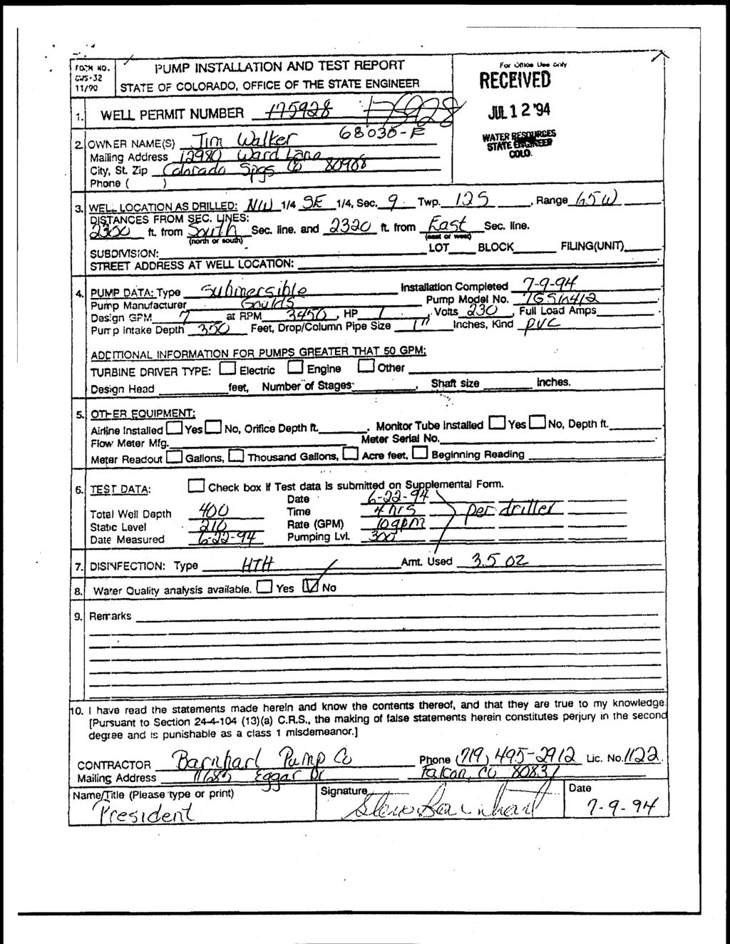
 866-3681 71 WELL PERMIT NUMBER 74767 F APPLICANT Lot: DIV, 2 WD 10 DES.")
33 Form No. GWS-25 OFFICE OF THE STATE ENGINEER COLORADO DIVISION OF WATER RESOURCES 818 Centennial Bldg., 1313 Sherman St., Denver, Colorado ) WELL PERMIT NUMBER F APPLICANT Lot: DIV, 2 WD 10 DES. BASIN MID 2 Block: Filing: Subdiv: WALKER PLACE APPROVED WELL LOCATION EL PASO COUNTY NW 1/4 SE 1/4 Section 9 MIKE LUDWIG Township 12 S Range 65 W Sixth P.M LINNWOOD LN DISTANCES FROM SECTION LINES BLACK FOREST, CO Ft. from South Section Line 2017 Ft. from East Section Line UTM COORDINATES (Meters,Zone: 13,NAD83) 303) PERMIT TO CONSTRUCT A WELL AMENDED) Easting: Northing: ISSUANCE OF THIS PERMIT DOES NOT CONFER A WATER RIGHT Page 1 of 2 CONDITIONS OF APPROVAL 1) This well shall be used in such a way as to cause no material injury to existing water rights. The issuance of this permit does not ensure that no injury will occur to another vested water right or preclude another owner of a vested water right from seeking relief in a civil court action. 2) The construction of this well shall be in compliance with the Water Well Construction Rules 2 CCR 402-2, unless approval of a variance has been granted by the State Board of Examiners of Water Well Construction and Pump Installation Contractors in accordance with Rule 18. 3) Approved pursuant to CRS (4) on the condition that this well is operated in accordance with the James G. Walker, et al. Plan for Augmentation approved by the Division 2 Water Court in consolidated case nos. 07CW49 (Div. 2) and 07CW1 04 (Div. 1). If this well is not operated in accordance with the terms of said decree, it will be subject to administration including orders to cease diverting water. 4) The total depth of the well shall not exceed 995 feet, which corresponds to the base of the Dawson aquifer. At a minimum, plain casing shall be installed and grouted through all unconsolidated materials and shall extend a minimum of ten feet into the bedrock formation to prevent production from other zones. 5) The use of ground water from this well is limited to ordinary household purposes inside one single family dwelling, including incidental commercial uses such as a home office or a home-based business, the irrigation of home gardens and landscaping, decorative ponds and fountains, hot tubs and swimming pools, fire fighting, and livestock watering, 6) The pumping rate of this well shall not exceed 15 GPM. 7) The allowed annual amount of groundwater to be withdrawn by this well individually shall not exceed 0.7 acre-foot 228,100 gallons), and in combination with all other Dawson aquifer wells operated pursuant to the plan for augmentation in case no, 07CW49, shall not exceed 2.8 acre-feet. 8) The return flow from the use of this well must be through an individual waste water disposal system of the non-evaporative type where the water is returned to the same stream system in which the well is located. 9) A totalizing flow meter must be installed on this well and maintained in good working order, Permanent records of all diversions must be maintained by the well owner (recorded at least annually) and submitted to the Division Engineer upon request. 10) This well shall be constructed not more than 200 feet from the location specified on this permit. 11) The entire length of the hole shall be geophysically logged as required by Rule 9 of the Statewide Nontributary Ground Water Rules prior to installing casing. NOTE: The ability of this well to withdraw its authorized amount of water from this non-renewable aquifer may be less than the 100 years upon which the amount of water in the aquifer is allocated, due to anticipated water level declines. APPROVED CRF State Engineer I,Receipt No A DATE ISSUED By 2011 EXPIRATI N DATE
34 Receipt No A WELL PERMIT NUMBER F Page 2 ISSUANCE OF THIS PERMIT DOES NOT CONFER A WATER RIGHT CONDITIONS OF APPROVAL NOTE: To ensure a maximum productive life of this well, perforated casing should be set through the entire producing interval of the approved zone or aquifer indicated above. NOTE: This permit will expire on the expiration date unless the well is constructed and a pump is installed by that date. A Well Construction and Test Report (GWS-31) and Pump Installation and Test Report (GWS-32) must be submitted to the Division of Water Resources to verify the well has been constructed and the pump has been installed. A one-time extension of the expiration date may be available. Contact the DWR for additional information or refer to the extension request form GWS-64) available at: water.state. co.us/ pubs/forms. asp www. NOTE: Permit Condition of Approval No. 11 has been waived. April 14, MPS 04/14/ 2011
35 Form No. OFFICE OF THE STATE ENGINEER GWS -25 COLORADO DIVISION OF WATER RESOURCES 818 Centennial Bldg., 1313 Sherman St., Denver, Colorado ) APPLICAN MIKE LUDWIG LINNWOOD LN BLACK FOREST, CO Lot: WELL PERMIT NUMBER DIV. 2 WD 10 DES. BASIN MD 2 Block: Filing: Subdiv: WALKER PLACE APPROVED WELL LOCATION EL PASO COUNTY NW 1/4 SE 1/4 Section 9 Township 12 S Range 65 W Sixth P.M. DISTANCES FROM SECTION LINES 1887 Ft. from South Section Line 2017 Ft. from East Section Line 303) UTM COORDINATES (Meters,Zone: 13,NAD83) ERMIT TO CON5TRUCT A WELL L. J' V "UV" ' " W ISSUANCE OF THIS PERMIT DOES NOT CONFER A WATER RIGHT Page 1 of 2 CONDITIONS OF APPROVAL 1) This well shall be used in such a way as to cause no material injury to existing water rights. The issuance of this permit does not ensure that no injury will occur to another vested water right or preclude another owner of a vested water right from seeking relief in a civil court action. 2) The construction of this well shall be in compliance with the Water Well Construction Rules 2 CCR 402-2, unless approval of a variance has been granted by the State Board of Examiners of Water Well Construction and Pump Installation Contractors in accordance with Rule 18. 3) Approved pursuant to CRS (4) on the condition that this well is operated in accordance with the James G. Walker, et al. Plan for Augmentation approved by the Division 2 Water Court in consolidated case nos. 07CW49 (Div. 2) and 07CW104 (Div. 1). If this well is not operated in accordance with the terms of said decree, it will be subject to administration including orders to cease diverting water. 4) The total depth of the well shall not exceed 995 feet, which corresponds to the base of the Dawson aquifer. At a minimum, plain casing shall be installed and grouted through all unconsolidated materials and shall extend a minimum of ten feet into the bedrock formation to prevent production from other zones. 5) The use of ground water from this well is limited to ordinary household purposes inside one single family dwelling, including incidental commercial uses such as a home office or a home -based business, the irrigation of home gardens and landscaping, decorative ponds and fountains, hot tubs and swimming pools, fire fighting, and livestock watering. 6) The pumping rate of this well shall not exceed 15 GPM. 7) ' The allowed annual amount of ground water to be withdrawn by this well individually shall not exceed 0.7 acre foot - 228,100 gallons), and in combination with all other Dawson aquifer wells operated pursuant to the plan for augmentation in case no. 07CW49, shall not exceed 2.8 acre feet. - 8) The return flow from the use of this well must be through an individual waste water disposal system of the non - evaporative type where the water is returned to the same stream system in which the well is located. 9) A totalizing flow meter must be installed on this well and maintained in good working order. Permanent records of all diversions must be maintained by the well owner (recorded at least annually) and submitted to the Division Engineer upon request. 10) This well shall be constructed not more than 200 feet from the location specified on this permit. 11) The entire length of the hole shall be geophysically logged as required by Rule 9 of the Statewide Nontributary Ground Water Rules prior to installing casing. NOTE: The ability of this well to withdraw its authorized amount of water from this non - renewable aquifer may be less than the 100 years upon which the amount of water in the aquifer is allocated, due to anticipated water level declines. V APPROVED CRF eceipt No A State Engineer DATE ISSUED B EXPIRATION DATE
36 Receipt No A WELL PERMIT NUMBER Page 2 ISSUANCE OF THIS PERMIT DOES NOT CONFER A WATER RIGHT CONDITIONS OF APPROVAL NOTE: To ensure a maximum productive life of this well, perforated casing should be set through the entire producing interval of the approved zone or aquifer indicated above. NOTE: This permit will expire on the expiration date unless the well is constructed and a pump is installed by that date. A Well Construction and Test Report (GWS -31) and Pump Installation and Test Report (GWS -32) must be submitted to the Division of Water Resources to verify the well has been constructed and the pump has been installed. A one time - extension of the expiration date may be available. Contact the DWR for additional information or refer to the extension request form GWS -64) available at: http: www. / / water us.state.co. pubs / forms.asp /
 866-3587 main: (303) 866-3581 fax: 303 866-3589 htt : /Avww.water. state.co.")
37 Z h I I ab ocwh9 COLORADO DIVISION OF WATER RESOURCES DEPARTMENT OF NATURAL RESOURCES 1313 SHERMAN ST., RM 818, DENVER, CO phone info: (303) main: (303) fax: htt : /Avww.water. state.co. us RESIDENTIAL Note: Also use this form to apply far livestock watering Water Well Permit Application Review form Instructions prior to completing form. Office Use Only Form GWS44 (07/1009) The form must be completed In black or blue Ink or typed. 1. A! cant Information 6. Use Of Well check applicable boxes Name ofappll,an, See instructions to determine use(s) for which you may qualify Mike Ludwig A. Ordinary household use in one single - family dwelling no outside use) ( Malting address Linnwood Lane B. Ordinary household use in 1 to 3 single - family dwellings: City state Zip code Number of dwellings: o Black'' Forest Home garden/lawn irrigation, not to exceed one acre: Telephone tr (optional) area irrigated s ft. acre 4h C: Domestic animal watering - (non- commercial) 2. Type Of Application (check applicable boxes) Construct new well C. Livestock watering (on farm /ranch range / /pasture) Change source (aquifer) Replace existing well Reapplication (expired permit) 7 Well Data (proposed) Use existing well Rooftop precip. collection Mardmum pumping rate Annual amount to be withdrawn Change or Increase use Other: 15 gpm 0.7 acre - 3. Refer To (if applicable) Well permit s water court rasa # Designated Basin ostarminavon a wall name ore 4. Location Of Proposed Well Im ortanti See Instructions n fee! Aquifer Dawson 8. Water Supplier Is this parcel within boundaries of a water service area? YE [] If yes, provide name of supplier. 9. Type Of Sewage System County El Paso NW 114 of the SE 114 Septic tank / absorption leach field section Township N ors Range E orw Pdndpal Maddian th Distance of well from sectian gries (section lines are typically not property fines) Central system: District name: Vault: Location sewage to be hauled to: 1887 Ft. from N ($ S 2017 Ft from [3 E W Other (attach copy of engineering design and report) 10. Proposed Well Driller License # D tional For replacementwellsonly dlstenae and direction from old well tonewweu feet direction Well location address (Include city, state, zp) Wheck ifwell address Is same as In item f. Optional: GPS well location Information in UTM formal. GPS unit settings are as follows: Formal must be UTM zone 12 o one 13 Eastrng: Units must be Meters Datum must be NAD63 Nonhing Print name b UUe L Aw NO c'] D feet 11. Signature Of Applicant(s) Or Authorized Agent The making of false statements herein constitutes PerJry u In the second degree, which is punishable as a Gass 1 misdemeanor pursuant to C.R. S D4 (13)(a). I have read the statements herein, know the contents thereof and state that the are true to knowled Sign here (Must be oaglnafslgnawrey Unit must be set to true north Owner Ml o.e S', L tx / w I19 Was GPS unit checked forabove7 AYES Remember to set Datum tonad83 Offi Use Only 5. Parcel On Which Well Will Be Located USGS map name DWR map no, Su YOU MUST ATTACH A CURRENT DEED FOR THE SUBJECT PARCEL) 6 A. You must check and complete one of the following: EN Subdivision: Name Walker Place PMt : La4} 600 Receipt area only Lot 2 Block Filing /Unit well Spe.L n_a k.. nd. 04{ Par t:fcs 17 County exemption (attach copy of county approval & survey): is 1 tt)lm) (2)( Namel# Lot # stew 44 l.. e= n. WS Parcel less than 35 acres, not in a subdivision, attach a deed with metes ppawcd bk.si rte S k use os. and bounds description recorded prior to June 1, 1972, and a current cc e.}c.n Trans Number: deed tsa630-f 1113/2011 1:18: 20 PM caf Mining claim (attach a copy wthe deed or survey): Ham el# r/js /: tr ADUaMa - Geoff Davis Square 40 acre parcel as described in Item 4 Total Trans Amt: $ y a / CHECK El Parcel Of 35 Or more acres (attach a melee and bounds description or survey) WR/ (. aleck Number: Other (attach mates& bounds description orsumay and supporting documents) Check Amount: $ B. CWC8 a at awe in Parcel G+ Aka. you the owner or tns pa,oata DYES NO (f no sea instructions) TWO D. Will We be the ordy wag on this parcel? Myes NO (ir no list other wells) M,LAR 1 Date t/ t E. State Parcel DOF U - net): 595 DN WD SA_ MD
38 WARRANTY DEED / :42: 52 PGS 1 $ 6.00 DF $ Eleckronleally Recorded Official Records El Pase CeunH CO RobertC.' Bob "Ballnk Clerk and Reeerd,r THIS DEED, made this 5th day of April, 2010, between James G. Walker and Rosemary V. Walker of the County of El Paso and State of Colorado, grantor(s), and Michael S. Ludwig TD1000 Y ff JAN TAB whose legal address is,, of the County of El Paso and State of Colorado, grantees: WITNESS, that the grantor(s), for and in consideration of the sum of ONE HUNDRED NINETY SIX THOUSAND AND 00 /100 DOLLARS ($196, ), the receipt and sufficiency of which is hereby acknowledged, has granted, bargained, sold and conveyed, and by these presents does grant, bargain, sell, convey and confirm unto the grantees, their heirs and assigns forever, In Severalty, all the real property, together with improvements, if any, situate, lying and being in the County of El Paso and State of Colorado, described as follows: Lot 2, Walker Place, together with Access Rights set forth in Common Access Maintenance Agreement recorded March 29, 2010 at Reception No , El Paso County, Colorado. also known by street and number as: Ward Lane, Colorado Springs, CO TOGETHER with all and singular the hereditaments and appurtenances thereunto belonging, or in anywise appeartaining, and the reversion and reversions, remainder and remainders, rents, issues and profits thereof, and all the estate, right, title, interest, claim and demand whatsoever of the grantor(s), either in law or equity, of, in and to the above bargained premises, with the hereditaments and appurtenances; TO HAVE AND TO HOLD the said premises above bargained and described, with the appurtenances, unto the grantees, their heirs and assigns forever. The grantor(s), for himself, his heirs, and personal representatives, does covenant, grant, bargain and agree to and with the grantees, their heirs and assigns, that at the time of the ensealing and delivery of these presents, he is well seized of the premises above conveyed, has good, sure, perfect, absolute and indefeasible estate of inheritance, in law, in fee simple, and has good right, full power and lawful authority to grant, bargain, sell and convey the same in manner and form as aforesaid, and that the same are free and clear from all former and other grants, bargains, sales, liens, taxes, assessments, encumbrances and restrictions of whatever kind or nature soever, except general taxes for the current year and subsequent years, and except easements, covenants, conditions, restrictions, reservations, and rights of way of record, if any. The grantor(s) shall and will WARRANT AND FOREVER DEFEND the above - bargained premises in the quiet and peaceable possession of the grantees, their heirs and assigns, against all and every person or persons lawfully claiming the whole or any part thereof. The singular number shall include the plural, the plural the singular, and the use of any gender shall be applicable to all genders. IN WITNESS WHEREOF, the grantor has executed this deed on the date set forth above. 4ames. Walker a Rosemary V. Wal er State of Colorado } County Of } The foregoing instrument was acknowledged before me this April 5, 2010, by James G. Walker and Rosemary V. Walker.,. -,µ My Corrinlission xptxes:'r A f j JRilt }_- R d Witness my hand and official seal. 1 ; 110TARY N, whose address is 12855 Linnwood Lane, Colorado Springs, Colorado 80908, of the County of El Paso, and State of Colorado: 210031711 04/0612010 01 :42 :52 RE+IvENED PGS 16 $ 81.")
39 SPECIAL WARRANTY DEED THIS DEED, dated 1z.« between James G. Walker and Rosemary V. Walker ( "Grantors "), whose address is Ward Lane, Colorado Springs, Colorado 80908, and Michael 1!j?. Ludwig ( "Grantee "), whose address is Linnwood Lane, Colorado Springs, Colorado 80908, of the County of El Paso, and State of Colorado: / :42 :52 RE+IvENED PGS 16 $ DF $ 0 Electronically Recorded Official Records El Paso County CO Robert C. "Bob Ballnk Clerk and Recorder M1000 N WITNESS, that the Grantors, for and in consideration of the sum of TEN DOLLARS and other good and valuable consideration, the receipt and sufficiency ofwhich is hereby acknowledged, have granted, bargained, sold and conveyed, and by these presents do grant, bargain, sell convey and confirm unto the grantee, his heirs and assigns forever, all the real property, together with improvements, if any situate, lying and being in the County of El Paso and State. of Colorado, described as follows: JAN wp,nft RE COL na S n i 3 All water rights and ground water rights related to, used upon, underlying, or appurtenant to Lot No. 2 of the Walker Place Minor Subdivision as approved by the El Paso County Board of County Commissioners on December 17, 2009, and as recorded with the Clerk and Recorder of El Paso County at Reception No. Z Ip9ck zrz including,, without limitation, the ground water rights and rights to extract and use ground water within the Dawson, Denver, Arapahoe and Laramie -Fox Hills aquifers of the Denver Basin related to said Lot No, 2, being a pro rata - percentage of the total underlying ground water, whether nontributary or not nontributary, as adjudicated by the May 12, 2008 Findings of Fact, Conclusions of Law, Judgment and Decree granting underground water rights and approving a plan for augmentation in Case No. 07CW49 of the District Court for Water Division 2, State of Colorado ( "Decree and Plan for Augmentation "). The Decree and Plan for Augmentation is Pursuant to the terms of the Decree and Plan for Augmentation in Case No. 07CW49, said Denver Basin water rights, being a 114 pro rata - portion of the total water rights adjudicated in the Decree and Plan for augmentation, are specifically described as follows: d1 g Dawson aquifer. 822 acre feet; (2.74 annual acre feet, based upon a 300 year aquifer life) Denver aquifer. 621 acre feet; (2.07 annual acre feet) Arapahoe aquifer. 432 acre feet; (1.44 annual acre feet) Laramie -Fox Hills aquifer. 288 acre feet, (0.96 annual acre feet) Grantee is also specifically conveyed the all rights and interests to one of the four Dawson aquifer wells authorized by the Decree and Plan for Augmentation. The water rights conveyed herein are intended to provide a 300 year water supply for Lot No. 2 of the Walker Place Minor Subdivision as referenced above. Therefore, these water rights shall run with the land, must be transferred to all successors and assigns of Grantee, may not be separated from transfer of title to the land, and may not be separately conveyed, bartered, liened or encumbered. The decreed amounts of ground water may be adjusted upward or downward pursuant to the retained jurisdiction of the Water Court in the Decree and Plan for Augmentation. This conveyance includes a proportionate interest in the rights to the Decree and Plan for Augmentation related to and based upon Grantees' Lot No. 2 within the Walker Place Minor Subdivision, and the right to receive one well permit thereunder, together with all obligations and responsibilities for compliance with the Decree and Plan for Augmentation relating to Grantees' Lot. This conveyance is subject to the terms and provisions of the Decree and Plan for Augmentation. This conveyance is also subject to the terms and provisions of the 1
40 Covenants for Walker Place Minor Subdivision recorded with the El Paso County Recorder at Reception No. TOGETHER, with all and singular the hereditaments and appurtenances thereunto belonging, or in anywise appertaining, the reversion and reversions, remainder and remainders, rents, issues and profits thereof, and all the estate, right, title, interest, claim and demand whatsoever of the grantor, either in law or equity, of, in and to the above bargained premises, with the hereditaments and appurtenances; TO HAVE AND TO HOLD the said premises above bargained and described, with the appurtenances unto the Grantee, their heirs and assigns forever. The Grantors, for themselves, their heirs, personal representatives, successors and assigns does covenant and agree that they shall and will WARRANT AND FOREVER DEFEND the above bargained premises in the quiet and peaceable possession of the Grantee, his heirs and assigns, against all and every person or persons claiming the whole or any part thereof, by, through or under the Grantors, forth IN WITNESS WHEREOF, the have executed this Special Warranty Deed on the date set VATS OF COLORADO } COUNTY OFr. ' ) ss. By: osemary V. V&er The foregoing instrument was acknowledged before me this 45 _, day of s Y 2010, by James G. Walker and Rosemary V. Walker. My commission expires: It -ZE I!;;-! Witness my hand and official seal, P1iRICIA NC TURNER --_ h10ta,ny PI.JBLIG Notary Public icy Cotruni,siun ;expires /2013 FACNentUdnlg, WchaefOwLemenWSW peed 10 acre pareel.wpd 2
41 FELT, MONSON & CULICHIA, LLC y JAN N. WEBER STREET COLORADO SPRINGS, CO JAMES G. FELT STEVEN T. MONSON JAMES W. CULICHIA TELEPHONE: (719) FAX: (719) cdc fmcwater. com CHRISTOPHER D. CUMMINS DAVID M. SHOHET MICHAEL J. GUSTAFSON Office of the State Engineer Colorado Division of Water Resources 818 Centennial Building 1313 Sherman Street Denver, Colorado January 12, 2011 Re: Application for Re- Permitting of Residential Well Permit, Second Well Permit To Whom it May Concern This firm represents Michael S. Ludwig, who has acquired a 3/4 interest in the Denver Basin groundwater adjudicated in Case No. 07CW49 (consolidated in Division 2), and the plan for augmentation decreed therein. Mr. Ludwig currently obtains his domestic supply from the well permitted as Permit No , an "exempt domestic well ". Pursuant to the terms of the decree in Case No. 07CW49, this well was to be repermitted consistent with the terms of the Plan for Augmentation therein, and one of the enclosed applications is intended, in part, to do just that. However, the well is showing signs of failure, and Mr. Ludwig's consultants at Hamacher Drilling have advised that an emergency redrill is in order. As such, Mr. Ludwig also requests an "emergency" processing of this repermitting application to allow for an immediate re -drill of a replacement well, as specified therein. Mr. Ludwig's interests provide him with entitlements to up to three wells under the Plan for Augmentation decreed in Case No. 07CW49. At this time, Mr. Ludwig seeks one additional well permit. Enclosed herein please find a GWS -44 Application for the emergency redrill of the residential well currently permitted as Well Permit No , and for re- permitting of that well consistent with the terms and conditions of the Decree in Case No. 07CW49, along with the required $ filing fee. Also enclosed, please find a GWS -44 Application for the second of three wells to which Mr. Ludwig is entitled pursuant to Case No. 07CW49's decreed plan for augmentation. Attached to each of the applications is a Warranty Deed demonstrating Mr. Ludwig's ownership. Also enclosed herein are a copy of the decree in Case No. 07CW49, and a copy of the deeds transferring title to the Denver Basin groundwater underlying Mr. Ludwig's properties to Mr. Ludwig.
42 Please copy this office on any correspondence with the Applicants, as well as with a copy of the well permit when issued. Thank you, and do not hesitate to contact me with any questions or comments. Sincerely, D. Cu encl. cc: Michael S. Ludwig Hamacher Drilling 2
43 Report Date: 1/25/ 2011 Bedrock Aquifer Evaluation Determination Tool Denver Basin Aquifer - Specific Location Determination Tool Applicant: Receipt No: Evaluated By: Mike Ludwig A CRF Location: Basin Designation: NW 1/4 of SE 114 of Sec. 9, T. 12S, R.65W. ( 1887 SSL, 2017 ESL) Location is within the UNKNOWN Designated Ground Water Basin. Ground Surface Elevation: 7620 Feet Number of Acres: AQUIFER ELEVATION (ft) Bot. Top NET SAND DEPTH TO (ft) Bot. Top ANNUAL APPROP. A- F) STATUS Upper Dawson NNT Lower Dawson Denver NNT ,o34 Upper Arapahoe NT Lower Arapahoe Laramie -Fox Hills NT NOTE: 'E' indicates a location is at an aquifer boundary and the values may be more approximate.

44 FORM NO, vvc"i. tfx%~ Iw I J as ^V tl STATE OF COLORADO, OFFICE OF THE STATE ENGINEER GWS-31 04*005 * 4313 Sharma" st" Room $18, Dorwer, CO Mom - Irifu (303) M-3567 Ma P (303) Fox (3031 W64559 VVELL PERMIT NUMBER F WELL OWNER 11WORMATION NAME OF WELL 0VVNERMIKE LUDWIG WHILING ADDRESS: LINNWOOD LN rl.] Tv COLO SPRINGS A CO ZIP CODE: APR 2 s TELEPHONE NOMBER. ( ( 304) WELL LOCATI(:)N AS OSJLLF NW 1g, SE 1X. $00-9 T 12 E3 N or (3 S, Pan(ge 65 : 3F- ear MW 2017 DISTANCES FROM SEC, LINES: -- A, from [I N or M 6 sect on fi and kfrom E]Etr[ 3W section tine. SUBDIVISION: WALKER PLACE ' LOT _2 BLOCK_ FILI UNIT)_ Optional GPS L*oation- GPS L)rot must use the folknonj settings: Format mstbeutm Units Eastirg, I bt meters. Datum must be NAD83, Unit rws1 be set to true N, 0 Zone 12 or 93 Zone 13 STREET ADDRESS AT IAC-LL LOCATION., LOT 2 WALKER PLACE CO SPRINGS CO Norfta 4. GROUND SURFACE ELEVATION feet DRILLING METHODRotary air Ovier' swefi Desiona%on ' r)atf CYWPI FTFn 4/15/ 2011 TOTAL DEPTH 495 feet DEPTH COI tpleted 495 feet L) Grain Size C010f eater Loc Topsoil T - - an May Z May Send &' Clay Sand & -Gravel Clay Sand & Gravel Clay Remarks 7, PLA'N CASING; OD ( Kird VVall Size (in) 7 Steel PVC PVC n) PVC t PERFORATE;0CASING: Screen Slot S' e(, in) PVC. 25 is PVC I 4.5 PVC PVC. 25 FILTER PACK. mater at ; Silica Sand Size 6/9 InteV 21, GROUTING RECORD rom (A) To (ft) S PACKER PUkCEMENT Type Dep1h Vw'000A Amount Density Ir} te Cement 5 SK 35 GA Placement Tremie have have toad toad the the staternons staternons rwdc rwdc herein herein ano ano knew knew tho tho contentscontentst-woott-woot and and they they wo wo Inic Inic to to my my kowmeage. kowmeage. This This docunwrit, docunwrit, is is tad tad an an d d cotti cotti fied fied h h aocotdarwe aocotdarwe Yvith Yvith Rule Rule II T4 T4 VVTheThe Water Water V*0 Corntru&cn Rules, Rules, 22 CCR CCR Mw Mw filing filing of of aa doculnow doculnow that that contains contains false false staterrzt, staterrzt, is is aa vmtafian vmtafian Hamacher Hamacher Well Well Works, Works, Inc Inc I I,, j j (719) ( 719) Hwy Hwy 24, 24, P.O. Box Box Simla, Simla, CO CO I / AA A A - - &- & I r r --"" 11 ' ` ' ` " " " a a "" ""' ' ' ' TR TR Hamacher Hamacher 11 ' ' 11
 966-3581 PAGE 2 RECEIVEt FORM NO, ova-31 Fax (303 8w3589 h Itv: h'x% VV1.w4ter ta10,. co, U 1I LL PERMIT NUMBER.")
45 I -. I 1 ' WELL CONSTRUCTION AND TEST REPORT Fw Otf cc usem STATE OF COLORADO. OFFICE OF THE STATE EWiINEER 04J sftef roan Su, Rowe 614, 00pVcr, CO Phone - tr-fo (303) Vain (303) PAGE 2 RECEIVEt FORM NO, ova-31 Fax (303 8w3589 h Itv: h'x% VV1.w4ter ta10,. co, U 1I LL PERMIT NUMBER F APR WELL OWNER INFORMATION NAME OF WELL 0VVNERffl LUDWIG WATER Espw'hig STATE NI QINE-F1 MAILING ADDRESS: LINNWOOD LN rllty COLO SPRINGS -, TA CO ZIP CODE TELEPHONE NVMBER: ( ( 301) WELL LOCATION AS QRILLEI jw -U4, j_ E It4. Sec, 9, T, 2 E3 N 0 E3,S - Range 65 0 F or M W DI-STANCES FROM SEC. LINES: 1887 ft, from 0 t4 or M S section fine a to, - ft, from E3E. SUSD ISION V,. WALKER PLACE LOT _ 2 BP FILI UNIT) Optional GPS Location* GPs must use the follomprig settings: Format must be UTM. Units must te nwtors. Datum enust be NAD63, Unit must be set to truo N, [I Zone 12 or El Zone 1 Eastiernlq STREET ADDRESS AT WELL LOCATION., LOT 2 WALKER PLA CO SPRINGS CO Northin GROUND SURFACE ELEVATION feet D-RUING, METHODRotary air DATE COMPLETED 4/15/ 2011 TOTAL DEPTH 495 feet DEPTH COMPLETED 495 feet 6 5. GEOLOGIC LOG: 10- HOLE DIAM fin-1 From,ffl) To ft I Depth Type Grain Size Rater Loco F, PLAIN CASING; 00 (in) Kind Wall Size (in) 4.5 PVC PVC rom (ft) is To (h) PERFORATED CASING: Screen Stol Sze in). 4.5 PVC I. FILTER PACK. S. PACKER PLACEMENT: Mvtei iat Silica Sand Size 6/9 ltat GROUTING RECORD Type Clem MweriiW Amount Density tt to at Placement Ren,farks- Cement 5 SK 35 GAL Tremie Ill. DISINFECTION: T HTH I Arnt, Used 1 CUP I 12. VVELL TEST IDATA: U Ched( box it Test 0013 is SUDMITe'a on t-011m Mmoer avvte (. zile 2:iupplemeptix vveff test, TESTING METHOD Aired & Bailed Static Level 232 k Cate,'Timt me saved: 4/15/ 2011 Proluction Rate is gpm, Pumping Level 350 ft D-ate T; measured 4/15/ 2011 Test Length hers' 4 Remake 13-1 have mad the swonients mde hvtin and im*w the cartents Vweot and they are kut to toy kowmtdoe, This docu"wa M ed ard cottified in accor&- Inco wth RUIC 17.4 of the 'Awel V Cwwlruclmn Ruses, 2C w*, lihng, of a documero, that contains false utatea ms Is a w0hatial of cclian tmwel. C,R- S.. and s ounishoble bv firtes up to $5000 andlof govocation0 the conu acting license,) Hamacher Well Works, Inc ) i Mailin2 Address. Signalore: ";" /.> Hwy 24, P. Box 86 Simla, CO ', LWtNarne and TA]e TRHamacher Date4/18/ 2'011
46 FORM NO. PUMP INSTALLATION AND TEST REPORT STATE OF COLORADO, OFFICE OF THE STATE ENGINEER OWS Sherman St- Room 818, Denver, CO Into t303) X3,0 3'i Fax (303's se WELL PERMIT NUMBER: F 2. WELL OWNER INFORMATION NAME lrj 01MER LUDWIG DRILLING MAIL NG ADDRESS PO BOX 1059 CITY STATE ZIP CODE CASTLE ROCK CO LEPHONE # 303) or Office Use Or-IV 1 VVELL LOCATION AS DRILLILUr NW 131, SE IM Sec, 9 ' 111wP12 IN or Ejv, R 65 L or D I STAN -- L S FR011 SEC, L'if EL S Y. from N or S s ectian lin e and SIJ"I3DIVi&, r-1n-- WALKER PLACE LO 2, 2017 ft. forn REMNED APR W-lc El L or [1%rV section Ire. BLOCK HLiNGfJNJ 1. Optional GPS Location.,GPS L; I,, xust use the tollomx- I settinas _ Fanrat!i bo. UTM, Units Linsting' in, st be meters. Datjin mlisi[ be NAD83. UrIit hilist be se tc- true N. Zone 12 or [j] Zone S I REET ADDRESS ATVVEL LOCIAT;CN: LOT 2 WALKER PLACE COLO SPRINGS Submersible 4, ' JMP DATA Type Date Installed,. PUMP MalUtaCtUrCr: FRANKLIN Pump 10SDQP2HPN Design GPM: 10! it RPi%4, HIP volts FL111 L. Arrps 470 PUMr, intake L)c Wth". Neel xrt - Dop. pe Sze 1.25lr' Ches, K Jrd of D ro p Pipe PVC 4/20/ ADDITIONAL I-NIFORMATiON FOR PLINIPS GREAI 5C GPN1, Tuibine Driver Type: IL-fectric Erigme Other Design Head feet Nuirnaer of Stages Shaft si inches S. OTHER V C-UVrVENT: Airfine Instaged Yes E] No, Orifice Depth tt, N',or! i ube Installed " Yes IKINo. Dept,i ft- F!Ovi rdeter HAYS staler Serial No tdo'e ReadrM Gallon,%, 11'riousand [ Gallons. Acre feet i3equ Reactin 6. TES" DATA,: chec box if TO'St Data issubrlitte-d Or SUPP0niEnta" FOrM, 4/20/ Total VVell Depth,: Static. LeVel: fl, Rate (qpqf: Dat e Ni ca suc', 1: 7. 0&NzLC Fype 4/ HTH 84 ` A"' ater Quat,*'y V71 avarable: El Yes ff] No Pumpirq Leveli,' Ifil 470 hves, p!ease slibmit With this ieport. ArTit. Usec' 1 CUP 9. Remarks: M I have react the statements made herein and, Kr= the contents thereot. ond they are true to my r rro-micoqe. his accument is signed aid certified M accordance w Rule 1 o tl c: Ve Cans;i wtior, RU. IU 5, 2 C -- R 402-2, The fi Iwq D a ao(t ment that co ritaii :s ta'se Statements s aviotaticin of sec Uon I U6e llia"- C.R ' S.. an(a ;s P'Iv; Sf18' by firies p arlj ' - ewcatlorl of tne r-ontrac Corn any Name Hamacher Well Works, Inc 719) Li inse IN umber: I'Awmg Address: Hwy 24, P.O. Box 86 Simla, CO Signaturee n Print N ime and T itlo TR Hamacher 4/22/ 2011
47 I DEPARTMENT OF NATURAL RESOURCES DIVISION OF WATER RESOURCES 8709A W. Hickenlooper King tive Director April 14, 2011 Wolfe, P.E. tor /State Engineer Bonnie Hamacher Hamacher Well Works, Inc. P.O. Box 86 Simla, Colorado Re: Request for Waiver of Geophysical Logging Requirement, Permit No Dear Ms Hamacher: I have evaluated your faxed request of April 13, 2011, for a waiver of the gec logging requirement attached to the above referenced permit, issued to Mike Permit No F approves the construction of a well to divert water from the Caw. Aquifer. The proposed well would not fully penetrate the uppermost aquifer, and WOL not provide data on the depth to the top of the Denver aquifer, or the thickness of the confining layer separating the uppermost aquifer from the next lower aquifer. Therefore, Permit Condition of Approval No. 11 is waived on the basis that a geo hysic, log would not provide the Division with data useful to administration of the grounc water in this area. This waiver does not abrogate the well owner's or well construction contractor's responsibility to fulfill all requirements of any applicable court decree. A copy of the amended permit has been attached. Please feel free to contact me if you have any questions or require additional information. Sincer y, Michael P Schaubs Geologist, Geotechnical Services Branch Colorado Division of Water Resources Attachment cc: Permit File Mike Ludwig Office of the State Engineer 1313 Sherman Street, Suite 818 Denver, CO Phone: a Fax: state.co. us water.
48 I n HAMACHER WELL WORKS, INC- T.R. SHORT " r' HAMACHER WELL DRILLING, PUMPS, WINDMILLS, PIPELINES P.O. BOX 86 SIMLA_ C DATE: 4 TO: f ATTN: F.AX # FROM: TIME FAXED - 2 mm e S'e FAXING_ PAGES INCLUDING FAX COVER COMMENTS 0 PLEASE CONTACT US IF NOT RECEIVED IN READABLE CONDITION NLZ 0 I TO 39Vd SANOM 1 N3HDVWVH 09tlZTb56TL 8T:5T TTOZ16TItbO
49 Blank - Separates Permits
50 Form No. GWS-25 OFFICE OF THE STATE ENGINEER COLORADO DIVISION OF WATER RESOURCES 818 Centennial Bldg., 1313 Sherman St., Denver, Colorado ) APPLICANT WELL PERMIT NUMBER F DIV. 2 WD 10 DES. BASIN MD APPROVED WELL LOCATION EL PASO COUNTY NW 1/4 SE 1/4 Section 9 MIKE LUDWIG Township 12 S Range 65 W Sixth P.M LINNWOOD LN DISTANCES FROM SECTION LINES BLACK FOREST, CO Ft. from South Section Line 1460 Ft. from East Section Line UTM COORDINATES (Meters,Zone: 13,NAD83) 303) PERMIT TO CONSTRUCT A WELL AMENDED) Easting: Northing: ISSUANCE OF THIS PERMIT DOES NOT CONFER A WATER RIGHT Page 1 of 2 CONDITIONS OF APPROVAL 1) This well shall be used in such a way as to cause no material injury to existing water rights. The issuance of this permit does not ensure that no injury will occur to another vested water right or preclude another owner of a vested water right from seeking relief in a civil court action. 2) The construction of this well shall be in compliance with the Water Well Construction Rules 2 CCR 402-2, unless approval of a variance has been granted by the State Board of Examiners of Water Well Construction and Pump Installation Contractors in accordance with Rule 18. 3) Approved pursuant to CRS (4) on the condition that this well is operated in accordance with the James G. Walker, et al. Plan for Augmentation approved by the Division 2 Water Court in consolidated case nos. 07CW49 (Div. 2) and 07CW11 04 (Div. 1), If this well is not operated in accordance with the terms of said decree, it will be subject to administration including orders to cease diverting water. 4) Approved for the replacement and expanded use of an existing well, permit no Upon completion of the new well, the old well must be plugged and abandoned in accordance with Rule 16 of the Water Well Construction Rules. A Well Abandonment Report form must be submitted within sixty (60) days of abandonment of the old well. 5) The total depth of the well shall not exceed 995 feet, which corresponds to the base of the Dawson aquifer. At a minimum, plain casing shall be installed and grouted through all unconsolidated materials and shall extend a minimum of ten feet into the bedrock formation to prevent production from other zones. 6) The use of ground water from this well is limited to ordinary household purposes inside one single family dwelling, including incidental commercial uses such as a home office or a home-based business, the irrigation of home gardens and landscaping, decorative ponds and fountains, hot tubs and swimming pools, fire fighting, and livestock watering. 7) The pumping rate of this well shall not exceed 15 GPM. 8) The allowed annual amount of ground water to be withdrawn by this well individually shall not exceed 0.7 acre-foot 228,1100 gallons), and in combination with all other Dawson aquifer wells operated pursuant to the plan for augmentation in case no. 07CW49, shall not exceed 2.8 acre-feet. 9) The return flow from the use of this well must be through an individual waste water disposal system of the non-evaporative type where the water is returned to the same stream system in which the well is located. 10) A totalizing flow meter must be installed on this well and maintained in good working order. Permanent records of all diversions must be maintained by the well owner (recorded at least annually) and submitted to the Division Engineer upon request. 11) This well shall be constructed not more than 200 feet from the location specified on this permit and more than 100 feet from the property boundary. 7 APPROVED CRF State Engineer Receipt No E DATE ISSUED By 2011 EXPIRATION
51 Receipt No WELL PERMIT NUMBER F Page 2 ISSUANCE OF THIS PERMIT DOES NOT CONFER A WATER RIGHT CONDITIONS OF APPROVAL 12) The entire length of the hole shall be geophysically logged as required by Rule 9 of the Statewide Nontributary Ground Water Rules prior to installing casing. NOTICE: This permit has been approved for for the following change: the UTIVI Northing coordinate was amended based on the distances from section lines provided by the applicant. You are hereby notified that you have the right to appeal the issuance of this permit, by filing a written request with this office within sixty (60) days of the date of issuance, pursuant to the State Administrative Procedures Act. (See Section through 106, C.R, S.) NOTE: The ability of this well to withdraw its authorized amount of water from this non-renewable aquifer may be less than the 100 years upon which the amount of water in the aquifer is allocated, due to anticipated water level declines. NOTE: To ensure a maximum productive life of this well, perforated casing should be set through the entire producing interval of the approved zone or aquifer indicated above. NOTE: This permit will expire on the expiration date unless the well is constructed and a pump is installed by that date. A Well Construction and Test Report (GWS-31) and Pump Installation and Test Report (GWS-32) must be submitted to the Division of Water Resources to verify the well has been constructed and the pump has been installed. A one-time extension of the expiration date may be available. Contact the DWR for additional information or refer to the extension request form GWS-64) available at: water.state. co,us/ pubs/forms. asp www. NOTE: Permit Condition of Approval No. 12 has been waived. April 14, 2011 MPS
52 Form No. GWS -25 OFFICE OF THE STATE ENGINEER COLORADO DIVISION OF WATER RESOURCES 818 Centennial Bldg., 1313 Sherman St., Denver, Colorado ) APPLICAN WELL PERMIT NUMBER DIV. 2 WD 10 DES. BASIN MD MIKE LUDWIG LINNWOOD LN BLACK FOREST, CO ) APPROVED WELL LOCATION EL PASO COUNTY NW 1/4 SE 1/4 Section 9 Township 12 S Range 65 W Sixth P.M. DISTANCES FROM SECTION LINES 1511 Ft. from South Section Line 1460 Ft. from East Section Line UTM COORDINATES (Meters, Zone: 13,NAD83) all lyj -, - I YVI LI 1111a. ISSUANCE OF THIS PERMIT DOES NOT CONFER A WATER RIGHT Page 1 of 2 CONDITIONS OF APPROVAL 1) This well shall be used in such a way as to cause no material injury to existing water rights. The issuance of this permit does not ensure that no injury will occur to another vested water right or preclude another owner of a vested water right from seeking relief in a civil court action. 2) The construction of this well shall be in compliance with the Water Well Construction Rules 2 CCR 402-2, unless approval of a variance has been granted by the State Board of Examiners of Water Well Construction and Pump Installation Contractors in accordance with Rule 18. 3) Approved pursuant to CRS (4) on the condition that this well is operated in accordance with the James G. Walker, et al. Plan for Augmentation approved by the Division 2 Water Court in consolidated case nos. 07CW49 (Div. 2) and 07CW104 (Div. 1). If this well is not operated in accordance with the terms of said decree, it will be subject to administration including orders to cease diverting water. 4) Approved for the replacement and expanded use of an existing well, permit no Upon completion of the new well, the old well must be plugged and abandoned in accordance with Rule 16 of the Water Well Construction Rules. A Well Abandonment Report form must be submitted within sixty (60) days of abandonment of the old well. 5) The total depth of the well shall not exceed 995 feet, which corresponds to the base of the Dawson aquifer. At a minimum, plain casing shall be installed and grouted through all unconsolidated materials and shall extend a minimum of ten feet into the bedrock formation to prevent production from other zones. 6) The use of ground water from this well is limited to ordinary household purposes inside one single family dwelling, including incidental commercial uses such as a home office or a home -based business, the irrigation of home gardens and landscaping, decorative ponds and fountains, hot tubs and swimming pools, fire fighting, and livestock watering. 7) The pumping rate of this well shall not exceed 15 GPM. 8) The allowed annual amount of ground water to be withdrawn by this well individually shall not exceed 0.7 acre foot - 228,100 gallons), and in combination with all other Dawson aquifer wells operated pursuant to the plan for augmentation in case no. 07CW49, shall not exceed 2.8 acre -feet. 9) The return flow from the use of this well must be through an individual waste water disposal system of the non - evaporative type where the water is returned to the same stream system in which the well is located. 10) A totalizing flow meter must be installed on this well and maintained in good working order. Permanent records of all diversions must be maintained by the well owner (recorded at least annually) and submitted to the Division Engineer upon request. 11) This well shall be constructed not more than 200 feet from the location specified on this permit and more than 100 feet from the property boundary. APPROVED CRF State Engineer No B DATE ISSUED TION`0ATE
53 Receipt No WELL PERMIT NUMBER Page 2 ISSUANCE OF THIS PERMIT DOES NOT CONFER A WATER RIGHT CONDITIONS OF APPROVAL 12) The entire length of the hole shall be geophysically logged as required by Rule 9 of the Statewide Nontributary Ground Water Rules prior to installing casing. NOTICE: This permit has been approved for for the following change: the UTM Northing coordinate was amended based on the distances from section lines provided by the applicant. You are hereby notified that you have the right to appeal the issuance of this permit, by filing a written request with this office within sixty (60) days of the date of issuance, pursuant to the State Administrative Procedures Act. (See Section through 106, C.R. S.) NOTE: The ability of this well to withdraw its authorized amount of water from this non - renewable aquifer may be less than the 100 years upon which the amount of water in the aquifer is allocated, due to anticipated water level declines. NOTE: To ensure a maximum productive life of this well, perforated casing should be set through the entire producing interval of the approved zone or aquifer indicated above. NOTE: This permit will expire on the expiration date unless the well is constructed and a pump is installed by that date. A Well Construction and Test Report (GWS -31) and Pump Installation and Test Report (GWS -32) must be submitted to the Division of Water Resources to verify the well has been constructed and the pump has been installed. A one time - extension of the expiration date may be available. Contact the DWR for additional information or refer to the extension request form GWS -64) available at: http: www. / / water us.state.co. pubs / forms.asp /
 866-3587 main: (303) 866-3581 RESIDENTIAL Note: Also use this form to apply for livestock watering Water Well Permit Application Review forth instructions")
54 p Z 07CW 1 DEPARTMENT OF NATURAL RESOURCES 1313 SHERMAN ST., RM 818, DENVER, CO phone info: (303) main: (303) RESIDENTIAL Note: Also use this form to apply for livestock watering Water Well Permit Application Review forth instructions prior to completing form. The form must be completed in black or blue Ink or typed. Mike Ludwi Black Forest I cc) W Type Of Application Construct new well Replace existing well Use existing well Change or increase use 3. Refer To (if applicabl, Designated Basin Determination # 4. Location Of Proposed 114 County E1 Paso Section Township Nor S 9 12 IN Distance of well from section lima (section ides 1511 FL from N )XS C: LJ Change source (aquifer) Reapplication (expired permit) Rooftop precip, collection rtantl See Instructions E or W 114 of the SF 1/4 t property Imes) Ft. fr Datum must be NAD83 Northing Northing Prinapsi Meddian 6th nor= W feet direction Well location address (include City. State. Zip) IN check if Wall addre is same as in item 1. Unit Unit must must be be set set to to true true north north Owner Owner Remember to set Datum tonad83 Was GPS unit chocked for above? YES Office Office UseOn15 UseOn15 5. Parcel On Which Well Will Be Located USGS USGS map map name name Office Use Only For GWS-44 ( Use Of Well (check applicable boxes ) JAN See instructions to determine use(s) for which you may qualify A. Ordinary household use in one single- family dwelling no outside use) r P) rt B. Ordinary household use in 1 to 3 single - family dwellings: Number of dwellings: Home garden/lawn irrigation, not to exceed one acre: p, area irrigated sq. ft. acre p Domestic animal watering (non- commerciaq C. Livestock watering (on farm ranchlrange / /pasture) 7. Well Data (proposed) Maximum pumping rate Mnual amount to be withdrawn 15 gpm 0.7 acre-feet feet 8. Water Supplier I Dawson Is this parcel within boundaries of a water service area? YESX No If yes, provide name of supplier: 9. Type Of Sewage System l Septic tank / absorption leach field Central system: District name: Vault: Location sewage to be hauled to: Other (attach copy of engineering design and report) 10. Proposed Well Driller License 41 o tional : Signature Of Applicant(s) Or Authorized Agent The making of false statements herein constitutes perjury in the second degree, which is punishable as a Gass t misdemeanor pursuant to C.R. S. Depth 310 Old Well (13)(a). I have read the statements herein, know the contents Op0enal: GPS welllowtbrt information In W formal GPS unit settings are as follows: Format must be UTM D zone 12 orxxone 13 Easting: Units must be Meters YOU MUST ATTACH A CURRENT DEED FOR THE SUBJECT PARCEL A. You must check and complete one of the following: Subdivision: Name El thereof and state that the are true tom knawledoe_ Sign hero (Must be original signature} Print name a title r4o4t : lef4 Loo well spec;^ Lot Block Filing /Unit eft, per CR County exemption (attach copy of county approval & survey): 137(4. tl) I Name/# Name/# Lot Lot # # W/ YpNti. 6uir'c3f 3 Parcel less than 35 acres, not in a subdivision, attach a deed with metes PP. PP. " ed "ed % % 0Se 0Se see ne4c.n taop -F and bounds description recorded prior to June 1, 1972, and a current deed CRF Vzs / ett AOUAMAP Mining claim (attach a copy of the dead orsurvey ):Name/# Square 40 acre parcel as described in Item 4 WE / Parcel of 35 or more acres (attach a metes and bounds description or survey) WR " Other (attach metes & bounds description or survey and supporting documents) B. # of acres in parcel C. Are you the owner of tills peroel7 CWCB YES El NOOno seeinswdions) TOPO D. Will this be the only we4 on this parcel? ES h10 (if no list otherwell) MYLAR SBS t ola s;, clew i Recelot area oniv DWR map no. raw; p" irri r AV!, 7t "A 1f,5nO O MVI Surf CHi=t: X 0- etk.? Blur ilefr 133 N: 4 rnlol ft, }0 PlpPc af DIVZ WD 110 BA_ MD rn t/ 10/1 n
55 /06/ ,28: 36 PGS 9 $ 6.00 DF $ Flb W.N. P/ R64dr"d Oftlal al Ft rd,ef Ma C-M, CO Rob.. C. "Rob BMW CIIlk IndR.ele, V 00 r THIS DEED, madethis" day of Munson of the County of EI Paso and State of Colorado, grantor(s), and Michael S. Ludwig WARRANTY DEED 20 l between, James J. Monson and Alecia K. whose legal address is F.O. Box 1059, Castle Rock, CO of the County of Ef Paso and State of Colorado, grantees: WITNESS, that the grantor(s), for and in consideration of the sum of SIX HUNDRED FIFTY THOUSAND AND DOLLARS ($650,000, 00), the receipt and sufficiency of which is hereby acknowledged, has granted, bargained, sold and conveyed, and by these presents does grant, bargain, sell, convey and confirm unto the grantees, their heirs and assigns forever, In Severalty, all the real property, together witb improvements, if any, situate, lying and being in the County of El Paso and State of Colorado, described as follows: The East Half of the Northwest Quarter of the Southeast Quarter of Section 9 in Township 12 South, Range 65 West of the 6th P.M., El Paso County, Colorado, also known by suect and number as: Ltnnwood Lane, Colorado Springs, CO TOGETHER with all and singular the hereditaments and appurtenances thereunto belonging, or in anywise appeartaining, and the reversion and reversions, remainder and remainders, rents, tissues and profits thereof, and all the estate, right, title, interest, claim and demand whatsoever of the grantor(s), either in law or equity, of, in and to the above bargained premises, with the hereditaments and appurtenances; TO HAVE AND TO BOLD the said premises above bargained and described, with the appurtenances, unto the grantees, their heirs and assigns forever. The grantor(s), for himself, big heirs, and personal representatives, does covenant, grant, bargain and agree to and with the grantees, their hews and assigns, that at the time of the ensealing and delivery of these presents, he is well seized of the promises above conveyed, has good, sure, perfect, absolute and indefeasible estate of inheritance, in law, in fee simple, and has good right, full power and lawful authority to grant, bargain, sell and convey the same in manner and form as aforesaid, and that the same are Gee and clear from all former and other grants, bargains, sales, liens, taxes, assessments, encumbrances and restrictions of whatever kind or nature soever, except general taxes for the current year and subsequent years, and except easements, covenants, conditions, restrictions, reservations, and rights of way of record, if any. The grantors} shall and will WARRANT AND FOREVER DEFEND the above - bargained premises in the quiet and peaceable possession of the grantees, their heirs and assigns, against all and every person or persons lawfully claiming the whole or any part thereof. The singular number shall include the plural, the plural the singular, and the use of any gender shall be applicable to all genders. IN WITNESS WHEREOF, the grantor has executed this deed on the date set forth above, D i ji mes J. un clak. ncnsn o State of Colorado } ss. County Of El Paso } The foregoing instrument was acknowledged before me this, by James J. Munson and Alecia K. Munson. My Commission expires: Witness my hand and official seal. Notary Public WARRANTY DEED Filet 7122LITC ON icyr'erfr n COM' MIV!
56 QUITCLAIM DEED 0, THIS DEED, dated 2010 between James J. Munson and Alecia K. Munson, Grantors (" "), and Michael _ Ludwig ("Grantee), whose address is Linnwood Lane, Colorado Springs, Colorado 80908, of the County of El Paso, and State of Colorado: RECEIVED JAN WITNESS, that the Grantors, by Quitclaim Deed dated August 2009, as recorded at Reception No., of the Clerk and Recorder for El Paso County, Colorado ("Original Quitclaim "), did grant, remise, release, sell and quitclaim to Grantee certain water rights underlying real property located in El Paso County, Colorado; WITNESS, that the Grantors by this Quitclaim Deed intend to correct the description of water rights transferred by the Original Quitclaim and that to the extent this Deed differs from the Original Quitclaim, the terms of this Deed shall Govern. THEREFORE, for and in consideration of the sum of TEN DOLLARS and other good and valuable consideration, the receipt and sufficiency ofwhich is hereby acknowledged, Grantors have granted, bargained, sold and conveyed, and by these presents do grant, bargain, sell convey and confirm unto the Grantee, his heirs and assigns forever, all the real property, together with improvements, if any situate, lying and being in the County of El Paso and State of Colorado, described as follows: All water rights and ground water rights related to, used upon, underlying, or appurtenant to real property described as the E1/2 NW1 /4 SE1 /4 of Section 9, Township 12 South, Range 65 West of the W P.M., El Paso County, Colorado, including, without limitation, the ground water rights and rights to extract and use ground water within the Dawson, Denver, Arapahoe and Laramie -Fox Hills aquifers of the Denver Basin related to said real property, being a pro - rata percentage ofthe total underlying ground water, whether nontributary or not nontributary, as adjudicated by the May 12, 2008 Findings of Fact, Conclusions of Law, Judgment and Decree granting underground water rights and approving a plan for augmentation in Case No. 07CW49 of the District Court for Water Division 2, State of Colorado ( "Decree and Plan for Augmentation'). The Decree and Plan for Augmentation is recorded with the El Paso County Recorder at Reception No.. Pursuant to the terms of the Decree and Plan for Augmentation in Case No. 07CW49, said Denver Basin water rights, being a 1/2 pro rata - portion of the total water rights adjudicated in the Decree and Plan for augmentation, are specifically described as follows: Dawson aquifer acre feet; 5.48 annual acre feet, based upon a 300 year aquifer life) Denveraquifer acre feet; 4.14 annual acre feet) Arapahoe aquifer. 864 acre feet; 2.88 annual acre feet) Laramie -Fox Hills aquifer. 576 acre feet; 1.92 annual acre feet) Grantee is also specifically conveyed the all rights and interests to two of the four Dawson aquifer wells authorized by the Decree and Plan for Augmentation, including Well Permit No The water rights conveyed herein are intended to provide a 300 year water supply for the real property described above. Therefore, these water rights shall run with the land, must be transferred to all successors and assigns of Grantee, may not be separated from transfer of title to the land, and may not be separately conveyed, bartered, liened or encumbered. The decreed amounts of ground water may be adjusted upward or downward pursuant to the
57 AN 1 )l II t0l retained jurisdiction of the Water Court in the Decree and Plan for Augmentation. This conveyance includes a proportionate interest in the rights to the Decree and Plan for Augmentation related to and based upon Grantees` above- described real property, and the right to receive an additional well permit thereunder, together with all obligations and responsibilities for compliance with the Decree and Plan for Augmentation relating to Grantees' real property. This conveyance is subject to the terms and provisions of the Decree and Plan for Augmentation. TOGETHER, with all andsingular the hereditaments and appurtenances thereunto belonging, or in anywise appertaining, the reversion and reversions, remainder and remainders, rents, issues and profits thereof, and all the estate, right, title, interest, claim and demand whatsoever of the Grantors, either in law or equity, of, in and to the above bargained premises, with the hereditaments and appurtenances; TO HAYEAND TOHOLD the said premises above bargained and described, with the appurtenances, unto the Grantee, his heirs and assigns forever. IN WITNESS WHEREOF, the Grantors have executed this Quitclaim Deed on the date set forth above. 8' Ames J. Mdnso ZD By: (' AI cia K. Munson STATE OF COLORADO ) COUNTY OF V1 - a ) o ) ss. ( The foregoing instrument was acknowledged before me this James J. Munson and Alecia K. Munson. H day of Tug, 2010, by My commission expires: Olrr - S - 2 Witness my hand and official seal. Notary Public z NOTARy : O POOLiG 0 O OF E ExQ" F: C5enT%AWwi9, Mwha*U) 9 um rds= Gar Geed 20 aae parw.wpd
58 FELT, MONSON & CULICHIA, LLC lim is N. WEBER STREET COLORADO SPRINGS, CO JAMES G. FELT STEVEN T. MONSON JAMES W. CULICHIA TELEPHONE: (719) FAX: (719) cdco- fmcwater.com CHRISTOPHER D. CUMMINS DAVID M. SHOHET MICHAEL J. GUSTAFSON Office of the State Engineer Colorado Division of Water Resources 818 Centennial Building 1313 Sherman Street Denver, Colorado January 12, 2011 Re: Application for Re- Permitting of Residential Well Permit, Second Well Permit To Whom it May Concern: This firm represents Michael S. Ludwig, who has acquired a 3/4 interest in the Denver Basin groundwater adjudicated in Case No. 07CW49 (consolidated in Division 2), and the plan for augmentation decreed therein. Mr. Ludwig currently obtains his domestic supply from the well permitted as Permit No , an "exempt domestic well ". Pursuant to the terms of the decree in Case No. 07CW49, this well was to be repermitted consistent with the terms of the Plan for Augmentation therein, and one of the enclosed applications is intended, in part, to do just that. However,-the well is showing signs of failure, and Mr. Ludwig's consultants at Hamacher Drilling have advised that an emergency is in order. As such, Mr. Ludwig also requests an "emergency" processing of this repermitting application to allow for an immediate re -drill of a replacement well, as specified therein. Mr. Ludwig's interests provide him with entitlements to up to three wells under the Plan for Augmentation decreed in Case No. 07CW49. At this time, Mr. Ludwig seeks one additional well permit. Enclosed herein please find a GWS -44 Application for the emergency redrill of the residential well currently permitted as Well Permit No , and for re- permitting of that well consistent with the terms and conditions of the Decree in Case No. 07CW49, along with the required $ filing fee. Also enclosed, please find a GWS -44 Application for the second of three wells to which Mr. Ludwig is entitled pursuant to Case No. 07CW49's decreed plan for augmentation. Attached to each of the applications is a Warranty Deed demonstrating Mr. Ludwig's ownership. Also enclosed herein are a copy of the decree in Case No. 07CW49, and a copy of the deeds transferring title to the Denver Basin groundwater underlying Mr. Ludwig's properties to Mr. Ludwig.
59 Please copy this office on any correspondence with the Applicants, as well as with a copy of the well permit when issued. Thank you, and do not hesitate to contact me with any questions or comments. Sincerely, rurnn I Qom'. 1Cvia` ia encl. cc: Michael S. Ludwig Hamacher Drilling 2
60 Report Date: 1/25/ 2011 Bedrock Aquifer Evaluation Determination Tool Denver Basin Aquifer - Specific Location Determination Tool Applicant: Receipt No: Evaluated By: Mike Ludwig B. CRF Location: Basin Designation: Ground Surface Elevation: NW 1/4 of SE 1/4 of Sec. 9, T.12S, R.65W. ( 1511 SSL, 1460 ESL) Location is within the UNKNOWN Designated Ground Water Basin, 7620 Feet Number of Acres: 20 AQUIFER ELEVATION (ft) NET SAND DEPTH TO (ft) ANNUAL STATUS Bot. Top Bot. Top APPROP. A- F) Upper Dawson NNT Lower Dawson Denver NNT Upper Arapahoe NT Lower Arapahoe Laramie -Fox Hills NT NOTE: 'E' indicates a location is at an aquifer boundary and the values may be more approximate.
 W-3WT Main (3031 $W3561 fax (3031 M-35W ' APR 3 3 2011 WELL PERMIT NUMBER, 74768-F WELL OWNER INFORMATION RESOURG NAME OF WELL OVVNER:MIKE LUDWIG YAWE T, ENGINEF1 1 MAILING")
61 I FORM NO. WELL CONSTRUCTION AND TEST REPORT Pof Officz Use Ordy GWZ-31 STATE OF COLORADO, OFFICE OF THE STATE ENGINEER REMIVEU 04s Shaman St, Room $16 Dwwa. CO Phone info (303) W-3WT Main (3031 $W3561 fax (3031 M-35W ' APR WELL PERMIT NUMBER, F WELL OWNER INFORMATION RESOURG NAME OF WELL OVVNER:MIKE LUDWIG YAWE T, ENGINEF1 1 MAILING ADDRESS_ LINNWOOD LN rjty- COLO SPRINGS & To)6T E- CO ZIP CODE, I "WELL LOCATIM AS DRILLED: NW 114. SE 114, S 9 T 12 E3 Na or [3 & R 65 E or [M W fi from 0 N or 0 6 secton fine and ft- from 93EorOw scion line. 4 DISTANCES FROM SEC. LINES: SUBDIVISION _ LOT. BLOCK- FILING UNIT) Owner's Well sianad Optional GpS Location: Gps unit must use the follo*ng settings: Formal must be UTM, Units Eastim mast be meters. Datum fast be NAD83. Untit must be set to true N, 13 zone 12 or 10 Zone 13 STREET ADDRESS AT ATELL LOCATIOM LINNWOOD LN COLO SPRINGS CO Northing., GROUND SURFACE ELEVATION Feet DRILLING ME THODRotary air Dew: MATF rraapi F-Trn 4/14/ 201 TOTAL l- jfpth 495 feel DEPTH COMPLETED 495 feet Depth TXRj Grain Size Cow Water LOC. 0 Topsoil an & May clay an ay Sand & Gravel T. PLA%." N CASING: 00 (n) Kind ' Nail -Size (m) Fiomfft) 7 Steel PVC. 25 is PVC PVC PERFORATZ Screen Slot s 4.5 PVC PVC. 25 S PVC S PVC S FILTER PACK: Material Silica Sand I - Size 6/ Q. GROUTING RECORD To (fl) e (in), S 335 S. PACKER PI.ACENIENT. Type Material Amount Density Interval Cement 5 SK 35 GAL , DtSINFECTION T HTH I CUP I An't, Used 42. VVQL TEST DATA: L3 Check box if Test Dala is sinaed on Form. Nuniber G% S 39 " SuppIwIemat Well Test, TESTING METHOD Aired & Bailed Slatic Level 232 ff, GatetTime meastifed: Z ' Production Rate is Ipmp Leve 350 fj Datej measufed 4/14/ ZU11 Test Len (ph (hrs; th 4 Placement Tremie 43, i havc read tho statenw, ts rrode hetem and know rw Contents thereol, all d they are Vut to my hno*miwqe. ThitidooUmtnttss! d W d 001tift'd in accotdance mo Rude of the Vlh. tef Vk-fl Caistructon RtPos. 2 CCR 402-, 1,! fiting, of a document that ContalnS I is is a wmation, of wdion and is fries m to S5 WW an wvocatwofthc hoenst,l F Company Namt [ Lice n Linter. 719) Hamacher Well Works, Inc Phonc ( ( Hwy 24, P.O. Box 86 Simla, CO Nam,andT TR Hamacher I Datt
 829-7, 082")
62 FORM NO GV 041'2005 WELL CONSTRUCTION AND TEST REPORT S"ATE OF COLCr00, OFFCE OF THE STA ENGINEER w313 sherma-) St.. Rcom6% oionvuf, CO 802W PAGE 2 Fax 1. WELL PERMIT NUMBEW F 1 WELL OWNER INFORMATION N;%, IV Of"VVELL O'WNER: MIKE LUDWIG MAIL ADQR^SS: LINNWOOD LN CI-Y: COLO SPRINGS STATE: CO zp CODE: TELEPHONE,% ( ( 304) 829-7, 082 cqui Fo Mlicc Lse Ofity VW AP RECEIVEU RESOURCES 1E INFER 3, WELL LOCATION AS DRILLED: NW 1 t4, SE 1* Ses I... 9, Tvvp,. E3 f4 o [3&, Mange 65 r E o (M 'Ar' DIISTANCES FROM SEC, 'LINES: f" from rl N 01 M Z- SeC1: 0A hr ana 1460 tarcm 9] E or 0 IVseclil-r, line, SUBDVISION, ( > C 9L,N- GWNIT). Optional GPS L*eatiow GPS'Jnj mlsi t se the follow,ng setfii s Fermat n be UTM UMs rnuv to meters, Oaw-m. Tustbe NAD83, Unitinus lie set FOttue!N Ozcreizo(K] Zoie'3 Eiastir ci STREET ADDRESS ATWELL LOCATION, LINNWOOD L COLO SPRINGS CO Northirg INGh,, FTFCDRotary air k GROUND SURFACE ELEVAOION feet DR-LI OLE DIAM Qn,) From (fl) o f T. PLA14 - -ASING, 1 0 * t1ril Kird WaI Size (n = m `fl' 7o q 4.5 PVC PVC DATE COMPLETED 4/14/ 2011 TOTAL DEpTF 495 feel DEPTH - D-O'vIPLE = feet 5- GECLOGIC LOG: 16_ Dew?) Type Grams Size C010- Aiatr Lrc. P;ERFOPATED- CASING. Screen, 4.5 PVC In' iro Rears FIL PACK Iv atetiaf Silica Sand 9, 'PACKER P"kCEMENT. T"we ze 6/9 j jt, Dep!. 10. GROUTING RE00 V"aleral Amount Densi!y Irter Pfaaeme")t Cement 5 SK 35 GAL 2-41 Tremie 11, U,V NFECTION, T HTH ATJ, Jsed 1CUP 12, VVE',L TEST LkTA, E] Cl etk I)oxif 7est'-) ala is submi`t aon Fory '"Ii, wber G 3 TESTIN WET +: DD Aired & Bailed Static Level 232 ft, GaWT.rie meisiired: 4/14/ Pum'pi' iq eve 350 ft Date,'Tme rneastved 4/14/ 2011 Test Length (hrs) 4 Test, 2011 Prococti<'r Rile 15 qn), Rtmae-s: 13, hwic wad the 44-Atcgmrts i9 Y! hc-tr- w1r. -wcw 1VU ccnlq-lh Plert-LI" and thqi zvv Vu, to my tmd S s: qrwd and ceitiltcd it ac otdwwcw,tn Ru'i. 1 oll tt M)'C' vvell puw*, 2 rcr 41J ' hzing tit a o -- klltrtcw that contains false s*atuncrm; is a 01 Corn,cativ Name. Hamacher Well Works, Inc 719) 41-24& e W inzer: 71 Weailira Address; Hwy 24, P.O. Box 86 Simla, CO Pw N3me, and Vile TR Hamacher olte4/18/ 2011'
63 PUMP INSTALLATION AND TEST REPORT C STATE OF COLORADO, OFFICE OF THE STATE ENGINEER AWENED FOP M NO She-nzr, St.. Room 818, Denver, CC Into (303' ? Mlim 003' Fax (303') WELL PERMIT NUMBER: F 2, WELL OWNER INFORMATION NAME OF0 LUDWIG DRILLING APR 2 3 MAUNGAIDDR-ESS PO Box 1059 CI TIV, ATE ZIP CODE CASTLE ROCK CO TELEPHONE # I - ( 303) , "e"v NW 1;4- SE 114 Sec, 9, T,-,Q N-- or `, Rjrge 65 L 0, E] DISTANCS E FRON", SLC, I-V LS: ' ft. frorn L or [] W section 4)e. It- from E] N or g] S sc,=n ii-leand SUBDIV;S; n"j LO' BLOCK FILING' i Optional GPS Location: tfisu^ tzrrust us;.dv e 10110w,ng Settin-,gs IM Llnils La5tinq: m-4s, be motors, DalLA T'Llst be NAD83. Ui, 5r be set to true N, 0 Zone 12or[j1Zone! S I R ADDRESS AT *WELL LOCAT 1101N, LINNWOOD LN HOUSE WELL COLO SPRINGS 4. PUMP OATA Type:- Submersible bate: Installed: PUMP Ma1L;ta,- t,', jrer: FRANKLIN DI-05]( 41 GPNI: 10 at RPM 3420 HIP vo 470 Pump ntakcdepth: inert, -, Drop,. 00tUrnr Pip PapeSkze Pump ("Aode''No. 10SDQP2HPN4 is Nortl-''- nc: F01 Load Amps Kknd ofd-or Pipe PVC ADDITION-AjL IVORIVIATIQNI FOR PUMPS G.2 EAT L"' R 'r 50 GPM Turoire Driver Type: '"" ectric 8.1 Eng 4119/2011 Design Head feet Number of Stages S17aft size inches 5. OTHERr-' T: QU47PVEN' Airline in8ta4erl Yes El No, Onfice Depth I'l, Momto Tube Installed Yes No, Deptrn t, Flow tllater N9q, HAYS Serial No ie Plebe Readoul Gallons, Thousano Guilons Acre feet Beqirinfriq Reac"ing 6. TEST DATA: cnec-- box 0 -res' Data is RJLM'tted on Supo4arxuqta F Q, 0 4/19/ otal VVell Depth: f IWO: Static Level: t1 Rate ( 4119/ Date MeMJMCI: Pijmpinq Level :11" HTH 7. r1&in1" 11CTI0- k_ ype? ' Anit. Jsed 8. 'TAitei Qua My anaiysis avaiial4fle: Yes El NO 1 yes, P:ease subri'llt vvith Vus report. I CUP 9. Remarks: lave read ti le statew ems rnade herein an kr,.c; ve the contents thei Cot, and they are true to - ly knovikedfi cwtillied n accordance with Rule of the C:orSt1L1rt1GV. RUIes 2 C' 402-2, I'T', rte filwq cl a document hat contui lase ficense. loryipary NJarne-, Hamacher Well Works, Inc a r e 719) urrber: q Hwy 24, P.O. Box 86 Simla, CO sigratu Or'vlt Narnic al d t I e TR Hamacher a! 4/22/ 2011
64 DEPARTMENT OF NATURAL RESOURCES DIVISION OF WATER RESOURCES W. Hickenlooper King itive Director April 14, 20'11 Wolfe, P.E. tor /State Engineer Bonnie Hamacher Hamacher Well Works, Inc. P.O. Box 86 Simla, Colorado Re: Request for Waiver of Geophysical Logging Requirement, Permit No. 74 Dear Ms Hamacher: I have evaluated your faxed request of April 13, 2011, for a waiver of the geo logging requirement attached to the above referenced permit, issued to Mike Permit No F approves the construction of a well to divert water from the Dawsoi Aquifer. The proposed well would not fully penetrate the uppermost aquifer, and would not provide data on the depth to the top of the Denver aquifer, or the thickness ol the confining layer separating the uppermost aquifer from the next lower aquifer. Therefore, Permit Condition of Approval No. 12 is waived on the basis that a geo hysic, log would not provide the Division with data useful to administration of the grounc water in this area. This waiver does not abrogate the well owner's or well construction contractor's responsibility to fulfill all requirements of any applicable court decree. A copy of the amended permit has been attached. Please feel free to contact me if you have any questions or require additional information. Sincerely, A<hau Michaelbr Geologist, Geotechnical Services Branch Colorado Division of Water Resources Attachment cc: Permit File Mike Ludwig Office of the State Engineer 1313 Sherman Street, Suite 818 Denver, CO Phone: Fax: state.co. us water.
65 I HAMACHER WELL WORKS, INC. I T,R.. SHORN' " HAMACHER WELL DRILLING, PUMPS WINDMILLS, PIPELINES P.O. BOX 96 SIMLA UTT DATE: =,/,/_ TO: e Of ATTN: FAX # y3m FROM: TIME -' FAXEDO If.161 RE. + G//. żl dc ;/'0; bq&g"- PAGES INCLUDING FAX COVER FAXING_ Dw 3ap c A.,. 5 W4. 7i;V y'ox:: ; COMMENTS r. PLEASE CON'T' ACT US IF NOT RECEIVED IN READABLE COND1TION 71" ME 10 39Gd SM80M 113M 83HDVWVH 090ZT096TL 5Z ZZOZ /E1/170
66 Blank - Separates Permits
67 IDWD1c.:_ Use R. gistered Cards typed n sp STATE OF COLORAbO 13MSION OF WATER RESOURCES OFFICE OF THE STATE ENGINEER SEP GROUND WATER SECTION AROUND WATER SECT, LOG AND HISTORY sow aqnju CbMPANYNo.6 Miner CHARLES Ea HELM 909 Mare Drive Addressg, Paso. Texas WELL O ' LJ C'! L z : icounty : :: EL PASO 1j WELL LOCATION ir <;DU STATE ENGINEER of Sect.- L Twp. 12 S srge. 6W s 6 PM Tenant Used for House hold LOCATE WELL ACCURATELY IN TO SMALL SQUARES REPRESENTING 46 ACRES on or by Home site in Count description or alfe or Date Started May 9, 195_ Date Coxpleted May 15, 03-9_1 8 Date Tested MaZ 29, Yield 10 klus an cfs 102V type Subm. Size a H. P. Driven by Elec. Motor RPM 3450 Depth to Inlet 238 Draw down 278 ft I 1 1 t 1 1 G:rounci elevation I Size and Kind of Casings 6" 20 gauge From 0 to 115 Ty" Plain xt. 3 The HAw Drilled: perft. Rotary From 138 ` to 184 Type Wt. " From lg6 to 242 Type " Wt. " " Perforations: Size and Type Double From. ito.. x 8 Type louvrgize 6" From 184 to. 196 ppe " Size " From 242 to 288 Type " size " Well description REMARKS Cement ngs act g, of Shut- off$7bpth to Shut- offsetc PUT LOG OF WELL ON REVERSE SIDE Rotary drilled well to 296 feet, 10 inch hole cased with standard 6 inch 20 gauge galy. steal casing, gravel packed with special screened gravel from bottom to top of well. Thoroughly washed and balled out till water was clear. brills* from 0 to 226 s 10 in. from to s in* from to s TO BE MADE OUT IN QUADRUPLICATE: Original Blue and ba licate Green to State Engineer' s Office, White copy to Owners and Yellow copy to Driller
68 A. 1 LOG OF WELL ADD SPACES AS NEEDED From _ - - Q - - tt. tq 13 ft Gravel rook. ft. to_ 39 ft. Clay & gravel 39_...ft. =tic 47.. ft. Clay i7 ft. to rift Clay & soft rock 5 ft. to, 9? ft. Rook, sand & clay. 97 to 106 ft. clay 106 to 113 ft. Clay & sand 113 to 117 ft. Sand 117 to 124 ft. Sand, clay & red rock 124 to 138 ft. Sand &: rook 138 to 144 ft. Rook 144 to 152 ft. Rook, sand & olay 152 to 16o ft. Sand & olay q e 160 to 229 ft. Sand & rock 229 to 240 ft. Fine sand 240 to 270 ft. Gravel & clay 270 to 285 ft. clay 285 to to 296 ft. Clay and very hard at 294 feet. TOTAL DEPTH FEET... u A
69 F n r m C( Rev, ) 1 58/ 2. 5M STATE OF COLORADO APPLICATION FOR USE OF GROUND WATER Applicant CHARLES E. HELM 8909 MARTS DRIVE P. O. Address EL PASO TE)CAA- Quantity applied for 1p gpm or AF Storage Used for House hold Purposes LOCATION OF WE' ' county EL PASO N of * of Sect, B 9 Twp. 12 S. Rge. 65W, 6 P. M. OR r)! '(' on / at Home site legal description of land site.) Total acreage irrigated and other rts. ESTIMATED DATA OF WELL: Hole size: 10 in. to 23_Q_ ft. in. to ft. Plain & perfor4ted Casing To B Installed Casing: Plain in, from to t as necessary Tin_ from to ft. Perf. in. from to ft. in. from to ft. PUMP Subm. 1 H.P. 1" Type, Horsepower, Discharge size. Use initiation datemay Use Supplemental pages for additional data) THIS APPLICATION APPROVED NO. / /; L&,> DATE ' i : 5' 19 $ H Street Address or Lot & W Black Forest Town or Subdivision 1 I r I I I 1 0 I 1 I 1 Bock No fee required for Industrial, Commercial or Irrigation uses. Applicant CHARLES E. HELM Agent JOE CONIFF COMPANY I 1 so
70 Blank - Separates Permits

71 Pf ulaf st WRJ 51ReF 6A0 JAN ATER Applicatiol be complet applicable Type or print in BLACK INK No overstrikes or erasures initialed unless REWURCIS COLORADO DIVISION OF WATER RESOURCES 818 Centennial Bldg 1313 Sherman St Denver Colorado PERMIT APPLICATION FORI Ely X A PERMIT TO USE GROUND WATE RFj X A PERMIT TO CONSTRUCT A WEdWN TOR X A PERMIT TO INSTALL A PUMP WATER RiiURCtS REPLACEMENT FOR NO OTHER WATER COURT CASE NO MU DKIIEleY CIR c 221 jrx NAME STREET David Betty Polhemus 981 Via Omdnland n FOR OFFICE USE ONLY DO NOT WRITE IN THIS COLUMN s Receipt No Basin O F Dist CITY Vtentura CaTif 97nnZ TELEPHONE NO Ista e Zip 2 LOCATION OF PROPOSED WELL County El Paso CONDITIONS OF APPROVAL This well shall be used in such a way as to cause no material injury to existing water rights The issuance of the permit does not assure the applicant that no injury will occur to another vested water right or preclude another owner of a vested water right from seeking relief in a civil court action a of the SE a Section 9 Twp 12 S Rng 65 w Pith P M IN SI IE WI 3 WATER USE AND WELL DATA Proposed maximum pumping rate gpm 15 Average annual amount of ground water to be appropriated acre feet l Number of acres to be irrigated 8 Proposed total depth feet 1005 to 188 Aquifer ground water is to be obtained from Owner s well designation Denver GROUND WATER TO BE USED FOR TO INSURB A MAXIMUM PRODUCTIVE LIFE OF HIS WELL PERFORATED CASING SHOULD BE SET THROUGH TIN ENTIRE PRODUCING INTERVAL OF THE APPROVED ZONE OR AQUIFER INDICATED ABOVE HOUSEHOLD USE ONLY no irrigation 0 1 DOMESTIC 1 1 INDUSTRIAL LIVESTOCK 2 IRRIGATION 6 COMMERCIAL MUNICIPAL 8 OTHER 9 DETAIL THE USE ON BACK IN 11 4 DRILLER Name Paul F letetler Sons Ine Street 605 Hiay io5 APPLICATION APPROVED PERMIT NUMBER DATE ISSUED JEB EXPIRATION DATE FEB U City Palmer T ake w 81 1zI p Telephone No M V J 9 Lic No I I Q 2 COUNTY
72 I r I r I 5 THE LOCATION OF THE PROPOSED WELL and the area on which the water will be used must be indicated on the diagram below Use the CENTER SECTION 0 section 640 acres for the well location I 4 6 THE WELL MUST BE LOCATED BELOW by distances from section lines 2225 South ft from sec line north or south 1 A 1 MILE 5280 FEET 360 ft from EA gt sec line fi i east or west LOT BLOCK FILING a 4 NORTH SECTION LINE SUBDIVISION 7 TRACT ON WHICH WELL WILL BE A09C NORTHI T LOCATED Owner OW No of acres Pt5 PQL t ae Will this be 2O m the only well on this tract Vag U N Irn 3 4 m 8 PROPOSED CASING PROGRAM Plain Casing 4 in from 0 ft to 1005 ft 4 SOUTH SECTION LINE 4 in from ft to ft Perforated casing 1 in from 1005 ft to 1885 ft v l 4 4 in from ft to ft 4 I I f i 9 FOR REPLACEMENT WELLS givedistance and direction from old well and plans for plugging t it The scale of the diagram is 2 inches 1 mile Each small square represents 40 acres WATER EQUIVALENTS TABLE Rounded Figures An acre foot covers 1 acre of land 1 foot deep 1 cubic foot per second cfs 449 gallonsper minute lgpml A family of 5 will require approximately 1 acre foot of water per year 1 acrefoot cubic feet gallons grim pumped continuously for one day produces 4 42 acre feet 10 LAND ON WHICH GROUND WATER WILL BE USED n Owner s Betty David Polhelill No of acres 2 5 J a rc197 P Legal description Vollmer Rd Colorado Snrings Cnlnrarin 8000P 01 DETAILED DESCRIPTION of the use of ground water Household use and domestic wells must indicate type ofdisposal A system to be used 1 will have closed sevti a System with nnfieriz unr9 l anc L OTHER WATER RIGHTS used on this land including wells Give Registration and Water Court Case Numbers Type or right n Used for purpose Description of land on which used 13 THE APPLICAN S STATE S THAT THE INFORMATION SET FORTH HEREON IS TRUE TO THE T OF HIS KNOWLEDGE TURE OF APPLICANT S Use additional sheets of paper if more space is required
73 r Best Copy Available RECEIVEQ SEP ym7rr RFSgAM mom G01 n i C ice Gl t 1 1 i V Y G was jy i r G C Z r i NJ O r 1 O C r9 s G CCi J icy C i ri7 i J i
74 No STATE OF COLORADO COUNTY OF EL PASO j THE SECURITY ABSTRACT AND TITLE COMPANY a corporation bonded and licensed under the laws of the State of Colorado hereby certifies the foregoing entries numbered from 1 to inclusive to be a full and correct abstract of title to the following real estate situate in El Paso County Colorado to wit The North 165 feet of the Fast 660 feet of the South three fourths of the Northeast quarter of the Southeast quarter of Section 9 in Township 12 South Range 65 West of the 6th P M except ril it of Way for road purposes over the Fast 30 feet thereof and over the South 30 feet thereof as the same appears of record in the office of the County Recorder of said County Since the beginninkt Dated this 22nd day of March A D 19b x at p 8 OC oclock A M THE SECURITY IWICT AFID TITLE CO Y ident No This abstract has been extended per entries numbered to inclusive from at to at o clock M THE SECURITY ABSTRACT AND TITLE COMPANY By President No This abstract has been extended per entries numbered to inclusive at to at o clock M THE SECURITY ABSTRACT AND TITLE COMPANY No This abstract has been extended per entries numbered to inclusive By President at to at o clock M THE SECURITY ABSTRACT AND TITLE COMPANY No This abstract has been extended per entries numbered to inclusive By President at to at oclock M THE SECURITY ABSTRACT AND TITLE COMPANY By President
75 tie O4 COL RICHARD D LAMM Governor r 8 JERIS A DANIELSON State Engineer 1876 OFFICE OF THE STATE ENGINEER DIVISION OF WATER RESOURCES 1313 Sherman Street Room 818 Denver Colorado av DNS Dowd e keon Ubue946ey 7 j Y RE Well Permit Application Receipt No 6 SI Dear k1 V 4 lyey PCA evv u s The referenced application for a permit to construct a well is being returned to advise you of a policy change in the evaluation of applications for exempt type wells withdrawing ground water from the Denver Basin Aquifers and to give you the opportunity to amend your application This change was necessitated by the enactment of Senate Bill 5 effective on July and adoption of the Denver Basin Rules effective on January Preli nary evaluation of the application indicates that water in the lxi OSLy aquifer is tributary to surface streams These surface streams are over appropriated At some or all times of the year the water supplies for these surface streams are insufficient to satisfy all of the decreed water rights senior to an appropriation by your proposed well Due to this it is unlikely your application can be approved as requested Based on the preliminary evaluation it appears the following options may be available to you Please review these options thoroughly before deciding to amend your application Option 1 Amend the application to household use only ordinary household purposes inside one single family dwelling with no outside uses The following checked items on the application must be amended Please disregard those items that are not checked Ue In item 3 the number of acres to be irrigated must be zero 0 In item 3 the owner s well designation must be amended from domestic use to household use only In item 3 under the subheading Ground Water To Be Used For the domestic and or livestock categories must be deleted and household use only checked
76 y c t Cg G 7 Page 2 V In item 11 the uses as stated must be deleted and household use only indicated In item 11 the return flow from the use of the well must be through an individual waste water disposal system of the non evaporative type where the water is returned to the same stream system in which the well is located A standard septic tank and leach field will generally qualify Please indicate the type of disposal system you will utilize in item 11 Option 2 Amend the application for construction of a well in the ID e n vw aquifer which is anticipated to exist in the interval between 1 feet to I 8s 5 feet below the land surface Water from this well could b used for ordinary household purposes inside one single family dwelling and limited outside uses The following checked items on the application must be amended Please disregard those items that are not checked L In item 3 the proposed total depth should be greater than feet but not greater than I SS feet L In item 3 the aquifer ground water is to be obtained from would be ss the t hvei aquifer In item 8 plain nonperforated casing must be installed down to a minimum depth of 005 feet Perforated casing should not exceed a total depth of Fs5 feet In item 11 the return flow from the use of the well must be through an individual waste water disposal system of the type where a portion of the water is returned to the same stream system in which the well is located A standard septic tank and leach field will generally qualify Please indicate the type of disposal system you will utilize in item 11 Also please be advised that as of April it is no necessary to file a landownership affidavit with this type of application If such an affidavit was submitted it is being returned with your application It is not necessary to resubmit the affidavit Your application is also being returned for the following reasons
77 rec 6g4 2 7 Page 3 Please make the necessary amendments corrections and or provide the information requested above If other corrections or additional information is required for evaluation of the application an additional memorandum may be enclosed Please review the enclosures carefully before returning the application All amendments to the application must be initialed and dated to be acceptable If you have any questions feel free to contact this office Sincerely JWB pdt Enclosures John W 8ilisoly Engineering Techn Ground Water Sect Form 0546 M
78 GWS REV DENVER B A S I N EXEMPT WELL DATA SHEET APPLICANT tbl 4eAAU S RECEIPT NO oy LOCATION K E 3 4 SEC 9 TWP 12S RNG NO OF ACRES Iiz S T o V lu DATA CALCULATIONS DETERMINED BY 8 ON I ITIALS SOURCE OF DATA DENVER BASIN ATLAS 1 OTHER EXPLAIN IS PROPERTY WITHIN SERVICE BOUNDARIES OF MUNICIPALITY S B 5 CONSENT PS NO YES DATE IF SUBDIVISION IS UNDER AUGMENTATION PLAN CASE NO IS DIV IF SUBDIVISION WAS RECOMMENDED FOR APPROVAL BY THE WATER MANAGEMENT BRANCH DATE OF LETTER IS INFORMATION ON SUBDIVISION OR TRACT OF LAND SPECIAL RESTRICTIONS AQUIFER TOP ELEV BOTTOM SATURATED ANNUAL SURFACE DEPTH ELEV DEPTH SANDS SPECIFIC APPROPRIATION ELEV AT WELL TO TOP FT TO BOTTOM FT Y ACRE FEET CALCULATIONS NOTES TOP ELEV BOTTOM AQUIFER SATURATED ANNUAL SURFACE DEPTFI ELEV DEPTH SANDS SPECIFIC APPROPRIATION ELEV AT WELL TO TOP FT TO BOTTOM FT ACRE FEET CALCULATIONS NOTES AQUIFE ELEV SURFACE AT WELL TOP ELEV BOTTOPI DEPTH ELEV DEPTH TO TOP FT 0 BOTTOM FT SATURATED SANDS SPECIFIC y ANNUAL APPROPRIATION ACRE FEET CALCULATIONS NOTES
79 GWS REV D E N V E R B A S I N E X E M P T W E L L D A T A S H E E T APPLICANT Ebt E ie Lt RECEIPT NO agz7 Oy LOCATION km Sr SEC R TWP 42S RNG e51 0 NO OF ACRES 2 s 1222S S tacoe DATA CALCULATIONS DETERMINED BY ON R SOURCE OF DATA DENVER BASIN IS PROPERTY WITHIN SERVICE BO OTHER EXPLAIN ICIPALITY S B 5 CONSENT NO YES IF SUBDIVISION IS UNDER AUGMENTATION PLAN CASE NO IS DIV IF SUBDIVISION WAS RECOMMENDED FOR APPROVAL BY THE WATER MANAGEMENT BRANCH DATE OF LETTER IS INFORMATION ON SUBDIVISION OR TRACT OF LAND SPECIAL RESTRICTIONS Best Copy Available AQUIFER TOP ELEV BOTTOM SATURATED ANNUAL SURFACE DEPTH ELEV DEPTH SANDS SPECIFIC APPROPRIATION ELEV AT WELL TO TOP FT 0 BOTTOM FT ACRE 7s I CALCULATIONS NOTES AQUIFER TOP ELEV BOTTOM SATURATED ANNUAL SURFACE DEPTH ELEV DEPTH SANDS SPECIFIC APPROPRIATION ELEV AT WELL TO TOP FT 0 BOTTOM FT ACRE FEET CALCULATIONS NOTESv 17 s AQUIFE SURFACE ELEV AT WELL TOP ELEV DEPTH TO TOP FT BOTTOM ELEV DEPTH 0 BOTTOM FT SATURATED SANDS SPECIFIC Y ANNUAL APPROPRIATION ACRE FEET CALCULATIONS NOTES
80 Colorado Division of Water Resources 818 centennial Bldg 1313 Skerman 3t Denver Colorado December Dear Sires On September we mailed a sleek wkick kas been asks and an application for a water well an eur property lecatod N 165 ft of E 660 ft of of NE 1 4 of BE 1 4 of Sec 9 Tn 12 S Range 65 k of 6th p M E1 Pogo Ceunty It is now 3 mentka and we kove keard netting tell us when we can expect to receive ear permit can you RE re DEC Tkank you Betty David Polkemus 9a3 Via Ondulando Ventura CA
81 RICHARD D gym O Governor m 0 JERIS A DANIELSON State Engineer 1876 t OFFICE OF THE STATE ENGINEER DIVISION OF WATER RESOURCES 1313 Sherman Street Room 818 Denver Colorado December Mr Mrs David Polhemus 983 Via Ondulando Ventura CA RE Well Permit Application Receipt No Dear Mr Mrs Polhemus This is in reply to your letter dated December In your letter you requested to know the status of your above referenced well permit application Your application was received in this office on September A preliminary evaluation of the application was completed on November and the application subsequently returned to you for additional information and concerning another problem Apparently the returned application was never received by you Perhaps the address given in item 1 on the application could have some bearing on your not receiving the application In an effort to resolve this matter we are enclosing photocopies of your file and a new application form An additional filing fee will not be required If you have any questions feel free to contact this office Sincerely John W Bilisoly Engineering Technician Ground Water Section JWB mds Enclosures 6163I
82 az STATE OF COLORADO OFFICE OF THE STATE ENGINEER DIVISION OF WATER RESOURCES 04 cc4 9Q 1313 Sherman St Room 823 Denyerl Colorado r 1876 TO RE WELL PERMIT APPLICANT APPLICATION RECEIPT NO L 8C 27 Your application for a permit to construct a well is being returned for the reasons indicated below The corrections and or information we are requesting is required for evaluation of the application The application including all corrections must be typed or neatly printed in BLACK INK Please initial and date in the maroin ad joining any changes or additions to the application Do not alter or change any s on the am i cation FROM John Silisoly DATE
83 WRJ 5 RCV 76 Application must be complete where applicable Type or print in BLACK IN K No overstrikes or erasures unless initialed COLORADO DIVISION OF WATER RESOURCES 818 Centennial Bldg 1313 Sherman St Denver Colorado FOR PERMIT APPLICATION FORM X A PERMIT TO USE GROUND WATER X A PERMIT TO CONSTRUCT A WELL X A PERMIT TO INSTALL A PUMP I REPLACEMENT FOR NO IOTHER WATER COURT CASE NO RECEIVED SEP WATER RESOURCE T TE ENGINEER 1 APPLICANT mailing FOR OFFICE USE ONLY DO N WRITE IN THIS COLUMN NAME David Betty Polheinus Receipt No t V 1 STREET a 3 Via Ondulando Basin Dist CITY Venta Ventura CA state iz p CONDITIONS OF APPROVAL TELEPHONE NO 2 LOCATION OF PROPOSED WELL County El Paso This well shall be used in such a way as to cause no material injury to existing water rights The issuance of the permit does not assure the applicant that no injury will occur to another vested water right or preclude another owner of a vested water right from seeking relief in a civil court action NE of the SE Section 9 i Twp 12 S Rng 65 W 6th P M N SI IE M 3 WATER USE AND WELL DATA Proposed maximum pumping rate gpm 15 t lcr1t CU Average annual amount of ground water to be appropriated acre feet 1 Number of acres to be irrigated 1 Proposed total depth feed 350 Aquifer ground water is to be obtained from Dawson Owner s well designation GROUND WATER TO BE USED FOR HOUSEHOLD USE ONLY no irrigation 0 X DOMESTIC 1 INDUSTRIAL 5 I LIVESTOCK 2 1 IRRIGATION 6 COMMERCIAL 4 MUNICIPAL 8 O I HER 9 DETAIL THE USE ON BACK IN 11 APPLICATION APPROVED 4 Name PAUT FJ FTCHER SONS TNC PERMIT NUMBER DATE ISSUED EXPIRATION DATE Strept F l r Hwv 105 C4v Palmer Lake a CO RO1 9 1 sta tel Zip STATE ENGINEER Telephone No Lic No 1069 BY I D o COUN fy
84 I I r I 5 THE LOCATION OF THE PROPOSED WELL and the area on which the water will be used must be indicated on the diagram below Use the CENTER SECTION 1 section 640 acres for the well location 4 I 4 1 MILE 5280 FEET 6 THE WELL MUST BE LOCATED BELOW by distances from section lines 2225 ft from South sec line northor south 360 ft from East sec line east or west I I I 4 I I No TH4 NORTH SECTION LINE I y LOT BLOCK FILING r Vollmer Rd SUBDIVISION0 4 IQ PR QAQA 7 TRACT ON WHICH WELL WILL BE LOCATED Owner polhemus No of acres Will this be Yes the only well on this tract i T 0z 2m L 8 RROPOSED CASING PROGRAM Plain Casing 4 in from 0 ft to 250 ft 4 in from ft to eft Perforated casing 4 in from 250 ft to 330 ft 4 in from ft to ft 9 FOR REPLACEMENT WELLS givedistance and direction from old well and plans for plugging it The scale of the diagram is 2 inches 1 mite Each small square represents 40 acres WATER EQUIVALENTS TA6LE Rounded Figures An acre foot covers 1 acre of land 1 foot deep 1 cubic foot per second ifs 449 ganons per minute Igpm A family of 5 will require approximately 1 acre foot of water per year 1 acre foot cubic feet gallons gpm pumped continuously for one day produces 4 42 acre feet 10 LAND ON WHICH GROUND WATER WILL BE USED OwnerW Betty David Pdlhemus No of acres Legal description Vol l rner Road Cnlnrado SnrinFg CO R0g0R 11 DETAILED DESCRIPTION of the use of ground water Household use and domestic wells must indicate type of disposal system to be used Family use and watering lawn small garden Will have closed septic system with underground leach field 12 OTHER WATER RIGH Type or right None used on this land including wells Used for purpose Give Registration and Water Cduit Case Numbers Description of land on which used 13 THE APPLICANT S STATE S THAT THE INFORMATION SET FORTH HEREON IS E TO THE BEgT OF HIS KNOWLEDGE OF PPLICANT S Use additional sheets of paper if more space is required
85 I i WRJ 5 R 76 Application must be complete where applicable Type or print in BLACK N K No overstrik or erasures unless initialed COLORADO DIVISION OF WATER RESOURCES 818 Centennial Bldg 1313 Sherman St Denver Colorado PERMIT APPLICATION FORM X A PERMIT TO USE GROUND WATER X A PERMIT TO CONSTRUCT A WELL FOR X A PERMIT TO INSTALL A PUMP REPLACEMENT FOR NO OTHER WATER COURT CASE NO RECEIVED SEP WATER 111CO AS WE EN811M address NAME David Bete Polhemus FOR OFFICE Receipt No USCE7i ONLyQgO WRITE IN THIS COLUMN STREET 983 Via Ondulanda Basin Dist CITY Venta Ventura y CA IState 121 p TELEPHONE NO 2 LOCATION OF PROPOSED WELL County ti Paso CONDITIONS OF APPROVAL This well shall be used in such a way as to cause no material injury to existing water rights The issuance of the permit does not assure the applicant that no injury will occur to another vested water right or preclude another owner of a vested water right from seeking relief in a civil court action NE Y of the SE Y Section Twp 12 S Rng 65 W N S IE W 3 WATER USE AND WELL DATA Proposed maximum pumping rate gpm 15 Average annual amount of ground water to be appropriated acre feet 1 Number of acres to be irrigated 1 r F i 1 T r V Proposed total depth feet 350 r Aquifer ground water is to be obtained Dawson Owner s well designation a I HOUSEHOLD USE ONLY XI DOMESTIC 11 LIVESTOCK 2 COMMERCIAL 4 no irrigation 0 1 INDUSTRIAL 5 I IRRIGATION 6 1 MUNICIPAL 8 t OTHER 9 APPLICATION APPROVED DETAIL THE USE ON BACK IN 11 4 DRILLER PERMIT NUMBER 1 DATE ISSUED EXPIRATION DATE City Palmer I ake r 8n19 State Zip STATE ENGINEER Telephone No Lic No Y I D COUNTY
86 i I I I I I 5 THEJLOCATION OF THE PROPOSED WELL and the area on which the water will be used must be indicated on the diagram below Use the CENTER SECTION 1 section 640 acres for the well location 6 THE WELL MUST BE LOCATED BELOW by distances from section lines 2225 ft from Sntlth sec line north or south i 1 MILE 5280 FEET ft from East sec line east or west NORTH SECTION LINE LOT BLOCK FII TNG u Vollmer Rd SUBDIVISION pr lr tn NORTH J T A r 2 all Drn li 7 TRACT ON WHICH WELL WILL BE LOCATED Owner Polhemus No of acres Will this be 2 C F E 4 3 Cu V I IT i X t WNM D2 2m it the only well on this tract Yes 8 PROPOSED CASING PROGRAM Plain Casing 4 in from 0 ft to 250 ft t JUU 1 H Jet IUN LINE 4 in from 330 ft to 350 ft Perforated casing 4 in from 250 ft to 330 ft in from ft to t 9 FOR REPLACEMENT WELLS givedistance and direction from old well and plans for plugging it The scale of the diagram is 2 inches 1 mile Each small square represents 40 acres WATER EQUIVALENTS TABLE Rounded Figures v An acre foot covers 1 acre of land 1 foot deep 1 cubic foot per second cfs 449 gallons per minute m x A family of 5 will require approximately 1 acre foot of ater per year 1 acre foot cubic feet gallons Y gpm pumped continuously for one day produce 4 42 acre feet 10 LAND ON WHICH GROUND WATEWWILLT Owner s Betty David Polhemus BE USED No of acres Legal description Vn11mP RnRdr r nlnradn c 11 DETAILED DESCRIPTION of thh use of groundwater Household use and domestic wells must indicate type of disposal system to be used Famil 4 use and watering lawn smal1 garden 12 OTHER WATER RIGHTS used on this land including wells Give Registration and Water Court Case Numbers Type or right Used for purpose Description of land on which used None 13 THE APPLICANT S STATE S THAT THE INFORMATION SET FORTH HEREON IS Tiltlil E TO THE BEg OF HIS KNOWLEDGE lsgna TURE OF PL CANT SJ J Use additional sheets of paper if more space is required
87 JOHN D FISHER Director El Paso County Planning Department KENNETH G ROWBERG Assistant Director RLGLIvELY AUG August NAM unuam 2 NENG91lillill on CERTIFIED MAIL David and Betty Polhemus 983 Via Ondulando Ventura California Dear Mr and Mrs Polhemus Please be advised that certain conveyances of property you own in the Northeast Quarter of the Southeast Quarter Section 9 Township 12 South Range 65 West of the 6th P M along Vollmer Road in El Paso County Colorado may constitute illegal subdivision which is primarily the division of property into parce s ess t an 35 acres see the attached Statutory definition C R S The definition of Subdivision with amendment as well as subdivision requirements have been in effect since 1972 In addition certain parcels you ve conveyed contain less than to minimum 4 75 acres which is the minimum lot area when located on a section line of the A 4 zoning established by El Paso County in 1965 As you should be aware a request for a lot area reduction was made to the Board of Adjustment for one of the approximately 2 5 acre parcels in January 1987 and subsequently denied You will find attached a chronology of two master parcels and 039 which were initially 9 97 and acres respectively and have been replaced by six parcels encompassing the same area Without further documentation to the contrary all may be subject to the subdivision defini tion and therefore subject to Tie County s adopted subdivision requirements Enclosed you will also find a copy of the violation section of the Subdivision Statutes In addition building permits will not be approved for any of the properties until and unless this matter is resolved Well permits may also be unavailable pending satisfaction of applicable water resource criteria 27 E Vermilo P O Box 2007 Colorado Springs Colorado FAX Colorado Springs Colorado 80901
88 David and Betty Polhemus August Page 2 It is advisable to contact this office within thirty 30 days to discuss the matters contained within this letter Subsequent to 30 days following receipt of this letter the matter will be turned over to the County Attorney s Office Sincerely Rick O Connor Principal Planner Attachments C R S a C R S a Chronology of Conveyances cc County Attorney s Office Division of Water Resdurces

89 COPY Government County Disposition means a contract of sale resulting in the transfer of equitable title to an interest in subdivided land an option to purchase an interest in subdivided land a lease or an assignment of an interest in sub divided land or any other conveyance of an interest in subdivided land which is not made pursuant to one of the foregoing 2 Evidence means any map table chart contract or other document or testimony prepared or certified by a qualified person to attest to a specific claim or condition which evidence shall be relevant and competent and shall support the position maintained by the subdivider 3 Municipal planning commission means any planning commission or other body charged with the functions of such commission of any city city and county or incorporated town whether created pursuant to the authority of state statute or of home rule charter 4 Planning commission means either a planning commission or in a county where there is no planning commission the board of county commis sioners 5 Plat means a map and supporting materials pf certain described land prepared in accordance with subdivision regulations as an instrument for recording of real estate interests with the county clerk and recorder 6 Preliminary plan means the map of a proposed subdivision and specified supporting materials drawn and submitted in accordance with the requirements of adopted regulations to permit the evaluation of the proposal prior to detailed engineering and design 7 Region means the area encompassed by a regional planning com mission being the combined land areas subject to the jurisdiction of the parti cipating governmental units 8 Sketch plan means a trap of a proposed subdivision drawn and submitted in accordance with the requirements of adopted regulations to evaluate feasibility and design characteristics at an early state in the planning 9 Subdivider or developer means any person firm partnership joint venture association or corporation participating as owner promoter developer or sales agent in the planning platting development promotion sale or lease of a subdivision 10 a Subdivision or subdivided land means any parcel of land in the state which is to be used for condominiums apartments or any other multiple dwelling units unless such land when previously subdivided was accompanied by a filing which complied with the provisions of this part I with substantially the same density or which is divided into two or more parcels separate interests or interests in common unless exempted under paragraph b c or d of this subsection 10 As used in this section interests includes any and all interests in the surface of land but excludes any and all subsurface interests b The terms subdivision and subdivided land as defined in para graph a of this subsection 10 shall not apply to any division of land which creates parcels of land each of which comprises thirty five or more acres of land and none of which is intended for use by multiple owners c Unless the method of disposition is adopted for the purpose of evading this part 1 the terms subdivision and subdivided land as defined in paragraph a of this subsection 10 shall not apply to any division of land

90 so i Best COPY p Government County deemed a determination by such district county or municipal planning com mission that the matter is local in nature f The regional planning commission on its own initiative may initiate a review of any matter involving its regional planning functions whether such matter has been referred to it or not if the subject of the review affects two or more local jurisdictions and may make a report of the result of such review to the governing bodies of the jurisdictions involved g The provisions of this subsection 2 shall not apply to any proposed business or industrial zoning change of less than twenty acres nor to any proposed residential zoning change or subdivision of less than forty acres 3 a All plans of streets or highways for public use and all plans plats plots and replots of land laid out in subdivision or building lots and the streets highways alleys or other portions of the same intended to be dedi cated to a public use or the use of purchasers or owners of lots fronting thereon or adjacent thereto shall be submitted to the board of county com missioners for review and subsequent approval conditional approval or dis approval It is not lawful to record any such plan or plat in any public office unless the same bears thereon by endorsement or otherwise the approval of the board of county commissioners and after review by the appropriate planning commission b The approval of said plan or plat by such commission shall not be deemed an acceptance of the proposed dedication by the public Such accep c The boar distributed the to in section 30 d Any viol evidence of a fi chaser to void It e This sub than thirty five 5 a Notic this section to b sion or to the I lies wholly or pi ity but not wit referred to the t commission or Within fourteen of its city coma commission ma sinners which s ning commissio designated by t the receipt of t recommendatiol tante if any shall be given by action of the governing body of the municipal b If such r ity or by the board of county commissioners The owners and purchasers into considerat of such lots shall be presumed to have notice of public plans maps and regional or cou reports of such commission affecting such property within its jurisdiction the plans The 4 a Any subdivider or agent of a subdivider who transfers legal or county planning equitable title or sells any subdivided land before a final plat for such sub the recommend divided land has been approved by the board of county commissioners and receipt of the pr recorded or filed in the office of the county clerk and recorder is guilty of a misdemeanor and upon conviction thereof shall be punished by a fine Source L M of not more than one thousand dollars nor less than five hundred dollars p L for each parcel of or interest in subdivided land which is sold All fines col 4 g 2 3 L 79 lected under this paragraph a shall be credited to the general fund of the county No person shall be prosecuted tried or punished under this para cross references graph a unless the indictment information complaint or action for the cured see same is instituted prior to the expiration of eighteen months after the recorda Law reviews For tion or filing in the office of the county clerk and recorder of the instrument meets in Zoning L Dicta Fr transferring or selling such subdivided land The board of county commission Legislation in Color ers may provide for the enforcement of subdivision regulations by means I 1974 of withholding building permits No plat P for subdivided land shall be A Viable Alternmi Alternati 1974 approved by the board of county commissioners unless at the time of the The powers of th approval of platting the subdivider provides the certification of the county sinners must be m treasurer s office that all ad valorem taxes applicable to such subdivided land County Comm rs v for years prior to that year in which approval is granted have been paid P 2d spreto and imp b The board of county commissioners of the county in which the sub political subdivision divided land is located has the power to bring an action to enjoin any sub sesses only those p divider from selling subdivided land before a final plat for such subdivided granted to it and to are reasonably m land has been approved by the board of county commissioners
91 r R r ipr 4N S1 O Il If Q

92 i I masn om w pafrr M 1 fil O so so L of tl I wall well NiKll W S 1 HNVae aftll plea W O i o O o 8a 0 Nf a N p 0 ZY Q4au Crrrf VI aavnn O r O m masn o
93 Blank - Separates Permits
94 wt tf Application must be complete where COLORADO DIVISION OF WATER RESOURC 818 Centennial Bldg., 1313 Sherman St., Denver, Colo' ad EIVED PERMIT APPLICATION FORM NOV XI A PERMIT TO USE GROUND WATER applicable. Type or x) A PERMIT TO CONSTRUCT A WELL 4 print in BLACK FOR: I%) A PERMIT TO INSTALL A PUMP INK. No overstrikes or erasures unless REPLACEMENT FOR NO. initialed. j OTHER WATER COURT CASE N0, NAME mailing address 2cQgg: STREET O. OG Dn? Nctl. R/ i t7 CITY L74Q& 09-0 S?i4 /&t K C C% 70?0 TELEPHONENO. 2) County _ 4E- SO (. PJC/ H/' IYZ" -_% of the 5Z' %, Section Twp, / Z_. 7,7/ S_, Rng. i.. -._ z-, _& P.M. N, S) ( E. W) 3) WATER USE AND WELL DATA FOR OFFICE USE ONLY: DO NOT WRITE IN THIS COLUMN Receipt No. 0O / L / Basin Dist. CONDITIONS OF APPROVAL This well shall be used in such a way as to cause no material injury to existing water rights. The issuance of the permit does not assure the applicant that no injury will occur to another vested water right or preclude another owner of a right from seeking relief in a vested water civil court action. APPROVED FOR DOMESTIC USE, TIMING TIM IRRIGATION OF NOT OVER ONE ACRE OF ROME GARDENS AND LAWNS. Proposed maximum pumping rate ( gpm) / Average annual amount of ground water to be appropriated ( acre- feet): Number of acres to be irrigated: // Proposed total depth ( feet):. 12 J-D J S Z Aquifer ground water is to be obtained from: DO.w Xy Vt Owner' s well designation Q 1U,/_ GROUND WATER TO BE USED FOR: J Install plain ( non- perforated) casings from ground surface down to a minimum depth of 11q. feet and properly sealed to prevent the pumping or appropriation of tributary waters. THE MUNICIPAL OR COUNTY GOVERNMENT SHALL BE CONSULTED WHEN LOCATING THIS WELL, AND THEIR REGULATIONS SHALL BE COMPLIED WITH., PERMIT EXPIRATION DATE EXTENDED TO PAL OV, 981 v / z3 / 4oWZ HOUSEHOLD USE ONLY X) DOMESTIC ( 1) 1 LIVESTOCK ( 2) COMMERCIAL ( 4) no irrigation ( 0) INDUSTRIAL ( 5) IRRIGATION ( 6) MUNICIPAL ( 8) DATE OTHER ( 9) APPLICATION APPROVED DETAIL THE USE ON BACK IN ( 11) 4) DRILLER Name _ 704 "bi, Street 6 cj( PERMIT NUMBER 036 DATE ISSUED DECC 091 EXPIRATION City E Ci/ //4104Q gpojeop State) ( Zip) Telephone No. 1' 341g_-15' 9.! Lic. No. I` / j BY I w D. `( COUNTY - 2 vvir. vw - -
95 I II I 5) THE LOCAT19NOR Ti ROPOSED WELL and the area on. which the water it + n s be indicated on the diagram below.' Use the CENTER 1rCTIOfy ( t section, 640 acres) for the well location. r: 39:w rix MILA2e0 FEET = 11 6) 6) THE THE WELL WELL MUST MUST BE BE LOCATED LOCATED Bc` Bc`Lt9WLt9W by by distances distances from from section section lines. lines ft. ft. from from SouT SouT sec. sec. line line north north or or south) south) S6 S6 ft. ft. from from EAST EAST sec. sec. line line east east or or west) west) LOT LOT BLOCK BLOCK FILING FILING 4- _ ff I NORTH( A + C 9. Uv v A4- A4-33 I NORTH SECTION LINE + _ 1 I I Vw IR IR u1V 11u1V LILAC Vw 1 LILAC DD nh mm i i -}- 22 L n + I I I I I I I-- 1I I 1 ' I' II I SUBDIVISION SUBDIVISION 7) 7) TRACT TRACT ON ON WHICH WHICH WELL WELL WILL WILL BE BE LOCATED LOCATED Owner:) Owner:) xy1fae xy1fae k4609 k4609 No. No. of of acres acres 77 LL Will Will this this ba ba the the only only well well on on this this tract.? tract.? 8) 8) PROPOSED PROPOSED CASING CASING PROGRAM PROGRAM Plain Plain Casing Casing in. in. from from ft. ft. to to ft. ft. ii y / Z_ in. from ; 0 ft. to ft. y / Z_ in. from ; 0 ft. to ft. Perforated Perforated casing casing 44 in. in. from fromeft. eft. to to SS QQ ft. ft. in. in. from from ft. ft. to to ft. ft. 9) 9) FOR FOR REPLACEMENT REPLACEMENT WELLS WELLS givedistance givedistance and and direction direction from from old old well well and and plans plans for for plugging plugging it: it: The The scale scale of of the the diagram diagram is is 22 inches inches = = 11 mile mile Each Each small small sauare sauare represents represents acres. acres. WATER WATER EQUIVALENTS EQUIVALENTS TABLE TABLE ( ( Rounded Rounded Figures) Figures) An An acre acre - - foot foot covers covers 1 acre acre of of land land i foot foot deep deep 1 cubic cubic foot foot per per second second ( ( cfs) cfs) gallons gallons per per minute minute ( ( gpm) gpm) AA family family of of 55 will will require require approximately approximately 11 acre acre - - foot foot of of water water per per year. year. 11 acre- acre- foot foot , 43, cubic cubic feet feet , 325, gallons. gallons. 1, 1, gpm gpm pumped pumped continuously continuously for for one one day day produces produces acre acre - - feet. feet. 10) 10) LAND LAND ON ON WHICH WHICH GROUND GROUND WATER WATER WILL WILL BE BE USED: USED: Owner( Owner( s): ee 1) 1) cc nn AA ss le le e, e, II R R - - 1' 1' s- s- No. No. of of acres: acres: Legal Legal description description XI' XI' c c % ZZ yy SC SC 1,/, 1,/,, `%, `% %/ %// / 22 SS II ff GG WW ff C C / / yl yl 11) 11) DETAILED DETAILED DESCRIPTION DESCRIPTION of of the the use use of of ground ground water: water: Household Household use use and and domestic domestic wells wells must must indicate indicate type type of of disposal disposal system system to to be be used. used. ff A/ A/ S- S- e e / / d d ( ( JJ rr YY e e OY OY SS e- e- 177' 177' Z 12) 12) OTHER OTHER WATER WATER RIGHTS RIGHTS used used on on this this land, land, including including wells. wells. Give Give Registration Registration and and Water Water Court Court Case Case Numbers. Numbers. Type Type or or right right Used Used for for ( ( purpose) purpose) A A Description Description of of land land on on which which used used 13) 13) TT ie ie APPLICANT( APPLICANT( S) S) STATE( STATE( S) S) THAT THAT THE THE INFORMATION INFORMATION SET SET FORTH FORTH HEREON HEREON IS IS AUIE AUIE TO TO THE THE BEST BEST OF OF l/ IS IS KNOWLEDGE. KNOWLEDGE. APPL APPL Use Use additional additional sheets sheets of of paper paper if if more more space space is is required. required.
96 RICHARD D. LAMM Governor J. A. DANIELSON State Engineer DIVISION OF WATER RESOURCES Department of Natural Resources 1313 Sherman Street - Room 818 Denver. Colorado Administration (303) Ground Water (303) October 24, 1980 Douglas R. Kilgore 884 Westmoreland Road Colorado Springs, CO RN: Well Permit No Dear Mr. Kilgore: Your request for an extension of time to construct your well has been reviewed. You are hereby given notice that an extension of one (" 1) year to December 8, 1981, has been approved by the State Engineer and a copy of' the amended permit; : in enc. loned. P.l.casc be adviued that additional extensions might not be approved and that extensions can only be granted for one ( 1) year at a time. Once the permanent pump is installed, a permanent pump installation report and permanent pump test data report must be submitted to c-;r office. In order to properly complete the above well, you must submit a Statement of Beneficial Use. The necessary forms are available from Water Well Contractors, Pump Installation Contractors, or the Colorado Division of Water Resources office. me. If you have any questions on this matter, please feel free to contact. Very truly yours, Richard A. Bell Water Resources Geologist Ground Water Section RAB/ bt Enclosure
97 i RECEMED, i OCT l October 10, 1980 am a cas DOUGLAS R. KILGORE 4310 Old Ranch Road Colorado Springs, CO etexe ercin rt Re: Permit # Recipt # Colorado Division of Water Resources 818 Centennial Bldg 1313 Sherman St Denver, CO Gentlemen, Request a two ( 2) Well Permit. Year Extension of the above referenced Water Justification: Interest Rates and other building coat- has prevented me obtaining sufficient money to build on this tract of land. I anticipate that within the next two years to build my home on this land. from Thank You very much for your consideration of this reequest.
98
99 S x ozo DIVISION OF WATER RESOURCES DEPARTMENT OF NATURAL RESOURCES 1313 SHERMAN STS EET, ROOM 818 DENVER. COLORADO CHUCK ROBERTS, P. E. WATER RE50URCE ENGINEER GROUND WATER OPERATIONS O kl_
100 EL PASO COUNTY 27 EAST VERMIJO COLORADO SPRINGS, COLORADO November 17, 1978 TO WHOM IT MAY CONCERN: The tract of land presently owned by Douglas R. & Margie B. Kilgore described as " The west 990 feet and the north 30 feet of the east 330 feet of the north half of the north half of the northeast quarter of the southeast quarter of Section 9 in Township 12 South, Range 65 West of the 6th P. M., except any portion along the east side of subject property lying within the public roadway ", is located within E1 Paso County, State of Colorado. Research by the Land Use Department reveals no regulations adopted by E1 Paso County. violation of the subdivision Respectfully, a J ordon W: Dustin Senior Planner GWD / bg
101 JUL BOOKc) U59 PACE Filed for rew d the _ day of _. A. D. 19., 03 ocicrfl M. HARR'IFT REAL_ RECORDER tate of Colorado arra t 4:3 Pb ounty,'of El Pasn Wnnul all Mrn lilt lltrl;r prrorillfi, That - P;i; r}_ of the County of _ cypaso - -_.._._ and State of g9lorado for the consideration of One Dollar and other good and valuable considerations, in hand paid, hereby sell and mus --- and Fet J. N_olhe,.Ws - convey in Joint Tenancy*, of the County and State of. _. 0QlOrat10 whose mailing address is 123ia2 J zllme l oad _!.Mora( v_.sgrjn i-, the following Real Property situate in the County of - _ F2?2" and State of Colorado, ( Assessor' s Schedule Number _.--,._ -. ) to -wit: 0-. _- _ The west 990 feet and the North 30 feet of the Fast 330 feet of the llorth half of the North half of the jortheast,, jartcr of the $ OiitheaSA ( uarter of Section 9 in Toyemship 12 South, 4ante o5!' lest of the 6th P. "' except any portion along the Fast side of Surject property lying within file public roadway, 0 0 STATE MMMMTAW JUL Od with all its appurtenances and warrant( s) the title to the same, subject to general tastes, reservations, restrictions, easements and Dee. of Trust of record. Signed and delivered this 20th -- day g/t? STATE. Co T i- QU, l ru If -- Colorado aso 111 ss. The foregoing instrument was acknowledged before me p... a 19 72, by ----!! arty Alva arkcer» V & 7ril, j nd official sea). rci Ei pires t, ter 1 _ 1.9_2lL _ i +,, t`' rrk?rappaa"sr' 1. S "PA+ i.af1u it } l ss NOYARY PUBLIC The foregoing instrument was acknowledged before me this^ _ Witness my hand and official seat. My commission expires. day as President Secretary of corporation. NOTARY PUBLIC OE MPUBC 0- PL IN1132 crc ocean t ( ornidud by COLORADO' n TLE GUARANTY CO. if joint tenancy is not desired, s. 1? 1, PASO ABSTRACT CO. strike the phrase between the asterisks. i ' 1' i "r l 121 k: n : t verudio A,,. C
102 Filed for I rd 1. A _... M_ lktww all f4en bg t4ror Preimthl, That J, _ Y011WWUs of the County - and State Of. colorago for the consideration of One Dollar and other good and valuable considerations, in hand paid, hereby sell and convey Joint Tenancy*, of the County - and State of Colorado the following Real Property situate in the County of F1 State of Colorado, to-wit: rhe West 990 feet and the North 30 feet of the FZU- t 330 feet of the North half of the North half of the Northeast quarter of i, h(,. Southeast quarter of Section 9 in Township 12 South, Hange 65! lest or the 6th II. M., except any portion along the Fast side of Subject property lying within the public roa,. ay. with all its appurtenances and warrant( s) the title to the same, subject to general taxes, reservations,, restrictions, and easements of 7 Pcord. Signed and delivered thistw nty_-firil day of Septe r STATE OF Colorado County of E1_PaBD Jss. The foregoing instrument was acknowledged before me this_t_w?.n_t3l-_first _.-day of-- -_ 5_Vpt_t_mber Witness my hand and official seal. My commission STATE County Witness my hand and official seal. My commission expires NorrAlity FultiLic The foit-going instrument was acknowledged before me day of 19, President its, as Secretary of a corporation. NOTARY PUBLIC CIO 61". 04 If joint tenancy is not desired, strike the phrase between the asterisks. OqP44, ; COLORADO 7TILE GUARANTY Cu, J' I. I' AS0AB,S' IIIAc,rco..11 1
103 4 t The Mated portions of this form avvroved hr the Colorado Real Estate Cvmmlxslon ( SC ) SPECIFIC PERFORMANCE RESIDENTIAL) RECEIVED FROM SI.II(e T?. yl:, -.. /, / G taj 1 Purchaser ( as Io tenants, the^ uin of $_ -.. / A20.., in the form of 0&. - to be held by.r - -- Q_CAV 10s _. broker, in his escrow or trustee account, as earnest money and art payment for the following described real estate situate in the _ fir_ Colorado, to -wit. ii''i' r - - L- 0 T_ County of _ Q6') - 5 loop? 3n Z _sai he1l_ I r) E. ` Npft1 >. 0 -elco ST'!,U AAi tl aysrsis._ OF Tt4F 1R7 Sty_31at C _ t4w csg. 7H zcf' ID.LXs- U IG' -- with all improvements thereon and all fixtures of it permanent nature currently on the premises except as herein- after provided, in their present condition, ordinary weir and tear excepted, known as A *o.._ which perty purchaser agrees to buy upon the following terms and conditions, for the purchase price ox rt's payable as follows: $ - QQ --. hereby receipteci for, 7/ 4T / A& P Alf, / < 0 1. If a note /( rust deed or mortgage is to be assumed, the purchaser agrees to pay a loan transfer fee not to exceed $. / and it is a condition of this cost ct that the purchaser may assume such encum- brance without hinge in Its terms or conditions except 2. Price to include any of tile following items currently on the premises: Lighting, heating and plumbing fixtures; all outdoor plants, window and porch shades, venetian blinds, storm windows, storm doors, screens, curtain rods, drapery rods, central air um, awnings, water wall carpeting and onditioning, ventilating fixtures, attached TV antennas, attached mirrors, linole- softew (/,if 2wried by seller), fireplace screen and grate, built -in kitchen appliances, wall to all in their present condition, free and clear of all taxes, liens and encumbrances; except as provided in 4; provided, however, that the following fixtures of a permanent nature are excluded from this sale:, An abstract of title to said property, certified to date, or a current commitment for title i ance policy in an at to the purchase price, at seller' s option and expense, shall be furnished t urchuser on or before 19. If seller elects to furnish said title i ance commitment, seller will deliver the title insu ce policy to purchaser after closing and pay the prpwrrum thereon. 4. Title shall be merchantab ' < he seller. Subject to with the other terms and conditions her der by purchasg clout warranty deed to said pu seli6n/_ reement, at an earlier date, conveying sal rop f be, payable January 1, 19, except T or tender as above provided and compliance in seller shall execute and deliver a good and suffi- 19_, and clear of all taxes, except the general or, by mutual taxes for of all li ur special improvements now installed, whether asses or not; free and clear of all liens Ices.. cept eusemmrts for telephone, electricity, water -and sanitary se nd except _ and sub to building and zoning regulations, and restrictive covenants of record. Any encumbrance required to be Pal uay be paid from the proceeds of this transaction. No. SC U-7-7t speeitic reriosmance Contract ( Resiaennab - -Acme Printing Co I ^ 3 0 PAGE ( OF,_,,, L PAGES
104 V 1 5. General taxes for 19 ( basod on 19 levy and 1!) asse, snlentl, prepaid r. nls, w:nrr t_ n, sewer ants, FIIA mortuan ill t utee rreminms and iut. rost on oueumbrn nc'es, if any, and IfCUr _ IU. tc - < - xqxs Uir C 4liS( Z - n! J NSea'` be apportinurcl to date of deliry or dyed. _ Rib ii. The hr ou nd place of closing shall be as designated by f/ (% 1 - lr(. ': 4 _ Df^ 7. P essinn f Premises shall be delivered to purchaser on JLO subject to the following leases or tenancies; If the seller fails to deliver possession on the date herein specified, the seller shall be subject to eviction and shall I).. liable for a daily rental of $ e5.' 1antil possession is delivered. d. In the event the premises shalt be damaged by fire or other casualty prior to time of closing, in an amount of not more than ten per cent of the total purchase price, the seller shall be obligated to repair the same before the i;, tc here in provided for delivery of deed. In the event such damage cannot he repaired within said time or if such age shall exceed such sum, this contract may he cancelled at option of purchaser. Should the purchaser elect to carry out this agreement despite such damage, such purchaser shall be. entitled to all the credit for the insurance proveeds resulting from such damage, not exceeding, however, the total purchase price. Should any fixtures or services fail between the date of this agreement and the date of possession or the date of delivery of deed, whichever shall be e: uiier, then the seller shall be responsible for the repair or replacement of such fixtures or services with a unit of similar size, age and quality, or an equivalent credit. 9. Time is of the essence hereof, and if any payment or any other condition hereof is not made, tendered, or per- formed by either the seller or purchaser as herein provided, then this contract, at the option of the party who is not in default, may be terminated by such party, in which case the non - defaulting party may recover such damages as may be proper. In the event of such default by the seller, and the purchaser elects to treat the contract as termin- ated, then all payments made hereon shall be returned to the purchaser. In the event of such default by the pur- chaser, and the seller elects to treat the contract as terminated, then all payments made hereunder shall be forfeited and retained on behalf of the seller. In the event, however, the non - defaulting party elects to treat this contract as being in full force and effect, then nothing herein shall be construed to prevent its specific performance. 10. In the event the seller fails to approve this instrument in writing on or before _., or if title is not merchantable and written notice of defects is given to the seller or agent within the time herein provided for delivery of treed and shall not be rendered merchantable within 30 days after such written notice, then this contract, at purchaser' s option, shall be void and of nn effect and each party hereto shall be released from all obligations hereunder and the payments made hornunder shall be ret;u' nod forthwith to purchaser upon return of the abstract, if any, to seller; provided, however, that in lieu of correcting such defects, seller may, within said 30 days, obtain a commitment for Oo-nm' s Title Insurance Policy in the amount of the purchase price showing the title to be free from such defects and seller shall pay full premium for such Title Insurance Policy. ( 1. AdeI onal Provisions 1'1" V 4G, c1 e U NONi _ c 7 LG_ 12. Upon approval hereof by the seller this agreement shall become a contract between seller and purchaser shall inure to the benefitpf the heirs, successors and assigns of said parties. 4!'_/ % C.L. - IL,L.1r d /. rr j_fly_7. Agent- - O Dnte 7 / % L By: -- Seller approves the above contract this - day of..._.._. 12 and agrees to pay a commission of. -% of the gross sales price for services in this transaction, and agrees that, in the event orfeitue ofj ym its made by purchaser, such payments shall be divided between the seller's broker and the elle, one elf er o said broker, but not to exceed the comet' lion, and the b nee to the seller. Seller Seller saj Purchaser' s Address.._ ^ Seller' s Address^_ _. No. SC
105 Fild Lor remrd the da, o[ ----._.._._ A. D. t9, etn <bek X. 1 Reeetlon No..., rticc of fgi' IICCIit, Made this ( lay ot ---- Sap.l. uinler A. P _ -, between David.C..., P.olhemua_ : nu ; etty_j... Yo.lhemus of the County of E1._. Paso. _..._..._ Ind State of Colorado, of the first part, and ie:.} 3.._ l 9t" e _ of--- the second part. Witnesseth, That if the part.ie.of the second part shall first make the payments and perform the covenants hereinafter mentioned on ---- their part to._... be made and performed, the said parties..of the first part hereby covenants and alrrees to convey to the said parties -of the second part, in fee simple, by good and sufficient Warranty Deed to the following lot..._, piece.:... or parcel.._ The West 990 feet and the North. 60 feet of the Fast 330 feet of of ground, viz: the Dlortn half of the North half of the Northeast quarter of the Southeast quarter of Section 9 in Township 12 South, Range 65 West of the 6th,- V p, M,, except any portion along the Fast side of Subject property lying within the public roadway, It is mutually agreed that purchaser will allow seller to pasture horses until April 1976 in return for payment of taxes. The note secured by this agreement is not assumable and entire balance due will be paid at any time the proprty is sold by the signers of this agreement. It is also agreed that at any time the payment is 30 days in arrears the sellers may ask the escrow agent to return the ; Yrranty Deed, Quit Claim Deed and all other papers concerning this Agreement. Tine sellers then may record l. he Quit Claim Deed at their option. said premises to be free and clear of all liens, incumbrances and taxes except as..ssl i And the said part.i:ep... of the second part hereby covenants and agrees to pay to the said part_.iwi.of the first part, the sum of --- Fourteen_ Thousand_ noliars _....,- in the manner following: ft nereby receipted for, and balance of Twelve 00, or more, including Thousand Dollars to be paid in monthly installments of, <*. 72% interest per annum, payable the First day of November, 1972, and like payments of , or more, including interest, payable the rust day of each and every month thereafter until the entire amount is fully paid r with interest upon the back payments at the rate of....._ per cent. per annum from date until paid, and to pay all taxes, assessments or impositions that may be legally levied or imposed upon said lot-....; and in case of failure of the said part_ispf the second part to make either of the payments or perform any of the covenants on.... flaeix part,.._ this contract shall be forfeited and determined at the election of said party of the first part, upon his giving to the said part_a..es...of the second part.. tea... _ days'... notice of his intention so to do; and the said part asi. of the second part shall forfeit all payments made.. Rreviausly -. on this contract, and such payments shall be retained by the said part..ca..of the first part in full satisfaction and liquidation of all damages by._ them sustained:.. and he shall have right to re -enter and take possession of said premises. It Is Mutually A - reed, That the time of payment shall be an essential part of this contract, and if at any time the same shall be forfeited and determined in the manner above provided, the said parti-e-a --- of the second part do.-ea--hereby covenant and agree to surrender and deliver up said above described premises peaceably, to the said part... of the first part, immediately upon the termination of this contract as aforesaid, and if._.._ they..... shall remain in possession of said premises after such termination..., ;,p; (..._._... shall be deemed guilty of a forcible detainer of said premises under the statute, and shall be subject to all the conditions and provisions above stated and to eviction and removal, forcible or otherwise, with or without process of law. And It is further mutually agreed and understood, that all the covenants and agreements herein contained shall extend to and be obligatory upon the heirs, executors, administrators and assigns of the respective parties. In Witness Whereof, The parties to these presents have hereunto set their hands and seals the day and year first above written, 5. Sib -Y ACCEEMENT FOR SALE AND 1-17ACu ASR OF PROPERTY O, tnvest 61m' l; C Amty rrintem inc. Evil Seca PAGE OF PAGES
106 t ror igorp, oxe ATONTI-A.Y PAYbIPNTS) Colorado Springs, Colorado 12, , For value received the undersigned promise( s) to pay to the order of...._.._._..._.. Lavid-- C... Enlhemus..or_.Setty Polhemus _ at Colorado Springs, Colorado, or such other place as the holder hereof may designate, the sum of Twelve. Thousand.. - anc._ na /JAO DOLLARS. together with interest at the rate of _ percent --. per annum from date until paid, principal and interest payable as follows: _ or-., more,. including interest, payable the...:... day of _ , and like payments of $ , or more, including interest,... payable the _ _... day. of each and every month thereafter until the entire amount shall be fully paid and satisfied. It is understood this note is not assumable ana entire balance due will be paid at any time the property is sold by the signers of this note. If default be made in the payment of any installment under this note and if such default is not made good within 10 days the entire principal sum and accrued interest shall at once become due and payable without notice at the option of the holder of this note. Failure to exercise this option shall not constitute a waiver of the right to exercise the same in the event of any subsequent default. Presentment for payment, notice of non - payment, protest and notice of protest are each hereby expressly and severally waived by the makers and all endorsers hereof and in case the payment shall not be made at 'maturity it is agreed by all parties hereto that all costs of collection and a reasonable attorney' s fee may be collected as a part hereof I Contract to purchase This Note is secured by a 13[ 0(0d; % 1fAX%executed of even date herewith. PAGE v PAGE I i.shad h COLORADO TITLE GUARANTY GO_ EL PASO ABSTRACT CO. 121 Emaµ We. ijo Ave. Curxdo Sl doa. Cohnado
107 L6 V n M 7 Jj rtl O O Ea co, H C tj KtD{ cii CJ- l3 ir - 1 N C7 c+ A p o N M' C w 0 00 Ci Uy W Pr ro ij ONa td rr0tz o oj O pia M N H p +. o i i C+ o0 7J N ' F5' 4J y 0 OJ U tj t7 taj jw0 Gi H O w o` ro o co A Ud i avj N
108 WRJ -5 - Rev. 76 COLORADO DIVISION OF WATER RESOURCES 818 Centennial Bldg., 1313 Sherman St., Denver, Colorado PERMIT APPLICATION FORM RECEIVED MAY Application must WATER RESOURMS be complete where A PERMIT TO USE GROUND WATER STATE - EN61NW ar licable. Type or 1`- 4 A PERMIT TO CONSTRUCT A WELL. am print in BLACK FOR: A PERMIT TO INSTALL A PUMP INK. Nooverstrikes or erasures unless ( 1 REPLACEMENT FO NO. initialed. OTHER en. r 1? 1rI I O36tfS WATER COURYCASE NO. 1) APPLICANT - mailing address FOR OFFICE USE ONLY: DO NOT WRITE IN THIS COLUMN NAME1)eU6! LRS fi190rcc Receipt No. STREETT/. i 0 Redo Basin Dist CITY 6,7ZO, OPO $. il.xt.!. J - e:?5k2.o state) ( Zip) TELEPHONE NO. 2) LOCATION OF PROPOSED WELL County 4L PN SC-) L' r U,ri Y-ci G A/ E of the Y, Section _ 1 Twp., 5., Rng. 03 t_u G-4 P. M. in. S) le.wl 3) WATER USE AND WELL DATA Proposed maximum pumping rate ( gpm) Average annual amount of ground water to be appropriated ( acre - feet): Number of acres to he irrigated: 1 4 Proposed total depth ( feet): o2--s-v Aquifer ground water is to be obtained from: 15oc7 Owner' s well designation ti114 GROUND WATER TO BE USED FOR: HOUSEHOLD USE ONLY - no irrigation ( 0) k) DOMESTIC ( 1) ( 1 INDUSTRIAL ( 5) 1 LIVESTOCK ( 2) ( ) IRRIGATION ( 61 COMMERCIAL ( 4) ( 1 MUNICIPAL ( 8) OTHER ( 9) DETAIL THE USE ON BACK IN 01) 4) DRILLER Name CONDITIONS OF APPROVAL This well shall be used in such a way as to cause no material injury to existing water rights. The issuance of the permit does not assure the applicant that no injury will occur to another vested water right or preclude another owner of a vested water right from seeking relief in a civil court action. Install plain ( non - perforated) casings from ground surface down to a minimum depth of a00 feet and properly sealed to prevent the pumping or appropriation of tributary waters. 2) DEPTH OF THIS WELL SHALL NOT EXCEED 1,A260 FEET WHICH CORRESPONDS TO THE BASE OF THE IJsWS0A) THE USE OF GROUNDWATER FROM THIS WELL IS LIMITED, TO FIRE PROTECTION, ORDINARY HOUSEHOLD PURPOSES INSIDE A SINGLE FAMILY DWELLING, THE IRRIGATION OF NOT MORE THAN ONE ACRE OF HOME GARDENS AND LAWNS, AND THE WATERING OF DOMESTIC ANIMALS. EXPIRED!, SEE4/ /. DATE S - zr -s6 4OTEI TO INSURE A MAXIMUM PRODUCTIVE LIFE OF HIS WELL, PERFORATED CASING SHOULD BE SET HROUGH THE ENTIRE PRODUCING interval OF THE QUIFERr TO THE DEPTH INDICATED ABOVEJ. APPLICATION APPROVED PERMIT NUMBER _ DATE ISSUED MAY EXPIRATION DATE MAY r Street City Telephone No. Llc. No. I. D. J / 0 COUNTY
109 I 5) THE LOCATION OF THE PROPOSED WELL and the area on which the water will be used must be indicated on the diagram below. Use the CENTER SECTION ( i section, 640 acres) for the well location. it `..: ' 1 MILE, 5280 FEET 4-- 6) THE WELL MUST BE LOCATED BELOW by distances from section lines., 2/ 967 ft. from 5ea-m sec. line north or south) SO ft. from S7 sec. line east of wasp LOT BLOCK FILING i NORTH+ IIT 1 1 i-- I 2 2C FLU f u 3 I NORTH SECTION LINE I I x I SUU IN 51: 1L; I IUN LINt y n a n n it C n+ t I I T III SUBDIVISION 7) TRACT ON WHICH WELL WILL LOCATED Owner: 6 E No. of acres - n L. Will this be the only well on this tract? 8) PROPOSED CASING PROGRAM Plain Casing in, from O ft. to 4-O ft. f /L in. from - 20 ft. to ft. Perforated casing I I I IVA in. from _ 7ro ft. to. V,5-0 ft. I in. from ft. to ft. 9) FOR REPLACEMENT WELLS givedistance and direction from old well and plans for plugging it: The scale of the diagram is 2 inches = 1 mile WATER EQUIVALENTS TABLE ( Rounded Figures) An acre -foot covers 1 acre of land 1 foot deep 1 cubic foot per second ( cfs) gallons per minute ( gpm) A family of 5 will require approximately t acre -foot of water per year. 1 acre -foot... 43,560 cubic feet ,900 gallons. 1, 000 gpm pumped continuously for one day produces acre -feet. 10) LAI Owner( s) : No. of acres:! 1. z Legal description: NEB 56' / s/ Z ' s ' e -S-fu ' PHi 11) DETAILED DESCRIPTION of the use of ground water: Household use and domestic wells must indicate type of disposal system to be used. ofise%n /1/ ii.l de base ail2 L):' Spp /ig -- S ysle, f 7D Cleee"& i s'lrt ' f ioxs 12) OTHER WATER RIGHTS used on this land, including wells. Give Registration and Water Court Case Numbers. Type or right Used for ( purpose) Description of land on which used 13) THE APPLICANT( S) STATE( S) THAT THE INFORMATION SET FORTH HEREON IS TRUE,ITO THE BEST OF Hlt$ KNOWLEDGE. Use additional sheets of paper if more space is required.
110 O GWS July 1, 1983 COLORADO DIVISION OF WATER RESOURCES 818 CENTENNIAL BUILDING 1313 Sherman Street Denver, Colorado LANDOWNERSHIP AFFIDAVIT RECENCO MAY SIgE, L A STATE OF COLORADO ) COUNTY OF ' e L [ 19 ' /4- O SS property consisting of L e Q 7 f acres and situate in the County of State of Colorado. ke. vmei-a Are 70C A&,;ef6, % df a f171" UCe?If t-., s7 7urh' Tc a{. Smfio 9 //; i / A SOW% i '` sjav T f'il e (o / n 141 y X Capp e, gi sv f'es nt e / o P st d/ 1nu C / moo ' /* r Cep N vv d : ti 0z N. BLJo[', SC S 1T/' <?. 1..y' 7 c<.- yr, 2, o P- - i/rdr'( ' O. a 9G yo. Q'. r vy io fo. 0, P ' 9 S : o1p_ c, f' S <'' / " r',' a 7zj ef,: -vy u;;/. " u9c/ c wrdlx,"r< melee S' 5rc; FC, 411yd a A a, vs K9aof' ea -7. stir i1.r111 33U Fu.i 6(' jf ff o R: d Fs n'ebre/ 7}Pr/t'7""' and, that he ( she} ( liwy) or their predecessors have not given up their right to appropriate the unappropriated nontributary ground water, from the 0 AUJ5[) A2 Aquifer underlying the above - described land. Further, the affiant( s) depose( s) and say( s) that he ( she) ( they) has eve) read the statements made herein; knows the contents hereof; and that the same are true of his ( her) ( their) o knowledge. ce% 714 4'67 zt Subsc ibed and sworn to before me, this day of, 194. My Commission expires P, Notary Public see instructions on other side)
111 i JUL F. W f., reron lay Y. of _...._.., A. D. I9...._.,. at eook3059 vace91' state of Colorado ounty of El Patn N I t f ' _- 14ARRIFT RFAI S RECORDER Warranty 4:34d u! l 9lrtt Ut1 11irllr prrimitil. That Of the County of._. rl -pa a_. and - State of lorado for the consideration of One Dollar and other good and valuable considerations, in hand paid, hereby sell and convey to - - -_ T) av is, pol'if ' d` _ I d fetty J. Po_lhertus _ _ _. yin Joint Tenancy,. of the County of_ 1P i 2 _ -...._.. and State of._ Lulore4o _ _ -- _ - _ whose mailing address is ullcm :z -- Road ; uloraao_sprini;s,._- the following Real Property situate in the County of F.1 Pa-' r,, -. _ - and State of Colorado, ( Assessor' s Schedule Number-._- _ _ ) to -wit: II f he ' hest > 90 feet and L:: e North 30 feet of the F,'i,,:t 330 fees cf the North half of the North half of titr ' Iortne ast,, iart.(r of the tzo itheast, quarter of Section 9! in Tosnship 12 South,? a. ihe o3! rest of t. e". 6th P. V., except any portion along the Fast ; aide of Sutjrct property lyinh tirvit.hin tine public roadnay, I! I 46?3 STATE DMME!'f W JUL I FFr s / with all its appurtenances and warrants) the title to the same, subject to general taxes, reservations, re tri_ ior. easerents sod Leca of Trust of record. Signed and delivered this 20th ' v STATEtQ o, Coiorado } ss. The foregoing instrument was acknowledged before me this- _ s 2th _ day of_ April by ' art' gva arcer lnd official seal. County' of, ss The foregoing instrument was acknowledged before me Witness my hand and official seal. My commission expires by _--- _ -_ _ -_ as _- - President as - -. Secretary of corporation. NOTARY PUBLIC DCMYJBCO - PLi HI ( 13 BiB. w II jwiut turusy!s not desired, 1 ikr 0", U ts. een 0), T fl.. h. d I f COLORADO TITLE GUARANTY CO EL PASO ABSTRACT CO 21 FB v p A.,,
112 ic o, tegeived MAY WATER RESOURCES UWE, ENGINEER Coln,Piadn Sf,Pivy't t ' 5'op je'c1e,1p.vdo 1,) ' v cf iga C /' raoae'ees ey cceh L'r7 p c,,l o, C fpa1 t J 9 ' 7 7Lt C,JGLfJ..e a- `[ -[ ' 2. Lc"i LG' - CCf TL -f. GGi' C i/// e'''c --C -.. I + U s <.Gl' Ck:e.o Ctcf <' a c%yc - C/`?/ ". GCt<t,- Lt- J'YL'.( - CZ - GL L. -` C -d1lt E.t.:.. 4t F_._ G u a /
113

114
115

116
117
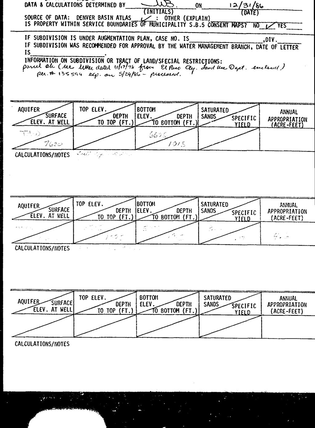
118
119
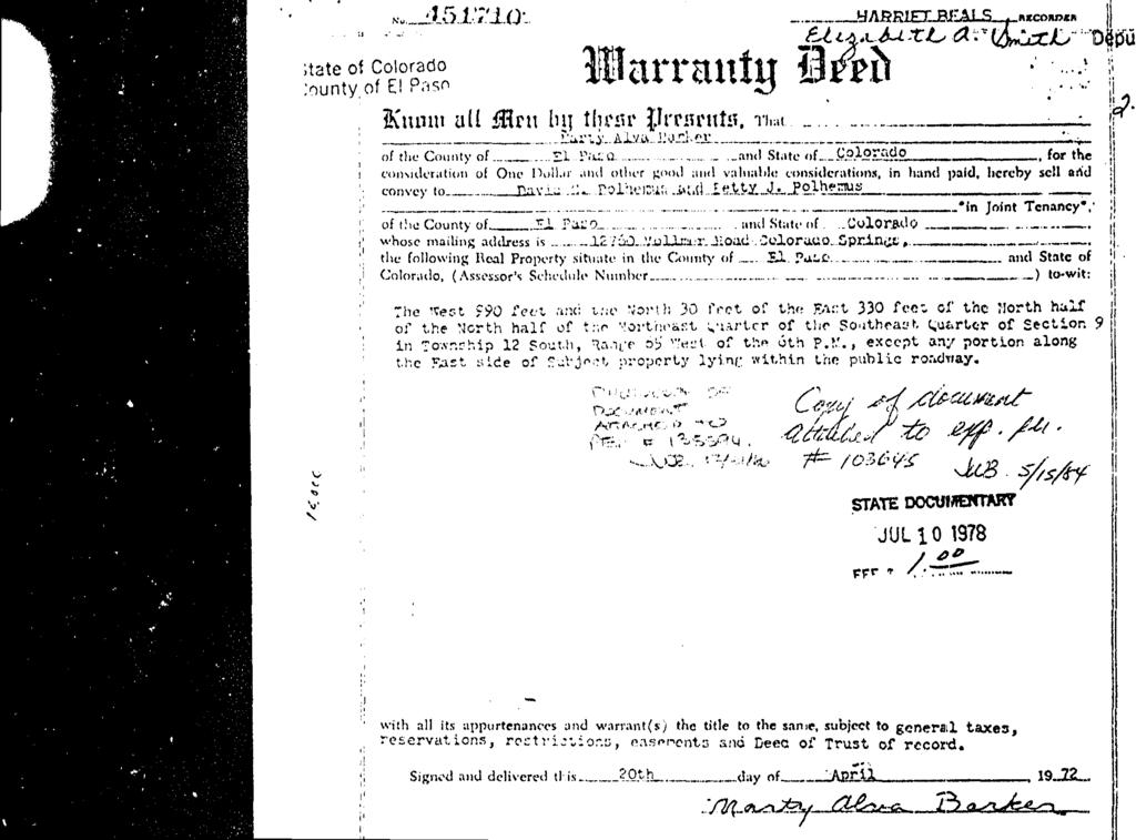
120
121 The Country Life: Where there's a well, there's a way to get water - hopefully Colorado Sprin of 5 5/18/2018, 10:53 AM By: Bill Radford (/author/bill+radford) June 15, 2015 Updated: June 15, 2015 at 4:10 am EXHIBIT D
122 The Country Life: Where there's a well, there's a way to get water - hopefully Colorado Sprin of 5 5/18/2018, 10:53 AM
123 The Country Life: Where there's a well, there's a way to get water - hopefully Colorado Sprin of 5 5/18/2018, 10:53 AM About 27,000 households are served by individual water wells in El Paso County. BILL RADFORD, THE GAZETTE View Gallery (/gallery/articleid/ /pictures?display=flexfullscreen&gallerytheme=lighttheme) Log in to comment (/comments/1/ ) When a well was drilled for a neighbor's new home recently, it was another "straw" dipping into the water beneath our feet. There's a lot of such straws in the area. An estimated 27,000 homes - about 67,500 residents - are served by private water wells in El Paso County. That's about 11 percent of residents; the rest are served by public drinking water systems, from the biggie - Colorado Springs Utilities - to smaller ones such as Donala Water and Sanitation District, Cherokee Metro and the city of Fountain. The public systems draw their water from surface water, groundwater or both. In eastern El Paso County, where I live, most utilize groundwater - the water that lies beneath the Earth's surface. Our well reaches 870 feet into the Arapahoe Aquifer; it's one of four aquifers that make up the Denver Basin, which stretches from El Paso County to Weld County. If you're looking for property in the country with plans to dig a well, do your homework first, cautions Mark Birkelo, general manager of Barnhart Pump Co. in Falcon.
124 The Country Life: Where there's a well, there's a way to get water - hopefully Colorado Sprin of 5 5/18/2018, 10:53 AM "The first phone call you want to make is to a water well contractor," Birkelo said. A company such as Barnhart quickly can check on water quality and quantity in a given area. "That phone call can save a lot of grief," Birkelo said. Once a site is chosen, the homeowner must acquire a permit from the state Division of Water Resources. Residential permits include domestic and household use only; the latter means no outside water, so no water for lawns, livestock, etc. Ready to drill a well? "The cost for drilling and pumping can be considerable," cautions El Paso County's "Code of the West." Expect to pay about $22 to $24 a foot for a well 600 feet or deeper, Birkelo said; the cost per foot will be less if under about 600 feet. Barnhart is not a drilling company, but does the oversight for 40 to 50 new wells a year, Birkelo said. If moving to property with a well, test the water pump's production and the quality of the water, Birkelo advised; for information on water potability testing, visit El Paso County Public Health's website at elpasocountyhealth.org/service/water-quality. Quality is one issue; quantity is another. One afternoon I turned on the tap and nothing came out. The immediate paranoid thought: Our well had run dry. But we had simply overtaxed the water pump; after a 10- minute break, water started to flow again. But long-term worry remains. As a water resources report on the county's website notes, "the aquifers found in the Denver Basin are not considered to be a long-range, renewable source of water. The bedrock aquifers are subject to depletion if withdrawals exceed the natural recharge rate, which is very slow, given that the water within these aquifers has accumulated over thousands of years. The negligible rate of natural recharge, the considerable increase in water withdrawal, and the semiarid climate of the region have led to a situation where the amount of withdrawal from the aquifers may be exceeding the amount of recharge." Birkelo, who has been in the water business in El Paso County for 30 years, believes that rate of replenishment
125 The Country Life: Where there's a well, there's a way to get water - hopefully Colorado Sprin of 5 5/18/2018, 10:53 AM depends on the area. There are some wells that have a higher water level than they did decades before, he said, even though "there have been more straws put into that glass of water over time." In other areas, he has seen water levels drop. Bottom line: It's tough to know what's happening deep underground, he says. That's why oil companies "spend millions of dollars trying to see what's down there" and often end up with a hole in the ground and nothing to show for it. "We know more about outer space," Birkelo said, "than we do what's under our own two feet."
126 EXHIBIT E
127
128 INVOICE #: Invoice Date: Aug 1, 2018 Date Received: Jul 17, Bill To Monson, Cummins & Shohet, LLC Chris D. Cummins Northgate Estates Dr. Suite 250 Colorado Springs CO Original Results To Monson, Cummins & Shohet, LLC Chris D. Cummins Northgate Estates Dr. Suite 250 Colorado Springs CO Client Project Name: Redtail Ranches New Subdivision Task Number: Customer PO: Quantity Description Unit Price Extension Item 1 Water - Drinking 504 EDB $ Water - Drinking 505 Pest $ Water - Drinking Herb $ Water - Drinking VOCS $ Water - Drinking SOCS $ Water - Drinking Carbamates $ Water - Drinking 547 Glyphosate (Sub) $ Water - Drinking Endothall $ Water - Drinking Diquat $ Water - Drinking Chloride $ Water - Drinking Cyanide-Total $ Water - Drinking Fluoride $ Water - Drinking Gross Alpha/Beta (Sub) $ Water - Drinking Inorganics $ Water - Drinking Langelier Index $ Water - Drinking Nitrate Nitrogen $ Water - Drinking Nitrite Nitrogen $ Water - Drinking Sulfate $ Water - Drinking Total Coliform P/A $ Water - Drinking Total Metals By ICP-MS $ Water - Drinking Total Metals By OES $ Shipping Cooler Shipment - UPS $ Shipping Sample Shipment to Outside Lab $15.00 $65.00 $80.00 $ $ $ $ $ $ $ $17.00 $38.00 $18.00 $56.16 $ $57.00 $17.00 $17.00 $17.00 $23.00 $60.00 $12.00 $10.00 $15.00 Payment Terms: C.O.D. Pay From This Invoice. Remit Payment To: Colorado Analytical Lab P.O. Box 507 Brighton, CO Invoices and results are sent via only. If you have questions please call **Records associated with samples submitted will be retained for 5 years from the date received.** 240 South Main Street / Brighton, CO / Mailing Address: P.O. Box 507 / Brighton, CO / Fax: Page 1 of

129 INVOICE #: Invoice Date: Aug 1, 2018 Date Received: Jul 17, Bill To Monson, Cummins & Shohet, LLC Chris D. Cummins Northgate Estates Dr. Suite 250 Colorado Springs CO Original Results To Monson, Cummins & Shohet, LLC Chris D. Cummins Northgate Estates Dr. Suite 250 Colorado Springs CO Client Project Name: Redtail Ranches New Subdivision Task Number: Customer PO: Quantity Description Unit Price Extension Item Thank You! We Appreciate Your Business. Total: $1, Payment Terms: C.O.D. Pay From This Invoice. Remit Payment To: Colorado Analytical Lab P.O. Box 507 Brighton, CO Invoices and results are sent via only. If you have questions please call **Records associated with samples submitted will be retained for 5 years from the date received.** 240 South Main Street / Brighton, CO / Mailing Address: P.O. Box 507 / Brighton, CO / Fax: Page 2 of
130 D O! " # $ % & ' ( ' ) * +, -. / 0 1, * 5, + 6 * * *. 1 9 ) * 8 : * +, -. * 7 ; * - * * 3 0. *, , *. * 8 0 / + 3 * 8 8 : 4 / 6.. * ; * * 2. 9 < 0 = * 2 ) * 8 * 0-5 ; >? , * ; 0.. ; * - * 8 : * - * + - * 8 * A *, B ; 6 2 C,. ; * -. ; 0 2. ; * 8 0 / + 3 * 8. ; * - * - * 5 * 6 A * ; * 3 0 4, - 0., - 1 E F G G G G G G G G GG G G GG GG GG GG GG GG G G G G GG GG G G G G G G G G G G G G G H I J J K L M N O I P N P M Q E R K L M Q S MM TT UU VV MM RR UU VV KK II JJ WW KK VV II LL RR U V ] ^ _ ` a b c ^ d e ^ f g h i! X Y Z [ & \ Y Z # " j k
131 ! " # $ % & ' ( ' l m n o m p q r s t u v w x [ y z { } p s ~ o m p q r s t u ƒ l % Y x x x # % ˆ m ~ m p s s ~ Š { y } Œ s % Ž [! Z % % Y! Z % Y v $ ~ } { { r q m q y l w ( ( ( v x x w x w! ' ~ } { { s m q y l w ( ( w ( v x x w x w! ' [ j š % & X #! & # œ [ k X [ k ' & ' ž X! # Ÿ ' X! j x! & w x x k [ k [ Z j $ Z % % Ÿ " $ k j ( % " Y ( [ % Ÿ Ÿ % % Ÿ % Ÿ % Ÿ!! % % % $ ] ^ _ ` a b c ^ d e ^ f g h i! X Y Z [ & \ Y Z # " j k
132 ««ª

133

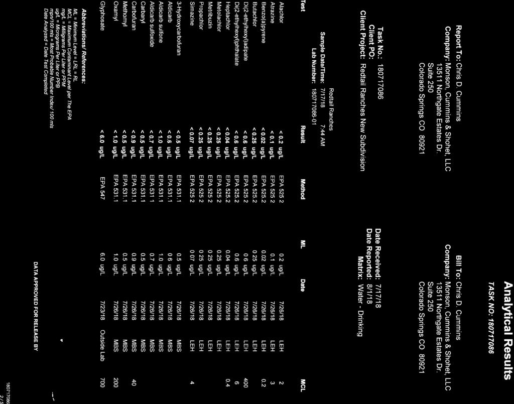
134

135
136
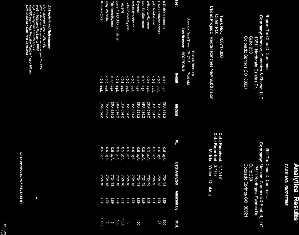
137
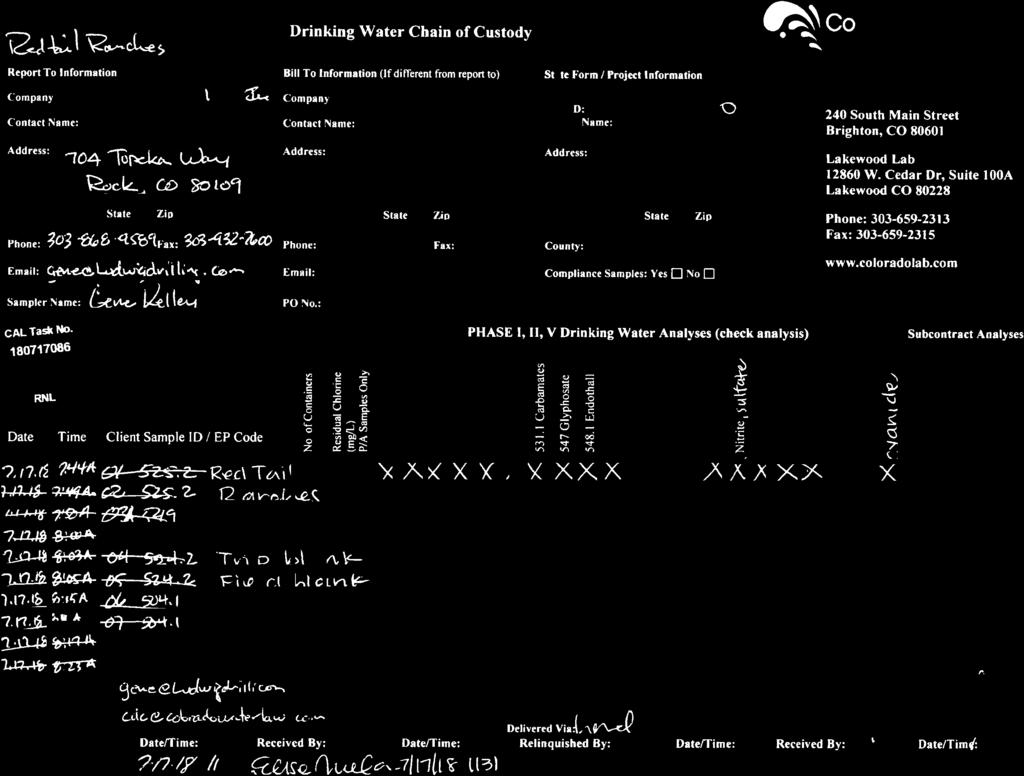
138
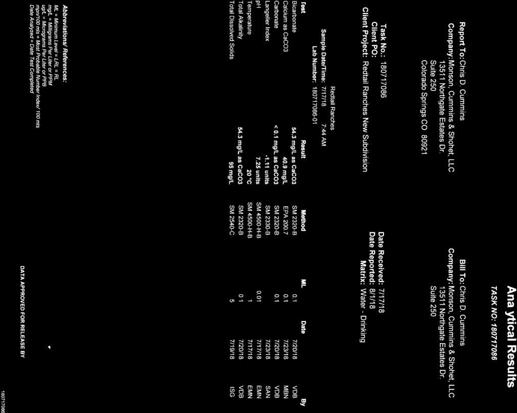
139
140


141
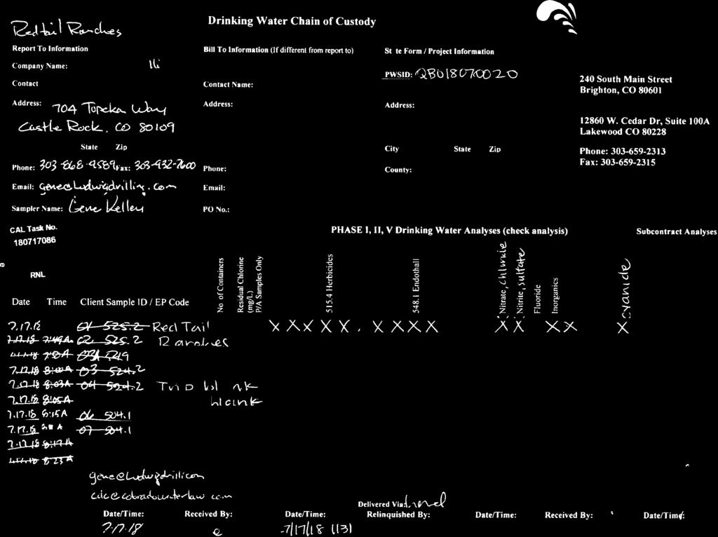
142
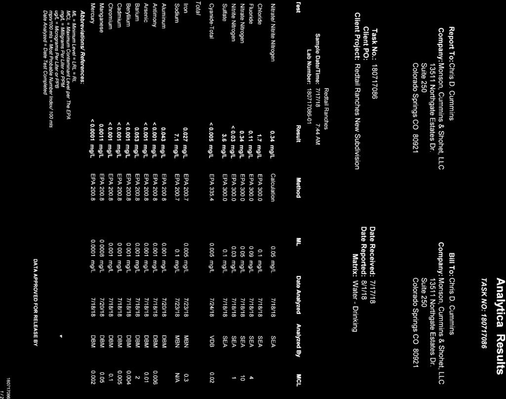
143

144
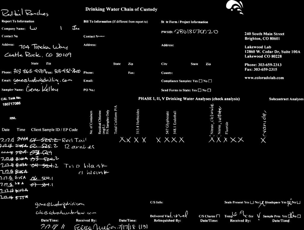
145
Chapter 12: Water Rights
 Chapter 12: Water Rights An * in the left margin indicates a change in the statute, rule or text since the last publication of the manual. * I. Water Allocation Laws and Procedures All water in natural
WATER DUE DILIGENCE:
 WATER DUE DILIGENCE: What real estate attorneys should understand about water rights due diligence when their clients are purchasing property with water rights I. A brief history of salient Colorado water
CASE NO. 04CW12(96CW53) RTV LLC,
 RTV LLC,") DISTRICT COURT, WATER DIVISION NO. 2, COLORADO --------------------------------------------------------------------------------------------------------- RESUME OF CASES FILED DURING FEBRUARY 2004 ---------------------------------------------------------------------------------------------------------
DISTRICT COURT, WATER DIVISION NO. 2, COLORADO --------------------------------------------------------------------------------------------------------- RESUME OF CASES FILED DURING FEBRUARY 2004 ---------------------------------------------------------------------------------------------------------
IT IS ORDERED that the following rules governing the Water Administration Fee Program are adopted by the State Engineer.
 AUTHORIZATION These rules are promulgated pursuant to the authority granted the State Engineer in section 37-80-121, C.R.S. (2003) to implement a Water Administration Fee Program in the State of Colorado.
Project File #: SF Project Name: Redtail Ranch Subdivision Parcel Nos.: , , ,
 COMMISSIONERS: MARK WALLER (CHAIR) LONGINOS GONZALEZ, JR. (VICE-CHAIR) HOLLY WILLIAMS STAN VANDERWERF CAMI BREMER PLANNING AND COMMUNITY DEVELOPMENT DEPARTMENT CRAIG DOSSEY, EXECUTIVE DIRECTOR TO: FROM:
Planning Commission Hearing Date: 2/21/2017 Board of County Commissioners Hearing Date: 3/8/2017
 COMMISSIONERS: DARRYL GLENN (PRESIDENT) MARK WALLER (PRESIDENT PRO TEMPORE) STAN VANDERWERF LONGINOS GONZALEZ PEGGY LITTLETON PLANNING AND COMMUNITY DEVELOPMENT DEPARTMENT CRAIG DOSSEY, EXECUTIVE DIRECTOR
WILLIAMSON ACT CONTRACTS GUIDELINES
 NEVADA COUNTY COMMUNITY DEVELOPMENT AGENCY PLANNING DEPARTMENT ERIC ROOD ADMINISTRATION BUILDING 950 Maidu Avenue Nevada City, California 95959-8617 Phone: (530) 265-1222 FAX : (530) 265-9851 WILLIAMSON
Transfers and Conveyances of Water Rights: Evaluation, Due Diligence, and Forms of Conveyances
 Transfers and Conveyances of Water Rights: Evaluation, Due Diligence, and Forms of Conveyances Publication 12/18/2002 12:00:00 AM 1. INTRODUCTION Chris Thorne Partner 303.295.8488 Denver cthorne@hollandhart.com
Project File #: SF Project Name: Jackson Ranch Filing No. 4 Parcel Nos.: , and
 COMMISSIONERS: DARRYL GLENN (PRESIDENT) MARK WALLER (PRESIDENT PRO TEMPORE) STAN VANDERWERF LONGINOS GONZALEZ PEGGY LITTLETON PLANNING AND COMMUNITY DEVELOPMENT DEPARTMENT CRAIG DOSSEY, EXECUTIVE DIRECTOR
MS MINOR SUBDIVISION TREVITHICK
 MS-02-015 341.12 MINOR SUBDIVISION TREVITHICK A request by Danny Trevithick for a one-lot Minor Subdivision on five acres. The property is zoned A-35 (Agricultural) District and is located ¼ mile south
LEASE OF GROUNDWATER
 LEASE OF GROUNDWATER This Lease of Groundwater ("Lease") is entered into to be effective this day of, 20 the Effective Date ), by and between (hereinafter referred to as Lessor whether one or more) and
SPECIAL WARRANTY DEED. THIS DEED, made this day of, 2005, between
 SPECIAL WARRANTY DEED Owner s Last Name THIS DEED, made this day of, 2005, between [Owner #1 Full Name] and [Owner #2 Full Name] ( Grantors ) and ARAPAHOE COUNTY WATER AND WASTEWATER AUTHORITY, 13031 East
ARTICLE VII. NONCONFORMITIES. Section 700. Purpose.
 ARTICLE VII. NONCONFORMITIES. Section 700. Purpose. The purpose of this chapter is to regulate and limit the development and continued existence of legal uses, structures, lots, and signs established either
IV. Florida Administrative Code (F.A.C.) Department of Community Affairs Rules
 Department of Community Affairs Rules") IV. Florida Administrative Code (F.A.C.) Department of Community Affairs Rules - 1998 CHAPTER 9J-2 - RULES OF PROCEDURE AND PRACTICE PERTAINING TO DEVELOPMENTS OF REGIONAL IMPACT PART I GENERAL 9J-2.001
IV. Florida Administrative Code (F.A.C.) Department of Community Affairs Rules - 1998 CHAPTER 9J-2 - RULES OF PROCEDURE AND PRACTICE PERTAINING TO DEVELOPMENTS OF REGIONAL IMPACT PART I GENERAL 9J-2.001
BEFORE THE ST. JOHNS RIVER WATER MANAGEMENT DISTICT PETITION FOR ADMINISTRATIVE HEARING
 BEFORE THE ST. JOHNS RIVER WATER MANAGEMENT DISTICT SIERRA CLUB INC. and ST. JOHNS RIVERKEEPER INC. Petitioners v. ST JOHNS RIVER WATER MANAGMENT DISTRICT and SLEEPY CREEK LANDS LLC Respondents PETITION
1. Parties to Agreement 1.1 Citizens of Centre County (the People ), as beneficiaries of the corpus of the public trust: public natural resources.
, as beneficiaries of the corpus of the public trust: public natural resources.") 3/27/18 Centre County Citizens/Spring Township Water Authority/Nestle Waters North America --- Capital Investment/ Profit-Sharing/Economic Development/Watershed Conservation/Water Supply Agreement ---
3/27/18 Centre County Citizens/Spring Township Water Authority/Nestle Waters North America --- Capital Investment/ Profit-Sharing/Economic Development/Watershed Conservation/Water Supply Agreement ---
ORDINANCE NO. C-590(E0916)
") ORDINANCE NO. C-590(E0916) AN ORDINANCE AMENDING THE WATER AND WASTEWATER IMPACT FEES ORDINANCE NO. C-590(D0314) RELATING TO THE REGULATION OF THE USE AND DEVELOPMENT OF LAND IN THE INCORPORATED LIMITS
ORDINANCE NO. C-590(E0916) AN ORDINANCE AMENDING THE WATER AND WASTEWATER IMPACT FEES ORDINANCE NO. C-590(D0314) RELATING TO THE REGULATION OF THE USE AND DEVELOPMENT OF LAND IN THE INCORPORATED LIMITS
INDIAN MOUNTAIN METROPOLITAN DISTRICT S ANSWER AND COUNTERCLAIMS
 DISTRICT COURT, PARK COUNTY, STATE OF COLORADO P. O. Box 190 Fairplay, Colorado 80440 Plaintiff: INDIAN MOUNTAIN CORP. v. IMMD: INDIAN MOUNTAIN METROPOLITAN DISTRICT Attorneys for Indian Mountain Metropolitan
LEASE OF PERMITTED EDWARDS GROUNDWATER RIGHTS (Beginning (post-january 1, year lease)
") EDWARDS AQUIFER HABITAT CONSERVATION PLAN PROGRAM LEASE OF PERMITTED EDWARDS GROUNDWATER RIGHTS (Beginning (post-january 1, 2013 -year lease) This Lease of Permitted Edwards Groundwater Rights ( Lease
EDWARDS AQUIFER HABITAT CONSERVATION PLAN PROGRAM LEASE OF PERMITTED EDWARDS GROUNDWATER RIGHTS (Beginning (post-january 1, 2013 -year lease) This Lease of Permitted Edwards Groundwater Rights ( Lease
REGIONAL DISTRICT OF NORTH OKANAGAN SUBDIVISION SERVICING BYLAW NO. 2600, 2013
 REGIONAL DISTRICT OF NORTH OKANAGAN SUBDIVISION SERVICING BYLAW NO. 2600, 2013 Page 3 TABLE OF CONTENTS SECTION -100- SCOPE AND APPLICABILTY... 4 101 Title... 4 102 Application... 4 103 Compliance with
ORDINANCE NUMBER
 TOWN OF LAKE PLACID AGENDA ITEM INTRODUCTION MEETING DATE: March 14, 2016 MEETING TYPE: Town Council Regular AGENDA ITEM # AND TITLE: 4.D. 1st Reading Ordinance 2016-715 Sewer System Dev Charge Reduction
Public Service Commission
 State of Florida Public Service Commission Capital Circle Office Center 2540 Shumard Oak Boulevard Tallahassee, Florida 32399-0850 -M-E-M-O-R-A-N-D-U-M- DATE: November 22, 2016 TO: Office of Commission
EASEMENT AGREEMENT (Distributor Performance Non-Exclusive)
") EASEMENT AGREEMENT (Distributor Performance Non-Exclusive) THIS EASEMENT AGREEMENT, effective the day of, 20, is made between WITNESSETH:, hereafter called Grantor, (whether grammatically singular or plural)
EASEMENT AGREEMENT (Distributor Performance Non-Exclusive) THIS EASEMENT AGREEMENT, effective the day of, 20, is made between WITNESSETH:, hereafter called Grantor, (whether grammatically singular or plural)
Water Rights Ownership in Nevada
 Water Rights Ownership in Nevada Certified Residential Specialists (CRS) Hugh Ricci, P.E. & Tracy Taylor, P.E. State Engineer s Office April 13, 2006 Water Resources & State Engineer s Office are Interchangeable
Shared Well Agreement
 Shared Well Agreement This information is provided to assist you in developing a shared well agreement. Please remember that each situation is different and may require additional language to protect the
WSWC-WestFAST Non-Tribal Federal Water Rights Workgroup Stock Water Rights for Grazing Cattle on Federal Lands October 24, 2018
 WSWC-WestFAST Non-Tribal Federal Water Rights Workgroup Stock Water Rights for Grazing Cattle on Federal Lands October 24, 2018 Wyoming Stock Water Rights on Federal Land Chris Brown, Senior Assistant
CHAPTERS 35 to 37 Reserved CHAPTER 38 PRIVATE WATER WELL CONSTRUCTION PERMITS
 , 8/18/04 Ch 38, p.1 TITLE III WITHDRAWAL, DIVERSION, STORAGE AND USE OF WATER DIVISION A WATER WELL CONSTRUCTION: GENERAL STANDARDS AND REGISTRATION OF CONTRACTORS CHAPTERS 35 to 37 Reserved, 8/18/04
CHAPTER 3 PRELIMINARY PLAT
 10-3-1 10-3-3 SECTION: CHAPTER 3 PRELIMINARY PLAT 10-3-1: Consultation 10-3-2: Filing 10-3-3: Requirements 10-3-4: Approval 10-3-5: Time Limitation 10-3-6: Grading Limitation 10-3-1: CONSULTATION: Each
Form 11.A.9.17 INSTRUCTIONS FOR APPLICATION FOR PLAT WAIVER (Art. 11.A.8)
") Form 11.A.9.17 INSTRUCTIONS FOR APPLICATION FOR PLAT WAIVER (Art. 11.A.8) All questions in each part must be completed. When a question is not applicable to the property, enter "N/A" or other phrase indicating
Form 11.A.9.17 INSTRUCTIONS FOR APPLICATION FOR PLAT WAIVER (Art. 11.A.8) All questions in each part must be completed. When a question is not applicable to the property, enter "N/A" or other phrase indicating
WATER SOFTENING APPLIANCE REGULATION ORDINANCE. (Ord. No ) Brine discharging water softening appliance use regulation ordinance.
 Brine discharging water softening appliance use regulation ordinance.") WATER SOFTENING APPLIANCE REGULATION ORDINANCE (Ord. No. 2011-003) Brine discharging water softening appliance use regulation ordinance. THE TOWNSHIP OF GRATTAN ORDAINS: Section 1. Short Title. This shall
WATER SOFTENING APPLIANCE REGULATION ORDINANCE (Ord. No. 2011-003) Brine discharging water softening appliance use regulation ordinance. THE TOWNSHIP OF GRATTAN ORDAINS: Section 1. Short Title. This shall
ARTICLE 24 SITE PLAN REVIEW
 ARTICLE 24 SITE PLAN REVIEW 24.1 PURPOSE: The intent of these Ordinance provisions is to provide for consultation and cooperation between the land developer and the Township Planning Commission in order
Due Care Obligations
 Sec 324.XXXXX Due Care; duties of owner or operator, residential tenant, having knowledge of facility; compliance with section. (1) A current owner or operator of real property, or a residential tenant,
SECTION 1 INTRODUCTION TO THE PANAMA CITY BEACH COMPREHENSIVE GROWTH DEVELOPMENT PLAN
 1. PURPOSE SECTION 1 INTRODUCTION TO THE PANAMA CITY BEACH COMPREHENSIVE GROWTH DEVELOPMENT PLAN The purpose of the City of Panama City Beach's Comprehensive Growth Development Plan is to establish goals,
UPPER GUNNISON RIVER WATER ACTIVITY ENTERPRISE
 Contract No. Contract Date: UPPER GUNNISON RIVER WATER ACTIVITY ENTERPRISE AGREEMENT FOR PURCHASE OF CLASS D AUGMENTATION CERTIFICATE PROVIDING FOR WATER SERVICE FROM MERIDIAN LAKE RESERVOIR This Agreement
25 Annual Water Law Conference Coronado, CA February 22-23, Fundamentals of Prior Appropriation Systems
 TH 25 Annual Water Law Conference Coronado, CA February 22-23, 2007 Fundamentals of Prior Appropriation Systems Stephen G. Bartell Natural Resources Section Environment & Natural Resources Division United
THEREFORE BE IT RESOLVED
 INGHAM COUNTY HEALTH DEPARMENT REGULATION AMENDING THE SANITARY CODE BY ADDING CHAPTER VII REGULATIONS FOR THE INSPECTION OF ONSITE WATER AND SEWAGE DISPOSAL SYSTEMS AT THE TIME OF PROPERTY TRANSFER PREAMBLE:
Subtitle 24 Revision to incorporate SGT SB 236 8/3/2012 STAFF DRAFT 2
 Subtitle 24 Revisions DRAFT 2 Definitions: Section 24-101 Remainder Agricultural Parcel-On or after October 1, 2012 pursuant to Section 9-206 of the Environment Article a remainder parcel is created by
WHITEHAWK RANCH MUTUAL WATER COMPANY
 1. The Development WHITEHAWK RANCH MUTUAL WATER COMPANY (Offering Circular) WHITEHAWK RANCH is located in Eastern Plumas County, 230 miles from San Francisco and 150 miles from Sacramento via Interstate
DECLARATION OF RESTRICTIVE COVENANTS. THIS DECLARATION OF RESTRICTIVE COVENANTS made this day of, 200_, by ( Declarant ). RECITALS
. RECITALS") DECLARATION OF RESTRICTIVE COVENANTS THIS DECLARATION OF RESTRICTIVE COVENANTS made this day of, 200_, by ( Declarant ). RECITALS WHEREAS, Declarant is the owner of the surface of certain real property
DECLARATION OF RESTRICTIVE COVENANTS THIS DECLARATION OF RESTRICTIVE COVENANTS made this day of, 200_, by ( Declarant ). RECITALS WHEREAS, Declarant is the owner of the surface of certain real property
October 25, Eric R. King
 Unitization and Communitization October 25, 2012 Eric R. King 52 O.S. 287.1 Unitized Management and Operation of Oil and Gas Properties The Legislature finds and determines that it is desirable and necessary,
Letter of Intent May 2017 (Revised November 2017)
") THE BEACH AT WOODMOOR LETTER OF INTENT MAY 2017 (REVISED NOVEMBER 2017) OWNER/APPLICANT: CONSULTANT: Lake Woodmoor Holdings LLC N.E.S. Inc. 1755 Telstar Drive, Suite 211 619 North Cascade Avenue Colorado
THE BEACH AT WOODMOOR LETTER OF INTENT MAY 2017 (REVISED NOVEMBER 2017) OWNER/APPLICANT: CONSULTANT: Lake Woodmoor Holdings LLC N.E.S. Inc. 1755 Telstar Drive, Suite 211 619 North Cascade Avenue Colorado
GUIDELINES FOR THE PERMITTING PROCESS NONPUBLIC WATER SYSTEM NONPUBLIC WATER SYSTEM DEFINED PERMIT PROCESSING FEES
 GUIDELINES FOR THE PERMITTING PROCESS NONPUBLIC WATER SYSTEM The following information is intended to guide the prospective water system applicant through the process required for the Nonpublic Water Supply
CHAPTER County of Alameda Onsite Wastewater Treatment Systems Ordinance
 The Alameda County Board of Supervisors hereby finds and declares: A. Modifications to Chapter 15.18 of the Alameda County General Ordinance Code are necessary to comply with new standards and regulations
TOWN OF WATERVILLE VALLEY NEW HAMPSHIRE SITE PLAN REVIEW REGULATIONS
 TOWN OF WATERVILLE VALLEY NEW HAMPSHIRE Effective date March 17, 1981 Revised March 16, 1982 Revised March 13, 1986 Revised March 10, 1987 Revised March 14, 2013 Revised March 8, 2016 TOWN OF WATERVILLE
CHAPTER Committee Substitute for Committee Substitute for Senate Bill No. 2188
 CHAPTER 2004-372 Committee Substitute for Committee Substitute for Senate Bill No. 2188 An act relating to land development; amending s. 197.502, F.S.; providing for the issuance of an escheatment tax
Chapter 9 - Non-Conformities CHAPTER 9 - INDEX
 CHAPTER 9 - INDEX 9-10: GENERAL... 3 9-20: SUBSTANDARD SIZE LOTS OR PARCELS... 3 9-20-10: GENERAL... 3 9-20-20: CUMULATING OF SUBSTANDARD SIZE LOTS OR PARCELS... 3 9-20-30: SEPARATION OF PLATTED SUBSTANDARD
Regional District of Central Kootenay Subdivision Bylaw No. 2159, 2011
 Regional District of Central Kootenay Subdivision Bylaw No. 2159, 2011 Adopted September 2011 Page 1 of 21 TABLE OF CONTENTS PART 1 - TITLE... 2 PART 2 - PURPOSE... 2 PART 3 - APPLICATION AND ADMINISTRATION...
ARTICLES OF INCORPORATION OF KING S DEER HOMEOWNERS ASSOCIATION, INC. AS AMENDED JUNE 30, ARTICLE I Name. ARTICLE II Duration
 ARTICLES OF INCORPORATION OF KING S DEER HOMEOWNERS ASSOCIATION, INC. AS AMENDED JUNE 30, 2008 ARTICLE I Name The name of this Corporation shall be KING S DEER HOMEOWNERS ASSOCIATION, INC. ARTICLE II Duration
MEMORANDUM OF UNDERSTANDING BETWEEN CALIFORNIA REGIONAL WATER QUALITY CONTROL BOARD, LOS ANGELES REGION AND THE CITY OF LOS ANGELES
 Effective Date: May 12, 2005 (Execution Date by City) C-108122 MEMORANDUM OF UNDERSTANDING BETWEEN CALIFORNIA REGIONAL WATER QUALITY CONTROL BOARD, LOS ANGELES REGION AND THE CITY OF LOS ANGELES REGARDING
APPLICATION FOR CONDITIONAL USE PERMIT
 Receipt No. Fee Date Date Permit Issued: Certificate of Compliance: Date DOOR COUNTY LAND USE SERVICES 421 Nebraska Street Door County Government Center Sturgeon Bay, Wisconsin 54235 (920) 746-2323 - FAX
EASEMENT AGREEMENT. hereinafter called Grantor, (whether grammatically singular or plural) and the:
 and the:") EASEMENT AGREEMENT THIS EASEMENT AGREEMENT, made and entered into as of the day of,, by and between: hereinafter called Grantor, (whether grammatically singular or plural) and the: hereinafter called Distributor.
EASEMENT AGREEMENT THIS EASEMENT AGREEMENT, made and entered into as of the day of,, by and between: hereinafter called Grantor, (whether grammatically singular or plural) and the: hereinafter called Distributor.
ENGLEWOOD WATER DISTRICT MANDATORY WASTEWATER UTILITY CONNECTION POLICY
 ENGLEWOOD WATER DISTRICT MANDATORY WASTEWATER UTILITY CONNECTION POLICY RESOLUTION NO: 02-12-19 C Section 1 Introduction 1.1 General The following (UCP) of the Englewood Water District (the District )
ENVIRONMENTAL DISCLOSURE FOR TRANSFER OF REAL PROPERTY (IC ) State Form (R / 1-07) Indiana Department of Environmental Management
 State Form (R / 1-07) Indiana Department of Environmental Management") ENVIRONMENTAL DISCLOSURE FOR TRANSFER OF REAL PROPERTY (IC 13-25-3-7.5) State Form 52653 (R / 1-07) Indiana Department of Environmental Management A WARNING TO THE PARTIES TO A TRANSFER OF PROPERTY: The
ENVIRONMENTAL DISCLOSURE FOR TRANSFER OF REAL PROPERTY (IC 13-25-3-7.5) State Form 52653 (R / 1-07) Indiana Department of Environmental Management A WARNING TO THE PARTIES TO A TRANSFER OF PROPERTY: The
TRANSFERABLE DEVELOPMENT RIGHTS PROCESS GUIDE
 TRANSFERABLE DEVELOPMENT RIGHTS PROCESS GUIDE Clear Creek County Planning Department P.O. Box 2000 Georgetown, Colorado 80444 (303) 679-2436 - phone (303) 569-1103 - fax 1 PURPOSE: A Transfer of Development
H 7816 AS AMENDED S T A T E O F R H O D E I S L A N D
 ======== LC001 ======== 01 -- H 1 AS AMENDED S T A T E O F R H O D E I S L A N D IN GENERAL ASSEMBLY JANUARY SESSION, A.D. 01 A N A C T RELATING TO TAXATION -- TAX SALES Introduced By: Representative Robert
WATER RIGHTS CASE LAW: AN UPDATE. Marcus J. Lock, Esq. Wilderson Lock & Hill, LLC
 WATER RIGHTS CASE LAW: AN UPDATE Marcus J. Lock, Esq. Wilderson Lock & Hill, LLC mlock@lawoftherockies.com COLORADO SUPREME COURT DECISIONS Reynolds v. Cotten, 274 P.3d 540 COLLATERAL ESTOPPEL: AN IDENTICAL
All roads developed to access four (4) or more parcels shall be constructed to Park County Road and Bridge Standards.
 or more parcels shall be constructed to Park County Road and Bridge Standards.") P a r k C o u n t y P l a n n i n g a n d Z o n i n g 1002 Sheridan Avenue Cody, WY 82414 Phone: 307-527-8540 35-40 ACRE SUBDIVISIONS www.parkcounty.us/planandzone.htm May 2011 This is only intended as
P a r k C o u n t y P l a n n i n g a n d Z o n i n g 1002 Sheridan Avenue Cody, WY 82414 Phone: 307-527-8540 35-40 ACRE SUBDIVISIONS www.parkcounty.us/planandzone.htm May 2011 This is only intended as
WRITTEN DECISION OF THE HAYDEN CITY COUNCIL REGARDING MAPLE GROVE PRELIMINARY SUBDIVISION APPLICATION (SUB-0013) HAYDEN SIGNATURE, LLC
 HAYDEN SIGNATURE, LLC") WRITTEN DECISION OF THE HAYDEN CITY COUNCIL REGARDING MAPLE GROVE PRELIMINARY SUBDIVISION APPLICATION (SUB-0013) HAYDEN SIGNATURE, LLC Application of Hayden Signature, LLC, an Idaho limited liability company,
WRITTEN DECISION OF THE HAYDEN CITY COUNCIL REGARDING MAPLE GROVE PRELIMINARY SUBDIVISION APPLICATION (SUB-0013) HAYDEN SIGNATURE, LLC Application of Hayden Signature, LLC, an Idaho limited liability company,
SAMPLE FOR Exhibit A. STANDARD CONTRACT TERMS AND CONDITIONS Landscape Irrigation and Recreational Use Contracts
 SAMPLE FOR 2016 - Exhibit A STANDARD CONTRACT TERMS AND CONDITIONS Landscape Irrigation and Recreational Use Contracts I. WATER SUPPLY... 2 A. PERMIT(S) MAY BE REQUIRED... 2 B. MAXIMUM ANNUAL QUANTITY...
CITY OF GROVER BEACH COMMUNITY DEVELOPMENT DEPARTMENT Tentative Map Checklist
 CITY OF GROVER BEACH COMMUNITY DEVELOPMENT DEPARTMENT Tentative Map Checklist The following list includes all of the items you must submit for a complete application. Some specific types of information
ARTICLE 100 SUBDIVISION APPLICATION PROCEDURE AND APPROVAL PROCESS
 ARTICLE 100 SUBDIVISION APPLICATION PROCEDURE AND APPROVAL PROCESS 100.01 General Procedure 100.02 Exempt Subdivision 100.03 Administrative Subdivision 100.04 Major Subdivision 100.05 Signing and Recording
Water Rights Related to Oil Shale Development in the Upper Colorado River Basin
 Order Code RS22986 November 18, 2008 Summary Water Rights Related to Oil Shale Development in the Upper Colorado River Basin Cynthia Brougher Legislative Attorney American Law Division Concerns over fluctuating
PLANNED UNIT DEVELOPMENTS (Ordinance No.: 3036, 12/3/07; Repealed & Replaced by Ordinance No.: 4166, 10/15/12)
") 159.62 PLANNED UNIT DEVELOPMENTS (Ordinance No.: 3036, 12/3/07; Repealed & Replaced by Ordinance No.: 4166, 10/15/12) A. PURPOSE 1. General. The Planned Unit Development (PUD) approach provides the flexibility
159.62 PLANNED UNIT DEVELOPMENTS (Ordinance No.: 3036, 12/3/07; Repealed & Replaced by Ordinance No.: 4166, 10/15/12) A. PURPOSE 1. General. The Planned Unit Development (PUD) approach provides the flexibility
WATER RIGHTS CONVEYANCING AND RELATED ISSUES
 WATER RIGHTS CONVEYANCING AND RELATED ISSUES DUE DILIGENCE AND EVALUATION, FORMS OF CONVEYANCE, MUTUAL DITCH COMPANY SHARE TRANSFERS AND PERFECTING SECURITY INTERESTS Christopher L. Thorne & Meghan N.
Goals and Policies Concerning Use of MELLO-ROOS COMMUNITY FACILITIES ACT OF 1982
 Goals and Policies Concerning Use of MELLO-ROOS COMMUNITY FACILITIES ACT OF 1982 Section TABLE OF CONTENTS Page Introduction 1 1 Policy & Goals 1 2 Definitions 2 3 Eligible Public Facilities 3 4 Value-to-Lien
SPECIAL EXCEPTION PUBLIC HEARING PHASE SUBMITTAL REQUIREMENTS. The following items are required for all Special Exception applications.
 200 W. Oak Street, 3rd Floor Fort Collins, CO 80521 (970) 498-7683 / larimer.org/planning SPECIAL EXCEPTION PUBLIC HEARING PHASE The submittal requirements listed in this packet are intended to collect
IRVINE UNIFIED SCHOOL DISTRICT RESOLUTION NO
 IRVINE UNIFIED SCHOOL DISTRICT RESOLUTION NO. 14-15-46 APPROVING PURCHASE AGREEMENT AND FINAL ACCEPTANCE OF REAL PROPERTY FOR THE PROPOSED PLANNING AREA (PA) 5B ELEMENTARY SCHOOL WHEREAS, the Irvine Unified
CHAPTER 2 APPLICATION AND PERMITTING PROCEDURES
 Table of Contents CHAPTER 2 APPLICATION AND PERMITTING PROCEDURES Table of Contents 2-01 COMMON DEVELOPMENT REVIEW PROCEDURES FOR DEVELOPMENT APPLICATIONS...3 2-01-01 Step 1: Conceptual Review...3 2-01-02
EASEMENT AGREEMENT. hereinafter called Grantor, (whether grammatically singular or plural) and the:
 and the:") EASEMENT AGREEMENT THIS EASEMENT AGREEMENT made and entered into as of the day of,, by and between: hereinafter called Grantor, (whether grammatically singular or plural) and the: hereinafter called Distributor.
EASEMENT AGREEMENT THIS EASEMENT AGREEMENT made and entered into as of the day of,, by and between: hereinafter called Grantor, (whether grammatically singular or plural) and the: hereinafter called Distributor.
2018 Declaration & Articles of Incorporation Vote
 2018 Declaration & Articles of Incorporation Vote WHITE PAPEr 2018 GATEWAY TO THE OUACHITAS The following pages outline recommended changes to the Hot Springs Village Declaration and Articles of Incorporation.
CITY OF DUNES CITY LANE COUNTY, OREGON ORDINANCE NO. 228
 CITY OF DUNES CITY LANE COUNTY, OREGON ORDINANCE NO. 228 AN ORDINANCE AMENDING TITLE XV OF THE DUNES CITY CODE OF ORDINANCES BY REPEALING CHAPTER 157 ENTITLED SEPTIC SYSTEM MAINTENANCE, AMENDING TITLE
Special Exception Use Order Application
 Development Services Department Planning Division CITY OF OVIEDO 400 Alexandria Boulevard Oviedo, Florida 32765 Application No. Date Received Pre-application Meeting Date Phone: (407) 971-5775 (407)971-5819
Public Improvement District (PID) Policy
 Policy") Public Improvement District (PID) Policy OVERVIEW Public Improvement Districts ( PIDs ), per the Texas Local Government Code Chapter 372 ( the code or PID Act ), provide the City of Marble Falls ( the
Public Improvement District (PID) Policy OVERVIEW Public Improvement Districts ( PIDs ), per the Texas Local Government Code Chapter 372 ( the code or PID Act ), provide the City of Marble Falls ( the
ADMINISTRATIVE PROCEDURES. For WATER DEMAND OFFSET REQUIREMENTS
 ADMINISTRATIVE PROCEDURES For WATER DEMAND OFFSET REQUIREMENTS DEVELOPMENT WATER BUDGETS (Section 14-8.3 SFCC 1987) CITY WATER BUDGET (Article 25-9 SFCC 1987) CITY WATER BANK (Article 25-10 SFCC 1987)
ARTICLE 1 GENERAL PROVISIONS
 ARTICLE 1 GENERAL PROVISIONS SECTION 100 TITLE This Ordinance shall be known and cited as the "Rice Township Subdivision and Land Development Ordinance." SECTION 101 AUTHORITY Rice Township is empowered
H 7816 S T A T E O F R H O D E I S L A N D
 LC001 01 -- H 1 S T A T E O F R H O D E I S L A N D IN GENERAL ASSEMBLY JANUARY SESSION, A.D. 01 A N A C T RELATING TO TAXATION -- TAX SALES Introduced By: Representative Robert E. Craven Date Introduced:
Concept Plan Project Narrative For 852 River Ranch Court
 Concept Plan Project Narrative For 852 River Ranch Court Date: January 5, 2016 Prepared by: Robert W. Jones II, P.E. Vortex Engineering, Inc. 2394 Patterson Rd., Ste 201 Grand Junction, CO 81505 970-245-9051
SITE PLAN REVIEW PROCEDURES SECTION DEVELOPMENTS REQUIRING SITE PLAN APPROVAL
 SECTION 22.01 PURPOSE ARTICLE XXII PROCEDURES The purpose of this Article is to establish uniform requirements of procedure for all developments in the Township. Certain specific types of minor development
RULE 23 - ACTION ON APPLICATION FOR A WATER PERMIT TO CONNECT TO OR MODIFY A CONNECTION TO AN EXISTING WATER DISTRIBUTION SYSTEM
 RULE 23 - ACTION ON APPLICATION FOR A WATER PERMIT TO CONNECT TO OR MODIFY A CONNECTION TO AN EXISTING WATER DISTRIBUTION SYSTEM A. PROCESS 1. New and Amended Water Permit 23-1 a. The General Manager shall
BOARD OF COUNTY COMMISSIONERS ARCHULETA COUNTY, COLORADO RESOLUTION 2018-
 BOARD OF COUNTY COMMISSIONERS ARCHULETA COUNTY, COLORADO RESOLUTION 2018- ARCHULETA COUNTY IMPROPERLY DIVIDED PARCELS EXEMPTION INTERIM RESOLUTION - A RESOLUTION ADDRESSING PARCELS UNDER THE SIZE OF 35
EXCHANGE AGREEMENT R E C I T A L S
 EXCHANGE AGREEMENT This Exchange Agreement (the Agreement ) is made and entered into by and between the LaVerkin Bench Canal Company, a not for profit corporation organized under the laws of Utah (the
DRAFT Resolution File No.: CU
 DRAFT Resolution A RESOLUTION OF THE ST. LUCIE COUNTY BOARD OF COUNTY COMMISSIONERS GRANTING COMPOST USA OF THE TREASURE COAST, LLC CONDITIONAL USE PERMIT APPROVAL FOR THE ESTABLISHMENT OF A BIOSOLIDS
To provide for the review of the final engineering plans, the subdivision improvement agreement, public dedications, and other legal agreements.
 ARTICLE 5 FINAL PLAT 501 Intent DOUGLAS COUNTY SUBDIVISION RESOLUTION To provide for the review of the final engineering plans, the subdivision improvement agreement, public dedications, and other legal
ATTACHMENT 4 CERCLA NOTICE, COVENANT, AND ACCESS PROVISIONS AND OTHER DEED PROVISIONS
 ATTACHMENT 4 CERCLA NOTICE, COVENANT, AND ACCESS PROVISIONS AND OTHER DEED PROVISIONS CERCLA NOTICE, COVENANT, AND ACCESS PROVISIONS AND OTHER DEED PROVISIONS The following CERCLA Notice, Covenant, and
RIVER EDGE COLORADO SUBDIVISION IMPROVEMENTS AGREEMENT FILING NO. THIS RIVER EDGE COLORADO SUBDIVISION IMPROVEMENTS AGREEMENT
 RIVER EDGE COLORADO SUBDIVISION IMPROVEMENTS AGREEMENT FILING NO. THIS RIVER EDGE COLORADO SUBDIVISION IMPROVEMENTS AGREEMENT FILING NO. ("SIA") is made and entered into this day of, 20, by and between
GENERAL PROVISIONS
 Santa Fe 14-8.1 GENERAL PROVISIONS (Ord. No. 2011-37 10) (A) Purpose The purposes of Article 14-8 are to: (1) provide proper standards that ensure a high quality appearance of the Santa Fe area and promote
TOWN OF WINDSOR RESOLUTION NO
 TOWN OF WINDSOR RESOLUTION NO. 2014-39 A RESOLUTION APPROVING ONE NO- SURFACE- OCCUPANCY OIL AND GAS LEASE, AND RELATED TERMS, BETWEEN THE TOWN OF WINDSOR, COLORADO, AND EXTRACTION OIL & GAS, LLC, AND
COUNTY LAND REUTILIZATION CORPORATION. Summary of Ohio Statutory Foreclosure Proceedings
 Form XI-4 COUNTY LAND REUTILIZATION CORPORATION Summary of Ohio Statutory Foreclosure Proceedings TABLE OF CONTENTS 323.25 FORECLOSURE Commencing a 323.25 Co. Treasurer Foreclosure Action Right of Redemption
Charter Township of Bedford 115 S. ULDRIKS DRIVE BATTLE CREEK, MICHIGAN 49037
 Charter Township of Bedford 115 S. ULDRIKS DRIVE BATTLE CREEK, MICHIGAN 49037 ORDINANCE NO. 05-11-17-26 OF 2017 AN ORDINANCE TO PROVIDE FOR THE OPERATION OF THE SANITARY SEWAGE DISPOSAL SYSTEM WITHIN BEDFORD
Article 5: Divisions of Land
 LUDC 2013 GARFIELD COUNTY, COLORADO Article 5: Divisions of Land Article 5 Divisions of Land Table of Contents DIVISION 1. GENERAL PROVISIONS.... 1 5-101. Types of Land Division.... 1 A. Definition of
13-2 SUBDIVISION PLANS AND PLATS REQUIRED EXCEPTIONS Subdivision Plats Required To be Recorded
 ARTICLE XIII SUBDIVISIONS 13-1 INTENT AND PURPOSE 13-1-1 Intent: It is the intent of the County Commission through the adoption of this Article to more fully avail itself of the power granted under 17-27-601
GENERAL ASSEMBLY OF NORTH CAROLINA SESSION 2017 SESSION LAW HOUSE BILL 436
 GENERAL ASSEMBLY OF NORTH CAROLINA SESSION 2017 SESSION LAW 2017-138 HOUSE BILL 436 AN ACT TO PROVIDE FOR UNIFORM AUTHORITY TO IMPLEMENT SYSTEM DEVELOPMENT FEES FOR PUBLIC WATER AND SEWER SYSTEMS IN NORTH
Article 6: Planned Unit Developments
 LUDC 2013 GARFIELD COUNTY, COLORADO Article 6: Planned Unit Developments ARTICLE 6 PLANNED UNIT DEVELOPMENTS TABLE OF CONTENTS DIVISION 1. GENERAL.... 1 6-101. GENERAL PROVISIONS.... 1 A. Purpose....
ORDINANCE NO AN ORDINANCE AMENDING THE CODE OF ORDINANCES OF THE CITY OF PORT ARANSAS, TEXAS, BY ADOPTING A NEW CHAPTER
 ORDINANCE NO. 2008-09 AN ORDINANCE AMENDING THE CODE OF ORDINANCES OF THE CITY OF PORT ARANSAS, TEXAS, BY ADOPTING A NEW CHAPTER TWENTY-SIX CONCERNING IMPACT FEES FOR ROADWAY FACILITIES; INCORPORATING
CITY OF VAUGHAN POLICY AND PROCEDURES FOR DEALING WITH CONTAMINATED OR POTENTIALLY CONTAMINATED SITES
 CITY OF VAUGHAN POLICY AND PROCEDURES FOR DEALING WITH CONTAMINATED OR POTENTIALLY CONTAMINATED SITES MAY 2001 This Report should be read in conjunction with the City of Vaughan BACKGROUND REPORT ON POLICY
PUBLIC SITE PLAN. Please Note: Once submitted to the County, all application materials become a matter of public record. SUBMITTAL REQUIREMENTS
 200 W. Oak Street, 3rd Floor Fort Collins, CO 80521 (970) 498-7683 / larimer.org/planning PUBLIC SITE PLAN The submittal requirements listed in this packet are intended to collect all of the information
ARTICLES OF INCORPORATION TRAPPERS VIEW HOMEOWNERS ASSOCIATION, INC.
 ARTICLES OF INCORPORATION OF TRAPPERS VIEW HOMEOWNERS ASSOCIATION, INC. In compliance with the requirements of the Colorado Nonprofit Corporation Act, Section 7-20- 101 through 7-29-106, C. R. S. 1973,
PURCHASE ORDER TERMS AND CONDITIONS
 PURCHASE ORDER TERMS AND CONDITIONS BILLING AND SHIPPING A. All matter shall be suitably packed, marked, and shipped in compliance with the requirements of common carriers in a manner to secure lowest
Conditional Use Permit / Standard Subdivision Application
 Conditional Use Permit / Standard Subdivision Application Name of Proposed Subdivision: Total Area (Acres) Is Proposed Subdivision to be built in phases? Number of Lots If yes, how many phases? Applicant/Owner
Case JMC-7A Doc 1133 Filed 01/31/17 EOD 01/31/17 13:25:18 Pg 1 of 10 SO ORDERED: January 31, 2017.
 Case 16-07207-JMC-7A Doc 1133 Filed 01/31/17 EOD 01/31/17 13:25:18 Pg 1 of 10 SO ORDERED: January 31, 2017. James M. Carr United States Bankruptcy Judge UNITED STATES BANKRUPTCY COURT SOUTHERN DISTRICT