(County Board to maintain a two-hour meeting limit or take action to continue meeting beyond that time.) CLAIMS
|
|
|
- Blanche Cameron
- 5 years ago
- Views:
Transcription
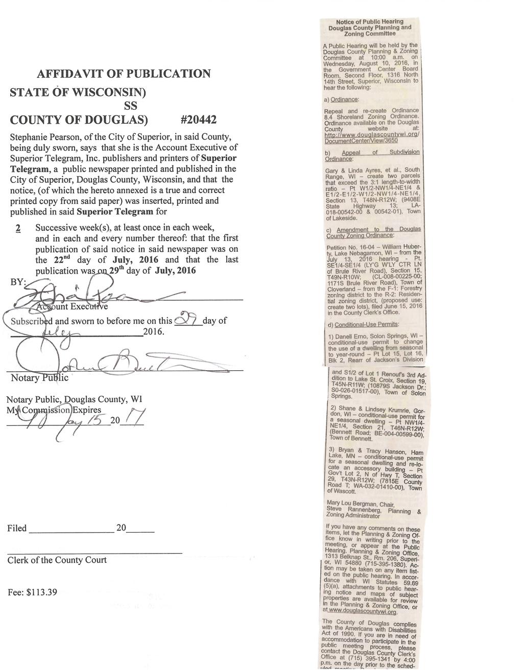
1 AGENDA FOR THE DOUGLAS COUNTY BOARD OF SUPERVISORS Thursday, August 18, 2016, 6:00 p.m., Board Room, Second Floor, Government Center 1316 North 14 th Street, Superior, Wisconsin (County Board to maintain a two-hour meeting limit or take action to continue meeting beyond that time.) Meeting called to order by Chairman Mark Liebaert. Pledge of Allegiance to be recited. Roll call taken by County Clerk Susan Sandvick. Approval of the June 16, 2016, meeting minutes. CLAIMS Summons and Complaint by Barry R. Donohoo, Pro Se Litigant, vs. Steven Rannenberg, Susan T. Sandvick, and Douglas County, requesting relief and damages relating to issuance of land use permit. Summons and Complaint by Attorney Mark R. Cummisford, on behalf of Wilmington Savings Fund Society, FSB, d/b/a/ Christiana Trust, not individually but as Trustee for Hilldale Trust, a Delaware Trust, naming Douglas County Clerk of Circuit Court as Defendant, regarding foreclosure of mortgage. CORRESPONDENCE 1. U.S. General Services Administration, notice of availability of Superior Harbor South Breakwater Light. (Receive and place on file.) 2. National Park Service, notice of National Park Service 2016 Centennial as related to St. Croix National Scenic Riverway. (Receive and place on file.) 3. DNR, notice of severance share assessment on wood products cut from Douglas County forest lands. (Refer to Forest, Parks and Recreation Committee.) 4. Public Service Commission, notice of Superior Water, Light and Power Company application for authority to increase electric and water rates, and decrease natural gas rate. (Receive and place on file.) 5. DNR, notice of application by Richard Pogorek, for private boat ramp permit on bed of Minong Flowage. (Receive and place on file.) 6. DNR, notice Douglas County Forestry Program Audit Report, (Refer to Forest, Parks and Recreation Committee.) DOUGLAS COUNTY MISSION STATEMENT The mission of Douglas County is to provide cost-effective services, with equal access to all citizens; to continue and enhance partnerships; to responsibly manage our resources and plan for the future.
2 PRESENTATION Update on Transportation Planning Projects Ron Chicka, Director, Metropolitan Interstate Council ORDINANCES Amendment to Ordinance #8.0, Zoning Ordinance, presented by the Zoning Committee. (Exhibit A-8-16) Repeal and Re-creation of Ordinance #8.4, Shoreland Zoning Ordinance, presented by the Zoning Committee. RESOLUTIONS #40-16: Resolution by the Land and Development Committee approving sale of property to Village of Oliver. #41-16: Resolution by the Land and Development Committee approving transfer of parcels to City of Superior. #42-16: Resolution by the Land and Development Committee approving repurchase requests for tax deeded properties, pursuant to Douglas County Ordinance #1.5. #43-16: Resolution by Supervisor Liebaert supporting July 13, 2016, Proclamation of State of Emergency pursuant to Sections and (4)(b) of Wisconsin Statutes. #44-16: Resolution by Supervisor Liebaert authorizing application for Community Development Block Grant funds to assist in housing, public facilities/infrastructure and business damages occurring as a result of State of Emergency Proclamation issued July 13, #45-16: Resolution by the Administration Committee authorizing county-wide referendum for November 8, 2016, election regarding Better City Initiative. #46-16: Resolution by Supervisor Pomush approving Parkland Tower lease. (Exhibit B-8-16) #47-16: Resolution by the Administration Committee approving Wisconsin Department of Administration request to terminate lease at Douglas County Highway Department. #48-16: Resolution by the Administration Committee approving budgetary transfers. COUNTY ADMINISTRATOR REPORT COUNTY BOARD CHAIR REPORT Certificates of Appreciation to County Board Youth Representatives Nathan Lindahl, Dustin Soyring, Joseph Stensland, Kara Schmidt
3 APPOINTMENTS: Douglas County Livestock Operations Study Group: Mary Lou Bergman (LCC) Chair, Jane Anklam, Nick Baker (Zoning), Christine Ostern, Steve Rannenberg, Pat Ryan (Zoning), Terry White (LCC), Carolyn Pierce Advisor; Sue Hendrickson, Alternate for LCC representatives COMMITTEE REPORTS YOUTH REPRESENTATIVE REPORT APPROVAL OF BILLS AND CLAIMS (on ipad paperless drive) FUTURE AGENDA ITEMS ADJOURNMENT: Next regularly scheduled meeting September 15, Submitted by, Susan T. Sandvick Douglas County Clerk NOTE: Attachments to agenda available in County Clerk's Office for viewing or copying, or on county's website Action may be taken on items on the agenda. The County of Douglas complies with the Americans with Disabilities Act of If you are in need of an accommodation to participate in the public meeting process, please contact the Douglas County Clerk's Office at (715) by 4:00 p.m. on the day prior to the scheduled meeting. Douglas County will attempt to accommodate any request depending on the amount of notice we receive. TDD (715) Posted: Courthouse, Government Center, Pamela A. Tafelski
4 Roll Call District Number Yes No 1. Pomush 2. White 3. Finn 4. Clark 5. Baker 6. Paine 7.Glazman 8. Robinson 9. Jaques 10. Quam 11. Finendale 12. Lear 13. Allen 14. Ryan 15. Hendrickson 16. Luostari 17. Liebaert 18. Corbin 19. Mock 20. Conley 21. Bergman Roll: Ayes _ Noes Absent Abstain AMENDMENT TO ORDINANCE #8.0 ZONING ORDINANCE PRESENTED BY THE ZONING COMMITTEE THE COUNTY BOARD OF SUPERVISORS OF THE COUNTY OF DOUGLAS DOES ORDAIN AS FOLLOWS: WHEREAS, the Douglas County Zoning Committee held a public hearing on August 10, 2016, on the following petition for amendment of the county zoning district ordinance map: Part of SE1/4-SE1/4 (LY G W LY CTR LN of Brule River Road), Section 15, T49N-R10W; (CL ; 1171S Brule River Road), Town of Cloverland, from the F- 1: Forestry zoning district to the R-2: Residential zoning district, by William Huberty, Lake Nebagamon, Wisconsin; referred from July 13, 2016 hearing. Intended use: Create two lots. WHEREAS, proof of publication of the notice of the public hearing, proof of giving notice to the town clerk of the hearing, and letter of Town Board approval, are as shown in Exhibit A NOW, THEREFORE, BE IT RESOLVED that the Douglas County Board of Supervisors accepts the recommendation of the Zoning Committee and approves the petition. BE IT FURTHER RESOLVED that the County Clerk notify the town clerk of this action. Dated this 18 th day of August, (Committee Action: Unanimous) (Fiscal Note: None) Passed Lost Refer Amend Other Rev. 04/19/16
5 EXHIBIT A-8-16 ORDINANCE #8.0 ZONING ORDINANCE Presented by Zoning Committee DOUGLAS COUNTY BOARD OF SUPERVISORS August 18, 2016

6
7
8
9
10
11
12
13 Roll Call District Number Yes No 1. Pomush 2. White 3. Finn 4. Clark 5. Baker 6. Paine 7.Glazman 8. Robinson 9. Jaques 10. Quam 11. Finendale 12. Lear 13. Allen 14. Ryan 15. Hendrickson 16. Luostari 17. Liebaert 18. Corbin 19. Mock 20. Conley 21. Bergman Roll: Ayes _ Noes Absent Abstain Passed Lost Refer Amend Other Rev. 04/19/16 REPEAL AND RE-CREATION OF ORDINANCE #8.4 SHORELAND ZONING ORDINANCE PRESENTED BY THE ZONING COMMITTEE THE COUNTY BOARD OF SUPERVISORS OF THE COUNTY OF DOUGLAS DOES ORDAIN AS FOLLOWS: That Ordinance #8.4, adopted October 3, 1985, of the Douglas County Code of Ordinances is hereby repealed and recreated as follows: 8.4 SHORELAND ZONING ORDINANCE THE COUNTY BOARD OF SUPERVISORS OF THE COUNTY OF DOUGLAS DOES ORDAIN AS FOLLOWS: SECTION I. STATUTORY AUTHORIZATION, FINDING OF FACT, STATEMENT OF PURPOSE, AND TITLE 1.1 Statutory Authorization This ordinance is adopted pursuant to the authorization in Sections 59.69, , and , , 87.30, and Wis. Stats Finding of Fact Uncontrolled use of the shorelands and pollution of the navigable waters of Douglas County would adversely affect the public health, safety, convenience, and general welfare and impair the tax base. The legislature of Wisconsin has delegated responsibility to the counties to further the maintenance of safe and healthful conditions; prevent and control water pollution; protect spawning grounds, fish and aquatic life; control building sites, placement of structures and land uses; and to preserve shore cover and natural beauty. This responsibility is hereby recognized by Douglas County, Wisconsin. 1.3 Purpose and Intent For the purpose of promoting the public health, safety, convenience and welfare, and promote and protect the public trust in navigable waters, this ordinance has been established to:
14 1.31 Further the maintenance of safe and healthful conditions and prevent and control water pollution through: (1) Limiting structures to those areas where soil and geological conditions will provide a safe foundation; (2) Establishing minimum lot sizes to provide adequate areas for private on-site waste treatment systems; (3) Controlling filling and grading to prevent soil erosion problems; and (4) Limiting impervious surfaces to control runoff which carries pollutants Protect spawning grounds, fish and aquatic life through: (1) Preserving wetlands and other fish and aquatic habitat; (2) Regulating pollution sources; and (3) Controlling shoreline alterations, dredging and lagooning Control building sites, placement of structures and land uses through: (1) Prohibiting certain uses detrimental to the shoreland-wetlands; (2) Setting minimum lot sizes and widths; (3) Setting minimum building setbacks from waterways; and (4) Setting the maximum height of near-shore structures Preserve and restore shoreland vegetation and natural scenic beauty through: (1) Restricting the removal of natural shoreland cover; (2) Preventing shoreline encroachment by structures; (3) Controlling shoreland excavation and other earth moving activities; and (4) Regulating the use and placement of boathouses and other structures. 1.4 Title Shoreland Zoning Ordinance for Douglas County, Wisconsin.
15 SECTION II. GENERAL PROVISIONS 2.1 Areas to be Regulated Areas regulated by this ordinance shall include all the lands (referred to herein as shorelands) in the unincorporated areas of Douglas County which are: 2.11 Within one thousand (1,000) feet of the ordinary high water mark of navigable lakes, ponds or flowages. If the navigable water is a glacial pothole lake, this distance shall be measured from the high water mark of the lake. Lakes, ponds or flowage in Douglas County shall be presumed to be navigable if they are listed in the Wisconsin Department of Natural Resources publication FH-800, 2009 Wisconsin Lakes book available at the following website: or are shown on United States Geological Survey quadrangle maps or other zoning base maps Within three hundred (300) feet of the ordinary high water mark of navigable rivers or streams, or to the landward side of the floodplain, whichever distance is greater. Rivers and streams in Douglas County shall be presumed to be navigable if they are designated as perennial waterways or intermittent waterways on United States Geological Survey quadrangle maps (1:24,000). Flood hazard boundary maps, flood insurance rate maps, flood boundary-floodway maps, county soil survey maps or other existing county floodplain zoning maps shall be used to delineate floodplain areas The provisions of this chapter apply to regulation of the use and development of unincorporated shoreland areas unless specifically exempted by law, all cities, villages, towns, counties and, when s (13), Stats., applies, state agencies are required to comply with and obtain all necessary permits under, local shoreland ordinances. The construction, reconstruction, maintenance or repair of state highways and bridges carried out under the direction and supervision of the Wisconsin Department of Transportation is not subject to local shoreland zoning ordinances if s (1), Stats., applies. (NR ) Shoreland zoning requirements in annexed or incorporated areas are provided in s and s , Stats Determinations of navigability and ordinary high water mark location shall initially be made by the Zoning Administrator. When questions arise, the Zoning Administrator shall contact the appropriate office of the Department for a final determination of navigability or ordinary high water mark. The county may work with surveyors with regard to s (1h).
16 2.15 Under Section (2m), Wis. Stats., notwithstanding any other provision of law or administrative rule promulgated thereunder, this shoreland zoning ordinance does not apply to lands adjacent to farm drainage ditches if: (1) Such lands are not adjacent to a natural navigable stream or river; (2) Those parts of such drainage ditches adjacent to such lands were not navigable streams before ditching; and (3) Lands adjacent to artificially constructed drainage ditches, ponds or stormwater retention basins that are not hydrologically connected to a natural navigable water body. 2.2 Shoreland-Wetland Maps The maps designated below are hereby adopted and made part of this ordinance. They are on file in the office of the Zoning Administrator for Douglas County. (1) The most recent version of the Wisconsin Wetland Inventory, as depicted on the Department of Natural Resources Water Data Viewer is made part of this ordinance. The maps can be viewed at: (2) The most recent version of the Flood Insurance Rate Maps created by the Federal Emergency Management Agency (FEMA) including the appendix listed in Ordinance 8.3 (3) Douglas County Official Zoning Map dated December 10, 1970 and amendments. 2.3 Compliance The use of any land or water, the size, shape and placement of lots, the use, size, type and location of structures on lots, the installation and maintenance of water supply and waste disposal facilities, the filling, grading, lagooning, dredging of any lands, the cutting of shoreland vegetation, the subdivision of lots, shall be in full compliance with the terms of this ordinance and other applicable local, state or federal regulations. Buildings, signs and other structures shall require a permit unless otherwise expressly excluded by a provision of this ordinance. Property owners, builders and contractors are responsible for compliance with the terms of this ordinance. 2.4 Municipalities and State Agencies Regulated Unless specifically exempted by law, all cities, villages, towns, and counties are required to comply with this ordinance and obtain all necessary permits. State
17 agencies are required to comply when Section 13.48(13), Wis. Stats., applies. The construction, reconstruction, maintenance and repair of state highways and bridges by the Wisconsin Department of Transportation are exempt when Section (1), Wis Stats., applies. 2.5 Abrogation and Greater Restrictions The provisions of this ordinance supersede any provisions in a county zoning ordinance which solely relate to shorelands. In other words, if a zoning standard only applies to lands that lie within the shoreland and applies because the lands are in shoreland, then this ordinance supercedes those provisions. However, where an ordinance adopted under a statute other than Section Wis. Stats., does not solely relate to shorelands and is more restrictive than this ordinance, for example a floodplain ordinance, that ordinance shall continue in full force and effect to the extent of the greater restrictions, but not otherwise This ordinance shall not require approval or be subject to disapproval by any town or town board If an existing town ordinance relating to shorelands is more restrictive than this ordinance or any amendments thereto, the town ordinance continues in all respects to the extent of greater restrictions, but not otherwise This ordinance is not intended to repeal, abrogate or impair any existing deed restrictions, covenants or easements. However, where this ordinance imposes greater restrictions, the provisions of this ordinance shall prevail The more restrictive provisions of the Douglas County General Zoning Ordinance are hereby incorporated and made part of this ordinance and shall have the same force and effect as if fully numerated herein This ordinance may establish standards to regulate matters that are not regulated in NR 115, but that further the purposes of shoreland zoning as described in Section 1.3 of this ordinance. (s (1d)(b), Wis Stats.) 2.56 The provisions of Douglas County Zoning Ordinance 8.0 Section IV, Subsection 4.4 apply to the shoreland zone and are referenced herein. (s (1d)(b), Wis Stats.) 2.57 Douglas County does not establish or regulate any of the following in the shoreland district (s (1k)(a)1., Wis. Stats.): (1) Approval to install or maintain outdoor lighting in shorelands,
18 impose any fee or mitigation requirement to install or maintain outdoor lighting in shorelands, or otherwise prohibits or regulates outdoor lighting in shorelands if the lighting is designed or intended for residential use. (2) Requires any inspection or upgrade of a structure before the sale or other transfer of the structure may be made The construction and maintenance of a facility is considered to satisfy the requirements of a shoreland zoning ordinance if the department has issued all required permits or approvals authorizing the construction or maintenance under ch. 30, 31, 281 or 283. (s (7), Stats) 2.6 Interpretation In their interpretation and application, the provisions of this ordinance shall be held to be minimum requirements and shall be liberally construed in favor of the county and shall not be deemed a limitation or repeal of any other powers granted by Wisconsin Statutes. Where a provision of this ordinance is required by Statute and a standard in Wis. Adm. Code NR 115, and where the ordinance provision is unclear, the provision shall be interpreted in light of the Statute and NR 115 standards in effect on the date of the adoption of this ordinance or in effect on the date of the most recent text amendment to this ordinance. 2.7 Severability If any portion of this ordinance is adjudged unconstitutional or invalid by a court of competent jurisdiction, the remainder of this ordinance shall not be affected. SECTION III. LAND DIVISION REVIEW AND SANITARY REGULATIONS 3.1 Land Division Review The county shall review, pursuant to Section , Wis. Stats. and Douglas County Subdivision Ord 8.1, all land divisions in shoreland areas which create one or more parcels or building sites of less than 10 acres each within a 5-year period. In such review the following factors shall be considered: (1) Hazards to the health, safety or welfare of future residents; (2) Proper relationship to adjoining areas; (3) Public access to navigable waters, as required by law; (4) Adequate stormwater drainage facilities; and (5) Conformity to state law and administrative code provisions.
19 3.2 Limited Rezoning to Achieve Reduced Lot Sizes and Setbacks 3.21 Purpose In some instances where an individual lot or small tract of land has unique characteristics, such as unique terrain, which would result in unnecessary hardship as defined in Section 13.2, if the owner were required to comply with one or more of the requirements for minimum lot sizes, width and setback, the Zoning Committee may grant a variance. In other instances where larger areas are involved, the appropriate method for seeking a relaxation of the same minimum standards is by rezoning to establish a Planned Residential Unit Development overlay. The Planned Residential Unit Development is intended to permit smaller lots and setbacks where the physical layout of the lots is so arranged (often by setting them back farther from navigable water) as to better assure the control of pollution and preservation of ground cover than would be expected if the lots were developed with the normal lot sizes and setbacks and without special conditions placed upon the Planned Residential Unit Development at the time of its approval. A condition of all Planned Residential Unit Development is the preservation of certain open space, preferably on the shoreland, in perpetuity Requirements for Planned Residential Unit Development The County Board may at its discretion, upon its own motion or upon petition, approve a Planned Residential Unit Development, either by approving first an overlay district and then a plat or by approving only a plat for the specific planned residential project upon finding, after a public hearing, that all of the following facts exist: (1) Area. The area proposed for the Planned Residential Unit Development is at least 40 acres in size. (2) Pollution Control. The location and nature of the septic systems which will serve the home sites individually or collectively will assure that effluent from the septic systems will not reach the ground or surface waters in a condition which would contribute to health hazards, taste, odor, turbidity, fertility or impair the aesthetic character of navigable waters. (3) Preservation of Ground Cover. The location of home sites and the dedication of part of the land for the use by the public or residents of the Planned Residential Unit Development will preserve the ground cover of the shoreland and scenic beauty of the navigable water, prevent erosion, and other pertinent factors. Land not used for lots and streets shall be dedicated in perpetuity to remain in open space. This may be accomplished by conveyance in common to each of the owners of lots in the development or to a corporation
20 formed by them, or by dedication to the county, town or municipality. Lands dedicated to the public must be accepted by action of the governing body of the accepting unit of government. If the land is to be conveyed to owners of lots in the development, a homeowner's association or similar legally constituted body shall be created to maintain the open space land. Any restriction placed on platted land by covenant, grant of easement or any other manner which was required by a public body or which names a public body as grantee, promisee or beneficiary, shall vest in the public body the right to enforce the restriction at law or in equity against anyone who has or acquires an interest in the land subject to the restriction. (4) Density. The number of platted home sites shall not exceed those which would have been possible if the same land were platted in accordance with the minimum lot sizes, setbacks and widths provided by the applicable provisions of the zoning ordinance. This figure shall be determined by dividing the total area of the subdivision, excluding streets, by the minimum lot size required by Section 4.0 of this ordinance. (5) Lot Sizes, Widths, Setbacks, and Tree-cutting. The lot sizes, widths, and setbacks shall not be less than those provided for in current statutes, Wis. Adm. Codes or ordinances, and shall not be so small as to cause pollution or erosion along streets or other public ways and waterways or so small as to substantially depreciate the property values in the immediate neighborhood Procedure for Establishing a Planned Residential Unit Development District The procedure for establishing limited rezoning in the form of a Planned Residential Unit Development district shall be as follows: (1) Petition. A petition setting forth all of the facts required in Section 3.22 shall be submitted to the County Clerk with sufficient copies to provide for distribution by the Clerk as required by Section 3.23(2). (2) Review and Hearing. The petition shall be submitted to the county zoning agency established as required by Sections and , Wis. Stats., which shall hold a public hearing and report to the County Board as required by law. Copies of the petition and notice of the hearing shall also be sent to the appropriate office of the Department as described in Section 11.2 of this ordinance. The county zoning agency's report to the County Board shall reflect the recommendations of any federal, state or local agency with which the county zoning agency consults. If a petition seeks approval of a
21 Planned Residential Unit Development plat without first seeking the granting of an overlay district, a hearing shall be held on such plat as in any regular amendment to the zoning ordinance. If, however, a hearing is first held on the overlay for a Planned Residential Unit Development district, a second public hearing need not be held in connection with the approval of a subsequent plat or plats which comply with the overlay district as approved. (3) Findings and Conditions of Approval. The County Board shall make written findings as to the compliance or noncompliance of the proposed overlay district with each of the applicable requirements set forth in Section If the petition is granted in whole or part, the County Board shall attach such written conditions to the approval as are required by and consistent with Section The conditions of approval shall in all cases establish the specific restrictions applicable with regard to minimum lot sizes, width, setbacks and the location of septic systems and the preservation of ground cover and open space. (4) Planning Studies. A landowner or petitioner may at his own expense develop the facts required to establish compliance with the provisions of Section 3.22 or may be required to contribute funds to the county to defray all or part of the contribute funds to the county to defray all or part of the cost of such studies being undertaken by the county or any agency or person with whom the county contracts for such work. 3.3 Sanitary Regulations The county shall adopt sanitary regulations for the protection of health and the preservation and enhancement of water quality. (1) Where public water supply systems are not available, private well construction shall be required to conform to Wis. Adm. Code NR Ch (2) Where a public sewage collection and treatment system is not available, design and construction of private sewage disposal systems shall be governed by a private sewage system ordinance adopted by the county under Section 59.70(5), Wis. Stats. and required to comply with Wis. Admin. Code SPS 383. SECTION IV. DIMENSIONS OF BUILDING SITES 4.1 Purpose: Minimum lot sizes in the shoreland area shall be established to afford protection against danger to health, safety and welfare and protection against pollution of the adjacent body of water.
22 4.2 Lot Sizes 4.21 Minimum Area and Width. The lot area and lot width for shoreline lots shall comply with the Zoning Schedule Dimensional Requirements found herein Sewered and Unsewered Lots. Lot sizes shall comply with the Zoning Schedule Dimensional Requirements found herein. 4.3 Substandard Lots 4.31 After adoption of this ordinance, no lot areas shall be so reduced that the dimensional and yard requirements required by this ordinance cannot be met. Lots existing and of record prior to adoption of this ordinance, but of substandard size, may be devoted to uses permitted in the district in which located if such use can be accomplished in compliance with the lot and building dimensional schedule of this ordinance If two or more substandard lots with continuous frontage have the same ownership as of the effective date of this ordinance, the lots involved shall be considered to be one parcel for the purposes of this ordinance Lots created after adoption of this ordinance and which are not served by public sewer systems shall meet the minimum area requirements of the Douglas County Sanitary Code and the Douglas County Zoning Ordinance Other substandard lots. Except for lots which meet the requirements of Sections 4.31, 4.32, or 4.33, a building permit for the improvement of a lot having lesser dimensions than those stated in Sections 4.1 and 4.2 shall be issued only after granting of a variance by the Board of Adjustment. 4.4 Lots in Cluster Subdivisions Lots in cluster subdivisions not served by public sanitary sewers may be reduced to the minimum allowed by the county private sewage system ordinance pursuant to the procedures set forth in Section 3.2 of this ordinance. SECTION V. SETBACKS FROM THE WATER 5.1 Lots that Abut on Navigable Waters (NR (1)(b)) Permitted building setbacks shall be established to conform to health, safety and welfare requirements, preserve natural beauty, reduce flood hazards and avoid water pollution. All buildings and structures, except exempt structures, shall be set back at least 75 feet from the ordinary high water mark of navigable waters. 5.2 Structures Exempt from the Minimum Setback in 5.1 in accordance with Wisconsin Statutes (1v) and WI Administrative Code NR (1)(b)(1m)
23 5.21 Boathouses. (1) Boathouses shall be designed and constructed solely for the storage of boats and related equipment and shall not be used for human habitation and may not be plumbed. (2) Boathouses shall be set back a minimum of 2 feet and no greater than 20 feet from the ordinary high water mark and shall be constructed in conformity with local floodplain zoning standards. Boathouses shall be located within the viewing and access corridor. (3) One boathouse is permitted on a lot as an accessory building. (4) Boathouses shall not exceed one story and 250 square feet in floor area. (5) Existing exempt structures that were legally constructed may be maintained, repaired, replaced, restored, rebuilt and remodeled provided the activity does not expand the footprint and does not go beyond the three-dimensional building envelope of the existing structure. (6) The roof of a boathouse may be used as a deck provided that: (a) (b) (c) the boathouse has a flat roof the roof has no side walls or screens the roof may have a railing that meets the Department of Safety and Professional Services standards Open-sided or screened structures referred to as minor structures within shoreland setback area (gazebo law). (1) The part of the structure that is nearest to the water is located at least 35 feet landward from the ordinary high water mark. (2) The floor area of all the structures in the shoreland setback area will not exceed 200 square feet. (3) The structure that is the subject of the request for special zoning permission has no sides or has open or screened sides. (4) The county must approve a plan that will be implemented by the owner of the property to preserve or establish a vegetative buffer zone that covers at least 70% of the half of the shoreland setback area that is nearest to the water.
24 5.23 Stairways, walkways and lifts that are necessary to provide pedestrian access to the shoreline and are a maximum of 60 inches in width Broadcast signal receivers, including satellite dishes or antennas that are one meter or less in diameter, and satellite earth station antennas that are two meters or less in diameter Utility transmission and distribution lines, poles, towers, water towers, pumping stations, well pumphouse covers, private on-site wastewater treatment systems that comply with Wis. Admin. Code SPS 383, and other utility structures that have no feasible alternative location outside of the minimum setback and that employ best management practices to infiltrate or otherwise control storm water runoff from the structure Devices or systems used to treat runoff from impervious surfaces. 5.3 Reduced Principal Structure Setbacks 5.31 A setback less than the 75 required setback from the ordinary high water mark shall be permitted for a proposed principal structure and shall be determined as follows: (1) Where there are existing principal structures in both directions, the setback shall equal the average of the distances the two existing principal structures are set back from the ordinary high water mark provided all of the following are met: (a) (b) (c) Both of the existing principal structures are located on adjacent lot to the proposed principal structure. Both of the existing principal structures are located within 250 of the proposed principal structure. Both of the existing principal structures are located less than 75 from the ordinary high water mark. (d) The average setback shall not be reduced to less than 35 from the ordinary high water mark of any navigable water. (2) Where there is an existing principal structure in only one direction, the setback shall equal the average of the distance the existing principal structure is set back from the ordinary high water mark and the required setback of 75 from the ordinary high water mark provided all of the following are met: (a) The existing principal structure is located on adjacent lot to the proposed principal structure.
25 (b) The existing principal structure is located within 250 of the proposed principal structure. (c) The existing principal structure is located less than 75 from the ordinary high water mark. (d) The average setback shall not be reduced to less than 35 from the ordinary high water mark of any navigable water Setback reductions may also be permitted by the Board of Adjustment pursuant to Section 10.5 of this ordinance. 5.4 Increased Principal Structure Setbacks A setback greater than the required 75 from the ordinary high water mark shall be required for a proposed principal structure and determined as follows: (1) Where there are existing principal structures in both directions, the setback shall equal the average of the distances the two existing principal structures are set back from the ordinary high water mark provided all of the following are met: (a) (b) Both of the existing principal structures are located on adjacent lot to the proposed principal structure. Both of the existing principal structures are located within 200 of the proposed principal structure. (c) Both of the existing principal structures are located greater than 75 from the ordinary high water mark. (d) (e) Both of the existing principal structures were required to be located at a setback greater than 75 from the ordinary high water mark. The increased setback does not apply if the resulting setback limits the placement to an area on which the structure cannot be built. 5.5 Floodplain Structures Buildings or structures to be constructed or placed in a floodplain shall be required to comply with Douglas County Floodplain Ordinance 8.3. Legal preexisting structures within the floodplain may not be replaced, modified or additions constructed that do not comply with Section WI Stats and WI Admin Code NR 116.
26 SECTION VI. REMOVAL OF SHORE COVER 6.1 Shoreline Cutting (NR (1)(c)1.) To protect natural scenic beauty, fish and wildlife habitat, and water quality, a county shall regulate removal of vegetation in shoreland areas, consistent with the following: The county shall establish ordinance standards that consider sound forestry and soil conservation practices and the effect of vegetation removal on water quality, including soil erosion, and the flow of effluents, sediments and nutrients. Tree and shrubbery cutting in an area parallel to the ordinary high water mark, and extending 35 feet inland from all points along the ordinary high water mark, shall be limited in accordance with the following provisions: 6.11 Removal of trees and shrubs in the vegetative buffer zone to create access and viewing corridors is allowed. Per s (1f)(b), Stats., the viewing corridor may be at least 35 feet wide for every 100 feet of shoreline frontage. The viewing corridors may run contiguously for the entire maximum width of the shoreline frontage owned Natural shrubbery shall be preserved as far as practicable and, where removed, it shall be replaced with other vegetation that is equally effective in retarding runoff, preventing erosion and preserving natural beauty. 6.2 Paths Any path, road or passage within the access and viewing corridor shall be constructed and surfaced so as to effectively control erosion. 6.3 Cutting Plan As an alternative to Section 6.11, a special cutting plan allowing greater cutting may be permitted by the County Zoning Committee by issuance of a conditionaluse permit, pursuant to Section An application for such a permit shall include a sketch of the lot providing the following information: location of parking, topography of the land, existing vegetation, proposed cutting, and proposed replanting. The Committee may grant such a permit only if it finds that such special cutting plans: 6.31 Will not cause undue erosion or destruction of scenic beauty, and 6.32 Will provide substantial visual screening from the water of dwellings, accessory structures and parking areas. Where the plan calls for replacement planting, the Committee may require the submission of a bond which guarantees the performance of the planned tree or shrubbery replacement by the lot owner. 6.4 Cutting More Than 35 Feet Inland From the inland edge of the 35-foot area to the outer limits of the shoreland, the
27 cutting of trees and shrubbery shall be allowed when accomplished using accepted forest management and soil conservation practices which protect water quality. SECTION VII. FILLING, GRADING, LAGOONING, DREDGING, DITCHING, AND EXCAVATING 7.1 General Standards Filling, grading, lagooning, dredging, ditching or excavating which does not require a permit under Section 7.2 may be permitted in the shoreland area provided that: 7.11 It is done in a manner designed to minimize erosion, sedimentation and impairment of fish and wildlife habitat Filling, grading, lagooning, dredging or excavating in a shorelandwetland district meets the requirements of Section 8.13 of this ordinance All applicable federal, state and local authority is obtained in addition to a permit under this ordinance Any fill placed in the shoreland area is protected against erosion by the use of rip-rap, vegetative cover or a bulkhead. 7.2 Permit Required Except as provided in Section 7.3 a zoning permit is required: 7.21 For any filling or grading of any area which is within 300 feet landward of the ordinary high water mark of navigable water and which has surface drainage toward the water and on which there is either: (1) Any filling or grading on slopes of more than 20%; (2) Filling or grading of more than 2,500 sq. ft. in addition to the minimum necessary for the construction of the principal building and the installation of on-site waste treatment systems on slopes of 12%-20%; or (3) Filling or grading of more than 5,000 sq. ft. in addition to the minimum necessary for the construction of the principal building and the installation of on-site waste treatment systems on slopes of 0%-12% For any construction or dredging commenced on any artificial waterway, canal, ditch, lagoon, pond, lake or similar waterway which is within 300 feet landward of the ordinary high water mark of a navigable
28 body of water or where the purpose is the ultimate connection with a navigable body of water. 7.3 Soil Conservation Practices Soil conservation practices such as terraces, runoff diversions and grassed waterways which are used for erosion control shall not require a permit under Section 7.2 when designed and constructed to Natural Resources Conservation Service technical standards. 7.4 Permit Conditions In granting a zoning permit under Section 7.2, the County Zoning Administrator shall attach the following conditions, where appropriate: 7.41 The smallest amount of bare ground shall be exposed for as short a time as feasible Temporary ground cover (such as mulch or jute netting) shall be used and permanent vegetative cover shall be established Diversion berms or bales, silting basins, terraces, filter fabric fencing, and other methods shall be used to prevent erosion Lagoons shall be constructed to avoid fish trap conditions Fill shall be stabilized according to accepted engineering standards Filling shall comply with any local floodplain zoning ordinance and shall not restrict a floodway or destroy the flood storage capacity of a floodplain Channels or artificial watercourses shall be constructed with side slopes of two (2) units horizontal distance to one (1) unit vertical or flatter which shall be promptly vegetated, unless bulkheads or rip-rap are provided. 7.5 Impervious Surface Standards 7.51 Purpose Establish impervious surface standards to protect water quality and fish and wildlife habitat and to protect against pollution of navigable waters. County impervious surface standards shall apply to the construction, reconstruction, expansion, replacement or relocation of any impervious surface on a riparian lot or parcel and any non-riparian lot or parcel that is located entirely within 300 feet of the ordinary high water mark of any navigable waterway Calculations of Percentage of Impervious Surface (Wis. Adm. Code NR (1)(e)) Percentage of impervious surface shall be calculated by dividing the surface area of the existing and proposed impervious surfaces on the portion of a lot or parcel that is within 300 feet of the ordinary high
29 water mark by the total surface area of that lot or parcel, and multiplied by 100. Impervious surfaces described in 7.55 shall be excluded from the calculation of impervious surface on the lot or parcel. If an outlot lies between the ordinary high water mark and the developable lot or parcel and both are in common ownership, the lot or parcel and the outlot shall be considered one lot or parcel for the purposes of calculating the percentage of impervious surface General Impervious Surface Standard (NR (1)(e)2.) Up to 15% impervious surface is allowed on the portion of a lot or parcel that is within 300 feet of the ordinary high water mark Maximum Impervious Surface (NR (1)(e)3.) A property may exceed the impervious surface standard under 7.53 provided the following standards are met: (1) For properties where the general impervious surface standard applies under Section 7.53 a property owner may have more than 15% impervious surface but not more than 30% impervious surface on the portion of a lot or parcel that is within 300 feet of the ordinary high water mark. (2) For properties that exceed the standard under 7.53 but do not exceed the maximum standard under 7.54(1), a permit can be issued for development with a mitigation plan that meets the standards found in Section Excluded Impervious Surfaces (NR (1)(e) and s (1k)(a)1.e.) Impervious surfaces that can be documented to show they meet either of the following standards shall be excluded from the impervious surface calculations under 7.52: (1) The impervious surface is treated by devices such as stormwater ponds, constructed wetlands, infiltration basins, rain gardens, bioswales or other engineered systems. (2) The runoff from the impervious surface discharges to an internally drained pervious area that retains the runoff on or off the parcel and allows infiltration into the soil Existing Impervious Surfaces (NR (1)(e)4.) For existing impervious surfaces that were lawfully placed when constructed but that do not comply with the impervious surface standard in Section 7.53 or the maximum impervious surface standard in Section 7.54, the property owner may do any of the following: (1) Maintain and repair the existing impervious surfaces.
30 (2) Replace existing impervious surfaces with similar surfaces within the existing building envelope. (3) Relocate or modify an existing impervious surface with similar or different impervious surface, provided that the relocation or modification does not result in an increase in the percentage of impervious surface that existed on the effective date of the county shoreland ordinance, and the impervious surface meets the applicable setback requirements in s. Wis Admin. Code NR (1)(b). SECTION VIII. SHORELAND-WETLAND OVERLAY DISTRICTS 8.1 Designation This district shall include all shorelands within the jurisdiction of this ordinance which are designated as wetlands on the most recent version of the Wisconsin Wetland Inventory as depicted on the Department of Natural Resources Surface Water Data Viewer Locating Shoreland-Wetland Boundaries Where an apparent discrepancy exists between the shoreland-wetland district boundary shown on the Wisconsin Wetland Inventory maps and actual field conditions, the Zoning Administrator shall contact the Department to determine if the map is in error. If Department staff concur with the Zoning Administrator that a particular area was incorrectly mapped as a wetland or meets the wetland definition but was not shown as wetland on the map, the Zoning Administrator shall have the authority to immediately grant or deny a zoning permit in accordance with the regulations applicable to the correct zoning district. In order to correct wetland mapping errors on the official zoning map, an official zoning map amendment must be initiated within a reasonable period of time Purpose This district is created to maintain safe and healthful conditions, to prevent water pollution, to protect fish spawning grounds and wildlife habitat, to preserve shore cover and natural beauty and to control building and development in wetlands whenever possible. When development is permitted in a wetland, the development should occur in a manner that minimizes adverse impacts upon the wetland Permitted Uses The following uses shall be allowed, subject to general shoreland zoning regulations contained in this ordinance, the provisions of Chs. 30 and 31 and , Wis. Stats. and the provisions of other applicable local, state and federal laws:
31 (1) Activities and uses which do not require the issuance of a zoning permit, but which must be carried out without any filling, flooding, dredging, ditching, tiling or excavating as allowed under Section 8.13(2) or 8.13(3): (a) Hiking, fishing, trapping, hunting, swimming, and boating; (b) The harvesting of wild crops, such as marsh hay, ferns, moss, wild rice, berries, tree fruits, and tree seeds, in a manner that is not injurious to the natural reproduction of such crops; (c) The pasturing of livestock; (d) The cultivation of agricultural crops; (e) The practice of silviculture, including the planting, thinning, and harvesting of timber; and (f) The construction or maintenance of duck blinds. (2) Uses which do not require the issuance of a zoning permit and which may include limited filling, flooding, draining, dredging, ditching, tiling, or excavating but only to the extent specifically provided below: (a) Temporary water level stabilization measures necessary to alleviate abnormally wet or dry conditions that would have an adverse impact on silvicultural activities if not corrected; (b) The cultivation of cranberries including flooding, dike and dam construction or ditching necessary for the growth and harvesting of cranberries; (c) The maintenance and repair of existing agriculture drainage systems where permissible by Section 30.20, Wis. Stats., including ditching, tiling, dredging, excavating and filling necessary to maintain the level of drainage required to continue the existing agriculture use. This includes the minimum filling necessary for disposal of dredged spoil adjacent to the drainage system provided that the dredged spoil is placed on existing spoil banks where possible; (d) The construction or maintenance of fences for the pasturing of livestock, including excavating and filling necessary for such construction or maintenance; (e) The construction or maintenance of piers, docks, or walkways built on pilings, including limited excavating and filling necessary for such construction and maintenance; and (f) The maintenance, repair, replacement or reconstruction of existing town and county highways and bridges, including limited excavating and filling necessary for such maintenance, repair, replacement or reconstruction. (3) Uses which require the issuance of a zoning permit under Section
32 (b) (c) 10.2 and which may include limited filling, flooding, draining, dredging, ditching, tiling, or excavating, but only to the extent specifically provided below: (a) The construction and maintenance of roads which are necessary to conduct silvicultural activities or agriculture cultivation provided that: (i) (ii) The road cannot as a practical matter be located outside wetland; The road is designed and constructed to minimize adverse impact upon the natural functions of the wetland enumerated in Section 8.152; (iii) The road is designed and constructed with the minimum cross-sectional area practical to serve the intended use; and (iv) Road construction activities are carried out in the immediate area of the roadbed only. The construction or maintenance of nonresidential buildings provided that: (i) (ii) (iii) (iv) The building is essential for and used solely in conjunction with the raising of waterfowl, minnows or other wetland or aquatic animals; or some other use permitted in the shoreland-wetland district; The building cannot, as a practical matter, be located outside the wetland; Such building is not designed for human habitation and does not exceed 500 sq. ft. in floor area; and Only limited filling or excavating necessary to provide structural support for the building is authorized. The establishment of public and private parks and recreation areas, natural and outdoor education areas, historic and scientific areas, wildlife refuges, game bird and animal farms, fur animal farms, fish hatcheries and public boat launching ramps and attendant access roads, provided that: (i) (ii) Any private development is used exclusively for the permitted use and the applicant has received a permit or license under Ch. 29, Wis. Stats., where applicable; Filling or excavating necessary for the construction or maintenance of public boat launching ramps or attendant access roads is allowed only where such construction or maintenance meets criteria in Section 8.13(3)(a)-(c); and
33 (d) (iii) Ditching, excavating, dredging, or dike and dam construction in public and private parks and recreation areas, natural and outdoor education areas, historic and scientific areas, wildlife refuges, game bird and animal farms, fur animal farms, and fish hatcheries is allowed only for the purpose of improving wildlife habitat and to otherwise enhance wetland values. The construction or maintenance of electric, gas, telephone, water and sewer transmission and distribution facilities, by public utilities and cooperative associations organized for the purpose of producing or furnishing heat, light, power, or water to their members and the construction or maintenance of railroad lines provided that: (i) (ii) The transmission and distribution facilities and railroad lines cannot, as a practical matter, be located outside the wetland; and Such construction or maintenance is done in a manner designed to minimize adverse impact upon the natural functions of the wetland enumerated in Section 8.15(2) Prohibited Uses Any use not listed in Sections 8.13(1), 8.13(2), or 8.13(3) is prohibited, unless the wetland or portion of the wetland has been rezoned by amendment of this ordinance in accordance with Section 8.15 of this ordinance and Section 59.69(5)(e), Wis. Stats Rezoning of Lands in the Shoreland-Wetland District (1) For all proposed text and map amendments to the shorelandwetland provisions of this ordinance, the appropriate office of the Department shall be provided with the following: (a) (b) (c) A copy of every petition for a text or map amendment to the shoreland-wetland provisions of this ordinance, within 5 days of the filing of such petition with the County Clerk. Such petition shall include a copy of the Wisconsin Wetland Inventory map adopted as part of this ordinance describing any proposed rezoning of a shoreland-wetland; Written notice of the public hearing to be held on a proposed amendment at least 10 days prior to such hearing; A copy of the county zoning agency's findings and recommendations on each proposed amendment within 10 days after the submission of those findings and recommendations to the County Board; and
34 (d) Written notice of the County Board's decision on the proposed amendment within 10 days after it is issued. (2) A wetland, or portion thereof, in the shoreland-wetland district shall not be rezoned if the proposed rezoning may result in a significant adverse impact upon any of the following: (a) (b) (c) (d) (e) (f) (g) Storm and flood water storage capacity; Maintenance of dry season stream flow, the discharge of groundwater to a wetland, the recharge of groundwater from a wetland to another area, or the flow of groundwater through a wetland; Filtering or storage of sediments, nutrients, heavy metals or organic compounds that would otherwise drain into navigable waters; Shoreline protection against soil erosion; Fish spawning, breeding, nursery or feeding grounds; Wildlife habitat; or Wetlands both within the boundary of designated areas of special natural resource interest and those wetlands which are in proximity to or have a direct hydrologic connection to such designated areas as defined in NR which can be accessed at the following web site: (3) If the Department notifies the County Zoning Committee that proposed text or map amendment to the shoreland-wetland provisions of this ordinance may have a significant adverse impact upon any of the criteria listed in Section 8.15(2) of this ordinance, that amendment, if approved by the County Board, shall contain the following provision: "This amendment shall not take effect until more than 30 days have elapsed after written notice of the County Board's approval of this amendment is mailed to the Department of Natural Resources. During that 30-day period the Department of Natural Resources may notify the County Board that it will adopt a superseding shoreland ordinance for the county under Section (6), Wis. Stats. If the Department does so notify the County Board, the effect of this amendment shall be stayed until the Section (6), Wis. Stats., adoption procedure is completed or otherwise terminated."
35 SECTION IX. NONCONFORMING USES AND LEGAL PRE-EXISTING STRUCTURES 9.1 The lawful use of a building, structure or property which existed at the time this ordinance, or an applicable amendment to this ordinance, took effect and which is not in conformity with the provisions of this ordinance, including the routine maintenance of such a building or structure, may be continued, subject to the conditions of this ordinance. 9.2 Shoreland Nonconforming Uses 9.21 Compliance with legal pre-existing principal building provisions. Any shoreland building, structure, premises or fixture that constitutes a nonconforming use and is also a legal pre-existing principal building must adhere to the provisions set forth in subsection for nonconforming shoreland structures Prohibited Expansion. The alteration of, or addition to, or repair in excess of fifty percent (50%) of the assessed value of any existing building, premises, structure or fixture for the purpose of carrying on a nonconforming use is prohibited. (see Wis. Stats (10) (am)) 9.23 Exceptions to Prohibited Expansion. If the alteration, addition or repair of a legal pre-existing building or structure in the shoreland district with a nonconforming use is prohibited because it is for the purpose of carrying on a nonconforming use and is in excess of fifty percent (50%) of the assessed value of the existing building, premises, structure or fixture, the property owner may still make the proposed alteration, addition or repair if the property owner meets all provisions set forth in subsection 9.3 for legal pre-existing structures and: (1) The alteration, addition or repair is not for the purpose of carrying on a nonconforming use. (2) A nonconforming use is permanently changed to a conforming use. (3) The property owner appeals the determination of the Zoning Administrator and County Board of Adjustment or the Circuit Court finds in favor of the property owner under Secs (4) or (10), Wis. Stats. (4) The property owner successfully petitions to have the property rezoned by amendment of this Chapter and Sec (5)(e), W is. Stats Discontinuance. If a shoreland nonconforming use is discontinued for
36 twelve (12) consecutive months, any future use of the building, structure or property shall conform to this Chapter Temporary Structures. If the shoreland nonconforming use of a temporary structure is discontinued, such nonconforming use may not be recommenced Nuisances. Uses that are nuisances shall not be permitted to continue as nonconforming uses Burden of Proof: A property owner claiming a nonconforming use and exemption from applicable regulations shall prove by a preponderance of the evidence that: (1) The use was legally established; (2) The use predated zoning provisions with which it does not comply; (3) The use was active and actual prior to adoption of such provisions and not merely casual and occasional or incidental to the principal use of the property in which case no vested right to continue the use shall have been acquired. 9.3 Legal Pre-Existing Principal Structures and Buildings 9.31 Shoreland Setback. The minimum setback to the ordinary high water mark of any navigable water body to the nearest part of a building or structure shall apply Maintenance, Repair, Replacement or Vertical Expansion of Nonconforming Structures (s (1k)(a)1.b. and d.) An existing structure that was lawfully placed when constructed but that does not comply with the required shoreland setback: (1) May be maintained, repaired, replaced, restored, rebuilt or remodeled if the activity does not expand the footprint of the nonconforming structure. (2) May be vertically expanded unless the vertical expansion would extend more than 35 feet above grade level. (3) Special review and consideration will be given to situations where expansion of the structure beyond the existing footprint is necessary to comply with applicable state or federal requirements Legal Pre-existing Principal Structure Located Thirty-five (35) Feet or
37 More but Less than Seventy-five (75) Feet from the Ordinary High Water Mark. A legal pre-existing principal structure located thirty-five (35) or more feet, but less than seventy-five (75) feet, from the ordinary high water mark may be expanded laterally, provided that: (1) The resulting structure shall not exceed thirty-five (35) feet in height, as defined in ch. NR (1)(f), Wis. Adm Code. (2) Lateral expansion is limited to 200 square feet over the life of the structure. No portion of the expansion may be any closer to the ordinary high-water mark than the closest point of the existing principal structure. The property owner obtains a land use permit and fulfills the mitigation requirements of Subsection 9.4 by the date specified in the permit. (3) All other provisions of the Douglas County Shoreland Zoning Ordinance shall be met. (4) If use of the principal structure has been discontinued for a period of twelve (12) months or more, any further use of the structure shall conform to this chapter Expansion of a Nonconforming Principal Structure Beyond Setback (NR (1)(g)5m.). An existing principal structure that was lawfully placed when constructed but that does not comply with the required building setback under Section 5.1, may be expanded horizontally, landward or vertically provided that the expanded area meets the building setback requirements per Section 5.1 and that all other provisions of the shoreland ordinance are met. A mitigation plan is not required solely for expansion under this paragraph, but may be required per Section Relocation of Nonconforming Principal Structure (NR (1)(g)6.) An existing principal structure that was lawfully placed when constructed but that does not comply with the required building setback per Sections 5.1 and 5.3 may be relocated on the property provided all of the following requirements are met: (1) The use of the structure has not been discontinued for a period of twelve months or more if a nonconforming use. (2) The existing principal structure is at least 35 feet from the ordinary high-water mark.
38 (3) No portion of the relocated structure is located any closer to the ordinary high-water mark than the closest point of the existing principal structure. (4) The county determines that no other location is available on the property to build a principal structure with the same square-footage footprint to the structure proposed for relocation that will result in compliance with the shoreland setback requirement per Section 5.1. (5) The county shall issue a permit that requires a mitigation plan that shall be approved by the county and implemented by the property owner by the date specified in the permit. The mitigation plan shall meet the standards found in Section 9.4 to include enforceable obligations of the property owner to establish or maintain measures that the county determines are adequate to offset the impacts of the permitted expansion on water quality, near-shore aquatic habitat, upland wildlife habitat and natural scenic beauty. The mitigation measures shall be proportional to the amount and impacts of the replaced or relocated structure being permitted. The obligations of the property owner under the mitigation plan shall be evidenced by an instrument recorded in the office of the Douglas County Register of Deeds. (6) All other provisions of the shoreland ordinance shall be met Maintenance, Repair, Replacement or Vertical Expansion of Structures that were Authorized by Variance (s (1k)(a)2. and (a)4.). A structure of which any part has been authorized to be located within the shoreland setback area by a variance granted before July 15, 2015 may be maintained, repaired, replaced, restored, rebuilt or remodeled if the activity does not expand the footprint of the authorized structure. Additionally, the structure may be vertically expanded unless the vertical expansion would extend more than 35 feet above grade level. Counties may allow expansion of a structure beyond the existing footprint if the expansion is necessary to comply with applicable state or federal requirements. Shoreland mitigation measures are not required Compliance with Most Restrictive Zone Standards. Legal pre-existing principal structures, and buildings which are located in more than one minimum setback zone, shall comply with the standards of the more restrictive zone.
39 9.4 Mitigation Measures 9.41 Actions that trigger mitigation (1) Exceeding the maximum impervious surface area allowed (s. 7.54(2)) (2) Lateral expansion of a nonconforming principal structure (s. 9.33(2)) (3) Relocation of a nonconforming principal structure (9.35(5)) (4) Vegetative buffer required as mitigation under open-sided structure provision (s. 5.22(4)) 9.42 Required mitigation A site plan and implementation schedule describing any required mitigation shall be submitted by the property owner or their authorized agent and approved by the Zoning Department prior to issuing the related land use permit(s). Mandatory practices for mitigation shall include: (1) Evaluation and if needed upgrading of any existing sanitary system on the subject property to meet current Douglas County and DSPS regulations. (2) Implementation of standard erosion and storm water runoff control measures described in applicable sections of this ordinance Additional requirements: Shall accumulate at least two (2) points from among the following proposed or current practices: (1) Maintenance of an existing shoreland buffer area within 35 feet of the ordinary high water mark of Lakes and Rivers/Streams (2 points). (2) Restoration of the shoreland buffer area within 35 feet of the ordinary high water mark of Lakes and Rivers/Streams (2 points). (3) Restoration of native vegetation along both sideyards, minimum of 5 feet wide measured perpendicular to the lot line for the entire length of the lot (1/2 point). (4) Removal of legal pre-existing accessory buildings from within the shoreland setback area (1 point per building).
40 (5) Use of exterior building materials or treatments that are inconspicuous and blend with the natural setting of the site (1/2 point). (6) Removal of waterward improvements (seawalls, dockage, artificial sand beach etc. and / or restoration of emergent aquatic vegetation (1 point for each distinct removal / restoration effort). (7) Any other mitigation that is deemed appropriate by the Zoning Administrator may be used to meet the mitigation requirement of Section A Shoreland Mitigation/Preservation Affidavit shall be signed and recorded with the Register of Deeds prior to the issuance of a zoning permit Type of Shoreland Buffer The type of shoreland buffer restoration chosen under Section 9.42 or required under Section 5.22(4) will be determined by the Zoning Department and/or the Land Conservation Department. The buffer type shall be either woodland, prairie, or wetland. The woodland and prairie buffers shall comply with the standards set forth in Section 9.45 Table 1. Wetland buffers will also be permitted where deemed appropriate by the Zoning Department and/or the Land Conservation Department.
41 9.46 Table 1. Shoreland Buffer Planting Standards Woodland Buffer Prairie Buffer Layer Minimum number of species Density per 100 square feet Minimum number of species Density per 100 square feet Area Credits Tree Canopy Existing tree canopy edge viewing corridor Shrub Understory Groundcover Plant Plugs Existing shrub understory wet edge viewing corridor Existing well vegetated native ground cover Groundcover seeding 1 Varies 5 Varies Existing well vegetated native ground cover WI Biology Technical Note 1: Shoreland Habitat; Interim Standard # 643A Shoreland Habitat provides specific criteria for Shoreland Habitat establishment and for determining the dimensions of the practice (Section V). It identifies the necessary components of a Shoreland Habitat establishment plan (Section VII), and lists criteria for operation and maintenance of the practice (Section VIII) Type of Vegetation Recovery (1) Natural Recovery: Shoreland buffer areas that are suited for natural recovery will be allowed only after Zoning and /or County Land Conservation approval. (2) Accelerated (Planted) Recovery: Areas not suited to natural recovery will require plantings to establish native vegetation and must be planted. Areas such as lawns or eroded sites with no seed source will require plantings. Dense turf grass growths that have been maintained for several years will need to be removed and native plantings installed. Planted buffers must meet the required plant densities based on square footage of buffer area and the type of buffer (Table 1). Planting credits will be allowed for the viewing corridor, areas of existing native vegetation, and areas suited for natural recovery.
42 9.48 Douglas County Native Plant List Species of plants must be selected from the Douglas County Native Plant List and approved for shoreline buffers by the Land Conservationist. Substitutions must be approved by the Land Conservationist. Substitutions to the list will be allowed in the event of lack of plant stock or seed availability on a case-by-case basis. All plants may be transplanted from areas outside of the buffer zone Planting Densities Planting densities are based on the total area of the required buffer. Area credits calculated are subtracted from the total required density on an equal square footage of coverage basis. Trees must be at least 2 years old and greater than 1 foot tall to qualify as a credit or planting Shoreland Buffer Plan Requirements A shoreland restoration plan shall be completed for all required shoreland mitigation or preservations. Plans must be approved by the Land Conservationist and the Zoning Administrator. (1) Shoreland Buffer Restoration Site Plans must include: (a) Name and address of property owner (b) Property address and legal description (c) Extent of the shoreland buffer (d) Scale (e.g. 1 inch = 10 feet) (e) North arrow (f) Ordinary high water mark (OHWM) location (g) Location of all structures in the shoreland buffer zone (h) Viewing and access corridor (i) Boundary of the shoreland buffer zone (j) Existing trees, shrubs, and native ground cover (k) Areas to be planted with trees, shrubs, and groundcovers (l) Implementation schedule (m) A plant species list; indicate if you are requesting substitutions from the prepared list (n) Erosion control practices (to be installed prior to and during buffer establishment) (o) Water diversions and channelized flow areas (p) Buffer Maintenance (weeding, replanting) (2) Implementation Schedule: The approved Shoreland Buffer Restoration Site Plan must be started within one year from the issue date of applicable permit. All plantings and any other required activities in the Shoreland Buffer Restoration Site Plan must be completed within two years of the permit issue date.
43 SECTION X. ADMINISTRATIVE PROVISIONS 10.1 Zoning Administrator The Zoning Administrator shall have the following duties and powers: Develop and administer a system of permits for new construction, development, reconstruction, structural alteration or moving of buildings and structures. A permit application shall be required to be submitted to the Zoning Office Regular inspection of permitted work in progress to insure conformity of the finished structures with the terms of the ordinance A variance procedure which authorizes the board of adjustment to grant such variance from the terms of the ordinance as will not be contrary to the public interest where, owing to special conditions and the adoption of the shoreland zoning ordinance, a literal enforcement of the provisions of the ordinance will result in unnecessary hardship A special exception (conditional use) procedure under Section 10.3 herein The county shall keep a complete record of all proceedings before the board of adjustment, zoning agency and planning agency Written notice to the appropriate office of the Department at least 10 days prior to any hearing on a proposed variance, special exception or conditional use permit, appeal for a map or text interpretation, map or text amendment, and copies of all proposed land divisions submitted to the county for review under Ordinance Submission to the appropriate office of the Department, within 10 days after grant or denial any decision on a variance, special exception or conditional use permit, or appeal for a map or text interpretation, and any decision to amend a map or text of an ordinance Mapped zoning districts and the recording, on an official copy of such map, of all district boundary amendments The establishment of appropriate penalties for violations of various provisions of the ordinance, including forfeitures. Compliance with the ordinance shall be enforceable by the use of injunctions to prevent or abate a violation, as provided in WI Stats (11) The prosecution of violations of the shoreland ordinance.
44 10.2 Zoning Permits When Required: Except where another section of this ordinance specifically exempts certain types of development from this requirement a zoning permit shall be obtained from the Zoning Administrator before any new development, as defined in Section 13.2, or any change in the use of an existing building or structure, is initiated Application: An application for a zoning permit shall be made to the Zoning Administrator upon forms furnished by the county and shall include for the purpose of proper enforcement of these regulations, the following information: (1) Name and address of applicant and property owner; (2) Legal description of the property and type of proposed use; (3) A to-scale sketch of the dimensions of the lot and location of all existing and proposed structures and impervious surface calculations relative to the lot lines, center line of abutting highways and the ordinary high water mark of any abutting waterways; (4) Location and description of any existing private water supply or sewage system or notification of plans for any such installation; (5) Plans for appropriate mitigation (when required); (6) Payment of the appropriate fee; (7) Additional information required by the Zoning Administrator Expiration of Permit: Zoning permits shall expire 12 months from date issued if no substantial work has commenced Conditional-Use Permits Application for a Conditional-Use Permit: Any use listed as a conditionaluse in this ordinance shall be permitted only after an application has been submitted to the Zoning Administrator and a conditional-use permit has been granted by the County Zoning Committee Standards Applicable to All Conditional-Uses: In passing upon a conditional-use permit, the County Zoning Committee shall evaluate the effect of the proposed use upon: (1) The maintenance of safe and healthful conditions;
45 (2) The prevention and control of water pollution including sedimentation; (3) Compliance with local floodplain zoning ordinances and opportunity for damage to adjacent properties due to altered surface water drainage; (4) The erosion potential of the site based upon degree and direction of slope, soil type, and vegetative cover; (5) The location of the site with respect to existing or future access roads; (6) The need of the proposed use for a shoreland location; (7) Its compatibility with uses on adjacent land; (8) The amount of liquid and solid wastes to be generated and the adequacy of the proposed disposal systems; and (9) Location factors under which: (a) (b) (c) Domestic uses shall be generally preferred; Uses not inherently a source of pollution within an area shall be preferred over uses that are or may be a pollution source; and Use locations within an area tending to minimize the possibility of pollution shall be preferred over use locations tending to increase that possibility Use Conditions: Upon consideration of the factors listed above, the County Zoning Committee shall attach such conditions, in addition to those required elsewhere in this ordinance, as are necessary to further the purposes of this ordinance. Violations of any of these conditions shall be deemed a violation of this ordinance. Violations of any of these conditions may include specifications for, without limitation because of specific enumeration: type of shore cover; specific sewage disposal and water supply facilities; landscaping and planting screens; period of operation; operational control; sureties; deed restrictions; location of piers, docks, parking and signs; and type of construction. To secure information upon which to base its determination, the County Zoning Committee may require the applicant to furnish the following information: (1) A plan of the area showing surface contours, soil types, ordinary high water marks, ground water conditions, subsurface geology and vegetative cover.
46 (2) Location of buildings, parking areas, traffic access, driveways, walkways, piers, open space and landscaping. (3) Plans of building, sewage disposal facilities, water supply systems and arrangement operations. (4) Specifications for areas of proposed filling, grading, lagooning or dredging. (5) Other pertinent information necessary to determine if the proposed use meets the requirements of this ordinance. (6) Rationale for why the proposed conditional use meets all of the conditional use criteria listed in the ordinance Notice, Public Hearing and Decision: Before deciding upon an application for a conditional-use permit, the County Zoning Committee shall hold a public hearing. Notice of such public hearing, specifying time, place and matters to come before the Committee, shall be given a Class 2 notice under Ch. 985, Wis. Stats. Such notice shall be mailed to the appropriate office of the Department at least 10 days prior to the hearing. The Zoning Committee shall state in writing the grounds for granting or refusing a conditional-use permit Recording: When a conditional-use permit is approved, an appropriate record shall be made of the land use and structures permitted and such permit shall be applicable solely to the structures, use and property so described. A copy of any decisions on a conditional-use permit shall be mailed to the appropriate office of the Department within 10 days after it is granted or denied Revocation: Where the conditions of a conditional-use permit are violated, the conditional-use permit shall be revoked by the County Zoning Committee Variances The Board of Adjustment may grant upon appeal a variance from the dimensional standards of this ordinance where an applicant convincingly demonstrates that literal enforcement of the provisions of the ordinance will: (1) Result in unnecessary hardship on the applicant, (2) Due to special conditions unique to the property, and (3) That such variance is not contrary to the public interest.
47 10.41 Notice, Hearing and Decision: Before passing on an application for a variance, the Board of Adjustment shall hold a public hearing. Notice of such hearing specifying the time, place and matters of concern, shall be given a Class 2 notice under Ch. 985, Wis. Stats. Such notice shall be mailed to the appropriate district office of the Department at least 10 days prior to the hearing. The Board shall state in writing the reasons for granting or refusing a variance and shall mail a copy of such decision to the appropriate Department office within 10 days of the decision Board of Adjustment The Chairman of the County Board shall appoint a Board of Adjustment consisting of 5 voting and 2 alternate members under Section , Wis. Stats. The County Board shall adopt such rules for the conduct of the business of the Board of Adjustment as required by Section , Wis. Stats Powers and Duties (1) The Board of Adjustment shall adopt such additional rules as it deems necessary and may exercise all of the powers conferred on such boards by Section , Wis. Stats. (2) It shall hear and decide appeals where it is alleged there is error in any order, requirements, decisions or determination made by an administrative official in the enforcement or administration of this ordinance. (3) It may grant a variance from the dimensional standards of this ordinance pursuant to Section (4) In granting a variance, the Board may not impose conditions which are more restrictive than any of the specific standards in the ordinance. Where the ordinance is silent as to the extent of restriction, the Board may impose any reasonable permit conditions to affect the purpose of this ordinance Appeals to the Board: Appeals to the Board of Adjustment may be made by any person aggrieved or by an officer, department, board or bureau of the county affected by any decision of the Zoning Administrator or other administrative officer. Such appeal shall be made within a reasonable time, as provided by the rules of the Board, by filing with the officer whose decision is in question, and with the Board of Adjustment, a notice of appeal specifying the reasons for the appeal. The Zoning Administrator or other officer whose decision is in question shall promptly transmit to the Board all the papers constituting the record concerning the matter appealed Hearing Appeals and Applications for Variances
48 (1) The Board of Adjustment shall fix a reasonable time for hearing on the appeal or application. The Board shall give public notice thereof by publishing a Class 2 notice under Ch. 985, Wis. Stats., specifying the date, time and place of the hearing and the matters to come before the Board. Notice shall be given to the appropriate office of the Department at least 10 days prior to hearings on proposed shoreland variances and appeals for map or text interpretations. (2) A decision regarding the appeal or application shall be made as soon as practical. Copies of all decisions on shoreland variances and appeals for map or text interpretations shall be submitted to the appropriate office of the Department within 10 days after they are granted or denied. (3) The final disposition of an appeal or application to the Board of Adjustment shall be in the form of written resolution or order signed by the chairman and secretary of the Board. Such resolution shall state the specific facts which are the basis of the Board's determination and shall either affirm, reverse, vary or modify the order, requirement, decision or determination appealed, in whole or in part, dismiss the appeal for lack of jurisdiction or prosecution or grant the application. (4) At the public hearing, any party may appear in person or by agent or by attorney Fees General: The County Board may, by resolution, adopt fees including, but not limited to, the following: (1) Land use permits; (2) Conditional-use permits; (3) Planned Residential Unit Development reviews; (4) Public hearings; (5) Legal notice publications; and (6) Variances and administrative appeals SECTION XI CHANGES AND AMENDMENTS The County may, from time to time, alter, supplement or change the boundaries of
49 use districts and the regulations contained in this ordinance in accordance with the requirements of Section and , Wis. Stats., and Wis. Adm. Code Ch NR 115, where applicable Amendments to this ordinance may be made on petition of any interested party as provided in Section 59.69(5), Wis. Stats Every petition for a text or map amendment filed with the County Clerk shall be referred to the County Zoning Committee. A copy of each petition shall be mailed to the appropriate district office of the Department within 5 days of the filing of the petition with the County Clerk. Written notice of the public hearing to be held on a proposed amendment shall be mailed to the appropriate office of the Department at least 10 days prior to the hearing A copy of the County Board's decision on each proposed amendment shall be forwarded to the appropriate office of the Department within 10 days after the decision is issued. SECTION XII. ENFORCEMENT AND PENALTIES Any development, any building or structure constructed, moved or structurally altered, or any use established after the effective date of this ordinance in violation of the provisions of this ordinance, by any person, firm, association, corporation (including building contractors or their agents) shall be deemed a violation. The Zoning Administrator or the county zoning agency shall refer violations to the District Attorney or Corporation Counsel who shall expeditiously prosecute violations. Any person, firm, association, or corporation who violates or refuses to comply with any of the provisions of this ordinance shall be subject to a forfeiture of not less than Fifty ($50.00) dollars nor more than Two Hundred ($200.00) dollars per offense, together with the taxable costs of action. Each day which the violation exists shall constitute a separate offense. Every violation of this ordinance is a public nuisance and the creation thereof may be enjoined and the maintenance thereof may be abated pursuant to Sections 59.69, 59.69(11) and , Wis. Stats. SECTION XIII. DEFINITIONS 13.1 For the purpose of administering and enforcing this ordinance, the terms or words used herein shall be interpreted as follows: Words used in the present tense include the future; words in the singular number include the plural number; and words in the plural number include the singular number. The word "shall" is mandatory, not permissive. All distances, unless otherwise specified, shall be measured horizontally The following terms used in this ordinance mean:
50 Access & Viewing Corridor a strip of vegetated land that allows safe pedestrian access to the shore through the vegetative buffer zone (NR (1d)) Accessory Construction construction, replacement, placement, or modification of, but not limited to, decks, porches (open or screened), and walkways Accessory Structure or Use a detached subordinate structure or a use which is clearly incidental to, and customarily found in connection with, the principal structure or use to which it is related, and which is located on the same lot as the principal structure or use. Accessory structures include, but are not limited to: detached garages, barns, gazebos, patios, decks, swimming pools, hot tubs, fences, retaining walls, driveways, parking lots, sidewalks, detached stairways and lifts. Boathouse any permanent structure designed solely for the purpose of protecting or storing boats and related equipment for noncommercial purposes Building Envelope is the three-dimensional space within which a structure is built (NR (1p)) Conditional Use a use which is permitted by this ordinance provided that certain conditions specified in the ordinance are met and that a permit is granted by the Planning and Zoning Committee County Zoning Agency that committee or commission created or designated by the County Board under Section 59.69(2), Wis. Stats., to act in all matters pertaining to county planning and zoning Department the Wisconsin Department of Natural Resources Development any man-made change to improve real estate, including but not limited to the construction of buildings, structures or accessory structures; the construction or additions or substantial alterations to buildings, structures or accessory structures, the placement of mobile homes, ditching, lagooning, dredging, filling, grading, paving, excavation or drilling operations, and the deposition or extraction of earthen materials Drainage System one or more artificial ditches, tile drains or similar devices which collect surface
51 runoff or groundwater and convey it to a point of discharge Existing Development Pattern when principal structures exist within 250 feet of a proposed principal structure in both directions along the shoreline (NR (3m)) Expansion any structural modification, which increases the existing structure envelope or footprint Exterior Improvement upgrades in aesthetics, function, or worth of the outside surface(s) or components of a structure. Such improvements may include, but are not limited to: structural alteration for the expansion or addition of doors, windows, replacement of basement/foundation walls and footings Facility any property or equipment of a public utility, as defined in s (5), or a cooperative association organized under ch. 185 for the purpose of producing or furnishing heat, light, or power to its members only, that is used for the transmission, delivery, or furnishing of natural gas, heat, light or power Floodplain the land which has been or may be hereafter covered by floodwater during a regional flood occurrence. The floodplain includes the floodway and flood fringe as those terms are defined in Wis. Adm. Code NR116.03(16) Footprint the land area covered by a structure at ground level measured on a horizontal plane. The footprint of a dwelling or building includes the horizontal plane bounded by the furthest exterior wall and eave (if present), projected to natural grade. For structures without walls (decks, stairways, patios, carports, etc) a single horizontal plane bounded by the furthest portion of the structure projected to natural grade. For the purposes of replacing or reconstructing a nonconforming building with walls, the footprint shall not be expanded by enclosing the area that is located within the horizontal plane from the exterior wall to the eaves or deck projected to natural grade. This would constitute lateral expansion under NR 115 and would need to follow NR (1)(g)5. Generally Accepted Forestry Management Practices forestry management practices that promote sound management of a forest (NR 1.25(2)(b)) as outlined in the most recent version of the department publication known as Wisconsin Forest Management Guidelines and identified as PUB FR- 226 Impervious Surface (NR (4g)) an area that releases as runoff all or a majority of the precipitation that falls on it. Excludes (among other things): frozen soil and decks that have at least a ¼ inch
52 space between deck boards with a pervious surface below. Includes (among other things): rooftops, sidewalks, driveways, parking lots, shingles, concrete, asphalt and streets (unless specifically designed, constructed, and maintained to be pervious). Roadways as defined in s (54) or sidewalks as defined in s (58) are not considered impervious surfaces. Interior Improvement upgrades in aesthetics, function, or worth of the interior surface(s) or components of a structure. Such improvements may include, but are not limited to: replacement or the addition of interior doors, cabinets, drywall, insulation, or plumbing, heating, and electrical system components. No land use permit is required for these activities. Legal Pre-Existing Structure a dwelling or other building, structure or accessory building that existed lawfully before the current zoning ordinance was enacted or amended, but that does not conform with one or more of the development regulations in the current zoning ordinance Lot a continuous parcel of land, not divided by a public right-of-way, and sufficient in size to meet the lot width and lot area provisions of this ordinance Lot Area the area of a horizontal plane bounded by the front, side and rear lot lines of a lot, but not including the area of any land below the ordinary high water mark of navigable waters Mitigation means balancing measures that are designed, implemented and function to restore natural functions and values that are otherwise lost through development and human activities (NR (4r)) Navigable Waters Lake Superior, Lake Michigan, all natural inland lakes within Wisconsin and all streams, ponds, sloughs, flowages and other waters within the territorial limits of this state, including the Wisconsin portion of boundary waters, which are navigable under the laws of this state (NR (5)). Under s (2)(d), Wis Stats, notwithstanding any other provision of law or administrative rule promulgated thereunder, shoreland ordinances required under s , Wis Stats, and ch. NR 115, Wis Adm Code, do not apply to lands adjacent to: (a) Farm drainage ditches where such lands are not adjacent to a natural navigable stream or river and such lands were not navigable streams before ditching; and
53 (b) Artificially constructed drainage ditches, ponds or stormwater retention basins that are not hydrologically connected to a natural navigable water body. Nonconforming Use a use of land, a dwelling, or a building that existed lawfully before the current zoning ordinance was enacted or amended, but that does not conform to the use restrictions in the current ordinance Ordinary High Water Mark the point on the bank or shore up to which the presence and action of surface water is so continuous as to leave a distinctive mark such as by erosion, destruction or prevention of terrestrial vegetation, predominance of aquatic vegetation or other easily recognized characteristics (NR (6)) Ordinary Maintenance and Repair ordinary and routine actions necessary to continue or restore the safe and healthy use of a structure which has been damaged or has deteriorated through natural aging and wear and which does not result in a substantial structure improvement or a significant increase in value. Such actions may include, but are not limited to: painting and staining, and the repair of the following; exterior windows, skylights, doors, vents, siding, insulation, shutters, gutters, flooring, shingles, roofing materials, walls or the foundation, and internal improvements within the structural envelope without doing a structural alteration Principal Building or Principal Structure a structure that is designed for independent human habitation and includes sanitary and/or food preparation facilities whether such structure is attached to another structure(s) or stands alone Regional Flood a flood determined to be representative of large floods known to have generally occurred in Wisconsin and which may be expected to occur on a particular stream because of like physical characteristics, once in every 100 years Renovation and Remodeling See Ordinary Maintenance and Repair Routine Maintenance of Vegetation normally accepted horticultural practices that do not result in the loss of any layer of existing vegetation and do not require earth disturbance (NR (7m)) Shoreland Setback (Area) an area in a shoreland that is within a certain distance of the ordinary high water mark in which the construction or placement of structures has been limited or prohibited under an ordinance enacted under section Wis Stats
54 Shoreland-Wetland District the zoning district, created as a part of this shoreland zoning ordinance, comprised of shorelands that are designated as wetlands on the wetland maps which have been adopted and made part of this ordinance Shorelands lands within the following distances from the ordinary high water mark of navigable waters: 1,000 feet from a lake, pond or flowage; and 300 feet from a river or stream or to the landward side of the floodplain whichever distance is greater Structural Alteration any activity not considered ordinary maintenance and repair that results in a change to the integral framework, or the exterior silhouette or footprint of a structure Structure a principal structure or any accessory structure including a garage, shed, boathouse, sidewalk, walkway, patio, deck, retaining wall, porch or firepit (s (1)(e) Wis Stats) Substandard Lot a legally created lot or parcel that met minimum area and minimum average width requirements when created, but does not meet current lot size requirements for a new lot Unnecessary Hardship those circumstances where special conditions, which were not self-created, affect a particular property and make strict conformity with restrictions governing area, setbacks, frontage, height or density unnecessarily burdensome or unreasonable in light of the purposes of this ordinance Variance an authorization granted by the Board of Adjustment to construct, alter or use a building or structure in a manner that deviates from the dimensional and use standards of this ordinance Wetlands those areas where water is at, near or above the land surface long enough to be capable of supporting aquatic or hydrophytic vegetation and which have soils indicative of wet conditions SECTION XIV. EFFECTIVE DATE This ordinance shall take effect immediately upon passage and publication. Dated this 18 th day of August, 2016.
55 ZONING SCHEDULE - DIMENSIONAL REQUIREMENTS 1 R-1 R-2 RR-1 A-1 C-1 I-1 F-1 Building Height Limit Required Lot Area (Acres or sq. ft.) With Public Sewer 10, acres 20, acres 10, acre 10 acres Without Public Sewer 15, acres 20, acres 20, acre 10 acres Minimum Lot Width 4 With Public Sewer Without Public Sewer Lotline Setbacks Required Front Side principal building accessory building Rear principal building accessory building Floor Area, Residence (sq. ft.) 3 or more bedrooms 1,000 1, , bedrooms bedroom Floor Area, Mobile Home (sq. ft.) 3 or more bedrooms bedrooms bedroom Not Allowed Not Allowed 1 Unless specified elsewhere in this ordinance or on the official zoning map, the dimensional requirements of this schedule shall apply to the respective listed districts. 2 Minimum for one-family dwellings; add 5,000 sq. ft. for each additional unit over one.
56 3 Plus additional area required by Wis. Admin. Code Ch. SPS No lot shall be created with a length to width ratio greater than three (3) to one (1). SETBACK REQUIREMENTS ON HIGHWAYS AND ROADS, AS STATED IN SECTION 4.2, DOUGLAS COUNTY ORDINANCE: The distance that is greater (measured from the centerline and from the right-of-way line), shall apply. (a) ALL STATE AND U.S. NUMBERED HIGHWAYS ft. from centerline or 66 ft. from rightof-way line. (b) ALL COUNTY TRUNK HIGHWAYS - 75 ft. from centerline or 42 ft. from right-of-way line. (c) ALL TOWN ROADS - 63 ft. from centerline or 30 ft. from right-of-way line. SETBACK REQUIREMENTS FOR LAKES AND STREAMS 75 ft. from the high water mark of lakes or streams
57 Roll Call District Number Yes No 1. Pomush 2. White 3. Finn 4. Clark 5. Baker 6. Paine 7.Glazman 8. Robinson 9. Jaques 10. Quam 11. Finendale RESOLUTION #40-16 RESOLUTION BY THE LAND AND DEVELOPMENT COMMITTEE Subject: Sale of Tax Deeded Property to Village of Oliver RESOLVED that the Douglas County Board of Supervisors accepts the recommendation of the Land and Development Committee and approves transfer of ownership of Parcel #OL (2047 E State Highway 105) to the Village of Oliver upon payment of real estate taxes in the amount of $1, Dated this 18 th day of August, (Committee Action: Unanimous) (Fiscal Note: None) 12. Lear 13. Allen 14. Ryan 15. Hendrickson 16. Luostari 17. Liebaert 18. Corbin 19. Mock 20. Conley 21. Bergman Roll: Ayes _ Noes Absent Abstain Passed Lost Refer Amend Other Rev. 04/19/16
58 Roll Call District Number Yes No 1. Pomush 2. White 3. Finn 4. Clark 5. Baker 6. Paine 7.Glazman 8. Robinson 9. Jaques 10. Quam 11. Finendale 12. Lear 13. Allen 14. Ryan 15. Hendrickson 16. Luostari 17. Liebaert 18. Corbin 19. Mock 20. Conley 21. Bergman RESOLUTION #41-16 RESOLUTION BY THE LAND AND DEVELOPMENT COMMITTEE Subject: Transfer of Tax Deeded Properties to City of Superior RESOLVED that the Douglas County Board of Supervisors accepts the recommendation of the Land and Development Committee and approves transfer of ownership to the City of Superior of the following described properties: (1) Parcel # (214 Main Street, Lot 9, Block 1, Hunters 2 nd Division of Connors Point, City of Superior) upon payment of delinquent real estate taxes in the amount of $1,281.64, for the purpose of adding it to Tax Increment District #8, Industrial Park, Redevelopment Authority of City of Superior; and (2) Parcel # (1117 Banks Avenue, Lots 8 and 9, Block 121, West Superior 1 st Division, City of Superior) at no cost (City of Superior has $57,000 invested through Community Development Block Grant Rehabilitation Program.) Dated this 18 th day of August, (Committee Action: Unanimous) (Fiscal Note: None) Roll: Ayes _ Noes Absent Abstain Passed Lost Refer Amend Other Rev. 04/19/16
59 Roll Call District Number Yes No 1. Pomush 2. White 3. Finn 4. Clark 5. Baker 6. Paine 7.Glazman 8. Robinson 9. Jaques 10. Quam 11. Finendale 12. Lear 13. Allen 14. Ryan 15. Hendrickson 16. Luostari 17. Liebaert 18. Corbin 19. Mock 20. Conley 21. Bergman Roll: Ayes _ Noes Absent Abstain RESOLUTION #42-16 RESOLUTION BY THE LAND AND DEVELOPMENT COMMITTEE Subject: Repurchase of Tax Delinquent Property RESOLVED that the Douglas County Board of Supervisors accepts the recommendation of the Land and Development Committee and approves the following requests to repurchase tax delinquent property, pursuant to Douglas County Ordinance #1.5: (1) From Karen Erickson, to repurchase Parcel # , Lots 9 and 10, Block 386, West Superior 17 th Division, City of Superior, having paid delinquent taxes and fees in the amount of $4,900.76; (2) From Miles L. Johnson, to repurchase Parcel #LN , Lot 1 of CSM #966 recorded in Volume 7 Page 65 located in Government Lot 1, Section , Village of Lake Nebagamon, having paid delinquent taxes and fees in the amount of $ ; and (3) From Stacey Miller, to repurchase Parcel # , Lot 27, Block 31, South Superior Labelle Division, City of Superior, having paid delinquent taxes and fees in the amount of $11, Dated this 18 th day of August, (Committee Action: Unanimous) (Fiscal Note: None) Passed Lost Refer Amend Other Rev. 04/19/16
60 Roll Call District Number Yes No 1. Pomush 2. White 3. Finn 4. Clark 5. Baker 6. Paine 7.Glazman 8. Robinson 9. Jaques 10. Quam 11. Finendale 12. Lear 13. Allen 14. Ryan 15. Hendrickson 16. Luostari 17. Liebaert 18. Corbin 19. Mock 20. Conley 21. Bergman Roll: Ayes _ Noes Absent Abstain Passed Lost Refer Amend Other RESOLUTION #43-16 RESOLUTION BY SUPERVISOR LIEBAERT Subject: Proclamation of State of Emergency July 13, 2016 WHEREAS, a disaster consisting of heavy rain and high winds, resulting in flood and wind damages commencing in the early morning hours of July 11, 2016, has struck the County of Douglas in Wisconsin, and WHEREAS, extensive damage was caused to public and private property, highway systems, and forested areas, and WHEREAS, due to the extensive damages and immediate risk of threat to people, property, and wildlife, said event created an emergency situation, and WHEREAS, because of such emergency conditions the Douglas County Board was unable to meet with promptness, and WHEREAS, County Board Chair Mark E. Liebaert declared a State of Emergency pursuant to Sections and (4)(b) of the Wisconsin Statutes, and WHEREAS, Section (4)(b) of the Wisconsin Statutes states such proclamation shall be subject to ratification, alteration, modification, or repeal by the governing body. NOW, THEREFORE, BE IT RESOLVED that the Douglas County Board of Supervisors ratify said Proclamation of a State of Emergency for Douglas County declared by Chair Mark E. Liebaert on the 13 th day of July, Dated this 18 th day of August, (Fiscal Note: None) Rev. 04/19/16
61 Roll Call District Number Yes No 1. Pomush 2. White 3. Finn 4. Clark 5. Baker 6. Paine 7.Glazman 8. Robinson 9. Jaques 10. Quam 11. Finendale 12. Lear 13. Allen 14. Ryan 15. Hendrickson 16. Luostari 17. Liebaert 18. Corbin 19. Mock 20. Conley 21. Bergman Roll: Ayes _ Noes Absent Abstain Passed Lost Refer Amend Other Rev. 04/19/16 RESOLUTION #44-16 RESOLUTION BY SUPERVISOR LIEBAERT Subject: CDBG-Emergency Assistance Program (CDBG-EAP) Cooperation Agreement Authorized WHEREAS, Douglas County has an identified Emergency Assistance need in the municipalities resulting from a natural disaster, and WHEREAS, Douglas County contemplates submitting jointly with the Counties of Ashland, Bayfield, Burnett, Iron, Price, Sawyer, and Washburn an application for funds under the Small Cities Community Development Block Grant - Emergency Assistance Program (CDBG-EAP) of the Wisconsin Division of Energy, Housing and Community Resources for the purpose of meeting those needs, and WHEREAS, Douglas County and the Counties of Ashland, Bayfield, Burnett, Iron, Price, Sawyer, and Washburn desire to and are required to enter into a written cooperative agreement with each other to participate in such CDBG-EAP program, and WHEREAS, Douglas County and the Counties of Ashland, Bayfield, Burnett, Iron, Price, Sawyer, and Washburn understand that Iron County will act as the applicant and will have the ultimate responsibility to assume all obligations under the terms of the grant including assuring compliance with all applicable laws and program regulations and performance of all work in accordance with the contract, and WHEREAS, it is understood that the Department of Housing and Urban Development and the Wisconsin Division of Energy, Housing and Community Resources will have access to all participants' grant records and authority to monitor all activities. NOW, THEREFORE, BE IT RESOLVED that pursuant to Wisconsin Statutes , Douglas County and the Counties of Ashland, Bayfield, Burnett, Iron, Price, Sawyer, and Washburn agree to cooperate in the submission of an application for such funds and agree to cooperate in the implementation of the submitted CDBG-EAP program as approved by the Department of Administration, and the Division of Energy, Housing and Community Resources.
62 Roll Call District Number Yes No 1. Pomush 2. White 3. Finn 4. Clark BE IT FURTHER RESOLVED that nothing contained in the agreement shall deprive any municipality of any power or zoning, development control or other lawful authority which it presently possesses. Dated this 18 th day of August, (Fiscal Note: None) 5. Baker 6. Paine 7.Glazman 8. Robinson 9. Jaques 10. Quam 11. Finendale 12. Lear 13. Allen 14. Ryan 15. Hendrickson 16. Luostari 17. Liebaert 18. Corbin 19. Mock 20. Conley 21. Bergman Roll: Ayes _ Noes Absent Abstain Passed Lost Refer Amend Other Rev. 04/19/16
63 Roll Call District Number Yes No 1. Pomush 2. White 3. Finn 4. Clark 5. Baker 6. Paine 7.Glazman 8. Robinson 9. Jaques 10. Quam 11. Finendale 12. Lear 13. Allen 14. Ryan 15. Hendrickson 16. Luostari RESOLUTION #45-16 RESOLUTION BY THE ADMINISTRATION COMMITTEE Subject: Better City Initiative Referendum Language for November 8, 2016, Ballot Authorized RESOLVED that the Douglas County Board of Supervisors accepts the recommendation of the Administration Committee and authorizes the following referendum language for inclusion on the November 8, 2016, county-wide ballot: Should the Wisconsin State Legislature pass legislation authorizing the Better City Initiative to further economic development in Douglas County by attracting new business, providing job opportunities for residents, reducing unemployment, growing business activity within the County, expanding the local tax base, encouraging tourism, and bringing needed capital into the County for the benefit and welfare of residents by implementing a Local Exposition District tax on tourist related items (hotel/motel room, food and beverage, rental car) for the purpose of acquiring and managing exposition center facilities and related Better City development? 17. Liebaert 18. Corbin 19. Mock 20. Conley 21. Bergman Yes Dated this 18 th day of August, (Committee Action: Unanimous) (Fiscal Note: None) No Roll: Ayes _ Noes Absent Abstain Passed Lost Refer Amend Other Rev. 04/19/16
64 Roll Call District Number Yes No 1. Pomush 2. White 3. Finn 4. Clark 5. Baker 6. Paine 7.Glazman 8. Robinson 9. Jaques 10. Quam RESOLUTION #46-16 RESOLUTION BY SUPERVISOR POMUSH Subject: Parkland Tower Lease between Douglas County and Verizon Wireless Approved RESOLVED that the Douglas County Board of Supervisors accepts the recommendation of Supervisor Pomush and approves Parkland Tower lease between Douglas County and Cellular Inc. Network Corporation (d/b/a Verizon Wireless) as set forth in Exhibit B Dated this 18 th day of August, (Fiscal Note: None) 11. Finendale 12. Lear 13. Allen 14. Ryan 15. Hendrickson 16. Luostari 17. Liebaert 18. Corbin 19. Mock 20. Conley 21. Bergman Roll: Ayes _ Noes Absent Abstain Passed Lost Refer Amend Other Rev. 04/19/16
65 EXHIBIT B-8-16 RESOLUTION #46-16 PARKLAND TOWER LEASE Presented by Supervisor Pomush DOUGLAS COUNTY BOARD OF SUPERVISORS August 18, 2016
66 Verizon Lease Summary for Parkland Tower Here is a quick summary of what this lease contains. The old tower needs to be removed to make way for future development at the Parkland Industrial Park. This agreement is cooperative agreement between Douglas County and Verizon to construct a new tower on the south west corner of the property out of the way of future development. Verizon will build the new tower at Parkland at no cost to Douglas County. Tower will be constructed with the capacity to hold a total of three cell carriers and all our public safety communications equipment and microwave. Verizon will deed the tower to Douglas County on the completion of construction. Verizon will have use of the tower for 114 months (9.5 years) at no charge, Rent Abatement. At the end of the 114 month Rent Abatement period Verizon will pay the county $2,200 per month ($26, per year) rent till the end of the 25 th year of this agreement Over the term of this agreement it will provide the county with approximately $409, in revenue in addition to the original construction cost estimated to be $250, which Verizon paid. Verizon and Douglas County will negotiate rent based on current market rates for year 26 and beyond. Verizon will pay their own utility expense. Their operation at the site will cost Douglas County nothing. After construction is completed and the tower is deeded over to Douglas County the county will be able to retain all rent from other users under the terms of this agreement. Douglas County will be responsible to move our Public Safety Communications Equipment and equipment shelter from the old site to the new tower site. $140,000 in capital project funds has been allocated for this project with the remainder of funding to come next year. Douglas County will have to work with AT&T to relocate their cellular equipment from the old tower to the new tower. AT&T built the current tower and deeded it to Douglas County in 1996 and has a rent abatement lease with us running through 2021 that we are required to honor. It is my belief we will be able to negotiate their move with them paying the cost by providing them an extension to their current rent abatement on the new tower.
67 DRAFTED BY AND RETURN TO: Moss & Barnett (AAD) 150 South Fifth Street, Suite 1200 Minneapolis, MN (Site Name: DULC Parkland) (Prepared by Cheryl S. Sheldon Telephone No. (612) Parcel Id. No Legal Description on Page 5 (Space above this line for Recorder s use.) MEMORANDUM OF TOWER LEASE AGREEMENT THIS MEMORANDUM OF TOWER LEASE AGREEMENT is made this day of, 20, between Douglas County, Wisconsin, a body corporate under the laws of the State of Wisconsin, with a mailing address of 1316 North 14 th Street, Suite 10, Superior, Wisconsin, hereinafter referred to as ( LESSOR ), and Cellular Inc. Network Corporation d/b/a Verizon Wireless, with its address for notice located at 180 Washington Valley Road, Bedminster, New Jersey 07921, hereinafter referred to as ( LESSEE ). LESSOR and LESSEE are at times collectively referred to hereinafter as the Parties or individually as the Party. 1. LESSOR and LESSEE entered into a Tower Lease Agreement (the Agreement ) on, 20, for an initial term of five (5) years, commencing on the Commencement Date. The Agreement shall automatically be extended for four (4) additional five (5) year terms unless LESSEE terminates it at the end of the then current term by giving LESSOR written notice of the intent to terminate at least six (6) months prior to the end of the then current term. If at the end of the fourth (4 th ) five (5) year extension term the Agreement has not been terminated by either Party by giving to the other written notice of an intention to terminate it at least three (3) months prior to the end of such term, the Agreement shall continue for a further term of five (5) years and for five (5) year terms thereafter until terminated by either Party by giving to the other DULC Parkland Memorandum of Tower Lease Agreement v1 1
68 written notice of its intention to so terminate at least three (3) months prior to the end of such term. 2. Pursuant to the Agreement, LESSOR leased to LESSEE a portion of that certain space ( the Tower Space ) on the LESSOR s tower, hereinafter referred to as the Tower, located near the intersection of County Road Z and Grand Avenue, near the City of South Range, County of Douglas, State of Wisconsin, as being further described in Exhibit A attached hereto and made a part hereof (the entirety of LESSOR s property is referred to hereinafter as the Property ), together with a parcel of land (the Land Space ) sufficient for the installation of LESSEE s equipment building; together with the non-exclusive right ( the Right of Way ) for ingress and egress, seven (7) days a week, twenty-four (24) hours a day, on foot or motor vehicle, including trucks, and for the installation and maintenance of utility wires, poles, cables, conduits, and pipes over, under, or along a right-of-way extending from the nearest public right-of-way, County Road Z, to the Land Space; and together with any further rights of way (the Further Rights of Way ) over and through the Property between the Land Space and the Tower Space for the installation and maintenance of utility wires, poles, cables, conduits, and pipes. 3. The Agreement shall commence on the first day of the month following the date that the construction of the tower is complete. 4. LESSEE has the right of first refusal to purchase the Premises during the initial term and all renewal terms of the Agreement. 5. The terms, covenants and provisions of the Agreement, the terms of which are hereby incorporated by reference into this Memorandum, shall extend to and be binding upon the respective executors, administrators, heirs, successors and assigns of LESSOR and LESSEE. Signatures on following page The remainder of this page intentionally left blank DULC Parkland Memorandum of Tower Lease Agreement v1 2
69 IN WITNESS WHEREOF, hereunto and to a duplicate hereof, LESSOR and LESSEE have caused this Memorandum to be duly executed on the date written herein below. LESSOR: Douglas County, Wisconsin, a body corporate under the laws of the State of Wisconsin By: Name: Its: Date: LESSEE: Cellular Inc. Network Corporation d/b/a Verizon Wireless By: Name: Its: Date: By: Name: Its: Date: Acknowledgments on following page The remainder of this page intentionally left blank DULC Parkland Memorandum of Tower Lease Agreement v1 3
70 STATE OF WISCONSIN ) ) ss. COUNTY OF ) ACKNOWLEDGMENTS LESSOR ACKNOWLEDGMENT On this day of, 20, before me, the undersigned, a Notary Public in and for the State of Wisconsin, duly commissioned and sworn, personally appeared and, to me known to be the and of Douglas County, a body corporate under the laws of the State of Wisconsin, that executed the foregoing instrument, and acknowledged said instrument to be the free and voluntary act and deed of Douglas County, for the uses and purposes therein mentioned, and on oath stated that they are authorized to execute the said instrument. IN WITNESS WHEREOF, I have hereunto set my hand and affixed my official seal the day and year first above written. STATE OF ) ) ss. COUNTY OF ) Print or Type Name: Notary Public in and for the State of My appointment expires: LESSEE ACKNOWLEDGMENT On this day of, 20, before me, the undersigned, a Notary Public in and for the State of, duly commissioned and sworn, personally appeared, to me known to be the of Cellular Inc. Network Corporation d/b/a Verizon Wireless, that executed the foregoing instrument, and acknowledged said instrument to be the free and voluntary act and deed of Cellular Inc. Network Corporation d/b/a Verizon Wireless, for the uses and purposes therein mentioned. IN WITNESS WHEREOF, I have hereunto set my hand and affixed my official seal the day and year first above written Print or Type Name: Notary Public in and for the State of My appointment expires: DULC Parkland Memorandum of Tower Lease Agreement v1 4
71 Exhibit A Legal Description The Southwest Quarter (SW 1/4) of the Southwest Quarter (SW 1/4) of Section Nine (9) in Township Forty Eight (48) of Range Thirteen (13). Douglas County, State of Wisconsin. DULC Parkland Memorandum of Tower Lease Agreement v1 5

72 SITE NAME: DULC Parkland SITE NUMBER: ATTY/DATE: 7/14/16 TOWER LEASE AGREEMENT This Agreement, made this day of, 20, between Douglas County, Wisconsin, a body corporate under the laws of the State of Wisconsin, with its principal offices located at 1316 North 14 th Street, Suite 10, Superior, Wisconsin 54880, hereinafter designated LESSOR, and Cellular Inc. Network Corporation d/b/a Verizon Wireless, with its principal offices at One Verizon Way, Mail Stop 4AW100, Basking Ridge, New Jersey (telephone number ), hereinafter designated LESSEE. The LESSOR and LESSEE are at times collectively referred to hereinafter as the Parties or individually as the Party. WITNESSETH In consideration of the mutual covenants contained herein and intending to be legally bound hereby, the Parties hereto agree as follows: 1. TOWER CONSTRUCTION/PREMISES. Beginning on the Effective Date, defined below, LESSOR hereby grants to LESSEE the right to construct LESSOR s tower at the location depicted on Exhibit A, and LESSEE hereby agrees to procure and pay for the construction of the tower. LESSEE agrees that the tower will be able to structurally support the following equipment: DULC Parkland Tower Lease Agreement v2 1
73 On the first day of the month following the date that construction of the tower is complete (the "Commencement Date"), LESSEE shall transfer the tower "WHERE IS" and "AS IS" to LESSOR pursuant to a quit claim bill of sale in the form attached as Exhibit "D". LESSOR and LESSEE agree that they shall acknowledge in writing the Commencement Date. LESSOR hereby leases to the LESSEE a portion of that certain space ( the Tower Space ) on the LESSOR s tower, hereinafter referred to as the Tower, located near the intersection of County Road Z and Grand Avenue, near the City of South Range, County of Douglas, State of Wisconsin, as being further described in Exhibit A attached hereto and made a part hereof (the entirety of LESSOR s property is referred to hereinafter as the Property ), together with a parcel of land (the Land Space ) sufficient for the installation of LESSEE s equipment building; together with the non-exclusive right ( the Right of Way ) for ingress and egress, seven (7) days a week, twenty-four (24) hours a day, on foot or motor vehicle, including trucks, and for the installation and maintenance of utility wires, poles, cables, conduits, and pipes over, under, or along a right-of-way extending from the nearest public right-of-way, County Road Z, to the Land Space; and together with any further rights of way (the Further Rights of Way ) over and through the Property between the Land Space and the Tower Space for the installation and maintenance of utility wires, poles, cables, conduits, and pipes. The Tower Space, Land Space, Right of Way and Further Rights of Way, if any, are collectively referred to hereinafter as the Premises are substantially described in Exhibit A, attached hereto and made a part hereof. In the event any public utility is unable to use the Right of Way or Further Rights of Way, the LESSOR hereby agrees to grant an additional right-of-way(s) either to the LESSEE or to the public utility at no cost to the LESSEE. LESSOR hereby grants permission to LESSEE to install, maintain and operate the radio communications equipment, antennas and appurtenances described in Exhibit B attached hereto. LESSEE reserves the right to replace the aforementioned equipment with similar and comparable equipment provided said replacement does not increase tower loading of said Tower. 2. SURVEY. LESSOR also hereby grants to LESSEE the right to survey the Property and Premises, and said survey shall then become Exhibit C which shall be attached hereto and made a part hereof, and shall control in the event of boundary and access discrepancies between it and Exhibit A. Cost for such work shall be borne by the LESSEE. 3. TERM; RENTAL; RENT ABATEMENT; ELECTRICAL. a. This Agreement shall be effective as of the date of execution by both Parties (the Effective Date ), provided, however, the initial term shall be for five (5) years and shall commence on the Commencement Date at which time rental payments shall commence and be due at a total annual rental of Twenty Six Thousand Four Hundred and No/100 Dollars ($26,400.00) to be paid in equal monthly installments on the first day of the month, in advance, to LESSOR, or to such other person, firm or place as LESSOR may, from time to time, designate in writing at least thirty (30) days in advance of any rental payment date by notice given in DULC Parkland Tower Lease Agreement 2
74 accordance with Paragraph 24 below. In consideration of LESSEE's procurement and construction of the tower, rent shall abate for 114 months constituting LESSEE's projected, approximate cost of the construction of the tower and related activities for the benefit of LESSOR. Regardless of the actual cost of the tower, tower construction and related activities, there shall be no adjustment to the rent abatement. Upon agreement of the Parties, LESSEE may pay rent by electronic funds transfer and in such event, LESSOR agrees to provide to LESSEE bank routing information for such purpose upon request of LESSEE. b. LESSOR hereby agrees to provide to LESSEE certain documentation (the Rental Documentation ) evidencing LESSOR s interest in, and right to receive payments under, this Agreement, including without limitation: (i) documentation, acceptable to LESSEE in LESSEE s reasonable discretion, evidencing LESSOR s good and sufficient title to and/or interest in the Property and right to receive rental payments and other benefits hereunder; (ii) a complete and fully executed Internal Revenue Service Form W-9, or equivalent, in a form acceptable to LESSEE, for any party to whom rental payments are to be made pursuant to this Agreement; and (iii) other documentation requested by LESSEE in LESSEE s reasonable discretion. From time to time during the Term of this Agreement and within thirty (30) days of a written request from LESSEE, LESSOR agrees to provide updated Rental Documentation in a form reasonably acceptable to LESSEE. The Rental Documentation shall be provided to LESSEE in accordance with the provisions of and at the address given in Paragraph 24. Delivery of Rental Documentation to LESSEE shall be a prerequisite for the payment of any rent by LESSEE and notwithstanding anything to the contrary herein, LESSEE shall have no obligation to make any rental payments until Rental Documentation has been supplied to LESSEE as provided herein. Within fifteen (15) days of obtaining an interest in the Property or this Agreement, any assignee(s), transferee(s) or other successor(s) in interest of LESSOR shall provide to LESSEE Rental Documentation in the manner set forth in the preceding paragraph. From time to time during the Term of this Agreement and within thirty (30) days of a written request from LESSEE, any assignee(s) or transferee(s) of LESSOR agrees to provide updated Rental Documentation in a form reasonably acceptable to LESSEE. Delivery of Rental Documentation to LESSEE by any assignee(s), transferee(s) or other successor(s) in interest of LESSOR shall be a prerequisite for the payment of any rent by LESSEE to such party and notwithstanding anything to the contrary herein, LESSEE shall have no obligation to make any rental payments to any assignee(s), transferee(s) or other successor(s) in interest of LESSOR until Rental Documentation has been supplied to LESSEE as provided herein. c. LESSOR shall, at all times during the Term, provide electrical service and telephone service access within the Premises. If permitted by the local utility company servicing the Premises, LESSEE shall furnish and install an electrical meter at the Premises for the measurement of electrical power used by LESSEE s installation. In the alternative, if permitted by the local utility company servicing the Premises, LESSEE shall furnish and install an electrical sub-meter at the Premises for the measurement of electrical power used by LESSEE s DULC Parkland Tower Lease Agreement 3
75 installation. In the event such sub-meter is installed, the LESSEE shall pay the utility directly for its power consumption, if billed by the utility, and if not billed by the utility, then the LESSEE shall pay the LESSOR thirty (30) days after receipt of an invoice from LESSOR indicating the usage amount based upon LESSOR s reading of the sub-meter. All invoices for power consumption shall be sent by LESSOR to LESSEE at Verizon Wireless, M/S 3846, P.O. Box 2375, Spokane, Washington LESSEE shall be permitted at any time during the Term, to install, maintain and/or provide access to and use of, as necessary (during any power interruption at the Premises), a temporary power source, and all related equipment and appurtenances within the Premises, or elsewhere on the Property in such locations as reasonably approved by LESSOR. LESSEE shall have the right to install conduits connecting the temporary power source and related appurtenances to the Premises. 4. EXTENSIONS. This Agreement shall automatically be extended for four (4) additional five (5) year terms unless LESSEE terminates it at the end of the then current term by giving LESSOR written notice of the intent to terminate at least six (6) months prior to the end of the then current term. 5. ADDITIONAL EXTENSIONS. If at the end of the fourth (4th) five (5) year extension term this Agreement has not been terminated by either Party by giving to the other written notice of an intention to terminate it at least three (3) months prior to the end of such term, this Agreement shall continue in force upon the same covenants, terms and conditions for a further term of five (5) years and for five (5) year terms thereafter until terminated by either Party by giving to the other written notice of its intention to so terminate at least three (3) months prior to the end of such term. Annual rental for each such additional five (5) year term shall be negotiated prior to the end of the preceding five (5) year term. The initial term and all extensions shall be collectively referred to herein as the Term. 6. TAXES. LESSEE shall have the responsibility to pay any personal property, real estate taxes, assessments, or charges owed on the Property which LESSOR demonstrates is the result of LESSEE s use of the Premises and/or the installation, maintenance, and operation of the LESSEE s improvements, and any sales tax imposed on the rent (except to the extent that LESSEE is or may become exempt from the payment of sales tax in the jurisdiction in which the Property is located), including any increase in real estate taxes at the Property which LESSOR demonstrates arises from the LESSEE s improvements and/or LESSEE s use of the Premises. LESSOR and LESSEE shall each be responsible for the payment of any taxes, levies, assessments and other charges imposed including franchise and similar taxes imposed upon the business conducted by LESSOR or LESSEE at the Property. Notwithstanding the foregoing, LESSEE shall not have the obligation to pay any tax, assessment, or charge that LESSEE is disputing in good faith in appropriate proceedings prior to a final determination that such tax is properly assessed provided that no lien attaches to the Property. Nothing in this Paragraph shall be construed as making LESSEE liable for any portion of LESSOR s income taxes in connection with any Property or otherwise. Except as set forth in this Paragraph, LESSOR shall have the responsibility to pay any personal property, real estate taxes, assessments, or charges owed on the Property and shall do so prior to the imposition of any lien on the Property. DULC Parkland Tower Lease Agreement 4
76 LESSEE shall have the right, at its sole option and at its sole cost and expense, to appeal, challenge or seek modification of any tax assessment or billing for which LESSEE is wholly or partly responsible for payment. LESSOR shall reasonably cooperate with LESSEE at LESSEE s expense in filing, prosecuting and perfecting any appeal or challenge to taxes as set forth in the preceding sentence, including but not limited to, executing any consent, appeal or other similar document. In the event that as a result of any appeal or challenge by LESSEE, there is a reduction, credit or repayment received by the LESSOR for any taxes previously paid by LESSEE, LESSOR agrees to promptly reimburse to LESSEE the amount of said reduction, credit or repayment. In the event that LESSEE does not have the standing rights to pursue a good faith and reasonable dispute of any taxes under this paragraph, LESSOR will pursue such dispute at LESSEE s sole cost and expense upon written request of LESSEE. 7. USE; GOVERNMENTAL APPROVALS. LESSEE shall use the Premises for the purpose of constructing, maintaining, repairing and operating a communications facility and uses incidental thereto. All improvements, equipment, antennas and conduits shall be at LESSEE s expense and their installation shall be at the discretion and option of LESSEE. LESSEE shall have the right to replace, repair, add or otherwise modify its utilities, equipment, antennas and/or conduits or any portion thereof and the frequencies over which the equipment operates, whether the equipment, antennas, conduits or frequencies are specified or not on any exhibit attached hereto, during the Term. It is understood and agreed that LESSEE s ability to use the Premises is contingent upon its obtaining after the execution date of this Agreement all of the certificates, permits and other approvals (collectively the Governmental Approvals ) that may be required by any Federal, State or Local authorities as well as satisfactory soil boring tests and structural analysis which will permit LESSEE use of the Premises as set forth above. LESSOR shall cooperate with LESSEE in its effort to obtain such approvals and shall take no action which would adversely affect the status of the Property with respect to the proposed use thereof by LESSEE. In the event that (i) any of such applications for such Governmental Approvals should be finally rejected; (ii) any Governmental Approval issued to LESSEE is canceled, expires, lapses, or is otherwise withdrawn or terminated by governmental authority; (iii) LESSEE determines that such Governmental Approvals may not be obtained in a timely manner; (iv) LESSEE determines that any soil boring tests or structural analysis is unsatisfactory; (v) LESSEE determines that the Premises is no longer technically or structurally compatible for its use, or (vi) LESSEE, in its sole discretion, determines that the use of the Premises is obsolete or unnecessary, LESSEE shall have the right to terminate this Agreement. Notice of LESSEE s exercise of its right to terminate shall be given to LESSOR in writing by certified mail, return receipt requested, and shall be effective upon the mailing of such notice by LESSEE, or upon such later date as designated by LESSEE. All rentals paid to said termination date shall be retained by LESSOR. Upon such termination, this Agreement shall be of no further force or effect except to the extent of the representations, warranties and indemnities made by each Party to the other hereunder. Otherwise, the LESSEE shall have no further obligations for the payment of rent to LESSOR. 8. INDEMNIFICATION. Subject to Paragraph 9 below, each Party shall indemnify and hold the other harmless against any claim of liability or loss from personal injury or property damage resulting from or arising out of the negligence or willful misconduct of the indemnifying DULC Parkland Tower Lease Agreement 5
77 Party, its employees, contractors or agents, except to the extent such claims or damages may be due to or caused by the negligence or willful misconduct of the other Party, or its employees, contractors or agents. 9. INSURANCE. a. Notwithstanding the indemnity in Paragraph 8, the Parties hereby waive and release any and all rights of action for negligence against the other which may hereafter arise on account of damage to the Premises or to the Property, resulting from any fire, or other casualty of the kind covered by standard fire insurance policies with extended coverage, regardless of whether or not, or in what amounts, such insurance is now or hereafter carried by the Parties, or either of them. These waivers and releases shall apply between the Parties and they shall also apply to any claims under or through either Party as a result of any asserted right of subrogation. All such policies of insurance obtained by either Party concerning the Premises or the Property shall waive the insurer s right of subrogation against the other Party. b. LESSEE will maintain at its own cost; i. Commercial General Liability insurance with limits not less than $1,000,000 for injury to or death of one or more persons in any one occurrence and $500,000 for damage or destruction to property in any one occurrence. ii. Commercial Auto Liability insurance on all owned, non-owned and hired automobiles with a minimum combined limit of not less than one million ($1,000,000) per occurrence. iii. Workers Compensation insurance providing the statutory benefits and not less than one million ($1,000,000) of Employers Liability coverage. LESSEE will include the LESSOR as an additional insured on the Commercial General Liability and Auto Liability policies. c. LESSOR will maintain at its own cost commercial general liability insurance with limits not less than $1,000,000 for injury to or death of one or more persons in any one occurrence and $500,000 for damage or destruction to property in any one occurrence. LESSOR will include the LESSEE as an additional insured. 10. LIMITATION OF LIABILITY. Except for indemnification pursuant to Paragraphs 8 and 30, neither Party shall be liable to the other, or any of their respective agents, representatives, employees for any lost revenue, lost profits, loss of technology, rights or services, incidental, punitive, indirect, special or consequential damages, loss of data, or interruption or loss of use of service, even if advised of the possibility of such damages, whether under theory of contract, tort (including negligence), strict liability or otherwise. DULC Parkland Tower Lease Agreement 6
78 11. ANNUAL TERMINATION. Notwithstanding anything to the contrary contained herein, provided LESSEE is not in default hereunder beyond applicable notice and cure periods, LESSEE shall have the right to terminate this Agreement upon the annual anniversary of the Commencement Date provided that three (3) months prior notice is given to LESSOR. 12. ACCESS TO TOWER. LESSOR agrees the LESSEE shall have free access to the Tower at all times for the purpose of installing and maintaining the said equipment. LESSOR shall furnish LESSEE with necessary means of access for the purpose of ingress and egress to this site and Tower location. It is agreed, however, that only authorized engineers, employees or properly authorized contractors of LESSEE or persons under their direct supervision will be permitted to enter said premises. 13. TOWER COMPLIANCE. LESSOR covenants that it will keep the Tower in good repair as required by all Laws (as defined in Paragraph 34 below). The LESSOR shall also comply with all rules and regulations enforced by the Federal Communications Commission with regard to the lighting, marking and painting of towers. If the LESSOR fails to make such repairs including maintenance the LESSEE may make the repairs and the costs thereof shall be payable to the LESSEE by the LESSOR on demand together with interest thereon from the date of payment at the greater of (i) ten percent (10%) per annum, or (ii) the highest rate permitted by applicable Laws. If the LESSOR does not make payment to the LESSEE within ten (10) days after such demand, the LESSEE shall have the right to deduct the costs of the repairs from the succeeding monthly rental amounts normally due from the LESSEE to the LESSOR. No materials may be used in the installation of the antennas or transmission lines that will cause corrosion or rust or deterioration of the Tower structure or its appurtenances. All antenna(s) on the Tower must be identified by a marking fastened securely to its bracket on the Tower and all transmission lines are to be tagged at the conduit opening where it enters any user s equipment space. Not later than fifteen (15) days following the execution of this Agreement, LESSOR shall supply to LESSEE copies of all structural analysis reports that have done with respect to the Tower and throughout the Term, LESSOR shall supply to LESSEE copies of all structural analysis reports that are done with respect to the Tower promptly after the completion of the same. Upon request of the LESSOR, LESSEE agrees to relocate its equipment on a temporary basis to another location on the Property, hereinafter referred to as the Temporary Relocation, for the purpose of LESSOR performing maintenance, repair or similar work at the Property or on the Tower provided: a. The Temporary Relocation is similar to LESSEE s existing location in size and is fully compatible for LESSEE s use, in LESSEE s reasonable determination; b. LESSOR pays all costs incurred by LESSEE for relocating LESSEE s equipment to the Temporary Relocation and improving the Temporary Relocation so that it is DULC Parkland Tower Lease Agreement 7
79 fully compatible for the LESSEE s use, in LESSEE s reasonable determination; c. LESSOR gives LESSEE at least ninety (90) days written notice prior to requiring LESSEE to relocate; d. LESSEE s use at the Premises is not interrupted or diminished during the relocation and LESSEE is allowed, if necessary, in LESSEE s reasonable determination, to place a temporary installation on the Property during any such relocation; and e. Upon the completion of any maintenance, repair or similar work by LESSOR, LESSEE is permitted to return to its original location from the temporary location with all costs for the same being paid by LESSOR. 14. INTERFERENCE. LESSEE agrees to install equipment of the type and frequency which will not cause harmful interference which is measurable in accordance with then existing industry standards to any equipment of LESSOR or other lessees of the Property which existed on the Property prior to the date this Agreement is executed by the Parties. In the event any after-installed LESSEE s equipment causes such interference, and after LESSOR has notified LESSEE in writing of such interference, LESSEE will take all commercially reasonable steps necessary to correct and eliminate the interference, including but not limited to, at LESSEE s option, powering down such equipment and later powering up such equipment for intermittent testing. In no event will LESSOR be entitled to terminate this Agreement or relocate the equipment as long as LESSEE is making a good faith effort to remedy the interference issue. LESSOR agrees that LESSOR and/or any other tenants of the Property who currently have or in the future take possession of the Property will be permitted to install only such equipment that is of the type and frequency which will not cause harmful interference which is measurable in accordance with then existing industry standards to the then existing equipment of LESSEE. The Parties acknowledge that there will not be an adequate remedy at law for noncompliance with the provisions of this Paragraph and therefore, either Party shall have the right to equitable remedies, such as, without limitation, injunctive relief and specific performance. 15. REMOVAL AT END OF TERM. LESSEE shall, upon expiration of the Term, or within ninety (90) days after any earlier termination of the Agreement, remove its building(s), antenna(s), equipment, conduits, fixtures and all personal property and restore the Premises to its original condition, reasonable wear and tear and casualty damage excepted. LESSOR agrees and acknowledges that all of the equipment, conduits, fixtures and personal property of LESSEE shall remain the personal property of LESSEE and LESSEE shall have the right to remove the same at any time during the Term, whether or not said items are considered fixtures and attachments to real property under applicable Laws. If such time for removal causes LESSEE to remain on the Premises after termination of this Agreement, LESSEE shall pay rent at the then existing monthly rate or on the existing monthly pro-rata basis if based upon a longer payment term, until such time as the removal of the building, antenna structure, fixtures and all personal property are completed. DULC Parkland Tower Lease Agreement 8
80 16. HOLDOVER. LESSEE has no right to retain possession of the Premises or any part thereof beyond the expiration of that removal period set forth in Paragraph 15 herein, unless the Parties are negotiating a new lease or lease extension in good faith. In the event that the Parties are not in the process of negotiating a new lease or lease extension in good faith, LESSEE holds over in violation of Paragraph 15 and this Paragraph 16, then the rent then in effect payable from and after the time of the expiration or earlier removal period set forth in Paragraph 15 shall be equal to the rent applicable during the month immediately preceding such expiration or earlier termination. 17. RIGHT OF FIRST REFUSAL. If LESSOR elects, during the Term (i) to sell or otherwise transfer all or any portion of the Property, whether separately or as part of a larger parcel of which the Property is a part, or (ii) to grant to a third party by easement or other legal instrument an interest in and to that portion of the Tower and or Property occupied by LESSEE, or a larger portion thereof, for the purpose of operating and maintaining communications facilities or the management thereof, with or without an assignment of this Agreement to such third party, LESSEE shall have the right of first refusal to meet any bona fide offer of sale or transfer on the same terms and conditions of such offer. If LESSEE fails to meet such bona fide offer within thirty (30) days after written notice thereof from LESSOR, LESSOR may sell or grant the easement or interest in the Property or portion thereof to such third person in accordance with the terms and conditions of such third party offer. For purposes of this Paragraph, any transfer, bequest or devise of LESSOR s interest in the Property as a result of the death of LESSOR, whether by will or intestate succession, or any conveyance to LESSOR s family members by direct conveyance or by conveyance to a trust for the benefit of family members shall not be considered a sale of the Property for which LESSEE has any right of first refusal. 18. RIGHTS UPON SALE. Should LESSOR, at any time during the Term decide (i) to sell or transfer all or any part of the Property or the Tower thereon to a purchaser other than LESSEE, or (ii) to grant to a third party by easement or other legal instrument an interest in and to that portion of the Tower and or Property occupied by LESSEE, or a larger portion thereof, for the purpose of operating and maintaining communications facilities or the management thereof, such sale or grant of an easement or interest therein shall be under and subject to this Agreement and any such purchaser or transferee shall recognize LESSEE s rights hereunder under the terms of this Agreement. To the extent that LESSOR grants to a third party by easement or other legal instrument an interest in and to that portion of the Tower and/or Property occupied by LESSEE for the purpose of operating and maintaining communications facilities or the management thereof and in conjunction therewith, assigns this Agreement to said third party, LESSOR shall not be released from its obligations to LESSEE under this Agreement, and LESSEE shall have the right to look to LESSOR and the third party for the full performance of this Agreement. 19. QUIET ENJOYMENT. LESSOR covenants that LESSEE, on paying the rent and performing the covenants herein, shall peaceably and quietly have, hold and enjoy the Premises. 20. TITLE. LESSOR represents and warrants to LESSEE as of the execution date of this Agreement, and covenants during the Term that LESSOR is seized of good and sufficient DULC Parkland Tower Lease Agreement 9
81 title and interest to the Property and has full authority to enter into and execute this Agreement. LESSOR further covenants during the Term that there are no liens, judgments or impediments of title on the Property, or affecting LESSOR s title to the same and that there are no covenants, easements or restrictions which prevent or adversely affect the use or occupancy of the Premises by LESSEE as set forth above. 21. INTEGRATION. It is agreed and understood that this Agreement contains all agreements, promises and understandings between LESSOR and LESSEE and that no verbal or oral agreements, promises or understandings shall be binding upon either LESSOR or LESSEE in any dispute, controversy or proceeding at law, and any addition, variation or modification to this Agreement shall be void and ineffective unless made in writing signed by the Parties or in a written acknowledgment in the case provided in Paragraph 3. In the event any provision of the Agreement is found to be invalid or unenforceable, such finding shall not affect the validity and enforceability of the remaining provisions of this Agreement. The failure of either Party to insist upon strict performance of any of the terms or conditions of this Agreement or to exercise any of its rights under the Agreement shall not waive such rights and such Party shall have the right to enforce such rights at any time and take such action as may be lawful and authorized under this Agreement, in law or in equity. 22. GOVERNING LAW. This Agreement and the performance thereof shall be governed, interpreted, construed and regulated by the Laws of the State in which the Property is located. 23. ASSIGNMENT. This Agreement may be sold, assigned or transferred by the LESSEE without any approval or consent of the LESSOR to the LESSEE s principal, affiliates, subsidiaries of its principal or to any entity which acquires all or substantially all of LESSEE s assets in the market defined by the Federal Communications Commission in which the Property is located by reason of a merger, acquisition or other business reorganization. As to other parties, this Agreement may not be sold, assigned or transferred without the written consent of the LESSOR, which such consent will not be unreasonably withheld, delayed or conditioned. No change of stock ownership, partnership interest or control of LESSEE or transfer upon partnership or corporate dissolution of LESSEE shall constitute an assignment hereunder. 24. NOTICES. All notices hereunder must be in writing and shall be deemed validly given if sent by certified mail, return receipt requested or by commercial courier, provided the courier s regular business is delivery service and provided further that it guarantees delivery to the addressee by the end of the next business day following the courier s receipt from the sender, addressed as follows (or any other address that the Party to be notified may have designated to the sender by like notice): LESSOR: LESSEE: Douglas County 1316 North 14 th Street, Suite 10 Superior, Wisconsin Cellular Inc. Network Corporation d/b/a Verizon Wireless DULC Parkland Tower Lease Agreement 10
82 180 Washington Valley Road Bedminster, New Jersey Attention: Network Real Estate Notice shall be effective upon actual receipt or refusal as shown on the receipt obtained pursuant to the foregoing. 25. SUCCESSORS. This Agreement shall extend to and bind the heirs, personal representative, successors and assigns of the Parties hereto. 26. SUBORDINATION AND NON-DISTURBANCE. LESSOR shall obtain not later than fifteen (15) days following the execution of this Agreement, a Non-Disturbance Agreement, as defined below, from its existing mortgagee(s), ground lessors and master lessors, if any, of the Property. At LESSOR s option, this Agreement shall be subordinate to any future master lease, ground lease, mortgage, deed of trust or other security interest (a Mortgage ) by LESSOR which from time to time may encumber all or part of the Property, Tower or right-ofway; provided, however, as a condition precedent to LESSEE being required to subordinate its interest in this Agreement to any future Mortgage covering the Tower or Property, LESSOR shall obtain for LESSEE s benefit a non-disturbance and attornment agreement for LESSEE s benefit in the form reasonably satisfactory to LESSEE, and containing the terms described below (the Non-Disturbance Agreement ), and shall recognize LESSEE s right to remain in occupancy of and have access to the Premises as long as LESSEE is not in default of this Agreement beyond applicable notice and cure periods. The Non-Disturbance Agreement shall include the encumbering party s ( Lender s ) agreement that, if Lender or its successor-in-interest or any purchaser of Lender s or its successor s interest (a Purchaser ) acquires an ownership interest in the Tower or Property, Lender or such successor-in-interest or Purchaser will (1) honor all of the terms of the Agreement, (2) fulfill LESSOR s obligations under the Agreement, and (3) promptly cure all of the then-existing LESSOR defaults under the Agreement. Such Non-Disturbance Agreement must be binding on all of Lender s participants in the subject loan (if any) and on all successors and assigns of Lender and/or its participants and on all Purchasers. In return for such Non-Disturbance Agreement, LESSEE will execute an agreement for Lender s benefit in which LESSEE (1) confirms that the Agreement is subordinate to the Mortgage or other real property interest in favor of Lender, (2) agrees to attorn to Lender if Lender becomes the owner of the Tower or Property and (3) agrees to accept a cure by Lender of any of LESSOR s defaults, provided such cure is completed within the deadline applicable to LESSOR. In the event LESSOR defaults in the payment and/or other performance of any mortgage or other real property interest encumbering the Property, LESSEE, may, at its sole option and without obligation, cure or correct LESSOR s default and upon doing so, LESSEE shall be subrogated to any and all rights, titles, liens and equities of the holders of such mortgage or other real property interest and LESSEE shall be entitled to deduct and setoff against all rents that may otherwise become due under this Agreement the sums paid by LESSEE to cure or correct such defaults. 27. RECORDING. LESSOR agrees to execute a Memorandum of this Agreement which LESSEE may record with the appropriate recording officer. The date set forth in the DULC Parkland Tower Lease Agreement 11
83 Memorandum of Lease is for recording purposes only and bears no reference to commencement of either the Term or rent payments. 28. DEFAULT. a. In the event there is a breach by LESSEE with respect to any of the provisions of this Agreement or its obligations under it, including the payment of rent, LESSOR shall give LESSEE written notice of such breach. After receipt of such written notice, LESSEE shall have fifteen (15) days in which to cure any monetary breach and thirty (30) days in which to cure any non-monetary breach, provided LESSEE shall have such extended period as may be required beyond the thirty (30) days if the nature of the cure is such that it reasonably requires more than thirty (30) days and LESSEE commences the cure within the thirty (30) day period and thereafter continuously and diligently pursues the cure to completion. LESSOR may not maintain any action or effect any remedies for default against LESSEE unless and until LESSEE has failed to cure the breach within the time periods provided in this Paragraph. b. In the event there is a breach by LESSOR with respect to any of the provisions of this Agreement or its obligations under it, LESSEE shall give LESSOR written notice of such breach. After receipt of such written notice, LESSOR shall have thirty (30) days in which to cure any such breach, provided LESSOR shall have such extended period as may be required beyond the thirty (30) days if the nature of the cure is such that it reasonably requires more than thirty (30) days and LESSOR commences the cure within the thirty (30) day period and thereafter continuously and diligently pursues the cure to completion. LESSEE may not maintain any action or effect any remedies for default against LESSOR unless and until LESSOR has failed to cure the breach within the time periods provided in this Paragraph. Notwithstanding the foregoing to the contrary, it shall be a default under this Agreement if either party fails, within five (5) days after receipt of written notice of such breach, to perform an obligation required to be performed by the breaching party, if the failure to perform such an obligation interferes with the other party's ability to conduct its business on the Property; provided, however, that if the nature of the obligation is such that more than five (5) days after such notice is reasonably required for its performance, then it shall not be a default under this Agreement if performance is commenced within such five (5) day period and thereafter diligently pursued to completion. 29. REMEDIES. Upon a default, the non-defaulting Party may at its option (but without obligation to do so), perform the defaulting Party s duty or obligation on the defaulting Party s behalf, including but not limited to the obtaining of reasonably required insurance policies. The costs and expenses of any such performance by the non-defaulting Party shall be due and payable by the defaulting Party upon invoice therefor. In the event of a default by either Party with respect to a material provision of this Agreement, without limiting the non-defaulting Party in the exercise of any right or remedy which the non-defaulting Party may have by reason of such default, the non-defaulting Party may terminate the Agreement and/or pursue any remedy now or hereafter available to the non-defaulting Party under the Laws or judicial decisions of the state in which the Premises are located; provided, however, LESSOR shall use reasonable efforts to mitigate its damages in connection with a default by LESSEE. DULC Parkland Tower Lease Agreement 12
84 30. ENVIRONMENTAL. a. LESSOR shall be responsible for all obligations of compliance with applicable Federal, State and Local requirements governing environmental and industrial hygiene matters including, but not limited to, those set out in any applicable statute, regulation, order, legal decision or by common law, except to the extent that any failure to comply with a requirement is caused by the activities of LESSEE. LESSOR agrees to sign any necessary waste manifest associated with the removal, transportation and/or disposal of soils excavated at the Property during construction of LESSEE s facility. b. LESSOR shall hold LESSEE harmless, defend and indemnify LESSEE from and assume all duties, responsibility and liability, at LESSOR's sole cost and expense, for all duties, responsibilities, and liability (for payment of penalties, sanctions, forfeitures, losses, costs, attorney s fees or damages) and for responding to any action, notice, claim, order, summons, citation, directive, litigation, investigation or proceeding which results or is alleged to have resulted from any (i) failure to comply with any legal requirement governing environmental or industrial hygiene matters except to the extent that any such non-compliance is caused by LESSEE; and (ii) environmental or industrial hygiene conditions arising out of or in any way related to the condition of the Premises or activities conducted thereon, except to the extent that such environmental conditions are caused by LESSEE. 31. CASUALTY. In the event of damage by fire or other casualty to the Tower or Premises that cannot reasonably be expected to be repaired within forty-five (45) days following same or, if the Property is damaged by fire or other casualty so that such damage may reasonably be expected to disrupt LESSEE s operations at the Premises for more than forty-five (45) days, then LESSEE may, at any time following such fire or other casualty, provided LESSOR has not completed the restoration required to permit LESSEE to resume its operation at the Premises, terminate this Agreement upon fifteen (15) days prior written notice to LESSOR. Any such notice of termination shall cause this Agreement to expire with the same force and effect as though the date set forth in such notice were the date originally set as the expiration date of this Agreement and the Parties shall make an appropriate adjustment, as of such termination date, with respect to payments due to the other under this Agreement. Notwithstanding the foregoing, the rent shall abate during the period of repair following such fire or other casualty in proportion to the degree to which LESSEE s use of the Premises is impaired. 32. CONDEMNATION. In the event of any condemnation of the Property, Premises or Tower, LESSEE, in LESSEE s sole discretion, is unable to use the Premises for the purposes intended hereunder, or if such condemnation may reasonably be expected to disrupt LESSEE s operations at the Premises for more than forty-five (45) days, LESSEE may, at LESSEE s option, to be exercised in writing within fifteen (15) days after LESSOR shall have given LESSEE written notice of such taking (or in the absence of such notice, within fifteen (15) days after the condemning authority shall have taken possession) terminate this Agreement as of the date the condemning authority takes such possession. LESSEE may on its own behalf make a claim in any condemnation proceeding involving the Premises for losses related to the equipment, conduits, fixtures, its relocation costs and its damages and losses (but not for the loss DULC Parkland Tower Lease Agreement 13
85 of its leasehold interest). Any such notice of termination shall cause this Agreement to expire with the same force and effect as though the date set forth in such notice were the date originally set as the expiration date of this Agreement and the Parties shall make an appropriate adjustment as of such termination date with respect to payments due to the other under this Agreement. If LESSEE does not terminate this Agreement in accordance with the foregoing, this Agreement shall remain in full force and effect as to the portion of the Premises remaining, except that the rent shall be reduced in the same proportion as the rentable area of the Premises taken bears to the total rentable area of the Premises. In the event that this Agreement is not terminated by reason of such condemnation, LESSOR shall promptly repair any damage to the Premises caused by such condemning authority. 33. SUBMISSION OF AGREEMENT / PARTIAL INVALIDITY/AUTHORITY. The submission of this Agreement for examination does not constitute an offer to lease the Premises and this Agreement becomes effective only upon the full execution of this Agreement by the Parties. If any provision herein is invalid, it shall be considered deleted from this Agreement and shall not invalidate the remaining provisions of this Agreement. Each of the Parties hereto warrants to the other that the person or persons executing this Agreement on behalf of such Party has the full right, power and authority to enter into and execute this Agreement on such Party s behalf and that no consent from any other person or entity is necessary as a condition precedent to the legal effect of this Agreement. 34. APPLICABLE LAWS. During the Term, LESSOR shall maintain the Property and all structural elements of the Premises in compliance with all applicable laws, rules, regulations, ordinances, directives, covenants, easements, zoning and land use regulations, and restrictions of record, permits, building codes, and the requirements of any applicable fire insurance underwriter or rating bureau, now in effect or which may hereafter come into effect (including, without limitation, the Americans with Disabilities Act and laws regulating hazardous substances) (collectively Laws ). LESSEE shall, in respect to the condition of the Premises and at LESSEE s sole cost and expense, comply with (a) all Laws relating solely to LESSEE s specific and unique nature of use of the Premises (other than general office use); and (b) all building codes requiring modifications to the Premises due to the improvements being made by LESSEE in the Premises. 35. SURVIVAL. The provisions of the Agreement relating to indemnification from one Party to the other Party shall survive any termination or expiration of this Agreement. Additionally, any provisions of this Agreement which require performance subsequent to the termination or expiration of this Agreement shall also survive such termination or expiration. 36. CAPTIONS. The captions contained in this Agreement are inserted for convenience only and are not intended to be part of the Agreement. They shall not affect or be utilized in the construction or interpretation of the Agreement. Signatures on following page Remainder of page intentionally left blank DULC Parkland Tower Lease Agreement 14
86 IN WITNESS WHEREOF, the Parties hereto have set their hands and affixed their respective seals the day and year written below. LESSOR: Douglas County, Wisconsin, a body corporate under the laws of the State of Wisconsin By: Name: Its: Date: LESSEE: Cellular Inc. Network Corporation d/b/a Verizon Wireless By: Name: Its: Date: By: Name: Its: Date: Remainder of page intentionally left blank DULC Parkland Tower Lease Agreement 15
87 Exhibit A Legal Description of Property The Southwest Quarter (SW 1/4) of the Southwest Quarter (SW 1/4) of Section Nine (9) in Township Forty Eight (48) of Range Thirteen (13). Douglas County, State of Wisconsin. DULC Parkland Tower Lease Agreement v2 16
88 Exhibit A Sketch of Land Space within Property DULC Parkland Tower Lease Agreement 17
89 Exhibit A Sketch of Tower Space DULC Parkland Tower Lease Agreement 18
90 Exhibit B Radio Communications Equipment, Antennas and Appurtenances) Six (6) antennas at 205 foot centerline above ground level, twelve (12) cable lines from equipment to antennas, equipment building with communications/power supply equipment, telephone and electrical facilities, and all associated equipment and appurtenances related to the aforementioned antennas, lines, equipment and facilities. DULC Parkland Tower Lease Agreement v2 19
91 Exhibit C Survey DULC Parkland Tower Lease Agreement 20
92 Exhibit C Survey DULC Parkland Tower Lease Agreement 21
93 Exhibit D Quit Claim Bill of Sale QUIT CLAIM BILL OF SALE FOR VALUABLE CONSIDERATION, Cellular Inc. Network Corporation d/b/a Verizon Wireless, Seller, sells and conveys to Douglas County, Wisconsin, a body corporate under the laws of the State of Wisconsin, Buyer, the following personal property: Seller s tower (excluding its communications equipment, antennas, and coax) ( Personal Property ), located at: The Southwest Quarter (SW 1/4) of the Southwest Quarter (SW 1/4) of Section Nine (9) in Township Forty Eight (48) of Range Thirteen (13). Douglas County, State of Wisconsin. SELLER MAKES NO WARRANTY, EXPRESS OR IMPLIED, AS TO THE CONDITION OF THE PERSONAL PROPERTY OR ITS MERCHANTABILITY OR FITNESS FOR ANY PARTICULAR PURPOSE. BY ITS ACCEPTANCE OF THIS QUIT CLAIM BILL OF SALE, BUYER ACKNOWLEDGES THAT IT HAS FULLY INSPECTED THE PERSONAL PROPERTY AND BUYER ACCEPTS THE SAME WHERE IS AND IN ITS PRESENT USED AND AS IS CONDITION. This Quit Claim Bill of Sale merely conveys to Buyer all right, title and interest, if any, of Seller in such Personal Property. By its acceptance of this Quit Claim Bill of Sale, Buyer hereby assumes the full risk of any injuries, damages or loss related to the Personal Property except to the extent such liability is caused by Seller s gross negligence or intentional or willful acts and except for third-party injuries, damages or losses occurring prior to the execution of this Quit Claim Bill of Sale. Buyer hereby indemnifies and agrees to hold Seller harmless and forever releases, relieves, discharges and covenants not to sue Seller for any and all, claims, liabilities, demands, costs and expenses (including attorneys' fees), actions, proceedings, causes of action of any kind, known or unknown, claimed or concealed, based on any theory whatsoever, including claims arising out of Seller s negligence and except to the extent any claim is caused by Seller s gross negligence or intentional or willful acts, which Buyer or any third party has, ever had, or ever claims to have ever had or may have against Seller, which are related to the Personal Property conveyed hereunder and except for third-party injuries, damages or losses occurring prior to the execution of this Quit Claim Bill of Sale. This Quit Claim Bill of Sale contains the entire agreement and representations of the parties related to the sale of the Personal Property, may not be altered except by a written instrument signed by both parties, and shall be construed in accordance with the laws of Wisconsin. Cellular Inc. Network Corporation d/b/a Verizon Wireless By: Name: Its: Date: DULC Parkland Tower Lease Agreement 22
94 Roll Call District Number Yes No 1. Pomush 2. White 3. Finn 4. Clark 5. Baker 6. Paine 7.Glazman 8. Robinson 9. Jaques 10. Quam 11. Finendale 12. Lear RESOUTION #47-16 RESOLUTION BY THE ADMINISTRATION COMMITTEE Subject: State Department of Administration Termination of Lease at Douglas County Highway Department RESOLVED that the Douglas County Board of Supervisors accepts the recommendation of the Administration Committee and approves termination of State Department of Administration lease, dated December 19, 2013, for space at Douglas County Highway Department garage, effective September, Dated this 18 th day of August, (Committee Action: Unanimous) (Fiscal Note: Loss of lease revenue of $4, in 2016; $8, in 2017; $8, in 2018) 13. Allen 14. Ryan 15. Hendrickson 16. Luostari 17. Liebaert 18. Corbin 19. Mock 20. Conley 21. Bergman Roll: Ayes _ Noes Absent Abstain Passed Lost Refer Amend Other Rev. 04/19/16
95 Roll Call District Number Yes No 1. Pomush 2. White 3. Finn 4. Clark 5. Baker 6. Paine 7.Glazman 8. Robinson 9. Jaques 10. Quam 11. Finendale 12. Lear 13. Allen 14. Ryan 15. Hendrickson 16. Luostari 17. Liebaert 18. Corbin 19. Mock 20. Conley 21. Bergman RESOLUTION #48-16 RESOLUTION BY THE ADMINISTRATION COMMITTEE Subject: Budgetary Transfers Approved RESOLVED that the Douglas County Board of Supervisors accepts the recommendation of the Administration Committee and approves the following budgetary transfers: (1) Land Records $ 118, (J.E.# Release capital project funds for Pictometry) (2) Land Records $ 31, (J.E.# Release capital project funds for LIDAR) (3) Land $ (J.E. # Release funds Conservation from Land Conservation Reserve for camp scholarship to North Lakeland Discovery Center) Dated this 18 th day of August, (Committee Action: Unanimous) (Fiscal Note: (1) Increase Land Records assets, decrease Capital Projects Reserve; (2) Increase Land Records assets, decrease Capital Projects Reserve; (3) Increase General Fund expenditures, decrease Land Conservation Reserve fund) (Administrative Note: Two-thirds vote of Board-elect required) Roll: Ayes _ Noes Absent Abstain Passed Lost Refer Amend Other Rev. 04/19/16

96 CORRESPONDENCE #1 - #6 (as listed on Agenda) DOUGLAS COUNTY BOARD OF SUPERVISORS August 18, 2016
97
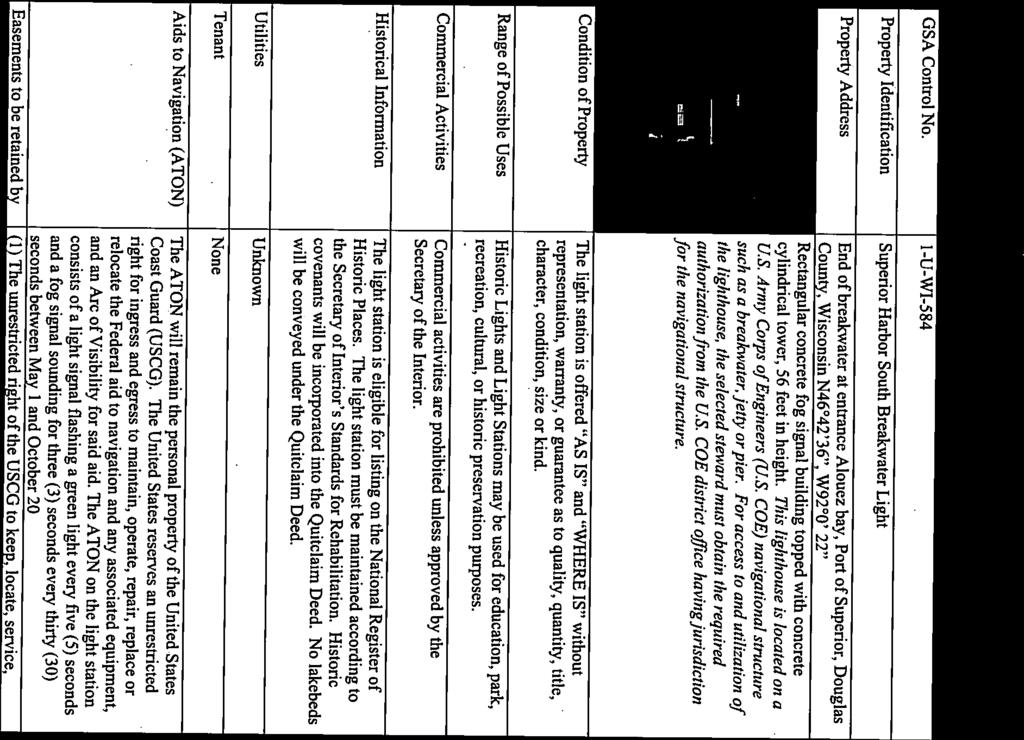
98

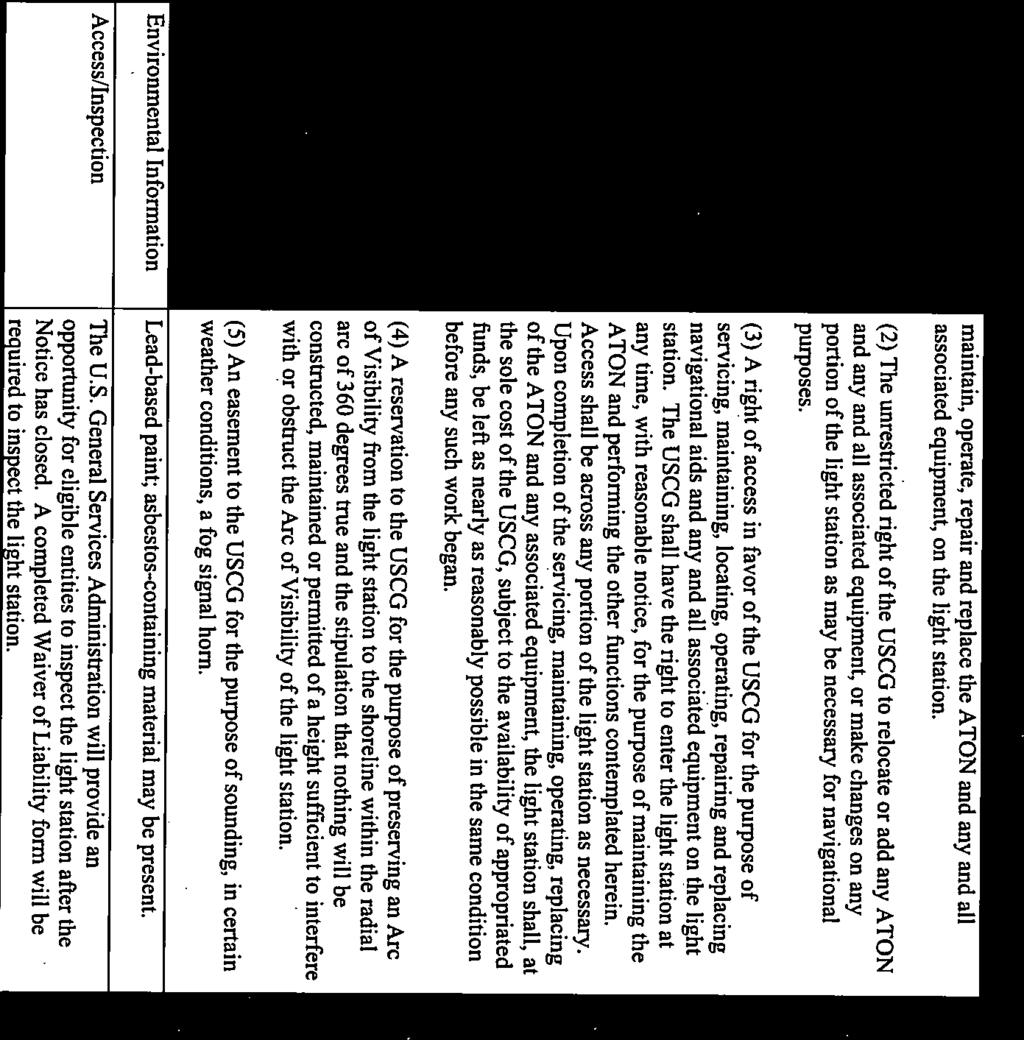
99
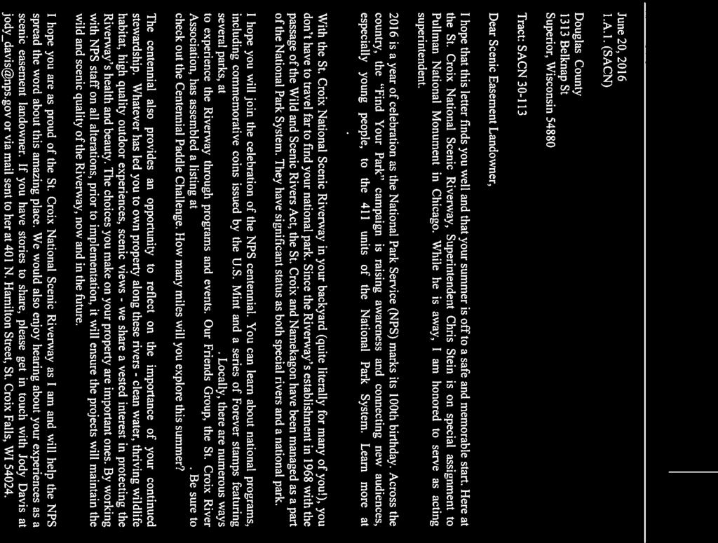


100

101
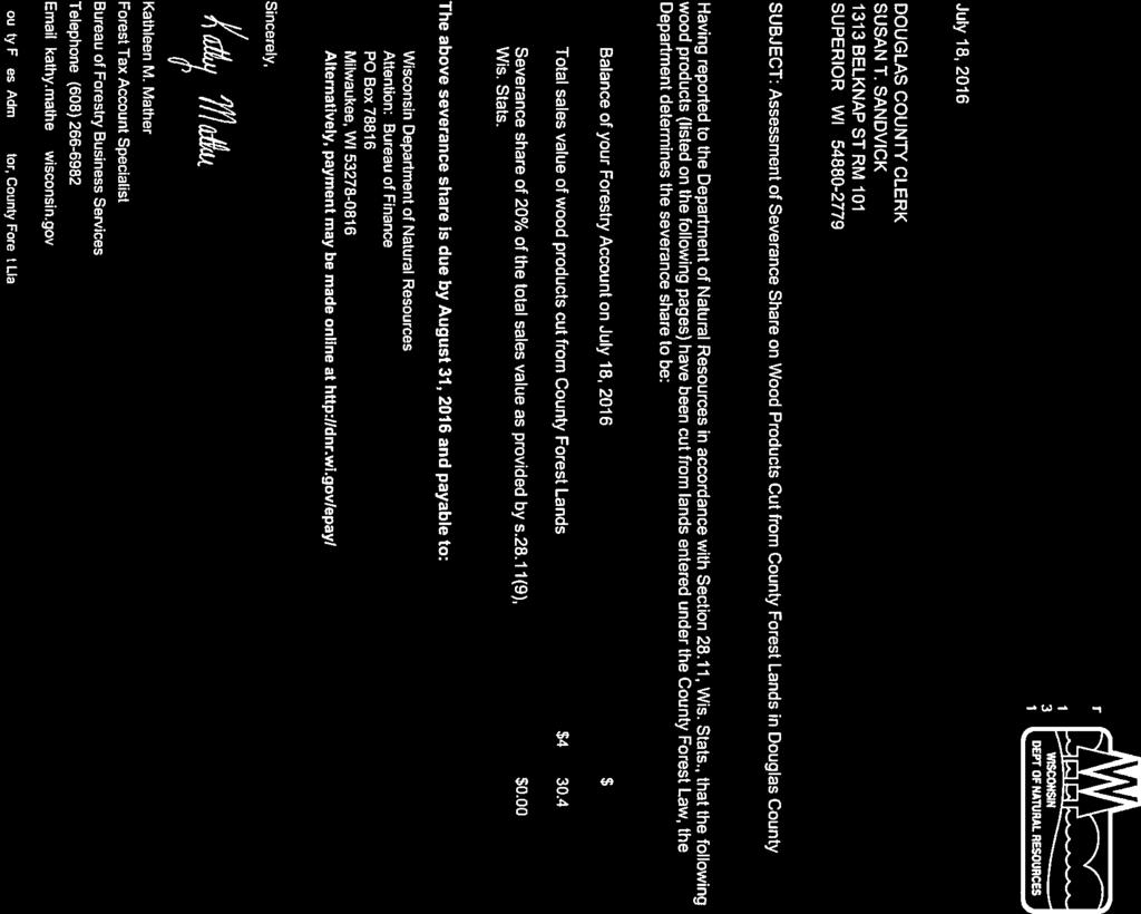


102
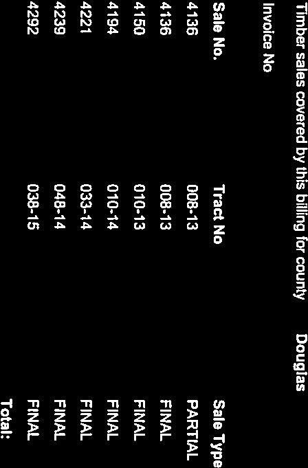

103


104


105
106

107


108
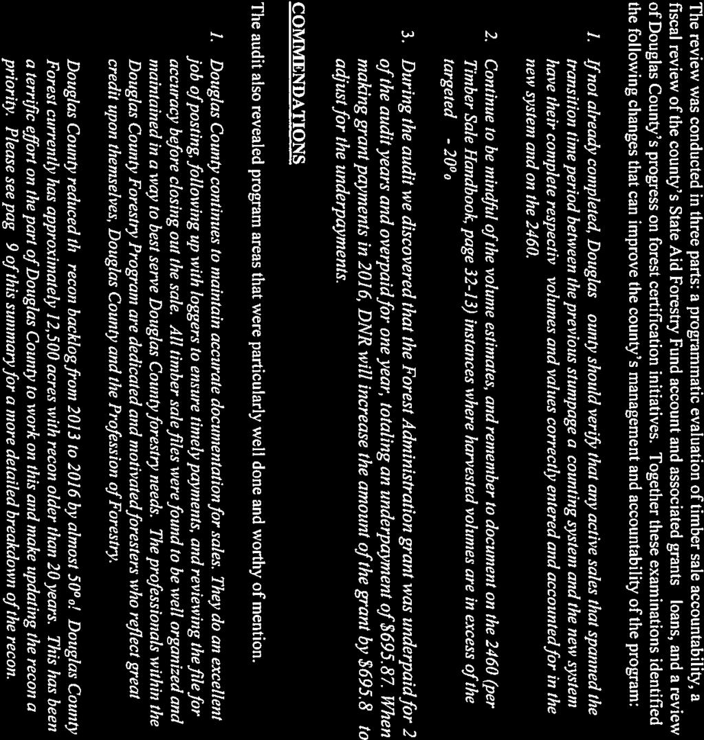

109

110
111
112
113


114


115


116

117
THE COUNTY BOARD OF SUPERVISORS OF THE COUNTY OF DOUGLAS DOES ORDAIN AS FOLLOWS:
 8.4 SHORELAND ZONING ORDINANCE THE COUNTY BOARD OF SUPERVISORS OF THE COUNTY OF DOUGLAS DOES ORDAIN AS FOLLOWS: SECTION I. STATUTORY AUTHORIZATION, FINDING OF FACT, STATEMENT OF PURPOSE, AND TITLE 1.1
Motion by Pomush, second Hendrickson, to approve June 16, 2016, meeting minutes. Motion carried. CLAIMS CORRESPONDENCE
 PROCEEDINGS OF THE DOUGLAS COUNTY BOARD OF SUPERVISORS Thursday, August 18, 2016, 6:00 p.m., Board Room, Second Floor, Government Center 1316 North 14 th Street, Superior, Wisconsin Meeting called to order
Wood County Shoreland Zoning Ordinance For Wisconsin s Shoreland Protection Program
 Wood County Shoreland Zoning Ordinance For Wisconsin s Shoreland Protection Program October 1, 2014 Revised January 12, 2015 Revised September 16, 2015 (2015 Wisconsin Act 55) Revised March 2, 2016 (2015
SHORELAND PROTECTION ORDINANCE FOR VERNON COUNTY, WI. Table of Contents
 SHORELAND PROTECTION ORDINANCE FOR VERNON COUNTY, WI Table of Contents Section Page 50-1.0 Statutory Authorization, Finding of Fact, Statement of Purpose and Title 3 50-1.1 Statutory Authorization 3 50-1.2
MENOMINEE COUNTY, WISCONSIN SHORELAND PROTECTION ORDINANCE #68. Adopted September 22, 2016
 MENOMINEE COUNTY, WISCONSIN SHORELAND PROTECTION ORDINANCE #68 Adopted September 22, 2016 Published September 28, 2016 MENOMINEE COUNTY SHORELAND PROTECTION ORDINANCE - #68 Table of Contents Section Page
Shawano County Shoreland Wetland Zoning Ordinance Draft
 Shawano County Shoreland Wetland Zoning Ordinance Draft February 25, 2016 Revised Draft with DNR Comments Table of Contents Shawano County Shoreland Wetland Zoning Ordinance... 1 1.0 STATUTORY AUTHORIZATION,
General Code of Ordinances for Marathon County Chapter 22 Shoreland, Shoreland-Wetland, and Floodplain Code. June 2016
 General Code of Ordinances for Marathon County Chapter 22, -Wetland, and Code June 2016 TABLE OF CONTENTS TABLE OF CONTENTS... i TITLE 1 SHORT TITLE, PURPOSE AND SCOPE... 1 Chapter 22.101 General... 1
City of Chilton Ch. 24 Shoreland-Wetland Zoning CHAPTER 24 SHORELAND-WETLAND ZONING. (Ord. #1106 6/17/2014, Ord. #667 8/4/87)
") CHAPTER 24 SHORELAND-WETLAND ZONING (Ord. #1106 6/17/2014, Ord. #667 8/4/87) 24.01 Statutory Authorization 2 24.02 General Provisions 2 24.03 Shoreland-Wetland Zoning District 3 24.04 Nonconforming Structures
CHAPTER 24 SHORELAND-WETLAND ZONING (Ord. #1106 6/17/2014, Ord. #667 8/4/87) 24.01 Statutory Authorization 2 24.02 General Provisions 2 24.03 Shoreland-Wetland Zoning District 3 24.04 Nonconforming Structures
CHAPTER 21 SHORELAND-WETLAND ZONING CODE (Cr. Ord. #764)
") CHAPTER 21 SHORELAND-WETLAND ZONING CODE (Cr. Ord. #764) 21.01 Statutory Authorization, Finding of Facts, Statement of Purpose and Title 21.02 General Provisions 21.03 Definitions 21.04 Shoreland-Wetland
CHAPTER 21 SHORELAND-WETLAND ZONING CODE (Cr. Ord. #764) 21.01 Statutory Authorization, Finding of Facts, Statement of Purpose and Title 21.02 General Provisions 21.03 Definitions 21.04 Shoreland-Wetland
As of March 27, 2018 THE DOOR COUNTY BOARD OF SUPERVISORS DOOR COUNTY RESOURCE PLANNING COMMITTEE
 As of March 27, 2018 THE DOOR COUNTY BOARD OF SUPERVISORS Daniel Austad Helen Bacon David Englebert Roy Englebert David Enigl Kenneth F. Fisher, Vice-Chair Joel Gunnlaugsson Randy Halstead Jon Koch Susan
Division 2 Section to are to be renumbered as follows; deletions (strikes) and additions (underlines). DIVISION 1. Introduction.
 and additions (underlines). DIVISION 1. Introduction.") Division 2 Section 74-163 to 74-175 are to be renumbered as follows; deletions (strikes) and additions (underlines). DIVISION 1. Introduction. Sec. 74-153. - Purpose. The purpose of this ordinance is to
Division 2 Section 74-163 to 74-175 are to be renumbered as follows; deletions (strikes) and additions (underlines). DIVISION 1. Introduction. Sec. 74-153. - Purpose. The purpose of this ordinance is to
Door County Shoreland Zoning. Door County Land Use Services Department June 26, 2018
 Door County Shoreland Zoning Door County Land Use Services Department June 26, 2018 Wisconsin ShorelandZoning: Background June 12, 1968: State-mandated date for counties to begin administering shoreland
THE EVOLUTION OF SHORELAND ZONING AND WHAT IT MEANS TO SURVEYORS-ACT 55
 THE EVOLUTION OF SHORELAND ZONING AND WHAT IT MEANS TO SURVEYORS-ACT 55 I. History of Act 55 and Shoreland Zoning. A. On July 12, 2015 Governor Walker signed 2015-17 biennial budget (Act 55) which modifies
THE COUNTY BOARD OF SUPERVISORS OF THE COUNTY OF DOUGLAS DOES ORDAIN AS FOLLOWS:
 8.1 SUBDIVISION CONTROL ORDINANCE THE COUNTY BOARD OF SUPERVISORS OF THE COUNTY OF DOUGLAS DOES ORDAIN AS FOLLOWS: SECTION I. GENERAL INTERPRETATION This ordinance shall not repeal, impair or modify private
PROCEEDINGS OF THE BOARD OF SUPERVISORS
 PROCEEDINGS OF THE BOARD OF SUPERVISORS Columbia County, Wisconsin Portage, Wisconsin September 21, 2016 7:00 p.m. The Board of Supervisors of Columbia County convened in regular session at the Carl C.
Deb Grube Walworth County Land Use and Resource Management
 Deb Grube dgrube@co.walworth.wi.us 262-741-7907 Walworth County Land Use and Resource Management www.co.walworth.wi.us County Zoning Contacts: Deb Grube (262) 741-7907 Board of Adjustment, Mobile Towers
** If your lot does not meet the requirements above, please read Sec below
 Sec. 13-1-60 Zoning District Dimensional Requirements. For the Zoning Dept To Issue a Land Use Permit The Following Dimensions are Required. Minimum Side and Rear Yards s Lakes Classification Minimum Class
STATUTORY AUTHORIZATION, PURPOSE AND FINDING OF FACT
 16.1 SHORELAND ZONING 16.1001 STATUTORY AUTHORIZATION, PURPOSE AND FINDING OF FACT 1) Statutory Authorization. This ordinance is adopted pursuant to the authorization contained in Sections 59.69, 59.692
STAFF REPORT. Arthur and Kathleen Quiggle 4(b)
") STAFF REPORT Application: Requests related to the construction of a 28' x 41' dwelling and 6' wrap-around open deck to replace an existing 24' x 32' cabin and wrap-around open deck and the installation
STAFF REPORT Application: Requests related to the construction of a 28' x 41' dwelling and 6' wrap-around open deck to replace an existing 24' x 32' cabin and wrap-around open deck and the installation
POLK COUNTY SHORELAND PROTECTION ZONING ORDINANCE
 POLK COUNTY SHORELAND PROTECTION ZONING ORDINANCE (Effective April 1, 2010) The County Board of Supervisors of the County of Polk does ordain as follows: Article 1. Title... 1 Article 2. Statutory Authorization...
Special Use Permit - Planned Unit Development Checklist. Property Address:
 Special Use Permit - Planned Unit Development Checklist Special Use Permit Number. Parcel Code/s #28-11- - - Property Address: Applicant: ARTICLE VIII Ordinance Reference - Section 8.1.2 Permit Procedures:
General Zoning Requirements.
 Article B: Sec. 13-1-20 General Provisions General Zoning Requirements. (a) (b) Jurisdiction. The jurisdiction of this Chapter includes all the shorelands in the unincorporated areas of Bayfield County
Part 72. Sec. 1. This ordinance shall be known and may be cited as the Clyde Township Wetlands Ordinance.
 Part 72 72.000 WETLANDS ORDINANCE Ord. No. 1 Adopted: June 12, 1991 Amended: April 13, 1994 72.001 SHORT TITLE. 72.002 PURPOSE. 72.003 DEFINITIONS. CLYDE TOWNSHIP ORDAINS: Sec. 1. This ordinance shall
MULTI-FAMILY DWELLING UNIT SUBDIVISION ORDINANCE TOWN OF SIDNEY, MAINE
 MULTI-FAMILY DWELLING UNIT SUBDIVISION ORDINANCE TOWN OF SIDNEY, MAINE I. GENERAL A. Title B. Purpose C. Administration D. Scope II. DEFINITIONS A. Building Height B. Dwelling Unit C. Family D. Multi-Unit
FINAL DRAFT 12/1/16, Rev. to 7/18/17
 FINAL DRAFT 12/1/16, Rev. to 7/18/17 (As Adopted 8/8/17 Effective 9/1/17) SHELTON PLANNING AND ZONING COMMISSION Proposed Amendments to Zoning Regulations I. Amend Section 23 PERMITTED USES by inserting
CHARLES CITY COUNTY SITE PLAN ORDINANCE. This Ordinance shall be known as the Charles City County Site Plan Ordinance.
 CHARLES CITY COUNTY SITE PLAN ORDINANCE Section 1. Title This Ordinance shall be known as the Charles City County Site Plan Ordinance. Section 2. Authority. This Ordinance is enacted pursuant to the authority
WALWORTH COUNTY RESOURCE MANAGEMENT/CONSERVATION (262) Land Disturbance/Erosion Control Fay Amerson, Urban Program Specialist
 Land Disturbance/Erosion Control Fay Amerson, Urban Program Specialist") WALWORTH COUNTY LAND USE AND RESOURCE MANAGEMENT SHORELAND ZONING Michael Cotter, Director Lou Olson, Deputy Director WALWORTH COUNTY LAND USE Ph # (262) 741-4972 Fax (262) 741-4974 Deb Grube, Sr. Zoning
WALWORTH COUNTY LAND USE AND RESOURCE MANAGEMENT SHORELAND ZONING Michael Cotter, Director Lou Olson, Deputy Director WALWORTH COUNTY LAND USE Ph # (262) 741-4972 Fax (262) 741-4974 Deb Grube, Sr. Zoning
ARTICLE 5 GENERAL REQUIREMENTS
 5.1 SUITABILITY OF THE LAND ARTICLE 5 GENERAL REQUIREMENTS 5.1.1 Land subject to flooding, improper drainage or erosion, and land deemed to be unsuitable for development due to steep slope, unsuitable
APPLICATION FOR SUBDIVISION APPROVAL OF A SKETCH PLAN with checklist
 Prior to filing any application for SUBDIVISION approval, the applicant shall request in writing that the zoning administrator schedule a pre-submission conference. APPLICATION TO THE PLANNING BOARD TOWN
APPLICATION PROCEDURE
 ANTRIM PLANNING BOARD P. O. Box 517 Antrim, New Hampshire 03440 Phone: 603-588-6785 FAX: 603-588-2969 APPLICATION FORM AND CHECKLIST FOR MINOR OR MAJOR SITE PLAN REVIEW File Date Received By APPLICATION
A. Maintenance. All legally established, nonconforming structures can be maintained (e.g., painting and repairs);
;") Chapter 24.50 NONCONFORMING USES, STRUCTURES AND LOTS Sections: 24.50.010 Nonconforming uses, structures, and lots Purpose. 24.50.020 Nonconforming uses, structures, and lots Alteration or expansion of
Chapter 24.50 NONCONFORMING USES, STRUCTURES AND LOTS Sections: 24.50.010 Nonconforming uses, structures, and lots Purpose. 24.50.020 Nonconforming uses, structures, and lots Alteration or expansion of
SITE PLAN REVIEW PROCEDURES SECTION DEVELOPMENTS REQUIRING SITE PLAN APPROVAL
 SECTION 22.01 PURPOSE ARTICLE XXII PROCEDURES The purpose of this Article is to establish uniform requirements of procedure for all developments in the Township. Certain specific types of minor development
ARTICLE VII. NONCONFORMITIES. Section 700. Purpose.
 ARTICLE VII. NONCONFORMITIES. Section 700. Purpose. The purpose of this chapter is to regulate and limit the development and continued existence of legal uses, structures, lots, and signs established either
Local units of government control the use of private
 9 Land Use REEB 24.085 Chapter Overview Land use issues are one of the hottest topics in the area of real estate. This chapter outlines the basics of land use regulation. Important Terminology conditional
ORDINANCE NO WHEREAS, the Town of Jupiter ( Town ) has adopted a Comprehensive Plan
 has adopted a Comprehensive Plan") 0 0 ORDINANCE NO. -0 AN ORDINANCE OF THE TOWN COUNCIL OF THE TOWN OF JUPITER, FLORIDA, AMENDING CHAPTER OF THE TOWN CODE TO AMEND SECTION -, ENTITLED INTENT TO ADD PERMITTING LANDGUAGE; TO AMEND SECTION
0 0 ORDINANCE NO. -0 AN ORDINANCE OF THE TOWN COUNCIL OF THE TOWN OF JUPITER, FLORIDA, AMENDING CHAPTER OF THE TOWN CODE TO AMEND SECTION -, ENTITLED INTENT TO ADD PERMITTING LANDGUAGE; TO AMEND SECTION
A.3. ARTICLE 7 PLAN REQUIREMENTS FOR MINOR SUBDIVISION AND/OR LAND DEVELOPMENT
 700. 701.A.3. ARTICLE 7 PLAN REQUIREMENTS FOR MINOR SUBDIVISION AND/OR LAND DEVELOPMENT SECTION 700 PURPOSE The purpose of this Article is to set forth a streamlined set of Plan Requirements for minor
CHAPTER XVIII SITE PLAN REVIEW
 CHAPTER XVIII SITE PLAN REVIEW Section 18.1 Section 18.2 Description and Purpose. The purpose of this chapter is to provide standards and procedures under which applicants would submit, and the Township
CHAPTER 6 CHESAPEAKE BAY PRESERVATION AREAS AND STREAM PROTECTION AREAS
 CHAPTER 6 CHESAPEAKE BAY PRESERVATION AREAS AND STREAM PROTECTION AREAS 6.1 INTRODUCTION Virginia s Chesapeake Bay Preservation Area (CBPA) Designation and Management Regulations (9VAC10-20 et seq.) require
PENINSULA TOWNSHIP LAND DIVISION ORDINANCE TOWNSHIP OF PENINSULA COUNTY OF GRAND TRAVERSE, STATE OF MICHIGAN ORDINANCE NO OF 2012
 PENINSULA TOWNSHIP LAND DIVISION ORDINANCE TOWNSHIP OF PENINSULA COUNTY OF GRAND TRAVERSE, STATE OF MICHIGAN ORDINANCE NO OF 2012 AN ORDINANCE TO REGULATE THE DIVISION OF EXISTING PARCELS OF LAND PURSUANT
4. facilitate the construction of streets, utilities and public services in a more economical and efficient manner;
 PVPC MODEL BYLAW BY-RIGHT CLUSTER ZONING BYLAW Prepared by Pioneer Valley Planning Commission Revised: October 2001 1.00 Development 1.01 Development Allowed By Right Development in accordance with this
LINCOLN COUNTY FLOOD DAMAGE PREVENTION ORDINANCE
 LINCOLN COUNTY FLOOD DAMAGE PREVENTION ORDINANCE SECTION 1.0 STATUTORY AUTHORIZATION, FINDINGS OF FACT, PURPOSE AND OBJECTIVES SECTION 2 DEFINITIONS SECTION 3.0 GENERAL PROVISIONS SECTION 4.0 ADMINISTRATION
Town of Prairie du Sac Sauk County, WI. Land Division Ordinance 07-3
 Town of Prairie du Sac Sauk County, WI Land Division Ordinance 07-3 1.01 DISCLAIMER (1) Multiple Jurisdictions. All persons reviewing the provisions of this Ordinance should be aware that the Town of Prairie
BY BOARD OF COUNTY COMMISSIONERS AN ACT TO BE ENTITLED
 BY BOARD OF COUNTY COMMISSIONERS ORDINANCE NO. AN ACT TO BE ENTITLED AN ORDINANCE AMENDING THE PASCO COUNTY LAND DEVELOPMENT CODE, ARTICLE 700, BY REPEALING EXISTING SECTION 702, ENVIRONMENTALLY SENSITIVE
A. Preserve natural resources as identified in the Comprehensive Plan.
 1370.08 Conservation Residential Overlay District. Subd. 1 Findings. The City finds that the lands and resources within the Conservation Residential Overlay District are a unique and valuable resource
***** Subchapter A. GENERAL PROVISIONS ***** PERMIT APPLICATIONS
 105.11. Permit requirements. 105.12. Waiver of permit requirements. Title 25 Environmental Protection Part I. Department of Environmental Protection Subpart C. Protection of Natural Resources Article I.
CHAPTER 9 ANIMAL WASTE STORAGE
 CHAPTER 9 ANIMAL WASTE STORAGE 9.01 Authority 9.02 Title 9.03 Findings and Declaration of Policy 9.04 Purpose 9.05 Interpretation 9.06 Severability Clause 9.07 Applicability 9.08 Effective Date 9.09 Definitions
Land Use Ordinance. Town of Readfield, Maine. Adopted June 12, 2018
 Land Use Ordinance Town of Readfield, Maine Adopted June 12, 2018 Revised: March 20, 2000; June 14, 2001; September 17, 2001; June 13, 2002; June 12, 2003; September 15, 2004; June 15, 2006; June 16, 2007;
EXCERPTS FROM HALIFAX REGIONAL MUNICIPALITY CHARTER
 EXCERPTS FROM HALIFAX REGIONAL MUNICIPALITY CHARTER Municipal planning strategy 227 The Council may adopt a municipal planning strategy for all, or part, of the Municipality and there may be separate strategies
UPPER MOUNT BETHEL TOWNSHIP NORTHAMPTON COUNTY, PENNSYLVANIA
 UPPER MOUNT BETHEL TOWNSHIP NORTHAMPTON COUNTY, PENNSYLVANIA JOINDER DEED / LOT CONSOLIDATION TOWNSHIP REVIEW PROCESS When accepting proposed Joinder Deeds / Lot Consolidations, review the Joinder Deed
CHAPTER 352 COUNTY LAND PRESERVATION AND USE COMMISSIONS
 CHAPTER 352 COUNTY LAND PRESERVATION AND USE COMMISSIONS Referred to in 6B.3, 15E.111, 159.6, 173.3, 455B.275 Chapter does not invalidate ordinances existing on July 1, 1982, or require adoption of zoning
ARTICLE FIVE FINAL DRAFT
 ARTICLE FIVE 021218 FINAL DRAFT Sec. 503.6 Open Space Preservation Option Open Space Preservation Option Open Space Preservation developments may be approved in the AR, R-1, R-2 and R-3 zoning districts,
ARTICLE SINGLE FAMILY SITE CONDOMINIUM DEVELOPMENT STANDARDS
 ARTICLE 28.00 SINGLE FAMILY SITE CONDOMINIUM DEVELOPMENT STANDARDS Section 28.01 PURPOSE The purpose of this Article is to recognize that conventional single family developments, traditionally developed
AN ORDINANCE TO AMEND SECTION OF THE RAPID CITY MUNICIPAL CODE TO ALLOW FOR ADMINISTRATIVE DISSOLUTION OF PLANNED DEVELOPMENTS
 Ordinance No. 6231 AN ORDINANCE TO AMEND SECTION 17.50.050 OF THE RAPID CITY MUNICIPAL CODE TO ALLOW FOR ADMINISTRATIVE DISSOLUTION OF PLANNED DEVELOPMENTS WHEREAS, the City of Rapid City has adopted a
CHAPTER 6: ZONING CODE
 CHAPTER 6: ZONING CODE Table of Contents 6.1 PURPOSE.... 2 6.2 INTENT.... 2 6.3 DEFINITIONS.... 3 6.4 VILLAGE ZONING DISTRICTS.... 8 6.5 RESIDENCE DISTRICT REGULATIONS.... 8 6.6 RESTRICTIONS ON LAKE ACCESS....
POLK COUNTY CHAPTER 18 SUBDIVISION ORDINANCE
 POLK COUNTY CHAPTER 18 SUBDIVISION ORDINANCE Ordinance No. 13-17 Polk County Chapter 18 Subdivision Ordinance Enacted: March 21, 2017; Published: March 29, 2017 Effective Date: March 29, 2017 Polk County
Attached is a Clinton Township Zoning Permit Application and requirements for issuance of a permit.
 To Whom It May Concern: Attached is a Clinton Township Zoning Permit Application and requirements for issuance of a permit. The fee for the permit application is $75.00, which shall be made payable to
ARTICLE 15 - PLANNED UNIT DEVELOPMENT
 Section 15.1 - Intent. ARTICLE 15 - PLANNED UNIT DEVELOPMENT A PUD, or Planned Unit Development, is not a District per se, but rather a set of standards that may be applied to a development type. The Planned
LANGLADE COUNTY ANIMAL WASTE STORAGE ORDINANCE
 Langlade County Code of Ordinances Chapter 24 Ordinance #2-2001 LANGLADE COUNTY ANIMAL WASTE STORAGE ORDINANCE 24.01 AUTHORITY This ordinance is adopted under authority granted by Section 59.02 and 92.16,
ARTICLE 1 GENERAL PROVISIONS
 ARTICLE 1 GENERAL PROVISIONS SECTION 100 TITLE This Ordinance shall be known and cited as the "Rice Township Subdivision and Land Development Ordinance." SECTION 101 AUTHORITY Rice Township is empowered
Article XII. General Provisions and Regulations
 and Regulations The regulations contained in this chapter are intended to clarify, supplement or modify the regulations set forth elsewhere in this ordinance. 157.182. USE OF LAND OR STRUCTURES A. Conformity
TOWN OF WATERVILLE VALLEY NEW HAMPSHIRE SITE PLAN REVIEW REGULATIONS
 TOWN OF WATERVILLE VALLEY NEW HAMPSHIRE Effective date March 17, 1981 Revised March 16, 1982 Revised March 13, 1986 Revised March 10, 1987 Revised March 14, 2013 Revised March 8, 2016 TOWN OF WATERVILLE
Staff Planner Carolyn A.K. Smith
 Applicant Property Owner, Pamela K. & Steven A. Gray Public Hearing April 13, 2016 City Council Election District Princess Anne Agenda Item 8 Request Modification of Proffers (Modification to the proffer
Chapter 9 - Non-Conformities CHAPTER 9 - INDEX
 CHAPTER 9 - INDEX 9-10: GENERAL... 3 9-20: SUBSTANDARD SIZE LOTS OR PARCELS... 3 9-20-10: GENERAL... 3 9-20-20: CUMULATING OF SUBSTANDARD SIZE LOTS OR PARCELS... 3 9-20-30: SEPARATION OF PLATTED SUBSTANDARD
Chapter 136. SOIL EROSION
 1 of 8 12/19/2011 4:17 PM Township of Andover, NJ Monday, December 19, 2011 Chapter 136. SOIL EROSION [HISTORY: Adopted by the Township Committee of the Township of Andover by Ord. No. 77-11 (Ch. XVII
ARTICLE 7: PLOT PLANS AND SITE PLAN REQUIREMENTS AND REVIEW
 ARTICLE 7: PLOT PLANS AND SITE PLAN REQUIREMENTS AND REVIEW Section 7.0 - Purpose The purpose of this article is to specify the documents and/or drawings required for a Site Plan Review or a Plot Plan
CHAPTER 18 SUBDIVISION AND PLATTING ORDINANCE OF THE TOWN OF OSCEOLA CODE OF ORDINANCES
 TOWN OF OSCEOLA POLK COUNTY WISCONSIN ORDINANCE # 18-03-03 CHAPTER 18 SUBDIVISION AND PLATTING ORDINANCE OF THE TOWN OF OSCEOLA CODE OF ORDINANCES 18.01 Purpose Adopted 3/08/99, Amended 5/12/03, 7/9/07,
Chapter 210 CONDITIONAL USES
 Chapter 210 CONDITIONAL USES 210.01 Purpose 210.02 Authorization 210.03 Process Type 210.04 Determination of Major or Minor Conditional Use Review 210.05 Approval Criteria 210.06 Conditions of Approval
Certified Survey Map (CSM) Submittal Updated: 6/29/18
 Submittal Updated: 6/29/18") Certified Survey Map (CSM) Submittal Updated: 6/29/18 Town of Middleton 7555 W. Old Sauk Road Verona, WI 53593-9700 Phone: 608-833-5887 Fax: 608-833-8996 info@town.middleton.wi.us The Town of Middleton
Certified Survey Map (CSM) Submittal Updated: 6/29/18 Town of Middleton 7555 W. Old Sauk Road Verona, WI 53593-9700 Phone: 608-833-5887 Fax: 608-833-8996 info@town.middleton.wi.us The Town of Middleton
STATE OF MICHIGAN COUNTY OF MARQUETTE, TOWNSHIP OF NEGAUNEE LAND DIVISION, SUBDIVISION AND CONDOMINIUM ORDINANCE
 STATE OF MICHIGAN COUNTY OF MARQUETTE, TOWNSHIP OF NEGAUNEE LAND DIVISION, SUBDIVISION AND CONDOMINIUM ORDINANCE Adopted: August 8 th, 2008 Effective: August 28 th, 2008 Sec.100. Title ARTICLE I GENERAL
13-2 SUBDIVISION PLANS AND PLATS REQUIRED EXCEPTIONS Subdivision Plats Required To be Recorded
 ARTICLE XIII SUBDIVISIONS 13-1 INTENT AND PURPOSE 13-1-1 Intent: It is the intent of the County Commission through the adoption of this Article to more fully avail itself of the power granted under 17-27-601
610 LAND DIVISIONS AND PROPERTY LINE ADJUSTMENTS OUTSIDE A UGB
 ARTICLE VI: LAND DIVISIONS AND PROPERTY LINE ADJUSTMENTS VI-21 610 LAND DIVISIONS AND PROPERTY LINE ADJUSTMENTS OUTSIDE A UGB 610-1 Property Line Adjustments (Property Line Relocation) A property line
Construction & Earthwork Request Form (CERF)
") ShoreLand Traditions Construction & Earthwork Request Form (CERF) SECTION 1 SECTION 2 SECTION 3 Definitions and Points to Remember Requirements and Process Site Sketch Requirements and Sample If you have
ShoreLand Traditions Construction & Earthwork Request Form (CERF) SECTION 1 SECTION 2 SECTION 3 Definitions and Points to Remember Requirements and Process Site Sketch Requirements and Sample If you have
(B) On lots less than 1.5 acres, accessory buildings shall have a maximum size of 672 square feet in area.
 On lots less than 1.5 acres, accessory buildings shall have a maximum size of 672 square feet in area.") Setbacks in Commercial Districts: (1) Downtown Business District: Setbacks from State Highways 70 and 155 shall be the lesser of a minimum of 100 feet or the footprint of the present principal building
Setbacks in Commercial Districts: (1) Downtown Business District: Setbacks from State Highways 70 and 155 shall be the lesser of a minimum of 100 feet or the footprint of the present principal building
SECTION ZONING DISTRICTS
 SECTION 17.04 ZONING DISTRICTS 1. ESTABLISHMENT OF DISTRICTS In order to carry out the purposes and provisions of this chapter, the Town is hereby divided into the following zoning Districts. All property
SUBDIVISION REGULATIONS for Lawrence and the Unincorporated Areas of Douglas County, KS
 SUBDIVISION REGULATIONS for Lawrence and the Unincorporated Areas of Douglas County, KS December 19, 2006 Edition Amended: 09/11/07; 12/04/07; 03/25/08; 09/10/08 Amended: January 6, 2009 Article 8 Subdivision
{{t:t;r:n;o:"signer 2";l:"Date";}}
 Application/File # Date Application Rec'd: Oct 13 2017 Fee Collected $ (for office use only) CONDITIONAL USE APPLICATION MOTLEY MN Site Address (E-911#): 164 MORRISON STREET WEST 410095000 Lake/River Name:
CALDWELL COUNTY. Phase II Stormwater Ordinance
 CALDWELL COUNTY Phase II Stormwater Ordinance 1 Table of Contents Phase II Stormwater Model Ordinance for North Carolina... 1 SECTION 1: GENERAL PROVISIONS... 7 101 Title... 7 102 Authority... 7 103 Findings...
FRESHWATER WETLANDS PROTECTION IN NEW JERSEY Tools for Municipal Action
 FRESHWATER WETLANDS PROTECTION IN NEW JERSEY Tools for Municipal Action The Freshwater Wetlands Protection Act INTENT OF FRESHWATER WETLANDS LAW The New Jersey legislature passed the Freshwater Wetlands
CHAPTER 24 F FLOOD ZONE OVERLAY DISTRICT
 CHAPTER 24 OVERLAY DISTRICT SECTION 24.01 PURPOSE It is the intent of this district to apply special regulation to the use of land in those areas subject to periodic inundation. Such regulation is deemed
ARTICLE I. IN GENERAL
 Adopted by City Council on December 7, 2009 AN ORDINANCE TO AMEND AND REORDAIN CHAPTER 10 (WATER PROTECTION) OF THE CODE OF THE CITY OF CHARLOTTESVILLE, 1990, AS AMENDED, BY DELETING SECTIONS 10-51 AND
CHAPTER 21 SHORELAND-WETLAND ZONING
 CHAPTER 21 SHORELAND-WETLAND ZONING 21.01 STATUTORY AUTHORIZATION, FINDING OF FACT, STATEMENT OF PURPOSE AND TITLE (1) Statutory Authorization (2) Finding of Fact (3) Purpose (4) Title 21.02 DEFINITIONS
CHAPTER 21.12: NONCONFORMITIES
 CHAPTER 21.12: NONCONFORMITIES 21.12.010 GENERAL PROVISIONS... 12-2 A. Purpose... 12-2 B. Authority to Continue... 12-2 C. Determination of Nonconformity Status... 12-3 D. Government Agency Property Acquisitions...
ORDINANCE NO. _4.06 AN ORDINANCE TO ESTABLISH BUILDING SITE REGULATIONS SECTION A PURPOSE AND INTENT
 ORDINANCE NO. _4.06 AN ORDINANCE TO ESTABLISH BUILDING SITE REGULATIONS SECTION A PURPOSE AND INTENT This Ordinance provides minimum regulations, provisions and requirements for safe, aesthetically pleasing
CHAPTER 2 RELATIONSHIP WITH OTHER LAWS.
 CHAPTER 2 General Provisions 12-2-1 Minimum Requirements 12-2-2 Relationship with Other Laws 12-2-3 Effect on Existing Agreements 12-2-4 Scope of Regulations 12-2-5 Building Permit 12-2-6 Nonconforming
Rice County Buffer Ordinance
 Rice County Buffer Ordinance CHAPTER 640 STATUTORY AUTHORIZATION AND PURPOSE 640.1 Statutory Authorization: This buffer ordinance is adopted pursuant to the authorization and policies contained in Minn.
WASCO COUNTY PRELIMINARY SUBDIVISION APPLICATION
 WASCO COUNTY PRELIMINARY SUBDIVISION APPLICATION DETAILED SPECIFIC WRITTEN REQUEST File Number: SDV- Number of Proposed Lots & their Dimensions: PRELIMINARY SUBDIVISION PLAN REQUIREMENTS The approval of
TABLE OF CONTENTS. Township of Clyde i
 TABLE OF CONTENTS ARTICLE 1 - TITLE, PURPOSE, SCOPE, AND LEGAL BASIS... 1-1 1.01 TITLE...1-1 1.02 PURPOSE... 1-1 1.03 SCOPE AND INTERPRETATION...1-1 1.04 THE EFFECT OF ZONING... 1-2 1.05 LEGAL BASIS...1-2
WEBSTER TOWNSHIP LAND DIVISION ORDINANCE. Summary Table of Amendments
 WEBSTER TOWNSHIP LAND DIVISION ORDINANCE Ordinance No. 2012 02 As Adopted 04-17-12 Summary Table of Amendments Adoption Date Affected Sections Summary October 10, 3 Added definition of Township Engineer
ARTICLE 8C SITE CONDOMINIUM DEVELOPMENT ORDINANCE
 ARTICLE 8C SITE CONDOMINIUM DEVELOPMENT ORDINANCE SECTION 8C.01 PURPOSE It is the purpose of this Ordinance to insure that plans for development within Oceola Township proposed under the provisions of
All distances unless otherwise specified shall be measured horizontally.
 Chapter 22 - LAND USE State Law reference County zoning and boards of adjustment, Wis. Stats. 59.694; zoning filing fees, Wis. Stats. 59.696; fees for zoning appeals, Wis. Stats. 59.697; floodplain zoning,
E L M E R B O R O U G H L A N D U S E B O A R D APPLICATION COVER SHEET (to be completed for all applications and appeals)
") E L M E R B O R O U G H L A N D U S E B O A R D APPLICATION COVER SHEET (to be completed for all applications and appeals) 1. Name(s): 2. Address: 3. Telephone Number(s): 4. E-mail: 5. Owner Name(s) (if
E L M E R B O R O U G H L A N D U S E B O A R D APPLICATION COVER SHEET (to be completed for all applications and appeals) 1. Name(s): 2. Address: 3. Telephone Number(s): 4. E-mail: 5. Owner Name(s) (if
Chapter Planned Residential Development Overlay
 Chapter 19.29 Planned Residential Development Overlay Sections 010 Purpose 020 Scope 030 Definitions 030 Minimum Size 040 Allowable Uses 050 Minimum Development Standards 060 Density Bonus 070 Open Space
AGENDA STATEMENT NO BUSINESS OF THE PLANNING COMMISSION City of Victoria, Minnesota STAFF REPORT. Casco Ventures (Developer)
") AGENDA STATEMENT NO. 17-1 BUSINESS OF THE PLANNING COMMISSION City of Victoria, Minnesota STAFF REPORT TO: Planning Commission PREPARED BY: Erin Smith, Senior Planner RE: Waterford Landing Project Rezoning
AGENDA STATEMENT NO. 17-1 BUSINESS OF THE PLANNING COMMISSION City of Victoria, Minnesota STAFF REPORT TO: Planning Commission PREPARED BY: Erin Smith, Senior Planner RE: Waterford Landing Project Rezoning
A. ARTICLE 16 - STEEP SLOPE CONSERVATION DISTRICT
 1600. 1601.A. ARTICLE 16 - STEEP SLOPE CONSERVATION DISTRICT SECTION 1600 PURPOSE The purpose of this Article is to expand upon the Community Development Objectives associated with environmental protection
BRIDGETON SUBDIVISION APPLICATION CHECKLIST
 APPLICATION NAME AND # CHECKLIST COMPLETED BY: DATE: Signature and printed name BRIDGETON SUBDIVISION APPLICATION CHECKLIST TO SUBDIVISION APPLICANTS: The attached checklist is to assist you in the submission
Town of Winthrop Zoning Ordinance
 The University of Maine DigitalCommons@UMaine Maine Town Documents Maine Government Documents 2004 Town of Winthrop Zoning Ordinance Winthrop (Me.) Follow this and additional works at: https://digitalcommons.library.umaine.edu/towndocs
GWINNETT COUNTY CSO CONSERVATION SUBDIVISION OVERLAY DISTRICT REQUIREMENTS
 GWINNETT COUNTY CSO CONSERVATION SUBDIVISION OVERLAY DISTRICT REQUIREMENTS Section 1316. CSO Conservation Subdivision Overlay District. 1. Purposes. The purposes of this overlay district are as follows:
GARDEN HIGHWAY SPECIAL PLANNING AREA
 GARDEN HIGHWAY SPECIAL PLANNING AREA 501-250. INTENT. The land area between the Garden Highway and the Sacramento River possesses unique environmental amenities that require special treatment and regulation.
MINNESOTA POLLUTION CONTROL AGENCY GENERAL PERMIT FOR DISPOSAL OF UNCOMTAMINATED CONCRETE
 MINNESOTA POLLUTION CONTROL AGENCY GENERAL PERMIT FOR DISPOSAL OF UNCOMTAMINATED CONCRETE ISSUANCE DATE: December 23, 2013 EXPIRATION DATE: December 23. 2018 This permit is a General Permit issued pursuant
TOWNSHIP OF ALGOMA COUNTY OF KENT, MICHIGAN. Minutes of a regular meeting of the Township Board of the Township of Algoma, Kent
 Site Plan No. 0410 --- TOWNSHIP OF ALGOMA COUNTY OF KENT, MICHIGAN Minutes of a regular meeting of the Township Board of the Township of Algoma, Kent County, Michigan, held in the Algoma Township Hall,