PUBLIC HEARING. Zoning Amendment Bylaw No. 7645, 2013 (41 and 175 Duncan Street)
|
|
|
- Erin Griffin
- 5 years ago
- Views:
Transcription
1 PUBLIC HEARING Zoning Amendment Bylaw No. 7645, 2013 (41 and 175 Duncan Street) To be considered at the June 23, 2014 Public Hearing 6:00 p.m. in the City Hall Council Chamber *Please note: For convenience, the contents of this package contains information relative to the Public Hearing. If you have any questions, please inquire with Development Services staff, or contact
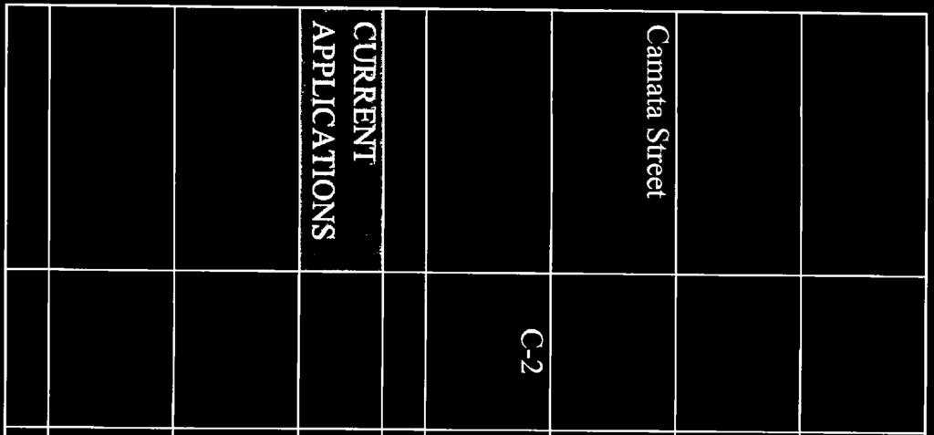
2 Public Hearing Information for Zoning Amendment Bylaw No. 7645, and 175 Duncan Street Reports to Council Report Author Meeting/Document/Date Public Hearing Date # Legislative Minute Extracts June 23, 2014 R-1 Services Development CW, Report, November 18, 2013 June 23, 2014 R-2 Services Development CW, Report, November 4, 2013 June 23, 2014 R-3 Services APC CW, Report, November 4, 2013 June 23, 2014 R-4 Development Services Development Services Development Services CW, Report, September 20, 2010 June 23, 2014 R-5 CW, Report, May 5, 2008 June 23, 2014 R-6 CW, Report, February 12, 2008 June 23, 2014 R-7 Written Submissions Name Correspondence Date Date Received In Support/Opposed / Concerns None to date. # Legend: APC = Advisory Planning Commission CW = Committee of the Whole NWDP = New Westminster Design Panel OH = Open House PH = Public Hearing RM = Regular Meeting Doc # Page 2 Last updated: 6/9/2014
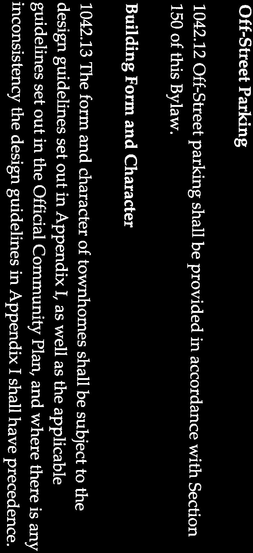
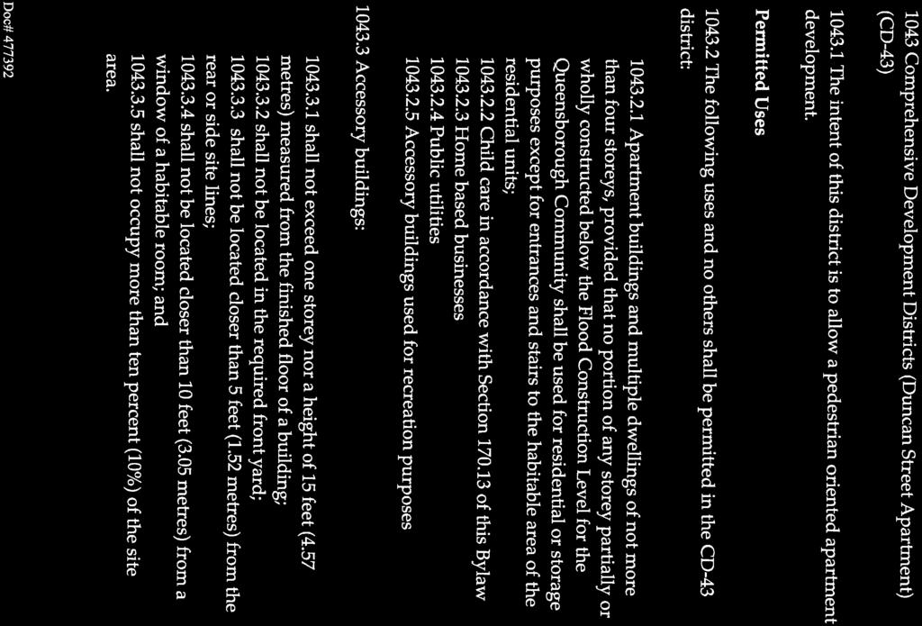
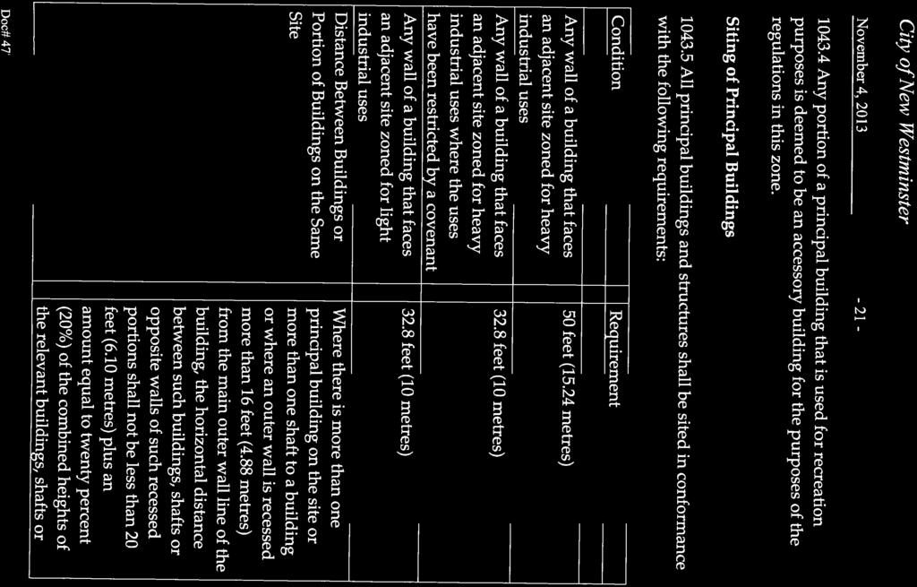
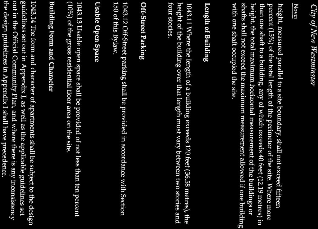
 (CD-42), Comprehensive Development Districts (Duncan Street Apartment) (CD-43), Heavy Industrial Districts (M-2) and Park Districts(P-10) in order to develop 48 townhouse units, 425")
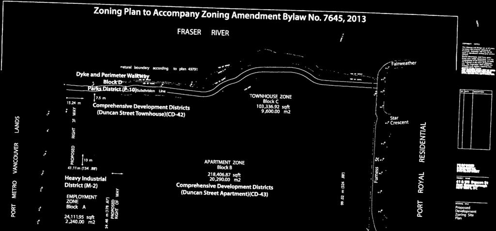
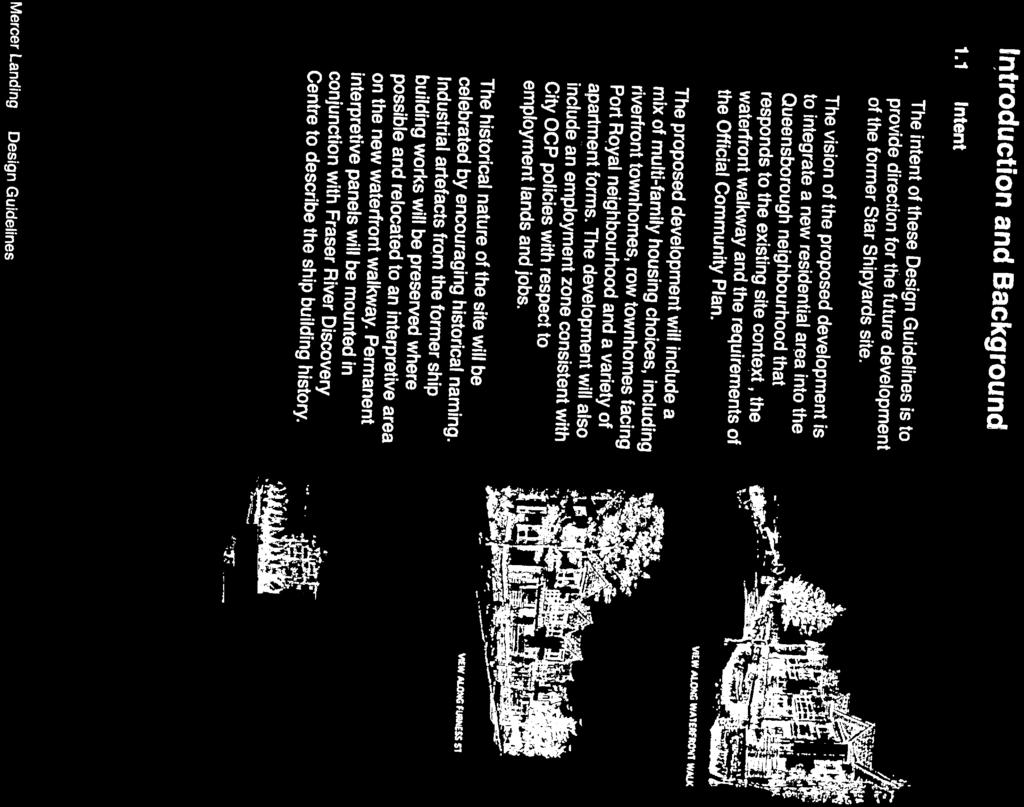
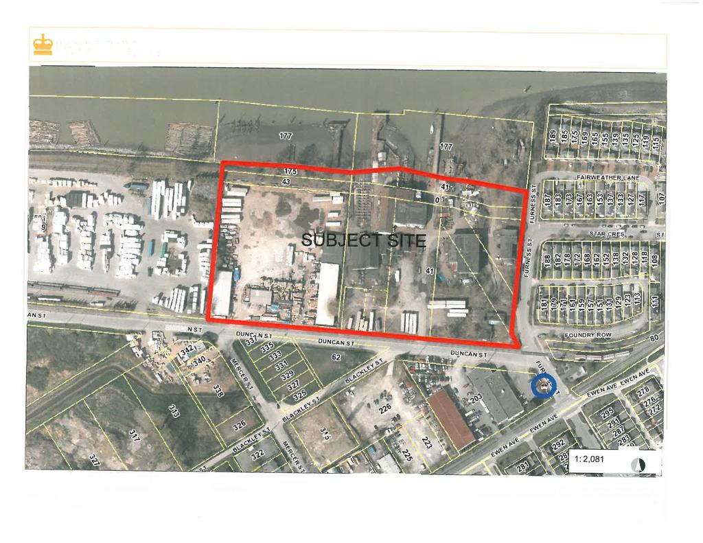
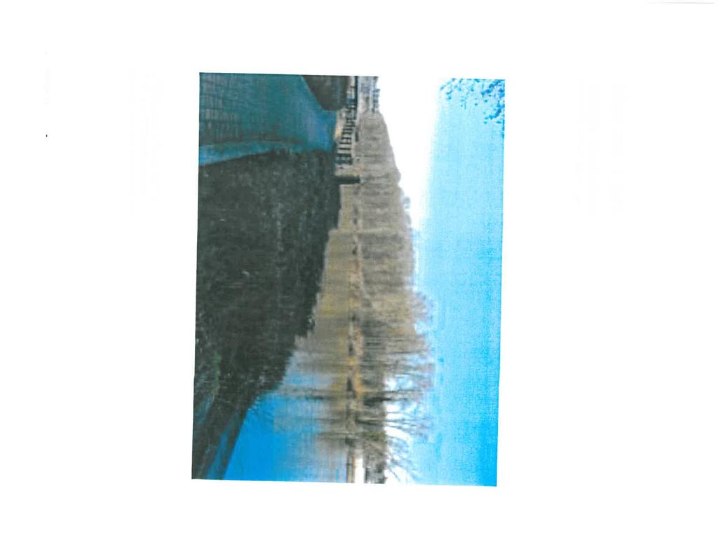
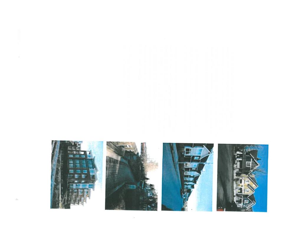
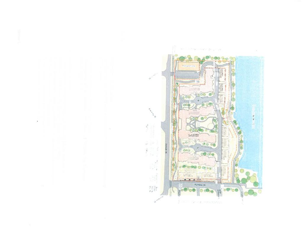
3 PROJECT DESCRIPTION: A proposal has been submitted to rezone 41 and 175 Duncan Street (outlined in bold in map) from Heavy Industrial Districts (M-2) to Comprehensive Development Districts (Duncan Street Townhouse) (CD-42), Comprehensive Development Districts (Duncan Street Apartment) (CD-43), Heavy Industrial Districts (M-2) and Park Districts(P-10) in order to develop 48 townhouse units, 425 apartment units, relocate the existing dyke to the perimeter of the site and construct a section of the perimeter trail on the dyke. PUBLIC HEARING 6:00 pm on June 23, 2014 in Council Chamber City Hall, 511 Royal Avenue New Westminster Zoning Amendment Bylaw No. 7645, 2013 (41 and 175 Duncan Street) WHAT IS ZONING AMENDMENT BYLAW NO. 7645, 2013 ABOUT? A rezoning is required to change the permitted uses on the property from industrial to multifamily residential and establish the permitted number of residential units on the property. The bylaw would establish the Comprehensive Development Districts (Duncan Street Townhouse) (CD-42), Comprehensive Development Districts (Duncan Street Apartment) (CD-43) zones and rezone the site to these zones. HOW DO I GET MORE INFORMATION? The bylaw and all pertinent material are available for viewing in the Planning Department at City Hall 10 business days prior to the Public Hearing, June 10 to June 23, 2014, Monday through Friday (except statutory holidays) between 8:30am and 4:30pm, and also online at HOW CAN I BE HEARD? The public is welcome to attend the Public Hearing on June 23, 2014, or send a written submission addressed to Mayor and Council prior to the closing of the hearing.
4

5

6

7

8
9
10

11
12
13

14
15
16


17
18


19
20

21


22


23


24


25

26


27
28

29

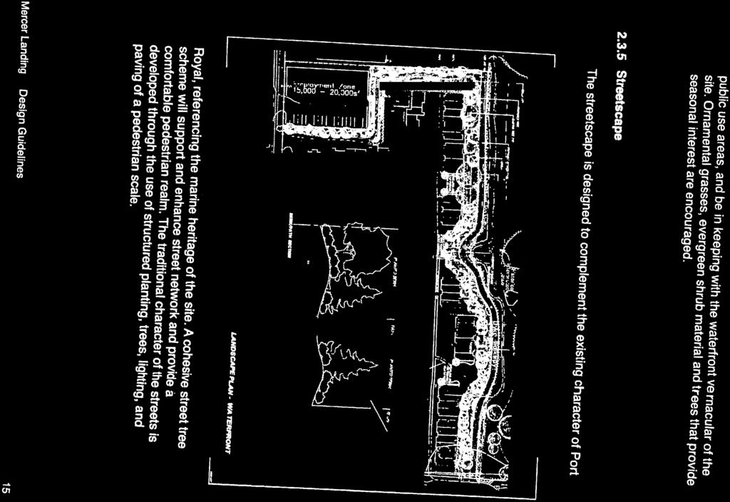
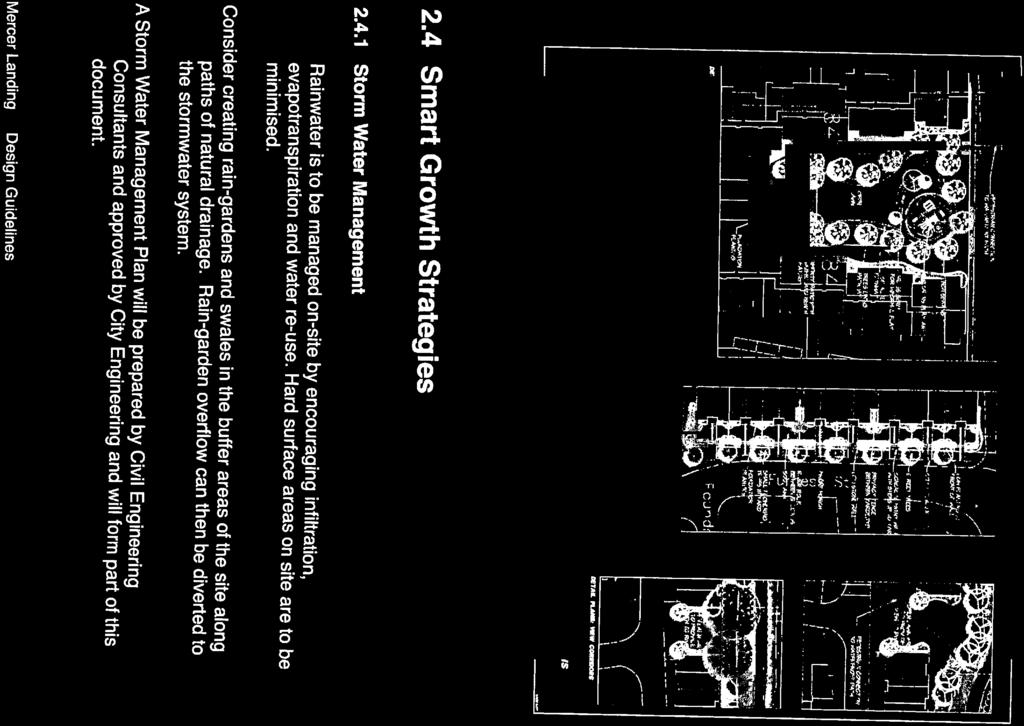
30

31

32


33


34
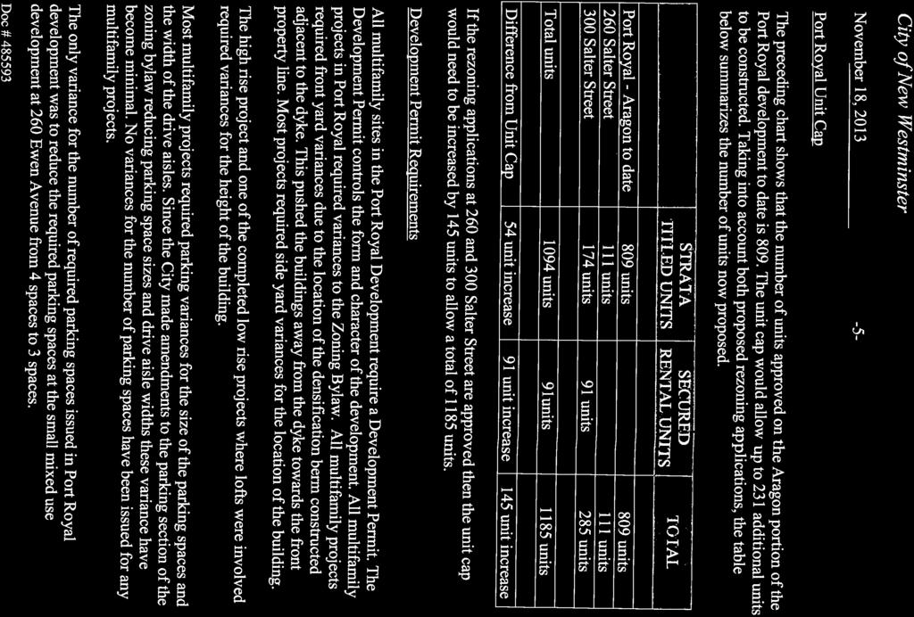
35 R-1 Minutes Extracts for 41 and 175 Duncan Street APC January 21, and 175 Duncan Street REZ00008 Jim Hurst, Development Planner, summarized the report dated November 4, 2013 regarding an application that has been received to rezone the property at 41 and 175 Duncan Street from Heavy Industrial Districts (M-2) to Comprehensive Development Districts (Duncan Street)(CD-42), Comprehensive Development Districts (Duncan Street) (CD-43), Parks Districts (P-10) and Heavy Industrial Districts (M - 2). The applicant proposes to develop 48 townhouses, 425 apartment units, leave a portion of the site under a modified industrial zoning to allow employment uses in the development and reconstruct the perimeter dyke with a portion of the perimeter trail located on the dyke. The dyke would be dedicated to the City. Mr. Hurst advised that notification was sent to: The surrounding neighbourhood within 100 metres (83 notices); All Residents Associations; The Board of School Trustees; Superintendent of Schools; and The New Westminster Heritage Preservation Society. Mr. Hurst noted that the Commission reviewed the project on May 24, 2013, and that the proposal has since been amended to include the addition of 100 apartment units, resulting in a floor space ratio of 1.5. Mr. Hurst reported that the application includes relocating the existing dyke to the perimeter of the site and constructing a walkway on the dyke which is dedicated to the City for park purposes. Gary Pooni, Brook Pooni Associates provided the following details regarding the application: A historical assessment completed indicated that there is no historical value on the site; There has been some work completed by Bunt and Associates regarding transportation to the site; Mitigating the rail noise remains a priority for the applicant; The applicant is offering the city $100,000, as there is no lift in land value with the increase of density;
36 In response to resident s concerns regarding entry to the site, there have been discussions with Metro Vancouver regarding another entry to the site through the Port Metro side of the development; and, Residents have expressed concern over on-site visitor parking. Don Andrew, Creekside Architects, noted that the railway noise has been minimized through buffers such as the orientation of the buildings and landscaping. The Commission generally agreed that the increase of density included with the proposal is feasible, as it results in more parking and outdoor amenity space. It was noted that the main access to the site off Furness Street is the most practical option given the location of the railway and noted site constraints. Mary Broten, Resident, noted that she is in opposition the 100 additional units proposed in the application, and expressed the following concerns: It was suggested that the development will contribute to the traffic congestion in Queensborough, especially with the lack of transit service; It was questioned if a six-storey development will set a precedent for future development; and, It was suggested that the additional density will result in a negative social impact in regards to childcare and schools. Mr. Hurst offered the following points in response to Ms. Broten s concerns: The applicant proposes a six-storey development to reduce site coverage and increase the amount of parking space; The Queensborough Middle School was built to have a third floor; however, there is no funding to carry forward with it at this time; and, The goal is to increase transit service to the area, as the development could result in more users. MOVED and SECONDED THAT the application to rezone the property addressed as 41 and 175 Duncan Street to allow a 473 unit multifamily residential development and the extension of the City s perimeter walkway in Queensborough be supported. CARRIED. All members of the Commission present voted in favour of the motion. MOVED and SECONDED
37 THAT the letter of January 19, 2014 from Norm Huey Re: 41 and 175 Duncan Street be received for information (On Table). CARRIED. All members of the Commission present voted in favour of the motion. CW November 4, Rezoning of 41 and 175 Duncan Street to Allow a 473 Unit Multi Family Residential development and the extension of the City s perimeter Walkway in Queensborough - Bylaw for First and Second Readings a) APC Report: 41 and 175 Duncan Street Results of May 21, 2013 Meeting MOVED and SECONDED THAT Council receive for information the Advisory Planning Commission s recommendations namely: THAT the Advisory Planning Commission supports the rezoning application for the property addressed as 41 and 175 Duncan Street which proposes to rezone the site from Heavy Industrial Districts (M-2) to Comprehensive Development Districts (Duncan Street)(CD-42) Comprehensive Development Districts (Duncan Street)(CD-43), Parks Districts(P-10) and Heavy Industrial Districts (M-2). b) Staff Report MOVED and SECONDED THAT Zoning Amendment Bylaw 7645, 2013, to establish the Comprehensive Development Districts (Duncan Street Townhouse)(CD-42) and Comprehensive Development Districts (Duncan Street Apartment)(CD- 43) zoning schedules and to rezone 41 and175 Duncan Street from Heavy Industrial Districts (M 2) to Comprehensive Development Districts (Duncan Street Townhouse)(CD-42), Comprehensive Development Districts (Duncan Street Apartment)(CD-43), Heavy Industrial Districts (M 2) and Park Districts (P-10) be forwarded to Council for consideration of First and Second reading. Regular September 10, 2013 f) 41 and 175 Duncan Street Preliminary Report on the Amended Rezoning Application
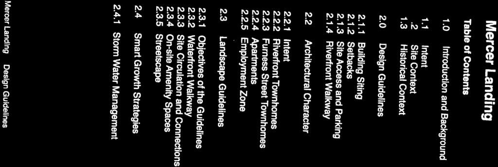
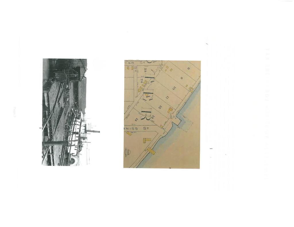
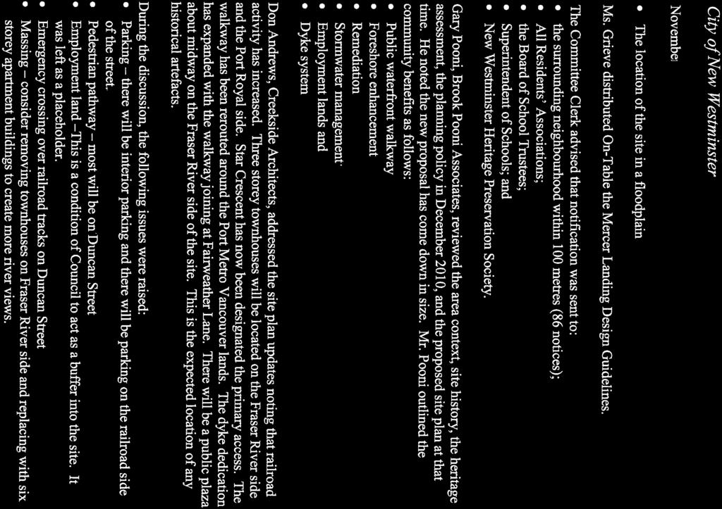
38 APC May 21, 2013 MOVED and SECONDED THAT staff be directed to continue to process the application to rezone 41 and 175 Duncan Street once the revised site plan is submitted; and THAT staff report back to Council when the staff and committee review process is complete. CARRIED. All members of Council voted in favour of the motion and 115 Duncan Street REZ0008 An application has been received to rezone the property at 41 and 175 Duncan Street (from Heavy Industrial Districts (M-2) to Comprehensive Development Districts (Duncan Street)(CD-42), Comprehensive Development Districts (Duncan Street) (CD-43), Parks Districts (P-10) and Heavy Industrial Districts (M-2) in order to develop 48 townhouses, 325 apartment units and leave a portion of the site under a modified industrial zoning to allow employment uses in the development. Bev Grieve, Acting Director of Development Services reviewed the history of the project. It was noted there are several factors that complicate the processing of the subject site: The location of the property on the Fraser River, a significant ecological area and fishery resource; The location of the property next to Port Metro Vancouver Lands which were purchased by the Port after the rezoning application on the subject site was made; The location of the site adjacent to a rail line, which is becoming increasingly active due to the Port activities; The existence of site contamination from industrial operations; and The location of the site in a floodplain area. Ms. Grieve distributed On-Table the Mercer Landing Design Guidelines. The Committee Clerk advised that notification was sent to: the surrounding neighbourhood within 100 metres (86 notices); All Residents Associations; the Board of School Trustees; Superintendent of Schools; and New Westminster Heritage Preservation Society
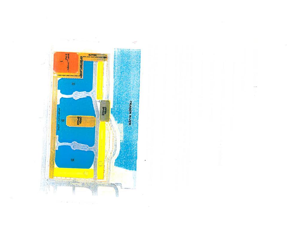
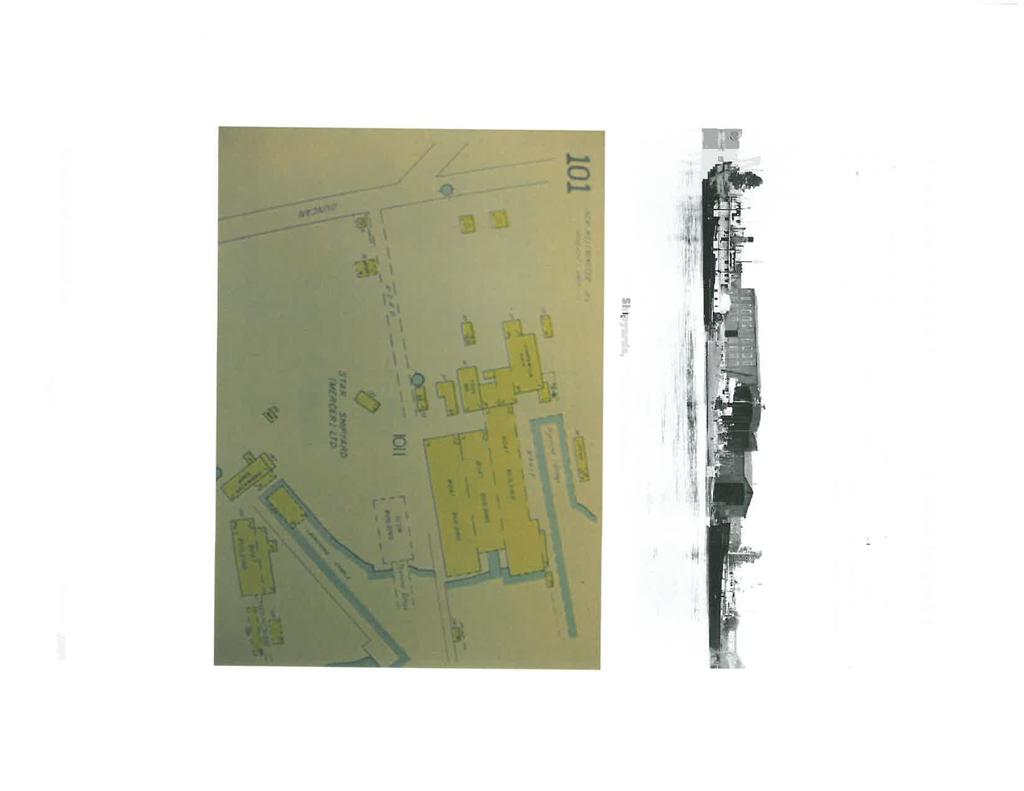
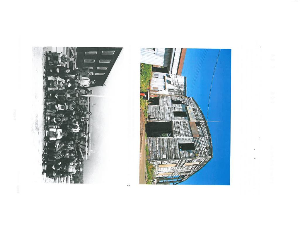
39 Gary Pooni, Brook Pooni Associates, reviewed the area context, site history, the heritage assessment, the planning policy in December 2010, and the proposed site plan at that time. He noted the new proposal has come down in size. Mr. Pooni outlined the community benefits as follows: Public waterfront walkway Foreshore enhancement Remediation Stormwater management Employment lands and Dyke system Don Andrews, Creekside Architects, addressed the site plan updates noting that railroad activity has increased. Three storey townhouses will be located on the Fraser River side and the Port Royal side. Star Crescent has now been designated the primary access. The walkway has been rerouted around the Port Metro Vancouver lands. The dyke dedication has expanded with the walkway joining at Fairweather Lane. There will be a public plaza about midway on the Fraser River side of the site. This is the expected location of any historical artefacts. During the discussion, the following issues were raised: Parking there will be interior parking and there will be parking on the railroad side of the street. Pedestrian pathway most will be on Duncan Street Employment land This is a condition of Council to act as a buffer into the site. It was left as a placeholder. Emergency crossing over railroad tracks on Duncan Street Massing consider removing townhouses on Fraser River side and replacing with six storey apartment buildings to create more river views. MOVED and SECONDED THAT the Advisory Planning Commission supports the rezoning application for the property addressed as 41 and 175 Duncan Street which proposes to rezone the site from Heavy Industrial Districts (M-2) to Comprehensive Development Districts (Duncan Street)(CD-42, Comprehensive Development Districts (Duncan Street)(CD-43), Parks Districts(P-10) and Heavy Industrial Districts (M-2). CARRIED. Bart Slotman opposed. CHC April 6, Star Shipyard, 41 & 175 Duncan Street
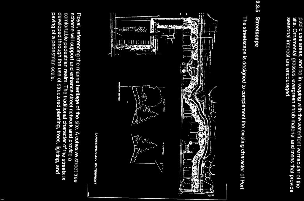
40 Bev Grieve, Manager of Planning, presented the overall development proposal for 41 and 175 Duncan Street, asking the Commission members to comment on the proponent s submitted design guidelines, in particular how the guidelines respond to the Donald Luxton Heritage Assessment report. Questions from the Commission: (Response in italics) What is the employment zone? An area to keep industrial employment. How do we insure future developers will do what is recommended? It will be incorporated into the rezoning. Comments from the Commission: Like to see carpenter shop preserved/renovated; Incorporate mosaics about the shipyard in the walkway; Keep ship boat-ways; Do creative things with ship-like items; Consider interpretive centre like Steveston; Nice to have a viewing platform; Support Luxton report; Work with Fraser River Discovery Centre and the Museum; Like the idea of placing the artefacts in a public sphere; Recommend relocating employment zone to where carpenter shop exists; Concerned about loss of jobs that service the river. Concerned land is being taken out of industrial; NWDP March 22, & 175 Duncan Street File: REZ00008 Bev Grieve, Manager of Planning, reported a rezoning application has been received for the property addressed as 41 and 175 Duncan Street. The application is to rezone the property to allow future development of a 406 unit multiple unit residential development and a small commercial or light industrial building. Andrew Mindell, Creekside Architects, reviewed the design guidelines as presented in the On Table document entitled Mercer Landing Guidelines. He noted the intent of the guidelines is to provide direction for the future development of the former Star Shipyards site. The historical nature of the site will be celebrated by encouraging historical naming and preservation of industrial artefacts where possible. Questions from the Panel: (Response in italics) Will underground parking cover the entire site? Primary parking will be under the buildings. A deck level will be established at the top of dyke level
41 Did you consider putting the two storey employment zone building on the other side of the property for more direct access? It was determined the building is a good buffer and it is better to have the walkway along residential where there are eyes on the street. Did you consider a six storey building? It was put forward at an early stage but it was decided four storeys is more achievable at this time. Comments from the Panel: Like how parking is being handled Consider separating two middle buildings Historical reference is not very specific; concerned the site planning does not reflect heritage value; like to see industrial heritage be brought into landscape. Need more definitive circulation plan; currently some weaknesses Suggest bringing employment building further into project Uncomfortable with underground parking being higher than the dyke Internal streets need more detail Open spaces need to be connected Consider how to connect walkways to the rest of community Would like to see some insurance in the guidelines that there will be an integration between existing public roads and pathways Circulation systems important need a lot of thought to satisfy needs Historic interpretive area should reflect industrial in content and presentation Green spaces seem disconnected Need more detail regarding circulation Historic artefacts could better be reflected in planning Need professional heritage consultant to do inventory of artefacts MOVED and SECONDED THAT the application for 41 and 75 Duncan Street be supported with the following site plan and design guideline considerations: Clarification on landscaping regarding off slab native plants Location of amenity spaces Historic references need to be more specific Schematic circulation plan needed Height of parking structure above dyke and roads Integration of open spaces CARRIED. Five members of the Panel voted in favour of the motion with one member opposed. NWDP February 22,
42 & 175 Duncan Street File: REZ 008 A rezoning application has been received for the property addressed as 41 and 175 Duncan Street. The application is to rezone the property to allow future development of a 406 unit multiple unit residential development and a small commercial or light industrial building (Don Andrews, Creekside Architects) Jim Hurst, Senior Planner reviewed the application and requested consideration of the following: Design Guidelines for Mercer Landing Landscape Concept Adequacy of landscaping Site Plan Panel Queries (Response in italics) How many residential units are planned for Phase 1, Port Royal? There will be approximately 50 small lot homes or approx. 150 units in the first phase. Will the new proposal to create a series of parcels for residential rather than employment property? The zoning will be defined for residential and employment use. If the application is approved, would the applicant be doing other amenity improvements? Yes, those are engineering offsite works i.e., dyke, streets. Why is this being proposal being presented as one site? It is to give the developer and people a certainty for the future. The project could be done in multiple phases, each with their own character. What is the definition of an employment zone? What is the genesis of the employment zone? Council is concerned about the loss of employment and/or taxation and is seeking to find a balance that will maintain employment and be a buffer against heavy industrial use. Are there any previous applications for this site? No. Will the amenities be done as a package or in pieces? There are two issues, the approval of the land use and then the design of the buildings. If public amenities are the issue (dyke is not coming to the City, it is dedicated and the walkway on top of the dyke is protected by an easement to the City for public purposes). Mr. Donald C. Andrew, Creekside Architects reviewed the project design as follows: The applicant has retained Westmar Consultants to review dyking guidelines with the Dyking Authority and Fraser River Estuary who will be commenting further at the time the property is rezoned
43 The conditions relating to contamination of the 100-year old shipyard are to be addressed. Board drawings of the site in detail and influences on it were reviewed. The old facilities has been given an historical assessment Inventory will be taken of the public amenity spaces on site. Duncan Street rail line will run two trains per day, but it is possible this will extend on the port side to 4-6 trains per day (on the railway right-of-way, not land). The dyke right of way currently dips into the property and must be reconstructed and relocated. The neighbourhood character of surrounding properties was addressed. The neighbouring Port Royal site was discussed, as well as the newer developments east of the site. The fee-simple townhouses, each on its own lot, will be a good fit for the neighbourhood. The dyke walkway will be on the existing natural boundary with the townhouse decks sitting adjacent. The dyke walkway will include a turnaround area for service vehicles. The railway buffer includes a 35 ft. setback with a berm and acoustic fence. The parking separation includes a berm embankment. Building orientation is planned to afford river views while minimizing the railway view at rear of building, creating indoor/outdoor quiet spaces. The building form will be compatible with Port Royal site. The small historical cove will be designed as an historical interpretive area. Details were also provided for the townhouse site, employment, industrial interface, views along Duncan, Furness, waterfront walk, Maritime Village Design Guidelines not to depart radically from the Port Royal character (gables, shakes, siding, wood fences, trellis entranceways, street views). Ms. Meredith Mitchell, DMG Landscape Architects, provided a brief overview of landscaping as follows: The cross section drawing indicated a 50-ft. pathway berm to buffer industrial noise. The planted berm will provide visual/sound buffering and fencing. The main concern is the overall circulation pattern for the site. The dyke walkway will an additional circulation pattern to connect with the southwest, the historical interpretative area, internal walkways, connections to residential units. As many existing natural plantings as possible will be retained. Examples of future views along Furness, plantings, trees, character of green areas (screening), amenity area, gazebo area to keep some existing wood structures on site and find placements for the industrial tools found on location was reviewed
44 The whole idea is to create a very definitive circulation pattern integrating the conceptual design with the landscape design and utilizing existing structures. Panel Queries: Can you explain the meaning of the colour coding on the map? In part, the river foreshore is in FREMP red zone which indicates that no work can be carried out outside of the existing dyke. Further explanations can be provided by Mr. Hurst as to colour/map/area designation along the river. Is there any relationship between the final dyke works and the legal plan dyke easement? The dyke will eventually be moved. The dyke location must be finalized prior to the rezoning bylaw preparation. Westmar reviewed this issue in 2008 during discussions with the Port Authority and came up with several options for following the modified high water line. The final conclusion will probably use the existing natural boundary originating from surveys of Is there an approved location for the dyke on the plan? There will be no official or approved location until the project goes through the City s rezoning process, in consultation with the Dyking Authority. The file was opened with the Fraser River Estuary Management to review, but is closed pending rezoning of the site. There may be sections that engineering has approved in principle, and a no built-covenants list final details in terms of identifying exact locations. Is this site considered one legal site? It is two legal sites. Will the property be subdivided into more than one residential site in the future? Yes. Could you describe the parking for the different building types? Parking will be taken to the outside edge of townhouses. There will be underground parking for almost 400 units. The top of the parking will be 4.4 metres high, roadway is 2.2 to 2.4 m, entry to site and underground parking roads will ramp up, to meet deck. Is it the intent to require the historical site to be cleaned up when the dyke is rebuilt? The intent is for everything to go. The Parks Department have asked for ideas for a new wharf along the river. Is riprap a type of dyke or pier structure, headwall material? Not clear, Westmar drawings indicate detail. Staff stated that a shear wall is at point at Port Royal. Is there a proposal for the section opposite Poplar Island? Port Royal is next door, combinations of riprap and headwall (vertical) have been in place the last years. Staff advised the first house was built in Staff is of the opinion that the first section is all riprap. The beach area has headwalls surrounding it to access beach years of riprap has all grown in, it is not what we think of as riprap
45 Is there a reason the employment zone will have 2 storey buildings rather than 3 storey buildings or larger square footage buildings? In discussions with the City the intent is to replace 20 jobs which are determined to be roughly equivalent to 20,000 sq. ft. By defining the zoning now, will there be any flexibility in the future? Flexibility is always welcome. There could be more opportunity in 2-3 years for a bigger building. Shouldn t the guidelines be more specific? Yes, the guidelines could be more specific. Generally the applicant followed the Port Royal site for inspiration. With respect to massing, is the layout open to interpretation or are there guidelines on how they should be set up on the site? Staff indicated access points are fixed. Furness St. access points are approved. In terms zoning, it would be determined by townhouses vs. industrial. Staff stated the applicant must decide where the dyke is going to be and then the zoning line can be decided. What is the reason for not showing pathway connections? The pathways will be shown in the landscape plan. What is the status of those trees, do they preclude a path? Yes, as currently shown in landscape plan, the trees preclude a path. A gravel path would require more in depth review for allowable tree potential. When full inventory has been completed and full connection made, the intention is to be able to look down the site. The Chair noted this is an information submission only. The design guidelines for approval will come later, complete with a much more resolved site plan. Panel Comments: Need more specificity on guidelines with discussion on materials and colours. Suggest guidelines cover some items like pedestrian circulation, environmental issues such as storm water treatment, amount of open space, landscape concept, waterfront detail and public space aesthetics. Not happy with the way the project is buffered to future port industry (west side of site). Colours could be quite charming, quirky. Concerned about design guidelines. Need more details and guidelines on heritage elements and design. Seems more Georgian scheme far from a marine village. Question of adequacy of landscaping buffer. Sensitivity to industrial heritage is important. Landscape details and plan to be included in guidelines. Site plan and guidelines should show future subdivision or phasing of project
46 MOVED and SECONDED THAT the report prepared by Ms. Beverly Grieve, Manager of Planning, entitled 41 and 175 Duncan Street Report to the New Westminster Design Panel, dated February 22, 2011, be received for information. CARRIED. All members of the Panel present voted in favour of the motion. CW September 20, and 175 Duncan Street Preliminary Report on the Amended Rezoning Application September 20, 2010 report providing preliminary information to Council on the amended application to rezone 41 and 175 Duncan Street. ** THAT staff be directed to continue to process the application to rezone 41 and 175 Duncan Street once the revised site plan is submitted; and THAT staff report back to Council when the staff and committee review process is complete. APC June 16, & 175 Duncan Street File: REZ008 Jim Hurst, Senior Planning Analyst reported an application for rezoning has been received for the properties addressed as 41 and 175 Duncan Street. The applicant is proposing to construct 425 residential units. The site is designated medium density residential in the current Official Community Plan. Questions from the Commission Why is there no notification sign on the site? A sign on the site is not required until it comes forward for approval. This is an information only item at this time. Will there be consideration to some of industrial structures as heritage structures? That has not been considered at this time. Is the moratorium going to be lifted? Council has seen this application and feel since this was ongoing project at the time, it should go forward. Is there anything that makes this property unsuitable for M1 or M2? It is being used for industrial purposes now. Will the Port Authority be using the tracks? That would be a question for Southern Rail. The Port Authority will likely use this area for container storage. Would be a question for Southern Rail
47 Is Duncan Street a designated access? Engineering has reviewed the concept and are okay with this as planned now. They would require two accesses. The rail does not come into the site it is a spur line. What is the estimated population for 426 units? Could be anywhere from 1 to 1.75 people per unit or about 600 people. What are the next steps? The next steps are discussion of amenities and then the consultation process. Gary Pooni, Brook and Associates, gave a brief overview of the project with respect to site context, site history, policy context (housing, trails and open space, environment and urban design), the urban design rationale and the community benefits. MOVED and SECONDED THAT agenda item 4 - Rezoning of 230 Third Avenue be deferred until 6:45 p.m. CARRIED. All Commission members present voted in favour of the motion. Comments from the Commission Request a population estimate and circulation plan Concerned about loss of M2 land in NW If this project is approved as a residential development, it should be green and sustainable. Request evaluation of access to property Gavin Palmer, speaking on behalf of Queensborough Residents Association reported residents are feeling betrayed because the adjacent land was designated residential in the OCP and now is staying industrial. CW May 5, Proposed Rezoning of 41 and 175 Duncan Street - Preliminary Report The Director of Development Services and Jim Hurst, Senior Planning Analyst, responded to questions regarding the May 5, 2008, report seeking direction from Council on the processing of the rezoning application for the property addressed as 41 and 175 Duncan Street. ** MOVED and SECONDED and CARRIED, this Committee recommends THAT staff continue working with the proponent on the rezoning application for the property addressed as 41 and 175 Duncan Street. CARRIED
48 All members of Committee present voted in favour of the motion.


49 R-2
50
51

52
53


54
55
56
57 R-3

58

59
60

61


62
63


64

65


66
67

68

69

70

71

72

73


74
75
76

77


78

79


80
81

82


83
84

85

86


87

88
89

90
91
92
93
94

95
96

97
98

99

100

101

102
103
104

105

106

107
108


109
110


111
112


113
114

115
116


117

118


119
120


121


122

123
124


125


126

127


128

129
130

131


132


133

134

135


136
137

138
139
140
141
142
143

144

145 R-4
146


147

148
149
150
151
152
153 R-5 City of New Westminster REPORT DEVELOPMENT SER VICES DEPARTMENT To: Mayor W. Wright and Members of Date: September 20, 2010 Council in Committee of the Whole From: Lisa Spitale, Director of Development Services File: 7031 Subject: 41 and 175 Duncan Street - Preliminary Report on the Amended Rezoning Application RECOMMENDATION THAT Council direct staff to continue to process the application once the revised site plan is submitted, and report to Council when the staff and Committee review process is complete. PURPOSE A revised rezoning application has been received for the property addressed as 41 and 175 Duncan Street. The application now proposes to include employment uses in the development. The purpose of this report is to provide preliminary information to Council on this amended application. BACKROUND Property Owner: OCP Land Use Designation OCP Development Permit Designation Kesho Inc. and Sonjan Enterprises, (RM) Residential - Medium Density Residential Development Permit Area #11 East Queensborough Existing Zoning: Heavy Industrial Districts (M - 2) Proposed Zoning: Comprehensive Development District Allowing Multi Family

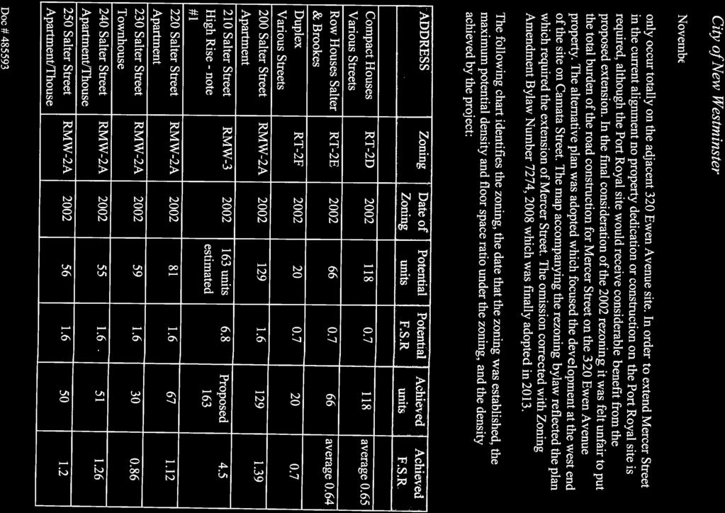
154 City of New Westminster September 20, 2010 Residential and Employment uses Site Characteristics: Site Area : 8.04 acres (3.3 Hectares) AREA MAP ' 'Z J Bis,, x ^ x r > - x smsi ^: i _' D < M.J' "% > jmr..- ^ mc <-*/ ^ 41 and 175 Duncan Street J 'I S or i S 2 Ml: ;LEY»SI Y* 4, li jjlr. t f ',<>. ts BSBi ^nt 'M-I I I ' I i T isi I r ^ ;3B ; <>, gg «" SITE CONTEXT The subject site is currently zoned (M-2) Heavy Industrial Districts and is occupied by a seven industrial users that range from Patent Construction and Fraser Shipyards to five small operations including a woodworking shop. The property to the east of the site is the first phase of the Port Royal Development constructed in This area zoned for residential development and has been built out with 45 compact lot houses and a low rise development with 70 apartment units and 14 townhouse units. Across Duncan Street to the south are properties with various lot sizes that are zoned Light Industrial Districts (M-l). Many of these properties are owned by the City. Most of
155 City of New Westminster September 20, 2010 these M-l zoned properties are either vacant or have low intensity industrial uses. The City's towing yard and animal shelter are located in this area. To the west is the vacant Interfor sawmill site which is zoned (M-2) Heavy Industrial. PROPOSAL The applicant proposes a mixed use development with 413 residential units on 7.4 acres of the site. The application has reduced the number of units proposed in the original application from 437 to 413 units. The housing would range from row house and townhouse to low rise apartment. The site would be remediated and the City's perimeter walkway would be extended. An employment use is proposed on a 0.6 acre portion of the site. The exact range of employment uses to be allowed has yet to be defined. A letter from the applicant's consultant on the amended application is attached to this report. OFFICIAL COMMUNITY PLAN CONSIDERATIONS The portion of the site inside the dyke is designated in the Official Community Plan as Residential Medium Density. The Plan describes this designation as: (RM) Residential - Medium Density: this area will contain medium density multi-family residential uses such as row houses, stacked townhouses and low rises. Depending on the provision of public amenities, a density bonus may be provided in order to reach the upper limits of density in this area. The portion of the site located on top of the dyke is designated as Walkway in the Official Community Plan. The Plan describes this designation as: Walkway System: this area will include walking trails. The portion of the site located outside of the dyke is designated as Intertidal Open Space in the Official Community Plan. The Plan describes this designation as: Intertidal/Open Space: this area will remain in a natural state in order to preserve the intertidal area of the Fraser River foreshore. This site is also designated as part of Residential Development Permit Area #11 East Queensborough. This Development Permit area:
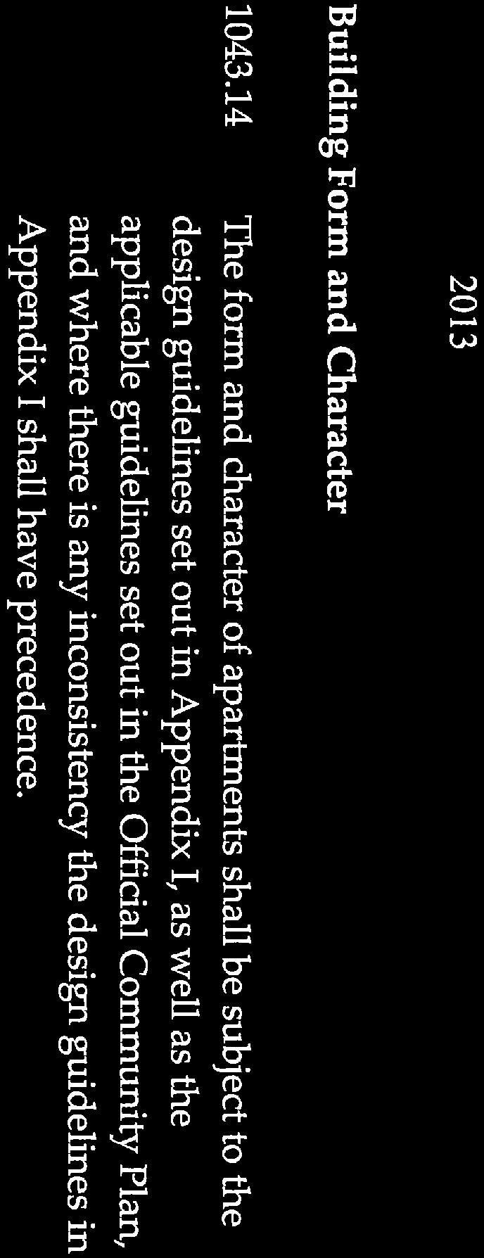
156 City of New Westminster September 20, "...is designated to accommodate a range of multi-family dwelling types. This Development Permit Area protects development from hazardous conditions arising from the floodplain and establishes objectives and guidelines for the form and character of multi-family development. PROCESS TO DATE 1. March Staff confirm the Medium Density Residential designation of the site and in conjunction with the owner, identified a list of reports that would be required prior to staff reviewing any redevelopment proposal for the site. This list included: Identification of Site Contamination issues and contact with the Ministry of Environment regarding their resolution. Identification of Dyke issues with the Dyke Authority and the City. Identification of foreshore environmental issues with FREMP Identification of foreshore use issues with Eraser Port 2. January A number of sites in Queensborough, including the subject site, were placed into an industrial conversion "study area". 3. April Council directed staff to commence with a new Queensborough Neighbourhood Plan. 4. May On May 5, 2008 Council moved that staff continue working with the proponent on the rezoning application for the property addresses at 41 and 175 Duncan Street. 5. June Land Use presentation to Advisory Planning Commission. 6. November Presentation to Queensborough Residents Association. DISCUSSION In the time since this application was considered by Council, new issues have been identified. First, subsequent to the Queensborough Residents Association presentation, City staff and Council identified issues with regard to the retention of existing employment uses on the site that are still active and employ an estimated 25 full time equivalent workers. In response to Council and staff concerns regarding the loss of industrial jobs, the applicant met with staff and has discussed modified plans to address the employment issue. In addition, the applicant was asked to consider the use of the site in the context of the Employment Lands Strategy.

157 City of New Westminster September 20, 2010 The applicant has provided a modified site plan which allows for up to 27,600 square feet of floor space for office, commercial or light industrial use. The proposed site is adjacent to the Port Metro Vancouver land to the west and will provide a buffer to a portion of the Port land and take advantage of the road exposure and convenient access. It is expected that the commercial/industrial parcel would pennit a 2 to 4 storey building which would replace the 25 full time equivalent positions at the shipyards. The proposed green space buffer on the west side of the site will also soften the impact of the industrial use on the Port lands. The inclusion of this proposed employment use is in line with current direction in this area; however it will require an amendment to the Official Community Plan. The entire site is currently designated (RM) Residential - Medium Density and the proposed employment use would require a Industrial or Commercial designation in order to allow Council to consider that portion of the rezoning application. The second issue raised is the impact of sale of the adjacent Interfor site to Port Metro Vancouver. This portion of the Interfor site is currently designated for future residential development in the Queensborough Official Community Plan but was included in the Council direction that all lands zoned for Industrial Use not be considered for residential development until the new Queensborough Community Plan was finalized. Further, the purchase of the Interfor site by Port Metro Vancouver for port-related industrial uses likely secures the future use of this site for industrial purposes. Staff has learned that there is a strong likelihood that the east portion of the former Interfor lands (now Port Metro Vancouver) will be used for industrial purposes in the near future, and the rail line running along Duncan could be re-activated. As such, staff has asked the applicant to revise the proposed site plan to mitigate the impact of an active railway line which is adjacent to the new residential development by including a greater setback and consideration of a landscape berm. The revised site plan has not been submitted. OPTIONS There are two options for Council's consideration; they are: 1. Direct staff to continue to process the application once the revised site plan is submitted, and report to Council when the staff and Committee review process is complete; or 2. Provide staff with further direction in the processing of this application Staff recommend Option 1
158 City of New Westminster September 20, CONCLUSION A revised rezoning application has been received for the property addressed as 41 and 175 Duncan Street to include employment land use in the proposal. This report outlines, for Council's information, two changes in the context for this proposal - the inclusion of the employment land use and the likely re-emergence of an industrial presence to the west of the site. /! JaiWs Hurst / *** velopment Planner Beverly^Grieve Manager of Planning Approved for Presentation to Council (y Lisa Spitale, Director of Development Services Paul Daminato, City Administrator : jh

159 APPENDIX Location Map
160 s:: FAIRWEATHER STAR CV c D 111 a- 3 / ^ct' D( v rcx sr. i) ; r A LT'- "> FOUNDRY 3 1^*. Ui X ' LU > \> 5 c. cr>i r". s K Q I in m S A \X> < 1 o t? \ CO 2 51 and 175 Duncan Street Scale: 1:2000 p The Corporation of Date: September 16, 2010 The City of New Westminster Copyrighl & This drawing is provided as a convenience, for information purposes only. The City of 03 <' Development Services - GIS New Westminster disclaims all responsibility for accuracy or completeness of - - Ct - Information contained In this drawing. All map Information should be confirmed In the field. Map information is derived from sources with varying levels of accuracy and may < have changed since compiled. In no event will the Cily of New Westminster be liable for any indirect, special, consequential or other damages due to any inaccuracy or Incompleteness ol map information. 5 CL
161 Letter from Applicant
162 A BROOK Brook + Associates Inc Suite 4'0-535 Thurlow Street Vancouve;, BC V6E 3L2 www,brookdev.com T ' 9053 F September 2, 2010 City of New Westminster 511 Royal Avenue New Westminster, BC (via ) Attention: Ms. Lisa Spitale, Ms. Bev Grieve, Mr. Jim Hurst City of New Westminster Development Services RE: Updates to Rezoning Application - 41 and 175 Duncan Street INTRODUCTION The purpose of this report is to provide an update to the City of New Westminster regarding the rezoning application in process for the 41 and 175 Duncan Street ("subject site"), also known as "Fraser Shipyards." The approximately 8 acres subject site is located immediately adjacent to the Fraser River, between the Port site to the west and the residential neighbourhood of Port Royal to the east. Kesho-Sonjan ("the proponent") had originally proposed a residential only development. Based on recent City feedback, the proposal has been revised to reduce the number of units and include an "employment" transitional zone to the Port site 'immediately west. This interim report provides: 1. Relevant background on the project; 2. Summary of previous updates to the City and Council; 3. Proposed changes to the project, namely the addition of a new "employment" area. BACKGROUND The Developer purchased the site in November, 2006, with the understanding an existing OCP designation for multi-family residential was in place. Subsequently, planning for the Subject Site has been underway since late 2006, and meetings with the City of New Westminster Development Services Department since early Based on the planning work undertaken on site and discussions with City staff, the proponent submitted a rezoning application for the subject property in April As presented previously to Council, the proponent has requested a change from the current zoning of Heavy Industrial (M-2) to Multi-Family Residential (CD) zoning. POLICY CONTEXT A number of policies and plans are in place in order to guide the planning and development associated with the subject site. The subject site is currently zoned M-2 - Heavy Industrial; however, the site is designated as RM - Residential Medium Density in the Official Community Plan, The RM designation slates that:
163 A BROOK Page 2 Fraser Shipyards, Update to Council - September 2, 2010 "this area will contain medium density multi-family residential uses such as row houses, stacked townhouses and low rises." The Queensborough Neighbourhood Plan designation for the subject site is RM - Residential Medium Density. Furthermore, the site is located in the East Queensborough Development Permit Area which "is designated to accommodate a range of multi-family dwelling types." COUNCIL RESOLUTIONS Throughout the history of this project Council has passed a number of resolutions and directives that have affected the subject property. January 2008 A number of sites in Queensborough, including the subject site, were placed into an industrial conversion "study area". This resolution prohibits commercial or residential redevelopment of identified properties until the Queensborough Community Plan had been reviewed. April 2008 Council directed staff to commence with a new Queensborough Neighbourhood Plan. This neighbourhood plan was initiated in June 2008 with a target completion in The proponent sought Council's direction regarding next steps and how to best proceed with the rezoning process and requested that Council consider the subject site independently of the Queensborough Plan review given the considerable amount of planning and design completed to date. Mav 2008 On May 5, 2008 Council moved that staff continue working with the proponent on the rezoning application for the property addresses at 41 and 175 Duncan Street. Based on that motion the proponent project team has continued to work with the City and move forward in the rezoning process. UPDATES TO PROJECT The proposed project updates respond to the adjacent land use context and are consistent with the spirit of the OCP policies and the City's employment objectives. Some of these proposed amendments to the plan are a result of post-rezoning application feedback received from the Development Services Department and the May 2008 Council resolution: Transitional Area The updated proposal contains a transitional buffer zone located at the western edge of the site. The goal of this area is to act as a transitional "buffer" to the Port site. Transition in this case has taken two forms: A parcel of land slated for employment related uses, commercial or industrial, or a mix of both. 2. A public open space located between proposed residential uses on the subject site and the Port site - and provides a park amenity to the riverfront.

164 icu BROOK Page 3 Fraser Shipyards, Update to Council - September 2,2010 The mixed commercial/industrial employment zone and greenspace along the western edge of the property will act as a transitional buffer area between the Port site to the west and the residential land uses to the east. Homes adjacent to the open space buffer could have an acoustical treatment for sound attenuation as a secondary measure to mitigate any potential sound nuisance from future industrial uses. The proposed employment zone located at the southwest corner of the site takes advantage of the road exposure/visibility and convenient access. Typically higher density commercial/industrial employment yields 1 employee per OOOsf. Therefore an employment zone parcel zoned to allow for a 2-4 story building would replace the approximately 25 existing full-time equivalent jobs at the Fraser Shipyards site. The proponent is requesting the parcel be zoned to accommodate a 2 story future employment related building (e.g. industrial or commercial), with an opportunity to build up to 4 storeys. It should be noted that the developer has contacted a construction company to estimate the "man-years" involved with site construction, Including consultants such as architects, engineers, etc. required for the design and site planning, and NOT including employment such as realty services, accountants, or lawyers that would receive consultant fees involved with the project, and NOT including the ongoing service jobs for the project after completion (landscaping, maintenance, plumber, electrician, property management etc.) - it estimated that 612 to 734 "man-years" of employment would be generated by the site development. In other words, this would equate to approximately 40 to 50 jobs per year for 15 years. Reduction of Housing Units The number of proposed units has been reduced from 437 to 413. The original mix of residential housing types outlined in the preliminary proposal has been retained and is as follows: Four 4 storey waterfront apartment buildings (approx. 302 units) Eight 2 storey stacked townhouse buildings (approx. 96 units) A 2 storey row townhouse zone (approx. 15 units) (Note: approximate number of units shown reflect the reduced numbers from the original proposal). CONCLUSION The proponent and its project team would like to continue the planning process and public consultation that began last year. The team presented to the Advisory Planning Committee in 2009, followed by a presentation to the Queensborough Residents Association on November 17, If the proposed amendments are sufficient in dealing with City questions to-date, we would like to schedule an update to the Residents Association and a Public Open House in October. The proposed development will provide a variety of residential dwelling types and a zone for future employment opportunities on-site. This will result in a lasting, high quality development that responds to the residential context of the neighbourhood, and an industrial land use immediately adjacent. We believe the proposed development will be a positive addition to the Queensborough community and the City of New Westminster, and the proposed amendments to the plan are a welcome addition to the project
165 A BROOK Page 4 Fraser Shipyards, Update to Council - September 2, 2010 If you would like to discuss further, please contact either of the undersigned. Sincerely, Brook + Associates Inc K.'TZUIC Gary Pooni, MEDes, MCIP President t: 604, x108 e: qpooni(q)brookdev.com Kathryn Tonelli, MEDes Planner t: x114 e: ktonelli(q)brookdev.com cc: Andrew Mindell, Sonjan Enterprises Randy Cooke, Kesho Inc. Donald Andrew, Creekside Architecture
166 1"- UlA-M? ittr. COPYRIQHT NOTICE B This drawing and design are al an hfpes to remain the exdusive property of Creekside Archiiccts and may nol bo used or reproduced vnihoui prtor wtijian consent W/itten dimensions shall have precedence over scaled dknensfons. A 11 is Iho r D responsidily of!he Contractor 10 notify IflS to.* Ihe Arch<et! m»he even! o» duc-eparv E 10E oea The Corlraclor shal contact the Architect in ah matters requiring mierprelaton ol this drawing. THIS DRAWING SMALL NOT BE USED FOR CONSTRUCTION PURPOSES UNTIL ISSUED FOR CONSTRUCTION. ' Li):r^sr r-7-> / b -V, 10? N I 1 " s v. PROJECT NAME WATERFRONT APARTMENT ZONE WATERFRONT APARTMENT ZONE i_u CBS um O PORT OPEN I r^i DRAWING TITLE UL. LXJ I I ZD LAND oo ca SPACE i IWATERFRQNT ACCESS n EMPLOYMENT CD C^L ZONE STACKED TOWNHOUSE ZONE PROJECT O O PROPOSED RESIDENTIAL DEVELOPMENT 41and 175 Duncan St East Queensborough New Weslminster BC CREEKSIDE ABCHIIbUIS No DR*WN APPROVED ::SJ: :::::: :r:... J...."V^^CZ SCALE N.T8. PLOT DATE NET SITE AREA SQF(8.04 ACRE) ROW TOWNHOUSE 15 STACK TOWNHOUSE 96 (FROM 120) APARTMENT 302 TOTAL 413 (FROM 437) UPA 55.8 APPROXIMATE FAR xx October i

167 V 1 Mi/v-n 1? COPYRIGHT NOTICE A B used or re C ICS E drawi ng and design are at all (he e»c4u*lv«propeny ol Architects and may r»ol produced without prior written consent. Written dim unions shall have precescaled dimensions. It is the Contractor shall prelc THIS DRAWING SHALL NOT BE USED FOR CONSTRUCTION PURPOSES UNTIL ISSUED FOR CONSTRUCTION. - : A SCxllS" 6900 sf :-J4?WPARTljltNT ^ J:? r" t v J n n [ J- PROJECT NAME PROPOSED RESIDENTIAL DEVELOPMENT m. % n - r-i J ' T T- n r nmt m cds 41 and 175 Duncan St X Easl Queensborough New Westminster BC DRAWING TITLE.. SS2 V, -yrrfita-tt, xslr^ CREEKSIDE ARCHTTECTS STACK TOWNHOUSE S-.. PROJECT No rvr-tfj cx tlx Z J :::::::: "J I SCALE "RAIlWAYBUf FERGREEN BUT" N.T.S. DRAWN APPROVED PLOT DATE NET SITE AREA SQF (8.04 ACRE) ROW TOWNHOUSE 15 STACK TOWNHOUSE 96 (FROM 120) APARTMENT 302 TOTAL 413 (FROM 437) UPA 55.8 APPROXIMATE FAR xx October
ADVISORY PLANNING COMMISSION
 Corporation of the City of ^ NEW WESTMINSTER ADVISORY PLANNING COMMISSION Tuesday, 5:30 p.m. Committee Room No. 2 MINUTES VOTING MEMBERS PRESENT; Ken Williams Peter Goodwin Peter Hall Andrew Orchard Margaret
250, 252, 254 and 256 Royal York Road and 8 and 10 Drummond Street - Zoning By-law Amendment Application - Preliminary Report
 STAFF REPORT ACTION REQUIRED 250, 252, 254 and 256 Royal York Road and 8 and 10 Drummond Street - Zoning By-law Amendment Application - Preliminary Report Date: May 28, 2013 To: From: Wards: Reference
WELCOME! TO THE UNIVERSITY ENDOWMENT LANDS BLOCK F PUBLIC OPEN HOUSE
 WELCOME! TO THE UNIVERSITY ENDOWMENT LANDS BLOCK F PUBLIC OPEN HOUSE The UEL & Block F What is the UEL? Site Location The University Endowment Lands (UEL) is a separate jurisdiction from the City of Vancouver
2. Rezone a portion of the lot from R2 (Small Lot Residential) to RD2 (Duplex: Housing Lane).
 to RD2 (Duplex: Housing Lane).") Public Notice September 6, 2018 Subject Property Subject Property: 337 Hastings Ave Lot 24, District Lot 1, Group 7, Similkameen Division Yale (Formerly Yale-Lytton) District, Plan 932 Application: The
Public Notice September 6, 2018 Subject Property Subject Property: 337 Hastings Ave Lot 24, District Lot 1, Group 7, Similkameen Division Yale (Formerly Yale-Lytton) District, Plan 932 Application: The
Director, Community Planning, Toronto and East York District
 STAFF REPORT September 1, 2005 To: From: Subject: Toronto and East York Community Council Director, Community Planning, Toronto and East York District Further Report Applications to amend Official Plan
REGULAR MEETING OF THE LAND USE AND PLANNING COMMITTEE
 REGULAR MEETING OF THE LAND USE AND PLANNING COMMITTEE Notice is hereby given of the following Land Use and Planning Committee: September 12, 2016 at 12:00 p.m. Committee Room 2, City Hall Call to order.
3035 Weston Road - Official Plan and Zoning By-law Amendment and Draft Plan of Subdivision Applications - Request for Directions Report
 STAFF REPORT ACTION REQUIRED 3035 Weston Road - Official Plan and Zoning By-law Amendment and Draft Plan of Subdivision Applications - Request for Directions Report Date: December 18, 2007 To: From: Wards:
CITY OF CAMPBELL RIVER PUBLIC HEARING AGENDA
 CITY OF CAMPBELL RIVER PUBLIC HEARING AGENDA PUBLIC HEARING MEETING, Monday, July 10, 2017 at 6:30 PM in the City Hall Council Chambers, 301 St. Ann's Road, Campbell River, BC. Page The agenda presents
PUBLIC HEARING INFORMATION PACKAGE
 PUBLIC HEARING INFORMATION PACKAGE ADDRESS: APPLICANT: 8522 Nottman Street Analytical Consulting PLANNING FILE(S): OCP17-002 R17-015 This Public Hearing Information Package has been compiled to provide
NCP Amendment Rezoning Development Permit
 City of Surrey PLANNING & DEVELOPMENT REPORT NCP Amendment Rezoning Development Permit Proposal: NCP Amendment from "Townhouses 15 upa max" to "Townhouses 20 upa max". Rezone from RA to CD and a DP to
LIN AVE The applicant is proposing to construct a four-unit Lot A R.P
 Public Notice June 21, 2018 Subject Property: 125 Calgary Avenue Lot 4, District Lot 250, Similkameen Division Yale District, Plan 1164, Except Plan B5473 Application: Rezone PL2018-8261 The applicant
CITY OF KAMLOOPS BYLAW NO A BYLAW TO AMEND THE ZONING BYLAW OF THE CITY OF KAMLOOPS
 67 68 CITY OF KAMLOOPS BYLAW NO. 5-1-2796 A BYLAW TO AMEND THE ZONING BYLAW OF THE CITY OF KAMLOOPS The Municipal Council of the City of Kamloops, in open meeting assembled, enacts as follows: 1. This
STAFF REPORT PLN September 11, 2017
 Page: 1 TO: SUBJECT: GENERAL COMMITTEE APPLICATIONS FOR OFFICIAL PLAN AMENDMENT AND ZONING BY-LAW AMENDMENT 37 JOHNSON STREET WARD: WARD 1 PREPARED BY AND KEY CONTACT: SUBMITTED BY: GENERAL MANAGER APPROVAL:
Planned Residence District (PR) To review a plan to construct 11 single family homes on approximately 4.01 acres.
 To review a plan to construct 11 single family homes on approximately 4.01 acres.") STAFF REPORT PLANNING & ZONING COMMISSION Village Green Municipal Building, Council Chambers 47 Hall Street Wednesday, March 13, 2019 7:00 P.M. 1. FINAL DEVELOPMENT PLAN REVIEW Applicant: Romanelli and
STAFF REPORT PLANNING & ZONING COMMISSION Village Green Municipal Building, Council Chambers 47 Hall Street Wednesday, March 13, 2019 7:00 P.M. 1. FINAL DEVELOPMENT PLAN REVIEW Applicant: Romanelli and
66 Isabella Street Rezoning Application - Preliminary Report
 STAFF REPORT ACTION REQUIRED 66 Isabella Street Rezoning Application - Preliminary Report Date: November 15, 2010 To: From: Wards: Reference Number: Toronto and East York Community Council Director, Community
1417, , 1427 & 1429 Yonge Street - Official Plan Amendment and Zoning Amendment Applications - Preliminary Report
 STAFF REPORT ACTION REQUIRED 1417, 1421-1425, 1427 & 1429 Yonge Street - Official Plan Amendment and Zoning Amendment Applications - Preliminary Report Date: March 24, 2015 To: From: Wards: Reference Number:
Rezoning Development Permit Development Variance Permit
 City of Surrey PLANNING & DEVELOPMENT REPORT Rezoning Development Permit Development Variance Permit Proposal: Rezone from RA to RM-30 and DP to permit development of a 58-unit townhouse development. DVP
LITTLE MOUNTAIN ADJACENT AREA REZONING POLICY
 LITTLE MOUNTAIN ADJACENT AREA REZONING POLICY JANUARY 2013 CONTENTS 1.0 INTENT & PRINCIPLES...1 2.0 APPLICATION...2 3.0 HOUSING TYPES, HEIGHT & DENSITY POLICIES...3 3.1 LOW TO MID-RISE APARTMENT POLICIES...4
CITY OF CAMPBELL RIVER PUBLIC HEARING AGENDA
 CITY OF CAMPBELL RIVER PUBLIC HEARING AGENDA PUBLIC HEARING MEETING, Tuesday, September 6, 2016 at 6:30 PM in the City Hall Council Chambers, 301 St. Ann's Road, Campbell River, BC. Page The agenda presents
York Neighbourhood Area Structure Plan
 York Neighbourhood Area Structure Plan Office Consolidation March 2006 Prepared by: Planning and Policy Services Branch Planning and Development Department City of Edmonton Bylaw 7064 was adopted by Council
STAFF REPORT. March 14, Toronto and East York Community Council. Director, Community Planning, South District
 STAFF REPORT March 14, 2005 To: From: Subject: Toronto and East York Community Council Director, Community Planning, South District Preliminary Report Official Plan Amendment and Rezoning Application 05
City of Surrey PLANNING & DEVELOPMENT REPORT
 City of Surrey PLANNING & DEVELOPMENT REPORT File: 7911-0016-00 Planning Report Date: September 12, 2011 PROPOSAL: Rezoning from C-4 to CD (based on C-5) in order to permit additional commercial uses in
NCP Amendment Rezoning Development Variance Permit
 City of Surrey PLANNING & DEVELOPMENT REPORT File: NCP Amendment Rezoning Development Variance Permit Proposal: NCP amendment from "Single Family Residential" to "Single Family Residential Small Lots";
City of Surrey PLANNING & DEVELOPMENT REPORT File:
 City of Surrey PLANNING & DEVELOPMENT REPORT PROPOSAL: Planning Report Date: June 15, 2009 Rezoning from C-4 to CD (based on C-5) in order to permit additional commercial uses in an existing non-conforming
City of Surrey PLANNING & DEVELOPMENT REPORT File:
 City of Surrey PLANNING & DEVELOPMENT REPORT PROPOSAL: Partial LUC Discharge Planning Report Date: April 28, 2008 Rezoning from RF to RF-9 in order to allow subdivision into three small single family lots.
Weston Road (Phase 2) - Official Plan and Zoning By-law Amendment and Lifting of the (H) Holding Symbol Applications - Preliminary Report
 - Official Plan and Zoning By-law Amendment and Lifting of the (H) Holding Symbol Applications - Preliminary Report") STAFF REPORT ACTION REQUIRED 3415-3499 Weston Road (Phase 2) - Official Plan and Zoning By-law Amendment and Lifting of the (H) Holding Symbol Applications - Preliminary Report Date: March 8, 2016 To:
STAFF REPORT ACTION REQUIRED 3415-3499 Weston Road (Phase 2) - Official Plan and Zoning By-law Amendment and Lifting of the (H) Holding Symbol Applications - Preliminary Report Date: March 8, 2016 To:
Welcome. Please show us where you live: A Zone and Design Guidelines for the Apartment Transition Area. We want your feedback!
 Welcome Please show us where you live: A Zone and Design Guidelines for the Apartment Transition Area The Plan, approved by Council in 2010, outlines a long-term vision of a neighbourhood heart centred
Rezoning. Rezone a portion of the property from CD to RF-9 to allow subdivision into approximately 8 small single family lots with rear lane access.
 City of Surrey PLANNING & DEVELOPMENT REPORT File: Rezoning Proposal: Rezone a portion of the property from CD to RF-9 to allow subdivision into approximately 8 small single family lots with rear lane
Sheppard Ave East and 6, 8 and 10 Greenbriar Road - Official Plan Amendment and Zoning Amendment Applications - Preliminary Report
 STAFF REPORT ACTION REQUIRED 625-627 Sheppard Ave East and 6, 8 and 10 Greenbriar Road - Official Plan Amendment and Zoning Amendment Applications - Preliminary Report Date: April 15, 2016 To: From: Wards:
Staff Report for Council Public Meeting
 Agenda Item 3.3 Staff Report for Council Public Meeting Date of Meeting: September 27, 2017 Report Number: SRPRS.17.134 Department: Division: Subject: Planning and Regulatory Services Development Planning
Chairman and Members of the Planning and Development Committee. Thomas S. Mokrzycki, Commissioner of Planning and Building
 Exhibit 1 Port Credit DATE: TO: FROM: SUBJECT: Chairman and Members of the Planning and Development Committee Thomas S. Mokrzycki, Commissioner of Planning and Building Proposed Heritage Conservation District
Yonge Street and 3 Gerrard Street East - Zoning Amendment Application - Preliminary Report
 STAFF REPORT ACTION REQUIRED 363-391 Yonge Street and 3 Gerrard Street East - Zoning Amendment Application - Preliminary Report Date: May 22, 2015 To: From: Wards: Reference Number: Toronto and East York
Islington Avenue - Official Plan and Zoning By-law Amendment Application - Preliminary Report
 STAFF REPORT ACTION REQUIRED 3002-3014 Islington Avenue - Official Plan and Zoning By-law Amendment Application - Preliminary Report Date: Febuary 2, 2016 To: From: Wards: Reference Number: Etobicoke York
REPORT TO THE CHIEF ADMINISTRATIVE OFFICER FROM THE DEVELOPMENT, ENGINEERING, AND SUSTAINABILITY DEPARTMENT
 April 19, 2018 REPORT TO THE CHIEF ADMINISTRATIVE OFFICER FROM THE DEVELOPMENT, ENGINEERING, AND SUSTAINABILITY DEPARTMENT ON REZONING APPLICATION NO. REZ00631 DEVELOPMENT PERMIT APPLICATION NO. DPM00627
Property Location: 2970 Bank Road
 When? Where? Why? Tuesday, May 29, 2018, 7:00 pm Council Chambers, City Hall, 7 Victoria Street West Kamloops City Council will hold a Public Hearing to consider the following proposed amendments to City
5 to 25 Wellesley Street West and 14 to 26 Breadalbane Street - Zoning Amendment Application - Preliminary Report
 STAFF REPORT ACTION REQUIRED 5 to 25 Wellesley Street West and 14 to 26 Breadalbane Street - Zoning Amendment Application - Preliminary Report Date: May 16, 2013 To: From: Wards: Reference Number: Toronto
TO: Mayor & Council DATE: July 19, FROM: General Manager, Planning & Development FILE:
 CORPORATE REPORT NO: L002 COUNCIL DATE: July 24, 2017 REGULAR COUNCIL LAND USE TO: Mayor & Council DATE: July 19, 2017 FROM: General Manager, Planning & Development FILE: 5480 01 SUBJECT: Proposed Amendments
Address: 2025 Agassiz Road Applicant: Cristian Anca. RM5 Medium Density Multiple Housing
 REPORT TO COUNCIL Date: February 20, 2017 RIM No. 1250-30 To: From: City Manager Community Planning Department (TB) Application: Z16-0052 Owner: Exceling Investments Inc. No. BC1062096 Address: 2025 Agassiz
Rezoning. Rezone from RA to RF-12 to allow subdivision into approximately 8 small single family lots. Approval to Proceed
 City of Surrey PLANNING & DEVELOPMENT REPORT File: 7904-0228-00 Rezoning Proposal: Rezone from RA to RF-12 to allow subdivision into approximately 8 small single family lots. Recommendation: Approval to
Lot 1 KAP Lot 1. Lot 1. Lot 4. ot 5
 Public Notice January 11, 2018 Subject Property: 237 Phoenix Avenue Lot 4, District Lot 5, Group 7 Similkameen Division Yale (Formerly Yale-Lytton) District, Plan 10974 Application: The applicant is proposing
The Corporation of Delta COUNCIL REPORT Regular Meeting
 E.02 The Corporation of Delta COUNCIL REPORT Regular Meeting To: Mayor and Council File No.: LU007986 From: Community Planning & Development Department Date: April 25, 207 Bylaw Nos.: 766 and 7662 Official
12, 14, 16 and 18 Marquette Avenue and 7 Carhartt Street Zoning By-law Amendment Application - Preliminary Report
 STAFF REPORT ACTION REQUIRED 12, 14, 16 and 18 Marquette Avenue and 7 Carhartt Street Zoning By-law Amendment Application - Preliminary Report Date: July 17, 2014 To: From: Wards: Reference Number: North
Density Bonus Program Phase 2 City of New Westminster
 Bonus Program Phase 2 Downtown New Westminster Bonus Program Phase 2 City of New Westminster Presentation to the Urban Development Institute May 2, 2014 Michael Watson, Planning Technician, Barry Waitt,
OCP Amendment Rezoning Development Permit Development Variance Permit
 City of Surrey PLANNING & DEVELOPMENT REPORT Files: 7906-0297-00 OCP Amendment Rezoning Development Permit Development Variance Permit Proposal: OCP Amendment of a portion from Commercial to Multiple Residential.
STAFF REPORT. Financial Impact Statement There are no immediate financial impacts associated with the adoption of this report.
 STAFF REPORT Planning and Development Department Subject: Cottage Country Unsubstantial Amendment to Development Agreement To: CAO for Planning Advisory Committee, December 13, 2016 Date Prepared: December
*DO NOT REMOVE * R Sharp McRae Avenue
 *DO NOT REMOVE * R16-003 - Sharp 32385 McRae Avenue This Public Hearing Information Package has been compiled to provide information pertaining to the subject property. If you have questions regarding
ADVISORY PLANNING COMMISSION
 ADVISORY PLANNING COMMISSION Tuesday, at 5:30 p.m. Council Chambers MINUTES VOTING MEMBERS PRESENT: Alex Sweezey Laura Cornish Margaret Fairweather Peter Goodwin Andrew Hull Peter Hall Christa MacArthur
Toronto and East York Community Council. Director, Community Planning, Toronto and East York District
 STAFF REPORT ACTION REQUIRED 1481, 1491, 1501 Yonge Street, 25 & 27 Heath Street East and 30 Alvin Avenue Official Plan and Zoning Amendment Application 06 199698 STE 22 OZ Preliminary Report Date: March
Development Permit No Government Road Amblepath Townhomes
 DISTRICT OF SQUAMISH REPORT TO: Council FOR: Business PRESENTED: May 15 th 2007 FILE: DP No. 257 2006-51 FROM: SUBJECT: Planning Department Development Permit No. 257 40137 Government Road Amblepath Townhomes
NO: R172 COUNCIL DATE: SEPTEMBER 9, Locational Guidelines for Private Liquor Stores (Licensee Retail Stores)
") CORPORATE REPORT NO: R172 COUNCIL DATE: SEPTEMBER 9, 2013 REGULAR COUNCIL TO: Mayor & Council DATE: September 9, 2013 FROM: General Manager, Planning and Development FILE: 0340-01 SUBJECT: Locational Guidelines
CORPORATE REPORT NO: R172 COUNCIL DATE: SEPTEMBER 9, 2013 REGULAR COUNCIL TO: Mayor & Council DATE: September 9, 2013 FROM: General Manager, Planning and Development FILE: 0340-01 SUBJECT: Locational Guidelines
25 Leonard Avenue - Official Plan Amendment and Zoning Amendment Applications - Preliminary Report
 STAFF REPORT ACTION REQUIRED 25 Leonard Avenue - Official Plan Amendment and Zoning Amendment Applications - Preliminary Report Date: March 8, 2017 To: From: Wards: Reference Number: Toronto and East York
General Manager of Planning, Urban Design, and Sustainability in consultation with the Director of Legal Services
 POLICY REPORT DEVELOPMENT AND BUILDING Report Date: August 31, 2016 Contact: Anita Molaro Contact No.: 604.871.6489 RTS No.: 11651 VanRIMS No.: 08-2000-20 Meeting Date: October 18, 2016 TO: FROM: SUBJECT:
6040 Bathurst Street and 5 Fisherville Road Zoning Bylaw Amendment Application Preliminary Report
 STAFF REPORT ACTION REQUIRED 6040 Bathurst Street and 5 Fisherville Road Zoning Bylaw Amendment Application Preliminary Report Date: January 24, 2017 To: From: Wards: Reference Number: North York Community
CITY OF VANCOUVER POLICY REPORT DEVELOPMENT AND BUILDING
 P2 CITY OF VANCOUVER POLICY REPORT DEVELOPMENT AND BUILDING Report Date: May 1, 2007 Author: Michael Naylor Phone No.: 604.871.6269 RTS No.: 06621 VanRIMS No.: 11-3600-10 Meeting Date: May 15, 2007 TO:
City of Surrey PLANNING & DEVELOPMENT REPORT File: Development Permit
 City of Surrey PLANNING & DEVELOPMENT REPORT File: 7909 0142 00 PROPOSAL: Development Permit Planning Report Date: October 19, 2009 Development Variance Permit in order to permit the development of two
3390, 3392, 3394, 3396 and 3398 Bayview Avenue - Official Plan Amendment, Zoning By-law Amendment Application - Preliminary Report
 STAFF REPORT ACTION REQUIRED 3390, 3392, 3394, 3396 and 3398 Bayview Avenue - Official Plan Amendment, Zoning By-law Amendment Application - Preliminary Report Date: March 14, 2016 To: From: Wards: Reference
Planning and Building Department
 Page 1 of Report PB-83-13 TO: Development and Infrastructure Committee Planning and Building Department SUBJECT: OP & Rezoning 5001 Corporate Drive Appleby Gardens LJM Developers Report Number: PB-83-13
City of Surrey PLANNING & DEVELOPMENT REPORT File:
 City of Surrey PLANNING & DEVELOPMENT REPORT File: 7907-0215-00 Planning Report Date: October 17, 2011 PROPOSAL: Rezoning a portion from IL-1 to CHI Development Permit Development Variance Permit in order
50 and 52 Neptune Drive Rezoning Preliminary Report
 STAFF REPORT ACTION REQUIRED 50 and 52 Neptune Drive Rezoning Preliminary Report Date: February 11, 2010 To: From: Wards: Reference Number: North York Community Council Director, Community Planning, North
3 and 5 Southvale Dr - Official Plan Amendment and Zoning Amendment Applications - Preliminary Report
 STAFF REPORT ACTION REQUIRED 3 and 5 Southvale Dr - Official Plan Amendment and Zoning Amendment Applications - Preliminary Report Date: August 20, 2015 To: From: Wards: Reference Number: North York Community
Director, Community Planning, North York District NNY 10 OZ and NNY 10 RH
 STAFF REPORT ACTION REQUIRED 847 873 Sheppard Avenue West - Official Plan Amendment and Zoning By-law Amendment and Rental Housing Demolition and Conversion Applications - Preliminary Report Date: April
City of Kelowna Public Hearing AGENDA
 City of Kelowna Public Hearing AGENDA Tuesday, November 21, 2017 6:00 pm Council Chamber City Hall, 1435 Water Street Pages 1. Call to Order THE CHAIR WILL CALL THE HEARING TO ORDER: 1. (a) The purpose
Inverness Area Planning Advisory Committee Inverness County Planning Advisory Committee Inverness County Council Planning Staff (EDPC)
") STAFF REPORT To: From: Inverness Area Planning Advisory Committee Inverness County Planning Advisory Committee Inverness County Council Planning Staff (EDPC) Date: January 18, 2018 Reference: Request for
STAFF REPORT To: From: Inverness Area Planning Advisory Committee Inverness County Planning Advisory Committee Inverness County Council Planning Staff (EDPC) Date: January 18, 2018 Reference: Request for
Staff Report for Council Public Meeting
 Agenda Item 3.3 a Staff Report for Council Public Meeting Date of Meeting: February 7, 2018 Report Number: SRPRS.18.022 Department: Division: Subject: Planning and Regulatory Services Development Planning
Rezoning Development Permit
 City of Surrey PLANNING & DEVELOPMENT REPORT File: Rezoning Development Permit Proposal: Rezone from RF to RM-D in order to allow subdivision into 2 duplex lots. A Development Permit to allow development
RM2 Low Density Row Housing RM3 Low Density Multiple Housing
 REPORT TO COUNCIL Date: May 30, 2017 RIM No. 0940-40 To: From: City Manager Community Planning Department (LK) Application: DP16-0014 & DVP16-0144 Owner: RA Quality Homes Ltd., INC. No.BC0647947 & 1052192
8.5.1 R1, Single Detached Residential District
 8.5.1 R1, Single Detached Residential District The purpose of this district is to provide for residential development in the form of single detached dwellings. Dwelling, Single Detached Home Business,
COUNCIL AGENDA DISTRICT OF WEST VANCOUVER TH STREET, WEST VANCOUVER BC V7V 3T3 COUNCIL REPORT
 COUNCIL AGENDA Director CAO Date: Item: DISTRICT OF WEST VANCOUVER 750 17TH STREET, WEST VANCOUVER BC V7V 3T3 COUNCIL REPORT Date: July 3, 2018 Subject: Rezoning and Development Variance Permit for The
5. Housing. Other Relevant Policies & Bylaws. Several City-wide policies guide our priorities for housing diversity at the neighbourhood level: Goals
 5. Housing Other Relevant Policies & Bylaws Several City-wide policies guide our priorities for housing diversity at the neighbourhood level: Goals 1. Encourage more housing diversity while maintaining
Plan Dutch Village Road
 Plan Dutch Village Road Objective: The lands around Dutch Village Road are a minor commercial area that services the larger Fairview community. Maintaining the vibrancy of the area by planning for redevelopment
SUBJECT: Official Plan and Zoning By-law Amendment Applications for 4853 Thomas Alton Boulevard
 Page 1 of Report PB-100-16 SUBJECT: Official Plan and Zoning By-law Amendment Applications for 4853 Thomas Alton Boulevard TO: FROM: Development and Infrastructure Committee Planning and Building Department
Keele Street - Official Plan and Zoning By-law Amendment Application - Preliminary Report
 STAFF REPORT ACTION REQUIRED 406-410 Keele Street - Official Plan and Zoning By-law Amendment Application - Preliminary Report Date: September 20, 2017 To: From: Wards: Reference Number: Etobicoke York
DEVELOPMENT APPLICATION PRE-CONSULTATION FORM
 DEVELOPMENT APPLICATION PRE-CONSULTATION FORM Meeting Date: Property Owner: Site Address: Applicant & Address Site Area: APPLICATION TYPE (check applicable applications): Local Official Plan Amendment
PLANNING COMMISSION STAFF REPORT
 PLANNING COMMISSION STAFF REPORT West Capitol Hill Zoning Map Amendment Petition No. PLNPCM2011-00665 Located approximately at 548 W 300 North Street, 543 W 400 North Street, and 375 N 500 West Street
740 and 750 York Mills Road and 17 Farmstead Road Zoning By-law Amendment Application Preliminary Report
 STAFF REPORT ACTION REQUIRED 740 and 750 York Mills Road and 17 Farmstead Road Zoning By-law Amendment Application Preliminary Report Date: September 20, 2013 To: From: Wards: Reference Number: North York
Financial Impact Statement There are no immediate financial impacts associated with the adoption of this report.
 STAFF REPORT Planning and Development Department Subject: Application by RYC Property to rezone a portion of lands on John Murray Dr. and Megan Lynn Dr. from R2 to R3 and to enter into a Development Agreement
City of Surrey PLANNING & DEVELOPMENT REPORT File:
 City of Surrey PLANNING & DEVELOPMENT REPORT PROPOSAL: Planning Report Date: November 5, 2007 Rezoning from RA to RF in order to allow subdivision into approximately 12 single family residential lots.
4650 Eglinton Avenue West - Zoning By-law Amendment Application - Preliminary Report
 STAFF REPORT ACTION REQUIRED 4650 Eglinton Avenue West - Zoning By-law Amendment Application - Preliminary Report Date: August 14, 2015 To: From: Wards: Reference Number: Etobicoke York Community Council
For Vintages of Four Mile Creek Town of Niagara on the Lake, Ontario
 Planning Impact Analysis For Vintages of Four Mile Creek Town of Niagara on the Lake, Ontario Prepared by: Upper Canada Consultants 261 Martindale Road Unit #1 St. Catharines, Ontario L2W 1A1 Prepared
Public Notice. June 7, Application: New Zoning Schedule: RD3 (Residential Infill)
") Public Notice June 7, 2018 Application: New Zoning Schedule: RD3 (Residential Infill) The new zoning designation RD3 (Residential Infill) can support smart growth by increasing density in areas where existing
Public Notice June 7, 2018 Application: New Zoning Schedule: RD3 (Residential Infill) The new zoning designation RD3 (Residential Infill) can support smart growth by increasing density in areas where existing
Greenfield Development Requirements
 Greenfield Development Requirements Planning & Engineering Department City of Yorkton Saskatchewan 2014 Summary Greenfield Development refers to the development of raw land to a finished state as residential,
P. H. Robinson Consulting Urban Planning, Consulting and Project Management
 PLANNING RATIONALE REPORT FOR SITE PLAN AND DRAFT PLAN OF CONDOMINIUM APPLICATIONS 73-75 HARVEY STREET CITY OF OTTAWA PREPARED BY: P H ROBINSON CONSULTING AUGUST 2012 1 This report has been prepared on
Request for Proposal RFP To Acquire and Develop 2203 Marine Drive, nd Street West Vancouver, BC
 Request for Proposal RFP 08 19 - To Acquire and Develop 2203 Marine Drive, 787 815 22nd Street West Vancouver, BC Prime development site in the heart of West Vancouver Adjacent to Marine Drive and the
ALC Bylaw Reviews. A Guide for Local Governments
 2018 ALC Bylaw Reviews A Guide for Local Governments ALC Bylaw Reviews A Guide for Local Governments This version published on: August 14, 2018 Published by: Agricultural Land Commission #201-4940 Canada
PLANNING REPORT Gordon Street City of Guelph. Prepared on behalf of Ontario Inc. March 17, Project No. 1507
 PLANNING REPORT 1131 Gordon Street City of Guelph Prepared on behalf of 1876698 Ontario Inc. March 17, 2016 Project No. 1507 423 Woolwich Street, Suite 201, Guelph, Ontario, N1H 3X3 Phone (519) 836-7526
Planning Rationale in Support of an Application for Plan of Subdivision and Zoning By-Law Amendment
 Planning Rationale in Support of an Application for Plan of Subdivision and Zoning By-Law Amendment The Kilmorie Development 21 Withrow Avenue City of Ottawa Prepared by: Holzman Consultants Inc. Land
770 BROOKFIELD ROAD Site Plan Control Atlantis Investments November 2017
 770 BROOKFIELD ROAD Site Plan Control Atlantis Investments November 2017 Prepared for: Atlantis Investments Inc. Prepared by: Fotenn Planning + Design 223 McLeod Street Ottawa, ON K2P 0Z8 fotenn.com October
General Manager of Planning, Urban Design, and Sustainability, in consultation with the Director of Legal Services
 POLICY REPORT DEVELOPMENT AND BUILDING Report Date: September 27, 2016 Contact: Anita Molaro Contact No.: 604.871.6479 RTS No.: 11685 VanRIMS No.: 08-2000-20 Meeting Date: October 18, 2016 TO: FROM: SUBJECT:
Proposed Development at Ajax Plaza Windcorp Grand Harwood Place Ltd.
 Proposed Development at Ajax Plaza Windcorp Grand Harwood Place Ltd. Presentation to Ajax Council July 4, 2013 Introduction 1. Background 2. Planning Policies and Regulations 3. Downtown Community Improvement
Advisory Design Panel Report For the Meeting of February 27, 2019
 Advisory Design Panel Report For the Meeting of February 27, 2019 To: Advisory Design Panel Date: February 15, 2019 From: Subject: Moira Wilson, Senior Planner - Urban Design 952 Johnson Street and 1400
City of Surrey PLANNING & DEVELOPMENT REPORT File: Rezoning from RA to RF in order to allow subdivision into 2 single family lots.
 City of Surrey PLANNING & DEVELOPMENT REPORT File: 7911-0033-00 Planning Report Date: April 23, 2012 PROPOSAL: Rezoning from RA to RF in order to allow subdivision into 2 single family lots. LOCATION:
3.1. OBJECTIVES FOR RESIDENTIAL LAND USE DESIGNATIONS GENERAL OBJECTIVES FOR ALL RESIDENTIAL DESIGNATIONS
 3. RESIDENTIAL LAND USE DESIGNATIONS INTRODUCTION The Residential land use designations provide for housing and other land uses that are integral to, and supportive of, a residential environment. Housing
10.2 ALBION AREA PLAN
 10.2 ALBION AREA PLAN Maple Ridge Official Community Plan Bylaw No. 7060-2014 Chapter 10, Page 5 10.2 ALBION AREA PLAN The following policies are adopted to guide development within the Albion urban area.
1061 The Queensway - Official Plan and Zoning By-law Amendment Applications - Preliminary Report
 STAFF REPORT ACTION REQUIRED 1061 The Queensway - Official Plan and Zoning By-law Amendment Applications - Preliminary Report Date: January 28, 2015 To: From: Wards: Reference Number: Etobicoke York Community
Staff Report for Council Public Meeting
 Agenda Item 3.3 a Staff Report for Council Public Meeting Date of Meeting: April 11, 2018 Report Number: SRPRS.18.087 Department: Division: Subject: Planning and Regulatory Services Development Planning
District of Summerland Advisory Planning Commission Meeting Agenda
 District of Summerland Advisory Planning Commission Meeting Agenda Friday July 22nd 2016 at 9:00 a.m. Council Chambers Municipal Hall - 13211 Henry Avenue, Summerland, BC 1. Call to Order 2. Adoption of
Rezoning from IL-1 to IB-2
 City of Surrey PLANNING & DEVELOPMENT REPORT PROPOSAL: Rezoning from IL-1 to IB-2 Planning Report Date: June 27, 2011 to facilitate future industrial development in South Westminster. LOCATION: OWNER:
CASTLES OF CALEDON URBAN DESIGN REPORT
 CASTLES OF CALEDON URBAN DESIGN REPORT PROPOSED RESIDENTIAL DEVELOPMENT CALEDON, ONTARIO 10 JULY, 2015 TABLE CONTENTS: 1.0 DEVELOPMENT 4.0 CONCLUSION 1.1 Introduction 1.2 Castles of Caledon- Urban Design
1970 Victoria Park Avenue and 9 Clintwood Gate Zoning By-law Amendment Application Preliminary Report
 STAFF REPORT ACTION REQUIRED 1970 Victoria Park Avenue and 9 Clintwood Gate Zoning By-law Amendment Application Preliminary Report Date: September 23, 2013 To: From: Wards: Reference Number: North York
30 Widmer Street and Adelaide Street West - Zoning Amendment Application - Preliminary Report
 STAFF REPORT ACTION REQUIRED 30 Widmer Street and 309-315 Adelaide Street West - Zoning Amendment Application - Preliminary Report Date: January 13, 2015 To: From: Wards: Reference Number: Toronto and