CITY OF NEWPORT PLANNING COMMISSION MEETING NEWPORT CITY HALL JULY 12, :00 P.M.
|
|
|
- Godwin Murphy
- 5 years ago
- Views:
Transcription

1 CITY OF NEWPORT PLANNING COMMISSION MEETING NEWPORT CITY HALL JULY 12, :00 P.M. Chairperson: Susan Lindoo City Administrator: Brian Anderson Vice-Chair: Dan Lund Executive Analyst: Renee Helm Commissioner: Janice Anderson Council Liaison: Tom Ingemann Commissioner: Katy McElwee-Stevens Commissioner: Matt Prestegaard 1. CALL TO ORDER 2. ROLL CALL AGENDA 3. APPROVAL OF PLANNING COMMISSION MINUTES A. Planning Commission Minutes of May 10, APPOINTMENTS WITH COMMISSION A. Public Hearing To consider an application from Martin Vietoris for Rezoning and Minor Subdivision for property located at the corner of Ford and Valley Roads 1. Memo from Berry Farrington 2. Application 3. Notice of Public Hearing 4. Resolution No. P.C Resolution No P.C B. Resolution No. P.C Recommending that City Council approve an amendment to Chapter 6, Animals of the City of Newport Code of Ordinances 5. COMMISSION & STAFF REPORTS 6. NEW BUSINESS 7. ANNOUNCEMENTS A. Upcoming Meetings and Events: 1. Open House for Transit Station July 18, :00 p.m. 2. City Council Meeting July 19, :30 p.m. 3. City Council Meeting August 2, :30 p.m. 4. Planning Commission Meeting August 9, :00 p.m. 8. ADJOURNMENT
2 City of Newport Planning Commission Minutes May 10, CALL TO ORDER Chairperson Lindoo called the meeting to order at 7:01 P.M. 2. ROLL CALL - Commissioners present Susan Lindoo, Dan Lund, Janice Anderson, Katy McElwee-Stevens, Matt Prestegaard Commissioners absent Also present Brian Anderson, City Administrator; Renee Helm, Executive Analyst; Tom Ingemann, Council Liaison; Sherri Buss, TKDA Planner 3. APPROVAL OF PLANNING COMMISSION MINUTES A. Planning Commission Minutes of April 12, 2012 Motion by McElwee-Stevens, seconded by Prestegaard, to approve the April 12, 2012 minutes as presented. With 5 Ayes, 0 Nays, the motion carried. B. Board of Appeal Minutes of April 19, 2012 Motion by Prestegaard, seconded by McElwee-Stevens, to approve the April 19, 2012 Board of Appeal minutes as presented. With 5 Ayes, 0 Nays, the motion carried. 4. APPOINTMENTS WITH COMMISSION A. Public Hearing To consider amendments to the Zoning Code, including the following: Chapter 1300, Section 1330 General District Regulations, and Section 1350 Nonresidential Districts, and to consider an addition to Chapter 1300 by adding Section River Redevelopment Overlay District The Public Hearing opened at 7:03 p.m. Admin. Anderson, Sherri Buss, and Executive Analyst Helm presented on this item as outlined in the May 10, 2012 Planning Commission packet. Executive Analyst Helm presented on the amendments to Subd. 15 and 21 of Section Dan Lund Do we want to define a small enclosure? Executive Analyst Helm I think that would be the discretion of the City Administrator. Dan Lund Because we want it to include gardens, trees and shrubs. Also, we re excluding it from people outside of the RE District, correct? Executive Analyst Helm Yes, it can only be used in the RE District. 1 3.A
3 Dan Lund I would say that we allow it in all of the residential districts. Do we want to include chicken wire as well? Susan Lindoo I m fine with using it as an enclosure but not as a fence. I wouldn t want to see chicken or welded wire used as a fence. I would be fine with welded wire in the backyard. Matt Prestegaard I agree. I think we should suggest that welded wire is always appropriate for small enclosures, but not fences. Dan Lund We could say that we don t consider welded wire or chicken wire around gardens to be a fence. Ms. Buss You could say welded wire may be used in all districts in the following locations. Matt Prestegaard My suggestion is to put welded wire under letter I, and state that it can be used for small enclosures. We leave the letter J, which states that it can be used for fencing in the RE District. Susan Lindoo Although, I states the allowable materials for fences. Executive Analyst Helm What we could do is for K put Welded wire may be used for small enclosures in all of the districts and for J, I would add that welded wire may not be used for fences except for in the rear yard in the RE District. Dan Lund Do we need to address chicken wire? Susan Lindoo It s not on the list of allowable materials for fences. Dan Lund I don t want to tell people that they can t use chicken wire to keep out rabbits. Susan Lindoo I don t think we are, we re just saying you can t use it as a fence. Dan Lund We have two problems here, one is what the words should say and the other is what do we mean them to say. I think we should address what we mean them to say before we do it. Susan Lindoo In my sense, I wouldn t worry about chicken wire because it s not a permitted fence use and I think that s the most visible. It seems that your point is that we want to allow protection of plants in all districts. What Renee has suggested seems clear to me. Ms. Buss As long as fence is defined in the ordinance. The Public Hearing closed at 7:32 p.m. Motion by Anderson, seconded by Prestegaard, to approve Resolution No. P.C as amended. With 5 Ayes, 0 Nays, the motion carried. B. Public Hearing To consider an addition to Section 1371 Storm Water Management The Public Hearing opened at 8:11 p.m. Executive Analyst Helm presented on this item as outlined in the May 10, 2012 Planning Commission packet. Dan Lund Do we want to ban the sale of coal-tar based products as well? Admin. Anderson It s not an illegal substance. The local hardware stores do have customers from surrounding areas where it isn t banned and it may hinder their sales. 2
4 Susan Lindoo I would need more research and a legal opinion. Katy McElwee-Stevens I would need more information. Executive Analyst Helm White Bear Lake or Maplewood is the only municipality that bans the sale of it. Also, Home Depot, Lowes and Menards have stopped selling these products. Admin. Anderson I spoke with the owner of Bartles about the ordinance and didn t mention that we were looking at banning the sale; I only mentioned that we were looking at banning the use. He understood why we want to ban the use of it. Matt Prestegaard I agree that I would need more information. Dan Lund I agree that we need more consideration to ban the sale. The Public Hearing closed at 8:19 p.m. Motion by Lund, seconded by Anderson, to approve Resolution No. P.C as presented. With 5 Ayes, 0 Nays, the motion carried. C. Red Rock Corridor Redevelopment Plan Admin. Anderson, Barb Dacy, Executive Director of the Washington County HRA, and Stacy Kvilvang of Ehlers, presented on this item as outlined in the May 10, 2012 Planning Commission packet. Ms. Buss This City has not done a Tax Increment District in quite a while, could you provide a brief tutorial on it? Ms. Dacy The County HRA would create and be responsible for the TIF District. Once a district is created, the value of the property is set as a floor, called the base value. When new development occurs, they will be at a higher value. The difference between the values is the tax increment. We can use that difference to help pay the various costs. The properties will still continue to pay taxes based on the base value. We can use the tax increment for a period of years to help pay for the improvements. Susan Lindoo So the HRA is putting the money upfront and when the development occurs, the difference will go to paying back the HRA. Will TIF fund the infrastructure? If we sell those types of bonds, how do those get paid off? Ms. Kvilvang There are two types of bond that you can sell for the public improvements. For any roadway improvements, there s a GO429 Special Assessment Bond. That means that at least 20% of the cost of the improvement has to be assessed back to the benefiting property owners. That s paid from special assessments, the rest is paid from a tax levy. We will look at all of the financing tools once the public improvements come forward to determine which tool is the best to use. Matt Prestegaard We must realize the tax increment before we re obliged to use that money. Is there interest or what s the arrangement back to the HRA? Ms. Dacy This is a key part of our mission. The investment that will occur in this area will help both the City and County. Ms. Kvilvang An interfund loan is created for both the City and HRA. They would loan money to the district and expect to get repaid. Statute limits the amount of interest, today it is at 4%. 3
5 Dan Lund What exactly are we committing to? Ms. Dacy The overall goals and the notion that it s appropriate to do this. It also implements the MX-3 District that you just approved. Dan Lund What time line do you expect before major development? Ms. Dacy The commercial market is still trying to recover, the housing market is significantly brighter. There could be development in the next two to five years. Motion by Anderson, seconded by McElwee-Stevens, to recommend the City Council approve the Red Rock Corridor Redevelopment Plan. With 5 Ayes, 0 Nays, the motion carried. 5. COMMISSION AND STAFF REPORTS Susan Lindoo I would like to request that Sherri provide information on what percentage of the City is in each zoning district. Ms. Buss I can provide that. We can do it on the current land use and the new zoning map. Admin. Anderson The City qualified as a Step 2 City and is in the process of completing several other Best Practices to be a Step 3 City. The City also submitted two more grant applications for the Knauff Property. We should hear in June. Ms. Buss The Federal Government will be funding HUD with some money for development grants for The applications will be coming out later this summer and we ll be looking at it for the Red Rock Gateway Area. Janice Anderson Has Veolia vacated their building? Admin. Anderson It looks like they have vacated both the mechanical and office buildings. 6. NEW BUSINESS No new business 7. ANNOUNCEMENTS A. Upcoming Meetings and Events: 1. City Council Meeting May 17, :30 p.m. 2. Memorial Day City Offices will be May 28, 2012 closed 3. City Council Meeting June 7, :30 p.m. 4. Planning Commission Meeting June 14, :00 p.m. 8. ADJOURNMENT Motion by McElwee-Stevens, seconded by Prestegaard, to adjourn the Planning Commission Meeting at 8:28 P.M. With 4 Ayes, 0 Nays, 1 Absent, the motion carried. Respectfully submitted, Signed: Susan Lindoo, Chairperson Renee Helm Executive Analyst 4
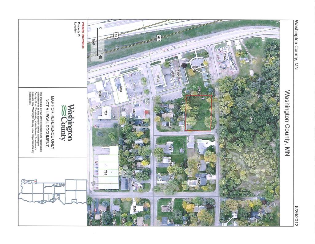
6 Memorandum To: City of Newport Planning Reference: Martin J. Vietoris Rezoning and Commission PUD-Minor Subdivision Request Copies To: Brian Anderson, City Administrator Renee Helm, Executive Assistant Project No.: From: Berry Farrington, AICP Routing: Sherri Buss, Planner Date: July 2, 2012 SUBJECT: Vietoris Property Rezoning and PUD-Minor Subdivision request MEETING DATE: July 12, 2012 LOCATION: Red Rock Park Block 1, Lots 1, 2, 3 and 4, at the southwest corner of Valley Road and Ford Road APPLICANT: ZONING: Martin J. Vietoris (Martin Joseph LLC) 2154 Hastings Ave, Suite 100 Newport, MN B-2 (Business Park/Office/Warehouse) ITEMS REVIEWED: Application Form and Preliminary Plat sketch received June 20, 2012; Proposed alley improvements plan received June 27, BRIEF DESCRIPTION OF THE REQUEST The applicant is requesting a rezoning of four parcels from B-2 to R-1 (Business Park/ Office/ Warehouse to Low Density Single Family Residential). The applicant is also requesting a minor subdivision by Planned Unit Development (PUD). The minor subdivision would create 3 singlefamily residential lots. A PUD is requested because the proposed lots do not meet all standards of the R-1 District. The Zoning Ordinance allows for a PUD to vary from standards of the underlying zoning district if the PUD goals and requirements of the ordinance are met. 4.A
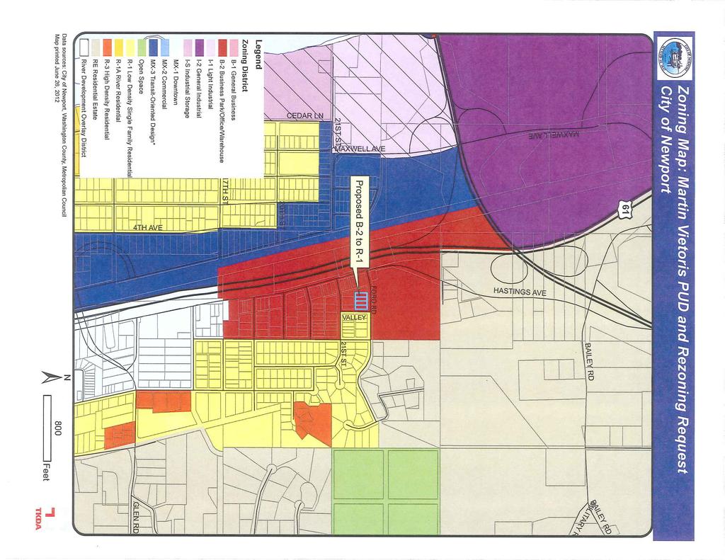
7 Vietoris Request Page 2 July 12, 2012 Newport Planning Commission BACKGROUND The subject property is 4 vacant lots located at the southwest corner of Valley Road and Ford Road, just east of Hastings Avenue. The total area of the parcels is approximately 28,350 square feet (.65 acres). The request is to create three parcels: Parcel A of 10,135 square feet, and Parcels B and C, each including 9,107 square feet. The lots were created prior to the current zoning ordinance, and were permitted lots in a residential district at the time that they were created. Since that time, the area was rezoned to B-2, which does not allow single-family residential as a permitted use. The B-2 zone currently has a minimum lot size of 15,000 square feet. Therefore the applicant is seeking to rezone the property to R-1 to permit residential development. The minimum lot size in the R-1 district is 9,100 square feet. The applicant cannot develop four single family homes on the four existing lots because the zoning ordinance requires that if a nonconforming lot is adjacent to an existing vacant lot that is under the same ownership it must be combined to meet the standards of the district. Therefore, the four lots under the same ownership must be redrawn to create three lots that meet the minimum density standards of the proposed zoning district. The applicant is seeking to rezone the property from B-2 to R-1 so that it may be developed as three single-family parcels. The applicant envisions that the City stormwater pond across Ford Road would be a natural and scenic amenity for residential property. The surrounding neighborhood to the east and south is existing residential development. The parcels in the area are of similar size and dimension to those proposed by the applicant. Parcels to the west are commercial land uses with frontage on Hastings Avenue. A new storm water pond is under construction to the north of the proposed subdivision. The applicant is seeking approval of a PUD-Minor Subdivision to allow for flexibility in the following: the minimum lot width of 70 feet for interior lots and 90 feet for the corner lot, and maximum lot coverage of 25%, as required by the R-1 District. The applicant proposes that two of the three lots have a minimum lot width of feet, and the corner lot would be 71.5 feet wide. The PUD ordinance allows the City discretion in approving lots that vary from the District standards, such as lot width and lot coverage, so long as the PUD goals and requirements are met. EVALUATION OF THE REQUEST Rezoning The applicant is requesting to change the zoning from B-2 (Business Park/ Office/ Warehouse) to R-1 (Low Density Single Family Residential). Section , Subd. 3 of the City s Zoning Ordinance addresses rezoning applications. Requests are evaluated based on existing and proposed land uses, how the proposed zoning would fit in with the general zoning pattern of the neighborhood and city, the conservation of property values, and advantages to the entire City. No change shall be recommended unless it is in the interest of public health, safety and welfare, and is compatible with the comprehensive plan. The attached Zoning Map, Existing Land Use Map, and aerial photograph of the site illustrate the following conditions: The parcels to the east of the subject property are zoned R-1 and used for residences. If the subject property is rezoned to R-1, it will be contiguous to other R-1 zoning.
8 Vietoris Request Page 3 July 12, 2012 Newport Planning Commission While zoned B-2, the parcel to the north is being used for a stormwater pond and will not be developed for commercial purposes. The stormwater pond will be compatible with proposed residential development, and may be an amenity for adjacent residential areas. The parcels to the south are zoned B-2, but the existing land use is single family residential. The parcel to the west is zoned and used for commercial purposes. The adjacent commercial parcel to the west and nearby commercial are oriented to Hastings Avenue. The subject property gains access from Ford Road. This section of Ford Road predominantly serves residential properties. The subject property may not be a desirable location for business due to its low visibility and location on a lower trafficked street, as compared to Hastings Avenue. The City Engineer indicated that the rezoning of four parcels from B-2 to R-1 would not have adverse effects on public services or public infrastructure, such as solid waste collection, wastewater treatment, stormwater management, streets or parks. These public services are already provided to residences in the area, and available infrastructure has the capacity to add four more single-family residential units. The Comprehensive Plan s land use policies recommend that the Hastings Avenue area include residential as well as commercial land uses, and that Hastings Avenue itself should be redeveloped with a Main Street character. The Comprehensive Plan s future land use map currently guides the subject parcels for Commercial/Residential land use. This land use type calls for the integration of residential land uses with commercial land uses. The rezoning of the subject property from B-2 to R-1 and creation of three residential parcels is compatible with these comprehensive plan policies. If the City approves the rezoning, it should concurrently approve a comprehensive plan amendment, to guide the planned land use of the subject parcels as Single Family Detached (R-1). The Planner finds that rezoning to R-1 is consistent with the existing land use and zoning of the surrounding neighborhood. The Planner finds that the proposed R-1 zoning fits in with the general pattern of the neighborhood and city and that such a change in zoning would not have adverse impacts on public health, safety and welfare. The Planner finds that the request is compatible with the land use goals of the Comprehensive Plan. PUD Requirements and Evaluation The applicant is requesting approval of a preliminary plat for a minor subdivision using the Planned Unit Development (PUD) approach to development. The City s PUD ordinance requires that when a subdivision uses a PUD approach, the subdivision and PUD be reviewed simultaneously. The PUD process and requirements are described in Section 1360 of the development code. The PUD process is designed to allow greater flexibility in development when the project offers benefits not only to the proposer, but to the City and the public interest. The ordinance states that the City shall consider the PUD based on the standards and purposes of the Comprehensive Plan, and the goals of the PUD, which may include: variety in site design, sensitivity to natural characteristics,
9 Vietoris Request Page 4 July 12, 2012 Newport Planning Commission efficiency with regard to public infrastructure and utilities, density transfer, zoning district integration, and mutual benefit to both the proposer and the public interest. The PUD approach is requested in this case because the proposed lots would not meet the minimum lot width and maximum lot coverage standards of the R-1 District. The overall lot size and proposed density meet the ordinance requirement. The proposed are deeper than the required minimum depth, and narrower than the minimum width required by the zoning ordinance. Lot Width The minimum lot width is 70 feet for interior lots, and 90 feet for a corner lot. The proposed lots are 64.25, 64.25, and 71.5 feet in width. Nearby residential parcels have lot widths similar to those requested, ranging from 40 to 70 feet because they were created under a previous zoning ordinance that permitted narrower lots than the current code. Lot Coverage The maximum lot coverage is 25% of the lot. The site plan shows each parcel with a house area and a garage area. The house area alone on each parcel exceeds the 25% lot coverage standard. The proposed house areas are: Parcel A of 2,575 square feet, and Parcel B and Parcel C each of 3,617 square feet. The proposed garage areas are approximately 640 to 920 square feet each. The combined house and garage area lot coverages are: Parcel A of approximately 32%, Parcel B of approximately 50%, and Parcel C of approximately 50%. The lot coverage standard was established for two general purposes: to manage stormwater runoff from developed areas, and to maintain some general consistency in the density and intensity of development within a zoning district. The City engineer has indicated that the additional coverage will not create significant stormwater management concerns provided that the applicant is required to do the following: The applicant will need to add fill to the lots and grade the lots so that they drain to the street. The proposed alley must be graded to drain to Valley Road The aerial photo indicates that some other lots in the area have a higher degree of coverage than the standard in the current ordinance. GARAGE STANDARDS In considering the flexibility the City might grant through the PUD, the City has the option to limit the degree by which the proposed minor subdivision may exceed the lot coverage standard. The size of the garage area or house area may be limited by the City in the conditions of the PUD. The zoning ordinance requires that a residential lot be allowed at least 500 square feet of garage space, as long as the required setbacks and other dimensional standards are met.
10 Vietoris Request Page 5 July 12, 2012 Newport Planning Commission The zoning ordinance requires that garages be setback an additional 1 foot from the minimum front, side an rear setbacks for every 20 square feet in area over 900 square feet. If the proposed lot coverage is permitted, the proposed garages over 900 square feet in size would need to meet the additional setback requirement. The proposed PUD offers benefits to the City in that allowance of the narrower lot and some degree of greater lot coverage would allow for greater efficiency of use of the public infrastructure and utilities in the area including more efficient use of the existing street, wastewater and water conveyance systems. The PUD ordinance requires that the plat conform to the density requirements of the underlying zoning. The R-1 District density standards do allow for three lots to be created from the subject land area. Two of the proposed lots are 9,107 square feet each, with the third lot proposed as 10,135 square feet. The R-1 District requires a minimum lot size of 9,100 square feet. The Planner finds that the request is consistent with the PUD Ordinance s goal of efficiency and efficient use of infrastructure and utilities. By allowing for flexibility in lot width, the City would allow for more efficient use of the street and water/wastewater services, by allowing for three lots when the standard lot width requirement would limit the minor subdivision to two lots. The requested lot widths are consistent with the scale and character of the surrounding neighborhood. Some flexibility in lot coverage will also allow for more efficient use of public services through the allowance of three lots. The request meets the density requirements of the ordinance. The Planning Commission should discuss the request for flexibility from the standards for lot width and coverage. The Commission could recommend that the size of the proposed garages be reduced to the minimum ordinance requirement (500 feet) in order to bring the subdivision into closer compliance with the ordinance. However, even at the reduced size, some flexibility from the coverage standard would be required. Minor Subdivision Ordinance Requirements and Evaluation The Subdivision process and requirements are described in Chapter 12 of the City s Code. The subdivision must be consistent with the City s Comprehensive Plan, Zoning Ordinance and other adopted policies. It must be suitable to the physical character of the site and not cause environmental harm. The Subdivision Ordinance requires approval of the Preliminary Plat, and subsequent approval of the Final Plat. As noted in the previous section, the proposed residential use is consistent with Comprehensive Plan goals for the Hastings Avenue area. The proposed parcels meet the minimum yard areas of the R-1 District (front yard of 30 feet, side yard of 10 feet, dwelling rear yard of 30 feet and garage rear yard of 5 feet). Because the request is for a Minor subdivision rather than a major subdivision, the sketch plan supplied with the application provides sufficient detail for a preliminary plat evaluation. If the request proceeds to final plat, the final plat submittal must meet the standards of the Code addressing application requirements, required plan sheets and standards (Section ). Required plans include: Existing Conditions, Final Plans, Grading and Erosion Control Plan, Utility Plan, and Landscaping Plan.
11 Vietoris Request Page 6 July 12, 2012 Newport Planning Commission The South Washington Watershed District reviews proposed development that includes 1 acre or more. Therefore, a permit from the South Washington Watershed District (SWWD) will not be required. The applicant will need to meet the City s stormwater management requirements. The City Engineer will review the final plan and make recommendations regarding stormwater management if the preliminary plat is approved. The City Engineer has reviewed the preliminary plat submittal and has prepared a cost estimate for the paving of the alley located to the south of the subject property, attached. Final plans will be reviewed by the City Engineer and all Engineering comments must be addressed. The Subdivison Ordinance includes standards for Park Dedication (Section ). Because of the small land area and location of the request, the City may wish to take cash in lieu of land dedication. ACTION REQUESTED The Planning Commission can recommend to the City Council: 1. Approval 2. Approval with conditions 3. Denial with findings 4. Table the request, if additional information is needed to make a decision PLANNING STAFF FINDINGS AND RECOMMENDATIONS The Planner recommends that the Planning Commission recommend approval of the Martin J. Vietoris (Martin Joseph LLC) request for a rezoning from B-2 to R-1, and associated Comprehensive Plan amendment to guide the land use as Single Family Detached; and approval of the Planned Unit Development (PUD) and Preliminary Plat for a Minor Subdivision to create three lots, with conditions of approval. The Planner recommends the City consider limiting the garage area to bring the subdivision closer to compliance with the lot coverage standards. The Planner finds the following: 1. The proposed rezoning and PUD are consistent with the Comprehensive Plan s land use policies that the Hastings Avenue area will include residential as well as commercial land uses, and that Hastings Avenue should be redeveloped with a Mainstreet character. 2. The proposed R-1 zoning fits in with the general land use and zoning pattern of the neighborhood and city; 3. The proposed PUD will not compromise the health, safety and welfare of the community; 4. The proposed PUD is consistent with the PUD Ordinance s goal of efficiency and efficient use of infrastructure and utilities. 5. The lot widths proposed in the PUD are consistent with the scale and character of the surrounding neighborhood.
12 Vietoris Request Page 7 July 12, 2012 Newport Planning Commission 6. The proposed PUD meets the density requirements of the R-1 District. 7. The proposed PUD is not in conflict with the purpose and intent of the Zoning Ordinance and Subdivision Ordinance. The Planner recommends the following conditions for the proposed PUD and Minor Subdivision: 1. The Applicant shall submit a Final Plat that is substantially in conformance with the Preliminary Plat received by the City on June 20, Plans must meet the standards of Section Plans must include: Existing Conditions, Final Plans, Grading and Erosion Control Plan, and Utility Plan, and Landscaping Plan. Comments from the City Engineer and City Planner shall be addressed. 2. The Applicant shall finalize a developer agreement with the City for public improvments. 3. All lots, buildings and structures developed within the subdivision shall meet the setbacks, height requirements, other dimensional requirements and performance standards of the Zoning Ordinance that are not specifically allowed exception in the approved PUD. 4. The applicant shall assume all costs of water and sewer hook-ups. The applicant shall pay the City for costs of paving the alley. 5. The applicant must the City Engineer s recommendations for storm water management and other engineering requirements for the subdivision, including the following: The applicant will need to add fill to the lots and grade the lots so that they drain to the street The proposed alley must be graded to drain to Valley Road 6. The Applicant shall satisfy the City s park dedication requirements. 7. The Applicant shall provide a letter of credit or other financial guarantee acceptable to the City for completion of proposed alley improvements, as required in Section of the Subdivision Ordinance. 8. The applicant shall pay all fees and escrow associated with this application.
13

14
15
16
17
18
19
20
21
22 PLANNING COMMISSION RESOLUTION NO. P.C A RESOLUTION RECOMMENDING CITY COUNCIL APPROVE A REZONING REQUESTED BY MARTIN VIETORIS, 2154 HASTINGS AVENUE, SUITE 100, NEWPORT, MN 55055, FOR PROPERTY LOCATED JUST WEST OF VALLEY ROAD AND SOUTH OF FORD ROAD, NEWPORT, MN WHEREAS, Martin Vietoris, 2154 Hastings Avenue, Suite 100, Newport, MN has submitted a request for a rezoning; and WHEREAS, The proposed rezoning is for property located just west of Valley Road and south of Ford Road, Newport, MN 55055, and is more fully legally described as follows: PID# SubdivisionName RED ROCK PARK Lot 1 Block 1 SubdivisionCd PID# SubdivisionName RED ROCK PARK Lot 2 Block 1 SubdivisionCd PID# SubdivisionName RED ROCK PARK Lot 3 Block 1 SubdivisionCd PID# SubdivisionName RED ROCK PARK Lot 4 Block 1 SubdivisionCd 55325; and WHEREAS, The described property is zoned Business Park/Office/Warehouse (B-2); and WHEREAS, The request is to rezone the property to Low Density Single Family Residential (R-1); and WHEREAS, Chapter 13, Section , Subdivision 3, of the Code of Ordinance states; Proceedings for amendment, which are initiated by the petition of the owner or owners of the property, shall be filed with the Zoning Administrator. All applications shall be accompanied by an administrative fee as prescribed in Subsection and shall include the following information: A. The name and address of the applicant or applicants; B. A description of the area proposed to be rezoned; the names and addresses of all owners of property lying within such area and a description of the property owned by each; C. The present zone classification of the area and the proposed zone classification; D. A description of the present use of each separately owned tract within the area, and the intended use of any tract of land therein; E. A site plan showing the location and extent of the proposed building, parking, loading, access drives, landscaping and any other improvements; F. A statement of how the rezoning would fit in with the general zoning pattern of the neighborhood, and the zoning plan of the entire City; G. A map showing the property to be rezoned, and the present zoning of the surrounding area for at least a distance of three hundred fifty (350) feet, including the street pattern of such area, together with the names and addresses of the owners of the lands in each area. and WHEREAS, Following publication, posted, and mailed notice thereof, the Newport Planning Commission held a Public Hearing on July 12, 2012.
23 NOW, THEREFORE, BE IT FURTHER RESOLVED That the Newport Planning Commission Hereby Recommends Newport City Council Approval for a Rezoning of the described property to applicant Martin Vietoris, 2154 Hastings Avenue, Suite 100, Newport, MN with the following conditions: The parcels to the east of the subject property are zoned R-1 and used for residences. If the subject property is rezoned to R-1, it will be contiguous to other R-1 zoning. While zoned B-2, the parcel to the north is being used for a stormwater pond and will not be developed for commercial purposes. The stormwater pond will be compatible with proposed residential development, and may be an amenity for adjacent residential areas. The parcels to the south are zoned B-2, but the existing land use is single family residential. The parcel to the west is zoned and used for commercial purposes. The adjacent commercial parcel to the west and nearby commercial are oriented to Hastings Avenue. The subject property gains access from Ford Road. This section of Ford Road predominantly serves residential properties. The subject property may not be a desirable location for business due to its low visibility and location on a lower trafficked street, as compared to Hastings Avenue. Adopted this 12 th day of July 2012 by the Newport Planning Commission. VOTE: Lindoo Lund Anderson McElwee-Stevens Prestegaard Signed: Susan Lindoo, Chairperson ATTEST: Brian Anderson, City Administrator
24 PLANNING COMMISSION RESOLUTION NO. P.C A RESOLUTION RECOMMENDING CITY COUNCIL APPROVE A PLANNED UNIT DEVELOPMENT AND MINOR SUBDIVISION REQUESTED BY MARTIN VIETORIS, 2154 HASTINGS AVENUE, SUITE 100, NEWPORT, MN 55055, FOR PROPERTY LOCATED JUST WEST OF VALLEY ROAD AND SOUTH OF FORD ROAD, NEWPORT, MN WHEREAS, Martin Vietoris, 2154 Hastings Avenue, Suite 100, Newport, MN 55055, has submitted a request for a Planned Unit Development and Minor Subdivision; and WHEREAS, The proposed rezoning is for property located just west of Valley Road and south of Ford Road, Newport, MN 55055, and is more fully legally described as follows: PID# SubdivisionName RED ROCK PARK Lot 1 Block 1 SubdivisionCd PID# SubdivisionName RED ROCK PARK Lot 2 Block 1 SubdivisionCd PID# SubdivisionName RED ROCK PARK Lot 3 Block 1 SubdivisionCd PID# SubdivisionName RED ROCK PARK Lot 4 Block 1 SubdivisionCd 55325; and WHEREAS, The described property is zoned Business Park/Office/Warehouse (B-2); and WHEREAS, The Planning Commission approved Resolution No. P.C recommending that the City Council approve a rezoning request from Martin Vietoris to rezone the property from B-2 to R-1; and WHEREAS, Chapter 12, Section , of the Code of Ordinances states; The purpose and intent of this Chapter shall be to ensure that subdivisions are consistent with all applicable provisions of all applicable plans, laws, and regulations, and to provide for the orderly subdivision of land. And WHEREAS, Section 1360 of the Code of Ordinances states: Planned United Development is an approach to development that may provide a comprehensive procedure intended to allow greater flexibility in the development of neighborhoods or non-residential areas than would be possible under conventional standards by departing from the strict application of required setbacks, yard areas, lot sizes, densities, minimum house sizes, minimum requirements, and other performance standards associated with traditional zoning, the PUD can maximize the development potential of the land while remaining sensitive to its unique and valuable natural characteristics; WHEREAS, Following publication, posted, and mailed notice thereof, the Newport Planning Commission held a Public Hearing on July 12, NOW, THEREFORE, BE IT FURTHER RESOLVED That the Newport Planning Commission Hereby Recommends Newport City Council Approval for a Minor Subdivision of the described property to applicant Martin Vietoris, 2154 Hastings Avenue, Suite 100, Newport, MN 55055, with the following conditions:
25 1. The Applicant shall submit a Final Plat that is substantially in conformance with the Preliminary Plat received by the City on June 20, Plans must meet the standards of Section Plans must include: Existing Conditions, Final Plans, Grading and Erosion Control Plan, and Utility Plan, and Landscaping Plan. Comments from the City Engineer and City Planner shall be addressed. 2. The Applicant shall finalize a developer agreement with the City for public improvments. 3. All lots, buildings and structures developed within the subdivision shall meet the setbacks, height requirements, other dimensional requirements and performance standards of the Zoning Ordinance that are not specifically allowed exception in the approved PUD. 4. The applicant shall assume all costs of water and sewer hook-ups. The applicant shall pay the City for costs of paving the alley. 5. The applicant must the City Engineer s recommendations for storm water management and other engineering requirements for the subdivision, including the following: The applicant will need to add fill to the lots and grade the lots so that they drain to the street The proposed alley must be graded to drain to Valley Road 6. The Applicant shall satisfy the City s park dedication requirements. 7. The Applicant shall provide a letter of credit or other financial guarantee acceptable to the City for completion of proposed alley improvements, as required in Section of the Subdivision Ordinance. 8. The applicant shall pay all fees and escrow associated with this application. Adopted this 12th day of July 2012 by the Newport Planning Commission. VOTE: Lindoo Lund Anderson McElwee-Stevens Prestegaard Signed: Susan Lindoo, Chairperson ATTEST: Brian Anderson, City Administrator
26 MEMO TO: FROM: Newport Planning Commission Brian Anderson, City Administrator Renee Helm, Executive Analyst DATE: July 9, 2012 SUBJECT: Ordinances for Regulating Chickens and Honeybees BACKGROUND At the April 12, 2012 Planning Commission meeting, the members discussed ordinances for regulating honeybees and chickens in the City of Newport. The Planning Commission would like to add language to the City Code for allowing residents in the RE District to keep honeybees on their property and allowing residents on any singlefamily residential property in the R1, R1-A, RE, or MX-1 Districts to keep chickens.. At the meeting, the Planning Commission requested that staff bring back the keeping of honeybees for discussion at a future meeting. At the April 12, 2012 meeting it was requested that the draft language on chickens be amended in regards to the following: Definitions: Add language to require roofs under the definitions of Chicken Coop and Chicken Run Remove the following language The slaughtering of chickens is prohibited within the City from the ordinance Size: Change the language regarding size to have a minimum of 5-10 square feet per chicken and maximum of 40 square feet for chicken coops and 80 square feet for chicken runs. It was also requested that staff conduct further research in regards to the keeping of honeybees to determine if there are state mandates in regards to the keeping of honeybees such as required training for property owners, colony density, and setbacks. Furthermore, it was requested that the following be amended: Written Consent Applicants must receive written consent from occupied property owners within 250 feet from the hive. Colony Density Change the radius in 6.c from 200 feet to 250 feet to be consistent with written consent requirement. DISCUSSION Staff contacted the University of Minnesota s Extension Office in regards to State regulations and classes that they offer. According to the Extension Office, there are no State mandates in regards to the keeping of honeybees and that the individual city is responsible for regulating the setbacks, number of colonies, etc. Additionally, the Extension Office stated that their class is not required for purchasing bees and that this is again a regulation established by the individual city. The City of Minneapolis requires individuals to complete an educational requirement from the Extension Office, Century College, or Three Rivers Park District. The Extension offers a variety of classes for training individuals on how to take care of honeybees. The classes vary from Bee Management to Beekeeping in Northern Climates. The classes also range in price from $25 to $250. Century College has a class on beekeeping that is $115. Three Rivers Park District did not have any beekeeping classes scheduled for the near future. The Planning Commission 4.B
27 will need to discuss whether or not it would like to add language requiring individuals complete an educational requirement. If so, the following language would be added to Section , Subd 3(F): The applicant must complete an educational requirement as determined by the City within one (1) year of receiving the initial permit. City staff also requested that the Extension Office review the draft ordinance. The Office recommended that the City remove the regulation on Africanized Honeybees because there is no way of telling what species the honeybee is. Additionally, they stated that it s illegal to sell Africanized Honeybees in the U.S. so they would not be shipped here anyways. Staff felt that the language regarding Africanized Honeybees could be removed since it is illegal to sell them in the U.S. RECOMMENDATION It is recommended that the Planning Commission approve Resolution No. P.C recommending that the City Council approve a code amendment to Chapter 6, Animals. If the Planning Commission decides to add the above language regarding educational requirements, it may approve the Resolution as amended. Page 2 of 2
28 PLANNING COMMISSION RESOLUTION NO. P.C A RESOLUTION RECOMMENDING CITY COUNCIL APPROVE AN AMENDMENT TO CHAPTER 6, ANIMALS OF THE CITY OF NEWPORT CODE OF ORDINANCES. WHEREAS, the City currently allows the keeping of chickens in the RE District; and WHEREAS, the City does not allow the keeping of honeybees; and WHEREAS, residents have expressed interest in keeping chickens in Districts other than the RE District and keeping honeybees; and WHEREAS, City staff researched various ordinances allowing for the keeping of chickens and honeybees; and NOW, THEREFORE, BE IT RESOLVED, That the Newport Planning Commission recommends Newport City Council approval of am Amendment to Chapter 6, Animals, of the Newport City Code of Ordinances. It will read as follows: Definitions. CHAPTER 6. ANIMALS Section General Regulations Subd. 4 Chicken. Chicken shall mean a domesticated fowl of the genus Gallus and species G. gallus. Subd. 5 Chicken Coop. Chicken coop shall mean any structure used for the housing of chickens. Subd. 6 Chicken Run. Chicken run shall mean a fenced outside yard for the keeping and exercising of chickens. Subd. 7 Farm Animal. "Farm animal" shall mean any horse, colt, pony, mule, donkey, cattle, swine, sheep, goat, duck, goose, or honeybees, or similar animal, bird, fowl or poultry commonly associated with agricultural uses Chickens within City Limits Subd. 1 Permit Required. No person shall keep or maintain chickens on any single-family residential property in the R1, R1-A, RE, or MX-1 Districts without a permit. Subd. 2 Application. Each application for a chicken permit shall state the name and address of the applicant, a complete description of the premises and the owner thereof and adjoining owners, and shall set out in detail fence lines, shelter information, number of chickens to be kept, and such other information as may be required by the Council. Subd. 3 Requirements. No chicken permit shall be issued unless the following standards are met: 1
29 A. No person shall keep more than four (4) chickens on their property. B. The applicant must receive written consent from 75% of property owners situated within 150 feet from the chicken coop. C. Standards of Practice. Any person obtaining a permit pursuant to this section shall comply with the following standards of practice: 1. No person shall keep roosters, or adult male chickens, on any property within the City 2. Cockfighting is prohibited within the City. 3. No person shall raise chickens for breeding purposes within the City. 4. Chicken grains and feed must be stored in rodent-proof containers. D. Chicken Coops and Chicken Runs. Chickens shall be properly protected from the weather and predators in a chicken coop, and have access to the outdoors by the means of a chicken run. The chicken coop and run shall meet the following requirements. 1. Chickens shall be kept in the chicken coop and/or run at all times, which shall be kept in sound and usable condition. 2. Chicken coops and runs shall not be in the front or side yard. 3. Chicken coops and runs shall be located at least fifty (50) feet from any residential structure on adjacent lots and ten (10) feet from the property line. 4. Chicken coops and runs shall be screened from view with a solid fence with a minimum height of four (4) feet and must be constructed in accordance with Section , Subdivision Chicken coops and runs shall be considered accessory structures. 6. All chicken coops must have a minimum size of ten (10) square feet per chicken, a maximum size of forty (40) square feet, and must not exceed six (6) feet in total height and must be built according to the zoning code. 7. Chicken coops must be elevated a minimum of twelve (12) inches and a maximum of twenty-four (24) inches to allow for circulation beneath the coop. 8. Chicken runs may not exceed eighty (80) square feet and fencing must not exceed six (6) feet in height and must be built according to the zoning code. 9. Chicken runs may be enclosed with wood and/or woven wire materials, and may allow chickens to contact the ground. 10. Chicken runs must have a protective overhead netting to keep the chickens separated 2
30 from other animals. 11. Chicken coops must have a roof to keep the chickens separated from other animals. Subd. 4 Term. All chicken permits shall expire on December 31 of each year. Subd. 5 Revocation. Any chicken permit may be revoked by the Council for violation of any provision of this Code or any State law or regulation governing the keeping of animals. No chicken permit shall be revoked without a hearing preceded by ten days written notice stating the time and place of the hearing and the nature of the charges. Any person whose permit is revoked shall within ten days of the revocation humanely dispose of the chicken(s) Farm Animals. Subd. 3 Requirements. be met: No farm animal permit shall be issued unless the following standards shall C. The barn, stable, housing, or hive shall be located at least 150 feet from the nearest property line of adjacent property owners and must be built according to the zoning code. D. The barn, stable, housing or hive shall be considered accessory structures. F. Keeping of Honeybees. 1. No person shall keep or maintain any hive or other facility for the housing of honeybees on or in any property in the RE District without a permit. 2. The applicant must receive written consent from occupied property owners situated within 250 feet from the hive. 3. Definitions. As used in this section: a. Apiary means the assembly of one (1) or more colonies of honeybees at a single location. b. Beekeeper means a person who owns or has charge of one (1) or more colonies of honeybees. c. Beekeeping equipment means anything used in the operation of an apiary, such as hive bodies, supers, frames, top and bottom boards and extractors. d. Colony means an aggregate of honeybees consisting principally of workers, but having, when perfect, one (1) queen and at times drones, brood, combs, and honey. e. Hive means the receptacle inhabited by a colony that is manufactured for that purpose. f. Honeybee means all life stages of the common domestic honeybee, Apis mellifera species of European origin. 3
31 g. Lot means a contiguous parcel of land under common ownership. h. Nucleus colony means a small quantity of honeybees with a queen housed in a smaller than usual hive box designed for a particular purpose. i. Undeveloped property means any idle land that is not improved or actually in the process of being improved with residential, commercial, industrial, church, park, school or governmental facilities or other structures or improvements intended for human occupancy and the grounds maintained in associations therewith. The term shall be deemed to include property developed exclusively as a street or highway or property used for commercial agricultural purposes. 4. Standards of practice. Any person obtaining a permit pursuant to this section shall comply with the following standards of practice: a. Honeybee colonies shall be kept in hives with removable frames, which shall be kept in sound and usable condition. b. Each beekeeper shall ensure that a convenient source of water is available to the colony prior to and so long as colonies remain active outside of the hive. c. Each beekeeper shall ensure that no wax comb or other material that might encourage robbing by other bees are left upon the grounds of the apiary lot. Such materials once removed from the site shall be handled and stored in sealed containers, or placed within a building or other insect-proof container. d. For each colony permitted to be maintained under this ordinance, there may also be maintained upon the same apiary lot, one (1) nucleus colony in a hive structure not to exceed one (1) standard nine and five-eighths (9⅝) inch depth ten-frame hive body with no supers. e. Each beekeeper shall maintain their beekeeping equipment in good condition, including keeping the hives painted, and securing unused equipment from weather, potential theft or vandalism and occupancy by swarms. It shall be a violation of this section for any beekeeper's unused equipment to attract a swarm, even if the beekeeper is not intentionally keeping honeybees. f. Each beekeeper shall enclose the hive with a latching fence. The fence shall be located at a maximum of ten (10) feet from the hive. The fence shall be between four (4) and six (6) feet in height. 5. Colony density. Any person obtaining a permit pursuant to this section shall comply with the following restrictions on colony density based upon the size of the lot: a. One (1) acre but small than five (5) acres: No more than eight (8) colonies b. Larger than five (5) acres: As determined by the City Council c. Regardless of lot size, so long as all lots within a radius of at least two hundred and fifty (250) feet from any hive, measured from any point on the front of the hive, 4
CITY OF MEDINA ORDINANCE NO. ### AN ORDINANCE REGARDING THE KEEPING OF CHICKENS AND HONEY BEES; AMENDING CHAPTER 8 OF THE CITY CODE
 CITY OF MEDINA ORDINANCE NO. ### AN ORDINANCE REGARDING THE KEEPING OF CHICKENS AND HONEY BEES; AMENDING CHAPTER 8 OF THE CITY CODE The City Council of the City of Medina ordains as follows: SECTION I.
PASSED, ADOPTED, AND APPROVED FOR PUBLICATION this 25`h day of June, 2018, by the City Council ofthe City of Chanhassen.
 CITY OF CHANHASSEN CARVER AND HENNEPIN COUNTIES, MINNESOTA SUMMARY OF ORDINANCE NO. 634 AN ORDINANCE AMENDING CHAPTER 4, LICENSE, PERMIT AND ADMINISTRAIVE FEES; CHAPTER 5, ANIMALS AND FOWL; AND CHAPTER
CHAPTER 14. RESIDENTIAL ZONING DISTRICTS
 CHAPTER 14. RESIDENTIAL ZONING DISTRICTS 7-14-1. Zoning Districts. 7-14-1.1 In-Fill Overlay District. 7-14-1.2. In-Fill Overlay District Streets. 7-14-2. Zoning Districts Purpose. 7-14-3. Uses Allowed
4.2 RESIDENTIAL ZONING DISTRICTS
 4.2 RESIDENTIAL ZONING DISTRICTS A. Purpose: To define regulations and standards for each residential zoning district in the City. The following sections identify uses, regulations, and performance standards
CITY OF NEWPORT NEWPORT ECONOMIC DEVELOPMENT AUTHORITY NEWPORT CITY HALL JANUARY 15, 2015 IMMEDIATELY FOLLOWING CITY COUNCIL MEETING
 CITY OF NEWPORT NEWPORT ECONOMIC DEVELOPMENT AUTHORITY NEWPORT CITY HALL JANUARY 15, 2015 IMMEDIATELY FOLLOWING CITY COUNCIL MEETING President: Tim Geraghty E. D. Director/Executive Director: Deb Hill
ORDINANCE NO. WHEREAS, Article 2. Section 1 of the Ashland City Charter provides:
 ORDINANCE NO AN ORDINANCE AMENDING THE HEALTH AND SANITATION CHAPTER (9.08) AND THE GENERAL REGULATIONS CHAPTER (18.68) OF THE ASHLAND MUNICIPAL CODE TO ESTABLISH PROVISIONS FOR THE KEEPING OF MICRO-LIVESTOCK
DRAFT FOR DISCUSSION PURPOSES ONLY SEPTEMBER 29, 2017
 DRAFT FOR DISCUSSION PURPOSES ONLY SEPTEMBER 29, 2017 AN ORDINANCE AMENDING APPENDIX A OF THE CITY CODE, ENTITLED ZONING, ARTICLE 3, SECTION 3-403; ARTICLE 6, SECTIONS 6-2101 AND 6-2102; ARTICLE 10, SECTIONS
CHARTER TOWNSHIP OF BEDFORD 115 S. Uldriks Drive, Battle Creek, MI
 CHARTER TOWNSHIP OF BEDFORD 115 S. Uldriks Drive, Battle Creek, MI 49037 www.bedfordchartertwp.com ORDINANCE NO. OF 2018 AN ORDINANCE TO AMEND THE BEDFORD CHARTER TOWNSHIP ZONING ORDINANCE WITH RESPECT
UPPER MOUNT BETHEL TOWNSHIP NORTHAMPTON COUNTY, PENNSYLVANIA
 UPPER MOUNT BETHEL TOWNSHIP NORTHAMPTON COUNTY, PENNSYLVANIA JOINDER DEED / LOT CONSOLIDATION TOWNSHIP REVIEW PROCESS When accepting proposed Joinder Deeds / Lot Consolidations, review the Joinder Deed
The following regulations shall apply in the R-E District:
 "R-E" RESIDENTIAL ESTATE DISTRICT (8/06) The following regulations shall apply in the R-E District: 1. Uses Permitted: The following uses are permitted. A Zoning Certificate may be required as provided
A. Preserve natural resources as identified in the Comprehensive Plan.
 1370.08 Conservation Residential Overlay District. Subd. 1 Findings. The City finds that the lands and resources within the Conservation Residential Overlay District are a unique and valuable resource
Planning Department Oconee County, Georgia
 Planning Department Oconee County, Georgia STAFF REPORT REZONE CASE #: 6985 DATE: October 31, 2016 STAFF REPORT BY: Andrew C. Stern, Planner APPLICANT NAME: Williams & Associates, Land Planners PC PROPERTY
CITY OF BELLEVIEW PLANNING & ZONING BOARD AGENDA
 CITY OF BELLEVIEW PLANNING & ZONING BOARD AGENDA BELLEVIEW CITY HALL COMMISSION ROOM 5:30 PM IF A PERSON SHOULD DESIRE TO APPEAL ANY DECISION MADE BY THE BOARD, A VERBATIM RECORD OF THE PROCEEDINGS WHICH
AN ORDINANCE TO AMEND SECTION OF THE RAPID CITY MUNICIPAL CODE TO ALLOW FOR ADMINISTRATIVE DISSOLUTION OF PLANNED DEVELOPMENTS
 Ordinance No. 6231 AN ORDINANCE TO AMEND SECTION 17.50.050 OF THE RAPID CITY MUNICIPAL CODE TO ALLOW FOR ADMINISTRATIVE DISSOLUTION OF PLANNED DEVELOPMENTS WHEREAS, the City of Rapid City has adopted a
ARTICLE 24 SITE PLAN REVIEW
 ARTICLE 24 SITE PLAN REVIEW 24.1 PURPOSE: The intent of these Ordinance provisions is to provide for consultation and cooperation between the land developer and the Township Planning Commission in order
ARTICLE 15 - PLANNED UNIT DEVELOPMENT
 Section 15.1 - Intent. ARTICLE 15 - PLANNED UNIT DEVELOPMENT A PUD, or Planned Unit Development, is not a District per se, but rather a set of standards that may be applied to a development type. The Planned
-Section Contents Intent Household Pets Poultry, Fowl, and Small Livestock (noncommercial)...
...") SECTION 24 ANIMALS -Section Contents- INTENT 2401 Intent... 24-2 HOUSEHOLD PETS 2402 Household Pets... 24-2 POULTRY, FOWL AND SMALL LIVESTOCK 2403 Poultry, Fowl, and Small Livestock (noncommercial)...
SECTION 24 ANIMALS -Section Contents- INTENT 2401 Intent... 24-2 HOUSEHOLD PETS 2402 Household Pets... 24-2 POULTRY, FOWL AND SMALL LIVESTOCK 2403 Poultry, Fowl, and Small Livestock (noncommercial)...
Lane Code CHAPTER 10 CONTENTS
 Lane Code CHAPTER 10 CONTENTS SUBURBAN RESIDENTIAL DISTRICT (RA) 10.135-10 Permitted Buildings and Uses. 10.135-15 Conditional Uses. 10.135-21 Height. 10.135-23 Setback Requirements. 10.135-26 Lot Coverage.
PUBLIC NOTICE & AGENDA PLAN COMMISSION City Hall Forum State Street, Beloit, WI :00 PM Wednesday, November 07, 2018
 PUBLIC NOTICE & AGENDA PLAN COMMISSION City Hall Forum - 100 State Street, Beloit, WI 53511 7:00 PM Wednesday, November 07, 2018 1. CALL TO ORDER AND ROLL CALL 2. MINUTES 2.a. Consideration of the Minutes
RESOLUTION NO CITY OF MAPLE GROVE
 RESOLUTION NO. 18-122 CITY OF MAPLE GROVE RESOLUTION GRANTING PLANNED UNIT DEVELOPMENT CONCEPT STAGE PLAN, PLANNED UNIT DEVELOPMENT - DEVELOPMENT STAGE PLAN, AND PRELIMINARY PLAT FOR TERRITORIAL GREENS
Beekeeping Permit Application
 APPLICANT AND OWNERSHIP INFORMATION Applicant Name(s) Mailing Address/State/Zip Phone # Email Address: If the applicant is not the property owner, permission from the owner must be provided below: Property
VILLAGE OF DOWNERS GROVE PLAN COMMISSION VILLAGE HALL COUNCIL CHAMBERS 801 BURLINGTON AVENUE. June 2, :00 p.m. AGENDA
 VILLAGE OF DOWNERS GROVE PLAN COMMISSION VILLAGE HALL COUNCIL CHAMBERS 801 BURLINGTON AVENUE June 2, 2014 7:00 p.m. AGENDA 1. Call to Order 2. Roll Call a. Pledge of Allegiance 3. Approval of Minutes April
NYE COUNTY, NV PAHRUMP REGIONAL PLANNING COMMISSION REGULAR MEETING DECEMBER 14, 2016
 NYE COUNTY, NV PAHRUMP REGIONAL PLANNING COMMISSION REGULAR MEETING DECEMBER 14, 2016 Staff Report Agenda Item No. 14 CASE DESCRIPTION(S): LOCATION: For possible action ZC-2016-000011: Public hearing,
A. Essential Services. Essential services, as defined in this ordinance, shall be permitted in all districts.
 6.11 SUPPLEMENTAL REGULATIONS The provisions of this ordinance shall be subject to such exceptions, additions or modifications as set forth in the following supplementary regulations: A. Essential Services.
BUFFALO PLANNING COMMISSION AGENDA. Meeting: Monday, March 12, 2018 Place: Buffalo City Center Time: 7:00 p.m.
 BUFFALO PLANNING COMMISSION AGENDA Meeting: Monday, March 12, 2018 Place: Buffalo City Center Time: 7:00 p.m. 1. OPEN FORUM This is the time that residents or developers can bring items before the Planning
SECTION 5: ACCESSORY USES
 SECTION 5: ACCESSORY USES A. In Any District Subject to the restrictions of the Zoning Resolution, a use, equipment or item customarily incidental to an existing permitted use on a lot shall also be permitted
SECTION 10.7 R-PUD (RESIDENTIAL PLANNED UNIT DEVELOPMENT) ZONE
 ZONE") Article X Zones 10-20 SECTION 10.7 R-PUD (RESIDENTIAL PLANNED UNIT DEVELOPMENT) ZONE A. PURPOSE AND INTENT: The R-PUD Residential PUD Zone is intended to provide alternative, voluntary zoning procedures
Article X Zones 10-20 SECTION 10.7 R-PUD (RESIDENTIAL PLANNED UNIT DEVELOPMENT) ZONE A. PURPOSE AND INTENT: The R-PUD Residential PUD Zone is intended to provide alternative, voluntary zoning procedures
CHAPTER 14 PLANNED UNIT DEVELOPMENTS
 9-14-1 9-14-1 CHAPTER 14 PLANNED UNIT DEVELOPMENTS SECTION: 9-14-1: Purpose 9-14-2: Governing Provisions 9-14-3: Minimum Area 9-14-4: Uses Permitted 9-14-5: Common Open Space 9-14-6: Utility Requirements
Box Elder County Land Use Management & Development Code Article 3: Zoning Districts
 Chapter 3-6 Mobile Homes, Mobile Home Subdivisions, & Recreational Vehicle Parks Box Elder Zoning Ordinance as Adopted October 2007 Sections. 3-6-010. Purpose and Intent. 3-6-020. Conditional Use Permit
SECTION 16. "PUD" PLANNED UNIT DEVELOPMENT OVERLAY DISTRICT
 SECTION 6. "PUD" PLANNED UNIT DEVELOPMENT OVERLAY DISTRICT Subsection. Purpose. This district is established to achieve the coordinated integration of land parcels and large commercial and retail establishments
CHAPTER XVIII SITE PLAN REVIEW
 CHAPTER XVIII SITE PLAN REVIEW Section 18.1 Section 18.2 Description and Purpose. The purpose of this chapter is to provide standards and procedures under which applicants would submit, and the Township
Staff Report: Date: Applicant: Property Identification: Acreage of Request: Current Zoning of Requested Area: Requested Action: Attached:
 Staff Report: Completed by Jeff Palmer Director of Planning & Zoning Date: November 7, 2018, Updated November 20, 2018 Applicant: Greg Smith, Oberer Land Developer agent for Ronald Montgomery ET AL Property
a. To insure compatible relationships between land use activities;
 PART B SECTION VIII INSTITUTIONAL DISTRICTS Article 1 Planned Institutional District 1. Purpose and Intent: It is the purpose and intent of this district to permit and encourage the orderly, cooperative
PERMITTED USES: Within the MX-1 Mixed Use Neighborhood District the following uses are permitted:
 6.25 MX-1 - MIXED USE NEIGHBORHOOD 6.25.1 INTENT: The purpose of the MX-1 Mixed Use Neighborhood District is to accommodate the development of a wide-range of residential and compatible non-residential
ZONING AMENDMENT, PLANNED UNIT DEVELOPMENT & SUBDIVISION STAFF REPORT Date: August 8, 2013
 ZONING AMENDMENT, PLANNED UNIT DEVELOPMENT & SUBDIVISION STAFF REPORT Date: August 8, 2013 NAME SUBDIVISION NAME PV-Magnolia, LLC Twelve Trees Subdivision LOCATION 2860, 2862 and 2866 Pleasant Valley Road
Staff Report: Date: Applicant: Property Identification: Acreage of Request: Current Zoning of Requested Area: Requested Action: Attached:
 Staff Report: Completed by Jeff Palmer Director of Planning & Zoning Date: November 7, 2018 Applicant: Greg Smith, Oberer Land Developer agent for Ronald Montgomery ET AL Property Identification: Frontage
CITY OF RIO VISTA PLANNING COMMISSION STAFF REPORT
 MEETING DATE: January10, 2018 CITY OF RIO VISTA PLANNING COMMISSION STAFF REPORT AGENDA ITEM #4.2 PREPARED BY: Lamont Thompson, Planning Manager SUBJECT: Vesting Tentative Tract No. 2017-001: To consider
17.0 NONCONFORMITIES CHAPTER 17: NONCONFORMITIES Purpose and Applicability
 17.0 NONCONFORMITIES 17.1 Purpose and Applicability The purpose of this section is to regulate and limit the continued existence of uses and structures established prior to the effective date of this Ordinance
Article 7: Residential Land Use and Development Requirements
 Article 7: Residential Land Use and Section 701: Statement of Intent (A) (B) (C) The intent of Article 7 is to develop certain land use and development requirements for the residential uses within Cumru
Marion County Board of County Commissioners
 Marion County Board of County Commissioners Date: 12/29/2015 P&Z: 12/28/2015 BCC: 1/12/2016 Item Number 160113Z Type of Application Rezoning Request From: A-1 (General Agriculture) To: PUD (Planned Unit
City of San Juan Capistrano Agenda Report
 City of San Juan Capistrano Agenda Report TO: Zoning Administrator FROM: Reviewed by: Sergio Klotz, AICP, Assistant Development Services DirctJ. o ~ Prepared by: Laura Stokes, Housing Coordinator I Assistant
PLANNED UNIT DEVELOPMENTS (Ordinance No.: 3036, 12/3/07; Repealed & Replaced by Ordinance No.: 4166, 10/15/12)
") 159.62 PLANNED UNIT DEVELOPMENTS (Ordinance No.: 3036, 12/3/07; Repealed & Replaced by Ordinance No.: 4166, 10/15/12) A. PURPOSE 1. General. The Planned Unit Development (PUD) approach provides the flexibility
159.62 PLANNED UNIT DEVELOPMENTS (Ordinance No.: 3036, 12/3/07; Repealed & Replaced by Ordinance No.: 4166, 10/15/12) A. PURPOSE 1. General. The Planned Unit Development (PUD) approach provides the flexibility
PLANNED UNIT DEVELOPMENT (PUD) AREA PLAN/REZONING REVIEW PROCEDURE
 AREA PLAN/REZONING REVIEW PROCEDURE") PLANNED UNIT DEVELOPMENT (PUD) AREA PLAN/REZONING REVIEW PROCEDURE Professional inquiries will be made to our Township Planning Consultant, Township Engineer, and Township Attorney to get their opinions
PLANNED UNIT DEVELOPMENT (PUD) AREA PLAN/REZONING REVIEW PROCEDURE Professional inquiries will be made to our Township Planning Consultant, Township Engineer, and Township Attorney to get their opinions
MINNETONKA PLANNING COMMISSION October 26, Rear yard setback variance for a deck expansion at 5732 Kipling Avenue
 MINNETONKA PLANNING COMMISSION October 26, 2017 Brief Description Rear yard setback variance for a deck expansion at 5732 Kipling Avenue Recommendation Adopt the resolution approving the variance Background
SUBDIVISION APPLICATION CHECKLIST SKETCH PLAN PRELIMINARY PLAT FINAL PLAT
 RECEIVED STAMP SUBDIVISION APPLICATION CHECKLIST SKETCH PLAN PRELIMINARY PLAT FINAL PLAT A checklist of background information and submission requirements for processing of a sketch plan, preliminary plat
MINNETONKA PLANNING COMMISSION June 2, A conditional use permit for 2,328 square feet of accessory structures at 4915 Highland Road
 MINNETONKA PLANNING COMMISSION June 2, 2016 Brief Description A conditional use permit for 2,328 square feet of accessory structures at Recommendation Recommend the city council adopt the resolution approving
CHAPTER 8. Section Zoning Districts. For the purpose of this Section, the City is hereby divided into the following use districts:
 CHAPTER 8 LAND AND BUILDING REGULATIONS 826. ZONING - DISTRICT PROVISIONS Section 826.01. Zoning Districts. For the purpose of this Section, the City is hereby divided into the following use districts:
SPECIAL ZONING DISTRICTS
 SPECIAL ZONING DISTRICTS 5.01 5.99 RESERVED 5.100 PLANNED DEVELOPMENTS: Purpose: This district is intended to accommodate unified design of residential, commercial, office, professional services, retail
1. Allow a workable, interrelated mix of diverse land uses;
 5-24 PUD Planned Unit Development 5-24.1 Purpose A. The Planned Unit Development (PUD) District is intended to encourage flexible and innovative design in the development of appropriate sites as integrated
PROTECTIVE COVENANTS DEED RESTRICTIONS SPENCER BUSINESS/INDUSTRIAL PARK August 11, 1999 Amended, March 3, 2014
 PROTECTIVE COVENANTS DEED RESTRICTIONS SPENCER BUSINESS/INDUSTRIAL PARK August 11, 1999 Amended, March 3, 2014 1. GENERAL PURPOSES and CONDITIONS The real property conveyed hereby, being part of the Spencer
Article 6: Planned Unit Developments
 LUDC 2013 GARFIELD COUNTY, COLORADO Article 6: Planned Unit Developments ARTICLE 6 PLANNED UNIT DEVELOPMENTS TABLE OF CONTENTS DIVISION 1. GENERAL.... 1 6-101. GENERAL PROVISIONS.... 1 A. Purpose....
PLANNED RESIDENTIAL DEVELOPMENT (PRD)
") PLANNED RESIDENTIAL DEVELOPMENT SECTION 10. PLANNED RESIDENTIAL DEVELOPMENT (PRD) 10.1 Purpose Planned Residential Development allows by special permit from the Board an alternative pattern of residential
PLANNED RESIDENTIAL DEVELOPMENT SECTION 10. PLANNED RESIDENTIAL DEVELOPMENT (PRD) 10.1 Purpose Planned Residential Development allows by special permit from the Board an alternative pattern of residential
City of Valdosta Land Development Regulations
 Chapter 206 Section 206-1 Base Zoning Districts Standards for Uses, Structures, and Property Development (B) (C) Principal Uses and Structures. Principal uses and structures permitted in each base zoning
Chapter 100 Planned Unit Development in Corvallis Urban Fringe
 100.100 Scope and Purpose. Chapter 100 Planned Unit Development in Corvallis Urban Fringe (1) All applications for land divisions in the Urban Residential (UR) and Flood Plain Agriculture (FPA) zones within
Staff Report PLANNED DEVELOPMENT. Salt Lake City Planning Commission. From: Lauren Parisi, Associate Planner; Date: December 14, 2016
 Staff Report PLANNING DIVISION COMMUNITY & NEIGHBORHOODS To: Salt Lake City Planning Commission From: Lauren Parisi, Associate Planner; 801-535-7932 Date: December 14, 2016 Re: 1611 South 1600 East PLANNED
TOWNSHIP OF ALGOMA COUNTY OF KENT, MICHIGAN. Minutes of a regular meeting of the Township Board of the Township of Algoma, Kent
 Site Plan No. 0410 --- TOWNSHIP OF ALGOMA COUNTY OF KENT, MICHIGAN Minutes of a regular meeting of the Township Board of the Township of Algoma, Kent County, Michigan, held in the Algoma Township Hall,
CITY OF ALBERT LEA PLANNING COMMISSION ADVISORY BOARD
 CITY OF ALBERT LEA PLANNING COMMISSION ADVISORY BOARD 9/1/2015, 5:30 p.m. City Council Chambers AGENDA A. CALL TO ORDER AND ROLL CALL B. APPROVAL OF THE AGENDA C. APPROVAL OF MINUTES 1. PC Minutes from
MEMORANDUM. DATE: November 9, 2016 PC Agenda Item 3.B. Planning Commission Chair Thompson and Commissioners
 MEMORANDUM DATE: November 9, 2016 PC Agenda Item 3.B TO: FROM: SUBJECT: Planning Commission Chair Thompson and Commissioners Matthew Bachler, Senior Planner Planning Case #16-028 Public Hearing Required
In order to permit maximum applicability of the PUD District, PUD-1 and PUD-2 Districts are hereby created.
 ARTICLE III. PUD ned Unit Development Overlay District 205-128. Purpose. The PUD ned Unit Development Overlay District is intended to provide flexibility in the design of planned projects; to encourage
ARTICLE I ZONE BASED REGULATIONS
 ARTICLE I ZONE BASED REGULATIONS RZC 21.08 RESIDENTIAL REGULATIONS 21.08.290 Cottage Housing Developments A. Purpose. The purpose of the cottage housing requirements is to: 1. Provide a housing type that
May 12, Chapter RH HILLSIDE RESIDENTIAL ZONES REGULATIONS Sections:
 May 12, 2017 Chapter 17.13 RH HILLSIDE RESIDENTIAL ZONES REGULATIONS Sections: 17.13.010 Title, intent, and description. 17.13.020 Required design review process. 17.13.030 Permitted and conditionally
ARTICLE XXI. ACCESSORY USES (Amended by Ordinance , dated 3/28/2016; Ordinance , dated 9/26/2016)
") ARTICLE XXI. ACCESSORY USES (Amended by Ordinance 2016-06, dated 3/28/2016; Ordinance 2016-18, dated 9/26/2016) SECTION 2101. ANIMALS AND ANIMAL SHELTERS 1. In any zoning district, it is permitted to maintain
ARTICLE XXI. ACCESSORY USES (Amended by Ordinance 2016-06, dated 3/28/2016; Ordinance 2016-18, dated 9/26/2016) SECTION 2101. ANIMALS AND ANIMAL SHELTERS 1. In any zoning district, it is permitted to maintain
STATE OF MICHIGAN COUNTY OF BERRIEN ORONOKO CHARTER TOWNSHIP PRIVATE ROAD ORDINANCE ORDINANCE NO. 65
 STATE OF MICHIGAN COUNTY OF BERRIEN ORONOKO CHARTER TOWNSHIP PRIVATE ROAD ORDINANCE ORDINANCE NO. 65 AN ORDINANCE TO REQUIRE THAT ALL LOTS OR PARCELS OF LAND WHICH DO NOT ABUT PUBLIC STREETS ABUT A PRIVATE
31, Township 29 South, Range 25 East, Polk County, Florida, as depicted by the Land Use Plan attached
 ORDINANCE NO. 2013-04 AN ORDINANCE AMENDING THE ZONING MAP OF THE CITY OF BARTOW, FLORIDA, REZONING APPROXIMATELY 2. 2 ACRES OF LAND OWNED BY BALA3I OF POLK COUNTY, LLC AND LOCATED IN SECTION 31, TOWNSHIP
CITY OF CUDAHY CALIFORNIA Incorporated November 10, 1960 P.O. Box Santa Ana Street Cudahy, California
 CITY OF CUDAHY CALIFORNIA Incorporated November 10, 1960 P.O. Box 1007 5220 Santa Ana Street Cudahy, California 90201-6024 PLANNING DIVISION PLANNING APPLICATION FOR MAJOR PROJECTS Appeal Change of Zone
City of Brooklyn Park Planning Commission Staff Report
 City of Brooklyn Park Planning Commission Staff Report Agenda Item: 6D Meeting Date: August 9, 2017 Originating Agenda Section: Public Hearing Department: Community Development Resolution: X Ordinance:
Approved 58 Unit Residential Condo Development for Sale. For Sale: Price Upon Request
 Approved 58 Unit Residential Condo Development for Sale 185 Thorpe Street Fairfield, 06824 For Sale: Price Upon Request u u u u Approved 58 Unit Residential Condo Development For Sale on 6.7 Acres in Fairfield
PUD, HPUD, OSC Rezoning & Conceptual Plan Application (Planned Unit Development, Haggerty Road Planned Unit Development, Open Space Community)
") Township Use Only RZ #: Date: Hearing Date: Fee Paid: PUD, HPUD, OSC Rezoning & Conceptual Plan Application (Planned Unit Development, Haggerty Road Planned Unit Development, Open Space Community) Project
Township Use Only RZ #: Date: Hearing Date: Fee Paid: PUD, HPUD, OSC Rezoning & Conceptual Plan Application (Planned Unit Development, Haggerty Road Planned Unit Development, Open Space Community) Project
ACTION FORM BRYAN CITY COUNCIL
 ACTION FORM BRYAN CITY COUNCIL DATE OF COUNCIL MEETING: July 8, 2014 DATE SUBMITTED: June 17, 2014 DEPARTMENT OF ORIGIN: Development Services SUBMITTED BY: Maggie Dalton MEETING TYPE: CLASSIFICATION: ORDINANCE:
TOWNSHIP OF SOLON COUNTY OF KENT, MICHIGAN. Members: Robert Ellick, Fred Gunnell, Mark Hoskins, Mary Lou Poulsen
 As recommended by Planning Commission at its December 27, 2017 meeting TOWNSHIP OF SOLON COUNTY OF KENT, MICHIGAN At a regular meeting of the Township Board of the Township of Solon, Kent County, Michigan,
Chair Mark Seifert Presiding. 1. Roll Call. 2. Approval of Agenda. 3. Recognition by Planning Commission of Interested Citizens.
 If Commissioners have any comments, concerns or questions, they should contact the staff Project Manager prior to the scheduled meeting date. Also, if you are for any reason unable to attend the meeting,
MUNICIPAL DISTRICT OF ROCKY VIEW NO. 44 ELBOW VALLEY WEST DIRECT CONTROL DISTRICT BYLAW C
 This document has been consolidated for convenience only. A current listing of any and all amendments can be obtained from the Municpal District Office Bylaw No. Date of Approval Amendment Type Bylaw C-6042-2005
A favorable recommendation to the City Council is requested.
 To: Sycamore Plan Commission From: Brian Gregory, City Manager Date: November 9, 2017 Re: November 13, 2017 Plan Commission Meeting The Plan Commission has one action item and three workshop items. I.
SECTION 820 "R-R" - RURAL RESIDENTIAL DISTRICT
 SECTION 820 "R-R" - RURAL RESIDENTIAL DISTRICT The "R-R" District is intended to create or preserve rural or very large lot residential homesites where a limited range of agricultural activities may be
ARTICLE III: LAND USE DISTRICTS 304 R 9 DISTRICT
 ARTICLE III: LAND USE DISTRICTS III 23 304 R 9 DISTRICT (RESIDENTIAL 9 UNITS PER ACRE) 304 1 Intent and Purpose The R 9 District is intended to implement the policies of the Comprehensive Plan for areas
ATTENDING THE MEETING Robert Balogh, Vice-Chairman Sonia Stopperich, Supervisor Marcus Staley, Supervisor Bob Ross, Supervisor
 SPECIAL HEARING - TUESDAY, APRIL 12, 2016 PAGE 1 The North Strabane Township Board of Supervisors held a Special Meeting- Conditional Use Hearing, Tuesday, April 12, 2016, at approximately 6:30 P.M., at
Operating Standards Attachment to Development Application
 Planning & Development Services 2255 W Berry Ave. Littleton, CO 80120 Phone: 303-795-3748 Mon-Fri: 8am-5pm www.littletongov.org Operating Standards Attachment to Development Application 1 PLANNED DEVELOPMENT
ORDINANCE NO. 5 CASE NO. ORA THIRD SET OF OMNIBUS AMENDMENTS TO THE KOOTENAI COUNTY LAND USE AND DEVELOPMENT CODE
 ORDINANCE NO. 5 CASE NO. ORA18-0003 THIRD SET OF OMNIBUS AMENDMENTS TO THE KOOTENAI COUNTY LAND USE AND DEVELOPMENT CODE AN ORDINANCE OF KOOTENAI COUNTY, IDAHO, A POLITICAL SUBDIVISION OF THE STATE OF
CITY OF TARPON SPRINGS Staff Report May 16, 2017
 CITY OF TARPON SPRINGS Staff Report May 16, 2017 TO: FROM: HEARING DATES: SUBJECT: MAYOR & BOARD OF COMMISSIONERS PLANNING & ZONING DEPARTMENT MAY 15, 2017 (PLANNING & ZONING BOARD) JUNE 6, 2017 (BOC 1
ZONING ORDINANCE: OPEN SPACE COMMUNITY. Hamburg Township, MI
 ZONING ORDINANCE: OPEN SPACE COMMUNITY Hamburg Township, MI ARTICLE 14.00 OPEN SPACE COMMUNITY (Adopted 1/16/92) Section 14.1. Intent It is the intent of this Article to offer an alternative to traditional
MINUTES MANHATTAN BOARD OF ZONING APPEALS City Commission Room, City Hall 1101 Poyntz Avenue Wednesday, July 9, :00 PM
 MINUTES MANHATTAN BOARD OF ZONING APPEALS City Commission Room, City Hall 1101 Poyntz Avenue Wednesday, July 9, 2014 7:00 PM MEMBERS PRESENT: Harry Hardy, Chairperson; Connie Hamilton, Vice Chairperson;
ARTICLE 14 PLANNED UNIT DEVELOPMENT (PUD) DISTRICT
 DISTRICT") ARTICLE 14 PLANNED UNIT DEVELOPMENT (PUD) DISTRICT Section 14.01 Intent. It is the intent of this Article to allow the use of the planned unit development (PUD) process, as authorized by the Michigan Zoning
ARTICLE 14 PLANNED UNIT DEVELOPMENT (PUD) DISTRICT Section 14.01 Intent. It is the intent of this Article to allow the use of the planned unit development (PUD) process, as authorized by the Michigan Zoning
AGENDA. a. Carol Crews Special Exception Hair Salon (Continued from February) b. James Barber Special Exception Horse
 b. James Barber Special Exception Horse") Baker County Land Planning Agency (LPA) Thursday, April 23, 2015 Baker County Administration Building 55 North Third Street Macclenny, FL 32063 (904) 259-3354 AGENDA 5:OO P.M. LDR Mining Workshop A. Draft
Baker County Land Planning Agency (LPA) Thursday, April 23, 2015 Baker County Administration Building 55 North Third Street Macclenny, FL 32063 (904) 259-3354 AGENDA 5:OO P.M. LDR Mining Workshop A. Draft
Urban Planning and Land Use
 Urban Planning and Land Use 701 North 7 th Street, Room 423 Phone: (913) 573-5750 Kansas City, Kansas 66101 Fax: (913) 573-5796 Email: planninginfo@wycokck.org www.wycokck.org/planning To: From: City Planning
CHAPTER 1268 R-1-F (SINGLE FAMILY RESIDENTIAL, GOLF COURSE COMMUNITY)
") CHAPTER 1268 R-1-F (SINGLE FAMILY RESIDENTIAL, GOLF COURSE COMMUNITY) 1268.01 PURPOSE: The R-1-F (Single Family Residential - Golf Course Community) zoning district has been established to permit residential
CHAPTER 1268 R-1-F (SINGLE FAMILY RESIDENTIAL, GOLF COURSE COMMUNITY) 1268.01 PURPOSE: The R-1-F (Single Family Residential - Golf Course Community) zoning district has been established to permit residential
MINNETONKA PLANNING COMMISSION September 6, 2018
 MINNETONKA PLANNING COMMISSION September 6, 2018 Brief Description Resolution approving an aggregate side yard setback variance for a garage and living space addition at 4660 Caribou Drive. Recommendation
I. Requirements for All Applications. C D W
 108-16.1. Application checklists. Checklist for Required Submissions to the Planning Board or Zoning Board of Adjustment of Monroe Township All required submissions are to be made to the Administrative
CHAPTER 10 ENCLOSED AND TOTALLY CONFINED POULTRY CAFO OPERATIONS
 9-10-1 9-10-1 CHAPTER 10 ENCLOSED AND TOTALLY CONFINED POULTRY CAFO OPERATIONS SECTION: 9-10-1: Applicability 9-10-2: Procedure 9-10-3: Definitions 9-10-4: Zones Allowed 9-10-5: Development Density 9-10-6:
APPLICATION REVIEW CHECKLISTS
 APPLICATION REVIEW CHECKLISTS The following must be submitted with and are part of each application. No application is complete until all required documentation has been submitted to the Community Development
Salem Township Zoning Ordinance Page 50-1 ARTICLE 50.0: PUD PLANNED UNIT DEVELOPMENT
 Salem Township Zoning Ordinance Page 50-1 ARTICLE 50.0 PLANNED UNIT DEVELOPMENT Section 50.01 Purpose The provisions of this Article provide enabling authority and standards for the submission, review,
Section 7.22: Multifamily Assisted Housing in AA-30 Residential Zone (MAHZ) [Note: an additional line will be added to the Table in Article 3, 3.1.
 [Note: an additional line will be added to the Table in Article 3, 3.1.") Section 7.22: Multifamily Assisted Housing in AA-30 Residential Zone (MAHZ) [Note: an additional line will be added to the Table in Article 3, 3.1.1A] 7.22.1 Purpose The purpose of this Special Regulation
Section 7.22: Multifamily Assisted Housing in AA-30 Residential Zone (MAHZ) [Note: an additional line will be added to the Table in Article 3, 3.1.1A] 7.22.1 Purpose The purpose of this Special Regulation
Restrictive Covenants for Belleau Woods Subdivision
 Restrictive Covenants for Belleau Woods Subdivision RESTRICTIVE COVENANTS FOR BELLEAU WOODS SUBDIVISION WHEREAS, the undersigned, STRUCTURAL DEVELOPMENT, LLC., a Tennessee Limited Liability Company (Hereinafter
VILLAGE OF STIRLING IN THE PROVINCE OF ALBERTA Bylaw No Animal Control Bylaw
 VILLAGE OF STIRLING IN THE PROVINCE OF ALBERTA Bylaw No. 460-15 Animal Control Bylaw A BY-LAW OF THE VILLAGE OF STIRLING IN THE PROVINCE OF ALBERTA FOR THE PURPOSE OF REGULATING AND CONTROLLING WILD AND
Planning Department Oconee County, Georgia STAFF REPORT
 Planning Department Oconee County, Georgia STAFF REPORT REZONE CASE #: 7332 DATE: November 28, 2017 STAFF REPORT BY: Gabriel Quintas, Planner APPLICANT NAME: Smith Planning Group PROPERTY OWNER: John Hadden
CHAPTER 3 PRELIMINARY PLAT
 10-3-1 10-3-3 SECTION: CHAPTER 3 PRELIMINARY PLAT 10-3-1: Consultation 10-3-2: Filing 10-3-3: Requirements 10-3-4: Approval 10-3-5: Time Limitation 10-3-6: Grading Limitation 10-3-1: CONSULTATION: Each
ORDINANCE NO. 41. PRIVATE ROAD ORDINANCE As Amended Through April 10, 2008
 ORDINANCE NO. 41 PRIVATE ROAD ORDINANCE As Amended Through April 10, 2008 An Ordinance to protect the health, safety, and general welfare of the inhabitants of Port Sheldon Township. The Township of Port
SPECIAL EXCEPTION APPLICATION LEVY COUNTY, FLORIDA. Fee: (see fee schedule) Validation No.
 Validation No.") Filing Date Petition No. SE Fee: (see fee schedule) Validation No. TO THE LEVY COUNTY PLANNING COMMISSION: Special exceptions are intended to provide for land uses and activities not permitted by right
Filing Date Petition No. SE Fee: (see fee schedule) Validation No. TO THE LEVY COUNTY PLANNING COMMISSION: Special exceptions are intended to provide for land uses and activities not permitted by right
SECTION 500 RURAL RESIDENTIAL DISTRICTS VERY LOW DENSITY RESIDENTIAL DISTRICTS (VLDR-5, VLDR-2 ½, VLDR-1) [Last Amended 5/24/12; Ord.
 [Last Amended 5/24/12; Ord.") This section and related information is available at www.co.yamhill.or.us/plan/planning/ordinance/zoning_toc.asp SECTION 500 RURAL RESIDENTIAL DISTRICTS 502. VERY LOW DENSITY RESIDENTIAL DISTRICTS (VLDR-5,
This section and related information is available at www.co.yamhill.or.us/plan/planning/ordinance/zoning_toc.asp SECTION 500 RURAL RESIDENTIAL DISTRICTS 502. VERY LOW DENSITY RESIDENTIAL DISTRICTS (VLDR-5,
This is a conditional use permit request to establish a commercial wind energy conversion system.
 Public Works 600 Scott Boulevard South Hutchinson, Kansas 67505 620-694-2976 Road & Bridge Planning & Zoning Noxious Weed Utilities Date: March 28, 2019 To: From: Reno County Planning Commission Russ Ewy,
O-I (Office-Institutional) and AG-1(Agricultural)
 and AG-1(Agricultural)") PROPERTY INFORMATION ADDRESS 3503 and 3505 Bethany Bend DISTRICT, LAND LOTS 2/1 973 and 974 OVERLAY DISTRICT State Route 9 PETITION NUMBERS EXISTING ZONING O-I (Office-Institutional) and AG-1(Agricultural)
PROPERTY INFORMATION ADDRESS 3503 and 3505 Bethany Bend DISTRICT, LAND LOTS 2/1 973 and 974 OVERLAY DISTRICT State Route 9 PETITION NUMBERS EXISTING ZONING O-I (Office-Institutional) and AG-1(Agricultural)