COUNTY OF CLEVELAND, NORTH CAROLINA AGENDA FOR THE PLANNING BOARD MEETING. January 22, :00 PM. Commissioners Chamber
|
|
|
- Marybeth Green
- 5 years ago
- Views:
Transcription
1 COUNTY OF CLEVELAND, NORTH CAROLINA AGENDA FOR THE PLANNING BOARD MEETING January 22, :00 PM Commissioners Chamber Call to order and Establishment of a Quorum Invocation and Pledge of Allegiance Swearing in of New Members Approval of Minutes Cases Minutes from the Planning Board Meeting Case 18-10: Cell Tower Text Amendment Case 18-12: Garages and Carports Text Amendment Case 18-13: Request to rezone property at 1650 North Post Road from Restricted Residential to General Business Case 19-01: Request to rezone property at 134 Shady Lane from Rural Agriculture to Residential Case 19-02: Request to rezone property at 823 Old Stubbs Road from Residential to Light Industrial Conditional District Case 19-03: Cleveland County Solar Facility Ordinance Miscellaneous Business Adjournment
2 COUNTY OF CLEVELAND, NORTH CAROLINA AGENDA ITEM SUMMARY Swearing in of new member Department: Agenda Title: Agenda Summary: Proposed Action: ATTACHMENTS: File Name No Attachments Available Description
3 COUNTY OF CLEVELAND, NORTH CAROLINA AGENDA ITEM SUMMARY Minutes Department: Agenda Title: Agenda Summary: Proposed Action: Minutes from the Planning Board Meeting ATTACHMENTS: File Name _PB_Minutes.pdf Description Minutes

4 CLEVELAND COUNTY PLANNING BOARD Cleveland County Administrative Building Commission Chambers 311 E. Marion Street, Shelby, NC November 27, :00 p.m. Present: Absent: Others Max Hopper, Chairman Charles Christenbury Chris Martin, Senior Planner Tom Spurling, Vice-Chairman Lucas Shires Darryl Crawford Ronnie Whetstine Susan Scruggs Anna Parker, Administrative Assist. Henry Earle, Planner CALL TO ORDER AND ESTABLISH QUORUM Chairman Max Hopper called the meeting to order at 6:05 pm. It was determined that a quorum was present. INVOCATION AND PLEDGE OF ALLEGIANCE, Chairman Hopper led the invocation, followed by the Pledge of Allegiance. APPROVAL OF THE OCTOBER 23, 2018 MINUTES Vice Chairman Spurling made a motion to approve the October 23, 2018 minutes. It was seconded by Darryl Crawford and unanimously carried. CASE 18-12: TEXT AMENDMENT FOR CARPORTS & GARAGES IN FRONT SIDE YARDS Chris Martin stated that the Planning Department received a request to allow for carports in the front side-yards of properties. The applicant requested for a minimum of 2 acres and 150 feet from the right-of-way. The request is for the convenience of parking in the front near the home. Staff presented two options: the applicant s request and a draft re-worded by Staff. The applicant s request was for a 2 acre size minimum with a minimum of 150 from right-of-way. Staff presented some example aerial images of possible locations allowed based on setbacks from property lines and the home. A Public Hearing date has not been set yet so there is time to discuss the proposal. For definition purposes, the front is considered the road side of the property, and if it is a corner lot it would be the road that the driveway is off of. Staff has also proposed a 50 1
5 maximum setback from the front plane of the house. Susan Scruggs asked about situations where it is needed for handicap access, she is in favor of that 100%. Any structure of 12 will need a permit, unless it is agricultural use. The Board discusses the possibility of using a Conditional Use Permit, but thought it would be expensive and time consuming. The Staff version of the text amendment does not have an acreage minimum, since the front setback of 30 must be met. The size limit of the structure is debatable though since 2-3 automobiles is vague and open to interpretation on how the cars are laid out. Susan Scruggs pointed out that the current 5 setback from property lines might upset the neighbors if it is that close to their front yard. She would like to see that increased. As far as the size of the structure is concerned, it could be change to not be more than 30% or 50% of the primary residence. This could be applied for the front side yard only. Chairman Hopper suggested contacting local carport retailers and provide them a copy of the ordinance. Mr. Martin summarized the list of things that Staff to look into: A 30% or 50% size of the home requirement if the carport/garage is in the front side yard Special Needs accommodations Setbacks from the side property lines: 5, 10, or 15 feet. Clear up the language about planes/front yard Change #4 to front side yard. Add Garage and Carport to definitions The next step will be the Commissioners setting a Public Hearing date. The general consensus of the Planning Board was that they feel that the applicant s situation would be okay but overall it would be hard to enforce a county-wide ordinance. CASE CELL TOWER ORDINANCE TEXT AMENDMENT Staff added maintenance of screening into the amendment. Darryl Crawford reviewed some material he provided; endangered species was left out, and putting the list of requirements in the same order as the FCC uses. Chris Martin said the Planning Board can do the final review in January. Board Dinner Staff would like to host the annual Board member dinner as a thank you. The proposed date is December 11 th, the second Tuesday in December, at Newgrass in Shelby. 2
6 Miscellaneous Business Ronnie Whetstine said he will be stepping down from the Planning Board in January since he was re-elected to the Board of Commissioners ADJOURNMENT There being no further business, Chairman Hopper adjourned the meeting at 7:30 pm. ATTEST: Max Hopper, Chairman Anna Parker, Administrative Assistant 3
7 COUNTY OF CLEVELAND, NORTH CAROLINA AGENDA ITEM SUMMARY Case Cell Tower Text Amendment Department: Agenda Title: Agenda Summary: Proposed Action: Case 18-10: Cell Tower Text Amendment ATTACHMENTS: File Name Working_Cell_Tower_Document_January_3_2019.pdf 18-10_Staff_Report.pdf Description Working Cell Tower Document Staff Report
8 OBJECTIVES: (Land Use Plan Strategy C-B7) Strengthen the zoning regulations pertaining to the location of telecommunication towers. Plan for and regulate the siting or modification of wireless support structures and wireless facilities in accordance with NCGS Article 18 of Chapter 153A, Part 3B. Wireless Telecommunications Facilities. Land use, public safety, and zoning considerations include aesthetics, landscaping, land-use based location priorities, structural design, setbacks, and fall zones. Encourage colocation of antennas. PROPOSED TEXT AMENDMENT ARTICLE II. GENERAL DEFINITIONS Sec Definitions of basic terms. Alternative Support Structure: A new or existing structure, excluding monopoles, lattice towers, or guyed towers, that is designed to support or capable of supporting wireless facilities. A utility pole is not an alternative support structure. Antenna: Communications equipment that transmits and/or receives electromagnetic radio signals used in the provision of all types of wireless communication services Colocation: The placement or installation of wireless facilities on existing wireless structures and/or locations including electrical transmission towers, water towers, buildings, and other structures capable of structurally supporting the attachment of wireless facilities in compliance with applicable codes. Eligible Facilities Request: A request for modification of an existing wireless tower or base station that involves collocation of new transmission equipment of replacement of transmission equipment but does not include a substantial modification. Fall Zone: The area in which a wireless support structure may fall in the event of a structural failure, as measured by engineering standards. Search Ring: The area within which a wireless support facility or wireless facility must be located in order to meet service objectives of the wireless service provider using the wireless facility or wireless support structure. Substantial Modification: The mounting of a proposed wireless facility on a wireless support structure that substantially changes the physical dimensions of the support structure and requires consultant review. A mounting is presumed to be a substantial modification if it meets any one or more of the criteria listed below. 1. Increasing the existing vertical height of the structure by the greater of more than ten percent (10%) of the height of one additional antenna array with separation from the nearest existing antenna not to exceed twenty (20) feet. 2. Except where necessary to shelter the antenna from inclement weather or to connect to the tower via cable, adding an appurtenance to the body of a wireless support structure that protrudes horizontally from the edge of the wireless support structure the greater of more than twenty (20) feet or the width of the wireless support structure at the level of appurtenance. 3. Increasing the square footage of the existing equipment compound by more than 2,500 square feet. The burden is on the local government to demonstrate that a change not listed above constitutes a substantial change to the physical dimensions of the wireless support structure. 1
9 Third-Party Consultant: A professional engineer who provides expert advice or services professionally. Utility Pole: A structure that is designed for and used to carry lines, cables, or wires for telephone, cable television, or electricity, or to provide lighting. Water Tower: A water storage tank, a standpipe, or an elevated tank situated on a support structure originally constructed for use as a reservoir or facility to store or deliver water. Wireless Facility: The set of equipment and network components, exclusive of the underlying wireless support structure or tower, including antennas, transmitters, receivers, base stations, power supplies, cabling, and associated equipment necessary to provide wireless data and wireless telecommunications services to a discrete geographical area, as provided in NCGS 153A (9). Wireless Support Structure: A new or existing structure, such as a monopole, lattice tower, or guyed tower that is designed to support or capable of supporting wireless facilities. A utility pole is not a wireless support structure. (2007-S26, s. 2; , s. 2.) ARTICLE VIII. ZONING DISTRICTS AND ZONING MAP DIVISION 2. ZONING DISTRICTS Sec Table of Permitted Uses. RA-Rural Agricultural RR-Restricted Residential R-Residential RM-Manufactured Home & Parks Table of Permitted Uses NB-Neighborhood Business GB-General Business CP-Corridor Protection NAIC S RA RR R R M LI-Light Industrial HI-Heavy Industrial NB GB C P INFORMATION Wireless Support Structures C C C C Z Z C Z Z Substantial Modifications of 6000 Z Z Z Z Z Z Z Z Z Wireless Support Structure Eligible Facilities Request 6000 Z Z Z Z Z Z Z Z Z LI HI ARTICLE IX. DEVELOPMENT STANDARDS Sec Wireless Facilities Support Structure. The following application procedures and standards shall apply to wireless facilities and wireless support structures: A. Application Procedures: 1. Zoning Permit or Conditional Use Permit (reference sec ) 2. All applications for the placement or construction of a new wireless support structure or substantial modification of a wireless support structure will be reviewed for the following: a. Applicable public safety, land use, or zoning regulations, including aesthetics, landscaping, land-use based location priorities, structural design, setbacks, and fall zones. b. Evidence is to be provided by the applicant: 1. That no existing or previously approved wireless support structure can 2
10 reasonably be used for the wireless facility placement instead of the construction of a new wireless support structure, or 2. That, where applicable, historic, and designated scenic areas cannot be served from outside the area. c. Applicants for new wireless facilities shall evaluate the reasonable feasibility of collocating new antennas and equipment on an existing wireless support structure or structures within the applicant's search ring of not less than one and one half (1.5) miles. The applicant shall include with the application sufficient information to determine whether collocation on existing wireless support structures is reasonably feasible. 3. Third-Party Consultation and Review: a. The County will engage the services of a third-party consultant for technical consultation and review of all applications for new wireless support structures and substantial modifications that are located within a one and a half (1.5) mile radius of an existing tower. b. The applicant shall pay a review fee. The fee for a third-party consultant shall be paid prior to review and is listed in the Cleveland County fee schedule. c. The results of the consultant review will be considered in the County s decision to approve or deny the application. 4. Eligible Facilities Request: Applications for an eligible facilities request not deemed to be a substantial modification shall receive written by right approval from the Planning Director if there is found to be sufficient evidence provided by the applicant to show that the proposed eligible facilities request will comply with this Chapter and federal, State, and local safety, land use, and zoning requirements. 5. Colocation Request: Applications for collocation not deemed to be a substantial modification shall receive written by right approval from the Planning Director if there is found to be sufficient evidence provided by the applicant to show that the proposed collocation request will comply with this Chapter and federal, State, and local safety, land use, and zoning requirements. B. Site Plan (reference Sec ). 1. The site plan does not require a boundary survey as described in section 12-33(a)(1). 2. In addition to the requirements of Article III Sec (a), the site plan and accompanying documents shall include the following: a. All setbacks, fall zones, the equipment compound area, location and use of structures on adjacent properties, elevation view of the wireless support structure and the wireless facilities showing the location of the proposed antennas, structure type (e.g. monopole, guyed, etc.) and height, antenna type (e.g. panel, stick, dish, etc.) and antenna height. b. Measurement of a wireless support structure height for the purpose of determining compliance with the requirements of this Chapter shall include the support structure, foundation, and any facilities attached thereto which extend above the top of the support structure. c. The site plan must be signed and sealed by a qualified professional engineer licensed in the State of North Carolina, along with certification by a qualified structural engineer licensed in the State of North Carolina that the structural design of the wireless support structure and wireless facilities meet the applicable structural standards required for the use or uses proposed. C. Design and Appearance: The requirements for siting, design and construction of all wireless support structures and wireless facilities regulated by this Chapter shall include the following: 1. Wireless support structures shall maintain a galvanized steel finish unless required to be painted in accordance with FAA guidelines. Antennas shall be of a neutral, non-reflective 3
11 color with no logos. Under certain circumstances, the County may request that the wireless support structure and ancillary equipment be painted in order to conform the structure and facilities to the surrounding environment and architecture. 2. The design of wireless support structures and wireless facilities shall, to the extent possible, use materials, colors, textures, screening, and landscaping that will blend the telecommunications facilities with the natural setting and the built environment. 3. Antennas and ancillary equipment installed on an adapted support structure shall be of a color that is identical to, or closely compatible with, the color of the structure so as to make the antenna and related equipment as visually unobtrusive as possible. 4. Wireless support structures, antennas and ancillary equipment installed on the structures shall not be artificially lighted, unless required by the FAA or other regulatory authority. If lighting is required, the County may require the applicant to install special design lighting systems, such as red strobes, to minimize the visual impacts on surrounding properties. 5. No advertising of any type may be placed on the antenna support structure or other components comprising the wireless support structure or facility. 6. A sign displaying the facility owner's name, address, FCC antenna support registration number and emergency contact phone number shall be posted. The sign shall not exceed four (4) square feet in size and shall be located on the security fence or other approved location. 7. Signs pursuant to FCC regulations shall be posted at wireless support structures and facilities. D. Setbacks: 1. A wireless support structure shall be set back from all property lines a distance equal to the height of the wireless support structure, unless an easement encumbering the affected property is recorded with the Register of Deeds office. 2. A wireless support structure shall be set back a minimum distance of one hundred fifty percent (150%) of the height, from any habitable structure. E. Securing of Telecommunications Facilities: 1. Wireless telecommunications facilities, support structures, and ground-mounted accessory equipment shall be enclosed by security fencing not less than six (6) feet in height and shall also be equipped with an appropriate anti-climbing device unless determined by the County not to be warranted. 2. If a wireless facility is mounted on an alternative support structure, the security fencing shall not be required unless the County determines that its safety requirements are not met without it. 3. Monopoles and other single-pole structures, standing alone, shall be secured by anticlimbing devices. F. Screening: 1. The Board of Adjustment may require screening around the perimeter of the site s equipment compound in accordance with Article XV Screening and Trees as a condition of the Conditional Use Permit. 2. Existing mature tree growth and natural landforms on the site shall be preserved to the maximum extent possible. 3. Any required screening shall be maintained as approved by the permit issuing authority. 4
12 G. Structural Requirements: 1. Prior to the use of any new support structure or facility, or substantially modified existing support structure or facility, the applicant shall provide an as built certification by a qualified structural professional engineer licensed in the State of North Carolina of the structural integrity of the wireless support structure and wireless facilities and that they meet the applicable structural standards required for the use or uses approved. 2. Owners of wireless telecommunications support structures and wireless facilities shall maintain said facilities such that they are in compliance with structural standards contained in applicable federal, state and local building codes and structural regulations. H. Federal and State Requirements: 1. Prior to construction of new wireless support structures and facilities, the applicant shall supply documentation to the Planning Director that appropriate federal and state approvals have been obtained and notifications have been made pursuant to applicable federal and state requirements for building a new tower or making substantial modifications to an antenna on an existing structure. At a minimum, these shall include: a. Notification(s) to the National Federal Communications Commission (FCC) compliant with the Commission s rules for environmental review including; 1. Compliance with the National Environmental Policy Act (NEPA); 2. Compliance with the Endangered Species Act (ESA); 3. Compliance with the National Historic Preservation Act (NHPA); b. If applicable, an approved Antenna Structure Registration (ASR) with the FCC. c. Notification(s) to the Federal Aviation Administration (FAA) and, if applicable, an FAA Navigation Hazard Report. 2. The initial Conditional Use or Zoning Permit shall not be denied based on documentation required above. 3. Once constructed or modified, all wireless support structures and wireless facilities shall meet or exceed all applicable federal and state standards and regulations set forth by the FCC, FAA, and other federal and state agencies with the authority to regulate such facilities. If such standards and regulations are changed, then the owners and operators of the wireless support structures and facilities shall bring such wireless support structures and wireless facilities into compliance as required. I. Construction and Operation 1. Approved and permitted towers must be constructed and in operation within twenty-four (24) months after issuance of a Zoning or Conditional Use Permit. a. Operation is defined as having at least one carrier using the tower to provide wireless services to the surrounding area. b. Should the tower fail to be in operation within twenty-four (24) months, the tower owner will be responsible for decommissioning the tower according to Section K below J. Change of ownership / operation and reporting: 1. Owners and licensee operators of wireless support structures shall notify the Planning Director in writing of any change in ownership or licensee operator within forty-five (45) days of such action. 2. All companies owning and/or operating wireless support structures and wireless facilities in the County shall submit by February 1 of each year an inventory of their wireless support structures and wireless facilities identifying the following: a. The structure location (latitude and longitude), street address, structure type (e.g. lattice, monopole, guyed, etc.). b. Structure height and FCC antenna support registration number. c. Each antenna located on the structure by owner and/or operator, antenna type (e.g. panel, stick, dish, etc.) and antenna height (centerline elevation). K. Decommissioning Plan 5
13 1. The tower owner is responsible for decommissioning, however, nothing about the issuance of this permit relieves the landowner of the obligation to remove the equipment as outlined in the Conditional Use Permit, Zoning Permit, or below in section F(2-4). 2. If the tower has been out of operation for a period of twelve (12) continuous months, the owner shall remove the structure and all equipment within six (6) months. 3. If after the allotted time the tower and all equipment has not been removed, the landowner shall be in violation of the Conditional Use or Zoning Permit, and be subject to the penalties set forth in Section Each day that the violation continues after notification to the landowner by the Administrator, shall be considered a separate offense for purposes of penalties and remedies. L. Enforcement by Injunction, Abatement and Liens 1. If a violation continues under Section 12-94, the violation may be enforced by an order of abatement issued by the General Court of Justice for failure of the landowner to correct the unlawful condition of the property. Upon issuance of an abatement order by the General Court of Justice, a landowner must comply with the order within the time limit specified. If the landowner fails to do so, the County may take steps necessary to correct the condition of the property. The cost to correct the condition shall be a lien on the property in the nature of a mechanic or material man lien. 2. The equipment which remains shall be deemed abandoned and salvaged for the cost of decommissioning. 3. Should the salvage value exceed the cost of decommissioning, the balance shall be placed with the Office of the Clerk of Court for abandoned funds. 6
14 STAFF REPORT To: Cleveland County Board of Commissioners Date: January 15, 2019 From: Subject: Chris Martin, Senior Planner Text Amendment Case Cell Towers Summary Statement: The Planning Board, at the request of the County Commissioners, is submitting Case 18-10, a zoning text amendment to the Cleveland County Unified Development Code. Review: At their May 1, 2018 regular meeting, the Board of Commissioners asked staff and the Planning Board to evaluate standards and regulations to help guide the development of future towers in the County. Telecommunication towers are currently permitted only in commercial and industrial zoning districts. The demand for more data is driving the need for towers in rural areas to provide more uniform coverage across the county. Also, a large percentage of Emergency 911 calls are being made by cell phones, as opposed to land line phones. New towers in residential areas require Conditional District rezoning and you have seen many rezoning cases of this type in recent years. The Cleveland County Land Use Plan encourages stronger zoning regulations pertaining to the location of telecommunication towers, per Strategy C-B7. North Carolina General Statutes allow counties to have reasonable standards. The Planning Board has developed a draft tower ordinance, allowing towers in all zoning districts with either a conditional use permit or a zoning permit. It also applied standards such as property line setbacks and decommissioning requirements. This draft ordinance would comply with the Land Use Plan. Pros: Cons: This amendment will create standards for cell tower development, including decommissioning and ensuring compliance with all applicable state and federal guidelines. By requiring a Conditional Use Permit, this amendment requires the Board of Adjustment to approve requests for towers in residential areas. Reduces rezoning requests for tower placement. Increased staff and Board of Adjustment time dedicated to Cell Towers. Fiscal Impact: None Recommendations: Planning Board:
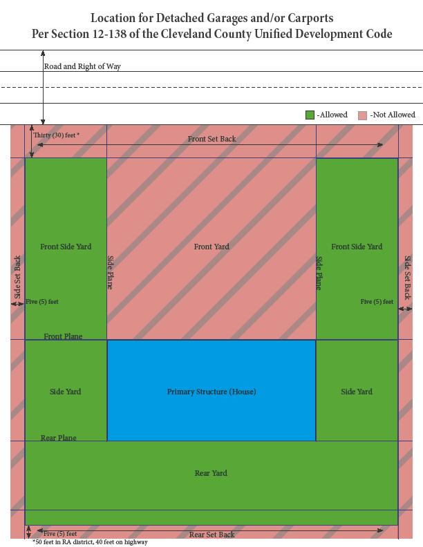
15 COUNTY OF CLEVELAND, NORTH CAROLINA AGENDA ITEM SUMMARY Case Carports and Garages Text Amendment Department: Agenda Title: Case 18-12: Garages and Carports Text Amendment Agenda Summary: Proposed Action: ATTACHMENTS: File Name 18-12_Staff_Report_Text_Amendment_Section_12-138_Garages_and_Carports.pdf Description Staff Report Section_12-138_Accessory_building_update_draft_for_garages_and_carports_for_case_18- Text Amendment 12_-January_15_2019.pdf Location_Allowance_for_Garages_and_Carports.pdf Section_12-138_Accessory_building_update_draft_from_applicant_for_Case_18-12.pdf Illustration Original Petition
16 STAFF REPORT To: The Cleveland County Board of Commissioners Date: January 15, 2019 From: Via: Chris Martin, Senior Planner Henry Earle, Planner Subject: Case Summary Statement: Britt Bernhardt has submitted a request for an amendment to Section (a) of the Cleveland County Unified Development Code. Review: Britt Bernhardt has applied for a text amendment to Section (a) of the Cleveland County UDO that would allow garages/carports to be placed in the front of a principal dwelling. Section of UDO addresses accessory structures and location of said structures. It states that all accessory structures must be located in the rear or side yard of any parcel with a principal dwelling. The Board of Commissioners has set a public hearing for Tuesday, February 5, 2019 to hear the case. Pros: Allows for greater flexibility of placement for garages/carports on residential lots Addresses a common question asked of the zoning department Cons: None Fiscal Impact: None Recommendations: Planning Board:
17 Proposed Text Amendment Allowing Garages/Carports within the Front-Side Yard of Residential Lots Sec Location of accessory buildings on residential lots. (a) On any residential lot, accessory buildings and structures shall not be located in any front yard required for principal buildings, shall not cover more than thirty (30) percent of any rear yard required for the principal building, and shall be at least twenty (20) feet from any building used for human habitation on adjoining lots. Exceptions to this rule include garages and carports, which are allowed within the front side yard of any principal dwelling, under the following conditions: 1. Garages and carports may be no larger than 50% of the square footage of the principle building. 2. The garage or carport may be placed no more than fifty (50) feet in front of the front plane of the principal dwelling. 3. The garage or carport shall comply with principal building setbacks from the street right-of-way, subject to Section Only one (1) garage or carport may be placed in the front side yard per parcel. (b) Accessory buildings designed or used for human habitation as may be permitted by this chapter shall be located no closer to the principal building than thirty (30) feet and shall meet the side yard requirements for the district in which located. (c) A double garage, one-half (½) of which would be located on each of two (2) lots, shall be permitted in any residential district, provided a written request signed by both parties is submitted with the building permit application. (d) On any lot or tract in the RA district, accessory buildings and structures shall be at least twenty (20) feet from any building used for human habitation on adjoining lots. (e) Outdoor swimming pools shall be protected by a fence or equal enclosure, a minimum of four (4) feet in height, equipped with a self-locking and positive self-latching gate provided with hardware for permanent locking. This enclosure is intended to protect against potential drowning by restricting access to swimming pools. (f) See also section , accessory building setback requirements.
18
19 Sec Accessory building setback requirements. Accessory buildings in the R, RM, and RR districts shall meet a setback requirement of at least five (5) feet. Accessory buildings located in the RA district shall meet a setback requirement of at least ten (10) feet. These structures shall not be located in any front or side yard and shall not cover more than thirty (30) percent of the rear yard. See also section , location of accessory buildings on residential lots. Sec Definitions of basic terms. Carport: a shelter for a car, or cars, consisting of a roof supported on posts. Front Side Yard: The area of a lot located between the front plane of a primary structure and the road right of way, while also being between either side plane of the primary structure and the corresponding side property line. See illustration in section Garage: a building used primarily for parking or storing motor vehicles.
20 Location for Detached Garages and/or Carports Per Section of the Cleveland County Unified Development Code Road and Right of Way -Allowed -Not Allowed Thirty (30) feet * Front Set Back Front Side Yard Front Yard Front Side Yard Side Set Back Five (5) feet Side Plane Side Plane Five (5) feet Side Set Back Front Plane Side Yard Primary Structure (House) Side Yard Rear Plane Rear Yard Five (5) feet *50 feet in RA district, 40 feet on highway Rear Set Back
21 Text Amendment Requested by Applicant Sec Location of accessory buildings on residential lots. (a) On any residential lot, accessory buildings and structures shall not be located in any front yard required for principal buildings, shall not cover more than thirty (30) percent of any rear yard required for the principal building, and shall be at least twenty (20) feet from any building used for human habitation on adjoining lots. Exceptions to this rule include garages and carports, which are allowed within the front yard of any principal dwelling, under the following conditions: 1. The parcel on which the garage or carport is to be located is a minimum of two (2) acres. 2. The garage or carport maintains a 150 foot setback from the front right-of-way. (b) Accessory buildings designed or used for human habitation as may be permitted by this chapter shall be located no closer to the principal building than thirty (30) feet and shall meet the side yard requirements for the district in which located. (c) A double garage, one-half (½) of which would be located on each of two (2) lots, shall be permitted in any residential district, provided a written request signed by both parties is submitted with the building permit application. (d) On any lot or tract in the RA district, accessory buildings and structures shall be at least twenty (20) feet from any building used for human habitation on adjoining lots. (e) Outdoor swimming pools shall be protected by a fence or equal enclosure, a minimum of four (4) feet in height, equipped with a self-locking and positive self-latching gate provided with hardware for permanent locking. This enclosure is intended to protect against potential drowning by restricting access to swimming pools. (f) See also section , accessory building setback requirements.
22 COUNTY OF CLEVELAND, NORTH CAROLINA AGENDA ITEM SUMMARY Case 18-13: Rezoning at 1650 North Post Road Department: Agenda Title: Agenda Summary: Proposed Action: Case 18-13: Request to rezone property at 1650 North Post Road from Restricted Residential to General Business ATTACHMENTS: File Name 18-13_Staff_Report.pdf 18-13_Aerial_Map_1650_North_Post_Road.pdf 18-13_Zoning_Map_1650_North_Post_Road.pdf 18-13_Land_Use_Map_1650_North_Post_Road.pdf Description Staff Report aerial map zoning map land use map
23 STAFF REPORT To: Cleveland County Board of Commissioners Date: January 2, 2019 From: Chris Martin, Senior Planner Subject: Rezoning Case Summary Statement: Challenger Three Golf Club, Inc. has applied to rezone parcels 24702, and at 1650 North Post Road, from Restricted Residential Corridor Protection (RRCP) to General Business (GB). Review: Challenger III is located on Highway 180 North and currently zoned Restricted Residential. The property is used for a golf course and outdoor amusement and recreation which was in use prior to County wide zoning in The surrounding zoning is mixed with Restricted Residential to the east and north and General Business to the southwest along North Post Road. The surrounding uses are also mixed consisting of commercial and residential. The Land Use Plan calls this area Future Commercial. Pros: Cons: The General Business zoning district is compatible with the current use of the property. General Business would be compatible with the Land Use Plan. Our Code states GB is generally located along arterial streets. None Fiscal Impact: None Recommendations: Planning Board: The Planning Board will hear this case at its January 22, 2019 meeting.

24 Case # Re-Zoning for 1650 North Post Road RR to GB Aerial Map, Parcel # 24702, & acres

25 Case # Re-Zoning for 1650 North Post Road RR to GB Zoning Map, Parcel # 24702, & acres

26 Case # Re-Zoning for 1650 North Post Road RR to GB Land Use Map, Parcel # 24702, & acres
27 COUNTY OF CLEVELAND, NORTH CAROLINA AGENDA ITEM SUMMARY Case 19-01: Rezone at 134 Shady Lane Department: Agenda Title: Agenda Summary: Proposed Action: Case 19-01: Request to rezone property at 134 Shady Lane from Rural Agriculture to Residential ATTACHMENTS: File Name 19-01_Staff_Report.pdf 19-01_Aerial_Map_134_Shady_Lane.pdf 19-01_Zoning_Map_134_Shady_Lane.pdf Capture.pdf Description Staff Report Aerial Map zoning map Message from Todd and Ginger Short
28 STAFF REPORT To: Cleveland County Board of Commissioners Date: January 15, 2019 From: Chris Martin, Senior Planner Subject: Rezoning Case Summary Statement: Diana Gillespie is requesting to rezone property at 134 Shady Lane, from Rural Agriculture (RA) to Residential (R). Review: Parcel 42784, at 134 Shady Lane, is currently zoned Rural Agriculture. Property to the immediate north and south along Shady Lane are zoned Residential as is property across the street to the east. To the west is Rural Agriculture. The surrounding area is comprised of Residential uses. Pros: Cons: The Residential zoning district is compatible with the current use on the property. Rezoning this property to Residential would be an extension of an already existing zoning district. None Fiscal Impact: None Recommendations: Planning Board:

29 Case # Re-Zoning for 134 Shady Lane RA to R Aerial Map, Parcel # acres

30 Case # Re-Zoning for 134 Shady Lane RA to R Zoning Map, Parcel # acres

31
32 COUNTY OF CLEVELAND, NORTH CAROLINA AGENDA ITEM SUMMARY Case 19-02: Rezone at 823 Old Stubbs Road Department: Agenda Title: Agenda Summary: Proposed Action: Case 19-02: Request to rezone property at 823 Old Stubbs Road from Residential to Light Industrial Conditional District ATTACHMENTS: File Name 19-02_Staff_Report.pdf 19-02_Aerial_Map_823_Stubbs_Road.pdf 19-02_Land_Use_Map_823_Stubbs_Road.pdf 19-02_Zoning_Map_823_Stubbs_Road.pdf HPSCANNER0051.pdf Description Staff Report Aerial Map Land Use Map Zoning map Site Plan
33 STAFF REPORT To: Cleveland County Board of Commissioners Date: January 17, 2019 From: Chris Martin, Senior Planner Subject: Rezoning Case Summary Statement: Jason Hamrick is requesting to rezone property at 823 Old Stubbs Rd, from Residential (R) to Light Industrial-Conditional Use District (LI-CD). Review: The property is 2 acres and located on Old Stubbs Rd north of Moss Lake, about 0.2 of a mile from the Highway 150 intersection. Mr. Hamrick has acquired the property and wishes to operate a metal fabrication business at this location. He has submitted an application and site plan showing how the property will be used. There is an existing building on the property that was historically used as a yarn and knitting business and has since closed. The previous business was established prior to zoning adoption in this area. The property is zoned Residential along with the surrounding properties. The surrounding area is comprised of residential uses, and a storage facility further down Old Stubbs Rd, and some retail businesses at the intersection of Old Stubbs Rd and Highway 150. The Land Use Plan designates the intersection future commercial, with the designation reaching Mr. Hamrick s property. The Land Use Plan encourages the redevelopment of vacant buildings Pros: Cons: General Business is compatible with the Land Use Plan s commercial designation. The Land Use Plan encourages the redevelopment of vacant buildings. Could be considered spot zoning. Fiscal Impact: None Recommendations: Planning Board:

34 Case # Re-Zoning for 823 Stubbs Road R to LI-CD Aerial Map, Parcel # 44164, 1.9 acres

35 Case # Re-Zoning for 823 Stubbs Road R to LI-CD Land Use Map, Parcel # 44164, 1.9 acres
36 Case # Re-Zoning for 823 Stubbs Road R to LI-CD Zoning Map, Parcel # 44164, 1.9 acres
37
38 COUNTY OF CLEVELAND, NORTH CAROLINA AGENDA ITEM SUMMARY Case 19-03: Solar Facility Discussion Department: Agenda Title: Agenda Summary: Proposed Action: Case 19-03: Cleveland County Solar Facility Ordinance ATTACHMENTS: File Name 19-03_Staff_Report.pdf Description Staff Report Sec _Solar_Electric_Power_Generation.pdf Section
39 STAFF REPORT To: Cleveland County Planning Board Date: January 22, 2019 From: Subject: Chris Martin, Senior Planner Text Amendment Case 19-03: Solar Facility Ordinance Update Summary Statement: The Board of Commissioners has requested that the Planning Board evaluate, and suggest improvements to, the Cleveland County Solar Facility Ordinance. Review: At their April 5, 2016 regular meeting, the Board of Commissioners adopted Section , Solar Electric Power Generation, into the Cleveland County Unified Development Code, providing standards for Solar Facilities. At their January 15, 2019 regular meeting, the Board has requested the Planning Board to reevaluate this section of the Code and to explore the following components: Ways to preserve the agricultural heritage of Cleveland County Evaluate standards such as screening and setbacks Evaluate zoning standards including application processes for various zoning districts Evaluate the fee schedule Pros: Evaluating standards will create the opportunity to create a more effective ordinance that will be reflective of the continued growth of solar facilities in Cleveland County Cons: Recommendations: Planning Board:
40 Sec Solar electric power generation. The following development standards shall apply to the construction of any solar facility designed to generate electricity for a commercial purpose. Any solar facility on properties less than ten (10) acres shall be prohibited: (a) A site plan shall be prepared in accordance with section The site plan does not require a boundary survey as described in subsection 12-33(a)(1). The site plan shall show the location of any structures within one hundred (100) feet of the property line, and also demonstrate compliance with the other standards in this section. (b) Opaque (Type A) screening shall be installed between the security fence and adjacent non-participating property and the road right-of-way, prior to the operation of any solar equipment. (c) Security fencing shall be installed around the perimeter of the solar farm. The fencing shall be a minimum of six (6) feet in height, chain link, and equipped with a gate and locking mechanism. (d) Setbacks shall be measured from the security fencing: (1) Fifty (50) feet from any non-participating property; (2) One hundred (100) feet from any habitable dwelling or commercial structure; (3) One thousand (1,000) feet from the right-of-way of a NCDOT Scenic Byway. (e) Landscape screening, fencing, gates and warning signs shall be maintained in good condition until the facility is decommissioned. (f) Decommission plan. (1) The owner/operator of the solar facility shall submit a decommissioning plan prior to the issuance of a zoning permit or conditional use permit (example provided following this section); however, nothing about the issuance of this permit relieves the landowner of the obligation to remove the equipment as outlined in the conditional use or zoning permit. (2) If the owner/operator of the solar facility fails to ensure the removal of the equipment within six (6) months after power production ceases for a period of twelve (12) continuous months, the landowner shall be in violation of the conditional use or zoning permit, and be subject to the penalties set forth in section
41 (3) Each day that the violation continues after notification to the landowner by the administrator, shall be considered a separate offense for purposes of penalties and remedies. (g) Enforcement by injunction, abatement and liens. (1) If a violation continues under section 12-94, the violation may be enforced by an order of abatement issued by the general court of justice for failure of the landowner to correct the unlawful condition of the property. Upon issuance of an abatement order by the general court of justice, a landowner must comply with the order within the time limit specified. If the landowner fails to do so, the county may take steps necessary to correct the condition of the property. The cost to correct the condition shall be a lien on the property in the nature of a mechanic or material man lien. (2) The equipment which remains shall be deemed abandoned and salvaged for the cost of decommissioning. (3) Should the salvage value exceed the cost of decommissioning, the balance shall be placed with the office of the clerk of court for abandoned funds. (Ord. of (1) Example of the Decommissioning Plan Decommission Plan for Big Bright Solar ("Facility"), located at. Prepared and Submitted by, the owner of Big Bright Solar This decommissioning plan is presented as required by Subsection (f) of the Cleveland County Code. Decommissioning will occur as a result of any of the following conditions: 1. The land lease ends 2. The system does not produce power for 12 months 3. The system is damaged and will not be repaired or replaced The owner of the Facility, as provided for in its lease with the landowner, will do the following as a minimum to decommission the project. 1. Remove all non-utility owned equipment, conduits, structures, fencing, and foundations to a depth of at least three feet below grade.
42 2. Remove all graveled areas and access roads unless the owner of the leased real estate requests in writing for it to stay in place. 3. Restore the land to a condition reasonably similar to its condition before SES development, including replacement of top soil removed or eroded. 4. Re-vegetate any cleared areas with warm season grasses that are native to the Piedmont region, unless requested in writing by the owner of the real estate to not re-vegetate due to plans for agricultural planting. All said removal and decommissioning shall occur within 12 months of the facility ceasing to produce power for sale. The Facility Owner, currently, is responsible for this decommissioning. Nothing in this plan relieves any obligation that the real estate property owner may have to remove the facility as outlined in the Conditional Use Permit in the event the operator of the facility does not fulfill this obligation. The owner of the Facility will provide the Cleveland County Planning Department and the Register of Deeds with an updated signed decommissioning plan within 30 days of change in the Facility Owner. This plan may be modified from time to time and a copy of any modified plans will be provided to the planning staff and filed with the Register of Deeds by the party responsible for decommissioning. Facility Owner Signature: Date: Landowner (if different) Signature: Date: (Ord. of (1)
LAND OWNER OF SITE ADDRESS PHONE NUMBER FAX NUMBER. APPLICANT (if other than owner) ADDRESS PHONE NUMBER FAX NUMBER
 ADDRESS PHONE NUMBER FAX NUMBER") TELECOMMUNICATION TOWER CONDITIONAL USE PERMIT APPLICATION FOR WALWORTH COUNTY - $1025 The undersigned hereby applies to the Walworth County Zoning Agency (Walworth County Land Use and Resource Management
TELECOMMUNICATION TOWER CONDITIONAL USE PERMIT APPLICATION FOR WALWORTH COUNTY - $1025 The undersigned hereby applies to the Walworth County Zoning Agency (Walworth County Land Use and Resource Management
COMMUNICATION TOWERS ORDINANCE No. 31
 COMMUNICATION TOWERS ORDINANCE No. 31 ARTICLE 1: AUTHORITY AND JURISDICTION Authority Pursuant to the authority granted by 1967 SDCL 11-2 as amended; the following regulations are hereby adopted by the
TYPE II LAND USE APPLICATION Telecommunications Tower: Collocation
 LAND MANAGEMENT DIVISION Date Received: TYPE II LAND USE APPLICATION Telecommunications Tower: Collocation PUBLIC WORKS DEPARTMENT 3050 N. DELTA HWY, EUGENE OR 97408 Planning: 682-3577 For Office Use Only
TITLE 33 REGULATION OF WIRELESS TELECOMMUNICATIONS FACILITIES
 CITY OF STURGIS ORDINANCES TITLE 33-1 TITLE 33 REGULATION OF WIRELESS TELECOMMUNICATIONS FACILITIES (Title 33 established effective 8/4/07, Ordinance 2007-17) Chapters: 33.01: General Provisions 33.02:
ALBEMARLE COUNTY PLANNING STAFF REPORT SUMMARY
 ALBEMARLE COUNTY PLANNING STAFF REPORT SUMMARY Project Name: SDP2010-94 Hillsdale Farm/Cosner Property (AT&T CV427 Tier II) - Final Planning Commission Public Hearing: March 1, 2011 Owners: Kimco, LC Acreage:
TOWN OF RUTLAND Ordinance No. 12.5
 TOWN OF RUTLAND Ordinance No. 12.5 AN ORDINANCE RELATING TO CHANGES TO ZONING DISTRICT BOUNDARIES AND CONDITIONAL USE PERMITS REQUESTED TO ALLOW THE CONSTRUCTION AND OPERATION OF COMMUNICATION TOWERS The
ARTICLE II: CELLULAR ANTENNA TOWERS
 Kenton County Planning Commission 8 ARTICLE II: CELLULAR ANTENNA TOWERS SECTION 2.0 PRE-APPLICATION CONFERENCE: Applicants must contact Staff and request a pre-application conference. This meeting will
ARTICLE VI. SPECIAL EXCEPTION REGULATIONS
 ARTICLE VI. SPECIAL EXCEPTION REGULATIONS SECTION 601. GENERAL DESCRIPTION Special exceptions are deemed to be permitted uses in their respective districts, subject to the satisfaction of the requirements
Division 16.Telecommunication Tower Standards
 Division 16.Telecommunication Tower Standards Section 17-311. Telecommunication towers and antennas: general provision. The Director shall have the authority to regulate the construction and operation
ARTICLE XX THE COUNTY BOARD OF MERCER COUNTY, ILLINOIS RESOLUTION AMENDING THE MERCER COUNTY ZONING ORDINANCE SOLAR ENERGY FACILITIES
 ARTICLE XX THE COUNTY BOARD OF MERCER COUNTY, ILLINOIS RESOLUTION AMENDING THE MERCER COUNTY ZONING ORDINANCE SOLAR ENERGY FACILITIES 20.1 TITLE. This ordinance shall be known as the Solar Energy Ordinance.
SHIAWASSEE COUNTY ZONING ORDINANCE Article 4 Specific Use Regulations
 SHIAWASSEE COUNTY ZONING ORDINANCE Article 4 Specific Use Regulations Section 4.3.76 Wind Energy Conversion Systems 1. Purpose A. Through this section it is hereby set forth that Shiawassee County promotes
MONTEREY COUNTY PLANNING COMMISSION
 MONTEREY COUNTY PLANNING COMMISSION Meeting: June 11, 2003 @ 9:30 AM Agenda Item: D2 Project Description: Use Permit (Associated Tagline/Sprint #PLN000669) for the construction of a 50 Ft. monopole with
Telecommunications Development Permit Application Package
 Telecommunications Development Permit Application Package POLICY POL#308 Title: Policy Guidelines to Evaluate Commercial Communications Facilities Legal References: Radio Communication Act Municipal Government
Pagosa Lakes Telecommunication Facility Development Plan Rezoning in the PUD zone, located at 1311 Lake Forest Cir.
 Archuleta County Development Services Planning Department 1122 HWY 84 P. O. Box 1507 Pagosa Springs, Colorado 81147 970-264-1390 Fax 970-264-3338 MEMORANDUM TO: Archuleta County Planning Commission FROM:
TITLE 7, CHAPTER 3 TAZEWELL COUNTY
 TITLE 7, CHAPTER 3 TAZEWELL COUNTY WIND FARM ORDINANCE ADOPTED SEPTEMBER 2004 Amendment Dates: February, 2008 March, 2008 February 25, 2009 September 1, 2018 7TCC 3-1. Wind Energy Conversion Systems Purpose.
MODEL WIRELESS TELECOMMUNICATIONS ORDINANCE for Siting of "Small Cell" Telecommunication Infrastructure in Public Rights-Of-Way
 MODEL WIRELESS TELECOMMUNICATIONS ORDINANCE for Siting of "Small Cell" Telecommunication Infrastructure in Public Rights-Of-Way This document is intended for use by towns and villages that have existing
ML-4 MULTIFAMILY RESIDENTIAL ZONE. [Added by Ord. No ]
![ML-4 MULTIFAMILY RESIDENTIAL ZONE. [Added by Ord. No ]](/thumbs/90/103301433.jpg "ML-4 MULTIFAMILY RESIDENTIAL ZONE. [Added by Ord. No ]") 55-26. ML-4 MULTIFAMILY RESIDENTIAL ZONE. [Added 2-2-98 by Ord. No. 1998-1 2] The following regulations apply in the ML-4 Zone. A. Permitted Uses. (1) Garden apartments, together with accessory structures
55-26. ML-4 MULTIFAMILY RESIDENTIAL ZONE. [Added 2-2-98 by Ord. No. 1998-1 2] The following regulations apply in the ML-4 Zone. A. Permitted Uses. (1) Garden apartments, together with accessory structures
CHAPTER 2 RELATIONSHIP WITH OTHER LAWS.
 CHAPTER 2 General Provisions 12-2-1 Minimum Requirements 12-2-2 Relationship with Other Laws 12-2-3 Effect on Existing Agreements 12-2-4 Scope of Regulations 12-2-5 Building Permit 12-2-6 Nonconforming
ARTICLE 14 BUILDINGS, STRUCTURES, AND USES ACCESSORY TO SINGLE-FAMILY RESIDENTIAL DWELLINGS
 ARTICLE 14 BUILDINGS, STRUCTURES, AND USES ACCESSORY TO SINGLE-FAMILY RESIDENTIAL DWELLINGS Sec. 14.1. Sec. 14.2. Sec. 14.3. Sec. 14.4. Sec. 14.5. Sec. 14.6. Sec. 14.7. Sec. 14.8. Sec. 14.9. Sec. 14.10.
SOLAR ENERGY FACILITIES ORDINANCE #17-07 KOCHVILLE TOWNSHIP
 SOLAR ENERGY FACILITIES ORDINANCE #17-07 KOCHVILLE TOWNSHIP WHEREAS, the Kochville Township Board desires to enact an ordinance providing for the regulating of solar energy facilities in Kochville Township,
Conditional Use Permit Report South Anna Magisterial District PC Meeting Date: January 21, Overview. Request
 CUP-1O-15, NATIONAL COMMUNICATION TOWERS Conditional Use Permit Report South Anna Magisterial District PC Meeting Date: January 21, 2016 Overview Request To permit a 199 telecommunications tower Zoning
5.2 GENERAL MEASUREMENT REQUIREMENTS
 Sec. 5.2.1 / Density 5.2 GENERAL MEASUREMENT REQUIREMENTS 5.2.1 Density Density shall be measured by taking the quotient of the total number of dwelling units on a site proposed for development divided
Town of York, Maine. Table of Contents. 1.1 Title and Effective Date pg Authority pg Purpose pg Applicability pg 2
 Table of Contents 1.1 Title and Effective Date pg 2 1.2 Authority pg 2 1.3 Purpose pg 2 1.4 Applicability pg 2 1.5 Approval Authority pg 3 1.6 Technical Assistance pg 3 1.7 Locations for WCFs pg 3 1.8
Wind Energy Conversion System Ordinance No. 467
 Wind Energy Conversion System Ordinance No. 467 AN ORDINANCE ESTABLISHING A PERMITTING PROCESS FOR WIND ENERGY CONVERSION SYSTEMS ADOPTED BY THE Big Timber City Council on this day of, 2006. ADOPTED BY
EXHIBIT A SHIAWASSEE COUNTY ZONING ORDINANCE ARTICLE 4 SPECIFIC USE REGULATIONS RECOMMENDED AMENDMENTS TO SECTION (REVISED MAY 11, 2018)
") EXHIBIT A SHIAWASSEE COUNTY ZONING ORDINANCE ARTICLE 4 SPECIFIC USE REGULATIONS RECOMMENDED AMENDMENTS TO SECTION 4.3.76 (REVISED MAY 11, 2018) Section 4.3.76 Wind Energy Conversion Systems ( WECS ) 1.
EXHIBIT A SHIAWASSEE COUNTY ZONING ORDINANCE ARTICLE 4 SPECIFIC USE REGULATIONS RECOMMENDED AMENDMENTS TO SECTION 4.3.76 (REVISED MAY 11, 2018) Section 4.3.76 Wind Energy Conversion Systems ( WECS ) 1.
DRAFT PARK COUNTY US HIGHWAY 89 SOUTH EAST RIVER ROAD OLD YELLOWSTONE TRAIL ZONING DISTRICT REGULATIONS
 Formatting: Changes recommended by the Board and accepted by the County Commission are formatted in RED: Changes made by the Park County Commission are formatted in YELLOW highlight: and changes made by
May 12, Chapter RH HILLSIDE RESIDENTIAL ZONES REGULATIONS Sections:
 May 12, 2017 Chapter 17.13 RH HILLSIDE RESIDENTIAL ZONES REGULATIONS Sections: 17.13.010 Title, intent, and description. 17.13.020 Required design review process. 17.13.030 Permitted and conditionally
Planning and Zoning Staff Report Maverick Towers Van Wassenhove, PH
 Planning and Zoning Staff Report Maverick Towers Van Wassenhove, PH2018-17 Hearing Date: April 19, 2018 Development Services Department Applicant: Maverick Towers - Nadine Bostwick Owner: Paul Van Wassenhove
** If your lot does not meet the requirements above, please read Sec below
 Sec. 13-1-60 Zoning District Dimensional Requirements. For the Zoning Dept To Issue a Land Use Permit The Following Dimensions are Required. Minimum Side and Rear Yards s Lakes Classification Minimum Class
ARTICLE ZONING DISTRICTS AND OFFICIAL MAP SEC SUPPLEMENTAL AREA, YARD AND HEIGHT RESTRICTIONS.
 SEC. 27-310. SUPPLEMENTAL AREA, YARD AND HEIGHT RESTRICTIONS. The following requirements provide exceptions or qualify and supplement the specific district regulations set forth in this part. Planned developments
ARTICLE III: LAND USE DISTRICTS 304 R 9 DISTRICT
 ARTICLE III: LAND USE DISTRICTS III 23 304 R 9 DISTRICT (RESIDENTIAL 9 UNITS PER ACRE) 304 1 Intent and Purpose The R 9 District is intended to implement the policies of the Comprehensive Plan for areas
VOLUME II - APPENDIX B - BASIC ZONING ORDINANCE ARTICLE V. DISTRICT REGULATIONS
 Sec. 5.1000. Multiple-family Residential (R-5). (Ord. No. 4005, 1(Res. No. 8947, Exh. A, 55), 4-3-12) Sec. 5.1001. Purpose. This district is intended to provide for development of multiple-family residential
Accessory Dwelling Units PJR-032
 Accessory Dwelling Units PJR-032 Purpose: This handout summarizes the regulations of the Sonoma County Zoning Ordinance for accessory dwelling units. The text of the ordinance is located in Attachment
ARTICLE C. ZONING TEXT, DISTRICT CLASSIFICATIONS AND BOUNDARIES
 ARTICLE C. ZONING TEXT, DISTRICT CLASSIFICATIONS AND BOUNDARIES Sec. 10-2054. ZONING TEXT, DISTRICT CLASSIFICATIONS AND BOUNDARIES. In order to regulate the location of structures, the height and bulk
Ordinance #68. Highlighted items in bold and underline font to be added. Highlighted items in strikethrough font to be removed.
 Ordinance #68 AN ORDINANCE ENTITLED, AN ORDINANCE AMENDING ARTICLE II DEFINITIONS AND CHAPTER 5.22 (WIND ENERGY SYSTEMS) OF ARTICLE V GENERAL REQUIREMENTS OF ORDINANCE 65 AN ORDINANCE AMENDING ORDINANCE
WIND ENERGY CONVERSION SYSTEM (WECS) APPLICATION
 APPLICATION") PLANNING & DEVELOPMENT SERVICES PO Box 4169, 911 North 7 Avenue Pocatello, Idaho 83205 WIND ENERGY CONVERSION SYSTEM (WECS) APPLICATION Submittal Date: Contact Person: Permit #: Receipt Date: Plan Review
PLANNING & DEVELOPMENT SERVICES PO Box 4169, 911 North 7 Avenue Pocatello, Idaho 83205 WIND ENERGY CONVERSION SYSTEM (WECS) APPLICATION Submittal Date: Contact Person: Permit #: Receipt Date: Plan Review
COUNTY OF TAZEWELL DEPARTMENT OF COMMUNITY DEVELOPMENT
 The following checklist is aid in a thorough submittal process and shall be submitted with a building permit application: Completed commercial building permit application to include a Site Plan of the
Chapter 9 Wind Energy
 SECTION 9.01 PURPOSE AND INTENT This ordinance balances the need for clean renewable energy resources with the necessity to protect the public health, safety, and welfare of the community. Tuscola Township
ORDINANCE NO NOW, THEREFORE, BE IT ENACTED BY THE CITY OF WINTER GARDEN, FLORIDA, AS FOLLOWS:
 ORDINANCE NO. 11-13 AN ORDINANCE OF THE CITY COMMISSION OF THE CITY OF WINTER GARDEN, FLORIDA, AMENDING CHAPTER 118, ARTICLE VI, DIVISION 7, SECTION 118-1297 OF THE WINTER GARDEN CODE OF ORDINANCES RELATING
CHAPTER 2 GENERAL PROVISIONS
 CHAPTER 2 GENERAL PROVISIONS 200 ZONING DISTRICTS ESTABLISHED 201 SUPPLEMENTAL DISTRICTS ESTABLISHED 202 OFFICIAL ZONING MAP ESTABLISHED 203 DISTRICT BOUNDARY DESCRIPTION and INTERPRETATION 204 LIMITATION
ARTICLE 6.07 FENCES Division 1. Generally
 FENCE REGULATIONS ARTICLE 6.07 FENCES Division 1. Generally Sec. 6.07.001 Definitions For the purpose of this article, the following terms, phrases and words shall have meanings respectively ascribed to
STAFF REPORT #
 STAFF REPORT #15-4000-0001 A Conditional Use PLANNING COMMISSION MEETING DATE: March 19, 2015 1. APPLICATION: A public hearing regarding a request for a conditional use permit for the installation of a
TOWN OF SWANSBORO Planning Board Regular Meeting. December 5, 2016 Members Present Members Absent
 TOWN OF SWANSBORO Planning Board Regular Meeting December 5, 2016 Members Present Members Absent Wayne Mixon Christina Ramsey Sandi Eubanks Joel Wiltgen Brent Hatlestad Laurent Meilleur The meeting was
Planning and Zoning Staff Report Vallivue School District - PH
 Hearing Date: April 19, 2018 Planning and Zoning Staff Report - PH2018-16 Development Services Department Applicant: Nate Bondelid Owner: Staff: Dan Lister, Planner II (208) 455-5959 dlister@canyonco.org
TELECOMMUNICATIONS TOWER AND VARIANCE STAFF REPORT
 TELECOMMUNICATIONS TOWER AND VARIANCE STAFF REPORT City County Planning Commission 1141 State Street Bowling Green, Kentucky 42101 (270) 842 1953 Summary: The applicants have filed an application for approval
Proposed Overland Park Kansas Ordinance RE-1 Residential Estates Community
 18.171 RE-1 Residential Estate Community 18.171.010 Statement of intent. The zoning of property as RE-1, (Residential Estates Community, 1 dwelling unit per Gross acre density), is intended to provide
County Of Lincoln, North Carolina Planning & Inspections Department
 County Of Lincoln, North Carolina Planning & Inspections Department Lincoln County Board of Commissioners Agenda Item Memorandum DateSubmitted: October22,2013 DepartmentMakingRequest: PlanningandInspections
RESOLUTION DISAPPROVING APPEAL NO
 RESOLUTION DISAPPROVING APPEAL NO. 2017-01 WHEREAS, Strategis LLC, 2530 Superior Avenue #303, Cleveland, OH 44114, as agent for Crown Castle and Verizon Wireless, Appellant, on December 7, 2016, filed
SECTION 822 "R-1-A" AND "R-1-AH" - SINGLE FAMILY RESIDENTIAL DISTRICTS
 SECTION 822 "R-1-A" AND "R-1-AH" - SINGLE FAMILY RESIDENTIAL DISTRICTS The "R-1-A" and "R-1-AH" Districts are intended to provide for the development of single family residential homes at urban standards
4-1 TITLE 6 MOBILE HOME AND RECREATIONAL VEHICLE PARKS 4-3
 4-1 TITLE 6 MOBILE HOME AND RECREATIONAL VEHICLE PARKS 4-3 Chapter 4 RECREATIONAL VEHICLE PARKS Sec. 4-1: Sec. 4-2: Sec. 4-3: Sec. 4-4: Sec. 4-5: Sec. 4-6: Sec. 4-7: Sec. 4-8: Sec. 4-9: Sec. 4-10: Sec.
Application for Pool and Pool Fence (revised 3/14/17)
") Application for Pool and Pool Fence Fees: Pool $100 Electrical $50 Fence $25/$50 Initial Plan Review fee for pools is $100.00 plus inspection fees. Fence Plan Review fee is $50.00. Permit fees are prepared
Application for Pool and Pool Fence Fees: Pool $100 Electrical $50 Fence $25/$50 Initial Plan Review fee for pools is $100.00 plus inspection fees. Fence Plan Review fee is $50.00. Permit fees are prepared
RESOLUTION PC NOW THEREFORE, the Planning Commission of the City of Duarte resolves as follows:
 RESOLUTION PC 18-09 A RESOLUTION OF THE PLANNING COMMISSION OF THE CITY OF DUARTE APPROVING CONDITIONAL USE PERMIT 14-02, FOR THE USE AND OPERATION OF A WIRELESS COMMUNICATION FACILITY FOR VERIZON WIRELESS,
Howard County Checksheet for Large Wind to Energy Facilities (WEF)
") Wind to Energy Facility, Large permitted in AG IA I1 I2 IU Howard County Checksheet for Large Wind to Energy Facilities (WEF) Zoning of Property: Address of Property: Number of Components: General Information:
Wind to Energy Facility, Large permitted in AG IA I1 I2 IU Howard County Checksheet for Large Wind to Energy Facilities (WEF) Zoning of Property: Address of Property: Number of Components: General Information:
DOUGLAS COUNTY ZONING RESOLUTION Section 4 LRR - Large Rural Residential District 3/10/99. -Section Contents-
 SECTION 4 LRR LARGE RURAL RESIDENTIAL DISTRICT -Section Contents- 401 Intent... 4-2 402 Principal Uses... 4-2 403 Accessory Uses... 4-3 404 Uses Permitted by Special Review... 4-4 405 Land Dedication...
John Machado et al (PLN040304)
") PLANNING COMMISSION COUNTY OF MONTEREY, STATE OF CALIFORNIA RESOLUTION NO. 04051 A.P. # 207-022-017-000 In the matter the application John Machado et al (PLN040304) FINDINGS & DECISION for a Use in accordance
PLANNING COMMISSION COUNTY OF MONTEREY, STATE OF CALIFORNIA RESOLUTION NO. 04051 A.P. # 207-022-017-000 In the matter the application John Machado et al (PLN040304) FINDINGS & DECISION for a Use in accordance
PREAMBLE. That the Gratiot County Zoning Ordinance be amended as follows:
 Amendment of Gratiot County Zoning Ordinance AN ORDINANCE TO AMEND THE GRATIOT COUNTY ZONING ORDINANCE REQUIREMENTS FOR SOLAR ENERGY SYSTEMS AND SOLAR FARMS FOR THE COUNTY-ZONED TOWNSHIPS OF ELBA, HAMILTON,
DRAFT Smithfield Planning Board Minutes Thursday, May 7, :00 P.M., Town Hall, Council Room
 DRAFT Smithfield Planning Board Minutes Thursday, May 7, 2015 6:00 P.M., Town Hall, Council Room Members Present: Chairman Eddie Foy Vice-Chairman Stephen Upton Daniel Sanders Gerald Joyner Mark Lane Jack
CITY OF TAFT PLANNING COMMISSION REGULAR MEETING WEDNESDAY, JANUARY 20, 2016 CITY HALL COUNCIL CHAMBERS 209 E. KERN ST.
 CITY OF TAFT PLANNING COMMISSION REGULAR MEETING AGENDA WEDNESDAY, JANUARY 20, 2016 CITY HALL COUNCIL CHAMBERS 209 E. KERN ST., TAFT, CA 93268 AS A COURTESY TO ALL - PLEASE TURN OFF CELL PHONES Any writings
ARTICLE 5.0 SCHEDULE OF REGULATIONS
 ARTICLE 5.0 SCHEDULE OF REGULATIONS Section 5.101 Table of Dimensional Standards by District. Dimensional Standards AG AG with sewer Districts Rural Residential Business Other SF SF with sewer R-1 R-1
4.2 RESIDENTIAL ZONING DISTRICTS
 4.2 RESIDENTIAL ZONING DISTRICTS A. Purpose: To define regulations and standards for each residential zoning district in the City. The following sections identify uses, regulations, and performance standards
Part 4, C-D Conservation District
 The Township is divided into the districts set forth by this chapter and as shown by the district boundaries on the Official Zoning District Map. The zoning districts are: C-D Conservation District A-1
ORDINANCE NO. Be it ordained by the City Council of the City of Abilene, Texas:
 ORDINANCE NO. An ordinance repealing Chapter 23, Subpart B of the Code of the City of Abilene, Texas, entitled Mobile Homes and Vacation Travel Trailers; stating the authority; setting forth the scope
Article XII. R-1 Agricultural-Low Density Residential District
 Article XII R-1 Agricultural-Low Density Residential District Section 1200. Declaration of Legislative Intent In expansion of the Declaration of Legislative Intent and Statement of Community Development
15.02 PERMITTED USES: The following uses and no other shall be deemed Residential, R-1, uses and permitted in all R-1 districts:
 Amended October 3, 1994, Effective November 3, 1994 Revised effective November 16, 1995, Revised effective 12/1/04, Revised effective 7/06/06, Revised effective 7/18/07, Revised effective 9/03/09, Revised
C HAPTER 15: N ONCONFORMITIES
 SECTION 15.1: PURPOSE AND APPLICABILITY The purpose of this Chapter is to regulate and limit the continued existence of uses and structures established prior to the effective date of this Code (or any
DRAFT PARK COUNTY US HIGHWAY 89 SOUTH EAST RIVER ROAD OLD YELLOWSTONE TRAIL ZONING DISTRICT REGULATIONS
 DRAFT PARK COUNTY US HIGHWAY 89 SOUTH EAST RIVER ROAD OLD YELLOWSTONE TRAIL ZONING DISTRICT REGULATIONS I. TITLE These regulations and the accompanying map(s) shall be known as, and shall be cited and
Town of Siler City - Unified Development Ordinance ARTICLE XII - Density and Dimensional Regulations
 ARTICLE XII - Density and Dimensional Regulations 167 Minimum Lot Size Subject to the provisions of 173 (Cluster Subdivisions) and all lots in the following zones shall have at least the amount of square
WILLIAMSON ACT CONTRACTS GUIDELINES
 NEVADA COUNTY COMMUNITY DEVELOPMENT AGENCY PLANNING DEPARTMENT ERIC ROOD ADMINISTRATION BUILDING 950 Maidu Avenue Nevada City, California 95959-8617 Phone: (530) 265-1222 FAX : (530) 265-9851 WILLIAMSON
Planning Commission recommends APPROVAL of the amendment to Article 4, Article 7, and Article 14 as presented by Staff on 6/19/17.
 DATE: June 20, 2017 TO: FROM: SUBJECT: Mayor and City Council Planning Director Zoning Ordinance Amendment Article 4, Article 7, and Article 14 related to accessory uses, fences, walls, and administrative
Action Recommendation: Budget Impact:
 City of Fayetteville Staff Review Form Garner Stoll Submitted By 2018-0144 Legistar File ID 4/17/2018 City Council Meeting Date - Agenda Item Only N/A for Non-Agenda Item 3/22/2018 Submitted Date Action
CHAPTER 5. Signs. It is further the intent of this section to prohibit signs which:
 CHAPTER 5 Signs 12-5-1 Purpose 12-5-2 Permitted Signs 12-5-3 Prohibited Signs 12-5-4 Computation of Number and Square Footage of Signs 12-5-5 District Regulations 12-5-6 Maintenance and Removal 12-5-7
TOWN OF MELBOURNE BEACH 2016 DEVELOPMENT APPLICATION
 TOWN OF MELBOURNE BEACH 2016 DEVELOPMENT APPLICATION I. SUBMITTAL REQUIREMENTS: 1. Fees per current schedule. 2. Deed to property. 3. Pre-Application meeting is mandatory. Contact the Building Official
AGENDA. a. Carol Crews Special Exception Hair Salon (Continued from February) b. James Barber Special Exception Horse
 b. James Barber Special Exception Horse") Baker County Land Planning Agency (LPA) Thursday, April 23, 2015 Baker County Administration Building 55 North Third Street Macclenny, FL 32063 (904) 259-3354 AGENDA 5:OO P.M. LDR Mining Workshop A. Draft
Baker County Land Planning Agency (LPA) Thursday, April 23, 2015 Baker County Administration Building 55 North Third Street Macclenny, FL 32063 (904) 259-3354 AGENDA 5:OO P.M. LDR Mining Workshop A. Draft
PERMITTED USES: Within the MX-1 Mixed Use Neighborhood District the following uses are permitted:
 6.25 MX-1 - MIXED USE NEIGHBORHOOD 6.25.1 INTENT: The purpose of the MX-1 Mixed Use Neighborhood District is to accommodate the development of a wide-range of residential and compatible non-residential
RP-2, RP-3, RP-4, AND RP-5 PLANNED RESIDENTIAL DISTRICTS
 6.10 - RP-2, RP-3, RP-4, AND RP-5 PLANNED RESIDENTIAL DISTRICTS 6.10.1 GENERAL DESCRIPTION: 6.10.1.1 The regulations established in this Section are intended to provide optional methods of land development
ARTICLE III: LAND USE DISTRICTS 348 AGRICULTURE AND FOREST DISTRICT (AF 5)
") ARTICLE III: LAND USE DISTRICTS III 159 348 AGRICULTURE AND FOREST DISTRICT (AF 5) 348 1 Intent and Purpose The AF 5 District is intended to retain an area s rural character and conserve the natural resources
ARTICLE III: LAND USE DISTRICTS III 159 348 AGRICULTURE AND FOREST DISTRICT (AF 5) 348 1 Intent and Purpose The AF 5 District is intended to retain an area s rural character and conserve the natural resources
EXCERPTS FROM SERAFINA GOVERNING DOCUMENTS
 EXCERPTS FROM SERAFINA GOVERNING DOCUMENTS The Governing Documents shall mean and refer to the Declaration, Articles of Incorporation, By-laws and rules, regulations and resolutions of the Association.
New Cingular Wireless Telecommunication Tower at County Road 48, Milner Conditional Use Permit
 New Cingular Wireless Telecommunication Tower at 39415 County Road 48, Milner ACTIVITY #: Conditional Use Permit PP2012-023 HEARING DATES: Planning Commission (PC): August 16, 2012 at 6:00pm PETITIONER:
Accessory Dwelling Unit Permit
 PLANNING SERVICES DEPARTMENT 411 Main Street (530) 87-6800 P.O. Box 3420 Chico, CA 527 Application No. APPLICATION FOR Accessory Dwelling Unit Permit Applicant Information Applicant Street Address Daytime
Indicates Council-recommended changes Introduced by: Mr. Tackett Date of introduction: June 14, 2016 SUBSTITUTE NO. 1 TO ORDINANCE NO.
 Indicates Council-recommended changes Introduced by: Mr. Tackett Date of introduction: June 14, 2016 SUBSTITUTE NO. 1 TO ORDINANCE NO. 16-067 TO AMEND NEW CASTLE COUNTY CODE CHAPTER 40 (ALSO KNOWN AS THE
ARTICLE 15 - PLANNED UNIT DEVELOPMENT
 Section 15.1 - Intent. ARTICLE 15 - PLANNED UNIT DEVELOPMENT A PUD, or Planned Unit Development, is not a District per se, but rather a set of standards that may be applied to a development type. The Planned
1. APPLICANT: The City of Overland Park is the applicant for this request.
 8. UNIFIED DEVELOPMENT ORDINANCE AMENDMENT - ZRR 2590 - Residential Neighborhood District 1. APPLICANT: The City of Overland Park is the applicant for this request. 2. REQUESTED ACTION: The applicant is
PLANNING COMMISSION REPORT Regular Agenda Public Hearing Item CONDITIONAL USE PERMIT FOR VERIZON WIRELESS; 1287 E 1200 RD (SLD)
") PC Staff Report 9/26/2016 CUP-16-00312 Item No. 5-1 PC Staff Report 9/26/2016 ITEM NO. 5 PLANNING COMMISSION REPORT Regular Agenda Public Hearing Item CONDITIONAL USE PERMIT FOR VERIZON WIRELESS; 1287
PC Staff Report 9/26/2016 CUP-16-00312 Item No. 5-1 PC Staff Report 9/26/2016 ITEM NO. 5 PLANNING COMMISSION REPORT Regular Agenda Public Hearing Item CONDITIONAL USE PERMIT FOR VERIZON WIRELESS; 1287
City of Fayetteville, Arkansas Page 1 of 3
 City of Fayetteville, Arkansas 113 West Mountain Street Fayetteville, AR 72701 (479) 575-8323 Legislation Text File #: 2018-0144, Version: 1 ADM 18-6094 (AMEND UDC 164.19/ACCESSORY DWELLING UNITS): AN
Charter Township of Plymouth Zoning Ordinance No. 99 Page 35 Article 7: R-M Mobile Home Residential Districts Amendments:
 Charter Township of Plymouth Zoning Ordinance No. 99 Page 35 PURPOSE ARTICLE VII R-M MOBILE HOME RESIDENTIAL DISTRICTS This District is designed primarily to provide locations for mobile home parks thus
CHAPTER 154: SIGNS. Section
 CHAPTER 154: SIGNS Section 154.01 Permit required 154.02 Where prohibited 154.03 Street decorations 154.04 Approval by state 154.05 Purpose 154.06 Definitions 154.07 General sign and street graphics regulations
Check all that apply: Major Facility Major Modification Collocation Substantial Change
 Community Development Department 14000 City Center Dr., Chino Hills, CA 91709 (909) 364-2780 Fax (909) 364-2795 www.chinohills.org CUP No.: TDA No.: Submittal Date: CONDITIONAL USE PERMIT FOR WIRELESS
ARTICLE 5 AG AGRICULTURAL AND RURAL DISTRICT Updated
 ARTICLE 5 AG AGRICULTURAL AND RURAL DISTRICT Updated 2-24-14 Sec. 5.01 DESCRIPTION AND PURPOSE. This zone is intended for tracts of land within the township that are best suited and located for agricultural
ARTICLE III: LAND USE DISTRICTS 302 R 5 DISTRICT
 ARTICLE III: LAND USE DISTRICTS III 7 302 R 5 DISTRICT (RESIDENTIAL 5 UNITS PER ACRE) 302 1 Intent and Purpose The R 5 District is intended to implement the policies of the Comprehensive Plan for areas
An Ordinance Governing Wind Energy Conversion Systems In The Unincorporated Areas of Coles County, Illinois
 An Ordinance Governing Wind Energy Conversion Systems In The Unincorporated Areas of Coles County, Illinois The County of Coles, Illinois hereby establishes this Wind Energy Conversion Systems Ordinance
BONNER COUNTY PLANNING DEPARTMENT
 BONNER COUNTY PLANNING DEPARTMENT 1500 HIGHWAY 2, SUITE 208, SANDPOINT, ID 83864 (208) 265-1458 (208) 265-1463 (FAX) planning@bonnercountyid.gov (email) www.bonnercounty.us (web page) INFORMATION SHEET
17.13 RH HILLSIDE RESIDENTIAL ZONES REGULATIONS SECTIONS:
 Effective April 14, 2011 Chapter 17.13 RH HILLSIDE RESIDENTIAL ZONES REGULATIONS SECTIONS: 17.13.010 Title, Intent, and Description 17.13.020 Required Design Review Process 17.13.030 Permitted and Conditionally
ZONING RESOLUTION OF BLOUNT COUNTY, TENNESSEE
 ZONING RESOLUTION OF BLOUNT COUNTY, TENNESSEE Article 1. ENACTMENT. Section 1.1. Title. This Resolution shall be titled Zoning Resolution of Blount County, Tennessee, hereinafter referred to as Resolution.
 Page 1 of 9 Escondido Municipal Code Up Previous Next Main Collapse Search Print No Frames Chapter 33 ZONING ARTICLE 8. RESIDENTIAL ESTATES (R-E) ZONE Sec. 33-120. Purpose. The purpose of the residential
REPRESENTATIVE: Centerline Solutions Table Mountain Parkway Golden, CO 80403
 COMMISSIONERS: DARRYL GLENN (PRESIDENT) MARK WALLER (PRESIDENT PRO TEMPORE) STAN VANDERWERF LONGINOS GONZALEZ PEGGY LITTLETON PLANNING AND COMMUNITY DEVELOPMENT DEPARTMENT CRAIG DOSSEY, EXECUTIVE DIRECTOR
4-1 TITLE 4 ZONING CODE 4-4
 4-1 TITLE 4 ZONING CODE 4-4 Sec. 4-1: Sec. 4-2: Sec. 4-3: Sec. 4-4: Sec. 4-5: Chapter 4 BULK AND PLACEMENT REGULATIONS Introduction. Bulk and Placement Regulations Table. Exceptions to Height Regulations.
ARTICLE 18 WIND ENERGY CONVERSION SYSTEMS
 ARTICLE 18 WIND ENERGY CONVERSION SYSTEMS Section 1800 Purpose & Intent The purpose of this Article is to regulate the placement, construction, and modification of Mini WECS, SWECS, and Wind Energy Conversion
REPORT TO PLANNING & ZONING COMMISSION - CITY OF MARYLAND HEIGHTS
 APPLICATION NUMBER APPLICATION (PROJECT) NAME APPLICANT NAME PROPERTY OWNER NAME CUP16-0003 CENTRAL POWER SYSTEMS & SERVICES, INC. Central Power Systems & Services, Inc. 900 Liberty Drive, Liberty, MO
Zoning Regulations. Blount County, Tennessee
 Zoning Regulations Blount County, Tennessee June 15, 2000 Zoning Regulations Blount County, Tennessee June 15, 2000 Containing the text of resolutions from Resolution 00-06-010, a resolution adopting zoning
COMMERCIAL/INDUSTRIAL DEVELOPMENT GUIDELINES
 COMMERCIAL/INDUSTRIAL DEVELOPMENT GUIDELINES Planning Division Sections Chapter 17.16 Commercial, Industrial Development Standards 17.16.010 Lot Size 17.16.020 Setbacks 17.16.030 Fences, Hedges and Walls