AGENDA. Park Township Planning Commission Regular Meeting. July 11, :30 p.m.
|
|
|
- Allen Richardson
- 5 years ago
- Views:
Transcription

1 AGENDA Park Township Planning Commission Regular Meeting July 11, :30 p.m. (Please turn off or set to silent mode all cellphones and other electronic devices) 1. Call to Order 2. Approval of Agenda 3. Approval of Minutes: Regular meeting June 13, Discussion/Action Items: Note: Notices for the Public Hearings were published in the Holland Sentinel on Tuesday, June 26, 2018, and mailed on Monday, June 25, a. *Proposed language for the Macatawa Park Overlay District b. Draft of Amendment to the Master Plan South Side Subarea - Macatawa Park c. Timberline Acres #6 Final plat approval d. Timeline for the next steps for remaining NHP areas 5. Public Comments 6. Announcements Upcoming ordinance amendments Airport overlay, Subdivisions, corner lots, Nonpet animals in residential zone. Next meeting date August 8, Adjourn *Denotes a public hearing on the application in addition to the Public Comment time.
2 MINUTES PARK TOWNSHIP PLANNING COMMISSION Park Township Hall nd Street Holland, MI Regular Meeting June 13, :30 P.M. DRAFT COPY CALL TO ORDER: Chair Pfost called to order the regular meeting of the Park Township Planning Commission at 6:30 P.M., held in the Township Hall at the Park Township Office. ATTENDANCE: Present: Jeff Pfost, Terry DeHaan, Dennis Eade, Rosemary Ervine, Diana Garlinghouse, David Kleinjans, Denise Nestel Staff: Ed de Vries, Community Development Director, Gregory Ransford, Staff Planner, Dan Martin, Legal Counsel Ervine moved, supported by Kleinjans, to approve the agenda as presented. Voice Vote: Ayes 7, Nays 0. Motion carried. APPROVAL OF MINUTES: Nestel questioned if construction hours for the proposed DeHaan development should have been included as part of the recommended conditions. Following discussion it was found that no beginning time had been agreed upon. Martin advised it was not necessary to include the formal recommendation in the minutes because the recommended condition was included in the report prepared by the planner that was submitted to the Township Board. Kleinjans noted one correction on page 2. The reference to DeHaan should be Applicant DeHaan to distinguish from Commissioner DeHaan.
3 PC June 13, 2018 DeHaan moved, supported by Kleinjans, to approve the Regular Meeting Minutes of May 9, 2018 as corrected. BUSINESS ITEMS: A. Nomination and Election of Planning Commission Officers Chair Pfost volunteered to serve another term as Chair. He nominated Rosemary Ervine as Vice Chair. Dennis Eade volunteered to continue for another term as Secretary. Nestel moved, supported by Garlinghouse, to approve the slate of officers. Roll Call Vote: Garlinghouse, aye; DeHaan, aye; Ervine, aye; Pfost, aye; Kleinjans, aye; Nestel, aye; Eade, aye. Ayes 7, Nays 0. Motion carried B. Special Use/Site Plan Approval Norland Compaan for Harderwyk Ministries DeHaan asked to recuse himself from the discussion of this agenda item based on his personal relationship with Harderwyk Church. Ervine moved, supported by Kleinjans, to approve DeHaan s recusal. Voice Vote: Ayes, 6; Nays 0. Motion carried. Ransford introduced this agenda item. This is a Special Use Application from Norlyn Compaan on behalf of the Harderwyk Christian Reformed Church located at 1627 Lakewood Boulevard, parcel number , to construct a 2,204 square foot addition to the Ministries building, to construct a 2,523 square foot addition and 450 square foot addition to the Anchor building, and to relocate the portable classroom, as a result of the addition on the north end of the Anchor building. The subject property is located within the R-3 Low Density One Family Residence Zoning District (R-3), where churches are permitted by special use. Although the church already exists on the property, the proposed project is considered an expansion of the special use, which requires amendment to the previous approval. In addition, the applicant seeks to amend their existing special use permit for a reduction of the required number of parking spaces from 382 parking spaces to 316 parking spaces. It is important to note that the applicant seeks to reduce the existing parking area by five (5) spaces, after the additions are constructed. Ransford noted that hereviewed the application and found it complete, pending the Planning Commission s review of the recommended considerations listed in hismemorandum of June 6,
4 PC June 13, 2018 Pending comments received at the public hearing, Ransford believes approval of both special use requests is appropriate. Ransford recommended the Planning Commission review plans for the gravel area listed for storm water runoff, enclosures for the trash disposal containers, fencing or screening of the parking lot, drainage, and special use for the minimum number of parking spaces. According to de Vries, the Fire Chief has approved the plan. Section (4) Use Regulations of the PTZO provides standards of review for the Planning Commission to consider specific to churches within the R-3 Zoning District. The Planning Commission should conclude whether or not these standards are met. Jordan Johnson, representative for GMB Artchitects, spoke for the applicant in Norlyn Compaan s absence. Garlinghouse asked if the parking lot will be enlarged. Johnson replied it will not at this time. Ervine asked Johnson to review what will be done on the visual drawing to make it clearer for her understanding of the project. Johnson pointed out the location of the anchor building in relation to the proposed additions. He said one goal is to create a new welcoming main entrance to the Fusion worship location. The plan is to make the area more recognizable. It will also add more classroom space. PUBLIC HEARING Pfost opened the Public Hearing at 6:58 P.M. There was no comment. Pfost closed the Public Hearing at 6:58 P.M. Pfost pointed out there are two items for consideration: special use and site plan approval. Martin noted each issue requires separate consideration. Pfost requested a motion for approval of the special use application amendment. Ervine moved, supported by Kleinjans, to approve the special use amendment. Voice Vote: Ayes 6, Nays 0. Motion carried. Discussion of the site plan proceeded with Pfost s review of the items outlined in the Staff Memo. 3
5 PC June 13, 2018 Pfost asked if there were any concerns about the gravel area for drainage and/or storm water recharge Kleinjans asked if the Water Resource Commission will review it. Pfost confirmed this. There was general consensus for a single motion to include all items. 1 Parking: Garlinghouse asked about the parking spaces. Jordan said there will be a loss of five spaces for parking. Garlinghouse asked about the purpose of the driveway on the west side of the building that doesn t appear to be used since the church was remodeled. Pfost suggested this issue be considered later. Doug DeKock of Harderwyk explained they based the number of spaces on expected occupancy, not the number of seats. He said there are more than enough spaces. Should more spaces be necessary there is available property to create additional parking. Ransford said the church meets the minimum use for parking. They need 382 and they have 315. There was general consensus there was no concern about parking spaces. 2 Fencing and Screening: Pfost asked if the fence on the north border toward west belongs to the church. DeKock said the church constructed the fence. Pfost asked if additional fencing is required. It was agreed this was not an issue. 3 Dumpster enclosures: the current one is near the anchor building in parking lot. They aren t screened. The proposal is to screen these but leave the paper gator area open for easy access. The ordinance recommends enclosure but in this case there is no issue. All agreed the dumpsters would be screened, but would not require a gate. There would be no enclosure for the paper gator. 4 A/C unit no issues with this. Garlinghouse asked about eliminating the drive on the west side of the main building. It was her opinion this drive was redundant, and was located too close to the intersection of Lakewood Blvd. and 160 th Ave. Jordan said it can be used for handicap access. It is also used for wedding parties. DeKock said they will review it and if the church determines this drive is not needed they will remove the drive space. He said it is rarely used and is not considered a safety issue. The church will look at it and report to the Township staff on this point. 4
6 PC June 13, 2018 Kleinjans asked about the comment on the site plan regarding sewer vs. septic noting it needs to be corrected on the site plan. It appears to be an old reference to the sewer system. He said the site plan says 12 from the shop to the portico area and the architect s plan says 75 so there is a difference which should be updated. Jordan said that was on the old plan. Martin asked if updated plans were submitted the Planning Commission needs the newest ones for consideration of approval. Ransford said they have been submitted. Ervine asked about the lighting sconce at the canopy. Johnson said the fixture is on the building. The canopy prevents the light going up beyond the building. Martin advised to make this a condition. Ransford said the site plan items could be a collective motion if Planning Commission considers all have been met. Kleinjans moved, supported by Garlinghouse, to approve the Harderwyk Church site plan as submitted because it meets the standards provided in Section , Section 38-36(d), and Section (4) of the Zoning Ordinance, with the following conditions: the gravel area is approved by the Water Resources Commissionalong with the approval of the overall storm water plan, the plan is approved by the Fire Chief, the septic reference will be corrected, the older access drive will be reviewed and reported to staff, and the sconce lights shall not shine beyond the building canopy. Voice Vote: Ayes 6, Nays 0. Motion carried. Pfost requested a motion to allow Commissioner DeHaan to return to the meeting. Kleinjans moved, supported by Garlinghouse, to allow DeHaan to return to the meeting. Voice Vote: Ayes 6, Nays 0. Motion carried. C. Proposed Ordinance Amendment Definitions Ransford presented this item. Pursuant to the Planning Commission s request at the May 2, 2018 meeting, a Zoning Text Amendment Ordinance was prepared to revise several definitions within Section 38-6 Definitions of the Park Township Zoning Ordinance. The definitions proposed for revision or addition includes Lot, Lot Width, Lot Area, Front Lot Line, Rear Lot Line, Side Lot Line, and Street. The Planning Commission s recent direction sought the addition of the term continuously to the definition of Lot Width, which is now included. Lastly, the definitions were further modified based on comments provided by Commissioner Kleinjans in an effort to simplify the 5
7 PC June 13, 2018 text. The proposed Text Amendment Ordinance has been scheduled for a public hearing at the June 13, 2018 meeting. PUBLIC HEARING Pfost opened the Public Hearing at 7:42 P.M. There was no comment. Pfost closed the Public Hearing at 7:42 P.M. Ransford said this will be a recommendation to the Township Board. Ervine moved, supported by Eade, to forward the Zoning Text Amendment Ordinance to the Township Board with a recommendation foradoption. DeHaan asked about the definition of waterfront lots on an inland lake such as what he has in a subdivision. Pfost confirmed he was open to discussion of this issue, but confirmed we can t change it as this was not part of the changes in the public notice. Martin said the purpose of this is we have restrictions for waterfront lots which are regulated by definition of waterfront lots with frontage on Lake Michigan or Lake Macatawa. Waterfront property definitions do not apply to inland ponds and lakes. They are not subject to the same restrictions of Lake Michigan or Lake Macatawa. It has been the intent of the Township to refer to the big lake and it was later amended to include Lake Macatawa. PUD restrictions apply to the manmade ponds and subdivision lakes. Pfost asked if all are in agreement to move forward with the list of definitions submitted by Staff. Voice Vote: Ayes 7, Nays 0. D. Review Proposed Language for the Macatawa Park NHP District Pfost invited Manager Howard Fink to join the discussion on this topic. Fink introduced the item. The packet of changes and recommendations were shared with the Planning Commission for their review. Language regarding the Master Plan is also included. The document reflects the preferred language following discussion with the Planning Commission. He referred Commissioners to the right column of the pages for the recommended language. The language for the ordinance was in the Planning Commission meeting packet. Changes and recommendations have been made. Language for the Master Plan is also included. 6
8 PC June 13, 2018 Pfost referred to the dual path of the Master Plan language and the ordinance language. The ordinance language should go before the Master Plan language. They don t have to be mutually included. Ransford noted that in the right column of the Master Plan regarding Southside district elements there is not much language because the NHPs were to be addressed in the future. Under the specific plan elements the Master Plan language recommendsthe overlay. Ransford reviewed the language improvements as suggested at the Planning Commission s request during the May 2, 2018 meeting. The Planning Commissions direction included the following revisions: Strengthen the mitigation section for Improved Lots Define Median Grade Remove all view shed provisions Revise Automatic Fire Extinguishing System language to remove installation mandate and note that installation is at the discretion of the Fire Chief Allow parking spaces required by Section of the Park Township Zoning Ordinance (PTZO) to be located inside in lieu of outside Exclude decks or patios of thirty (30) inches or less in height from the building footprint Provide the same averaging setbacks within the Vacant Unimproved Lots as the Improved Lots In addition, Staff performed minor revisions where necessary. More substantially, after further review with Township legal counsel and Township staff, the yard averaging for Improved Lots and Vacant Unimproved Lots was revised to extend the distance within which Principal Buildings can be included in the averaging calculation from 200 feet to 300 feet. In addition, a provision was added to address the instance where less than the required number of dwellings exist. Lastly, a proposed definition of Block was included as a result of the averaging language and because of relevance throughout the remainder of the Park Township Zoning Ordinance. Additionally, Staff included a comparison document showing the changes from the previous draft. It is important to note that Section of the Park Township Zoning Ordinance is not proposed as a new section. Staff has highlighted the proposed revision to the section in bold font. Finally, pursuant to the Planning Commission s direction, attached to the June 5 Staff Memo is a copy of the proposed language recommended by Staff to include within the Park Township Master Plan. Proposed additions are shown in underlined text. No deletions are proposed. There was discussion about the view shed issue and how it is controlled. Pfost advised this is the PC recommendation to the Township Board they can send it back with modifications. Martin advised that the Township Board has the ultimate authority regarding the ordinance and the Master Plan. He reminded Commissioners that the Master Plan must be sent back to the Planning Commission for revision if the Board does not approve it. The ordinances do not have to. The Board may reject the ordinance, or could send it back to the Planning Commission with suggestions. 7
9 PC June 13, 2018 Ransford noted the revision of the fire code which allows review by the Township Fire Chief on a case by case basis. Nestel noted on page 5 regarding the 75% maximum height on the view shed. Ransford made note of that reference and will delete the paragraph regarding maximum height. Fink said this document will be returned for a Public Hearing at the Planning Commission s July meeting. This will allow Macatawa Park an opportunity to express concerns. A notice will be sent to Macatawa Park residents. Kleinjans suggested deleting the word density on the first page of Item 2 regarding improving access on the roads. Martin said, as an example, we lessen congestion by expanding lanes, however, in Macatawa Park there is the exception. Fink said when there is new development the Township ensures that the safety factor is considered. Kleinjans suggested adding the wording and other adjacent areas to #4 regarding the protection of woodland. Ervine moved, supported by Eade, to direct Staff to move forward with the next step for the Macatawa Park Overlay District Ordinances as proposed except for A to insert language for adjacent dune areas, deletion of #2 and #6 regarding congestion, deletion of paragraph #5 on page 3, and deletion of #6 on page 5. Voice Vote: Ayes 7, Nays 0. Motion carried. Pfost asked if the language is problematic for the Master Plan changes. Nestel said she agreed and suggested forwarding it to the Township Board as two separate questions. de Vries asked Martin if this would be a minor amendment. Martin concurred and added the Township should acknowledge we will study these areas. He said it could be a minor or major amendment, but the planning process would be the same. Fink suggested the Master Plan language forms a basis for why we are providing for Macatawa Park s unique district. Martin noted two important considerations: the ordinance dictates zoning regulations, both use and general regulations. The zoning ordinance must be based on a plan, and the prior approved Master Plan was drafted to support the overlay zoning districts, but the proposed Master Plan language adds additional support. 8
10 PC June 13, 2018 Nestel moved to forward to the Township Board the final draft for this part of the Master Plan. This will be a separate action. Martin advised that only the amendment to the Master Plan that includes grammatical changes or title changes to the adopted plat should be referenced. DeHaan asked if the Planning Commission concurs with the proposed language. Kleinjans said there were too many changes for him to agree. Pfost suggested asking the Staff to complete the cleanup of the language for this part of the Master Plan. We do want to move forward while residents are present in the Township to be allowed to participate. Nestel requested to withdraw her previous motion. Nestel moved, supported by Eade, to request Staff to complete the recommended amendment to the Master Plan language and clarify the necessary language specific to Macatawa Park. Voice Vote: Ayes 7, Nays 0. Motion carried. Fink thanked the members of the Planning Commission for their careful review of these documents. PUBLIC COMMENT Pfost opened Public Comment at 8:50 P.M. Tammy Scheerhorn said she was impressed with the deliberations of the Planning Commission. Pfost closed Public Comment at 8:51 P.M. ANNOUNCEMENTS de Vries received notice from Holland Township that they are conducting a review of the Master Plan. There is one application for the July meeting de Vries announced that Meghann Reynolds will be contracted for Zoning Administration through Fresh Coast Planning instead of Andrea Hendrick. The next meeting is scheduled for July 10, ADJOURNMENT 9
11 PC June 13, 2018 Ervine moved, supported by Kleinjans, to adjourn the meeting at 8:55 P.M. Voice Vote: Ayes 7, Nays 0. Motion carried. Respectfully submitted, Judith Hemwall Recording Secretary June 15, 2018 APPROVED: 10
12 MEMORANDUM To: Park Township Planning Commission From: Gregory L. Ransford, MPA Date: July 4, 2018 Re: Macatawa Park Overlay District Zoning Text Amendment Ordinance and Master Plan Language Fresh Coast Planning 950 Taylor Avenue, Ste 200 Grand Haven, MI Gregory L. Ransford, MPA Brian Werschem Meghann Reynolds Pursuant to your direction at your June 13, 2018 meeting, attached is a Zoning Text Amendment Ordinance of the final draft of the proposed Macatawa Park Overlay District (MPOD), definitions, and other related zoning ordinance provisions, which are scheduled for public hearing at your July 11, 2018 meeting. Additionally attached is the related master plan language. While the master plan language is also scheduled for said meeting, it is not formally part of the public hearing notice. However, we believe it is reasonable to allow public comment on the master plan document as well. Macatawa Park Overlay District As a result of your recent direction, the final draft of the MPOD includes the following changes: Maximum height provisions for both Improved Lots and Unimproved Lots have been deleted Section A(2) the term density was deleted Section A(4) language was added to address areas adjacent to Lake Michigan and Lake Macatawa Section A(6) This section previously contained language regarding viewsheds and was deleted (now replaced by the subsequent number) Master Plan Language As you know, the Park Township Master Plan (PTMP) classifies several areas within the township as Neighborhood Heritage Preservation (NHP), including Macatawa Park. Chapter 4 Community Agenda of the PTMP provides descriptions of land use classifications, including the NHP areas, as well as recommended plan elements for subarea plans containing the various NHPs. Below is a summary, in part, of the NHP classification description and the related subarea plan and specific plan elements. Land Use Classification Description Neighborhood Heritage Preservation Specifically, the NHP classification (page 54) indicates, among other items, that: The NHP areas must be reviewed with a more detailed analysis of current development patterns and establish new regulations which do not prohibit development, but recognize the need to preserve existing neighborhood development patterns while at the same time protecting those areas with access limitations, shoreline use, critical dunes, and prime scenic vistas Overall dwelling unit targets should be set for each NHP area. These targets will be based on: o Analysis of existing development patterns o Characteristics of open lands o Existing constraints to development
13 o Ability to adequately serve residents with public utilities, fire protection and the provision of other public services and amenities Subarea Plans and Specific Plan Elements As you are aware, the PTMP identifies several subarea plans within the township, including, Southside, North Beach, Bayviews, Lakeshore, Park Central, Perry Reserve, and Uplands. These subarea plans identify specific plan elements, which are intended to be implemented through revisions to the Park Township Zoning Ordinance and other applicable ordinances to achieve the objectives of the subarea plans and NHP provisions. Some of these subarea plans contain NHPs. The Macatawa Park NHP is located within the Southside Subarea Plan. Currently, the Southside Subarea Plan (page 56) minimally identifies the Macatawa Park NHP and does not provide any specific plan elements. Given this, the proposed revisions to Chapter 4 (on page 56) of the PTMP provides for the accommodation of Macatawa Park in greater detail, including: Expansion of the introduction to identify the completion of NHP analysis Creation of a subtitle for Macatawa Park to better organize the subarea plan and the inclusion of language regarding density targets, as the NHP classification recommends Creation of a Specific Plan Element for Macatawa Park, which recommends adoption of an overlay district to achieve the objectives of the NHP and related analysis Planning Commission Considerations As we recently discussed, it is preferred to modify the language within the PTMP by identifying the aforementioned density recommendation and implementation strategy (MPOD). While a recommendation regarding the Macatawa Park Overlay District can be provided prior to adoption of or without the master plan language, we recommend that the Planning Commission continues toward adoption of the proposed master plan language regardless of the outcome of the MPOD. As you know, the master planning process is much lengthier than a zoning text amendment. It is unnecessary to delay one process to catch-up to another process. The proposed Zoning Text Amendment Ordinance and related master plan language have been scheduled for your review at your July 11, 2018 meeting. As aforementioned, only the Zoning Text Amendment Ordinance has been scheduled for a public hearing. If you have any questions, please let us know. GLR Planner Attachments cc: Ed de Vries, Community Development Director Howard Fink, Manager
14 DIVISION 6A MP Macatawa Park Overlay District Sec A. Description and purpose. The MP Macatawa Park Overlay District is designed to promote the health, safety, and general welfare of the township through the following goals and objectives: (1) Limit densities that would compromise safe access by emergency vehicles, unnecessarily increase fire loads, and restrict the ability to provide adequate emergency service. (2) Improve access on roads by lessening congestion. (3) Provide for the safe movement of pedestrian and vehicular traffic. (4) Protect woodlands, dune areas, and areas adjacent to Lake Macatawa and Lake Michigan, and other environmentally sensitive areas from overdevelopment. (5) Limit site improvements to blend with the existing topographic character of the earth. (6) Allow for the modernization of existing single-family and two-family dwellings. (7) Maintain stable single-family and two-family neighborhoods within Macatawa Park. Sec A Use regulations. (1) The Macatawa Park Overlay District does not replace or restrict the range of uses allowed in the underlying zoning districts but provides additional development standards that must be met for any lot located partially or completely within the Macatawa Park Overlay District identified on the zoning map, which includes the lots listed within Section A of this Ordinance. (2) Where the standards of the Macatawa Park Overlay District are less restrictive or more restrictive than the underlying zoning district or any other provision of this Ordinance, as determined by the Zoning Administrator, the standards of the Macatawa Park Overlay District shall apply. Where the standards of the Macatawa Park Overlay District are silent, the general regulations and restrictions of the zoning ordinance, including but not limited to the 1
15 underlying zoning district, shall control. No new Planned Unit Developments within the Macatawa Park Overlay District shall be permitted. (3) Permitted and special uses within the Macatawa Park Overlay District shall be regulated in the underlying zoning district subject to the following additional provisions: a. Improved Lot. A Lot containing a single-family dwelling or a two-family dwelling shall comply with the following: i. Front Yard averaging. The required Front Yard of the Principal Building may be reduced to seventy-five percent (75%) of the average depth of at least three (3) Front Yards of existing Principal Buildings on Lots within three hundred (300) feet of the Lot in question and within the same block and within the same underlying zoning district; provided, however, if there are fewer than three (3) such Principal Buildings within three hundred (300) feet of the lot in question, then the three hundred (300) foot distance shall be extended to the distance necessary to utilize a minimum of three (3) such Principal Buildings for the purpose of determining the average depth, as established by a licensed surveyor or the zoning administrator. ii. Side Yard averaging. The required Side Yard of the Principal Building may be reduced to seventy-five percent (75%) of the average depth of at least three (3) Side Yards of existing Principal Buildings on Lots within three hundred (300)feet of the Lot in question and within the same block and within the same underlying zoning district; provided, however, if there are fewer than three (3) such Principal Buildings within three hundred (300) feet of the lot in question, then the three hundred (300) foot distance shall be extended to the distance necessary to utilize a minimum of three (3) such Principal Buildings for the purpose of determining the average depth, as established by a licensed surveyor or the zoning administrator. iii. Rear Yard averaging. The required Rear Yard of the Principal Building may be reduced to seventy-five percent (75%) of the average depth of at least three (3) Rear Yards of existing Principal Buildings on Lots within three hundred (300)feet of the Lot in question and within the same block and within the same underlying zoning district; provided, however, if there are fewer than three (3) such Principal Buildings within three hundred (300) feet of the lot in question, then the three hundred (300) foot distance shall be extended to the distance necessary to utilize a minimum of three (3) such Principal Buildings for the purpose of determining the average depth, as established by a licensed surveyor or the zoning administrator. iv. Mitigation. Any Improved Lot subject to a building permit that reduces the Front Yard to less than five (5) feet or increases the building area within five (5) feet of the Street right-of-way shall provide means to mitigate hazards for vehicular and pedestrian traffic within the adjacent street to the satisfaction of the zoning administrator, who 2
16 shall confer with the appropriate expert(s) regarding the proposed means to mitigate hazards, including but not necessarily limited to, the Ottawa County Sheriff s Department, the Township Fire Chief, the Township Planner, the Township Attorney, or any other Township staff or consultant qualified to assess hazard mitigation. Alternatively, a professional study or studies containing evidence that mitigation is impossible shall be provided. v. Automatic Fire Extinguishing System. Pursuant to Section of the International Fire Code, as amended, because special hazards exist in addition to the normal hazards of occupancy, and access for fire apparatus is unduly difficult, the Park Township Fire Chief may require an Automatic Fire Extinguishing System be installed within any single-family dwelling or two-family dwelling subject to a building permit. vi. Parking Area. Any Improved Lot subject to a building permit shall provide an on-site Parking Area meeting the minimum number of parking spaces and the minimum dimensions for each parking space pursuant to Article VII of this Ordinance. Alternatively, off-site parking or a combination of on-site parking and off-site parking, when located entirely within MP Overlay District, may be provided to the satisfaction of the zoning administrator. In addition, for each six hundred (600) square feet of Principal Building Floor Area beyond the first one thousand eight hundred (1,800) square feet of Principal Building Floor Area one (1) additional parking space shall be required. vii. Pre-existing Principal Building and Reconstruction. All setbacks for a Principal Building in existence prior to the adoption of this Chapter shall be considered conforming. Any Principal Building destroyed by fire, wind, act of God, public enemy, or any other means not self-inflicted, may be rebuilt and restored to its former building footprint. Reconstruction of a pre-existing principal building is subject to Section A(3)a.vi of this Division. b. Unimproved Lot. A Lot vacant of a Principal Building, Accessory Structure or combination thereof shall comply with the following: i. New Construction. No new Principal Building shall be constructed on an unimproved or vacant Lot unless the Lot meets the minimum Lot Area and the minimum Lot Width of the underlying zoning district. ii. Front Yard averaging. The required Front Yard of the Principal Building may be reduced to seventy-five percent (75%) of the average depth of at least three (3) Front Yards of existing Principal Buildings on Lots within three hundred (300) feet of the Lot in question and within the same block and within the same underlying zoning district; provided, however, if there are fewer than three (3) such Principal Buildings within three hundred (300) feet of the lot in question, then the three hundred (300) foot distance shall be extended to the distance necessary to utilize a minimum of three (3) 3
17 such Principal Buildings for the purpose of determining the average depth, as established by a licensed surveyor or the zoning administrator. iii. Side Yard averaging. The required Side Yard of the Principal Building may be reduced to seventy-five percent (75%) of the average depth of at least three (3) Side Yards of existing Principal Buildings on Lots within three hundred (300)feet of the Lot in question and within the same block and within the same underlying zoning district; provided, however, if there are fewer than three (3) such Principal Buildings within three hundred (300) feet of the lot in question, then the three hundred (300) foot distance shall be extended to the distance necessary to utilize a minimum of three (3) such Principal Buildings for the purpose of determining the average depth, as established by a licensed surveyor or the zoning administrator. iv. Rear Yard averaging. The required Rear Yard of the Principal Building may be reduced to seventy-five percent (75%) of the average depth of at least three (3) Rear Yards of existing Principal Buildings on Lots within three hundred (300) feet of the Lot in question and within the same block and within the same underlying zoning district; provided, however, if there are fewer than three (3) such Principal Buildings within three hundred (300) feet of the lot in question, then the three hundred (300) foot distance shall be extended to the distance necessary to utilize a minimum of three (3) such Principal Buildings for the purpose of determining the average depth, as established by a licensed surveyor or the zoning administrator. v. Building Footprint. The building footprint shall include all foundation walls and any cantilevered building faces together with any attached accessory buildings, but excluding decks and patios of thirty (30) inches or less in height. vi. Automatic Fire Extinguishing System. Pursuant to Section of the International Fire Code, as amended, because special hazards exist in addition to the normal hazards of occupancy, and access for fire apparatus is unduly difficult, the Park Township Fire Chief may require an Automatic Fire Extinguishing System be installed within the entirety of any new single-family dwelling or two-family dwelling. vii. Parking Area. Any Improved Lot subject to a building permit shall provide an on-site Parking Area meeting the minimum number of parking spaces and the minimum dimensions for each parking space pursuant to Article VII of this Ordinance. Alternatively, off-site parking or a combination of on-site parking and off-site parking may be provided to the satisfaction of the zoning administrator. In addition, for each six hundred (600) square feet of Principal Building Floor Area beyond the first one thousand eight hundred (1,800) square feet of Principal Building Floor Area one (1) additional parking space shall be required. 4
18 Sec A Lots within the district Sec Definitions. 5
19 BLOCK The property on either or both sides of the same street between the two (2) nearest intersecting streets (crossing or terminating), railroad right-of-way, unsubdivided acreage, lake, rivers, or live streams, or between any of the foregoing and any other barrier to the continuity of development, or boundary line of the township. BUILDING, PRINCIPAL A building, or, where the context so indicates, a group of buildings which are permanently affixed to the land and which are built, used, designed, or intended for the shelter or enclosure of the principal Use of the lot. LOT, IMPROVED A property developed with a principal building, accessory structure, or combination thereof. LOT, UNIMPROVED A property left undisturbed in a natural state without a principal building, accessory structure, or combination thereof, or any other man-made feature. Sec Zone districts. The Township is hereby divided into the following zoning districts: (1) AG agricultural and permanent open space district. (2) R-1 rural estate residence district. (3) R-2 lakeshore residence district. (4) R-3 low density single-family residence district. (5) R-4 medium density single- and two-family residence district. (6) R-5 low density multifamily residence district. (7) C-1 neighborhood business district. (8) C-2 resort service district. (9) MP macatawa park overlay district. 6
20 Sec General. In all zoning districts, there shall be provided, before any building or structure is occupied, or is enlarged or increased in capacity, off-street, outdoor parking spaces for motor vehicles as provided in the following table, except that the required parking spaces may be located inside one (1) garage or one (1) other accessory building on parcels within the MP Overlay District. All parking shall be designed and constructed to be in compliance with relevant provisions of all state and federal laws and regulations, including but not limited to the Michigan Persons with Disabilities Civil Rights Act and the federal American Disabilities Act. This shall include, but not be limited to, the requisite number of handicapped parking spaces to be made available. Use Minimum Parking Spaces Required Dwellings Assembly uses such as theaters, clubs, community halls, arenas, museums, pools, studios, mortuary, or other similar uses. This specifically excludes restaurants and bars Hospitals, institutions Sanitariums, convalescent, or nursing homes Homes for senior citizens Hotels, motels, resorts Bowling alleys Private, elementary and junior high schools Two for each dwelling unit One for each 25 square feet of assembly area and 1 for each employee Two for each patient bed One for each patient bed Two for each dwelling unit One space per each unit between 250 square feet and 400 square feet; 2 spaces per each unit between 400 square feet and 650 square feet; 3 spaces per each unit 650 square feet; in addition, there shall be 1 space for each employee on duty in addition, there shall be designated loading zones Eight for each alley One for each employee normally engaged in or about the buildings and grounds plus 1 for each 4 seats used in a public assembly area 7
21 Use Senior high schools and institutions of higher learning Churches Minimum Parking Spaces Required One for each employee normally engaged in or about the buildings and grounds, and 1 for each 3 students enrolled in the institution One for each 3 seats in the main worship unit Professional offices and buildings One for each 200 square feet of floor area and 1 for each employee Medical doctors office, dental clinic, or veterinarian office Banks, business offices, and public buildings not specifically mentioned elsewhere Taverns, bars, restaurants and ice cream parlors Marinas Drive-in establishments Outdoor cafes and ice cream shops without indoor seating Retail stores, supermarkets, department stores, billiard/pool rooms, personal service shops Other uses not specifically mentioned Mixed uses in same building Eight for each doctor plus 1 for each employee One for each 150 square feet of floor area One for each 2 seats One for each slip or mooring One for each employee plus 4 additional spaces One for each employee plus 1 for each 2 outdoor seats but not less than a minimum of 4 additional spaces One for each employee and 1 for each 150 square feet of retail sales area In the case of buildings which are used for uses not specifically mentioned, those provisions for off-street parking facilities for a use which is so mentioned and to which said use is similar in terms of parking demand shall apply In the case of mixed uses in the same building, the amount of parking space for each use specified shall be provided and the space for 1 use shall be not considered as providing required spaces for any other use except as to 8
22 Use Minimum Parking Spaces Required churches and auditoriums incidental to public and parochial schools permitted herein 9
23 ORDINANCE NO ZONING TEXT AMENDMENT ORDINANCE AN ORDINANCE TO AMEND SECTION 38-6 DEFINITIONS; AMEND SECTION ZONE DISTRICTS; ADD DIVISION 6A MACATAWA PARK OVERLAY DISTRICT; AND AMEND SECTION GENERAL OF THE PARK TOWNSHIP ZONING ORDINANCE. THE TOWNSHIP OF PARK, COUNTY OF OTTAWA, AND STATE OF MICHIGAN ORDAINS: Section 1. Definitions. Section 38-6 of the Zoning Ordinance shall be amended to state in its entirety as follows. Sec Definitions. The following words, terms and phrases, when used in this chapter, shall have the meanings ascribed to them in this section, except where the context clearly indicates a different meaning: ABUT To physically touch or border upon, or to share a common property line. A property is considered to abut another property when the two properties share all or a portion of a common property line or the property lines touch, such as at a corner. ACCESSORY USE OR STRUCTURE A use, building or structure on the same lot with, and of a nature customarily incidental and subordinate to, the principal use, building or structure. Without limitation of the foregoing definition of an accessory building, the following buildings are hereby determined to be accessory buildings: garages, storage buildings, guest houses, boat houses, greenhouses, playhouses, pool equipment and storage buildings, and pump houses. Without limitation of the foregoing definition, docks are hereby determined to be accessory structures. ADJACENT To be near but not necessarily abut, adjoin, or be contiguous. A property is considered to be adjacent to another property when the two properties are nearby, but do not share a common property line. ADJOIN To physically touch or border upon, or share all or part of a common property line with another lot or parcel of land. A property is considered to adjoin another property when the two properties share all or part of a common property line. ADULT FOSTER CARE FACILITY A facility licensed under Public Act No. 218 of 1979 (MCL et seq.), as well as any other facility of substantially similar character and purpose.
24 ALTERATIONS, STRUCTURAL Any change in the supporting members of a building or structure such as bearing walls, columns, beams or girders, any substantial change in the roof, or an addition to or diminution of a structure or building. BASEMENT A portion of a building, or a portion of a room, located wholly or partially below grade, but not including any part thereof not so located. BED AND BREAKFAST OPERATION An operation located in a single-family dwelling used to house a family unit as its principal place of residence, which offers overnight accommodations and a morning meal to transient guests in return for payment, including, but not limited to any operation designed as an inn or tourist home. BILLBOARDS and SIGNS BILLBOARD Any structure, including the wall of any building, on which lettered, figured, or pictorial matter is displayed for advertising a business, service, or entertainment which is not conducted on the land upon which the structure is located or products not primarily sold, manufactured, processed or fabricated on such land. BUSINESS SIGN Any structure, including the wall of any building, on which lettered, figured, or pictorial matter is displayed for advertising a business, service, or entertainment conducted on the land where the structure is located, or products primarily sold, manufactured, processed, or fabricated on such land. IDENTIFYING SIGN Any structure on the same premises it identifies which serves only: (1) To tell the name or use of any public or semi-public building or recreation space, club, lodge, church, or institution; (2) To tell the name or address of an apartment house, hotel, or motel; or (3) To inform the public as to the use of a parking lot. NAMEPLATE A structure affixed flat against the wall of a building, which serves solely to designate the name or the name and profession or business occupation of a person or persons occupying the building. REAL ESTATE SIGN Any temporary structure used only to advertise with pertinent information the sale, rental, or leasing of the premises upon
25 which it is located. BLOCK The property on either or both sides of the same street between the two (2) nearest intersecting streets (crossing or terminating), railroad right-of-way, unsubdivided acreage, lake, rivers, or live streams, or between any of the foregoing and any other barrier to the continuity of development, or boundary line of the township. BUILDING Anything which is constructed or erected, including a mobile home, having a roof supported by columns, walls, or other supports, which is used for the purpose of housing or storing of persons, animals, or personal property or carrying on business activities or other similar uses. BUILDING HEIGHT The vertical distance measured from the average existing grade measured 3 feet out from the structure, to the highest point of the roof surface. BUILDING, PRINCIPAL A building, or, where the context so indicates, a group of buildings which are permanently affixed to the land and which are built, used, designed, or intended for the shelter or enclosure of the principal Use of the lot. BUILDING SETBACK The distance between the adjacent lot line and the nearest wall projection or structural component of any building as measured along a straight line at a right angle to the lot line. Certain exceptions or additional restrictions to building setbacks can be found in Sections , 495, 496, 497, 483 and various other parts of this ordinance regulating the location of buildings or structures. A deck or raised patio may be located within the building setback only if it is not more than 30 inches above the average surrounding grade. A deck over 30 inches above grade on a waterfront lot must comply with Section CARPORT An open-sided vehicle shelter usually, but not always, formed by the extension of the roof from the side of a building. A carport shall be considered both an outdoor parking space and an accessory structure. COMMON OPEN SPACE Any area or space other than required yard areas which is unobstructed and unoccupied by buildings, structures, roads, or other man-made objects and is readily accessible to all those for whom it is required. CONTIGUOUS To abut or adjoin another property by sharing all or portion of a boundary line or property line. A property is considered to be contiguous to another property when the two properties share all or a portion of a common property line.
26 CORNER LOT A lot located at the intersection of two or more public streets, private roads, or combination of public streets and private roads, where the corner interior angle formed by the intersection of the streets, and/or roads, is 135 or less or a lot abutting upon a curved street, and/or road, if tangents to the curve, at the two points where the lot lines meet the curve, form an interior angle of 135 or less. DOCK Any structure, whether permanent or removable, that extends from the shoreline into a lake, river or stream and to which one or more boats or other watercraft may be docked or moored. DWELLING Any building or portion of a building that is occupied in whole or in part as a home or residence, either permanently or temporarily, by one or more families, but not including motels, hotels, resorts, tourist rooms or cabins. Subject to compliance with the requirements of Section , a mobile home shall be considered to be a dwelling. MULTIFAMILY A building designed for use and occupancy by three or more families. SINGLE-FAMILY A building designed for use and occupancy by one family only. TWO-FAMILY A building designed for use and occupancy by two families only. DWELLING UNIT A building, or a portion of a building, with one or more rooms, including bathroom, kitchen, and sleeping facilities, connected together in a manner designed and maintained as a self-contained unit for residential occupancy by one or more people living as a single housekeeping unit. FAMILY One or more persons occupying a single dwelling unit and using common cooking facilities; provided, however, that unless members are related by blood, marriage or adoption, no such family shall contain more than five persons. FLOOR AREA The gross floor area of all floors of a building or an addition to an existing building. For all office buildings and for any other building, except dwelling units, where the principal use thereof shall include the basement, the basement floor area shall be included except that part thereof which contains heating and cooling equipment and other basic utilities.
27 GREENBELT An undeveloped or natural area, which may only be improved with landscaping and/or nature trails. GROSS SITE ACREAGE The total area in acres in any PUD that is determined according to the requirements of Section (2) a. and that may include road right-of-way if the legal description for the land includes the road right-of-way. GROSS USABLE ACRE The total area per acre in any PUD district that is suitable for development, i.e., excluding areas of swamps steep slopes, or other natural or manmade limitations, which preclude or limit development. HOME OCCUPATION An occupation that is traditionally or customarily conducted within a dwelling by the residents of the dwelling, which use is incidental and secondary to the use of the dwelling as a home, and which does not alter the residential character of the property. HOTEL A commercial establishment that offers lodging accommodations and additional services, such as restaurants, meeting rooms, entertainment, or recreational facilities, to transient guests in return for payment. Access to the lodging facilities is generally from indoor corridors. JUNKYARD A place where junk, waste, or discarded or salvaged materials are bought, sold, exchanged, stored, baled, packed, disassembled or handled, including wrecked vehicles, used building materials, structural steel materials and equipment and other manufactured goods that are worn, deteriorated or obsolete. KENNEL Any land, building or structure where five or more cats and/or dogs over four months of age are boarded, housed or bred. LOT A piece or parcel of land occupied or intended to be occupied by a principal building or a group of such buildings and accessory structures, or utilized for a principal use and accessory uses, together with such open spaces as are required by this chapter. LOT AREA The total horizontal area within the Lot Lines of a Lot. In the case of a waterfront Lot, the Lot Area shall be measured to the 100-year floodplain elevation as depicted in the December 2011 Flood Insurance Rate Map (FIRM), as amended,
28 issued by the United States Federal Emergency Management Agency. In determining Lot Area, land located within a public street right-of-way and/or a private road easement shall not be considered. LOT, IMPROVED A property developed with a principal building, accessory structure, or combination thereof. LOT LINE, FRONT In the case of a Lot not located on a corner, the line separating said Lot from the Street right-of-way. In the case of a Corner Lot, the Front Lot Line shall be that line that separates said Lot from the Street which is designated as the front Street on the site plan, or which is designated as the front Street on the site plan review application or request for a building permit. LOT LINE, REAR Ordinarily, that Lot Line which is opposite and most distant from the Front Lot Line. In the case of irregular, triangular, wedge shaped, or Lots that are pointed at the rear, the Rear Lot Line shall be an imaginary line parallel to the Front Lot Line, not less than ten (10) feet in length, lying farthest from the Front Lot Line and wholly within the Lot. LOT LINE, SIDE Any Lot Line other than the Front or Rear Lot Lines. A Side Lot Line separating a Lot from a Street is a side Street Lot Line. A Side Lot Line separating a Lot from another Lot or Lots is an interior Side Lot Line. LOT, UNIMPROVED A property left undisturbed in a natural state without a principal building, accessory structure, or combination thereof, or any other man-made feature. LOT WIDTH The horizontal distance between the Side Lot Lines of a Lot parallel to the Front Lot Line. Lot Width shall be measured at the Front Lot Line and shall not be less than the minimum width required within the zoning district in which it is located continuously to the minimum depth necessary to meet the minimum lot area of the zoning district in which it is located. MAJOR AUTOMOBILE REPAIR General repair, rebuilding, or reconditioning of engines, or vehicles, collision service, including body repair and frame straightening, painting or upholstering; or vehicle steam cleaning and undercoating. MARINA A place where any one or more of the following conditions exist: (1) A commercial enterprise is operated for the sale, service or storage of
29 boats or other watercraft; or (2) A dock and/or mooring is extended into or over an inland lake or stream for use by the public and/or land, condominium or dock owners and more than four boats will be moored to any one dock and/or more than four moorings will be located. MINOR AUTOMOBILE REPAIR Minor repairs, incidental replacement of parts, or motor service to passenger automobiles and trucks not exceeding two tons capacity; provided, however, there is excluded any repair or work included in the definition of the term "major automotive repair" in this section. MOBILE HOME A structure, transportable in one or more sections, which is built on a chassis and designed to be used as a dwelling with or without permanent foundation, when connected to the required utilities and includes the plumbing, heating, airconditioning and electrical systems contained in the structure, excluding, however, a vehicle designed and used as temporary living quarters for recreational, camping or travel purposes, including a vehicle having its own motor power or a vehicle moved on or drawn by another vehicle. DOUBLE WIDE A combination of two mobile homes designed and constructed to be connected along the longitudinal axis, thus providing double the living space of a conventional single wide unit without duplicating any of the service facilities such as kitchen equipment or furnace. SINGLE WIDE A mobile home with longitudinal width of no greater than 14 feet for its full length. MOBILE HOME COMMISSION ACT The Michigan Public Act No. 96 of 1987 (MCL et seq.), or other similar successor statute having similar licensing jurisdiction. MOBILE HOME LOT A measured parcel of land within a mobile home park which is delineated by lot lines on a final development plan and which is intended for the placement of a mobile home and the exclusive use of the occupants of such mobile home. MOBILE HOME PAD That portion of a mobile home lot reserved for the placement of a mobile home, appurtenant structures, or additions. MOBILE HOME PARK A parcel of land under single ownership which has been planned and improved for the placement of mobile homes on a rental basis for nontransient use.
30 MOBILE HOME SUBDIVISION A mobile home park except that the mobile home lots are subdivided, surveyed, recorded, and sold in accordance with Public Act No. 288 of 1967 (MCL et seq.). MOTEL A commercial establishment consisting of a building or group of buildings on the same lot, whether detached or in connected rows, which offers lodging accommodations and sleeping rooms to transient guests in return for payment. Access to the lodging facilities is generally from the outside. MOTOR VEHICLE Every vehicle that is self-propelled. NET BUILDABLE ACREAGE The area in acres in any PUD that is determined according to the requirements of Section (2). NONCOMMERCIAL ORGANIZATION An organization which does not produce an income for any person; a nonprofit organization which raises funds for itself and which has 15 or more stockholders or members shall be considered a noncommercial organization. NURSING HOME A facility licensed under Public Act No. 368 of 1978 (MCL et seq.). OWNERSHIP INTEREST A proprietary interest in land which confers certain rights and responsibilities, held by any individual, firm, association, syndicate, partnership, or corporation. OUTDOOR POND Any outdoor body of standing water accumulated in a natural or artificially constructed basin or depression in the earth, either above or below or partly above or partly below grade, capable of holding water to a depth of greater than two feet when filled to capacity. PARKING AREA, SPACE OR LOT An off-street open area, the principal use of which is for the parking of automobiles, whether for compensation or not, or as an accommodation to clients, customers, visitors or employees. The term "parking area" includes access drives within the actual parking area. For purposes of this definition, and as used throughout this chapter, the term "off-street," when related to off-street parking requirements, includes both public streets and private roads, thereby requiring the parking area to be located off both public streets and private roads. PARKING BAY A hard surface area adjacent and connected to, but distinct from a street or
31 private road, intended for parking motor vehicles. PIER Concrete posts embedded in the ground to a depth below the frost line at regular intervals along the longitudinal distance of a mobile home and intended to serve as a base for supporting the frame of the mobile home. PRINCIPAL OR MAIN USE The primary or predominant use of a lot. RESORT A commercial establishment, generally used as a vacation facility by the general public, which offers lodging accommodations, restaurants or meals, recreation and entertainment to transient guests in return for payment, and which provides onsite activities such as golfing, horseback riding, skiing, swimming, snowmobiling, hiking, biking, tennis, other court sports or other similar activities. ROADSIDE MARKET STAND A temporary building or structure designed or used for the display and/or sale of agricultural products produced on the premises upon which the stand is located. SATELLITE DISH ANTENNA A parabolic or spherical reflective type of antenna used for communications with a satellite based system located in planetary orbit. STREET A publicly or privately owned and maintained right-of-way which affords traffic circulation and principal means of access to abutting property, including any avenue, place, way, drive, lane, boulevard, highway, road or other thoroughfare, except an alley. The Street right-of-way shall include all land deeded or dedicated for Street purposes or, in the absence of a deed or dedication for Street purposes, the Street right-of-way shall be considered to be 66 feet in width. STRUCTURE Anything except a building, constructed or erected, the use of which requires permanent location on the ground or lake, river or stream bottom or attachment to something having a permanent location on the ground or lake, river or stream bottom. SWIMMING POOL A structure either above or below or partly above and partly below grade, located either in part or wholly outside of a permanently enclosed and roofed building, designed to hold water to a depth of greater than two feet when filled, and intended to be used for swimming purposes. TOURIST HOME A building, other than a hotel, boardinghouse, lodginghouse, or motel, where
32 lodging is provided by a resident family in its home for compensation, mainly for transients. TRAVEL TRAILER A transportable unit intended for occasional or shortterm occupancy as a dwelling unit during travel, recreational, or vacation use. UNDIVIDED PERMANENT OPEN SPACE Property that is contiguous (i.e., undivided by any road, street, etc.) and in common ownership that will perpetually remain as undeveloped open space via a conservation easement, plat dedication, restrictive covenant, or other legal means that run with the land. USABLE FLOOR AREA The floor area of a dwelling exclusive of garages, porches, basement or utility area. VEHICLE Every device in, upon, or by which any person or property is or may be transported or drawn upon a highway, excepting devices propelled by human power or used exclusively upon stationary rails or tracks. WATERFRONT LOT A lot abutting or having frontage on either Lake Michigan or Lake Macatawa. YARD An open space other than a court unoccupied and unobstructed by any building or structure; provided, however, that fences, walls, poles, posts and other customary yard accessories, ornaments and furniture may be permitted in any yard subject to height limitations and requirements limiting obstruction of visibility. Yards or minimum yards as required in other provisions of this zoning ordinance shall be considered as required yards and allowable building projections shall be the same as defined in this section for building setbacks. YARD, FRONT A yard extending across the full width of the lot, the depth of which is the distance between the street right-of-way (or private road easement) line and the main wall of the building or structure. In the case of waterfront lots, the yard fronting on the street (or private road) shall be considered the front yard. YARD, REAR A yard, unoccupied except for accessory buildings, extending across the full width of the lot, the depth of which is the distance between the rear lot line and the rear wall of the main building. YARD, SIDE A yard between a main building and the side lot line, extending from the front
33 yard to the rear yard, or any yard that is not considered a front or rear yard. ZONING ACT The Michigan Zoning Enabling Act, Public Act No. 110 of 2006 (MCL et seq.). Section 2. Zone Districts. Section of the Zoning Ordinance shall be amended to state in its entirety as follows. Sec Zone districts. The Township is hereby divided into the following zoning districts: (1) AG agricultural and permanent open space district. (2) R-1 rural estate residence district. (3) R-2 lakeshore residence district. (4) R-3 low density single-family residence district. (5) R-4 medium density single- and two-family residence district. (6) R-5 low density multifamily residence district. (7) C-1 neighborhood business district. (8) C-2 resort service district. (9) MP macatawa park overlay district. Section 3. MP Macatawa Park Overlay District. Division 6A of the Zoning Ordinance shall be added to create the Macatawa Park Overlay District, which shall state in its entirety as follows. Sec A. Description and purpose. The MP Macatawa Park Overlay District is designed to promote the health, safety, and general welfare of the township through the following goals and objectives: (1) Limit densities that would compromise safe access by emergency vehicles, unnecessarily increase fire loads, and restrict the ability to provide adequate emergency service. (2) Improve access on roads by lessening congestion.
34 (3) Provide for the safe movement of pedestrian and vehicular traffic. (4) Protect woodlands, dune areas, and areas adjacent to Lake Macatawa and Lake Michigan, and other environmentally sensitive areas from overdevelopment. (5) Limit site improvements to blend with the existing topographic character of the earth. (6) Allow for the modernization of existing single-family and two-family dwellings. (7) Maintain stable single-family and two-family neighborhoods within Macatawa Park. Sec A Use regulations. (1) The Macatawa Park Overlay District does not replace or restrict the range of uses allowed in the underlying zoning districts but provides additional development standards that must be met for any lot located partially or completely within the Macatawa Park Overlay District identified on the zoning map, which includes the lots listed within Section A of this Ordinance. (2) Where the standards of the Macatawa Park Overlay District are less restrictive or more restrictive than the underlying zoning district or any other provision of this Ordinance, as determined by the Zoning Administrator, the standards of the Macatawa Park Overlay District shall apply. Where the standards of the Macatawa Park Overlay District are silent, the general regulations and restrictions of the zoning ordinance, including but not limited to the underlying zoning district, shall control. No new Planned Unit Developments within the Macatawa Park Overlay District shall be permitted. (3) Permitted and special uses within the Macatawa Park Overlay District shall be regulated in the underlying zoning district subject to the following additional provisions: a. Improved Lot. A Lot containing a single-family dwelling or a two-family dwelling shall comply with the following: i. Front Yard averaging. The required Front Yard of the Principal Building may be reduced to seventy-five percent (75%) of the average depth of at least three (3) Front Yards of existing Principal Buildings on Lots within three hundred (300) feet of the Lot in question and within the same block and within the same underlying zoning district; provided, however, if there are fewer than three (3) such Principal Buildings within three hundred (300) feet of the lot in question, then the three
35 hundred (300) foot distance shall be extended to the distance necessary to utilize a minimum of three (3) such Principal Buildings for the purpose of determining the average depth, as established by a licensed surveyor or the zoning administrator. ii. Side Yard averaging. The required Side Yard of the Principal Building may be reduced to seventy-five percent (75%) of the average depth of at least three (3) Side Yards of existing Principal Buildings on Lots within three hundred (300)feet of the Lot in question and within the same block and within the same underlying zoning district; provided, however, if there are fewer than three (3) such Principal Buildings within three hundred (300) feet of the lot in question, then the three hundred (300) foot distance shall be extended to the distance necessary to utilize a minimum of three (3) such Principal Buildings for the purpose of determining the average depth, as established by a licensed surveyor or the zoning administrator. iii. Rear Yard averaging. The required Rear Yard of the Principal Building may be reduced to seventy-five percent (75%) of the average depth of at least three (3) Rear Yards of existing Principal Buildings on Lots within three hundred (300)feet of the Lot in question and within the same block and within the same underlying zoning district; provided, however, if there are fewer than three (3) such Principal Buildings within three hundred (300) feet of the lot in question, then the three hundred (300) foot distance shall be extended to the distance necessary to utilize a minimum of three (3) such Principal Buildings for the purpose of determining the average depth, as established by a licensed surveyor or the zoning administrator. iv. Mitigation. Any Improved Lot subject to a building permit that reduces the Front Yard to less than five (5) feet or increases the building area within five (5) feet of the Street right-of-way shall provide means to mitigate hazards for vehicular and pedestrian traffic within the adjacent street to the satisfaction of the zoning administrator, who shall confer with the appropriate expert(s) regarding the proposed means to mitigate hazards, including but not necessarily limited to, the Ottawa County Sheriff s Department, the Township Fire Chief, the Township Planner, the Township Attorney, or any other Township staff or consultant qualified to assess hazard mitigation. Alternatively, a professional study or studies containing evidence that mitigation is impossible shall be provided. v. Automatic Fire Extinguishing System. Pursuant to Section of the International Fire Code, as amended, because special hazards exist in addition to the normal hazards of occupancy, and access for fire
36 apparatus is unduly difficult, the Park Township Fire Chief may require an Automatic Fire Extinguishing System be installed within any singlefamily dwelling or two-family dwelling subject to a building permit. vi. Parking Area. Any Improved Lot subject to a building permit shall provide an on-site Parking Area meeting the minimum number of parking spaces and the minimum dimensions for each parking space pursuant to Article VII of this Ordinance. Alternatively, off-site parking or a combination of on-site parking and off-site parking, when located entirely within MP Overlay District, may be provided to the satisfaction of the zoning administrator. In addition, for each six hundred (600) square feet of Principal Building Floor Area beyond the first one thousand eight hundred (1,800) square feet of Principal Building Floor Area one (1) additional parking space shall be required. vii. Pre-existing Principal Building and Reconstruction. All setbacks for a Principal Building in existence prior to the adoption of this Chapter shall be considered conforming. Any Principal Building destroyed by fire, wind, act of God, public enemy, or any other means not self-inflicted, may be rebuilt and restored to its former building footprint. Reconstruction of a pre-existing principal building is subject to Section A(3)a.vi of this Division. b. Unimproved Lot. A Lot vacant of a Principal Building, Accessory Structure or combination thereof shall comply with the following: i. New Construction. No new Principal Building shall be constructed on an unimproved or vacant Lot unless the Lot meets the minimum Lot Area and the minimum Lot Width of the underlying zoning district. ii. Front Yard averaging. The required Front Yard of the Principal Building may be reduced to seventy-five percent (75%) of the average depth of at least three (3) Front Yards of existing Principal Buildings on Lots within three hundred (300) feet of the Lot in question and within the same block and within the same underlying zoning district; provided, however, if there are fewer than three (3) such Principal Buildings within three hundred (300) feet of the lot in question, then the three hundred (300) foot distance shall be extended to the distance necessary to utilize a minimum of three (3) such Principal Buildings for the purpose of determining the average depth, as established by a licensed surveyor or the zoning administrator. iii. Side Yard averaging. The required Side Yard of the Principal Building may be reduced to seventy-five percent (75%) of the average depth of at least three (3) Side Yards of existing Principal Buildings on Lots within three hundred (300)feet of the Lot in question and within the same block and within the same underlying zoning district; provided,
37 Sec A however, if there are fewer than three (3) such Principal Buildings within three hundred (300) feet of the lot in question, then the three hundred (300) foot distance shall be extended to the distance necessary to utilize a minimum of three (3) such Principal Buildings for the purpose of determining the average depth, as established by a licensed surveyor or the zoning administrator. iv. Rear Yard averaging. The required Rear Yard of the Principal Building may be reduced to seventy-five percent (75%) of the average depth of at least three (3) Rear Yards of existing Principal Buildings on Lots within three hundred (300) feet of the Lot in question and within the same block and within the same underlying zoning district; provided, however, if there are fewer than three (3) such Principal Buildings within three hundred (300) feet of the lot in question, then the three hundred (300) foot distance shall be extended to the distance necessary to utilize a minimum of three (3) such Principal Buildings for the purpose of determining the average depth, as established by a licensed surveyor or the zoning administrator. v. Building Footprint. The building footprint shall include all foundation walls and any cantilevered building faces together with any attached accessory buildings, but excluding decks and patios of thirty (30) inches or less in height. vi. Automatic Fire Extinguishing System. Pursuant to Section of the International Fire Code, as amended, because special hazards exist in addition to the normal hazards of occupancy, and access for fire apparatus is unduly difficult, the Park Township Fire Chief may require an Automatic Fire Extinguishing System be installed within the entirety of any new single-family dwelling or two-family dwelling. vii. Parking Area. Any Improved Lot subject to a building permit shall provide an on-site Parking Area meeting the minimum number of parking spaces and the minimum dimensions for each parking space pursuant to Article VII of this Ordinance. Alternatively, off-site parking or a combination of on-site parking and off-site parking may be provided to the satisfaction of the zoning administrator. In addition, for each six hundred (600) square feet of Principal Building Floor Area beyond the first one thousand eight hundred (1,800) square feet of Principal Building Floor Area one (1) additional parking space shall be required. Lots within the district
38 Section 4. General. Section of the Zoning Ordinance shall be amended to state in its entirety as follows. Sec General. In all zoning districts, there shall be provided, before any building or structure is occupied, or is enlarged or increased in capacity, off-street, outdoor parking spaces for motor vehicles as provided in the following table, except that the required parking spaces may be located inside one (1) garage or one (1) other accessory building on parcels within the MP Overlay District. All parking shall be designed and constructed to be in compliance with relevant provisions of all state and federal laws and regulations, including but not limited to the Michigan Persons with Disabilities Civil Rights Act and the federal American Disabilities Act. This shall include, but not be limited to, the requisite number of handicapped parking spaces
39 to be made available. Use Dwellings Assembly uses such as theaters, clubs, community halls, arenas, museums, pools, studios, mortuary, or other similar uses. This specifically excludes restaurants and bars Hospitals, institutions Sanitariums, convalescent, or nursing homes Homes for senior citizens Minimum Parking Spaces Required Two for each dwelling unit One for each 25 square feet of assembly area and 1 for each employee Two for each patient bed One for each patient bed Two for each dwelling unit Hotels, motels, resorts One space per each unit between 250 square feet and 400 square feet; 2 spaces per each unit between 400 square feet and 650 square feet; 3 spaces per each unit 650 square feet; in addition, there shall be 1 space for each employee on duty in addition, there shall be designated loading zones Bowling alleys Private, elementary and junior high schools Senior high schools and institutions of higher learning Churches Eight for each alley One for each employee normally engaged in or about the buildings and grounds plus 1 for each 4 seats used in a public assembly area One for each employee normally engaged in or about the buildings and grounds, and 1 for each 3 students enrolled in the institution One for each 3 seats in the main worship unit
40 Use Professional offices and buildings Medical doctors office, dental clinic, or veterinarian office Banks, business offices, and public buildings not specifically mentioned elsewhere Taverns, bars, restaurants and ice cream parlors Marinas Minimum Parking Spaces Required One for each 200 square feet of floor area and 1 for each employee Eight for each doctor plus 1 for each employee One for each 150 square feet of floor area One for each 2 seats One for each slip or mooring Drive-in establishments One for each employee plus 4 additional spaces Outdoor cafes and ice cream shops without indoor seating Retail stores, supermarkets, department stores, billiard/pool rooms, personal service shops Other uses not specifically mentioned Mixed uses in same building One for each employee plus 1 for each 2 outdoor seats but not less than a minimum of 4 additional spaces One for each employee and 1 for each 150 square feet of retail sales area In the case of buildings which are used for uses not specifically mentioned, those provisions for off-street parking facilities for a use which is so mentioned and to which said use is similar in terms of parking demand shall apply In the case of mixed uses in the same building, the amount of parking space for each use specified shall be provided and the space for 1 use shall be not considered as providing required spaces for any other use except as to churches and auditoriums incidental to public and parochial schools permitted herein
41 Section 5. Effective Date. This amendment to the Park Township Zoning Ordinance was approved and adopted by the Township Board of Park Township, Ottawa County, Michigan on, 2018, after a public hearing as required pursuant to Michigan Act 110 of 2006, as amended. This Ordinance shall be effective on, 2018, which date is the eighth day after publication of the Zoning Text Amendment Ordinance in the as required by Section 401 of Act 110, as amended. However, this effective date shall be extended as necessary to comply with the requirements of Section 402 of Act 110, as amended. Gerald Hunsburger Township Supervisor Skip Keeter Township Clerk
42 CERTIFICATE I, Skip Keeter, the Clerk for the Township of Park, Ottawa County, Michigan, certify that the foregoing Park Township Zoning Text Amendment Ordinance was adopted at a regular meeting of the Township Board held on, The following members of the Township Board were present at that meeting:. The following members of the Township Board were absent: The Ordinance was adopted by the Township Board with members of the Board. voting in favor and members of the Board voting in opposition. Notice of Adoption of the Ordinance was published in the on, Skip Keeter, Township Clerk
43 Subarea Plans and Specific Plan Elements As outlined in Chapter 3, several subareas were identified by their unique assets to focus planning efforts. This section describes the specific elements of each subarea, including concepts to implement them. In addition, this section includes Neighborhood Heritage Areas that have completed further analysis addressing their appropriate maximum densities pursuant to various provisions of this Master Plan, including the Zoning Plan. The maximum densities established within the Neighborhood Heritage Areas are designed to maximize the protection of the health, safety and public welfare of the neighborhood. Southside The Southside Subarea Plan includes lands designated Low Density Residential, Inland Lakefront Residential, General Commercial, Resort Commercial, and Public/Open Space. The designations on the Future Land Use Map generally reflect current and historic uses within the subarea and major land use changes are not envisioned. Macatawa Park. The Point West1 property, which is a new infill development in the Macatawa Park area, includes residential uses and a commercial marina. This site is designated Neighborhood Heritage Area and any redevelopment should be compatible and in character with the existing Macatawa Park neighborhood. In combination with Point West1, Macatawa Park is a blend of predominately historic homes with minimal new development. As a result of its sensitive dunes, challenging landscape, limited access, and high density of 19 th century and 20 th century homes, new development and the expansion of existing dwellings shall be designed at a density that maintains and or improves access, reduces the fire load, enhances pedestrian and vehicular traffic safety, and protects the existing environmental and scenic character. Lack of maintaining these attributes has been identified as the most significant threat to Macatawa Park. As a result of extensive information gathered from township records and public participation efforts following the adoption of the Master Plan, coupled with the relevant Goals as well as the Southside subarea attributes identified in Chapter 3, the character of the Macatawa Park neighborhood should be protected to promote its historical significance. While development densities will differ in various areas of Macatawa Park, in an effort to maintain or improve the fire load, emergency and homeowner access, pedestrian and vehicular traffic safety, and protect dune areas, it is recommended that new development is designed in a fashion that adequately provides for the aforementioned attributes while preserving the historic physical character. New development is highly encouraged to be consistent with the totality of the existing density of the built environment in Macatawa Park. Specific Plan Elements 160th Avenue Commercial Neighborhood. The Black Sheep (formerly the Parkway Inn restaurant), the cluster of
44 businesses on 160th Avenue and the Maatman Center, provide a small commercial and activity node that has a rather intimate scale and serves the immediate area. Commercial uses should be limited to concise access areas where small businesses and stores can serve the neighborhood as well as limited smallscale businesses catering to visitors. The Township should further consider adopting specific use and design standards for this area to guarantee a development character and uses that are in scale with the surroundings. Examples of compatible architectural character are shown (see Figures 33 and 34 on the following page). Macatawa Park. The Township should consider adoption of an overlay district to control new development and preserve the existing neighborhood character by allowing for the modernization and expansion of existing dwellings without negatively impacting the dunes, scenic vistas, access, and fire load for the neighborhood.


45 A Copyright 2003, Ottawa County This map has been developed through the Ottawa County Geographic Information System and as such is the property of Ottawa County. Any duplication is restricted under the Copyright laws, the Ottawa County Policy on Enhanced Access to Public Records and Act 462 of the Public Acts of 1996, as amended. Photography date: April 2017 Date: 6/20/2018 Macatawa Park Legend µ Overlay District Zoning 1 inch = 100 feet Feet Geospatial Insights & Solutions IT Department Fillmore Street, Suite 320 West Olive, Michigan Phone (616) Rural Estates Residence District (R-1)!!!!!! Rural Estates Residence District (R-1PUD) Lakeshore Residence District (R-2)!!! Lakeshore Residence (R-2PUD)!!! Low Density One Family Residence District!!!!!! Medium Density 1 and 2 Family Residence (R-4)!!!!!! Medium Density 1 and 2 Family Residence (R-4PUD)!!! Low Density Multiple Family Residence (R-5) Macatawa Park (MP) Agricultural and Permanent Open Space (AGR) Neighborhood Business District (C-1) Resort Service District (C-2) Resort Service District (C-2PUD) Planned Unit District (PUD) Lake
46
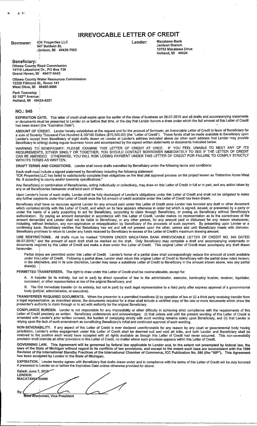
47
48
49
50
51
52
53
54
55
56
57
58
59
60
61
62
63
64
65
66
67
68
69
70
71
72

73
74
75
76
77
78
79
80
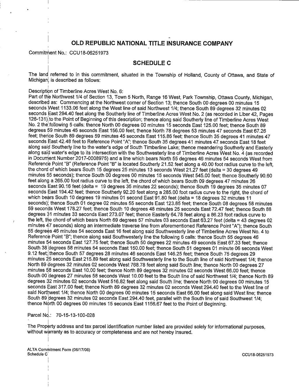
81
82
83
84
85
86
87
88
89
90
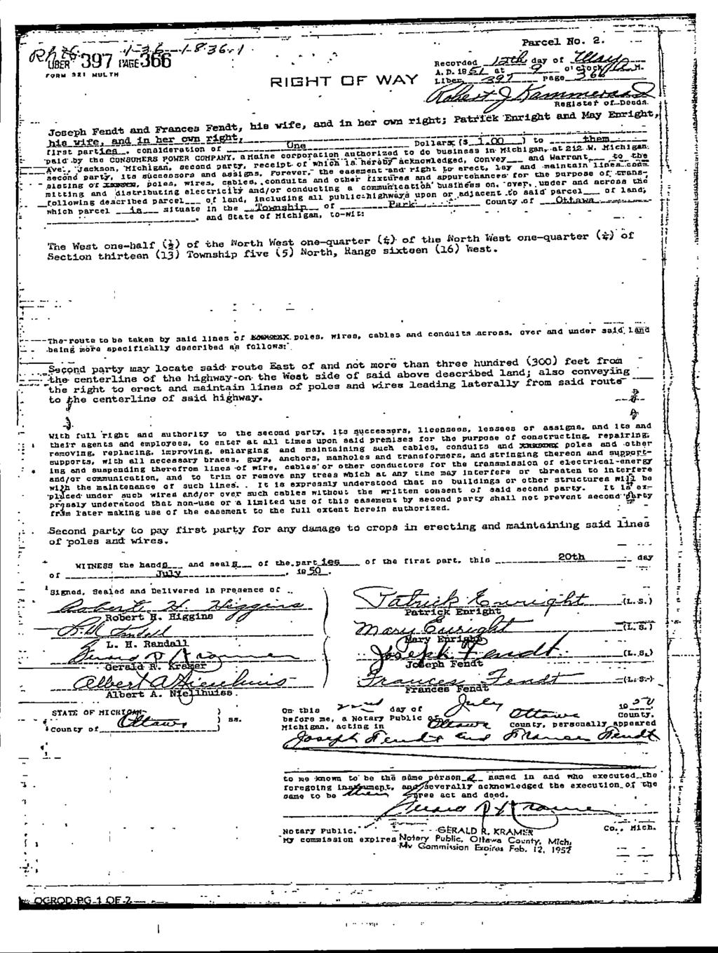
91
92
93
94
95
96
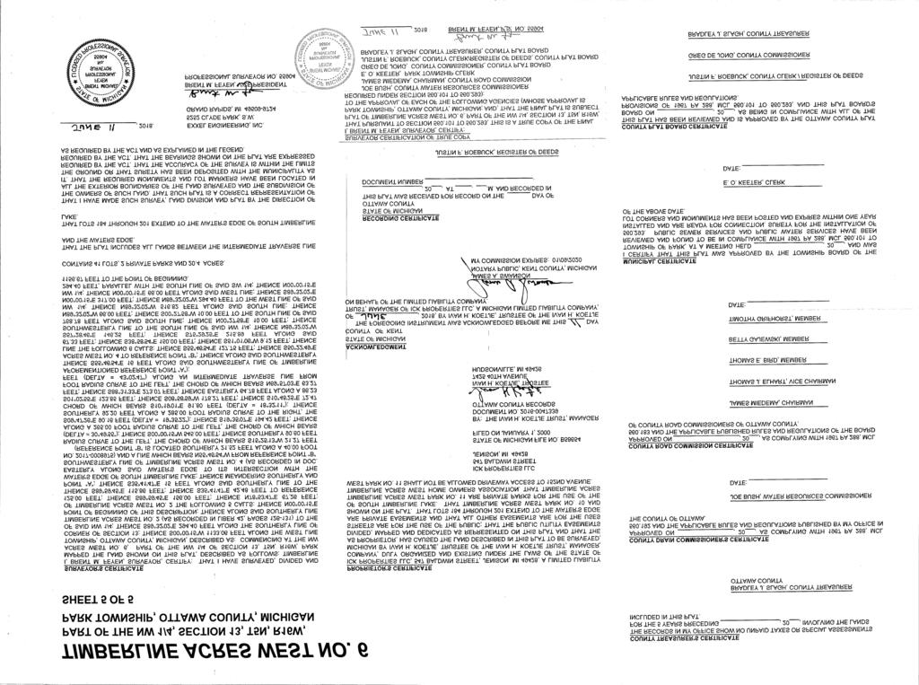
97
98

99
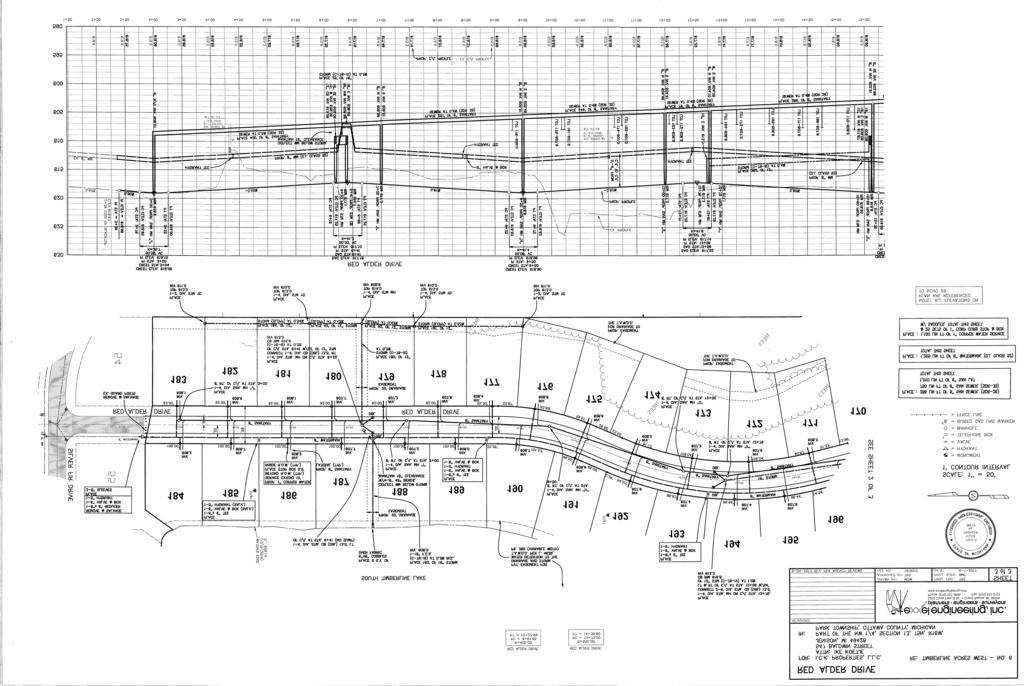
100

101
MINUTES PARK TOWNSHIP PLANNING COMMISSION Park Township Hall nd Street Holland, MI Regular Meeting June 13, :30 P.M.
 MINUTES PARK TOWNSHIP PLANNING COMMISSION Park Township Hall 52 152 nd Street Holland, MI 49418 Regular Meeting June 13, 2018 6:30 P.M. DRAFT APPROVED COPY CALL TO ORDER: Chair Pfost called to order the
NOTICE OF PUBLIC HEARING THE RESIDENTS OF THE TOWNSHIP OF PARK OTTAWA COUNTY, MICHIGAN
 NOTICE OF PUBLIC HEARING THE RESIDENTS OF THE TOWNSHIP OF PARK OTTAWA COUNTY, MICHIGAN There will be a public hearing before the Planning Commission of Park Township, Ottawa County, Michigan at the Park
MINUTES PARK TOWNSHIP PLANNING COMMISSION Park Township Hall nd Street Holland, MI Regular Meeting September 12, :30 P.M.
 MINUTES PARK TOWNSHIP PLANNING COMMISSION Park Township Hall 52 152 nd Street Holland, MI 49418 Regular Meeting September 12, 2018 6:30 P.M. DRAFT COPY CALL TO ORDER: Chair Pfost called to order the regular
MINUTES PARK TOWNSHIP PLANNING COMMISSION Park Township Hall nd Street Holland, MI Regular Meeting December 12, :30 P.M.
 MINUTES PARK TOWNSHIP PLANNING COMMISSION Park Township Hall 52 152 nd Street Holland, MI 49418 Regular Meeting December 12, 2018 6:30 P.M. DRAFT COPY CALL TO ORDER: Chair Pfost called to order the regular
MINUTES PARK TOWNSHIP PLANNING COMMISSION Park Township Hall nd Street Holland, MI Regular Meeting March 14, :30 P.M.
 MINUTES PARK TOWNSHIP PLANNING COMMISSION Park Township Hall 52 152 nd Street Holland, MI 49418 Regular Meeting March 14, 2018 6:30 P.M. DRAFT COPY CALL TO ORDER: Chair Pfost called to order the regular
MINUTES. PARK TOWNSHIP PLANNING COMMISSION Park Township Hall nd St. Holland, MI 49418
 MINUTES PARK TOWNSHIP PLANNING COMMISSION Park Township Hall 52 152 nd St. Holland, MI 49418 Regular Meeting March 17, 2015 6:30 P.M. DRAFT COPY CALL TO ORDER: Chair Pfost called the regular meeting of
AGENDA. Park Township Planning Commission Regular Meeting. January 9, :30 p.m.
 AGENDA Park Township Planning Commission Regular Meeting January 9, 2019 6:30 p.m. (Please turn off or set to silent mode all cellphones and other electronic devices) 1. Call to Order 2. Approval of Agenda
Park Township Board of Trustees and Planning Commission Special Meeting
 (Please turn off or set to silent mode all cell phones and other electronic devices.) 1. Call to order 2. Invocation 3. Pledge of Allegiance 4. Approval of Agenda (Additions to or Deletions from Agenda)
4.2 RESIDENTIAL ZONING DISTRICTS
 4.2 RESIDENTIAL ZONING DISTRICTS A. Purpose: To define regulations and standards for each residential zoning district in the City. The following sections identify uses, regulations, and performance standards
MINUTES PARK TOWNSHIP ZONING BOARD OF APPEALS Park Township Hall nd Street Holland, MI Regular Meeting April 27, :30 P.M.
 MINUTES PARK TOWNSHIP ZONING BOARD OF APPEALS Park Township Hall 52 152 nd Street Holland, MI 49418 Regular Meeting April 27, 2015 6:30 P.M. DRAFT COPY CALL TO ORDER: Chair Foster called to order the regular
MINUTES PARK TOWNSHIP ZONING BOARD OF APPEALS Park Township Hall nd Street Holland, MI Regular Meeting April 28, :35 P.M.
 MINUTES PARK TOWNSHIP ZONING BOARD OF APPEALS Park Township Hall 52 152 nd Street Holland, MI 49418 Regular Meeting April 28, 2014 6:35 P.M. DRAFT APPROVED COPY CALL TO ORDER: Chair Foster called to order
ARTICLE 834. PD 834. PD 834 was established by Ordinance No , passed by the Dallas City Council on December 8, (Ord.
 ARTICLE 834. PD 834. SEC. 51P-834.101. LEGISLATIVE HISTORY. PD 834 was established by Ordinance No. 28070, passed by the Dallas City Council on December 8, 2010. (Ord. 28070) SEC. 51P-834.102. PROPERTY
ARTICLE 8 R-2 MULTIPLE FAMILY RESIDENTIAL DISTRICT
 ARTICLE 8 R-2 MULTIPLE FAMILY RESIDENTIAL DISTRICT SECTION 800 STATEMENT OF PURPOSE This district classification is designed to permit the greatest density of residential uses allowed within the Township,
Article 30: Residence Zones
 ARTICLE 30, Use Regulations Controlling Residence Zones 118-300. Island Conservation Zone. [Added effective 1-22-1974] A. Declaration of necessity and purpose. Article 30: Residence Zones (1) It is declared
TABLE OF CONTENTS. Article / Section. Article 1 Administration and Enforcement
 TABLE OF CONTENTS Preamble How To Use This Ordinance Article / Section Page Article 1 Administration and Enforcement... 1-1 Sec. 1.01 Short Title... 1-1 Sec. 1.02 Intent... 1-1 Sec. 1.03 Scope... 1-1 Sec.
SECTION 822 "R-1-A" AND "R-1-AH" - SINGLE FAMILY RESIDENTIAL DISTRICTS
 SECTION 822 "R-1-A" AND "R-1-AH" - SINGLE FAMILY RESIDENTIAL DISTRICTS The "R-1-A" and "R-1-AH" Districts are intended to provide for the development of single family residential homes at urban standards
Planning and Zoning Commission STAFF REPORT
 Planning and Zoning Commission STAFF REPORT AGENDA # TO: FROM: CASA GRANDE PLANNING AND ZONING COMMISSION James Gagliardi, AICP, Planner MEETING DATE: February 5, 2015 SUBJECT: DSA-15-00007 Zoning Text
ARTICLE 7 R-1 ONE FAMILY RESIDENTIAL DISTRICT
 ARTICLE 7 R-1 ONE FAMILY RESIDENTIAL DISTRICT SECTION 700 STATEMENT OF PURPOSE This district classification is designed to be the most restrictive of the residential districts intended to encourage an
ARTICLE IV DISTRICT REGULATIONS
 PART 1. RESIDENTIAL DISTRICTS 4-101. RS. Single-Family Residential Suburban District. The RS District is designed for single-family dwellings, and compatible uses, at a density no greater than one dwelling
SECTION CLASSIFICATION OF ZONES For the purpose of this Code the following primary land use zoning districts are hereby established:
 ARTICLE 4 ZONING DISTRICTS SECTION 4.010 CLASSIFICATION OF ZONES For the purpose of this Code the following primary land use zoning districts are hereby established: Primary Zones Abbreviated Designation
CUDAHY MUNICIPAL CODE
 CUDAHY MUNICIPAL CODE 20.80.010 Accessory uses may be developed as permitted in this zoning code provided such uses are located on the same lot or parcel of land and are incidental to, and do not substantially
a. To insure compatible relationships between land use activities;
 PART B SECTION VIII INSTITUTIONAL DISTRICTS Article 1 Planned Institutional District 1. Purpose and Intent: It is the purpose and intent of this district to permit and encourage the orderly, cooperative
TOWN OF LERAY PLANNING BOARD Minor Subdivision Application Packet
 This Packet is designed to assist applicants in providing the forms needed for submission of a 1 to 4 lot subdivision to the Planning Board for approval. The following should be filled out to ensure the
DEVELOPMENT STANDARDS
 Chapter 5 DEVELOPMENT STANDARDS 501 Residential Development Standards 502 Neighborhood Commercial Standards 503 Mixed Use Standards 504 Industrial Development Standards 505 Public Use Standards 506 Open
FOR SALE 3520 and 3533 Watson Rd, St. Louis, MO 63139
 CHURCH And SCHOOL FOR SALE MLS # 17011742 $795,000 FOR SALE 3520 and 3533 Watson Rd, St. Louis, MO 63139 Property Highlights 350+ Seat Sanctuary 40+ Car Parking Kitchen Fellowship Hall Staff Kitchen Staff
ARTICLE VII. NONCONFORMITIES. Section 700. Purpose.
 ARTICLE VII. NONCONFORMITIES. Section 700. Purpose. The purpose of this chapter is to regulate and limit the development and continued existence of legal uses, structures, lots, and signs established either
Day care centers: Such uses shall require a Special Permit under the terms of Article VIII of this chapter.
 Page 1 of 12 DIVISION 1. - R-1 RESIDENTIAL ZONE Sec. 38-41. - Permitted uses. Single-family dwellings, excluding factory manufactured homes constructed as a single selfcontained unit and mounted on a single
Members of the Public in attendance are asked to be recognized by the Mayor before participating in any discussions of the Town Board AGENDA
 TOWN BOARD WORK SESSION August 27, 2018 // 5:30 p.m. // First floor conference room 301 Walnut Street, Windsor, CO 80550 GOAL of this Work Session is to have the Town Board receive information on topics
Glades County Staff Report and Recommendation Unified Staff Report for Small Scale Plan Amendment and Rezoning
 Glades County Staff Report and Recommendation Unified Staff Report for Small Scale Plan Amendment and Rezoning CASE NUMBERS: COMP17-02 and RZ17-02 DATE of STAFF REPORT: May 1, 2017 CASE TYPE: Application
City of Fraser Residential Zoning District
 City of Fraser Residential Zoning District The one-family districts are established to provide principally for one-family dwellings at varying densities. The specific interest of these districts is to
Column 1 Column 2 Column 3 USE OR USE CATEGORY SPACES REQUIRED PER BASIC ADDITIONAL MEASURING UNIT. 2 per dwelling unit
 Sections: 10-101 Parking Requirements 10-102 Interpretation of the Chart 10-103 Joint Use and Off-Site Facilities 10-104 Design Standards 10-105 Performance Standards 10-101 Parking Requirements: When
Permitted uses. Adult congregate living facility. Ambulance service. Animal clinics (outpatient care only and no overnight boarding)
") B-3, HIGHWAY SERVICE BUSINESS DISTRICT Intent. The B-3, Highway Service Business District is intended for application along highways carrying large volumes of traffic where establishments may locate to
B-3, HIGHWAY SERVICE BUSINESS DISTRICT Intent. The B-3, Highway Service Business District is intended for application along highways carrying large volumes of traffic where establishments may locate to
CHAPTER 5A A-1 AGRICULTURAL CONSERVATION DISTRICT
 CHAPTER 5A A-1 AGRICULTURAL CONSERVATION DISTRICT SECTION 5A.01 DESCRIPTION AND PURPOSE. It is recognized that the public health and welfare of the citizens of Salem Township, Allegan County, the state
MINUTES PARK TOWNSHIP ZONING BOARD OF APPEALS Park Township Hall nd Street Holland, MI Regular Meeting September 28, :30 P.M.
 MINUTES PARK TOWNSHIP ZONING BOARD OF APPEALS Park Township Hall 52 152 nd Street Holland, MI 49418 Regular Meeting September 28, 2015 6:30 P.M. DRAFT APPROVED COPY CALL TO ORDER: Chair Dreyer called to
TABLE OF CONTENTS. Township of Clyde i
 TABLE OF CONTENTS ARTICLE 1 - TITLE, PURPOSE, SCOPE, AND LEGAL BASIS... 1-1 1.01 TITLE...1-1 1.02 PURPOSE... 1-1 1.03 SCOPE AND INTERPRETATION...1-1 1.04 THE EFFECT OF ZONING... 1-2 1.05 LEGAL BASIS...1-2
ARTICLE 24 SITE PLAN REVIEW
 ARTICLE 24 SITE PLAN REVIEW 24.1 PURPOSE: The intent of these Ordinance provisions is to provide for consultation and cooperation between the land developer and the Township Planning Commission in order
DIVISION 7. R-6 AND R-6A RESIDENTIAL ZONES* The purpose of the R-6 residential zone is:
 Date of Draft: March 6, 2015 DIVISION 7. R-6 AND R-6A RESIDENTIAL ZONES* Sec. 14-135. Purpose. The purpose of the R-6 residential zone is: (a) To set aside areas on the peninsula for housing characterized
VOLUME II - APPENDIX B - BASIC ZONING ORDINANCE ARTICLE V. DISTRICT REGULATIONS
 Sec. 5.1000. Multiple-family Residential (R-5). (Ord. No. 4005, 1(Res. No. 8947, Exh. A, 55), 4-3-12) Sec. 5.1001. Purpose. This district is intended to provide for development of multiple-family residential
TOWNSHIP OF UPPER MACUNGIE LEHIGH COUNTY, PENNSYLVANIA. ORDINANCE NO [To be considered for Adoption June 1, 2017]
![TOWNSHIP OF UPPER MACUNGIE LEHIGH COUNTY, PENNSYLVANIA. ORDINANCE NO [To be considered for Adoption June 1, 2017]](/thumbs/91/106428876.jpg "TOWNSHIP OF UPPER MACUNGIE LEHIGH COUNTY, PENNSYLVANIA. ORDINANCE NO [To be considered for Adoption June 1, 2017]") TOWNSHIP OF UPPER MACUNGIE LEHIGH COUNTY, PENNSYLVANIA ORDINANCE NO. 2017 05 [To be considered for Adoption June 1, 2017] AN ORDINANCE OF THE BOARD OF SUPERVISORS OF THE TOWNSHIP OF UPPER MACUNGIE, LEHIGH
TOWNSHIP OF UPPER MACUNGIE LEHIGH COUNTY, PENNSYLVANIA ORDINANCE NO. 2017 05 [To be considered for Adoption June 1, 2017] AN ORDINANCE OF THE BOARD OF SUPERVISORS OF THE TOWNSHIP OF UPPER MACUNGIE, LEHIGH
NOTICE OF PUBLIC HEARINGS CITY OF LIVE OAK, CALIFORNIA
 NOTICE OF PUBLIC HEARINGS CITY OF LIVE OAK, CALIFORNIA NOTICE IS HEREBY GIVEN that public hearings by the Live Oak City Council will be held to receive public comments at 7:00 PM on Wednesday, December
There was no further discussion. Secretary Warren presented the following resolution: RESOLUTION NO
 FENTON TOWNSHIP CIVIC COMMUNITY CENTER 12060 MANTAWAUKA DRIVE, FENTON, MICHIGAN Chairperson McGuirk called the meeting to order at 7:00 p.m. Present: Cypher, Marko, McGuirk, Mustola, Tucker, Warren, Westbrook
GC General Commercial District
 Section 712. GC General Commercial District 712.1 Intent of District. It is the intent of this section that the GC Zoning District be developed and reserved for general business purposes. The regulations
ORDINANCE NO
 AN ORDINANCE OF THE CITY OF SANTA CRUZ AMENDING TITLE 24, SECTION 24.12.200 OF THE MUNICIPAL CODE, THE ZONING ORDINANCE, TO EXEMPT MIXED USE DEVELOPMENT FROM COVERED PARKING REQUIREMENTS. The City Council
Subchapter 5 Zoning Districts and Limitations
 Subchapter 5 Zoning Districts and Limitations 35.5.1 Rural Districts Sections: 35.5.1.1 Purpose. 35.5.1.2 Permitted Uses. 35.5.1.3 General Regulations. 35.5.1.1 Purpose. The purpose of a Rural District
August 13, 2018 // 5:30 p.m. // First floor conference room 301 Walnut Street, Windsor, CO 80550
 TOWN BOARD WORK SESSION August 13, 2018 // 5:30 p.m. // First floor conference room 301 Walnut Street, Windsor, CO 80550 GOAL of this Work Session is to have the Town Board receive information on topics
PUD Ordinance - Cascade Lakes Plat #10 of 1995
 PUD Ordinance - Cascade Lakes Plat #10 of 1995 CASCADE CHARTER TOWNSHIP Ordinance #10 of 1995 AN ORDINANCE TO AMEND THE CASCADE CHARTER TOWNSHIP ZONING ORDINANCE AND ZONING MAP TO ESTABLISH THE CASCADE
AN ORDINANCE AMENDING THE CITY ZONING ORDINANCE AND THE OFFICIAL CODE OF THE CITY OF CLARKSVILLE RELATIVE TO CLUSTER OPTION DEVELOPMENTS
 ORDINANCE 74-2012-13 AN ORDINANCE AMENDING THE CITY ZONING ORDINANCE AND THE OFFICIAL CODE OF THE CITY OF CLARKSVILLE RELATIVE TO CLUSTER OPTION DEVELOPMENTS BE IT ORDAINED BY THE CITY COUNCIL OF THE CITY
SECTION 827 "R-2" AND "R-2-A" - LOW DENSITY MULTIPLE FAMILY RESIDENTIAL DISTRICTS
 SECTION 827 "R-2" AND "R-2-A" - LOW DENSITY MULTIPLE FAMILY RESIDENTIAL DISTRICTS The "R-2" and "R-2-A" Districts are intended to provide for the development of low density multiple family residential
ORDINANCE NO. 5 CASE NO. ORA THIRD SET OF OMNIBUS AMENDMENTS TO THE KOOTENAI COUNTY LAND USE AND DEVELOPMENT CODE
 ORDINANCE NO. 5 CASE NO. ORA18-0003 THIRD SET OF OMNIBUS AMENDMENTS TO THE KOOTENAI COUNTY LAND USE AND DEVELOPMENT CODE AN ORDINANCE OF KOOTENAI COUNTY, IDAHO, A POLITICAL SUBDIVISION OF THE STATE OF
Town of Windham Land Use Ordinance Sec. 400 Zoning Districts SECTION 400 ZONING DISTRICTS
 Town of Windham Land Use Ordinance Sec. 400 Zoning Districts Sections SECTION 400 ZONING DISTRICTS SECTION 400 ZONING DISTRICTS 4-1 401 Districts Enumerated 4-2 402 Location of districts; Zoning Map 4-2
Part 4, C-D Conservation District
 The Township is divided into the districts set forth by this chapter and as shown by the district boundaries on the Official Zoning District Map. The zoning districts are: C-D Conservation District A-1
CHAPTER 6 RESIDENTIAL DISTRICTS LOW DENSITY RESIDENTIAL DISTRICT (R-1)
") TYPE OF DISTRICT: TRADITIONAL CHAPTER 6 RESIDENTIAL DISTRICTS LOW DENSITY RESIDENTIAL DISTRICT (R-1) ARTICLE 1: LOW DENSITY RESIDENTIAL DISTRICT (R-1) SECTION 6-1.01: PURPOSE The regulations of the R-1
TYPE OF DISTRICT: TRADITIONAL CHAPTER 6 RESIDENTIAL DISTRICTS LOW DENSITY RESIDENTIAL DISTRICT (R-1) ARTICLE 1: LOW DENSITY RESIDENTIAL DISTRICT (R-1) SECTION 6-1.01: PURPOSE The regulations of the R-1
ORDINANCE NO. 208 BE IT ORDAINED BY THE CITY COUNCIL OF THE CITY OF UNIVERSITY HEIGHTS, JOHNSON COUNTY, IOWA:
 ORDINANCE NO. 208 AN ORDINANCE AMENDING ORDINANCE NO. 79 (ZONING) TO CREATE A COMMERCIAL HOTEL ZONE AND PERMIT DEVELOPMENT PURSUANT TO A COMMERCIAL HOTEL PUD BE IT ORDAINED BY THE CITY COUNCIL OF THE CITY
TO THE HONORABLE CITY COUNCIL OF THE CITY OF NEWPORT PETITTION FOR ZONING AMENDMENT
 TO THE HONORABLE CITY COUNCIL OF THE CITY OF NEWPORT PETITTION FOR ZONING AMENDMENT WHEREAS, Petitioner, Newport Project Development Company, LLC, a Delaware limited liability company, with an address
ARTICLE III ZONING DISTRICTS AND GENERAL REGULATIONS
 ARTICLE III ZONING DISTRICTS AND GENERAL REGULATIONS 3.1 Districts. The City of Wheaton, Illinois, is hereby divided into the following zoning districts. The following are general descriptions, but not
ARTICLE ZONING DISTRICTS AND OFFICIAL MAP SEC SUPPLEMENTAL AREA, YARD AND HEIGHT RESTRICTIONS.
 SEC. 27-310. SUPPLEMENTAL AREA, YARD AND HEIGHT RESTRICTIONS. The following requirements provide exceptions or qualify and supplement the specific district regulations set forth in this part. Planned developments
Charter Township of Plymouth Zoning Ordinance No. 99 Page 58 Article 11: OS-ARC Office Service-Ann Arbor Road Corridor District ARTICLE XI OS-ARC
 Charter Township of Plymouth Zoning Ordinance No. 99 Page 58 PURPOSE ARTICLE XI OS-ARC OFFICE SERVICE ANN ARBOR ROAD CORRIDOR DISTRICT Recognizing the importance of a viable Ann Arbor Road Corridor with
1.300 ZONING DISTRICT REGULATIONS
 1.205 VACANT LOT SPECIAL REQUIREMENTS: On lots less than 1.5 acres, only one garage allowed with a maximum size of 672 square feet in area. 1.300 ZONING DISTRICT REGULATIONS 1.301 ESTABLISHMENT OF DISTIRCTS:
(B) On lots less than 1.5 acres, accessory buildings shall have a maximum size of 672 square feet in area.
 On lots less than 1.5 acres, accessory buildings shall have a maximum size of 672 square feet in area.") Setbacks in Commercial Districts: (1) Downtown Business District: Setbacks from State Highways 70 and 155 shall be the lesser of a minimum of 100 feet or the footprint of the present principal building
Setbacks in Commercial Districts: (1) Downtown Business District: Setbacks from State Highways 70 and 155 shall be the lesser of a minimum of 100 feet or the footprint of the present principal building
Planning & Zoning Commission Meeting Date: 02/07/2018 Submitted By: Janice Pokrant, Engineering Department. 4.a. Information SUBJECT:
 Planning & Zoning Commission Meeting Date: 02/07/2018 Submitted By: Janice Pokrant, Engineering Department 4.a. SUBJECT: Information Conduct a Public Hearing and Consider a Request For Plat 18-01 by Abner
1069 regarding Accessory Dwelling Units (ADUs) were signed into law; and
 were signed into law; and") AN ORDINANCE OF THE CITY COUNCIL OF THE CITY OF ARROYO GRANDE AMENDING TITLE 16 OF THE ARROYO GRANDE MUNICIPAL CODE REGARDING ACCESSORY DWELLING UNITS FOR COMPLIANCE WITH STATE LAW AND ADDITIONALLY ROOFTOP
AN ORDINANCE OF THE CITY COUNCIL OF THE CITY OF ARROYO GRANDE AMENDING TITLE 16 OF THE ARROYO GRANDE MUNICIPAL CODE REGARDING ACCESSORY DWELLING UNITS FOR COMPLIANCE WITH STATE LAW AND ADDITIONALLY ROOFTOP
GARDEN HIGHWAY SPECIAL PLANNING AREA
 GARDEN HIGHWAY SPECIAL PLANNING AREA 501-250. INTENT. The land area between the Garden Highway and the Sacramento River possesses unique environmental amenities that require special treatment and regulation.
SHOPPING CENTER DISTRICT (Zone BSC)
") Sec. 3-27. SHOPPING CENTER DISTRICT (Zone BSC) (a) (b) Area. All land designated as Zone BSC is subject to the regulations of this Section and Sec. 20.3-10. Such areas are established to provide for planned
Sec. 3-27. SHOPPING CENTER DISTRICT (Zone BSC) (a) (b) Area. All land designated as Zone BSC is subject to the regulations of this Section and Sec. 20.3-10. Such areas are established to provide for planned
APPLICATION PROCEDURE
 ANTRIM PLANNING BOARD P. O. Box 517 Antrim, New Hampshire 03440 Phone: 603-588-6785 FAX: 603-588-2969 APPLICATION FORM AND CHECKLIST FOR MINOR OR MAJOR SITE PLAN REVIEW File Date Received By APPLICATION
AGENDA PARK TOWNSHIP ZONING BOARD OF APPEALS. Regular Meeting April 23, :30 p.m.
 AGENDA PARK TOWNSHIP ZONING BOARD OF APPEALS Regular Meeting April 23, 2018 6:30 p.m. (Please turn off or set to silent mode all cellphones and other electronic devices.) 1. Call to Order 2. Approval of
WRIGHT TOWNSHIP Ottawa County 1565 Jackson Street, P.O. Box 255, Marne, Michigan 49435
 WRIGHT TOWNSHIP Ottawa County 1565 Jackson Street, P.O. Box 255, Marne, Michigan 49435 SITE PLAN REVIEW APPLICATION _ Instructions For an application to be considered complete, ALL information must be
ADA TOWNSHIP PLANNING COMMISSION MINUTES OF THE JUNE 15, 2017 MEETING
 ADA TOWNSHIP PLANNING COMMISSION MINUTES OF THE JUNE 15, 2017 MEETING A meeting of the was held on Thursday, June 15, 2017, 7:00 p.m. at the Ada Township Offices, 7330 Thornapple River Dr., Ada, MI. I.
Chapter 17-2 Residential Districts
 Chapter 17-2 Residential Districts 17-2-0100 District Descriptions...2-1 17-2-0200 Allowed Uses...2-2 17-2-0300 Bulk and Density Standards...2-5 17-2-0400 Character Standards...2-18 17-2-0500 Townhouse
ARTICLE 15 - PLANNED UNIT DEVELOPMENT
 Section 15.1 - Intent. ARTICLE 15 - PLANNED UNIT DEVELOPMENT A PUD, or Planned Unit Development, is not a District per se, but rather a set of standards that may be applied to a development type. The Planned
PUD Ordinance - Caravelle Village #7 of 1995
 PUD Ordinance - Caravelle Village #7 of 1995 CASCADE CHARTER TOWNSHIP Ordinance #17 of 1995 AN ORDINANCE TO AMEND THE CASCADE CHARTER TOWNSHIP ZONING ORDINANE AND ZONING MAP TO ESTABLISH THE CARAVELLE
FOR SALE. Prime Commercial Land +/ Acres US Highway 1, North of Walton Rd Port St. Lucie, Florida
 FOR SALE Prime Commercial Land +/- 2.36 Acres US Highway 1, North of Walton Rd Port St. Lucie, Florida For Further Information Contact: www.tccommercialre.com Shirley Harris (772) 288-6646 sharris@tccommercialre.com
CHAPTER 3 REGULATIONS INSIDE THE COASTAL ZONE
 CHAPTER 3 REGULATIONS INSIDE THE COASTAL ZONE Organization. Chapter 3 contains the regulations which apply exclusively within the California Coastal Zone in Humboldt County and is organized as follows:
Commercial Property with Great Visibility for Sale or Lease. For Sale at $1,500, or For Lease at $12.00/SF NNN
 EXECUTIVE SUMMARY Commercial Property with Great Visibility for Sale or Lease Monroe, Connecticut 06468 For Sale at $1,500,000.00 or For Lease at $12.00/SF NNN u 8,064 SF freestanding building on 0.95
ORDINANCE NO. O-5-10
 ORDINANCE NO. O-5-10 AN ORDINANCE OF THE TOWN COMMISSION OF THE TOWN OF PALM BEACH SHORES, FLORIDA, AMENDING THE TOWN CODE OF ORDINANCES AT APPENDIX A. ZONING. SECTION VI. DISTRICT B REGULATIONS BY AMENDING
Midwest City, Oklahoma Zoning Ordinance
 2010 Midwest City, Oklahoma Zoning Ordinance 9/2/2010 Table of Contents Section 1. General Provisions... 5 1.1. Citation... 5 1.2. Authority... 5 1.3. Purpose... 5 1.4. Nature and Application... 5 1.5.
ARTICLE 15. RULES, REGULATIONS AND DEFINITIONS
 ARTICLE 15. RULES, REGULATIONS AND DEFINITIONS Section 1. Interpretation and Construction: The following rules and regulations regarding interpretation and construction of the Ulysses-Grant County, Kansas,
PENINSULA TOWNSHIP DONATION of DEVELOPMENT RIGHTS ORDINANCE (DDR, No. 45)
") PENINSULA TOWNSHIP DONATION of DEVELOPMENT RIGHTS ORDINANCE (DDR, No. 45) THE TOWNSHIP OF PENINSULA, GRAND TRAVERSE COUNTY, MICHIGAN ORDAINS: Section 101 General Provisions A. Title: This Ordinance shall
PENINSULA TOWNSHIP DONATION of DEVELOPMENT RIGHTS ORDINANCE (DDR, No. 45) THE TOWNSHIP OF PENINSULA, GRAND TRAVERSE COUNTY, MICHIGAN ORDAINS: Section 101 General Provisions A. Title: This Ordinance shall
SECTION 821 "R-A" - SINGLE FAMILY RESIDENTIAL-AGRICULTURAL DISTRICT
 SECTION 821 "R-A" - SINGLE FAMILY RESIDENTIAL-AGRICULTURAL DISTRICT The "R-A" District is intended to provide for the development of single family residential estate homes in a semi-rural environment on
ORDINANCE NO The Town Council of the Town of Yucca Valley does ordain as follows:
 ORDINANCE NO. 141 AN ORDINANCE OF THE TOWN COUNCIL OF THE TOWN OF YUCCA VALLEY, CALIFORNIA, AMENDING TITLE 8, DIVISION 12, CHAPTER 1 RELATING TO DEFINITIONS AND TITLE 8, DIVISION 8, CHAPTER 3, RELATING
WHEREAS, on October 6, 2015, the Planning Commission held a duly noticed public hearing and recommended the proposed Ordinance Amendments; and
 ORDINANCE NO. ORDINANCE OF THE CITY COUNCIL OF THE CITY OF REDWOOD CITY AMENDING ARTICLE 2, ARTICLE 5, ARTICLE 30, ARTICLE 36, ARTICLE 37, AND ARTICLE 45 OF THE REDWOOD CITY ZONING ORDINANCE AND AMENDING
SUMMARY OF AMENDMENTS TO THE AGENDA Monroe County Planning Commission October 11, 2017
 SUMMARY OF AMENDMENTS TO THE AGENDA Monroe County Planning Commission October 11, 2017 8. New Business: A. Consent Agenda: Additions Township Zoning Reviews 200.1-10-17-32 Whiteford Township (map) This
Anthony Guardiani, Chair Arlene Avery Judith Mordasky, Alternate Dennis Kaba, Alternate James Greene, Alternate
 RECEIVED STAFFORD. CT Town ofstafford Zoning Board ofappeals Regular Meeting b- 1811 SEP loa q: I 1 September 6, 2018-7:00 p.m../. / ~ Stafford Senior Center r;;:~ait----- '/1 W\-iNCLERK Members Present:
6A. In ALL Residence zones, no building or land shall be used and no building or structure shall be erected or altered except for the following uses:
 SECTION 6 - RESIDENCE ZONES 6A. In ALL Residence zones, no building or land shall be used and no building or structure shall be erected or altered except for the following uses: 6A.1 Single family detached
ORDINANCE NO. Be it ordained by the City Council of the City of Abilene, Texas:
 ORDINANCE NO. An ordinance repealing Chapter 23, Subpart B of the Code of the City of Abilene, Texas, entitled Mobile Homes and Vacation Travel Trailers; stating the authority; setting forth the scope
FOR SALE. +/-.86 Acres at St. Lucie West Blvd & Bayshore in Port St. Lucie, Florida. St. Lucie West Boulevard & Bayshore Boulevard, Port St.
 Shirley Harris (772) 288-6646 sharris@tccommercialre.com FOR SALE +/-.86 Acres at St. Lucie West Blvd & Bayshore in Port St. Lucie, Florida St. Lucie West Boulevard & Bayshore Boulevard, Port St. Lucie,
TOWNSHIP OF SOLON COUNTY OF KENT, MICHIGAN. Members: Robert Ellick, Fred Gunnell, Mark Hoskins, Mary Lou Poulsen
 As recommended by Planning Commission at its December 27, 2017 meeting TOWNSHIP OF SOLON COUNTY OF KENT, MICHIGAN At a regular meeting of the Township Board of the Township of Solon, Kent County, Michigan,
ALPINE TOWNSHIP PLANNING COMMISSION REGULAR MEETING June 15, 2017
 Page 1 of 6 ALPINE TOWNSHIP PLANNING COMMISSION REGULAR MEETING 17-26 CALL TO ORDER / APPROVAL OF THE REGULAR MEETING MINUTES OF MAY 18, 2017 AND THE / PUBLIC COMMENT ON NON-AGENDA ITEMS The Alpine Township
Delete the word setback in these instances
 Various Sections The term principle is used in a various The term principle should be replaced Change reflects proper terminology sections with the term principal Various Sections Section 1 Interpretation
Town of Brookeville Zoning Ordinance
 Town of Brookeville Zoning Ordinance Article I. In General Section 10-101. Purpose: The Town of Brookeville has been included on the National Register of Historic Places since 1979 and designated as an
AGENDA. Park Township Planning Commission Regular Meeting. December 12, :30 p.m.
 1. Call to Order 2. Approval of Agenda AGENDA Park Township Planning Commission Regular Meeting December 12, 2017 6:0 p.m.. Approval of Minutes: November 14, 2017 4. Discussion/Action Items: Notices for
ORD Sections Added: City Zoning Ordinance Sections and 241.2
 ORD-3578 1 2 3 4 5 6 7 8 9 10 11 12 13 14 15 16 17 18 19 20 21 22 23 24 25 26 27 28 29 30 31 32 33 34 35 36 37 38 39 40 41 42 43 AN ORDINANCE TO AMEND SECTIONS 102, 111, 401, 501, 601, 901, 1110, 1125,
The following regulations shall apply in the R-E District:
 "R-E" RESIDENTIAL ESTATE DISTRICT (8/06) The following regulations shall apply in the R-E District: 1. Uses Permitted: The following uses are permitted. A Zoning Certificate may be required as provided
SECTION 820 "R-R" - RURAL RESIDENTIAL DISTRICT
 SECTION 820 "R-R" - RURAL RESIDENTIAL DISTRICT The "R-R" District is intended to create or preserve rural or very large lot residential homesites where a limited range of agricultural activities may be
UPPER MOUNT BETHEL TOWNSHIP NORTHAMPTON COUNTY, PENNSYLVANIA
 UPPER MOUNT BETHEL TOWNSHIP NORTHAMPTON COUNTY, PENNSYLVANIA JOINDER DEED / LOT CONSOLIDATION TOWNSHIP REVIEW PROCESS When accepting proposed Joinder Deeds / Lot Consolidations, review the Joinder Deed
May 12, Chapter RH HILLSIDE RESIDENTIAL ZONES REGULATIONS Sections:
 May 12, 2017 Chapter 17.13 RH HILLSIDE RESIDENTIAL ZONES REGULATIONS Sections: 17.13.010 Title, intent, and description. 17.13.020 Required design review process. 17.13.030 Permitted and conditionally
Chapter 15: Non-Conformities
 Chapter 15: Non-Conformities Section 15.1 Purpose... 15-2 Section 15.2 Non-Conforming Vacant Lots... 15-2 Section 15.3 Non-Conforming Buildings or Structures... 15-3 Section 15.4 Non-Conforming Uses...
Article IV. Terminology
 Article IV. Terminology 212-22 Purpose. Add or amend the following definitions: BUILDING HEIGHT The vertical distance measured from the average elevation of the proposed finished grade at the front of
HUERFANO COUNTY SIGN REGULATIONS SECTION 14.00
 TABLE OF CONTENTS Section Title Page 14.01 SIGN CODE... 14-1 14.01.01 Intent and Purpose... 14-1 14.02 GENERAL PROVISIONS... 14-1 14.02.01 Title... 14-1 14.02.02 Repeal... 14-1 14.02.03 Scope and Applicability
ARTICLE V AGRICULTURAL PRESERVATION AND RURAL RESIDENTIAL DISTRICT
 ARTICLE V AP AGRICULTURAL PRESERVATION AND RURAL RESIDENTIAL DISTRICT Section 500. PURPOSE It is the purpose of the AP, Agricultural Preservation and Rural Residential District, to foster the preservation
FOR SALE COMMERCIAL BEACHSIDE LOT
 FOR SALE COMMERCIAL BEACHSIDE LOT 1100 South Patrick Dr., Satellite Beach, Florida 32937.69 Acres, Zoning C-Commercial Lot is Cleared Numerous Allowable Intended Uses (see zoning on next page) High Visibility