Action Recommendation: Budget Impact:
|
|
|
- Colin Burke
- 5 years ago
- Views:
Transcription
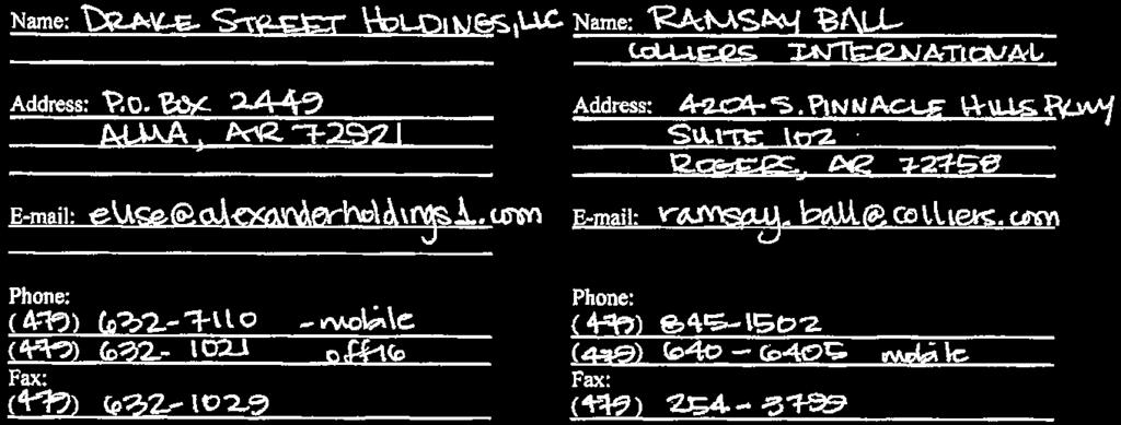
1 City of Fayetteville Staff Review Form Legistar File ID 12/6/2016 City Council Meeting Date - Agenda Item Only N/A for Non-Agenda Item Jeremy Pate Submitted By 11/18/2016 Submitted Date Action Recommendation: City Planning / Development Services Department Division / Department RZN : Rezone (SW CORNER OF GREGG AVE. & DRAKE ST./DRAKE ST. HOLDINGS, LLC, 289): Submitted by COLLIERS INTERNATIONAL, INC. for properties at the SW CORNER OF GREGG AVE. & DRAKE ST. The properties are zoned RMF-24, RESIDENTIAL MULTI FAMILY, 24 UNITS PER ACRE and contain approximately 8.95 acres. The request is to rezone the property to CS, COMMUNITY SERVICES. Budget Impact: Account Number Fund Project Number Project Title Budgeted Item? NA Current Budget $ - Funds Obligated $ - Current Balance $ - Does item have a cost? No Item Cost Budget Adjustment Attached? NA Budget Adjustment Remaining Budget $ - Must Attach Completed Budget Adjustment Previous Ordinance or Resolution # V Original Contract Number: Approval Date: Comments:
2 MEETING OF DECEMBER 6, 2016 TO: THRU: FROM: Mayor, Fayetteville City Council Andrew Garner, Planning Director Harry Davis, Current Planner DATE: November 18, 2016 SUBJECT: RZN : Rezone (SW CORNER OF GREGG AVE. & DRAKE ST./DRAKE ST. HOLDINGS, LLC, 289): Submitted by COLLIERS INTERNATIONAL, INC. for properties at the SW CORNER OF GREGG AVE. & DRAKE ST. The properties are zoned RMF-24, RESIDENTIAL MULTI FAMILY, 24 UNITS PER ACRE and contain approximately 8.95 acres. The request is to rezone the property to CS, COMMUNITY SERVICES. RECOMMENDATION: The City Planning staff and Planning Commission recommend approval of an ordinance to rezone the subject property to CS, Community Services, as requested by the applicant and as shown in the attached Exhibits A and B. BACKGROUND: The three subject parcels totaling 8.95 acres are located at the southwest corner of Drake St. and Gregg Ave. The property is zoned RMF-24, Residential Multi-family, 24 s per Acre and currently undeveloped with a public road, Quality Lane, running through one of the parcels. The eastern portion of the site is encompassed by the Scull Creek floodplain. Surrounding land use and zoning is depicted on Table 1. Request: The request is to rezone the site (approximately 8.95 acres) from RMF-24 to CS as the applicant would like to develop the property with a mix of uses. Land Use Compatibility: The proposed zoning is largely compatible with the nearby properties, including the UT and RMF-24 zones to the north and south, respectively. Uses permitted in CS, such as single-family, multi-family, eating places, offices, shopping, etc., are generally compatible with current or permitted uses in the surrounding zoning, barring the University of Arkansas land zoned R-A. The more intense commercial uses could be considered incompatible when directly adjacent to R-A, but the subject property already has the ability to do dense development and the added commercial uses would arguably not increase or expand the disparity. Additionally, the U of A farm is an institutional use that would not be adversely impacted by this rezoning. Land Use Plan Analysis: The proposed zoning is compatible with the Future Land Use Map (FLUM). The definition of a City Neighborhood area highlights particular characteristics of what this area should be, which is generally dense residential and non-residential uses on street
3 corners and along transit corridors. Such areas have a very wide spectrum of allowed uses that contribute to a neighborhood s overall walkability and sustainability, which necessitate traditional development patterns and buildings placed closer to the property line. CS allows for the very same things: mixture of dwelling types from single-family to apartments and live/work, a dynamic range of uses from residential and open space to varying intensities of non-residential development and businesses, and build-to zones closer to the street for new development. Therefore, the proposed zoning does encourage patterns of development that result in realizing these goals of City Plan 2030 and connect the definitions and City-wide aspirations between the proposed zoning and future land use. The location of this property makes CS a highly appropriate zone for this property. CS at the corner of two Minor Arterial streets is a generally appropriate situation for this zoning district s purpose and the subject property s context, coupled with the aforementioned compatibility with the 2030 Plan. The site has direct access to Drake St. and Quality Ln., which both connect to Gregg Ave. CS zoning would allow greater and more diverse residential and non-residential uses by right, which may increase traffic compared to the existing use and zoning. The surrounding street system has adequate capacity to handle increased traffic. DISCUSSION: On November 14, 2016 the Planning Commission forwarded the applicant s request with a recommendation for approval by a vote of BUDGET/STAFF IMPACT: N/A Attachments: Exhibit A Exhibit B Application Planning Commission Staff Report 2
4 Shared RZN Close Up View DRAKE ST. HOLDINGS EXHIBIT 'A' UT Subject Property PRIVATE 417 DRAKE ST DRAKE P-1 GREGG AVE PRIVATE 511 R-A MEADE ST RMF-24 DENZER AVE QUALITY LN BOWERS ST PRIVATE 2630 N Legend Planning Area Fayetteville City Limits Use Paved Trail Trail (Proposed) Building Footprint Feet inch = 200 feet Residential-Agricultural RT-12 Residential Two and Three-family RMF-24 Urban Thoroughfare P-1
5 EXHIBIT 'B' Legal Description A part of the Northwest Quarter of the Southeast Quarter (NW/4 SE/4) of Section Thirty-four (34), Township Seventeen (17) North, Range Thirty (30) West, Washington County, Arkansas, being more particularly described as follows: Commencing at the steel rebar pin that marks the Northwest corner of said NW/4 of the SE/4, thence South 87 degrees, 28 minutes, 35 seconds East along the North line of NW/4 of the SE/ feet to a steel rebar pin, said pin being the POINT OF BEGINNING and run thence South 87 degrees, 28 minutes, 35 seconds East along said North line of NW/4 of the SE/ feet to the right of way granted to the Arkansas Highway and Transportation Department in Washington County Deed Record , thence South 01 degrees, 18 minutes, 52 seconds West along said right of way line as monumented 7.09 feet; thence continuing along said right of way line as monumented South 73 degrees, 31 minutes, 19 seconds East feet; thence continuing along said right of way line as monumented South 85 degrees, 17 minutes, 03 seconds East feet to a steel rebar pin, thence departing said right of way line South 06 degrees, 58 minutes, 35 seconds East feet; thence South 87 degrees, 28 minutes, 38 seconds East feet to a steel rebar pin; thence feet along a non-tangent curve to the left said curve having a radius of feet and a long chord of South 17 degrees, 54 minutes, 13 seconds East feet; thence North 87 degrees, 28 minutes, 38 seconds West feet to a steel rebar pin; thence North 02 degrees, 29 minutes, 24 seconds East feet to the Point of Beginning, containing approximately square feet or 8.88 acres, more or less. Subject to the right of way of Drake Street along the North side, all other rights of way, easements, and covenants of record or in fact. LESS AND EXCEPT THAT PARCEL PREVIOUSLY CONVEYED TO THE CITY OF FAYETTEVILLE, AS SETOUT IN WARRANTY DEED FILED FOR RECORD AUGUST 7, 2009, AS DOCUMENT NO , RECORDS OF WASHINGTON COUNTY, ARKANSAS, AS FOLLOWS: A right of way of forty-four (44) feet equal and uniform width across a part of the Northwest Quarter of the Southeast Quarter (NW 1/4 of the SE 1/4) of Section Thirty-four (34), Township Seventeen North (Twp. 17 N.), Range Thirty West (Rng. 30 W.). City of Fayetteville, Washington County, Arkansas the boundary of the subject property being described in Plat Record of the records of the Circuit Clerk and Ex-officio recorder of Washington County, Arkansas, said right of way being more particularly described as follows: Commence at the northwest corner of said NW 1/4 of the SE 1/4 of Section 34, Twp. 17 N. Rng. 30 W.; thence S87 28'35"E feet to the northwest corner of the subject property; thence S02 29'44"W feet along the west line of said subject property to the southwest coiner thereof; thence S87 28'38"E feet along the south line of said subject property to the Point of Beginning and run thence N03 49'16"W feet; thence feet along a curve to the right, said curve having a radius of feet and a long chord of N31 48'24"E feet; thence feet along a non-tangent curve to the left, said curve having a radius of feet and a long chord of S16 52'18"E feet; thence feet along a non-tangent curve to the left, said curve having a radius of feet and a long chord of S30 52'51"W feet; thence S03 49'16"E feet; thence N87 28'38"W feet to the Point of Beginning, containing approximately sq. ft. or 0.25 acres, more or less.

6

7
8 TO: THRU: City of Fayetteville Planning Commission Andrew Garner, City Planning Director FROM: Harry Davis, Planner MEETING DATE: November 14, 2016 UPDATED WITH PC RESULTS SUBJECT: RZN : Rezone (SW CORNER OF GREGG AVE. & DRAKE ST./DRAKE ST. HOLDINGS, LLC, 289): Submitted by COLLIERS INTERNATIONAL, INC. for properties at the SW CORNER OF GREGG AVE. & DRAKE ST. The properties are zoned RMF-24, RESIDENTIAL MULTI FAMILY, 24 UNITS PER ACRE and contain approximately 8.95 acres. The request is to rezone the property to CS, COMMUNITY SERVICES. RECOMMENDATION: Staff recommends forwarding RZN with a recommendation for approval. BACKGROUND: The three subject parcels totaling 8.95 acres are located at the southwest corner of Drake St. and Gregg Ave. The property is zoned RMF-24, Residential Multi-family, 24 s per Acre and currently undeveloped with a public road, Quality Lane, running through one of the parcels. The eastern portion of the site is encompassed with the Scull Creek floodplain. Surrounding land use and zoning is depicted on Table 1. Table 1 - Surrounding Land Use and Zoning Direction from Site Land Use Zoning North Undeveloped UT, Urban Thoroughfare South Village at Scull Creek (Sources RMF-24, Residential Multi-family, Multi-family complex) 24 s per Acre East Frisco Railroad, Scull Creek Trail RMF-24, Residential Multi-family, 24 s per Acre; Railroad ROW; P-1, Institutional West University of Arkansas Agriculture R-A, Residential Agriculture Request: The request is to rezone the site (approximately 8.95 acres) from RMF-24 to CS as the applicant would like to see a mix of uses permitted on this property. Public Comment: No public comment as of writing this report. INFRASTRUCTURE:
9 Streets: Water: Sewer: Drainage:. Fire: Police: The subject parcels have access to Drake Street and Quality Lane. The parcels are cut off from direct access to Gregg Avenue by existing railroad right of way. Drake Street is designated as a Minor Arterial street in the Master Street Plan, but today is just a two-lane asphalt street without storm drainage, curb/gutter, or sidewalk improvements. Quality Lane is a fully improved local street, 2-lanes with curb/gutter, storm drainage, and sidewalks already constructed. The master trails plan shows a trail alignment proposed across the northern portion of this property. Any street improvements required in these areas would be determined at the time of development proposal. Public water is available to these parcels. There is an existing 8 water main in the Drake Street right of way available for services. There is also an existing 18 water main in the Gregg Avenue right of way available for main extensions. Sanitary Sewer is available to the site. There is an existing 8 sewer main located in the southeast corner of these parcels. A larger 33 sewer main exists on the eastern edge of these parcels in an existing easement. Any additional improvements or requirements for drainage will be determined at time of development. Portions of these properties are identified as FEMA regulated floodplains and floodways. No portions of these parcels lies within the Hillside-Hilltop Overlay District or have slopes in excess of 15%. Hydric soils are present on the site and any proposed development would be required to provide a preliminary wetlands statement. The Fire Department has not commented on this proposal. The Police Department did not express any concerns with this request. CITY PLAN 2025 FUTURE LAND USE PLAN: City Plan 2030 Future Land Use Plan designates the properties within the proposed rezone as City Neighborhood Area. These areas are more densely developed than residential neighborhood areas and provide a varying mix of nonresidential and residential uses. This designation supports the widest spectrum of uses and encourages density in all housing types. Non-residential uses range in size, variety and intensity from grocery stores and offices to churches, and are typically located at corners and along connecting corridors. FINDINGS OF THE STAFF 1. A determination of the degree to which the proposed zoning is consistent with land use planning objectives, principles, and policies and with land use and zoning plans. Finding: Land Use Compatibility: The proposed zoning is largely compatible with the nearby properties, including the UT and RMF-24 zones to the north and south, respectively. Uses permitted in CS, such as single-family, multifamily, eating places, offices, shopping, etc., are generally compatible with current or permitted uses in the surrounding zoning, barring the University of Arkansas land zoned R-A. The more intense commercial uses could be considered incompatible when directly adjacent to R-A, but the subject property already has the ability to do dense development and the added commercial uses would arguably not increase or expand the disparity. G:\ETC\Development Services Review\2016\Development Review\ RZN SW Corner of Gregg & Drake (Drake St. Holdings) 289
10 Additionally, the U of A farm is an institutional use that would not be adversely impacted by this rezoning. The maximum height of 56 feet in CS is lower than RMF-24 s maximum of 60 feet and lower than UT s maximum of 86 feet. R-A does not have a maximum height limit, although it is dependent on distance to property lines. This rezone proposal would be compatible in height to nearby districts. Land Use Plan Analysis: The proposed zoning is compatible with the Future Land Use Map (FLUM). The definition of a City Neighborhood area highlights particular characteristics of what this area should be, which is generally dense residential and non-residential uses on street corners and along transit corridors. Such areas have a very wide spectrum of allowed uses that contribute to a neighborhood s overall walkability and sustainability, which necessitate traditional development patterns and buildings placed closer to the property line. CS calls for the very same things: mixture of dwelling types from single-family to apartments and live/work, a dynamic range of uses from residential and open space to varying intensities of non-residential development and businesses, and build-to zones closer to the street for new development. Therefore, the proposed zoning does encourage patterns of development that result in realizing these goals of City Plan 2030 and connect the definitions and City-wide aspirations between the proposed zoning and future land use. The location of this property makes CS a highly appropriate zone for this property. CS at the corner of two Minor Arterial streets is a generally appropriate situation for this zoning district s purpose and the subject property s context, coupled with the aforementioned compatibility with the 2030 Plan. 2. A determination of whether the proposed zoning is justified and/or needed at the time the rezoning is proposed. Finding: The applicant has requested the zoning change in order to appropriately develop the property with mixed use under CS. In the future, this property and the property to the north would help create a corner at the corner of Drake St. and Gregg Ave., except for where the railroad intersects. 3. A determination as to whether the proposed zoning would create or appreciably increase traffic danger and congestion. Finding: The site has access to Drake St. and Gregg Ave. The CS zoning would allow greater and more diverse residential and non-residential uses by right, which may increase traffic compared to the existing use and zoning. The surrounding street system has adequate capacity to handle increased traffic. 4. A determination as to whether the proposed zoning would alter the population density and thereby undesirably increase the load on public services including schools, water, and sewer facilities. Finding: Rezoning the property from RMF-24 to CS would allow a greater density, but would not undesirably increase the load on public services more than what is already offered in the existing district. G:\ETC\Development Services Review\2016\Development Review\ RZN SW Corner of Gregg & Drake (Drake St. Holdings) 289
11 5. If there are reasons why the proposed zoning should not be approved in view of considerations under b (1) through (4) above, a determination as to whether the proposed zoning is justified and/or necessitated by peculiar circumstances such as: a. It would be impractical to use the land for any of the uses permitted under its existing zoning classifications; b. There are extenuating circumstances which justify the rezoning even though there are reasons under b (1) through (4) above why the proposed zoning is not desirable. Finding: N/A RECOMMENDATION: Staff recommends forwarding RZN with a recommendation for approval based on the findings discussed throughout this report. PLANNING COMMISSION ACTION: Required YES Date: November 14, 2016 Tabled Forwarded Denied Motion: Second: Vote: Hoskins Quinlan Motion to forward with recommendation for approval Motion passes BUDGET/STAFF IMPACT: None Attachments: Unified Development Code sections & Request letter One Mile Map Close-Up Map Current Land Use Map Future Land Use Map G:\ETC\Development Services Review\2016\Development Review\ RZN SW Corner of Gregg & Drake (Drake St. Holdings) 289
12 District RMF-24, Residential Multi-Family - Twenty-Four (24) s Per Acre (A) Purpose. The RMF-24 Multi-family Residential District is designed to permit and encourage the developing of a variety of dwelling types in suitable environments in a variety of densities. (B) Uses. (1) Permitted Uses. 1 City-wide uses by right 8 Single-family dwellings 9 Two-family dwellings 10 Three-family dwellings 26 Multi-family dwellings 44 Cottage Housing Development (2) Conditional Uses. 2 City-wide uses by conditional use permit 3 Public protection and utility facilities 4 Cultural and recreational facilities 5 Government facilities 11 Manufactured home park 12 Limited business 24 Home occupations 25 Professional offices 36 Wireless communications facilities (C) Density. s per acre (D) Bulk and Area Regulations. (1) Lot Width Minimum. Manufactured home park 24 or less 100 feet Lot within a Manufactured home park Single-family Two-family Three or more Professional offices (2) Lot Area Minimum. Manufactured home park Lot within a mobile home park Townhouses: Individual lot Single-family Two (2) family Three (3) or more Fraternity or Sorority Professional offices 50 feet 35 feet 35 feet 70 feet 100 feet 3 acres 4,200 square feet 2,000 square feet 3,000 square feet 4,000 square feet 7,000 square feet 2 acres 1 acres (3) Land Area Per Dwelling. Manufactured Home 3,000 square feet (E) Setback Requirements. Front A build-to zone that is located between the front property line and a line 25 feet from the front property line. Side Other Uses Side Single & Two (2) Family Rear Other Uses Rear Single Family 8 feet 5 feet 20 feet 5 feet (F) Building Height Regulations. Building Height Maximum 30/45/60 feet* *A building or a portion of a building that is located between 0 and 10 feet from the front property line or any master street plan right-of-way line shall have a maximum height of 30 feet, between feet from the master street plan right-of-way a maximum height of 45 feet and G:\ETC\Development Services Review\2016\Development Review\ RZN SW Corner of Gregg & Drake (Drake St. Holdings) 289
13 buildings or portions of the building set back greater than 20 feet from the master street plan right-of-way shall have a maximum height of 60 feet. Any building which exceeds the height of 20 feet shall be set back from any side boundary line of an adjacent single family district, an additional distance of 1 foot for each foot of height in excess of 20 feet. (G) Building Area. The area occupied by all buildings shall not exceed 50% of the total lot area. (H) Minimum Buildable Street Frontage. 50% of the lot width. (Code 1965, App. A., Art. 5(III); Ord. No. 2320, ; Ord. No. 2700, ; Code 1991, ; Ord. No. 4100, 2 (Ex. A), ; Ord. No. 4178, ; Ord. No. 5028, ; Ord. No. 5079, ; Ord. No. 5224, ; Ord. No. 5262, ; Ord. No. 5312, ; Ord. No. 5462, ; Ord. No. 5495, ; Ord. No. 5592, ; Ord. No. 5664, ; Ord. No. 5800, 1(Exh. A), ) G:\ETC\Development Services Review\2016\Development Review\ RZN SW Corner of Gregg & Drake (Drake St. Holdings) 289
14 Community Services (A) Purpose. The Community Services District is designed primarily to provide convenience goods and personal services for persons living in the surrounding residential areas and is intended to provide for adaptable mixed use centers located along commercial corridors that connect denser development nodes. There is a mixture of residential and commercial uses in a traditional urban form with buildings addressing the street. For the purposes of Chapter 96: Noise Control, the Community Services district is a commercial zone. The intent of this zoning district is to provide standards that enable development to be approved administratively. (B) Uses. (1) Permitted Uses. 1 City-wide uses by right 4 Cultural and recreational facilities 5 Government facilities 8 Single-family dwellings 9 Two-family dwellings Three-family dwellings 10 Eating places 13 Neighborhood Shopping goods 15 Gasoline service stations and drive-in/drive 18 through restaurants Home occupations 24 Offices, studios and related services 25 Multi-family dwellings 26 Cottage Housing Development 44 Small scale production 45 Note: Any combination of above uses is permitted upon any lot within this zone. Conditional uses shall need approval when combined with pre-approved uses. (2) Conditional Uses. 2 City-wide uses by conditional use permit 3 Public protection and utility facilities 14 Hotel, motel and amusement services 16 Shopping goods 17 Transportation, trades and services 19 Commercial recreation, small sites 28 Center for collecting recyclable materials 34 Liquor stores 35 Outdoor music establishments 36 Wireless communication facilities* 40 Sidewalk Cafes 42 Clean technologies (C) Density. None. (D) Bulk and Area Regulations. (1) Lot Width Minimum. Dwelling All others (2) Lot Area Minimum.None. 18 feet None (E) Setback regulations. A build-to zone that is located between 10 feet Front: and a line 25 feet from the front property line. Side and rear: None Side or rear, when contiguous to a singlefamily residential 15 feet district: (F) Building Height Regulations. Building Height Maximum 56 feet (G) Minimum Buildable Street Frontage.50% of the lot width.
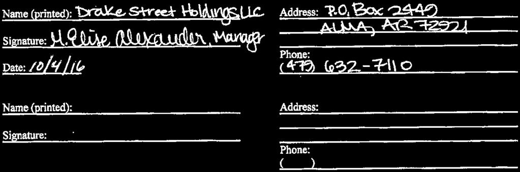
15 Drake Street Holdings, LLC Rezoning Request RMF 24 to Community Services A. The property is currently owned by Drake Street Holdings, LLC. It is the intent of the owner to sell the property when rezoned. B. The rezoning from RMF 24 to Community Services will allow the property to be developed with a mix of offices and other uses. C. The proposed rezoning will be compatible with surrounding uses and proposed uses. The surrounding properties have a mix of uses, primarily multifamily and institutional. The property immediately to the north was recently approved for office development, and the property to the south was rezoned to Urban Thoroughfare. The subject property is located at the intersection of Drake and Gregg Streets, which are non residential streets. The subject property will be subject to design and signage consistent with Community Services. D. The property is served by 8 water lines to both the south and north. In addition, an 18 water line is located to the east of the property. The property is served by both 8 and 33 sanitary sewer lines. E. The proposed zoning is consistent with the 2030 Future Land Use Plan which shows City Neighborhood Area for the property. F. The proposed zoning is both justified and needed now. G. The proposed zoning will decrease future traffic to the property, as the current zoning allows the development of over 200 apartment units. H. The proposed zoning will decrease the need for public infrastructure, as the current zoning allows the development of over 200 apartment units. I. It is currently impractical to develop apartments on the property, due the current construction of numerous projects in the Fayetteville market.
16 Legal Description A part of the Northwest Quarter of the Southeast Quarter (NW/4 SE/4) of Section Thirty-four (34), Township Seventeen (17) North, Range Thirty (30) West, Washington County, Arkansas, being more particularly described as follows: Commencing at the steel rebar pin that marks the Northwest corner of said NW/4 of the SE/4, thence South 87 degrees, 28 minutes, 35 seconds East along the North line of NW/4 of the SE/ feet to a steel rebar pin, said pin being the POINT OF BEGINNING and run thence South 87 degrees, 28 minutes, 35 seconds East along said North line of NW/4 of the SE/ feet to the right of way granted to the Arkansas Highway and Transportation Department in Washington County Deed Record , thence South 01 degrees, 18 minutes, 52 seconds West along said right of way line as monumented 7.09 feet; thence continuing along said right of way line as monumented South 73 degrees, 31 minutes, 19 seconds East feet; thence continuing along said right of way line as monumented South 85 degrees, 17 minutes, 03 seconds East feet to a steel rebar pin, thence departing said right of way line South 06 degrees, 58 minutes, 35 seconds East feet; thence South 87 degrees, 28 minutes, 38 seconds East feet to a steel rebar pin; thence feet along a non-tangent curve to the left said curve having a radius of feet and a long chord of South 17 degrees, 54 minutes, 13 seconds East feet; thence North 87 degrees, 28 minutes, 38 seconds West feet to a steel rebar pin; thence North 02 degrees, 29 minutes, 24 seconds East feet to the Point of Beginning, containing approximately square feet or 8.88 acres, more or less. Subject to the right of way of Drake Street along the North side, all other rights of way, easements, and covenants of record or in fact. LESS AND EXCEPT THAT PARCEL PREVIOUSLY CONVEYED TO THE CITY OF FAYETTEVILLE, AS SETOUT IN WARRANTY DEED FILED FOR RECORD AUGUST 7, 2009, AS DOCUMENT NO , RECORDS OF WASHINGTON COUNTY, ARKANSAS, AS FOLLOWS: A right of way of forty-four (44) feet equal and uniform width across a part of the Northwest Quarter of the Southeast Quarter (NW 1/4 of the SE 1/4) of Section Thirty-four (34), Township Seventeen North (Twp. 17 N.), Range Thirty West (Rng. 30 W.). City of Fayetteville, Washington County, Arkansas the boundary of the subject property being described in Plat Record of the records of the Circuit Clerk and Ex-officio recorder of Washington County, Arkansas, said right of way being more particularly described as follows: Commence at the northwest corner of said NW 1/4 of the SE 1/4 of Section 34, Twp. 17 N. Rng. 30 W.; thence S87 28'35"E feet to the northwest corner of the subject property; thence S02 29'44"W feet along the west line of said subject property to the southwest coiner thereof; thence S87 28'38"E feet along the south line of said subject property to the Point of Beginning and run thence N03 49'16"W feet; thence feet along a curve to the right, said curve having a radius of feet and a long chord of N31 48'24"E feet; thence feet along a non-tangent curve to the left, said curve having a radius of feet and a long chord of S16 52'18"E feet; thence feet along a non-tangent curve to the left, said curve having a radius of feet and a long chord of S30 52'51"W feet; thence S03 49'16"E feet; thence N87 28'38"W feet to the Point of Beginning, containing approximately sq. ft. or 0.25 acres, more or less.
17 Shared RZN Close Up View DRAKE ST. HOLDINGS UT Subject Property PRIVATE 417 DRAKE ST DRAKE P-1 GREGG AVE PRIVATE 511 R-A MEADE ST RMF-24 DENZER AVE QUALITY LN BOWERS ST PRIVATE 2630 N Legend Planning Area Fayetteville City Limits Use Paved Trail Trail (Proposed) Building Footprint Feet inch = 200 feet Residential-Agricultural RT-12 Residential Two and Three-family RMF-24 Urban Thoroughfare P-1
18 RZN DRAKE ST. HOLDINGS N One Mile View FULBRIGHT EXPY RAMP 67 FULBRIGHT EXPY Miles WATTS P-1 APPLEBY UT PRIVATE 417 RSF-4 Subject Property GREGG AVE RT-12 ISLEY ST MEADE ST WATTS AVE COOPER AVE DRAKE RMF-24 YOUNG AVE PRINCE ST BOWERS ST CASSATT ST DENZER AVE C-1 VALENCIA AVE RPZD MADRID ST HILLIAN AVE R-A STRANGE DR DONALD RD JESSE DR REYNOLDS ST REYNOLDS R-O WISE ST BUCK WATSON AVE ZEB LN OFFUTT DR C-2 I-1 Legend Planning Area Fayetteville City Limits Shared Use Paved Trail Trail (Proposed) Design Overlay District Building Footprint Planning Area Fayetteville City Limits Zoning EXTRACTION RESIDENTIAL SINGLE-FAMILY E-1 Residential-Agricultural COMMERCIAL RSF-.5 Residential-Office RSF-1 C-1 RSF-2 C-2 RSF-4 C-3 RSF-7 FORM BASED DISTRICTS RSF-8 Downtown Core RSF-18 Urban Thoroughfare RESIDENTIAL MULTI-FAMILY Main Street Center RT-12 Residential Two and Three-family Downtown General RMF-6 Community Services RMF-12 Neighborhood Services RMF-18 Neighborhood Conservation RMF-24 PLANNED ZONING DISTRICTS RMF-40 Commercial, Industrial, Residential INDUSTRIAL INSTITUTIONAL I-1 Heavy Commercial and Light Industrial P-1 I-2 General Industrial
19 RZN PRIVATE 417 Current Land Use DRAKE ST. HOLDINGS N Subject Property DRAKE ST DRAKE U of A Land Lakeside Village Apts G GREG AVE PRIVATE 511 QUALITY LN DENZER AVE MEADE ST PRIVATE 2630 Village at Scull Creek BOWERS ST E LAKE DR AG LL VI2015 Imagery Streams Street Streets Planned MSP Class Feet MINOR ARTERIAL MINOR ARTERIAL RZN Shared Use Paved Trail Trail (Proposed) Planning Area Fayetteville City Limits inch = 200 feet 600
20 Shared RZN DRAKE ST. HOLDINGS N Future Land Use Subject Property PRIVATE 417 DRAKE ST DRAKE GREGG AVE PRIVATE 511 MEADE ST DENZER AVE QUALITY LN PRIVATE 2630 BOWERS ST VILLAGE LAKE DR Legend Planning Area Fayetteville City Limits Use Paved Trail Trail (Proposed) Building Footprint Feet inch = 200 feet FUTURE LAND USE 2030 Residential Neighborhood Area City Neighborhood Area Urban Center Area Civic and Private Open Space/Parks Non-Municipal Government
Action Recommendation: Budget Impact:
 City of Fayetteville Staff Review Form 2018-0477 Legistar File ID 9/18/2018 City Council Meeting Date - Agenda Item Only N/A for Non-Agenda Item Garner Stoll Submitted By 8/28/2018 Submitted Date Action
City of Fayetteville, Arkansas Page 1 of 1
 City of Fayetteville, Arkansas 113 West Mountain Street Fayetteville, AR 72701 (479) 575-8323 Legislation Text File #: 2015-0400, Version: 1 RZN 15-5148 (402 E. 7TH ST./NIEDERMAN): AN ORDINANCE REZONING
Action Recommendation: Budget Impact:
 City of Fayetteville Staff Review Form 2017-0451 Legistar File ID 9/5/2017 City Council Meeting Date - Agenda Item Only N/A for Non-Agenda Item Andrew Garner Submitted By 8/18/2017 Submitted Date Action
Action Recommendation: Budget Impact:
 City of Fayetteville Staff Review Form 2018-0744 Legistar File ID 1/3/2019 City Council Meeting Date - Agenda Item Only N/A for Non-Agenda Item Garner Stoll 12/14/2018 CITY PLANNING (630) Submitted By
Action Recommendation: Budget Impact:
 City of Fayetteville Staff Review Form 2018-0582 Legistar File ID 11/8/2018 City Council Meeting Date - Agenda Item Only N/A for Non-Agenda Item Garner Stoll Submitted By 10/19/2018 Submitted Date Action
Action Recommendation: Budget Impact:
 City of Fayetteville Staff Review Form Jeremy Pate Submitted By 2016 0489 Legistar File ID 11/1/2016 City Council Meeting Date Agenda Item Only N/A for Non Agenda Item 10/14/2016 Submitted Date Action
Action Recommendation: Budget Impact:
 City of Fayetteville Staff Review Form 2018-0301 Legistar File ID 6/19/2018 City Council Meeting Date - Agenda Item Only N/A for Non-Agenda Item Garner Stoll Submitted By 6/1/2018 Submitted Date Action
City of Fayetteville, Arkansas Page 1 of 1
 City of Fayetteville, Arkansas 113 West Mountain Street Fayetteville, AR 72701 (479) 575-8323 Legislation Text File #: 2018-0288, Version: 1 RZN 18-6176 (714 S. COLLEGE AVE./CAMERON): AN ORDINANCE TO REZONE
Action Recommendation: Budget Impact:
 City of Fayetteville Staff Review Form 2018-0542 Legistar File ID 10/16/2018 City Council Meeting Date - Agenda Item Only N/A for Non-Agenda Item Garner Stoll Submitted By 9/28/2018 Submitted Date Action
Action Recommendation: Budget Impact:
 ity of Fayetteville Staff Review Form 2017-0564 Legistar File ID 10/17/2017 ity ouncil Meeting Date - Agenda Item Only N/A for Non-Agenda Item Andrew Garner Submitted By 9/29/2017 Submitted Date Action
City of Fayetteville, Arkansas Page 1 of 1
 City of Fayetteville, Arkansas 113 West Mountain Street Fayetteville, AR 72701 (479) 575-8323 Legislation Text File #: 2018-0148, Version: 1 VAC 18-6097 (W. OF BEECHWOOD AVE. & 15TH ST./BARRETT DEV. GROUP):
Action Recommendation: Budget Impact:
 City of Fayetteville Staff Review Form 2018-0302 Legistar File ID 6/19/2018 City Council Meeting Date - Agenda Item Only N/A for Non-Agenda Item Garner Stoll Submitted By 6/1/2018 Submitted Date Action
City of Fayetteville, Arkansas Page 1 of 1
 City of Fayetteville, Arkansas 113 West Mountain Street Fayetteville, AR 72701 (479) 575-8323 Legislation Text File #: 2018-0399, Version: 1 VAC 18-6148 (1901 S. HARDING PL./THOMPSON): AN ORDINANCE TO
City of Fayetteville, Arkansas Page 1 of 1
 City of Fayetteville, Arkansas 113 West Mountain Street Fayetteville, AR 72701 (479) 575-8323 Legislation Text File #: 2018-0222, Version: 1 VAC 18-6088 (525 S. SCHOOL AVE./MILL DISTRICT): AN ORDINANCE
TO: Glynn County Board of Commissioners. Eric Landon, Planner II. ZM2773 Peppertree Crossing Phase II
 COMMUNITY DEVELOPMENT DEPARTMENT Planning and Zoning Division 1725 Reynolds Street, Suite 200, Brunswick, GA 31520 Phone: 912-554-7428/Fax: 1-888-252-3726 TO: Glynn County Board of Commissioners MEMO FROM:
AGENDA ITEM SUMMARY GLADES COUNTY BOARD OF COUNTY COMMISSIONERS
 AGENDA ITEM SUMMARY GLADES COUNTY BOARD OF COUNTY COMMISSIONERS SUBJECT: Case Number COMP17-02, RFYC, LLC This is a Legislative Hearing. DEPARTMENT REQUEST: The Community Development Department requests
WESTMINSTER PARK PLACE SUBDIVISION
 WESTMINSTER PARK PLACE SUBDIVISION Engineering Comments: FINAL PLAT COMMENTS (should be addressed prior to submitting the FINAL PLAT for review and/or signature by the City Engineer): A. Provide all of
ARTICLE 14 PLANNED UNIT DEVELOPMENT (PUD) DISTRICT
 DISTRICT") ARTICLE 14 PLANNED UNIT DEVELOPMENT (PUD) DISTRICT Section 14.01 Intent. It is the intent of this Article to allow the use of the planned unit development (PUD) process, as authorized by the Michigan Zoning
ARTICLE 14 PLANNED UNIT DEVELOPMENT (PUD) DISTRICT Section 14.01 Intent. It is the intent of this Article to allow the use of the planned unit development (PUD) process, as authorized by the Michigan Zoning
City of Valdosta Land Development Regulations
 Chapter 206 Section 206-1 Base Zoning Districts Standards for Uses, Structures, and Property Development (B) (C) Principal Uses and Structures. Principal uses and structures permitted in each base zoning
Glades County Staff Report and Recommendation Unified Staff Report for Small Scale Plan Amendment and Rezoning
 Glades County Staff Report and Recommendation Unified Staff Report for Small Scale Plan Amendment and Rezoning CASE NUMBERS: COMP17-02 and RZ17-02 DATE of STAFF REPORT: May 1, 2017 CASE TYPE: Application
Metropolitan Planning Commission. DATE: April 5, 2016
 TO: FROM: Metropolitan Planning Commission MPC Staff DATE: April 5, 2016 SUBJECT: Petition of Nine Line Inc. Robert McCorkle, Agent PIN: 2-1034-01-002 380.5 Acres Aldermanic District: 5 (Shabazz) County
ZONING CLASSIFICATION SUMMARY SHEET
 Growth and Resource Management Planning and Development Services 123 West Indiana Avenue Room 202 DeLand, Florida 32720-4253 Telephone (386) 943-7059 Fax (386) 626-6570 www.volusia.org ZONING CLASSIFICATION
ARTICLE 15 - PLANNED UNIT DEVELOPMENT
 Section 15.1 - Intent. ARTICLE 15 - PLANNED UNIT DEVELOPMENT A PUD, or Planned Unit Development, is not a District per se, but rather a set of standards that may be applied to a development type. The Planned
ACTION FORM BRYAN CITY COUNCIL
 ACTION FORM BRYAN CITY COUNCIL DATE OF COUNCIL MEETING: July 8, 2014 DATE SUBMITTED: June 17, 2014 DEPARTMENT OF ORIGIN: Development Services SUBMITTED BY: Maggie Dalton MEETING TYPE: CLASSIFICATION: ORDINANCE:
Staff Report: Date: Applicant: Property Identification: Acreage of Request: Current Zoning of Requested Area: Requested Action: Attached:
 Staff Report: Completed by Jeff Palmer Director of Planning & Zoning Date: November 7, 2018, Updated November 20, 2018 Applicant: Greg Smith, Oberer Land Developer agent for Ronald Montgomery ET AL Property
ARTICLE FIVE FINAL DRAFT
 ARTICLE FIVE 021218 FINAL DRAFT Sec. 503.6 Open Space Preservation Option Open Space Preservation Option Open Space Preservation developments may be approved in the AR, R-1, R-2 and R-3 zoning districts,
Town of Cary, North Carolina Rezoning Staff Report 14-REZ-31 Cary Park PDD Amendment (Waterford II) Town Council Meeting January 15, 2015
 Town Council Meeting January 15, 2015") Town of Cary, North Carolina Rezoning Staff Report 14-REZ-31 Cary Park PDD Amendment (Waterford II) Town Council Meeting January 15, 2015 REQUEST To amend the Town of Cary Official Zoning Map by amending
Town of Cary, North Carolina Rezoning Staff Report 14-REZ-31 Cary Park PDD Amendment (Waterford II) Town Council Meeting January 15, 2015 REQUEST To amend the Town of Cary Official Zoning Map by amending
WESTMINSTER PARK SUBDIVISION
 WESTMINSTER PARK SUBDIVISION Engineering Comments: FINAL PLAT COMMENTS (should be addressed prior to submitting the FINAL PLAT for review and/or signature by the City Engineer): A. Provide all of the required
Staff Report: Date: Applicant: Property Identification: Acreage of Request: Current Zoning of Requested Area: Requested Action: Attached:
 Staff Report: Completed by Jeff Palmer Director of Planning & Zoning Date: November 7, 2018 Applicant: Greg Smith, Oberer Land Developer agent for Ronald Montgomery ET AL Property Identification: Frontage
** If your lot does not meet the requirements above, please read Sec below
 Sec. 13-1-60 Zoning District Dimensional Requirements. For the Zoning Dept To Issue a Land Use Permit The Following Dimensions are Required. Minimum Side and Rear Yards s Lakes Classification Minimum Class
Planning Department Oconee County, Georgia
 Planning Department Oconee County, Georgia STAFF REPORT REZONE CASE #: 6985 DATE: October 31, 2016 STAFF REPORT BY: Andrew C. Stern, Planner APPLICANT NAME: Williams & Associates, Land Planners PC PROPERTY
LAND USE ASSUMPTIONS REPORT POTENTIAL FUTURE DEVELOPMENT WEST WHITELAND TOWNSHIP, CHESTER COUNTY, PA
 LAND USE ASSUMPTIONS REPORT POTENTIAL FUTURE DEVELOPMENT WEST WHITELAND TOWNSHIP, CHESTER COUNTY, PA Adopted June 17, 2015 by Township Resolution No. 2015-30 Prepared by Theurkauf Design & Planning, LLC
PLANNED UNIT DEVELOPMENT & SUBDIVISION STAFF REPORT Date: July 20, 2017
 PLANNED UNIT DEVELOPMENT & SUBDIVISION STAFF REPORT Date: July 20, 2017 DEVELOPMENT NAME SUBDIVISION NAME LOCATION Rangeline Crossing III Subdivision Rangeline Crossing III Subdivision 5289 Halls Mill
COUNCIL COMMUNICATION
 Meeting Date: October 24, 2017 COUNCIL COMMUNICATION Agenda Item: Agenda Location: Public Hearings Work Plan # Legal Review: X 1 st Reading 2 nd Reading Subject: A public hearing regarding Zoning and a
Glades County Staff Report and Recommendation REZONING
 Glades County Staff Report and Recommendation REZONING CASE NUMBER: RZ15-01 DATE: October 2, 2015 CASE TYPE: Application for Rezoning REQUEST: J.J. Wiggins Memorial Trust is requesting a rezoning of 22.1±
City of Fayetteville, Arkansas Page 1 of 3
 City of Fayetteville, Arkansas 113 West Mountain Street Fayetteville, AR 72701 (479) 575-8323 Legislation Text File #: 2018-0144, Version: 1 ADM 18-6094 (AMEND UDC 164.19/ACCESSORY DWELLING UNITS): AN
MPC STAFF REPORT REZONING MAP AMENDMENT ALDERMANIC DISTRICT 1 COUNTY COMMISSION DISTRICT 5 April 3, 2013 MPC FILE NUMBER.
 MPC STAFF REPORT REZONING MAP AMENDMENT ALDERMANIC DISTRICT 1 COUNTY COMMISSION DISTRICT 5 April 3, 2013 MPC FILE NUMBER. 13-000929-ZA REZONING SUMMARY Report Status Initial Report Petitioner/Property
PLNSUB Meridian Commerce Center Subdivision Amendment & PLNPCM Meridian Commerce Center Street Closure
 Staff Report PLANNING DIVISION COMMUNITY & ECONOMIC DEVELOPMENT To: From: Salt Lake City Planning Commission Daniel Echeverria, 801-535-7165, daniel.echeverria@slcgov.com Date: September 4, 2014 Re: PLNSUB2014-000469
Midwest City, Oklahoma Zoning Ordinance
 2010 Midwest City, Oklahoma Zoning Ordinance 9/2/2010 Table of Contents Section 1. General Provisions... 5 1.1. Citation... 5 1.2. Authority... 5 1.3. Purpose... 5 1.4. Nature and Application... 5 1.5.
Town of Waxhaw Board of Commissioners. Waxhaw Police Department Community Meeting Room Tuesday January 12, 2016
 Town of Waxhaw Board of Commissioners Waxhaw Police Department Community Meeting Room Tuesday January 12, 2016 Petition RZ-003994-2015 A request by the Town of Waxhaw Planning & Community Development Department,
PLANNING COMMISSION REPORT Regular Agenda Public Hearing Item
 PC Staff Report 11/12/12 Item No. 2B- 1 PLANNING COMMISSION REPORT Regular Agenda Public Hearing Item ITEM NO. 2B: A TO GPI; 110 ACRES; E OF K-10 & N OF W 6 TH ST (MKM) : Consider a request to rezone approximately
Marcel Williams, MPC Project Planner
 TO: FROM: The Planning Commission MPC Staff DATE: SUBJECT: Petition to Rezone Property Heath Shelton, Owner Jay Maupin, Agent 2026 Habersham Street Aldermanic District: 2, Bill Durrence County Commission
MTC ALABAMA SUBDIVISION
 # 2 SUB-000370-2017 MTC ALABAMA SUBDIVISION Engineering Comments: FINAL PLAT COMMENTS (should be addressed prior to submitting the FINAL PLAT for review and/or signature by the City Engineer): A. Provide
VICINITY MAP SCALE 1'' = 2000'
 CITY CREEK ANNEXATION TO THE CITY OF THORNTON LOCATED IN THE SOUTHWEST QUARTER OF SECTION 11 AND THE WEST HALF OF SECTION 14, TOWNSHIP 1 SOUTH, RANGE 68 WEST OF THE 6TH PRINCIPAL MERIDIAN, COUNTY OF ADAMS,
The Planning Commission. DATE: July 19, 2016
 TO: FROM: The Planning Commission MPC Staff DATE: SUBJECT: Petition of Chatham Savannah Authority for the Homeless Cindy Kelley, Agent Saffold Properties L.P. (John Saffold), Owner Aldermanic District:
PLANNING AND ZONING COMMISSION AGENDA MEMORANDUM
 City and County of Broomfield, Colorado PLANNING AND ZONING COMMISSION AGENDA MEMORANDUM To: Planning and Zoning Commission From: John Hilgers, Planning Director Anna Bertanzetti, Principal Planner Meeting
ZONING AMENDMENT & SUBDIVISION STAFF REPORT Date: March 1, 2018
 #13 SUB-000406-2018 & ZON-000407-2018 ZONING AMENDMENT & SUBDIVISION STAFF REPORT Date: March 1, 2018 NAME SUBDIVISION NAME LOCATION Creekside @ Kooiman Dairy Creekside @ Kooiman Dairy Subdivision (South
DIVISION 1 PURPOSE OF DISTRICTS
 ARTICLE 2 ZONING DISTRICTS AND MAP DIVISION 1 PURPOSE OF DISTRICTS Section 2.101 Zoning Districts. For the purpose of this Ordinance, the City of Richmond is hereby divided into districts as follows: DISTRICT
Town of Cary, North Carolina Rezoning Staff Report 12-REZ-27 Morris Branch Town Council Public Hearing January 24, 2013
 Town of Cary, North Carolina Rezoning Staff Report 12-REZ-27 Morris Branch Town Council Public Hearing January 24, 2013 REQUEST To amend the Town of Cary Official Zoning Map to rezone approximately 9.0
May 12, Chapter RH HILLSIDE RESIDENTIAL ZONES REGULATIONS Sections:
 May 12, 2017 Chapter 17.13 RH HILLSIDE RESIDENTIAL ZONES REGULATIONS Sections: 17.13.010 Title, intent, and description. 17.13.020 Required design review process. 17.13.030 Permitted and conditionally
Action Recommendation: Budget Impact:
 City of Fayetteville Staff Review Form Garner Stoll Submitted By 2018-0144 Legistar File ID 4/17/2018 City Council Meeting Date - Agenda Item Only N/A for Non-Agenda Item 3/22/2018 Submitted Date Action
ADMINISTRATIVE HEARING STAFF REPORT Country Club Acres Second Amended Subdivision Amendment PLNSUB E Parkway Avenue December 12, 2013
 ADMINISTRATIVE HEARING STAFF REPORT Country Club Acres Second Amended Subdivision Amendment PLNSUB2013-00925 2167 E Parkway Avenue December 12, 2013 Planning Division Department of Community & Economic
PC Staff Report 11/18/2013 Z Item No. 1-1
 Z-13-00401 Item No. 1-1 PLANNING COMMISSION REPORT Regular Agenda - Public Hearing Item PC Staff Report 11/18/2013 ITEM NO. 1: Z-13-00401 IG (General Industrial) District TO CS (Strip Commercial) District;
HB-S RM8-S RS9 RM18 HB-S RS9 DOCKET #: W2872. PROPOSED ZONING: RM8-S (Child Day Care Center) EXISTING ZONING: RS9 and RM8-S
 EXISTING ZONING: RS9 and RM8-S") 150' 80' RS9 UNIVERSITY PW STANLEYVILLE DR HB-S LB 123' 70' PROPOSED BELTWAY!( RM8-S S 289' NOEL DR 202' NITA AV MILL CREEK DOCKET #: W2872 PROPOSED ZONING: RM8-S (Child Day Care Center) EXISTING ZONING:
150' 80' RS9 UNIVERSITY PW STANLEYVILLE DR HB-S LB 123' 70' PROPOSED BELTWAY!( RM8-S S 289' NOEL DR 202' NITA AV MILL CREEK DOCKET #: W2872 PROPOSED ZONING: RM8-S (Child Day Care Center) EXISTING ZONING:
CITY OF ALBERT LEA PLANNING COMMISSION ADVISORY BOARD
 CITY OF ALBERT LEA PLANNING COMMISSION ADVISORY BOARD 9/1/2015, 5:30 p.m. City Council Chambers AGENDA A. CALL TO ORDER AND ROLL CALL B. APPROVAL OF THE AGENDA C. APPROVAL OF MINUTES 1. PC Minutes from
RAE EXCLUSIVE RESIDENTIAL ZONE A residential district exclusively for low density single family housing and accessory uses.
 KNOX COUNTY ZONING ORDINANCE DISTRICT SUMMARY REQUIREMENTS 2/11/2009 RAE EXCLUSIVE RESIDENTIAL ZONE A residential district exclusively for low density single family housing and accessory uses. 10,000 sq.
COUNCIL AGENDA MEMO ITEM NO. III - #1
 COUNCIL AGENDA MEMO ITEM NO. III - #1 FROM: Anton Jelinek, Director of Utilities MEETING: October 24, 2017 SUBJECT: PRESENTER: Permanent Utility and Right-of-Way Easement Anton Jelinek Discussion: At the
I. Requirements for All Applications. C D W
 108-16.1. Application checklists. Checklist for Required Submissions to the Planning Board or Zoning Board of Adjustment of Monroe Township All required submissions are to be made to the Administrative
STAFF REPORT. Community Development Director PO Box 4755 Beaverton, OR 97076
 STAFF REPORT HEARING DATE: July 7, 2010 TO: Planning Commission STAFF: Jana Fox, Assistant Planner PROPOSAL: Southeast Beaverton Office Commercial Zoning Map Amendment (ZMA2010-0006) LOCATION: The subject
Oakland County Michigan Register of Deeds Plat Engineering, GIS, & Remonumentation Dept. Ph: (248) Fax (248)
 Fax (248)") Oakland County Michigan Register of Deeds Plat Engineering, GIS, & Remonumentation Dept. Ph: (248)-858-1447 Fax (248)-858-7466 Requirements Needed for Final Plat Approval No. General Requirements. 1 Routing
Oakland County Michigan Register of Deeds Plat Engineering, GIS, & Remonumentation Dept. Ph: (248)-858-1447 Fax (248)-858-7466 Requirements Needed for Final Plat Approval No. General Requirements. 1 Routing
CHARTER TOWNSHIP OF CALEDONIA COUNTY OF KENT, MICHIGAN. at the Township and Village Hall, 8196 Broadmoor Avenue, Caledonia, Michigan on the
 First Reading CHARTER TOWNSHIP OF CALEDONIA COUNTY OF KENT, MICHIGAN At a regular meeting of the Township Board of the Charter Township of Caledonia, held at the Township and Village Hall, 8196 Broadmoor
AGENDA ITEM SUMMARY GLADES COUNTY BOARD OF COUNTY COMMISSIONERS
 AGENDA ITEM SUMMARY GLADES COUNTY BOARD OF COUNTY COMMISSIONERS SUBJECT: Case Number COMP17-01, Legend Moto LLC This is a Legislative Hearing. DEPARTMENT REQUEST: The Community Development Department requests
Development Plan DP13-3 (Arlington Lofts) Planning and Zoning Meeting Date: Document Being Considered: Ordinance
 Planning and Zoning Meeting Date: Document Being Considered: Ordinance") Staff Report Development Plan DP13-3 (Arlington Lofts) Planning and Zoning Meeting Date: 6-19-13 Document Being Considered: Ordinance RECOMMENDATION Following the public hearing, consider Development Plan
Staff Report Development Plan DP13-3 (Arlington Lofts) Planning and Zoning Meeting Date: 6-19-13 Document Being Considered: Ordinance RECOMMENDATION Following the public hearing, consider Development Plan
Town of Cary, North Carolina Rezoning Staff Report. 956 W. Chatham Street. Town Council Meeting January 9, 2014
 Town of Cary, North Carolina Rezoning Staff Report 13-REZ-22 956 W. Chatham Street Town Council Meeting January 9, 2014 REQUEST To amend the Town of Cary Official Zoning Map by rezoning 0.85 acres located
PLANNED UNIT DEVELOPMENT & SUBDIVISION STAFF REPORT Date: April 18, 2019
 PLANNED UNIT DEVELOPMENT & SUBDIVISION STAFF REPORT Date: April 18, 2019 DEVELOPMENT NAME SUBDIVISION NAME Springhill Village Subdivision Springhill Village Subdivision LOCATION 4350, 4354, 4356, 4358,
31, Township 29 South, Range 25 East, Polk County, Florida, as depicted by the Land Use Plan attached
 ORDINANCE NO. 2013-04 AN ORDINANCE AMENDING THE ZONING MAP OF THE CITY OF BARTOW, FLORIDA, REZONING APPROXIMATELY 2. 2 ACRES OF LAND OWNED BY BALA3I OF POLK COUNTY, LLC AND LOCATED IN SECTION 31, TOWNSHIP
Planning Department Oconee County, Georgia STAFF REPORT
 Planning Department Oconee County, Georgia STAFF REPORT REZONE CASE #: 7332 DATE: November 28, 2017 STAFF REPORT BY: Gabriel Quintas, Planner APPLICANT NAME: Smith Planning Group PROPERTY OWNER: John Hadden
Chapter 8 The Residential District Requirements
 Chapter 8 The Residential District Requirements ECTION: 9-8-1 General Purpose tatement 9-8-2 General Cross-reference Guide for Additional Regulations. 9-8-3 Residential District Regulations 9-8-4 E-1 Estate
DEPARTMENT OF PLANNING AND COMMUNITY DEVELOPMENT STAFF REPORT
 DEPARTMENT OF PLANNING AND COMMUNITY DEVELOPMENT STAFF REPORT PLANNING COMMISSION AGENDA ITEM # 5: Project Name: Star Dance Zoning Map Amendment, ZMA-13-02 Prepared By: Toby Stauffer, AICP City Planner
Urban Planning and Land Use
 Urban Planning and Land Use 701 North 7 th Street, Room 423 Phone: (913) 573-5750 Kansas City, Kansas 66101 Fax: (913) 573-5796 Email: planninginfo@wycokck.org www.wycokck.org/planning To: From: City Planning
8Land Use. The Land Use Plan consists of the following elements:
 8Land Use 1. Introduction The Land Use Plan consists of the following elements: 1. Introduction 2. Existing Conditions 3. Opportunities for Redevelopment 4. Land Use Projections 5. Future Land Use Policies
SECTION 10.7 R-PUD (RESIDENTIAL PLANNED UNIT DEVELOPMENT) ZONE
 ZONE") Article X Zones 10-20 SECTION 10.7 R-PUD (RESIDENTIAL PLANNED UNIT DEVELOPMENT) ZONE A. PURPOSE AND INTENT: The R-PUD Residential PUD Zone is intended to provide alternative, voluntary zoning procedures
Article X Zones 10-20 SECTION 10.7 R-PUD (RESIDENTIAL PLANNED UNIT DEVELOPMENT) ZONE A. PURPOSE AND INTENT: The R-PUD Residential PUD Zone is intended to provide alternative, voluntary zoning procedures
Tuss and Lisa Taylor. Agriculture
 ZONE CHANGE STAFF REPORT CCPC City-County Planning Commission warrenpc.org (270) 842-1953 1141 State Street Bowling Green, KY 42101 DOCKET/CASE/APPLICATION NUMBER 2018-29-Z-CO PUBLIC HEARING DATE July
ARTICLE VI. SUBDIVISION STANDARDS, PUBLIC
 ARTICLE VI. SUBDIVISION STANDARDS, PUBLIC IMPROVEMENTS, AND DESIGN REQUIREMENTS ARTICLE VI. SUBDIVISION STANDARDS, PUBLIC IMPROVEMENTS, AND DESIGN REQUIREMENTS DIVISION 1. GENERAL PROVISIONS Sec. 21-6100.
MINUTES JOINT MEETING LINCOLN COUNTY and SIOUX FALLS PLANNING COMMISSIONS 7:00 pm August 10, 2011
 MINUTES JOINT MEETING LINCOLN COUNTY and SIOUX FALLS PLANNING COMMISSIONS 7:00 pm August 10, 2011 Commissioners Room - Lincoln County Court House A joint meeting of the Lincoln County and Sioux Falls Planning
SUBJECT: Application for Planned Unit Development and Rezoning 1725 Winnetka Road
 TO: FROM: CHAIRMAN BILL VASELOPULOS AND MEMBERS OF THE PLAN & ZONING COMMISSION STEVE GUTIERREZ DIRECTOR OF COMMUNITY DEVELOPMENT MEETING DATE: September 5, 2017 SUBJECT: Application for Planned Unit Development
Marion County Board of County Commissioners
 Marion County Board of County Commissioners Date: 12/29/2015 P&Z: 12/28/2015 BCC: 1/12/2016 Item Number 160113Z Type of Application Rezoning Request From: A-1 (General Agriculture) To: PUD (Planned Unit
4. facilitate the construction of streets, utilities and public services in a more economical and efficient manner;
 PVPC MODEL BYLAW BY-RIGHT CLUSTER ZONING BYLAW Prepared by Pioneer Valley Planning Commission Revised: October 2001 1.00 Development 1.01 Development Allowed By Right Development in accordance with this
Town of Cary, North Carolina Rezoning Staff Report 14-REZ-24 Indian Wells Road Properties Town Council Meeting November 20, 2014
 Town of Cary, North Carolina Rezoning Staff Report 14-REZ-24 Indian Wells Road Properties Town Council Meeting November 20, 2014 REQUEST To amend the Town of Cary Official Zoning Map by revising a condition
Proposed Overland Park Kansas Ordinance RE-1 Residential Estates Community
 18.171 RE-1 Residential Estate Community 18.171.010 Statement of intent. The zoning of property as RE-1, (Residential Estates Community, 1 dwelling unit per Gross acre density), is intended to provide
B. The Plan is in conformity with the Comprehensive Plan.
 ARTICLE 17 PLANNING UNIT DEVELOPMENT 17.01 INTENT The purpose of this Section is to permit the creation of new Planned Unit Developments, permitted as Conditional Uses where maximum variations of design
Land Use, Transportation, and Infrastructure Committee of Denver City Council FROM: Scott Robinson, Senior City Planner DATE: December 6, 2018 RE:
 Community Planning and Development Planning Services 201 W. Colfax Ave., Dept. 205 Denver, CO 80202 p: 720.865.2915 f: 720.865.3052 www.denvergov.org/cpd TO: Land Use, Transportation, and Infrastructure
PROPOSED AMENDMENTS TO THE DERBY ZONING REGULATIONS AUGUST 12, 2008
 ARTICLE II Definitions and word usage 195-7. Definitions and word usage. Modify the following: HOUSING FOR THE ELDERLY OLDER PERSONS Housing in accordance with and as defined in the United States Fair
AN ORDINANCE TO AMEND SECTION OF THE RAPID CITY MUNICIPAL CODE TO ALLOW FOR ADMINISTRATIVE DISSOLUTION OF PLANNED DEVELOPMENTS
 Ordinance No. 6231 AN ORDINANCE TO AMEND SECTION 17.50.050 OF THE RAPID CITY MUNICIPAL CODE TO ALLOW FOR ADMINISTRATIVE DISSOLUTION OF PLANNED DEVELOPMENTS WHEREAS, the City of Rapid City has adopted a
Special Use Permit - Planned Unit Development Checklist. Property Address:
 Special Use Permit - Planned Unit Development Checklist Special Use Permit Number. Parcel Code/s #28-11- - - Property Address: Applicant: ARTICLE VIII Ordinance Reference - Section 8.1.2 Permit Procedures:
ORDINANCE NO. 208 BE IT ORDAINED BY THE CITY COUNCIL OF THE CITY OF UNIVERSITY HEIGHTS, JOHNSON COUNTY, IOWA:
 ORDINANCE NO. 208 AN ORDINANCE AMENDING ORDINANCE NO. 79 (ZONING) TO CREATE A COMMERCIAL HOTEL ZONE AND PERMIT DEVELOPMENT PURSUANT TO A COMMERCIAL HOTEL PUD BE IT ORDAINED BY THE CITY COUNCIL OF THE CITY
ARTICLE Encourage well planned, efficient development.
 ARTICLE 14.00 PD PLANNED SECTIONS: 14.01 Intent 14.02 Procedure 14.03 Initial Development Plan 14.04 Final Development Plan 14.05 Amendments 14.06 Planned Development Districts PD-1 Willow Run PD PD-2
DATE: February 28, Marilynn Lewis, Principal Planner
 DATE: February 28, 2007 TO: FROM: RE: Salt Lake City Planning Commission Marilynn Lewis, Principal Planner Planning Commission Hearing for Petition 400-06-41 Zoning Map Amendment to Rezone 6 Properties,
RESIDENTIAL DISTRICTS
 RESIDENTIAL DISTRICTS RESIDENTIAL DISTRICTS The residential district standards have been revised to reflect on-the-ground development conditions, while continuing to respect the use patterns established
PLANNED UNIT DEVELOPMENT & ZONING AMENDMENT STAFF REPORT Date: December 21, 2017
 # 14 PUD-000324-2017 & ZON-000326-2017 PLANNED UNIT DEVELOPMENT & ZONING AMENDMENT STAFF REPORT Date: December 21, 2017 APPLICANT NAME DEVELOPMENT NAME LOCATION Dewberry/Preble-Rish Longleaf Gates Subdivision,
PART 3 RESIDENTIAL ZONING DISTRICTS. Designation of Residential Zoning Districts and Purpose Statements.
 PART 3 S Section 301. Designation of and Purpose Statements. See Table 3-1 herein this Section for the designations and purpose statements of the respective Residential Zoning Districts which are shown
RS9 LB-S RSQ-S RS9 RS9 DOCKET: W2822 PROPOSED ZONING: LB EXISTING ZONING: RS-9. PETITIONER: J&J Properties of W-S, LLC, for property owned by Same
 HAYMOUNT ST RS9 IP DOCKET: W2822 PROPOSED ZONING: LB POPE RD CLEMMONSVILLE RD EXISTING ZONING: RS-9 RSQ-S LB-S OLD SALISBURY RD WINSTON-SALEM ZONING FORSYTH COUNTY ZONING PETITIONER: J&J Properties of
CITY OF DURHAM DURHAM COUNTY NORTH CAROLINA. Zoning Map Change Report. RR Existing Zoning. Rural Rural Density Residential Site Characteristics
 CITY OF DURHAM DURHAM COUNTY NORTH CAROLINA Zoning Map Change Report Meeting Date: February 26, 2007 Reference Name Arrowhead () Jurisdiction County Proposed Zoning RR Existing Zoning RS-20 Request Proposed
CITY OF CHARLOTTESVILLE DEPARTMENT OF NEIGHBORHOOD DEVELOPMENT SERVICES STAFF REPORT APPLICATION FOR A SPECIAL USE PERMIT
 CITY OF CHARLOTTESVILLE DEPARTMENT OF NEIGHBORHOOD DEVELOPMENT SERVICES STAFF REPORT APPLICATION FOR A SPECIAL USE PERMIT PLANNING COMMISSION AND CITY COUNCIL JOINT PUBLIC HEARING DATE OF HEARING: July
Planning Commission Application Summary
 Planning Commission Application Summary Project Name: Creekside Estates Zone Change and Land Use Amendment Address: 571 West 11400 South Current Zoning: RA1 Hearing Date: July 14, 2016 Summary of Request
FINAL DRAFT 12/1/16, Rev. to 7/18/17
 FINAL DRAFT 12/1/16, Rev. to 7/18/17 (As Adopted 8/8/17 Effective 9/1/17) SHELTON PLANNING AND ZONING COMMISSION Proposed Amendments to Zoning Regulations I. Amend Section 23 PERMITTED USES by inserting
610 LAND DIVISIONS AND PROPERTY LINE ADJUSTMENTS OUTSIDE A UGB
 ARTICLE VI: LAND DIVISIONS AND PROPERTY LINE ADJUSTMENTS VI-21 610 LAND DIVISIONS AND PROPERTY LINE ADJUSTMENTS OUTSIDE A UGB 610-1 Property Line Adjustments (Property Line Relocation) A property line
City of Brooklyn Park Planning Commission Staff Report
 City of Brooklyn Park Planning Commission Staff Report Agenda Item: 6D Meeting Date: August 9, 2017 Originating Agenda Section: Public Hearing Department: Community Development Resolution: X Ordinance:
SUBDIVISION, PLANNED UNIT DEVELOPMENT, ZONING AMENDMENT, & SIDEWALK WAIVER STAFF REPORT Date: July 19, 2018
 SUBDIVISION, PLANNED UNIT DEVELOPMENT, ZONING AMENDMENT, & SIDEWALK WAIVER STAFF REPORT Date: July 19, 2018 NAME SUBDIVISION NAME LOCATION West Mobile Properties, LLC U.S. Machine Subdivision 556, 566,
PLAINFIELD CHARTER TOWNSHIP COMMUNITY DEVELOPMENT DEPARTMENT PLANNING, ZONING & BUILDING SERVICES MEMORANDUM
 PLAINFIELD CHARTER TOWNSHIP COMMUNITY DEVELOPMENT DEPARTMENT PLANNING, ZONING & BUILDING SERVICES 6161 BELMONT AVENUE N.E. BELMONT, MI 49306 PHONE 616-364-1190 FAX: 616-364-1170 www.plainfieldchartertwp.org