National Register of Historic Places Registration Form
|
|
|
- Basil Gardner
- 5 years ago
- Views:
Transcription
1 United States Department of the Interior National Park Service National Register of Historic Places Registration Form Listed in National Register 07/07/2015 This form is for use in nominating or requesting determinations for individual properties and districts. See instructions in National Register Bulletin, How to Complete the National Register of Historic Places Registration Form. If any item does not apply to the property being documented, enter "N/A" for "not applicable." For functions, architectural classification, materials, and areas of significance, enter only categories and subcategories from the instructions. Place additional certification comments, entries, and narrative items on continuation sheets if needed (NPS Form a). 1. Historic name Other names/site number KHRI # Name of related Multiple Property Listing N/A 2. Location Street & number Washington Boulevard N/A not for publication City or town Kansas City N/A vicinity State Kansas Code KS County Wyandotte Code 209 Zip code State/Federal Agency Certification As the designated authority under the National Historic Preservation Act, as amended, I hereby certify that this X_ nomination _ request for determination of eligibility meets the documentation standards for registering properties in the National Register of Historic Places and meets the procedural and professional requirements set forth in 36 CFR Part 60. In my opinion, the property x_ meets _ does not meet the National Register Criteria. I recommend that this property be considered significant at the following level(s) of significance: national statewide X local Applicable National Register Criteria: A B X C D See File. Signature of certifying official/title Patrick Zollner, Deputy SHPO Kansas State Historical Society State or Federal agency/bureau or Tribal Government Date In my opinion, the property meets does not meet the National Register criteria. Signature of commenting official Date Title State or Federal agency/bureau or Tribal Government 4. National Park Service Certification I hereby certify that this property is: entered in the National Register determined eligible for the National Register determined not eligible for the National Register removed from the National Register other (explain:) Signature of the Keeper Date of Action 1
2 5. Classification Ownership of Property (Check as many boxes as apply.) Category of Property (Check only one box.) Number of Resources within Property (Do not include previously listed resources in the count.) Contributing Noncontributing X private building(s) 4 0 buildings public - Local X district 0 0 sites public - State site 0 0 structures public - Federal structure 0 0 objects object 4 0 Total Number of contributing resources previously listed in the National Register N/A 6. Function or Use Historic Functions (Enter categories from instructions.) DOMESTIC/Multiple dwelling Current Functions (Enter categories from instructions.) DOMESTIC/Multiple dwelling 7. Description Architectural Classification (Enter categories from instructions.) Materials (Enter categories from instructions.) MODERN MOVEMENT foundation: Stone walls: Brick roof: other: Asphalt 2
3 Narrative Description (Describe the historic and current physical appearance and condition of the property. Describe contributing and noncontributing resources, if applicable. Begin with a summary paragraph that briefly describes the general characteristics of the property, such as its location, type, style, method of construction, setting, size, and significant features. Indicate whether the property has historic integrity.) Summary The (District) occupies a two-acre site on the south side of Washington Boulevard, between 16 th and 18 th Streets, just west of downtown Kansas City,. Four contributing buildings comprise the District. The two eastern buildings were constructed in 1947 and 1949 while the two western buildings were completed in 1952 (Figure 2). The Westheight Apartments utilize a Modern architectural vocabulary with no ornamentation, asymmetrical facades, and flat roofs. Interior spaces are arranged to maximize light, air, and privacy. The three-story buildings are set back from Washington Boulevard with a parking terrace. The District retains excellent integrity of location, design, setting, materials, workmanship, feeling, and associations. Elaboration Setting The occupies a long, narrow strip of land fronting the south side of Washington Boulevard between 16 th Street and 18 th Street. At the east end of the district, 16 th Street abuts the easternmost building. Everett Avenue, a much smaller road, passes closely behind the buildings to the south. The grade rises steadily from Washington Boulevard to the buildings. Behind the buildings, the grade again rises sharply to Everett Avenue. The grade also rises gently from east to west. There are asphalt paved parking terraces in front of all but the easternmost building. These are accessed by driveways that curve up from Washington Boulevard. Diagonal parking spaces line the north side of each terrace. Concrete stairs lined with simple pipe railings rise to the buildings from the driveways. Concrete walks run continuously in front of the buildings. The area surrounding the buildings is otherwise grassy. A row of mature deciduous trees shades the entire yard behind the buildings. Non historic metal picket fencing lines the south edge of the property along Everett Avenue and the space between buildings. Two commercial buildings occupy lots between the westernmost building and 18 th Street. A series of one story commercial buildings lines the north side of Washington Boulevard. They share the midcentury vintage and Modern Movement styling of the apartments. West of 18 th Street is the Westheight Manor Historic District comprised of single-family residences. 1 Exterior The four three story buildings that form the were constructed over a period of five years from 1947 to 1952, moving from east to west. Despite the extended period of development, the buildings share the same general design, massing, setbacks, and materials, although there are some subtle variations in size and configuration (Photos 1 and 8). In plan, the buildings are configured in blocks, each rectangular block having a projecting central bay flanked by two equal bays on each side. The central bay contains the building entry and a stair tower that provides direct access to two apartments on each floor (Photo 13). Multiple blocks are conjoined to create a single building. The two eastern buildings (Solar Apartments at Washington Boulevard and Terrace Apartments Washington Boulevard) have a symmetrical arrangement, the easternmost building being two conjoined blocks (Photo 10) and the building to its west having four conjoined blocks (Photo 7). The blocks that compose the two identical western buildings (West Terrace Apartments at Washington Boulevard and Washington Boulevard) have slightly asymmetrical façades. Here the projecting center bay is flanked by two narrow bays on one side and two wider bays on the other side (Photos 2 and 5). The narrow bays are recessed slightly further from the face of the projecting block than are the wider bays. A regular rhythm is formed by pairs of conjoined blocks with a mirrored façade arrangement. The buildings are rectangular in plan and topped by flat roofs. A small eave rises above the roof along the façades. Red brick clads the walls. On the side elevations, limestone blocks clad the foundations. On rear elevations, concrete block is 1 Westheight Manor Historic District was listed in the National Register of Historic Places on 19 February
4 exposed at the foundations (Photos 4, 6, 9, 11, 12). Window wells at the ground level accommodate windows in basement units on the rear (south) façades. Modern Movement styling presents a clean, unornamented appearance. The flat façades are interrupted only by the projecting blocks that rise the height of the building. Square brick planter boxes flank one side of the doorway in the base of each block (Photo 14). The historic doorway openings remain but are filled with non historic doors and paneled siding. Non historic canvas awnings shelter the entries. All of the buildings retain their historic window openings. These include tall rectangular openings on the projecting stair towers and horizontal rectangular window openings on all elevations. Large horizontal openings pierce the rear (south) elevations. Non historic vinyl windows fill the historic openings. The single light sliding sashes mimic the historic window configuration discernable in a vintage newspaper image. Metal fire escape platforms are mounted to the wall between windows on the rear elevation of each block. Interior On the interior of each building, a double loaded central stair hall provides vertical access to all floors (Photos 15-20). Two doors on each floor open into studio, one, or two bedrooms apartments. All of the stair halls and apartments retain their historic configuration and some historic features. As noted below, cosmetic finishes have been updated. The stairs are metal, including treads, risers, and stringers. Simple painted metal pipe railings line the stairs and landings. Non historic carpet covers the stairs and landings. Historic painted plaster clads the walls and ceilings of the stair halls in all but the easternmost building, which has original exposed red brick in the halls. The painted slab doors that fill the apartment entrances also appear to be historic. A few openings have non historic paneled doors. Apartment finishes are simple (Photos 22-26). Walls and ceilings are painted plaster or drywall, some with a textured surface. Base trim and door casings have a flat profile. Windows have plaster returns. There is no other molding. Historic bathtubs are extant. Bathroom sinks and kitchen fixtures have been replaced. INTEGRITY: Like all multi family rental apartments, renovations to the Westheight Apartments over the past 60 years have altered some original materials and design elements, yet the essential qualities that communicate historic significance remain intact, and the District retains sufficient integrity to merit listing on the National Register. Location The nominated buildings were constructed to provide multiple family housing, infilling vacant lots on the edge of a prominent older residential district. The buildings have not been moved and continue to occupy the lots fronting Washington Boulevard on which they were built. Integrity of Location is fully intact. Setting The neighborhood surrounding the District includes older (early-twentieth century) single-family residences, contemporary (mid twentieth century) multi family apartments, and commercial buildings of various ages. The arterial 18 th Street runs one half block to the west. Within the District, the relationship between the buildings and of the buildings to the historic off street parking terrace, to the grassy rear terrace, and to adjacent buildings is unchanged. Integrity of Setting remains fully intact. Design The nominated buildings demonstrate a quintessential expression of the Modern Movement design elements espoused by the Federal Housing Authority and expressed in guidelines published in Following these tenets, each building in the District is composed of blocks of six apartment units (three stories each with two units per floor). The primary variation between buildings is in the number of blocks each contains. The facades of the two westernmost buildings are slightly asymmetrical, whereas the façades of the two easternmost buildings are symmetrical. In addition to the geometric massing, the brick exteriors are uniformly unornamented. All have flat roofs. The efficient interior layout of each block is drawn directly from the published FHA guidelines. A single stair well provides direct access to two apartments per floor. As recommended by the FHA, the buildings are configured so that each apartment has north and south windows to enhance natural light and ventilation. The living room and bedroom are at the rear (south) of the building and kitchens and living rooms are at the front (north), allowing large windows to enhance views and prevailing breezes to 4
5 blow kitchen odors out of the apartments. All of these qualities communicate the origin of the design with the FHA standards. Newspaper articles published at the time of construction mentioned louvers installed on the rear elevation of the buildings to shade the apartments in summer and to allow light transmission in winter. Removal of the louvers (at an unknown date) does impact the integrity of design. However, FHA literature does not describe this element and its absence does not diminish the buildings expression of the FHA design tenets. The loss does not detract from the cohesive Modern Movement architecture of the District. The buildings otherwise retain all of the salient qualities that communicate the design standards for which they are being nominated. The District retains integrity of Design. Materials The Westheight Apartments have experienced some alterations to original materials as the buildings were updated over time to address normal wear and tear and to maintain the marketability of the apartment units. In the majority of instances, replacement materials match the original fabric. Where they do not, the intent of the historic design is intact. Wall surfaces have been patched and painted. Carpet, and in some cases wall board, has been replaced, as have kitchen and some bathroom fixtures. The most significant change of materials was the replacement of windows at an unknown date. The best available historic image is a rendering published in the Kansas City Kansan in 1951 announcing the start of construction on the West Terrace Apartment buildings. The image shows the front elevation of one of the buildings, where large window openings are filled with sliding sash windows (Figure 5). The façade is easily recognizable as the building today. Newspaper articles published at the time of construction described the buildings as having sliding windows. This configuration is apparent in the 1951 image. While the replacement of windows removed historic fabric, the change did not otherwise impact the more significant elements of the historic design. The replacement windows replicate not only the original windows size but this operational style. Integrity of Materials remains substantially intact. Workmanship It is difficult to evaluate integrity of Workmanship in many post World War II buildings, whose design consciously eliminated architectural ornament and whose construction emphasized modern building materials and construction technology. There is little evidence of artisans labor and skill aside from the exterior brickwork, which retains integrity in the area of Workmanship. Feeling & Association The aspects of integrity described above contribute to the distinct feeling of the nominated district as a cohesive development constructed over a five year period to provide affordable housing in compliance with the FHA guidelines of The nominated buildings retain all of the salient qualities of location, setting, design, materials and workmanship that communicate the context for which they are being nominated. Integrity of feeling and association are highly intact. 5
6 8. Statement of Significance Applicable National Register Criteria (Mark "x" in one or more boxes for the criteria qualifying the property for National Register listing.) Areas of Significance ARCHITECTURE A B Property is associated with events that have made a significant contribution to the broad patterns of our history. Property is associated with the lives of persons significant in our past. X C Property embodies the distinctive characteristics of a type, period, or method of construction or represents the work of a master, or possesses high artistic values, or represents a significant and distinguishable entity whose components lack individual distinction. Period of Significance 1947; 1949; 1952 D Property has yielded, or is likely to yield, information important in prehistory or history. Significant Dates 1947; 1949; 1952 Criteria Considerations (Mark "x" in all the boxes that apply.) Property is: A B C Owned by a religious institution or used for religious purposes. removed from its original location. a birthplace or grave. Significant Person (Complete only if Criterion B is marked above.) N/A Cultural Affiliation N/A D E F G a cemetery. a reconstructed building, object, or structure. a commemorative property. less than 50 years old or achieving significance within the past 50 years. Architect/Builder Earnheart, Robert (Architect) Period of Significance (justification) The period of significance corresponds to the dates of construction for each of the four buildings that comprise the. All four resources were built by the same father-son developer team, Fred and Robert Earnheart, and designed by architect Robert Earnheart. Criteria Considerations (justification) N/A
7 Narrative Statement of Significance (Provide a summary paragraph that includes level of significance, applicable criteria, justification for the period of significance, and any applicable criteria considerations.) Summary The (District) on the 1600 block of Washington Boulevard in Kansas City,, includes four multi family apartment buildings constructed between 1947 and The district is locally significant under National Register Criterion C for the area of ARCHITECTURE. It is a rare, intact collection of simple, yet distinctly Modern Movement apartment buildings in. In their design, the Westheight Apartments embraced basic tenets of the Modern Movement aesthetic, which were more commonly applied to commercial buildings or later, large apartment buildings. By contrast, nearly all contemporary Wyandotte County apartment projects featured buildings that enlarged and adapted the single family dwelling form and traditional historically derived architectural idioms to fit a multi family purpose. The Westheight Apartments have flat roofs, rectangular massing emphasized by projecting entrance and stair towers, some asymmetricality, and wide expanses of windows, while the other local multi family housing developments from the same period have gable or hipped roofs, symmetrical facades with small punched windows, and nondescript entrances with single doors and small gabled pediments. The District distinctly embodies national design trends from the mid twentieth century when the Federal Housing Administration (FHA) heavily influenced the design of multi family housing that was constructed using agency backed mortgages. The nominated buildings clearly convey their associations with the design standards and features of the multi family apartment property type that was produced according to FHA standards. The FHA design guidelines emphasized efficiency in plan, construction, and operations. The developers of the Westheight Apartments followed these dictates and took this approach one step further by erecting buildings with distinctly Modern facades that are nearly identical in plan and appearance. The is significant as an intact example of multi family residential development that meets FHA standards for design while embracing the Modern Movement aesthetic in ways that are unique among contemporary residential developments in Wyandotte County. The period of significance for the Westheight Apartments Historic District is 1947, 1949, and 1952, the years in which the four apartment buildings were constructed. Elaboration ARCHITECTURE The Modern Movement style of the Westheight Apartments stands out as one of the more-progressive apartment building designs in the area. The Modern Movement architectural style worked well with these buildings, where form, rather than ornament, was the defining feature. The Westheight Apartments retain distinctly Modern plans and façades, the details of which identify their period of construction. Flat roofs with overhanging eaves emphasize the rectangular massing of the buildings; projecting stair towers with bands of windows add a contrasting verticality; and wide horizontal bands of windows on the rear façades provide abundant light and incorporate natural ventilation. The District developed in phases as the father and son team of Fred and Robert Earnheart purchased lots and erected buildings incrementally. It was only after designing, financing and constructing the first 12-unit building that they were able to finance and build the second, and subsequently the third project phase. Despite the gaps between construction phases, the District has a unified appearance. The distinctly Modern façades, although simple in their expression, unabashedly communicate the multifamily function of the buildings and clearly distinguish the District from contemporary multi-family developments, which adopted design elements, materials, and architectural details of the traditional single-family Colonial Revival house. The design of the buildings in the follows the Modern Movement style, popular between 1940 and This period marked a transition from designs of the late-nineteenth and early-twentieth century based on classical elements to those characterized by a marked break from the past through geometric forms and
8 simplistic decoration. 2 The International Style, characterized by flat, smooth surfaces, ribbon windows, exposed structure and flat roofs, was a primary influence. Significant features of this sub-type include boxed overhanging eaves and banded windows installed flush with the wall. Occasionally referred to as American International, these flat-roofed structures often employed natural materials such as wood and stone to provide visual interest in contrast to unadorned concrete and stucco surfaces. Simple forms, austere facades, geometric planes, and the rejection of applied ornament exemplify the functional vernacular interpretations of American modernism that developed in the decade following World War II. The low-rise form of the Westheight Apartments is compatible with the scale of the surrounding residential neighborhood, making the District an excellent example of this architectural idiom and its application to a modest multi-family building form. ARCHITECTURE OF MID-CENTURY MULTI-FAMILY DEVELOPMENT IN WYANDOTTE COUNTY By the mid-1940s there was a tremendous pent-up demand for new housing in the United States. Very little new housing stock single-family or multi-family had been built since the start of the Great Depression. Limited access to construction materials during World War II deferred maintenance and repairs to existing buildings. When the war ended in 1945 the housing needs of returning GIs rose to the forefront of national housing policy. In 1946 the Veteran s Emergency Housing Act enhanced the authority of the Federal Housing Administration to insure mortgages, and the FHA turned its attention to supporting the development of housing, particularly rental housing, for veterans. Mortgages issued under Section 608 of the act extended the period of amortization by five years, reduced requirements for working capital, and streamlined the application process for private developers who built housing for veterans. 3 This program facilitated not only large subdivision-scale housing development projects but also allowed for smaller projects that met program stipulations. The lower capital requirements and extended mortgage period made it possible for individuals like Fred and Robert Earnheart, with no previous development experience and limited access to capital, to incrementally finance and construct the four Westheight Apartments buildings. In 1947, the FHA published a document outlining the key design features required for rental housing projects developed using the agency s mortgage insurance programs. 4 The guidelines were intended to create residential units that met two primary goals to appeal to tenants and to provide low operating and maintenance costs. While the agency did not dictate architectural style, it did promote simple, direct designs [based on] mass, scale and proportion. Buildings of this type, the agency felt, would be more attractive to tenants, and the resultant structures sounder investments, than those which strive for picturesque or unusual effects by means of over-ornamentation or a startling use of materials. 5 In achieving these goals, the FHA promoted economical construction methods and well-organized floorplans (Figures 20, 21). Favored were efficient layouts, geometric forms, and Modern facades, although there were allowances to adapt both exterior appearance and building form to regional climate and lifestyle. Exterior and interior ornament, including everything from projecting cornices and parapets to glass door knobs and ceramic towel bars, were frowned upon. Unit plans that promoted privacy, convenience, and natural light and ventilation were favored. Fire resistive construction materials were required. While developers readily adopted efficient floorplans and fireproof materials, the majority of housing developed in Wyandotte County during this period adorned building facades in elements derived from traditional housing styles, particularly the Colonial Revival. By comparison, the Westheight Apartments present a unique intact expression of the Modern Movement tenets encouraged by the FHA guidelines. Newspaper articles published at the time of construction touted that the nominated buildings met FHA project regulations. 6 The brick-clad concrete buildings were sited with wide setbacks from the street to accommodate tenant parking as well as green space in the rear. They were blocky forms with flat roofs. Large bands of sliding windows 2 George Erlich, Kansas City, MO: An Architectural History, , revised and enlarged edition, (Columbia, MO: University of Missouri Press: 1984), Federal Housing Administration, The FHA Story in summary, , (Washington, DC: Federal Housing Administration, 1960) Planning Rental Housing Projects, (Washington, DC: Federal Housing Authority, 1947). 5 Ibid, 8. 6 In-Out Awnings a Feature in New Apartments, The Kansas City Kansan, 19 Sept 1948, from the collection of Monte Gross.
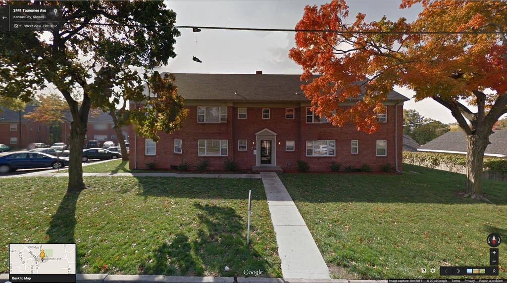
9 optimized light and ventilation. Applied ornament was non-existent. Enclosed stairways, articulated on the front of each building, provided direct entry to two apartments on each floor. The living room and bedroom in each four-room apartment had southern exposure, while the dinette, kitchen and bath faced north. This orientation kept kitchen odors out of the apartment and placed private spaces on the rear of the building away from traffic noise. Kitchen appliances, including a garbage disposal, were electric, and hot water radiators provided heat from a central boiler in the basement of each building. All of these features were a direct reflection of the FHA design guidelines, creating a strong and distinct association between the Westheight Apartments and the FHA Section 608 funding program. The stands in stark contrast with contemporary residential development in Wyandotte County. The desire of families to move away from congested urban areas and the availability of ample open land prompted low-density development on an unprecedented scale in Wyandotte County during this period. 7 Suburban growth expanded the city outward from downtown Kansas City, Kansas. Some projects occurred north of developed areas, but the primary growth was west of downtown along the major east-west transportation routes. The 2000 U.S. Housing Census recorded roughly twelve thousand dwellings in Wyandotte County that had been built prior to That same report identified more than twenty-three thousand dwellings that had been constructed between 1940 and 1959, nearly double the number of housing units previously existing. 8 The overwhelming majority (99.5%) of housing units constructed in Wyandotte County during the mid-twentieth century ( ) were single-family dwellings. During this period the Kansas City Kansan documented hundreds of plats for new residential subdivisions that were approved by the Wyandotte County Planning Commission. 9 These subdivisions varied greatly in size, from four lots to eight hundred lots. Although one development included a small number of duplex units, all of the approved plats were for single-family residences. 10 While not all of the projects were completed precisely as planned or within that fifteen-year window, developers did produce single-family dwellings on roughly 7,300 lots. 11 Neighboring Johnson County, Kansas and Jackson, Clay and Platte Counties, Missouri experienced parallel rates of suburban single-family residential development. Within the local context of mid-twentieth century multi-family housing development, the Westheight Apartments Historic District is unique in Wyandotte County for its architectural style. Six of seven contemporary multi-family developments utilized simplified variations of Colonial Revival architecture, which was also popular at the time for single-family houses. Two developments set the architectural precedent for mid-century multi-family housing projects in Wyandotte County. Fairfax Hills (1945), a private development utilizing FHA financing, and Hovey Place (c. 1945), a public housing project, were completed prior to the end of the war to house defense industry workers. The forty-eight buildings at Fairfax (Figures 6 and 7) and ninety-four buildings at Hovey Place (Figures 8 and 9) used Colonial Revival architecture with brick and wood (now vinyl) siding, respectively. Both developments intermingled several building types, each basic rectangular plan containing a different number of units and adorned with different Colonial Revival elements. Although these projects were completed prior to the issuance of the FHA Guidelines in 1947, they reflect typical design elements applied to multi-family housing in Wyandotte County during the mid-twentieth century. In addition to the Westheight Apartments, two multi-family developments in Wyandotte County are known to have used Section 608 financing: the Wyandotte Apartments and the Hillcrest Village Garden Apartments. The Wyandotte Apartments (25 th Street south of Minnesota Avenue) offered forty-eight units in six eight-unit buildings. The buildings had red brick walls, gabled roofs, and Georgian Revival pedimented surrounds at each entry (Figures 12 and 13). Erected in , this was the largest single private housing project in Wyandotte County since the opening in 1945 of the much larger Fairfax Hills project. Contractor C. Wells Haren, a principal investor in the Wyandotte Apartments, was very active in post-war development throughout Wyandotte and Johnson Counties, Kansas. Roughly that same year, a St. Louis 7 The statistics used in this paragraph come from different sources that use different periods of time for data analysis. Despite this, the time periods overlap enough to provide a general picture of suburban development in Wyandotte County. 8 Profile of Selected Housing Characteristics: 2000, U.S. Census Bureau, Census 2000 Summary File 3, Matrices H1, H7, H20, H23, H24, H30, H34, H38, H40, H43, H44, H48, H51, H62, H63, H69, H74, H76, H90, H91, and H94. 9 Regular articles from the Kansas City Kansan, March 13, 1946 November 8, 1955, Microfilm, Wyandotte County Museum, courtesy of Monte Gross. 10 Begin New Housing Development The Kansas City Kansan, March 13, 1946, Microfilm, Wyandotte County Museum, courtesy of Monte Gross. 11 Kevin Fox Gotham, Race, Real Estate, and Uneven Development, (Albany, NY: State University of New York Press, 2002), 62.
10 developer erected the Hillcrest Village Garden Apartments at 34 th and Minnesota. This $2 million, 200-unit development required the city to extend Minnesota Avenue west from 29 th Street to 33 rd Street, bridging the divide between multi-family and suburban projects (Figures 14 and 15). The eight-unit buildings are identical to one another, with their two-story rectangular massing, symmetrical brick façades with pedimented porticos at the center entrances, and gabled roofs. Wide and narrow rectangular window openings pierce the front and back elevation of each building. The two multi-family developments constructed after the Westheight Apartments, between 1959 and 1965, also applied restrained Colonial Revival designs to attached townhouse dwellings. The small development at 38 th Street and Montadon Lane has four buildings, while the much larger development at 2 nd Street and Stewart Avenue originally had ninety-seven buildings, although only half are extant (Figures 10 and 11). 12 The buildings at both of these developments are simplified, enlarged versions of contemporary single-family dwellings reconfigured to contain four to eight apartment units. The red brick walls with the center pedimented entry, side-gable roof with projecting chimneys, and tripartite picture windows resemble large single-family dwellings. Only two other mid-twentieth century developments in Wyandotte County are architecturally comparable to the Westheight Apartments, neither of which retain integrity. The two 12-unit buildings located immediately south of the District on Everett Avenue were constructed in 1947 (Figures 16 and 17). The simple unornamented brick façades and flat roofs of the U- shaped buildings allude to the Modern Movement aesthetics then gaining popularity. These features aside, traditional elements dominate the designs, including bilateral symmetry, punched window openings with hung sashes, stone foundations, and continuous balconies that access the second-story units. A non-historic balcony with wood posts and railings replaced the historic brick posts and iron railings on the east building, and both buildings have vinyl replacement windows. The Hawthorne Apartments at Parkwood Boulevard and Brown Avenue (Figures 18 and 19), constructed around 1952, provides the best comparison to the Westheight Apartments. 13 The six L-shaped brick buildings had flat roofs, projecting entrances and stair towers, and wide window openings at the corners. Two of the six buildings have been demolished; hipped roofs have been added to the extant buildings; and the windows openings have been altered to accommodate smaller, vinyl windows. The loss of integrity suffered by these developments enhances the significance of the District as the best extant example of a mid-century Modern Movement multi-family development in Wyandotte County. PROPERTY HISTORY The four buildings that comprise the were constructed by a single father-son development team between 1947 and The property sits just east of the upscale Westheight Manor neighborhood that developed before World War II. These parcels, part of the West Height Manor No. 4 Addition, remained undeveloped before the war, at which time a handful of modest single-family dwellings occupied scattered lots on the adjacent blocks. The first notice of new development in the area appeared in April 1947 when architect John Maultsby, Jr. put forward a plan for an 84-unit, 11-story apartment building on this stretch of Washington Boulevard. The project received preliminary approval from the City but never materialized after neighbors raised concerns about traffic issues that would stem from a development of that density. The next month, May 1947, the Kansas City Kansan reported zoning approval for a 24-unit housing project at Everett Street, on the block south of the nominated properties. On these lots builder Thomas C. Tudor, Jr. and service station operator Steve Hawkins developed two 12-unit U-shaped buildings. 12 While no definitive documentation was found that these developments used FHA financing, it is assumed that they did given the ubiquity of the financing vehicle. 13 It is also unknown if this development used FHA financing. 14 Unless otherwise noted, information in this section comes from articles published in the Kansas City Kansan provided to Rosin Preservation by Monte Gross, researcher with the Wyandotte County Museum.
11 Later that summer, in August 1947, permits were issued for construction of a 12-unit apartment building on Washington Boulevard by the father and son team of Fred and Robert Earnheart. The $50,000 project at Washington Boulevard was designated the Solar Apartments. It would be a three-story building (with a raised basement) of fire-proof concrete construction clad with brick and tile on the exterior. The elder Earnheart was a sales manager for the American Sash and Door Company. The younger Earnheart was the project architect in conjunction with his employers, the firm of Neville Sharp and Simon. Robert Eldridge was the builder. When the Solar Apartments opened in September 1948, the local newspaper noted that it was entirely occupied by the families of World War II veterans, including Robert Earnheart. The article also noted that the project complied with FHA regulations. With the first building complete, the Earnhearts were able to fund the second piece of their development, the Terrace Apartments ( Washington Boulevard), on the lots immediately west of the Solar Apartments. This 20-unit building was announced in March The facades, unit layouts, and building features were identical to those of the Solar Apartments, but arrayed in a longer single mass. Early in 1952 the Earnhearts completed their development boomlet with the opening of twenty additional housing units in two adjacent buildings called the West Terrace Apartments ( and Washington Boulevard) (Figure 5). These buildings mimicked the facades, materials and key design features of the earlier buildings, with slight variations in the façade to accommodate studio and two-bedroom apartments instead of one-bedroom units. The basements housed laundry rooms, incinerators and lockers. The buildings remain under common ownership and serve their historic function. Architect Robert Earnheart was born in Kansas City in July He received his architecture degree from the University of Kansas in 1943 before performing military service as a U.S. Naval Reserve officer during World War II. Following his discharge, Earnheart joined the noted Kansas City architecture firm Neville, Sharp and Simon as a draftsman. He later worked for Marshall & Brown before becoming a partner with Earl Wilson in Wilson & Earnheart, Architects in Among the projects listed in his 1956 AIA biography were the Solar Apartments, the Wyandotte County Juvenile Detention Home, and the Webster, Morse and Snow (now Rushton) Schools. 15 That year Earnheart continued to reside at 1633 Washington Boulevard and worked from offices just down the block at 1645 Washington Boulevard. It appears that Earnheart moved shortly thereafter for graduate studies in urban planning at the University of Iowa. While in Iowa in the mid-1960s he designed the Johnson County Home in Iowa City and the Muscatine County Home in Muscatine. In 1970, he moved to Guilford County, North Carolina to work in the County Building Department. 16 CONCLUSION The is a distinct and cohesive Modern Movement expression (exterior and interior) of FHA design guidelines applied to multiple buildings erected incrementally to provide housing for military veterans in the years following World War II. The flat roofs, geometric massing, and ornament-free exteriors retain integrity and clearly express the period of construction. They stand in stark contrast with contemporary developments that utilized traditional, historically-derived design idioms to communicate associations with the single-family residences that dominated new housing construction in Wyandotte County during the mid-twentieth century. On the interior, the Westheight Apartments feature unit plans and direct-access stairwells that are straight from the FHA design manual. Replacement of windows has not altered the size or shape of window openings, the configuration of large sliding sashes, or the strategic crossventilation inherent in unit layouts and window design. Neither updated interior finishes nor the loss of rear solar louvers 15 Earnheart, R(obert) E(ugene), American Architects Directory First edition, 1956 Copyright December 1955 R.R. Bowker LLC, (accessed June 2, 2014). 16 Earnheart, Robert Eugene, American Architects Directory Third edition, 1970 Copyright 1970 R.R. Bowker LLC.
12 diminishes the ability of the District to communicate its associations with the FHA veteran s housing initiative and its unique forward-looking embrace of Modern Movement design.
13 9. Major Bibliographical References Bibliography (Cite the books, articles, and other sources used in preparing this form.) Begin New Housing Development, The Kansas City Kansan, March 13, Microfilm. Wyandotte County Museum, courtesy of Monte Gross. Earnheart, Robert Eugene. American Architects Directory First edition Copyright December 1955 R.R. Bowker LLC, < n%20architects%20directory/bowker_1956_e.pdf. Accessed June 2, Earnheart, Robert Eugene. American Architects Directory Third edition Copyright 1970 R.R. Bowker LLC. < n%20architects%20directory/bowker_1970_e.pdf.> Erlich, George. Kansas City, MO: An Architectural History, , revised and enlarged edition. Columbia, MO: University of Missouri Press: Federal Housing Administration. The FHA Story in Summary, Washington, DC: Federal Housing Administration, Gotham, Kevin Fox. Race, Real Estate, and Uneven Development. Albany, NY: State University of New York Press, Kansas City Kansan, March 13, 1946 November 8, Microfilm. Wyandotte County Museum, courtesy of Monte Gross. In Out Awnings a Feature in New Apartments. The Kansas City Kansan, 19 Sept From the collection of Monte Gross. Planning Rental Housing Projects. Washington, DC: Federal Housing Authority, Profile of Selected Housing Characteristics: 2000, U.S. Census Bureau, Census 2000 Summary File 3, Matrices H1, H7, H20, H23, H24, H30, H34, H38, H40, H43, H44, H48, H51, H62, H63, H69, H74, H76, H90, H91, and H94. Previous documentation on file (NPS): Primary location of additional data: x preliminary determination of individual listing (36 CFR 67 has been X State Historic Preservation Office requested) Other State agency previously listed in the National Register Federal agency previously determined eligible by the National Register Local government designated a National Historic Landmark University recorded by Historic American Buildings Survey # X Other recorded by Historic American Engineering Record # Name of repository: Wyandotte County Museum recorded by Historic American Landscape Survey # Historic Resources Survey Number (if assigned): 10. Geographical Data Acreage of Property Approx. 1.4 acres
14 Provide latitude/longitude coordinates OR UTM coordinates. (Place additional coordinates on a continuation page.) Latitude/Longitude Coordinates Datum if other than WGS84: (enter coordinates to 6 decimal places) Latitude: Longitude: Latitude: Longitude: 2 4 Latitude: Longitude: Latitude: Longitude: Verbal Boundary Description (describe the boundaries of the property) The is bounded on the north by Washington Blvd, on the south by Everett Ave, and by alleys between these two streets to the east and west. Boundary Justification (explain why the boundaries were selected) These boundaries follow property lines surrounding the four apartment buildings as they were delineated historically and presently. The boundaries of the district include all four apartment buildings built by the Earnhart development team between 1947 and Form Prepared By name/title Rachel Nugent, Sr. Historic Preservation Specialist; Ellis Mumford-Russell, Historic Preservation Spec. organization Rosin Preservation date January 2015 street & number 215 W 18 th St, Suite 150 telephone city or town Kansas City state MO rachel@rosinpreservation.com Property Owner: (complete this item at the request of the SHPO or FPO) name Ognen Borisov, Westheight Apartments, LLC street & number 1621 Washington Boulevard, #17 telephone city or town Kansas City state KS zip code Paperwork Reduction Act Statement: This information is being collected for applications to the National Register of Historic Places to nominate properties for listing or determine eligibility for listing, to list properties, and to amend existing listings. Response to this request is required to obtain a benefit in accordance with the National Historic Preservation Act, as amended (16 U.S.C.460 et seq.). Estimated Burden Statement: Public reporting burden for this form is estimated to average 100 hours per response including time for reviewing instructions, gathering and maintaining data, and completing and reviewing the form. Direct comments regarding this burden estimate or any aspect of this form to the Office of Planning and Performance Management. U.S. Dept. of the Interior, 1849 C. Street, NW, Washington, DC.
15 Additional Documentation Submit the following items with the completed form: Photographs Submit clear and descriptive photographs. The size of each digital image must be 1600x1200 pixels (minimum), at 300 ppi (pixels per inch) or larger. Key all photographs to a sketch map or aerial map. Each photograph must be numbered and that number must correspond to the photograph number on the photo log. For simplicity, the name of the photographer, photo date, etc. may be listed once on the photograph log and doesn t need to be labeled on every photograph. Photograph Log : City or Vicinity: Kansas City County: Wyandotte County State: Kansas Photographer: Date Photographed: July Brad Finch, F-Stop Photography Description of Photograph(s) and number, include description of view indicating direction of camera: 1 of 26: Site from across Washington, view southeast 2 of 26: Washington, front (north) elevation, view south 3 of 26: Washington, front and east elevations, view southwest 4 of 26: Washington, rear (south) elevation, view northwest 5 of 26: Washington, front (north) elevation, view south 6 of 26: Washington, rear (south) elevation, view east 7 of 26: Washington, front (north) elevation, view southeast 8 of 26: Washington, front (north) elevation, view southwest 9 of 26: Washington, rear (south) elevation, view northwest 10 of 26: Washington, front (north) and west elevations, view southeast 11 of 26: Washington, rear (south) elevation, view northeast 12 of 26: Washington, rear (south) and east elevations, view northwest 13 of 26: Typical entry/stair tower 14 of 26: View west along sidewalk from 1621 Washington 15 of 26: Stair hall, Washington, view southeast 16 of 26: Stair hall, Washington, view northeast 17 of 26: Stair hall, 1609 Washington (typical), view southeast 18 of 26: Stair hall, 1613 Washington (typical), view northeast 19 of 26: Stair hall, 1625 Washington (typical), view northwest 20 of 26: Stair hall, 1625 Washington (typical), view northwest 21 of 26: Typical apartment entry door/dining area 22 of 26: Typical apartment entry door/dining area 23 of 26: Typical apartment living room 24 of 26: Typical apartment bedroom 25 of 26: Typical apartment hall 26 of 26: Typical apartment bathroom Figure Log
16 Figure 1.. Site map. ArcGIS, Figure 2.. Site Map. Google Earth, Figure 3. Context Map. ArcGIS, Figure 4. Photo Map. Bing Maps, Figure 5. The Kansas City Kansan. Illustration from newspaper article depicting the West Terrace Apartments. Note the windows with sliding sashes. Figure 6. Fairfax Hills site map. Google Maps, Figure 7. Fairfax Hills. Typical Building. Brad Finch, Figure 8. Hovey Place site plan. Google Maps, Figure 9. Hovey Place. Typical Building. Google Streetview, Figure nd Street & Stewart Avenue site plan. Google Maps, Figure nd Street & Stalwart Avenue. Typical Building. Google Streetview, Figure 12. Wyandotte Apartments site plan. Google Maps, 2014 Figure 13. Wyandotte Apartments. Typical Building. Google Streetview, Figure 14. Hillcrest Village Garden Apartments site plan. Google Maps, Figure 15. Hillcrest Village Garden Apartments. Typical Building. Google Streetview, Figure 16. Everette Avenue Apartments site plan. Google Maps, Figure 17. Everett Avenue apartments. Rosin Preservation, Figure 18. Hawthorne Apartments site plan. Google Maps, Figure 19. Hawthorne Apartments. Typical Building. Google Streetview, Figure 20. Westheight Apartments. Typical 1 bedroom unit. Figure 21. FHA Plan, Typical 1 bedroom unit. Source: Planning Rental Housing Projects, (Washington, DC: Federal Housing Authority, 1947).
 Lat/Long: 39.")
17 Figure 1.. Site map. ArcGIS, Kansas City, (Datum: WGS84) Lat/Long: ,

")
18 Figure 2.. Site Map. Google Earth, Figure 3. Context Map. ArcGIS, Kansas City, (Datum: WGS84) Lat/Long: ,


19 Figure 4. Photo Map. Bing Maps, Figure 5. The Kansas City Kansan. Illustration from newspaper article depicting the West Terrace Apartments. Note the windows with sliding sashes.


20 Figure 6. Fairfax Hills site map. Google Maps, Figure 7. Fairfax Hills. Typical Building. Brad Finch, 2008.


21 Figure 8. Hovey Place site plan. Google Maps, Figure 9. Hovey Place. Typical Building. Google Streetview, 2011.

22 Figure nd Street & Stewart Avenue site plan. Google Maps, Figure nd Street & Stalwart Avenue. Typical Building. Google Streetview, 2011.

23

24 Figure 12. Wyandotte Apartments site plan. Google Maps, 2014 Figure 13. Wyandotte Apartments. Typical Building. Google Streetview, 2011.
25


26 Figure 14. Hillcrest Village Garden Apartments site plan. Google Maps, Figure 15. Hillcrest Village Garden Apartments. Typical Building. Google Streetview, 2011.


27 Figure 16. Everette Avenue Apartments site plan. Google Maps, Figure 17. Everett Avenue apartments. Rosin Preservation, 2014.


28 Figure 18. Hawthorne Apartments site plan. Google Maps, Figure 19. Hawthorne Apartments. Typical Building. Google Streetview, 2011.
29 Figure 20. Westheight Apartments. Typical Floor plan. Figure 21. FHA Plan, Typical 1 bedroom unit. Source: Planning Rental Housing Projects, (Washington, DC: Federal Housing Authority, 1947).

30
1. Name of Property Historic name: Other names/site number: Name of related multiple property listing:
 United States Department of the Interior National Park Service National Register of Historic Places Registration Form This form is for use in nominating or requesting determinations for individual properties
NATIONAL REGISTER NOMINATION CHECK-OFF LIST (Revised )
") Office of Archaeology and Historic Preservation History Colorado Publication #1413a NATIONAL REGISTER NOMINATION CHECK-OFF LIST (Revised 2-2015) This check-off list is to insure that all necessary materials
Office of Archaeology and Historic Preservation History Colorado Publication #1413a NATIONAL REGISTER NOMINATION CHECK-OFF LIST (Revised 2-2015) This check-off list is to insure that all necessary materials
II' i. Entered in the National Register. National Register of Historic Places Registration Form. historic name other names/site number
 NPS Form 10-900 (Rev. 10-90) RECEIVED DPmvFH 2280 ***, 11""-* OMBNo. 1024-0018 Registration Form SEP ' w96 This form is for use in nominating or requesting determinations for individual properties and
NFS Form (Rev )
") NFS Form 10-900 (Rev. 10-90) OMB No. 1fl?4-QQia RECEIVED 2280 MAY I 9 1998 NAT. REGISTER OF HISTORIC PLACES NATIONAL PARK SERVICE This form is for use in nominating or requesting determinations for individual
NFS Form 10-900 (Rev. 10-90) OMB No. 1fl?4-QQia RECEIVED 2280 MAY I 9 1998 NAT. REGISTER OF HISTORIC PLACES NATIONAL PARK SERVICE This form is for use in nominating or requesting determinations for individual
Current Functions (Enter categories from instructions) 02D01: Commerce / financial / savings and loan 11D03: doctor office chiropractic
 02D01: Commerce / financial / savings and loan 11D03: doctor office chiropractic") Site Inventory Form State Inventory No. 92-00550 New Supplemental State Historical Society of Iowa Part of a district with known boundaries (enter inventory no.) 92-00349 (November 2005) Relationship:
Site Inventory Form State Inventory No. 92-00550 New Supplemental State Historical Society of Iowa Part of a district with known boundaries (enter inventory no.) 92-00349 (November 2005) Relationship:
Current Functions (Enter categories from instructions) Materials (Enter categories from instructions)
 Materials (Enter categories from instructions)") Site Inventory Form State Inventory No. 92-00584 New Supplemental State Historical Society of Iowa Part of a district with known boundaries (enter inventory no.) 92-00349 (November 2005) Relationship:
Site Inventory Form State Inventory No. 92-00584 New Supplemental State Historical Society of Iowa Part of a district with known boundaries (enter inventory no.) 92-00349 (November 2005) Relationship:
The City of Titusville Historic Preservation Board Local Historic Resource Nomination Form
 The City of Titusville Historic Preservation Board Local Historic Resource Nomination Form 1. Location Street Address City Titusville State Florida Zip Code 2. Property Owner Owner Name Address (if different
1. Name of Property. other names/site number Downtown Survey Map # DT- 053
 Site Inventory Form State Inventory No. 92-00510 New Supplemental State Historical Society of Iowa Part of a district with known boundaries (enter inventory no.) 92-00349 (November 2005) Relationship:
Infill & Other Residential Design Review
 Infill & Other Residential Design Review December 2018 Infill and Other Residential Design Review applies to projects that are located within the Infill Regulations District, on properties immediately
5^3 CAM MAY United States Department of the Interior National Park Service
 NPS Fonn 10-900 (Oct 1990) United States Department of the Interior National Park Service NATIONALREGISTER OFHISTORIC PLACES REGISTRATIONFORM PECtlVEO 2290 MAY - 6 1997 OMB No. 10024-0018 5^3 1. NAME OF
1 Total Total. Current Functions (Enter categories from instructions) Materials (Enter categories from instructions)
 Materials (Enter categories from instructions)") Site Inventory Form State Inventory No. 29-03663 New Supplemental State Historical Society of Iowa Part of a district with known boundaries (enter inventory no.) (November 2005) Relationship: Contributing
Site Inventory Form State Inventory No. 29-03663 New Supplemental State Historical Society of Iowa Part of a district with known boundaries (enter inventory no.) (November 2005) Relationship: Contributing
The City of Titusville Historic Preservation Board Local Historic Resource Nomination Form
 The City of Titusville Historic Preservation Board Local Historic Resource Nomination Form 1. Location Street Address Original Street Name (if any) City Titusville State Florida Zip Code Streets that form
The City of Titusville
 The City of Titusville Historic Preservation Board Local Historic Resource Nomination Form 1. Location Street Address Original Street Name (if any) City Titusville State Florida Zip Code Streets that form
Sickels Laundry and Dry Cleaning
 Site Inventory Form State Inventory No. 29-03677 New Supplemental State Historical Society of Iowa Part of a district with known boundaries (enter inventory no.) 29-03685 (November 2005) Relationship:
NATIONAL HISTORIC LANDMARK NOMINATION NPS Form USDI/NPS NRHP Registration Form (Rev. 8-86) OMB No OLD MOBILE SITE
 OMB No OLD MOBILE SITE") NATIONAL HISTORIC LANDMARK NOMINATION OLD MOBILE SITE Page 1 1. NAME OF PROPERTY Historic Name: OLD MOBILE SITE Other Name/Site Number: 2. LOCATION Street & Number: City/Town: Not for publication: X Vicinity:
NATIONAL HISTORIC LANDMARK NOMINATION OLD MOBILE SITE Page 1 1. NAME OF PROPERTY Historic Name: OLD MOBILE SITE Other Name/Site Number: 2. LOCATION Street & Number: City/Town: Not for publication: X Vicinity:
other names/site number Downtown Survey Map # J-143
 Site Inventory Form State Inventory No. 29-01123 New Supplemental State Historical Society of Iowa Part of a district with known boundaries (enter inventory no.) 29-03685, 29-00001 (November 2005) Relationship:
Current Functions (Enter categories from instructions) Materials (Enter categories from instructions)
 Materials (Enter categories from instructions)") Site Inventory Form State Inventory No. 29-00089 New Supplemental State Historical Society of Iowa Part of a district with known boundaries (enter inventory no.) 29-03522 (November 2005) Relationship:
Site Inventory Form State Inventory No. 29-00089 New Supplemental State Historical Society of Iowa Part of a district with known boundaries (enter inventory no.) 29-03522 (November 2005) Relationship:
0 buildings sites structures 0 objects. 0 Total. Name of related multiple property listing: Historic and Architectural Resources of Nacogdoches, Texas
 NPS Form 10-900 (Rev. 8-86) United States Department of the Interior National Park Service NATIONAL REGISTER OF HISTORIC PLACES REGISTRATION FORM OMB No. 1024-0018 N -1 r-'.-, p ^ \ * i I ^ I i u \S If!
Site Inventory Form State Inventory No New Supplemental
 Site Inventory Form State Inventory No. 70-00940 New Supplemental State Historical Society of Iowa Part of a district with known boundaries (enter inventory no.) (December 1, 1999) Relationship: Contributing
Wyman Historic District
 Wyman Historic District DISTRICT DESCRIPTION The Wyman Historic District is a large district that represents the many architectural styles in fashion between the late 1800s through 1955. With the establishment
CALIFORNIA. cfr. i l fi ERIC GARCETTI MAYOR
 DEPARTMENT OF CITY PLANNING 200 N. Spring Street, Room 272 LOS ANGELES, CA 90012-4801 CULTURAL HERITAGE COMMISSION RICHARD BARRON PRESIDENT GAILKENNARD VICE PRESIDENT PILAR BUELNA DIANE KANNER BARRY MILOFSKY
NEW HAMPSHIRE HISTORIC PROPERTY DOCUMENTATION LESSARD HOUSE NH STATE NO Second Avenue, Berlin, Coos County, New Hampshire
 NEW HAMPSHIRE HISTORIC PROPERTY DOCUMENTATION LESSARD HOUSE NH STATE NO. 695 Location:, Berlin, Coos County, New Hampshire USGS Berlin Quadrangle UTM Coordinates: Z19 4926222N 326139E Present Owner: Present
1. Name of Property. historic name Coonradt, Ernest E. and Ruth G., House. other names/site number. 2. Location
 Site Inventory Form State Inventory No. 09-00875 New Supplemental State Historical Society of Iowa Part of a district with known boundaries (enter inventory no.) 09-00962 (November 2005) Relationship:
National Register of Historic Places Registration Form
 1 United States Department of the Interior National Park Service National Register of Historic Places Registration Form This form is for use in nominating or requesting determinations for individual properties
Submitted to Fire Station 8 Working Group and Arlington County Public Library HOUSE AT 2211 NORTH CULPEPER STREET
 Submitted to Fire Station 8 Working Group and Arlington County Public Library HOUSE AT 2211 NORTH CULPEPER STREET Location: 2211 North Culpeper Street, Arlington, Virginia. Significance: The house at 2211
Current Functions (Enter categories from instructions) Materials (Enter categories from instructions)
 Materials (Enter categories from instructions)") Site Inventory Form State Inventory No. 92-00503 New Supplemental State Historical Society of Iowa Part of a district with known boundaries (enter inventory no.) 92-00349 (November 2005) Relationship:
Site Inventory Form State Inventory No. 92-00503 New Supplemental State Historical Society of Iowa Part of a district with known boundaries (enter inventory no.) 92-00349 (November 2005) Relationship:
other names/site number Downtown Survey Map # J-135
 Site Inventory Form State Inventory No. 29-01109 New Supplemental State Historical Society of Iowa Part of a district with known boundaries (enter inventory no.) 29-03685, 29-00001 (November 2005) Relationship:
laaj 1-11S90- NATIONAL REGISTER OMB No NPS Form (Rev, 8-86)
") NPS Form 10-900 (Rev, 8-86) OMB No. 1024-0018 United States Departaent of the Interior National Park Service NATIONAL REGISTER OF HISTORIC PLACES REGISTRATION FORM J laaj 1-11S90- NATIONAL REGISTER i 1.
NPS Form 10-900 (Rev, 8-86) OMB No. 1024-0018 United States Departaent of the Interior National Park Service NATIONAL REGISTER OF HISTORIC PLACES REGISTRATION FORM J laaj 1-11S90- NATIONAL REGISTER i 1.
Site Inventory Form State Inventory No New Supplemental
 Site Inventory Form State Inventory No. 70-00938 New Supplemental State Historical Society of Iowa Part of a district with known boundaries (enter inventory no.) (December 1, 1999) Relationship: Contributing
M E M O R A N D U M PLANNING AND COMMUNITY DEVELOPMENT DEPARTMENT CITY OF SANTA MONICA PLANNING DIVISION
 M E M O R A N D U M 10-A PLANNING AND COMMUNITY DEVELOPMENT DEPARTMENT CITY OF SANTA MONICA PLANNING DIVISION DATE: May 14, 2018 TO: FROM: SUBJECT: The Honorable Landmarks Commission Planning Staff 1314
Historic Property Report
 Location Address: Geographic Areas: Information Number of stories: 1326 E Club Ct, Spokane, WA, 99203, USA Spokane Certified Local Government, Spokane County, T25R43E32, SPOKANE SW Quadrangle N/A Construction
NEW HAMPSHIRE HISTORIC PROPERTY DOCUMENTATION DINARDO-DUPUIS HOUSE NH STATE NO Wight Street, Berlin, Coos County, New Hampshire
 NEW HAMPSHIRE HISTORIC PROPERTY DOCUMENTATION DINARDO-DUPUIS HOUSE NH STATE NO. 696 Location:, Berlin, Coos County, New Hampshire USGS Berlin Quadrangle UTM Coordinates: Z19 4926650N 325990E Present Owner:
Architectural Inventory Form
 OAHP1403 Rev. 9/98 COLORADO CULTURAL RESOURCE SURVEY Architectural Inventory Form Official eligibility determination (OAHP use only) Date Initials Determined Eligible- NR Determined Not Eligible- NR Determined
Durant Ave., Berkeley
 Page 1 of 6 Attachment: 2121-2123 Durant Ave., Berkeley Proposed Project Analysis for New Construction Prepared for: Kahn Design Associates 1810 6 th Street Berkeley, CA. 94710 19 December 2014 Revised
IMPORTANT NOTICE. Architectural Inventory Form COLORADO CULTURAL RESOURCE SURVEY I. IDENTIFICATION. 519 West 19th Street 5PE.6460
 IMPORTANT NOTICE OAHP1403 Rev. 9/98 COLORADO CULTURAL RESOURCE SURVEY Architectural Inventory Form Page 1 This survey form represents an UNOFFICIAL COPY and is provided for informational purposes only.
STAFF DESIGN REVIEW RESIDENTIAL BUILDING APPLICATION SUPPLEMENT
 STAFF DESIGN REVIEW RESIDENTIAL BUILDING APPLICATION SUPPLEMENT OFFICIAL USE ONLY Case #: Received By: Master File #: Project Planner: Date: Related Cases: Single Family, including Townhomes (ln-fill housing
CITY OF MERCED SMALL LOT SINGLE-FAMILY HOME DESIGN GUIDELINES
 CITY OF MERCED SMALL LOT SINGLE-FAMILY HOME DESIGN GUIDELINES Development Services Department Planning and Permitting Adopted August 15, 2005 SMALL LOT SINGLE FAMILY HOME GUIDELINES A. Purpose and Applicability.
Rock Island County Courthouse History & Significance
 1 Rock Island County Courthouse History & Significance HISTORY: The Rock Island County Courthouse was built in 1896 in downtown Rock Island. Rock Island County was established in 1833 and Stephenson, as
Memorandum. Historic Resources Inventory Survey Form 315 Palisades Avenue, 1983.
 Memorandum TO: Roxanne Tanemori, City of Santa Monica DATE: August 30, 2007 CC: FROM: Jon L. Wilson, M.Arch., Architectural Historian RE: Preliminary Historic Assessment: 315 Palisades Avenue (APN 4293-015-015)
DHR Resource Number: AVON STREET
 DHR Resource Number: 104-5082-0089 309 AVON STREET 309 Avon Street Parcel ID: 580127000 DHR Resource Number: 104-5082-0089 Primary Resource: Store, Spudnuts (contributing) Date: 1960 Commercial Style Site
National Register of Historic Places Registration Form
 NPS Form 10-900 OMB No. 1024-0018 (Expires 5/31/2012) United States Department of the Interior National Register Listed National Park Service 4-15-2011 National Register of Historic Places Registration
other names/site number Downtown Survey Map # J-158, J-159
 Site Inventory Form State Inventory No. 29-01136, 29-01137 New Supplemental State Historical Society of Iowa Part of a district with known boundaries (enter inventory no.) 29-03685, 29-00001 (November
Appendix C: Historic Preservation and Guideline Information
 Appendix C: Historic Preservation and Guideline Information The following Web sites offer relevant information pertaining to preservation: Regulations for the State Preservation Statute (Kansas) http://www.kshs.org/resource/statestatute.htm
HISTORIC RESOURCE SURVEY FORM University of Oregon Cultural Resources Survey Eugene, Lane County, Oregon Summer 2006
 HISTORIC RESOURCE SURVEY FORM University of Oregon Cultural Resources Survey Eugene, Lane County, Oregon Summer 2006 RESOURCE IDENTIFICATION Current building name: Condon Hall Historic building name: Science
Steve Mizokami Senior Planner, City of Santa Monica. From: Christine Lazzaretto, Principal; Heather Goers, Architectural Historian Date: April 3, 2018
 To: Steve Mizokami Senior Planner, City of Santa Monica 1 From: Christine Lazzaretto, Principal; Heather Goers, Architectural Historian Date: April 3, 2018 INTRODUCTION Per your request, Historic Resources
National Register of Historic Places Registration Form
 United States Department of the Interior National Register Listed National Park Service 8-23-2011 National Register of Historic Places Registration Form This form is for use in nominating or requesting
NOV ' NATIONAL REGiSTER. NPS Form (Rev. 8-86) OMB No
 OMB No") NPS Form 10-900 (Rev. 8-86) United States Departaent of the Interior National Park Service NATIONAL REGISTER OF HISTORIC PLACES REGISTRATION FORM OMB No. 1024-0018 LJ NOV 1 41390' NATIONAL REGiSTER I S3?
NPS Form 10-900 (Rev. 8-86) United States Departaent of the Interior National Park Service NATIONAL REGISTER OF HISTORIC PLACES REGISTRATION FORM OMB No. 1024-0018 LJ NOV 1 41390' NATIONAL REGiSTER I S3?
Composition of traditional residential corridors.
 Page 1 of 7 St. Petersburg, Florida, Code of Ordinances >> PART II - ST. PETERSBURG CITY CODE >> Chapter 16 - LAND DEVELOPMENT REGULATIONS >> SECTION 16.20.060. CORRIDOR RESIDENTIAL TRADITIONAL DISTRICTS
Architectural Inventory Form
 OAHP1403 Rev. 9/98 COLORADO CULTURAL RESOURCE SURVEY Architectural Inventory Form Official eligibility determination (OAHP use only) Date Initials Determined Eligible- NR Determined Not Eligible- NR Determined
Criteria Evaluation: Landmark staff found that the structure application meets History Criteria 1a, and Architecture Criterion 2a and 2b.
 To: Landmark Preservation Commission From: Kara Hahn, Principal Planner, Community Planning & Development (CPD) Date: October 9, 2018 RE: Landmark Designation for the Henderson House, 2600 Milwaukee Street
Maryland Historical Trust Inventory No. PG: 81B-003 Maryland Inventory of Historic Properties Form
 Maryland Historical Trust Inventory No. PG: 81B-003 Maryland Inventory of 1. Name of Property (indicate preferred name) historic other 2. Location Thrift Schoolhouse street and number 11110 Thrift Road
Architectural Narrative Columbia & Hawthorn responds to its unique location as a gateway to Little Italy and the Bay in several ways. 1. The visual ch
 Architectural Narrative Columbia & Hawthorn responds to its unique location as a gateway to Little Italy and the Bay in several ways. 1. The visual character of the building is intended to symbolically
Key for Understanding Integrity Rating and Architecture Rating used in the Showplace Square / Northeast Mission Historic Resources Survey
 Key for Understanding Integrity Rating and Architecture Rating used in the Showplace Square / Northeast Mission Historic Resources Survey Integrity Integrity, as it applies to historic preservation, is
WEST PALM BEACH REGISTER OF HISTORIC PLACES NOMINATION FORM
 WEST PALM BEACH REGISTER OF HISTORIC PLACES NOMINATION FORM City of West Palm Beach Historic Preservation Development Services Department 401 Clematis Street, P.O. Box 3366 West Palm Beach, Florida 33402
HISTORIC RESOURCE SURVEY FORM University of Oregon Cultural Resources Survey Eugene, Lane County, Oregon Summer 2006
 HISTORIC RESOURCE SURVEY FORM University of Oregon Cultural Resources Survey Eugene, Lane County, Oregon Summer 2006 RESOURCE IDENTIFICATION Current building name: Esslinger (Arthur A.) Hall Historic building
National Register of Historic Places Registration Form
 NPS Form 10-900 OMB No. 1024-0018 National Register Listed National Park Service December 4, 2013 National Register of Historic Places Registration Form This form is for use in nominating or requesting
IMPORTANT NOTICE. Architectural Inventory Form COLORADO CULTURAL RESOURCE SURVEY I. IDENTIFICATION North Grand Avenue 5PE.
 IMPORTANT NOTICE OAHP1403 Rev. 9/98 COLORADO CULTURAL RESOURCE SURVEY Architectural Inventory Form Page 1 This survey form represents an UNOFFICIAL COPY and is provided for informational purposes only.
NEW HAMPSHIRE HISTORIC PROPERTY DOCUMENTATION BICKFORD RENTAL HOUSE NH STATE NO First Avenue, Berlin, Coos County, New Hampshire
 NEW HAMPSHIRE HISTORIC PROPERTY DOCUMENTATION BICKFORD RENTAL HOUSE NH STATE NO. 689 Location:, Berlin, Coos County, New Hampshire USGS Berlin Quadrangle UTM Coordinates: Z19 4926353N 326093E Present Owner:
Memorandum. Overview. Background Information. To: Scott Albright, City of Santa Monica Date: 04/22/2013 Jan Ostashay, Principal OAC
 Memorandum P.O. Box 542 Long Beach, CA 562.500.9451 HISTORICS@AOL.COM To: Scott Albright, City of Santa Monica Date: 04/22/2013 From: Jan Ostashay, Principal OAC Re: PRELIMINARY HISTORICAL ASSESSMENT:
Architectural Inventory Form
 310 N Spruce St 5SM1775 Official Eligibility Determination OAHP1403 (OAHP use only) COLORADO CULTURAL RESOURCE SURVEY Rev. 9/98 Date Initials Determined Eligible National Register Determined Not Eligible
HISTORIC RESOURCE SURVEY FORM University of Oregon Cultural Resources Survey Eugene, Lane County, Oregon Summer 2006
 HISTORIC RESOURCE SURVEY FORM University of Oregon Cultural Resources Survey Eugene, Lane County, Oregon Summer 2006 RESOURCE IDENTIFICATION Current building name: Cascade Annex West Wing Historic building
Mary J. Berg House 2517 Regent Street
 CITY OF BERKELEY Ordinance #4694 N.S. LANDMARK APPLICATION Mary J. Berg House 2517 Regent Street Additional Photographs Streetscape showing 2511, 2517 & 2521 Regent Street 2517 Regent Street front façade
FORM A - AREA MASSACHUSETTS HISTORICAL COMMISSION MASSACHUSETTS ARCHIVES BUILDING 220 MORRISSEY BOULEVARD BOSTON, MASSACHUSETTS 02125
 FORM A - AREA MASSACHUSETTS HISTORICAL COMMISSION MASSACHUSETTS ARCHIVES BUILDING 220 MORRISSEY BOULEVARD BOSTON, MASSACHUSETTS 02125 Assessor s Sheets USGS Quad Area Letter Form Numbers in Area Town Northborough
NATIONAL REGISTER OF HISTORIC PLACES
 1501 (Rev. 07/2012) INFORMATION ON NOMINATING PROPERTIES TO THE NATIONAL REGISTER OF HISTORIC PLACES AND THE COLORADO STATE REGISTER of HISTORIC PROPERTIES National Register and State Register Programs
Urban Design Brief Dundas Street. London Affordable Housing Foundation. November Zelinka Priamo Ltd.
 Urban Design Brief 1039-1047 Dundas Street London Affordable Housing Foundation November 2017 Zelinka Priamo Ltd. TABLE OF CONTENTS Page No. INTRODUCTION... 3 SECTION 1 LAND USE PLANNING CONTEXT... 3 1.1
3.1 Existing Built Form
 3.1 Existing Built Form There is a wide variety of built form in the study area, generally comprising 2 and 3 storey buildings. This stretch of Queen Street East is somewhat atypical of Toronto's main
Historic Property Report
 Location Address: 1224 E ROCKWOOD PINES RD, SPOKANE, WA 99203 Tax No/Parcel No: 35294.0243 Plat/Block/Lot: ROCKWOOD PINES 2ND L15 Geographic Areas: Spokane County, SPOKANE NW Quadrangle, T25R43E29 Information
Architectural Inventory Form
 OAHP1403 Rev. 9/98 COLORADO CULTURAL RESOURCE SURVEY Architectural Inventory Form Official eligibility determination (OAHP use only) Date Initials Determined Eligible- NR Determined Not Eligible- NR Determined
Architectural Inventory Form
 COLORADO CULTURAL RESOURCE SURVEY Page 1 Official Eligibility Determination (OAHP use only) Date Initials Determined Eligible-National Register Determined Not Eligible - National Register Determined Eligible
Anacortes, WA. 718 commercial ave. FOR lease. 2,320 +/- sf retail space in a 10,820 +/- sf building. Located in historic downtown Anacortes
 718 commercial ave Anacortes, WA FOR lease 2,320 +/- sf retail space in a 10,820 +/- sf building Located in historic downtown Anacortes Frontage on Commercial Ave alongside four other retail spaces Zoned
Sedro woolley, WA 720 MURDOCK ST. FOR sale. 14,500 +/- sf office building with 8,500 +/- sf unfinished basement space on 0.
 720 MURDOCK ST Sedro woolley, WA FOR sale 14,500 +/- sf office building with 8,500 +/- sf unfinished basement space on 0.27 +/- AC Former City Hall built in 1930 Located in the Downtown Sedro Woolley core
National Register of Historic Places Registration Form
 NFS Form 10-900 OMBNo. 10024-0018 (Oct. 1990) United States Department of the Interior National Park Service National Register of Historic Places Registration Form 11. Name of Property historic name other
other names/site number Downtown Survey Map # J-146
 Site Inventory Form State Inventory No. 29-01129 New Supplemental State Historical Society of Iowa Part of a district with known boundaries (enter inventory no.) 29-03685, 29-00001 (November 2005) Relationship:
IMPORTANT NOTICE. Architectural Inventory Form COLORADO CULTURAL RESOURCE SURVEY I. IDENTIFICATION North Grand Avenue 5PE.
 IMPORTANT NOTICE OAHP1403 Rev. 9/98 COLORADO CULTURAL RESOURCE SURVEY Architectural Inventory Form Page 1 This survey form represents an UNOFFICIAL COPY and is provided for informational purposes only.
Plymouth 163. Place (neighborhood or village)
") USGS Quad Area(s) Form Number Plymouth 163 Town Place (neighborhood or village) Address 2 Cross Street Historic Name Uses: Present residence Original residence Date of Construction c.1850 Source maps Style/Form
USGS Quad Area(s) Form Number Plymouth 163 Town Place (neighborhood or village) Address 2 Cross Street Historic Name Uses: Present residence Original residence Date of Construction c.1850 Source maps Style/Form
Architectural Inventory Form
 COLORADO CULTURAL RESOURCE SURVEY Page 1 Official Eligibility Determination (OAHP use only) Date Initials Determined Eligible-National Register Determined Not Eligible - National Register Determined Eligible
Total 1 Total. Current Functions (Enter categories from instructions) 02F04: Commerce / department store 02E: Commerce / specialty store
 02F04: Commerce / department store 02E: Commerce / specialty store") Site Inventory Form State Inventory No. 29-01103 New Supplemental State Historical Society of Iowa Part of a district with known boundaries (enter inventory no.) 29-03685, 29-00001 (November 2005) Relationship:
Site Inventory Form State Inventory No. 29-01103 New Supplemental State Historical Society of Iowa Part of a district with known boundaries (enter inventory no.) 29-03685, 29-00001 (November 2005) Relationship:
2.2.2 The Land Use Setting
 2-6 Planning Area pearance varies dramatically from season to season. The absence of significant topographic or man-made features within the District contributes to a very open visual character that allows
- site. - structure - ob j ect. (Do not include previously listed resources in the count.)
") Terra Alta Bank Name of Property Preston Countv, WV County and State 5. Classification Ownership of Property: (Check as many boxes as - x private - public-local - public-state - public-federal Category
Terra Alta Bank Name of Property Preston Countv, WV County and State 5. Classification Ownership of Property: (Check as many boxes as - x private - public-local - public-state - public-federal Category
Places. not for Dublication ~ vicinity ~ ~ ~ KS ~ P~ code 145 zip code
 NPS Fo '0-000 "'" No. ' 24-',,".Rev. "1'0} United States Department of the Interior National Register Registration Fo of Historic Places This form is for use in nominating or requesting determinations
Total 1 Total. Current Functions (Enter categories from instructions) 02E03; Commerce/Specialty/ dry goods/notions 02G: Commerce/Restaurant
 02E03; Commerce/Specialty/ dry goods/notions 02G: Commerce/Restaurant") Site Inventory Form State Inventory No. 29-01241 New Supplemental State Historical Society of Iowa Part of a district with known boundaries (enter inventory no.) 29-03685 (November 2005) Relationship:
Site Inventory Form State Inventory No. 29-01241 New Supplemental State Historical Society of Iowa Part of a district with known boundaries (enter inventory no.) 29-03685 (November 2005) Relationship:
Current Functions (Enter categories from instructions) 14D09 Automotive Service or Repair. Materials (Enter categories from instructions)
 14D09 Automotive Service or Repair. Materials (Enter categories from instructions)") Site Inventory Form State Inventory No. 29-03504 New Supplemental State Historical Society of Iowa Part of a district with known boundaries (enter inventory no.) (November 2005) Relationship: Contributing
Site Inventory Form State Inventory No. 29-03504 New Supplemental State Historical Society of Iowa Part of a district with known boundaries (enter inventory no.) (November 2005) Relationship: Contributing
MEMORANDUM REGARDING: DATE September 13, 2016 PROJECT NO Mill Creek Residential Trust 411 Borel Avenue, Suite #405 San Mateo, CA 94402
 MEMORANDUM DATE September 13, 2016 PROJECT NO. 16137 TO Dave Fiore PROJECT 2190 Shattuck Avenue OF Mill Creek Residential Trust 411 Borel Avenue, Suite #405 San Mateo, CA 94402 FROM Katherine Wallace,
VIRGINIA BEACH HISTORICAL REGISTER PROGRAM INFORMATION AND NOMINATION/APPLICATION FORM INSTRUCTIONS
 VIRGINIA BEACH HISTORICAL REGISTER PROGRAM INFORMATION AND NOMINATION/APPLICATION FORM INSTRUCTIONS Program Information: The Virginia Beach Historical Register was established by the Virginia Beach City
Architectural Inventory Form
 COLORADO CULTURAL RESOURCE SURVEY Page 1 Official eligibility determination (OAHP use only) Date Initials Determined Eligible- NR Determined Not Eligible- NR Determined Eligible- SR Determined Not Eligible-
ticv NATIONAL REGISTER NPS Form (Rev. 8-86) OMB No
 OMB No") NPS Form 10-900 (Rev. 8-86) OMB No. 1024-0018 United States Department of the National Park Service NATIONAL REGISTER OF HISTORIC PLACES REGISTRATION FORM Interior ticv 1 41990- NATIONAL REGISTER 1. Naae
NPS Form 10-900 (Rev. 8-86) OMB No. 1024-0018 United States Department of the National Park Service NATIONAL REGISTER OF HISTORIC PLACES REGISTRATION FORM Interior ticv 1 41990- NATIONAL REGISTER 1. Naae
Residential Design Guide Appendices
 Residential Design Guide Appendices Appendix 1 Thorndon Appendix 2 Mt Victoria Appendix 3 Aro Valley Appendix 4 Southern Inner Residential Areas Appendix 5 Oriental Bay Appendix 6 Residential Coastal Edge
HISTORIC PRESERVATION COMMISSION MEETING CITY OF DAVENPORT, IOWA TUESDAY, NOVEMBER 13, 2018; 6:00 PM
 HISTORIC PRESERVATION COMMISSION MEETING CITY OF DAVENPORT, IOWA TUESDAY, NOVEMBER 13, 2018; 6:00 PM CITY COUNCIL CHAMBERS 226 WEST 4TH STREET DAVENPORT, IOWA 52801 WORK SESSION I. Call to Order II. Secretary's
Elm Street School. Description of Historic Place. Heritage Value of Historic Place
 100 HISTORIC RESOURCES 2013 City of Medicine Hat Elm Street School Date of Construction 1912 Address 1001 Elm Street SE Original Owner Medicine Hat School District #76 Architect William T. Williams Contractor
Los Angeles Department of City Planning RECOMMENDATION REPORT
 Los Angeles Department of City Planning RECOMMENDATION REPORT CULTURAL HERITAGE COMMISSION HEARING DATE: October 2, 2014 TIME: 10:00 AM PLACE: City Hall, Room 1010 200 N. Spring Street Los Angeles, CA
Demolition of Three Heritage Properties in the South Rosedale Heritage Conservation District - 5, 7, and 9 Dale Avenue
 REPORT FOR ACTION Demolition of Three Heritage Properties in the South Rosedale Heritage Conservation District - 5, 7, and 9 Dale Avenue Date: January 30, 2018 To: Toronto Preservation Board Toronto and
Historic Preservation
 PETITION NUMBER - - (FOR OFFICIAL USE ONLY) DATE RECEIVED BY CITY AUDITOR AND CLERK: Historic Preservation Historic Designation Application Packet (Buildings, Sites and Districts) for the NAME OF RESOURCE
NOW, THEREFORE, THE COUNCIL OF THE CITY OF CALGARY ENACTS AS FOLLOWS:
 PUD2017-0081 ATTACHMENT 1 BYLAW NUMBER 13M2017 BEING A BYLAW OF THE CITY OF CALGARY TO DESIGNATE THE WHITE RESIDENCE AS A MUNICIPAL HISTORIC RESOURCE * * * * * * * * * * * * * * * * * * * * * * * * * *
APPENDIX E. Cultural Resources Reports
 APPENDIX E Cultural Resources Reports 1042 South La Cienega Boulevard Los Angeles Historic Resource Report Prepared by Christopher A. Joseph & Associates 11849 W. Olympic Boulevard,
CRITERIA FOR EVALUATION
 This project focused on establishing the historic context for the commercial buildings in West Hollywood from its initial development in the 1890s through its incorporation as a city in 1984. The scope
National Register of Historic Places Registration Form
 United States Department of the Interior National Park Service National Register of Historic Places Registration Form This form is for use in nominating or requesting determinations for individual properties
National Register of Historic Places Registration Form
 United States Department of the Interior National Park Service DRAFT 10/5/2015 National Register of Historic Places Registration Form This form is for use in nominating or requesting determinations for
REASONS FOR LISTING: 306 AND 308 LONSDALE ROAD. #306 Lonsdale #308 Lonsdale. 306 and 308 Lonsdale Road Apartments
 REASONS FOR LISTING: 306 AND 308 LONSDALE ROAD ATTACHMENT 2A #306 Lonsdale #308 Lonsdale 306 and 308 Lonsdale Road Apartments Description The properties at 306 and 308 Lonsdale Road are worthy of inclusion
-^1 REGISTER. NPS Form (Rev. 8-86) OMB No
 OMB No") NPS Form 10-900 (Rev. 8-86) OMB No. 1024-0018 United States Department of the National Park Service NATIONAL REGISTER OF EISTORIC PLACES REGISTRATION FORM Interior -^1 NATIONAL 11990' ^ REGISTER 1. Name
NPS Form 10-900 (Rev. 8-86) OMB No. 1024-0018 United States Department of the National Park Service NATIONAL REGISTER OF EISTORIC PLACES REGISTRATION FORM Interior -^1 NATIONAL 11990' ^ REGISTER 1. Name
NCV ' NATIONAL REGISTER. NPS Form (Rev. 8-86) OMB No
 OMB No") NPS Form 10-900 (Rev. 8-86) OMB No. 1024-0018 United States Departaent of tha Interior National Park Service NATIONAL REOISTER OF HISTORIC PLACES REGISTRATION FORM [ ' Lb NCV 1 41990' NATIONAL REGISTER
NPS Form 10-900 (Rev. 8-86) OMB No. 1024-0018 United States Departaent of tha Interior National Park Service NATIONAL REOISTER OF HISTORIC PLACES REGISTRATION FORM [ ' Lb NCV 1 41990' NATIONAL REGISTER