PARISH OF ASCENSION OFFICE OF PLANNING AND DEVELOPMENT PLANNING DEPARTMENT. Planning Commission
|
|
|
- Marylou Holmes
- 5 years ago
- Views:
Transcription
1 1. Call to Order 2. Roll Call of Members 3. Pledge of Allegiance 4. Introduction of Staff 5. Chairman's Comments (A) PARISH OF ASCENSION OFFICE OF PLANNING AND DEVELOPMENT PLANNING DEPARTMENT Planning Commission May 9, :00 PM Courthouse East, 2nd Floor, Council Meeting Room Gonzales, Louisiana AGENDA CPEX Presentation - Master Land Use Plan Update 6. Public Comment on any Agenda Item 7. General Business 8. Minutes (A) 9. Consent Agenda (A) (B) (C) Approval or Denial of the Minutes and Written Decisions of the April 11, 2018 Planning Commission Meeting Affidavit of Mortgage Declaration Ridge Paul Corbett - Lot E-1-A-1 (43173 Cannon Road, Gonzales, LA) Affidavit of Mortgage Declaration Wes Diez - Lot B (43159 Hwy 621, Gonzales, LA) Final Plat Approval Grand Oaks Subdivision Quality Engineering & Surveying, LLC (Council District 3) 10.Public Hearing to Approve or Deny the Following Family Partition: (A) Joseph Thomas, Sr. Property - Lots 2-A, 2-B & 2-C McLin Taylor, Inc. (Council District 5)
2 (B) Emmett Smart Property - Tracts 3-A-1-A & 3-A-1-B B.M. Aguillard & Associates, LLC (Council District 5) 11.Public Hearing to Approve or Deny the Following Preliminary Plats: (A) (B) (C) 12.Old Business Christy Place Quality Engineering & Surveying, LLC (Council District 11) Jamestown Crossing - Filing One Louisiana Land Engineering, LLC (Council District 7) Jamestown Crossing - Filing Two Louisiana Land Engineering, LLC (Council District 7) (A) Ancil P. Templet Property - Lots 5-A thru 5-F Family Partition Louisiana Land Surveying, Inc. (Council District 6) 13.Staff Report 14.Engineering Staff Report 15.Adjourn
3 Description: CPEX Presentation - Master Land Use Plan Update
4 Description: Approval or Denial of the Minutes and Written Decisions of the April 11, 2018 Planning Commission Meeting ATTACHMENTS: Description Upload Date Type Minutes and Written Decisions of Apr Planning 4/30/2018 Comm Cover Memo
5 The below minutes and written decisions are taken from the meeting to represent items addressed and actions taken by this board. All meetings are recorded with video and audio for our records. In the event these minutes and written decisions are ever in question or controversy, the audio/video archive shall be used to determine the actual item or action taken by individuals present at this meeting. MINUTES AND WRITTEN DECISIONS PLANNING COMMISSION APRIL 11, 2018 The Planning Commission of the Parish of Ascension held a Public Meeting on Wednesday, April 11, 2018 at 6:00 p.m. in the Courthouse East Meeting Room, Gonzales, Louisiana in a regular session convened. I. Meeting was Called to Order Meeting was called to order by Vice Chairman Anthony Christy. II. Roll Call of Members The following members were present: Julio Dumas, Ken Firmin, Morrie Bishop, Anthony Christy, Aaron Chaisson, Wade Schexnaydre The following members were absent: Matthew Pryor III. Introduction of Staff Stacie Webb Secretary, Planning and Development Cody Martin Legal Counsel Jerome Fournier Director, Planning and Development Eric Poche Planner Shaun Sherrow Engineering Review Agent IV. Chairman s Comments No Comments. A motion was made by Mr. Julio Dumas, seconded by Mr. Aaron Chaisson and unanimously adopted, to amend the agenda by adding two (2) items. Moved by Mr. Julio Dumas, seconded by Mr. Aaron Chaisson and unanimous adopted, to add item 8(B) - To Correct the January 10, 2018 Planning Commission Minutes. Moved by Mr. Julio Dumas, seconded by Mr. Ken Firmin and unanimously adopted, to add item 11(C) - Oak Lake Subdivision - Right-of-Way Transfer for Hwy 44 A) CPEX Presentation Master Land Use Plan Update Ms. Lauren Marschall with CPEX gave a brief presentation. She expressed since last month s presentation they have continued tours with the Ascension Parish Council and seeing through their eyes it has been extremely informative. They have also held some small group meetings and interviews with stakeholders and have had their first stakeholder committee meeting. She said the stakeholder committee is a group of people who the Parish has helped CPEX identify who can
6 Planning Commission Minutes April 11, 2018 Page 2 be a sounding board throughout the process before going before the public with ideas. Another stakeholder meeting will be held in May. June 4, 5 and 6 will be the first set of public meetings, the visioning workshops. There will be one meeting on the west bank and two on the east bank of the parish. V. Public Comment on any Agenda Item There were no comments. VI. Minutes A) Approval or Denial of the Minutes and Written Decisions of the March 14, 2018 Planning Commission Meeting Commission Action: Moved by Mr. Ken Firmin, seconded by Mr. Aaron Chaisson and unanimously adopted, to approve the March 14, 2018 Planning Commission Minutes and Written Decisions as presented. B) Correction to the January 10, 2018 Planning Commission Minutes and Written Decisions A typographical error was noticed in the January 10, 2018 Planning Commission Minutes and Written Decisions on page four (4), paragraph one (1). The word/phrase normal should have been no more. Commission Action: Moved by Mr. Julio Dumas, seconded by Mr. Ken Firmin and unanimously adopted, to correct the January 10, 2018 Planning Commission Minutes and Written Decisions by changing the word normal to no more. VII. Consent Agenda A) Affidavit of Mortgage Declaration Lynward S. Christ and Branden F. Christ Tract 2-A (41492 Oak Harbor Rd, Prairieville, LA) B) Affidavit of Mortgage Declaration Mark Manchester Tract 2-B (41488 Oak Harbor Rd, Prairieville, LA) C) Affidavit of Mortgage Declaration Randy A. and Trudy B. Mire Tract B (43044 Earl Bercegeay Rd, Gonzales, LA) D) Affidavit of Mortgage Declaration Wanda Sue Cannon Lot E-2-A (12484 Di-d-bop Lane, Gonzales, LA) Commission Action: Moved by Mr. Julio Dumas, seconded by Mr. Morrie Bishop and unanimously adopted, to approve the consent agenda as presented.
7 Planning Commission Minutes April 11, 2018 Page 3 VIII. Public Hearing to Approve or Deny the Following Family Partition: A) R. E. Carbo Property Lots Y-1-A thru Y-1-H The subject property is located between Ourso Lane and Township Road approximately 1,575 north of LA Hwy. 943 in Council District 1 and is zoned Conservation (C). The application is on behalf of Ellen Guillot (executor of the estate) by Louisiana Land Surveying, Inc. The Applicant is proposing a family partition of Lot Y-1 (9.436 acres) into Lot Y- 1-A (0.707 acres), Lot Y-1-B (1.247 acres), Lot Y-1-C (1.247 acres), Lot Y-1-D (1.247 acres), Lot Y-1-E (1.247 acres), Lot Y-1-F (1.247 acres), Lot Y-1-G (1.247 acres) and Lot Y-1-H (1.247 acres). Lot Y-1-A is being retained by the owner, Lot Y-1-B is being donated to a son, Lot Y-1-C, to a daughter, Lot Y-1-D to a son, Lot Y-1-E to a son, Lot Y-1-F to a daughter, Lot Y-1-G to a daughter and Lot Y-1-H to a daughter. STAFF REVIEW COMMENTS Comments sent to Louisiana Land Surveying, Inc. on : 1. The instrument no. for reference no. 1 is The instrument no. for reference no. 2 is There is an existing 15 servitude on the line between existing lots Y-1 and Y- 2, (7.5 on each side) which must be shown as existing on the map. The applicant must go through the servitude revocation process to have them removed. 4. Margaret C. Powell is shown as receiving 2 lots. The owner of the parent tract is only allowed to retain 1 lot. 5. Revise tracts in Servitude of Access dedication statement to lots. 6. Location and description of all monuments, to be placed at ALL corners, are required to be on map. 7. Submit final plat in CAD prior to final plat being signed. STAFF RECOMMENDATIONS This property division meets the requirements of the family partition section of the subdivision regulations. The owner(s) have owned the property for at least three years or prior to January 1, 2015 as required by Paragraph B. Should the commission concur with the staff analysis, staff recommends approval contingent on addressing all comments on the final map as listed above and the required conveyance documents being completed and recorded according to Paragraph F of the Subdivision Regulations. Mr. Curtis Chaney with Louisiana Land Surveying, LLC presented this family partition. Public hearing was opened. No comments. Public hearing was closed.
8 Planning Commission Minutes April 11, 2018 Page 4 Commission Action: Moved by Mr. Ken Firmin, seconded by Mr. Morrie Bishop and unanimously adopted, to approve this family partition as presented. IX. Public Hearing to Approve or Deny the Following Preliminary Subdivision Plats: A) Jamestown Crossing Filing One Louisiana Land Engineering, LLC (Council District 7) This item was pulled from the agenda prior to meeting by the developer. B) Jamestown Crossing Filing Two Louisiana Land Engineering, LLC (Council District 7) This item was pulled from the agenda prior to meeting by the developer. C) Oak Lake Subdivision Right-of-Way Transfer Mr. Jerome Fournier addressed the Planning Commission as to why this subdivision has been brought back before them. He stated the final plat for the Oak Lake Subdivision was approved at the January 10, 2018 meeting of the Planning Commission. A condition of approval for the project has the developer dedicating the necessary right-of-way (ROW) to the Department of Transportation and Development (DOTD) for the construction of an exterior travel lane for Highway 44 within ninety (90) days of the approval of the final plat. The condition continues stating should the dedication not occur with that time frame, building permits are to be withheld until such time as the ROW dedication takes place. The developer has had numerous communications with DOTD. Staff has been copied on the communication and DOTD is not willing to accept the ROW until the improvements are installed and inspected. This process could take six (6) months or more from this date. It is the recommendation of staff that the ninety (90) day ROW dedication time period be extended six (6) months from this date and allow building permits to be issued for the entire first phase of the project, a total of fifty (50) permits. Additionally, the developer is aware that the preliminary plat approval requires, a round-about be already constructed or a turn lane be required by the time the second phase, final plat is proposed. Commission Action: Moved by Mr. Aaron Chaisson, seconded by Mr. Wade Schexnaydre an unanimously adopted, to go with Staff s recommendation that the ninety (90) day right-of-way period be extended to six (6) months from today s date and to allow the building permits be issued for the first phase, for a total of fifty (50) permits.
9 Planning Commission Minutes April 11, 2018 Page 5 X. Staff Report Mr. Fournier announced that the Parish has retained the firm of Urban Systems, Inc. They have been looking at the policies the Parish has in place to prepare traffic studies for the Parish. They have already made a brief presentation to the Transportation Committee this past Monday. Urban Systems, Inc. will hold a stakeholder meeting on Wednesday, April 25, 2018 at 1:00pm and 3:00pm. at the Ascension Parish Governmental Complex in Conference Room 109. All of the Planning Commissioners are a part of said stakeholder committee and are encouraged to attend. XI. Engineering Staff Report No report. XII. Adjourn A motion was made by Mr. Julio Dumas, seconded by Mr. Ken Firman and unanimously adopted; meeting was adjourned at 6:28 p.m. Matthew Pryor, Chairman
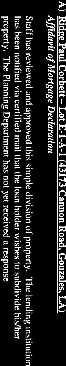
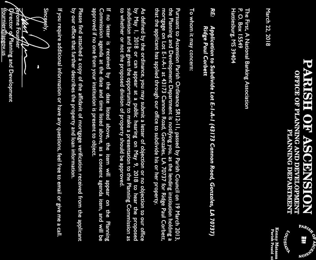
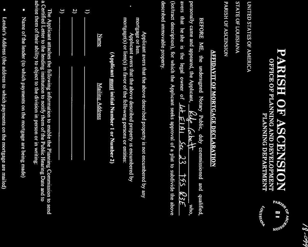
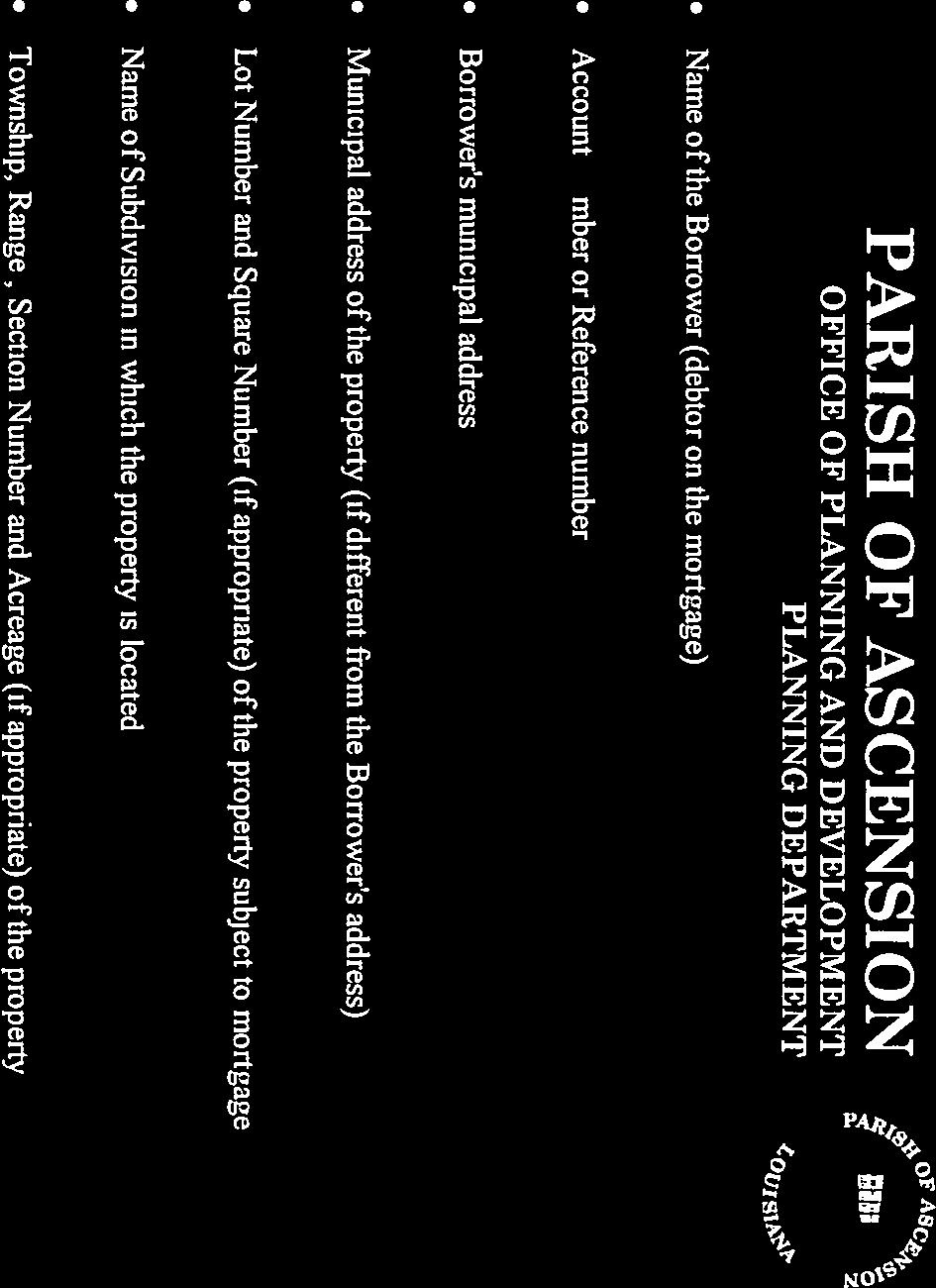
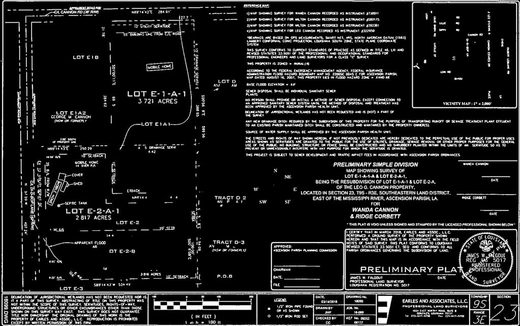
10 Description: Affidavit of Mortgage Declaration Ridge Paul Corbett - Lot E-1-A-1 (43173 Cannon Road, Gonzales, LA) ATTACHMENTS: Description Upload Date Type Ridge Paul Corbett 4/30/2018 Cover Memo

11

12

13

14


15

16
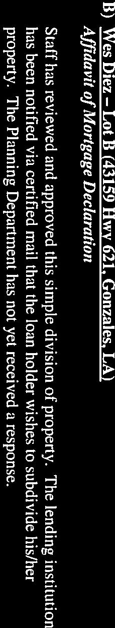
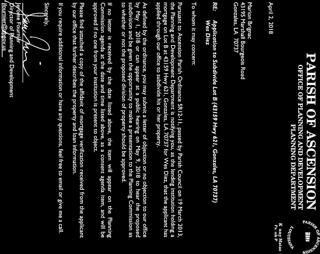
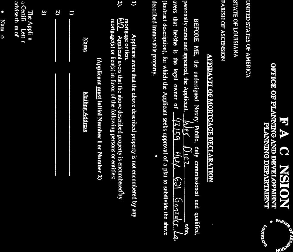
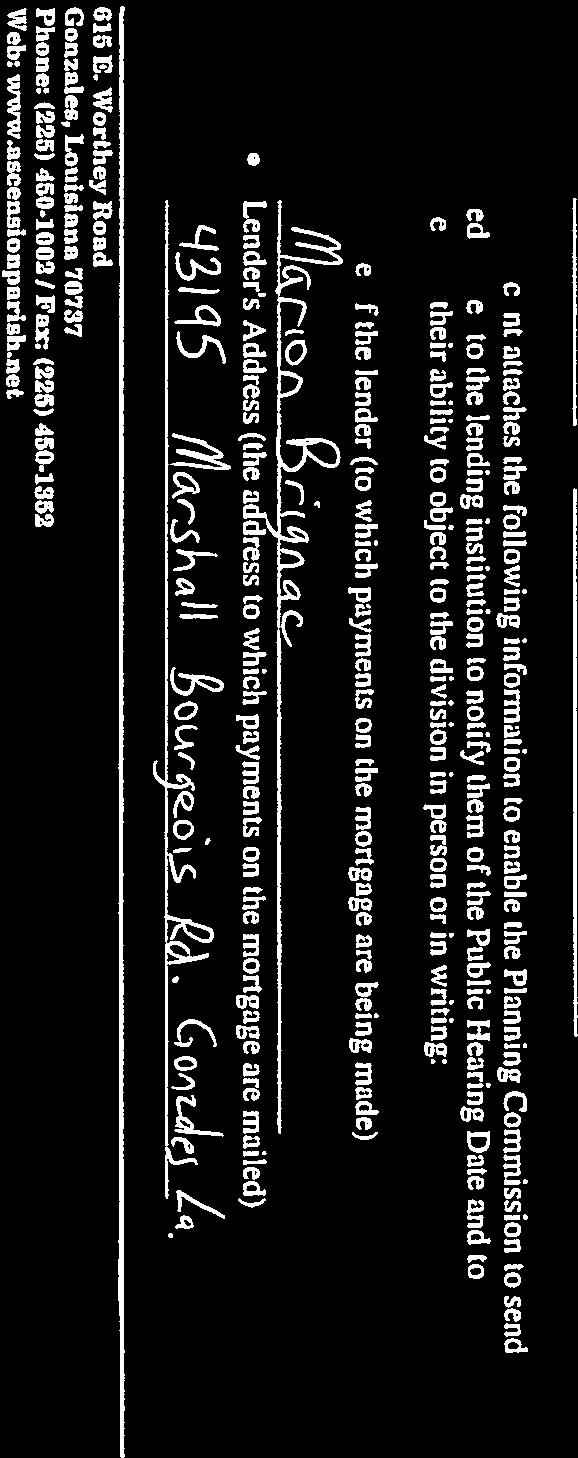
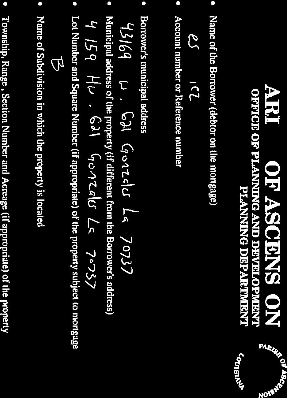
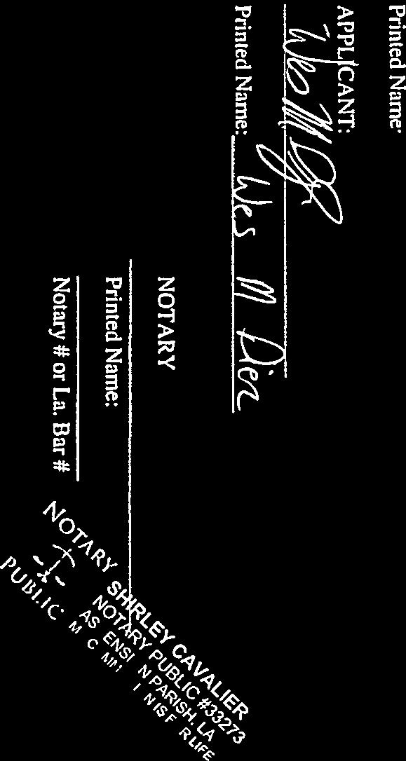
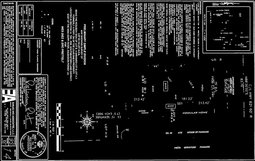
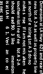
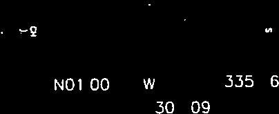
17 Description: Affidavit of Mortgage Declaration Wes Diez - Lot B (43159 Hwy 621, Gonzales, LA) ATTACHMENTS: Description Upload Date Type Wes Diez 4/30/2018 Cover Memo


18

19

20


21


22


23
24 Description: Final Plat Approval Grand Oaks Subdivision Quality Engineering & Surveying, LLC (Council District 3) ATTACHMENTS: Description Upload Date Type Grand Oaks Subdivision 5/2/2018 Cover Memo Grand Oaks Subd - Minutes of 13JAN2016 5/2/2018 Cover Memo Grand Oaks Subd -CSRS Final Plat Review 5/2/2018 Cover Memo Grand Oaks Subd - CSRS Final Inspec Punch List 5/2/2018 Cover Memo Grand Oaks Subd - Approved Prelim Plat /2/2018 Cover Memo Grand Oaks Subd - Final Plat 5/2/2018 Cover Memo
25 May 9, 2018 MAJOR SUBDIVISON FINAL PLAT C) Grand Oaks The subject property is located on Cornerview Road (LA Hwy. 429) approximately 475 feet east of Boudreaux Road in Council District 3 and is zoned Medium Intensity (RM). The application is on behalf of America Homeland, LLC by Quality Engineering & Surveying, LLC. The property is 22 acres and the applicant is applying for the final plat containing 66 residential lots. Lots range from feet wide with a minimum size of 6,250 square feet. The overall subdivision includes 3.5 acres of designated park space. Project Timeline: January 13, Planning Commission approves the preliminary plat. April 17, 2018 Latest Staff level approved Preliminary Plat revision. February 15, Construction plans approved. May 1, 2018 Final Inspection Performed STAFF/ERA FINAL PLAT REVIEW COMMENTS (see attached Final Plat Comments) ENGINEERING DEPT/ERA OUTSTANDING ITEMS: (see attached punch list from final inspection) STAFF RECOMMENDATIONS Staff recommends approval contingent upon satisfactory completion of all outstanding punch list items and any payment by the developer or credit offset being approved by the utilities department, for their portion of the sewer impact fee according to parish ordinances. Note: Signature by the Planning Commission Chairman shall be withheld until all items have been completed as noted.
26 Planning Commission Minutes January 13, 2016 Page 4 Public hearing was closed. Commission Action: Moved by Mr. Gasper Chifici, seconded by Mr. Jackie Callender and unanimously adopted, to approve this family partition contingent on staff comments being addressed. X. Public Hearing to Approve or Deny the Following Preliminary Subdivision Plats: A) Grand Oaks The subject property is located on Cornerview Road approximately 475 feet east of Boudreaux Road in Council District 3 and is zoned Medium Intensity (RM). The application is on behalf of America Homeland, LLC by Quality Engineering & Surveying, LLC. The property is 22 acres and the applicant is proposing a major subdivision containing 56 single family residential lots. Lots range from feet wide with a minimum size of 8,100 square feet. The subdivision will include 1.1 acres of designated park space. STAFF REVIEW COMMENTS Planning department comments: Staff recommends that a T-turnaround be provided at the east end of Sterling Oaks Avenue. Negotiations must continue with the Parish utilities department regarding sewer treatment/discharge. Drainage impact study: The drainage impact study has been reviewed by the Department of Engineering. Comments are attached. Traffic impact study: The traffic impact study has been reviewed and approved. A letter granting approval is attached. STAFF RECOMMENDATIONS The proposed plat meets all guidelines for a major subdivision. However without approval of the drainage impact study, staff cannot recommend approval at this time. Mr. Deric Murphy with Quality Engineering & Surveying, LLC presented this preliminary subdivision plat. Mr. Murphy stated they are asking for consideration to not put the T-turnaround at the east end of Sterling Oaks Avenue as it is a recommendation by staff. He also asked for an interpretation of the code regarding T-turnarounds as it is ambiguous. Mr. Bob Turner stated the traffic report required trees be removed along the frontage of the subdivision along Cornerview Road to the left and right of the intersection and would like that to be a contingency if approved.
27 Planning Commission Minutes January 13, 2016 Page 5 Public hearing was opened. The following spoke: 1- Mr. Jeff Pettit neither for or against development Public hearing was closed. Commission Action: Moved by Mr. Robert Burgess, seconded by Mr. Jackie Callender, this preliminary subdivision plat was approved by the following roll call vote contingent on (a) the trees along Cornerview Road to the left and right of the intersection be removed for site distance; (b) the drainage impact study being approved by Engineering Department; and (c) a t-turnaround be added at the end of East Sterling Avenue. YEAS: Gasper Chifici, Robert Burgess, Jackie Callender, Donald Songy, Morrie Bishop NAYS: Joshua Ory ABSENT: None ABSTAINED: None The Chairman did not vote. 5 YEAS, 1 NAYS, 0 ABSENT, 0 ABSTAINED and the motion CARRIED. B) Ascension Commerce Center 5 th Phase and 6 th Phase The subject property is located near the intersection of Hwy 73 and Hwy 30 in Council District 3 and is zoned Heavy Industry (HI) and Light Industry (LI). The application is on behalf of LJG Land Company, LLC by Quality Engineering & Surveying, LLC. The property is acres and the applicant is proposing an industrial subdivision containing 51 lots. The lots range from 100 to 500 feet wide and from 1 acre to 17 acres. The applicant is requesting variances to: E, G, H, I block length standards, pedestrian system, park and tree requirements as the lots will never be allowed to have a residential use A.1 prohibits open ditches along streets will require approval of Drainage Director, Director of Public works and the Director of Planning and Development Street construction standards all lots are a minimum of 100 wide, the street will include a 4 improved shoulder and swales will be a maximum 4:1 slope
28 May 1, 2018 Mr. Jerome Fournier Ascension Parish Planning Commission P.O. Box 1659 Gonzales, La RE: Grand Oaks Final Plat Review Mr. Fournier: The ERA and Ascension Parish staff have reviewed the Final Plat submitted for the above referenced development for compliance with the Ascension Parish Subdivision Regulations and the Ascension Parish Development Code, and we offer the following comments: 1. Typical Lot Detail shows a 3 setback on the 53 width lots. Revise to 5 as required. 2. Add note, Any new drainage ditch required by the subdivision of this property for the purpose of transporting runoff or sewage treatment plant effluent to an existing Parish maintained ditch shall be constructed and maintained by the property owner(s). 3. Add note, Source of water supply shall be approved by the Ascension Parish Health Unit. 4. Add note, This project is subject to traffic impact fees in accordance with Ascension Parish ordinances. 5. Under Owner signature block, label/specify entity/company applying for subdivision as well as representative s name. 6. Submit letter of coordination with Ascension Parish Utilities Dept. to determine any credits due as well as final Sewer Development fee to be paid for each lot and list on plat, (ex., This project is subject to sewer development fees of $??.?? per lot in accordance with Ascension Parish ordinances ) or verification that total fee has been paid. 7. Admirable Oaks Ave. is incorrectly spelled. 8. Revise front building setbacks along the west side of Admirable Oaks Ave. as per approved Preliminary Plat revision dated, Revise side/corner building setbacks as per approved Preliminary Plat revision dated, Add lot areas to map as required. 11. Provide permanent (completed) Benchmark information on Final Plat as required by Paragraph A.15 of the Subdivision Regulations prior to final approval. 12. According to Paragraph C of the Subdivision Regulations: P e r k in s R o a d, S u i te B a t o n R o u g e, L A ( ) w w w. c s r s in c. c o m
29 C. Restrictive covenants or trusteeships and their periods of existence to apply to lots in the subdivision shall be signed by the owner or his agent and recorded in the office of the parish recorder, and references to such instrument shall be made on the plat and a copy shall be furnished to the planning commission. Applicant is reminded that any Restrictive Covenants that are referenced on the Final Plat with copy made available to the Commission after recording of the Final Plat as required. 13. Add Sewer Note to plat, THE SEWER SYSTEM, INCLUDING BUT NOT LIMITED TO, ALL TREATMENT SYSTEM(S), PUMP(S), LIFT STATION(S), COLLECTION LINES TO THE SYSTEM, BOTH ONSITE AND OFFSITE, AND THE USER OF SAID IMPROVEMENTS, ARE HEREBY DEDICATED TO THE PARISH OF ASCENSION. THE PARISH OF ASCENSION IS ALSO HEREBY GRANTED A PERMANENT SERVITUDE OF ACCESS AND USE OVER THE IMMOVABLE PROPERTY UPON WHICH ANY PORTION OF THE TREATMENT SYSTEM(S), PUMP(S), LIFT STATIONS(S), AND COLLECTION LINES DEDICATED ABOVE ARE LOCATED FOR NECESSARY MAINTENANCE OR IMPROVEMENTS. SAID SERVITUDE IS TO BE CONSIDERED TRANSFERABLE AND HERITABLE AND SHALL BE ENFORCEABLE AGAINST ANY AND ALL SUCCESSORS OR ASSIGNS OF THE PROPERTY OWNER. 14. Add to note 11, Sidewalk, The Owner of a lot shall be responsible for all maintenance, repair or replacement of the sidewalk on or adjacent to his/her lot. Both the Homeowner and the Homeowner s Association shall hold Ascension Parish harmless for any and all work pertaining to the upkeep and/or replacement of the sidewalks within this development. 15. Add note, Sidewalk must be constructed prior to certificate of occupancy being issued for each lot. 16. Add note, Upon approval and recordation of this Plat, all servitudes previously affecting the property described by this Plat are deemed revoked and said servitudes shall now exist as shown by and evidenced on this Plat. 17. Add Tree and Park Space Standards block. 18. Add note, One Class A tree to be provided per lot. Trees must be planted prior to C.O. being issued for each lot. 19. Add note, 12 class A trees and 24 ornamental trees are to be planted per acre of park space. Trees shall be planted prior to first C.O. being issued. 20. Add note, The parks will be of a stage 1 requirement and the maintenance and upkeep of all common areas will be the responsibility of the HOA. A sign will be installed to identify the park space. 21. Add note: Any non-standard street signs and posts considered to be ornamental shall be owned, maintained, repaired, and/or replaced by the developer or subdivision homeowner s association. Both the developer and the homeowner s association shall hold Ascension Parish harmless for any and all work pertaining to the replacement and upkeep of these non-standard street signs and/or posts within this development. The developer and/or homeowner s association also hereby agrees to maintain said ornamental street signs and posts as required by law P e r k in s R o a d, S u i te B a t o n R o u g e, L A ( ) w w w. c s r s in c. c o m
30 22. Provide Jurisdictional Determination as required under Paragraph G of the Subdivision Regulations. 23. This is not an exhaustive list. There are other notes that need to be added as per previous plats. Consultant has typically placed, General Subdivision Note, Tree and Park Space Standards, Sidewalk Note, Restrictions Note, Sewer Note, General Subdivision Information, etc. Review and add as necessary. The Engineer/Surveyor is being advised of these comments by electronic transmittal of this letter. These comments should be addressed and submitted to our office by Friday, May 4 so that final comments may be provided to the Planning Commission. If you have any questions or comments, please do not hesitate to contact me at (225) Do not hesitate to contact me should you have any questions. Engineering Review Agency for the Ascension Parish Planning Commission Shaun Sherrow, P.E., PMP cc: (via ) Deric Murphy, PE, QES, LLC; P e r k in s R o a d, S u i te B a t o n R o u g e, L A ( ) w w w. c s r s in c. c o m
31 May 1, 2018 Mr. Jerome Fournier Ascension Parish Planning Commission P.O. Box 1659 Gonzales, La RE: Grand Oaks Final Inspection Punch List Dear Mr. Fournier: The final inspection for the above referenced project was held on 5/1/2018 at 8:00 am. The contractor, the project engineer, inspection department, and utilities department were present. By electronic copy of this letter, we are transmitting our comments to the engineer. The engineer or contractor will contact subdivision inspection department when these items are ready for a re-inspection: Project Closeout 1. Provide the following closeout items if not already provided. a. Provide as-builts that satisfy section C of the UDC. b. Provide all testing reports if not already submitted. c. Provide maintenance bond agreement. d. Provide sanitary sewer observation reports. e. Provide engineering certification. f. Provide testing lab certification. g. Provide all testing reports if not already submitted. h. Any applicable sewer agreement with the Parish needs to complete prior to the Final Plat being signed. Final Plat Items 1. None. (See final plat review letter from review process) Drainage 1. Complete construction of rear swale ditch behind lots as shown on the approved construction plans. 2. Remove excess dirt along fence along east side of lot CA-3 so that dirt at fence is no higher than adjacent existing ground. 3. Remove excess dirt at southeast corner of lot CA3 so that CA3 is no higher than adjacent existing ground. 4. Construction plans show a proposed swale ditch with 5:1 side slopes with a 15 ft drainage servitude is needed behind lots Side slope of south side of ditch is greater than 5:1 and is larger than what would fit within at 15 ft rear year drainage servitude. Flatten ditch side slope to match approved plans. 5. The top of inlet A4 is too high to receive swale ditch. Lower top or convert to weir inlet. 6. The side slope of ditch at outfall D is steeper than 3:1. Flatten ditch slope so that it is no steeper than 3:1 and replace rip/rap and fabric. 7. Rip rap at outfalls E and C need to be continued to outfall as shown in approved plans P e r k in s R o a d, S u i te B a t o n R o u g e, L A ( ) w w w. c s r s in c. c o m
32 8. AP specifications allow for recycled rip rap if rip rap meets DOTD gradation of stone rip rap. There large chunks of rip rap are more like slab pieces of 4 thick sidewalk. Remove any non-conforming rip rap and replace. 9. Rip rap detail on sheet 5 shows rip rap to be 18 thick below finished grade. There are places where only one piece of 4 thick rip rap is laying on excavated grade. Remove and replace rip rap where not conforming to detail on sheet Add additional rip rap at top of pipe and at outfall of outfall A. Make sure to use proper gradation of rip rap per AP subdivision specifications. 11. Extend rip rap from end of outfall F to water surface of bayou. 12. Remove washed down sediment that is in bayou at outfall of F. Sanitary Sewer 1. Provide documentation of approval of startup of pump station. 2. Driveway to treatment plant needs to be at least 10 ft wide. Measure and make sure that it has correct width. 3. Provide water pressure test results for force main. 4. Provide revised sheets for construction plans that show proposed routing of force main to drainage box. 5. Provide DHH approval of pump station discharge into drainage box. 6. Contact utilities department to determine need for shop drawings, manuals, and other documentation for treatment plant. Landscape Requirements 1. Repair busted sidewalk along south side of walking trail. 2. Provide sign identify private park space. Roadway 1. Plans show a barricade with dead end sigh at back end of pump station drive. Make sure that physical barricade is constructed as shown on sheet Repair the 2 broken handicap ramps. 3. Traffic study noted that right turn out of subdivision did not have adequate site distance when looking west and that trees should be removed. Site distance does not appear to be adequate. Provide letter and supporting information with photos for review from licensed engineer showing that proper site distance is provided. Provide cones or some other visual aid in photos from design view locations of site triangle. Lots/grading 1. None Utilities 1. None. Erosion Control 1. The developer/owner must continue to maintain erosion control measures as stipulated by the owner s SWPPP. 2. Install all silt fence, inlet protection, seeding and erosion matting as shown on sheet 9a and approved SWPPP. 3. Provide erosion control blanket/seeding along bayou banks that were disturbed during construction P e r k in s R o a d, S u i te B a t o n R o u g e, L A ( ) w w w. c s r s in c. c o m
33 Do not hesitate to contact me should you have any questions. Engineering Review Agency for the Ascension Parish Planning Commission Shaun Sherrow, P.E., PMP cc: (via ) Deric Murphy, PE, QES, LLC; Rickey DeArmond P e r k in s R o a d, S u i te B a t o n R o u g e, L A ( ) w w w. c s r s in c. c o m
34 GRAND VIEW AVENUE VICINITY MAP: SCALE: 1" = 2000' ' Staff Level Approval to add 17.5' side setbacks where req'd. and change park space walk from crushed gravel to concrete. 25 N SITE 30 REVISIONS: No.: Date: Description: ' ' ' ' ' ' LEGEND: EMINENT OAKS AVENUE 1 TREE AND PARK SPACE STANDARDS: TYPICAL LOT DETAIL: N.T.S ADMIRABLE OAKS AVENUE ' PROPOSED PARKS: GENERAL SUBDIVISION INFORMATION: 24 HONORABLE OAKS AVENUE 7 POND X-SECTION A-A: N.T.S ' GENERAL NOTES: ' ' ' ' ' ' ' NOTE: TITLE: PROJECT: PRELIMINARY PLANS REVISED PRELIMINARY PLAT GRAND OAKS TYPICAL STREET SECTION (50' RIGHT-OF-WAY): N.T.S. DESCRIPTION: LOCATED IN SECTION 30, TOWNSHIP 9 SOUTH, RANGE 3 EAST, SOUTHEASTERN LAND DISTRICT EAST OF THE MISSISSIPPI RIVER, ASCENSION PARISH, LOUISIANA CLIENT: AMERICA HOMELAND LLC P.O. BOX BATON ROUGE, LA SIDEWALK SECTION N.T.S. Project No.: Date: MARCH 2018 Drawn By: RMB DWG Path:
35 (50' RIGHT-OF-WAY) GRAND VIEW AVENUE LINE TABLE LINE TABLE CORNERVIEW ROAD - LOUISIANA HIGHWAY 429 (RIGHT-OF-WAY VARIES) N76 34'19"E ' N VICINITY MAP: SCALE: 1" = 2000' 25 N00 51'30"W ' 56 S00 49'18"E ' CORNERVIEW ROAD - LOUISIANA HIGHWAY 429 (RIGHT-OF-WAY VARIES) S78 36'05"E ' SITE LOT "CA-3" LOT "CA-2" N00 52'32"E ' CURVE TABLE 53 N89 56'09"E ' INSET "A" EMINENT OAKS (50' RIGHT-OF-WAY) (50' RIGHT-OF-WAY) ADMRABLE OAKS AVENUE LOT "CA-1" S00 06'45"W ' TYPICAL LOT DETAIL: 4 N00 48'19"W ' GENERAL SURVEY NOTES: 24 HONORABLE OAKS AVENUE (50' RIGHT-OF-WAY) APPROVED: FLOOD INFORMATION: LOT "STP" S56 01'56"W ' ASCENSION PARISH PLANNING COMMISSION LANDOWNER/OFFICER CERTIFICATION: SEWAGE DISPOSAL NOTE PUBLIC DEDICATION S74 34'38"W ' S88 29'30"W ' REFERENCE PLATS: S80 40'00"W ' N73 32'47"W ' LEGEND: S86 38'49"W ' S73 17'00"W ' CERTIFICATION: S70 15'48"W ' BASIS OF BEARINGS ** TITLE: PROJECT: DESCRIPTION: CLIENT: FINAL PLAT GRAND OAKS SUBDIVISION AMERICA HOMELAND LLC P.O. BOX BATON ROUGE, LA QUALITY Engineering & Surveying, LLC Hwy 42 Port Vincent, LA TEL FAX Project No.: Date: APRIL 2018 Drawn By: CDP DWG Path:
36 Description: Joseph Thomas, Sr. Property - Lots 2-A, 2-B & 2-C McLin Taylor, Inc. (Council District 5) ATTACHMENTS: Description Upload Date Type Joseph Thomas Sr 5/1/2018 Cover Memo Joseph Thomas Sr Prelim Plat 5/1/2018 Cover Memo
37 May 9, 2018 FAMILY PARTITION A) The Joseph Thomas, Sr. Property for the Joseph Thomas, Sr. Heirs Lots 2 & 3 The subject property is located on the north side of LA Hwy. 42 approximately 200 west of LA Hwy. 933 in Council District 5 and is zoned Conservation (C). The application is on behalf of Joseph Thomas, Sr. by McLin-Taylor, Inc. The Applicant is proposing a family partition of Lot 2 (2.277 acres) and Lot 3 (1.002 acres) into Lot 2-A (1.000 acres), Lot 2-B (1.000 acres) and Lot 2-C (1.279 acres). Lot 2- A is being donated to a daughter, Lot 2-B, to a son and Lot 2-C to a daughter. STAFF REVIEW COMMENTS Comments sent to McLin-Taylor, Inc. on : 1. Building line along eastern boundary of new lot 2-C may be 10 as it is considered a side building line. 2. Submit final plat in CAD prior to final plat being signed. STAFF RECOMMENDATIONS This property division meets the requirements of the family partition section of the subdivision regulations. The owner(s) have owned the property for at least three years or prior to January 1, 2015 as required by Paragraph B. Should the commission concur with the staff analysis, staff recommends approval contingent on addressing all comments on the final map as listed above and the required conveyance documents being completed and recorded according to Paragraph F of the Subdivision Regulations.
38
39 Description: Emmett Smart Property - Tracts 3-A-1-A & 3-A-1-B B.M. Aguillard & Associates, LLC (Council District 5) ATTACHMENTS: Description Upload Date Type Emmett Smart 5/1/2018 Cover Memo Emmett Smart Prelim Plat 5/1/2018 Cover Memo
40 May 9, 2018 FAMILY PARTITION B) The Emmett Smart Property for the Emmett Smart Heirs Lots 3-A-1 The subject property is located approximately 600 north of Norwood Road along T.C. Norwood Rd. (Private Drive) between Tiger Lewis Road and John West Road in Council District 5 and is zoned Medium Intensity Residential (RM). The application is on behalf of Emmett W. Smart by B. M. Aguillard & Associates, LLC. The Applicant is proposing a family partition of Lot 3-A-1 (2.028 acres) into Lot 3-A-1- A (0.956 acres) and Lot 3-A-1-B (1.072 acres). Lot 3-A-1-A is being retained by the owner, and Lot 3-A-1-B is being donated to a daughter. STAFF REVIEW COMMENTS Comments sent to B. M. Aguillard & Associates, LLC on : 1. Emmett Smart is misspelled on new lot 3-A-1-A label. 2. Remove (40 R/W) from T. C. Norwood Rd. Label. 3. Remove n as shown. 4. Label cover on existing structure at southern end of new lot 3-A-1-A as existing and non-conforming. 5. Submit final plat in CAD prior to final plat being signed. STAFF RECOMMENDATIONS This property division meets the requirements of the family partition section of the subdivision regulations. The owner(s) have owned the property for at least three years or prior to January 1, 2015 as required by Paragraph B. Should the commission concur with the staff analysis, staff recommends approval contingent on addressing all comments on the final map as listed above and the required conveyance documents being completed and recorded according to Paragraph F of the Subdivision Regulations.
41 B.M. Aguillard & Associates, LLC P. O. Box 1407 Phone: (225) Prairieville, LA Fax: (225)
42 Description: Christy Place Quality Engineering & Surveying, LLC (Council District 11) ATTACHMENTS: Description Upload Date Type Christy Place 5/1/2018 Cover Memo Christy Place Prelim Plat Review CSRS 5/1/2018 Cover Memo Christy Place Prelim Plat 5/1/2018 Cover Memo
43 May 9, 2018 MAJOR SUBDIVISION PRELIMINARY PLAT A) Christy Place The proposed subdivision is located on the south side of LA Hwy. 929 approximately 1,300 east of LA Hwy. 930 and Daigle Road in Council District 11 and zoned Medium Intensity Residential (RM). The application is on behalf of America Homeland, LLC by Quality Engineering & Surveying, LLC. The property consists of +/-16 acres. The applicant is proposing a subdivision containing 48 lots with a minimum size of 6,350 square feet. There are 18 lots at 50 in width, 23 lots at 60 width and 7 lots at 70 in width. The proposed subdivision will contain 1.00 acres of park space, with all of that being upland space complying with the major subdivision regulations. None of the property is within a FEMA Flood Zone. There are 6.22 acres of wetlands that the developer is proposing to mitigate for the project. The project will drain north across LA Hwy. 929 to Muddy Creek as well as south to laterals of Black Bayou. Sewer will also travel along LA Hwy. 929 discharging to Muddy Creek and must comply with the recent DEQ TMDL requirements for discharge into the Bayou Manchac watershed. STAFF REVIEW COMMENTS All elements of the subdivision as per ordinance have been provided and addressed on the plat along with the required notes, labels, setbacks and servitudes as per Paragraph of the Subdivision Regulations. The developer is proposing to provide a new sewer treatment plant that will be dedicated to the parish along with all infrastructure and customers. The developer is also requesting a variance from the typical street section to allow placement of sidewalks within the ROW. All other comments have been addressed by the consultant as noted in ERA Review Letter. ENGINEER REVIEW COMMENTS Preliminary Plat: The Preliminary Plat has been reviewed by Staff and the Engineer Review Agent (ERA) Comments are attached. Drainage impact study: The drainage impact study has been reviewed by the Engineer Review Agent (ERA) Comments are attached. Traffic impact study: The traffic impact study has been reviewed by the Engineer Review Agent (ERA) Comments are attached. STAFF RECOMMENDATIONS The proposed plat meets all guidelines for a major subdivision per current ordinance and should the commission concur with staff s analysis, staff recommends approval provided applicant addresses all comments and receives approval from DEQ for the discharge of the Sewer
44 Treatment Plant. The property will be accessed from LA Hwy. 929, which meets the minimum 18 parish width requirements.
45 April 30, 2018 Mr. Jerome Fournier Ascension Parish Planning Commission P.O. Box 1659 Gonzales, La RE: Christy Place Preliminary Plat Review Summary Mr. Fournier: The ERA and Ascension Parish staff have reviewed the Preliminary Plat, Drainage Impact Study, and Traffic Impact Study submitted for the above referenced development for compliance with the Ascension Parish Subdivision Regulations and the Ascension Parish Development Code. Shown below are the comments made to the Consulting Engineer for the project as a result of our review of their submittals, as well as a description of their correction or response made to our comments (shown in bold print). Preliminary Plat Comments 1) Please submit proposed street names. These street names can then be checked for 911 purposes. Consultant has provided. 2) Show pedestrian system in neighborhood as required. Consultant has provided. 3) Delineate and label Section and Township lines on map as required. Consultant has provided. 4) A variance must be requested from the Planning Commission to deviate from the standard street section, per code, to put the sidewalk within the ROW. Show this on plat. Consultant has provided. 5) Add existing road to map and width of adjoining street (LA HWY 929) as required. Consultant has provided. 6) Show proposed sewer discharge location, as required. Consultant has provided. 7) List property as vacant if there are no existing dwellings on it. Consultant has provided. 8) List 100 Year Base Flood Elevation (if not in flood zone, list the adjacent). Consultant has provided. Drainage Impact Study Comments 1) The site is flat and study indicates that rear of property naturally splits up flow to two existing ditches. Understanding how much existing flow to each of these ditches is critical to making sure that post developed design does not exceed predeveloped flow at each outfall location. Please conform that enough actual survey, rather than just LIDAR, and field observations have been done to confirm onsite acreage and flow to these two back outfalls. Consultant confirmed acreage to the two ditches P e r k in s R o a d, S u i te B a t o n R o u g e, L A ( ) w w w. c s r s in c. c o m
46 2) Account for tailwater in cross drain in model. Consultant revised model to account for tailwater. 3) The post development flow rates per acre for area C are low in comparison to what they were in predevelopment for areas A and C. Please reevaluate to confirm the correct flow rates. Consultant made necessary adjustments. 4) Create a summary table comparing pre- and post-development peak flow from exit points leaving the site so that ERA can confirm that site is not sending higher runoff rate from each exit point from the site at property lines. The Muddy creek and Black bayou outfall summary tables need to be removed because they are too far past the boundary of the subdivision for analysis. Contact Engineering Review Agency to discuss said table. Consultant has provided. 5) In section 3.2 of the report, Table 2.6 is mentioned but not labeled. Make sure that tables have titles on them/ Also in section 3.3 of the report, it mentions the pre-development drainage summary results are on page 6 when it should be page 5. Consultant revised report. 6) Correct the pre- development drainage summary table on page 5 of the report and in exhibits 5 and 6 to match the following changes in red per the HydroCAD report: Consultant revised report. Traffic Impact Study Comments 1) The HV calculations done for the AM and PM peak periods in the first page of the appendix are not consistent with what is shown in Figure 3. The calculated AM peak period %HV is 1.18% and is rounded down to 1%. On the other hand, the calculated PM peak period %HV is 0.11%, but is rounded up to 1%. Please review and correct for consistency. Consultant revised report. Drainage Impact Study Summary: Consulting Engineer: Jeff Loup, PE Date of Study: April 2018 Size of Development: 16.0 acres Existing Land Use: Pasture with Trees Receiving Basin: Muddy Creek and Black Bayou laterals. FEMA Flood Zone: Nearest flood zone is 0.32 miles downstream with AE classification 100-year Flood Elevation: 15.0 ft (nearest) Record Inundation: None provided by Parish. Offsite Drainage Area: Minimal Fill Mitigation: Existing site does not provide storage for base flood elevation 15 ft. Therefore, fill mitigation is not applicable for his project. However, proposed pond will provide storage for design rainfall events. The Drainage Impact Study substantially conforms to the requirements of the Drainage Impact Study Policy included in the Subdivision Regulations. The Engineering Review Agency has performed a review of the input parameters and results of the submitted drainage calculations for compliance with the Subdivision Regulations P e r k in s R o a d, S u i te B a t o n R o u g e, L A ( ) w w w. c s r s in c. c o m
47 and generally accepted practices for storm water hydrologic design. Upon approval of the preliminary plat, the applicant can proceed with final drainage design in accordance with the concepts submitted in the impact study. Traffic Impact Study Summary: Consulting Engineer: Brin Ferlito P.E., PTOE, Vectura Consulting Services, LLC Date of Report: April 19, 2018 Date of Traffic Counts: February 22, 2018 Number of Proposed Lots: 48 Peak Hour P.M. Trips: 54 Study Threshold Level: 1 Offsite Intersections Studied: None. (Threshold 1 only requires analyzing proposed entrance) Conclusion: No improvements at studied intersections are recommended to offset additional cars generated by this project. Sight Distance Evaluation: Sight distance was evaluated at the current condition and concluded that sight distance will cause no traffic operational problems for this proposed development. The following items should be considered by the Planning Commission in their analysis of the case: No comments. Should you have any questions or comments, please do not hesitate to contact me at (225) Sincerely, Engineer Review Agency for the Ascension Parish Planning Commission Shaun Sherrow, P.E. cc: (via ) Mr. Jeffrey J. Loup, P.E. (Quality Engineering & Surveying, LLC) P e r k in s R o a d, S u i te B a t o n R o u g e, L A ( ) w w w. c s r s in c. c o m
48 73' 55' 50' 50' 50' 50' 55' 50' 529' DAIGLE RD EUGENE RD JESSIE JOHNSON RD TIGER HEIGHTS RD SHIRLEY DR AIKENS RD W LAKEPOINT CT P'VILLE IND AVE BRAUD RD ACADIA DR TYPICAL LOT DETAIL: N.T.S. TYPICAL STREET SECTION (50' RIGHT-OF-WAY): N.T.S. SIDEWALK SECTION: N.T.S. VICINITY MAP: SEC 36 T8S R2E PRAIRIEVILLE FAIRGROUND RD DARVILLE RD DAME DR J LEE STEVENS LN SEC 31 T8S R3E LORENA DR BAYRIDGE DR SCALE: 1" = 2000' BUD BROUSSARD RD SEC 32 T8S R3E HWY 929 CAUSEY RD LOS ARBOLES ST SEC 1 T9S R2E ROY ROGERS RD PALMETTO LN FOREST OAK RD BRAUD RD SHEREE DR N AIRLINE HWY SITE JAMES DR VIRGIL DUPLESSIS RD SEC 6 T9S R3E PALOMINO LN COUNTRY DR MEADOW LN SWEET PECAN AVE ROY'S DR WOODLAND AVE COTTON FIELD AVE SEC 5 T9S R3E GERMANY RD DUPLESSIS RD HICKORY ST BLACK LOCUST ST HOLLY ST SEC 12 T9S R2E MULBERRY ST CEDAR ST SEC 8 T9S R3E SWEET LEAF RD ELISE CATHERINE DR GERMANY RD BRENTWOOD CT GAUTREAU RD N WOODRUN CIR WOODRUN BLVD BRAUD RD SEC 8 T9S R3E 1298' ' 28 LOT "C3" ' 120' ' 60' 60' 60' 50' 50' 50' 50' 62' ' ' ' 22 74' 60' 60' 60' 50' 50' 50' 50' 62' 50' 50' 60' 158' ' 50' 60' 50' 50' 50' 50' 50' 60' 70' 70' 70' 70' 60' 60' 60' 60' 60' LOT "C2" GENERAL NOTES: 141' 50' 50' 50' 50' 50' 60' 70' 70' 70' 70' 60' 60' 60' 60' 60' ' ' 65' 50' ' 50' 50' 60' 60' 60' 60' 60' 60' 60' ' 6 60' 5 60' 70' 60' ' 1 LOT "C1" ' 63' 50' 50' 50' 50' 60' 60' 60' 60' 60' 60' 60' 60' 60' 60' 70' 60' 70' 1298' PRELIMINARY PLAT TITLE: PRELIMINARY PLAN PUBLIC DEDICATION: FLOOD ZONE NOTE: GENERAL SUBDIVISION INFORMATION: VARIANCE REQUEST: TREE AND PARK REQUIREMENTS: LEGEND: PROJECT: DESCRIPTION: LOCATED IN SECTION 6, TOWNSHIP 9 SOUTH, RANGE 3 EAST, SOUTH EAST LAND DISTRICT, EAST OF THE MISSISSIPPI, ASCENSION PARISH, LOUISIANA CLIENT: CHRISTY PLACE AMERICA HOMELAND, L.L.C. P.O. BOX BATON ROUGE, LOUISIANA LOT COUNT: SEWAGE DISPOSAL NOTE: CONTOUR NOTE: DIMENSION NOTE: Project No.: Date: NOV Drawn By: KL DWG Path: QUALITY Engineering & Surveying, LLC Hwy 42 Port Vincent, LA TEL FAX
49 Description: Jamestown Crossing - Filing One Louisiana Land Engineering, LLC (Council District 7) ATTACHMENTS: Description Upload Date Type Jamestown Crossing - Filing One 5/1/2018 Cover Memo Jamestown Crossing, Filing One CSRS PP Review Summary 5/1/2018 Cover Memo Jamestown Crossing -Filing One Prelim Plat 5/1/2018 Cover Memo
50 May 9, 2018 MAJOR SUBDIVISION PRELIMINARY PLAT B) Jamestown Crossing Subdivision-Filing One The proposed subdivision is located at the northeast corner of the intersection of LA Hwy. 930 and Parker Road in Council District 11 and zoned Medium Intensity Residential (RM). The application is on behalf of Dantin-Bruce Development, LLC by Louisiana Land Engineering, LLC. The property consists of +/ acres. The applicant is proposing a subdivision containing 88 lots with a minimum size of 7,000 square feet. There are 22 lots at 50 in width, 45 lots at 60 width, 17 lots at 70 width 3 lots at 80 in width and 1 lot at 90 in width. The proposed subdivision will contain 2.00 acres of park space, with approximately 2/3 of that being upland space complying with the major subdivision regulations. Approximately 3%-5% of the property is within the A Flood Zone with a Base Flood Elevation of 21, (to be verified). The project will drain across LA Hwy. 930 to Muddy Creek. Sewer will also travel across LA Hwy. 930 discharging to Muddy Creek and must comply with the recent DEQ TMDL requirements for discharge into the Bayou Manchac watershed. STAFF REVIEW COMMENTS All elements of the subdivision as per ordinance have been provided and addressed on the plat along with the required notes, labels, setbacks and servitudes as per Paragraph of the Subdivision Regulations. The developer is proposing to provide a new sewer treatment plant that will be dedicated to the parish along with all infrastructure and customers. All other comments have been addressed by the consultant as noted in ERA Review Letter. ENGINEER REVIEW COMMENTS Preliminary Plat: The Preliminary Plat has been reviewed by Staff and the Engineer Review Agent (ERA) Comments are attached. Drainage impact study: The drainage impact study has been reviewed by the Engineer Review Agent (ERA) Comments are attached. Traffic impact study: The traffic impact study has been reviewed by the Engineer Review Agent (ERA) Comments are attached. STAFF RECOMMENDATIONS The proposed plat meets all guidelines for a major subdivision per current ordinance and should the commission concur with staff s analysis, staff recommends approval provided applicant addresses all comments and receives approval from DEQ for the discharge of the Sewer Treatment Plant. The property will be accessed from Parker Road, which meets the minimum 18 parish width requirements.
51 March 6, 2018 Mr. Jerome Fournier Ascension Parish Planning Commission P.O. Box 1659 Gonzales, La RE: Jamestown Crossing, Filing 1 Preliminary Plat Review Summary Mr. Fournier: The ERA and Ascension Parish staff have reviewed the Preliminary Plat, Drainage Impact Study, and Traffic Impact Study submitted for the above referenced development for compliance with the Ascension Parish Subdivision Regulations and the Ascension Parish Development Code. Shown below are the comments made to the Consulting Engineer for the project as a result of our review of their submittals, as well as a description of their correction or response made to our comments (shown in bold print). Preliminary Plat 1. Show existing contour labels. Consultant provided 2. Sidewalk details are illegible. Provide easier to see graphic. Consultant revised. 3. Add street names and widths to roads located inside the boundary of Filing 1. Consultant revised. 4. Provide total acreage involved in the proposed subdivision and total remaining adjacent property owned by the developer and the location thereof. Consultant provided 5. Primary school is incorrectly noted as Oak Grove Primary instead of Prairieville Primary. Consultant revised. 6. Add note that all lots that are on perimeter of subdivision shall not have direct access to Parker Road, Hwy 930, or A N White Road. Consultant provided 7. Rear drainage and necessary servitude are required at rear of lots unless property is on ridge and natural drains onto adjacent property. Depict rear yard servitudes on preliminary plat. Consultant provided 8. Provide wetland delineation. Consultant provided 9. Submit street names as soon as possible as they will need to be checked for 911 purposes. Consultant provided 10. Please verify the current ROW of LA Hwy. 930 as additional ROW has been acquired. Consultant revised plat. 11. Identify Section and Township lines. Consultant provided 12. There were revisions to the adjacent property owner s form. Adjust the preliminary plat as necessary. Consultant revised. 13. Lot 43 appears to be an 80 lot and lot 88 appears to be a 90 lot. Verify and revise chart as necessary. On another note, verify the minimum lot size requirements per Table C as my notation of lot sizes may have to do with area vs. frontage. Consultant revised. 14. Add 8 and 9 setbacks to typical lot for 80 and 90 lots. Consultant provided 15. Verify that a lift station will not be necessary to install within the boundaries of the first filing. Consultant indicated that lift station is not needed. 16. There will be an additional waiver request for the sidewalk being placed within the ROW. Add this to the plat. Consultant provided P e r k in s R o a d, S u i te B a t o n R o u g e, L A ( ) w w w. c s r s in c. c o m
MINUTES PLANNING COMMISSION August 10, 2016
 The below minutes are taken from the meeting to represent items addressed and actions taken by this board. All meetings are recorded with video and audio for our records. In the event these minutes are
MINUTES AND WRITTEN DECISIONS PLANNING COMMISSION DECEMBER 13, Meeting was called to order by Chairman Matthew Pryor.
 The below minutes and written decisions are taken from the meeting to represent items addressed and actions taken by this board. All meetings are recorded with video and audio for our records. In the event
MINUTES PLANNING COMMISSION July 13, Meeting was called to order by Chairman Matthew Pryor.
 The below minutes are taken from the meeting to represent items addressed and actions taken by this board. All meetings are recorded with video and audio for our records. In the event these minutes are
PARISH OF ASCENSION OFFICE OF PLANNING AND DEVELOPMENT PLANNING DEPARTMENT. Planning Commission
 1. Call to Order 2. Roll Call of Members 3. Pledge of Allegiance 4. Introduction of Staff 5. Chairman's Comments 6. General Business 7. Minutes (A) 8. Consent Agenda PARISH OF ASCENSION OFFICE OF PLANNING
PARISH OF ASCENSION OFFICE OF PLANNING AND DEVELOPMENT PLANNING DEPARTMENT. Zoning Meeting
 PARISH OF ASCENSION OFFICE OF PLANNING AND DEVELOPMENT PLANNING DEPARTMENT 1. Meeting Called to Order by Chairman 2. Roll Call of Members 3. Minutes (A) Zoning Meeting February 13, 2019 Courthouse Annex
PARISH OF ASCENSION OFFICE OF PLANNING AND DEVELOPMENT PLANNING DEPARTMENT
 1. Call to Order 2. Roll Call of Members 3. Pledge of Allegiance 4. Introduction of Staff 5. Chairman's Comments 6. Minutes (A) 7. Consent Agenda (A) PARISH OF ASCENSION OFFICE OF PLANNING AND DEVELOPMENT
PARISH OF ASCENSION OFFICE OF PLANNING AND DEVELOPMENT PLANNING DEPARTMENT. Planning Commission
 1. Call to Order 2. Roll Call of Members 3. Pledge of Allegiance 4. Introduction of Staff 5. Chairman's Comments 6. General Business 7. Minutes (A) 8. Consent Agenda PARISH OF ASCENSION OFFICE OF PLANNING
MINUTES Planning Commission October 14, 2015
 The below minutes are taken from the meeting to represent items addressed and actions taken by this board. All meetings are recorded with video and audio for our records. In the event these minutes are
MINUTES PLANNING COMMISSION July 10, 2013
 The below minutes are taken from the meeting to represent items addressed and actions taken by this board. All meetings are recorded with video and audio for our records. In the event these minutes are
PARISH OF ASCENSION OFFICE OF PLANNING AND DEVELOPMENT PLANNING DEPARTMENT
 PARISH OF ASCENSION OFFICE OF PLANNING AND DEVELOPMENT PLANNING DEPARTMENT 1. Meeting Called to Order by Chairman 2. Roll Call of Members 3. Pledge of Allegiance 4. Introduction of Staff 5. Minutes (A)
PARISH OF ASCENSION OFFICE OF PLANNING AND DEVELOPMENT ZONING DEPARTMENT. Board of Adjustments
 1. Called to Order 2. Roll Call of Members 3. Public Comments 4. Acceptance of the Minutes (A) PARISH OF ASCENSION OFFICE OF PLANNING AND DEVELOPMENT ZONING DEPARTMENT Board of Adjustments July 26, 2016-6:00
MINUTES PLANNING COMMISSION April 13, 2011
 The below minutes are taken from the meeting to represent items addressed and actions taken by this board. All meetings are recorded with video and audio for our records. In the event these minutes are
PARISH OF ASCENSION OFFICE OF PLANNING AND DEVELOPMENT PLANNING DEPARTMENT
 1. Call to Order 2. Roll Call of Members 3. Pledge of Allegiance 4. Introduction of Staff 5. Chairman's Comments 6. General Business 7. Minutes (A) (B) 8. Consent Agenda (A) (B) (C) PARISH OF ASCENSION
PARISH OF ASCENSION OFFICE OF PLANNING AND DEVELOPMENT PLANNING DEPARTMENT. Joint Planning and Zoning Meeting
 1. Call To Order 2. Roll Call of Members 3. Minutes PLANNING DEPARTMENT Joint Planning and Zoning Meeting March 14, 2018 6:00 PM Courthouse Annex - 828 Irma Blvd Council Meeting Room 2nd Floor (Following
PARISH OF ASCENSION OFFICE OF PLANNING AND DEVELOPMENT PLANNING DEPARTMENT. Planning Commission
 1. Call to Order 2. Roll Call of Members 3. Pledge of Allegiance 4. Introduction of Staff 5. Chairman's Comments 6. General Business (A) 7. Minutes (A) 8. Consent Agenda (A) (B) PARISH OF ASCENSION OFFICE
PARISH OF ASCENSION OFFICE OF PLANNING AND DEVELOPMENT PLANNING DEPARTMENT. Planning Commission
 1. Call to Order 2. Roll Call of Members 3. Pledge of Allegiance 4. Introduction of Staff 5. Chairman's Comments 6. General Business PARISH OF ASCENSION OFFICE OF PLANNING AND DEVELOPMENT PLANNING DEPARTMENT
MINOR SUBDIVISION FINAL PLAT APPLICATION Town of Apex, North Carolina
 MINOR SUBDIVISION FINAL PLAT APPLICATION Town of Apex, North Carolina This document is a public record under the North Carolina Public Records Act and may be published on the Town s website or disclosed
MASTER SUBDIVISION FINAL PLAT APPLICATION Town of Apex, North Carolina
 MASTER SUBDIVISION FINAL PLAT APPLICATION Town of Apex, North Carolina This document is a public record under the North Carolina Public Records Act and may be published to the Town s website or disclosed
PARISH OF ASCENSION OFFICE OF PLANNING AND DEVELOPMENT PLANNING DEPARTMENT. Planning Commission
 1. Call to Order 2. Roll Call of Members 3. Pledge of Allegiance 4. Introduction of Staff 5. Chairman's Comments 6. General Business (A) 7. Minutes (A) 8. Consent Agenda (A) (B) (C) (D) PARISH OF ASCENSION
City of Ferndale CITY COUNCIL STAFF REPORT
 SUBJECT: Final Plat Approval DATE: January 19, 2016 FROM: Haylie Miller, Assistant Planner PRESENTATION BY: Haylie Miller City of Ferndale CITY COUNCIL STAFF REPORT MEETING DATE: January 19, 2016 AGENDA
PARISH OF ASCENSION OFFICE OF PLANNING AND DEVELOPMENT ZONING DEPARTMENT
 1. Called to Order 2. Roll Call of Members 3. Public Comments 4. Acceptance of the Minutes (A) PARISH OF ASCENSION OFFICE OF PLANNING AND DEVELOPMENT ZONING DEPARTMENT Board of Adjustments April 28, 2015-6:00
MINOR SUBDIVISION PLAT CHECKLIST
 MINOR SUBDIVISION PLAT CHECKLIST Project Name: Tax ID #: Project Number: Date: _ Reviewed By: Telephone: NOTES: All lots on septic systems must comply with the Fulton County Health Department requirements
PARISH OF ASCENSION OFFICE OF PLANNING AND DEVELOPMENT PLANNING DEPARTMENT
 1. Call to Order 2. Roll Call of Members 3. Pledge of Allegiance 4. Introduction of Staff 5. Chairman's Comments 6. General Business (A) 7. Minutes PARISH OF ASCENSION OFFICE OF PLANNING AND DEVELOPMENT
I. Requirements for All Applications. C D W
 108-16.1. Application checklists. Checklist for Required Submissions to the Planning Board or Zoning Board of Adjustment of Monroe Township All required submissions are to be made to the Administrative
CHAPTER 26 PLANNING AND ZONING ARTICLE VII. MOBILE HOMES AND RECREATIONAL VEHICLE (RV) PARKS. Recreational Vehicle (RV) Park Development Standards
 PARKS. Recreational Vehicle (RV) Park Development Standards") CHAPTER 26 PLANNING AND ZONING ARTICLE VII. MOBILE HOMES AND RECREATIONAL VEHICLE (RV) PARKS. Section 26-VII-1. Section 26-VII-2. Section 26-VII-3. Section 26-VII-4. Section 26-VII-5. Purpose Permitted
CHAPTER 26 PLANNING AND ZONING ARTICLE VII. MOBILE HOMES AND RECREATIONAL VEHICLE (RV) PARKS. Section 26-VII-1. Section 26-VII-2. Section 26-VII-3. Section 26-VII-4. Section 26-VII-5. Purpose Permitted
REPORT TO THE PLANNING COMMISSION
 Agenda Number: PC14-50 MEETING DATE: February 5, 2015 REPORT TO THE PLANNING COMMISSION SUBJECT: Villas of Tara Oaks Request approval of a Preliminary Subdivision Plat for 29 lots, on 9.14 acres located
APPLICATION PROCEDURE
 ANTRIM PLANNING BOARD P. O. Box 517 Antrim, New Hampshire 03440 Phone: 603-588-6785 FAX: 603-588-2969 APPLICATION FORM AND CHECKLIST FOR MINOR OR MAJOR SITE PLAN REVIEW File Date Received By APPLICATION
Residential Major Subdivision Review Checklist
 Residential Major Subdivision Review Checklist Plan Submittal Requirements: 2 full sets of stamped plans Electric submittal - all plans contained in a single PDF 3 full sets if commercial kitchen or dining
Staff Report to the North Ogden Planning Commission
 Staff Report to the North Ogden Planning Commission SYNOPSIS / APPLICATION INFORMATION Application Request: Consideration and action on an administrative application for final approval for the Legacy North
MINUTES Planning Commission October 14, 2009
 The below minutes are taken from the meeting to represent items addressed and actions taken by this board. All meetings are recorded with video and audio for our records. In the event these minutes are
Residential Minor Subdivision Review Checklist
 Residential Minor Subdivision Review Checklist Plan Submittal Requirements: 2 full sets of stamped plans Electric submittal - all plans contained in a single PDF 3 full sets if commercial kitchen or dining
CITY OF SARALAND FINAL SUBDIVISION PLAT REVIEW
 CITY OF SARALAND FINAL SUBDIVISION PLAT REVIEW Application Number: Date Plat Submitted: Name of Subdivision: Name of Owner: Owner Address: (Street or P.O. Box) Telephone #: (City) (State) (Zip) E-mail:
FINAL SITE PLAN PLAT APPLICATION Town of Apex, North Carolina
 FINAL SITE PLAN PLAT APPLICATION Town of Apex, North Carolina This document is a public record under the North Carolina Public Records Act and may be published on the Town s website or disclosed to third
JEFFERSON COUNTY, ALABAMA
 JEFFERSON COUNTY, ALABAMA Major Development Checklist, Notes and Information A Major Development is any proposed new structure or addition to an existing structure which will cause a change in the topography
ST. TAMMANY PARISH PATRICIA P. BRISTER PARISH PRESIDENT
 revised Completed Permit Application REQUIREMENTS FOR RESIDENTIAL PLAN REVIEW Swimming Pools Assessment # / Parcel #(10 digit number from Assessor s Office 985-809-8180 www.stpao.org) Legal Description
ST. TAMMANY PARISH PATRICIA P. BRISTER PARISH PRESIDENT
 TENTATIVE SUBDIVISION APPROVAL CHECK SHEET Revised October 5, 2018 The Developer shall submit a request for Tentative Plan Review to the Department of Planning & Development in the appropriate format.
BOSSIER CITY PARISH METROPOLITAN PLANNING COMMISSION 620 Benton Rd. Bossier City, LA Phone: Fax: PRELIMINARY PLAT
 (OFFICE USE ONLY) Application Fee: Paid: Date: CASE # Project Information BOSSIER CITY PARISH METROPOLITAN PLANNING COMMISSION 620 Benton Rd. Bossier City, LA 71111 Phone: 318-741-8824 Fax: 318-741-8827
New Private Way Ordinance Westbrook Planning Board Workshop , Planning Board Public Hearing Definitions
 201 Definitions Private Right of Way; Private way A strip of land at least fifty feet wide, meeting the minimum standards for the construction of a gravel base for a public road, over which abutters may
UPPER ALLEN TOWNSHIP PLANNING COMMISSION REGULAR MEETING August 27, :00 P.M.
 UPPER ALLEN TOWNSHIP PLANNING COMMISSION REGULAR MEETING August 27, 2018 7:00 P.M. PC MEMBERS TOWNSHIP OFFICIALS - PRESENT R. Wayne Willey, Chairperson Jennifer Boyer, Comm. Dev. Director Philip Cerveny,
ZONING AMENDMENT & SUBDIVISION STAFF REPORT Date: November 3, 2016
 ZONING AMENDMENT & SUBDIVISION STAFF REPORT Date: November 3, 2016 APPLICANT NAME SUBDIVISION NAME David Shumer 5955 Airport Subdivision CITY COUNCIL DISTRICT District 6 5955 Airport Boulevard, 754 Linlen
PARISH OF ASCENSION OFFICE OF PLANNING AND DEVELOPMENT PLANNING DEPARTMENT
 PARISH OF ASCENSION OFFICE OF PLANNING AND DEVELOPMENT PLANNING DEPARTMENT 1. Meeting Called to Order by Chairman 2. Roll Call of Members 3. Pledge of Allegiance 4. Introduction of Staff 5. Minutes (A)
SUBMITTAL REQUIREMENTS: The number indicates the number of copies for submittal (if applicable).
.") Office Use Only Preliminary Long Plat Long Subdivision Applicant Checklist PLANNING, COMMUNITY, & ECONOMIC DEVELOPMENT DEPARTMENT FINAL LONG PLAT LONG SUBDIVISION CHECKLIST Mailing Address: P.O. Box 547,
Office Use Only Preliminary Long Plat Long Subdivision Applicant Checklist PLANNING, COMMUNITY, & ECONOMIC DEVELOPMENT DEPARTMENT FINAL LONG PLAT LONG SUBDIVISION CHECKLIST Mailing Address: P.O. Box 547,
SPANISH FORT PLANNING COMMISSION PRELIMINARY SUBDIVISION PLAT APPLICATION. Number of Lots (Units) Address. Address.
 Address. Address.") Case No. SPANISH FORT PLANNING COMMISSION PRELIMINARY SUBDIVISION PLAT APPLICATION Name of Subdivision Tax Parcel Number(s) Subdivision Location Total Acreage Number of Lots (Units) Average Lot Size Current
Case No. SPANISH FORT PLANNING COMMISSION PRELIMINARY SUBDIVISION PLAT APPLICATION Name of Subdivision Tax Parcel Number(s) Subdivision Location Total Acreage Number of Lots (Units) Average Lot Size Current
SUBMITTAL REQUIREMENTS: The number indicates the number of copies for submittal (if applicable).
.") Office Use Only Preliminary Long Plat Long Subdivision Applicant Checklist PLANNING, COMMUNITY, & ECONOMIC DEVELOPMENT DEPARTMENT PRELIMINARY LONG PLAT LONG SUBDIVISION CHECKLIST Mailing Address: P.O.
Office Use Only Preliminary Long Plat Long Subdivision Applicant Checklist PLANNING, COMMUNITY, & ECONOMIC DEVELOPMENT DEPARTMENT PRELIMINARY LONG PLAT LONG SUBDIVISION CHECKLIST Mailing Address: P.O.
DAUPHIN CREEK ESTATES SUBDIVISION
 # 12 SUB-000076-2017 DAUPHIN CREEK ESTATES SUBDIVISION Engineering Comments: FINAL PLAT COMMENTS (should be addressed prior to submitting the FINAL PLAT for review and/or signature by the City Engineer):
TOWN OF LEWISTON PLANNING BOARD APPLICATION
 TOWN OF LEWISTON PLANNING BOARD APPLICATION DESCRIPTION OF PROPOSED REQUEST: Name of Property Owner: Phone #: Name of Applicant:Phone #: Address or Location of Proposal:_SBL# Size of Parcel or Structure:Existing
Staff Report to the North Ogden City Council
 Staff Report to the North Ogden City Council SYNOPSIS / APPLICATION INFORMATION Application Request: Consideration and action on an administrative application to provide comments on the preliminary plan
COMMERCIAL SITE PLAN & CONDITIONAL USE PERMIT REVIEW PROCESS & CHECKLIST
 Community Development 110 South Main Street Springville, UT 84663 COMMERCIAL SITE PLAN & CONDITIONAL USE PERMIT REVIEW PROCESS & CHECKLIST 801.491.7861 www.springville.org Prior to the issuance of a building
CITY OF FERNDALE HEARING EXAMINER
 CITY OF FERNDALE HEARING EXAMINER RE: Planned Unit Development ) 16001-PUD Preliminary Plat ) 16018-SE Plat Variance ) 16002-VAR Application by ) ) MD General, L.L.C. ) FINDINGS OF FACT, Malloy Heights
SUBDIVISION, PLANNING APPROVAL, & REZONING STAFF REPORT Date: June 4, 2015
 SUBDIVISION, PLANNING APPROVAL, & REZONING STAFF REPORT Date: June 4, 2015 APPLICANT NAME SUBDIVISION NAME DEVELOPMENT NAME LOCATION Board of Water & Sewer Commissioners of the City of Mobile MAWSS MLK
LAND USE APPLICATION
 LAND USE APPLICATION File Name: File No(s).: Receipt No.: Receipt Date: Received By: Amount.: $ Instructions for Applicants Please read and follow all instructions on your application carefully. If you
THE CITY OF MOBILE, ALABAMA
 THE CITY OF MOBILE, ALABAMA LE 'I IER OF DECISION Kimberly Clark Mobile Operations 200 Africatown Blvd. Prichard, AL 36610 Re: 100 & 200 Africatown Boulevard (Northeast corner of Bay Bridge Road and Paper
DEVELOPMENT PLAN REVIEW CHECKLIST. To initiate the application, the applicant shall submit to the Administrative Officer:
 DEVELOPMENT PLAN REVIEW CHECKLIST To initiate the application, the applicant shall submit to the Administrative Officer: 1. Sixteen (16) copies of the Project Review Application Form, printed double-sided;
géãç Éy VtÇtÇwt zât 5440 Routes 5 & 20 West Canandaigua, NY Phone: (585) / Fax: (585)
 / Fax: (585)") géãç Éy VtÇtÇwt zât 5440 Routes 5 & 20 West Canandaigua, NY 14424 Phone: (585) 394-1120 / Fax: (585) 394-9476 APPLICATION FOR LOT-LINE ADJUSTMENT The applicant is responsible for the completeness of all
géãç Éy VtÇtÇwt zât 5440 Routes 5 & 20 West Canandaigua, NY 14424 Phone: (585) 394-1120 / Fax: (585) 394-9476 APPLICATION FOR LOT-LINE ADJUSTMENT The applicant is responsible for the completeness of all
EDGERTON CITY HALL PLANNING COMMISSION MEETING REGULAR SESSION March 12, 2019
 EDGERTON CITY HALL PLANNING COMMISSION MEETING REGULAR SESSION The met in regular session with Chair John Daley calling the meeting to order at 7:00 p.m. All present participated in the Pledge of Allegiance.
Department of Planning & Development Services
 Department of Planning & Development Services S T A F F R E P O R T February 9, 2015 CASE NO: PROJECT: EXECUTIVE SUMMARY: ZA14-154 Plat Revision for Lots 25R-1A, 25R-1B and 25R-1C, Block 1, Woodland Heights
CONDOMINIUM REGULATIONS
 ARTICLE 37 CONDOMINIUM REGULATIONS SECTION 37.01. Purpose The purpose of this Article is to regulate projects that divide real property under a contractual arrangement known as a condominium. New and conversion
ALPINE TOWNSHIP PLANNING COMMISSION REGULAR MEETING June 15, 2017
 Page 1 of 6 ALPINE TOWNSHIP PLANNING COMMISSION REGULAR MEETING 17-26 CALL TO ORDER / APPROVAL OF THE REGULAR MEETING MINUTES OF MAY 18, 2017 AND THE / PUBLIC COMMENT ON NON-AGENDA ITEMS The Alpine Township
SECTION 4: PRELIMINARY PLAT
 SECTION 4: PRELIMINARY PLAT After the completion of the sketch plan process, if submitted, the owner or developer shall file with the City an application for preliminary plat. The preliminary plat stage
Attached is a Clinton Township Zoning Permit Application and requirements for issuance of a permit.
 To Whom It May Concern: Attached is a Clinton Township Zoning Permit Application and requirements for issuance of a permit. The fee for the permit application is $75.00, which shall be made payable to
PRELIMINARY PLAN CHECKLIST Major Land Development Projects. To initiate the application, the applicant shall submit to the Administrative Officer:
 PRELIMINARY PLAN CHECKLIST Major Land Development Projects To initiate the application, the applicant shall submit to the Administrative Officer: 1. The application review fee, as established by the South
Final Plats for Major Residential and Commercial Subdivisions Checklist
 Project Name: : This form is a checklist of Zoning Ordinance requirements for major residential and commercial subdivision plats to assist the applicant in their submittal. It is not intended to be a comprehensive
ARTICLE 5 MINOR SUBDIVISION/LAND DEVELOPMENT
 ARTICLE 5 MINOR SUBDIVISION/LAND DEVELOPMENT SECTION 501 ONLY FINAL PLAN REQUIRED The classification of a proposed subdivision as a "Minor Subdivision" shall only require the submission, review and approval
CITY OF ST. FRANCIS ST. FRANCIS, MN PLANNING COMMISSION MINUTES APRIL 19, 2006
 CITY OF ST. FRANCIS ST. FRANCIS, MN PLANNING COMMISSION MINUTES APRIL 19, 2006 1. Call to Order: The Planning Commission meeting was called to order at 7:00 pm by Chairman Rich Skordahl. 2. Roll Call:
SUBDIVISION & PLANNING APPROVAL STAFF REPORT Date: December 1, 2016
 SUBDIVISION & PLANNING APPROVAL STAFF REPORT Date: December 1, 2016 APPLICANT NAME SUBDIVISION NAME DEVELOPMENT NAME LOCATION Board of Water and Sewer Commissioners of the City of Mobile Halls Mill Road
CITY OF OCOEE LAND DEVELOPMENT CODE SUFFICIENCY TABLE WITH NOTES
 CITY OF OCOEE LAND DEVELOPMENT CODE SUFFICIENCY TABLE WITH NOTES The Sufficiency Table is a checklist to help identify the types of information and documentation needed for various types of projects. The
ATTENDING THE MEETING Robert Balogh, Vice-Chairman Sonia Stopperich, Supervisor Marcus Staley, Supervisor Bob Ross, Supervisor
 SPECIAL HEARING - TUESDAY, APRIL 12, 2016 PAGE 1 The North Strabane Township Board of Supervisors held a Special Meeting- Conditional Use Hearing, Tuesday, April 12, 2016, at approximately 6:30 P.M., at
TOWNSHIP OF INDIANA PLANNING COMMISSION MARCH 22, 2017
 TOWNSHIP OF INDIANA PLANNING COMMISSION MARCH 22, 2017 A regular meeting of the Indiana Township Planning Commission was called to order at 6:00 p.m. by Chairman Cecil Tranquill with the Pledge of Allegiance.
CHAPTER 3 PRELIMINARY PLAT
 10-3-1 10-3-3 SECTION: CHAPTER 3 PRELIMINARY PLAT 10-3-1: Consultation 10-3-2: Filing 10-3-3: Requirements 10-3-4: Approval 10-3-5: Time Limitation 10-3-6: Grading Limitation 10-3-1: CONSULTATION: Each
City of Prior Lake APPLICATION FOR COMBINED PRELIMINARY AND FINAL PLAT
 Case File No. Property Identification No. City of Prior Lake APPLICATION FOR COMBINED PRELIMINARY AND FINAL PLAT Requested Action Brief description of proposed project (Please describe the proposed amendment,
ZONING AMENDMENT, PLANNED UNIT DEVELOPMENT & SUBDIVISION STAFF REPORT Date: August 8, 2013
 ZONING AMENDMENT, PLANNED UNIT DEVELOPMENT & SUBDIVISION STAFF REPORT Date: August 8, 2013 NAME SUBDIVISION NAME PV-Magnolia, LLC Twelve Trees Subdivision LOCATION 2860, 2862 and 2866 Pleasant Valley Road
ARTICLE 13 CONDOMINIUM REGULATIONS
 ARTICLE 13 CONDOMINIUM REGULATIONS Section 13.01 Purpose. The purpose of this Article is to regulate projects that divide real property under a contractual arrangement known as a condominium. New and conversion
ARTICLE 4 MAJOR SUBDIVISION/LAND DEVELOPMENT PLAN REQUIREMENTS
 ARTICLE 4 MAJOR SUBDIVISION/LAND DEVELOPMENT PLAN REQUIREMENTS SECTION 401 LAND SKETCH PLANS FOR MAJOR SUBDIVISIONS AND DEVELOPMENTS 401.1 Sketch Plan Information The following process and procedures shall
SUBDIVISION PLAT CHECKLIST. The following information shall be include on the plat:
 SUBDIVISION PLAT CHECKLIST Subdivision Name: Land Surveyor: Owner/Developer: Date Submitted: The following information shall be include on the plat: The plat shall be drawn at a scale of one inch equals
PLANNED UNIT DEVELOPMENT & SUBDIVISION STAFF REPORT Date: November 17, 2016
 PLANNED UNIT DEVELOPMENT & SUBDIVISION STAFF REPORT Date: November 17, 2016 DEVELOPMENT NAME SUBDIVISION NAME LOCATION Autonation Ford of Mobile Autonation Ford of Mobile Subdivision 901, 909, and 925
ARTICLE V PRELIMINARY PLAN SUBMISSION
 ARTICLE V PRELIMINARY PLAN SUBMISSION 501. Plan Requirements a. On or before the 25 th day of the month prior to a regularly scheduled meeting of the Planning Commission, the applicant shall submit two
TOWNSHIP OF BORDENTOWN LAND DEVELOPMENT APPLICATION CHECKLIST. General Requirements for all Applications
 TOWNSHIP OF BORDENTOWN LAND DEVELOPMENT APPLICATION CHECKLIST This CHECKLIST has been adopted in accordance with Section 25:807 of the Land Development Ordinance of the Township of Bordentown and will
FINAL PLAT CHECKLIST
 FINAL PLAT CHECKLIST Project Name: Tax ID #: Project Number: Date: _ Reviewed By: Telephone: Please address all items marked with an "X" Please return redline comments with corrected plan, original mylar,
URBANDALE PLANNING AND ZONING COMMISSION MINUTES. July 9, 2018
 URBANDALE PLANNING AND ZONING COMMISSION MINUTES The Urbandale Planning and Zoning Commission met in regular session on Monday,, at the Urbandale City Hall, 3600 86th Street. Chairperson Jeff Hatfield
FINAL SUBDIVISION AND LAND DEVELOPMENT PLAN CHECKLIST. Plan Name. Applicant's Name:
 TOWNSHIP OF UPPER ST. CLAIR FINAL SUBDIVISION AND LAND DEVELOPMENT PLAN CHECKLIST Date Filed Plan Name PLC Applicant's Name: Phone Filing Date for Final Application Final Plat 114.22. FINAL APPLICATION
City of Prior Lake APPLICATION FOR PRELIMINARY PLAT
 City of Prior Lake APPLICATION FOR PRELIMINARY PLAT Requested Action Brief description of proposed project (Please describe the proposed amendment, project, or variance request. Attach additional sheets
City of Prior Lake APPLICATION FOR REGISTERED LAND SURVEY
 Case File No. Property Identification No. City of Prior Lake APPLICATION FOR REGISTERED LAND SURVEY Requested Action Brief description of proposed project (Please describe the proposed amendment, project,
WRITTEN DECISION OF THE HAYDEN CITY COUNCIL REGARDING MAPLE GROVE PRELIMINARY SUBDIVISION APPLICATION (SUB-0013) HAYDEN SIGNATURE, LLC
 HAYDEN SIGNATURE, LLC") WRITTEN DECISION OF THE HAYDEN CITY COUNCIL REGARDING MAPLE GROVE PRELIMINARY SUBDIVISION APPLICATION (SUB-0013) HAYDEN SIGNATURE, LLC Application of Hayden Signature, LLC, an Idaho limited liability company,
WRITTEN DECISION OF THE HAYDEN CITY COUNCIL REGARDING MAPLE GROVE PRELIMINARY SUBDIVISION APPLICATION (SUB-0013) HAYDEN SIGNATURE, LLC Application of Hayden Signature, LLC, an Idaho limited liability company,
ARTICLE 900 PLAT AND PLAN REQUIREMENTS
 ARTICLE 900 PLAT AND PLAN REQUIREMENTS SEC. 900.1 ITEMS TO BE SHOWN ON PLAT OR PLAN General (1) Property lines of all property owners adjacent to the exterior boundaries of the project shall be located
Town of Canandaigua 5440 Routes 5 & 20 West Canandaigua, NY Phone: (585) / Fax: (585)
 / Fax: (585)") Town of Canandaigua 5440 Routes 5 & 20 West Canandaigua, NY 14424 Phone: (585) 394-1120 / Fax: (585) 394-9476 NOTICE TO ALL PLANNING BOARD APPLICANTS FOR SINGLE STAGE PRELIMINARY/FINAL SUBDIVISION PLAT
Town of Canandaigua 5440 Routes 5 & 20 West Canandaigua, NY 14424 Phone: (585) 394-1120 / Fax: (585) 394-9476 NOTICE TO ALL PLANNING BOARD APPLICANTS FOR SINGLE STAGE PRELIMINARY/FINAL SUBDIVISION PLAT
Township of Little Egg Harbor Planning Board 665 Radio Road Little Egg Harbor, New Jersey Phone: ext. 221 Fax:
 BLOCK(S) LOT(S) Township of Little Egg Harbor Planning Board 665 Radio Road Little Egg Harbor, New Jersey 08087 Phone: 609-296-7241 ext. 221 Fax: 609-294-3040 Development Application Amended Development
Condominium Unit Requirements.
 ARTICLE 19 CONDOMINIUM REGULATIONS Section 19.01 Purpose. The purpose of this Article is to regulate projects that divide real property under a contractual arrangement known as a condominium. New and conversion
CONCEPTUAL MASTER PLAN CHECKLIST Major Land Development Project
 CONCEPTUAL MASTER PLAN CHECKLIST Major Land Development Project To initiate the application, the applicant shall submit to the Administrative Officer: 1. The application review fee, as established by the
WESTON COUNTY FINAL PLAT APPLICATION
 WESTON COUNTY FINAL PLAT APPLICATION Property Owner: Mailing Address of owner: Telephone Number(s) of owner: Property Owner: Mailing Address of owner: Telephone Number(s) of owner: (If subdivider/applicant
SITE PLAN REVIEW ADMINISTRATIVE REVIEW. Please Note: Once submitted to the County, all application materials become a matter of public record.
 200 W. Oak Street, 3rd Floor Fort Collins, CO 80521 (970) 498-7683 / larimer.org/planning SITE PLAN REVIEW ADMINISTRATIVE REVIEW The submittal requirements listed in this packet are intended to collect
PLANNING COMMISSION February 4, 2016
 PLANNING COMMISSION The Planning Commission of South Strabane Township held their Regular Meeting on Thursday, February 4, 2016 at 7:00 P.M. in the Municipal Building, 550 Washington Road, Washington,
Section Preliminary Plat Checklist and Application Forms
 Section 201 - Preliminary Plat Checklist and Application Forms PRELIMINARY SUBDIVISION PLAT REVIEW PROCESS CHART PRELIMINARY SUBDIVISION PLAT APPLICATION PRELIMINARY PLAT REVIEW CHECKLIST CITY OF NAMPA
géãç Éy VtÇtÇwt zât 5440 Routes 5 & 20 West Canandaigua, NY Phone: (585) / Fax: (585)
 / Fax: (585)") géãç Éy VtÇtÇwt zât 5440 Routes 5 & 20 West Canandaigua, NY 14424 Phone: (585) 394-1120 / Fax: (585) 394-9476 NOTICE TO ALL PLANNING BOARD APPLICANTS FOR PRELIMINARY SUBDIVISION PHASED PROJECTS The applicant
géãç Éy VtÇtÇwt zât 5440 Routes 5 & 20 West Canandaigua, NY 14424 Phone: (585) 394-1120 / Fax: (585) 394-9476 NOTICE TO ALL PLANNING BOARD APPLICANTS FOR PRELIMINARY SUBDIVISION PHASED PROJECTS The applicant
SECTION SITE SURVEYS
 PART 1 - GENERAL 1.1 DESCRIPTION SECTION 02 21 00 SPEC WRITER NOTES: 1. Use this section only for NCA projects. 2. Delete between //---// if not applicable to project. Also delete any other item or paragraph
-MENDOCINO COUNTY PLANNING AND BUILDING SERVICES- DIVISION OF LAND REGULATIONS TITLE 17
 ARTICLE VI -- GENERAL REGULATIONS AND PROVISIONS Sec. 17-50. Sec. 17-51 General Plan. Sec. 17-52 Lot and Block Design and Configuration. Sec. 17-53 Lot Access. Sec. 17-54 Private Roads. Sec. 17-55 Water
Township of Collier 2418 Hilltop Road Presto, PA 15142
 Township of Collier 2418 Hilltop Road Presto, PA 15142 Fees: Major: 2 checks $600 + $50 per lot & $1700 Escrow) APPLICATION FOR SUBDIVISION major FINAL only Plans must be folded Rolled plans will not be
Joint City-County Planning Commission of Barren County, Kentucky. November 18, 2013
 Joint City-County Planning Commission of Barren County, Kentucky The Joint City-County Planning Commission of Barren County, Kentucky met in regular session on Monday, at 7:00 PM in the Glasgow City Building.
CHECKLIST FOR DEVELOPMENT REVIEW
 CHECKLIST FOR DEVELOPMENT REVIEW Petitions and related documents and plans for land development or other proposals regulated by Title 16 of the Municipal Code (Development Ordinance) and Title 17 of the
THE CITY OF MOBILE, ALABAMA
 THE CITY OF MOBILE, ALABAMA LETTER OF DECISION March 9, 2018 Byrd Surveying, Inc. 2609 Halls Mill Road Mobile, AL 36606 Re: 4439 Rangeline Road (Northwest corner of Rangeline Road and Halls Mill Road).
NOT TO BE SUBMITTED WITH SKETCH DESIGN APPROVAL Subdivision Checklist: Major Subdivision Final Plat
 Must be received with review fee (equal to $200.00, plus $25.00 per lot) no later than 15 days prior to Planning Board meeting, which is normally the first Monday of the month (certain holidays may modify