Decision Notice and Finding of No Significant Impact
|
|
|
- Homer Harrell
- 5 years ago
- Views:
Transcription
1 United States Department of Agriculture Forest Service Eastern Region Decision Notice and Finding of No Significant Impact Delich Land Exchange Project Bergland, Ontonagon and Watersmeet Ranger Districts Ottawa National Forest Ontonagon County, Michigan February 2011
2 The U.S. Department of Agriculture (USDA) prohibits discrimination in all its programs and activities on the basis of race, color, national origin, age, disability, and where applicable, sex, marital status, familial status, parental status, religion, sexual orientation, genetic information, political beliefs, reprisal, or because all or part of an individual's income is derived from any public assistance program. (Not all prohibited bases apply to all programs.) Persons with disabilities who require alternative means for communication of program information (Braille, large print, audiotape, etc.) should contact USDA s TARGET Center at (202) (voice and TDD). To file a complaint of discrimination, write USDA, Director, Office of Civil Rights, 1400 Independence Avenue, SW, Washington, DC or call (800) (voice) or (202) (TDD). USDA is an equal opportunity provider and employer.
3 Contents Introduction... 2 Purpose and Need for Project... 2 Decision and Proposed Action... 2 Decision Rationale Public Interest Determination... 3 Alternatives Considered... 4 Alternatives Considered But Not Carried Forward for Further Analysis... 4 Public Involvement and Issues Raised... 5 Finding of No Significant Impact... 6 Findings Required by Other Laws and Regulations... 9 Summary of Findings Administrative Review and Appeal Opportunities Implementation Contact EXHIBIT 1 FEDERAL AND NON-FEDERAL DESCRIPTIONS EXHIBIT 2 MAPS OF PARCELS EXHIBIT 3 - ERRATA FOR THE JANUARY 2010 ENVIRONMENTAL ASSESSMENT...17
4 The Deciding Official for this project is Keith B. Lannom, Acting Forest Supervisor of the Ottawa National Forest. This Decision Notice and Finding of No Significant Impact (DN/FONSI) documents the selection of an alternative for implementation of the Delich Land Exchange Project. Introduction This Decision Notice documents my decision to implement a modified version of Alternative 2 as described on pages 8 and 9 of the January 2010 Environmental Assessment (EA). This decision will approve conveyance of approximately 240 acres of National Forest System (NFS) land described as the federal parcels to Mr. Robert D. Delich, for approximately 421 acres of private property described as the non-federal parcel. All parcels are located in Ontonagon County, Michigan. The project area s legal descriptions and maps are listed in Exhibits 1 and 2, attached to this document. The USDA Forest Service has prepared an EA for the Delich Land Exchange Project. This document presented the environmental analysis and disclosed the environmental effects of the proposed action. Detailed records of the environmental analysis and supporting Project File are available for public review at the Watersmeet-Iron River Ranger Districts office, E23979 U.S. 2 East, Watersmeet, MI Development of the Delich Land Exchange Project EA was in accordance with the requirements of the National Environmental Policy Act (NEPA), National Forest Management Act (NFMA), and the Council on Environmental Quality (CEQ) regulations at the Code of Federal Regulations (CFR), 40 CFR The EA is available for public review at the Watersmeet Ranger District office, the college libraries listed on page 2 of the Ottawa Quarterly (the Forest s Schedule of Proposed Actions) and at the following website: Appraisals for the federal and non-federal lands were approved for agency use on August 27, 2010 with an effective value on July 1, The values are valid through June 30, An appraisal review of the 240 acres identified for exchange through this decision was completed on November 15, Through the market appraisal, it has been determined that this land exchange meets the requirement that the value of the federal and nonfederal lands be balanced; with "balanced" being defined as the non-federal land being valued within 25% of the federal land. Values would be equalized up to the 25% through a cash payment. Purpose and Need for Project The overall purpose and need for this exchange is to adjust landownership following the guidelines of the Ottawa National Forest s 2006 Land and Resource Management Plan (Forest Plan). A modified Alternative 2 best meets the direction outlined in the Forest Plan with regard to Goal #40, which states, Adjust landownership to facilitate restoration, protection and management of resources; and to provide recreation opportunities (Forest Plan, p. 2-12). 1
5 Implementing this alternative will work to meet Forest Plan Guidelines (p. 2-36) where priorities for land exchanges are outlined. These priorities include those exchanges that: Will result in more efficient land ownership patterns. Will result in lower resource management costs. Will provide public recreation opportunities. This exchange would also serve to meet several goals of the USDA Forest Service Strategic Plan. For example, it would: Provide an opportunity for more efficient timber management and for public use by conveying several parcels of land where the Forest Service has no legal access, while acquiring lands where Forest Service has legal access (Goals 2 and 4); Protect an otherwise large, contiguous expanse of land from conversion to other uses (Goal 3); Consolidate National Forest System Lands within a Semi-Primitive Non-Motorized Management Area (Goal 4); and Reduce the potential risk of trespass and encroachment associated with interspersed ownership (Goal 5). Decision and Proposed Action It is my decision to approve the land exchange as proposed in the EA, with a modified configuration. My decision includes exchanging out of federal parcels 1-4 and 7 as described in the EA, and does not include parcels 5 and 6. These two parcels have been dropped from the decision, at the request of Mr. Delich, in order to achieve a more balanced land value of the parcels involved. These parcels were originally added to the proposal in order to provide value, but in the final appraisal added more than was necessary. This action also responds to and implements the goals and objectives of the Forest Plan. The 5 federal parcels totaling 240 acres that will be conveyed into private ownership are adjacent to private lands in Ontonagon County, MI. Uses on these adjacent private lands include single family residential and vacation homes, recreational properties and managed forest lands. Current permits on the federal parcels authorize use and maintenance of existing driveways on NFS lands. These permitted improvements will be protected in the parcel conveyance by the issuance of easements or other acceptable instruments to the permit holders. Easement will also be granted to Ontonagon County for an existing public road, and will be managed by the County as a public road. The Forest Service will retain an easement for snowmobile Trail #1 located in parcel 7, to allow its continued use as a snowmobile trail. A deed covenant covering 17 acres will also be issued to protect floodplains located on 3 of the federal parcels in T46N, R40W, Sec. 27, SWSE and Sec. 34. The U.S. Forest Service will acquire one parcel on the Bergland Ranger District, totaling 421 acres. This parcel is surrounded by NFS lands and the Porcupine Mountains Wilderness State Park. The non-federal parcel contains forested acres consisting of regenerating maple and aspen, as well as pockets of mature hemlock. Ownership consolidation of this land will reduce 2
6 complexity of the land ownership pattern and offer additional semi-primitive, non-motorized (SPNM) dispersed recreation opportunities. Other than transfer of title, landownership, and management of the lands identified, as well as issuance of the easements identified above, this action will not authorize any site-specific management activities by either party. Any site-specific management activities or actions on the acquired non-federal land would require environmental analysis, in accordance with NEPA and other Federal Regulations. Lands conveyed out of federal ownership become subject to all laws, regulations and zoning authorities of state and local governing bodies. Decision Rationale Public Interest Determination My decision best meets the purpose and need for the project as described above. In accordance with 36 CFR 254.3(b), I have determined that this exchange will serve the public interest. My reasons for proceeding with this action and selecting a modified version of Alternative 2 are as follows: 1. This exchange will provide improved land ownership patterns of federal land through consolidation of National Forest ownership, contributing to a contiguous land base where consistent management objectives are applied (EA, p. 3). 2. The resource values and the public objectives served by the non-federal lands or interests to be acquired, exceed the resource values and public objectives served by the federal land to be conveyed (EA, pp ). 3. The intended residential and commercial timber harvesting use of the conveyed federal land will not substantially conflict with established management objectives on adjacent federal land. It would also not conflict with current development or zoning restrictions on adjacent private land. Township zoning ordinances will regulate the amount and type of any future development on the property. 4. There are both positive and negative effects on landowners adjacent to the properties involved and to the general public. However, the negative effects, as described in the EA and within this decision, are minimal and limited in scope (EA, pp ). 5. The exchange would result in an overall increase of approximately 181 acres of public ownership. National Forest administration will be simplified and enhanced through acquisition of the non-federal land, and result in an improved federal ownership pattern. The resulting consolidation of landownership would decrease administrative costs, including the cost of landline maintenance. 6. The EA shows that National Forest management will not be adversely affected by this exchange. It further shows that there will be no significant adverse impacts on the quality of the human environment and the exchange is in the public interest. 3
7 7. The exchange would provide increased recreation opportunities, particularly for dispersed, SPNM pursuits. Having a single, larger, contiguous parcel in federal ownership, would provide better recreational access than several smaller parcels that are for the most part surrounded by private lands. The location of the non-federal parcel, immediately adjacent to the Porcupine Wilderness State Park and the North Country Trail, adds to the increased recreational access. Alternatives Considered Two alternatives were considered (EA, pp. 7-10): Alternative 1 No Action: where no land exchange would occur. Alternative 2 The Proposed Exchange (modified version selected) where federal and non-federal parcels would be exchanged. I did not select Alternative 1 for implementation as I do not feel that the No Action alternative would have met the purpose and need for this project. Alternative 1 would not have been responsive to the desired conditions outlined in the Forest Plan in terms of the priority objectives for implementing land exchanges as disclosed on page 2 of this document. A comparison summary of the alternatives may be found in the EA on pages Detailed analyses of effects may be found in Chapter 3 of the EA, pages 11-41, as well as the project file. Alternatives Considered But Not Carried Forward for Further Analysis Consider excluding federal parcels 1, 2 and 3 from the land exchange. To address some of the concerns raised during scoping, an alternative was considered that excluded Federal parcels 1, 2 and 3 from the land exchange. The majority of the comments received objected to the land exchange due to the loss of public land in the County Line Lake area. Of particular concern were the potential effects on the parcels resources if under private ownership as well as loss of use in the area from development and/or other private management of the area. The commenters greatest concerns were due to the proposed land exchange within parcel 1 (adjacent to County Line Lake) and parcel 2, which contains a waterfall (known as Wildcat Falls) on the Scott and Howe Creek. This waterfall and the natural features associated with the area provide a different environment than can be commonly seen in the project area and it is considered a special place by generations of local residents (see Intensity section of FONSI for more information). As described in the EA (pp. 9-10), this alternative was considered, but not analyzed as it did not fully meet the purpose and need as described in Chapter 1. In particular, the opportunity to consolidate NFS lands and concentrate resource management efforts in more effective blocks of land would not be achieved. Also, prior to moving forward with the exchange, a feasibility analysis was completed and it was determined that the land values would be balanced, with "balanced" being defined as the non-federal land being valued within 25% of the federal land. Therefore, all of the proposed parcels (1-7) were analyzed in the EA, to ensure that balance remained. 4
8 When considering the development of this alternative, it was thought that excluding all three parcels would have resulted in an unbalanced exchange. Had this occurred, the alternative would not have been implementable. The final appraisal, which was received after the release of the 2010 EA, determined that the exchange, as proposed, is still balanced. However, in order to achieve an even closer balanced value of the federal and non-federal parcels and reduce the amount of cash equalization involved, I have decided to remove parcels 5 and 6 as identified in the Decision section of this document. Parcel 5 is contiguous with adjacent NFS lands, and by itself, conveyance of the parcel does not contribute to achieving Forest Plan goals and objectives. Parcel 6 is completely surrounded by private ownership and has no legal access and was also the last parcel added for consideration when putting together the exchange. Following completion of the appraisal and learning that this parcel was not needed to achieve value balance, Mr. Delich requested that parcel 6 be removed from the exchange. Therefore, I have determined that removing federal parcels 5 and 6 from the exchange best meets the purpose and need, and that the development of another alternative was not reasonable. Consider purchasing the non-federal parcels. An alternative was considered to purchase outright the approximate 421 acres that Mr. Delich proposed for exchange with the Forest Service. However, this alternative was not analyzed in detail as the landowner was not interested in selling the parcels involved; he was interested only in pursuing an exchange of lands. Furthermore, current levels of appropriated funding for acquisitions would prevent the purchase from occurring. Public Involvement and Issues Raised Initial scoping for the project was conducted in February 2009, and as a result no other action alternatives were developed. On January 4, 2010, an EA that explained the purpose and need for this action was mailed to more than 54 interested and affected parties. The document was posted on the Ottawa National Forest internet web page and listed in the Ottawa Quarterly, a Forest published document used to inform the general public about proposed projects. A legal notice was also published in Ironwood, Michigan s Daily Globe, the newspaper of record, on January 7, The 30-day formal comment period ended on February 8, Responses were received from 14 interested parties during the EA s 30-day comment period. The Interdisciplinary (ID) Team s response to comments received is located in the project file, and is available for public review. Concerns of limited scope were identified through public comments, including: 1. Concerns regarding the condition of the non-federal parcel and its current lack of timber value. 2. Concerns about water quality related to the potential logging and development of some of the federal parcels. 3. Concerns regarding exchanging out of a federal parcel containing a known waterfall. 4. Concerns regarding continuing access across the currently federal parcels, in order to access private property. 5
9 No significant issues, or concerns not already addressed in the EA were identified, and therefore no additional alternatives were created. Finding of No Significant Impact In order to determine the significance of an action, the regulations found in Forest Service Handbook (FSH) states: Significantly, as used in NEPA, requires considerations of both context and intensity, pursuant to 40 CFR The Delich Land Exchange Project was considered in both context and intensity and the determination made for both follows: A) Context: In the case of site specific actions, significance would usually depend on the effects in the locale rather than in the world as a whole. Both short- and long-term effects are relevant (FSH , 65.1, Part 02). Based upon the consideration of the factors disclosed for short- and long-term effects, it is my determination that this project is a site-specific action that by itself does not have international, national, region-wide, or statewide importance. The resource effects analysis disclosed in the EA reveal that most of the environmental effects of project implementation are confined to the project area, with some effects extending into cumulative effects analysis areas, but not beyond. The cumulative effects analyses were evaluated in consideration of the CEQ guidance and the results were disclosed in the EA. The discussion of the significance criteria that follows applies to the intended action and is within the context of local importance in the area associated with the Delich Land Exchange Project. B) Intensity: This refers to the severity of impact and the following areas should be considered in evaluating the intensity of the actions: 1. Consideration of both beneficial and adverse impacts. I considered both the beneficial and adverse impacts associated with the alternatives as presented in Chapter 3 of the EA. No significant adverse resource effects from implementing the project were identified in the EA (see Chapter 3), or disclosed by commenters during the scoping period. Concern was expressed by commenters about future management of the currently federal parcels. However, the proposed future uses of the parcels (timber management, recreation and development of private home sites), is not inconsistent with established uses on adjacent lands and is not inconsistent with local zoning ordinances. Beneficial impacts within the project area include consolidating NFS lands for more efficient and lower resource mangement costs. It would also increase public recreation opportunities by providing additonal lands within a SPNM area, adjacent to the Porcupine Mountains Wilderness State Park. Overall, this exchange would progress the Ottawa s landbase towards the desired conditions as outlined in the Forest Plan. I have given careful consideration to these factors and I have determined that there will be no significant impacts from implementing this project. 6
10 2. Consideration of the effects on public health and safety. This alternative will not significantly affect public health and safety. Based on past experience with land exchanges similar in nature, there have been no instances where public safety has been affected. Lands conveyed out of federal ownership become subject to the laws, regulations and zoning authorities of state and local governing bodies. Non-federal lands would be managed by the Forest Service and subject to federal laws and regulations. Therefore, I have determined the selected alternative will have no effects on public health and safety. 3. Consideration of the unique characteristics of the geographic area. My decision will not affect any unique areas, historic features, or ecologically critical areas. It is acknowledged that the scenic location known as Wildcat Falls will no longer be federally owned (EA p ). It is acknowledged that the site has given some who visit it, a sense of place and attachment to the area. I have considered this concern, and while the falls are appealing, they are in fact not unique in regards to their particular form or character. Under the Forest Service Visual Management System the area is classified as having minimal variety in its features and being within a low sensitivity area. If the parcel were to remain in Forest Service ownership, it would be managed with a Visual Quality Objective of Modification or Maximum Modification. The site itself is also not unique in the sense that it has no historical significance and similar sites may be found in many places in the Upper Peninsula. It is not expected that this decision will impact its free-flowing condition. A deed covenant restricting development in the floodplains of parcels 2, 3 and 4 would serve to protect the falls as well. Based on this information, I conclude that this decision will have no adverse effects on unique resources. 4. The degree to which the effects on the quality of human environment are likely to be highly controversial. Human Environment shall be interpreted comprehensively to include the natural and physical environment and the relationship of people with that environment (FSH , 65.1). Based upon previous implementation of similar projects and the results of the EA, the effects of the selected alternative actions on the quality of the human environment are not likely to be highly controversial. This does not mean that the decision to proceed with the project will be acceptable to all people, as some may find that their needs and interests are not served by the selected alternative. I interpret the controversy criteria to be the degree to which there is scientific controversy relative to the results of the effects analysis, not whether one favors or opposes a specific alternative. It is my professional judgment that physical, biological, social issues have been addressed and the best available science was utilized in the preparation of the effects analysis, therefore the effects of the proposed action are reasonably predictable. 5. Consideration of the degree to which effects on the human environment are highly uncertain or involve unique or unknown risks. Based upon my knowledge and professional experience, I am confident that we understand the effects of the selected actions on the human environment. There are no known effects on the human environment that are highly uncertain, or involve unique or unknown risks. Environmental effects described in the EA have been analyzed in detail to determine predictable results. 7
11 6. The degree to which this action may establish a precedent for future actions with significant effects or represents a decision in principle about future considerations. These decisions are similar to many past actions in this analysis area and across the Ottawa and its effects are reasonably expected to be similar. The associated effects analysis is sitespecific to the Delich Land Exchange project area and is consistent with the Forest Plan (EA, Chapter 3). There are no precedent-setting actions proposed in the EA, and this is not a decision in principle about future considerations, nor does it establish a precedent. 7. Consideration of the action in relation to other actions with individually insignificant but cumulative significant effects. Cumulative effects analysis for the resources within the analysis area was conducted in the EA, Chapter 3. The EA evaluated the effects of the selected alternative on multiple resource management actions that could be implemented, including timber, wildlife, hydrology, soil, and recreation. In addition, the analysis looked at private land ownership activities and considered them in the cumulative effects analysis. The EA has shown that the cumulative effects of this decision, when considered in conjunction with other past, ongoing and reasonably foreseeable activities, are not expected to be significant. 8. The degree to which the action may affect listed or eligible historic places. This project meets federal, state and local laws for protection of historic places (EA, pp ). As described in the EA and in the project file, no heritage resource sites were discovered, and any discoveries on lands received by the Forest Service will be protected in accordance with laws and regulations. 9. The degree to which the action may affect an endangered species or their habitat. A Biological Evaluation (BE) was completed for the exchange parcels in November 2010, and is hereby incorporated into this decision document by reference. My decision will not adversely affect any proposed or currently listed threatened or endangered (T&E) or their habitat. There is no indication that implementing this project will move a proposed listed T&E species towards federal listing or increase the present status of federal listing. If any federally proposed or listed animal or plant species are found at a later date, or if any new information relevant to potential effects of the project on these species become available, then the Section 7 consultation process, as per the Endangered Species Act of 1973, as amended, would be initiated. 10. Whether the proposed action threatens a violation of Federal, State, or local law or requirements imposed for the protection of the environment. This action does not threaten a violation of federal, state, or local environmental protection laws. The Forest Service will be divesting of 17 acres of floodplain, with a total net loss of 6 acres of floodplain. Pursuant to the National Flood Insurance Act of 1968, as amended (42 U.S.C. 4001, et.seg.), and the Flood Disaster Protection Act of 1973 (87 Stat. 975), improvements within the floodplain will be restricted by a deed covenant. County and town governments were made aware of the proposed land exchange. The action will authorize transfer of title, land ownership, and management of the land identified. The action will not authorize any site-specific activities by either party. Land conveyed out of federal ownership becomes 8
12 subject to all laws, regulations and zoning authorities of federal, state and local governing bodies. Findings Required by Other Laws and Regulations I have determined that my decision is consistent with all laws, regulations, and agency policy. The following summarizes findings required by major environmental laws. 1) National Forest Management Act (16 USC 1600 ET SEQ.): The National Forest Management Act (NFMA) and accompanying regulations require that several specific findings be documented at the project level. These are as follows: a) Consistency with Forest Plan (16 USC 1604(i)): Development of the Delich Land Exchange project adhered to the requirements of NFMA, as well as to the Council on Environmental Quality (CEQ) regulations at 40 CFR b) Sensitive Species: Federal law and direction applicable to sensitive species include the NFMA and the Forest Service Manual (2670). In making my decision, I have reviewed the analysis and projected effects on sensitive plant and animal species listed as possibly occurring on the Ottawa that was presented in the BE. The BE states that 15 Regional Forester s Sensitive Species may be affected based upon available habitat, and therefore species may be present that could be affected by implementation of this land exchange. The selected alternative is not likely to cause a trend to federal listing or loss of viability for these species (BE, p. 14). 2) Executive Order (EO) regarding wetland management, and EO regarding floodplain management: The positive acquisition of wetlands into federal ownership meets the objectives of EO The exchange would result in a net loss of 6 (six) acres of floodplain from federal ownership. In accordance with EO 11988, all of the floodplain currently on federal lands, would be protected from development by a deed covenant. 3) The Endangered Species Act (16 USC 1531 ET. SEQ.): Formal consultation with U.S. Department of Interior, Fish & Wildlife Service regarding all federally listed species known to occur on the Ottawa took place during the development of the 2006 Forest Plan. Informal Level 2 consultation is required for any proposal that may affect, but is not likely to adversely affect a proposed or federally listed species. As required by the Endangered Species Act (ESA), a BE was prepared that addressed the potential effects to threatened or endangered species using the project area. The analysis concluded that this project will have no effect on any federally listed threatened or endangered species, including the gray wolf, Canada lynx, and Kirtland s warbler (BE, pp ). Therefore, in accordance with ESA, no Section 7(a) (2), consultation is required (refer to the BE in the project file). 4) National Historic Preservation Act (NHPA): In compliance with Section 106 of the NHPA, a project-specific inventory of NFS parcels has been conducted and placed in the archaeological files. Based upon analysis in the Delich Land Exchange EA (Chapter 3, pp ), I determined that there are no direct, indirect, or cumulative effects to heritage resources from implementation of this decision. Any new sites discovered on parcels gained through the exchange will be 9
13 protected as outlined in the standards set forth under the guidelines of the Memorandum of Agreement between the USDA Forest Service and the local Tribal Historic Preservation Officers and Michigan State Historic Preservation Officer. 5) Environmental Justice Act: The Environmental Justice Act of 1994 requires consideration of whether projects would disproportionately impact minority or low-income populations. Public involvement occurred for this project, and the results of it did not identify any adversely impacted local minority or low-income populations. I have considered the effects of this project on low-income and minority populations and have concluded that this project is consistent with the intent of this Order (EO 12898). 6) Comprehensive Environmental Response Compensation and Liability Act: The federal and non-federal lands have been examined for evidence of hazardous materials in accordance with this act. No evidence was found to indicate any hazardous material was stored for one year or more or disposed of on the properties. 7) This exchange will be completed under the authority of, and in accordance with, the Weeks Act of March 1, 1911, as amended; the Federal Land Policy and Management Act of October 21, 1976; and the Federal Land Exchange Facilitation Act of August 20, This decision is consistent with these Acts. Summary of Findings My review of the analysis prepared by the project s ID Team indicates that this decision responds to public concerns, and it is consistent with management direction in the 2006 Forest Plan and other applicable laws. Provisions of 40 CFR (b) indicate project significance must be judged in terms of the project context and intensity. After thorough consideration of the factors that are used to determine significance in context and intensity, I have determined that the action selected will not significantly affect the quality of the human environment, either individually or cumulatively. I have reviewed the project file which includes the EA, Appendices, BE, public comments received, as well as the project references. I find that there are no significant impacts, and, therefore, the preparation of an environmental impact statement is not needed. The site-specific actions of the selected alternative, a modified Alternative 2, in both the short and the long-term, are not significant. The Project File demonstrates a thorough review of relevant scientific information, consideration of responsible opposing views, and where appropriate, the acknowledgment of incomplete or unavailable information, scientific uncertainty, and risk. This project was planned under the 2000 Planning Rule at 36 CFR , and the Interpretive Rules of 2001 and Administrative Review and Appeal Opportunities This decision is subject to appeal pursuant to 36 CFR A written notice of appeal must be submitted within 45 calendar days after the Legal Notice is published in the Ironwood Daily 10
14
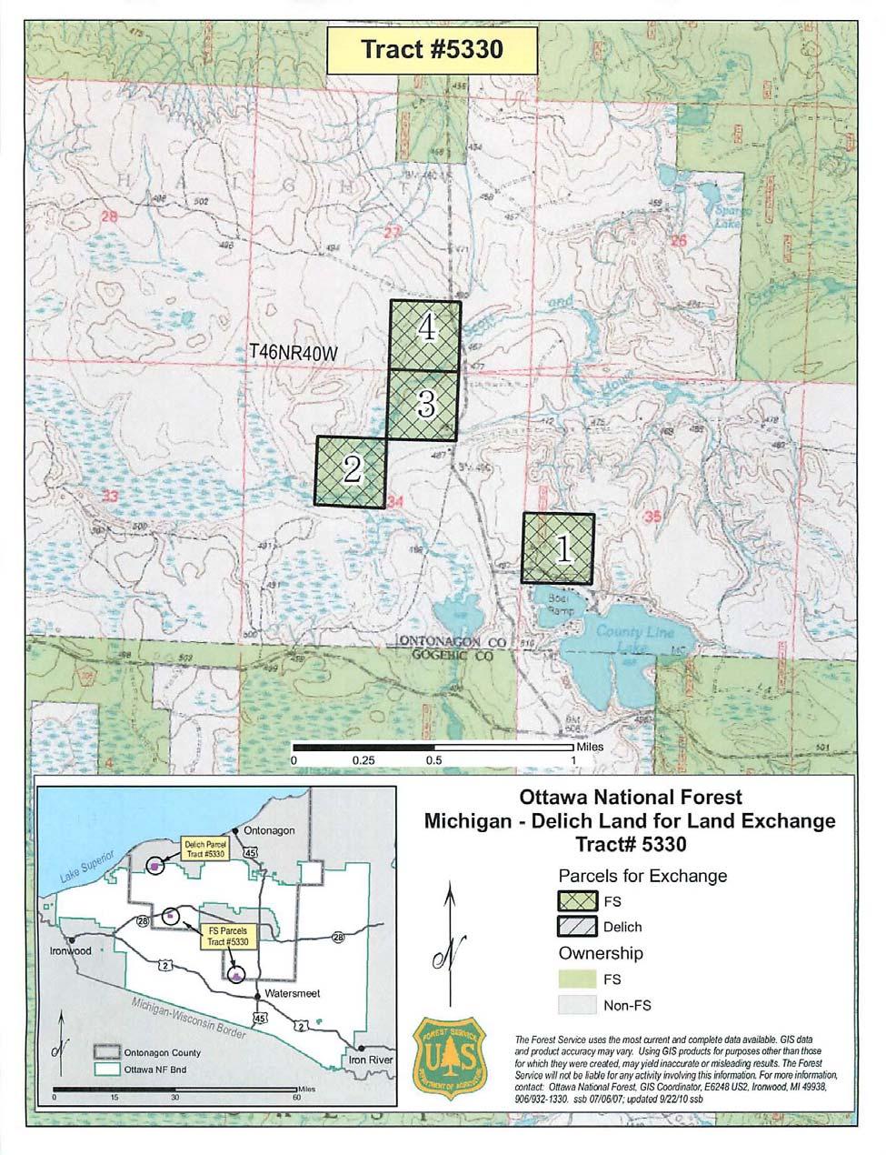
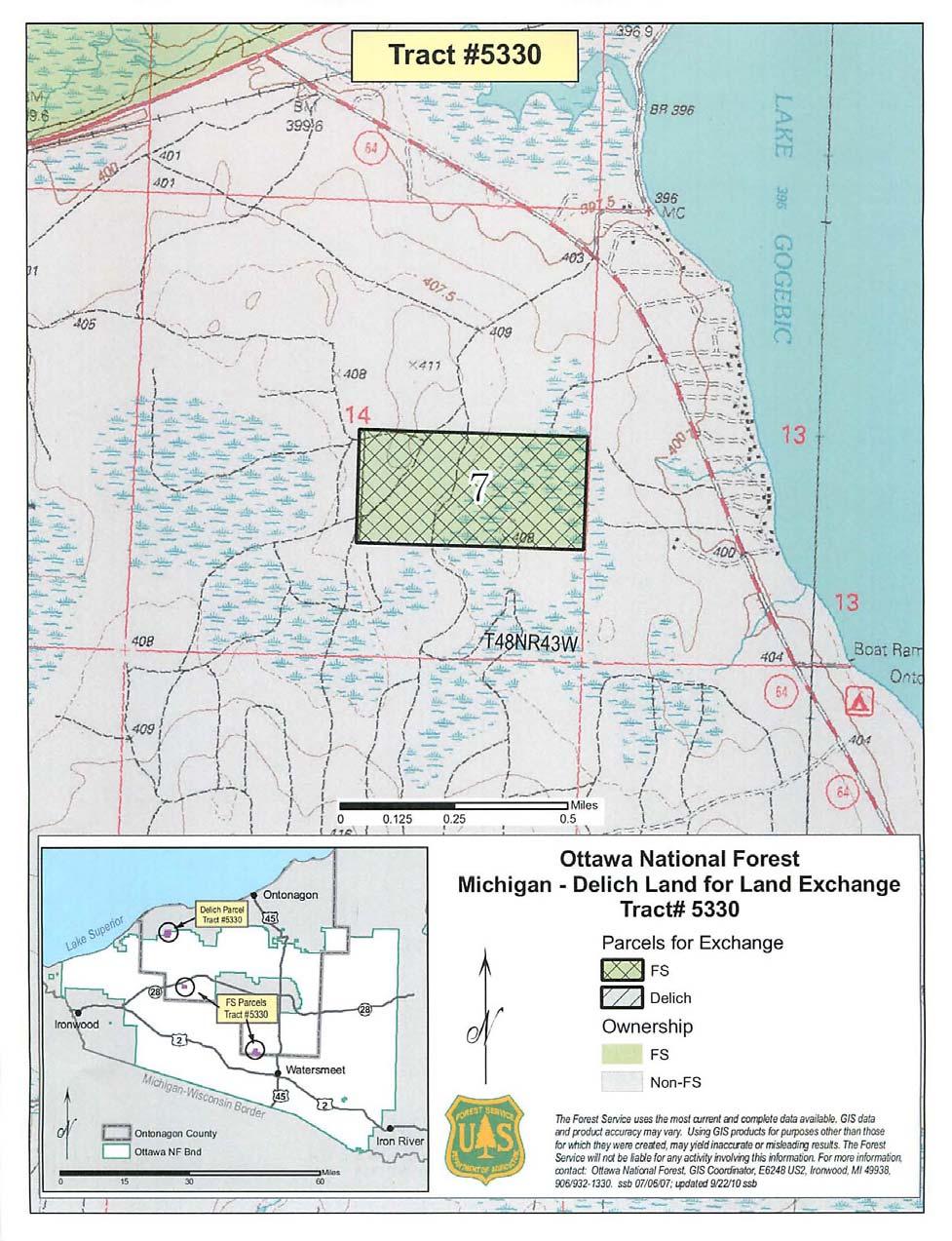
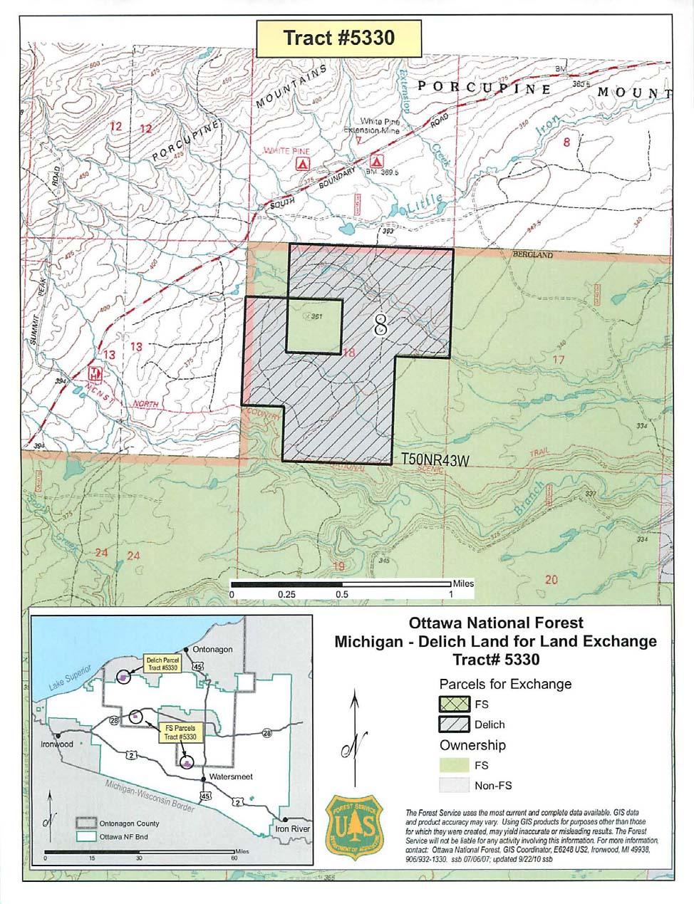
15 Exhibit 1 Federal and Non-federal Descriptions Federal Land Township of Haight, Ontonagon County, Michigan MICHIGAN MERIDIAN - TOWNSHIP 46N, RANGE 40W, Section 27, SWSE Parcels 4: Containing 40 acres, more or less Section 34, NWNE, SENW Parcels 2 and 3: Containing 80 acres, more or less Section 35, NWSW Parcel 1: Containing 40 acres, more or less Township of Bergland, Ontonagon County, Michigan MICHIGAN MERIDIAN - TOWNSHIP 48N, RANGE 43W, Section 14, N1/2SE Parcel 7: Containing 80 acres, more or less Federal Parcels Total: Containing in the aggregate 240 acres, more or less. Non-federal Lands Owned by Mr. Robert D. Delich Township of Carp Lake, Ontonagon County, Michigan MICHIGAN MERIDIAN - TOWNSHIP 50N, RANGE 43W, Section 18, NE, NENW, SWNW, NWSW, E1/2SW, W1/2SE Non-Federal Parcel (8) Containing acres, more or less. 12
16 Exhibit 2 Maps of Parcels 13
17 14
18 15
19 16
20 EXHIBIT 3 ERRATA FOR THE JANUARY 2010 ENVIRONMENTAL ASSESSMENT The Interdisciplinary Team has reviewed the January 2010 Environmental Assessment (EA). The following document reflects needed changes to the EA based on this review. Page numbers listed in this errata document pertain to the pages for the January 2010 EA. I. Information not addressed in this errata document. Corrections for minor typographical errors in spelling, punctuation and format. Updates to the literature cited. The January 2010 EA included literature cited which was not referenced in the EA. II. Information addressed in this errata document. The following list displays where minor changes were made in the January 2010 EA. Italicized text denotes where changes have occurred. This exchange is being considered under the authority of the Federal Land Policy and Management Act of 1976, the Federal Land Exchange Facilitation Act of 1988, and the Weeks Act of March 1, 1911 (p. 2). An alternative was considered to purchase outright the approximate 421 acres that Mr. Delich proposed for exchange with the Forest Service. However, this alternative was not analyzed in detail as the landowner was not interested in selling the parcels involved; he was interested only in pursuing an exchange of lands. Furthermore, current levels of appropriated funding for acquisitions would prevent the purchase from occurring (p. 10). Special use permits to grant authorized use of routes to access four homes on parcel 1 is currently being analyzed (p. 27). Opportunities for hiking and the viewing of wildlife and natural features, such as Wildcat Falls, on the parcels involved may be altered; however there are many other opportunities within the Ottawa to gain similar recreation experiences (p. 27). The proponent also plans to develop parcel 1 into five acre lots, which would have a negative effect on marten habitat (p. 47). 17
DRAFT Decision Notice and Finding of No Significant Impact
 United States Department of Agriculture Forest Service December 2014 DRAFT Decision Notice and Finding of No Significant Impact Town of Manila Land Conveyance (Manila Landfill) Flaming Gorge Ranger District,
Environmental Assessment South Administrative Site Proposed Property Sale
 Department of Agriculture Forest Service June 2010 Environmental Assessment 6200 South Administrative Site Proposed Property Sale Uinta-Wasatch-Cache NF Salt Lake Ranger District Salt Lake County, Utah
Grand Mesa, Uncompahgre and Gunnison National Forests Region 2, USDA Forest Service
 Decision Memo Taylor River Land Exchange Under the General Exchange Act of March 20, 1922 as Amended, The Federal Land Policy and Management Act of 1976 as Amended and the Federal Land Exchange Facilitation
1.1 Purpose. The purpose of this chapter is to summarize guidance on those requirements generally applicable to grant programs.
 523 FW 1 Summary FWM#: 061 (new) Date: December 17, 1992 Series: State Grant Programs Part 523: Federal Aid Compliance Requirements Originating Office: Division of Federal Aid 1.1 Purpose. The purpose
Record of Decision Mt. Hood National Forest Geothermal Leases August Record of Decision. Mt. Hood National Forest Geothermal Leases
 Summary Record of Decision Mt. Hood National Forest Geothermal Leases USDA Forest Service Mt. Hood National Forest Hood River and Barlow Ranger Districts Hood River County, Oregon It is my recommendation
Ensuring Success in Navigating the NRCS Ag Land Easement Program and Appraisal Review process
 Ensuring Success in Navigating the NRCS Ag Land Easement Program and Appraisal Review process Agricultural Conservation Easement Program - ACEP Agricultural Land Easement (ALE) Agricultural Conservation
Northern Land and Sales Land Exchange Project
 United States Department of Agriculture Forest Service Northern Land and Sales Land Exchange Project Draft Decision Notice Bergland, Kenton and Ontonagon Ranger Districts, Ottawa National Forest, Houghton
Forest Service Role CHAPTER 2
 CHAPTER 2 Forest Service Role Implementation of the Management Plan charters a federal presence with an expanded focus beyond traditional Forest Service roles. In addition to administration of the National
Environmental Assessment
 United States Department of Agriculture Forest Service September 2013 Environmental Assessment Hotchkiss Reservoir Land Exchange Norwood Ranger District Grand Mesa, Uncompahgre, and Gunnison National Forests
DECISION MEMO FOR CATEGORICAL EXCLUSION. USDA-Forest Service Hiawatha National Forest
 DECISION MEMO FOR CATEGORICAL EXCLUSION USDA-Forest Service Hiawatha National Forest Sault Ste. Marie Administrative Site Forest Service Facility Realignment and Enhancement Act of 2005 Chippewa County,
DRAFT FOR PUBLIC HEARING (rev. March, 2016)
") Chapter 200. ZONING Article VI. Conservation/Cluster Subdivisions 200-45. Intent and Purpose These provisions are intended to: A. Guide the future growth and development of the community consistent with
Chapter 200. ZONING Article VI. Conservation/Cluster Subdivisions 200-45. Intent and Purpose These provisions are intended to: A. Guide the future growth and development of the community consistent with
Georgia Conservation Tax Credit Program Frequently Asked Questions
 Georgia Conservation Tax Credit Program Frequently Asked Questions What are the minimum requirements for eligibility under the Georgia Conservation Tax Credit Program (GCTCP)? Individual and corporate
Central Pennsylvania Conservancy Project Selection Criteria Form
 Central Pennsylvania Conservancy Project Selection Criteria Form The following criteria guide the actions of the Central Pennsylvania Conservancy s Land Protection Committee and Board of Directors in selecting
Coon Creek Administrative Site Sale
 Decision Notice/Finding of No Significant Impact Coon Creek Administrative Site Sale USDA Forest Service Grand Valley Ranger District Grand Mesa, Uncompahgre and Gunnison National Forest Mesa County, Colorado
CITY OF FORT COLLINS NATURAL AREAS AND CONSERVED LANDS EASEMENT POLICY
 CITY OF FORT COLLINS NATURAL AREAS AND CONSERVED LANDS EASEMENT POLICY Adopted January 3, 2012 PURPOSE: The purpose of the policy statement is to clarify the policies and procedures of the City of Fort
FINDING OF NO SIGNIFICANT IMPACT TENNESSEE VALLEY AUTHORITY DISPOSAL FEE OWNERSHIP OF YELLOW CREEK INDUSTRIAL PARK PROPERTIES
 FINDING OF NO SIGNIFICANT IMPACT TENNESSEE VALLEY AUTHORITY DISPOSAL FEE OWNERSHIP OF YELLOW CREEK INDUSTRIAL PARK PROPERTIES In 1971, the Tennessee Valley Authority (TVA) partnered with the Mississippi
FOREST SERVICE HANDBOOK NATIONAL HEADQUARTERS (WO) WASHINGTON, DC
 WASHINGTON, DC") Page 1 of 58 FOREST SERVICE HANDBOOK NATIONAL HEADQUARTERS (WO) WASHINGTON, DC Amendment No.: 5409.13-2004-1 Effective Date: February 27, 2004 Duration: This amendment is effective until superseded or
Page 1 of 58 FOREST SERVICE HANDBOOK NATIONAL HEADQUARTERS (WO) WASHINGTON, DC Amendment No.: 5409.13-2004-1 Effective Date: February 27, 2004 Duration: This amendment is effective until superseded or
3.23 LANDS AND SPECIAL USES
 3.23 LANDS AND SPECIAL USES Introduction This section addresses those aspects of SJPLC management relating to public land ownership and use. Special Use Permits, rights-of-way (ROW) grants, easements,
Alternatives: Three alternatives were analyzed in detail in the FEIS, including:
 Logo Department Name Agency Organization Organization Address Information United States Department of Agriculture Forest Service Rocky Mountain Region 740 Simms Street Golden, CO 80401 303-275-5350 FAX:
Article 12.5 Exemptions for Agricultural Housing, Affordable Housing, and Residential Infill Projects
 Title 14. California Code of Regulations Chapter 3. Guidelines for Implementation of the California Environmental Quality Act Article 12.5 Exemptions for Agricultural Housing, Affordable Housing, and Residential
NRCS Floodplain Easement Program Sheffield Brook Floodplain Restoration. Lesley R. Sweeney, PE USDA Natural Resources Conservation Service
 NRCS Floodplain Easement Program Sheffield Brook Floodplain Restoration Lesley R. Sweeney, PE USDA Natural Resources Conservation Service Natural Resources Conservation Service (NRCS) A Voluntary Federal
Chapter 100 Planned Unit Development in Corvallis Urban Fringe
 100.100 Scope and Purpose. Chapter 100 Planned Unit Development in Corvallis Urban Fringe (1) All applications for land divisions in the Urban Residential (UR) and Flood Plain Agriculture (FPA) zones within
PROJECT SCORING GUIDANCE. Introduction: National Proiect Selection:
 FOREST LEGACY PROGRAM PROJECT SCORING GUIDANCE Introduction: This document provides guidance to the National Review Panel on how to score individual Forest Legacy Program (FLP) projects, including additional
Title 5: ADMINISTRATIVE PROCEDURES AND SERVICES
 Title 5: ADMINISTRATIVE PROCEDURES AND SERVICES Chapter 353: LAND FOR MAINE'S FUTURE Table of Contents Part 15-A. LAND FOR MAINE'S FUTURE... Section 6200. FINDINGS... 3 Section 6201. DEFINITIONS... 3 Section
Public Law th Congress An Act
 114 STAT. 2563 Public Law 106 538 106th Congress An Act To establish the Las Cienegas National Conservation Area in the State of Arizona. Be it enacted by the Senate and House of Representatives of the
CHAPTER 15: ENVIRONMENTAL REVIEW
 CHAPTER 15: ENVIRONMENTAL REVIEW CHAPTER PURPOSE & CONTENTS This chapter provides grantees with general information on environmental review. The chapter will provide an overview of the applicable regulations,
Subtitle H Agricultural Conservation Easement Program
 1 1 1 1 1 1 0 1 0 1 0 Subtitle H Agricultural Conservation Easement Program SEC.. [1 U.S.C. ] ESTABLISHMENT AND PURPOSES. (a) Establishment. The Secretary shall establish an agricultural conservation easement
Chapter 10 Local Protection Measures
 The DPC fully supports the protection of private property rights and the DPC will work to ensure that there will be no negative impacts stemming from NHA activities on private property, should the designation
The University of Texas System Systemwide Policy. Policy: UTS Title. Environmental Review for Acquisition of Real Property. 2.
 1. Title 2. Policy Environmental Review for Acquisition of Real Property Sec. 1 Sec. 2 Policy Statement. It is the policy of The University of Texas System to minimize its potential for exposure to claims
THE COUCHICHING CONSERVANCY LAND STEWARDSHIP POLICY. As approved by the Board, April 30, 2007
 THE COUCHICHING CONSERVANCY LAND STEWARDSHIP POLICY As approved by the Board, April 30, 2007 When one tugs at a single thing in nature, he finds it attached to the rest of the world. John Muir This policy
Code of Federal Regulations
 Code of Federal Regulations Title 24 - Housing and Urban Development Volume: 1 Date: 2004-04-01 Original Date: 2004-04-01 Title: PART 50 - PROTECTION AND ENHANCEMENT OF ENVIRONMENTAL QUALITY Context: Title
PACIFIC REGION LAND ACQUISITION REQUIREMENTS
 PACIFIC REGION LAND ACQUISITION REQUIREMENTS The following is an outline of the filing requirements for tribal land acquisition requests and timeframes involved for various steps of the process: 1) All
Fax: (413) Internet: Version: Hawaii 6.0 USDA Forest Service, National Woodland Owner Survey
 Internet: Version: Hawaii 6.0 USDA Forest Service, National Woodland Owner Survey") Comments or questions? Please contact us: USDA Forest Service National Woodland Owner Survey 160 Holdsworth Way Amherst, MA 01003 Toll-Free Telephone: (855) 233-3372 Email: nwos@fs.fed.us Fax: (413) 545-1860
Comments or questions? Please contact us: USDA Forest Service National Woodland Owner Survey 160 Holdsworth Way Amherst, MA 01003 Toll-Free Telephone: (855) 233-3372 Email: nwos@fs.fed.us Fax: (413) 545-1860
AFFIRMATIVELY FURTHERING FAIR HOUSING
 FINAL REGULATIONS AFFIRMATIVELY FURTHERING FAIR HOUSING Ed Gramlich (ed@nlihc.org) National Low Income Housing Coalition Modified, October 2015 INTRODUCTION On July 8, 2015, HUD released the long-awaited
STAFF REPORT. Permit Number: Porter. Kitsap County Board of Commissioners; Kitsap County Planning Commission
 STAFF REPORT Permit Number: 15 00461 Porter DATE: November 9, 2015 TO: FROM: Kitsap County Board of Commissioners; Kitsap County Planning Commission Katrina Knutson, AICP, Senior Planner, DCD and Jeff
ARTICLE XI - CONSERVATION SUBDIVISIONS
 ARTICLE XI - CONSERVATION SUBDIVISIONS Section 1101: Purpose and Intent. This Article is intended to provide for residential subdivisions that are designed based first and foremost on the preservation
Application Procedures for Easements or Rights of Way on City of Fort Collins Natural Areas and Conserved Lands March 2012
 Application Procedures for Easements or Rights of Way on City of Fort Collins Natural Areas and Conserved Lands March 2012 IMPORTANT NOTE: This document was created to accompany the City of Fort Collins
For the reasons set forth in the preamble, the Department proposes to amend 25 CFR 151
 For the reasons set forth in the preamble, the Department proposes to amend 25 CFR 151 as follows: 1. Revise Part 151 of Title 25 of the Code of Federal Regulations to read as follows: PART 151 LAND ACQUISITION
BY BOARD OF COUNTY COMMISSIONERS AN ACT TO BE ENTITLED
 BY BOARD OF COUNTY COMMISSIONERS ORDINANCE NO. AN ACT TO BE ENTITLED AN ORDINANCE AMENDING THE PASCO COUNTY LAND DEVELOPMENT CODE, ARTICLE 700, BY REPEALING EXISTING SECTION 702, ENVIRONMENTALLY SENSITIVE
CHAPTER 11: ENVIRONMENTAL REVIEW
 CHAPTER 11: ENVIRONMENTAL REVIEW CHAPTER PURPOSE & CONTENTS This chapter provides states with general information on environmental review. The chapter will provide an overview of the applicable regulations,
Page 1 of 17. Office of the City Manager ACTION CALENDAR March 28, 2017 (Continued from February 28, 2017)
") Page 1 of 17 Office of the City Manager ACTION CALENDAR March 28, 2017 (Continued from February 28, 2017) To: From: Honorable Mayor and Members of the City Council Dee Williams-Ridley, City Manager Submitted
Page 1 of 17 Office of the City Manager ACTION CALENDAR March 28, 2017 (Continued from February 28, 2017) To: From: Honorable Mayor and Members of the City Council Dee Williams-Ridley, City Manager Submitted
Chapter VIII. Conservation Easements: Valuing Property Subject to a Qualified Conservation Contribution
 A. Overview and Purpose Chap. VIII Conservation Easements: Valuing... Jacobson & Becker 91 Chapter VIII Conservation Easements: Valuing Property Subject to a Qualified Conservation Contribution Forest
Kitsap County Department of Community Development
 Kitsap County Department of Community Development Staff Report and Recommendation Annual Comprehensive Plan Amendment Process for 2018 Public Facility Designations and Park Classifications Update Report
Field CPD Division Directors Issued: July 17, 2001 Field Environmental Officers Expires: July 17, 2002 HOME Participating Jurisdictions and Partners
 U.S. DEPARTMENT OF HOUSING AND URBAN DEVELOPMENT Community Planning and Development WASHINGTON, D.C. 20410-7000 Special Attention of: NOTICE CPD-01-11 Field CPD Division Directors Issued: July 17, 2001
Walworth County Farmland Preservation Plan Update, Chapter 1 Plan Summary (Cover Document)
") Background Walworth County Farmland Preservation Plan Update, 2012 Chapter 1 Plan Summary (Cover Document) For over 30-years, the Wisconsin Farmland Preservation Program has served to preserve Walworth
Background Walworth County Farmland Preservation Plan Update, 2012 Chapter 1 Plan Summary (Cover Document) For over 30-years, the Wisconsin Farmland Preservation Program has served to preserve Walworth
PENINSULA TOWNSHIP DONATION of DEVELOPMENT RIGHTS ORDINANCE (DDR, No. 45)
") PENINSULA TOWNSHIP DONATION of DEVELOPMENT RIGHTS ORDINANCE (DDR, No. 45) THE TOWNSHIP OF PENINSULA, GRAND TRAVERSE COUNTY, MICHIGAN ORDAINS: Section 101 General Provisions A. Title: This Ordinance shall
PENINSULA TOWNSHIP DONATION of DEVELOPMENT RIGHTS ORDINANCE (DDR, No. 45) THE TOWNSHIP OF PENINSULA, GRAND TRAVERSE COUNTY, MICHIGAN ORDAINS: Section 101 General Provisions A. Title: This Ordinance shall
IRS FORM 8283 SUPPLEMENTAL STATEMENT DONATION OF CONSERVATION EASEMENT
 Name(s) shown on income tax return Identifying Number Robert T. Landowner 021-34-1234 Susan B. Landowner 083-23-5555 IRS FORM 8283 SUPPLEMENTAL STATEMENT DONATION OF CONSERVATION EASEMENT On November 12,
MIDWAY CITY Municipal Code
 MIDWAY CITY Municipal Code TITLE 9 ANNEXATION CHAPTER 9.01 PURPOSE CHAPTER 9.02 GENERAL REQUIREMENTS CHAPTER 9.03 PROPERTY OWNER INITIATION OF ANNEXATION CHAPTER 9.04 PROCEDURES FOR CONSIDERATION OF PETITION
Residential Project Convenience Facilities
 Standards for Specific Land Uses 35.42.220 E. Findings. The review authority shall approve a Land Use Permit in compliance with Subsection 35.82.110.E (Findings required for approval) or a Conditional
Conservation Easement Stewardship
 Conservation Easements are effective tools to preserve significant natural, historical or cultural resources. Conservation Easement Stewardship Level of Service Standards March 2013 The mission of the
STAFF REPORT. Permit Number: Garland. Kitsap County Board of Commissioners; Kitsap County Planning Commission
 STAFF REPORT Permit Number: 15 00686 Garland DATE: February 25, 2016 TO: FROM: Kitsap County Board of Commissioners; Kitsap County Planning Commission Katrina Knutson, AICP, Senior Planner, DCD and Jeff
IMPLEMENTING AGREEMENT. for the EAST CONTRA COSTA COUNTY HABITAT CONSERVATION PLAN/ NATURAL COMMUNITY CONSERVATION PLAN.
 IMPLEMENTING AGREEMENT for the EAST CONTRA COSTA COUNTY HABITAT CONSERVATION PLAN/ NATURAL COMMUNITY CONSERVATION PLAN by and between EAST CONTRA COSTA COUNTY HABITAT CONSERVANCY, COUNTY OF CONTRA COSTA,
Sabine River Authority, State of Louisiana
 Sabine River Authority, State of Louisiana Policy for Administering the Shoreline Management Plan (SMP) Encroachments Adopted by SRA Board of Commissioners: Introduction The Federal Energy Regulatory Commission
December 21, The specific provisions of P.L that apply solely to the CDCA are:
 United States Department of the Interior BUREAU OF LAND MANAGEMENT California State Office 2800 Cottage Way, Suite W1623 Sacramento, CA 95825 www.blm.gov/ca December 21, 2012 In Reply Refer To: 4100 (CA930)
78th OREGON LEGISLATIVE ASSEMBLY Regular Session. House Bill 2510 SUMMARY
 th OREGON LEGISLATIVE ASSEMBLY--0 Regular Session Sponsored by Representative CLEM (Presession filed.) House Bill 0 SUMMARY The following summary is not prepared by the sponsors of the measure and is not
LAKE OF THE WOODS COUNTY WETLAND CONSERVATION ORDINANCE OF 2002
 Ordinance # LAKE OF THE WOODS COUNTY WETLAND CONSERVATION ORDINANCE OF 2002 ARTICLE 1 TITLE AND PURPOSE Section 1.1. Title This Ordinance shall be known, cited and referred to as the Lake of the Woods
Evaluating and Processing Road and Utility Easement Proposals on Corps Lands and Flowage Easements
 Evaluating and Processing Road and Utility Easement Proposals on Corps Lands and Flowage Easements Don Wiese Natural Resources Manager Fort Worth District September 13, 2017 US Army Corps of Engineers
DEPARTMENT OF THE ARMY OFFICE OF THE CHIEF OF ENGINEERS WASHINGTON, D.C
 DEPARTMENT OF THE ARMY OFFICE OF THE CHIEF OF ENGINEERS WASHINGTON, D.C. 20314-1000 REPLY TO ATTENTION OF: CECW-PM (10-1-7a) THE SECRETARY OF THE ARMY 1. I submit for transmission to Congress my report
Town of Falmouth s Four Step Design Process for Subdivisions in the Resource Conservation Zoning Overlay District
 Town of Falmouth s Four Step Design Process for Subdivisions in the Resource Conservation Zoning Overlay District All subdivisions shall be designed in accordance with the following four-step process.
APPENDIX B COMPLIANCE WITH THE GOVERNMENT CODE
 APPENDIX B COMPLIANCE WITH THE GOVERNMENT CODE A. GENERAL PLAN AMENDMENT PROCEDURE In general, local governments may not amend any of the mandatory elements of the General Plan (e.g. Land Use, Open Space,
A. Preserve natural resources as identified in the Comprehensive Plan.
 1370.08 Conservation Residential Overlay District. Subd. 1 Findings. The City finds that the lands and resources within the Conservation Residential Overlay District are a unique and valuable resource
SUBJECT: CROWN RESERVED ROAD POLICY
 SUBJECT: CROWN RESERVED ROAD POLICY Policy Number: CLM 006 2003 C. R. File Number: 656-00-0001 Effective Date: July 6, 2010 To Be Reviewed: July 6, 2014 Approval: Original Signed by Phil LePage, Deputy
Chapter HABITAT CONSERVATION PLAN / NATURAL COMMUNITY CONSERVATION PLAN IMPLEMENTATION ORDINANCE
 Chapter 15.108 HABITAT CONSERVATION PLAN / NATURAL COMMUNITY CONSERVATION PLAN IMPLEMENTATION ORDINANCE Sections: 15.108.010 Purpose. 15.108.020 Definitions. 15.108.030 Applicability 15.108.040 Responsibility
Corporation Of The City Of Kingston. Ontario. By-Law Number A By-Law To Provide For The Conveyance Of Land For Park Purposes,
 Corporation Of The City Of Kingston Ontario By-Law Number 2013-107 A By-Law To Provide For The Conveyance Of Land For Park Purposes, Or Cash-In-Lieu Of Parkland Conveyance Passed: May 21, 2013 Updated:
RECITALS. B. WHEREAS, Ranch, its successors and assigns, are referred to in the Easement as the Grantor ; and
 Basic Components of Management Plans Associated with Conservation Easement Acquisitions Where A Land Trust Or other third party Is the Grantee April 17, 2012 Key: Text in normal font, without highlight,
UNIFORM RULE 5. Administration of Williamson Act Contracts
 UNIFORM RULE 5 Administration of Williamson Act Contracts I. PROCEDURE TO ESTABLISH AN AGRICULTURAL PRESERVE AND WILLIAMSON ACT CONTRACT See Appendices 1 and 2 for the following forms: Application Form
Chapter XX Purchase of Development Rights Program
 Chapter XX Purchase of Development Rights Program Short Title. This ordinance is to be known and may be cited as the Purchase of Development Rights ( PDR ) Program. Purpose Pursuant to the authority granted
Note: The Local Public Agency should print the first page of this assurance on their respective letterhead
 Note: The Local Public Agency should print the first page of this assurance on their respective letterhead Standard Title VI/Non-Discrimination Assurances DOT Order No. 1050.2A The Local Public Agency,
Our Commitment to Fair Housing. Montgomery County, Pennsylvania
 Our Commitment to Fair Housing Montgomery County, Pennsylvania HUD Urban County Montgomery County is a recipient of federal Community Development Block Grant (CDBG) and Home Investment Partnership (HOME)
[15XL LLIDI02000.L EO0000. LVTFD A ; IDI- Notice of Intent to Amend the Pocatello Resource Management Plan and Notice of
 This document is scheduled to be published in the Federal Register on 08/10/2015 and available online at http://federalregister.gov/a/2015-19606, and on FDsys.gov 4310-GG-P DEPARTMENT OF THE INTERIOR Bureau
OPEN SPACE & RECREATION PLAN
 OPEN SPACE & RECREATION PLAN HOPEWELL TOWNSHIP Cumberland County, New Jersey Prepared by: Hopewell Township Environmental Commission Final October 2011 (THIS PAGE INTENTIONALLY LEFT BLANK) PUBLIC MEETINGS
Strategic Growth Council: Identifying Infill Barriers
 Streamlining Infill in the CEQA Guidelines (SB 226) Strategic Growth Council: Identifying Infill Barriers Looking within state agencies to reduce conflicts and promote successful programs Working with
RESIDENTIAL AND RECREATIONAL
 Energy, Mines & Resources Land Management Branch 320-300 Main Street Whitehorse, Yukon Y1A 2B5 667-5215 Fax 667-3214 www.emr.gov.yk.ca RESIDENTIAL AND RECREATIONAL Lot Enlargement Policy OBJECTIVE To facilitate
Chapter 210 CONDITIONAL USES
 Chapter 210 CONDITIONAL USES 210.01 Purpose 210.02 Authorization 210.03 Process Type 210.04 Determination of Major or Minor Conditional Use Review 210.05 Approval Criteria 210.06 Conditions of Approval
If projects are received at the counter to be submitted without prior draft review, the project will be deferred to the next meeting.
 5400 Butternut Drive East Syracuse, NY13057-8509 Phone: 315.446.3910 x3 Fax: 315.449.0620 Edward M.Michalenko, PhD. Supervisor Planning & Zoning Samuel C. Gordon, MLA, Director Welcome to the Town of DeWitt
APPLICATION CHECKLIST
 DEPARTMENT OF PLANNING AND COMMUNITY DEVELOPMENT 1010 10TH Street, Suite 3400, Modesto, CA 95354 Phone: 209.525.6330 Fax: 209.525.5911 Form Available Online: http://www.stancounty.com/planning/applications.shtm
RECORD OF DECISION HERMOSA /MITCHELL LAKES LAND EXCHANGE
 RECORD OF DECISION FINAL ENVIRONMENTAL IMPACT STATEMENT FOR THE HERMOSA /MITCHELL LAKES LAND EXCHANGE USDA FOREST SERVICE ROCKY MOUNTAIN REGION (R2) SAN JUAN NATIONAL FOREST COLUMBINE RANGER DISTRICT LA
16 USC 545b. NB: This unofficial compilation of the U.S. Code is current as of Jan. 4, 2012 (see
 TITLE 16 - CONSERVATION CHAPTER 2 - NATIONAL FORESTS SUBCHAPTER II - SCENIC AREAS 545b. Opal Creek Wilderness and Scenic Recreation Area (a) Definitions In this section: (1) Bull of the Woods Wilderness
NOTICE OF PREPARATION of a Draft Program Environmental Impact Report for the Fresno County General Plan Review and Zoning Ordinance Update
 NOTICE OF PREPARATION of a Draft Program Environmental Impact Report for the Fresno County General Plan Review and Zoning Ordinance Update Date: March 21, 2018 To: State Clearinghouse, Responsible Agencies,
Short Title This Chapter shall be known and cited as the Open Space Open Space Program and Public Benefit Rating System.
 CHAPTER 14.08 OPEN SPACE OPEN SPACE PROGRAM AND PUBLIC BENEFIT RATING SYSTEM SECTIONS: 14.08.0 10 - Short Title 14.08.020 - Purpose 14.08.030 - Administration 14.08.040 - Compliance with Regulations 14.08.050
Notice of Continuance Land Classified as Current Use or Forest Land RCW Chapter and 84.33
 When Recorded Return to: Notice of Continuance Land Classified as Current Use or Forest Land RCW Chapter 84.34 and 84.33 Grantor(s)/Sellers: Grantee(s)/Buyers: Mailing Address: City, State, Zip: Assessor
Notice of Continuance Land Classified as Current Use or Forest Land Chapter and Revised Code of Washington
 When Recorded Return to: Cowlitz County Assessor s Office Attn: Forest Land / Current Use Dept 207 N 4 th Avenue Kelso WA 98626 Notice of Continuance Land Classified as Current Use or Forest Land Chapter
Remains eligible for state or federal farm programs. Can use land as collateral for loans. Can reserve home lots for children
 December 2002 B-1132 Conservation Easements: An Introductory Review for Wyoming By Allison Perrigo and Jon Iversen, William D. Ruckelshaus Institute of Environment and Natural Resources William D. Ruckelshaus
REGENTS POLICY PART V FINANCE AND BUSINESS MANAGEMENT Chapter Real Property
 REGENTS POLICY PART V FINANCE AND BUSINESS MANAGEMENT Chapter 05.11 Real Property P05.11.010. Purpose and Scope. A. This chapter establishes guidelines for the prudent management, including trust management,
Chapter 52 FARMLAND AND OPEN SPACE PRESERVATION
 Chapter 52 FARMLAND AND OPEN SPACE PRESERVATION [HISTORY: Adopted by the Town Board of the Town of Troy 10-11-1999 by Ord. No. 99-2. Amendments noted where applicable.] GENERAL REFERENCES Building construction
Down Payment and Closing Cost Assistance. Neighborhood Housing Services of Bedford Stuyvesant 1012 Gates Avenue Brooklyn, NY 11221
 NEW YORK STATE HOUSING TRUST FUND HOME PROGRAM PROGRAMMATIC ENVIRONMENTAL REVIEW RECORD FOR LOCAL PROGRAM ADMINISTRATOR (LPA) PROGRAMS PROGRAM NAME: Down Payment and Closing Cost Assistance SHARS NUMBER:
Title 6 - Local Government Provisions Applicable to Special Purpose Districts and Other Political Subdivisions
 Title 6 - Local Government Provisions Applicable to Special Purpose Districts and Other Political Subdivisions CHAPTER 29. SOUTH CAROLINA LOCAL GOVERNMENT COMPREHENSIVE PLANNING ENABLING ACT OF 1994 1994
PLANNED UNIT DEVELOPMENT (PUD)
") SECTION 38.01. ARTICLE 38 PLANNED UNIT DEVELOPMENT (PUD) Purpose The purpose of this Article is to implement the provisions of the Michigan Zoning Enabling Act, Public Act 110 of 2006, as amended, authorizing
SECTION 38.01. ARTICLE 38 PLANNED UNIT DEVELOPMENT (PUD) Purpose The purpose of this Article is to implement the provisions of the Michigan Zoning Enabling Act, Public Act 110 of 2006, as amended, authorizing
BLUEPRINT REAL ESTATE POLICY
 DATE September 19,2007 TITLE BLUEPRINT REAL ESTATE POLICY ORG. AGENCY Blueprint Intergovernmental Agency APPROVED.01 STATEMENT OF POLICY The purpose of this administrative regulation is to establish a
HOW TO APPLY FOR A USE PERMIT
 HOW TO APPLY FOR A USE PERMIT MENDOCINO COUNTY PLANNING AND BUILDING SERVICES What is the purpose of a use permit? Throughout the County, people use their properties in many different ways. They build
SENATE, No STATE OF NEW JERSEY. 217th LEGISLATURE INTRODUCED SEPTEMBER 8, 2016
 SENATE, No. 0 STATE OF NEW JERSEY th LEGISLATURE INTRODUCED SEPTEMBER, 0 Sponsored by: Senator BOB SMITH District (Middlesex and Somerset) Senator CHRISTOPHER "KIP" BATEMAN District (Hunterdon, Mercer,
Requests for Qualifications
 Franklin Redevelopment and Housing Authority I. GENERAL SPECIFICATIONS Requests for Qualifications RFQ #20140224 DEV Franklin Redevelopment and Housing Authority ( FRHA ) hereby requests proposals from
CONSERVATION AND PRESERVATION EASEMENTS ACT Act of Jun. 22, 2001, P.L. 390, No. 29 AN ACT Providing for the creation, conveyance, acceptance,
 CONSERVATION AND PRESERVATION EASEMENTS ACT Act of Jun. 22, 2001, P.L. 390, No. 29 AN ACT Cl. 68 Providing for the creation, conveyance, acceptance, duration and validity of conservation and preservation
A Class Environmental Assessment for Provincial Parks and Conservation Reserves. Phase III: Submission to Ministry of the Environment
 A Class Environmental Assessment for Provincial Parks and Conservation Reserves Phase III: Submission to Ministry of the Environment II CLASS EA FOR PROVINCIAL PARKS AND CONSERVATION RESERVES 2001, Queen
A Presentation to the. Wyoming Solid Waste and Recycling Association (WSWRA) 2016 Annual Conference Agenda
 2016 Annual Conference Agenda") A Presentation to the Wyoming Solid Waste and Recycling Association (WSWRA) 2016 Annual Conference Agenda So you want to build a landfill? Then you re gonna need some land The Bureau of Land Management
A Presentation to the Wyoming Solid Waste and Recycling Association (WSWRA) 2016 Annual Conference Agenda So you want to build a landfill? Then you re gonna need some land The Bureau of Land Management
content chapter Section 4(f) Parks, Recreation Areas, Historic Sites, Wildlife and Waterfowl Refuges
 Parks, Recreation Areas, Historic Sites, Wildlife and Waterfowl Refuges") chapter Section 4(f) Parks, Recreation Areas, Historic Sites, Wildlife and Waterfowl Refuges 22 content 22.1 Summary of Key Legislation, Regulations, and Guidance 22.2 Agency Roles 22.3 General Methodology
chapter Section 4(f) Parks, Recreation Areas, Historic Sites, Wildlife and Waterfowl Refuges 22 content 22.1 Summary of Key Legislation, Regulations, and Guidance 22.2 Agency Roles 22.3 General Methodology
BROCHURE # 37 OPEN SPACE
 BROCHURE # 37 OPEN SPACE The information and instructions in this publication are to be used when applying for assessment on the basis of current use under the open space laws, chapter 84.34 RCW and chapter
Minnesota Pollution Control Agency Voluntary Investigation and Cleanup
 Minnesota Pollution Control Agency Voluntary Investigation and Cleanup Summary of Applicable Laws 1.0 Introduction Guidance Document #3 Over the past few years, the Minnesota Superfund law, known as the
Conservation & Development Policies: The Plan for Connecticut
 2013-2018 Conservation & Development Policies: The Plan for Connecticut CT Land Conservation Council March 21, 2015 www.ct.gov/opm/cdplan CT s Planning Framework State statutes include three separate,
Introduction to INRMP Implementation Options
 El Dorado County Integrated Natural Resources Management Plan Introduction to INRMP Implementation Options 1 Our approach to the options evaluation is based on the INRMP components as they are currently