Rural Framework Committee
|
|
|
- Julius Matthews
- 5 years ago
- Views:
Transcription
1 Rural Framework Committee Community Planning and Sustainable Development Dept. Summary for Sept. 29, 2009 Open House Douglas County Philip S. Miller Building Public Hearing Room Committee Members Present: Christine Hashimoto, Cozy Swickard, Dave Archer, John Spillane, Paul Fotinos Public: four members of the public Staff: Jeanette Bare, Brett Thomas, Dan Dertz, Matt Williams, Kim Smith Jeanette Bare gave a PowerPoint presentation summarizing the history of the RSP regulations repeal, background on the Rural Framework Planning Effort, how the Rural Framework Committee was selected, what they have looked a so far, and what they are currently working on (beginning the recommendations discussion/phase). Comments made during the Open House: Dave Archer Has there been any attempt to individually contact the large property owners regarding this committee? I think it s extremely important to get a notice to people who will be affected by this, like all the property s having 100 acres or greater. I have a problem with someone in Indian Creek telling someone in Cherry Valley what they can do with their land. If we don t get more time for this committee, then there won t be time for this, but if there is an extension, I think we need to reach out to those people. Chris Hashimoto I think it s good to inform the property owners, but perhaps a survey would provide us with more information. Guest 1) Put all of this information that is in the PowerPoint in the newspaper; 2) Have a telephone line where people can call in and get questions answered; 3) How can you be rural when adding cement to roads? That s just inviting development. It doesn t work if three people know about a cell tower going in and no one else does; and 4) It looks like you re going after Franktown and Cherry Valley; and 5) I like the 35-acre, take everything else away. Dave Archer Have the Planning Commission involved early in this process. Chris Hashimoto Send notices to abutting properties and put signs at the site for all projects. Frank What s left? The greatest impact will be to areas 5 and 6 on the map the large landowners. John Spillane One of the problems that the commissioners had with the Rural Site Plan (RSP) was the cost of infrastructure. What solution was the Board looking for? Jeanette Bare s reply Some of the Board s concerns with the RSP was that it didn t work for the public, the process took a lont time, and the infrastructure costs for the limited amount of lots received appeared too high. The Board wanted a more reasonable process in terms of time with possibly less engineering required. Dave Archer The developer cost per unit was horrendous. I liked the engineering process because it made drainage improvements and set road standards to last 20 years. It made it safe for the public and those living there. 100 Third Street, Castle Rock, Colorado Fax
2 Follow-up Items: Handout or mention the RSP resolution again at a future meeting to remind members what the goal is. Next Meeting: The next regular meeting is set for Tuesday, Oct. 6 from 6 to 9 p.m. Attachments: PowerPoint - Rural Framework Planning Process Status/Summary Presentation 2
3 Rural Framework Open House September 29 th, 2009 Purpose: To update public on the progress of the Rural Framework Committee s efforts and take feedback Schedule: 5:00 Greeting and Gathering 5:30 Formal Presentation by Staff 6:00 Remarks from RFC Members 6:15 Public Comment (Open Mike) 6:45 Next Steps
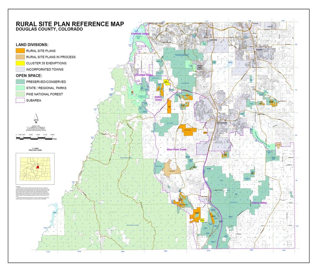
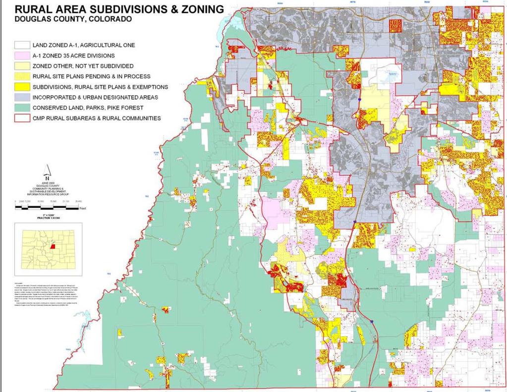
4 Rural Framework Study Area
5 Why this process? Board repeal of Rural Site Plan (RSP) regulations in April, 2009 Unacceptable elements needing refinement: Public input process inadequate BCC vs. staff roles confusing Excessive infrastructure costs Lengthy timeframes unacceptable for all Rural character and scale must be preserved Board desire to have rural residents and stakeholders directly participate in developing the framework for new/amended rural regulations
6 What were Rural Site Plans? Alternative to 35-acre land divisions in the A-1 zone district Allowed for clustered lots (smaller lot sizes) and bonus dwelling units (double) when open space was preserved in perpetuity 67% open space required to gain a 100% density bonus; 50% open space in lots to gain 40% bonus Maximum 1 du/17.5 acre gross density Administratively approved (planning staff) with BCC concurrence
7
8 Rural Framework Committee (RFC) 30-member ad-hoc citizen s committee appointed in May by the BCC Directed to submit recommendations on a framework of rural land use policies and regulations by October 15 th. Staff to support work of RFC and draft corresponding regulations. First RFC meeting held on June 23 rd (8 times over a 3 month period)
9 BCC Resolution Directives
10 Committee Tasks Review Existing Rural Regs and Development Patterns Define Rural Values and Visual Preferences Study Specific (Top) Rural Issues Evaluate Alternative Regulatory Approaches 2 Public Open Houses August 5 th & Sept. 29 th Develop Recommended Regulatory Concepts and other Framework Recommendations Present Formal Framework Recommendation to the Board (and staff-drafted regulations) Begin formal process of review and adoption of Regs (public work sessions, referral period, public hearings before PC and BCC).
11 Rural Framework Meetings

12 Rural Development Trends Urban vs. Non-urban: Acreages, total units, growth trends By Subarea: Decade of greatest growth General development characteristics RSP buildout trends
13
14 Framework Overview Comprehensive Plan General community plan that guides land use decisions and implemented by: 1) Zoning Use, intensity and other land use restrictions defined by District 2) Subdivision Division of land into lots, tracts and streets for sale or transfer 3) Construction permitting Specific codes applied to public facilities and private buildings
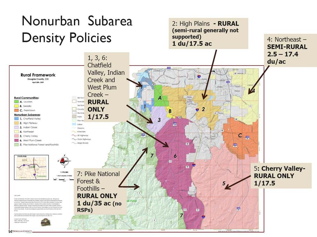
15 Master Plan Definitions Nonurban Density Categories: Semi-Rural (Gross) density of 1 dwelling unit per acres (Generally corresponds to RR, ER, and LRR Districts) Rural (Gross) maximum density of 1 dwelling unit per 17.5 acres (Generally corresponds to A-1, including Cluster-35 and former RSP Plans) Gross Density total units/total acreage of a subdivision/project (not minimum lot size)
16
17 Types of Zone Districts and Review: Straight-Zones (ER, RR, LRR, A-1) Planned Development Districts (PUDs) Overlay Districts IGA s with Parker and Castle Rock Wildfire Hazard Floodplain Water Supply Centennial Airport Administrative Process (SIPs, limited USRs, Cluster 35 Plans, former RSPs) Public Hearing Process (Rezonings, Amendments, USRs, Variances, Appeals)
18
19 Defining Rural Priorities What s most important to the rural community? Visual Preference Survey Small group prioritization exercise

20 Of Significant Value Agricultural uses and preserved Environmental Resources: Open space Active ranching and farming Equestrian uses Historic structures Wide-open vistas Wildlife Stream corridors


21 Support Services and Land Uses Agricultural-related uses strongly supported Most rural services (utility, institutional, emergency) supported Commercial uses split, favoring ag-related Recreational split, favoring passive Industrial uses not supported

22 Compatible With Rural Environment and Character Least conclusive Most split votes Any agricultural component shown - supported Single homes or lower density res. - supported Ridgeline placement, excessive cuts and fills, and unbuffered transitions not supported
 Small/more architecturally compatible buildings Tuck in")
23 Which One? Cluster/non-cluster split preference Support for clear choices: Natural entry features Good land management (less de-vegetation) Small/more architecturally compatible buildings Tuck in elevations Water use for agriculture Natural vegetative landscaping Transparent/visually compatible fencing (wildlife) Narrow roads, natural shoulders Limited lighting/contextual fixtures
24 Rural Values

25 Preserve Wildlife Habitat, maintain natural grade and terrain, maintain air quality Ensure the provision of sustainable water supply Establish minimum lot sizes for cluster subdivisions Support agricultural use as a priority Maintain Dark Skies Maintain a quiet environment Maintain low traffic levels Ensure proper range/land management Maintain rural sense of place


26 Topical Work Sessions
27 Open Space and Natural Resources COSAC (County Open Space Advisory Committee) County Parks, Trails, and Open Spaces Conservation Easements Geologic Hazards and Subsurface Geology Douglas County Conservation District soils, drainage, land management, weed control, erosion control subdivision review Wildlife Habitat Preservation Strategies (2030 Comp Plan)
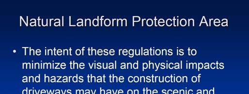
28 Rural Services Rural road and drainage standards Grading and erosion control Building codes Driveway review Natural Landforms Protection Wildfire Hazard Regulations
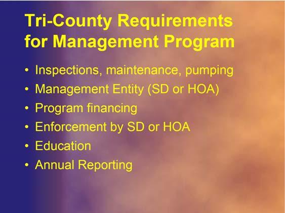
29 Water and Sewer Tri-County Health Department Septic System (ISDS individual sewage disposal systems) design and management Well and septic separations Douglas County Rural Water Authority Background and purpose of Authority Water supply challenges for rural areas Sustainable water supply - possible definitional changes and changes to County regs (18A)
30 Other Topics Approved RSP Analysis Large rancher challenges to maintain agricultural use in Douglas County Dedicated sales tax issues Rural road paving programs/options The future of agriculture: micro-ag and agriburbia trends Ag property tax assessments/other preservation strategies
31 Alternative Regulatory Approaches Other states Other Colorado Counties PUDs, Bonus Cluster Subdivisions, and TDRs (Transfer of Development Rights)
32 Possible Recommendations/ Discussion Points Develop fundamental principals/guiding statements as umbrella for next step: e. g., protect non-renewable water supplies and preserve important open space (environmental, visual, and public access) resource lands Incentive based process to encourage preservation of open lands is necessary. Incentives/trade-offs between property owners/developers and County must be meaningful to both. A variety of mechanisms should be used to accomplish rural area goals (regulatory changes, tax incentives, education, state legislative changes, further study regarding water supply, visual assets, etc ) Nearby rural community members should be involved early on in the land use review process to help prioritize preservation areas PC and BCC should hold public hearings for rural land use proposals and make final decision Criteria for lighting and other quality of life standards need to be specific
33 Possible Recommendations/ Discussion Points, cont All land use proposals should meet water supply criteria Rural roads and other improvements should look rural Encourage voluntary conservation easements Study TDR s further Ensuring proper land management/maintenance of open space is critical Public access to open space areas should be provided as much as possible Amend water supply regs to ensure greater sustainability Evaluate water supply demands for rural uses Review existing rural zone districts (uses and intensities) Require truly effective buffers next to existing rural/semi-rural Undertake a study to identify major visual assets in County Take all necessary steps to control noxious weeds Promote continued ag use, activities, education
34 Next Steps Committee has asked the BCC for a time extension to conclude its work effectively Develop/establish core Guiding Principals Identify and evaluate possible incentives (density bonus or other) for cluster/land preservation regs Create a priority matrix (or point system) which would allow a ranking or rating of different types of preservation elements in a particular development proposal Evaluate possible subarea regulatory distinctions based upon water availability, topographic conditions, or other unique elements
June 23, 2009 Initial Meeting RURAL FRAMEWORK COMMITEE
 June 23, 2009 Initial Meeting RURAL FRAMEWORK COMMITEE Committee Member Introductions One minute summary Name Subarea location/stakeholder identification What do you hope will come out of this rural framework
Guide to Combined Preliminary and Final Plats
 Guide to Combined Preliminary and Final Plats Introduction The Douglas County is committed to providing open, transparent application processes to the public. This Guide is provided to assist anyone interested
Guide to Preliminary Plans
 Guide to Preliminary Plans Introduction The Douglas County is committed to providing open, transparent application processes to the public. This Guide is provided to assist anyone interested in the procedures
-Section Contents- 201 Districts Overlay Districts Incorporation of Maps District Boundaries...
 SECTION 2 GENERAL REQUIREMENTS AND EXCEPTIONS -Section Contents- ZONING DISTRICTS 201 Districts... 2-2 202 Overlay Districts... 2-2 203 Incorporation of Maps... 2-3 204 District Boundaries... 2-3 LAND
Chapter 100 Planned Unit Development in Corvallis Urban Fringe
 100.100 Scope and Purpose. Chapter 100 Planned Unit Development in Corvallis Urban Fringe (1) All applications for land divisions in the Urban Residential (UR) and Flood Plain Agriculture (FPA) zones within
Guide to Minor Developments
 Guide to Minor Developments Introduction The Douglas County (DCD) is committed to providing open, transparent application processes to the public. This Guide is provided to assist anyone interested in
Guide to Replats. Step 1. Step 2. Step 3. Step 4. Step 5. Step 6. Step 7. Step 8. Step 9. Step 10
 Guide to Replats Introduction Douglas County is committed to providing open, transparent application processes to the public. This Guide is provided to assist anyone interested in the procedures and expectations
Conservation Design Subdivision Option
 Sheridan County, Wyoming Conservation Design Subdivision Option Recent Amendments to Zoning and Subdivision Rules and Regulations Adopted November 2010 Mark Reid, County Planner 1 County Road #255 traffic
DOUGLAS COUNTY SUBDIVISION RESOLUTION Article 4 Preliminary Plan 10/13/2015
 ARTICLE 4 PRELIMINARY PLAN 401 Intent An in-depth analysis of the proposed subdivision, including a review of the design considering the ability to obtain water and sanitation, identified geologic hazards,
HHLT Educational Forum: Conservation Subdivisions and the Open Space Overlay. February 5th 2018 Winter Hill
 HHLT Educational Forum: Conservation Subdivisions and the Open Space Overlay February 5th 2018 Winter Hill 1 Topics Covered SECTION I II III IV V TOPIC Comprehensive Plan Open Space Index Conservation
USE BY SPECIAL REVIEW STAFF REPORT- UPDATE
 ~~DOUGLAS COl-U~!X www.douglas.co.us Department of Community Development Planning Services USE BY SPECIAL REVIEW STAFF REPORT- UPDATE December 2, 2014 TO: FROM: RE: Douglas County Planning Commission Pam
FINAL DRAFT 12/1/16, Rev. to 7/18/17
 FINAL DRAFT 12/1/16, Rev. to 7/18/17 (As Adopted 8/8/17 Effective 9/1/17) SHELTON PLANNING AND ZONING COMMISSION Proposed Amendments to Zoning Regulations I. Amend Section 23 PERMITTED USES by inserting
Summary of Recommended Changes to the Town of Ballston Zoning Law and Key Items for Ongoing Discussion
 Summary of Recommended Changes to the Town of Ballston and Key Items for Ongoing Discussion Major Themes Incorporated to Bring Zoning into Consistency with Comprehensive Plan 1. Removed PUDD as allowable
ZRTD , Glenn Drive. M. Tyler Klein, AICP, Project Manager, Planning and Zoning John Merrithew, Acting Director, Planning and Zoning
 DEPARTMENT OF PLANNING Date of Hearing: AND ZONING STAFF REPORT # 4 BOARD OF SUPERVISORS PUBLIC HEARING SUBJECT: ELECTION DISTRICT: ZRTD-2014-0003, 22675 Glenn Drive Broad Run CRITICAL ACTION DATE: September
A. Preserve natural resources as identified in the Comprehensive Plan.
 1370.08 Conservation Residential Overlay District. Subd. 1 Findings. The City finds that the lands and resources within the Conservation Residential Overlay District are a unique and valuable resource
The Ranches Sketch Plan
 The Ranches Sketch Plan APPLICATION: RURAL LAND USE PROCESS (AKA CLUSTER DEVELOPMENT) HEARING DATES: Planning Commission: 12 July 2017 at 6:30 pm Board of County Commissioners: TBD APPLICANT: REQUEST:
Instructions: Script:
 Before the course, select four of the 11 tool topics to insert into the presentation, including at least one tool from each of the three goal categories. Replace each tool placeholder slide with the slides
Planned Unit Development (PUD). Sections:
. Sections:") Chapter 19.07. Planned Unit Development (PUD). Sections: 19.07.01. Purpose. 19.07.02. PUD Definition and Design Compatibility. 19.07.03. General PUD Standards. 19.07.04. Underlying Zones. 19.07.05. Permitted
Chapter 19.07. Planned Unit Development (PUD). Sections: 19.07.01. Purpose. 19.07.02. PUD Definition and Design Compatibility. 19.07.03. General PUD Standards. 19.07.04. Underlying Zones. 19.07.05. Permitted
Conservation Easement Stewardship
 Conservation Easements are effective tools to preserve significant natural, historical or cultural resources. Conservation Easement Stewardship Level of Service Standards March 2013 The mission of the
Article Optional Method Requirements
 Article 59-6. Optional Method Requirements [DIV. 6.1. MPDU DEVELOPMENT IN RURAL RESIDENTIAL AND RESIDENTIAL ZONES Sec. 6.1.1. General Requirements... 6 2 Sec. 6.1.2. General Site and Building Type Mix...
Preserving Rural Landscapes Using Transferable Development Rights and Other Open Land Preservation Tools. December Alberta, Canada
 Boulder County, Colorado Preserving Rural Landscapes Using Transferable Development Rights and Other Open Land Preservation Tools December 2010 - Alberta, Canada Our mission to conserve natural, cultural
4. If any perennial surface water passes through or along the property lines of the acreage, a minimum of 200 feet or frontage should be required.
 b. Provide adequate acreage for appropriate productive use of rural residential land, such as small numbers of livestock, large gardens, etc. 3. Minimum of 200 feet of frontage on an improved county or
DRAFT FOR PUBLIC HEARING (rev. March, 2016)
") Chapter 200. ZONING Article VI. Conservation/Cluster Subdivisions 200-45. Intent and Purpose These provisions are intended to: A. Guide the future growth and development of the community consistent with
Chapter 200. ZONING Article VI. Conservation/Cluster Subdivisions 200-45. Intent and Purpose These provisions are intended to: A. Guide the future growth and development of the community consistent with
DOUGLAS COUNTY ZONING RESOLUTION Section 4 LRR - Large Rural Residential District 3/10/99. -Section Contents-
 SECTION 4 LRR LARGE RURAL RESIDENTIAL DISTRICT -Section Contents- 401 Intent... 4-2 402 Principal Uses... 4-2 403 Accessory Uses... 4-3 404 Uses Permitted by Special Review... 4-4 405 Land Dedication...
GWINNETT COUNTY CSO CONSERVATION SUBDIVISION OVERLAY DISTRICT REQUIREMENTS
 GWINNETT COUNTY CSO CONSERVATION SUBDIVISION OVERLAY DISTRICT REQUIREMENTS Section 1316. CSO Conservation Subdivision Overlay District. 1. Purposes. The purposes of this overlay district are as follows:
Article XII. R-1 Agricultural-Low Density Residential District
 Article XII R-1 Agricultural-Low Density Residential District Section 1200. Declaration of Legislative Intent In expansion of the Declaration of Legislative Intent and Statement of Community Development
Tentative Map Application Review Procedures
 FOR REFERENCE ONLY This page is not part of the application. Tentative Map Application Review Procedures The tentative map process in Churchill County is designed to provide a mechanism in order to divide
Land Use. Existing Land Use
 8 Land Use 8.1 Land Use Chapter Purpose and Contents This element includes a brief summary of existing land use conditions and trends followed by a series of goals, objectives, and recommendations to guide
Project File #: SF Project Name: Jackson Ranch Filing No. 4 Parcel Nos.: , and
 COMMISSIONERS: DARRYL GLENN (PRESIDENT) MARK WALLER (PRESIDENT PRO TEMPORE) STAN VANDERWERF LONGINOS GONZALEZ PEGGY LITTLETON PLANNING AND COMMUNITY DEVELOPMENT DEPARTMENT CRAIG DOSSEY, EXECUTIVE DIRECTOR
Land Use. Land Use Categories. Chart 5.1. Nepeuskun Existing Land Use Inventory. Overview
 Land Use State Comprehensive Planning Requirements for this Chapter A compilation of objectives, policies, goals, maps and programs to guide the future development and redevelopment of public and private
REPLACEMENT EXHIBIT 2 SECOND AMENDMENT TO THE COMPREHENSIVE DEVELOPMENT PLAN
 REPLACEMENT EXHIBIT 2 SECOND AMENDMENT TO THE COMPREHENSIVE DEVELOPMENT PLAN User s Guide for the Douglas County Town of Parker Intergovernmental Agreement (IGA) Please be advised that approved amendments
NYE COUNTY, NV PAHRUMP REGIONAL PLANNING COMMISSION REGULAR MEETING DECEMBER 14, 2016
 NYE COUNTY, NV PAHRUMP REGIONAL PLANNING COMMISSION REGULAR MEETING DECEMBER 14, 2016 Staff Report Agenda Item No. 14 CASE DESCRIPTION(S): LOCATION: For possible action ZC-2016-000011: Public hearing,
SECTION 16. "PUD" PLANNED UNIT DEVELOPMENT OVERLAY DISTRICT
 SECTION 6. "PUD" PLANNED UNIT DEVELOPMENT OVERLAY DISTRICT Subsection. Purpose. This district is established to achieve the coordinated integration of land parcels and large commercial and retail establishments
TOWN OF ORO VALLEY PLANNING & ZONING COMMISSION MEETING DATE: December 6, 2011
 PLANNING & ZONING COMMISSION MEETING DATE: December 6, 2011 TO: FROM: SUBJECT: PLANNING & ZONING COMMISSION Matt Michels, Senior Planner mmichels@orovalleyaz.gov; tel. 229-4822 Public Hearing: Rancho de
Marion County Board of County Commissioners
 Marion County Board of County Commissioners Date: 12/29/2015 P&Z: 12/28/2015 BCC: 1/12/2016 Item Number 160113Z Type of Application Rezoning Request From: A-1 (General Agriculture) To: PUD (Planned Unit
APPLICATION FOR SUBDIVISION APPROVAL OF A SKETCH PLAN with checklist
 Prior to filing any application for SUBDIVISION approval, the applicant shall request in writing that the zoning administrator schedule a pre-submission conference. APPLICATION TO THE PLANNING BOARD TOWN
4.2 RESIDENTIAL ZONING DISTRICTS
 4.2 RESIDENTIAL ZONING DISTRICTS A. Purpose: To define regulations and standards for each residential zoning district in the City. The following sections identify uses, regulations, and performance standards
SUBURBAN AND URBAN RESIDENTIAL LAND USE
 SUBURBAN AND URBAN RESIDENTIAL LAND USE GOAL 1 DISCOURAGE URBAN AND SUBURBAN DEVELOPMENT OUTSIDE INCORPORATED AREAS IN WHITMAN COUNTY, EXCEPT WITHIN DESIGNATED UNINCORPORATED COMMUNITIES, AND THOSE AREAS
Spirit Lake North, LLC
 BONNER COUNTY PLANNING DEPARTMENT PLANNING AND ZONING COMMISSION STAFF REPORT FOR March 1, 2018 Project Name: Amendment & Zone Change: Spirit Lake North, LLC File Number,Type: AM 162-18/ZC365-18 Request:
CZMP Workshop Preserving Your Community & The Environment From Development Impacts
 CZMP Workshop Preserving Your Community & The Environment From Development Impacts Sponsored By Community & Environmental Defense Services 410-654-3021 www.ceds.org/bcmd Help@ceds.org Greater Baltimore
2030 General Plan. December 6, 7 pm
 2030 General Plan GPAC Meeting #9 GPAC Meeting #9 December 6, 7 pm City Council Input on Working Draft Land Use Map Council discussed GPAC & PC versions of the working draft land use map 11/28 Council
Conservation Design Subdivisions
 Conservation Design Subdivisions An excerpt from the Rules and Regulations Governing Division of Land in Sheridan County, Wyoming, November 5, 2010 Sheridan County Public Works Department 224 S. Main Street
Business Item Community Development Committee Item:
 Business Item Community Development Committee Item: 2008-124 C Meeting date: July 21, 2008 ADVISORY INFORMATION Date: May 21, 2008 Subject: Flexible Residential Development Ordinance Guidelines District(s),
GOALS, OBJECTIVES, AND STRATEGIES
 GOALS, OBJECTIVES, AND STRATEGIES What follows is a series of goals, recommendations and actions that reflect the themes outlined in the Mineral Springs Vision Plan (incorporated into this document as
Agricultural Lease Bid Process and Policy Updated September 21, 2017
 Agricultural Lease Bid Process and Policy Updated September 21, 2017 Introduction: Pitkin County Open Space & Trails (OST) was established by the voters of Pitkin County in 1990 with the following mission;
Residential Project Convenience Facilities
 Standards for Specific Land Uses 35.42.220 E. Findings. The review authority shall approve a Land Use Permit in compliance with Subsection 35.82.110.E (Findings required for approval) or a Conditional
TREASURE COAST REGIONAL PLANNING COUNCIL M E M O R A N D U M
 TREASURE COAST REGIONAL PLANNING COUNCIL M E M O R A N D U M To: Council Members AGENDA ITEM 6A From: Date: Subject: Staff May 20, 2011 Council Meeting Local Government Comprehensive Plan Review Draft
Land Acquisition Strategy and Implementation Policy Public Opinion Survey Results
 Land Acquisition Strategy and Implementation Policy Public Opinion Survey Results Presentation to Council and Parks & Planning Commissions May 9, 2017 Background Parks CIP: - Allocated $13 million to Land
Implementation TOWN OF LEON COMPREHENSIVE PLAN 9-1
 9 Implementation 9.1 Implementation Chapter Purpose and Contents This element includes a compilation of regulatory and non-regulatory measures to implement the objectives of this comprehensive plan. The
TOWN OF BALLSTON WORKSHOP SUMMARY OF PROPOSED ZONING CHANGES
 TOWN OF BALLSTON WORKSHOP SUMMARY OF PROPOSED ZONING CHANGES Presentation August 7, 2017 Presented by Nan Stolzenburg AICP CEP Community Planning & Environmental Associates OVERALL GOALS OF PROJECT To
DOUGLAS COUNTY ZONING RESOLUTION Section 3A Rural Site Plan 03/10/99
 Section 3A Rural Site Plan 03/10/99 SECTION 3A RURAL SITE PLAN (Amended 4/14/09) The Rural Site Plan regulations are hereby repealed as of April 14, 2009. Rural Site Plans approved prior to this date shall
Comment: the Plan endeavors to conserve resources that can nurture additional development. What kind of resources, environmental, capital, or etc.?
 Memorandum TO: Peggy Fiandaca and Curt Dunham, Partners for Strategic Action Inc. FROM: Jessica Sarkissian, CMX DATE: September 4, 2008 SUBJECT: Proposed 2008 Draft Comprehensive Plan Comments This memo
SKETCH PLAN REVIEW SPECIAL EXCEPTION, SPECIAL REVIEW,
 www.larimer.org Planning Department 200 W. Oak Street 3 rd Floor Fort Collins, CO 80521 970-498-7683 SKETCH PLAN REVIEW SKETCH PLAN REVIEW for Conservation Developments, Planned Land Divisions, Subdivisions,
Letter of Intent May 2017 (Revised November 2017)
") THE BEACH AT WOODMOOR LETTER OF INTENT MAY 2017 (REVISED NOVEMBER 2017) OWNER/APPLICANT: CONSULTANT: Lake Woodmoor Holdings LLC N.E.S. Inc. 1755 Telstar Drive, Suite 211 619 North Cascade Avenue Colorado
THE BEACH AT WOODMOOR LETTER OF INTENT MAY 2017 (REVISED NOVEMBER 2017) OWNER/APPLICANT: CONSULTANT: Lake Woodmoor Holdings LLC N.E.S. Inc. 1755 Telstar Drive, Suite 211 619 North Cascade Avenue Colorado
EXCERPTS FROM HALIFAX REGIONAL MUNICIPALITY CHARTER
 EXCERPTS FROM HALIFAX REGIONAL MUNICIPALITY CHARTER Municipal planning strategy 227 The Council may adopt a municipal planning strategy for all, or part, of the Municipality and there may be separate strategies
The Zoning Committee voted 4-2 to APPROVE this petition.
 Rezoning Petition 2016-T001 Zoning Committee Recommendation August 9, 2016 REQUEST SUMMARY OF PETITION PETITIONER AGENT/REPRESENTATIVE COMMUNITY MEETING STATEMENT OF CONSISTENCY Text amendment to Sections
MINOR BOUNDARY LINE ADJUSTMENT PROCESS GUIDE
 MINOR BOUNDARY LINE ADJUSTMENT PROCESS GUIDE Clear Creek County Planning Department P.O. Box 2000 Georgetown, Colorado 80444 (303) 679-2436 phone (303) 569-1103 fax 1 PURPOSE To establish criteria and
MS MINOR SUBDIVISION TREVITHICK
 MS-02-015 341.12 MINOR SUBDIVISION TREVITHICK A request by Danny Trevithick for a one-lot Minor Subdivision on five acres. The property is zoned A-35 (Agricultural) District and is located ¼ mile south
Urban Fringe Development Area Project Update And Staff Recommendation
 Urban Fringe Development Area Project Update And Staff Recommendation July 30, 2008 July 30, 2008 Urban Fringe Development Area Project Table of Contents Introduction, Background, and Next Steps 3 Constraints:
Land Use Planning to Protect Open Space :
 Land Use Planning to Protect Open Space : Conservation Subdivisions Salt Lake City, Utah. September 11, 2008 Center for Green Space Design a nonprofit organization that conserves open lands by helping
Comprehensive Plan Amendment #PLN , Reserve at Cannon Branch (Coles Magisterial District)
") COUNTY OF PRINCE WILLIAM 5 County Complex Court, Prince William, Virginia 22192-9201 PLANNING (703) 792-7615 FAX (703) 792-4758 OFFICE Internet www.pwcgov.org Christopher M. Price, AICP Director of Planning
COUNTY OF PRINCE WILLIAM 5 County Complex Court, Prince William, Virginia 22192-9201 PLANNING (703) 792-7615 FAX (703) 792-4758 OFFICE Internet www.pwcgov.org Christopher M. Price, AICP Director of Planning
River Rock Estates Sketch Plan, a proposed major subdivision in S24, T35N R2W NMPM on County Rd 119 (PLN18-336)
") MEMORANDUM Archuleta County Development Services Planning Department 1122 HWY 84 P. O. Box 1507 Pagosa Springs, Colorado 81147 970-264-1390 Fax 970-264-3338 TO: Archuleta County Planning Commission FROM:
MEMORANDUM Archuleta County Development Services Planning Department 1122 HWY 84 P. O. Box 1507 Pagosa Springs, Colorado 81147 970-264-1390 Fax 970-264-3338 TO: Archuleta County Planning Commission FROM:
PLANNING AND ZONING COMMISSION ZONE CHANGE
 PLANNING AND ZONING COMMISSION ZONE CHANGE DOÑA ANA COUNTY COMMUNITY DEVELOPMENT DEPARTMENT Doña Ana County Government Center 845 N. Motel Blvd. Las Cruces, New Mexico 88007 Telephone: (575) 647-7350 MEETING
Staff Report: Date: Applicant: Property Identification: Acreage of Request: Current Zoning of Requested Area: Requested Action: Attached:
 Staff Report: Completed by Jeff Palmer Director of Planning & Zoning Date: November 7, 2018 Applicant: Greg Smith, Oberer Land Developer agent for Ronald Montgomery ET AL Property Identification: Frontage
ARTICLE FIVE FINAL DRAFT
 ARTICLE FIVE 021218 FINAL DRAFT Sec. 503.6 Open Space Preservation Option Open Space Preservation Option Open Space Preservation developments may be approved in the AR, R-1, R-2 and R-3 zoning districts,
MIDWAY CITY Municipal Code
 MIDWAY CITY Municipal Code TITLE 9 ANNEXATION CHAPTER 9.01 PURPOSE CHAPTER 9.02 GENERAL REQUIREMENTS CHAPTER 9.03 PROPERTY OWNER INITIATION OF ANNEXATION CHAPTER 9.04 PROCEDURES FOR CONSIDERATION OF PETITION
4. facilitate the construction of streets, utilities and public services in a more economical and efficient manner;
 PVPC MODEL BYLAW BY-RIGHT CLUSTER ZONING BYLAW Prepared by Pioneer Valley Planning Commission Revised: October 2001 1.00 Development 1.01 Development Allowed By Right Development in accordance with this
2011 AICP Review Course
 2011 AICP Review Course March 2011 Alex Dambach, AICP, PP Director of Policy, Planning, and Development City of East Orange Exam Content A. Strategic planning/visioning B. Goal setting C. Research methods
Eastern Corridor Planning Area Workshop No April 2016
 Eastern Corridor Planning Area Workshop No. 3 28 April 2016 Agenda 1. Visual Aids 2. Guiding Principles 3. Preferred Alternative Concept Plan 4. Fiscal Impact Analysis 5. Findings 6. Recommendations 7.
Special Consideration Multiple jurisdictions is cumbersome
 Elements of Agricultural Land Preservation Hawaii Technique Comments Status in Hawaii Agriculture Zoning Most effective if it minimizes farmland conversion and prevents the intrusion of nonfarm uses into
1. an RSF-R, RSF-1, RSF-2, RSF-4, RMF-5, or RMF-8 zoning district; or
 Chapter 9 INCENTIVES 9.1 General 9.1.1 Review and Approval Procedure Projects requesting bonuses under this chapter for land that has not been platted, or for land that is being voluntarily replatted,
Strathcona County Municipal Policy Handbook. Last Review Date: May 21, 2013 Next Review Date: 05/2016
 SER-008-019 Strathcona County Municipal Policy Handbook Conceptual Schemes Date of Approval by Council: 09/28/04; 05/08/2007; 05/21/2013 Resolution No: 786/2004; 386/2007; 314/2013 Lead Role: Chief Commissioner
DOUGLAS COUNTY SUBDIVISION RESOLUTION Article 7 Replat 10/13/2015
 ARTICLE 7 REPLAT 701 Intent To provide a review process for the replatting of an existing subdivision plat or superblock final plat. The process shall vary according to the nature of the proposed amendment,
Dakota County Farmland and Natural Areas Program. Lake Pepin TMDL May 31, 2007
 Dakota County Farmland and Natural Areas Program Lake Pepin TMDL May 31, 2007 Presentation Overview County Context FNAP Planning Process FNAP Implementation Integrating Conservation Efforts Parcel Development
MAJOR BOUNDARY LINE ADJUSTMENT PROCESS GUIDE
 MAJOR BOUNDARY LINE ADJUSTMENT PROCESS GUIDE Clear Creek County Planning Department P.O. Box 2000 Georgetown, Colorado 80444 (303) 679-2436 - phone (303) 569-1103 - fax PURPOSE To establish criteria and
Open Space Model Ordinance
 Open Space Model Ordinance Section I. Background Open space development has numerous environmental and community benefits, including: 1) Reduces the impervious cover in a development. Impervious cover
Supplemental Handout
 Supplemental Handout Is Your Community TDR-Ready? Presentation American Planning Association National Conference Minneapolis, MN April 27, 2009 Rick Pruetz, FAICP arje@attglobal.net www.beyondtakingsandgivings.com
1. Allow a workable, interrelated mix of diverse land uses;
 5-24 PUD Planned Unit Development 5-24.1 Purpose A. The Planned Unit Development (PUD) District is intended to encourage flexible and innovative design in the development of appropriate sites as integrated
STAFF REPORT. Permit Number: Porter. Kitsap County Board of Commissioners; Kitsap County Planning Commission
 STAFF REPORT Permit Number: 15 00461 Porter DATE: November 9, 2015 TO: FROM: Kitsap County Board of Commissioners; Kitsap County Planning Commission Katrina Knutson, AICP, Senior Planner, DCD and Jeff
Planning Department Oconee County, Georgia
 Planning Department Oconee County, Georgia STAFF REPORT REZONE CASE #: 6985 DATE: October 31, 2016 STAFF REPORT BY: Andrew C. Stern, Planner APPLICANT NAME: Williams & Associates, Land Planners PC PROPERTY
Allenspark Townsite Planning Initiative Community Meeting July 23, Boulder County Land Use Department
 Allenspark Townsite Planning Initiative Community Meeting July 23, 2018 OBJECTIVES FOR THIS MEETING Update the community on developments, outcomes of recent discussions Recognizing the revised scope (Allenspark
CHAIRMAN WOLPERT AND MEMBERS OF THE HOUSE LOCAL AND MUNICIPAL GOVERNMENT AND URBAN REVITALIZATION COMMITTEE
 TO: FROM: SUBJECT: CHAIRMAN WOLPERT AND MEMBERS OF THE HOUSE LOCAL AND MUNICIPAL GOVERNMENT AND URBAN REVITALIZATION COMMITTEE LARRY LONG, EXECUTIVE DIRECTOR COUNTY COMMISSIONERS ASSOCIATION OF OHIO (CCAO)
Washington Boulevard + Kirkwood Road Special General Land Use Plan (GLUP) Study "Plus"
 Study Plus") Washington Boulevard + Kirkwood Road Special General Land Use Plan (GLUP) Study "Plus" Long Range Committee of the Planning Commission Meeting #4 May 18, 2017 Department of Community Planning, Housing
Washington Boulevard + Kirkwood Road Special General Land Use Plan (GLUP) Study "Plus" Long Range Committee of the Planning Commission Meeting #4 May 18, 2017 Department of Community Planning, Housing
SITE PLAN REVIEW ADMINISTRATIVE REVIEW. Please Note: Once submitted to the County, all application materials become a matter of public record.
 200 W. Oak Street, 3rd Floor Fort Collins, CO 80521 (970) 498-7683 / larimer.org/planning SITE PLAN REVIEW ADMINISTRATIVE REVIEW The submittal requirements listed in this packet are intended to collect
TRANSFERABLE DEVELOPMENT RIGHTS PROCESS GUIDE
 TRANSFERABLE DEVELOPMENT RIGHTS PROCESS GUIDE Clear Creek County Planning Department P.O. Box 2000 Georgetown, Colorado 80444 (303) 679-2436 - phone (303) 569-1103 - fax 1 PURPOSE: A Transfer of Development
FRUITA/MESA COUNTY TDR/C PROGRAM. October 2005
 FRUITA/MESA COUNTY TDR/C PROGRAM October 2005 FRUITA/MESA COUNTY TDR/C PROGRAM 3 Fundamental Components: 1) Intergovernmental agreement between Fruita and Mesa County (12/02); 2) City of Fruita Land Use
REPORT OF THE PLANNING AND DEVELOPMENT DEPARTMENT FOR APPLICATION FOR REZONING ORDINANCE TO PLANNED UNIT DEVELOPMENT MAY 18, 2017
 BEL REPORT OF THE PLANNING AND DEVELOPMENT DEPARTMENT FOR APPLICATION FOR REZONING ORDINANCE 2016-805 TO PLANNED UNIT DEVELOPMENT MAY 18, 2017 The Planning and Development Department hereby forwards to
TOWN OF MOUNT PLEASANT, SOUTH CAROLINA PLANNING & DEVELOPMENT COMMITTEE OCTOBER 31, 2016 MINUTES. Municipal Complex, Building A, Public Meeting Room 1
 TOWN OF MOUNT PLEASANT, SOUTH CAROLINA PLANNING & DEVELOPMENT COMMITTEE OCTOBER 31, 2016 MINUTES Municipal Complex, Building A, Public Meeting Room 1 Members Present: Staff Present: Bob Brimmer, Joe Bustos,
Conservation & Development Policies: The Plan for Connecticut
 2013-2018 Conservation & Development Policies: The Plan for Connecticut CT Land Conservation Council March 21, 2015 www.ct.gov/opm/cdplan CT s Planning Framework State statutes include three separate,
Chapter VIII. Conservation Easements: Valuing Property Subject to a Qualified Conservation Contribution
 A. Overview and Purpose Chap. VIII Conservation Easements: Valuing... Jacobson & Becker 91 Chapter VIII Conservation Easements: Valuing Property Subject to a Qualified Conservation Contribution Forest
Transferable Development Credits
 Transferable Development Credits Four American Examples Guy Greenaway and Kimberly Good Miistakis Institute, University of Calgary Community Planning Association of Alberta Red Deer April 7, 2008 Four
SUBDIVISION REGULATIONS
 CHAPTER 14 SUBDIVISION REGULATIONS 14-100 Provisions 14-200 Preliminary Plat 14-300 Final Plat 14-400 Replat 14-500 Minor Subdivision 14-600 Administrative Replat 14-700 Vacation of Roadways, Public Easements,
New Cingular Wireless Telecommunication Tower at County Road 48, Milner Conditional Use Permit
 New Cingular Wireless Telecommunication Tower at 39415 County Road 48, Milner ACTIVITY #: Conditional Use Permit PP2012-023 HEARING DATES: Planning Commission (PC): August 16, 2012 at 6:00pm PETITIONER:
2/22/2016. Planning and Zoning. David Owens March 2016 SOME CONTEXT
 Planning and Zoning David Owens March 2016 SOME CONTEXT 1 N.C. Population 1900 1.6 million 1950 2.4 million 2015 10 million 2 3 Population Growth Housing Units/ Square Mile Source: UNC Carolina Population
CHAPTER34 PRUD - PLANNED RESIDENTIAL UNIT DEVELOPMENT
 CHAPTER34 PRUD - PLANNED RESIDENTIAL UNIT DEVELOPMENT 17-34-1 17-34-2 17-34-3 17-34-4 17-34-5 17-34-6 17-34-7 17-34-8 17-34-9 Purpose Planned Residential Unit Development Defined Planned Residential Unit
Land Transaction Procedures Approved July 17, 2012
 Land Transaction Procedures Approved July 17, 2012 Purpose: The Greenbelt Land Trust (GLT) acquires fee title or conservation easements for lands to fulfill its mission to conserve and protect in perpetuity
STAFF SUMMARY FOR Z18-09 CONDITIONAL ZONING DISTRICT APPLICATION
 STAFF SUMMARY FOR Z18-09 CONDITIONAL ZONING DISTRICT APPLICATION APPLICATION SUMMARY Case Number: Z18-09 Request: Conditional R-10 Zoning District in order to develop a performance residential development
WHY ARE WE UPDATING THE RURAL AREA LAND DEVELOPMENT REGULATIONS (LDRS)?
?") PROCESS OVERVIEW WHY ARE WE UPDATING THE RURAL AREA LAND DEVELOPMENT REGULATIONS (LDRS)? The Rural Area LDRs are being updated to implement the Comprehensive Plan adopted in May 2012. Current regulations
PROCESS OVERVIEW WHY ARE WE UPDATING THE RURAL AREA LAND DEVELOPMENT REGULATIONS (LDRS)? The Rural Area LDRs are being updated to implement the Comprehensive Plan adopted in May 2012. Current regulations
Town of Falmouth s Four Step Design Process for Subdivisions in the Resource Conservation Zoning Overlay District
 Town of Falmouth s Four Step Design Process for Subdivisions in the Resource Conservation Zoning Overlay District All subdivisions shall be designed in accordance with the following four-step process.
Oregon Theodore R. Kulongoski, Governor
 Oregon Theodore R. Kulongoski, Governor Department of Land Conservation and Development 635 Capitol Street NE, Suite 150 Salem, Oregon 97301-2524 Phone: (503) 373-0050 First Floor/Coastal Fax: (503) 378-6033