IV. IMPLEMENTATION PLAN
|
|
|
- Lisa Robbins
- 5 years ago
- Views:
Transcription

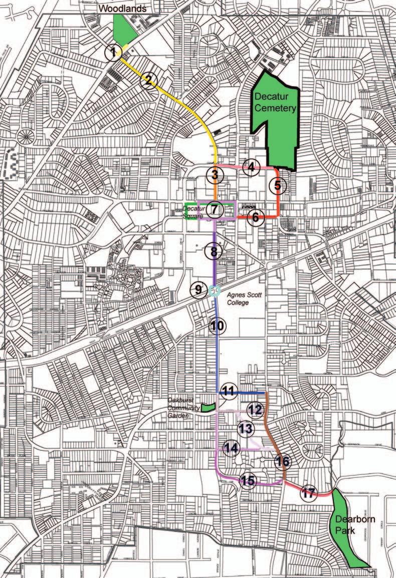
1 IMPLEMENTATION IV. IMPLEMENTATION PLAN IV.A Phasing and Priorities The proposed city-wide network plan for the Decatur Preservation Corridor is a long term vision and guide for future implementation. It is anticipated that small, contained segments of the system will garner impacted stakeholder interest in fund-raising and contribution to its realization. Wayfi nding and signage like this PATH trail marker are important implementation factors. In recommending a Phase I prioritization for the City, the Consultant returned to the original scope of the project - that is, the connection of the four anchor greenspace nodes. This has been moderately augmented by stakeholder input with the addition of the Oakhurst Business District as an important initial connection node. Implementing this circulation system will serve as the initial catalyst to the overall system. The Phase I plan shows two options to connect South McDonough Street to Candler Street and eventually Dearborn Park. Both are shown not as critical to initial implementation, but each requires at least one easement approval. Thus, one of the segments is expected to be implemented prior to the other based on owner interest. In addition the northernmost segment requires a signifi cant length of greenway trail along challenging topography, although its advantage is that it incorporates a large city-owned property. The delineation of this route in a Phase I priority list does not prohibit alternative segment deployment. In fact, the large amount of Shared Lane segments offers the opportunity to rapidly expand the system with minimum cost through the installation of signage. (However, the Shared Lane segments do assume an assessment is conducted for the existing sidewalk conditions which may warrant additional repair costs.) The City and Greenspace Commission may also choose to begin investigation of easement approval, conservation easement acquisition, and possible lot acquisition in all such areas identifi ed on the plan. Such negotiations can prove lengthy and it would be warranted to gauge initial owner reactions for the feasibility of the proposed segments. In addition, land prices will continue to rise and any undeveloped parcel today may not be available in the future. One of the desired goals of this study by the Greenspace Commission was to provide an acquisition guide for possible greenspace preservation. Because of the lack of large undeveloped properties in the City, one alternative for the Commission is to instead maximize the reach of funds through acquisition of conservation easements (vs. fee simple land purchases). Such easements can be very useful in the preservation of linear corridors that may or may not be integrated with a public trail system. Decatur Preservation Corridor Master Plan IV-1

2 IMPLEMENTATION Figure IV.1: Decatur Preservation Corridor Phasing Plan. IV-2 Decatur Preservation Corridor Master Plan
3 IMPLEMENTATION IV.B Summary of Cost Analysis Preliminary Cost Analysis Length in Miles Route Type (Excludes Existing Trails) Length/Feet Unit Cost/Budget Per Linear Foot Cost Per Mile * Soft Surface Asphalt Concrete Asphalt Concrete Soft Surface Greenway Paved Trails < 10' $20.00 $50.00 $109, $273, Greenway Easement Required < 10' ** $20.00 $50.00 $245, $614, Greenway Unpaved/Softsurface < = 4' $5.00 $0.00 $0.00 $0.00 $24, On Street Shared Lane Bicycle*** $1.00 $0.00 $52, $0.00 On Street Dedicated Bike Lane **** $10.00 $0.00 $207, $0.00 Multi Use Path =>10' $20.00 $50.00 $51, $128, Total Miles Total Cost $667, $1,016, $24, * Represents basic path materials and light clearing and grubbing only. ** Easement greenways may be softsurface or paved. Estimate uses the highest cost scenerio condition of all paved surfaces. *** The On-Street Shared Lane Bicycle cost represents a signage budget. **** The On-Street Dedicated Bike Lane cost is a budget for streets that would not require curb and infrastructure relocation. General Cost Notes Right-of-ways, lighting, bridges, retaining walls, intersection improvements and interpretive signage costs are not included. Due to extreme variability, does not include costs for improvements to sidewalks within the proposed routing corridor. Decatur Preservation Corridor Master Plan IV-3
4 IMPLEMENTATION I.C Marketing The support and use of the Decatur Preservation Corridor, once completed, will be enhanced by appropriate marketing actions in the following areas: Naming Wayfinding (i.e. signage, maps, directions, etc.) Promotion The name chosen for the trail system is linked with wayfinding issues. The name should be distinctive, memorable and easily readable/spoken. Ideally, it should be related to the trail and its function, and tie to a logo that will be used extensively in route signage and promotion. The logo must be easily recognized and simple in design in order to facilitate application on vertical and horizontal surfaces of all sizes and materials. A community-wide contest or vote could be offered to determine the preferred alternative or generate name options for consideration. Such a contest could be one way of introducing and communicating the existence of the Master Plan to the community at-large. While a comprehensive wayfinding program is beyond the scope of this project, a signage plan for the Decatur Preservation Corridor could be integrated into the current Wayfinding study being conducted by the City. Promotion will also be key, including the creation of brochures and route maps, and visibility on the City s website. IV-4 Decatur Preservation Corridor Master Plan
5 APPENDIX V. APPENDIX V-A: Draft Alternative I V-B: Draft Alternative II V-C: Street Attributes Decatur Preservation Corridor Master Plan V-1
6 V-A: Alternative I
7 V-B: Alternative II
8
Implementation Strategy
 7 Implementation Strategy Trail - Raleigh, NC Introduction The Zebulon Greenway Master Plan is an overall vision and foundation for implementation of the system illustrated. The town would be challenged
Chapter 10: Implementation
 Chapter 10: Introduction Once the Comprehensive Plan has been adopted by the City of Oakdale, the City can begin to implement the goals and strategies to make this vision a reality. This chapter will set
DESCRIPTION OF THE DISTRICT
 DESCRIPTION OF THE DISTRICT The project plan for City of Wausau, Tax Increment District #11 has been prepared in compliance with Wisconsin Statutes Chapter 66.1105(4). The plan establishes the need for
Title: ENCROACHMENT POLICY Number: 0132 Reference: Administrative Committee January 21, Adopted by City Council: February 2, 2009
 POLICY Title: ENCROACHMENT POLICY Number: 0132 Reference: Administrative Committee January 21, 2009 February 2, 2009 Supersedes: May 2, 2005 Prepared by: PLANNING, BUILDING AND DEVELOPMENT SERVICES STATEMENT
AGENDA. A. CALL TO ORDER 1:00 PM B. PLEDGE OF ALLEGIANCE C. DISCLOSURES D. APPROVAL OF THE MINUTES: October 13, 2015 Town Council Meeting
 The Regular Meeting of the Brian Head Town Council acting as the Governing Body of the Brian Head Redevelopment Agency Town Hall - 56 North Highway 143 Brian Head, UT 84719 TUESDAY, OCTOBER 27, 2015 @
Project Description Preferred Alternative
 DETERMINATION AND FINDINGS PURSUANT TO SECTION 204 OF EMINENT DOMAIN PROCEDURE LAW (EDPL) CITY OF SYRACUSE, PROEJCT SPONSOR CREEKWALK PHASE II JEFFERSON STREET TO COLVIN STREET PROJECT IDENTIFICATION NO.
Draft Model Access Management Overlay Ordinance
 Draft Model Access Management Overlay Ordinance This model was developed using the City of Hutchinson and the Trunk Highway 7 corridor. The basic provisions of this model may be adopted by any jurisdiction
DESIGN PUBLIC HEARING JANUARY 12, 2017 TOWN HALL SULLIVAN MEETING ROOM 558 SOUTH MAIN STREET RAYNHAM, MASSACHUSETTS 7:00 PM FOR THE PROPOSED
 DESIGN PUBLIC HEARING JANUARY 12, 2017 AT TOWN HALL SULLIVAN MEETING ROOM 558 SOUTH MAIN STREET RAYNHAM, MASSACHUSETTS 7:00 PM FOR THE PROPOSED REPLACEMENT OF BRIDGE NO. R-02-013 US ROUTE 44 OVER STATE
SECTION 7000 LAND DEVELOPMENT REQUIREMENTS
 SECTION 7000 LAND DEVELOPMENT REQUIREMENTS 7000 LAND DEVELOPMENT REQUIREMENTS... 1 7001 LEGISLATIVE AUTHORITY... 1 7001.1 LAND DEVELOPMENT... 1 7001.1.1 Title 40, Idaho Code... 1 7001.1.2 Idaho Code 40-1415
Downtown Development Focus Area: I. Existing Conditions
 Downtown Development Focus Area: I. Existing Conditions The Downtown Development Focus Area is situated along Route 1, south of the train tracks, except for the existing Unilever property. It extends west
Municipal Address. 120 South Town Centre Boulevard. 130 South Town Centre Boulevard. S.S. Highway 7 East. 60 South Town Centre Boulevard
 of Report No. 6 of the was adopted, without amendment, by the Council of The Regional Municipality of York at its meeting on November 21, 2013. 18 APPROVAL TO EXPROPRIATE LANDS WIDENING AND CONSTRUCTION
Sidewalk Program Policy Revised: 06 November 13
 Sidewalk Program Policy Revised: 06 November 13 Program Scope: A program to coordinate identification, selection, design, funding sources and construction management for new sidewalk projects in the City
L Provision of facilities for pedestrians and bicycles
 Attachment # Page-1 STATE OF FLORIDA DEPARTMENT OF TRANSPORTATION APPLICATION FOR TRANSPORTATION ENHANCEMENT PROJECTS 8a of 7. 2/2003 Page 1 Of 3 Project Title: Meridian Greenway Trail Project Sponsor
Approval of Takoma Amended Joint Development Agreement and Compact Public Hearing
 Planning, Program Development and Real Estate Committee Item IV - B March 13, 2014 Approval of Takoma Amended Joint Development Agreement and Compact Public Hearing Washington Metropolitan Area Transit
4.0 Implementation & Phasing Strategies
 VISION MANDATE: To ensure that the City Centre Area Plan (CCAP) develops in an orderly, sustainable and fi nancially sound manner: Build Community : Ensure that the necessary infrastructure and community
GRAHAM PEDESTRIAN TRANSPORTATION PLAN
 GRAHAM PEDESTRIAN TRANSPORTATION PLAN Chapter 5 T he text in this chapter describes how the City of Graham can turn the vision of a connected network of safe pedestrian routes into a reality. The strategy
QUARTERPATH COMMUNITY DEVELOPMENT AUTHORITY CITY OF WILLIAMSBURG, VIRGINIA SPECIAL ASSESSMENT REPORT. Prepared By: MuniCap, Inc.
 QUARTERPATH COMMUNITY DEVELOPMENT AUTHORITY CITY OF WILLIAMSBURG, VIRGINIA SPECIAL ASSESSMENT REPORT Prepared By: MuniCap, Inc. October 25, 2011 QUARTERPATH COMMUNITY DEVELOPMENT AUTHORITY CITY OF WILLIAMSBURG,
Section 4 Master Plan Framework
 Section 4 Master Plan Framework 4.1 PURPOSE The Master Plan, as an implementation tool of the SPC District, establishes the primary framework for the overall development of the Property. Detailed site
DESIGN PUBLIC HEARING JULY 7, 2016 CITY COUNCIL HEARING ROOM, FIRST FLOOR ONE GOVERNMENT CENTER FALL RIVER, MASSACHUSETTS 6:30 PM FOR THE PROPOSED
 DESIGN PUBLIC HEARING JULY 7, 2016 AT CITY COUNCIL HEARING ROOM, FIRST FLOOR ONE GOVERNMENT CENTER FALL RIVER, MASSACHUSETTS 6:30 PM FOR THE PROPOSED AIRPORT ROAD OVER ROUTE 24, BRIDGE DECK REPLACEMENT
Staff Report. Street Vacation. Salt Lake City Planning Commission. Ashley Scarff, (801) or Date: April 10 th, 2019
 or Date: April 10 th, 2019") Staff Report PLANNING DIVISION DEPARTMENT of COMMUNITY & NEIGHBORHOODS To: From: Salt Lake City Planning Commission Ashley Scarff, (801) 535-7660 or ashley.scarff@slcgov.com Date: April 10 th, 2019 Re:
Staff Report PLANNING DIVISION DEPARTMENT of COMMUNITY & NEIGHBORHOODS To: From: Salt Lake City Planning Commission Ashley Scarff, (801) 535-7660 or ashley.scarff@slcgov.com Date: April 10 th, 2019 Re:
7. IMPLEMENTATION STRATEGIES
 7. IMPLEMENTATION STRATEGIES A. GENERAL APPROACH FOR IMPLEMENTATION Implementing the plan will engage many players, including the Municipality of Anchorage (MOA), the Government Hill Community Council,
2.2 72ND STREET STATION ENTRANCE ALTERNATIVES
 Chapter 2: Entrance Alternatives 2.1 INTRODUCTION This chapter describes the alternatives that are evaluated in this Supplemental Environmental Assessment (EA) for the 72nd Street Station and 86th Street
Questions and Answers about Neighborhood Conservation Districts
 Questions and Answers about Neighborhood Conservation Districts NEIGHBORHOOD CONSERVATION Planning Department Housing and Neighborhood Services NCD@townofchapelhill.org (919) 968-2728 Questions about Neighborhood
Staff Report PLANNING DIVISION COMMUNITY & ECONOMIC DEVELOPMENT. Alley Closure
 Staff Report PLANNING DIVISION COMMUNITY & ECONOMIC DEVELOPMENT To: From: Salt Lake City Planning Commission Doug Dansie, 801-535-6182, doug.dansie@slcgov.com Date: March 23, 2016 Re: PLNPCM2015-00941
Subject: Addendum No. 2 Request for Expressions of Interest (RFEI) for Development of Brooklyn College School of Business.
 for Development of Brooklyn College School of Business.") Subject: Addendum No. 2 Request for Expressions of Interest (RFEI) for Development of Brooklyn College School of Business. Date: August 9, 2018 Facilities Planning, Construction, and Management Office
Subject: Addendum No. 2 Request for Expressions of Interest (RFEI) for Development of Brooklyn College School of Business. Date: August 9, 2018 Facilities Planning, Construction, and Management Office
GREENWAY EASEMENT AGREEMENT
 GREENWAY EASEMENT AGREEMENT This greenway access easement is entered into by and between the Laramie County School District Number One ( Grantor ), a corporate body organized under the laws of the State
SHORE DRIVE CORRIDOR: PAST, PRESENT, & FUTURE APRIL 19, 2018 BAYFRONT ADVISORY COMMISSION
 SHORE DRIVE CORRIDOR: PAST, PRESENT, & FUTURE APRIL 19, 2018 BAYFRONT ADVISORY COMMISSION 1 OVERVIEW I. Shore Drive Corridor Overview II. Shore Drive Corridor History III. Completed Projects IV. Current
Rosslyn Sector Plan Implementation GLUP, MTP & Zoning Amendments. Park and Recreation Commission June 28, 2016
 Rosslyn Sector Plan Implementation GLUP, MTP & Zoning Amendments Park and Recreation Commission June 28, 2016 Agenda Background GLUP Amendments MTP Amendments Zoning Ordinance Amendments to the C-O Rosslyn
May 21, ACHD Board of Commissioners Stacey Yarrington, Planner II DRH /DRH
 Development Services Department May 21, 2013 TO: FROM: SUBJECT: ACHD Board of Commissioners Stacey Yarrington, Planner II DRH13-00106/DRH13-00108 Executive Summary: This is a design review application
DESIGN PUBLIC HEARING MAY 18, 2017 GROVELAND TOWN HALL GROVELAND, MASSACHUSETTS 7:00PM FOR THE PROPOSED
 DESIGN PUBLIC HEARING MAY 18, 2017 AT GROVELAND TOWN HALL GROVELAND, MASSACHUSETTS 7:00PM FOR THE PROPOSED GROVELAND COMMUNITY TRAIL PROJECT Roadway Project Management Section IN THE TOWN OF GROVELAND,
ARLINGTON COUNTY, VIRGINIA
 ARLINGTON COUNTY, VIRGINIA County Board Agenda Item Meeting of April 19, 2008 DATE: April 2, 2008 SUBJECT: ORDINANCE TO AMEND, REENACT, AND RECODIFY Section 20 CP- FBC, Columbia Pike Form Based Code Districts
NEW JERSEY TRANSIT CORPORATION SPECIAL TELEPHONE BOARD OF DIRECTORS MEETING JUNE 25, 2013 ACTION ITEM
 NEW JERSEY TRANSIT CORPORATION SPECIAL TELEPHONE BOARD OF DIRECTORS MEETING JUNE 25, 2013 FINAL AGENDA PAGE CALL TO ORDER PUBLIC COMMENTS ON AGENDA ITEM ONLY EXECUTIVE SESSION AUTHORIZATION ACTION ITEM
174 North King Street Workforce Housing Development Downtown Jackson, Wyoming
 174 North King Street Workforce Housing Development Downtown Jackson, Wyoming Request for Proposals Release Date November 7, 2017 Information Session December 4, 2017 Submission Deadline February 9, 2018
The Corporation of the District of Central Saanich
 The Corporation of the District of Central Saanich COMMITTEE OF THE WHOLE REPORT For the Committee of the Whole meeting on November 28, 2016 To: Patrick Robins Chief Administrative Officer File: From:
DESIGN PUBLIC HEARING
 DESIGN PUBLIC HEARING October 25, 2016 AT STEVENS MEMORIAL LIBRARY 345 MAIN STREET NORTH ANDOVER, MASSACHUSETTS 7:00 PM FOR THE PROPOSED Chickering Road (Route 125) & Massachusetts Avenue Intersection
Meridian Township Greenspace Plan
 Meridian Township Greenspace Plan FINAL REPORT Prepared For: Charter Township of Meridian Prepared By: May 6, 2004 Table of Contents 1. Introduction... Page 1 2. Vision, Goals, and Objectives... Page
City of Terrace. Request for Proposals Update of Downtown Plan & Downtown Design Guidelines. Issue Date: November 3, 2017
 City of Terrace Request for Proposals Issue Date: November 3, 2017 Closing Date: December 1, 2017 City of Terrace 5003 Graham Avenue Terrace, BC V8G 1B3 Contact: Tara Irwin City Planner Telephone: (250)
Downtown & East Town CRA Expansion Plan City of Eustis
 Downtown & East Town CRA Expansion Plan City of Eustis May 2018 Contents 1 Introduction... 1 CRA Overview/History... 1 2 Existing Conditions... 2 Downtown & East Town Community Redevelopment Area Expansion...
a. provide for the continuation of collector streets and thoroughfare streets between adjacent subdivisions;
 Section 7.07. Intent The requirements of this Section are intended to provide for the orderly growth of the Town of Holly Springs and its extra-territorial jurisdiction by establishing guidelines for:
THE REDEVELOPMENT AGENCY OF THE CITY OF SAN JOSE
 BOARD AGENDA: 4/27/10 ITEM: 8.1 THE REDEVELOPMENT AGENCY OF THE CITY OF SAN JOSE MEMORANDUM TO: HONORABLE MAYOR, CITY COUNCIL, AND AGENCY BOARD SUBJECT: SEE BELOW FROM: HARRY S. MAVROGENES EXECUTIVE DIRECTOR
Wood Dale Comprehensive Plan Open House #2 Summary
 Wood Dale Comprehensive Plan Open House #2 Summary Wood Dale residents once again showed great enthusiasm and energy for the planning process that is guiding development of the City s Comprehensive Plan.
Plan Dutch Village Road
 Plan Dutch Village Road Objective: The lands around Dutch Village Road are a minor commercial area that services the larger Fairview community. Maintaining the vibrancy of the area by planning for redevelopment
Barbara County Housing Element. Table 5.1 Proposed Draft Housing Element Goals, Policies and Programs
 Table 5.1 Proposed Draft Housing Element Goals, Policies and Programs Goal 1: Enhance the Diversity, Quantity, and Quality of the Housing Supply Policy 1.1: Promote new housing opportunities adjacent to
H-POLICY 1: Preserve and improve existing neighborhoods. Ensure that Prince William County achieves new neighborhoods with a high quality of life.
 HOUSING Intent The intent of the Housing Plan is to provide a framework for providing for the housing needs of all residents of Prince William County. These needs are expressed in terms of quality, affordability,
City Council Study Session Agenda Puyallup City Council Chambers 333 S Meridian, Puyallup Tuesday, February 5, :30 PM
 City Council Study Session Agenda Puyallup City Council Chambers 333 S Meridian, Puyallup 98371 Tuesday, February 5, 2019 6:30 PM PLEDGE OF ALLEGIANCE ROLL CALL APPROVAL OF THE AGENDA 1. AGENDA ITEMS 1.a
SARASOTA COUNTY GOVERNMENT
 SARASOTA COUNTY GOVERNMENT Parks, Recreation and Natural Resources TO: Sarasota County Commission THROUGH: Jonathan R. Lewis, County Administrator FROM: Carolyn Brown, Director, Parks, Recreation and Natural
Appendix B: Housing Element Sites Inventory and Detailed Analysis
 Appendix B: 2015-2023 Housing Element Sites Inventory and Detailed Analysis Redwood City General This page intentionally left blank. Redwood City General Site Identifier Assessor Parcel Number General
Hutt River City Centre Upgrade Project Preliminary Integrated Design
 Report 2016.24 Date 5 February 2016 File N/03/18/22 Committee Author Hutt Valley Flood Management Subcommittee Daya Atapattu, Senior Project Engineer Hutt River City Centre Upgrade Project Preliminary
Community Development Committee
 Community Development Committee For the Metropolitan Council meeting of February 13, 2013 Committee Report Business Item 2013-29 ADVISORY INFORMATION Date Prepared: January 25, 2013 Subject: Rice Creek
Subject: Workshop No. 2 with Webster Street Block Development Committee and the SEA Consulting team.
 September 4, 2003 Webster Street Development Actions Location: Norwalk City Hall Community Room Present: Brian Bartholomew Desman Associates Keith Brown Condron-Brown Builders Jack Burritt Norwalk Redevelopment
Condominium Unit Requirements.
 ARTICLE 19 CONDOMINIUM REGULATIONS Section 19.01 Purpose. The purpose of this Article is to regulate projects that divide real property under a contractual arrangement known as a condominium. New and conversion
METROPOLITAN COUNCIL 390 North Robert Street, St. Paul, MN Phone (651) TDD (651)
 TDD (651)") METROPOLITAN COUNCIL 390 North Robert Street, St. Paul, MN 55101 Phone (651) 602-1000 TDD (651) 291-0904 DATE: December 26, 2012 TO: Metropolitan Parks and Open Space Commission FROM: Jan Youngquist, AICP;
METROPOLITAN COUNCIL 390 North Robert Street, St. Paul, MN 55101 Phone (651) 602-1000 TDD (651) 291-0904 DATE: December 26, 2012 TO: Metropolitan Parks and Open Space Commission FROM: Jan Youngquist, AICP;
THREE RIVERS PARK DISTRICT BOARD OF COMMISSIONERS
 1. OPENING BUSINESS A. Call to Order B. Pledge of Allegiance C. Roll Call 2. APPROVAL OF AGENDA THREE RIVERS PARK DISTRICT BOARD OF COMMISSIONERS SPECIAL MEETING Administrative Center - Board Room 3000
City of LaBelle Passive Recreational Park Management Plan
 City of LaBelle Passive Recreational Park Management Plan Table of Contents Park Management Plan 1-7 LIST OF APPENDICES Appendix 1 Appendix 2 Appendix 3 Appendix 4 Appendix 5 Initial Lease First amendment
2011 AICP Review Course
 2011 AICP Review Course March 2011 Alex Dambach, AICP, PP Director of Policy, Planning, and Development City of East Orange Exam Content A. Strategic planning/visioning B. Goal setting C. Research methods
Urban Design Brief. Proposed Medical / Dental Office 1444 Adelaide Street North. Vireo Health Facility Ltd.
 Urban Design Brief Proposed Medical / Dental Office Vireo Health Facility Ltd. November 27, 2013 TABLE OF CONTENTS Page No. INTRODUCTION... 1 SECTION 1 LAND USE PLANNING CONTEXT... 1 1.1 The Subject Lands...
SUBJECT: Report Number PDC Acquisition of 20 Single Family Residences from the Housing Authority of Portland EXECUTIVE SUMMARY
 DATE: May 28, 2008 TO: FROM: Board of Commissioners Bruce A. Warner, Executive Director SUBJECT: Report Number 08-69 PDC Acquisition of 20 Single Family Residences from the Housing Authority of Portland
developed industrial lots. They are expanding due to a current need. A developed
 Final Project Proposal For The RENU Committee 1. Group Proposing Infrastructure Project Name: City of New Ulm- Community Development Department & the New Ulm Economic Development Corporation ( NUEDC) b.
ARTICLE IV: DEVELOPMENT STANDARDS
 ARTICLE IV: DEVELOPMENT STANDARDS IV-53 409 PRIVATE STREETS A private street means any way that provides ingress to, or egress from, property by means of vehicles or other means, or that provides travel
December 31, 2014 RE: PROGRAM EXTENSION REQUEST FOR SP NORTH CREEK REGIONAL GREENWAY TRAIL. Dear Mr. Keel:
 December 31, 2014 Mr. Karl Keel, P.E. Chair, TAC Funding and Programming Committee Metropolitan Council 390 Robert Street. North St. Paul, MN 55101-1805 RE: PROGRAM EXTENSION REQUEST FOR SP 188-090-002
Hennepin County Department of. Housing, Community Works and Transit. Transit Oriented Development (TOD) Guidelines
 Guidelines") Hennepin County Department of Housing, Community Works and Transit 2007 Transit Oriented Development (TOD) Guidelines Hennepin County Transit Oriented Development (TOD) Bond Funds Hennepin County Housing,
Hennepin County Department of Housing, Community Works and Transit 2007 Transit Oriented Development (TOD) Guidelines Hennepin County Transit Oriented Development (TOD) Bond Funds Hennepin County Housing,
PRESENTATION AGENDA ITEM #2.B Distributed 5/23/16. Presentation to the Los Altos Hills City Council and Planning Commission May 23, 2016
 PRESENTATION AGENDA ITEM #2.B Distributed 5/23/16 Presentation to the Los Altos Hills City Council and Planning Commission May 23, 2016 Pathways are a fundamental part of the Town s infrastructure. Pathway
Approval of Takoma Amended Joint Development Agreement
 Planning, Program Development and Real Estate Committee Item IV- A October 10, 2013 Approval of Takoma Amended Joint Development Agreement Washington Metropolitan Area Transit Authority Board Action/Information
Richardson s TOD Experience From ULI Panel Report to Breaking Ground. September 8, 2011
 Richardson s TOD Experience From ULI Panel Report to Breaking Ground Presented to ULI Minnesota District Council Presented By: Gary Slagel President and CEO CapitalSoft Former Mayor, City of Richardson,
Pierce County Comprehensive Plan Review
 2015-2016 Pierce County Comprehensive Plan Review March 16, 2016 Introduction Planning and Management Policies Some of the policies governing both the planning and management of growth and change within
CHAPTER V: IMPLEMENTING THE PLAN
 CHAPTER V: IMPLEMENTING THE PLAN A range of resources is available to fund the improvements included in the Action Plan. These resources include existing commitments of County funding, redevelopment-related
Community Development Department Council Chambers, 7:30 PM, June 7, 2018
 STAFF REPORT 2018-19P: Special Use Permit Community Development Department Council Chambers, 7:30 PM, June 7, 2018 To: From: Re: Paul Luke, Plan Commission Chairperson Carrie Haberstich, AICP, Planner/CDBG
NANTUCKET ISLANDS LAND BANK AFFORDABLE HOUSING POLICY Adopted by the vote of the Land Bank Commission on November 10, 2015
 NANTUCKET ISLANDS LAND BANK AFFORDABLE HOUSING POLICY Adopted by the vote of the Land Bank Commission on November 10, 2015 In recent history, the island of Nantucket has experienced a shortage of affordable,
Proposed Transaction between City of Toronto and Lanterra 234 Simcoe Realty Ltd St. Patrick Street (Municipal Carpark 221)
") GM26.15 REPORT FOR ACTION Proposed Transaction between City of Toronto and Lanterra 234 Simcoe Realty Ltd. - 121 St. Patrick Street (Municipal Carpark 221) Date: March 14, 2018 To: Government Management
GM26.15 REPORT FOR ACTION Proposed Transaction between City of Toronto and Lanterra 234 Simcoe Realty Ltd. - 121 St. Patrick Street (Municipal Carpark 221) Date: March 14, 2018 To: Government Management
Item No. 8.1 Halifax Regional Council March 10, 2015 April 14, 2015
 P.O. Box 1749 Halifax, Nova Scotia B3J 3A5 Canada TO: Mayor Savage and Members of Halifax Regional Council Item No. 8.1 Halifax Regional Council March 10, 2015 April 14, 2015 SUBMITTED BY: Richard Butts,
Town Council Meeting August 6, 2013
 Town Council Meeting August 6, 2013 Agenda Plan Context Planning Process Peak Plan Goals Peak Plan 2030 Early Implementation Recommendations Timeline 2000 2004 Unified Development Ordinance Apex Comprehensive
Truganina Employment Precinct Development Contributions Plan
 Amendment C124 to the Wyndham Planning Scheme Truganina Employment Precinct Development Contributions Plan December 2009 SM 20091202 11:05 CONTENTS PURPOSE 3 REPORT STRUCTURE 3 1.0 STRATEGIC BASIS 5 1.1
PROPOSED METRO JOINT DEVELOPMENT PROGRAM: POLICIES AND PROCESS July 2015 ATTACHMENT B
 PROPOSED METRO JOINT DEVELOPMENT PROGRAM: POLICIES AND PROCESS ATTACHMENT B TABLE OF CONTENTS I. INTRODUCTION / PURPOSE............................ 3 II. OBJECTIVES / GOALS..................................
FOR SALE Acre Residential Property Cypress Lakes Subdivision (Partially Completed) 6138 Moseley Dixon Road Macon, Bibb County, GA 31220
 6138 Moseley Dixon Road Macon, Bibb County, GA 31220") FOR SALE BANK OWNED Property Video: https://youtu.be/kdeoaplz1s4 37.18 Acre Residential Property Cypress Lakes Subdivision (Partially Completed) 6138 Moseley Dixon Road Macon, Bibb County, GA 31220 SALES
FOR SALE BANK OWNED Property Video: https://youtu.be/kdeoaplz1s4 37.18 Acre Residential Property Cypress Lakes Subdivision (Partially Completed) 6138 Moseley Dixon Road Macon, Bibb County, GA 31220 SALES
CITY OF PETALUMA HOUSING PROGRAM REQUEST FOR PROPOSALS FY
 CITY OF PETALUMA HOUSING PROGRAM REQUEST FOR PROPOSALS FY 2018-2019 I. INTRODUCTION The City of Petaluma has two sources of revenue for the purpose of providing funds to assist the City in meeting the
Committed to Service
 Committed to Service Paul Woods, President Rebecca W. Arnold, Vice President Sara M. Baker, Commissioner Jim D. Hansen, Commissioner Kent Goldthorpe, Commissioner August 25, 2017 Development Services TO:
14 Compensation for Expropriation Bayview Avenue - Elgin Mills Road to Stouffville Road Town of Richmond Hill
 Clause 14 in Report No. 14 of was adopted, without amendment, by the Council of The Regional Municipality of York at its meeting held on September 24, 2015. 14 Bayview Avenue - Elgin Mills Road to Stouffville
Shawnee Landing TIF Project. City of Shawnee, Kansas. Need For Assistance Analysis
 Shawnee Landing TIF Project City of Shawnee, Kansas Need For Assistance Analysis December 17, 2014 Table of Contents 1 EXECUTIVE SUMMARY... 1 2 PURPOSE... 2 3 THE PROJECT... 3 4 ASSISTANCE REQUEST... 7
Project Charter Project Name: Conservation Subdivision Review
 Project Charter Project Name: Conservation Subdivision Review Creation Date: June 19, 2013 Last Updated: June 27, 2013 Version: 1 Purpose The purpose of this project is to review the subdivision regulations
Rosslyn Sector Plan Implementation Zoning Ordinance Amendments. NAIOP Meeting April 13, 2016
 Rosslyn Sector Plan Implementation Zoning Ordinance Amendments NAIOP Meeting April 13, 2016 Agenda Background, Process & Schedule Preliminary Amendments to C-O Rosslyn Building Height & Step-backs Density
Chapter 35. The Appraiser's Sales Comparison Approach INTRODUCTION
 Chapter 35 The Appraiser's Sales Comparison Approach INTRODUCTION The most commonly used appraisal technique is the sales comparison approach. The fundamental concept underlying this approach is that market
CITY OF ALBERT LEA PLANNING COMMISSION ADVISORY BOARD
 CITY OF ALBERT LEA PLANNING COMMISSION ADVISORY BOARD 9/1/2015, 5:30 p.m. City Council Chambers AGENDA A. CALL TO ORDER AND ROLL CALL B. APPROVAL OF THE AGENDA C. APPROVAL OF MINUTES 1. PC Minutes from
SECTION I - INTRODUCTION
 - INTRODUCTION 1 2 - INTRODUCTIONION THE MASTER PLAN State law requires every community to have a Master Plan establishing an orderly guide to the use of lands in the community to protect public health
City-Wide Real Estate Transformation
 City-Wide Real Estate Transformation Presentation on Portfolio & Asset Management Toronto Realty Agency Board Meeting October 20, 2017 Re: RA5.3 What is Portfolio Strategy & Asset Management Portfolio
LAKE MERRITT STATION AREA PLAN
 LAKE MERRITT STATION AREA PLAN Emerging Plan Open House Summary October 2011 2 1 Introduction The City of Oakland, Bay Area Rapid Transit (BART), and the Peralta Community College District, through a grant
Eastern Corridor Planning Area Workshop No April 2016
 Eastern Corridor Planning Area Workshop No. 3 28 April 2016 Agenda 1. Visual Aids 2. Guiding Principles 3. Preferred Alternative Concept Plan 4. Fiscal Impact Analysis 5. Findings 6. Recommendations 7.
ARTICLE 13 CONDOMINIUM REGULATIONS
 ARTICLE 13 CONDOMINIUM REGULATIONS Section 13.01 Purpose. The purpose of this Article is to regulate projects that divide real property under a contractual arrangement known as a condominium. New and conversion
Purpose of the Public Hearing
 Purpose of the Public Hearing To provide you with Information on the proposed sidewalk project(s) Opportunities to review plans and exhibits The ability to ask questions and get answers about each project
Appendix1,Page1. Urban Design Guidelines. Back to Back and Stacked Townhouses. DRAFT September 2017
 Appendix1,Page1 Urban Design Guidelines DRAFT September 2017 Back to Back and Stacked Townhouses Appendix1,Page2 Table of Contents 1 Introduction 1 1.1 Purpose 1 1.2 Urban Design Objectives 1 1.3 Building
S U B D I V I S I O N AGREEMENT
 S U B D I V I S I O N AGREEMENT THIS AGREEMENT made this 17th day of January, 2006, by and between Peachtree Properties, L.L.C., (hereinafter referred to as "Developer"); SANITARY AND IMPROVEMENT DISTRICT
City of Grande Prairie Development Services Department
 City of Grande Prairie Development Services Department COUNTRYSIDE SOUTH OUTLINE PLAN Prepared by: GPEC Consulting Ltd. #202, 10712-100th Street Grande Prairie, AB Council Resolution of August 20, 2001
CITY OF COLD SPRING ORDINANCE NO. 304
 CITY OF COLD SPRING ORDINANCE NO. 304 AN ORDINANCE AMENDING THE CITY CODE OF COLD SPRING BY ADDING SECTIONS 555 AND 510 PERTAINING TO PAYMENT-IN-LIEU-OF-PARKING THE CITY COUNCIL OF THE CITY OF COLD SPRING,
BE IT ORDAINED by the Township Council of the Township of West Windsor, County of
 ORDINANCE 2017-30 AN ORDINANCE AMENDING THE REDEVELOPMENT PLAN FOR PRINCETON JUNCTION BY MODIFYING PROVISIONS PERTAINING TO DISTRICT RP- 5 WHEREAS, by Resolution adopted on December 19, 2005, the governing
Regional Open Space Study
 Regional Open Space Study Midpeninsula Regional Open Space District 330 Distel Circle Los Altos, California 94022-1404 Phone: (650) 691-1200 Fax: (650) 691-0485 E-mail: mrosd@openspace.org Web Site: www.openspace.org
submitted to: Department of Planning and Zoning County of Fairfax, Virginia
 submitted to: Department of Planning and Zoning County of Fairfax, Virginia September 2008 TABLE OF CONTENTS General Introduction... 1 Purpose of this Report... 1 Planning Context... 1 Description of Study
Rezoning Petition Pre-Hearing Staff Analysis April 17, 2017
 Rezoning Petition 2017-041 Pre-Hearing Staff Analysis April 17, 2017 REQUEST Current Zoning: R-5 (single family residential), R-22MF (multifamily residential), and I-1 (light industrial) Proposed Zoning:
DRAFT FOR DISCUSSION PURPOSES ONLY. Port Credit Local Area Plan Built Form Guidelines and Standards DRAFT For Discussion Purposes
 Port Credit Local Area Plan Built Form Guidelines and Standards DRAFT For Discussion Purposes 1 Local Area Plan - Project Alignment Overview Directions Report, October 2008 (General Summary Of Selected
CONDOMINIUM REGULATIONS
 ARTICLE 37 CONDOMINIUM REGULATIONS SECTION 37.01. Purpose The purpose of this Article is to regulate projects that divide real property under a contractual arrangement known as a condominium. New and conversion
Broadway Corridor Planning Program
 Broadway Corridor Planning Program 1. Status and Timing 2. Proposed Approach to Curbing Land Speculation 3. Interim Rezoning Policy Stakeholder Information Session: May 22nd 2018 Presentation Overview
RIVER VALE MASTER PLAN PZ CITY COUNCIL PUBLIC HEARING JULY 19, 2017 CITY OF BEND
 RIVER VALE MASTER PLAN PZ-16-0954 CITY COUNCIL PUBLIC HEARING JULY 19, 2017 RIVER VALE MASTER PLAN Master Plan process Required for developments over 20 acres Application submitted under old Master Plan