|
|
|
- Oswald Dalton
- 5 years ago
- Views:
Transcription
1
2
3
4
5
6
7
8
9
10
11
12
13 Sec General Provisions (C) Jurisdiction. These regulations shall apply. (1) These regulations shall not apply to building permit applications for plats previously recorded by the Register of Deeds, that do not involve the subdivision of a plat, prior to the Adoption of this Ordinance by The Oconee County Council.
14 Agenda Item 7 STATE OF SOUTH CAROLINA COUNTY OF OCONEE ORDINANCE NO AN ORDINANCE AMENDING CHAPTER 32 AND CHAPTER 38 OF THE OCONEE COUNTY CODE OF ORDINANCES, IN CERTAIN LIMITED REGARDS AND PARTICULARS ONLY, REGARDING SETBACKS, AND AMENDING CHAPTER 38 REGARDING AGRICULTURAL RESIDENTIAL ZONING DISTRICTS IN CERTAIN LIMITED REGARDS AND PARTICULARS; AND OTHER MATTERS RELATED THERETO. WHEREAS, Oconee County, South Carolina (the County ), a body politic and corporate and a political subdivision of the State of South Carolina (the State ), acting by and through its governing body, the Oconee County Council (the County Council ), has adopted multiple ordinances for the effective, efficient governance of the County, which, subsequent to adoption, are codified in the Oconee County Code of Ordinances (the Code of Ordinances ), as amended, from time to time; and WHEREAS, the County, acting by and through the County Council, is authorized by Section (9) and Chapter 29 of Title 6 of the South Carolina Code, 1976, as amended, among other sources, to impose land use restrictions and development standards in the unincorporated areas of the County; and, WHEREAS, Chapter 32 of the Code of Ordinances contains terms, provisions and procedures applicable to performance standards in the County; and WHEREAS, Chapter 38 of the Code of Ordinances contains terms, provisions and procedures applicable to zoning in the County; and WHEREAS, County Council recognizes that there is a need to revise the law of the County to meet the changing needs of the County and that there is a need to amend, specifically, certain sections of Chapter 32 and Chapter 38 of the Code of Ordinances involving setbacks and setback lines, and to amend the Agricultural Residential District sections of Chapter 38, as to the Intent and Definitions provisions; and WHEREAS, County Council has therefore determined to modify Chapters 32 and 38 of the Code of Ordinances, and to affirm and preserve all other provisions of the Code of Ordinances not specifically or by implication amended hereby. NOW, THEREFORE, it is hereby ordained by the Oconee County Council, in meeting duly assembled, that: GREENVILLE v4
15 Agenda Item 7 1. Section of Chapter 32 of the Code of Ordinances, entitled Lot Improvements, is hereby revised, rewritten, and amended to read as set forth in Attachment A, which is attached hereto and hereby incorporated by reference as fully as if set forth verbatim herein. 2. Section of Chapter 38 of the Code of Ordinances, entitled Control Free District (CFD), is hereby revised, rewritten, and amended to read as set forth in Attachment B, which is attached hereto and hereby incorporated by reference as fully as if set forth verbatim herein. 3. The Definition and Intent portions of Section of the Code of Ordinances, entitled Agricultural Residential Districts (ARD), are hereby revised, rewritten and amended to read as set forth in Attachment C, which is attached hereto and hereby incorporated by reference as fully as is set forth verbatim herein. 4. County Council hereby declares and establishes its legislative intent that Attachment A, hereto, as may be amended from time to time, amend Section of the land use performance standards of the County, and that Attachments B and C, hereto, as may perhaps be amended from time to time, become the applicable zoning provisions of the County, or parts thereof, with regard to the sections amended by Attachments B and C, from and after their adoption, states its intent to so adopt Attachments A, B and C, and directs that a public hearing thereon be undertaken by County Council or the Oconee County Planning Commission, in accord with and as required by Section and by Section , South Carolina Code, 1976, as amended. 5. Should any part or provision of this Ordinance be deemed unconstitutional or unenforceable by any court of competent jurisdiction, such determination shall not affect the rest and remainder of this Ordinance, all of which is hereby deemed separable. 6. All ordinances, orders, resolutions, and actions of County Council inconsistent herewith are, to the extent of such inconsistency only, hereby repealed, revoked, and rescinded. However, nothing contained herein, or in the Attachments hereto, shall cancel, void, or revoke, or shall be interpreted as cancelling, voiding, or revoking, ex post facto, in any regard any prior performance standard, zoning or rezoning acts, actions, or decisions of the County or County Council based thereon, which were valid and legal at the time in effect and undertaken pursuant thereto, in any regard. 6. All other terms, provisions, and parts of the Code of Ordinances, and specifically, but without exception, the remainder of Section of Chapter 38, not amended hereby, directly or by implication, shall remain in full force and effect. 7. This Ordinance shall take effect and be in full force and effect from and after third reading and enactment by County Council, and will apply to all zoning processes initiated after first (1 st ) reading hereof. All processes actually initiated by submitting a properly and legally completed petition to the County, at a minimum, prior to first (1 st ) reading of this ordinance and the establishment of the pending ordinance doctrine thereby, shall be completed under the zoning GREENVILLE v4
16 Agenda Item 7 and performance standard rules and regulations of Chapters 32 and 38 of the Code of Ordinances, as in effect prior to final adoption of this ordinance. ORDAINED in meeting, duly assembled, this day of, ATTEST: Elizabeth Hulse, Clerk to Oconee County Council Joel Thrift, Chairman, Oconee County Council First Reading: Second Reading: Third Reading: Public Hearing: GREENVILLE v4
17 Agenda Item 7 ATTACHMENT A To Ordinance Sec Lot improvements. (a) Lot arrangements. All lots shall be arranged such that there will be no apparent difficulties in securing driveway encroachment permits or building permits for reasons of topography or other conditions and must have driveway access from an approved road. The developer shall be liable for all lots within a proposed subdivision. (b) Lot dimensions. Except where circumstances such as topography, watercourses, road alignment or existing site boundary configurations dictate otherwise, the following requirements shall apply: (1) Dimensions of corner lots shall be large enough to allow for the erection of buildings observing the minimum yard setbacks from both streets, without encroaching into side and rear yard setbacks, established in the building line section of this chapter. (2) Depth and width of properties reserved or laid out for business, commercial, or industrial purposes shall be adequate to provide for off-street parking and loading facilities required for that type of development, without encroaching into yard setbacks. (c) Lot size. Minimum lot size shall be.57 acres (approximately 25,000 square feet) with traditional onsite septic tanks served by public water, unless DHEC requires greater area or dimensions. All required set backs shall be met regardless of lot size. No part of a septic system shall be located within any road right-of-way. (d) Building Lines. [See Section for all setback requirements in the Control Free District of the County] (e) [Reserved] (f) Usable area. All lots adjacent to floodplains, creeks, and wetlands should use these natural features as lot boundaries when possible. Lots containing areas unsuitable for usage shall not use these areas in calculating minimum lot area. (g) Septic system setback. (1) Traditional septic systems shall be constructed so that they comply with all regulations of the South Carolina Department of Health and Environmental Control (DHEC). (2) The applicant shall provide the planning director a copy of all South Carolina Department of Health and Environmental Control (DHEC) permit drawings and an approved DHEC permit application for the proposed septic systems utilized within the development. (3) The developer must demonstrate to the planning director that the proposed development will not adversely affect the present water table and the existing water supplies; and also demonstrate that the proposed water supply system will not be adversely affected by existing septic systems. (h) Lot drainage. Lots shall be laid out so as to provide positive drainage away from all buildings, and individual lot drainage shall be coordinated with the general storm drainage pattern for the area. Drainage shall be designed so as to prevent concentration of stormwater from each lot to any adjacent property. Drainage systems used to control water on one property shall not increase the water flow on adjacent properties without legal easements. (i) Lakes and streams. If a tract being subdivided contains a water body, or portion thereof, the ownership of and the responsibility for safe and environmentally compliant maintenance of the water body is to be placed so that it will not become a local government responsibility. The minimum area of a lot required under this article may not be satisfied by land that is under water. Where a watercourse other than storm drainage separates the lot's buildable area from the road providing access, an engineer's certified structure shall be provided linking the buildable area to the road. All watercourses shall remain free of obstructions and degradations. GREENVILLE v4
18 Agenda Item 7 (j) Easements. Easements having a minimum width of ten feet and located along the side or rear lot lines shall be provided as required for utilities and drainage. (k) Entrances. One entrance is required for every 100 lots in a proposed subdivision, or a maximum of 100 lots on a dead end road with a cul-de-sac. This requirement may be waived by the planning director due to topography and feasibility. Every effort shall be made to not have an entrance directly onto an arterial road. (l) Vegetative buffers. The approval of subdivisions, site plans and/or building permits for construction of new residential units or commercial projects to be located within 1,000 feet of Lakes Keowee, Hartwell, and Jocassee shall be contingent upon the establishment of a natural vegetative buffer of a width of less than 25 feet, with a view land width of no more than 15 percent of the total length of a natural vegetative buffer. The buffer shall meet the following standards: (1) To reduce nonpoint source pollution, a natural buffer of 25 feet shall be maintained with no grasses or ornamental vegetation established within that buffer. To reduce nonpoint pollution a vegetative buffer of 25 feet measured horizontally from the full pond elevation shall be maintained with no manicured laws or other managed grasses established within that buffer. A diverse mix of native plants and unmanaged (uncut below 12 inches and untreated) native grasses are preferred vegetation where available and suited to the site. Additionally, no clear cutting or mowing, cultivation activities, fertilization, use of herbicides, fungicides, or pesticides shall occur within the 25-foot buffer area. Right-of-way maintenance activities by utilities shall be exempt. (2) No trees larger than six-inch caliper at four feet from the ground shall be removed unless certified to be a hazard by a registered forester or arborist. (3) Trees may be limbed up to 50 percent of their height. This regulation shall exempt projects that are located on parcels lying no closer than 25 feet from a lake shoreline or are located on parcels that are not traversed, either in full or in part, by a perennial stream, designed wetland, or other watercourse within 1,000 feet of Lakes Keowee, Hartwell, and Jocassee. The buffer shall begin at the lake's full pond level. (Ord. No , Art. 4( ), ) GREENVILLE v4
19 Agenda Item 7 ATTACHMENT B To Ordinance Sec Control free district (CFD). The control free district is intended to be the initial zoning district for all parcels within the jurisdiction at the time of initial adoption of zoning in Oconee County, only; any parcel subsequently rezoned to any other district shall not be a part of the control free district at any future date. Dimensional requirements:* Residential uses Density and Lot Size Minimum Yard Requirements Max. Height Nonresidential Uses Min. lot size Max. Density Min. width (ft.) Front setback (ft.) Side setback (ft.) Rear setback (ft.) N/A N/A N/A Structure height (ft.) Minimum Lot Size Minimum Yard Requirements Max. Height Min. Lot Size Min. Width (ft.) Front Setback (ft.) Side Setback (ft.) Rear Setback (ft.) N/A N/A Structure Height (ft.) (Ord. No , 1, ) GREENVILLE v4
20 Agenda Item 7 ATTACHMENT C To Ordinance Changes to the Intent and Definition portions of Section Of the Oconee County Code of Ordinances Intent: The Agricultural Residential districts are intended to allow for most agricultural, forestry, and other related uses that are typically found in rural communities; however, in consideration for the residential areas nearby, certain uses are prohibited in this zoning district. Definition: For those areas that have maintained their rural uses, including engaging in agricultural and forestry practices, while the neighboring areas have experienced a growth in residential development not typical to rural areas. GREENVILLE v4
21
22
23
24

25
26

27
28
29
30
31
32
33

34
35
36
37

38
39
40
41
42
43
44

45
46
47
48
49
50
51
52
53
54
55
56
57
58
59
60
61
62
63
64
65
66
67
68
69
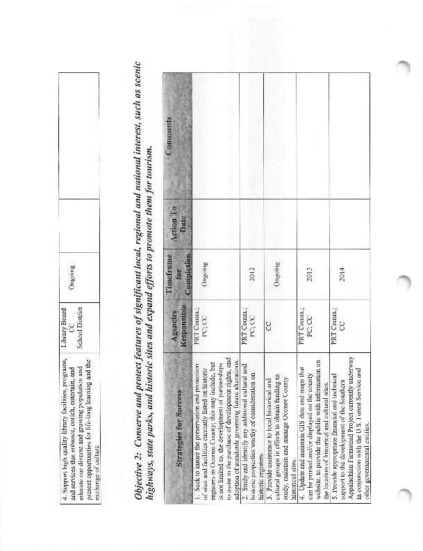
70
71
72 Goal # 1: Preserve, protect, and enhance the quality and quantity of Oconee County s natural resources. Objective 1: Work to guarantee adequate water distribution systems for present and future economic development in Oconee County. Timeframe Agencies Action To Strategies for Success for Comments Responsible Date Completion 1. Work to facilitate the establishment of a partnership with water providers aimed at expanding service into underserved unincorporated areas of the county. Link to growth areas and rural enhancement areas? 2. Partner with municipalities in inventorying current condition of their water infrastructure systems to determine ability to accommodate future growth. 3. Work to develop agreements with water providers to coordinate with County on a plan provide for required fire protection for new development. PC; CC 2012 Ongoing IAC; PC; CC Emer. Serv. Comm.; PC; CC Ongoing 2012 Pioneer, etc Edit to link with community character framework? Do we need this one? Cities use firms to do this Status? Fire Plan Ch. Art. 6 fire protection for subdivisions Fire Code Draft for 3/23/15 Planning Commission Meeting
73 Objective 2: Improve and expand wastewater treatment within Oconee County. Timeframe Agencies Action To Strategies for Success for Responsible Date Completion 1. Expand sewer service throughout areas designated by the Land Use Element as primary areas of development, while implementing appropriate limits needed to avoid negative impacts on sensitive areas. Link to growth areas and rural enhancement areas? Use of regulations such as Form-Based & Smart Growth? 2. Implement requirements for all developer-initiated sewer expansions to be configured with sufficient capacity to allow existing and future affected property owners to connect to the proposed line. 3. Work with neighboring counties when possible to establish regional efforts to expand sewer service into prime commercial and industrial locations. 4. Partner with municipalities and Joint Regional Sewer Authority to coordinate efforts to provide sewer throughout high growth corridors. Identify growth corridors? Link to overall growth plan 5. Establish partnership(s) with regional, state, and federal agencies to find funding sources for wastewater treatment needs. 6. Study and establish increased access to sanitary boat dump stations on area lakes. Draft for 3/23/15 Planning Commission Meeting PC; CC Ongoing PC; CC 2012 PC; CC IAC; PC; CC PC; CC PRT Comm.; PC; CC Ongoing Ongoing Ongoing 2013 Comments Sewer South Nov. 12 ref. Edit to link with community character framework? Edit to link with community character framework? Grant Administrator position has been posted REMOVE Duke issue
74 Objective 3: Initiate efforts to develop the foundation of a county stormwater management program prior to federal mandates, thereby allowing for the most efficient and cost-effective implementation possible in the event of designation. Strategies for Success 1. Study and evaluate options available to jurisdictions designated by EPA to establish storm water management programs, identifying those attributes desirable for an Oconee County program. 2. Work with state and federal agencies as required to create necessary components of storm water program, when possible, through a phased approach that will lessen impact of meeting mandates. 3. Support regional efforts to protect watersheds. Agencies Responsible PC; CC PC; CC Timeframe for Completion PC; CC Ongoing Action To Date Comments Revisit Revisit Draft for 3/23/15 Planning Commission Meeting
75 Objective 4: Establish a program of managing both water quantity and water quality throughout the county that will ensure efficient utilization, and appropriate conservation, of our greatest natural resource. Strategies for Success Timeframe Comments Agencies Action To for Responsible Date Completion 1. Work with state and federal agencies to establish a comprehensive network of PC; CC 2014 water monitoring stations in Oconee County watersheds. 2. Establish accurate 7Q10 rating for all water basins in Oconee County. PC; CC Develop a county-wide water usage PC; CC plan that defines water conservation practices for both normal and drought conditions, and insures that all users share equally in restrictions during drought conditions Do we need these? 4. Partner with both public and private PC; CC entities to develop a county-wide 2012 education program designed to promote water conservation. 5. Study and evaluate the impact of Oconee County s water supply on ISO ratings, and the resulting cost of fire insurance, seeking to identify opportunities for better ratings. 6. Partner with adjacent jurisdictions on comprehensive water studies detailing availability from all sources and usages/outflows. Emer. Serv. Comm.; PC; CC PC; CC 2012 Ongoing Ongoing ISO rating of 4 Draft for 3/23/15 Planning Commission Meeting
76 Objective 5: Preserve, protect and enhance Oconee County s environmentally sensitive lands, unique scenic views, agrarian landscapes, and topographic features. Strategies for Success Timeframe Comments Agencies Action To for Responsible Date Completion 1. Encourage use of Best Management PC; CC Keep it edit to be more specific? Practices in farming and forestry Ongoing operations. 2. Work to partner with public and private PC; CC Keep it edit to be more specific? entities in developing a countywide 2014 greenway system that will offer opportunities for nature-based recreation in areas where few currently exist. 3. Encourage and support collaboration between landowners and public and private agencies in the development of ecologically and economically sound plans for preservation and restoration of forests and farmland. Purchase/Transfer Development Rights Programs, etc..? Establish land use policies by implementing density standards, acreage standards, use protections, cluster developments and other Form- Based Code/Smart Growth policies that protect agricultural assets. Establish overlays in scenic areas that protect & promote the beauty of Oconee s rural and cultural heritage by establishing policies including but not limited to Appalachian Rustic Elegance design standards/guidelines and PC; CC Draft for 3/23/15 Planning Commission Meeting Ongoing Keep it edit to be more specific? Link to community character framework?
77 signage standards. Encourage the use of soils maps when planning future development to preserve primary soils. Study the feasibility of a Purchase/Transfer Development Rights program. Establish Primary Investment Areas/ Rural Enhancement Area with associated policies that focus growth and infrastructure investment in the appropriate growth areas while preserving, protecting & promoting the rural beauty of Oconee county Establish an Agricultural Advisory Committee Draft for 3/23/15 Planning Commission Meeting
78 Objective 6: Promote partnerships and voluntary conservation easements to preserve significant lands and scenic areas under pressure. Timeframe Comments Agencies Action To Strategies for Success for Responsible Date Completion 1. Establish a county conservation bank to provide for the transfer of development rights and/or conservation easements to protect rural lands, sensitive areas, and significant natural resources. 2. Identify and establish various funding sources for the county conservation bank identified above; these may include grants, corporate gifts, a percentage of development permit fees, and annual revenue designations. 3. Provide appropriate assistance from county departments and agencies in efforts to identify and preserve historic structures, significant lands, and scenic areas. CC 2011 DONE CC PC; CC 2011 Ongoing Ongoing DONE Edit to more specific about next steps Duke - $600,000 as part of relicensing Grant Administrator position has been posted Grant Administrator has been posted Partners, Programs, specifics that can be measured? Draft for 3/23/15 Planning Commission Meeting
ARTICLE FIVE FINAL DRAFT
 ARTICLE FIVE 021218 FINAL DRAFT Sec. 503.6 Open Space Preservation Option Open Space Preservation Option Open Space Preservation developments may be approved in the AR, R-1, R-2 and R-3 zoning districts,
DRAFT FOR PUBLIC HEARING (rev. March, 2016)
") Chapter 200. ZONING Article VI. Conservation/Cluster Subdivisions 200-45. Intent and Purpose These provisions are intended to: A. Guide the future growth and development of the community consistent with
Chapter 200. ZONING Article VI. Conservation/Cluster Subdivisions 200-45. Intent and Purpose These provisions are intended to: A. Guide the future growth and development of the community consistent with
Chapter 100 Planned Unit Development in Corvallis Urban Fringe
 100.100 Scope and Purpose. Chapter 100 Planned Unit Development in Corvallis Urban Fringe (1) All applications for land divisions in the Urban Residential (UR) and Flood Plain Agriculture (FPA) zones within
Article XII. R-1 Agricultural-Low Density Residential District
 Article XII R-1 Agricultural-Low Density Residential District Section 1200. Declaration of Legislative Intent In expansion of the Declaration of Legislative Intent and Statement of Community Development
4. facilitate the construction of streets, utilities and public services in a more economical and efficient manner;
 PVPC MODEL BYLAW BY-RIGHT CLUSTER ZONING BYLAW Prepared by Pioneer Valley Planning Commission Revised: October 2001 1.00 Development 1.01 Development Allowed By Right Development in accordance with this
Amendment to the Zoning and Subdivision Ordinances; Consider Repeal Cluster Development Standards
 2 Board of Supervisors Meg Bohmke, Chairman Gary F. Snellings, Vice Chairman Jack R. Cavalier Thomas C. Coen L. Mark Dudenhefer Wendy E. Maurer Cindy C. Shelton February 28, 2018 Thomas C. Foley County
BY BOARD OF COUNTY COMMISSIONERS AN ACT TO BE ENTITLED
 BY BOARD OF COUNTY COMMISSIONERS ORDINANCE NO. AN ACT TO BE ENTITLED AN ORDINANCE AMENDING THE PASCO COUNTY LAND DEVELOPMENT CODE, ARTICLE 700, BY REPEALING EXISTING SECTION 702, ENVIRONMENTALLY SENSITIVE
A. Preserve natural resources as identified in the Comprehensive Plan.
 1370.08 Conservation Residential Overlay District. Subd. 1 Findings. The City finds that the lands and resources within the Conservation Residential Overlay District are a unique and valuable resource
APPLICATION FOR SUBDIVISION APPROVAL OF A SKETCH PLAN with checklist
 Prior to filing any application for SUBDIVISION approval, the applicant shall request in writing that the zoning administrator schedule a pre-submission conference. APPLICATION TO THE PLANNING BOARD TOWN
ELK RAPIDS TOWNSHIP ANTRIM COUNTY, MICHIGAN ORDINANCE NO
 ELK RAPIDS TOWNSHIP ANTRIM COUNTY, MICHIGAN ORDINANCE NO. 3-2011 AN ORDINANCE TO REPLACE THE SUBDIVISION CONTROL ORDINANCE WITH A NEW SUBDIVISION DEVELOPMENT ORDINANCE, IN ACCORD WITH THE LAND DIVISION
610 LAND DIVISIONS AND PROPERTY LINE ADJUSTMENTS OUTSIDE A UGB
 ARTICLE VI: LAND DIVISIONS AND PROPERTY LINE ADJUSTMENTS VI-21 610 LAND DIVISIONS AND PROPERTY LINE ADJUSTMENTS OUTSIDE A UGB 610-1 Property Line Adjustments (Property Line Relocation) A property line
Open Space Model Ordinance
 Open Space Model Ordinance Section I. Background Open space development has numerous environmental and community benefits, including: 1) Reduces the impervious cover in a development. Impervious cover
Title 6 - Local Government Provisions Applicable to Special Purpose Districts and Other Political Subdivisions
 Title 6 - Local Government Provisions Applicable to Special Purpose Districts and Other Political Subdivisions CHAPTER 29. SOUTH CAROLINA LOCAL GOVERNMENT COMPREHENSIVE PLANNING ENABLING ACT OF 1994 1994
ARTICLE 15. RULES, REGULATIONS AND DEFINITIONS
 ARTICLE 15. RULES, REGULATIONS AND DEFINITIONS Section 1. Interpretation and Construction: The following rules and regulations regarding interpretation and construction of the Ulysses-Grant County, Kansas,
** If your lot does not meet the requirements above, please read Sec below
 Sec. 13-1-60 Zoning District Dimensional Requirements. For the Zoning Dept To Issue a Land Use Permit The Following Dimensions are Required. Minimum Side and Rear Yards s Lakes Classification Minimum Class
SUBMITTAL REQUIREMENTS: The number indicates the number of copies for submittal (if applicable).
.") Office Use Only Preliminary Long Plat Long Subdivision Applicant Checklist PLANNING, COMMUNITY, & ECONOMIC DEVELOPMENT DEPARTMENT PRELIMINARY LONG PLAT LONG SUBDIVISION CHECKLIST Mailing Address: P.O.
Office Use Only Preliminary Long Plat Long Subdivision Applicant Checklist PLANNING, COMMUNITY, & ECONOMIC DEVELOPMENT DEPARTMENT PRELIMINARY LONG PLAT LONG SUBDIVISION CHECKLIST Mailing Address: P.O.
GWINNETT COUNTY CSO CONSERVATION SUBDIVISION OVERLAY DISTRICT REQUIREMENTS
 GWINNETT COUNTY CSO CONSERVATION SUBDIVISION OVERLAY DISTRICT REQUIREMENTS Section 1316. CSO Conservation Subdivision Overlay District. 1. Purposes. The purposes of this overlay district are as follows:
APPLICATION FOR A CERTIFICATE OF ZONING COMPLIANCE
 TOWN OF MILO, NEW YORK Department of Code Enforcement and Administration 137 Main Street Penn Yan, New York 14527 Telephone No.: (315) 531-8042 Fax No.: (315) 536-9760 TDD No.: (202) 720-6382 Email: codeofficer@townofmilo.com
THE COUNTY BOARD OF SUPERVISORS OF THE COUNTY OF DOUGLAS DOES ORDAIN AS FOLLOWS:
 8.1 SUBDIVISION CONTROL ORDINANCE THE COUNTY BOARD OF SUPERVISORS OF THE COUNTY OF DOUGLAS DOES ORDAIN AS FOLLOWS: SECTION I. GENERAL INTERPRETATION This ordinance shall not repeal, impair or modify private
Initial Subdivision Applications Shall Include the Following:
 Initial Subdivision Applications Shall Include the Following: 1) Subdivision Application Form: completely filled out (12 copies) 2) Plat: The Plat must adhere to the requirements set forth in the Town
ARTICLE 1 GENERAL PROVISIONS AUTHORITY AND ADMINISTRATION RESPONSIBILITIES OF DEVELOPER AND PLANNING COMMISSION
 ARTICLE 1 GENERAL PROVISIONS 103.101. TITLE 103.102. AUTHORITY AND ADMINISTRATION 103.103. PURPOSE 103.104. INTERPRETATION 103.105. RESPONSIBILITIES OF DEVELOPER AND PLANNING COMMISSION 103.106. JURISDICTION
SUBMITTAL REQUIREMENTS: The number indicates the number of copies for submittal (if applicable).
.") Office Use Only Preliminary Long Plat Long Subdivision Applicant Checklist PLANNING, COMMUNITY, & ECONOMIC DEVELOPMENT DEPARTMENT FINAL LONG PLAT LONG SUBDIVISION CHECKLIST Mailing Address: P.O. Box 547,
Office Use Only Preliminary Long Plat Long Subdivision Applicant Checklist PLANNING, COMMUNITY, & ECONOMIC DEVELOPMENT DEPARTMENT FINAL LONG PLAT LONG SUBDIVISION CHECKLIST Mailing Address: P.O. Box 547,
Residential Project Convenience Facilities
 Standards for Specific Land Uses 35.42.220 E. Findings. The review authority shall approve a Land Use Permit in compliance with Subsection 35.82.110.E (Findings required for approval) or a Conditional
CHAPTER 3 PRELIMINARY PLAT
 10-3-1 10-3-3 SECTION: CHAPTER 3 PRELIMINARY PLAT 10-3-1: Consultation 10-3-2: Filing 10-3-3: Requirements 10-3-4: Approval 10-3-5: Time Limitation 10-3-6: Grading Limitation 10-3-1: CONSULTATION: Each
Comprehensive Plan 2030
 Introduction The purpose of this chapter of the Comprehensive Plan is to accurately describe, in words and images, the goals and visions for the future of Clearfield, as determined by the people who live
ARTICLE 8C SITE CONDOMINIUM DEVELOPMENT ORDINANCE
 ARTICLE 8C SITE CONDOMINIUM DEVELOPMENT ORDINANCE SECTION 8C.01 PURPOSE It is the purpose of this Ordinance to insure that plans for development within Oceola Township proposed under the provisions of
MIDWAY CITY Municipal Code
 MIDWAY CITY Municipal Code TITLE 9 ANNEXATION CHAPTER 9.01 PURPOSE CHAPTER 9.02 GENERAL REQUIREMENTS CHAPTER 9.03 PROPERTY OWNER INITIATION OF ANNEXATION CHAPTER 9.04 PROCEDURES FOR CONSIDERATION OF PETITION
Special Use Permit - Planned Unit Development Checklist. Property Address:
 Special Use Permit - Planned Unit Development Checklist Special Use Permit Number. Parcel Code/s #28-11- - - Property Address: Applicant: ARTICLE VIII Ordinance Reference - Section 8.1.2 Permit Procedures:
CHARTER TOWNSHIP OF SUPERIOR WASHTENAW COUNTY, MICHIGAN PRIVATE ROAD ORDINANCE ORDINANCE NO. 163
 PAGE 163-1 CHARTER TOWNSHIP OF SUPERIOR WASHTENAW COUNTY, MICHIGAN PRIVATE ROAD ORDINANCE ORDINANCE NO. 163 AN ORDINANCE OF THE CHARTER TOWNSHIP OF SUPERIOR ESTABLISHING PROVISIONS FOR APPROVAL OF PRIVATE
ARTICLE 14 PLANNED UNIT DEVELOPMENT (PUD) DISTRICT
 DISTRICT") ARTICLE 14 PLANNED UNIT DEVELOPMENT (PUD) DISTRICT Section 14.01 Intent. It is the intent of this Article to allow the use of the planned unit development (PUD) process, as authorized by the Michigan Zoning
ARTICLE 14 PLANNED UNIT DEVELOPMENT (PUD) DISTRICT Section 14.01 Intent. It is the intent of this Article to allow the use of the planned unit development (PUD) process, as authorized by the Michigan Zoning
FRESHWATER WETLANDS PROTECTION IN NEW JERSEY Tools for Municipal Action
 FRESHWATER WETLANDS PROTECTION IN NEW JERSEY Tools for Municipal Action The Freshwater Wetlands Protection Act INTENT OF FRESHWATER WETLANDS LAW The New Jersey legislature passed the Freshwater Wetlands
WASCO COUNTY PRELIMINARY SUBDIVISION APPLICATION
 WASCO COUNTY PRELIMINARY SUBDIVISION APPLICATION DETAILED SPECIFIC WRITTEN REQUEST File Number: SDV- Number of Proposed Lots & their Dimensions: PRELIMINARY SUBDIVISION PLAN REQUIREMENTS The approval of
ARTICLE 1 GENERAL PROVISIONS
 ARTICLE 1 GENERAL PROVISIONS SECTION 100 TITLE This Ordinance shall be known and cited as the "Rice Township Subdivision and Land Development Ordinance." SECTION 101 AUTHORITY Rice Township is empowered
FINAL DRAFT 12/1/16, Rev. to 7/18/17
 FINAL DRAFT 12/1/16, Rev. to 7/18/17 (As Adopted 8/8/17 Effective 9/1/17) SHELTON PLANNING AND ZONING COMMISSION Proposed Amendments to Zoning Regulations I. Amend Section 23 PERMITTED USES by inserting
Town of Falmouth s Four Step Design Process for Subdivisions in the Resource Conservation Zoning Overlay District
 Town of Falmouth s Four Step Design Process for Subdivisions in the Resource Conservation Zoning Overlay District All subdivisions shall be designed in accordance with the following four-step process.
MINOR SUBDIVISION INFORMATION
 A. POINTS OF CONTACT: MINOR SUBDIVISION INFORMATION Surveyor: Address: Phone #: Fax # E-Mail Address: Representative (If different from applicant): Address: Phone #: Fax # E-Mail Address: B. GENERAL INFORMATION:
An Ordinance to provide regulations for private roads and driveways.
 30.0400 PRIVATE ROADS AND DRIVEWAYS TOWNSHIP OF GRAND HAVEN, MICHIGAN ord no. 262 eff. Apr. 27, 1997 An Ordinance to provide regulations for private roads and driveways. 30.0401 Sec. 1 TITLE This Ordinance
REZONING APPLICATION INSTRUCTIONS
 REZONING APPLICATION INSTRUCTIONS All required information, as stated on the Rezoning Application Checklist, must be included to qualify as a complete application. Upon receipt, staff will review the application
4. If any perennial surface water passes through or along the property lines of the acreage, a minimum of 200 feet or frontage should be required.
 b. Provide adequate acreage for appropriate productive use of rural residential land, such as small numbers of livestock, large gardens, etc. 3. Minimum of 200 feet of frontage on an improved county or
Article Optional Method Requirements
 Article 59-6. Optional Method Requirements [DIV. 6.1. MPDU DEVELOPMENT IN RURAL RESIDENTIAL AND RESIDENTIAL ZONES Sec. 6.1.1. General Requirements... 6 2 Sec. 6.1.2. General Site and Building Type Mix...
ARTICLE III District Regulations. A map entitled "Franklin Zoning Map" is hereby adopted as part of this chapter 1.
 ARTICLE III District Regulations ~ 305-8. Adoption of Zoning Map. A map entitled "Franklin Zoning Map" is hereby adopted as part of this chapter 1. ~ 305-9. Official Zoning Map; amendments. Regardless
Planning Department Oconee County, Georgia
 Planning Department Oconee County, Georgia STAFF REPORT REZONE CASE #: 6985 DATE: October 31, 2016 STAFF REPORT BY: Andrew C. Stern, Planner APPLICANT NAME: Williams & Associates, Land Planners PC PROPERTY
STAFF REPORT. Arthur and Kathleen Quiggle 4(b)
") STAFF REPORT Application: Requests related to the construction of a 28' x 41' dwelling and 6' wrap-around open deck to replace an existing 24' x 32' cabin and wrap-around open deck and the installation
STAFF REPORT Application: Requests related to the construction of a 28' x 41' dwelling and 6' wrap-around open deck to replace an existing 24' x 32' cabin and wrap-around open deck and the installation
CITY OF LABELLE ORDINANCE BROWARD AVE LLC PLANNED UNIT DEVELOPMENT REZONE
 CITY OF LABELLE ORDINANCE 2019-04 BROWARD AVE LLC PLANNED UNIT DEVELOPMENT REZONE AN ORDINANCE OF THE CITY OF LABELLE, FLORIDA, AMENDING THE CITY OF LABELLE ZONING MAP FOR PROPERTY LOCATED SOUTH OF BROWARD
ORDINANCE NO WHEREAS, the County Council desires to amend the current Code of
 1 1 1 1 1 1 0 1 0 1 ORDINANCE NO. 00- AN ORDINANCE OF THE COUNTY COUNCIL OF VOLUSIA COUNTY, FLORIDA, AMENDING THE CODE OF ORDINANCES OF THE COUNTY OF VOLUSIA, CHAPTER, TITLED UTILITIES, ARTICLE IV, STORMWATER
ARTICLE 15 - PLANNED UNIT DEVELOPMENT
 Section 15.1 - Intent. ARTICLE 15 - PLANNED UNIT DEVELOPMENT A PUD, or Planned Unit Development, is not a District per se, but rather a set of standards that may be applied to a development type. The Planned
The following regulations shall apply in the R-E District:
 "R-E" RESIDENTIAL ESTATE DISTRICT (8/06) The following regulations shall apply in the R-E District: 1. Uses Permitted: The following uses are permitted. A Zoning Certificate may be required as provided
Implementation TOWN OF LEON COMPREHENSIVE PLAN 9-1
 9 Implementation 9.1 Implementation Chapter Purpose and Contents This element includes a compilation of regulatory and non-regulatory measures to implement the objectives of this comprehensive plan. The
FREQUENTLY USED PLANNING & ZONING TERMS
 City Of Mustang FREQUENTLY USED PLANNING & ZONING TERMS Abut: Having property lines, street lines, or zoning district lines in common. Accessory Structure: A structure of secondary importance or function
CHAPTER 6 CHESAPEAKE BAY PRESERVATION AREAS AND STREAM PROTECTION AREAS
 CHAPTER 6 CHESAPEAKE BAY PRESERVATION AREAS AND STREAM PROTECTION AREAS 6.1 INTRODUCTION Virginia s Chesapeake Bay Preservation Area (CBPA) Designation and Management Regulations (9VAC10-20 et seq.) require
-MENDOCINO COUNTY PLANNING AND BUILDING SERVICES- DIVISION OF LAND REGULATIONS TITLE 17
 ARTICLE VI -- GENERAL REGULATIONS AND PROVISIONS Sec. 17-50. Sec. 17-51 General Plan. Sec. 17-52 Lot and Block Design and Configuration. Sec. 17-53 Lot Access. Sec. 17-54 Private Roads. Sec. 17-55 Water
Town of Cary, North Carolina Rezoning Staff Report 12-REZ-27 Morris Branch Town Council Public Hearing January 24, 2013
 Town of Cary, North Carolina Rezoning Staff Report 12-REZ-27 Morris Branch Town Council Public Hearing January 24, 2013 REQUEST To amend the Town of Cary Official Zoning Map to rezone approximately 9.0
ORDINANCE NO. Be it ordained by the City Council of the City of Abilene, Texas:
 ORDINANCE NO. An ordinance repealing Chapter 23, Subpart B of the Code of the City of Abilene, Texas, entitled Mobile Homes and Vacation Travel Trailers; stating the authority; setting forth the scope
EAST GOSHEN TOWNSHIP CHESTER COUNTY, PENNSYLVANIA ORDINANCE NO.
 EAST GOSHEN TOWNSHIP CHESTER COUNTY, PENNSYLVANIA ORDINANCE NO. AN ORDINANCE AMENDING THE EAST GOSHEN TOWNSHIP ZONING ORDINANCE OF 1997, AS AMENDED, WHICH IS CODIFIED IN CHAPTER 240 OF THE EAST GOSHEN
Planning Department Oconee County, Georgia STAFF REPORT
 Planning Department Oconee County, Georgia STAFF REPORT REZONE CASE #: 7332 DATE: November 28, 2017 STAFF REPORT BY: Gabriel Quintas, Planner APPLICANT NAME: Smith Planning Group PROPERTY OWNER: John Hadden
B. Subarea Provisions, including the Design Elements and Area of Special Concern and Potential Park/Open Space/Recreation Requirements;
 ARTICLE III: LAND USE DISTRICTS III-1 300 INTRODUCTION Article III of the Washington County Community Development Code consists of the primary and overlay districts which apply to the unincorporated areas
Plat Checklist PLAT TYPES AND DESCRIPTIONS
 Master Plan / Revision to Master Plan (For Platting Purposes Only) Preliminary/Final Plat Preliminary Plat Final Plat Minor Plat Replat Amended Plat Plat Checklist So that we may efficiently review your
TABLE OF CONTENTS CHAPTER 1 INTRODUCTORY PROVISIONS Section 1 Purposes. 6. Section 2 Statutory Authorization. 7.
 An Ordinance requiring permits for buildings, structures and the uses thereof; for land uses and for water supply and sewage treatment facilities; establishing minimum lot sizes, setbacks and side yards,
City of Sanibel. Planning Department STAFF REPORT
 City of Sanibel Planning Department STAFF REPORT Planning Commission Meeting: July 23, 2013 Planning Commission Agenda Item: No 7b. Application Number: 13-7438DP Applicant Name: Attorney Beverly Grady
RESOLUTION NO CITY OF MAPLE GROVE
 RESOLUTION NO. 18-122 CITY OF MAPLE GROVE RESOLUTION GRANTING PLANNED UNIT DEVELOPMENT CONCEPT STAGE PLAN, PLANNED UNIT DEVELOPMENT - DEVELOPMENT STAGE PLAN, AND PRELIMINARY PLAT FOR TERRITORIAL GREENS
APPLICATION REVIEW CHECKLISTS
 APPLICATION REVIEW CHECKLISTS The following must be submitted with and are part of each application. No application is complete until all required documentation has been submitted to the Community Development
CHAPTER XVIII SITE PLAN REVIEW
 CHAPTER XVIII SITE PLAN REVIEW Section 18.1 Section 18.2 Description and Purpose. The purpose of this chapter is to provide standards and procedures under which applicants would submit, and the Township
MINOR SUBDIVISION PLAT CHECKLIST
 MINOR SUBDIVISION PLAT CHECKLIST Project Name: Tax ID #: Project Number: Date: _ Reviewed By: Telephone: NOTES: All lots on septic systems must comply with the Fulton County Health Department requirements
Conservation Design Development Amendment to Zoning Ordinance as adopted by Town Council December 8, 2010
 Conservation Design Development Amendment to Zoning Ordinance as adopted by Town Council December 8, 2010 Definitions Add: Cluster- A site planning technique that concentrates buildings in specific areas
AGENDA ITEM SUMMARY GLADES COUNTY BOARD OF COUNTY COMMISSIONERS
 AGENDA ITEM SUMMARY GLADES COUNTY BOARD OF COUNTY COMMISSIONERS SUBJECT: Case Number COMP17-02, RFYC, LLC This is a Legislative Hearing. DEPARTMENT REQUEST: The Community Development Department requests
Staff Report: Date: Applicant: Property Identification: Acreage of Request: Current Zoning of Requested Area: Requested Action: Attached:
 Staff Report: Completed by Jeff Palmer Director of Planning & Zoning Date: November 7, 2018, Updated November 20, 2018 Applicant: Greg Smith, Oberer Land Developer agent for Ronald Montgomery ET AL Property
MAJOR RESIDENTIAL AND NONRESIDENTIAL SUBDIVISIONS
 Lawrence-Douglas County MAJOR RESIDENTIAL AND NONRESIDENTIAL SUBDIVISIONS Preliminary Plats The applicant shall schedule a Pre-Application meeting with Planning Staff at least seven (7) working days prior
PREPARED BY PLANNING DEPARTMENT ORANGE COUNTY NORTH CAROLINA
 PREPARED BY PLANNING DEPARTMENT ORANGE COUNTY NORTH CAROLINA Return to: DONNA PUCKETT 1555 NC 56 SUITE 2 CREEDMOOR, NC 27522 DECLARATION OF DEVELOPMENT RESTRICTIONS AND REQUIREMENTS RECORDED CONCURRENTLY
KANE COUNTY AGRICULTURE COMMITTEE AGENDA
 SMITH, Kenyon, Davoust, Haimann, Lewis, Taylor, Vazquez KANE COUNTY AGRICULTURE COMMITTEE AGENDA Monday, June 17, 2013 9:00 a.m. 1. Call to Order 2. Opening Remarks 3. Approval of Minutes: May 20, 2013
City of Shenandoah Development Package
 Upon completion return application to Development@shenandoahtx.us City of Shenandoah Development Package Documentation includes the following: Fee Schedule Platting Development Check List & Outline Development
MONTGOMERY COUNTY PLANNING DEPARTMENT THE MARYLAND-NATIONAL CAPITAL PARK AND PLANNING COMMISSION
 MONTGOMERY COUNTY PLANNING DEPARTMENT THE MARYLAND-NATIONAL CAPITAL PARK AND PLANNING COMMISSION MCPB Item No. 8 Date: 03-07-13 Sonoma, Preliminary Plan, 120130040 Melissa Williams, Senior Planner, Melissa.williams@montgomeryplanning.org,
ARTICLE 23 CONDOMINIUM STANDARDS
 ARTICLE 23 CONDOMINIUM STANDARDS Section 23.01 Intent. The intent of this Article is to provide regulatory standards for condominiums and site condominiums similar to those required for projects developed
Planned Residential Development ( PRD ) Application
 Application") FOR PLANNING USE ONLY Application # PRD Application Fee $ Receipt No. Filing Date Completeness Date Planned Residential Development ( PRD ) Application A. PROJECT INFORMATION 1. Project Name: 2. Address
FOR PLANNING USE ONLY Application # PRD Application Fee $ Receipt No. Filing Date Completeness Date Planned Residential Development ( PRD ) Application A. PROJECT INFORMATION 1. Project Name: 2. Address
ORDINANCE NO. 208 BE IT ORDAINED BY THE CITY COUNCIL OF THE CITY OF UNIVERSITY HEIGHTS, JOHNSON COUNTY, IOWA:
 ORDINANCE NO. 208 AN ORDINANCE AMENDING ORDINANCE NO. 79 (ZONING) TO CREATE A COMMERCIAL HOTEL ZONE AND PERMIT DEVELOPMENT PURSUANT TO A COMMERCIAL HOTEL PUD BE IT ORDAINED BY THE CITY COUNCIL OF THE CITY
SUBCHAPTER 59F CONSERVATION RESERVE ENHANCEMENY ENHANCEMENT PROGRAM (CREP) STATE PORTION OF THE PROGRAM
 STATE PORTION OF THE PROGRAM") SUBCHAPTER 59F CONSERVATION RESERVE ENHANCEMENY ENHANCEMENT PROGRAM (CREP) STATE PORTION OF THE PROGRAM SECTION.0100 - CONSERVATION RESERVE ENHANCEMENT PROGRAM (CREP) -- STATE PORTION OF THE PROGRAM 02
SUBCHAPTER 59F CONSERVATION RESERVE ENHANCEMENY ENHANCEMENT PROGRAM (CREP) STATE PORTION OF THE PROGRAM SECTION.0100 - CONSERVATION RESERVE ENHANCEMENT PROGRAM (CREP) -- STATE PORTION OF THE PROGRAM 02
TOWN OF WATERVILLE VALLEY NEW HAMPSHIRE SITE PLAN REVIEW REGULATIONS
 TOWN OF WATERVILLE VALLEY NEW HAMPSHIRE Effective date March 17, 1981 Revised March 16, 1982 Revised March 13, 1986 Revised March 10, 1987 Revised March 14, 2013 Revised March 8, 2016 TOWN OF WATERVILLE
Article 7: Residential Land Use and Development Requirements
 Article 7: Residential Land Use and Section 701: Statement of Intent (A) (B) (C) The intent of Article 7 is to develop certain land use and development requirements for the residential uses within Cumru
From Policy to Reality
 From Policy to Reality Updated ^ Model Ordinances for Sustainable Development 2000 Environmental Quality Board 2008 Minnesota Pollution Control Agency Funded by a Minnesota Pollution Control Agency Sustainable
SECTION 10.7 R-PUD (RESIDENTIAL PLANNED UNIT DEVELOPMENT) ZONE
 ZONE") Article X Zones 10-20 SECTION 10.7 R-PUD (RESIDENTIAL PLANNED UNIT DEVELOPMENT) ZONE A. PURPOSE AND INTENT: The R-PUD Residential PUD Zone is intended to provide alternative, voluntary zoning procedures
Article X Zones 10-20 SECTION 10.7 R-PUD (RESIDENTIAL PLANNED UNIT DEVELOPMENT) ZONE A. PURPOSE AND INTENT: The R-PUD Residential PUD Zone is intended to provide alternative, voluntary zoning procedures
Conservation Design Subdivisions
 Conservation Design Subdivisions An excerpt from the Rules and Regulations Governing Division of Land in Sheridan County, Wyoming, November 5, 2010 Sheridan County Public Works Department 224 S. Main Street
Guide to Preliminary Plans
 Guide to Preliminary Plans Introduction The Douglas County is committed to providing open, transparent application processes to the public. This Guide is provided to assist anyone interested in the procedures
Planned Unit Development (PUD). Sections:
. Sections:") Chapter 19.07. Planned Unit Development (PUD). Sections: 19.07.01. Purpose. 19.07.02. PUD Definition and Design Compatibility. 19.07.03. General PUD Standards. 19.07.04. Underlying Zones. 19.07.05. Permitted
Chapter 19.07. Planned Unit Development (PUD). Sections: 19.07.01. Purpose. 19.07.02. PUD Definition and Design Compatibility. 19.07.03. General PUD Standards. 19.07.04. Underlying Zones. 19.07.05. Permitted
ARTICLE 24 PRIVATE ROAD, SHARED PRIVATE DRIVEWAY AND ACCESS EASEMENT STANDARDS
 ARTICLE 24 PRIVATE ROAD, SHARED PRIVATE DRIVEWAY AND ACCESS EASEMENT STANDARDS SECTION 24.00 INTENT AND PURPOSE The standards of this Article provide for the design, construction and maintenance of private
UPPER MOUNT BETHEL TOWNSHIP NORTHAMPTON COUNTY, PENNSYLVANIA
 UPPER MOUNT BETHEL TOWNSHIP NORTHAMPTON COUNTY, PENNSYLVANIA JOINDER DEED / LOT CONSOLIDATION TOWNSHIP REVIEW PROCESS When accepting proposed Joinder Deeds / Lot Consolidations, review the Joinder Deed
RECITALS. PPAB v3 PPAB v4
 STATE OF SOUTH CAROLINA ) AGREEMENT FOR DEVELOPMENT COUNTY OF OCONEE ) FOR JOINT COUNTY INDUSTRIAL/BUSINESS ) PARK (OCONEE-PICKENS INDUSTRIAL COUNTY OF PICKENS ) PARK PROJECT MACKINAW) THIS AGREEMENT for
TOWNSHIP OF EVESHAM ORDINANCE NO
 TOWNSHIP OF EVESHAM ORDINANCE NO. 3-3-2015 ORDINANCE OF THE TOWNSHIP OF EVESHAM AMENDING CHAPTER 160, THE ZONING CODE OF THE TOWNSHIP OF EVESHAM TO MODIFY SECTION 160-63.1 MODERATE DENSITY RESIDENTIAL
TOWN OF KINNICKINNIC St. Croix County, Wisconsin. Ordinance An Ordinance Requiring Developer Agreements
 Or 0^ TOWN OF KINNICKINNIC St. Croix County, Wisconsin Ordinance 2004-1 An Ordinance Requiring Developer Agreements In the interest of the public health, safety, and welfare, the Town Board of the Town
CCC XXX Rural Neighborhood Conservation (NC)
") CCC 33.10.XXX Rural Neighborhood Conservation (NC) Purpose: Maintain low density rural residential areas and associated uses commonly found in rural areas consistent with the local character of the distinctive
CCC 33.10.XXX Rural Neighborhood Conservation (NC) Purpose: Maintain low density rural residential areas and associated uses commonly found in rural areas consistent with the local character of the distinctive
ARTICLE 12 PLANNED UNIT DEVELOPMENT DISTRICTS (PUDS) Sec Intent CHARTER TOWNSHIP OF BRIGHTON ZONING ORDINANCE
 Sec Intent CHARTER TOWNSHIP OF BRIGHTON ZONING ORDINANCE") ARTICLE 12 PLANNED UNIT DEVELOPMENT DISTRICTS (PUDS) Sec. 12-01 Intent 1 2 (a) The intent of this Article is to permit the coordinated development on larger sites, protect significant natural features
ARTICLE 12 PLANNED UNIT DEVELOPMENT DISTRICTS (PUDS) Sec. 12-01 Intent 1 2 (a) The intent of this Article is to permit the coordinated development on larger sites, protect significant natural features
Amendments to the Subdivision and Zoning Ordinances Regarding Open Space Land in Cluster Subdivisions
 Board of Supervisors Gary F. Snellings, Chairman Laura A. Sellers, Vice Chairman Meg Bohmke Jack R. Cavalier Paul V. Milde, III Cord A. Sterling Robert Bob Thomas, Jr. 10 May 13, 2015 Anthony J. Romanello,
Salem Township Zoning Ordinance Page 50-1 ARTICLE 50.0: PUD PLANNED UNIT DEVELOPMENT
 Salem Township Zoning Ordinance Page 50-1 ARTICLE 50.0 PLANNED UNIT DEVELOPMENT Section 50.01 Purpose The provisions of this Article provide enabling authority and standards for the submission, review,
Staff Planner Carolyn A.K. Smith
 Applicant Property Owner, Pamela K. & Steven A. Gray Public Hearing April 13, 2016 City Council Election District Princess Anne Agenda Item 8 Request Modification of Proffers (Modification to the proffer
Exhibit "A" have applied for a re-zoning and re-classification of that property from OPEN RURAL (OR) to that of a PLANNED UNIT DEVELOPMENT (PUD); and
 to that of a PLANNED UNIT DEVELOPMENT (PUD); and") I NSTR # 200632845 OR BK 61439 PGS 0728-0750 RECORDED 06/24/2066 12:25:50 PR JOHN Q. CRAWFOKD CLERK OF CIRCUIT COURT NASSAU COUNTY, FLORIDA RECORDING FEES 1.37.80 ORDINANCE NO. 2006-65 AN ORDINANCE AMENDING
I NSTR # 200632845 OR BK 61439 PGS 0728-0750 RECORDED 06/24/2066 12:25:50 PR JOHN Q. CRAWFOKD CLERK OF CIRCUIT COURT NASSAU COUNTY, FLORIDA RECORDING FEES 1.37.80 ORDINANCE NO. 2006-65 AN ORDINANCE AMENDING
Appendix J: Stormwater Utility Ordinance Guidance
 Appendix J: Stormwater Utility Ordinance Guidance 1. City of Marquette (MI) Stormwater Utility Ordinance 2. Guidance on Establishing Stormwater Utility Fees 169 City of Marquette (MI) Stormwater Utility
E L M E R B O R O U G H L A N D U S E B O A R D APPLICATION COVER SHEET (to be completed for all applications and appeals)
") E L M E R B O R O U G H L A N D U S E B O A R D APPLICATION COVER SHEET (to be completed for all applications and appeals) 1. Name(s): 2. Address: 3. Telephone Number(s): 4. E-mail: 5. Owner Name(s) (if
E L M E R B O R O U G H L A N D U S E B O A R D APPLICATION COVER SHEET (to be completed for all applications and appeals) 1. Name(s): 2. Address: 3. Telephone Number(s): 4. E-mail: 5. Owner Name(s) (if
AN ORDINANCE TO AMEND SECTION OF THE RAPID CITY MUNICIPAL CODE TO ALLOW FOR ADMINISTRATIVE DISSOLUTION OF PLANNED DEVELOPMENTS
 Ordinance No. 6231 AN ORDINANCE TO AMEND SECTION 17.50.050 OF THE RAPID CITY MUNICIPAL CODE TO ALLOW FOR ADMINISTRATIVE DISSOLUTION OF PLANNED DEVELOPMENTS WHEREAS, the City of Rapid City has adopted a
Cover Letter with Narrative Statement
 Cover Letter with Narrative Statement March 31, 2017 rev July 27, 2017 RE: Rushton Pointe Residential Planned Unit Development Application for Public Hearing for RPUD Rezone PL2015 000 0306 Mr. Eric Johnson,
CHARLES CITY COUNTY SITE PLAN ORDINANCE. This Ordinance shall be known as the Charles City County Site Plan Ordinance.
 CHARLES CITY COUNTY SITE PLAN ORDINANCE Section 1. Title This Ordinance shall be known as the Charles City County Site Plan Ordinance. Section 2. Authority. This Ordinance is enacted pursuant to the authority
TOWNSHIP OF ALGOMA. County, Michigan, held in the Algoma Township Hall, Algoma Avenue, N.E., within
 TOWNSHIP OF ALGOMA COUNTY OF KENT, MICHIGAN At a special meeting of the Township Board of the Township of Algoma, Kent County, Michigan, held in the Algoma Township Hall, 10531 Algoma Avenue, N.E., within
TO ADDRESS THE PRESERVATION OF PROPERTY FORMERLY ZONED HOLDING IN
 ORDINANCE NO. 1108 AN ORDINANCE OF THE CITY OF OKEECHOBEE FLORIDA, PROVIDING FOR AMENDMENT TO PART II-CODE OF ORDINANCES, SUBPART B- LAND DEVELOPMENT REGULATIONS, CHAPTER 66-GENERAL PROVISIONS, BY ADDING