CITY OF CRESTVIEW OFFICE OF THE CITY CLERK P.O. DRAWER 1209, CRESTVIEW, FLORIDA Phone # (850) Fax # (850)
|
|
|
- Barry Harrell
- 5 years ago
- Views:
Transcription

1 1. Call to Order 2. Pledge of Allegiance CITY OF CRESTVIEW OFFICE OF THE CITY CLERK P.O. DRAWER 1209, CRESTVIEW, FLORIDA Phone # (850) Fax # (850) May 29, :30 PM Council Chambers Special Meeting 3. Open Policy making and legislative session 4. Approve agenda 5. Public Hearings a. Ordinance 1650 Amending Chapter 102, Article XX Flood Damage Prevention. b. Ordinance Community Redevelopment Plan. c. Ordinance 1660 Charter d. Ordinance 1645 Small Scale Comp Plan Amendment 18S3 2.7 acres. e. Ordinance 1646 Rezoning of 2.7 acres (18S3) Spanish Trail Park. f. Ordinance 1647 Small Scale Comp Plan Amendment 18S4 0.5 acres. g. Ordinance 1648 Rezoning of 0.5 acres (18S4) Duggan Ave. h. Ordinance 1649 Small Scale Comp Plan Amendment 18S acres. i. Ordinance 1651 Rezoning 1.5+/- acres (18S5) John King Road j. Ordinance 1661 Rezoning of acres Redstone Avenue East. 6. Public Opportunity on Council proposition 7. Other items for Discussion a. Request for Fee waiver for fundraiser at OSTP 8. Comments from the Audience 9. Adjournment Those not listed on the regular agenda who wish to address the council should fill out a yellow card. The Card must be submitted to the City Clerk. Speaking time should be three minutes or less, large groups may designate a spokesperson. All remarks should be addressed to the Council as a whole and not to individual members. All meeting procedures are outlined in the Meeting Rules and Procedures brochure available outside the Chambers. If any person decides to appeal any decision made by the City Council with respect to any matter considered at such meeting or hearing, he or she will need a record of the proceedings, and that, for such purpose, he or she may need to ensure that a verbatim record of the proceedings is made, which record includes the testimony and evidence upon which the appeal is to be based. The City Council of the City of Crestview, Florida does not discriminate upon the basis of any individual s disability status. Anyone requiring reasonable accommodation as provided for in the American With Disabilities Act to insure access to and participation in the meeting should contact the Office of the City Clerk at (850) prior to the meeting to make appropriate arrangements.
2 10. Call to Order 11. Pledge of Allegiance CITY OF CRESTVIEW OFFICE OF THE CITY CLERK P.O. DRAWER 1209, CRESTVIEW, FLORIDA Phone # (850) Fax # (850) May 29, :30 PM Council Chambers Special Meeting 12. Open Policy making and legislative session 13. Approve agenda
3 14. Public Hearings a. Ordinance 1650 Amending Chapter 102, Article XX Flood Damage Prevention. b. Ordinance Community Redevelopment Plan. c. Ordinance 1660 Charter d. Ordinance 1645 Small Scale Comp Plan Amendment 18S3 2.7 acres. e. Ordinance 1646 Rezoning of 2.7 acres (18S3) Spanish Trail Park. f. Ordinance 1647 Small Scale Comp Plan Amendment 18S4 0.5 acres. g. Ordinance 1648 Rezoning of 0.5 acres (18S4) Duggan Ave. h. Ordinance 1649 Small Scale Comp Plan Amendment 18S acres. i. Ordinance 1651 Rezoning 1.5+/- acres (18S5) John King Road j. Ordinance 1661 Rezoning of acres Redstone Avenue East.
4 Public Hearings a. Ordinance 1650 Amending Chapter 102, Article XX Flood Damage Prevention
5 CITY OF CRESTVIEW Item #5a AGENDA ITEM CITY COUNCIL MEETING DATE: May 29, 2018 TYPE OF AGENDA ITEM: Public Hearings TO: Mayor and City Council CC: City Clerk, Staff and Attorney FROM: Growth Management Dept DATE: May 23, 2017 SUBJECT: Ordinance 1650 Repeal and Replacement of Article XX in Chapter 102 of the City of Crestview Code of Ordinances BACKGROUND: The City of Crestview adopted the rules, regulations, procedures and guidelines for development within the City Limits by Ordinance 700, on July 23, 1992 and same was entitled the Crestview Land Development Code. With the adoption of Ordinance 784, on December 28, 1992, Article XX Flood Damage Prevention was created and was codified in to the Code. The adoption of Ordinance 897 on Oct 14, 1996, repealed the Crestview Land Development Code in its entirety and readopted the contents, with minor amendments, which included the new name for Chapter 102, the Crestview Land Use Regulations. Article XX, Section Definitions, has been changed via Ordinance 980, adopted June 11, 1999 and Ordinance 1139, adopted November 10, Ordinance 980 also amended Section (B)(4), Specific Standards for A Zone Flood Hazard Area and Section (3), Specific Standards for Floodways. The remainder of the verbiage contained within the existing Article XX is the original as adopted in Ordinance 1650 shall repeal Article XX in its entirety and replaced it with revised verbiage which is in compliance with the Florida Statutes, including the Florida Building Code, the Federal Emergency Management Agency and National Flood Insurance Program, and also being in the best interest of the health and safety of the citizens of the City of Crestview. STAFF RECOMMENDATION: The Staff recommends adopting Ordinance 1650 on second reading and send to the Mayor, Council President and City Clerk for signatures. RECOMMENDED MOTION: I move to adopt Ordinance 1650 on second reading and send to the Mayor, Council President and City Clerk for signatures.
6 ORDINANCE NO AN ORDINANCE BY THE CITY OF CRESTVIEW, FLORIDA, PROVIDING FOR AUTHORITY AND PURPOSE; PROVIDING FOR THE AMENDMENT TO THE CITY OF CRESTVIEW CODE OF ORDINANCES, SUBPART B, LAND DEVELOPMENT CODE, CHAPTER 102, LAND USE REGULATIONS; PROVIDING FOR THE REPEAL AND REPLACEMENT OF ARTICLE XX FLOOD DAMAGE PREVENTION; PROVIDING FOR THE ADOPTION OF FLOOD HAZARD MAPS; PROVIDING FOR THE DESIGNATION OF A FLOODPLAIN ADMINISTRATOR; PROVIDING FOR THE ADOPTION OF PROCEDURES AND CRITERIA FOR DEVELOPMENT IN FLOOD HAZARD AREAS; PROVIDING FOR THE ADOPTION OF LOCAL ADMINI- STRATIVE AMENDMENTS TO THE FLORIDA BUILDING CODE; PROVIDING FOR APPLICABILITY; PROVIDING FOR THE REPEAL OF ALL ORDINANCES OR PART OF ORDINANCES IN CONFLICT HEREWITH; PROVIDING FOR SEVERABILITY; AND PROVIDING AN EFFECTIVE DATE. WHEREAS, the Legislature of the State of Florida has, in Chapter 166 Municipalities, Florida Statutes, conferred upon local governments the authority to adopt regulations designed to promote the public health, safety, and general welfare of its citizenry; and WHEREAS, the Federal Emergency Management Agency has identified special flood hazard areas within the boundaries of Crestview and such areas may be subject to periodic inundation which may result in loss of life and property, health and safety hazards, disruption of commerce and governmental services, extraordinary public expenditures for flood protection and relief, and impairment of the tax base, all of which adversely affect the public health, safety and general welfare, and WHEREAS, the City of Crestview was accepted for participation in the National Flood Insurance Program on February 3, 1993 and the City Council desires to continue to meet the requirements of Title 44 Code of Federal Regulations, Sections 59 and 60, necessary for such participation; and WHEREAS, Chapter 553, Florida Statutes, was adopted by the Florida Legislature to provide a mechanism for the uniform adoption, updating, amendment, interpretation and enforcement of a state building code, called the Florida Building Code; and WHEREAS, Section (5), Florida Statutes, allows adoption of local administrative amendments to the Florida Building Code to implement the National Flood Insurance Program; and WHEREAS, prior to July 1, 2010 the City Council adopted requirements for buildings and structures in flood hazard areas to include: (1) requiring buildings that sustain repetitive flood damage over a 10-year period to be included in the definition of substantial damage ; (2) requiring accumulation of costs of improvements and repairs of buildings, based on issued building permits, over a two (2) year period, (3) increasing the minimum elevation requirement; and (4) requiring declarations of land restriction for enclosures below elevated buildings in flood hazard areas; and, pursuant to Section (5), F.S., is formatting all of those requirements to coordinate with the Florida Building Code; WHEREAS, the City Council has determined that it is in the public interest to adopt the Ordinance 1650 Adoption May 29, 2018 Page 1
7 proposed floodplain management regulations that are coordinated with the Florida Building Code. NOW, THEREFORE, BE IT ORDAINED by the City Council of Crestview that the following floodplain management regulations, and the following local administrative amendments to the Florida Building Code, are hereby adopted. SECTION 1. Recitals. The foregoing whereas clauses are incorporated herein by reference and made a part hereof. SECTION 2. Repeal and Replacement. The existing Article entitled Article XX Flood Damage Prevention of the City of Crestview Code of Ordinances, Subpart B - Land Development Code, Chapter 102, Land Use Regulations, is hereby repealed in its entirety; and Is hereby replaced with Article XX Flood Damage Prevention as appears in Attachment A to this ordinance. SECTION 3. The Florida Building Code, Building, is hereby amended by the following technical amendments. Sec Minimum plan review criteria for buildings. Modify Minimum plan review criteria for buildings as follows. Commercial Buildings: Building 1. Site requirements: (partial) Flood hazard areas, flood zones, highest adjacent grade and lowest adjacent grade, and design flood elevations on an NFIP Elevation Certificate (FEMA Form ) 8. Structural requirements shall include: Flood requirements in accordance with Section 1612, including lowest floor elevations (on an NFIP Elevation Certificate), enclosures, declaration of land restriction (for enclosures that are 6 ft or higher), flood damage-resistant materials Residential (one- and two-family) 6. Structural requirements shall include: Flood hazard areas, flood zones, highest adjacent grade and lowest adjacent grade, design flood elevations, lowest floor elevations (on an NFIP Elevation Certificate), enclosures, declaration of land restriction (for enclosures that are 6 ft or higher), equipment, and flood damage-resistant materials. Sec. 202, Florida Building Code, Building Ordinance 1650 Adoption May 29, 2018 Page 2
8 Modify a definition as follows: SUBSTANTIAL DAMAGE. Damage of any origin sustained by a structure whereby the cost of restoring the structure to its before-damaged condition would equal or exceed 50 percent of the market value of the structure before the damage occurred. The term also includes flood-related damage sustained by a structure on two separate occasions during a 10-year period for which the cost of repairs at the time of each such flood event, on average, equals or exceeds 25 percent of the market value of the structure before the damage occurred. Sec. 202, Florida Building Code, Building Modify a definition as follows: SUBSTANTIAL IMPROVEMENT. Any combination of repair, reconstruction, rehabilitation, addition or improvement of a building or structure taking place during a two (2) year period, the cumulative cost of which equals or exceeds 50 percent of the market value of the structure before the improvement or repair is started. For each building or structure, the two (2) year period begins on the date of the first improvement or repair of that building or structure subsequent to October 14, If the structure has sustained substantial damage, any repairs are considered substantial improvement regardless of the actual repair work performed. The term does not, however, include either: 1. Aany project for improvement of a building required to correct existing health, sanitary or safety code violations identified by the building official and that are the minimum necessary to assure safe living conditions. 2. Any alteration of a historic structure provided that the alteration will not preclude the structure s continued designation as a historic structure. SECTION 4. The Florida Building Code, Existing Building is hereby amended by the following technical amendments. Sec. 202, Florida Building Code, Existing Building Modify a definition as follows: SUBSTANTIAL DAMAGE. Damage of any origin sustained by a structure whereby the cost of restoring the structure to its before-damaged condition would equal or exceed 50 percent of the market value of the structure before the damage occurred. The term also includes flood-related damage sustained by a structure on two separate occasions during a 10-year period for which the cost of repairs at the time of each such flood event, on average, equals or exceeds 25 percent of the market value of the structure before the damage occurred. Sec. 202, Florida Building Code, Existing Building Modify a definition as follows: SUBSTANTIAL IMPROVEMENT. Any combination of repair, reconstruction, rehabilitation, addition or improvement of a building or structure taking place during a two (2) year period, the cumulative cost of which equals or exceeds 50 percent of the market value of the structure before Ordinance 1650 Adoption May 29, 2018 Page 3
9 the improvement or repair is started. For each building or structure, the two (2) year period begins on the date of the first improvement or repair of that building or structure subsequent to October 14, If the structure has sustained substantial damage, any repairs are considered substantial improvement regardless of the actual repair work performed. The term does not, however, include either: 1. Aany project for improvement of a building required to correct existing health, sanitary or safety code violations identified by the building official and that are the minimum necessary to assure safe living conditions. 2. Any alteration of a historic structure provided that the alteration will not preclude the structure s continued designation as a historic structure. SECTION 5. Fiscal Impact Statement. In terms of design, plan application review, construction and inspection of buildings and structures, the cost impact as an overall average is negligible in regard to the local technical amendments because all development has been subject to the requirements of the local floodplain management ordinance adopted for participation in the National Flood Insurance Program. In terms of lower potential for flood damage, there will be continued savings and benefits to consumers. SECTION 6. Applicability. For the purposes of jurisdictional applicability, this ordinance shall apply in the City of Crestview. This ordinance shall apply to all applications for development, including building permit applications and subdivision proposals, submitted on or after the effective date of this Ordinance. SECTION 7. Repeal of Ordinances in Conflict. All ordinances or parts of ordinances in conflict herewith are hereby repealed to the extent of such conflict. SECTION 8. Incorporation into Code of Ordinances. This ordinance shall be incorporated into the City of Crestview Code of Ordinances and any section or paragraph number or letter and any heading may be changed or modified as necessary to effectuate the foregoing. SECTION 9. Severability. If any section, subsection, sentence, clause or phrase of this ordinance is, for any reason, declared by the courts to be unconstitutional or invalid, such decision shall not affect the validity of the ordinance as a whole, or any part thereof, other than the part so declared. SECTION 10. Effective Date. This ordinance shall take effect immediately upon its adoption. Ordinance 1650 Adoption May 29, 2018 Page 4
10 PASSED AND ADOPTED ON SECOND READING BY THE CITY COUNCIL OF CRESTVIEW, FLORIDA ON THE 29 th DAY OF MAY, ATTEST: J. B. WHITTEN Council President ELIZABETH M. ROY City Clerk APPROVED BY ME THIS DAY OF, DAVID CADLE Mayor Ordinance 1650 Adoption May 29, 2018 Page 5
11 Attachment A Chapter 102 Article XX Floodplain Management Article Ordinance 1650 Ordinance 1650 Adoption May 29, 2018 Page 6
12 DIVISION 1. ADMINISTRATION Sec General. ARTICLE XX. FLOOD DAMAGE PREVENTION (a) Title. These regulations shall be known as the Floodplain Management Article of Crestview, hereinafter referred to as this article. (b) Scope. The provisions of this article shall apply to all development that is wholly within or partially within any flood hazard area, including but not limited to the subdivision of land; filling, grading, and other site improvements and utility installations; construction, alteration, remodeling, enlargement, improvement, replacement, repair, relocation or demolition of buildings, structures, and facilities that are exempt from the Florida Building Code; placement, installation, or replacement of manufactured homes and manufactured buildings; installation or replacement of tanks; placement of recreational vehicles; installation of swimming pools; and any other development. (c) Intent. The purposes of this article and the flood load and flood resistant construction requirements of the Florida Building Code are to establish minimum requirements to safeguard the public health, safety, and general welfare and to minimize public and private losses due to flooding through regulation of development in flood hazard areas to: (1) Minimize unnecessary disruption of commerce, access and public service during times of flooding; (2) Require the use of appropriate construction practices in order to prevent or minimize future flood damage; (3) Manage filling, grading, dredging, mining, paving, excavation, drilling operations, storage of equipment or materials, and other development which may increase flood damage or erosion potential; (4) Manage the alteration of flood hazard areas, watercourses, and shorelines to minimize the impact of development on the natural and beneficial functions of the floodplain; (5) Minimize damage to public and private facilities and utilities; (6) Help maintain a stable tax base by providing for the sound use and development of flood hazard areas; (7) Minimize the need for future expenditure of public funds for flood control projects and response to and recovery from flood events; and (8) Meet the requirements of the National Flood Insurance Program for community participation as set forth in the Title 44 Code of Federal Regulations, Section (d) Coordination with the Florida Building Code. This article is intended to be administered and enforced in conjunction with the Florida Building Code. Where cited, ASCE 24 refers to the edition of the standard that is referenced by the Florida Building Code. (e) Warning. The degree of flood protection required by this article and the Florida Building Code, as amended by this community, is considered the minimum reasonable for regulatory purposes and is based on scientific and engineering considerations. Larger floods can and will occur. Flood heights may be increased by man-made or natural causes. This article does not imply that land outside of mapped special flood hazard areas, or that uses permitted within such flood hazard areas, will be free from flooding or flood damage. The Ordinance 1650 Adoption May 29, 2018 Page 7
13 flood hazard areas and base flood elevations contained in the Flood Insurance Study and shown on Flood Insurance Rate Maps and the requirements of Title 44 Code of Federal Regulations, Sections 59 and 60 may be revised by the Federal Emergency Management Agency, requiring this community to revise these regulations to remain eligible for participation in the National Flood Insurance Program. No guaranty of vested use, existing use, or future use is implied or expressed by compliance with this article. (f) Disclaimer of Liability. This article shall not create liability on the part of City Council of Crestview or by any officer or employee thereof for any flood damage that results from reliance on this article or any administrative decision lawfully made thereunder. Sec Applicability. (a) General. Where there is a conflict between a general requirement and a specific requirement, the specific requirement shall be applicable. (b) Areas to which this article applies. This article shall apply to all flood hazard areas within the City of Crestview, as established in Section (c) of this article. (c) Basis for establishing flood hazard areas. The Flood Insurance Study for Okaloosa County, Florida and Incorporated Areas dated December 6, 2002, and all subsequent amendments and revisions, and the accompanying Flood Insurance Rate Maps (FIRM), and all subsequent amendments and revisions to such maps, are adopted by reference as a part of this article and shall serve as the minimum basis for establishing flood hazard areas. Studies and maps that establish flood hazard areas are on file in the Growth Management Department at City Hall, 198 Wilson Street North, Crestview, FL (d) Submission of additional data to establish flood hazard areas. To establish flood hazard areas and base flood elevations, pursuant to Section of this article the Floodplain Administrator may require submission of additional data. Where field surveyed topography prepared by a Florida licensed professional surveyor or digital topography accepted by the community indicates that ground elevations: (1) Are below the closest applicable base flood elevation, even in areas not delineated as a special flood hazard area on a FIRM, the area shall be considered as flood hazard area and subject to the requirements of this article and, as applicable, the requirements of the Florida Building Code. (2) Are above the closest applicable base flood elevation, the area shall be regulated as special flood hazard area unless the applicant obtains a Letter of Map Change that removes the area from the special flood hazard area. (e) Other laws. The provisions of this article shall not be deemed to nullify any provisions of local, state or federal law. (f) Abrogation and greater restrictions. This article supersedes any regulations in effect for management of development in flood hazard areas. However, it is not intended to repeal or abrogate any existing ordinances including but not limited to land development regulations, zoning ordinances, stormwater management regulations, or the Florida Building Code. In the event of a conflict between this article and any other ordinance, the more restrictive shall govern. This ordinance shall not impair any deed restriction, covenant or easement, but any land that is subject to such interests shall also be governed by this article (g) Interpretation. In the interpretation and application of this article, all provisions shall be: (1) Considered as minimum requirements; Ordinance 1650 Adoption May 29, 2018 Page 8
14 (2) Liberally construed in favor of the governing body; and (3) Deemed neither to limit nor repeal any other powers granted under state statutes. Sec Duties and powers of the Floodplain Administrator. (a) Designation. The Growth Management Director is designated as the Floodplain Administrator. The Floodplain Administrator may delegate performance of certain duties to other employees or select a qualified candidate from Staff to serve as designee. (b) Certification requirements for the Floodplain Administrator. The Floodplain Administrator shall become certified and maintain said certification in good standing during employment with the City of Crestview. The requirements for certification are as follows: (1) Within one year of being hired or designated as such, the Floodplain Management Administrator shall apply to sit for and obtain a passing grade on the Certified Floodplain Manager examination administered by the Association of State Floodplain Managers (ASFPM). (2) The Floodplain Management Administrator shall maintain the Certified Floodplain Manager certification through continuing education credits as required by ASFPM. (c) General. The Floodplain Administrator is authorized and directed to administer and enforce the provisions of this article. The Floodplain Administrator shall have the authority to render interpretations of this article consistent with the intent and purpose of this article and may establish policies and procedures in order to clarify the application of its provisions. Such interpretations, policies, and procedures shall not have the effect of waiving requirements specifically provided in this article without the granting of a variance pursuant to Section of this article. (d) Applications and permits. The Floodplain Administrator, in coordination with other pertinent offices of the community, shall: (1) Review applications and plans to determine whether proposed new development will be located in flood hazard areas; (2) Review applications for modification of any existing development in flood hazard areas for compliance with the requirements of this article; (3) Interpret flood hazard area boundaries where such interpretation is necessary to determine the exact location of boundaries; a person contesting the determination shall have the opportunity to appeal the interpretation; (4) Provide available flood elevation and flood hazard information; (5) Determine whether additional flood hazard data shall be obtained from other sources or shall be developed by an applicant; (6) Review applications to determine whether proposed development will be reasonably safe from flooding; (7) Issue floodplain development permits or approvals for development other than buildings and structures that are subject to the Florida Building Code, including buildings, structures and facilities exempt from the Florida Building Code, when compliance with this article is demonstrated, or disapprove the same in the event of noncompliance; and Ordinance 1650 Adoption May 29, 2018 Page 9
15 (8) Coordinate with and provide comments to the Building Official to assure that applications, plan reviews, and inspections for buildings and structures in flood hazard areas comply with the applicable provisions of this article. (e) Substantial improvement and substantial damage determinations. For applications for building permits to improve buildings and structures, including alterations, movement, enlargement, replacement, repair, change of occupancy, additions, rehabilitations, renovations, substantial improvements, repairs of substantial damage, and any other improvement of or work on such buildings and structures, the Floodplain Administrator, in coordination with the Building Official, shall: (1) Estimate the market value, or require the applicant to obtain an appraisal of the market value prepared by a qualified independent appraiser, of the building or structure before the start of construction of the proposed work; in the case of repair, the market value of the building or structure shall be the market value before the damage occurred and before any repairs are made; (2) Compare the cost to perform the improvement, the cost to repair a damaged building to its predamaged condition, or the combined costs of improvements and repairs, if applicable, to the market value of the building or structure; (3) Determine and document whether the proposed work constitutes substantial improvement or repair of substantial damage; for proposed work to repair damage caused by flooding, the determination requires evaluation of previous permits issued to repair flood-related damage as specified in the definition of substantial damage and evaluation of previous permits issued for improvements and repairs as specified in the definition of substantial improvement ; and (4) Notify the applicant if it is determined that the work constitutes substantial improvement or repair of substantial damage and that compliance with the flood resistant construction requirements of the Florida Building Code and this article is required. (f) Modifications of the strict application of the requirements of the Florida Building Code. The Floodplain Administrator shall review requests submitted to the Building Official that seek approval to modify the strict application of the flood load and flood resistant construction requirements of the Florida Building Code to determine whether such requests require the granting of a variance pursuant to Section of this article. (g) Notices and orders. The Floodplain Administrator shall coordinate with appropriate local agencies for the issuance of all necessary notices or orders to ensure compliance with this article. (h) Inspections. The Floodplain Administrator shall make the required inspections as specified in Section of this article for development that is not subject to the Florida Building Code, including buildings, structures and facilities exempt from the Florida Building Code. The Floodplain Administrator shall inspect flood hazard areas to determine if development is undertaken without issuance of a permit. (i) Other duties of the Floodplain Administrator. The Floodplain Administrator shall have other duties, including but not limited to: (1) Establish, in coordination with the Building Official, procedures for administering and documenting determinations of substantial improvement and substantial damage made pursuant to Section (e) of this article; (2) Require that applicants proposing alteration of a watercourse notify adjacent communities and the Florida Division of Emergency Management, State Floodplain Management Office, and submit copies of such notifications to the Federal Emergency Management Agency (FEMA); Ordinance 1650 Adoption May 29, 2018 Page 10
16 (3) Require applicants who submit hydrologic and hydraulic engineering analyses to support permit applications to submit to FEMA the data and information necessary to maintain the Flood Insurance Rate Maps if the analyses propose to change base flood elevations, flood hazard area boundaries, or floodway designations; such submissions shall be made within 6 months of such data becoming available; (4) Review required design certifications and documentation of elevations specified by this article and the Florida Building Code to determine that such certifications and documentations are complete; and (5) Notify the Federal Emergency Management Agency when the corporate boundaries of Crestview are modified. (j) Floodplain management records. Regardless of any limitation on the period required for retention of public records, the Floodplain Administrator shall maintain and permanently keep and make available for public inspection all records that are necessary for the administration of this article and the flood resistant construction requirements of the Florida Building Code, including Flood Insurance Rate Maps; Letters of Map Change; records of issuance of permits and denial of permits; determinations of whether proposed work constitutes substantial improvement or repair of substantial damage; required design certifications and documentation of elevations specified by the Florida Building Code and this article; notifications to adjacent communities, FEMA, and the state related to alterations of watercourses; assurances that the flood carrying capacity of altered watercourses will be maintained; documentation related to appeals and variances, including justification for issuance or denial; and records of enforcement actions taken pursuant to this article and the flood resistant construction requirements of the Florida Building Code. These records shall be available for public inspection at City Hall, 198 N. Wilson St. N, Crestview, FL Sec Permits. (a) Permits required. Any owner or owner s authorized agent (hereinafter applicant ) who intends to undertake any development activity within the scope of this article, including buildings, structures and facilities exempt from the Florida Building Code, which is wholly within or partially within any flood hazard area shall first make application to the Floodplain Administrator, and the Building Official if applicable, and shall obtain the required permit(s) and approval(s). No such permit or approval shall be issued until compliance with the requirements of this article and all other applicable codes and regulations has been satisfied. (b) Floodplain development permits or approvals. Floodplain development permits or approvals shall be issued pursuant to this article for any development activities not subject to the requirements of the Florida Building Code, including buildings, structures and facilities exempt from the Florida Building Code. Depending on the nature and extent of proposed development that includes a building or structure, the Floodplain Administrator may determine that a floodplain development permit or approval is required in addition to a building permit. (c) Buildings, structures and facilities exempt from the Florida Building Code. Pursuant to the requirements of federal regulation for participation in the National Flood Insurance Program (44 C.F.R. Sections 59 and 60), floodplain development permits or approvals shall be required for the following buildings, structures and facilities that are exempt from the Florida Building Code and any further exemptions provided by law, which are subject to the requirements of this article: (1) Railroads and ancillary facilities associated with the railroad. (2) Nonresidential farm buildings on farms, as provided in Section , F.S. Ordinance 1650 Adoption May 29, 2018 Page 11
17 (3) Temporary buildings or sheds used exclusively for construction purposes. (4) Mobile or modular structures used as temporary offices. (5) Those structures or facilities of electric utilities, as defined in Section , F.S., which are directly involved in the generation, transmission, or distribution of electricity. (6) Chickees constructed by the Miccosukee Tribe of Indians of Florida or the Seminole Tribe of Florida. As used in this paragraph, the term chickee means an open-sided wooden hut that has a thatched roof of palm or palmetto or other traditional materials, and that does not incorporate any electrical, plumbing, or other non-wood features. (7) Family mausoleums not exceeding 250 square feet in area which are prefabricated and assembled on site or preassembled and delivered on site and have walls, roofs, and a floor constructed of granite, marble, or reinforced concrete. (8) Temporary housing provided by the Department of Corrections to any prisoner in the state correctional system. (9) Structures identified in Section (10)(k), F.S., are not exempt from the Florida Building Code if such structures are located in flood hazard areas established on Flood Insurance Rate Maps. (d) Application for a permit or approval. To obtain a floodplain development permit or approval the applicant shall first file an application in writing on a form furnished by the community. The information provided shall: (1) Identify and describe the development to be covered by the permit or approval. (2) Describe the land on which the proposed development is to be conducted by legal description, street address or similar description that will readily identify and definitively locate the site. (3) Indicate the use and occupancy for which the proposed development is intended. (4) Be accompanied by a site plan or construction documents as specified in Section of this article. (5) State the valuation of the proposed work. (6) Be signed by the applicant or the applicant's authorized agent. (7) Give such other data and information as required by the Floodplain Administrator. (e) Validity of permit or approval. The issuance of a floodplain development permit or approval pursuant to this article shall not be construed to be a permit for, or approval of, any violation of this article, the Florida Building Codes, or any other ordinance of this community. The issuance of permits based on submitted applications, construction documents, and information shall not prevent the Floodplain Administrator from requiring the correction of errors and omissions. (f) Expiration. A floodplain development permit or approval shall become invalid unless the work authorized by such permit is commenced within 180 days after its issuance, or if the work authorized is suspended or abandoned for a period of 180 days after the work commences. Extensions for periods of not more than 180 days each shall be requested in writing and justifiable cause shall be demonstrated. (g) Suspension or revocation. The Floodplain Administrator is authorized to suspend or revoke a floodplain development permit or approval if the permit was issued in error, on the basis of incorrect, inaccurate or incomplete information, or in violation of this article or any other ordinance, regulation or requirement of this community. Ordinance 1650 Adoption May 29, 2018 Page 12
18 (h) Other permits required. Floodplain development permits and building permits shall include a condition that all other applicable state or federal permits be obtained before commencement of the permitted development, including but not limited to the following: (1) The Northwest Florida Water Management District; Section , F.S. (2) Florida Department of Health for onsite sewage treatment and disposal systems; Section , F.S. and Chapter 64E-6, F.A.C. (3) Florida Department of Environmental Protection for activities subject to the Joint Coastal Permit; Section , F.S. (4) Florida Department of Environmental Protection for activities that affect wetlands and alter surface water flows, in conjunction with the U.S. Army Corps of Engineers; Section 404 of the Clean Water Act. (5) Federal permits and approvals. Sec Site plans and construction documents. (a) Information for development in flood hazard areas. The site plan or construction documents for any development subject to the requirements of this article shall be drawn to scale and shall include, as applicable to the proposed development: (1) Delineation of flood hazard areas, floodway boundaries and flood zone(s), base flood elevation(s), and ground elevations if necessary for review of the proposed development. (2) Where base flood elevations or floodway data are not included on the FIRM or in the Flood Insurance Study, they shall be established in accordance with Section (b)(2) or (3) of this article. (3) Where the parcel on which the proposed development will take place will have more than 50 lots or is larger than 5 acres and the base flood elevations are not included on the FIRM or in the Flood Insurance Study, such elevations shall be established in accordance with Section (b)(1) of this article. (4) Location of the proposed activity and proposed structures, and locations of existing buildings and structures. (5) Location, extent, amount, and proposed final grades of any filling, grading, or excavation. (6) Where the placement of fill is proposed, the amount, type, and source of fill material; compaction specifications; a description of the intended purpose of the fill areas; and evidence that the proposed fill areas are the minimum necessary to achieve the intended purpose. (7) Existing and proposed alignment of any proposed alteration of a watercourse. (8) The Floodplain Administrator is authorized to waive the submission of site plans, construction documents, and other data that are required by this article but that are not required to be prepared by a registered design professional if it is found that the nature of the proposed development is such that the review of such submissions is not necessary to ascertain compliance with this article. (b) Information in flood hazard areas without base flood elevations (approximate Zone A). Where flood hazard areas are delineated on the FIRM and base flood elevation data have not been provided, the Floodplain Administrator shall: Ordinance 1650 Adoption May 29, 2018 Page 13
19 (1) Require the applicant to include base flood elevation data prepared in accordance with currently accepted engineering practices. (2) Obtain, review, and provide to applicants base flood elevation and floodway data available from a federal or state agency or other source or require the applicant to obtain and use base flood elevation and floodway data available from a federal or state agency or other source. (3) Where base flood elevation and floodway data are not available from another source, where the available data are deemed by the Floodplain Administrator to not reasonably reflect flooding conditions, or where the available data are known to be scientifically or technically incorrect or otherwise inadequate: a. Require the applicant to include base flood elevation data prepared in accordance with currently accepted engineering practices; or b. Specify that the base flood elevation is three (3) feet above the highest adjacent grade at the location of the development, provided there is no evidence indicating flood depths have been or may be greater than three (3) feet. (4) Where the base flood elevation data are to be used to support a Letter of Map Change from FEMA, advise the applicant that the analyses shall be prepared by a Florida licensed engineer in a format required by FEMA, and that it shall be the responsibility of the applicant to satisfy the submittal requirements and pay the processing fees. (c) Additional analyses and certifications. As applicable to the location and nature of the proposed development activity, and in addition to the requirements of this Section, the applicant shall have the following analyses signed and sealed by a Florida licensed engineer for submission with the site plan and construction documents: (1) For development activities proposed to be located in a regulatory floodway, a floodway encroachment analysis that demonstrates that the encroachment of the proposed development will not cause any increase in base flood elevations; where the applicant proposes to undertake development activities that do increase base flood elevations, the applicant shall submit such analysis to FEMA as specified in Section (d) of this article and shall submit the Conditional Letter of Map Revision, if issued by FEMA, with the site plan and construction documents. (2) For development activities proposed to be located in a riverine flood hazard area for which base flood elevations are included in the Flood Insurance Study or on the FIRM and floodways have not been designated, hydrologic and hydraulic analyses that demonstrate that the cumulative effect of the proposed development, when combined with all other existing and anticipated flood hazard area encroachments, will not increase the base flood elevation more than one (1) foot at any point within the community. This requirement does not apply in isolated flood hazard areas not connected to a riverine flood hazard area or in flood hazard areas identified as Zone AO or Zone AH. (3) For alteration of a watercourse, an engineering analysis prepared in accordance with standard engineering practices which demonstrates that the flood-carrying capacity of the altered or relocated portion of the watercourse will not be decreased, and certification that the altered watercourse shall be maintained in a manner which preserves the channel's flood-carrying capacity; the applicant shall submit the analysis to FEMA as specified in Section (d) of this article. (d) Submission of additional data. When additional hydrologic, hydraulic or other engineering data, studies, and additional analyses are submitted to support an application, the applicant has the right to seek Ordinance 1650 Adoption May 29, 2018 Page 14
20 a Letter of Map Change from FEMA to change the base flood elevations, change floodway boundaries, or change boundaries of flood hazard areas shown on FIRMs, and to submit such data to FEMA for such purposes. The analyses shall be prepared by a Florida licensed engineer in a format required by FEMA. Submittal requirements and processing fees shall be the responsibility of the applicant. Sec Inspections. (a) General. Development for which a floodplain development permit or approval is required shall be subject to inspection. (b) Development other than buildings and structures. The Floodplain Administrator shall inspect all development to determine compliance with the requirements of this article and the conditions of issued floodplain development permits or approvals. (c) Buildings, structures and facilities exempt from the Florida Building Code. The Floodplain Administrator shall inspect buildings, structures and facilities exempt from the Florida Building Code to determine compliance with the requirements of this article and the conditions of issued floodplain development permits or approvals. (d) Buildings, structures and facilities exempt from the Florida Building Code, lowest floor inspection. Upon placement of the lowest floor, including basement, and prior to further vertical construction, the owner of a building, structure or facility exempt from the Florida Building Code, or the owner s authorized agent, shall submit to the Floodplain Administrator: (1) If a design flood elevation was used to determine the required elevation of the lowest floor, the certification of elevation of the lowest floor prepared and sealed by a Florida licensed professional surveyor; or (2) If the elevation used to determine the required elevation of the lowest floor was determined in accordance with Section (b)(3)(b) of this article, the documentation of height of the lowest floor above highest adjacent grade, prepared by the owner or the owner s authorized agent. (e) Buildings, structures and facilities exempt from the Florida Building Code, final inspection. As part of the final inspection, the owner or owner s authorized agent shall submit to the Floodplain Administrator a final certification of elevation of the lowest floor or final documentation of the height of the lowest floor above the highest adjacent grade; such certifications and documentations shall be prepared as specified in Section (d) of this article. (f) Manufactured homes. The Floodplain Administrator shall inspect manufactured homes that are installed or replaced in flood hazard areas to determine compliance with the requirements of this article and the conditions of the issued permit. Upon placement of a manufactured home, certification of the elevation of the lowest floor shall be submitted to the Floodplain Administrator. Sec Variances and appeals. (a) General. The Board of Adjustment shall hear and decide on requests for appeals and requests for variances from the strict application of this article. Pursuant to Section (5), F.S., the Board of Adjustment shall hear and decide on requests for appeals and requests for variances from the strict application of the flood resistant construction requirements of the Florida Building Code. (b) Appeals. The Board of Adjustment shall hear and decide appeals when it is alleged there is an error in any requirement, decision, or determination made by the Floodplain Administrator in the administration Ordinance 1650 Adoption May 29, 2018 Page 15
21 and enforcement of this article. Any person aggrieved by the decision of the Board of Adjustment may appeal such decision to the Circuit Court, as provided by Florida Statutes. (c) Limitations on authority to grant variances. The Board of Adjustment shall base its decisions on variances on technical justifications submitted by applicants, the considerations for issuance in Section (g) of this article, the conditions of issuance set forth in Section (h) of this article, and the comments and recommendations of the Floodplain Administrator and the Building Official. The Board of Adjustment has the right to attach such conditions as it deems necessary to further the purposes and objectives of this article. (d) Restrictions in floodways. A variance shall not be issued for any proposed development in a floodway if any increase in base flood elevations would result, as evidenced by the applicable analyses and certifications required in Section (c) of this article. (e) Historic buildings. A variance is authorized to be issued for the repair, improvement, or rehabilitation of a historic building that is determined eligible for the exception to the flood resistant construction requirements of the Florida Building Code, Existing Building, Chapter 12 Historic Buildings, upon a determination that the proposed repair, improvement, or rehabilitation will not preclude the building s continued designation as a historic building and the variance is the minimum necessary to preserve the historic character and design of the building. If the proposed work precludes the building s continued designation as a historic building, a variance shall not be granted and the building and any repair, improvement, and rehabilitation shall be subject to the requirements of the Florida Building Code. (f) Functionally dependent uses. A variance is authorized to be issued for the construction or substantial improvement necessary for the conduct of a functionally dependent use, as defined in this article, provided the variance meets the requirements of Section (d), is the minimum necessary considering the flood hazard, and all due consideration has been given to use of methods and materials that minimize flood damage during occurrence of the base flood. (g) Considerations for issuance of variances. In reviewing requests for variances, the Board of Adjustment shall consider all technical evaluations, all relevant factors, all other applicable provisions of the Florida Building Code, this article, and the following: (1) The danger that materials and debris may be swept onto other lands resulting in further injury or damage; (2) The danger to life and property due to flooding or erosion damage; (3) The susceptibility of the proposed development, including contents, to flood damage and the effect of such damage on current and future owners; (4) The importance of the services provided by the proposed development to the community; (5) The availability of alternate locations for the proposed development that are subject to lower risk of flooding or erosion; (6) The compatibility of the proposed development with existing and anticipated development; (7) The relationship of the proposed development to the comprehensive plan and floodplain management program for the area; (8) The safety of access to the property in times of flooding for ordinary and emergency vehicles; (9) The expected heights, velocity, duration, rate of rise and debris and sediment transport of the floodwaters and the effects of wave action, if applicable, expected at the site; Ordinance 1650 Adoption May 29, 2018 Page 16
22 (10) The costs of providing governmental services during and after flood conditions including maintenance and repair of public utilities and facilities such as sewer, gas, electrical and water systems, streets and bridges; and (11) The request for variance shall be submitted prior to commencement of any development or the start of any construction. (h) Conditions for issuance of variances. Variances shall be issued only upon: (1) Submission by the applicant, of a showing of good and sufficient cause that the unique characteristics of the size, configuration, or topography of the site limit compliance with any provision of this article or the required elevation standards; (2) Determination by the Board of Adjustment that: a. Failure to grant the variance would result in exceptional hardship due to the physical characteristics of the land that render the lot undevelopable; increased costs to satisfy the requirements or inconvenience do not constitute hardship; b. The granting of a variance will not result in increased flood heights, additional threats to public safety, extraordinary public expense, nor create nuisances, cause fraud on or victimization of the public or conflict with existing local laws and ordinances; and c. The variance is the minimum necessary, considering the flood hazard, to afford relief; (3) Receipt of a signed statement by the applicant that the variance, if granted, shall be recorded in the Office of the Clerk of the Court in such a manner that it appears in the chain of title of the affected parcel of land; and (4) If the request is for a variance to allow construction of the lowest floor of a new building, or substantial improvement of a building, below the required elevation, a copy in the record of a written notice from the Floodplain Administrator to the applicant for the variance, specifying the difference between the base flood elevation and the proposed elevation of the lowest floor, stating that the cost of federal flood insurance will be commensurate with the increased risk resulting from the reduced floor elevation (up to amounts as high as $25 for $100 of insurance coverage), and stating that construction below the base flood elevation increases risks to life and property. Sec Violations. (a) Violations. Any development that is not within the scope of the Florida Building Code but that is regulated by this article that is performed without an issued permit, that is in conflict with an issued permit, or that does not fully comply with this article, shall be deemed a violation of this article. A building or structure without the documentation of elevation of the lowest floor, other required design certifications, or other evidence of compliance required by this article or the Florida Building Code is presumed to be a violation until such time as that documentation is provided. (b) Authority. For development that is not within the scope of the Florida Building Code but that is regulated by this article and that is determined to be a violation, the Floodplain Administrator is authorized to serve notices of violation or stop work orders to owners of the property involved, to the owner s agent, or to the person or persons performing the work. (c) Unlawful continuance. Any person who shall continue any work after having been served with a notice of violation or a stop work order, except such work as that person is directed to perform to remove or remedy a violation or unsafe condition, shall be subject to penalties as prescribed by the Crestview Code of Ordinances. Section Ordinance 1650 Adoption May 29, 2018 Page 17
23 DIVISION 2. - DEFINITIONS Sec General. (a) Scope. Unless otherwise expressly stated, the following words and terms shall, for the purposes of this article, have the meanings shown in this Section. (b) Terms defined in the Florida Building Code. Where terms are not defined in this article and are defined in the Florida Building Code, such terms shall have the meanings ascribed to them in that code. (c) Terms not defined. Where terms are not defined in this article or the Florida Building Code, such terms shall have ordinarily accepted meanings such as the context implies. Sec Definitions. Alteration of a watercourse. A dam, impoundment, channel relocation, change in channel alignment, channelization, or change in cross-sectional area of the channel or the channel capacity, or any other form of modification which may alter, impede, retard or change the direction and/or velocity of the riverine flow of water during conditions of the base flood. Appeal. A request for a review of the Floodplain Administrator s interpretation of any provision of this article. ASCE 24. A standard titled Flood Resistant Design and Construction that is referenced by the Florida Building Code. ASCE 24 is developed and published by the American Society of Civil Engineers, Reston, VA. Base flood. A flood having a 1-percent chance of being equaled or exceeded in any given year. [Also defined in FBC, B, Section 202.] The base flood is commonly referred to as the "100-year flood" or the 1-percent-annual chance flood. Base flood elevation. The elevation of the base flood, including wave height, relative to the National Geodetic Vertical Datum (NGVD), North American Vertical Datum (NAVD) or other datum specified on the Flood Insurance Rate Map (FIRM). [Also defined in FBC, B, Section 202; see Basement (for flood loads).] Basement. The portion of a building having its floor subgrade (below ground level) on all sides. [Also defined in FBC, B, Section 202.] Declaration of Land Restriction. A form, provided by the City, signed by the owner and recorded on the property deed in Official Records of the Clerk of Courts, to agree not to convert or modify in any manner that is inconsistent with the terms of the building permit and these regulations, enclosures that are 6 feet in height or greater below elevated buildings. Design flood. The flood associated with the greater of the following two areas: [Also defined in FBC, B, Section 202.] (1) Area with a floodplain subject to a 1-percent or greater chance of flooding in any year; or (2) Area designated as a flood hazard area on the community s flood hazard map, or otherwise legally designated. Ordinance 1650 Adoption May 29, 2018 Page 18
24 Design flood elevation. The elevation of the design flood, including wave height, relative to the datum specified on the community s legally designated flood hazard map. In areas designated as Zone AO, the design flood elevation shall be the elevation of the highest existing grade of the building s perimeter plus the depth number (in feet) specified on the flood hazard map. In areas designated as Zone AO where the depth number is not specified on the map, the depth number shall be taken as being equal to 2 feet. [Also defined in FBC, B, Section 202.] Development. Any man-made change to improved or unimproved real estate, including but not limited to, buildings or other structures, tanks, temporary structures, temporary or permanent storage of equipment or materials, mining, dredging, filling, grading, paving, excavations, drilling operations or any other land disturbing activities. Encroachment. The placement of fill, excavation, buildings, permanent structures or other development into a flood hazard area which may impede or alter the flow capacity of riverine flood hazard areas. Existing building and existing structure. Any buildings and structures for which the start of construction commenced before February 3, [Also defined in FBC, B, Section 202.] Existing manufactured home park or subdivision. A manufactured home park or subdivision for which the construction of facilities for servicing the lots on which the manufactured homes are to be affixed (including, at a minimum, the installation of utilities, the construction of streets, and either final site grading or the pouring of concrete pads) is completed before February 3, Expansion to an existing manufactured home park or subdivision. The preparation of additional sites by the construction of facilities for servicing the lots on which the manufactured homes are to be affixed (including the installation of utilities, the construction of streets, and either final site grading or the pouring of concrete pads). Federal Emergency Management Agency (FEMA). The federal agency that, in addition to carrying out other functions, administers the National Flood Insurance Program. Flood or flooding. A general and temporary condition of partial or complete inundation of normally dry land from: [Also defined in FBC, B, Section 202.] (1) The overflow of inland or tidal waters. (2) The unusual and rapid accumulation or runoff of surface waters from any source. Flood damage-resistant materials. Any construction material capable of withstanding direct and prolonged contact with floodwaters without sustaining any damage that requires more than cosmetic repair. [Also defined in FBC, B, Section 202.] Flood hazard area. The greater of the following two areas: [Also defined in FBC, B, Section 202.] (1) The area within a floodplain subject to a 1-percent or greater chance of flooding in any year. (2) The area designated as a flood hazard area on the community s flood hazard map, or otherwise legally designated. Flood Insurance Rate Map (FIRM). The official map of the community on which the Federal Emergency Management Agency has delineated both special flood hazard areas and the risk premium zones applicable to the community. [Also defined in FBC, B, Section 202.] Ordinance 1650 Adoption May 29, 2018 Page 19
25 Flood Insurance Study (FIS). The official report provided by the Federal Emergency Management Agency that contains the Flood Insurance Rate Map, the Flood Boundary and Floodway Map (if applicable), the water surface elevations of the base flood, and supporting technical data. [Also defined in FBC, B, Section 202.] Floodplain Administrator. The office or position designated and charged with the administration and enforcement of this article (may be referred to as the Floodplain Manager). Floodplain development permit or approval. An official document or certificate issued by the community, or other evidence of approval or concurrence, which authorizes performance of specific development activities that are located in flood hazard areas and that are determined to be compliant with this article. Floodway. The channel of a river or other riverine watercourse and the adjacent land areas that must be reserved in order to discharge the base flood without cumulatively increasing the water surface elevation more than one (1) foot. [Also defined in FBC, B, Section 202.] Floodway encroachment analysis. An engineering analysis of the impact that a proposed encroachment into a floodway is expected to have on the floodway boundaries and base flood elevations; the evaluation shall be prepared by a qualified Florida licensed engineer using standard engineering methods and models. Florida Building Code. The family of codes adopted by the Florida Building Commission, including: Florida Building Code, Building; Florida Building Code, Residential; Florida Building Code, Existing Building; Florida Building Code, Mechanical; Florida Building Code, Plumbing; Florida Building Code, Fuel Gas. Functionally dependent use. A use which cannot perform its intended purpose unless it is located or carried out in close proximity to water, including only docking facilities, port facilities that are necessary for the loading and unloading of cargo or passengers, and ship building and ship repair facilities; the term does not include long-term storage or related manufacturing facilities. Highest adjacent grade. The highest natural elevation of the ground surface prior to construction next to the proposed walls or foundation of a structure. Historic structure. Any structure that is determined eligible for the exception to the flood hazard area requirements of the Florida Building Code, Existing Building, Chapter 12 Historic Buildings. Letter of Map Change (LOMC). An official determination issued by FEMA that amends or revises an effective Flood Insurance Rate Map or Flood Insurance Study. Letters of Map Change include: Letter of Map Amendment (LOMA): An amendment based on technical data showing that a property was incorrectly included in a designated special flood hazard area. A LOMA amends the current effective Flood Insurance Rate Map and establishes that a specific property, portion of a property, or structure is not located in a special flood hazard area. Letter of Map Revision (LOMR): A revision based on technical data that may show changes to flood zones, flood elevations, special flood hazard area boundaries and floodway delineations, and other planimetric features. Letter of Map Revision Based on Fill (LOMR-F): A determination that a structure or parcel of land has been elevated by fill above the base flood elevation and is, therefore, no longer located within the special flood hazard area. In order to qualify for this determination, the fill must have been permitted and placed in accordance with the community s floodplain management Ordinance 1650 Adoption May 29, 2018 Page 20
26 regulations. Conditional Letter of Map Revision (CLOMR): A formal review and comment as to whether a proposed flood protection project or other project complies with the minimum NFIP requirements for such projects with respect to delineation of special flood hazard areas. A CLOMR does not revise the effective Flood Insurance Rate Map or Flood Insurance Study; upon submission and approval of certified as-built documentation, a Letter of Map Revision may be issued by FEMA to revise the effective FIRM. Light-duty truck. As defined in 40 C.F.R , any motor vehicle rated at 8,500 pounds Gross Vehicular Weight Rating or less which has a vehicular curb weight of 6,000 pounds or less and which has a basic vehicle frontal area of 45 square feet or less, which is: (1) Designed primarily for purposes of transportation of property or is a derivation of such a vehicle, or (2) Designed primarily for transportation of persons and has a capacity of more than 12 persons; or (3) Available with special features enabling off-street or off-highway operation and use. Lowest floor. The lowest floor of the lowest enclosed area of a building or structure, including basement, but excluding any unfinished or flood-resistant enclosure, other than a basement, usable solely for vehicle parking, building access or limited storage provided that such enclosure is not built so as to render the structure in violation of the non-elevation requirements of the Florida Building Code or ASCE 24. [Also defined in FBC, B, Section 202.] Manufactured home. A structure, transportable in one or more sections, which is eight (8) feet or more in width and greater than four hundred (400) square feet, and which is built on a permanent, integral chassis and is designed for use with or without a permanent foundation when attached to the required utilities. The term "manufactured home" does not include a "recreational vehicle" or park trailer. [Also defined in 15C , F.A.C.] Manufactured home park or subdivision. A parcel (or contiguous parcels) of land divided into two or more manufactured home lots for rent or sale. Market value. The price at which a property will change hands between a willing buyer and a willing seller, neither party being under compulsion to buy or sell and both having reasonable knowledge of relevant facts. As used in this article, the term refers to the market value of buildings and structures, excluding the land and other improvements on the parcel. Market value may be established by a qualified independent appraiser, Actual Cash Value (replacement cost depreciated for age and quality of construction), or tax assessment value adjusted to approximate market value by a factor provided by the Property Appraiser. New construction. For the purposes of administration of this article and the flood resistant construction requirements of the Florida Building Code, structures for which the start of construction commenced on or after February 3, 1993 and includes any subsequent improvements to such structures. New manufactured home park or subdivision. A manufactured home park or subdivision for which the construction of facilities for servicing the lots on which the manufactured homes are to be affixed (including at a minimum, the installation of utilities, the construction of streets, and either final site grading or the pouring of concrete pads) is completed on or after February 3, Park trailer. A transportable unit which has a body width not exceeding fourteen (14) feet and which is built on a single chassis and is designed to provide seasonal or temporary living quarters when connected to utilities necessary for operation of installed fixtures and appliances. [See Section , F.S.] Ordinance 1650 Adoption May 29, 2018 Page 21
27 Recreational vehicle. A vehicle, including a park trailer, which is: [See Section 320, F.S.) (1) Built on a single chassis; (2) Four hundred (400) square feet or less when measured at the largest horizontal projection; (3) Designed to be self-propelled or permanently towable by a light-duty truck; and (4) Designed primarily not for use as a permanent dwelling but as temporary living quarters for recreational, camping, travel, or seasonal use. Special flood hazard area. An area in the floodplain subject to a 1 percent or greater chance of flooding in any given year. Special flood hazard areas are shown on FIRMs as Zone A, AO, A1-A30, AE, A99, AH, V1-V30, VE or V. [Also defined in FBC, B Section 202.] Start of construction. The date of issuance of permits for new construction and substantial improvements, provided the actual start of construction, repair, reconstruction, rehabilitation, addition, placement, or other improvement is within 180 days of the date of the issuance. The actual start of construction means either the first placement of permanent construction of a building (including a manufactured home) on a site, such as the pouring of slab or footings, the installation of piles, the construction of columns. Permanent construction does not include land preparation (such as clearing, grading, or filling), the installation of streets or walkways, excavation for a basement, footings, piers, or foundations, the erection of temporary forms or the installation of accessory buildings such as garages or sheds not occupied as dwelling units or not part of the main buildings. For a substantial improvement, the actual start of construction means the first alteration of any wall, ceiling, floor or other structural part of a building, whether or not that alteration affects the external dimensions of the building. [Also defined in FBC, B Section 202.] Substantial damage. Damage of any origin sustained by a building or structure whereby the cost of restoring the building or structure to its before-damaged condition would equal or exceed 50 percent of the market value of the building or structure before the damage occurred. The term also includes floodrelated damage sustained by a structure on two separate occasions during a 10-year period for which the cost of repairs at the time of each such flood event, on average, equals or exceeds 25 percent of the market value of the structure before the damage occurred. [Also defined in FBC, B Section 202.] Substantial improvement. Any combination of repair, reconstruction, rehabilitation, addition, or other improvement of a building or structure taking place during a two (2) year period, the cumulative cost of which equals or exceeds 50 percent of the market value of the building or structure before the improvement or repair is started. For each building or structure, the two (2) year period begins on the date of the first improvement or repair of that building or structure subsequent to October 14, If the structure has incurred "substantial damage," any repairs are considered substantial improvement regardless of the actual repair work performed. The term does not, however, include any project for improvement of a building required to correct existing health, sanitary, or safety code violations identified by the building official and that are the minimum necessary to assure safe living conditions. [Also defined in FBC, B, Section 202.] Variance. A grant of relief from the requirements of this article, or the flood resistant construction requirements of the Florida Building Code, which permits construction in a manner that would not otherwise be permitted by this article or the Florida Building Code. Watercourse. A river, creek, stream, channel or other topographic feature in, on, through, or over which water flows at least periodically. Ordinance 1650 Adoption May 29, 2018 Page 22
28 DIVISION 3. - FLOOD RESISTANT DEVELOPMENT Sec Buildings and Structures. Design and construction of buildings, structures and facilities exempt from the Florida Building Code. Pursuant to Section (c) of this article, buildings, structures, and facilities that are exempt from the Florida Building Code, including substantial improvement or repair of substantial damage of such buildings, structures and facilities, shall be designed and constructed in accordance with the flood load and flood resistant construction requirements of ASCE 24. Structures exempt from the Florida Building Code that are not walled and roofed buildings shall comply with the requirements of Section of this article. Sec Subdivisions. (a) Minimum requirements. Subdivision proposals, including proposals for manufactured home parks and subdivisions, shall be reviewed to determine that: (1) Such proposals are consistent with the need to minimize flood damage and will be reasonably safe from flooding; (2) All public utilities and facilities such as sewer, gas, electric, communications, and water systems are located and constructed to minimize or eliminate flood damage; and (3) Adequate drainage is provided to reduce exposure to flood hazards; in Zones AH and AO, adequate drainage paths shall be provided to guide floodwaters around and away from proposed structures. (b) Subdivision plats. Where any portion of proposed subdivisions, including manufactured home parks and subdivisions, lies within a flood hazard area, the following shall be required: (1) Delineation of flood hazard areas, floodway boundaries and flood zones, and design flood elevations, as appropriate, shall be shown on preliminary plats; (2) Where the subdivision has more than 50 lots or is larger than 5 acres and base flood elevations are not included on the FIRM, the base flood elevations determined in accordance with Section (b)(1) of this article; and (3) Compliance with the site improvement and utilities requirements of Section of this article. Sec Site improvements, utilities, and limitations. (a) Minimum requirements. All proposed new development shall be reviewed to determine that: (1) Such proposals are consistent with the need to minimize flood damage and will be reasonably safe from flooding; (2) All public utilities and facilities such as sewer, gas, electric, communications, and water systems are located and constructed to minimize or eliminate flood damage; and (3) Adequate drainage is provided to reduce exposure to flood hazards; in Zones AH and AO, adequate drainage paths shall be provided to guide floodwaters around and away from proposed structures. (b) Sanitary sewage facilities. All new and replacement sanitary sewage facilities, private sewage treatment plants (including all pumping stations and collector systems), and on-site waste disposal Ordinance 1650 Adoption May 29, 2018 Page 23
29 systems shall be designed in accordance with the standards for onsite sewage treatment and disposal systems in Chapter 64E-6, F.A.C. and ASCE 24 Chapter 7 to minimize or eliminate infiltration of floodwaters into the facilities and discharge from the facilities into flood waters, and impairment of the facilities and systems. (c) Water supply facilities. All new and replacement water supply facilities shall be designed in accordance with the water well construction standards in Chapter , F.A.C. and ASCE 24 Chapter 7 to minimize or eliminate infiltration of floodwaters into the systems. (d) Limitations on sites in regulatory floodways. No development, including but not limited to site improvements, and land disturbing activity involving fill or regrading, shall be authorized in the regulatory floodway unless the floodway encroachment analysis required in Section (c)(1) of this article demonstrates that the proposed development or land disturbing activity will not result in any increase in the base flood elevation. (e) Limitations on placement of fill. Subject to the limitations of this article, fill shall be designed to be stable under conditions of flooding including rapid rise and rapid drawdown of floodwaters, prolonged inundation, and protection against flood-related erosion and scour. In addition to these requirements, if intended to support buildings and structures, fill shall comply with the requirements of the Florida Building Code. Sec Manufactured homes. (a) General. All manufactured homes installed in flood hazard areas shall be installed by an installer that is licensed pursuant to Section , F.S., and shall comply with the requirements of Chapter 15C-1, F.A.C., City of Crestview Code of Ordinances Chapter 102, Article XXII Mobile and Manufactured Housing and the requirements of this article. (b) Foundations. All new manufactured homes and replacement manufactured homes installed in flood hazard areas shall be installed on permanent, reinforced foundations that are either: (1) Consistent with the site and flood limitations and design criteria and the recommended prescriptive designs specified in FEMA P-85, Protecting Manufactured Homes from Floods and Other Hazards. Foundations for manufactured homes subject to (f) are permitted to be reinforced piers or other foundation elements of at least equivalent strength. (2) Engineered by a licensed design professional for the base flood conditions at the site in accordance with the foundation requirements of ASCE-24, ASCE-7, and this article. (c) Anchoring. All new manufactured homes and replacement manufactured homes shall be installed using methods and practices which minimize flood damage and shall be securely anchored to an adequately anchored foundation system to resist flotation, collapse or lateral movement. Methods of anchoring include, but are not limited to, use of over-the-top or frame ties to ground anchors. This anchoring requirement is in addition to applicable state and local anchoring requirements for wind resistance. (d) Elevation. Manufactured homes that are placed, replaced, or substantially improved shall comply with Section (e) or (f) of this article, as applicable. (e) General elevation requirement. Unless subject to the requirements of Section (f) of this article, all manufactured homes that are placed, replaced, or substantially improved on sites located: Ordinance 1650 Adoption May 29, 2018 Page 24
30 (1) outside of a manufactured home park or subdivision; (2) in a new manufactured home park or subdivision; (3) in an expansion to an existing manufactured home park or subdivision; or (4) in an existing manufactured home park or subdivision upon which a manufactured home has incurred "substantial damage" as the result of a flood, shall be elevated such that the bottom of the frame is at or above the elevation required, as applicable to the flood hazard area, in the Florida Building Code, Residential Section R (f) Elevation requirement for certain existing manufactured home parks and subdivisions. Manufactured homes that are not subject to Section (e) of this article, including manufactured homes that are placed, replaced, or substantially improved on sites located in an existing manufactured home park or subdivision, unless on a site where substantial damage as result of flooding has occurred, shall be elevated such that either the: (1) Bottom of the frame of the manufactured home is at or above the elevation required in the Florida Building Code, Residential Section R322.2 (Zone A); or (2) Bottom of the frame is supported by reinforced piers or other foundation elements of at least equivalent strength that are not less than 36 inches in height above grade. (g) Enclosures. Enclosed areas below elevated manufactured homes shall comply with the requirements of the Florida Building Code, Residential Section R322 for such enclosed areas. A declaration of land restriction must be submitted for any enclosed areas that are 6 feet in height or greater as a condition for issuance of a final Certificate of Occupancy. (h) Utility equipment. Utility equipment that serves manufactured homes, including electric, heating, ventilation, plumbing, and air conditioning equipment and other service facilities, shall comply with the requirements of the Florida Building Code, Residential Section R322. Sec Recreational vehicles and park trailers. (a) General. Permanent placement of recreational vehicles and park trailers is not permitted. Recreational vehicles and park trailers placed temporarily in flood hazard areas shall: (1) Comply with the outside storage and temporary use as shown in the City of Crestview Code of Ordinances Chapter 102, Article XXII Mobile and Manufactured Housing, Section Outside Storage of Recreational Vehicles and Section Temporary Use of Recreational Vehicles; and (2) Be on the site for fewer than 180 consecutive days; and (3) Be fully licensed and ready for highway use, which means the recreational vehicle or park model is on wheels or jacking system, is attached to the site only by quick-disconnect type utilities and security devices, and has no permanent attachments such as additions, rooms, stairs, decks and porches. Sec Tanks. (a) Underground tanks. Underground tanks in flood hazard areas shall be anchored to prevent flotation, collapse or lateral movement resulting from hydrodynamic and hydrostatic loads during conditions of the design flood, including the effects of buoyancy assuming the tank is empty. (b) Above-ground tanks, not elevated. Above-ground tanks that do not meet the elevation requirements of Section (c) of this article shall be permitted in flood hazard areas, provided the tanks are anchored or otherwise designed and constructed to prevent flotation, collapse or lateral movement resulting from Ordinance 1650 Adoption May 29, 2018 Page 25
31 hydrodynamic and hydrostatic loads during conditions of the design flood, including the effects of buoyancy assuming the tank is empty and the effects of flood-borne debris. (c) Above-ground tanks, elevated. Above-ground tanks in flood hazard areas shall be attached to and elevated to or above the design flood elevation on a supporting structure that is designed to prevent flotation, collapse or lateral movement during conditions of the design flood. Tank-supporting structures shall meet the foundation requirements of the applicable flood hazard area. (d) Tank inlets and vents. Tank inlets, fill openings, outlets and vents shall be: (1) At or above the design flood elevation or fitted with covers designed to prevent the inflow of floodwater or outflow of the contents of the tanks during conditions of the design flood; and (2) Anchored to prevent lateral movement resulting from hydrodynamic and hydrostatic loads, including the effects of buoyancy, during conditions of the design flood. Sec Other development. (a) General requirements for other development. All development, including man-made changes to improved or unimproved real estate for which specific provisions are not specified in this article or the Florida Building Code, shall: (1) Be located and constructed to minimize flood damage; (2) Meet the limitations of Section (d) of this article if located in a regulated floodway; (3) Be anchored to prevent flotation, collapse or lateral movement resulting from hydrostatic loads, including the effects of buoyancy, during conditions of the design flood; (4) Be constructed of flood damage-resistant materials; and (5) Have mechanical, plumbing, and electrical systems above the design flood elevation or meet the requirements of ASCE 24, except that minimum electric service required to address life safety and electric code requirements is permitted below the design flood elevation provided it conforms to the provisions of the electrical part of building code for wet locations. (b) Fences in regulated floodways. Fences in regulated floodways that have the potential to block the passage of floodwaters, such as stockade fences and wire mesh fences, shall meet the limitations of Section (d) of this article. (c) Retaining walls, sidewalks and driveways in regulated floodways. Retaining walls and sidewalks and driveways that involve the placement of fill in regulated floodways shall meet the limitations of Section (d) of this article. (d) Roads and watercourse crossings in regulated floodways. Roads and watercourse crossings, including roads, bridges, culverts, low-water crossings and similar means for vehicles or pedestrians to travel from one side of a watercourse to the other side, that encroach into regulated floodways shall meet the limitations of Section (d) of this article. Alteration of a watercourse that is part of a road or watercourse crossing shall meet the requirements of Section (c)(3) of this article. Ordinance 1650 Adoption May 29, 2018 Page 26
32 Public Hearings b. Ordinance Community Redevelopment Plan.
33 CITY OF CRESTVIEW Item #5b AGENDA ITEM CITY COUNCIL MEETING DATE: May 29, 2018 TYPE OF AGENDA ITEM: Public Hearings TO: Mayor and City Council CC: City Clerk, Staff and Attorney FROM: Growth Management Dept DATE: May 23, 2017 SUBJECT: Ordinance Community Redevelopment Plan BACKGROUND: The City of Crestview Redevelopment Agency was established to carry out the community redevelopment purposes of Chapter 163, Part III, Florida Statutes, in the CRA District of the City of Crestview. The Crestview Community Redevelopment Plan was established and adopted to provide a mechanism to carry out the redevelopment measures within the Community Redevelopment areas. The Community Redevelopment Plan of 1995, Amendment 1, adopted on May 26, 1998, incorporated three addition parcels in to the original area and revised verbiage into the Plan. On September 28, 2015, the adoption of Ordinance 1590, implemented the City of Crestview 2015 Community Redevelopment Plan. The CRA was brought into compliance with the budget, program elements and project development for the District. The Plan was balanced by program designs and projects for each of the redevelopment areas. The City Council intends to amend the City of Crestview 2015 Community Redevelopment Plan, to update and include certain projects, objectives and plans for development, and to extend the term of the Crestview Community Redevelopment Agency for an additional fifteen (15) years, to terminate at the end of fiscal year The revised plan shall be titled the City of Crestview 2017 Community Redevelopment Plan. STAFF RECOMMENDATION: The Staff recommends adopting Ordinance 1656 on second reading and send to the Mayor, Council President and City Clerk for signatures. RECOMMENDED MOTION: I move to adopt Ordinance 1656 on second reading and send to the Mayor, Council President and City Clerk for signatures.
34 ORDINANCE NO AN ORDINANCE OF THE CITY OF CRESTVIEW, FLORIDA, RELATING TO A MODIFICATION OF THE CRESTVIEW COMMUNITY REDEVELOPMENT PLAN; PROVIDING FOR AUTHORITY AND PURPOSE FOR SUCH MODIFICATION; PROVIDING FOR GENERAL PROVISIONS OF THE MODIFIED PLAN; PROVIDING FOR CITY OF CRESTVIEW ADOPTION OF THE 2017 COMMUNITY REDEVEL- OPMENT PLAN; PROVIDING FOR REPEALER; PROVIDING FOR SEVERABILITY; AND PROVIDING FOR EFFECTIVE DATE. BE IT ORDAINED BY THE CITY COUNCIL OF CRESTVIEW, FLORIDA, AS FOLLOWS: SECTION 1. Authority. The authority for enactment of this Ordinance is Chapter 163, Part III, F.S., Chapter and Chapter 2 of the City Code. SECTION 2. Purpose. The City Council intends to amend the City of Crestview Community Redevelopment Plan of 2015 as previously amended, to update and include certain projects, objectives and plans for development, and to extend the term of the Crestview Community Redevelopment Agency for an additional fifteen (15) years, to terminate at the end of fiscal year The revised plan shall be titled the City of Crestview 2017 Community Redevelopment Plan. SECTION 3. General Provisions. The City of Crestview Community Redevelopment Agency was established to carry out the community redevelopment purposes as described in Chapter 163, Part II, Florida Statutes, in the downtown area of the City of Crestview. The Crestview Community Redevelopment Plan was established and adopted to provide a mechanism to carry out the Redevelopment Plan of 1995, Amendment 1, adopted on May 26, 1998, incorporated three expansion areas to the original redevelopment area and revised verbiage in the plan to properly incorporate this change. In 2015, Amendment 2 was adopted on September 28, 2015, to accommodate changes in the budget, and the program and project development anticipated to be accomplished by the Crestview Community Redevelopment Agency, and to balance the plan through project designs and projects. Since 2015, additional planning has been accomplished, a Master Plan has been developed and a revised Community Redevelopment Plan has been written, incorporating the Master Plan with new projects, plans and budget information. In addition, the modified Plan will extend the life of the Community Redevelopment Agency for an additional fifteen (15) years. SECTION 4. Findings. The City Council finds that: (a) A feasible method exists for the location of families who will be displaced from the community redevelopment area in decent, safe, and sanitary dwelling accommodations within their means and without undue hardship to such families; (b) The community redevelopment plan conforms to the general plan of the municipality as a whole; Adoption: May 29, Ordinance 1656
35 (c) The community redevelopment plan gives due consideration to the utilization of community policing innovations, and to the provision of adequate park and recreational areas and facilities that may be desirable for neighborhood improvement, with special consideration for the health, safety, and welfare of children residing in the general vicinity of the site covered by the plans; (d) The community redevelopment plan will afford maximum opportunity, consistent with the sound needs of the municipality as a whole, for the rehabilitation or redevelopment of the community redevelopment area by private enterprise. SECTION 5. City of Crestview 2017 Community Redevelopment Plan Adopted. The City of Crestview 2017 Community Redevelopment Plan, a copy of which is attached hereto and made a part hereof by reference, together with the Master Plan, is adopted. SECTION 6. Repealer. That all ordinances and parts of ordinances in conflict with this ordinance are hereby repealed to the extent of such conflict. SECTION 7. Severability. If any section, subsection, sentence, clause, phrase or portion of this ordinance or the particular application thereof shall be held invalid by any court, administrative agency or other body with appropriate jurisdiction, the remaining section, subsection, sentences, clauses or phrases under application shall not be affected thereby. SECTION 8. Effective Date. This ordinance shall become effective upon adoption. PASSED AND ADOPTED ON SECOND READING BY THE CITY COUNCIL OF CRESTVIEW, FLORIDA, ON THE 29 th DAY OF MAY, ATTEST: J. B. WHITTEN Council President ELIZABETH M. ROY City Clerk APPROVED BY ME THIS DAY OF, DAVID CADLE Mayor Adoption: May 29, Ordinance 1656
36 c. Ordinance 1660 Charter Public Hearings
37 CITY OF CRESTVIEW Item #5c AGENDA ITEM CITY COUNCIL MEETING DATE: May 29, 2018 TYPE OF AGENDA ITEM: Public Hearings TO: Mayor and City Council CC: City Clerk, Staff and Attorney FROM: Growth Management Dept DATE: May 23, 2018 SUBJECT: Ordinance 1660 Proposed City of Crestview Charter BACKGROUND: The City Council was aware that the existing Charter contained many elements the had become obsolete, redundant, and out of conformance with the current laws and regulations, and was in real need of be being reviewed, analyzed and updated. The Council appointed an ad-hoc Charter Review Committee, similar to the 2012 Committee, to review the Charter and make recommendations. The 2017 Committee agreed with the 2012 Committee that it would be advantageous for the City to establish the Council- Manager for of government in order to stream line the day to day business of running the City. New verbiage was created for the proposed Charter and has been approved by the City Council. Ordinance 1660 sets forth the verbiage for the proposed Charter and the Amendment Ballot Questions for the Referendum, which allows the electorate to vote on the issue. STAFF RECOMMENDATION: The Staff recommends adopting Ordinance 1660 on second reading and send to the Mayor, Council President and City Clerk for signatures. RECOMMENDED MOTION: I move to adopt Ordinance 1660 on second reading and send to the Mayor, Council President and City Clerk for signatures.
38 ORDINANCE NO AN ORDINANCE OF THE CITY COUNCIL OF THE CITY OF CRESTVIEW, FLORIDA, CALLING AN ELECTION ON PROPOSED CHARTER REVISIONS TO BE HELD ON TUESDAY, AUGUST 28, 2018; PROVIDING FOR SUBMISSION TO THE ELECTORS FOR APPROVAL OR DISAPPROVAL OF A PROPOSAL TO REPEAL AND REPLACE THE EXISTING CHARTER WITH A NEW CHARTER, OR PORTION THEREOF, WITH THE PROVISIONS STATED HEREIN BELOW; PROVIDING THAT SUPERVISOR OF ELECTIONS APPOINTED AS ELECTIONS OFFICER; PROVIDING THAT CITY SHALL BEAR ALL COSTS OF ELECTION; ESTABLISHING BALLOT TITLES AND SUMMARIES; PROVIDING FOR NEW COMPREHENSIVELY REWORDED CITY CHARTER; PROVIDING FOR ADOPTION OF A COUNCIL-MANAGER FORM OF GOVERNMENT; PROVIDING FOR AN APPOINTED CITY CLERK; PROVIDING FOR CONFORMANCE; PROVIDING SEVERABILITY; PROVIDING FOR THE REPEAL OF ORDINANCES IN CONFLICT; AND PROVIDING AN EFFECTIVE DATE. BE IT ORDAINED BY THE CITY OF CRESTVIEW, FLORIDA: WHEREAS, the Charter Review Committee was created to review the current Charter of the City of Crestview and make recommendations as to any changes; and WHEREAS, the Charter Review Committee finalized the revisions to the City Charter at its meeting on September 7, 2017, and recommended the proposed revisions to the City Council on October 9, 2017; and WHEREAS, the City Council received and considered the revisions to the City Charter recommended by the Charter Revision Committee; and WHEREAS, the City Council approved a proposed new City Charter containing proposals recommended by the Charter Review Committee at its meeting on December 11, 2017; and WHEREAS, the proposed new City Charter is required to be submitted to the electors of the City of Crestview for their consideration and approval before becoming effective; Adoption -- May 29, Ordinance # 1660
39 NOW, THEREFORE, BE IT ORDAINED BY THE CITY OF CRESTVIEW, FLORIDA: SECTION 1. Election Referendum Set. The City Council calls for the holding of a referendum of the electors of the City of Crestview on August 28, 2018, to consider and vote for or against the approval of the proposed City Charter revisions as herein below approved by the City Council. SECTION 2. Supervisor Appointed. The Supervisor of Elections of Okaloosa County is hereby appointed as the election officer of the election to be held on August 28, 2018, by ballot in accordance with Florida Statutes. The City of Crestview shall bear all related costs of said ballot. SECTION 3. City to Bear Costs. The City of Crestview shall reimburse the Supervisor of Elections for any costs incurred by that office directly related to the preparation for, conducting of, and certifying the results of the referendum on the proposed City Charter revisions. SECTION 4. Ballot Titles and Summaries. The ballot titles and summaries to appear on the ballot of the referendum on the proposed City Charter revisions shall be: CITY OF CRESTVIEW CHARTER REVISION QUESTIONS CHARTER AMENDMENT NO. 1 RELATING TO A NEW CITY CHARTER FOR THE CITY OF CRESTVIEW FLORIDA. Much of the current City Charter is obsolete and redundant. Shall the current City Charter be repealed and replaced with a comprehensively reworded Charter that conforms to municipal home rule powers granted by Florida Law; describes and clarifies the duties, responsibilities and authority of City officials; makes format changes; and deletes obsolete and redundant language? YES For adopting the amendment to the City Charter. NO Against adopting the amendment to the City Charter. Adoption -- May 29, Ordinance # 1660
40 CHARTER AMENDMENT NO. 2 RELATING TO THE ADOPTION OF A COUNCIL - MANAGER FORM OF GOVERNMENT The current Charter provides for a Council-Mayor form of Government. Shall the City Charter be amended to provide a Council-Manager form of Government whereby the City Council shall, by majority vote, appoint a City Manager? If adopted, the City Manager will answer to the City Council and will direct all department heads, allowing Council to focus on legislative responsibilities. YES For adopting the amendment to the City Charter. NO Against adopting the amendment to the City Charter. CHARTER AMENDMENT NO. 3 RELATING TO THE OFFICE OF CITY CLERK The City Charter currently provides for an elected City Clerk. Shall the City Charter be amended to provide for a City Clerk that is appointed by a majority vote of the City Council? If the amendment passes it further defines the City Clerk s powers and duties but does not diminish the Clerk s governmental role. YES For adopting the amendment to the City Charter. NO Against adopting the amendment to the City Charter. SECTION 5. Publication of Notice. The appropriate officials shall cause to be published in a newspaper of general circulation in the City the notices of the referendum required by Florida law. SECTION 6. Charter Amendments. In the event one or more of the foregoing Charter Revision Questions (Section 4 above) is approved by a majority of the electors voting on the proposal, on October 1, 2018, the existing Charter included as Exhibit A hereto shall be repealed either in its entirety, or in part, depending on the results of the election (provided that all extra territorial powers of the City conferred by special act or otherwise are preserved and can be repealed or modified only by further referendum or as otherwise provided by law) and the following new Charter for the City of Crestview shall, either in its entirety, or in part, depending on the results of the election, replace the existing Charter and become effective on October 1, 2018: [Remainder of page left intentionally blank] Adoption -- May 29, Ordinance # 1660
41 C H A R T E R F O R T H E CI T Y O F C R E S T V I E W ARTICLE I. GENERAL POWERS OF THE CITY Section General Powers and Corporate Existence. The municipal corporation now existing and known as the City of Crestview ("City"), located in Okaloosa County, Florida, within the boundaries hereinafter described, shall continue to be a body politic and corporate, and shall have all governmental, corporate, and proprietary powers to enable it to conduct municipal government, perform municipal functions and render municipal services, and may exercise any power for municipal purposes except when expressly prohibited by law. Section Construction. The powers of the City under this Charter shall be construed liberally in favor of the City, and the specific mention of particular powers in the Charter shall not be construed as limiting in any way the general power granted in this Article. ARTICLE II. CORPORATE BOUNDARIES Section Corporate Boundaries. The corporate boundaries of the City of Crestview shall remain fixed and established as they exist on the date this Charter takes effect, provided that the City shall have the power to change its boundaries in the manner prescribed by law. ARTICLE III. ELECTED CITY POSITIONS Section Form of Government. The City shall have a Council-City Manager form of government. There shall be a City Council, which shall be the governing body of the City with all legislative powers of the City vested therein, consisting of five (5) Council Members. All Council Members shall be elected by votes cast by City electors (Article VI, Section 6.02). The Council Member from Precinct 1 shall reside in Precinct 1, the Council Member from Precinct 2 shall reside in Precinct 2, and the Council Member from Precinct 3 shall reside in Precinct 3. If at any time a Council Member elected from a precinct moves his or her official residency from said precinct, a vacancy shall Adoption -- May 29, Ordinance # 1660
42 automatically occur in said office. The two Council Members at large may be elected without regard to the territorial limits of precincts. In such elections candidates running in any group receiving the highest vote shall be deemed elected. There shall also be a Mayor who is elected At-Large and who shall not be a member of the City Council. Section Election and Terms. The nonpartisan primary and general election of the Council Members and the Mayor shall be held in the manner provided in Article VI of this Charter and the terms of office for Mayor and Council Members shall be four (4) years and will commence on the first (1st) Monday in April immediately following his or her election. The base year for elections for Council Members for Group 1 At-Large and Group 2 At- Large, and the Mayor shall be 2019, and shall be for a four-year term. The base year for elections for Council Members for Precincts 1, 2, and 3 shall be 2021 and shall be for a four-year term. These base year dates are established only for the purpose of scheduling elections and staggering terms. All elected officials who are in office at the time of adoption of this Charter shall continue in office until their respective terms expire or are otherwise limited or terminated; and, as to elected or appointed officials, for such additional consecutive terms for which they seek and win election. Nothing in this Charter except as specifically provided herein, shall affect the rights, privileges or immunities of elected or appointed officials, existing at the time of adoption of this Charter. ARTICLE IV. MAYOR AND CITY COUNCIL Section Mayor. (a) Powers and Duties. The Mayor shall exemplify good citizenship and exhibit a cooperative spirit. The Mayor shall have the following powers and duties: (1) To be recognized as the official head of the City for all ceremonial purposes, and by the courts for the purpose of accepting and receiving civil process for the City, and by the governor for purpose of military law. To sign all contracts the City enters into on behalf on the City. (2) In time of public danger or officially declared state of emergency, the Mayor shall assume the role of Emergency Management Director, take command of the police and fire departments, maintain order, and enforce the law. (3) To preside over all meetings of the City Council with authority to participate in discussions, but without power to vote. Adoption -- May 29, Ordinance # 1660
43 (4) To present recommendations to the City Council on the requirements of its municipal government. (5) To exercise a veto power over ordinances adopted by the City Council within five (5) days of adoption by the City Council, except the Mayor may not exercise veto power over: (i) an emergency ordinance as defined in Florida Statutes; (ii) those ordinances adopted as a result of quasi-judicial proceedings, when such proceedings are mandated by law; and (iii) ordinances proposing Charter amendments, which the Council is required by law or by this Charter to place on the ballot. (6) The Mayor shall see that the provisions of this Charter, ordinances, laws, and rules of the City are complied with, and enforced. The Mayor shall have the power to make general investigations into the official conduct and affairs of all City officers or employees of the City, and may examine the conditions of all City books, papers, records, property, and equipment. It shall be his/her duty to make a report to the Council of all violations or neglect of duty or any misfeasance, malfeasance or nonfeasance in office, neglect of duty or improper conduct on the part of any City officer or employee that may come to his knowledge. The Mayor shall put down riots and unlawful assemblies, and may use the police and common power of the City for such purposes, and shall see that peace, good order, safety, and good morals are preserved within the City; the Mayor may veto any official ordinance of the City Council, subject to the limitations hereinafter prescribed; may call the Council together in special session; and shall recommend to the Council such measures from time to time, as to him/her shall seem wholesome and proper. (7) The Mayor is to hold no other elected public office while holding said office. (8) The Mayor may be removed from office as set forth in Sec , Florida Statutes. (9) The Mayor Pro Tem shall be chosen to serve in event of the Mayor s absence, as set forth in Section 4.03(b). (b) Vacancy. (1) Vacancy caused by death, resignation, refusal of the Mayor to serve, removal, or for any other reason, shall be filled by the Mayor Pro Tem as Acting Mayor, who shall serve until a successor is appointed and sworn in. The City Council shall fill the vacancy by a majority vote, and such vacancy shall be filled within thirty (30) days after the vacancy occurs. The appointed Mayor shall serve the unexpired term of the previous Mayor. (2) The Mayor appointed by the Council must meet the qualifications for office as set forth in this Charter at the time of appointment. Adoption -- May 29, Ordinance # 1660
44 (c) Compensation. The salary of the Mayor shall be set by ordinance, which shall take effect upon the Mayor assuming office following the next Mayoral election. (d) Signature of the Mayor. Every ordinance passed by the City Council, before becoming law, shall be presented to the Mayor for his signature and approval within five (5) business days after it has passed. Unless exercising veto power, the Mayor shall sign it and return it to the City Clerk with the date of his/her signature. If the Mayor fails to return any ordinance to the City Clerk before the next regular City Council meeting following the date of passage of the ordinance, unless the ordinance has been vetoed the Mayor shall be deemed to have approved the ordinance and it shall become law without his signature or further action. Section City Council. The City Council shall consist of five (5) electors who shall be designated as follows: Councilmember at large Group 1. Councilmember at large Group 2. Councilmember Precinct 1 Councilmember Precinct 2 Councilmember Precinct 3 (a) Powers and Duties. City Council Members shall exemplify good citizenship and exhibit a cooperative spirit. The City Council shall have the following powers and duties: (1) To legislate for the City by adopting ordinances and resolutions in the best interest of all citizens of the City. (2) To adopt the annual budget and all other appropriations necessary for efficient City government. (3) To override the Mayor's veto of an ordinance by an affirmative vote of two thirds of the entire Council. (4) To devote such time as is necessary to the performance of City Council duties, and hold no other elected public office or be an employee of the City while a City Council Member. (5) The City Council shall appoint the City Manager, City Attorney, City Clerk and Department Heads by a majority vote of the entire Council. (6) The Council may, in the investigation of charges against municipal officers, assistants, employees, and members of the Council, or of any other matters coming before them, issue subpoenas and compulsory process under the hands of the Mayor, the Clerk, and the seal, for the attendance of any person, firm or corporation, and for the production of books, papers, and records; and Mayor and Adoption -- May 29, Ordinance # 1660
45 Clerk shall each have authority to administer oaths and affirmations; and take depositions. (7) The City Council, by majority vote, may remove any member of the Council with four (4) consecutive unexcused absences. (b) Vacancies. (1) If a vacancy on the Council is caused by death, resignation, refusal of any Council Member to serve, removal of any Council Member, the residency relocation of a Council Member from the precinct from which the Council Member is elected, or for any other reason, the vacancy shall be filled for the unexpired term of the vacated seat by a majority vote of the remaining Council Members, and such vacancies must be filled within thirty (30) days after the vacancy occurs. The appointed Council Member may serve the unexpired term of the previous Council Member unless the unexpired term of the previous Council Member, is twentyeight (28) months or longer. If the unexpired term is twenty-eight (28) months or longer, a person shall be elected at the next general election to fill the unexpired portion of such term. (2) In the event of a military leave of absence for any elected municipal officer, such leave of absence shall be in accordance with current Florida Statutes. (3) The Council Member appointed by the Council must meet the qualifications for office as set forth in this Charter at the time of appointment. (c) Compensation. The salary of Council Members shall be set by ordinance; said compensation shall take effect upon the Council Member assuming office following the next Council election. Section City Council Procedures. (a) Meeting Rules and Procedures. The City Council shall determine its own rules of procedure and order of business. The City Council shall meet regularly at least once every month at such times and places as the City Council may prescribe. Policies and Procedures for the City Council shall be set forth by ordinance. (b) Mayor Pro Tem. The City Council, at its first regular meeting in April, shall select from among its members a Mayor Pro Tem. The Mayor Pro Tem so chosen shall, in the absence or disability of the Mayor, preside over the meetings of the City Council and perform all the duties and exercise all the authorities of the Mayor. The Mayor Pro Tem s term of service shall be for one year. The Mayor Pro Tem shall retain all voting privileges of an elected member of the City Council. Section Prohibitions. (a) Appointment and Removal. No individual City Council Member shall in any manner Adoption -- May 29, Ordinance # 1660
46 dictate the appointment or removal of any administrative officer or employee whom the City Manager or Department Heads are empowered to appoint. The City Council may, however, express its views and fully and freely discuss any and all matters with the City Manager or Department Heads pertaining to the appointment and removal of City officers and employees. (b) Interference with Administration. The City Council or Council Members shall deal with the City officers and employees, who are subject to the direction and supervision of the City Manager, solely through the City Manager. Neither the City Council nor Council Members shall give orders to any such officer or employee, either publicly or privately. It is the express intent of this Charter that recommendations for improvement of municipal governmental operations by individual Council Members be made solely to and through the City Manager. (c) Holding other Office. No elected City official shall hold any appointive City office, City board membership, or City employment while in office, except as may be provided by State law. No former elected City official shall hold any compensated appointive City office until one year after having last served as an elected official. ARTICLE V. APPOINTED CITY OFFICIALS The City Council shall appoint the City Manager, the City Attorney, and the City Clerk. Section City Manager. There shall be a City Manager who shall be appointed or dismissed by the City Council, by a majority vote of the entire Council, and who shall serve at the pleasure of the City Council. The City Manager shall direct all Department Heads and oversee the daily operations of the City. The compensation to be paid the City Manager for services rendered by said manager, shall be set by the City Council in the contract between the City Manager and the City. Additionally, the City Manager shall: (a) Attend the meetings of the City Council. (b) Draw and sign vouchers upon the depositories, which vouchers shall be countersigned by the City Clerk; and keep a true and accurate account of the same. (c) Shall prepare and submit to the Council once each month a statement of all finances, receipts, and disbursements. (d) Provide administrative services as required by the City Council. Adoption -- May 29, Ordinance # 1660
47 (e) See that all laws, provisions of this Charter, and acts of the Council, subject to his/her direction and supervision, are faithfully executed. (f) Coordinate with the City Clerk and Department Heads and submit the annual budget, budget message, and capital programs to the Council in the form prescribed by general law. (g) Submit to the Council and make available to the public a complete report on the finances and administrative activities of the City as of the end of each fiscal year. (h) Keep the Council fully advised as to the financial condition and future needs of the City and make recommendations to the Council concerning the affairs of the City. (i) Perform such other duties as are specified in this charter, or adopted by ordinance, or which may be required by the Council. Section City Attorney. The City Attorney shall serve as the chief legal adviser to the City Council, and shall represent elected or appointed officials, boards and commissions, and employees in the course and scope of their official duties or employment, respectively. The City Attorney shall represent the City in legal proceedings and shall perform any other duties prescribed by State law, by this Charter, or by ordinance or resolution. The City Council shall appoint or remove the City Attorney by an affirmative vote of a majority of its members. The compensation to be paid the City Attorney for the services rendered by said Attorney, shall be set by the City Council in the Contract between the City Attorney and the City. Section City Clerk. There shall be a City Clerk who shall be appointed or dismissed by the City Council, by a majority vote of the entire Council, and who shall serve at the pleasure of the City Council and whose duties and responsibilities are as provided by this Charter. The compensation to be paid the City Clerk for the services rendered, shall be set by the City Council. The City Clerk shall: (a) (b) (c) (d) (e) Attend all meetings of the City Council. Maintain minutes and records of the same. Review/countersign/approve all checks and electronic financial transfers with the City Manager. Attest to all contracts which shall be signed by the Mayor. Sign all licenses issued by the City. Adoption -- May 29, Ordinance # 1660
48 (f) (g) (h) Issue receipts for all money received and shall deposit said money in the proper depositories on the first regular banking day after receipt. Keep and have the care and custody of the books, records, papers, legal documents and journals of proceedings of the City Council Preform such additional duties as may be required by the Council. All other powers and duties of the City Clerk shall be as provided by ordinance Section Departments. Department Heads shall be appointed by the City Council with the recommendation of the City Manager. The City Manager shall make recommendations to the City Council regarding the organization of the City government and prescribe the duties and responsibilities assigned to the various departments. The City Manager shall direct the Department Heads of the City in a manner consistent with this Charter and the City s Code of Ordinances. The compensation to be paid the various Department Heads for the services rendered, shall be set by the City Council. Section City Boards, Commissions and Authorities. (a) Establishment. Unless otherwise provided by law, the City Council shall establish or terminate by ordinance, such boards, commissions and authorities as it may deem advisable from time to time. (b) Membership and Removal. Unless otherwise provided by law, the City Council shall determine procedures, membership and removal from City boards, commissions and authorities. ARTICLE VI. ELECTIONS Section Nonpartisan Elections. All nominations and elections for the offices of Mayor and City Council Members shall be conducted on a nonpartisan basis. Section Electors. Any person, who is a resident of the City, is a qualified Florida elector, and who has been assigned a voter registration number by the County Supervisor of Elections to vote shall be an elector of the City. Adoption -- May 29, Ordinance # 1660
49 Section Qualifications, Eligibility, and Filing Fee. (a) Qualifications and Eligibility. Any person who is a resident of the City, has qualified as a Florida elector, and has been assigned a voter registration number by the County Supervisor of Elections to vote not less than one (1) year prior to the end of the qualification period, shall be an eligible candidate for the office of Mayor or City Council member. Candidates for Council Member from a Precinct must have been a resident of the declared precinct for at least one (1) year prior to the end of the qualification period. (b) Qualifying Fee. Each candidate shall pay to the qualifying officer a qualifying fee in the amount as set forth by City ordinance, as well as an election assessment as provided by Florida State Law. (c) Determination of Qualifications and Eligibility. The Supervisor of Elections shall be the judge of qualifications for candidates for the positions of Mayor and City Council. (d) Determination of person elected. In the case of two or more persons receive an equal and highest number of votes for the same office, the election shall be determined as per Florida Statutes, Title IX, Chapter 100, Section Section Elections. Procedures. (a) General Elections. The Supervisor of Elections shall be the Filing Officer for the City of Crestview and shall conduct all elections in accordance with Florida Statutes. The general election shall be held on the second Tuesday in March. Elections shall be held every two (2) years. (b) Canvassing Board. Elections shall be conducted and results shall be tabulated, returned and canvassed by a board in accordance with general law. The canvassing board shall submit certified election results to the City Clerk. In a City election, where a County canvassing board would not be impaneled, the canvassing board shall include the Supervisor of Elections, a sitting County Judge, and the City Clerk. Section Candidate Qualifying Oath. (a) Qualifying Oath or Affirmation. Any person who is qualified under the laws of the State and this Charter may become a candidate for the office of Mayor or City Council by taking and subscribing to an oath or affirmation, and filing the same with the Supervisor of Elections during business hours during the period prescribed by general law for qualification of candidates for election to City offices. (b) Form. The form of the oath or affirmation shall be as provided by Florida law. Adoption -- May 29, Ordinance # 1660
50 Section Commencement of Term of Office. The term of office of any elected official (Mayor or City Council Member) will commence on the first (1 st ) Monday in April, after his or her election, at which time the newly elected official shall take an oath of office and be installed in office. In the event of a special election or other election other than the primary or general election, the term of office of any elected official will commence on the third (3 rd ) day after his or her election has been certified, at which time the newly elected official shall be given an oath of office and installed in office, or as provided by State law, unless the commencement date falls on a legal or City holiday, in which case the term of office will commence on the next day that is not a legal or City holiday. Section Council Precincts. (a) Number of Precincts. There shall be three (3) City Council precincts. The boundaries of the three (3) precincts shall remain the same as they existed prior to the approval of this charter by the electorate of the City, being described more particularly as: City Council Precincts: The City of Crestview shall be divided into three precincts, numbered as follows: Number One, East Crestview, comprising all that territory within the corporate limits east of Main Street and South of U.S. Highway No. 90; Number Two, West Crestview, comprising that territory within the corporate limits west of Main Street and south and west of U.S. Highway No. 90; Number Three, North Crestview, comprising all that territory within the corporate limits north of U.S. Highway No. 90. ARTICLE VII. CHARTER AMENDMENTS Section Charter Amendments. (a) Initiation by City Council. The City Council may propose amendments by ordinance to this Charter. Upon adoption of the initiating ordinance, the City Council shall submit the proposed amendment to a vote of the electors at the next general election held within the City or at a special election called for such purpose. (b) Initiation by Petition. The electors of the City may propose amendments to this Charter in accordance with the provisions of Sec , Florida Statutes. (c) Consistency. The method for Charter amendments shall be consistent with State law. Adoption -- May 29, Ordinance # 1660
51 ARTICLE VIII MISCELLANEOUS Section Code of Ethics. The City of Crestview shall subscribe to and abide by the Code of Ethics for Public Officers and Employees as provided in the Florida Statutes. ARTICLE IX. SCHEDULE Section Effective Date. Upon approval of a majority of the electorate voting at a referendum on this Charter, this Charter will become effective on October 1, Section Ordinances Preserved. All ordinances in effect upon the adoption of this Charter, to the extent not inconsistent herewith, shall remain in full force and effect until amended or repealed. Section Repeal of Former Charter Provisions. All Charter provisions in effect prior to the effective date of this Charter are repealed, provided that all extra territorial powers of the City conferred by special act or otherwise are preserved and can be repealed or modified only by referendum or as otherwise provided by law. Section Precedence over Code Provisions. If a conflict exists between the provisions of this Charter and the Code of Ordinances, the Charter provisions shall prevail. Section Officers and Employees. The adoption of this Charter shall not affect or impair the rights, privileges or immunities of City officers or employees at the time of the effective date of this Charter, including rights provided for pursuant to Chapter 447, Florida Statutes, and collective bargaining agreements. Elected officers shall continue to hold their offices for the terms prescribed by the Charter in effect on the date of their election, and they shall discharge their duties until their successors are elected. Adoption -- May 29, Ordinance # 1660
52 Section Existing Rights, Obligations, Duties and Relationships. (a) Continuity. All rights, claims, actions, orders, contracts and legal or administrative proceedings involving the City shall continue except as modified pursuant to the provisions of this Charter. (b) Obligations. No debt, contract obligation, or assessment by the City shall be impaired by adoption of this Charter. All existing debts, obligations and assessments shall remain valid and enforceable, according to their terms, under the Charter provisions applicable at the time the debt was incurred, contract signed, or assessment imposed. All obligations and rights arising in connection with projects financed under former Charter provisions shall be unaffected and remain in full force and effect as if the borrowing, taxing, bonding or other financing provisions had survived the adoption of this Charter. (c) Other Government Units. All existing rights, obligations, duties and relationships by law or agreement between the City and other governmental units shall be unaffected by the adoption of this Charter and remain in full force and effect. (d) Commencement of Terms for Year 2019 Elections. The terms for the Council Members and Mayor elected in the 2019 general election shall commence on the first (1 st ) Monday of April 2019 as provided for in the former City Charter. This provision shall be effective solely for the purposes of transition from the former City Charter to Section 3.02 of this Charter. Section Transition. The City Council shall adopt such ordinances and resolutions as are required to affect the transition. Ordinances adopted within sixty (60) days of the first Council meeting under this Charter for facilitating the transition may be passed as emergency ordinances following the procedures prescribed by law. Section Severability. If any section or part of a section of this Charter shall be held invalid by a court of competent jurisdiction, the court decision invalidating any section or part of said section shall not affect the remainder of this Charter or the context in which the invalidated section or part of section may appear, except to the extent that an entire section or part of section may be inseparably connected in meaning and effect with the section or part of section to which the court decision may directly apply. [End of Charter revisions] Adoption -- May 29, Ordinance # 1660
53 SECTION 7. Conformance. In the event that some, but not all, of the Charter revisions are approved by majority vote of the electors, confirming amendments shall be deemed to be adopted hereby, and the City Attorney is authorized to implement and accomplish such conforming amendments to the Charter, by restoring any necessary text of the previously existing Charter and harmonizing provisions, all to the extent necessary to assure that all revisions approved by the electors conform to one another and to all remaining Charter provisions. The Clerk shall file the revised Charter as so conformed with the Department of State. SECTION 8. Severability. The provisions of this Ordinance are declared to be severable and if any section, sentence, clause or phrase of this Ordinance shall for any reason be held to be invalid or unconstitutional by a Court of competent jurisdiction, such decision shall not affect the validity of the remaining sections, sentences, clauses and phrases of this Ordinance but shall remain in effect, it being the legislative intent that this Ordinance shall stand notwithstanding the invalidity of any part. SECTION 9. Conflicting Ordinances. All ordinances or parts of ordinances in conflict herewith are hereby repealed to the extent of such conflict. SECTION 10. Effective Date. This ordinance shall take effect immediately upon its adoption by the City Council. PASSED AND ADOPTED BY THE CITY COUNCIL OF THE CITY OF CRESTVIEW, FLORIDA ON THE 29 th DAY OF MAY, ATTEST: J. B. WHITTEN Council President ELIZABETH ROY City Clerk APPROVED BY ME THIS DAY OF, 2018 DAVID CADLE Mayor Adoption -- May 29, Ordinance # 1660
54 Public Hearings d. Ordinance 1645 Small Scale Comp Plan Amendment 18S3 2.7 acres.
55 CITY OF CRESTVIEW Item # 5d AGENDA ITEM CITY COUNCIL SPECIAL MEETING DATE: May 29, 2018 TYPE OF AGENDA ITEM: Public Hearings TO: Mayor and City Council CC: City Clerk, Staff and Attorney FROM: Growth Management Department DATE: May 23, 2018 SUBJECT: Second Reading of Ordinance 1645 Small Scale Comprehensive Plan Amendment of 2.7+/- acres located in Section 4, Township 3 North, Range 23 West, Okaloosa County BACKGROUND: City of Crestview Growth Management, on the request of the City Council, has submitted the applications requesting the filing of a small-scale plan amendment to the Comprehensive Plan and the assignment of the zoning designation for the 2.7± acres, situated in Section 4, Township 3 North, Range 23 West, Okaloosa County, Florida. The parcel is identified under Parcel Identification Numbers 04-3N in the Public Records of Okaloosa County. The recently annexed parcel is located adjacent to and developed as a part of Spanish Trail Park. It is utilized as part of the grass parking area and a stormwater retention pond for the Park. The current Okaloosa County future land use classification for this parcel is Low Density Residential (LDR) and it carries the Residential - 1 (R-1) zoning designation. The Future Land Use Categories, Zoning Designations and the existing use of the surrounding properties are: Direction FLU Zoning Existing Use East County LDR County R-1 Retention pond South LDR R-2 Residential West Public Lands Public Lands Municipal North County LDR County R-1 Retention pond The application requests that the assignment of Public Lands (PL) Future Land Use Category and Public Lands (P) District Zoning designation be placed on the property. Currently, no plans exist to further develop the site. The property was developed as a part of the adjacent Spanish Trail Park, with improvements including retention pond and boundary fencing. The property lies within Flood Zone X, which is an area determined to be outside the 500-year floodplain, as per the FIRM Panel Number 12091C0170H, dated STAFF RECOMMENDATION: The Staff recommends adopting Ordinance 1645 on second reading and send to the Mayor, Council President and City Clerk for signatures. RECOMMENDED MOTION: I move to adopt Ordinance 1645 on second reading and send to the Mayor, Council President and City Clerk for signatures. Page 1 of 1
56 ORDINANCE NO AN ORDINANCE OF THE CITY OF CRESTVIEW, FLORIDA, AMENDING ITS ADOPTED COMPREHENSIVE PLAN; PROVIDING FOR AUTHORITY; PROVIDING FOR FINDINGS OF FACT; PROVIDING FOR PURPOSE; PROVIDING FOR CHANGING THE FUTURE LAND USE DESIGNATION FROM OKALOOSA COUNTY LOW DENSITY RESIDENTIAL TO CITY OF CRESTVIEW PUBLIC LANDS FUTURE LAND USE CATEGORY ON APPROXIMATELY 2.7 ACRES, MORE OR LESS, IN SECTION 4, TOWNSHIP 3 NORTH, RANGE 23 WEST; PROVIDING FOR FUTURE LAND USE MAP AMENDMENT; AND PROVIDING FOR AN EFFECTIVE DATE. BE IT ORDAINED BY THE CITY COUNCIL OF CRESTVIEW, FLORIDA, AS FOLLOWS: SECTION 1. Authority. The authority for enactment of this Ordinance is Section 2 of the City Charter, F.S., F.S., F.S. and the adopted Comprehensive Plan. SECTION 2. Findings of Fact. The City Council of the City of Crestview finds the following: A. This amendment will promote compact, orderly development and discourage urban sprawl; and B. A public hearing has been conducted after "due public notice" by the Crestview Planning Board sitting as the Local Planning Agency with its recommendations reported to the City Council; and C. A public hearing has been conducted by the City Council after "due public notice"; and D. This amendment involves changing the future land use designation from Okaloosa County Low Density Residential Future Land Use Category to the City of Crestview Public Lands Future Land Use Category on a parcel of land containing 2.7 acres, more or less, lying within the corporate limits of the City; and E. This amendment is consistent with the adopted Comprehensive Plan and is in the best interests of the City and its citizens. SECTION 3. Purpose. The purpose of this Ordinance is to adopt an amendment to the "City of Crestview Comprehensive Plan: 2020." The amendment is known as 18S3 and it is as described in Section 4 below. SECTION 4. Future Land Use Map Amendment. Future Land Use Map is amended by changing the future land use category of a parcel containing approximately 2.7 acres of land, more or less, from Okaloosa County Low Density Residential Future Land Use Category to the City of Crestview Public Lands Future Land Use Category. For the purposes of this Ordinance and Adoption May 29, Ordinance 1645
57 Comprehensive Plan Amendment, the 2.7 acres, more or less, is known as Parcel 18S3 and commonly described as: PIN # 04-3N (Deed recorded in Deed Book 87, page 444, dated ) LOT 5, BLOCK 16, OAKDALE MINIATURE FARMS SUBDIVISION AS PER PLAT RECORDED IN BOOK 1, PAGE 129, OF THE PUBLIC RECORDS OF OKALOOSA COUNTY, FLORIDA. The Public Lands Future Land Use Category is hereby imposed on Parcel 18S3. Exhibit A, which is attached hereto and made a part hereof by reference, graphically depicts the revisions to the Future Land Use Map and shows Parcel 18S3 thereon. SECTION 5. Effective Date. The effective date of this plan amendment and ordinance shall be thirty-one (31) days after adoption on second reading by the City Council, unless the amendment is challenged pursuant to , F.S. If challenged, the effective date shall be the date a Final Order is issued by the State Land Planning Agency or the Administration Commission finding the amendment in compliance with , F.S. PASSED AND ADOPTED ON SECOND READING BY THE CITY COUNCIL OF CRESTVIEW, FLORIDA ON THE 29 th DAY OF MAY, ATTEST: J. B. WHITTEN Council President ELIZABETH M. ROY City Clerk APPROVED BY ME THIS DAY OF, DAVID CADLE Mayor Adoption May 29, Ordinance 1645
58 Location Map Parcel 18S3 Adoption May 29, Ordinance 1645
59 Small scale Comprehensive Report and FLU map Excerpt
60 A SMALL SCALE AMENDMENT to the Comprehensive Plan of THE CITY OF CRESTVIEW LPA DRAFT 18S3 APRIL 24, 2018 J. E. Dorman & Associates, Inc. Destin, Florida
61 INTRODUCTION This document contains a small scale amendment to the Comprehensive Plan of the City of Crestview, Florida and includes the data and analysis supporting the amendment, the amended Future Land Use Map (FLUM) and will contain the ordinance adopting the amendment. The subject property contains about 2.7+ acres and was recently annexed into the City. The amendment changes the Future Land Use category from Okaloosa County low density residential to Public Lands (PL). This report is organized into three (3) sections: Section 1 contains the data and analysis supporting the amendment; Section 2 contains the map product (FLUM) associated with the amendment; and, Section 3 will contain the ordinance adopting the amendment. This report constitutes the LPA and staff report to the City Council. We hope this report proves useful and informative.
62 SECTION 1
63 DATA AND ANALYSIS Amendment 18S3 This small scale amendment is in the form of a change to the adopted Future Land Use Map (FLUM). The amendment involves a 2.7 acre annexed parcel and changes the Future Land Use category from County LDR to PL. The purpose of the amendment is to indicate the correct land use category for the current and future use. FUTURE LAND USE MAP DESIGNATION Section 2 of this report contains the portion of the FLUM showing the area containing the subject property. The map shows the subject with the MDLR category imposed thereon. The adjacent lands north and east of the subject are in the Okaloosa County Low Density Residential category. The lands to the south are in the LDR category and the lands to the west are in the public lands category. This amendment constitutes a logical continuation of planned development patterns. EXISTING LAND USE/PRE-AMENDMENT CONDITIONS The subject is part of Spanish Trail Park and is used for retention with a boundary fence. Currently, the City has no plans for additional development, however, if plans are made for additional improvements to the property, such will be related to and part of Spanish Trail Park. PROPOSED DEVELOPMENT As noted above, no additional development is planned. IMPACTS ON INFRASTRUCTURE There will be no change in impacts to any infrastructure system. COMPATIBILITY AND SUITABILITY As part of an existing park, compatibility has been long established. Topography: The site is generally level with an average elevation of about 200 feet. Soils According to the Soil Survey of Okaloosa County, Florida by the U.S.D.A., Natural Resources Conservation Service, the property is comprised of soils in the Lakeland sand, 0 to 5 percent slopes. These soils are well suited to the current use. 1
64 Wetlands There are no natural wetlands on the subject, however, since the use includes storm water retention, some man-made wetlands are likely. As a part of the park and the retention area is integral to the park it will not be adversely affected. Historical and Archeological Resources According to figure 4-4 in a recently adopted Evaluation and Appraisal Report, there are no historic or archeological resources on or near the site. However, if development of the site reveals any such artifacts or resources, Plan Policy 7.A.4.5 will govern. 2
65 Summary This amendment is consistent with and furthers the adopted Comprehensive Plan. The amendment will result in the City owned property being within the city limits and governed by the City s Plan and LDC. There will be no adverse impacts to any protected environmental resource. The amendment furthers several important provisions of the Comprehensive Plan. The amendment is in the best interests of the City and its citizens. 3
66 SECTION 2
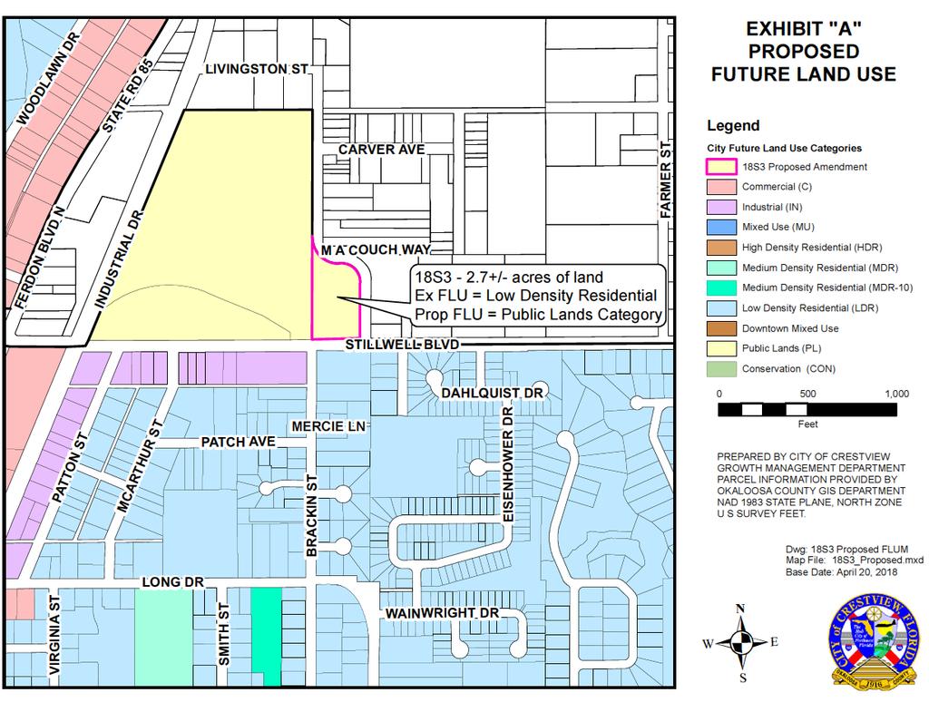
67
68 Public Hearings e. Ordinance 1646 Rezoning of 2.7 acres (18S3) Spanish Trail Park.
69 CITY OF CRESTVIEW Item # 5e AGENDA ITEM CITY COUNCIL SPECIAL MEETING DATE: May 29, 2018 TYPE OF AGENDA ITEM: Public Hearings TO: Mayor and City Council CC: City Clerk, Staff and Attorney FROM: Growth Management Department DATE: May 23, 2018 SUBJECT: Second Reading of Ordinance 1646 Rezoning of 2.7+/- acres located in Section 4, Township 3 North, Range 23 West, Okaloosa County BACKGROUND: City of Crestview Growth Management, on the request of the City Council, has submitted the applications requesting the filing of a small-scale plan amendment to the Comprehensive Plan and the assignment of the zoning designation for the 2.7± acres, situated in Section 4, Township 3 North, Range 23 West, Okaloosa County, Florida. The parcel is identified under Parcel Identification Numbers 04-3N in the Public Records of Okaloosa County. The recently annexed parcel is located adjacent to and developed as a part of Spanish Trail Park. It is utilized as part of the grass parking area and a stormwater retention pond for the Park. The current Okaloosa County future land use classification for this parcel is Low Density Residential (LDR) and it carries the Residential - 1 (R-1) zoning designation. The Future Land Use Categories, Zoning Designations and the existing use of the surrounding properties are: Direction FLU Zoning Existing Use East County LDR County R-1 Retention pond South LDR R-2 Residential West Public Lands Public Lands Municipal North County LDR County R-1 Retention pond The application requests that the assignment of Public Lands (PL) Future Land Use Category and Public Lands (P) District Zoning designation be placed on the property. Currently, no plans exist to further develop the site. The property was developed as a part of the adjacent Spanish Trail Park, with improvements including retention pond and boundary fencing. The property lies within Flood Zone X, which is an area determined to be outside the 500-year floodplain, as per the FIRM Panel Number 12091C0170H, dated STAFF RECOMMENDATION: The Staff recommends adopting Ordinance 1646 on second reading and send to the Mayor, Council President and City Clerk for signatures. RECOMMENDED MOTION: I move to adopt Ordinance 1646 on second reading and send to the Mayor, Council President and City Clerk for signatures. Page 1 of 1
70 ORDINANCE NO AN ORDINANCE OF THE CITY OF CRESTVIEW, FLORIDA, PROVIDING FOR THE REZONING OF 2.7 ACRES, MORE OR LESS, OF REAL PROPERTY, LOCATED IN SECTION 4, TOWNSHIP 3 NORTH, RANGE 23 WEST, FROM THE OKALOOSA COUNTY RESIDENTIAL - 1 ZONING DISTRICT TO THE CITY OF CRESTVIEW PUBLIC LANDS ZONING DISTRICT; PROVIDING FOR AUTHORITY; PROVIDING FOR THE UPDATING OF THE CRESTVIEW ZONING MAP; PROVIDING FOR SEVERABILITY; AND PROVIDING FOR AN EFFECTIVE DATE. BE IT ORDAINED BY THE CITY COUNCIL OF CRESTVIEW, FLORIDA AS FOLLOWS: SECTION 1. AUTHORITY. The authority for enactment of this ordinance is Section , Florida Statutes and Chapter 102, City Code. SECTION 2. PROPERTY REZONED. The following described 2.7 acres, more or less, of real property lying within the corporate limits of Crestview, Florida, being formerly zoned Okaloosa County Residential - 1 District Zoning (R-1) with the City of Crestview Public Lands Future Land Use Map designation recently ratified by the Florida Department of Economic Development, is hereby rezoned to the City of Crestview Public Lands District Zoning (P) to wit: PIN # 04-3N (Deed recorded in Deed Book 87, page 444, dated ) LOT 5, BLOCK 16, OAKDALE MINIATURE FARMS SUBDIVISION AS PER PLAT RECORDED IN BOOK 1, PAGE 129, OF THE PUBLIC RECORDS OF OKALOOSA COUNTY, FLORIDA. SECTION 3. MAP UPDATE. The Crestview Zoning Map, current edition, is hereby amended to reflect the above changes concurrent with passage of this ordinance. SECTION 4. SEVERABILITY. If any word, phrase, clause, paragraph, section or provision of this ordinance or the application thereof to any person or circumstance is held invalid or unconstitutional, such finding shall not affect the other provisions or applications of the ordinance which can be given effect without the invalid or unconstitutional provisions of this ordinance are declared severable. SECTION 5. EFFECTIVE DATE. The effective date of this Ordinance shall be the date Comprehensive Plan Amendment 18S3, adopted by Ordinance # 1645, becomes legally effective. Adoption May 29, Ordinance 1646
71 PASSED AND ADOPTED ON SECOND READING BY THE CITY COUNCIL OF CRESTVIEW, FLORIDA ON THE 29th DAY OF MAY, ATTEST: J B WHITTEN Council President ELIZABETH M. ROY City Clerk APPROVED BY ME THIS DAY OF, DAVID CADLE Mayor Adoption May 29, Ordinance 1646
72 Location Map ORDINANCE NO Adoption May 29, Ordinance 1646
73 Public Hearings f. Ordinance 1647 Small Scale Comp Plan Amendment 18S4 0.5 acres.
74 CITY OF CRESTVIEW Item # 5f AGENDA ITEM CITY COUNCIL SPECIAL MEETING DATE: May 29, 2018 TYPE OF AGENDA ITEM: Public Hearings TO: Mayor and City Council CC: City Clerk, Staff and Attorney FROM: Growth Management Department DATE: May 23, 2018 SUBJECT: Second Reading of Ordinance 1647 Small Scale Comprehensive Plan Amendment for 0.5+/- acres located in Section 20, Township 3 North, Range 23 West, Okaloosa County BACKGROUND: Petitions were submitted by Armando T. Borbon Jr and wife, Virginia R. Borbon, property owners, of the parcel described in the Warranty Deed recorded in OR Book 3220, page 3866, of the Public Records of Okaloosa County, Florida, and being identified by Parcel Tax I. D. 20-3N , located at 220 Duggan Avenue, Okaloosa County, Florida. The executed Petition and Agreement allowed for the annexation, which was accomplished April 9, 2018 by Ordinance The Petitioner has submitted application and payment for the comprehensive plan amendment and rezoning of the property. Ordinance 1647 will facilitate a small scale comprehensive plan amendment be filed in order to change the future land use of the property from Okaloosa County Low Density Residential to the City of Crestview Low Density Residential Future Land Use. Ordinance 1648 will facilitate the rezoning of the property from Okaloosa County Residential 1 District Zoning to City of Crestview Single Family Dwelling District Zoning (R-1). STAFF RECOMMENDATION: The Staff recommends adopting Ordinance 1647 on second reading and send to the Mayor, Council President and City Clerk for signatures. RECOMMENDED MOTION: I move to adopt Ordinance 1647 on second reading and send to the Mayor, Council President and City Clerk for signatures.
75 ORDINANCE NO AN ORDINANCE OF THE CITY OF CRESTVIEW, FLORIDA, AMENDING ITS ADOPTED COMPREHENSIVE PLAN; PROVIDING FOR AUTHORITY; PROVIDING FOR FINDINGS OF FACT; PROVIDING FOR PURPOSE; PROVIDING FOR CHANGING THE FUTURE LAND USE DESIGNATION FROM OKALOOSA COUNTY LOW DENSITY RESIDENTIAL CATEGORY TO CITY OF CRESTVIEW LOW DENSITY RESIDENTIAL FUTURE LAND USE CATEGORY ON APPROXIMATELY 0.5 ACRES, MORE OR LESS, IN SECTION 20, TOWNSHIP 3 NORTH, RANGE 23 WEST; PROVIDING FOR FUTURE LAND USE MAP AMENDMENT; AND PROVIDING FOR AN EFFECTIVE DATE. BE IT ORDAINED BY THE CITY COUNCIL OF CRESTVIEW, FLORIDA, AS FOLLOWS: SECTION 1. Authority. The authority for enactment of this Ordinance is Section 2 of the City Charter, F.S., F.S., F.S. and the adopted Comprehensive Plan. SECTION 2. Findings of Fact. The City Council of the City of Crestview finds the following: A. This amendment will promote compact, orderly development and discourage urban sprawl; and B. A public hearing has been conducted after "due public notice" by the Crestview Planning Board sitting as the Local Planning Agency with its recommendations reported to the City Council; and C. A public hearing has been conducted by the City Council after "due public notice"; and D. This amendment involves changing the future land use designation from Okaloosa County Low Density Residential Future Land Use Category to the City of Crestview Low Density Residential Future Land Use Category on a parcel of land containing 0.5 acres, more or less, lying within the corporate limits of the City; and E. This amendment is consistent with the adopted Comprehensive Plan and is in the best interests of the City and its citizens. SECTION 3. Purpose. The purpose of this Ordinance is to adopt an amendment to the "City of Crestview Comprehensive Plan: 2020." The amendment is known as 18S4 and it is as described in Section 4 below. SECTION 4. Future Land Use Map Amendment. Future Land Use Map is amended by changing the future land use category of a parcel containing approximately 0.5 acres of land, more or less, from Okaloosa County Low Density Residential Future Land Use Category to the City of Adoption May 29, Ordinance 1647
76 Crestview Low Density Residential Future Land Use Category. For the purposes of this Ordinance and Comprehensive Plan Amendment, the 0.5 acres, more or less, is known as Parcel 18S4 and commonly described as: PIN # 20-3N (Deed recorded in Official Records Book 3220, page 3866) BEGINNING AT THE NORTHEAST CORNER OF NORTHWEST QUARTER OF THE SOUTHWEST QUARTER RUN WEST 300 FEET FOR POINT OF BEGINNING; THENCE SOUTH PARALLEL TO EAST LINE OF FORTY 295 FEET; THENCE WEST 74 FEET PARALLEL TO NORTH LINE OF FORTY; THENCE NORTH 295 FEET; THENCE EAST ALONG FORTY LINE 74 TO POINT OF BEGINNING LOCATED IN SECTION 20, TOWNSHIP 3 NORTH, RANGE 23 WEST, OKALOOSA COUNTY, FLORIDA. The Low Density Residential Future Land Use Category is hereby imposed on Parcel 18S4. Exhibit A, which is attached hereto and made a part hereof by reference, graphically depicts the revisions to the Future Land Use Map and shows Parcel 18S4 thereon. SECTION 5. Effective Date. The effective date of this plan amendment and ordinance shall be thirty-one (31) days after adoption on second reading by the City Council, unless the amendment is challenged pursuant to , F.S. If challenged, the effective date shall be the date a Final Order is issued by the State Land Planning Agency or the Administration Commission finding the amendment in compliance with , F.S. PASSED AND ADOPTED ON SECOND READING BY THE CITY COUNCIL OF CRESTVIEW, FLORIDA ON THE 29 th DAY OF MAY, ATTEST: J. B. WHITTEN Council President ELIZABETH M. ROY City Clerk APPROVED BY ME THIS DAY OF, DAVID CADLE Mayor Adoption May 29, Ordinance 1647
77 Location Map Parcel 18S4 Adoption May 29, Ordinance 1647
78 Small scale Comprehensive Report and FLU map Excerpt
79 A SMALL SCALE AMENDMENT to the Comprehensive Plan of THE CITY OF CRESTVIEW LPA DRAFT 18S4 April 24, 2018 J. E. Dorman & Associates, Inc. Destin, Florida
80 INTRODUCTION This document contains a small scale amendment to the Comprehensive Plan of the City of Crestview, Florida and includes the data and analysis supporting the amendment, the amended Future Land Use Map (FLUM) and will contain the ordinance adopting the amendment. The subject property is a single lot that is about in size and was recently annexed into the City. The amendment changes the Future Land Use category from Okaloosa County Low Density Residential (LDR) to the City s LDR category. This report is organized into three (3) sections: Section 1 contains the data and analysis supporting the amendment; Section 2 contains the map product (FLUM) associated with the amendment; and, Section 3 will contain the ordinance adopting the amendment. This report constitutes the LPA and staff report to the City Council. We hope this report proves useful and informative.
81 SECTION 1
82 DATA AND ANALYSIS Amendment 18S4 This small scale amendment is in the form of a change to the adopted Future Land Use Map (FLUM). The amendment involves a single lot (0.50 acres) and was recently annexed into the City. The amendment changes the Future Land Use category from County Low Density Residential (LDR) to the City s LDR category and reflects the annexation. The purpose of the amendment is to provide for the development of a single family house. FUTURE LAND USE MAP DESIGNATION Section 2 of this report contains the portion of the FLUM showing the area containing the subject property. The map shows the subject with the LDR category imposed thereon. The adjacent lands east, south and west of the subject are in the county LDR category and the lands to the north are in the City s LDR category. This amendment constitutes a logical continuation of planned development patterns. EXISTING LAND USE/PRE-AMENDMENT CONDITIONS The subject property is wooded and vacant. The subject is located on the south side of Duggan Ave, which is the primary access for the subject. Single family homes exist throughout the adjacent property to the north. PROPOSED DEVELOPMENT The subject consists of an existing 0.50 acre lot on which a single family house is to be constructed. IMPACTS ON INFRASTRUCTURE The proposed use is considered de minimis for the purposes of this amendment, and only this amendment. Comprehensive Plan amendments that are de minimis need no additional analysis. NOTE: The City s concurrency management system requires a demonstration that all impacted infrastructure systems have available capacity to serve the development at established level of service standards prior to approving any development. The system will be applied to the development of this property, just as it is for all other development in the City. 1
83 COMPATIBILITY AND SUITABILITY Numerous single family homes exist adjacent and near the subject Among others, the amendment and contemplated development further the following provisions of the Comprehensive Plan: Policy 7.A.2.2 because development under the amendment will utilize existing water/sewer facilities and discourage urban sprawl. Policy 7.A.3.2 because the amendment is consistent with accepted planning principals and it represents efficiency of use of the property given its location relative to other uses. Policy 7.A.6.3 because the amendment promotes infill development. More importantly, neither the amendment or the contemplated development conflict with any provision of the adopted Comprehensive Plan.. Topography The site is gently sloping with an average elevation of about 200 feet. Soils According to the Soil Survey of Okaloosa County, Florida by the U.S.D.A., Natural Resources Conservation Service, the property is comprised of soils in the Troup sand. This soil is well drained and found in the uplands. Permeability is rapid in the upper part and moderate in the lower part. Runoff is slow. The seasonal high water table is at a depth of more than 80 inches. This soil is generally unsuited to cultivated crops and moderately suited to pasture. This soil is well suited to use as a site for homes, septic tank absorption fields, small commercial buildings, and local roads and streets. The soil is ideal for the intended use. Wetlands There are no wetlands or other protected resources on or adjacent to the subject. Historical and Archeological Resources According to the data in the Foundation Document supporting the Comprehensive Plan there are no historic or archeological resources on or near the site. However, if development of the site reveals any such artifacts or resources, Plan Policy 7.A.4.5 will govern. 2
84 Summary This amendment is consistent with and furthers the adopted Comprehensive Plan. The amendment reflects the recent annexation of the parcel. There will be no adverse impacts to any protected environmental resource. The amendment furthers several important provisions of the Comprehensive Plan. The amendment is in the best interests of the City and its citizens. 3
85 SECTION 2
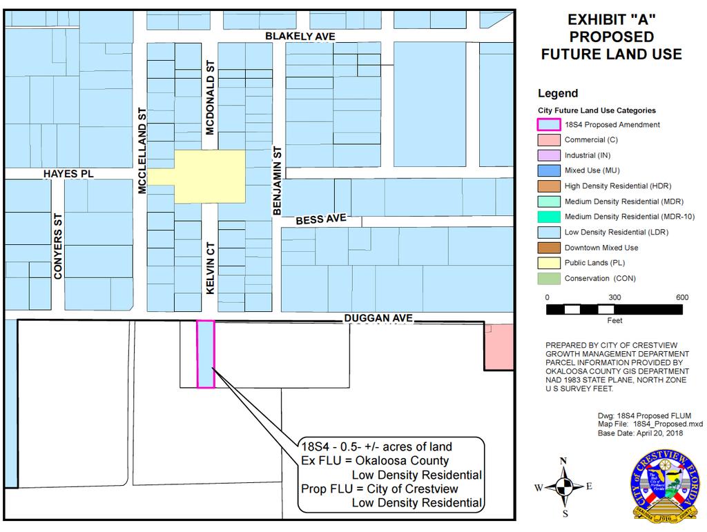
86
87 Public Hearings g. Ordinance 1648 Rezoning of 0.5 acres (18S4) Duggan Ave.

88 CITY OF CRESTVIEW Item # 5g AGENDA ITEM CITY COUNCIL SPECIAL MEETING DATE: May 29, 2018 TYPE OF AGENDA ITEM: Public Hearings TO: Mayor and City Council CC: City Clerk, Staff and Attorney FROM: Growth Management Department DATE: May 23, 2018 SUBJECT: Second Reading of Ordinance 1648 Rezoning for 0.5+/- acres located in Section 20, Township 3 North, Range 23 West, Okaloosa County BACKGROUND: Petitions were submitted by Armando T. Borbon Jr and wife, Virginia R. Borbon, property owners, of the parcel described in the Warranty Deed recorded in OR Book 3220, page 3866, of the Public Records of Okaloosa County, Florida, and being identified by Parcel Tax I. D. 20-3N , located at 220 Duggan Avenue, Okaloosa County, Florida. The executed Petition and Agreement allowed for the annexation, which was accomplished April 9, 2018 by Ordinance The Petitioner has submitted application and payment for the comprehensive plan amendment and rezoning of the property. Ordinance 1647 will facilitate a small scale comprehensive plan amendment be filed in order to change the future land use of the property from Okaloosa County Low Density Residential to the City of Crestview Low Density Residential Future Land Use. Ordinance 1648 will facilitate the rezoning of the property from Okaloosa County Residential 1 District Zoning to City of Crestview Single Family Dwelling District Zoning (R-1). STAFF RECOMMENDATION: The Staff recommends adopting Ordinance 1648 on second reading and send to the Mayor, Council President and City Clerk. RECOMMENDED MOTION: I move to adopt Ordinance 1648 on second reading and send to the Mayor, Council President and City Clerk.
89 ORDINANCE NO AN ORDINANCE OF THE CITY OF CRESTVIEW, FLORIDA, PROVIDING FOR THE REZONING OF 0.5 ACRES, MORE OR LESS, OF REAL PROPERTY, LOCATED IN SECTION 20, TOWNSHIP 3 NORTH, RANGE 23 WEST, FROM THE OKALOOSA COUNTY RESIDENTIAL - 1 DISTRICT ZONING TO THE CITY OF CRESTVIEW SINGLE FAMILY DWELLING DISTRICT ZONING (R-1); PROVIDING FOR AUTHORITY; PROVIDING FOR THE UPDATING OF THE CRESTVIEW ZONING MAP; PROVIDING FOR SEVERABILITY; AND PROVIDING FOR AN EFFECTIVE DATE. BE IT ORDAINED BY THE CITY COUNCIL OF CRESTVIEW, FLORIDA AS FOLLOWS: SECTION 1. AUTHORITY. The authority for enactment of this ordinance is Section , Florida Statutes and Chapter 102, City Code. SECTION 2. PROPERTY REZONED. The following described 0.5 acres, more or less, of real property lying within the corporate limits of Crestview, Florida, being formerly zoned Okaloosa County Residential - 1 District Zoning (R-1) with the City of Crestview Low Density Residential Future Land Use Map designation recently ratified by the Florida Department of Economic Development, is hereby rezoned to the City of Crestview Single Family Dwelling District Zoning (R-1) to wit: PIN # 20-3N (Deed recorded in Official Records Book 3220, page 3866) BEGINNING AT THE NORTHEAST CORNER OF NORTHWEST QUARTER OF THE SOUTHWEST QUARTER RUN WEST 300 FEET FOR POINT OF BEGINNING; THENCE SOUTH PARALLEL TO EAST LINE OF FORTY 295 FEET; THENCE WEST 74 FEET PARALLEL TO NORTH LINE OF FORTY; THENCE NORTH 295 FEET; THENCE EAST ALONG FORTY LINE 74 TO POINT OF BEGINNING LOCATED IN SECTION 20, TOWNSHIP 3 NORTH, RANGE 23 WEST, OKALOOSA COUNTY, FLORIDA. SECTION 3. MAP UPDATE. The Crestview Zoning Map, current edition, is hereby amended to reflect the above changes concurrent with passage of this ordinance. SECTION 4. SEVERABILITY. If any word, phrase, clause, paragraph, section or provision of this ordinance or the application thereof to any person or circumstance is held invalid or unconstitutional, such finding shall not affect the other provisions or applications of the ordinance which can be given effect without the invalid or unconstitutional provisions of this ordinance are declared severable. SECTION 5. EFFECTIVE DATE. The effective date of this Ordinance shall be the date Comprehensive Plan Amendment 18S4, adopted by Ordinance # 1647, becomes legally effective. Adoption May 29, Ordinance 1648
90 PASSED AND ADOPTED ON SECOND READING BY THE CITY COUNCIL OF CRESTVIEW, FLORIDA ON THE 29 th DAY OF MAY, ATTEST: J B WHITTEN Council President ELIZABETH M. ROY City Clerk APPROVED BY ME THIS DAY OF, DAVID CADLE Mayor Adoption May 29, Ordinance 1648
91 Location Map ORDINANCE NO Adoption May 29, Ordinance 1648
92 Public Hearings h. Ordinance 1649 Small Scale Comp Plan Amendment 18S5 1.5+/- ac
93 CITY OF CRESTVIEW Item # 5h AGENDA ITEM CITY COUNCIL SPECIAL MEETING DATE: May 29, 2018 TYPE OF AGENDA ITEM: Public Hearings TO: Mayor and City Council CC: City Clerk, Staff and Attorney FROM: Growth Management Department DATE: May 23, 2018 SUBJECT: Second Reading of Ordinance 1649 Small Scale Comprehensive Plan Amendment for 1.5+/- acres located in Section 32, Township 3 North, Range 23 West, Okaloosa County BACKGROUND: Panhandle Preschools, LLC, by Shawn Riley, Managing Member, has submitted the applications for filing of a small-scale plan amendment to the Comprehensive Plan and the assignment of the zoning designation for the 1.5+/- acres as required per the Out of City Municipal Services Agreement and Resolution The property is situated in the southwest quadrant of the intersection of John King Road and Live Oak Church Road. The property was recently annex on April 9, 2018 by Ordinance The parcel is situated in Section 32, Township 3 North, Range 23 West, Okaloosa County, Florida and is identified under Parcel Identification Number 32-3N in the Public Records of Okaloosa County. The parcel is contiguous to the City Limits on the northern and western boundaries and a portion of the southern and eastern boundaries. The current Okaloosa County future land use classification for this parcel is Mixed Use (MU) and it carries the Mixed Use (MU) zoning designation. The Future Land Use Categories, Zoning Designations and the existing use of the surrounding properties are: Direction FLU Zoning Existing Use East C & County MU C-1 & County MU Warehouse & Veh Repair South C & County MU C-1 & County MU Residential West C C-1 Community Shopping North C & LDR C-1 & R-1 Hotels/Motels The application requests that the assignment of Commercial (C) Future Land Use Category and Commercial (C-1) District Zoning designation be placed on the 1.5+/- acres. The site is fully developed with a 8950 SF facility for daycare services, together with the parking and infrastructure for same. Currently, it is occupied by the Childcare Network Daycare. The Facility shall be served with City of Crestview Utilities for potable water, sanitary sewer and garbage services. The property lies within Flood Zone X, which is an area determined to be outside the 500-year floodplain, as per the FIRM Panel Number 12091C0255H, dated STAFF RECOMMENDATION: The Staff recommends adopting Ordinance 1649 on second reading and send to the Mayor, Council President and City Clerk for signatures. RECOMMENDED MOTION: I move to adopt Ordinance 1649 on second reading and send to the Mayor, Council President and City Clerk for signatures.
94 ORDINANCE NO AN ORDINANCE OF THE CITY OF CRESTVIEW, FLORIDA, AMENDING ITS ADOPTED COMPREHENSIVE PLAN; PROVIDING FOR AUTHORITY; PROVIDING FOR FINDINGS OF FACT; PROVIDING FOR PURPOSE; PROVIDING FOR CHANGING THE FUTURE LAND USE DESIGNATION FROM OKALOOSA COUNTY MIXED USE CATEGORY TO CITY OF CRESTVIEW COMMERCIAL FUTURE LAND USE CATEGORY ON APPROXIMATELY 1.5 ACRES, MORE OR LESS, IN SECTION 32, TOWNSHIP 3 NORTH, RANGE 23 WEST; PROVIDING FOR FUTURE LAND USE MAP AMENDMENT; AND PROVIDING FOR AN EFFECTIVE DATE. BE IT ORDAINED BY THE CITY COUNCIL OF CRESTVIEW, FLORIDA, AS FOLLOWS: SECTION 1. Authority. The authority for enactment of this Ordinance is Section 2 of the City Charter, F.S., F.S., F.S. and the adopted Comprehensive Plan. SECTION 2. Findings of Fact. The City Council of the City of Crestview finds the following: A. This amendment will promote compact, orderly development and discourage urban sprawl; and B. A public hearing has been conducted after "due public notice" by the Crestview Planning Board sitting as the Local Planning Agency with its recommendations reported to the City Council; and C. A public hearing has been conducted by the City Council after "due public notice"; and D. This amendment involves changing the future land use designation from Okaloosa County Mixed Use Future Land Use Category to the City of Crestview Commercial Future Land Use Category on a parcel of land containing 1.5 acres, more or less, lying within the corporate limits of the City; and E. This amendment is consistent with the adopted Comprehensive Plan and is in the best interests of the City and its citizens. SECTION 3. Purpose. The purpose of this Ordinance is to adopt an amendment to the "City of Crestview Comprehensive Plan: 2020." The amendment is known as 18S5 and it is as described in Section 4 below. SECTION 4. Future Land Use Map Amendment. Future Land Use Map is amended by changing the future land use category of a parcel containing approximately 1.5 acres of land, more or less, from Okaloosa County Mixed Use Future Land Use Category to the City of Crestview Commercial Future Land Use Category. For the purposes of this Ordinance and Comprehensive Plan Amendment, the 1.5 acres, more or less, is known as Parcel 18S5 and commonly described as: Adoption May 29, Ordinance 1649
95 PIN # 32-3N (Deed recorded in Official Records Book 3208, page 1797) COMMENCE AT THE SOUTHWEST CORNER OF THE NORTHWEST 1/4 OF THE NORTHEAST 1/4 OF SECTION 32, TOWNSHIP 3 NORTH, RANGE 23 WEST, OKALOOSA COUNTY, FLORIDA; THENCE NORTH FEET; THENCE NORTH 89 DEGREES 37 MINUTES 00 SECONDS EAST FEET; THENCE NORTH FEET; THENCE NORTH 89 DEGREES 50 MINUTES 00 SECONDS EAST, A DISTANCE OF FEET; THENCE NORTH 00 DEGREES 00 MINUTES 57 SECONDS EAST, A DISTANCE OF FEET TO THE POINT OF BEGINNING; THENCE NORTH 00 DEGREES 00 MINUTES 57 SECONDS EAST, A DISTANCE OF FEET TO THE WESTERLY RIGHT-OF-WAY OF LIVE OAK CHURCH ROAD, SAID POINT BEING ON A CURVE; THENCE SOUTHEASTERLY, FEET ALONG THE ARC OF A CURVE, CONCAVED NORTHEASTERLY, HAVING A RADIUS OF FEET, A CENTRAL ANGLE OF 04 DEGREES 59 MINUTES 31 SECONDS AND A CHORD BEARING SOUTH 14 DEGREES 50 MINUTES 36 SECONDS EAST, FEET; THENCE DEPARTING SAID WESTERLY RIGHT-OF-WAY OF LIVE OAK CHURCH ROAD GO SOUTH 89 DEGREES 52 MINUTES 55 SECONDS WEST, A DISTANCE OF FEET TO THE POINT OF BEGINNING. The Commercial Future Land Use Category is hereby imposed on Parcel 18S5. Exhibit A, which is attached hereto and made a part hereof by reference, graphically depicts the revisions to the Future Land Use Map and shows Parcel 18S5 thereon. SECTION 5. Effective Date. The effective date of this plan amendment and ordinance shall be thirty-one (31) days after adoption on second reading by the City Council, unless the amendment is challenged pursuant to , F.S. If challenged, the effective date shall be the date a Final Order is issued by the State Land Planning Agency or the Administration Commission finding the amendment in compliance with , F.S. PASSED AND ADOPTED ON SECOND READING BY THE CITY COUNCIL OF CRESTVIEW, FLORIDA ON THE 29 th DAY OF MAY, ATTEST: J. B. WHITTEN Council President ELIZABETH M. ROY City Clerk APPROVED BY ME THIS DAY OF, DAVID CADLE Mayor Adoption May 29, Ordinance 1649
96 Location Map Parcel 18S5 Adoption May 29, Ordinance 1649
97 Small scale Comprehensive Report and FLU map Excerpt
98 A SMALL SCALE AMENDMENT to the Comprehensive Plan of THE CITY OF CRESTVIEW LPA DRAFT 18S5 April 24, 2018 J. E. Dorman & Associates, Inc. Destin, Florida
99 INTRODUCTION This document contains a small scale amendment to the Comprehensive Plan of the City of Crestview, Florida and includes the data and analysis supporting the amendment, the amended Future Land Use Map (FLUM) and will contain the ordinance adopting the amendment. The subject property contains about 1.36 acres and was recently annexed into the City. The amendment changes the Future Land Use category from Okaloosa County Mixed Use (MU) to the City s Commercial (C) category. This report is organized into three (3) sections: Section 1 contains the data and analysis supporting the amendment; Section 2 contains the map product (FLUM) associated with the amendment; and, Section 3 will contain the ordinance adopting the amendment. This report constitutes the LPA and staff report to the City Council. We hope this report proves useful and informative.
100 SECTION 1
101 DATA AND ANALYSIS Amendment 18S5 This small scale amendment is in the form of a change to the adopted Future Land Use Map (FLUM). The amendment involves a 1.36 acre that recently annexed into the City. The amendment changes the Future Land Use category from County Mixed Use to the City s Commercial category and reflects the annexation. FUTURE LAND USE MAP DESIGNATION Section 2 of this report contains the portion of the FLUM showing the area containing the subject property. The map shows the subject with the C category imposed thereon. The adjacent lands east and south of the subject are in the County MU and the City s Commercial category. The lands to the west are in the City s Commercial category and the lands to the north are in the City s Commercial and LDR categories This amendment constitutes a logical continuation of planned development patterns. EXISTING LAND USE/PRE-AMENDMENT CONDITIONS The subject is fully developed with a daycare facility (Childcare Network). PROPOSED DEVELOPMENT As noted, the parcel is fully developed and no additional development is planned. IMPACTS ON INFRASTRUCTURE Since the property is fully developed, all impacts to the infrastructure systems have been accommodated and no additional impacts will result from this amendment. As noted, when annexed, the parcel was in a mixed use category which provides for significantly more intense development than the amendment will permit. COMPATIBILITY AND SUITABILITY The property is fully developed and compatibility has been established. Among others, the amendment furthers the following provisions of the Comprehensive Plan: Policy 7.A.2.2 because development under the amendment utilizes existing water/sewer facilities and discourages urban sprawl. 1
102 Policy 7.A.3.2 because the amendment is consistent with accepted planning principals and it represents efficiency of use of the property given its location relative to other uses. More importantly, the amendment does not conflict with any provision of the adopted Comprehensive Plan.. Topography The site is generally level with an average elevation of about 150 feet. Soils According to the Soil Survey of Okaloosa County, Florida by the U.S.D.A., Natural Resources Conservation Service, the property is comprised of soils in the Lakeland sand. This soil is well drained and found in the uplands. Permeability is rapid in the upper part and moderate in the lower part. Runoff is slow. The seasonal high water table is at a depth of more than 80 inches. This soil is generally unsuited to cultivated crops and moderately suited to pasture. This soil is well suited to use as a site for homes, septic tank absorption fields, small commercial buildings, and local roads and streets. The soil is ideal for the existing use. Wetlands There are no wetlands or other protected resources on or adjacent to the subject. Historical and Archeological Resources According to the data in the Foundation Document supporting the Comprehensive Plan there are no historic or archeological resources on or near the site. However, if development of the site reveals any such artifacts or resources, Plan Policy 7.A.4.5 will govern. 2
103 Summary This amendment is consistent with and furthers the adopted Comprehensive Plan. The amendment reflects the recent annexation of the parcel. There will be no adverse impacts to any protected environmental resource. The amendment furthers several important provisions of the Comprehensive Plan. The amendment is in the best interests of the City and its citizens. 3
104 SECTION 2
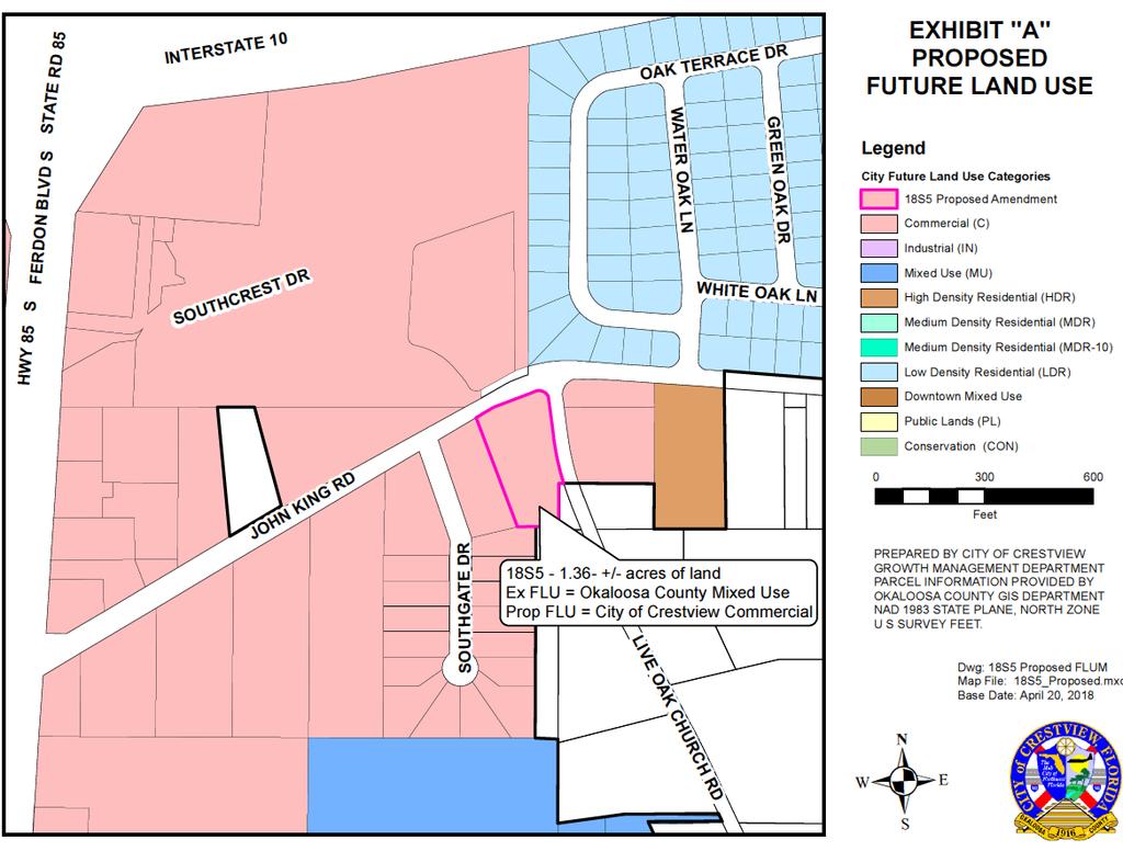
105
106 Public Hearings i. Ordinance 1651 Rezoning 1.5+/- acres (18S5) John King Road
107 CITY OF CRESTVIEW Item # 5i AGENDA ITEM CITY COUNCIL SPECIAL MEETING DATE: May 29, 2018 TYPE OF AGENDA ITEM: Public Hearings TO: Mayor and City Council CC: City Clerk, Staff and Attorney FROM: Growth Management Department DATE: May 23, 2018 SUBJECT: Second Reading of Ordinance 1651 Rezoning for 1.5+/- acres located in Section 32, Township 3 North, Range 23 West, Okaloosa County BACKGROUND: Panhandle Preschools, LLC, by Shawn Riley, Managing Member, has submitted the applications for filing of a small-scale plan amendment to the Comprehensive Plan and the assignment of the zoning designation for the 1.5+/- acres as required per the Out of City Municipal Services Agreement and Resolution The property is situated in the southwest quadrant of the intersection of John King Road and Live Oak Church Road. The property was recently annex on April 9, 2018 by Ordinance The parcel is situated in Section 32, Township 3 North, Range 23 West, Okaloosa County, Florida and is identified under Parcel Identification Number 32-3N in the Public Records of Okaloosa County. The parcel is contiguous to the City Limits on the northern and western boundaries and a portion of the southern and eastern boundaries. The current Okaloosa County future land use classification for this parcel is Mixed Use (MU) and it carries the Mixed Use (MU) zoning designation. The Future Land Use Categories, Zoning Designations and the existing use of the surrounding properties are: Direction FLU Zoning Existing Use East C & County MU C-1 & County MU Warehouse & Veh Repair South C & County MU C-1 & County MU Residential West C C-1 Community Shopping North C & LDR C-1 & R-1 Hotels/Motels The application requests that the assignment of Commercial (C) Future Land Use Category and Commercial (C-1) District Zoning designation be placed on the 1.5+/- acres. The site is fully developed with a 8950 SF facility for daycare services, together with the parking and infrastructure for same. Currently, it is occupied by the Childcare Network Daycare. The Facility shall be served with City of Crestview Utilities for potable water, sanitary sewer and garbage services. The property lies within Flood Zone X, which is an area determined to be outside the 500-year floodplain, as per the FIRM Panel Number 12091C0255H, dated STAFF RECOMMENDATION: The Staff recommends adopting Ordinance 1651 on second reading and send to the Mayor, Council President and City Clerk for signatures. RECOMMENDED MOTION: I move to adopt Ordinance 1651 on second reading and send to the Mayor, Council President and City Clerk for signatures.
108 ORDINANCE NO AN ORDINANCE OF THE CITY OF CRESTVIEW, FLORIDA, PROVIDING FOR THE REZONING OF 1.5 ACRES, MORE OR LESS, OF REAL PROPERTY, LOCATED IN SECTION 32, TOWNSHIP 3 NORTH, RANGE 23 WEST, FROM THE OKALOOSA COUNTY MIXED USE DISTRICT ZONING TO THE CITY OF CRESTVIEW COMMERCIAL DISTRICT ZONING (C-1); PROVIDING FOR AUTHORITY; PROVIDING FOR THE UPDATING OF THE CRESTVIEW ZONING MAP; PROVIDING FOR SEVERABILITY; AND PROVIDING FOR AN EFFECTIVE DATE. BE IT ORDAINED BY THE CITY COUNCIL OF CRESTVIEW, FLORIDA AS FOLLOWS: SECTION 1. AUTHORITY. The authority for enactment of this ordinance is Section , Florida Statutes and Chapter 102, City Code. SECTION 2. PROPERTY REZONED. The following described 1.5 acres, more or less, of real property lying within the corporate limits of Crestview, Florida, being formerly zoned Okaloosa County Mixed Use District Zoning (MU) with the City of Crestview Commercial Future Land Use Map designation recently ratified by the Florida Department of Economic Development, is hereby rezoned to the City of Crestview Commercial District Zoning (C-1) to wit: PIN # 32-3N (Deed recorded in Official Records Book 3208, page 1797) COMMENCE AT THE SOUTHWEST CORNER OF THE NORTHWEST 1/4 OF THE NORTHEAST 1/4 OF SECTION 32, TOWNSHIP 3 NORTH, RANGE 23 WEST, OKALOOSA COUNTY, FLORIDA; THENCE NORTH FEET; THENCE NORTH 89 DEGREES 37 MINUTES 00 SECONDS EAST FEET; THENCE NORTH FEET; THENCE NORTH 89 DEGREES 50 MINUTES 00 SECONDS EAST, A DISTANCE OF FEET; THENCE NORTH 00 DEGREES 00 MINUTES 57 SECONDS EAST, A DISTANCE OF FEET TO THE POINT OF BEGINNING; THENCE NORTH 00 DEGREES 00 MINUTES 57 SECONDS EAST, A DISTANCE OF FEET TO THE WESTERLY RIGHT-OF-WAY OF LIVE OAK CHURCH ROAD, SAID POINT BEING ON A CURVE; THENCE SOUTHEASTERLY, FEET ALONG THE ARC OF A CURVE, CONCAVED NORTHEASTERLY, HAVING A RADIUS OF FEET, A CENTRAL ANGLE OF 04 DEGREES 59 MINUTES 31 SECONDS AND A CHORD BEARING SOUTH 14 DEGREES 50 MINUTES 36 SECONDS EAST, FEET; THENCE DEPARTING SAID WESTERLY RIGHT-OF-WAY OF LIVE OAK CHURCH ROAD GO SOUTH 89 DEGREES 52 MINUTES 55 SECONDS WEST, A DISTANCE OF FEET TO THE POINT OF BEGINNING. SECTION 3. MAP UPDATE. The Crestview Zoning Map, current edition, is hereby amended to reflect the above changes concurrent with passage of this ordinance. Adoption May 29, Ordinance 1651
109 SECTION 4. SEVERABILITY. If any word, phrase, clause, paragraph, section or provision of this ordinance or the application thereof to any person or circumstance is held invalid or unconstitutional, such finding shall not affect the other provisions or applications of the ordinance which can be given effect without the invalid or unconstitutional provisions of this ordinance are declared severable. SECTION 5. EFFECTIVE DATE. The effective date of this Ordinance shall be the date Comprehensive Plan Amendment 18S5, adopted by Ordinance # 1649, becomes legally effective. PASSED AND ADOPTED ON SECOND READING BY THE CITY COUNCIL OF CRESTVIEW, FLORIDA ON THE 29 th DAY OF MAY, ATTEST: J B WHITTEN Council President ELIZABETH M. ROY City Clerk APPROVED BY ME THIS DAY OF, DAVID CADLE Mayor Adoption May 29, Ordinance 1651
110 Location Map ORDINANCE NO Adoption May 29, Ordinance 1651
111 Public Hearings j. Ordinance 1661 Rezoning of acres Redstone Avenue East.

112 CITY OF CRESTVIEW Item # 5j AGENDA ITEM CITY COUNCIL SPECIAL MEETING DATE: May 29, 2018 TYPE OF AGENDA ITEM: Public Hearing TO: Mayor and City Council CC: City Clerk, Staff and Attorney FROM: Growth Management Department DATE: May 23, 2018 SUBJECT: Second Reading of Ordinance 1661 Rezoning for /- acres located in Section 27, Township 3 North, Range 23 West, Okaloosa County BACKGROUND: Redstone Land 2017 FL, LLC, property owner, by Jenkins Engineering, Authorized Agent, Matt Zinke, Project Engineer, has submitted the application for the assignment of the zoning designation for the acres located in Section 27, Township 3 North, Range 23 West, same being a part of that certain 340+/- acres annexed into the jurisdictional limits of the City of Crestview, by the adoption of Ordinance 1277 on October 9, The property was processed through Conventional Comprehensive Plan Amendment , Ordinance 1415, adopted November 11, 2008, and was assigned the Low Density Residential Future Land Use. This portion of the property still retains the Okaloosa County Planned Unit Development Zoning District. The application requests that the assignment of Single Family Dwelling District Zoning (R-1) designation be placed on the property. The site is undeveloped at this time, however, conceptual plans show the next phase of Redstone Commons Subdivision, to be more commonly known as Redstone East. STAFF RECOMMENDATION: The Staff recommends adopting Ordinance 1661 on second reading and send to the Mayor, Council President and City Clerk for signatures. RECOMMENDED MOTION: I move to adopt Ordinance 1661 on second reading and send to the Mayor, Council President and City Clerk for signatures.
113 ORDINANCE NO AN ORDINANCE OF THE CITY OF CRESTVIEW, FLORIDA, PROVIDING FOR THE REZONING OF ACRES, MORE OR LESS, OF REAL PROPERTY, LOCATED IN SECTION 27, TOWNSHIP 3 NORTH, RANGE 23 WEST, FROM THE OKALOOSA COUNTY PLANNED UNIT DEVELOPMENT (PUD) ZONING TO THE CITY OF CRESTVIEW SINGLE FAMILY DWELLING DISTRICT ZONING (R-1); PROVIDING FOR AUTHORITY; PROVIDING FOR THE UPDATING OF THE CRESTVIEW ZONING MAP; PROVIDING FOR SEVERABILITY; AND PROVIDING FOR AN EFFECTIVE DATE. BE IT ORDAINED BY THE CITY COUNCIL OF CRESTVIEW, FLORIDA AS FOLLOWS: SECTION 1. AUTHORITY. The authority for enactment of this ordinance is Section , Florida Statutes and Chapter 102, City Code. SECTION 2. PROPERTY REZONED. The following described acres, more or less, of real property lying within the corporate limits of Crestview, Florida, being formerly zoned Okaloosa County Planned Unit Development District Zoning (PUD) with the City of Crestview Low Density Residential Future Land Use Map designation, is hereby rezoned to the City of Crestview Single Family Dwelling District Zoning (R-1) to wit: PIN # 27-3N (Deed recorded in Official Records Book 3288, page 1616) LEGAL DESCRIPTION (AS FURNISHED): A PARCEL OF LAND LYING IN SECTION 27, TOWNSHIP 3 NORTH, RANGE 23 WEST, OKALOOSA COUNTY, FLORIDA, AND BEING MORE PARTICULARLY DESCRIBED AS FOLLOWS: COMMENCE AT THE NORTHWEST CORNER OF SAID SECTION 27; THENCE S 87'56'24" E ON THE NORTH LINE OF THE NORTHWEST QUARTER OF SAID SECTION 27, A DISTANCE OF FEET TO THE NORTHEAST CORNER OF SAID NORTHWEST QUARTER; THENCE S 88 12'47" E ON THE NORTH LINE OF THE NORTHEAST QUARTER OF SAID SECTION 27, A DISTANCE OF FEET TO A POINT OF INTERSECTION WITH THE EAST RIGHT OF WAY LINE OF A 66 FOOT PUBLIC RIGHT OF WAY, HEREAFTER REFERRED TO AS THE "66 FOOT RIGHT OF WAY", SAID POINT ALSO BEING THE POINT OF BEGINNING; THENCE CONTINUE S 88 12'47" E, A DISTANCE OF FEET; THENCE DEPARTING SAID NORTH LINE, PROCEED S 01 06'42" W, A DISTANCE OF FEET TO A POINT ON THE NORTH RIGHT OF WAY LINE OF FLORIDA STATE ROAD 8 (INTERSTATE 10 RIGHT OF WAY; WIDTH VARIES); THENCE ON SAID NORTH RIGHT OF WAY LINE, THE FOLLOWING 5 (FIVE) CALLS: 1) N 88 07'30" W, A DISTANCE OF FEET; 2) THENCE N 85 07'55" W, A DISTANCE OF FEET TO A POINT ON A CURVE CONCAVE SOUTHERLY AND HAVING A RADIUS OF FEET; 3) THENCE ON SAID CURVE, THROUGH A CENTRAL ANGLE OF 00 30'54", AN ARC DISTANCE OF FEET, (CHORD BEARING = N 88'22'57" W, CHORD = FEET); 4) THENCE S 88'12'39" W, A DISTANCE OF FEET TO A POINT ON A CURVE CONCAVE SOUTHERLY AND HAVING A RADIUS OF FEET; 5) THENCE ALONG SAID CURVE, THROUGH A CENTRAL ANGLE OF Adoption May 29, Ordinance 1661
114 00 59'29", AN ARC DISTANCE OF FEET, (CHORD BEARING = N 89'27'39" W, CHORD = FEET), TO A POINT OF INTERSECTION WITH THE SOUTHERLY EXTENSION OF THE AFORESAID EAST RIGHT OF WAY LINE OF SAID "66 FOOT RIGHT OF WAY"; THENCE DEPARTING SAID NORTH RIGHT OF WAY LINE, PROCEED N 01'44'11" E ON SAID EAST RIGHT OF WAY LINE, A DISTANCE OF FEET TO THE POINT OF BEGINNING. SECTION 3. MAP UPDATE. The Crestview Zoning Map, current edition, is hereby amended to reflect the above changes concurrent with passage of this ordinance. SECTION 4. SEVERABILITY. If any word, phrase, clause, paragraph, section or provision of this ordinance or the application thereof to any person or circumstance is held invalid or unconstitutional, such finding shall not affect the other provisions or applications of the ordinance which can be given effect without the invalid or unconstitutional provisions of this ordinance are declared severable. SECTION 5. EFFECTIVE DATE. The effective date of this Ordinance shall be immediately upon adoption. PASSED AND ADOPTED ON SECOND READING BY THE CITY COUNCIL OF CRESTVIEW, FLORIDA, ON THE 29 th DAY OF MAY, ATTEST: J B WHITTEN Council President ELIZABETH M. ROY City Clerk APPROVED BY ME THIS DAY OF, DAVID CADLE Mayor Adoption May 29, Ordinance 1661

115 Location Map ORDINANCE NO Adoption May 29, Ordinance 1661
ORDINANCE #ORD
 ORDINANCE #ORD2017-17 AN ORDINANCE OF THE CITY OF DUNNELLON, FLORIDA, AMENDING THE CITY OF DUNNELLON LAND DEVELOPMENT REGULATIONS BY AMENDING CHAPTER 82 ARTICLE II, BUILDING CODE, TO ADOPT THE 2017 EDITION
ORDINANCE NO. XX-16. WHEREAS, the City Commission of the City of Delray Beach adopts the findings in the Planning and Zoning Staff Report; and
 ORDINANCE NO. XX-16 AN ORDINANCE OF THE CITY COMMISSION OF THE CITY OF DELRAY BEACH, FLORIDA, AMENDING THE LAND DEVELOPMENT REGULATIONS OF THE CODE OF ORDINANCES, BY REPEALING SECTION 4.5.3, FLOOD DAMAGE
ORDINANCE NO NOW, THEREFORE, BE IT ORDAINED by the Town Council of the Town of Indian
 ORDINANCE NO. 509 AN ORDINANCE BY THE TOWN OF INDIAN RIVER SHORES, FLORIDA AMENDING THE CODE OF ORDINANCES TO REPEAL CHAPTER 165 OF THE LAND DEVELOPMENT CODE; TO ADOPT A NEW CHAPTER 165 OF THE LAND DEVELOPMENT
ORDINANCE NO
 ORDINANCE NO. 22-2014 AN ORDINANCE BY THE CITY COUNCIL AMENDING THE CITY OF SEMINOLE CODE OF ORDINANCES TO REPEAL CHAPTER 62, ARTICLE IV. FLOODPLAINS, DIVISIONS 1 THROUGH 3, SECTION 62-251 THROUGH SECTION
ORDINANCE ARTICLE VI. RESOURCE PROTECTION STANDARDS
 ORDINANCE 2016-19 AN ORDINANCE OF THE CITY OF LAKE WALES, POLK COUNTY, FLORIDA AMENDING THE CITY OF LAKE WALES CODE OF ORDINANCES BY REPEALING CHAPTER 23 ZONING, LAND USE AND DEVELOPMENT REGULATIONS, ARTICLE
Chapter 8 FLOOD PREVENTION AND PROTECTION
 Chapter 8 FLOOD PREVENTION AND PROTECTION ARTICLE I - GENERAL 8.1 Title. 8.2 Scope. 8.3 Intent. 8.4 Coordination with the Florida Building Code. 8.5 Warning. 8.6 Disclaimer of Liability. 8.7 through 8.10
ORDINANCE NO. 13-_2_2
 ORDINANCE NO. 13-_2_2 AN ORDINANCE BY THE BOARD OF COUNTY COMMISSIONERS AMENDING THE BAY COUNTY CODE OF ORDINANCES TO REPEAL CHAPTER 9 DRAINAGE, ARTICLE II, FLOODPLAINS; TO ADOPT A NEW CHAPTER 9 DRAINAGE,
LEE COUNTY ORDINANCE NO
 LEE COUNTY ORDINANCE NO. 15-09 AN ORDINANCE AMENDING LEE COUNTY LAND DEVELOPMENT CODE CHAPTERS 6 AND 10 AND CERTAIN SECTIONS OF THE FLORIDA BUILDING CODE TO AUTHORIZE THE BOARD OF ADJUSTMENTS AND APPEALS
ORDINANCE NUMBER 2013-
 1 1 1 1 1 1 1 1 0 1 0 1 0 1 ORDINANCE NUMBER 01- AN ORDINANCE OF THE BOARD OF COUNTY COMMISSIONERS OF ESCAMBIA COUNTY, FLORIDA, AMENDING PART III OF THE ESCAMBIA COUNTY CODE OF ORDINANCES (1), THE LAND
ORDINANCE NO
 Introduced by: Council Member Wilson 1st Reading: April 2, 2018 2nd Reading: April 16, 2018 ORDINANCE NO. 2018-8107 AN ORDINANCE TO AMEND AN ORDINANCE ENACTING AND ESTABLISHING A COMPREHENSIVE LAND DEVELOPMENT
LDC AMENDMENT FLOODPLAINS
 Staff Report to the Municipal Planning Board March 20, 2018 L D C 2 0 1 8-10000 I T E M # 4 LDC AMENDMENT FLOODPLAINS Applicant City of Orlando Project Planner Elisabeth Dang, AICP Description of the Request:
6. Help maintain a stable tax base by providing for the sound use and development of flood hazard areas;
 CHAPTER 9 FLOODPLAIN MANAGEMENT SECTION 101 GENERAL 101.1 Title. These regulations shall be known as the Floodplain Management Ordinance of Yankeetown, hereinafter referred to as this ordinance. 101.2
ORDINANCE NO SECTION 1. RECITALS. The foregoing whereas clauses are incorporated herein by reference and made a part hereof.
 ORDINANCE NO. 13-10 AN ORDINANCE BY THE TREASURE ISLAND CITY COMMISSION AMENDING THE TREASURE ISLAND CODE OF ORDINANCES TO REPEAL CHAPTER 66, FLOOD CONTROL TO ADOPT A NEW CHAPTER 66, FLOODPLAIN MANAGEMENT
LINCOLN COUNTY FLOOD DAMAGE PREVENTION ORDINANCE
 LINCOLN COUNTY FLOOD DAMAGE PREVENTION ORDINANCE SECTION 1.0 STATUTORY AUTHORIZATION, FINDINGS OF FACT, PURPOSE AND OBJECTIVES SECTION 2 DEFINITIONS SECTION 3.0 GENERAL PROVISIONS SECTION 4.0 ADMINISTRATION
ENVIRONMENTAL AND RESOURCE PROTECTION
 CHAPTER THREE ENVIRONMENTAL AND RESOURCE PROTECTION Page 3.00.00 GENERALLY 3-3 3.00.01 Purpose and Intent 3-3 3.00.02 Applicability 3-3 3.01.00 ENVIRONMENTALLY SENSITIVE LANDS AND HABITATS 3-3 3.01.01
ORDINANCE NO
 ORDINANCE NO. 2017-09 AN ORDINANCE OF THE CITY COMMISSION OF THE CITY OF ST. AUGUSTINE, FL AMENDING THE CITY OF ST. AUGUSTINE CODE OF ORDINANCES AMENDING CHAPTER 8, ARTICLE V FLOODPLAIN MANAGEMENT AND
florida DEPARTMENT of. STAT~
 florida DEPARTMENT of. STAT~ RICK SCOTT Governor KEN DETZNER Secretary of State May 27,2015 Honorable Ken Burke Clerk of the Board of County Commissioners Pinellas County Courthouse 315 Court Street, 5th
PART III Escambia County Land Development Code DISCLAIMER:
 This document has been revised to reflect the Santa Rosa Island Authority Floodplain Management article of Chapter 4, Location and Use Regulations -only- To view full document, return to the SRIA Flood
FLOOD-RESISTANT CONSTRUCTION
 FLOOD-RESISTANT CONSTRUCTION The provisions contained in this appendix are not mandatory unless specifically referenced in the adopting ordinance. SECTION G101 ADMINISTRATION G101.1 Purpose. The purpose
B. Minimize expenditure of public money for costly flood-control projects;
 CHAPTER 1100. SPECIAL DEVELOPMENT STANDARDS SECTION 1104. FLOOD DAMAGE PREVENTION 1104.1. Intent and Purpose The special flood hazard areas of the County are subject to periodic inundation, which may result
CHAPTER XVII. REGULATION OF FLOOD PLAIN STATUTORY AUTHORIZATION, FINDINGS OF FACT, PURPOSE AND OBJECTIVES
 CHAPTER XVII. REGULATION OF FLOOD PLAIN ARTICLE 1.0 STATUTORY AUTHORIZATION, FINDINGS OF FACT, PURPOSE AND OBJECTIVES 17.0101 STATUTORY AUTHORIZATION The Legislature of the State of North Dakota has in
Chapter 4. Site Design and Development Standards
 Chapter 4 Site Design and Development Standards Table of Contents Chapter 4... 1 Site Design and Development Standards... 1 Chapter 4... 5 Site Design and Development Standards... 5 Article 4.1 General
Glades County Verification of Exemption from Florida Building Code & Zoning Review
 Date Received: Glades County Verification of Exemption from Florida Building Code & Zoning Review Fee Temporary structures associated with land development or construction projects - $300 for initial permit
BOARD OF COUNTY COMMISSIONERS
 BOARD OF COUNTY COMMISSIONERS ORDINANCE NO. AN ORDINANCE AMENDING THE PASCO COUNTY LAND DEVELOPMENT CODE SECTION 1104 FLOOD DAMAGE PREVENTION; APPENDIX A DEFINITIONS; AND OTHER SECTIONS, AS NECESSARY,
CHAPTER XIX FLOOD DAMAGE PROTECTION. Article. 1 Definitions 2 General Provisions 3 Administration 4 Provisions for Flood Hazard Reduction
 CHAPTER XIX FLOOD DAMAGE PROTECTION Article 1 Definitions 2 General Provisions 3 Administration 4 Provisions for Flood Hazard Reduction CHAPTER XIX FLOOD DAMAGE PROTECTION Article 1 Definitions 19.0101
The Onekama Township Flood Damage Prevention Ordinance of Onekama Township, Manistee County, Michigan was adopted by the Onekama ORDINANCE #4
 AN ORDINANCE The Onekama Township Flood Damage Prevention Ordinance of Onekama Township, Manistee County, Michigan was adopted by the Onekama Township Board at a regular meeting of its Township Board held
(Chapter Flood Damage Prevention)
") Chapter 13.10 Flood Damage Prevention Section: 13.10.010 Purpose and Policy 13.10.020 Definitions 13.10.030 Applicability and Areas of Special Flood Hazard 13.10.040 Administration 13.10.050 Provisions
Chapter 13.10 Flood Damage Prevention Section: 13.10.010 Purpose and Policy 13.10.020 Definitions 13.10.030 Applicability and Areas of Special Flood Hazard 13.10.040 Administration 13.10.050 Provisions
ARTICLE 6: RESOURCE PROTECTION STANDARDS. Article History 3 SECTION 6.01 PURPOSE 4 SECTION 6.02 WETLANDS 4
 ARTICLE 6 RESOURCE PROTECTION STANDARDS Table of Contents Article History 3 SECTION 6.01 PURPOSE 4 SECTION 6.02 WETLANDS 4 6.02.01 Purpose and Intent 4 6.02.02 Applicability and Requirements 4 6.02.03
CHAPTER 24 F FLOOD ZONE OVERLAY DISTRICT
 CHAPTER 24 OVERLAY DISTRICT SECTION 24.01 PURPOSE It is the intent of this district to apply special regulation to the use of land in those areas subject to periodic inundation. Such regulation is deemed
Town of Alexandria. Floodplain Management Ordinance
 1 of 7 8/8/2009 4:56 PM Town of Alexandria Floodplain Management Ordinance SECTION 1 PURPOSE Certain areas of the Town of Alexandria, New Hampshire are subject to periodic flooding, causing serious damages
Title 15. Buildings, Construction, Addressing and Land Use
 Chapters: 15.05 Land Use Fees 15.10 Flood Damage Prevention 15.15 Building Numbering Title 15 Buildings, Construction, Addressing and Land Use 15-1 Lyons Municipal Code 15.05.040 Chapter 15.05 Land Use
SPECIAL PURPOSE FLOOD DAMAGE PREVENTION ORDINANCE. Adopted: June 24th, 1998
 SPECIAL PURPOSE FLOOD DAMAGE PREVENTION ORDINANCE Adopted: June 24th, 1998 SECTION 1.0 STATUTORY AUTHORIZATION, FINDINGS OF FACT PURPOSE AND OBJECTIVES 1.1 STATUTORY AUTHORIZATION ARTICLE XVIII, Section
SPECIAL PURPOSE FLOOD DAMAGE PREVENTION REGULATIONS for FAIRFIELD COUNTY
 SPECIAL PURPOSE FLOOD DAMAGE PREVENTION REGULATIONS for FAIRFIELD COUNTY Adopted September 7, 1995 Effective October 9, 1995 Flood Maps are available in the Fairfield County Regional Planning Commission
Date of Review: 11/6/2015 Reviewer: RCQ/LMC STATE
 FINAL Florida Review Checklist: NFIP & FBC & Revised Model Ordinance (January 15, 2013d) Ordinance Citation: Model FPM regulations and 5 th Edition FBC : All Zones Date of Review: 11/6/2015 Reviewer: RCQ/LMC
THIS ARTICLE HAS BEEN COMPLETELY REWRITTEN. Chapter CRITICAL AREAS. Article XIX. Flood Hazard Areas. Article XIX. Flood Hazard Areas
 THIS ARTICLE HAS BEEN COMPLETELY REWRITTEN Chapter 18.55 CRITICAL AREAS Sections: Article XIX. Flood Hazard Areas 18.55.700 Purpose. 18.55.705 Definitions 18.55.707 Lands to which this article applies.
CHAPTER 5 FLOOD DAMAGE PREVENTION. Statutory Authorization, Findings of Fact, Purpose, Methods, and Definitions
 CHAPTER 5 FLOOD DAMAGE PREVENTION Article A. Section 5.1 Section 5.2 Section 5.3 Section 5.4 Section 5.5 Article B. Statutory Authorization, Findings of Fact, Purpose, Methods, and Definitions Statutory
CARTER COUNTY, OKLAHOMA FLOODPLAIN BOARD REGULATIONS ARTICLE I STATUTORY AUTHORIZATION, FINDINGS OF FACT, PURPOSE AND METHODS
 CARTER COUNTY, OKLAHOMA FLOODPLAIN BOARD REGULATIONS ARTICLE I STATUTORY AUTHORIZATION, FINDINGS OF FACT, PURPOSE AND METHODS SECTION A. STATUTORY AUTHORIZATION The Legislature of the State of Oklahoma
TITLE 14 ZONING AND LAND USE CONTROL CHAPTER 1 MUNICIPAL PLANNING COMMISSION
 14-1 TITLE 14 ZONING AND LAND USE CONTROL CHAPTER 1. MUNICIPAL PLANNING COMMISSION. 2. ZONING ORDINANCE. 3. FLOOD DAMAGE PREVENTION. CHAPTER 1 MUNICIPAL PLANNING COMMISSION SECTION 14-101. Creation and
ORDINANCE NO TOWNSHIP OF EAST WINDSOR COUNTY OF MERCER
 ORDINANCE NO. 2016-07 TOWNSHIP OF EAST WINDSOR COUNTY OF MERCER AN ORDINANCE REPEALING SECTION 22-4: FLOOD DAMAGE PREVENTION CODE, OF THE REVISED GENERAL ORDINANCES OF THE TOWNSHIP OF EAST WINDSOR AND
MANSFIELD TOWNSHIP BURLINGTON COUNTY ORDINANCE
 MANSFIELD TOWNSHIP BURLINGTON COUNTY ORDINANCE 2017-15 AN ORDINANCE TO AMEND THE CODE OF THE TOWNSHIP OF MANSFIELD BY DELETING AND REPEALING CHAPTER 22 THEREOF, ENTITLED FLOOD DAMAGE PREVENTION, AND REPLACING
ORDINANCE NO. 13 Series 2001
 ORDINANCE NO. 13 Series 2001 AN ORDINANCE REPEALING AND READOPTING WITH CHANGES CHAPTER 3 OF TITLE 10 OF THE BRECKENRIDGE TOWN CODE. KNOWN AS THE "BRECKENRIDGE FLOOD DAMAGE PREVENTION ORDINANCE" BE IT
2016 Fredericksburg Area Floodplain Management Workshop Tuesday, October 25, 2016
 2016 Fredericksburg Area Floodplain Management Workshop Tuesday, October 25, 2016 Charley Banks, CFM Department of Conservation And Recreation Division of Dam Safety & Floodplain Management Some Soapbox
ORDINANCE NO. 992 CITY OF OCEAN SHORES, WASHINGTON
 CITY OF OCEAN SHORES, WASHINGTON ORDINANCE NO. 992 AN EMERGENCY ORDINANCE OF THE CITY COUNCIL OF THE CITY OF OCEAN SHORES, WASHINGTON, AMENDING ORDINANCE NO. 990 AND OCEAN SHORES MUNICIPAL CODE CHAPTER
Section Floodplain Development Ordinance This ordinance, adopted pursuant to the authority of RSA 674:16, shall be known as the Town of Newport
 Section 212 - Floodplain Development Ordinance This ordinance, adopted pursuant to the authority of RSA 674:16, shall be known as the Town of Newport Floodplain Development Ordinance. The regulations and
OUTLINE STATUTORY AUTHORIZATION. FINDINGS OF FACT. PURPOSE AND METHODS... 1B
 MASTER FLOOD HAZARD PREVENTION ORDINANCE OUTLINE ARTICLE I Section A Section B Section C Section D STATUTORY AUTHORIZATION. FINDINGS OF FACT. PURPOSE AND METHODS... 1B Statutory Authorization... 1B Findings
Meeting Minutes Lodi Township Planning Commission November 27, 2012 Lodi Township Hall 3755 Pleasant Lake Road Ann Arbor, MI 48103
 Meeting Minutes Lodi Township Planning Commission November 27, 2012 Lodi Township Hall 3755 Pleasant Lake Road Ann Arbor, MI 48103 1) Call to Order The meeting was called to order by Chair Jack Steeb at
NOTICE OF LAND USE DECISION BY THE COOS COUNTY PLANNING DIRECTOR
 NOTICE OF LAND USE DECISION BY THE COOS COUNTY PLANNING DIRECTOR Coos County Planning 225 N. Adams St. Coquille, OR 97423 http://www.co.coos.or.us/ Phone: 541-396-7770 Fax: 541-396-1022 This notice is
CITY COUNCIL AGENDA Oldsmar Council Chamber 101 State Street West Oldsmar, Florida
 CITY COUNCIL AGENDA Oldsmar Council Chamber 101 State Street West Oldsmar, Florida Date: Tuesday, May 3, 2016 Time: 7:00 PM Notice is hereby given that the Oldsmar City Council will hold a Council Meeting
TITLE 14 ZONING AND LAND USE CONTROL CHAPTER 1 MUNICIPAL PLANNING COMMISSION
 14-1 TITLE 14 ZONING AND LAND USE CONTROL CHAPTER 1. MUNICIPAL PLANNING COMMISSION. 2. ZONING ORDINANCE. 3. FLOOD DAMAGE PREVENTION ORDINANCE. CHAPTER 1 MUNICIPAL PLANNING COMMISSION SECTION 14-101. Creation
CHAPTER 16. ZONING AND PLANNING
 CHAPTER 16. ZONING AND PLANNING Article 1. Zoning Regulations Article 2. Floodplain Management Article 3. Subdivision Regulations Article 4. Comprehensive Land Use Plan ARTICLE 1. ZONING REGULATIONS 16-101.
ARTICLE 14 FLOODPLAIN MANAGEMENT
 ARTICLE 14 FLOODPLAIN MANAGEMENT 14.1 Purpose and Establishment Certain areas of the Town of Buxton, Maine are subject to periodic flooding, causing serious damages to properties within these areas. Relief
ORDINANCE NO. 990 CITY OF OCEAN SHORES, WASHINGTON. NOW, THEREFORE, the City Council of the Ocean Shores does hereby ordain as follows:
 CITY OF OCEAN SHORES, WASHINGTON ORDINANCE NO. 990 AN ORDINANCE OF THE CITY COUNCIL OF THE CITY OF OCEAN SHORES, WASHINGTON, AMENDING OCEAN SHORES MUNICIPAL CODE CHAPTER 15.36 FLOOD DAMAGE PREVENTION WHEREAS,
ORDINANCE # ARTICLE I STATUTORY AUTHORIZATION, FINDINGS OF FACT, PURPOSE AND METHODS
 60.3 (b) FLOOD DAMAGE PREVENTION ORDINANCE ORDINANCE #2009-07 ARTICLE I STATUTORY AUTHORIZATION, FINDINGS OF FACT, PURPOSE AND METHODS SECTION A. STATUTORY AUTHORIZATION The Legislature of the State of
Flood Damage Prevention
 Flood Damage Prevention Town of Berkshire Local Law No. 1 of the year 1989 A local law for flood damage prevention as authorized by the New York State Constitution, Article IX, Section 2, and Environmental
NOTICE
 www.ketteringoh.org NOTICE This City of Kettering Code section is not the official version and is provided only for the convenience of the public. The only official version of the City of Kettering Code
An Ordinance of the City of Shady Cove, Oregon An Oregon Municipal Corporation
 An Ordinance of the City of Shady Cove, Oregon An Oregon Municipal Corporation ORDINANCE NO. 259 Establishing Regulations To Prevent Flood Damage Within The City Of Shady Cove, Oregon, Adopting Related
Floodplain Development Land Use Review
 PUBLIC WORKS - COMMUNITY DEVELOPMENT 333 Broadalbin Street SW, PO Box 490, Albany, Oregon 97321-0144 BUILDING 541-917-7553 PLANNING 541-917-7550 Floodplain Development Land Use Review Application Information
CHAPTER 1108 Flood Damage Protection
 CHAPTER 1108 Flood Damage Protection 1108.01 General Provisions. 1108.02 Definitions. 1108.03 Administration. 1108.04 Use and development standards for flood hazard reduction. 1108.05 Appeals and variances.
COMMERCIAL SITE DEVELOPMENT GUIDE FOR UNINCORPORATED ST. CHARLES COUNTY
 COMMERCIAL SITE DEVELOPMENT GUIDE FOR UNINCORPORATED ST. CHARLES COUNTY GENERAL INFORMATION: This brochure is to be used as a guide and is not intended to amend or supersede the corresponding County ordinances
ORDINANCE NO
 ORDINANCE NO. 1715.08 AN ORDINANCE ADOPTING A FLOOD DAMAGE PREVENTION ORDINANCE FOR THE CITY OF SAN ELIZARIO; ESTABLISHING FLOOD CONTROL REGULATIONS; CREATING A MISDEMEANOR OFFENSE PUNISHABLE BY A FINE
FLOODPLAIN MANAGEMENT ORDINANCE
 FLOODPLAIN MANAGEMENT ORDINANCE FOR THE TOWN OF MARIAVILLE, MAINE Enacted April 4. 1997 STATEMENT OF PURPOSE AND INTENT Certain areas of the Town of Mariaville, Maine are subject to periodic flooding.
BY BOARD OF COUNTY COMMISSIONERS AN ACT TO BE ENTITLED
 BY BOARD OF COUNTY COMMISSIONERS ORDINANCE NO. AN ACT TO BE ENTITLED AN ORDINANCE AMENDING THE PASCO COUNTY LAND DEVELOPMENT CODE, ARTICLE 700, BY REPEALING EXISTING SECTION 702, ENVIRONMENTALLY SENSITIVE
(Ord. No. 743, )
") CHAPTER 330. - FLOODPLAIN MANAGEMENT Section 330-1. - Purpose. (a) (b) (c) (d) It is hereby determined that the flood hazard areas of the City of Chamblee are subject to periodic inundation which may result
CHAPTER 330. - FLOODPLAIN MANAGEMENT Section 330-1. - Purpose. (a) (b) (c) (d) It is hereby determined that the flood hazard areas of the City of Chamblee are subject to periodic inundation which may result
FLOODPLAIN MANAGEMENT ORDINANCE
 FLOODPLAIN MANAGEMENT ORDINANCE ARTICLE I - PURPOSE AND ESTABLISHMENT Certain areas of the Town of North Berwick, Maine are subject to periodic flooding, causing serious damages to properties within these
ORDINANCE NO
 ORDINANCE NO. 11-311 AN ORDINANCE OF THE CITY OF MONTROSE, SD, AMENDING THE REVISED MUNICIPAL ORDINANCES OF THE CITY BY AMENDING CHAPTER 9.04, FLOOD INSURANCE. BE IT ORDAINED BY THE CITY OF MONTROSE, SD:
LUZERNE COUNTY ZONING ORDINANCE TEXT AMENDMENTS FLOOD PLAIN MANAGEMENT
 LUZERNE COUNTY ZONING ORDINANCE TEXT AMENDMENTS FLOOD PLAIN MANAGEMENT Eliminate in Article 11 DEFINITIONS The definitions of Flood, Flood- Fringe, Floodway, One Hundred Year Flood and One Hundred (100)
CITY OF OAK RIDGE KAUFMAN COUNTY, TEXAS ORDINANCE FLOODPLAIN MANAGEMENT
 CITY OF OAK RIDGE KAUFMAN COUNTY, TEXAS ORDINANCE 32-10 FLOODPLAIN MANAGEMENT ARTICLE I STATUTORY AUTHORIZATION, FINDINGS OF FACT, PURPOSE AND METHODS SECTION A. STATUTORY AUTHORIZATION The Legislature
ORDINANCE NO
 ORDINANCE NO. 161-95 AN ORDINANCE ENACTING A DOÑA ANA COUNTY FLOOD DAMAGE PREVENTION ORDINANCE, CITING STATUTORY AUTHORIZATION AND FINDINGS OF FACT, ESTABLISHING THE PURPOSE, METHODS, SHORT TITLE, DEFINITIONS,
CITY OF CAMBRIDGE FLOODPLAIN MANAGEMENT CHAPTER 7 (GRADING, EROSION AND SEDIMENT CONTROL)
") CITY OF CAMBRIDGE FLOODPLAIN MANAGEMENT CHAPTER 7 (GRADING, EROSION AND SEDIMENT CONTROL) City of Cambridge, MD Floodplain Management Ordinance (Tidal): May, 2011 1 City of Cambridge, Maryland Floodplain
CITY OF CAMBRIDGE FLOODPLAIN MANAGEMENT CHAPTER 7 (GRADING, EROSION AND SEDIMENT CONTROL) City of Cambridge, MD Floodplain Management Ordinance (Tidal): May, 2011 1 City of Cambridge, Maryland Floodplain
FLOOD DAMAGE PREVENTION COURT ORDER ARTICLE I STATUTORY AUTHORIZATION, FINDINGS OF FACT, PURPOSE AND METHODS
 FLOOD DAMAGE PREVENTION COURT ORDER ARTICLE I STATUTORY AUTHORIZATION, FINDINGS OF FACT, PURPOSE AND METHODS SECTION A. STATUTORY AUTHORIZATION The Legislature of the State of Texas has in the Flood Control
MODEL FLOODPLAIN MANAGEMENT / FLOOD DAMAGE PREVENTION ORDINANCE
 MODEL FLOODPLAIN MANAGEMENT / FLOOD DAMAGE PREVENTION ORDINANCE Description: Floodplain management involves the designation of flood-prone areas and the managing of their uses. It is also aimed at minimizing
TOWN OF SPAFFORD LOCAL LAW 3 OF THE YEAR 2016
 TOWN OF SPAFFORD LOCAL LAW 3 OF THE YEAR 2016 A Local Law Amending Local Law No. 2 of the Year 1990 to repeal the existing language and replace it with the following language relating to Flood Damage Prevention
DIVISION 1. - GENERAL PROVISIONS
 Sec. 90-708. - Statutory authorization and purpose. Sec. 90-709. - Applicability. Sec. 90-710. - Compliance and liability. Sec. 90-711. - Records. Sec. 90-712. - Abrogation and greater restrictions. Sec.
RD:VMT:NGA ORD. NO /3/09 ORDINANCE NO
 ORDINANCE NO. 28512 AN ORDINANCE OF THE CITY OF SAN JOSE AMENDING CHAPTER 17.08 OF TITLE 17 OF THE SAN JOSE MUNICIPAL CODE TO UPDATE THE CITY S SPECIAL FLOOD HAZARD REGULATIONS WHEREAS, the Council of
201 General Provisions
 201 General Provisions 201.01 Title 201.09 Amendments 201.02 Purpose and Intent 201.10 Public Purpose 201.03 Authority 201.11 Variances and Appeals 201.04 Jurisdiction 201.12 Nonconformances 201.05 Enactment
Cibola County Floodplain Development Permit Application
 Cibola County Floodplain Development Permit Application Application # FP Use Permit Variance Appeal Permit Fee $25.00 Date SECTION I: GENERAL PROVISIONS (APPLICANT to read and sign) 1. No work of any kind
ARTICLE 18 TABLE OF CONTENTS TO THE FLOODPLAIN MANAGEMENT REGULATIONS
 Table of Contents Valley Center Floodplain Ordinance ARTICLE 18 TABLE OF CONTENTS TO THE FLOODPLAIN MANAGEMENT REGULATIONS Chapter 18.01 STATUTORY AUTHORIZATION, FINDINGS OF FACT & PURPOSES...1 18.01.01
CHAPTER 109 NATURAL RESOURCES AND ENVIRONMENTAL PROTECTION. ARTICLE I. Flood Damage Prevention In General
 Sec. 109-1. - Authorization. CHAPTER 109 NATURAL RESOURCES AND ENVIRONMENTAL PROTECTION ARTICLE I. Flood Damage Prevention In General Article IX, Section II of the Constitution of the State of Georgia
SIOUX COUNTY IOWA FLOODPLAIN MANAGEMENT ORDINANCE
 SIOUX COUNTY IOWA FLOODPLAIN MANAGEMENT ORDINANCE SIOUX COUNTY FLOODPLAIN MANAGEMENT ORDINANCE SECTION I Statutory Authority, Findings of Fact and Purpose A. The Legislature of the State of Iowa has in
VILLAGE OF CORRALES ORDINANCE NO
 VILLAGE OF CORRALES ORDINANCE NO. 08-003 AN ORDNANCE AMENDING VARIOUS SECTIONS OF CHAPTER 18, ARTICLE IV OF THE CODE OF ORDNANCES OF THE VILLAGE OF CORRALES THE "VILLAGE", BEING ORDINANCE NO. 115, ADOPTED
FLOOD DAMAGE PREVENTION
 ARTICLE 30 FLOOD DAMAGE PREVENTION 30.01 General Provisions... 30-1 30.02 Administration... 30-2 30.03 Provisions for Flood Hazard Reduction... 30-7 30.01 General Provisions 30.01.01 Lands to Which This
FLOODPLAIN MANAGEMENT ORDINANCE
 FLOODPLAIN MANAGEMENT ORDINANCE SECTION I - Statutory Authority, Findings of Fact and Purpose A. The Legislature of the State of Iowa has in Chapter 364, Code of Iowa, as amended, delegated the power to
TUSCARAWAS COUNTY FLOOD DAMAGE REDUCTION REGULATIONS
 TUSCARAWAS COUNTY FLOOD DAMAGE REDUCTION REGULATIONS 2010 Approved for adoption by ODNR 5/11/07 Adopted by the Board of Tuscarawas County Commissioners Date: October 1, 2007 Resolution No: 736-2007 Revised
FLOOD DAMAGE REDUCTION RESOLUTION GREENE COUNTY, OHIO
 FLOOD DAMAGE REDUCTION RESOLUTION GREENE COUNTY, OHIO SECTION 101.01: GENERAL PROVISIONS 101.01.1 Statutory Authorization This resolution is adopted pursuant to authorization contained in Sections 307.37
JACKSON COUNTY DEVELOPMENT RULES, REGULATIONS AND PROTOCOLS Non-Commercial Structures
 JACKSON COUNTY DEVELOPMENT RULES, REGULATIONS AND PROTOCOLS Non-Commercial Structures Mission Statement: We are first a public agency, funded by public tax dollars. Our fundamental mission is to protect
Flood Hazard Zone. [Amended effective ; ; ; ; ; ]
![Flood Hazard Zone. [Amended effective ; ; ; ; ; ]](/thumbs/82/86423647.jpg "Flood Hazard Zone. [Amended effective ; ; ; ; ; ]") ARTICLE 110, Flood Hazard Zone [Added effective 4-24-1978] 118-1100. Flood Hazard Zone. [Amended effective 8-19-1986; 2-26-1993; 6-18-2010; 12-24- 2010; 7-8-2013; 7-25-2014] A. Purpose and intent. (1)
ARTICLE 110, Flood Hazard Zone [Added effective 4-24-1978] 118-1100. Flood Hazard Zone. [Amended effective 8-19-1986; 2-26-1993; 6-18-2010; 12-24- 2010; 7-8-2013; 7-25-2014] A. Purpose and intent. (1)
CHAPTER 1313 Flood Damage Prevention Statutory authorization Exemption from filing a Findings
 11 CHAPTER 1313 Flood Damage Prevention 1313.01 Statutory authorization. 1313.02 Findings of fact. 1313.03 Statement of purpose. 1313.04 Methods of reducing flood losses. 1313.05 Lands to which these regulations
Law # 1 of 2008 SECTION 1.0 STATUTORY AUTHORIZATION AND PURPOSE
 Law # 1 of 2008 A local law for Flood Damage Prevention as authorized by the New York State Constitution, Article IX, Section 2, and Environmental Conservation Law, Article 36 1.1 FINDINGS SECTION 1.0
CITY OF AUSTELL DESIGN AND CONSTRUCTION STANDARDS LAND DEVELOPMENT ORDINANCES
 CITY OF AUSTELL DESIGN AND CONSTRUCTION STANDARDS LAND DEVELOPMENT ORDINANCES Land Development Ordinances Section 8 CITY OF AUSTELL DESIGN AND CONSTRUCTION STANDARDS LAND DEVELOPMENT ORDINANCES Article
ORDINANCE NO
 ORDINANCE NO. 2017-01 AN ORDINANCE TO ADOPT THE GUTHRIE COUNTY, IOWA FLOODPLAIN MANAGEMENT ORDINANCE SETTING FORTH THE REGULATIONS GOVERNING THE ORDERLY LAND DEVELOPMENT FOR ALL THE UNINCORPORATED AREA
COUNTY OF SAN MATEO PLANNING AND BUILDING DEPARTMENT
 COUNTY OF SAN MATEO PLANNING AND BUILDING DEPARTMENT DATE: May 13, 2015 TO: FROM: Planning Commission Planning Staff SUBJECT: Consideration of amendments to the San Mateo County Zoning Regulations (Chapter
TOWN OF JEWETT LOCAL LAW # OF 2008 FLOOD PREVENTION LOCAL LAW STATUTORY AUTHORIZATION AND PURPOSE
 TOWN OF JEWETT LOCAL LAW # OF 2008 FLOOD PREVENTION LOCAL LAW SECTION 1. STATUTORY AUTHORIZATION AND PURPOSE 1.1 FINDINGS The Town Board of the Town Jewett finds that the potential and/or actual damages
City of Titusville "Gateway to Nature and Space"
 City of Titusville "Gateway to Nature and Space" Category: 10. Item: A. To: From: Subject: REPORT TO COUNCIL The Honorable Mayor and City Council Peggy Busacca, Community Development Director Ordinance
Chapter FLOOD DAMAGE PREVENTION
 Lake Elsinore Municipal Code Chapter 15.64 FLOOD DAMAGE PREVENTION Page 1 of 29 Sections: 15.64.100 Statutory authorization. 15.64.110 Findings of fact. 15.64.120 Statement of purpose. 15.64.130 Methods
ORDINANCE #
 ORDINANCE # 2014-2035 AN ORDINANCE BY THE CITY COUNCIL AMENDING THE CITY OF NEW PORT RICHEY LAND DEVELOPMENT CODE TO REPEAL CHAPTER 8, SECTION 8.03.00 THROUGH 8.03.05; TO ADOPT A NEW LAND DEVELOPMENT CODE,
Ordinance No. An Amendment to the City Code of Ordinances
 Ordinance No. An Amendment to the City Code of Ordinances CHAPTER AND PURPOSE. Chapter 74, Utilities, Article IV, Stormwater Management. ENACTING CLAUSE. The Council of the City of Norcross, Georgia hereby
Oxford Floodplain Management Ordinance
 Table of Contents SECTION 1.0 GENERAL PROVISIONS...1 1.1 Findings...1 1.2 Statutory Authorization...1 1.3 Statement of Purpose...1 1.4 Areas to Which These Regulations Apply...2 1.5 Basis for Establishing
BY THE CITY COMMISSION ORDINANCE NO.:
 BY THE CITY COMMISSION ORDINANCE NO.: 2005-0868 AN ORDINANCE BY THE CITY COMMISSION OF THE CITY OF DADE CITY, FLORIDA CREATING A DEVELOPMENT REVIEW PROCEDURES ORDINANCE; PROVIDING FOR INTENT, PURPOSE,
TITLE XV: LAND USAGE 151. SUBDIVISIONS
 TITLE XV: LAND USAGE Chapter 150. FLOOD 151. SUBDIVISIONS 152. ZONING 1 2 Parkston - Land Usage CHAPTER 150: FLOOD Section General Provisions 150.01 Statutory authorization 150.02 Findings of fact 150.03
(Ord. No. 5068, )
") ARTICLE VIII. - FLOODPLAIN MANAGEMENT AND FLOOD DAMAGE PREVENTION [5] Footnotes: --- (5) --- Editor's note Ord. No. 5068, adopted May 23, 1995, repealed and replaced flood damage control provisions formerly
ARTICLE VIII. - FLOODPLAIN MANAGEMENT AND FLOOD DAMAGE PREVENTION [5] Footnotes: --- (5) --- Editor's note Ord. No. 5068, adopted May 23, 1995, repealed and replaced flood damage control provisions formerly