Parcel Map Review Committee Staff Report Meeting Date: June 8, 2017
|
|
|
- Annabelle Weaver
- 5 years ago
- Views:
Transcription

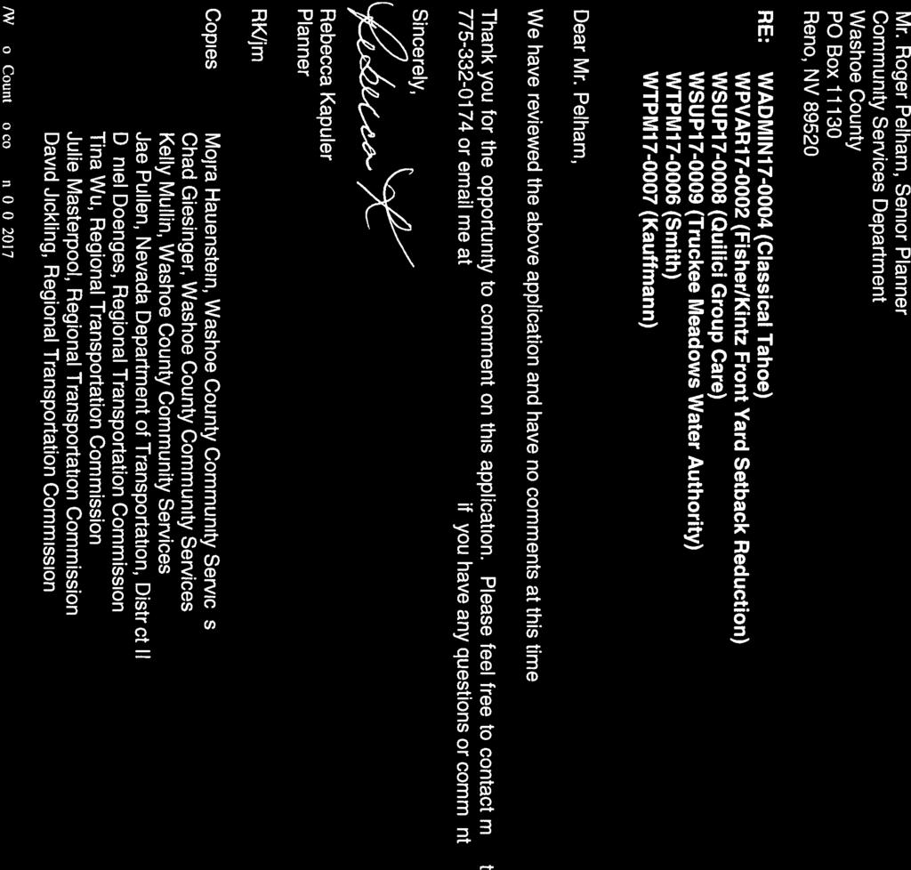
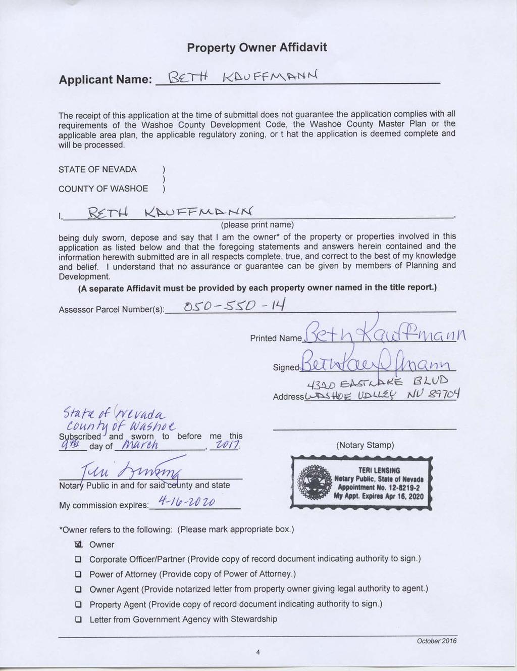
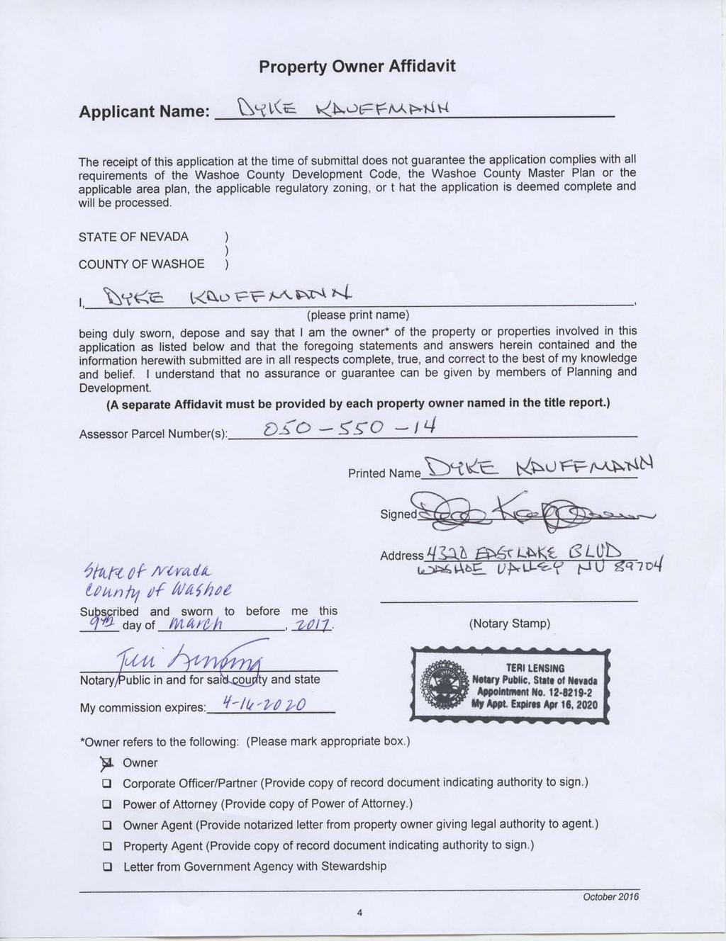
1 Parcel Map Review Committee Staff Report Meeting Date: June 8, 2017 Subject: Applicant/Owner: Agenda Item Number: Project Summary: Recommendation: Parcel Map Case Number Dyke and Beth Kauffmann 7C Divide one parcel of ±40.08-acres into four parcels. Three of the new parcels will be ±5.00-acres each, and one new parcel will be ±25.05-acres. Approval with Conditions Prepared by: Kelly Mullin, Planner Washoe County Community Services Department Planning and Development Division Phone: Description Tentative Parcel Map Case Number (Kauffmann) For possible action, hearing and discussion to approve a parcel map dividing one parcel of ±40.08-acres into four parcels. Three of the new parcels will be ±5.00-acres each, and one new parcel will be ± acres. Applicant/Property Owner: Dyke and Beth Kauffmann 4320 Eastlake Boulevard Carson City, NV Location: 0 Kauffmann Court, approximately 500 feet west of Eastlake Boulevard Assessor s Parcel Number: Parcel Size: ±40.08-acres Master Plan Category: Suburban Residential (SR) Regulatory Zone: Low Density Suburban (LDS) Area Plan: South Valleys Citizen Advisory Board: South Truckee Meadows/Washoe Valley Development Code: Authorized in Article 606, Parcel Maps Commission District: 2 Commissioner Lucey Section/Township/Range: Section 5, T16N, R20E, MDM, Washoe County, NV Post Office Box 11130, Reno, NV E. Ninth St., Reno, NV Telephone: Fax: KAUFFMANN
2 Washoe County Parcel Map Review Committee Staff Report Date: May 25, 2017 Staff Report Contents Parcel Map... 3 Vicinity Map... 4 Site Plan... 5 Tentative Parcel Map Evaluation... 6 South Valleys Area Plan Modifiers... 6 Development Information... 6 Reviewing Agencies... 6 Staff Comment on Required Findings... 7 Recommendation... 8 Possible Motion... 8 Appeal Process... 9 Exhibit Contents Conditions of Approval... Exhibit A Agency Review Comments and Conditions... Exhibit B Public Notice Map... Exhibit C Project Application... Exhibit D Parcel Map Case Number: Page 2 of 9 KAUFFMANN
3 Washoe County Parcel Map Review Committee Staff Report Date: May 25, 2017 Parcel Map The purpose of a parcel map is to allow for the creation of subdivisions, merger and resubdivision of existing lots, and common-interest communities consisting of four or fewer parcels pursuant to Washoe County Code (WCC) Chapter 110, Article 606, Parcel Maps. A tentative parcel map must be submitted to the Planning and Development Division for the purpose of review prior to or concurrent with the final parcel map. Every tentative parcel map must be prepared by a professional land surveyor. The parcel map process exists to establish reasonable standards of design and procedures for subdividing in order to further the orderly layout and use of land and insure proper legal descriptions and monumenting of subdivided land. Additionally, the process helps to safeguard the public health, safety and general welfare by establishing minimum standards of design and development for any land division platted in the unincorporated area of Washoe County. If the Washoe County Parcel Map Review Committee grants an approval of the tentative parcel map, that approval is subject to Conditions of Approval. Conditions of Approval are requirements that may need to be completed during different stages of the proposed project. Those stages are typically: Prior to recordation of a final map. Prior to obtaining a final inspection and/or a certificate of occupancy on a structure. Prior to the issuance of a business license or other permits/licenses. Some Conditions of Approval are referred to as Operational Conditions. These conditions must be continually complied with for the life of the project. Within 22 months from the date of approval of the tentative parcel map, the applicant must file a final parcel map along with any required supporting materials with the Planning and Development Division and the County Engineer showing that all conditions imposed by the Washoe County Parcel Map Review Committee have been met. Approval or conditional approval of a tentative parcel map imposes no obligation on the part of the Director of the Planning and Development Division or the Washoe County Board of Commissioners to approve the final parcel map or to accept any public dedication shown on the tentative or final parcel map. Failure to submit a complete final parcel map and pay the required fees within the two year time period shall cease any further action on the map and shall render the tentative parcel map as expired. The Conditions of Approval for Tentative Parcel Map Case Number is attached to this staff report and will be included with the Action Order if approved by the Parcel Map Review Committee. The subject property is ±40.05-acres in size and has a regulatory zone of Low Density Suburban. In general, this regulatory zone would allow one dwelling unit per acre and a minimum lot size of 35,000 square feet, per WCC Section However, WCC Section requires new lots to be a minimum of five acres in size in the East Lake area of the Washoe Valley Hydrographic Basin. The current request is to divide the subject property into four parcels, with three parcels ±5.00 acres in size, and one parcel ±25.05-acres in size. Parcel Map Case Number: Page 3 of 9 KAUFFMANN

4 Washoe County Parcel Map Review Committee Staff Report Date: May 25, 2017 Vicinity Map Parcel Map Case Number: Page 4 of 9 KAUFFMANN
5 Washoe County Parcel Map Review Committee Staff Report Date: May 25, 2017 Site Plan Parcel Map Case Number: Page 5 of 9 KAUFFMANN
6 Washoe County Parcel Map Review Committee Staff Report Date: May 25, 2017 Tentative Parcel Map Evaluation Regulatory Zone: Low Density Suburban (LDS) Maximum Lot Potential: 8 (with limitations from WCC Section ) Number of Lots on Parcel Map: 4 Minimum Lot Size Required: Minimum Lot Size on Parcel Map: Minimum Lot Width Required: 5-acres 5-acres 80 feet Minimum Lot Width on Parcel Map: ±271 feet The tentative parcel map meets all minimum requirements for the Low Density Suburban regulatory zone. Development Suitability Constraints: The South Valleys Area Plan Development Suitability Map, a part of the South Valleys Area Plan, identifies the subject parcel as most suitable for development. The subject parcel is outside the Truckee Meadows Service Area (TMSA) and will be served by an individual well and septic system. South Valleys Area Plan Modifiers There is one South Valleys Area Plan Modifier within Article 210 of the WCC Chapter 110 (Development Code) applicable to the proposed parcel map. WCC Section requires a minimum 5-acre lot size for all new parcels within the East Lake area of the Washoe Valley Hydrographic Basin. It also requires dedication of sufficient certificated water rights, which is included as a recommended condition of approval. Development Information The subject parcel is currently vacant and relatively level, sloping down gently from east to west. Required setbacks for residential lots at this location would be 30-feet from the front and rear property lines, and 12-feet from the sides. There is sufficient area within each parcel to develop in accordance with these standards. Reviewing Agencies The following agencies received a copy of the project application for review and evaluation: Washoe County Community Services Department o o Planning and Development Division Engineering and Capital Projects Division Washoe County Health District o o Environmental Health Services Division Air Quality Management Division Truckee Meadows Fire Protection District Regional Transportation Commission (RTC) Washoe-Storey Conservation District Charter Communications and NV Energy Parcel Map Case Number: Page 6 of 9 KAUFFMANN
7 Washoe County Parcel Map Review Committee Staff Report Date: May 25, 2017 Three of the above-listed agencies/departments provided comments and/or recommended conditions of approval in response to their evaluation of the project application. A summary of each agency s comments and/or recommended conditions of approval and their contact information is provided. The Conditions of Approval document is attached to this staff report and will be included with the Action Order, if granted approval. Washoe County Planning and Development Division requires the final map be in substantial compliance with all plans and documents submitted with the tentative parcel map, and offered conditions related to water rights dedication. Contacts: Kelly Mullin, , kmullin@washoecounty.us and Vahid Behmaram, , vbehmaram@ washoecounty.us Washoe County Engineering and Capital Projects Division provided comments related to technical map requirements. Contact: Mike Gump, , mgump@washoecounty.us Washoe County Health District provided conditions related to the septic system and test trenches. Contact: Wes Rubio, , wrubio@washoecounty.us The Regional Transportation Commission reviewed the application and indicated they had no comments or conditions of approval. Staff Comment on Required Findings WCC Section (i) requires that all of the following findings be made to the satisfaction of the Washoe County Parcel Map Review Committee before granting approval of the request. Staff has completed an analysis of the application and has determined that the proposal is in compliance with the required findings as follows. 1) General improvement considerations for all parcel maps including, but not limited to: a) Environmental and health laws and regulations concerning water and air pollution, the disposal of solid waste, facilities to supply water, community or public sewage disposal and, where applicable, individual systems for sewage disposal. Staff Comment: Compliance with all applicable environmental and health laws and regulations concerning water and air pollution, the disposal of solid waste, facilities to supply water, and sewage disposal will be ensured prior to recordation of the final map or prior to approval of a development permit on the subject site. The application was reviewed by the Health District and recommended conditions of approval were provided. b) The availability of water which meets applicable health standards and is sufficient for the reasonably foreseeable needs of the subdivision. Staff Comment: The existing and proposed lots will be served by individual domestic wells. Recommended conditions of approval were provided for water rights dedication requirements. c) The availability and accessibility of utilities. Staff Comment: The existing and proposed lots will be served by individual well and septic systems. Power will be provided through NV Energy. d) The availability and accessibility of public services such as schools, police and fire protection, transportation, recreation and parks. Staff Comment: The proposed parcel map would create three additional lots, which are anticipated to have minimal impacts on local services. The application was reviewed by fire and transportation agencies and no recommendation for denial was received. Parcel Map Case Number: Page 7 of 9 KAUFFMANN
8 Washoe County Parcel Map Review Committee Staff Report Date: May 25, 2017 e) Conformity with the zoning ordinances and master plan. Staff Comment: The proposed division of land conforms with the applicable provisions of the Washoe County Development Code and Master Plan, and the regulatory zoning on the property. f) General conformity with the governing body s master plan of streets and highways. Staff Comment: The application was reviewed by the Planning and Development Division, Engineering and Capital Projects Division, and Regional Transportation Commission, and no recommendations for denial were received. The proposal is in conformance with the Area Plan and Master plans for streets and highways. g) The effect of the proposed subdivision on existing public streets and the need for new streets or highways to serve the subdivision. Staff Comment: The application was reviewed by the Washoe County Engineering and Capital Projects Division and the Regional Transportation Commission, and no recommendations for new streets or highways to serve the subdivision were received. h) Physical characteristics of the land such as floodplain, slope and soil. Staff Comment: The project site is identified as most suitable for development by the South Valleys Area Plan Development Suitability Map. i) The recommendations and comments of those entities reviewing the tentative parcel map pursuant to NRS and , inclusive. Staff Comment: These provisions of statute refer to the preparation and distribution of tentative maps. All recommended conditions of approval have been included with the staff report. j) The availability and accessibility of fire protection including, but not limited to, the availability and accessibility of water and services for the prevention and containment of fires including fires in wild lands. Staff Comment: The application was reviewed by the Truckee Meadows Fire Protection District, and no recommendation for denial was received. k) Community antenna television (CATV) conduit and pull wire. Staff Comment: The application was provided to Charter Communications for review, and neither comments nor a recommendation for denial were received. l) Recreation and trail easements. Staff Comment: The proposal does not affect any existing recreational or trail easements in the area. The map reflects a 10-foot-wide equestrian easement that will extend across Parcel D, from the terminus of Kauffmann Court, to the adjacent property to the west. Recommendation Those agencies which reviewed the application, either recommended conditions in support of approval of the tentative parcel map or provided no comments. Therefore, after a thorough analysis and review, Parcel Map Case Number is being recommended for approval with conditions. Staff offers the following motion for the Parcel Map Review Committee s consideration. Possible Motion I move that, after giving reasoned consideration to the information contained within the staff report and the information received during the public meeting, that the Washoe County Parcel Map Review Committee approve Parcel Map Case Number for Dyke and Beth Parcel Map Case Number: Page 8 of 9 KAUFFMANN
9 Washoe County Parcel Map Review Committee Staff Report Date: May 25, 2017 Kauffmann, subject to the conditions of approval included as Exhibit A with the staff report, and make the determination that the following criteria is or will be adequately provided for pursuant to Washoe County Code Section : 1) General improvement considerations for all parcel maps including, but not limited to: a) Environmental and health laws and regulations concerning water and air pollution, the disposal of solid waste, facilities to supply water, community or public sewage disposal and, where applicable, individual systems for sewage disposal; b) The availability of water which meets applicable health standards and is sufficient for the reasonably foreseeable needs of the subdivision; c) The availability and accessibility of utilities; d) The availability and accessibility of public services such as schools, police and fire protection, transportation, recreation and parks; e) Conformity with the zoning ordinances and master plan; f) General conformity with the governing body s master plan of streets and highways; g) The effect of the proposed subdivision on existing public streets and the need for new streets or highways to serve the subdivision; h) Physical characteristics of the land such as floodplain, slope and soil; i) The recommendations and comments of those entities reviewing the tentative parcel map pursuant to NRS and , inclusive; j) The availability and accessibility of fire protection including, but not limited to, the availability and accessibility of water and services for the prevention and containment of fires including fires in wild lands; k) Community antenna television (CATV) conduit and pull wire; and l) Recreation and trail easements. Appeal Process Parcel Map Review Committee action will be effective 10 calendar days after the written decision is filed with the Secretary to the Parcel Map Review Committee, unless the action is appealed to the Washoe County Board of Commissioners, in which case the outcome of the appeal shall be determined by that Board. Any appeal must be filed in writing within 10 calendar days after the written decision is filed with and signed by the Secretary of the Parcel Map Review Committee and mailed to the applicant. Applicant/Property Owner: Representative: Dyke and Beth Kauffmann 4320 Eastlake Boulevard Carson City, NV Jon Loder 1570 Linda Way Sparks, NV Parcel Map Case Number: Page 9 of 9 KAUFFMANN

10 Conditions of Approval Parcel Map Case Number The tentative parcel map approved under Parcel Map Case Number shall be carried out in accordance with the Conditions of Approval granted by the Washoe County Parcel Map Review Committee on June 8, Conditions of Approval are requirements placed on a permit or development by each reviewing agency. These Conditions of Approval may require submittal of documents, applications, fees, inspections, amendments to plans, and more. These conditions do not relieve the applicant of the obligation to obtain any other approvals and licenses from relevant authorities required under any other act or to abide by all other generally applicable Codes, and neither these conditions nor the approval by the County of this project/use override or negate any other applicable restrictions on uses or development on the property. Unless otherwise specified, all conditions related to the approval of this tentative parcel map shall be met or financial assurance must be provided to satisfy the conditions of approval prior to the recordation of a final parcel map. The agency responsible for determining compliance with a specific condition shall determine whether the condition must be fully completed or whether the applicant shall be offered the option of providing financial assurance. All agreements, easements, or other documentation required by these conditions shall have a copy filed with the County Engineer and the Planning and Development Division. Compliance with the conditions of approval related to this tentative parcel map is the responsibility of the applicant, his/her successor in interest, and all owners, assignees, and occupants of the property and their successors in interest. Failure to comply with any of the conditions imposed in the approval of the tentative parcel map may result in the institution of revocation procedures. Washoe County reserves the right to review and revise the Conditions of Approval related to this tentative parcel map should it be determined that a subsequent license or permit issued by Washoe County violates the intent of this approval. For the purpose of conditions imposed by Washoe County, may is permissive and shall or must is mandatory. Conditions of Approval are usually complied with at different stages of the proposed project. Those stages are typically: Prior to recordation of a final map. Prior to obtaining a final inspection and/or a certificate of occupancy. Prior to the issuance of a business license or other permits/licenses. The Washoe County Commission oversees many of the reviewing agencies/departments with the exception of the following agencies. The DISTRICT BOARD OF HEALTH, through the Washoe County Health District, has jurisdiction over all public health matters in the Health District. Any conditions set by the Health District must be appealed to the District Board of Health. FOLLOWING ARE CONDITIONS OF APPROVAL REQUIRED BY THE REVIEWING AGENCIES. EACH CONDITION MUST BE MET TO THE SATISFACTION OF THE ISSUING AGENCY. Post Office Box 11130, Reno, NV E. Ninth St., Reno, NV Telephone: Fax: EXHIBIT A
11 Washoe County Parcel Map Review Committee Conditions of Approval Washoe County Planning and Development Division 1. The following conditions are requirements of the Planning and Development Division, which shall be responsible for determining compliance with these conditions. General Conditions - Contact: Kelly Mullin, , kmullin@washoecounty.us a. The final map shall be in substantial compliance with all plans and documents submitted as part of this tentative parcel map application, and with any amendments imposed by the Parcel Map Review Committee. All documentation necessary to satisfy the conditions noted below shall accompany the final map when submitted to the County Engineer and the Planning and Development Division. b. The applicant shall comply with all the conditions of approval and shall submit a final map for signature by the Director of the Planning and Development Division within 22 months from the date of approval by the Parcel Map Review Committee. Each agency responsible for imposing conditions may determine whether its conditions must be fully completed or whether the applicant shall be offered the option of providing financial assurances as a means of assuring compliance. c. The final map shall contain the following jurat: DIRECTOR OF PLANNING AND DEVELOPMENT CERTIFICATE THE FINAL PARCEL MAP CASE NO. MEETS ALL APPLICABLE STATUTES, ORDINANCES AND CODE PROVISIONS; IS IN SUBSTANTIAL CONFORMANCE WITH THE TENTATIVE MAP AND ITS CONDITIONS, WHICH ARE INCORPORATED HEREIN BY THIS REFERENCE, AND THOSE CONDITIONS HAVE BEEN SATISFIED FOR RECORDATION OF THIS MAP. THE OFFER(S) OF DEDICATION IS (ARE) REJECTED AT THIS TIME, BUT WILL REMAIN OPEN IN ACCORDANCE WITH NEVADA REVISED STATUTES CHAPTER 278. THIS FINAL MAP IS APPROVED AND ACCEPTED THIS DAY OF, 20, BY THE DIRECTOR OF PLANNING AND DEVELOPMENT OF WASHOE COUNTY, NEVADA, IN ACCORDANCE WITH NEVADA REVISED STATUTES THROUGH MOJRA HAUENSTEIN, DIRECTOR, PLANNING AND DEVELOPMENT DIVISION d. The applicant has indicated that the proposed improvements will not exceed the major grading thresholds that require a special use permit. If the final construction drawings for the map include grading that exceeds the Major Grading Permit Thresholds listed in Article 438 Grading Standards, the applicant shall apply for a special use permit for grading; and if approved, may be delayed up to three months processing time. In addition, all related standards within the Washoe County Development Code shall be met on the construction drawings. e. The approval for this tentative parcel map does not include improvements for driveways to building pads. Grading for access to building pads, if they exceed the criteria stated in the previous condition, shall require a special use permit. f. Any regulations, procedures, and conditions adopted by Washoe County Health District must be met prior to recordation of a final map. Tentative Parcel Map Case Number Page 2 of 4 EXHIBIT A
12 Washoe County Parcel Map Review Committee Conditions of Approval Water Rights Conditions Contact: Vahid Behmaram, , washoecounty.us g. The subject parcel is not near any municipal, quasi-municipal or private water delivery infrastructure; therefore, resulting parcels will rely on Individual Domestic wells as their source of domestic water supply. h. Washoe County code requires that the applicant for a parcel map with parcels served by an individual domestic well, to bring forth an approved and recorded Affidavit of Relinquishment for Domestic Wells by the Nevada State Engineer s office. The applicant shall complete the relinquishment process with the State Engineer s office and record the approved form with the County Recorder s office and submit a recorded copy to Washoe County as a pre-requisite to approval of their parcel map. i. Washoe County retains the authority to impose its own review and reject water rights which do not comply with Washoe County code and area plans. The applicant currently has water rights banked with Washoe County that will satisfy the requirements. j. The ground water rights subject to relinquishment MAY NOT be supplemental ground water which supplement primary surface water rights. k. The amount of water rights necessary is 2.00 acre-feet of ground water rights per newly created parcel. The original parcel is deemed exempt from the relinquishment process. In the way of an example, if one parcel is subdivided into a total of 4, there are 3 newly created parcels and one existing or remains thereof. l. The water rights must be in good standing with the State of Nevada, with current title. The water rights must be from the same hydrographic basin as the lands subject to the parcel map and comply with the appropriate area plan. Washoe County Engineering and Capital Projects Division 2. The following conditions are requirements of the Engineering and Capital Projects Division, which shall be responsible for determining compliance with these conditions. General Conditions - Contact: Mike Gump, , mgump@washoecounty.us a. Comply with the conditions of the Washoe County technical check for this map. b. Remove Water Resources from Utility Certificate and add Community Services Department. c. Calculated tie and easement line type in legend appears to be the same. d. Identify new easements on the map per this map. e. Identify drainage and utility easements on the map. f. All boundary corners must be set. g. Add a Security Interest Holder s Certificate to the map if applicable. Washoe County Health District 3. The following conditions are a requirement of the Washoe County Health District s Environmental Health Services Division, which shall be responsible for determining compliance with these conditions. Contact: Wes Rubio, , wrubio@washoecounty.us a. Per section of the WCHD Regulations Governing Sewage, Wastewater, and Sanitation the proposed parcel map meets the minimum requirements for acreage for a Tentative Parcel Map Case Number Page 3 of 4 EXHIBIT A
13 Washoe County Parcel Map Review Committee Conditions of Approval second subsequent parcel map. The minimum acreage is required to be 5 acres for any proposed parcel. b. As part of the proposed parcel map, a test trench is required on each of the proposed parcels. *** End of Conditions *** Tentative Parcel Map Case Number Page 4 of 4 EXHIBIT A
 Kauffmann Court, approximately 500 feet west of Eastlake Boulevard, Assessor s Parcel Number:")


14 COMMUNITY SERVICES P.O. Box Reno, Nevada Phone: (775) Fax: (775) April 27, 2017 TO: FROM: Kelly Mullen, Planner, CSD, Planning & Development Division Vahid Behmaram, Water Management Planner Coordinator, CSD SUBJECT: Tentative Parcel Map Case Number (Kauffmann) Kauffmann Court, approximately 500 feet west of Eastlake Boulevard, Assessor s Parcel Number: Project description: The applicant is proposing a parcel map dividing one parcel of ±40.08-acres into four parcels. Three of the parcels are ±5.00-acres each, and one parcel is ±25.05-acres.. Water will be provided by individual domestic wells, and sewage disposal will be by individual septic systems. The Community Services Department (CSD) recommends approval of this project with the following Water Rights conditions: 1) The subject parcel is not near any municipal, quasi-municipal or private water delivery infrastructure; therefore, resulting parcels will rely on Individual Domestic wells as their source of domestic water supply. 2) Washoe County code requires that the applicant for a parcel map with parcels served by an individual domestic well, to bring forth an approved and recorded Affidavit of Relinquishment for Domestic Wells by the Nevada State Engineer s office. The applicant shall complete the relinquishment process with the State Engineer s office and record the approved form with the County Recorder s office and submit a recorded copy to Washoe County as a pre-requisite to approval of their parcel map. 3) Washoe County retains the authority to impose its own review and reject water rights which do not comply with Washoe County code and area plans. The applicant currently has water rights banked with Washoe County that will satisfy the requirements. 4) The ground water rights subject to relinquishment MAY NOT be supplemental ground water which supplement primary surface water rights. 5) The amount of water rights necessary is 2.00 acre-feet of ground water rights per newly created parcel. The original parcel is deemed exempt from the relinquishment process. In the way of an example, if one parcel is subdivided into a total of 4, there are 3 newly created parcels and one existing or remains thereof. 6) The water rights must be in good standing with the State of Nevada, with current title. The water rights must be from the same hydrographic basin as the lands subject to the parcel map and comply with the appropriate area plan E. 9 TH Street, Reno, Nevada EXHIBIT B

15 Washoe County COMMUNITY SERVICES DEPARTMENT Engineering and Capital Projects INTEROFFICE MEMORANDUM DATE: 4/24/17 PARCEL MAP REVIEW TO: FROM: Department of Community Services, Kelly Mullin Mike Gump, PLS, Engineering Division SUBJECT: Parcel Map for: 3 rd for Dyke & Beth Kauffmann Parcel Map Case No.: APN: Review Date: 4/24/17 Existing Zoning/Land Use Designation: The Engineering Division has reviewed the subject parcel map and the following conditions must be successfully completed prior to final approval of this application by the Engineering Division. 1. Comply with the conditions of the Washoe County technical check for this map. 2. Remove water Resources from Utility Certificate and add Community Services Department. 3. Calculated tie and easement line type in legend appears to be the same. 4. Identify new easements on the map per this map. 5. Identify drainage and utility easements on the map. 6. All boundary corners must be set. 7. Add a Security Interest Holder s Certificate to the map if applicable E. 9 TH Street P.O. Box 11130, Reno, Nevada Phone (775) Fax (775) EXHIBIT B
 has reviewed the above referenced project. Approval by the WCHD is subject to the following conditions: 1.")
16 May 3, 2017 Kelly Mullin, Planner Washoe County Community Services Planning and Development Division PO Box Reno, NV RE: Kauffmann; APN Tentative Parcel Map; Dear Ms. Mullin: The Washoe County Health District, Environmental Health Services Division (WCHD) has reviewed the above referenced project. Approval by the WCHD is subject to the following conditions: 1. The WCHD has reviewed the proposed Tentative Parcel Map and have the following requirements in order to approve the proposed parcel map: a. Per section of the WCHD Regulations Governing Sewage, Wastewater, and Sanitation the proposed parcel map meets the minimum requirements for acreage for a second subsequent parcel map. The minimum acreage is required to be 5 acres for any proposed parcel. b. As part of the proposed parcel map, a test trench is required on each of the proposed parcels. If you have any questions or would like clarification regarding the foregoing, please contact Wes Rubio, Senior Environmental Health Specialist at wrubio@washoecounty.us regarding all Health District comments. Sincerely, James English, REHS, CP-FS EHS Supervisor Waste Management/Land Development Programs JE:wr ENVIRONMENTAL HEALTH SERVICES 1001 East Ninth Street I P.O. Box I Reno, Nevada I Fax: I washoecounty.us/health Serving Reno, Sparks and all of Washoe County, Nevada Washoe County is an Equal Opportunity Employer EXHIBIT B

17 EXHIBIT B

18 ESMERALDA PINTAIL DRAKE MAGPIE COOT PARTRIDGE GANDER CLARK FLICKER JUMBO GRADE KAUFFMANN HOLLY Subject Property EASTLAKE NYE JACOBS DOUGLAS PEPONITA DOC OLENA DOC BAR PEPPY SAN Public Notice Map Tentative Parcel Map Case No. Kauffmann Owners of 55 properties within 500-feet of project site provided with notice Z Source: Planning & Development Date: May 25, 2017 Feet Community Services Department, Planning and Development WASHOE COUNTY NEVADA EXHIBIT C Post Office Box Reno, Nevada (775)
19 Washoe County Development Application Your entire application is a public record. If you have a concern about releasing personal information, please contact Planning and Development staff at Project Information Staff Assigned Case No.: Project Name: Project Description: Project Address: Project Area (acres or square feet): Project Location (with point of reference to major cross streets AND area locator): Assessor s Parcel No.(s): Parcel Acreage: Assessor s Parcel No.(s): Parcel Acreage: Section(s)/Township/Range: Indicate any previous Washoe County approvals associated with this application: Case No.(s). Applicant Information (attach additional sheets if necessary) Property Owner: Professional Consultant: Name: Name: Address: Address: Zip: Zip: Phone: Fax: Phone: Fax: Cell: Other: Cell: Other: Contact Person: Contact Person: Applicant/Developer: Other Persons to be Contacted: Name: Name: Address: Address: Zip: Zip: Phone: Fax: Phone: Fax: Cell: Other: Cell: Other: Contact Person: Contact Person: For Office Use Only Date Received: Initial: Planning Area: County Commission District: Master Plan Designation(s): CAB(s): Regulatory Zoning(s): 3 October 2016 EXHIBIT D
20 EXHIBIT D
21 EXHIBIT D
22 EXHIBIT D
23 Tentative Parcel Map Application Supplemental Information (All required information may be separately attached) Chapter 110 of the Washoe County Code is commonly known as the Development Code. Specific references to tentative parcel maps may be found in Article 606, Parcel Maps. 1. What is the location (address or distance and direction from nearest intersection)? a. Please list the following: APN of Parcel Land Use Designation Existing Acres 2. Please describe the existing conditions, structures, and uses located at the site: 3. What are the proposed lot standards? Minimum Lot Area Minimum Lot Width Parcel 1 Parcel 2 Parcel 3 Parcel 4 Washoe County Planning and Development October 2016 TENTATIVE PARCEL MAP SUPPLEMENTAL INFORMATION 5 EXHIBIT D
24 4. Was the parcel or lot that is proposed for division created (recorded) within the last 5 years? (If yes, public review of the parcel map will be required. See Community Development staff for additional materials that are required to be submitted.) Yes No 5. Utilities: a. Sewer Service b. Electrical Service/Generator c. Water Service 6. Please describe the source of the water facilities necessary to serve the proposed tentative parcel map: a. Water System Type: Individual wells Private water Public water Provider: Provider: b. Available: Now 1-3 years 3-5 years 5+ years c. Washoe County Capital Improvements Program project? Yes No 7. What sewer services are necessary to accommodate the proposed tentative parcel map? a. Sewage System Type: Individual septic Public system Provider: b. Available: Now 1-3 years 3-5 years 5+ years c. Washoe County Capital Improvements Program project? Yes No 8. For most uses, the Washoe County Code, Chapter 110, Article 422, Water and Sewer Resource Requirements, requires the dedication of water rights to Washoe County when creating new parcels. Please indicate the type and quantity of water rights you have available should dedication be required: a. Permit # acre-feet per year b. Certificate # acre-feet per year c. Surface Claim # acre-feet per year d. Other, # acre-feet per year Washoe County Planning and Development October 2016 TENTATIVE PARCEL MAP SUPPLEMENTAL INFORMATION 6 EXHIBIT D
25 e. Title of those rights (as filed with the State Engineer in the Division of Water Resources of the Department of Conservation and Natural Resources): 9. Does the property contain wetlands? (If yes, please attach a preliminary delineation map and describe the impact the proposal will have on the wetlands. Impacts to the wetlands may require a permit issued from the U.S. Army Corps of Engineers.) Yes No If yes, include a separate set of attachments and maps. 10. Does property contain slopes or hillsides in excess of 15 percent and/or significant ridgelines? (If yes, and this is the second parcel map dividing this property, Article 424, Hillside Development of the Washoe County Development Code will apply.) Yes No If yes, include a separate set of attachments and maps. 11. Does property contain geologic hazards such as active faults; hillside or mountainous areas; is it subject to avalanches, landslides, or flash floods; is it near a water body, stream, Significant Hydrologic Resource as defined in Article 418, or riparian area such as the Truckee River, and/or an area of groundwater recharge Yes No If yes, include a separate set of attachments and maps. 12. Does the tentative parcel map involve common open space as defined in Article 408 of the Washoe County Development Code? (If so, please identify all proposed non-residential uses and all the open space parcels.)? Yes No If yes, include a separate set of attachments and maps. 13. If private roads are proposed, will the community be gated? If so, is a public trail system easement provided through the subdivision? Washoe County Planning and Development October 2016 TENTATIVE PARCEL MAP SUPPLEMENTAL INFORMATION 7 EXHIBIT D
26 14. Are there any applicable policies of the adopted area plan in which the project is located that require compliance? If so, which policies and how does the project comply Yes No If yes, include a separate set of attachments and maps. 15. Are there any applicable area plan modifiers in the Development Code in which the project is located that require compliance? If so, which modifiers and how does the project comply? 16. Is the project subject to Article 418, Significant Hydrologic Resources? If yes, please address Special Review Considerations within Section in a separate attachment. Yes No If yes, include a separate set of attachments and maps. Grading Please complete the following additional questions if the project anticipates grading that involves: (1) Disturbed area exceeding twenty-five thousand (25,000) square feet not covered by streets, buildings and landscaping; (2) More than one thousand (1,000) cubic yards of earth to be imported and placed as fill in a special flood hazard area; (3) More than five thousand (5,000) cubic yards of earth to be imported and placed as fill; (4) More than one thousand (1,000) cubic yards to be excavated, whether or not the earth will be exported from the property; or (5) If a permanent earthen structure will be established over four and one-half (4.5) feet high. If your project exceeds any of the above criteria, you shall either provide a preliminary grading and roadway design plan for review OR if these criteria are exceeded with the final construction drawings and not disclosed at the Tentative Parcel Map Application, you shall be required to apply for a special use permit for grading and you will be delayed up to three months, if approved. 17. How many cubic yards of material are you proposing to excavate on site? Washoe County Planning and Development October 2016 TENTATIVE PARCEL MAP SUPPLEMENTAL INFORMATION 8 EXHIBIT D
27 18. How many cubic yards of material are you exporting or importing? If exporting of material is anticipated, where will the material be sent? If the disposal site is within unincorporated Washoe County, what measures will be taken for erosion control and revegetation at the site? If none, how are you balancing the work on-site? 19. Can the disturbed area be seen from off-site? If yes, from which directions, and which properties or roadways? What measures will be taken to mitigate their impacts? 20. What is the slope (Horizontal:Vertical) of the cut and fill areas proposed to be? What methods will be used to prevent erosion until the revegetation is established? Washoe County Planning and Development October 2016 TENTATIVE PARCEL MAP SUPPLEMENTAL INFORMATION 9 EXHIBIT D
28 21. Are you planning any berms and, if so, how tall is the berm at its highest? How will it be stabilized and/or revegetated? 22. Are retaining walls going to be required? If so, how high will the walls be, will there be multiple walls with intervening terracing, and what is the wall construction (i.e. rockery, concrete, timber, manufactured block)? How will the visual impacts be mitigated? 23. Will the grading proposed require removal of any trees? If so, what species, how many, and of what size? 24. What type of revegetation seed mix are you planning to use and how many pounds per acre do you intend to broadcast? Will you use mulch and, if so, what type? Washoe County Planning and Development October 2016 TENTATIVE PARCEL MAP SUPPLEMENTAL INFORMATION 10 EXHIBIT D
29 25. How are you providing temporary irrigation to the disturbed area? 26. Have you reviewed the revegetation plan with the Washoe Storey Conservation District? If yes, have you incorporated their suggestions? 27. Surveyor: Name Address Phone Cell Fax Nevada PLS # Washoe County Planning and Development October 2016 TENTATIVE PARCEL MAP SUPPLEMENTAL INFORMATION 11 EXHIBIT D
30 Tentative Parcel Map Development Application Submittal Requirements This sheet must accompany the original application and be signed by the Professional Land Surveyor. 1. Fees: See Master Fee Schedule. Bring payment with your application to Community Services Department (CSD). Make check payable to Washoe County. A separate $ check for the engineering technical review fee is required upon submittal. 2. Development Application: A completed Washoe County Development Application form. 3. Owner Affidavit: The Owner Affidavit must be signed and notarized by all owners of the property subject to the application request. 4. Proof of Property Tax Payment: The applicant must provide a written statement from the Washoe County Treasurer s Office indicating all property taxes for the current quarter of the fiscal year on the land have been paid. 5. Application Materials: The completed Tentative Parcel Map Application materials. 6. Title Report: A preliminary title report, with an effective date of no more than one hundred twenty (120) days of the submittal date, by a title company which provides the following information: Name and address of property owners. Legal description of property. Description of all easements and/or deed restrictions. Description of all liens against property. Any covenants, conditions and restrictions (CC&Rs) that apply. Submit Title Report with Original Packet only. You may be requested to provide additional copies, but do not include Title Report in other copies of the packet. 7. Development Plan Specifications: (If the requirement is Not Applicable, please check the box proceeding the requirement) a. Map to be drawn using engineering scales (e.g. scale 1 = 100, 1 = 200, or 1 = 500 unless a prior approval is granted by the County Surveyor) showing all streets and ingress/egress to the property and must meet NRS standards as specified in NRS b. Property boundary lines, distances and bearings. c. Contours at five (5) foot intervals or two (2) foot intervals where, in the opinion of the County Engineer, topography is a major factor in the development. d. The cross sections of all right-of-ways, streets, alleys or private access ways within the proposed development, proposed name and approximate grade of each, and approximate radius of all curves and diameter of each cul-de-sac. e. The width and approximate location of all existing or proposed easements, whether public or private, for roads, drainage, sewers, irrigation, or public utility purposes. f. If any portion of the land within the boundary of the development is subject to inundation or storm water overflow, as shown on the adopted Federal Emergency Management Agency s Flood Boundary and Floodway Maps, that fact and the land so affected shall be clearly shown on the map by a prominent note on each sheet, as well as width and direction of flow of each water course within the boundaries of the development. Washoe County Planning and Development October 2016 TENTATIVE PARCEL MAP DEVELOPMENT APPLICATION SUBMITTAL REQUIREMENTS 12 EXHIBIT D
31 g. The location and outline to scale of each existing building or structure that is not to be moved in the development. h. Existing roads, trails or rights-of-way within the development shall be designated on the map. i. j. Vicinity map showing the proposed development in relation to the surrounding area. Date, north arrow, scale, and number of each sheet in relation to the total number of sheets. k. Location of snow storage areas sufficient to handle snow removed from public and private streets, if applicable. l. All known areas of potential hazard including, but not limited to, earth slide areas, avalanche areas or otherwise hazardous slopes, shall be clearly designated on the map. Additionally, active fault lines (post-holocene) shall be delineated on the map. 8. Street Names: A completed Request to Reserve New Street Name(s) form (included in application packet). Please print all street names on the Tentative Map. Note whether they are existing or proposed. 9. Packets: Four (4) packets and flash drive or DVD. One (1) packet must be labeled Original and must include the fee schedule (including the appropriate fees) and the original signed and notarized Owner Affidavit. Each packet shall include an 8.5 x 11 reduction of any large format sheets included in the application. These materials must be readable. Labeling on these reproductions should be no smaller than 8 point on the 8½ x 11" display. Each packet shall include: one (1) 8.5 x 11 reduction of any applicable site plan, development plan, and/or application map. Large format sheets should be included in a slide pocket(s). Any specialized reports identified above shall be included as attachments or appendices and be annotated as such. Notes: (i) Application and map submittals must comply with all specific criteria as established in the Washoe County Development Code and/or the Nevada Revised Statutes. (ii) Based on the specific nature of the development request, Washoe County reserves the right to specify additional submittal packets, additional information and/or specialized studies to clarify the potential impacts and potential conditions of development to minimize or mitigate impacts resulting from the project. No application shall be processed until the information necessary to review and evaluate the proposed project is deemed complete by the Director of Planning and Development. (iii) All oversized maps and plans must be folded to a 9 x 12 size. I hereby certify, to the best of my knowledge,, all information contained in this application is correct and meets all Washoe County Development Code requirements. Professional Land Surveyor Washoe County Planning and Development October 2016 TENTATIVE PARCEL MAP DEVELOPMENT APPLICATION SUBMITTAL REQUIREMENTS 13 EXHIBIT D
32 EXHIBIT D
33 EXHIBIT D
34 EXHIBIT D

, 1001 E. Ninth St, Suite C200, Reno, NV 89512 www.washoecounty.")
35 April 17, Foot Contours (zoom in to view) :4, mi 0.3 km Source: Esri, DigitalGlobe, G eoeye, Earthstar Geographics, CNES/Airbus DS, USDA, USGS, AeroGRID, IG N, and the G IS User Community Washoe County Tec hnology Servic es - Regional Serv ices Divis ion (G IS), 1001 E. Ninth St, Suite C200, Reno, NV (775) EXHIBIT D
Parcel Map Review Committee Staff Report
 Parcel Map Review Committee Staff Report Meeting Date: October 11, 2018 Agenda Item: 7A TENTATIVE PARCEL MAP CASE NUMBER: (Larkins) BRIEF SUMMARY OF REQUEST: Request to divide one parcel of ±1.084-acres
Parcel Map Review Committee Staff Report Meeting Date: October 13, 2016
 Subject: Applicant: Agenda Item Number: Project Summary: Recommendation: Parcel Map Review Committee Staff Report Meeting Date: October 13, 2016 Parcel Map Case Number Spanish Springs Associates Ltd. Ptsp.
Parcel Map Review Committee Staff Report Meeting Date: May 12, 2016
 Subject: Applicant: Agenda Item Number: Project Summary: Recommendation: Parcel Map Review Committee Staff Report Meeting Date: May 12, 2016 Tentative Parcel Map Case Number TL Mt. Rose Estates, LP 7C
Community Services Department TENTATIVE PARCEL MAP PARCEL MAP WAIVER APPLICATION
 Community Services Department Planning and Building TENTATIVE PARCEL MAP (see page 5) PARCEL MAP WAIVER (see page 15) APPLICATION Community Services Department Planning and Building 1001 E. Ninth St.,
Parcel Map Review Committee Staff Report Meeting Date: March 12, 2015
 Subject: Applicant(s): Agenda Item Number: Parcel Map Review Committee Staff Report Meeting Date: March 12, 2015 Parcel Map Case Number William and Maryanne Paganetti 7B Project Summary: Dividing a 14.2
Parcel Map Review Committee Staff Report Meeting Date: October 8, 2015
 Parcel Map Review Committee Staff Report Meeting Date: October 8, 2015 Subject: Applicant: Agenda Item Number: Project Summary: Recommendation: Parcel Map Case Number Reeves Business Ventures 7D Divide
Parcel Map Review Committee Staff Report Meeting Date: March 12, 2015
 Parcel Map Review Committee Staff Report Meeting Date: March 12, 2015 Subject: Applicant(s): Agenda Item Number: Project Summary: Recommendation: Prepared by: Parcel Map Case Number Eric and Rebecca Swanson
Parcel Map Review Committee Staff Report Meeting Date: April 13, 2017
 Parcel Map Review Committee Staff Report Meeting Date: April 13, 2017 Subject: Applicant: Agenda Item Number: Project Summary: Recommendation: Prepared by: Parcel Map Case Number Christy Corporation 7A
Planning and Development TENTATIVE SUBDIVISION MAP APPLICATION
 Community Services Department Planning and Development TENTATIVE SUBDIVISION MAP APPLICATION Community Services Department Planning and Development 1001 E Ninth St., Bldg A. Reno, NV 89520 Telephone: 775.328.3600
Community Services Department Planning and Development ABANDONMENT APPLICATION
 Community Services Department Planning and Development ABANDONMENT APPLICATION Community Services Department Planning and Development 1001 E. Ninth St., Bldg A Reno, NV 89520 Telephone: 775.328.3600 Washoe
Community Services Department BOUNDARY LINE ADJUSTMENT APPLICATION
 Community Services Department Planning and Building BOUNDARY LINE ADJUSTMENT APPLICATION Community Services Department Planning and Building 1001 E. Ninth St., Bldg. A Reno, NV 89520 Telephone: 775.328.6100
Administrative Permit Staff Report Meeting Date: February 2, 2017
 Administrative Permit Staff Report Meeting Date: February 2, 2017 Subject: Applicant: Agenda Item Number: Summary: Recommendation: Administrative Permit Case Number WADMIN16-0001 Carlson and Associates
Community Services Department Planning and Development BOUNDARY LINE ADJUSTMENT APPLICATION
 Community Services Department Planning and Development BOUNDARY LINE ADJUSTMENT APPLICATION Community Services Department Planning and Development 1001 E. Ninth St., Bldg A Reno, NV 89520 Telephone: 775.328.3600
Board of Adjustment Staff Report Meeting Date: June 1, 2017
 Board of Adjustment Staff Report Meeting Date: June 1, 2017 Subject: Applicant: Agenda Item Number: Summary: Recommendation: Prepared by: Phone: E-Mail: Administrative Permit Case Number Powning Family
Community Services Department Planning and Development SPECIAL USE PERMIT APPLICATION
 Community Services Department Planning and Development SPECIAL USE PERMIT APPLICATION Washoe County Development Application Your entire application is a public record. If you have a concern about releasing
Community Services Department REGULATORY ZONE AMENDMENT WITH SPECIFIC PLAN APPLICATION
 Community Services Department Planning and Development REGULATORY ZONE AMENDMENT WITH SPECIFIC PLAN APPLICATION Community Services Department Planning and Development 1001 E Ninth St., Bldg A. Reno, NV
Community Services Department MASTER PLAN AMENDMENT APPLICATION
 Community Services Department Planning and Building APPLICATION Community Services Department Planning and Building 1001 E. Ninth St., Bldg. A Reno, NV 89520 Telephone: 775.328.6100 1 2 Washoe County Development
DRAFT. 1. Determination of Quorum Eric Young called the meeting to order at 1:31 p.m. The following members and staff were present:
 WASHOE COUNTY PARCEL MAP REVIEW COMMITTEE Meeting Minutes Parcel Map Review Committee Members Thursday, December 8, 2016 1:30 p.m. James Barnes, Planning Commission James English, Health District Tim Simpson,
Tentative Map Application Review Procedures
 FOR REFERENCE ONLY This page is not part of the application. Tentative Map Application Review Procedures The tentative map process in Churchill County is designed to provide a mechanism in order to divide
Detached Accessory Dwelling Administrative Review Staff Report Date: August 26, 2014
 Detached Accessory Dwelling Administrative Review Staff Report Subject: Detached Accessory Dwelling Administrative Review Case No: DADAR14-04 Applicant(s): Nick Gibson Summary: To establish a Detached
APPLICATION FOR 555 Washington Street Tentative Map Red Bluff, CA Subdivision Map (530) ext Parcel Map.
 ext Parcel Map.") City of Red Bluff Community Development Department Application No. APPLICATION FOR 555 Washington Street Tentative Map Red Bluff, CA 96080 Subdivision Map (530) 527-2605 ext. 3059 Parcel Map Applicant
City of Red Bluff Community Development Department Application No. APPLICATION FOR 555 Washington Street Tentative Map Red Bluff, CA 96080 Subdivision Map (530) 527-2605 ext. 3059 Parcel Map Applicant
Preliminary Subdivision Application (Major) (Four (4) lots or more)
 (Four (4) lots or more)") Gunnison City Offices www.gunnisoncity.org 38 West Center Gunnison, Utah 84634 (435) 528 7969 Date of Application: Preliminary Subdivision Application (Major) (Four (4) lots or more) APPLICANT INFORMATION
Gunnison City Offices www.gunnisoncity.org 38 West Center Gunnison, Utah 84634 (435) 528 7969 Date of Application: Preliminary Subdivision Application (Major) (Four (4) lots or more) APPLICANT INFORMATION
Planning Commission Staff Report Meeting Date: February 2, 2016
 Planning Commission Staff Report Meeting Date: February 2, 2016 Subject: Applicant(s): Agenda Item Number: Summary: Recommendation: Abandonment Case Number Gary and Rachel Bullock 9B To allow the abandonment
Preliminary Subdivision Application (Minor) (Three (3) lots or less)
 (Three (3) lots or less)") Gunnison City Offices www.gunnisoncity.org 38 West Center Gunnison, Utah 84634 (435) 528 7969 Date of Application: Preliminary Subdivision Application (Minor) (Three (3) lots or less) APPLICANT INFORMATION
Gunnison City Offices www.gunnisoncity.org 38 West Center Gunnison, Utah 84634 (435) 528 7969 Date of Application: Preliminary Subdivision Application (Minor) (Three (3) lots or less) APPLICANT INFORMATION
MINOR SUBDIVISION INFORMATION
 A. POINTS OF CONTACT: MINOR SUBDIVISION INFORMATION Surveyor: Address: Phone #: Fax # E-Mail Address: Representative (If different from applicant): Address: Phone #: Fax # E-Mail Address: B. GENERAL INFORMATION:
CITY OF GROVER BEACH COMMUNITY DEVELOPMENT DEPARTMENT Tentative Map Checklist
 CITY OF GROVER BEACH COMMUNITY DEVELOPMENT DEPARTMENT Tentative Map Checklist The following list includes all of the items you must submit for a complete application. Some specific types of information
Conditional Use Permit / Standard Subdivision Application
 Conditional Use Permit / Standard Subdivision Application Name of Proposed Subdivision: Total Area (Acres) Is Proposed Subdivision to be built in phases? Number of Lots If yes, how many phases? Applicant/Owner
LYON COUNTY TITLE 15 LAND USE AND DEVELOPMENT CODE LAND DIVISION REGULATIONS CHAPTERS October 19, 2017 Ordinance Draft DRAFT
 DRAFT LYON COUNTY TITLE 15 LAND USE AND DEVELOPMENT CODE LAND DIVISION REGULATIONS CHAPTERS 15.600 15.607 October 19, 2017 Ordinance Draft This page left blank intentionally DRAFT DRAFT Lyon County Contents
MAJOR SUBDIVISION PRELIMINARY PLAT CHECKLIST
 TOWNSHIP OF EGG HARBOR PLANNING BOARD/ZONING BOARD OF ADJUSTMENT 3515 BARGAINTOWN ROAD EGG HARBOR TOWNSHIP, NJ 08234 MAJOR SUBDIVISION PRELIMINARY PLAT CHECKLIST The following checklist is designed to
APPLICATION SUBMITTAL REQUIREMENTS FOR Tentative Parcel or Subdivision Maps
 CITY OF EL CERRITO Community Development Department Planning and Building Division 10890 San Pablo Avenue, El Cerrito, CA 94530 (510) 215-4330 FA (510) 233-5401 planning@ci.el-cerrito.ca.us APPLICATION
Chapter 100 Planned Unit Development in Corvallis Urban Fringe
 100.100 Scope and Purpose. Chapter 100 Planned Unit Development in Corvallis Urban Fringe (1) All applications for land divisions in the Urban Residential (UR) and Flood Plain Agriculture (FPA) zones within
PRELIMINARY PLAT CHECK LIST
 PRELIMINARY PLAT CHECK LIST Name of Proposed Subdivision: The following items must be included with the initial submittal of a Preliminary Plat: Application, filled out completely Project Narrative Pre-application
APPLICATION PROCEDURE
 ANTRIM PLANNING BOARD P. O. Box 517 Antrim, New Hampshire 03440 Phone: 603-588-6785 FAX: 603-588-2969 APPLICATION FORM AND CHECKLIST FOR MINOR OR MAJOR SITE PLAN REVIEW File Date Received By APPLICATION
PRELIMINARY PLAT Checklist
 PRELIMINARY PLAT Checklist 3715 Bridgeport Way W University Place, WA 98466 PH: (253) 566-5656 FAX: (253) 460-2541 This is a checklist of materials required for a Preliminary Plat. This checklist is provided
CITY OF SARALAND PRELIMINARY SUBDIVISION PLAT REVIEW
 PRELIMINARY SUBDIVISION PLAT REVIEW Application Number: Date Plat Submitted: Name of Subdivision: Name of Owner: Owner Address: (Street or P.O. Box) Telephone #: (City) (State) (Zip) E-mail: Name of Authorized
CONDOMINIUM REGULATIONS
 ARTICLE 37 CONDOMINIUM REGULATIONS SECTION 37.01. Purpose The purpose of this Article is to regulate projects that divide real property under a contractual arrangement known as a condominium. New and conversion
WESTON COUNTY FINAL PLAT APPLICATION
 WESTON COUNTY FINAL PLAT APPLICATION Property Owner: Mailing Address of owner: Telephone Number(s) of owner: Property Owner: Mailing Address of owner: Telephone Number(s) of owner: (If subdivider/applicant
SUBMITTAL REQUIREMENTS: The number indicates the number of copies for submittal (if applicable).
.") Office Use Only Preliminary Long Plat Long Subdivision Applicant Checklist PLANNING, COMMUNITY, & ECONOMIC DEVELOPMENT DEPARTMENT PRELIMINARY LONG PLAT LONG SUBDIVISION CHECKLIST Mailing Address: P.O.
Office Use Only Preliminary Long Plat Long Subdivision Applicant Checklist PLANNING, COMMUNITY, & ECONOMIC DEVELOPMENT DEPARTMENT PRELIMINARY LONG PLAT LONG SUBDIVISION CHECKLIST Mailing Address: P.O.
SUBMITTAL REQUIREMENTS: The number indicates the number of copies for submittal (if applicable).
.") Office Use Only Preliminary Long Plat Long Subdivision Applicant Checklist PLANNING, COMMUNITY, & ECONOMIC DEVELOPMENT DEPARTMENT FINAL LONG PLAT LONG SUBDIVISION CHECKLIST Mailing Address: P.O. Box 547,
Office Use Only Preliminary Long Plat Long Subdivision Applicant Checklist PLANNING, COMMUNITY, & ECONOMIC DEVELOPMENT DEPARTMENT FINAL LONG PLAT LONG SUBDIVISION CHECKLIST Mailing Address: P.O. Box 547,
LYON COUNTY COMMUNITY DEVELOPMENT DEPARTMENT
 LYON COUNTY COMMUNITY DEVELOPMENT DEPARTMENT B UILDING D EVELOPMENT E NGINEERING P LANNING 27 S. MAIN S TREET Y ERINGTON, NEVADA 89447 (775) 463-6591 F AX: (775) 463-5305 34 LAKES B OULEVARD D AYTON, NEVADA
CITY OF SARALAND FINAL SUBDIVISION PLAT REVIEW
 CITY OF SARALAND FINAL SUBDIVISION PLAT REVIEW Application Number: Date Plat Submitted: Name of Subdivision: Name of Owner: Owner Address: (Street or P.O. Box) Telephone #: (City) (State) (Zip) E-mail:
Board of Adjustment Staff Report Meeting Date: April 4, 2013
 Board of Adjustment Staff Report Meeting Date: April 4, 2013 Subject: Applicant(s): Agenda Item No. Project Summary: Recommendation: Prepared by: Variance Case No: VA13-001 Gary R. Taylor on behalf of
Reference Document Do Not Copy
 Parcel Map, Division Into Large Parcels, and Reversion to Acreage Map Review Procedures The parcel map process in Churchill County is designed to provide a mechanism in order to divide a parcel or parcels
CHAPTER 3 PRELIMINARY PLAT
 10-3-1 10-3-3 SECTION: CHAPTER 3 PRELIMINARY PLAT 10-3-1: Consultation 10-3-2: Filing 10-3-3: Requirements 10-3-4: Approval 10-3-5: Time Limitation 10-3-6: Grading Limitation 10-3-1: CONSULTATION: Each
LAND USE APPLICATION
 LAND USE APPLICATION File Name: File No(s).: Receipt No.: Receipt Date: Received By: Amount.: $ Instructions for Applicants Please read and follow all instructions on your application carefully. If you
City of Leavenworth DEPARTMENT OF DEVELOPMENT SERVICES MAJOR SUBDIVISION APPLICATION 1
 Proposed Name of Subdivision: City of Leavenworth DEPARTMENT OF DEVELOPMENT SERVICES MAJOR SUBDIVISION APPLICATION 1 FOR PRELIMINARY SUBDIVISION APPROVAL This application must be filled out legibly, in
SUBDIVISION APPLICATION CHECKLIST SKETCH PLAN PRELIMINARY PLAT FINAL PLAT
 RECEIVED STAMP SUBDIVISION APPLICATION CHECKLIST SKETCH PLAN PRELIMINARY PLAT FINAL PLAT A checklist of background information and submission requirements for processing of a sketch plan, preliminary plat
TENTATIVE PARCEL MAP APPLICATION GUIDE TENTATIVE PARCEL MAP APPLICATION REQUIREMENTS
 TENTATIVE PARCEL MAP APPLICATION GUIDE SISKIYOU COUNTY PLANNING DIVISION 806 South Main Street, Yreka CA 96097 Phone: (530) 841-2100 / Fax: (530) 841-4076 TENTATIVE PARCEL MAP APPLICATION REQUIREMENTS
MAJOR RESIDENTIAL AND NONRESIDENTIAL SUBDIVISIONS
 Lawrence-Douglas County MAJOR RESIDENTIAL AND NONRESIDENTIAL SUBDIVISIONS Preliminary Plats The applicant shall schedule a Pre-Application meeting with Planning Staff at least seven (7) working days prior
SECTION 4: PRELIMINARY PLAT
 SECTION 4: PRELIMINARY PLAT After the completion of the sketch plan process, if submitted, the owner or developer shall file with the City an application for preliminary plat. The preliminary plat stage
TENTATIVE MAP INFORMATION SHEET
 TENTATIVE MAP INFORMATION SHEET GENERAL INFORMATION This information sheet explains how your Tentative Map application will be processed, what fees you must pay, and what plans you must submit. If you
ARTICLE 5 MINOR SUBDIVISION/LAND DEVELOPMENT
 ARTICLE 5 MINOR SUBDIVISION/LAND DEVELOPMENT SECTION 501 ONLY FINAL PLAN REQUIRED The classification of a proposed subdivision as a "Minor Subdivision" shall only require the submission, review and approval
CHAPTER SUBDIVISION MAPS
 CHAPTER 19.66 SUBDIVISION MAPS SUBDIVISION MAPS 19.66 Section Page 19.66.010 Purpose... IV-56 19.66.020 Application... IV-57 19.66.030 Exclusions... IV-57 19.66.040 Effect of Annexation... IV-57 19.66.050
Township of Collier 2418 Hilltop Road Presto, PA 15142
 Township of Collier 2418 Hilltop Road Presto, PA 15142 Fees: Major: 2 checks $600 + $50 per lot & $1700 Escrow) APPLICATION FOR SUBDIVISION major FINAL only Plans must be folded Rolled plans will not be
ARTICLE SINGLE FAMILY SITE CONDOMINIUM DEVELOPMENT STANDARDS
 ARTICLE 28.00 SINGLE FAMILY SITE CONDOMINIUM DEVELOPMENT STANDARDS Section 28.01 PURPOSE The purpose of this Article is to recognize that conventional single family developments, traditionally developed
ARTICLE 900 PLAT AND PLAN REQUIREMENTS
 ARTICLE 900 PLAT AND PLAN REQUIREMENTS SEC. 900.1 ITEMS TO BE SHOWN ON PLAT OR PLAN General (1) Property lines of all property owners adjacent to the exterior boundaries of the project shall be located
Initial Subdivision Applications Shall Include the Following:
 Initial Subdivision Applications Shall Include the Following: 1) Subdivision Application Form: completely filled out (12 copies) 2) Plat: The Plat must adhere to the requirements set forth in the Town
FINAL PLAT APPLICATION
 FINAL PLAT APPLICATION (Page 1 of 3) LEGAL OWNER(s): NAME: STREET ADDRESS OWNER(s): CITY, STATE, ZIP CODE: PHONE NUMBER: BILLING ADDRESS: NAME OF ENGINEER/SURVEYOR: Engineer/Surveyor Address, Phone: PROPERTY
City of Prior Lake APPLICATION FOR COMBINED PRELIMINARY AND FINAL PLAT
 Case File No. Property Identification No. City of Prior Lake APPLICATION FOR COMBINED PRELIMINARY AND FINAL PLAT Requested Action Brief description of proposed project (Please describe the proposed amendment,
MAJOR SUBDIVISION APPLICATION
 Revised 2.26.18 The Department is here to assist you with your development application pursuant to the Community Development Code (CDC). This publication outlines the Major Subdivision Development Application
APPLICATION for MINOR SUBDIVISION REVIEW for CONCEPT and FINAL PLAT within COALVILLE CITY. Project Name: Project Address or Area: Name of Owner:
 APPLICATION for MINOR SUBDIVISION REVIEW for CONCEPT and FINAL PLAT within COALVILLE CITY For Office Use Only: Application #: Application Date: PC Approval Date: CC Approval Date: Community Development
To provide for the review of the final engineering plans, the subdivision improvement agreement, public dedications, and other legal agreements.
 ARTICLE 5 FINAL PLAT 501 Intent DOUGLAS COUNTY SUBDIVISION RESOLUTION To provide for the review of the final engineering plans, the subdivision improvement agreement, public dedications, and other legal
TENTATIVE MAP APPLICATION GUIDE (BCC 20-1)( 20-2 to )( to 20-91)( to )
( 20-2 to )( to 20-91)( to )") Butte County Department of Development Services PERMIT CENTER 7 County Center Drive, Oroville, CA 95965 Planning Division Phone 530.552.3701 Fax 530.538.7785 Email dsplanning@buttecounty.net FORM NO PLG-05
Butte County Department of Development Services PERMIT CENTER 7 County Center Drive, Oroville, CA 95965 Planning Division Phone 530.552.3701 Fax 530.538.7785 Email dsplanning@buttecounty.net FORM NO PLG-05
Condominium Unit Requirements.
 ARTICLE 19 CONDOMINIUM REGULATIONS Section 19.01 Purpose. The purpose of this Article is to regulate projects that divide real property under a contractual arrangement known as a condominium. New and conversion
City of Prior Lake APPLICATION FOR PRELIMINARY PLAT
 City of Prior Lake APPLICATION FOR PRELIMINARY PLAT Requested Action Brief description of proposed project (Please describe the proposed amendment, project, or variance request. Attach additional sheets
Guide to Preliminary Plans
 Guide to Preliminary Plans Introduction The Douglas County is committed to providing open, transparent application processes to the public. This Guide is provided to assist anyone interested in the procedures
LAND USE APPLICATION
 Lincoln County Department of Planning & Development 210 SW 2nd Street, Newport, OR 97365 Phone (541) 265-4192 Fax (541) 265-6945 LAND USE APPLICATION TO BE COMPLETED BY STAFF Conditional Use Non-Conforming
WASCO COUNTY PRELIMINARY SUBDIVISION APPLICATION
 WASCO COUNTY PRELIMINARY SUBDIVISION APPLICATION DETAILED SPECIFIC WRITTEN REQUEST File Number: SDV- Number of Proposed Lots & their Dimensions: PRELIMINARY SUBDIVISION PLAN REQUIREMENTS The approval of
I. Requirements for All Applications. C D W
 108-16.1. Application checklists. Checklist for Required Submissions to the Planning Board or Zoning Board of Adjustment of Monroe Township All required submissions are to be made to the Administrative
APPLICATION FOR MAJOR SUBDIVISION APPROVAL (PRELIMINARY PLAT)
") 209 S. Main Street Marysville, Ohio 43040 Phone: (937) 645-7350 Fax: (937) 645-7351 www.marysvilleohio.org APPLICATION FOR MAJOR SUBDIVISION APPROVAL (PRELIMINARY PLAT) *** IMPORTANT INFORMATION ~ Please
209 S. Main Street Marysville, Ohio 43040 Phone: (937) 645-7350 Fax: (937) 645-7351 www.marysvilleohio.org APPLICATION FOR MAJOR SUBDIVISION APPROVAL (PRELIMINARY PLAT) *** IMPORTANT INFORMATION ~ Please
COLUMBIA COUNTY LAND DEVELOPMENT SERVICES COURTHOUSE 230 STRAND ST. HELENS, OREGON (503) APPLICANT: Name:
 APPLICANT: Name:") COLUMBIA COUNTY LAND DEVELOPMENT SERVICES COURTHOUSE 230 STRAND ST. HELENS, OREGON 97051 (503) 397-1501 PARTITION General Information File No. APPLICANT: Name: Mailing address: City State Zip Code Phone
COLUMBIA COUNTY LAND DEVELOPMENT SERVICES COURTHOUSE 230 STRAND ST. HELENS, OREGON 97051 (503) 397-1501 PARTITION General Information File No. APPLICANT: Name: Mailing address: City State Zip Code Phone
Township of Little Egg Harbor Planning Board 665 Radio Road Little Egg Harbor, New Jersey Phone: ext. 221 Fax:
 BLOCK(S) LOT(S) Township of Little Egg Harbor Planning Board 665 Radio Road Little Egg Harbor, New Jersey 08087 Phone: 609-296-7241 ext. 221 Fax: 609-294-3040 Development Application Amended Development
PLYMOUTH PLANNING BOARD APPLICATION FOR A MINOR SUBDIVISION OR MAJOR SUBDIVISION
 CASE # PLYMOUTH PLANNING BOARD APPLICATION FOR A MINOR SUBDIVISION OR MAJOR SUBDIVISION The undersigned Applicant hereby submits to the Plymouth Planning Board a completed application for a proposed minor
SUBDIVISION APPLICATION AND SUMMARY FORM
 SUBDIVISION APPLICATION AND SUMMARY FORM PLEASE READ NOTE AND SIGN BELOW: THE SUBMITTED APPLICATION PACKAGE REQUIRES SPECIFIC REPORTS/INFORMATION WHICH MAY NOT BE ADEQUATE AS DETERMINED THROUGH THE REVIEW
Division of Land Application
 FOR PLANNING USE ONLY Application # DIV Application Fee Receipt No. Filing Date Completeness Date Division of Land Application A. PROJECT INFORMATION 1. Project Name: 2. Address of Subject Property: 3.
City of Prior Lake APPLICATION FOR REGISTERED LAND SURVEY
 Case File No. Property Identification No. City of Prior Lake APPLICATION FOR REGISTERED LAND SURVEY Requested Action Brief description of proposed project (Please describe the proposed amendment, project,
APP. FEE: $ DATE & TIME LOCATION: 1/4 SECTION SECTION TOWNSHIP RANGE STREET ADDRESS AND GENERAL LOCATION OF PROPERTY CITY, STATE PHONE (DAY):
:") REVERSION TO ACREAGE PURSUANT TO N.R.S. 278.490 through 478.4965 Elko County Planning & Zoning 155 South 9th Street, Elko, NV 89801 (775) 738-6816 or 738-2266 APPLICATION MUST BE SUBMITTED WITH ALL REQUIRED
REVERSION TO ACREAGE PURSUANT TO N.R.S. 278.490 through 478.4965 Elko County Planning & Zoning 155 South 9th Street, Elko, NV 89801 (775) 738-6816 or 738-2266 APPLICATION MUST BE SUBMITTED WITH ALL REQUIRED
Guide to Combined Preliminary and Final Plats
 Guide to Combined Preliminary and Final Plats Introduction The Douglas County is committed to providing open, transparent application processes to the public. This Guide is provided to assist anyone interested
Guide to Minor Developments
 Guide to Minor Developments Introduction The Douglas County (DCD) is committed to providing open, transparent application processes to the public. This Guide is provided to assist anyone interested in
FINAL SPUD APPLICATION
 The Planning & Development Services Department is here to assist you with your development application pursuant to the Community Development Code (CDC). This publication outlines the Final SPUD Development
A.3. ARTICLE 7 PLAN REQUIREMENTS FOR MINOR SUBDIVISION AND/OR LAND DEVELOPMENT
 700. 701.A.3. ARTICLE 7 PLAN REQUIREMENTS FOR MINOR SUBDIVISION AND/OR LAND DEVELOPMENT SECTION 700 PURPOSE The purpose of this Article is to set forth a streamlined set of Plan Requirements for minor
ARTICLE 13 CONDOMINIUM REGULATIONS
 ARTICLE 13 CONDOMINIUM REGULATIONS Section 13.01 Purpose. The purpose of this Article is to regulate projects that divide real property under a contractual arrangement known as a condominium. New and conversion
MINOR BOUNDARY LINE ADJUSTMENT PROCESS GUIDE
 MINOR BOUNDARY LINE ADJUSTMENT PROCESS GUIDE Clear Creek County Planning Department P.O. Box 2000 Georgetown, Colorado 80444 (303) 679-2436 phone (303) 569-1103 fax 1 PURPOSE To establish criteria and
-MENDOCINO COUNTY PLANNING AND BUILDING SERVICES- DIVISION OF LAND REGULATIONS TITLE 17
 ARTICLE VI -- GENERAL REGULATIONS AND PROVISIONS Sec. 17-50. Sec. 17-51 General Plan. Sec. 17-52 Lot and Block Design and Configuration. Sec. 17-53 Lot Access. Sec. 17-54 Private Roads. Sec. 17-55 Water
ARTICLE 6 PRELIMINARY PLAT
 ARTICLE 6 PRELIMINARY PLAT SECTION: 30-06-01: Preliminary Plat 30-06-02: Information Required for Preliminary Plat 30-06-03: Determination of Requirement for Environmental Review Documents 30-06-04: Additional
CITY OF EL CENTRO COMMUNITY DEVELOPMENT DEPARTMENT APPLICATION FOR LOT LINE ADJUSTMENT
 LLA No. Processing Fee:$315.00 Date Filed: Received By: CITY OF EL CENTRO COMMUNITY DEVELOPMENT DEPARTMENT APPLICATION FOR LOT LINE ADJUSTMENT Application is hereby made to the City of El Centro, County
MINOR PLAT AMENDMENT APPLICATION CHECK APPLICABLE PERMIT ATTACHMENT:
 240 East Gammon Road Vineyard, Utah 84058 (801) 226-1929 MINOR PLAT AMMENDMENT APPLICATION Please Note: Attachment of request specific documents is required prior to processing your application. APPLICATION
FINAL PLAT SUBMITTAL CHECKLIST
 FINAL PLAT SUBMITTAL CHECKLIST The submission requirements for a Final Plat Review are found beginning in Section 24-4-40 of the Weld County Code. The Weld County Code is available on line at www.co.weld.co.us
LOT LINE ADJUSTMENT GENERAL INFORMATION AND
 LOT LINE ADJUSTMENT GENERAL INFORMATION AND APPLICATION Mariposa County Planning Department 5100 Bullion Street, P.O. Box 2039 Mariposa, CA 95338 Telephone (209) 966-5151 FAX (209) 742-5024 www.mariposacounty.org
APPLICATION FOR MINOR SUBDIVISION INSTRUCTION TO APPLICANTS
 Planning Services Division 3675 Mt. Diablo Boulevard, Suite 210 Lafayette, CA 94549 Tel. (925) 284-1976 Fax (925) 284-1122 http://www.ci.lafayette.ca.us APPLICATION FOR MINOR SUBDIVISION INSTRUCTION TO
Larimer County Planning Dept. Procedural Guide for 1041 PERMITS
 - Larimer County Planning Dept. Procedural Guide for 1041 PERMITS PLEASE NOTE: A PRE-APPLICATION CONFERENCE IS REQUIRED PRIOR TO SUBMITTING THIS APPLICATION. PURPOSE: State Statutes allow local governments
FOR OFFICE USE ONLY Date Submitted Received By Fees Paid $ Receipt No. Received By Application No. Application Complete Final Action Date
 COMMERCIAL, INDUSTRIAL, & MANUFACTURING SITE PLAN (CIM) APPLICATION Mariposa County Planning Department 5100 Bullion Street, P.O. Box 2039 Mariposa, CA 95338 Telephone (209) 966-5151 FAX (209) 742-5024
New Electronic Planning Commission Submittal Process
 New Electronic Planning Commission Submittal Process STANDARD OPERATING PROCEDURE Purpose: To outline the electronic submittal process for applications to the Planning Commission. Background: Procedure:
Application for Preliminary Plat Checklist
 Application for Preliminary Plat Checklist Note: No portion of an existing parcel may be sold or transferred to another party without first legally subdividing the property according to the City of Richmond
MINOR PLAT FILING APPLICATION
 FILING APPLICATION Date of PC Meeting: Date of BCC Meeting: Fee Paid: 1. APPLICANT: DAYTIME PHONE: MAILING ADDRESS: LANDOWNER: DAYTIME PHONE: MAILING ADDRESS: AUTHORIZED AGENT: MAILING ADDRESS: RELATIONSHIP
Waseca County Planning and Zoning Office
 Waseca County Planning and Zoning Office 300 North State Street Waseca, Minnesota 56093 Phone: 507-835-0650 Fax: 507-837-5310 Form no. PZ 081009 Web Site: www.co.waseca.mn.us FEES: 1) CUP FEE- $400.00
TOWNSHIP OF BORDENTOWN LAND DEVELOPMENT APPLICATION CHECKLIST. General Requirements for all Applications
 TOWNSHIP OF BORDENTOWN LAND DEVELOPMENT APPLICATION CHECKLIST This CHECKLIST has been adopted in accordance with Section 25:807 of the Land Development Ordinance of the Township of Bordentown and will
SUBDIVISION APPLICATION
 CITY OFMAYWOOD Building and Planning Department 4319 E. Slauson Avenue Maywood, CA 90270 Date: SUBDIVISION APPLICATION 1. Street : Between: and 2. This parcel/tract map has been filed to: a. Divide parcel(s)
CONDITIONAL USE PERMIT APPLICATION FOR AN EXCAVATION/BORROW PIT INSTRUCTIONS
 City of Chesapeake Department of Planning Post Office Box 15225 Chesapeake, Virginia 23328-5225 (757) 382-6176 FAX (757) 382-6406 CONDITIONAL USE PERMIT APPLICATION FOR AN EXCAVATION/BORROW PIT INSTRUCTIONS
ZONING & LAND USE APPLICATION
 City of Maple Plain 5050 Independence St P.O. Box 97 Maple Plain, MN 55359 Office: (763) 479-0515 Fax: (763) 479-0519 ZONING & LAND USE APPLICATION APPLICANT INFORMATION Applicant Name Company, if applicable