Jerome Street Mixed Use
|
|
|
- Phyllis Perry
- 5 years ago
- Views:
Transcription


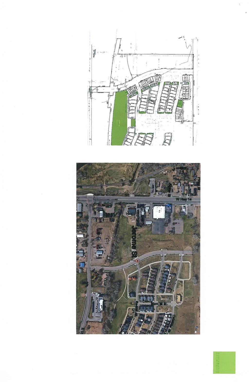
1 Jerome Street Mixed Use Aerial Site Map 287 N Mason St 1 «Douglas 25 Pinon St _ ^ Vine 287 Mulberry Horsetooth Timberline Drake Lemay Shields Prospect N College Ave 14 U V Taft Hill Mountain Vista Jerome St Vicinity Map 25 Osian d er St Harmony Alpine St Cajeta Trilby n St inch = 17,493 feet 287 «Zoning Map 14 «wn Dr Jerome St Wo odla CS t cal S Pas Osian d Cajeta CCN Pas er St n St c a l St 1 inch = 333 feet These map products and all underlying data are developed for use by the City of Fort Collins for its internal purposes only, and were not designed or intended for general use by members of the public. The City makes no representation or warranty as to its accuracy, timeliness, or completeness, and in particular, its accuracy in labeling or displaying dimensions, contours, property boundaries, or placement of location of any map features thereon. THE CITY OF FORT COLLINS MAKES NO WARRANTY OF MERCHANTABILITY OR WARRANTY FOR FITNESS OF USE FOR PARTICULAR PURPOSE, EXPRESSED OR IMPLIED, WITH RESPECT TO THESE MAP PRODUCTS OR THE UNDERLYING DATA. Any users of these map products, map applications, or data, accepts same AS IS, WITH ALL FAULTS, and assumes all responsibility of the use thereof, and further covenants and agrees to hold the City harmless from and against all damage, loss, or liability arising from any use of this map product, in consideration of the City's having made this information available. Independent verification of all data contained herein should be obtained by any users of these products, or underlying data. The City disclaims, and shall not be held liable for any and all damage, loss, or liability, whether direct, indirect, or consequential, which arises or may arise from these map products or the use thereof by any person or entity. E Vine Dr 1 inch = 175 feet


2


 component. Twelve years later this still remains as the highest and best use for the property.")


3 Concept Review application for Jerome Street Development Project Narrative (a) What are you proposing/use? The proposed use is to develop a two phased, mixed use block. The Old Town North neighborhood is a vibrant and eclectic area just off of the beaten path. The pedestrian and bicycle traffic in and out of the area plays to the dynamic nature of the property owners. Tract JJJ and Block 1, from the original developer s vision, has been earmarked as a mixed use block of commercial storefront combined with a living (or work-live) component. Twelve years later this still remains as the highest and best use for the property. Our proposal is to provide something unique, integral into the neighborhood as a benefit to those who live there and as a destination spot for others. For context, similar settings may be closer to what is being developed in the Highlands area of Denver, RiNo District or Stapleton Town Center areas. The elevations provided within the PDR package are not representative of the final design direction. They are a first pass at designing something different for Old Town North, yet complementary to its eclectic nature. Other inspirational photos demonstrating materiality and pallet : The project is broken into two phase due to the existence of the 100 year flood plain that exists on site. FEMA is currently going through their Risk Map process (remapping) and it appears that
4 this land will be removed from the 100 year flood plain, allowing for a living component to be added to the northern part of the project (Block 1 primarily). The southern portion is proposed as a commercial, flex-office or retail use. There is interest to move a brewery to this location with a small tasting room, artistic design firms and small manufacturing or warehouse use. Phase 1: one-story, 23,000 square foot, commercial building, flex office/industrial building on approximately 2 acres of land. The frontage along Jerome Street is ideal for a retail space while those that sit toward the west part of the site may be flex office or warehouse space. Phase 2: multifamily housing, for rent apartments and/or for sale condos on roughly 4 acres of land. Planning for this portion of the project would happen in conjunction with the commercial use on the south portion but may be under separate submittal, pending the timing on the FEMA remapping process. This part of the project would be higher density living. Although five stories are allowed under the CCN zoning for this areas we do not anticipate building more than four stories and most likely will build three story structures. For sale condominiums seem to be the best use although a for rent project may work as well. (b) What improvements and uses currently exist on the site? Site is vacant. (c) Describe the site circulation (auto and pedestrian), parking and how it coordinates with the existing neighborhood. See site plan in attached plan set. The intent is to be an easy connection to the City of Fort Collins river improvements project, just across Vine Drive. Jerome Street will act as the primary route for pedestrians, bicyclists and vehicular traffic. (d) Describe site design and architecture. See attached plan set. Intent of the architecture is to be a mix of differing materials to compliment the eclectic nature of Old Town North. See representative projects above. (e) How is your proposal compatible with the surrounding area? Surrounding area is a mix of commercial and residential. See aerial view in attached plan set. (f) Is water detention provided? If so, where? (show on site plan). Unknown, see questions (m). It is assumed at this point that the detention requirement is handled off site. (g) How does the site drain now (on and off site)? Will it change? If so, what will change? Unknown, see questions (m). It is assumed that storm drainage will be routed to the detention pond across Jerome Street. (h) What is being proposed to treat run-off? To be determined. (i) How does the proposal impact natural features? No impacts.
5 Site Plan (j) Do any existing structures have automatic fire sprinklers? Will the new structures have fire sprinklers? There are no existing buildings. The new building will be sprinkled. (k) Are there any unusual factors and/or characteristics are present that may restrict or affect your proposal? The 100-year flood plain covers roughly 2/3 of the site. FEMA is going through their risk map process to remap this area and through initial mapping it looks like the 100-year flood plain will be pulled south to only overlap the current tract JJJ. A commercial flex office is a permitted use within this area. The multi-family portion of the project will be phased at a later time when the revised mapping is complete, assuming that this portion does come out of the flood plain boundary. The first phase would include the commercial building on the south end and platting/ planning for the multi-family on the north. (l) Have you previously submitted an application? No, this is the first application we have submitted. (m) What specific questions, if any, do you want addressed? 1. Cajetan Street and Pascal Street had preliminary plan and profile design through this property and connecting to College. Since then, College Avenue has been improved. Are these two street connections still required by the City? 2. There appears to be an existing detention pond to the southeast of Block 1 and Tract JJJ, across Jerome Street. It appears that this existing pond was designed for this parcel. Please confirm the existence of this pond and its function. 3. What are the payment and construction responsibilities on the north end of the property to extend Suniga to College. We see that it was in the city budget for Has this been approved? 4. A temporary easement is shown on the original plat, to be vacated. Has this been done? 5. What are the surrounding utilities to the property? (a) Project site boundary and adjacent property uses Phase 1: parcel Phase 2: parcel (see plat map in attached plan set) Adjacent property uses are commercial to the south and west and single-family residential to the east. (b) Proposed circulation system, and how it ties into existing infrastructure (pedestrian and auto) See site plan in attached plan set.
6 (c) Existing and proposed landscaping (Will trees be removed?) The existing landscaping will be enhanced along the street front. There will be discussion with the ditch company to enhance their trees lining the ditch. Landscape planning is still to be determined. (d) Existing and proposed buildings (Will they remain? If they will change, how?) There are no existing buildings. See attached plan set. (e) Existing natural features (Will these be impacted by the proposal?) No impact. (f) On and off site improvements We are anticipating on-site improvements as depicted in the attached plan set. We are not anticipating any off-site improvements at this time. (g) Location of detention, drainage and water quality features To be determined. (h) Emergency vehicle access and fire hydrant locations Emergency vehicle access and fire hydrants are anticipated at Jerome Street.


7


8


9


10 Concept Design Fort Collins, CO Jerome Street NOT TO SCALE FLOOR PLAN & ELEVATIONS 141 S. College Ave. Suite 102 Fort Collins, CO t /27/16
Conceptual Review Agenda
 Conceptual Review Agenda Schedule for 03/19/18 to 03/19/18 281 Conference Room A Monday, March 19, 2018 Time Project Name Applicant Info Project Description Planner 9:30 Purpose Brewing CDR180013 Zach
Penny Flats North 323 N Mason
 Taft Hill Lemay Mason Ct Timberline Mason Ct Penny Flats North 323 N Mason Vicinity Map Aerial Site Map 287 «1 Douglas 25 Mountain Vista UV 14 287 ^_ Vine Mulberry Prospect Shields Drake Horsetooth 25
Conceptual Review Agenda
 Conceptual Review Agenda Schedule for 06/07/18 to 06/07/18 281 Conference Room A Thursday, June 7, 2018 Time Project Name Applicant Info Project Description 9:30 10:15 1314 Red Cedar Circle CDR180035 2155
Conceptual Review Agenda
 Conceptual Review Agenda Schedule for 11/13/17 to 11/13/17 281 Conference Room A Monday, November 13, 2017 Time Project Name Applicant Info Project Description Planner 9:30 Voice of Truth Tabernacle CDR170069
Conceptual Review Agenda
 Conceptual Review Agenda Schedule for 09/12/11 to 09/12/11 281 Conference Room A Monday, September 12, 2011 Time Project Name Applicant Info Project Description Planner 9:30 Mayor of Old Town Pation -
Conceptual Review Agenda
 Conceptual Review Agenda Schedule for 06/18/12 to 06/18/12 281 Conference Room A Monday, June 18, 2012 Time Project Name Applicant Info Project Description Planner 10:15 McClelland's Creek Filing 3 - Replat
Conceptual Review Agenda
 Conceptual Review Agenda Schedule for 12/13/18 281 Conference Room A Thursday, December 13, 2018 Time Project Name Applicant Info Project Description 9:30 1909 Harmony Dr CDR180091 Christopher Martin 970-388-6690
Conceptual Review Agenda
 Conceptual Review Agenda Schedule for 06/14/18 to 06/14/18 281 Conference Room A Thursday, June 14, 2018 Time Project Name Applicant Info Project Description Planner 9:30 Sunshine House CDR180038 Bo Brown
Conceptual Review Agenda
 Conceptual Review Agenda Schedule for 05/08/17 to 05/08/17 281 Conference Room A Monday, May 8, 2017 Time Project Name Applicant Info Project Description Planner 9:30 920 S Overland Trail - Single-Family
Conceptual Review Agenda
 Conceptual Review Agenda Schedule for 06/21/18 to 06/21/18 281 Conference Room A Thursday, June 21, 2018 Time Project Name Applicant Info Project Description 9:30 200 E Swallow Rd CDR180041 This is a request
Conceptual Review Agenda
 Conceptual Review Agenda Schedule for 10/18/18 281 Conference Room A Thursday, October 18, 2018 Time Project Name Applicant Info Project Description 9:30 915 E Prospect Rd Kaycee Heid This is a request
WORK SESSION ITEM City Council
 DATE: STAFF: February 23, 2016 Ginny Sawyer, Policy and Proect Manager Ted Shepard, Chief Planner WORK SESSION ITEM City Council SUBJECT FOR DISCUSSION Short Term Rentals. EXECUTIVE SUMMARY The purpose
320 Maple Mixed Use PDR Narrative Fort Collins, CO Project # 1525
 320 Maple Mixed Use PDR Narrative Fort Collins, CO Project # 1525 July 28, 2015 (a) What are you proposing/use? A 47,00 S.F., 3-story, mixed used project with 30 for-sale condo residential units and 2
WESTMINSTER PARK PLACE SUBDIVISION
 WESTMINSTER PARK PLACE SUBDIVISION Engineering Comments: FINAL PLAT COMMENTS (should be addressed prior to submitting the FINAL PLAT for review and/or signature by the City Engineer): A. Provide all of
Chapter Planned Residential Development Overlay
 Chapter 19.29 Planned Residential Development Overlay Sections 010 Purpose 020 Scope 030 Definitions 030 Minimum Size 040 Allowable Uses 050 Minimum Development Standards 060 Density Bonus 070 Open Space
AGENDA ITEM SUMMARY January 2, 2018 City Council
 Agenda Item 10 AGENDA ITEM SUMMARY January 2, 2018 City Council STAFF Kerri Allison, Real Estate Specialist II Tracy Dyer, Engineering Project Manager Chris Van Hall, Legal SUBJECT First Reading of Ordinance
Appendix J - Planned Unit Development (PUD)
") Appendix J - Planned Unit Development (PUD) Intent and Purpose The purpose of the PUD is: 1. To provide development that is consistent with the Comprehensive Land Use Plan and promote the goals and objectives
Appendix J - Planned Unit Development (PUD) Intent and Purpose The purpose of the PUD is: 1. To provide development that is consistent with the Comprehensive Land Use Plan and promote the goals and objectives
Conceptual Review Agenda
 Conceptual Review Agenda Schedule for 07/29/13 to 07/29/13 281 Conference Room A Monday, July 29, 2013 Time Project Name Applicant Info Project Description Planner 9:30 4101 S Taft Hill Rd - Annexation
WESTMINSTER PARK SUBDIVISION
 WESTMINSTER PARK SUBDIVISION Engineering Comments: FINAL PLAT COMMENTS (should be addressed prior to submitting the FINAL PLAT for review and/or signature by the City Engineer): A. Provide all of the required
CONCEPT PLAN APPLICATION Meeting with Staff Commercial Projects
 COMMUNITY DEVELOPMENT City of South Salt Lake Community Development Department 220 E. Morris Avenue South Salt Lake City, Utah 84115 Phone (801) 483-6011 Fax (801) 483-6060 CONCEPT PLAN APPLICATION Meeting
SUBDIVISION, PLANNED UNIT DEVELOPMENT, ZONING AMENDMENT, & SIDEWALK WAIVER STAFF REPORT Date: July 19, 2018
 SUBDIVISION, PLANNED UNIT DEVELOPMENT, ZONING AMENDMENT, & SIDEWALK WAIVER STAFF REPORT Date: July 19, 2018 NAME SUBDIVISION NAME LOCATION West Mobile Properties, LLC U.S. Machine Subdivision 556, 566,
ZONING AMENDMENT, PLANNED UNIT DEVELOPMENT & SUBDIVISION STAFF REPORT Date: August 8, 2013
 ZONING AMENDMENT, PLANNED UNIT DEVELOPMENT & SUBDIVISION STAFF REPORT Date: August 8, 2013 NAME SUBDIVISION NAME PV-Magnolia, LLC Twelve Trees Subdivision LOCATION 2860, 2862 and 2866 Pleasant Valley Road
PLANNED UNIT DEVELOPMENT & SUBDIVISION STAFF REPORT Date: April 18, 2019
 PLANNED UNIT DEVELOPMENT & SUBDIVISION STAFF REPORT Date: April 18, 2019 DEVELOPMENT NAME SUBDIVISION NAME Springhill Village Subdivision Springhill Village Subdivision LOCATION 4350, 4354, 4356, 4358,
SUBMITTAL REQUIREMENTS: The number indicates the number of copies for submittal (if applicable).
.") Office Use Only Preliminary Long Plat Long Subdivision Applicant Checklist PLANNING, COMMUNITY, & ECONOMIC DEVELOPMENT DEPARTMENT PRELIMINARY LONG PLAT LONG SUBDIVISION CHECKLIST Mailing Address: P.O.
Office Use Only Preliminary Long Plat Long Subdivision Applicant Checklist PLANNING, COMMUNITY, & ECONOMIC DEVELOPMENT DEPARTMENT PRELIMINARY LONG PLAT LONG SUBDIVISION CHECKLIST Mailing Address: P.O.
CITY OF OCOEE LAND DEVELOPMENT CODE SUFFICIENCY TABLE WITH NOTES
 CITY OF OCOEE LAND DEVELOPMENT CODE SUFFICIENCY TABLE WITH NOTES The Sufficiency Table is a checklist to help identify the types of information and documentation needed for various types of projects. The
Condominium Unit Requirements.
 ARTICLE 19 CONDOMINIUM REGULATIONS Section 19.01 Purpose. The purpose of this Article is to regulate projects that divide real property under a contractual arrangement known as a condominium. New and conversion
City of Ferndale CITY COUNCIL STAFF REPORT
 SUBJECT: Final Plat Approval DATE: January 19, 2016 FROM: Haylie Miller, Assistant Planner PRESENTATION BY: Haylie Miller City of Ferndale CITY COUNCIL STAFF REPORT MEETING DATE: January 19, 2016 AGENDA
SITE PLAN REVIEW ADMINISTRATIVE REVIEW. Please Note: Once submitted to the County, all application materials become a matter of public record.
 200 W. Oak Street, 3rd Floor Fort Collins, CO 80521 (970) 498-7683 / larimer.org/planning SITE PLAN REVIEW ADMINISTRATIVE REVIEW The submittal requirements listed in this packet are intended to collect
CONDOMINIUM REGULATIONS
 ARTICLE 37 CONDOMINIUM REGULATIONS SECTION 37.01. Purpose The purpose of this Article is to regulate projects that divide real property under a contractual arrangement known as a condominium. New and conversion
Planning and Zoning Commission STAFF REPORT
 TO: FROM: Planning and Zoning Commission STAFF REPORT CASA GRANDE PLANNING AND ZONING COMMISSION James Gagliardi, AICP, City Planner MEETING DATE: September 1, 2016 REQUEST AGENDA # Request by Marshall
Planning Department Oconee County, Georgia
 Planning Department Oconee County, Georgia STAFF REPORT REZONE CASE #: 6985 DATE: October 31, 2016 STAFF REPORT BY: Andrew C. Stern, Planner APPLICANT NAME: Williams & Associates, Land Planners PC PROPERTY
2012 COMMUNITY INFORMATION
 2012 COMMUNITY INFORMATION THE HARPER S PRESERVE COMMUNITY ASSOCIATION INC. ( HOA ) HAS PREPARED THIS COURTESY NOTICE OFSUMMARY INFORMATION TO ENCOURAGE THOSE INTERESTED IN HARPER S PRESERVE TO START TO
Plans shall be drawn at a readable scale, signed, and sealed by a Florida Registered Engineer. The application package shall include:
 CHAPTER 400. SECTION 403. PERMIT TYPES AND APPLICATIONS SITE DEVELOPMENT 403.3. Preliminary Site Plans (PSP) A. Intent and Purpose PSPs are used to identify existing site conditions and demonstrate general
AGENDA OF THE COUNCIL OF THE CITY OF FORT COLLINS, COLORADO. September 18, Proclamations and Presentations 5:30 p.m. Regular Meeting 6:00 p.m.
 AGENDA OF THE COUNCIL OF THE CITY OF FORT COLLINS, COLORADO September 18, 2001 Proclamations and Presentations 5:30 p.m A. Presentation of a Plaque to the Neighborhood Task Force for its Award of Excellence
PRELIMINARY PLAT CHECK LIST
 PRELIMINARY PLAT CHECK LIST Name of Proposed Subdivision: The following items must be included with the initial submittal of a Preliminary Plat: Application, filled out completely Project Narrative Pre-application
ARTICLE 13 CONDOMINIUM REGULATIONS
 ARTICLE 13 CONDOMINIUM REGULATIONS Section 13.01 Purpose. The purpose of this Article is to regulate projects that divide real property under a contractual arrangement known as a condominium. New and conversion
CHECKLIST FOR DEVELOPMENT REVIEW
 CHECKLIST FOR DEVELOPMENT REVIEW Petitions and related documents and plans for land development or other proposals regulated by Title 16 of the Municipal Code (Development Ordinance) and Title 17 of the
Site Plan Application
 Site Plan Application City of St. Pete Beach Community Development Department 155 Corey Avenue St. Pete Beach, Florida 33706 (727) 367-2735 www.stpetebeach.org Case Number: PROPERTY OWNER: Name: Address:
PLANNED UNIT DEVELOPMENT & SUBDIVISION STAFF REPORT Date: July 20, 2017
 PLANNED UNIT DEVELOPMENT & SUBDIVISION STAFF REPORT Date: July 20, 2017 DEVELOPMENT NAME SUBDIVISION NAME LOCATION Rangeline Crossing III Subdivision Rangeline Crossing III Subdivision 5289 Halls Mill
Residential Major Subdivision Review Checklist
 Residential Major Subdivision Review Checklist Plan Submittal Requirements: 2 full sets of stamped plans Electric submittal - all plans contained in a single PDF 3 full sets if commercial kitchen or dining
COUNCIL ACTION FORM. 1. The City Council can approve the Preliminary Plat for Menards Ames Subdivision
 ITEM #: 49 DATE: 03-27-18 COUNCIL ACTION FORM SUBJECT: PRELIMINARY PLAT FOR MENARDS BACKGROUND: Menards Ames Subdivision is a proposed 41-acre development on SE 16 th Street just west of the Skunk River.
Guide to Combined Preliminary and Final Plats
 Guide to Combined Preliminary and Final Plats Introduction The Douglas County is committed to providing open, transparent application processes to the public. This Guide is provided to assist anyone interested
PLANNING COMMISSION REPORT REGULAR AGENDA. PC Staff Report 08/25/10 ITEM NO 6: PRELIMINARY PLAT; HALLMARK ADDITION; ACRES; 151 MCDONALD DR (MKM)
") PP-6-6-10 Item No. 6-1 PLANNING COMMISSION REPORT REGULAR AGENDA PC Staff Report 08/25/10 ITEM NO 6: PRELIMINARY PLAT; HALLMARK ADDITION; 5.252 ACRES; 151 MCDONALD DR (MKM) PP-6-6-10: Consider a Preliminary
PP-6-6-10 Item No. 6-1 PLANNING COMMISSION REPORT REGULAR AGENDA PC Staff Report 08/25/10 ITEM NO 6: PRELIMINARY PLAT; HALLMARK ADDITION; 5.252 ACRES; 151 MCDONALD DR (MKM) PP-6-6-10: Consider a Preliminary
APPLICATION PROCEDURE
 ANTRIM PLANNING BOARD P. O. Box 517 Antrim, New Hampshire 03440 Phone: 603-588-6785 FAX: 603-588-2969 APPLICATION FORM AND CHECKLIST FOR MINOR OR MAJOR SITE PLAN REVIEW File Date Received By APPLICATION
ARTICLE 15 - PLANNED UNIT DEVELOPMENT
 Section 15.1 - Intent. ARTICLE 15 - PLANNED UNIT DEVELOPMENT A PUD, or Planned Unit Development, is not a District per se, but rather a set of standards that may be applied to a development type. The Planned
Section Preliminary Plat Checklist and Application Forms
 Section 201 - Preliminary Plat Checklist and Application Forms PRELIMINARY SUBDIVISION PLAT REVIEW PROCESS CHART PRELIMINARY SUBDIVISION PLAT APPLICATION PRELIMINARY PLAT REVIEW CHECKLIST CITY OF NAMPA
TULSA PARK ESTATES SUBDIVISION, RESUBDIVISION OF LOT 6
 TULSA PARK ESTATES SUBDIVISION, RESUBDIVISION OF LOT 6 Engineering Comments: FINAL PLAT COMMENTS (should be addressed prior to submitting the FINAL PLAT for review and/or signature by the City Engineer):
SUBMITTAL REQUIREMENTS: The number indicates the number of copies for submittal (if applicable).
.") Office Use Only Preliminary Long Plat Long Subdivision Applicant Checklist PLANNING, COMMUNITY, & ECONOMIC DEVELOPMENT DEPARTMENT FINAL LONG PLAT LONG SUBDIVISION CHECKLIST Mailing Address: P.O. Box 547,
Office Use Only Preliminary Long Plat Long Subdivision Applicant Checklist PLANNING, COMMUNITY, & ECONOMIC DEVELOPMENT DEPARTMENT FINAL LONG PLAT LONG SUBDIVISION CHECKLIST Mailing Address: P.O. Box 547,
Rezoning Report October 2018
 Zone Change Request 3099 W. Parkwood Ave. Request to change from Light Industrial (LI) to Light Industrial / Specific Use Permit (LI/SUP) to allow NAICS Use #7139 Other Amusement and Recreation Industries
CHAPTER34 PRUD - PLANNED RESIDENTIAL UNIT DEVELOPMENT
 CHAPTER34 PRUD - PLANNED RESIDENTIAL UNIT DEVELOPMENT 17-34-1 17-34-2 17-34-3 17-34-4 17-34-5 17-34-6 17-34-7 17-34-8 17-34-9 Purpose Planned Residential Unit Development Defined Planned Residential Unit
City of Ferndale CITY COUNCIL STAFF REPORT
 SUBJECT: Final Plat Approval DATE: February 6, 2017 FROM: Haylie Miller, Associate Planner PRESENTATION BY: Haylie Miller City of Ferndale CITY COUNCIL STAFF REPORT MEETING DATE: FEBRUARY 6, 2016 AGENDA
Conceptual Review Agenda
 Conceptual Review Agenda Schedule for 08/19/13 to 08/19/13 281 Conference Room A Monday, August 19, 2013 Time Project Name Applicant Info Project Description Planner 9:30 Trilby Rd & Avondale Rd - Single
CONCEPTUAL MASTER PLAN CHECKLIST Major Land Development Project
 CONCEPTUAL MASTER PLAN CHECKLIST Major Land Development Project To initiate the application, the applicant shall submit to the Administrative Officer: 1. The application review fee, as established by the
ARTICLE V. PRELIMINARY PLAT
 ARTICLE V. PRELIMINARY PLAT PAGE 13 SECTION A. PURPOSE. The purpose of the preliminary plat is to allow the Planning and Zoning Commission to review overall platting of the tract and street patterns within
Residential Minor Subdivision Review Checklist
 Residential Minor Subdivision Review Checklist Plan Submittal Requirements: 2 full sets of stamped plans Electric submittal - all plans contained in a single PDF 3 full sets if commercial kitchen or dining
SKETCH PLAN REVIEW SPECIAL EXCEPTION, SPECIAL REVIEW,
 www.larimer.org Planning Department 200 W. Oak Street 3 rd Floor Fort Collins, CO 80521 970-498-7683 SKETCH PLAN REVIEW SKETCH PLAN REVIEW for Conservation Developments, Planned Land Divisions, Subdivisions,
REVISED # Federal Drive Milestones Therapy Project Review for Planning and Zoning Commission
 REVISED #2012-111 394 Federal Drive Milestones Therapy Project Review for Planning and Zoning Commission Meeting Date: November 7, 2012 and November 19, 2012 Request: Location: Acreage: Existing Zoning:
DAUPHIN CREEK ESTATES SUBDIVISION
 # 12 SUB-000076-2017 DAUPHIN CREEK ESTATES SUBDIVISION Engineering Comments: FINAL PLAT COMMENTS (should be addressed prior to submitting the FINAL PLAT for review and/or signature by the City Engineer):
Sterling Meadow Subdivision
 Sterling Meadow Subdivision Proposal: A pre-application conference was held on November 7, 2017, with the applicant and City staff to discuss the development. The applicant took staff s recommendations
City of Fort Lupton Amended Plat Process
 City of Fort Lupton Amended Plat Process Purpose The Amended Plat process is an administrative process to amend a recorded Plat. An Amended Subdivision is an administrative revision to a recorded Subdivision
Cornerstone. Serenity Ridge Lots. REO - Finished Lots Million Dollar Views!!! Real Estate Investment Advisors
 Serenity Ridge Lots Serenity Ridge Berthoud, Colorado 80513 REO - Finished Lots Million Dollar Views!!! Serenity Ridge Berthoud, Colorado Exclusively Offered by: Steve Pfister 970.221.4524 steve@cstonerea.com
Planning Commission Planned Unit Development Master Development Plan Application
 Planning Commission Planned Unit Development Master Development Plan Application Refer to Meeting and Submittal Dates Calendar for Application Deadlines Note: A pre-application conference is required at
FOR SALE By SC Department of Transportation
 UPCOMING BID SALE INFO FOR SALE By SC Department of Transportation Type Property: VACANT LAND Approximately 0.267 of an acre of land Address: Meeting St. & Sheppard St. Charleston, SC Tax Map Number: 459-05-04-213
ZONING AMENDMENT & SUBDIVISION STAFF REPORT Date: July 9, 2015
 ZONING AMENDMENT & SUBDIVISION STAFF REPORT Date: July 9, 2015 APPLICANT NAME 2513 Dauphin Street, Inc. SUBDIVISION NAME Audubon Place Extension No. 3, Resubdivision of Lots 1-5 LOCATION 2513 Dauphin Street
PLANNED UNIT DEVELOPMENT (PUD)
") SECTION 38.01. ARTICLE 38 PLANNED UNIT DEVELOPMENT (PUD) Purpose The purpose of this Article is to implement the provisions of the Michigan Zoning Enabling Act, Public Act 110 of 2006, as amended, authorizing
SECTION 38.01. ARTICLE 38 PLANNED UNIT DEVELOPMENT (PUD) Purpose The purpose of this Article is to implement the provisions of the Michigan Zoning Enabling Act, Public Act 110 of 2006, as amended, authorizing
DEVELOPMENT PLAN REVIEW CHECKLIST. To initiate the application, the applicant shall submit to the Administrative Officer:
 DEVELOPMENT PLAN REVIEW CHECKLIST To initiate the application, the applicant shall submit to the Administrative Officer: 1. Sixteen (16) copies of the Project Review Application Form, printed double-sided;
APPLICATION REVIEW CHECKLISTS
 APPLICATION REVIEW CHECKLISTS The following must be submitted with and are part of each application. No application is complete until all required documentation has been submitted to the Community Development
ARTICLE 8C SITE CONDOMINIUM DEVELOPMENT ORDINANCE
 ARTICLE 8C SITE CONDOMINIUM DEVELOPMENT ORDINANCE SECTION 8C.01 PURPOSE It is the purpose of this Ordinance to insure that plans for development within Oceola Township proposed under the provisions of
County of Ottawa Fillmore Room 141 West Olive, MI (616)
") County of Ottawa Office of the Water Resources Commissioner Joe Bush Commissioner Linda S. Brown Deputy APPLICATION FOR DEVELOPMENT REVIEW & APPROVAL OF THE WATER RESOURCES COMMISSIONER (Michigan Land
County of Ottawa Office of the Water Resources Commissioner Joe Bush Commissioner Linda S. Brown Deputy APPLICATION FOR DEVELOPMENT REVIEW & APPROVAL OF THE WATER RESOURCES COMMISSIONER (Michigan Land
Innsbruck Val Moritz AFP of Lot 46, Lot 47, & Amended Lot 48 Block 17 Amended Final Plat Adjustment of Interior Lot Lines
 Innsbruck Val Moritz AFP of Lot 46, Lot 47, & Amended Lot 48 Block 17 Amended Final Plat Adjustment of Interior Lot Lines APPLICATION: AMENDED FINAL PLAT HEARING DATES: Planning Commission: 8 November
PLANNING COMMISSION STAFF REPORT SURROUNDING LAND USES. Light Industrial, Office, UDOT Right of Way (Interstate- 15)
") PLANNING COMMISSION STAFF REPORT MEETING DATE: March 21, 2019 PROJECT NUMBER: S-18-014 REQUEST: Final Plat approval for a single lot subdivision ADDRESS: 3535 South 500 West 7 Parcels: 15-36-127-021-0000,
PLANNING COMMISSION STAFF REPORT MEETING DATE: March 21, 2019 PROJECT NUMBER: S-18-014 REQUEST: Final Plat approval for a single lot subdivision ADDRESS: 3535 South 500 West 7 Parcels: 15-36-127-021-0000,
COMMUNITY DEVELOPMENT DEPARTMENT 333 Broadalbin Street SW, P.O. Box 490 Albany OR 97321
 COMMUNITY DEVELOPMENT DEPARTMENT 333 Broadalbin Street SW, P.O. Box 490 Albany OR 97321 NOTICE OF DECISION DATE OF NOTICE: August 16, 2016 FILE: TYPE OF APPLICATION: REVIEW BODY: SD-01-16 Ph: 541-917-7550
Article 6: Planned Unit Developments
 LUDC 2013 GARFIELD COUNTY, COLORADO Article 6: Planned Unit Developments ARTICLE 6 PLANNED UNIT DEVELOPMENTS TABLE OF CONTENTS DIVISION 1. GENERAL.... 1 6-101. GENERAL PROVISIONS.... 1 A. Purpose....
AGENDA OF THE COUNCIL OF THE CITY OF FORT COLLINS, COLORADO. October 7, Proclamations and Presentations 5:30 p.m.
 AGENDA OF THE COUNCIL OF THE CITY OF FORT COLLINS, COLORADO October 7, 2003 Proclamations and Presentations 5:30 p.m. A. Proclamation Proclaiming September 28, 2003, was a Day to Recognize and Celebrate
Conditional Use Permit / Standard Subdivision Application
 Conditional Use Permit / Standard Subdivision Application Name of Proposed Subdivision: Total Area (Acres) Is Proposed Subdivision to be built in phases? Number of Lots If yes, how many phases? Applicant/Owner
Submittal Requirements: Subdivision Plat (Final)
") s Planning and Zoning Submittal Requirements: Subdivision Plat (Final) 1. Application form, APO fees, and filing fee. Transportation Development Review Fee please contact Engineering at (970) 221-6605
s Planning and Zoning Submittal Requirements: Subdivision Plat (Final) 1. Application form, APO fees, and filing fee. Transportation Development Review Fee please contact Engineering at (970) 221-6605
SHORT PLAT Information
 Information This form provides information and an explanation of the procedures of a Short Plat. If you have any questions, contact the Planning and Development Services Department at (253) 566-5656. A
REQUEST FOR PLANNING COMMISSION ACTION
 REQUEST FOR PLANNING COMMISSION ACTION DATE: 06/01/2011 ITEM NO: 5b Division Approval Item Description: Agenda Section PUBLIC HEARINGS Request by Affinity Plus Federal Credit Union for approval of a drivethrough
STRATEGIC COMMERCIAL TRACT WEST AVENUE AT WURZBACH PARKWAY SAN ANTONIO, TEXAS
 STRATEGIC COMMERCIAL TRACT WEST AVENUE AT WURZBACH PARKWAY SAN ANTONIO, TEXAS LOCATION: SIZE: FRONTAGE: The property is located at the southeast corner of West Avenue and Wurzbach Parkway about one half
AGENDA OF THE COUNCIL OF THE CITY OF FORT COLLINS, COLORADO
 AGENDA OF THE COUNCIL OF THE CITY OF FORT COLLINS, COLORADO April 2, 2002 Proclamations and Presentations 5:30 p.m A. Proclamation Proclaiming the Month of April as Strategic Information Management Month.
3. What is the requested zoning for the property (including intensity designator)? RM1-45 Residential (Multi-Dwelling).
? RM1-45 Residential (Multi-Dwelling).") B. SUBJECT PROPERTY INFORMATION General location of subject property and address (if address has been assigned): Northside- 819 Stoddard St. Missoula, MT 59802 Legal Description - complete and unabbreviated:
B. SUBJECT PROPERTY INFORMATION General location of subject property and address (if address has been assigned): Northside- 819 Stoddard St. Missoula, MT 59802 Legal Description - complete and unabbreviated:
TOWN OF LEWISTON PLANNING BOARD APPLICATION
 TOWN OF LEWISTON PLANNING BOARD APPLICATION DESCRIPTION OF PROPOSED REQUEST: Name of Property Owner: Phone #: Name of Applicant:Phone #: Address or Location of Proposal:_SBL# Size of Parcel or Structure:Existing
CITY OF SARALAND PRELIMINARY SUBDIVISION PLAT REVIEW
 PRELIMINARY SUBDIVISION PLAT REVIEW Application Number: Date Plat Submitted: Name of Subdivision: Name of Owner: Owner Address: (Street or P.O. Box) Telephone #: (City) (State) (Zip) E-mail: Name of Authorized
I. Requirements for All Applications. C D W
 108-16.1. Application checklists. Checklist for Required Submissions to the Planning Board or Zoning Board of Adjustment of Monroe Township All required submissions are to be made to the Administrative
ZONING AMENDMENT & SUBDIVISION STAFF REPORT Date: July 3, 2014
 ZONING AMENDMENT & SUBDIVISION STAFF REPORT Date: July 3, 2014 APPLICANT NAME SUBDIVISION NAME LOCATION Georgia Crown Distributing Subdivision Georgia Crown Distributing Subdivision Southwest corner of
City of Leavenworth DEPARTMENT OF DEVELOPMENT SERVICES MAJOR SUBDIVISION APPLICATION 1
 Proposed Name of Subdivision: City of Leavenworth DEPARTMENT OF DEVELOPMENT SERVICES MAJOR SUBDIVISION APPLICATION 1 FOR PRELIMINARY SUBDIVISION APPROVAL This application must be filled out legibly, in
PRELIMINARY PLAN CHECKLIST Major Land Development Projects. To initiate the application, the applicant shall submit to the Administrative Officer:
 PRELIMINARY PLAN CHECKLIST Major Land Development Projects To initiate the application, the applicant shall submit to the Administrative Officer: 1. The application review fee, as established by the South
ARLINGTON COUNTY, VIRGINIA. County Board Agenda Item Meeting of July 15, 2017
 ARLINGTON COUNTY, VIRGINIA County Board Agenda Item Meeting of July 15, 2017 DATE: July 7, 2017 SUBJECT: Deed of Easement from Highland Holdings, LLC, to the County Board of Arlington County, Virginia
CITY OF NAPLES STAFF REPORT
 Meeting of 11/9/16 Subdivision/Replat Petition 16-SD3 CITY OF NAPLES STAFF REPORT To: Planning Advisory Board From: Planning Department Subject: Subdivison/Replat Petition 16-SD3 Petitioner: Matthew Grabinski,
Conceptual Review Agenda
 Conceptual Review Agenda Schedule for 08/09/18 to 08/09/18 281 Conference Room A Thursday, August 9, 2018 Time Project Name Applicant Info Project Description 9:30 Southridge Verizon WTE CDR180044 Shawn
géãç Éy VtÇtÇwt zât 5440 Routes 5 & 20 West Canandaigua, NY Phone: (585) / Fax: (585)
 / Fax: (585)") géãç Éy VtÇtÇwt zât 5440 Routes 5 & 20 West Canandaigua, NY 14424 Phone: (585) 394-1120 / Fax: (585) 394-9476 APPLICATION FOR LOT-LINE ADJUSTMENT The applicant is responsible for the completeness of all
géãç Éy VtÇtÇwt zât 5440 Routes 5 & 20 West Canandaigua, NY 14424 Phone: (585) 394-1120 / Fax: (585) 394-9476 APPLICATION FOR LOT-LINE ADJUSTMENT The applicant is responsible for the completeness of all
Memorandum: October 13, 2008 REVISED To: Trowbridge Township Planning Commission From: P. Hudson, AICP Re: Suggested New Ordinance
 1 Memorandum: October 13, 2008 REVISED 2-11-09 To: Trowbridge Township Planning Commission From: P. Hudson, AICP Re: Suggested New Ordinance Because of changes in both the Michigan Planning Enabling Act
DAWES SWITCHING STATION SUBDIVISION
 DAWES SWITCHING STATION SUBDIVISION Engineering Comments: Must comply with the Mobile County Flood Damage Prevention Ordinance. Development shall be designed to comply with the storm water detention and
PRELIMINARY PLATS. The following documents are provided as required by the City of Conroe for use in the above titled platting submittals:
 Public Works Engineering Division CITY OF CONROE PRELIMINARY PLATS The following documents are provided as required by the City of Conroe for use in the above titled platting submittals: Submittal Questionnaire
LABEL PLEASE NOTE: ALL APPLICATIONS AND SITE PLANS MUST BE COMPLETED IN BLACK OR BLUE INK ONLY Intake by:
 STAFF USE ONLY Thurston County Resource Stewardship 2000 Lakeridge Dr. S.W. Olympia, WA 98502 (360)786-5490 / (360)754-2939 (Fax) TDD Line (360) 754-2933 Email: permit@co.thurston.wa.us Supplemental Application
Administrative Plat Application Form
 1 Administrative Plat Application Form This form shall be submitted with each application for an administrative plat. CONTACT INFORMATION Applicant Architect (if different) Property Owner (if different)
ARTICLE 900 PLAT AND PLAN REQUIREMENTS
 ARTICLE 900 PLAT AND PLAN REQUIREMENTS SEC. 900.1 ITEMS TO BE SHOWN ON PLAT OR PLAN General (1) Property lines of all property owners adjacent to the exterior boundaries of the project shall be located
ARTICLE 12 PLANNED UNIT DEVELOPMENT DISTRICTS (PUDS) Sec Intent CHARTER TOWNSHIP OF BRIGHTON ZONING ORDINANCE
 Sec Intent CHARTER TOWNSHIP OF BRIGHTON ZONING ORDINANCE") ARTICLE 12 PLANNED UNIT DEVELOPMENT DISTRICTS (PUDS) Sec. 12-01 Intent 1 2 (a) The intent of this Article is to permit the coordinated development on larger sites, protect significant natural features
ARTICLE 12 PLANNED UNIT DEVELOPMENT DISTRICTS (PUDS) Sec. 12-01 Intent 1 2 (a) The intent of this Article is to permit the coordinated development on larger sites, protect significant natural features
City of Sanibel. Planning Department STAFF REPORT
 City of Sanibel Planning Department STAFF REPORT Planning Commission Meeting: July 23, 2013 Planning Commission Agenda Item: No 7b. Application Number: 13-7438DP Applicant Name: Attorney Beverly Grady
DENTON Developer's Handbook
 DENTON Developer's Handbook A guide for land development in the City of Denton Department of Development Services 2017 2 Table of Contents 1. City of Denton Development Process...5 Role of the Development