GIS & Mobile Technology: It s Not Just For Real Property Tangible Technology for Tangible Personal Property Valuation
|
|
|
- Roberta Rice
- 5 years ago
- Views:
Transcription

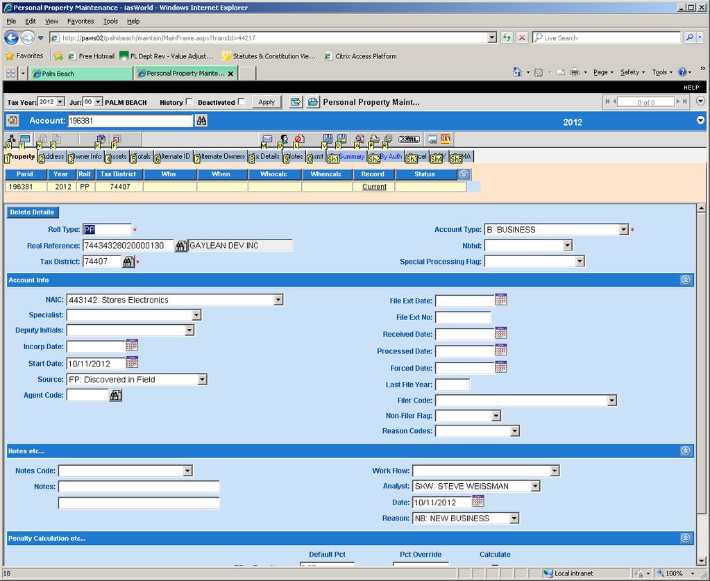
1 GIS & Mobile Technology: It s Not Just For Real Property Tangible Technology for Tangible Personal Property Valuation Steve Weissman, RES, CFE, MBA Manager, Personal Property Appraisal Section Palm Beach County Property Appraiser s Office
2 REAL ESTATE/REAL PROPERTY REAL ESTATE: the physical land and everything permanently attached to it. REAL PROPERTY: the sum of the tangible and intangible rights in land and improvements. Real property refers to the interests, benefits, and rights inherent in the ownership of physical real estate.


3
4 TANGIBLE PERSONAL PROPERTY Consists of movable items not permanently affixed to, or part of, the real estate. Capable of manual possession and whose chief value is intrinsic to the article itself. Inventory and household goods are expressly excluded from this definition. Does not include most licensed motor vehicles.


5

6 What s the Main Issue with TPP Assessment? Here Today, Gone Tomorrow

7 FIELD DATA COLLECTION IN PALM BEACH COUNTY A BRIEF HISTORY
8
9

10 THINK OUTSIDE THE BOX
11
12
13
14

15 There must be a better way

16 SOFTWARE OFF THE SHELF USER CUSTOMIZABLE CUSTOM SOFTWARE
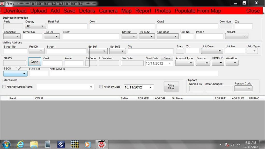
17 PPFIELD Developed by Jeremy Banner, CFE Systems Integrator/Developer

18
19
20

21
22
23
24
25
26
27

28

29 PPField Live Demo
30
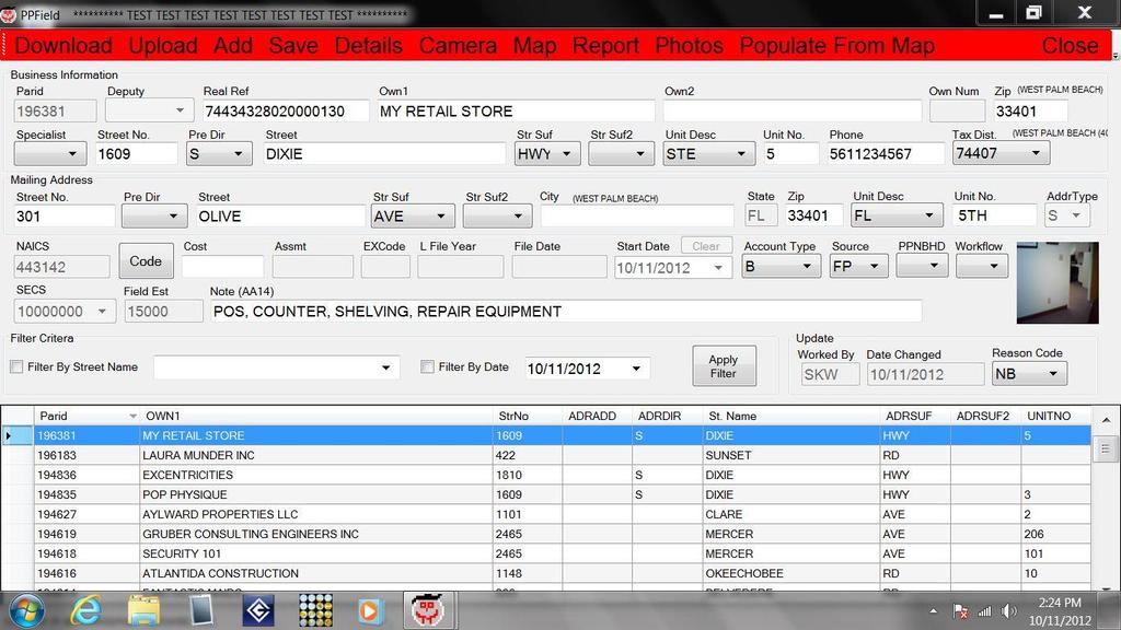
31
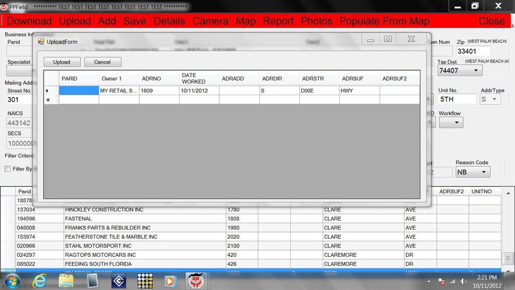
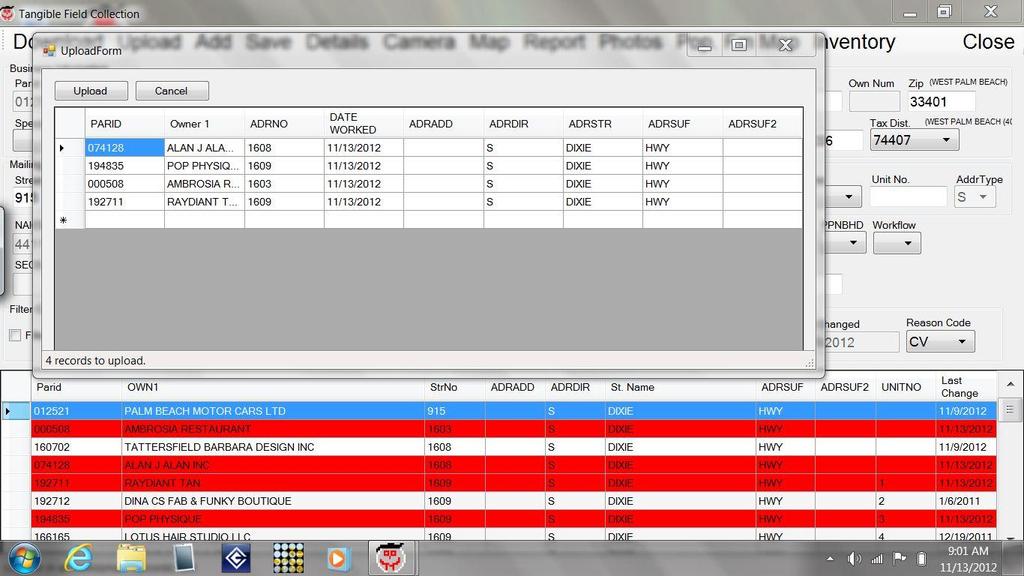
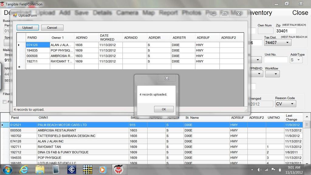
32
33
34


35
36 Tangible Personal Property Field Data Collection System Technical Description Requirements Tablet PC running Windows 7 Microsoft.Net Framework 4.0 Oracle 10G or higher client ESRI ArcGIS Mobile Microsoft Report Viewer Redistributable
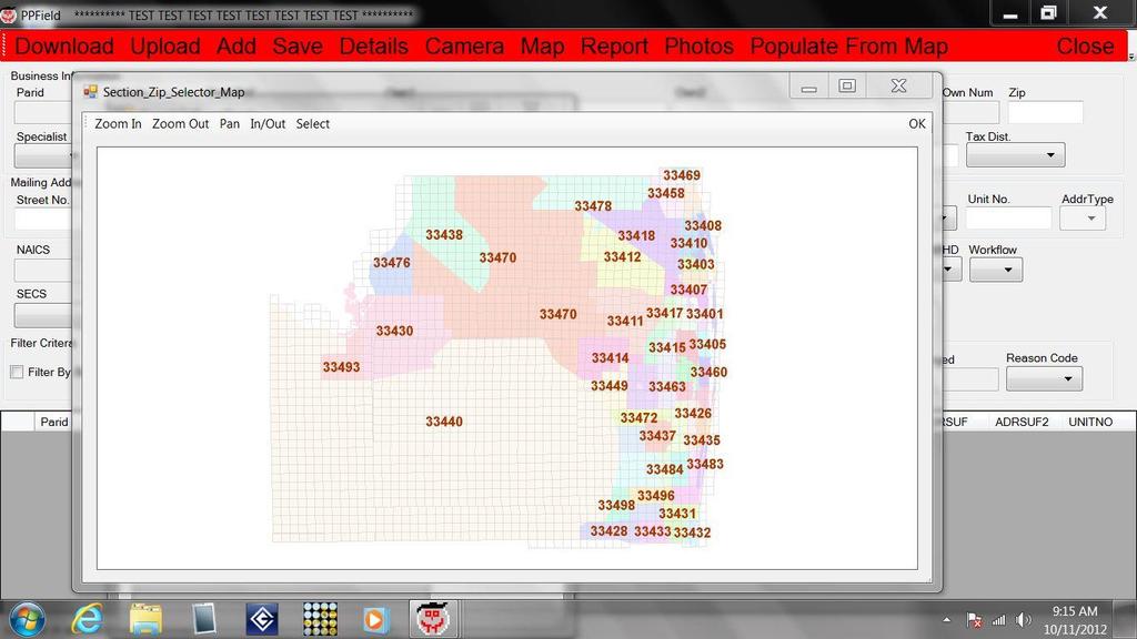
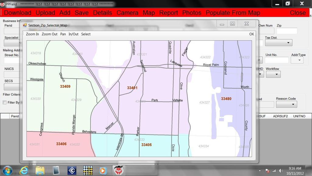
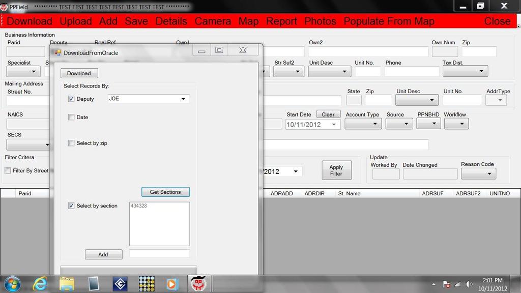
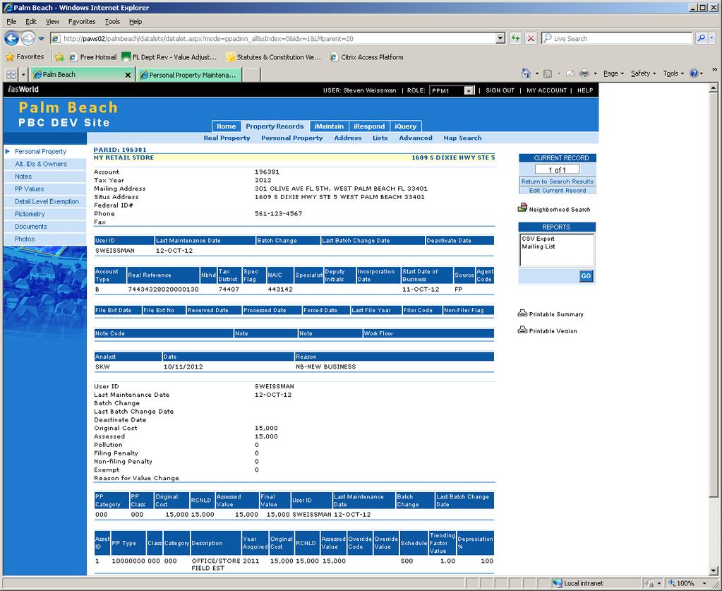
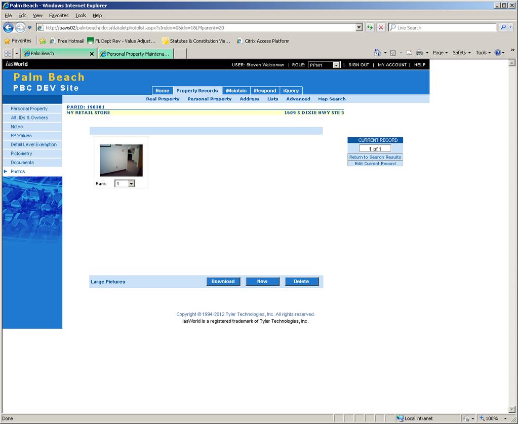
37 Tangible Personal Property Field Data Collection System Technical Description Structure Windows Forms Based application Written in C# Uses Oracle 10G client to communicate with the IAS World database for account data check-out and creation of transactions for account check-in. Data transfers are done over the network either wired or wireless. Lookup tables are updated during account download. Photos are pulled from the IAS World photos table during account download. Uses custom ArcGIS Mobile application to select accounts geographically. Also uses ArcGIS Mobile to show current location based on GPS and to copy current location data to expedite entering data for new accounts.
38 Tangible Personal Property Field Data Collection System Technical Description Structure Uses SQL Server Compact Edition to store data locally while out in the field. Microsoft Report Viewer is included to run simple canned reports on accounts in the local database. Telerik OpenAccess and Telerik WinForms Controls were used to expedite development. Aerial imagery is copied from an ArcGIS Server map cache and stored locally on the tablet for use in the built in mapping screen.
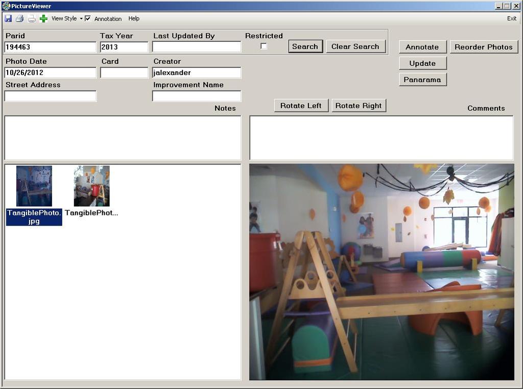
39 Tangible Personal Property Field Data Collection System Technical Description Key Features Accounts worked in the field are uploaded to IAS World through transactions that can be validated, abandoned, or committed through the IAS World interface. Photos taken in the field with the tablet camera are uploaded to the IAS World photos table with appropriate metadata (test mode). Photos are uploaded into Picture Manager, an application developed inhouse (production). New accounts can be added in the field and the current location can be used to populate the address field without typing or writing. Tablet based validation help reduce errors while entering zip codes, tax districts, and other data. Handwritten inventory scratchpad can be used for notes associated with an account.

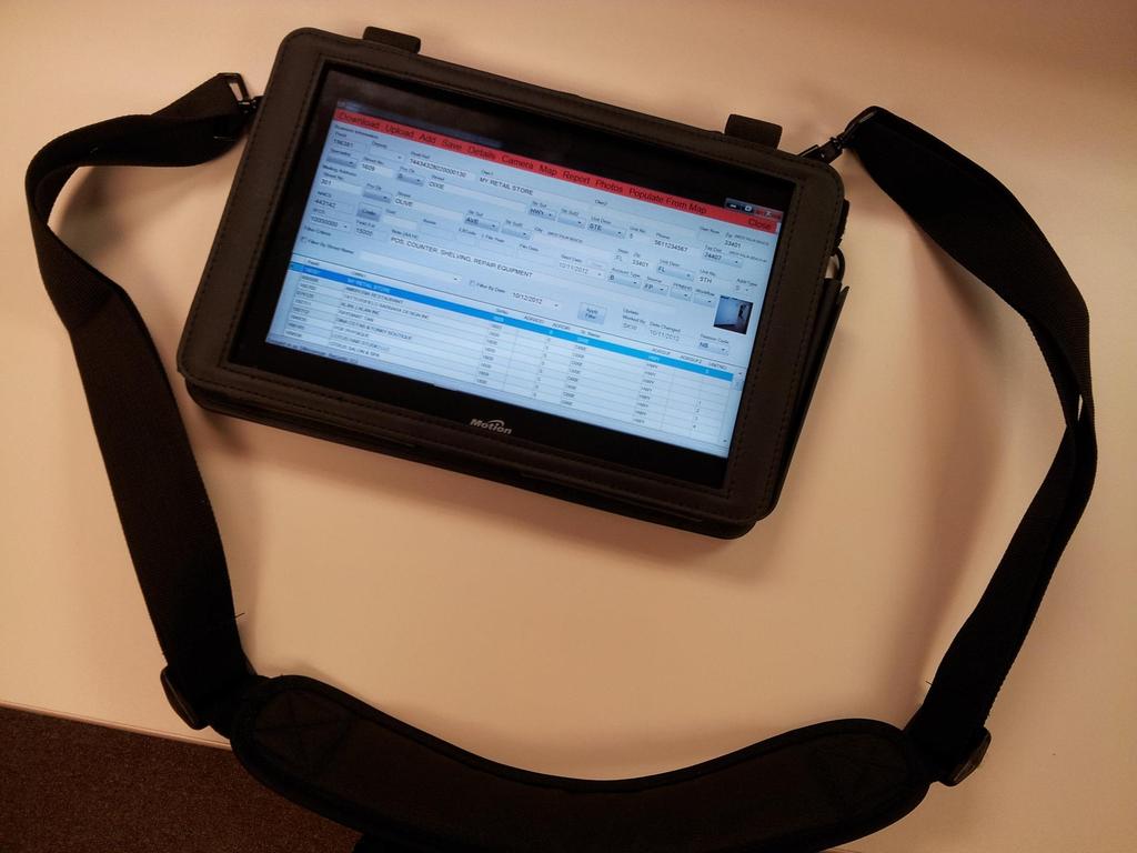
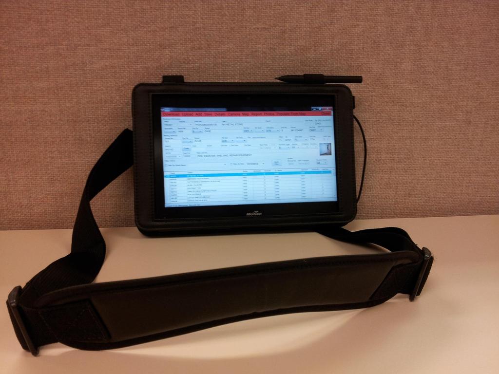
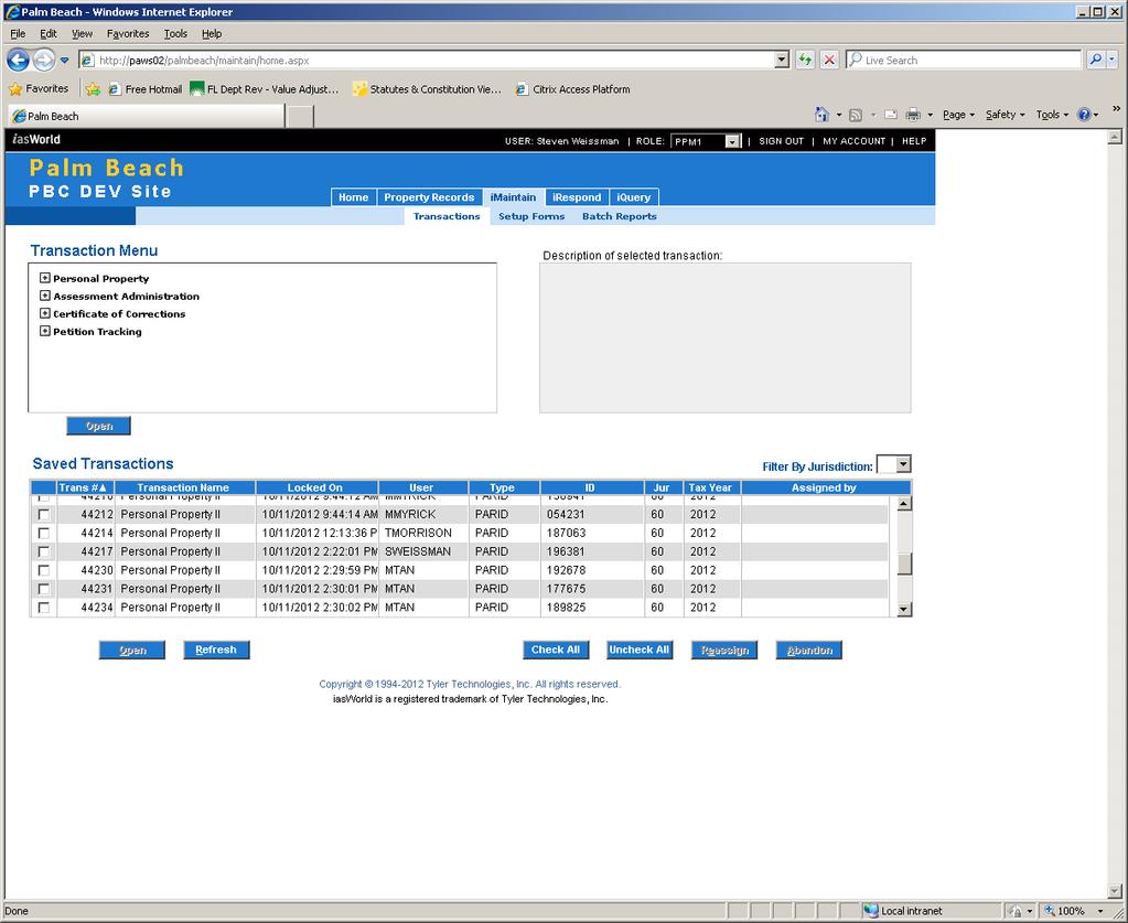
40 WHERE S MY DATA?
41
42
43
44
45
46

47 HARDWARE

48 Samsung Series 7 SLATE

49 Intel CORE i5 processor

50 GPS USB DONGLE

51 BESTEK MRI711C 75 Watt Power Inverter

52 Microsoft Surface
53

54 Docking Station

55 SHARING OF TPP DATA
56 Other Departments in the PBC-PAO Commercial Appraisal Check occupancy rates Check types of business Check TPP vs. Real Property Valuation Agricultural Appraisal Check if property with Agricultural Classification has a TPP account Avoid double assessment of assets Residential Appraisal Proximity to support services Avoid double assessment (appliances, etc.)

57
58 Taxpayers and other Agencies Builders and Realtors Proximity of support services Locations of complementary and competing businesses Commercial occupancy Business Owners Check ownership and assessments Download tax returns and other forms PBC Office of Economic Sustainability Attract new businesses to County Assist in selection of location for new and existing businesses Commercial occupancy

59
60 Multi-functional In-house maps


61 ArcView 10.1 ArcInfo 10.1 ArcReader 10.1

62 MAP LAYERS Municipal Boundaries Water Roadways Parcels Situs Points Tax Districts Aerials
 Assessment TPP and Commercial Permits TPP Petitions Commercial Rent")
63 Tabular and Other Data TPP Account Data Account number Business name Business type (NAICS) Assessment TPP and Commercial Permits TPP Petitions Commercial Rent Rolls
64
65
66
Cloud GIS Real Estate Management, Appraisal and Development Service USING ESRIs ARCGIS SERVER
 Cloud GIS Real Estate Management, Appraisal and Development Service USING ESRIs ARCGIS SERVER INFODIM: Was founded on 1992 and is internationally certified as a GIS company from D&B Dun & Bradstreet Global
Georgia Department of Revenue. WinGAP. Georgia CAMA Software
 WinGAP Georgia CAMA Software Presenter Tracy Thomas Business Operations Specialist Georgia Department of Revenue Local Government Services tracy.thomas@dor.ga.gov Public Utility Appraisal Eight DOR field
Fit-for Purpose Approaches to Land Administration
 Fit-for Purpose Approaches to Land Administration Brent Jones, PE, PLS Global Manager, Casastre/Land Records bjones@esri.com Land Administration GIS is the platform for land administration Land administration
NEW DEVELOPMENTS IN THE REAL PROPERTY REGISTER AND CADASTRE IN LITHUANIA
 NEW DEVELOPMENTS IN THE REAL PROPERTY REGISTER AND CADASTRE IN LITHUANIA Jaunius Grigas E-mail: jaunius.grigas@registrucentras.lt Verona, 2008 FUNCTIONS OF STATE ENTERPRISE CENTRE OF REGISTERS Registration
Over the past several years, appraisers have made
 COVER STORY Collecting Parcel Data on Handheld Computers by Edgar Clodfelter, Randy Link, and Thomas E. Walker Over the past several years, appraisers have made great strides in applying computer technologies
New Models for Property Data Verification and Valuation
 New Models for Property Data Verification and Valuation for 2006 IAAO Councils and Sections Joint Seminar May 9-11, 2006 Charleston, South Carolina Presented by George Donatello, CMS Principal Consultant
Using ArcGIS Server for National Property Information System
 Using ArcGIS Server for National Property Information System Shota Chachkhunashvili (National Agency of Public Registry, Georgia) Mikheil Tsiklauri (Geographic, Georgia) San Diego, 2008 About us National
LRIMS Cadastre Module
 LRIMS Cadastre Module User Requirements and Functionality (Seychelles Case Study) John Latham, NRL Renato Cumani, NRL Luigi Simeone, NRL Summary Background User Requirements Business Model Application
Integrating SAS and Geographic Information Systems for Regional Land Use Planning
 Integrating SAS and Geographic Information Systems for Regional Land Use Planning ABSTRACT Bill Bass, Houston-Galveston Area Council, Houston, Tx The Houston-Galveston Area Council (H-GAC) provides regional
Assessor. Mission Statement: Functions: Long Term Goals: Page 1 of 6
 Assessor Mission Statement: The mission of the Assessor s Office is to create accurate, equitable, and timely property tax assessments to fund public services; and to be a source of current, accurate property
RAINS COUNTY APPRAISAL DISTRICT
 RAINS COUNTY APPRAISAL DISTRICT 2017 MASS APPRAISAL SUMMARY REPORT mass appraisal report 2017 uspap_appr_report RAINS COUNTY APPRAISAL DISTRICT 2017 MASS APPRAISAL SUMMARY REPORT Identification of Subject:
QUESTIONNAIRE. 1. Authorizing statute(s) citation West Virginia Code and 11-1C-4(d)
 citation West Virginia Code and 11-1C-4(d)") QUESTIONNAIRE (Please include a copy of this form with each filing of your rule: Notice of Public Hearing or Comment Period; Proposed Rule, and if needed, Emergency and Modified Rule.) DATE: 6/8/15 TO:
QUESTIONNAIRE (Please include a copy of this form with each filing of your rule: Notice of Public Hearing or Comment Period; Proposed Rule, and if needed, Emergency and Modified Rule.) DATE: 6/8/15 TO:
MARTIN COUNTY PROPERTY APPRAISER LAUREL KELLY, CFA
 MARTIN COUNTY PROPERTY APPRAISER LAUREL KELLY, CFA Fun Facts Real property parcels.... 94,532 Commercial & industrial parcels....3,525 (3.7% of RP parcels) Tangible personal property accounts.. 13,351
- the future tool to success
 From chaos to order... GIS in Land Consolidation - the future tool to success Experiences from Forest Land Consolidation in Sweden FAO Workshop in Santiago de Compostela 2009 Mats Backman Land Consolidation
Modernizing Land Administration Systems
 Presented at the FIG Congress 2018, May 6-11, 2018 in Istanbul, Turkey Modernizing Land Administration Systems B r e n t J o n e s P E, PLS E s r i Land Administration Systems GIS is the Technology Platform
Presented by: Stewart Information International, Inc. Jack McKenna
 Presented by: Stewart Information International, Inc. Jack McKenna Held at the: 2007 ESRI Survey & Engineering GIS Summit San Diego Convention Center San Diego, California June 16-19, 2007 Integrating
DALLAS CENTRAL APPRAISAL DISTRICT DCAD VALUATION PROCESSES
 DALLAS CENTRAL APPRAISAL DISTRICT DCAD VALUATION PROCESSES DALLAS CENTRAL APPRAISAL DISTRICT DCAD DCAD appraisers appraise a large universe of properties by developing appraisal models DCAD appraisers
Estonian e-cadastre as basis for efficient land management
 Estonian e-cadastre as basis for efficient land management Priit Kuus Estonian Land Board November 14, 2017 Tallinn Scope of data Cadastral parcels (as of October 2017) 693 026 cadastral parcels, i.e.
Using GIS To Manage Surface Ownership and Right-Of-Way
 Using GIS To Manage Surface Ownership and Right-Of-Way Jeff Bute - Sr. Land Maintenance Rep. / GIS Analyst Jeff was formerly a Property Tax Right of Way and Claims field agent for the company. Now he uses
Cadastral services and virtual office in e-cadastre
 Cadastral services and virtual office in e-cadastre Priit Kuus Estonian Land Board October 26, 2016 Coimbra Scope of data Cadastral parcels (as of September 2016) 674 383 cadastral parcels, i.e. 97,7 %
A CADASTRAL GEODATA BASE FOR LAND ADMINISTRATION USING ARCGIS CADASTRAL FABRIC MODEL A CASE STUDY OF UWANI ENUGU, ENUGU STATE, NIGERIA
 A CADASTRAL GEODATA BASE FOR LAND ADMINISTRATION USING ARCGIS CADASTRAL FABRIC MODEL A CASE STUDY OF UWANI ENUGU, ENUGU STATE, NIGERIA BY Ndukwu, Raphael. Ike Department of Geoinformatics & Surveying University
DS0444 AP Allocations
 Property of WilloWare Incorporated. 1 DS0444 AP Allocations Property of WilloWare Incorporated. 2 Table of Contents Table of Contents... 2 Problem Definition... 3 Problem Definition... 3 Solution Overview...
Intangible Assets Web Site Costs
 SIC Interpretation 32 Intangible Assets Web Site Costs In March 2002 the International Accounting Standards Board issued SIC-32 Intangible Assets Web Site Costs, which had originally been developed by
New Technology for Cadastral Systems. Brent Jones, PE, PLS
 New Technology for Cadastral Systems Brent Jones, PE, PLS Benefits of Good Land Administration Key to addressing global challenges.. Secure Tenure Equitable Land and Property Taxation Support for Government
Introduction to ERDAS Imagine
 Course: Remote Sensing Basic Theory & Image Processing Methods 19-23 September 2011 Introduction to ERDAS Imagine Michiel Damen (damen@itc.nl) UNIVERSITY of TWENTE - Michiel Damen 1 Contents About ERDAS
Integrated Safeguards Data Sheet (Initial)
") Public Disclosure Authorized Public Disclosure Authorized Public Disclosure Authorized Public Disclosure Authorized Integrated Safeguards Data Sheet (Initial) Section I - Basic Information Date Prepared/Updated:
Public Disclosure Authorized Public Disclosure Authorized Public Disclosure Authorized Public Disclosure Authorized Integrated Safeguards Data Sheet (Initial) Section I - Basic Information Date Prepared/Updated:
2018 Assessment Roll Edit Guide for Parcel-Level Geographical Information System (GIS) Information
 Information") 2018 Assessment Roll Edit Guide for Parcel-Level Geographical Information System (GIS) Information Florida Department of Revenue Property Tax Oversight January 2, 2018 Intended Users This edit guide is
2018 Assessment Roll Edit Guide for Parcel-Level Geographical Information System (GIS) Information Florida Department of Revenue Property Tax Oversight January 2, 2018 Intended Users This edit guide is
LAND ADMINISTRATION IN LITHUANIA: CHALLENGES AND PERSPECTIVES
 UNECE WPLA Workshop Influence of Land Administration on People and Business, Cavtat, Croatia, October 2-3, 2008 LAND ADMINISTRATION IN LITHUANIA: CHALLENGES AND PERSPECTIVES Kestutis Sabaliauskas, Director
RUTHERFORD COUNTY TENNESSEE PROPERTY ASSESSOR ANNUAL BUDGET AND OPERATIONAL GUIDE
 RUTHERFORD COUNTY TENNESSEE PROPERTY ASSESSOR ANNUAL BUDGET AND OPERATIONAL GUIDE PREFACE The assessor of property was a statutory office for many decades before it became a constitutional office following
Land Consolidation in Sweden and Land
 From chaos to order... Land Consolidation in Sweden and Land Reform in Romaniasimilarities and discrepancies a comparison Mats Backman June 16 th 2008 Personal presentation Land Consolidation work in Sweden
Cadastral Information System of Sofia
 Alexander LAZAROV and Hristo DECHEV, Bulgaria Key words: ABSTRACT A new Cadastre and Property Register Act (CPRA) was passed in April 2000, setting up rules for the maintenance of these two registers.
A GUIDE TO THE PROPERTY VALUATION APPEAL PROCESS - EQUALIZATION APPEALS*
 A GUIDE TO THE PROPERTY VALUATION APPEAL PROCESS - EQUALIZATION APPEALS* LAND AND BUILIDNGS USED FOR RESIDENTIAL AND COMMERICAL PURPOSES (*IN COUNTIES WITHOUT HEARING OFFICER/PANELS) (Rev. 08/2016) Kansas
Opening: GIS Specialist and Real Property Lister Department: Land Management
 Opening: GIS Specialist and Real Property Lister Department: Land Management Trempealeau County Human Resource Department 36245 Main St., PO Box 67, Whitehall, WI 54773 715-538-2311 ext 224 personnel@tremplocounty.com
RPR For Your Business
 RPR For Your Business What is RPR? RPR (Realtors Property Resource) is a member benefit from the National Association of REALTORS and is provided to you at no additional charge. Logging in RPR is in our
YOUNG COUNTY APPRAISAL DISTRICT
 YOUNG COUNTY APPRAISAL DISTRICT 2017 - ANNUAL APPRAISAL REPORT AS OF 10/6/2017 1 2 TABLE OF CONTENTS ITEM PAGE Introduction 4 Purpose of Report...4 Taxing Entities, Rates & Exemptions 5 Property Types
Land Details. Bridging the Gap between Assessor Acres and GIS Acres
 Land Details Bridging the Gap between Assessor Acres and GIS Acres What are Assessor Acres? It is a legally agreed upon approximation of size Applies to larger parcels Has deep historical roots. Thomas
State of Washington Project Luke Rogers, University of Washington March 2010
 State of Washington Project Luke Rogers, University of Washington March 2010 Rural Technology Initiative (RTI) developed an online tutorial on how to use the Washington State Parcel and Forestland Databases
Property Tax Oversight Program
 Property Tax Oversight Program Consult the statutory reference before taking action. Dates are due dates or deadlines, unless otherwise stated. Dates that fall on a weekend or holiday are moved to the
webdealer County Release Notes February 2015
 February 2015 TABLE OF CONTENTS 1 Document Overview... 4 1.1 1.2 Purpose... 4 Scope... 4 2 1.3 Audience... 4 Single Sticker... 5 2.1 Title Preview for County Approvals... 6 3 4 2.2 Plate and Sticker Information
BinBase.com Purchase Agreement
 BinBase.com Purchase Agreement About BinBase.com and BIN/IIN Numbers Database BinBase.com provides merchant solutions for reducing credit card losses, and offers law enforcement agency support for Bank
GOVERNMENT. Case Study Ville de Trois Rivières streamlines property assessment
 GOVERNMENT Case Study Ville de Trois Rivières streamlines property assessment GIS-generated parcel basemap provides powerful visualization & analysis capabilities With a population of just over 130,000,
Pecos County Appraisal District. Chief Appraiser: Sam Calderon III
 Pecos County Appraisal District Chief Appraiser: Sam Calderon III Meet Your Appraiser Staff Agenda The goals and objectives of this presentation is to provide Property Owner s an overview of PCAD s Appraisal
Questions and Answers For Recorders About Land Records And GIS Integration
 2501 Aerial Center Parkway, Suite 103, Morrisville, NC 27560 877.997.7742 Questions and Answers For Recorders About Land Records And GIS Integration Adopted by the PRIA Board on March 15, 2011 http://www.pria.us
RULES OF TENNESSEE STATE BOARD OF EQUALIZATION CHAPTER ASSESSMENT OF COMMERCIAL AND INDUSTRIAL TANGIBLE PERSONAL PROPERTY TABLE OF CONTENTS
 RULES OF TENNESSEE STATE BOARD OF EQUALIZATION CHAPTER 0600 5 ASSESSMENT OF COMMERCIAL AND INDUSTRIAL TABLE OF CONTENTS 0600-5-.01 Definitions 0600-5-.02 Discovery 0600-5-.03 Control Records 0600-5-.04
My Open Door Policy. Fairly appraise all properties, so you pay only your required share of taxes. Treat everyone with courtesy, honesty and respect.
 My Open Door Policy Fairly appraise all properties, so you pay only your required share of taxes. Treat everyone with courtesy, honesty and respect. Our public records are always open for inspection and
National Parcel Layer Primer for Improving Commercial Real Estate Due Diligence
 National Parcel Layer Primer for Improving Commercial Real Estate Due Diligence - Property Assessment validation - - $/SF subject parcel vs. nearby parcels. - Optimizing same Owner parcels when assembling
Massive Collection of Cadastral Data in Greece Using Web-enabled GIS Technologies
 Massive Collection of Cadastral Data in Greece Using Web-enabled GIS Technologies Lefteris LYKOUROPOULOS and George MOURAFETIS, Greece Key words: Cadastre, Web services, applications, GIS, data collection
JEFFERSON COUNTY APPRAISAL DISTRICT
 JEFFERSON COUNTY APPRAISAL DISTRICT REAPPRAISAL PLAN TAX YEARS 2017-2018 Adopted September 14, 2016 i Contents EXECUTIVE SUMMARY... 1 Property Tax Code Requirement... 1 The Written Plan... 1 Plan for Periodic
In Conversation with Charles Young Bringing Government Cadastres Online
 In Conversation with Charles Young Bringing Government Cadastres Online Spatial Dimension Background Founded in 1999 with 4 staff Currently 50 staff (business analysts, programmers, database specialists,
ADDENDUM #2_RFP # Computer Mass Appraisal (CAMA) Software for HC Assessor Department
 Software for HC Assessor Department") Horry County Government PROCUREMENT DEPARTMENT www.horrycounty.org Horry County Office of Procurement 3230 Hwy. 319 E. Conway, South Carolina 29526 Phone 843.915.5380 Fax 843.365.9861 TO: FROM: ALL INTERESTED
Horry County Government PROCUREMENT DEPARTMENT www.horrycounty.org Horry County Office of Procurement 3230 Hwy. 319 E. Conway, South Carolina 29526 Phone 843.915.5380 Fax 843.365.9861 TO: FROM: ALL INTERESTED
New Developments in the Hellenic Cadastre
 New Developments in the Hellenic Cadastre Prof. M. Kavouras Vice-president Ktimatologio S.A. (Hellenic Cadastre) The Hellenic Cadastre Background The Hellenic National Cadastre Organizational and institutional
IMPORTANT ANNOUNCEMENT: Our website is changing! Please click here for details.
 IMPORTANT ANNOUNCEMENT: Our website is changing! Please click here for details. Home Search Downloads Exemptions Agriculture Maps Tangible Links Contact Home Frequently Asked Questions (FAQ) Frequently
MMSVP Migration Wizard
 MMSVP Migration Wizard Questions? From within BS&A, go to Help>Contact Customer Support and select Request Support Phone Call or Email Support. Or, you may call us at (855) 272-7638 and ask for the appropriate
LLANO CENTRAL APPRAISAL DISTRICT REAPPRAISAL PLAN FOR TAX YEARS 2017 & 2018 AS ADOPTED BY THE BOARD OF DIRECTORS
 LLANO CENTRAL APPRAISAL DISTRICT REAPPRAISAL PLAN FOR TAX YEARS 2017 & 2018 AS ADOPTED BY THE BOARD OF DIRECTORS TABLE OF CONTENTS ITEM PAGE Executive Summary 5 Revaluation Decision (Statutory or Administrative)
CITY OF JACKSONVILLE, FLORIDA
 PROPERTY APPRAISER DEPARTMENT VISION: To earn the public s trust. DEPARTMENT MISSION: We will: Produce a fair, equitable and accurate tax roll as required by law. Focus on our customers the taxpayers.
ABSTRACT Land Administration System in Lithuania
 ABSTRACT Land Administration System in Lithuania 1. General introduction to the Lithuanian Land Administration System and State Enterprise Centre of Registers ( shortly SECR) Lithuania has established
McLennan County Appraisal District Annual Report. MCAD Waco, TX. 1 P age
 McLennan County Appraisal District Waco, TX Administration Annual Report McLennan County Appraisal District 2016 Annual Report MCAD Waco, TX 1 P age Appraisal District Overview The McLennan County Appraisal
Esri Middle East and Africa User Conference. December Abu Dhabi, UAE. Land Administration. Mark Baker
 Esri Middle East and Africa User Conference December 10 12 Abu Dhabi, UAE Land Administration Mark Baker Our Agenda 0900 0930 Welcome Mark Baker, Esri 0930 1030 New Directions The New Addressing System
Will County GIS Product Distribution Policy January, 2008
 Will County GIS Product Distribution Policy January, 2008 Background: The goal of this policy is to provide GIS products to users in a reasonable manner and to ensure that products released are of sufficient
A Complete, Free Solution for Cadastral Map Management
 A Complete, Free Solution for Cadastral Map Management Gyula IVÁN Institute of Geodesy, Cartography & Remote Sensing (FÖMI) HUNGARY FIG Commission 7, Annual Meeting 11-15 September 2008., Verona, ITALY
Contents. & equitable. 16 Cover illustration by Chris Bennett and Daniel Anzaldi, RES FAIR. 3 Appraiser-Friendly GIS: Cover Story
 Contents AUGUST 2006 VOLUME 4. NUMBER 8 Cover Story 3 Appraiser-Friendly GIS: Keeping the Focus on the User by Daniel Anzaldi, RES Feature Article 7 A Partnership in Integration: The State of Wyoming and
Bexar Appraisal District COMMON ACCT.#
 MAILING ADDRESS Bexar Appraisal District COMMON ACCT.# RETURN COMPLETED RENDITION BY 1 APRIL 2018 NAME OF BUSINESS (DBA) AND LOCATION OF PROPERTY: IF OUT OF BUSINESS, GIVE DATE C O N F I D E N T I A L
The Strategic Plan can be viewed by clicking this link.
 What is the purpose of the Land Information Office? Many of Brown County's most basic services rely on accurate and up-to-date land information. Emergency response, resource conservation, infrastructure
Speaker: Danny Barrett 7/14/2017
 Speaker: Danny Barrett 7/14/2017 Texas Communities Group, LLC Texas Communities Group LLC is an independent municipal service and consulting firm designed to assist and provide cities solutions to problem
OQOOD Off-Plan Property Management Solution
 Emirates Real Estate Solutions (ERES) OQOOD Off-Plan Property Management Solution Property Developers Guide Version 1.1 http://www.oqood.ae/ Copyrights Emirates Real Estate Solutions (ERES) 2010. All Rights
Staff Analysis and Economic Impact Statement
 Staff Analysis and Economic Impact Statement Measure: SR 13 REFERENCE: ACTION: Sponsor: Subject: Finance and Tax Committee Just Valuation of Property 1. FTC 2. TBRC Favorable Pre-meeting Date: March 13,
IT-SUPPORTED STATE-LAND MANAGEMENT IN A TRANSITIONAL ENVIRONMENT
 IT-SUPPORTED STATE-LAND MANAGEMENT IN A TRANSITIONAL ENVIRONMENT - Examples from Eastern Germany and Mongolia - TOPICS 1 S LAND INFORMATION SYSTEM History and main components IT-strategy and development
Longleaf Pine REALTORS, Inc. RETS FEED or VOW FEED Order Form
 Longleaf Pine REALTORS, Inc. RETS FEED or VOW FEED Order Form Please Give Us A Call At 910-323-1421 Should You Have Any Questions Or Need Further Assistance. Your Information - All Fields Are Required
CATALOGING, MONITORING AND MANAGING INVASIVE SPECIES ON POST LANDS. PSU Geog596A Capstone Proposal Dale Jantzen Dec 17, 2015
 CATALOGING, MONITORING AND MANAGING INVASIVE SPECIES ON POST LANDS PSU Geog596A Capstone Proposal Dale Jantzen Dec 17, 2015 PROJECT OUTLINE AND PURPOSE Define a particular need within a non-profit land
County Land Information Plan Wood County, Wisconsin
 - 2005 - County Land Information Plan Wood County, Wisconsin Prepared By: Wood County Planning and Zoning Office Wood County Planning & Zoning Committee (Advisory Committee of the Wood County Land Records
IN THE DISTRICT COURT OF APPEAL OF THE STATE OF FLORIDA FIFTH DISTRICT JULY TERM v. CASE NO. 5D
 IN THE DISTRICT COURT OF APPEAL OF THE STATE OF FLORIDA FIFTH DISTRICT JULY TERM 2003 RON SCHULTZ, as Property Appraiser of Citrus County, et al., Appellants, v. CASE NO. 5D02-2406 TIME WARNER ENTERTAINMENT
Office of the County Auditor. Broward County Property Appraiser Report on Transition Review Services
 Office of the County Auditor Broward County Property Appraiser Report on Transition Review Services January 14, 2005 Table of Contents BACKGROUND AND SCOPE...3 FINDINGS AND RECOMMENDATIONS...3 1. Financial
Field surveying inspection using tablets
 Field surveying inspection using tablets Rami Farraj, Ahmad Sghyyer Survey of Israel, Lincoln 1, Tel-Aviv, Israel rami@mapi.gov.il ahmad@mapi.gov.il Key words: Field Surveying, Cadastre, Mapping Procedures
Request for Proposals (RFP) Assessment Services
 Assessment Services") 156 East First Street New Richmond, WI 54017 Ph 715-246-4268 Fax 715-246-7129 www.newrichmondwi.gov Request for Proposals (RFP) Assessment Services SUMMARY The City of New Richmond is seeking proposals
156 East First Street New Richmond, WI 54017 Ph 715-246-4268 Fax 715-246-7129 www.newrichmondwi.gov Request for Proposals (RFP) Assessment Services SUMMARY The City of New Richmond is seeking proposals
C O N F I D E N T I A L
 00320540000001 Bexar Appraisal District COMMON ACCT.# PID: RETURN COMPLETED RENDITION BY 1 APRIL 2018 NAME OF BUSINESS (DBA) AND LOCATION OF PROPERTY: IF OUT OF BUSINESS GIVE DATE (OPTIONAL) C O N F I
State Leadership Exchange Vermont Realtors Energy Efficient Professionals Qualifications Registry
 State Leadership Exchange Vermont Realtors Energy Efficient Professionals Qualifications Registry The Vermont Realtors creation of a nationwide Energy Efficient Professionals Qualifications Registry is
A NOMINAL ASSET VALUE-BASED APPROACH FOR LAND READJUSTMENT AND ITS IMPLEMENTATION USING GEOGRAPHICAL INFORMATION SYSTEMS
 A NOMINAL ASSET VALUE-BASED APPROACH FOR LAND READJUSTMENT AND ITS IMPLEMENTATION USING GEOGRAPHICAL INFORMATION SYSTEMS by Tahsin YOMRALIOGLU B.Sc., M.Sc. A thesis submitted for the Degree of Doctor of
ATASCOSA COUNTY APPRAISAL DISTRICT
 Atascosa County Appraisal District Michelle L. Cardenas RPA, RTA, CTA, CCA Chief Appraiser P. 0. Box 139 Poteet, TX. 78065 Tel: 830-742-3591 Fax: 830-742-3044 ATASCOSA COUNTY APPRAISAL DISTRICT Reappraisal
PAYMENT UNDER PROTEST APPEAL GUIDE
 PAYMENT UNDER PROTEST APPEAL GUIDE In Kansas you have two opportunities to appeal the value of your property. If you appeal at the time of paying taxes, it is called a Payment Under Protest. This guide
ArcCadastre Implementations within the Middle East
 ArcCadastre Implementations within the Middle East Kholoud Saad SALAMA, Egypt Key words: Cadastre, GIS, Survey, Data Conversion, Workflow SUMMARY In recent years, cadastre systems have developed from manual
A S S E S S O R JEFFREY PRANG
 A S S E S S O R JEFFREY PRANG ASSESSOR FRESH EYES BUILDING NEW TEAM DAY 270 69 THREE PRIORITIES Public Access & Responsiveness Open Data & Technology Modernization Community Partnerships & Public Education
RPR Product Overview RPR National Property Data Sets Reporting Features... 3
 Table of Contents RPR Product Overview... 2 RPR National Property Data Sets... 3 Reporting Features... 3 Features only available with MLS/CIE data included in RPR... 4 Why Include MLS/CIE Data into RPR?...
ATASCOSA COUNTY APPRAISAL DISTRICT
 Atascosa County Appraisal District Michelle L. Cardenas RPA, RTA, CTA, CCA Chief Appraiser P. 0. Box 139 Poteet, TX. 78065 Tel: 830-742-3591 Fax: 830-742-3044 ATASCOSA COUNTY APPRAISAL DISTRICT Reappraisal
Universal Geo-database Connector Interface Component (UG-CIC) For Virtual Web-base GIS Server Essential For Real Estate Industry Uses
 For Virtual Web-base GIS Server Essential For Real Estate Industry Uses") Universal Geo-database Connector Interface Component (UG-CIC) For Virtual Web-base GIS Server Essential For Real Estate Industry Uses Jad Jarroush & Dr. Kobi Zaid Zaid Orniv Group L.T.D Israel kobi_z@zaidorniv.co.il
Universal Geo-database Connector Interface Component (UG-CIC) For Virtual Web-base GIS Server Essential For Real Estate Industry Uses Jad Jarroush & Dr. Kobi Zaid Zaid Orniv Group L.T.D Israel kobi_z@zaidorniv.co.il
Data Co-op 2.3 Release Notes March The following changes and enhancements have been made to the MLS Data Co-op: Search Tab
 Data Co-op 2.3 Release Notes March 2013 The following changes and enhancements have been made to the MLS Data Co-op: Search Tab The listing number and address search have been combined into one field (they
Owners Association Management Services Asset & Facilities Management Services IT & Software Support Service
 www.ownersunion.net Owners Association Management Services Asset & Facilities Management Services IT & Software Support Service Owners Union Community Manager was specifically created by Iong time strata
Appraiser II / Tax Assessor's Office
 UNIFIED GOVERNMENT OF ATHENS-CLARKE COUNTY invites applications for the position of: Appraiser II / Tax Assessor's Office SALARY: $38,348.00 Annually OPENING DATE: 08/08/18 CLOSING DATE: 08/21/18 11:59
NUMBER: A-7 SUBJECT: Controller APPROVED: Infrastructures Structures and. Software = 3 to. 5 years. capital asset. master file follows: should then
 ADMINISTRATIVE MEMORANDUM COUNTY OF SAN MATEO NUMBER: A-7 SUBJECT: Accounting for Capital Assets RESPONSIBLE DEPARTMENT: Controller APPROVED: John L. Maltbie, County Manager DATE: September 22, 2014 This
Revised Tax Map Rules
 Revised Tax Map Rules PVC Subcommittee Committee Report October 3, 2013 Prepared by: Kurt Donaldson Manager WV GIS Technical Center West Virginia University Phone: (304) 293-9467 kdonalds@wvu.edu Contents
Land Information System for Revenue Planning, Estimates and Collection
 Land Information System for Revenue Planning, Estimates and Collection Hardi FADILLAH HAMZAH, Malaysia Key words: valuation, land revenues SUMMARY With the emerging trend of State Government implementing
REGIONAL GEOINFORMATION ENVIRONMENT REGIA
 REGIONAL GEOINFORMATION ENVIRONMENT REGIA Eglė Rimkienė Deputy Chief of Address Register Data Administration Division, State Enterprise Centre of Registers E-mail: Egle.Rimkiene@registrucentras.lt REGIONAL
Land Information Plan Update
 Land Information Plan 2014 Update Table of Contents I. EXECUTIVE SUMMARY A. Identification and Contact Information 2 B. Participants in the Planning Process 2 C. Summary of the Plan 3 D. County Land Information
Request For Proposal. Computer Assisted Mass Appraisal System. December 21, 2005
 Request For Proposal Computer Assisted Mass Appraisal System December 21, 2005 Broward County Property Appraiser s Office 115 S. Andrews Avenue, Room 111, Fort Lauderdale, Florida 33301 (954) 357-6830
MINUTES JACKSON COUNTY ZONING & LAND INFORMATION COMMITTEE October 14, 2010
 MINUTES JACKSON COUNTY ZONING & LAND INFORMATION COMMITTEE : Site Visit, Committee Meeting and Public Hearing Meeting Called To Order by Chairman Gary Olson at 8:00 a.m. Amy Peterson, MSA, was present
Lease To Purchase Option Agreement Usatitleal
 LEASE TO PURCHASE OPTION AGREEMENT USATITLEAL PDF - Are you looking for lease to purchase option agreement usatitleal Books? Now, you will be happy that at this time lease to purchase option agreement
HOW TO CREATE AN APPRAISAL
 Page 1 7/19/2005 IMAGEsoft s Appraise Link Instruction Manual HOW TO CREATE AN APPRAISAL Start at the MAIN MENU. Click on APPRAISALS. The WORK WITH APPRAISALS screen appears. This screen stores your appraisals,
Chapter 1: Appraisal Terminology. While USPAP does not define the term competency, it does contain a COMPETENCY RULE.
 - 22 - Chapter 1: Appraisal Terminology Competency While USPAP does not define the term competency, it does contain a COMPETENCY RULE. The COMPETENCY RULE states that in all cases, the appraiser must perform
Board of County Commissioners Agenda Request
 Board of County Commissioners Agenda Request Date of Meeting: March 26, 2019 Date Submitted: March 19, 2019 To: From: Agenda Location: Subject: Honorable Chairman and Members of the Board Margaret Emblidge,
The Survey Data Model Technology A practical survey solution to generate all levels of spatial and e-governance outcomes.
 Land Governance in a Rapidly Changing Environment Annual World Bank Conference on Land and Poverty April 24 & 25, 2012 The Survey Data Model Technology A practical survey solution to generate all levels
YOUNG CENTRAL APPRAISAL DISTRICT
 YOUNG CENTRAL APPRAISAL DISTRICT 2018 - MASS APPRAISAL REPORT AS OF 8/07/2018 1 2 2018 - MASS APPRAISAL REPORT INTRODUCTION: The Young Central Appraisal District has prepared and published this report