Protecting what Matters: Prioritizing Lands for Protection in the North River Corridor
|
|
|
- Eustace Francis Jones
- 5 years ago
- Views:
Transcription

1 Protecting what Matters: Prioritizing Lands for Protection in the North River Corridor Deborah Lenahan North & South Rivers Watershed Association P.O. Box 43 Norwell, MA April 22, 2004
2 Table of Contents Acknowledgements 3 Executive Summary 4-5 Introduction 6 Phase I- Preparation of the Base Map & Methodology 7-13 Phase II - Analysis for Prioritizing Parcels for Protection & Methodology Results Conclusion Tables Table 1. Assessor s Land Use Code 9 Table 2. Land Use Code Definitions 14 Table 3. Total Acres, Existing Protected Open Space Acres and % of open space of each town for the North River Corridor 17 Table 4. Potential Protected Open Space and Conservation Restrictions Acres by Town, Assessed Land Values and Percentage to Total Acreage in the River Corridor 20 Table 5. Chapter 61 Lands (Chap. 61, 61A,61B) by Town and Ranked Priority 23 Table 6. Potential Protected Open Space Parcels Ranked by priority 24 Table 7. Potential Conservation Restriction Parcels Ranked by Priority 25 Figures Figure 1. North River Corridor Boundary & Locus Map 8 Figure 2. Parcels by Town in the North River Corridor 10 Figure 3. Wetlands in the North River Corridor 11 Figure 4. Endangered Species Habitat, Potential Vernal Pools, 12 and Biocore Habitat in the North River Corridor Figure 5. Protected Open Space and Conservation Restrictions in the North River 13 Figure 6. Percentage of acres by Town (graph) 18 Figure 7. Percentage of Existing Protected Open Space by Town(graph) 19 Figure 8. Potential Protected Open Space by Town (graph) 21 Figure 9. Potential Conservation Restrictions by Town (graph) 22 Appendices Appendix A - Developed Priority Parcels Greater than 2 Acres (Figure A) Undeveloped Priority Parcels Greater than 2 Acres (Figure B) Chapter 61 lands in the North River Corridor (Figure C) Appendix B - Assessors data for Chapter 61 Lands (Table A) Assessors data for Developed Lands greater than 2 acres (Table B) Assessors data for Undeveloped Lands greater than 2 acres (Table C) (2)
3 Acknowledgements This study is the result of using a relatively new technology called Geographical Information Systems or GIS and would not have been possible were it not for the commitment of the Commonwealth of Massachusetts s Executive Office of Environemental Affairs (EOEA) by providing valuable natural resources in digital form to the public. In particular data used for this project is provided by MassGIS, the state s digital repository agency, the Natural Heritage Program for Endangered Species (NHESP) and the Department for Environment Protection (DEP). The analysis for this project was performed using ESRI Arcview. Herb Heidt and Eliza McClennon of Mapworks devoted endless hours to seeing Phase I through. The learning curve was steep for all of us. And the digitizing of parcels was long and tedious. Funding was provided by The Riverways Program, The Trustees of Reservation and the North & South Rivers Watershed Association. We acknowledge the Massachusetts Audubon Society and the Wildlands Trust of Southeastern Massachuestts as well as our funders as partners in protecting important lands along the North River. And finally I owe a debt of gratitude to Samantha Woods, the executive director for the North & South Rivers Watershed Association for her assistance in preparing the final results for this project. (3)
4 Executive Summary How can we protect lands that are critical to sustaining our environment when land is one of the hottest commodities in our economy? What is the best way for us to allocate our finite and limited resources towards conservation? Given the limited resources available for land protection today it is important to allocate financial resources where it will make the most difference. Protecting What Matters identifies the critical lands that need protection along the North River Corridor. The North River corridor flows through Hanover, Pembroke, Norwell, Marshfield and Scituate and has been recognized as a uniquely special place. It is the only protected scenic river in the state, it has been designated by the federal government as a Natural National Landmark, and much of its marshes and bordering lands have been designated as priority habitat for rare and endangered species. The NSRWA has long advocated for protection of the North River corridor. With this report the NSRWA creates the foundation for future protection that focuses on the most important lands to protect habitat and the river. Thirty five percent of the total land area of the North River Corridor is presently protected either owned outright by lands trusts and towns or through existing conservation restrictions. Protecting What Matters demonstrates that there is a potential to protect an additional 1,171 acres or 14% of the corridor through acquisition and another 2,889 acres or 35% through conservation restrictions. If this were done then 84% of the total North River Corridor would be permanently protected for future generations and for wildlife habitat. The 2001 assessed value of the undeveloped land for acquisition is approximately $11.3 million. While appraised values are often underestimated when compared to the real estate market, the initial cost estimate provides us with a basis to start from. In reality each parcel will have to be reviewed separately in order to assess its true value. This project prioritizes which lands are important for protection by looking at the following important criteria: Abuts existing protected open space Contains Rare and Endangered Species habitat according to NHESP Abuts the North River Parcel is 5 acres or greater The report separates parcels for open space protection into high priority, medium priority and low priority based on a weighted analysis of these criteria. Parcels that matched all four criteria were given the highest priority for protection, while parcels that matched none of the criteria were given the lowest priority for protection. (4)
5 There were 60 parcels that fell within the highest priority category, these lands encompass 746 acres and have a 2001 assessed value of $4,024,400. Those lands that had some existing development were also evaluated for protection through conservation restrictions and prioritized based on the criteria. The report shows that there are 72 parcels with some existing development containing 1288 acres that fell within the high priority category. In the year and a half since the NSRWA started this project, several large parcels (over 20 acres) are in the process of being subdivided for development in the corridor. One parcel in particular abuts the river and is designated estimated habitat for rare and endangered species through the Natural Heritage of Endangered Species Program (NHESP). A 58-acre parcel in Pembroke is currently undergoing the permitting process for development. This parcel is the last of this size abutting the North River. Protecting these remaining large parcels is a race against clock. We plan to present Protecting What Matters: in the North River Corridor to the committees in the towns that have passed the CPA. In addition, we will continue to work with our partners: The Trustees of Reservations, Mass Audubon Society and The Wildlands Trust of Southeastern Massachusetts using their expertise to educate landowners about the financial benefits as well as the benefits to our natural heritage of protecting what matters. (5)
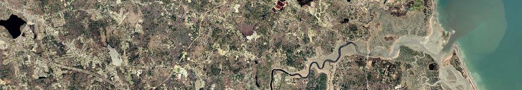
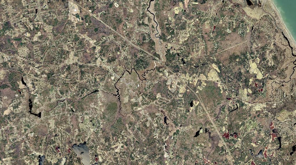
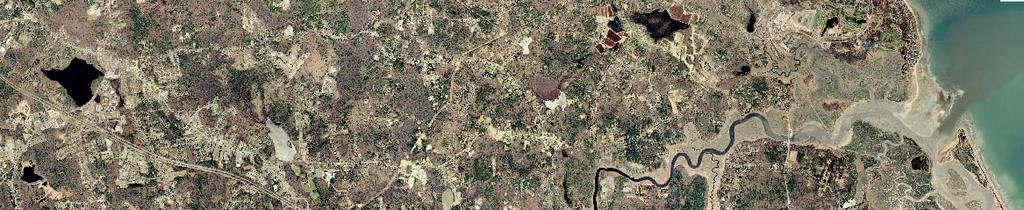
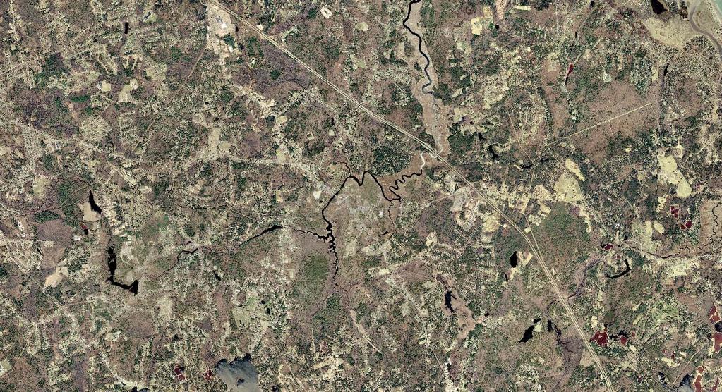
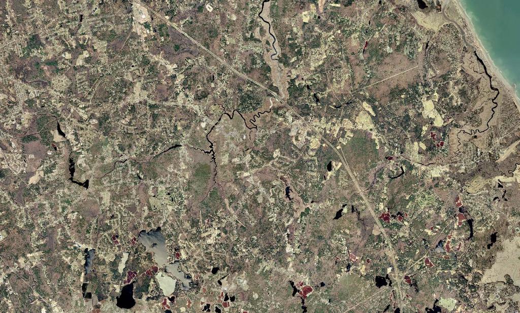
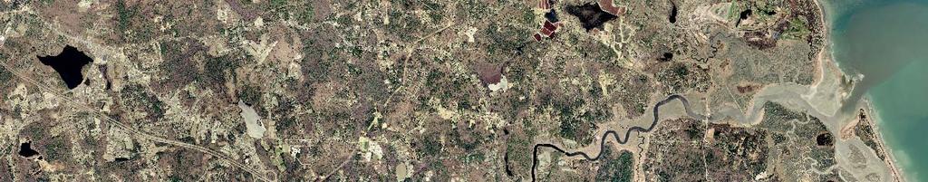
6 Introduction The North River Corridor is a special place in Southeastern Massachusetts. Located 20 miles south of Boston, the North River flows through the towns of Marshfield, Scituate, Norwell, Pembroke, and Hanover (Figure 1). A rural presence is still prevalent along the river even though it is surrounded by suburban sprawl. Its designation as the only protected scenic river under the Commonwealth s Scenic Rivers Protection Act affords the river some protection. Under the act, a 300-foot corridor is regulated by the North River Commission that oversees development in the corridor. In addition, the river was given federal recognition by the National Park System as a fine example of a coastal estuary with freshwater tidal habitat under the National Natural Landmark program. And recently, The Nature Conservancy has designated the North River as one of its priority rivers in Massachusetts as it contains one of the largest freshwater tidal systems in the state. The anticipation of the revival of the Greenbush Commuter rail line combined with a strong economy has contributed to the expanding sprawl south of Boston. All of these factors pose a direct threat to many of the unique natural resources along the North River. Now, more than ever, it is important to protect it. The in the North River Corridor project concept originated from a mapping project prepared by Brian Reid of the Wildlands Trust of Southeastern Massachusetts for the Herring Brook valley in the upper reaches of the North River. This project identified parcels and natural habitats on a 100+ acre parcel being considered for acquisition by the Wildlands Trust of Southeastern Massachusetts. Though done by hand, this map provided a valuable tool for looking at the relationship between property boundaries and natural resources in order to determine which properties were most important for protecting. in the North River Corridor incorporated this idea and expanded it to the parcels along North River. The project produced a base map in digital form showing individual parcels in relationship to natural resources. This has been accomplished using GIS or Geographical Information Systems. The use of GIS as a tool allows digital maps and databases to be combined and analyzed. One can then identify a parcel s land use (developed or undeveloped), owner s name and address, acreage, and other relevant information from the assessors data. Natural resources data can then be overlaid onto digitized parcels to show the relationship between the parcels and the natural resources. Incorporating natural resource data with parcel data allows querying for established criteria in order to assess the priority of a particular parcel for protection. The goal of the project is to identify and prioritize parcels important for maintaining a rich biodiversity environment along the North River corridor and to work with land trusts who already protect land in the North River Corridor to evaluate which entity is best suited for protecting these important lands. Since the North and South Rivers Watershed Association (NSRWA) is not in the business of owning land, a partnership was formed with three land trusts: The Trustees of Reservation, Mass Audubon, and Wildlands of Southeastern Massachusetts. The Division of Wildlife and Fisheries Riverways Program and the Trustees of the Reservation provided partial funding for this project. (6)
7 Phase I Preparation of the Base Map The first phase of the project produced a digitized parcel map of all parcels along the North River from the first major road to the river s edge. The parcels layer incorporated data from the assessors records including owner, address, parcel acreage, map and lot number and assessed value of the property. The natural resources and protected open space were also incorporated into the first phase of the mapping project. All of these data layers were overlaid onto an aerial photograph showing the features of the landscape. Methodology The study area for the project included all the parcels in the Towns of Scituate, Marshfield, Norwell, Pembroke and Hanover along the North River in an area defined by the first major road from the river s edge (Figure 1). The major roads included: Scituate: Driftway and Route 123 Norwell: Route 123, Dover St. and River St. Hanover: Broadway, Elm St. Pembroke: W. Elm St., Oldham St., Center St., Barker St., Washington St., Water St., Church St. Marshfield: Union St., Highland St., Spring St., Summer St., Damon s Point Digital parcel data represents the property boundaries of land ownership. Digital parcel data was available in Scituate and Norwell only. Parcel data for Pembroke, Hanover and Marshfield were digitized manually by Mapworks, Inc. In total approximately 2,350 parcels were produced in digital form. Parcel data was joined to the 2001 assessors data for each town in the corridor. Assessors data included information on map, block and lot, owner s name and address, parcel location, acreage and the land use code for each parcel. Land use code was queried to determine developed, undeveloped, potentially developed or undevelopable parcels. Lands held under Chapter 61 were also identified. (7)
8
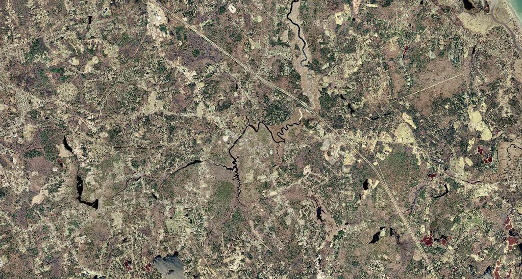
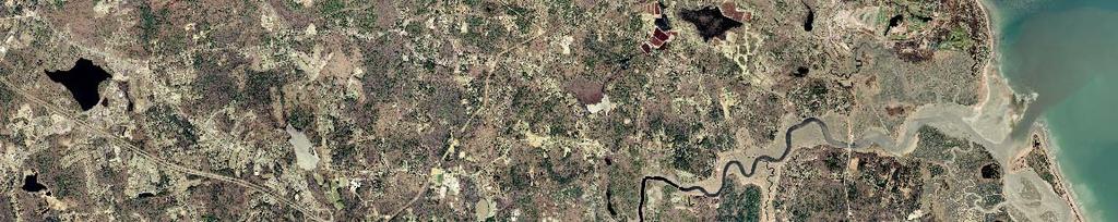
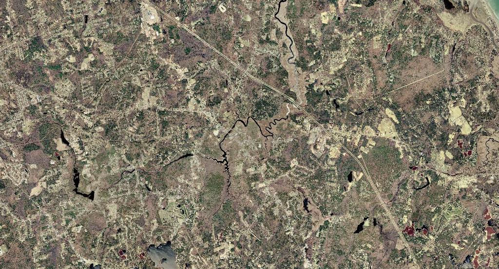
9 The major land use code categories the Assessors use are as follows: Table 1. Assessors Land Use Code Land Use Code Land Use 100 Residential 300 Commercial 400 Industrial 600 Forest Property - Chapter Agricultural/Horticultural Chapter 61A 800 Recreational Property Chapter 61B 900 Tax Exempt Property (Town Owned, Land Trust, Charities) Figure 2 shows digitized parcels overlaid on an aerial photograph of the North River valley. This aerial photography was flown in the year 2000 by the state and made available through MassGIS, the state s library of digital mapping resources. Natural resource maps, also available through MassGIS, were overlaid onto the study area. Figure 3 shows wetlands in the North River Corridor. An analysis of the wetlands demonstrates that there are approximately 3300 acres of wetlands in the corridor. Figure 4 shows rare and endangered species habitats and potential vernal pools from the Natural Heritage and Endangered Species Program (NHESP). Again, an analysis points out that there are 2797 acres of biocore habitat, primarily along the marsh of the North River, 1961 acres of priority habitat for rare and endangered species habitat and appoximately 24 potential vernal pools. An open space map of the North River Corridor was created by selecting Tax Exempt Property (Land Use Code 900). This land used code includes both private nonprofit lands, town-owned lands, lands owned by the state and federal government as wells as churches, schools, private schools, affordable housing and ball fields. Only a parcel-byparcel analysis would provide a true protected open space map. For this project the parcels owned by the town, the state, the federal government or land trust were considered protected open space. Town owned lands were then reviewed for their use and lands that were used for schools, affordable housing and ball fields were not considered protected open space. Those remaining town owned lands that are not developed are not necessarily protected, however they are considered protected open space in this project (figure 6). In addition to lands protected by ownership, parcels with existing conservation restrictions were also identified. Conservation restrictions or conservation easements, as they are often referred to, legally protect land from development permanently or for a stated period of time specified in an agreement with a conservation organization or town. These data are not tracked by the town assessors office. Conservation restriction data were obtained from the State s Division of Conservation Services. (9)
10

11
12

13
14 Phase II Analysis for Prioritizing Parcels for Protection The first phase of the project focused on creating a base map within the North River Corridor. The second phase of the project focused on prioritizing parcels for open space protection and identifying the most appropriate mechanism for pursuing these lands for protection. Methodology Protected open spaces, including lands with Conservation Restrictions, were removed prior to analyzing lands for future protection. The analysis for this project is done on a town-by-town basis because of the inconsistencies between each town s assessors databases. However consistent map layers were produced for each town reflecting the goals of the project. The Town of Norwell is shown below as an example of the methodology used. Town of Norwell Methodology A parcel map representing parcels greater than or equal to two acres was created. A twoacre threshold was used as criteria because Norwell has one acre zoning and thus any parcel greater than or equal to two acres has the potential to be subdivided. Parcels that were within 5% of the two-acre threshold were included in the analysis due to concerns regarding the accuracy of the area measurements for individual parcels. The query for 2 acres or more was: Query #1 Area > or = 1.90 acres (219 parcels) Two hundred and nineteen parcels remained that fit the criteria for greater than or equal to 2 acres. Parcels were then classified as developed or undeveloped. Developed lands are those that have existing structures and undeveloped lands have no structures. The classifications were defined by the relevant land use codes below: Table 2. Land Use Codes Definitions Classification Code Definition Developed Lands (existing structures) 101 Residential Single Family 109 Residential Multi-Family Undeveloped Lands (no structures) 130 Developable Land 131 Potentially Developable Land 132 Undevelopable Land (14)
15 These two categories, developed and undeveloped, ultimately were used to determine which parcels may be protected either through a conservation restriction or better protected through acquisition or other means. Developed parcels (those with some existing structures on it) that are greater than or equal to 2 acres were classified as parcels with the potential for conservation restrictions. Parcels that were undeveloped, undevelopable or potentially developable and greater than 2 acres were determined to be potential parcels for acquisition. Undevelopable lands were considered potentially developable to be conservative because regulations may change in the future. These lands must be examined on a parcel-by-parcel basis before ruling them as undevelopable. The 2 queries to determine the developed lands and the undeveloped lands are as follows: Undeveloped parcels: Query #2 Land use Code = 130, 131 or 132 (39 parcels) Developed parcels: Query #3 Land use Code = 101 or 109 (145 parcels) Identifying Priority Parcels Criteria were developed to prioritize parcels for protection. The criteria are as follows: 1) Parcel abuts the river 2) Parcel abuts Priority Habitat for Rare and Endangered Species, Biocore habitat, and potential vernal pools as defined by Natural Heritage for Endangered Species Program (NHESP) 3) Parcel is greater than or equal to 5 acres 4) Parcel abuts protected open space and/or conservation restricted lands A weighted analysis was used to determine the priority of a given parcel for protection either through acquisition or conservation restriction. A value of one was assigned to each criteria specified. The summation of values reflects the importance of protecting that parcel. For example, if a parcel meets 2 of the four criteria its summary value is 2 and would be given medium weight, those that meet all criteria would have a value of 4 and would be given the highest priority. (15)
16 The following are the priority values: Highest Priority 4 High Priority 3 Priority 2 Low Priority 1 Lowest Priority 0 Once the analysis was performed and the parcels ranked according to the importance of protection, a graduated color scheme was assigned to the parcels with darkest color being the highest priority and the lightest being the least (see Appendix A) Chapter 61 Lands Chapter 61 lands were considered separately for this project. Chapter 61 lands are voluntarily maintained for forestry, agriculture/horticulture or recreation uses. The lands are assessed lower to give property tax relief to the owner and each town has the right of first refusal to purchase the land when the landowner decides to sell. If the town decides to purchase the Chapter 61 land, the landowner does not have to reimburse the town for back taxes at the normal assessed values. This is incentive for the landowner to sell to the town. The query for these parcels is: Query #4 Land use Code > 600 or < 899 (3 parcels) A weighted analysis using the same criteria as above was used to prioritize Chapter 61 lands as well (see Appendix A). (16)
17 Results The results of this project show total acreage of existing open space in the North River Corridor by town and prioritizes the potential for protecting open space through acquisition or conservation restriction. In addition, Chapter 61 lands were identified. Table 3. Total Acreage of Existing Protected Open Space and % Protected Open Space by Town and for the North River Corridor Town Total Corridor (Acres) Existing Protected Open Space (Acres) % Marshfield 2, % Pembroke 2, % Hanover % Norwell 2, % Scituate 1, % Total River Corridor 8,288 2,860 35% It is interesting to note that the percentage of protected open space is roughly the same for each town (31% average) except for Scituate, which has 55% of its total acreage as protected open space. It should be noted that a large portion of open space in Scituate are large parcels of tidal marsh at the mouth of the North River. (17)
18 Figure 6. Percentage of Acres by Town in the Corridor Percentage of Acres by Town Scituate 13% Marshfield 29% Norwell 25% Hanover 4% 29% Pembroke Figure 6 shows the percentage of acreage by town in relationship to the whole corridor. Both Marshfield and Pembroke have the highest percentages followed by Norwell. (18)
19 Figure 7. Percentage of Existing Protected Open Space by Town Protected Open Space Acres by Town Scituate 21% Marshfield 25% Norwell 21% Hanover 4% Pembroke 29% Figure 7 represents the percentage of current protected open space by town. For example Marshfield has 25% of the total existing protected open space in the corridor. Table 4 represents the potential protected open space in acres and as a percentage of the total acres in that town. Again, Protected Open Space is defined as lands that have not been built upon. It also shows the potential conservation restrictions in acres and as a percentage of the total acres for each town. In addition, the assessed land vales are listed for each of the above categories by town. Conservation Restrictions land values will tend to be more as these lands have been developed. Also, potential protected open space lands include marsh and wetlands that have a significantly lower assessed value. (19)
20 Town Table 4. Potential Protected Open Space and Conservation Restrictions Acres by Town, Assessed Land Values and Percentage to Total Acreage in the River Corridor Total Corridor (Acres) Potential Protected Open Space (Acres) % Assessed Land Values (Dollars) Potential Conservation Restriction (Acres) % Assessed Land Values (Dollars) Marshfield 2, % $3,173, % $29,042,200 Pembroke 2, % $2,319, % $12,566,650 Hanover % $712, % $4,189,600 Norwell 2, % $4,350,600 1,000 49% $36,707,100 Scituate 1, % $729, % $8,987,300 Total North River 8,288 1,171 14% $11,285,600 2,889 35% $91,492,850 (20)
21 Figure 8. Potential Protected Open Space By Town in the Corridor Potential Protected Open Space By Town (Undeveloped Lands) Norwell 29% Scituate 7% Marshfield 29% Hanover 2% Pembroke 33% (21)
22 Figure 9. Potential Conservation Restriction by Town Potential Conservation Restrictions by Town (Developed Lands) Scituate 6% Marshfield 29% Norwell 35% Hanover 4% Pembroke 26% The average cost per acre for potential protected open space is $9,638 and the average cost per acre for potential conservation restriction is $31,670. In reality conservation restrictions are not bought and sold so the assessed values are not applicable. However, a landowner may wish to subdivide the house from the remainder of the property. In this case he/she has the option of selling the house separately and keeping the remaining land as open space either to be sold or donated to a land trust or to place a conservation restriction on the land all of which would have significant tax benefits for the owner. Chapter 61 lands, as noted previously, were separated from the other analysis due to their unique characteristics and potential for acquisition. Chapter 61 lands are important to point out in protecting open space because they are usually large parcels (5 acres or more) and are given a tax relief status to keep the land active for forestry, agriculture/horticulture and recreation. Landowners must give the town first refusal for purchase when they decide to sell the land. (22)
23 Table 5. Chapter 61 Lands (Chap. 61, 61A, & 61B) by Town and Ranked by Priority. Town High Priority Medium Priority Low Priority Marshfield 84 acres 10 acres 100 acres 3 parcels 1 parcel 5 parcels $356,400 $3,100 $342,500 Pembroke 85 acres 12 acres 30 acres 4 parcels 1 parcel 8 parcels $22,320 $10,366 $522,983 Hanover N/A N/A N/A Norwell 8 acres 5 acres 17 acres 1 parcel 1 parcel 2 parcels $1,900 $425,600 $11,900 Scituate 42 acres 5 acres N/A 2 parcels 1 parcel N/A $119,900 $855,800 N/A North River Corridor 219 acres 32 acres 147 acres 10 parcels 4 parcels 15 parcels $480,520 $1,294,866 $877,383 Table 5. shows the acreage of Chapter 61 lands within the North River Corridor by town, # of parcels, assessed land values, and ranks them by high, medium or low priority for protection. There are 10 Chapter 61 parcels covering 219 acres with an assessed value of $480,520 that ranked as high priority in the weighted analysis. Both Marshfield and Pembroke have 3 and 4 parcels respectively covering over 80 acres in each town alone. This accounts for 70% of the high priority Chapter 61 parcels. Table 6 summarizes potential protected open space greater than 2 acres in the North River corridor by town, acreage, # of parcels, assessed land values and ranking for protection. (23)
24 Table 6. Potential Protected Open Space Ranking Town High Priority Medium Priority Low Priority Marshfield 248 acres 73 acres 24 acres 14 parcels 9 parcels 7 parcels $1,283,300 $1,153,300 $737,300 Pembroke 263 acres 93 acres 26 acres 29 parcels 22 parcels 8 parcels $1,036,200 $750,300 $532,900 Hanover 17 acres 6 acres N/A 2 parcels 3 parcels N/A $246,100 $466,400 N/A Norwell 178 acres 47 acres 110 acres 12 parcels 8 parcels 19 parcels $1,436,800 $588,800 $2,325,000 Scituate 40 acres 35 acres 11 acres 3 parcels 5 parcels 3 parcels $22,000 $651,200 $56,000 North River Corridor 746 acres 254 acres 171 acres 60 parcels 47parcels 37 parcels $4,024,400 $3,610,000 $3,651,200 There are 746 acres classified as high priority for potential protected open space. These 746 acres constitute 60 parcels, with each parcel averaging 12 acres and an average assessed value of $54,000 per acre. Over 47 parcels have a medium priority, covering 154 acres with an average parcel size of 5.4 acres and an averaged assessed value of just over $14,000. If both high and medium priority parcels were protected we could protect over 100 parcels totaling 1,000 acres with an average assessed value of $7,635 per acre. Parcels greater that 2 acres with the potential for conservation restriction are parcels with a structure on the property. Table 7 shows an analysis of these parcels summarizing acreage, # of parcels, assessed values and ranked as high, medium or low priority for protection Table 7. (24)
25 Table 7. Potential Conservation Restriction Parcels Ranked by Priority Town High Priority Medium Priority Low Priority Marshfield 205 acres 339 acres 296 acres 11 parcels 42 parcels 74 parcels $3,288,400 $10,932,800 $14,821,000 Pembroke 482 acres 103 acres 180 acres 37 parcels 21 parcels 60 parcels $4,606,000 $2,058,100 $5,902,550 Hanover 34 acres 35 acres 42 acres 2 parcels 5 parcels 13 parcels $508,400 $1,140,300 $2,540,900 Norwell 538 acres 153 acres 309 acres 20 parcels 22 parcels 103 parcels $5,603,000 $6,466,700 $24,637,400 Scituate 29 acres 35 acres 109 acres 2 parcels 9 parcels 30 parcels $870,900 $1,734,200 $6,382,200 North River Corridor 1288 acres 665 acres 936 acres 72 parcels 99 parcels 280 parcels $8,987,300 $22,332,100 $54,284,050 There are 1,288 acres that have a high priority for protection through use of a conservation restriction mechanism. It is interesting to note that most of these parcels abut the North River. The average parcel of high priority would be 18 acres and average cost would be $6,977 per acre. It is interesting to note that the total high priority assessed values is considerably less than the medium or low priority total assessed values. Larger parcels tend to be assessed for less per acre in general. (25)
26 Conclusion While the North River has been uniquely protected both through regulation and conservation, Protecting what Matters; in the North River Corridor identifies the potential for further protection of lands along the North River. Thirty five percent of the total land area of the North River Corridor is presently protected either owned outright by lands trusts and towns or through existing conservation restrictions. in the North River Corridor demonstrates that there is a potential to further protect another 1171 acres or 14% through acquisition and another 2889 acres or 35% through conservation restrictions. Focusing on just the high priority lands for acquisition, there is a potential to protect another 746 acres along the North River Corridor at an assessed property cost of approximately $4 million. This is an average of $5395 per acre. In addition, focusing on the high priority lands for conservation restrictions there is a potential to protect another 1288 acres at a cost of almost $9 million at an average cost of $6977 per acre. If one has to decide which high priority parcel should be protected a weighted decision should be given to lands abutting currently protected open space that is identified as priority habitat for rare and endangered species. These lands are the potential corridors for encouraging wildlife and biodiversity. There are approximately 2797 acres or almost 34% of the total acreage of these priority habitats in the North River Corridor. This is an unusually high percentage thus all the more reason to protect this unique natural heritage. Many priority parcels for protection identified in this project are protected under the state s Wetlands Protection Act. Each parcel must be evaluated accordingly. However, it is our belief that wetlands should be protected through ownership as well. The lessening of the wetlands protection laws in recent past has demonstrated that wetlands will not always be protected. It is unrealistic to think we can protect all the remaining undeveloped lands in the North River Corridor. Therefore we must prioritize what lands can be protected. This project is the essential first step in beginning the dialogue and framing the question of how much land can we protect and at what cost? The North and South Rivers Watershed Association would like to see this plan used as the foundation for valuating the parcels identified through this study. This report lays out a framework for protection in a systematic way. It is our goal to bring this project to the attention of those who are able to facilitate the process of protecting priority lands such as the land trusts whom we have partnered with and other potential partners such as The Nature Conservancy and the Trust for Public Land. We will make presentations to the Community Preservation Committees in each of the towns in the river corridor. Based on the criteria of each land trust, we will establish which lands are in the interest of which land trust or town. Ultimately, land trusts and (26)
27 towns will need to actively pursue property owners. One way to make contact with owners is to hold an informational workshop on the financial benefits of conserving land as well as contributing to the legacy of our unique natural heritage. Another goal is to work with towns in helping them empower ways to protect open space. One way is to facilitate the process of updating open space plans. Another way is to make sure towns have properly identified and recorded by deed which town owned lands are protected under the Commonwealth s article 97. Lands protected under this article can only be used for other purposes other than conservation or recreation if there is a two thirds major vote at town meeting and in the Legislature. Time is of the essence. Since this project was started over a year and a half ago several large parcels along the river have been purchased for development including a parcel in Marshfield being developed under the state s Chapter 40B regulations that supersedes local bylaws. This parcel contains the important criteria for protection as presented in this project: it abuts existing open space, has rare and endangered species habitat, directly abuts the river and is greater than 5 acres (17 acres). Time was not on our side for this parcel. These high priority lands must be protected as soon as possible. (27)

28
29

30
IRS FORM 8283 SUPPLEMENTAL STATEMENT DONATION OF CONSERVATION EASEMENT
 Name(s) shown on income tax return Identifying Number Robert T. Landowner 021-34-1234 Susan B. Landowner 083-23-5555 IRS FORM 8283 SUPPLEMENTAL STATEMENT DONATION OF CONSERVATION EASEMENT On November 12,
2018 Highlands Region Land Preservation Status Report
 2018 Highlands Region Land Preservation Status Report Highlands Development Credit (HDC) properties (l to r): Tewksbury Township, Hunterdon County; Mount Olive, Morris County; Independence Township, Warren
Kent Land Trust Strategic Reassessment Project Final Report
 Kent Land Trust Strategic Reassessment Project Final Report Prepared For: Connecticut Institute for Resilience and Climate Adaptation (CIRCA) Prepared by: Michael A. Benjamin, Land Steward, Kent Land Trust
2016 Highlands Region Land Preservation Status Report
 State of New Jersey Highlands Water Protection and Planning Council 100 North Road (Route 513) Chester, New Jersey 07930-2322 (908) 879-6737 (908) 879-4205 (fax) www.nj.gov/njhighlands 2016 Highlands Region
Notice of Continuance Land Classified as Current Use or Forest Land Chapter and Revised Code of Washington
 When Recorded Return to: Cowlitz County Assessor s Office Attn: Forest Land / Current Use Dept 207 N 4 th Avenue Kelso WA 98626 Notice of Continuance Land Classified as Current Use or Forest Land Chapter
Notice of Continuance Land Classified as Current Use or Forest Land RCW Chapter and 84.33
 When Recorded Return to: Notice of Continuance Land Classified as Current Use or Forest Land RCW Chapter 84.34 and 84.33 Grantor(s)/Sellers: Grantee(s)/Buyers: Mailing Address: City, State, Zip: Assessor
PROJECT SCORING GUIDANCE. Introduction: National Proiect Selection:
 FOREST LEGACY PROGRAM PROJECT SCORING GUIDANCE Introduction: This document provides guidance to the National Review Panel on how to score individual Forest Legacy Program (FLP) projects, including additional
COMMUNITY PRESERVATION ACT Town of Hatfield OPEN SPACE PROJECT GUIDELINES
 COMMUNITY PRESERVATION ACT Town of Hatfield OPEN SPACE PROJECT GUIDELINES CPA Open Space Projects: The Act requires that a participating community shall spend, or set aside for later spending, not less
OPEN SPACE PRESERVATION. Reflections on the Value of Acquiring Property for Preservation Purposes
 OPEN SPACE PRESERVATION Reflections on the Value of Acquiring Property for Preservation Purposes What is open space and what does it do? The Town Plan of Conservation and Development defines it as follows:
NANTUCKET ISLANDS LAND BANK AFFORDABLE HOUSING POLICY Adopted by the vote of the Land Bank Commission on November 10, 2015
 NANTUCKET ISLANDS LAND BANK AFFORDABLE HOUSING POLICY Adopted by the vote of the Land Bank Commission on November 10, 2015 In recent history, the island of Nantucket has experienced a shortage of affordable,
PROJECT NARRATIVE FOR BRIDGEWATER CPA APPLICATION 10/5/11 (Revised per 10/6/11 CPC Vote) CALTHROP TRUST C.61A LAND ACQUISITION PROJECT PROPOSAL 1) WHA
 CALTHROP TRUST C.61A LAND ACQUISITION PROJECT PROPOSAL 1) WHA") PROJECT NARRATIVE FOR BRIDGEWATER CPA APPLICATION 10/5/11 (Revised per 10/6/11 CPC Vote) CALTHROP TRUST C.61A LAND ACQUISITION PROJECT PROPOSAL 1) WHAT IS THE PURPOSE AND SCOPE OF THE PROJECT? The project
PROJECT NARRATIVE FOR BRIDGEWATER CPA APPLICATION 10/5/11 (Revised per 10/6/11 CPC Vote) CALTHROP TRUST C.61A LAND ACQUISITION PROJECT PROPOSAL 1) WHAT IS THE PURPOSE AND SCOPE OF THE PROJECT? The project
Remains eligible for state or federal farm programs. Can use land as collateral for loans. Can reserve home lots for children
 December 2002 B-1132 Conservation Easements: An Introductory Review for Wyoming By Allison Perrigo and Jon Iversen, William D. Ruckelshaus Institute of Environment and Natural Resources William D. Ruckelshaus
OPEN SPACE & RECREATION PLAN
 OPEN SPACE & RECREATION PLAN HOPEWELL TOWNSHIP Cumberland County, New Jersey Prepared by: Hopewell Township Environmental Commission Final October 2011 (THIS PAGE INTENTIONALLY LEFT BLANK) PUBLIC MEETINGS
TOWN OF PELHAM, NEW HAMPSHIRE
 TOWN OF PELHAM, NEW HAMPSHIRE BUILDOUT ANALYSIS Prepared for the PELHAM CONSERVATION COMMISSION with the assistance of the NASHUA REGIONAL PLANNING COMMISSION TABLE OF CONTENTS I. INTRODUCTION...1 II.
TOWN OF MIDDLEBOROUGH COMMUNITY PRESERVATION PLAN
 TOWN OF MIDDLEBOROUGH COMMUNITY PRESERVATION PLAN Vision The residents of Middleborough desire a community which is family-oriented and which retains its small town character while preserving an abundance
ZEKIAH WATERSHED RURAL LEGACY AREA
 ZEKIAH WATERSHED RURAL LEGACY AREA GRANT AWARDS AND ACRES PRESERVED Since 1998, the County has received 8 grant awards totaling $9.4 million. With those funds, 2,328 acres have been protected on 18 properties.
Conservation Easements: Creating a Conservation Legacy for Private Property
 Conservation Easements: Creating a Conservation Legacy for Private Property What is a Conservation Easement? For landowners who want to conserve their land and yet keep it in private ownership and use,
ALREADY SUBMITTED FOR HIGHLANDS COUNCIL PRE
 Highlands Preservation Area Approval Application Checklist Items Block 15901 Lot 1, West Milford See Highlands Council Review at: http://www.highlands.state.nj.us/njhighlands/projectreview/ **For advisory
Please review the Draft PTF Grant Manual with the above background information in mind. AGC
 Board of Trustees Anna G. Chisholm, PTF Program Administrator 3.15.2017 Proposed Updates to the PTF Grant Manual The PTF Grant Manual was last updated in 2006 and many details of the easement process have
Before the meeting starts: Please circle the area your land trust works on the wall poster and note the land trust name
 Before the meeting starts: Please circle the area your land trust works on the wall poster and note the land trust name GIS in land conservation. Brian Hall brianhallconservation@gmail.com 10/3/2017 What
UNOFFICIAL COPY OF HOUSE BILL 1272 A BILL ENTITLED
 UNOFFICIAL COPY OF HOUSE BILL 1272 M4 6lr0525 By: Delegates Smigiel, Kelley, Rosenberg, and Sossi Introduced and read first time: February 10, 2006 Assigned to: Environmental Matters 1 AN ACT concerning
DESCRIPTION OF A LAND TRUST
 DESCRIPTION OF A LAND TRUST What is a land trust? Land trusts are non-profit organizations that work hand-in-hand with landowners to protect our valuable natural resources. Land trusts have become increasingly
BROCHURE # 37 OPEN SPACE
 BROCHURE # 37 OPEN SPACE The information and instructions in this publication are to be used when applying for assessment on the basis of current use under the open space laws, chapter 84.34 RCW and chapter
Chapter VIII. Conservation Easements: Valuing Property Subject to a Qualified Conservation Contribution
 A. Overview and Purpose Chap. VIII Conservation Easements: Valuing... Jacobson & Becker 91 Chapter VIII Conservation Easements: Valuing Property Subject to a Qualified Conservation Contribution Forest
CITY OF MEDFORD COMPREHENSIVE PLAN BUILDABLE LAND INVENTORY
 CITY OF MEDFORD COMPREHENSIVE PLAN PREPARED BY CITY OF MEDFORD PLANNING DEPARTMENT 200 SOUTH IVY STREET MEDFORD, OREGON 97501 BIANCA PETROU, A.I.C.P., ACTING PLANNING DIRECTOR LONG RANGE PLANNING SECTION
BUILD-OUT ANALYSIS GRANTHAM, NEW HAMPSHIRE
 BUILD-OUT ANALYSIS GRANTHAM, NEW HAMPSHIRE A Determination of the Maximum Amount of Future Residential Development Possible Under Current Land Use Regulations Prepared for the Town of Grantham by Upper
CHAPTER 12. BE IT ENACTED by the Senate and General Assembly of the State of New Jersey:
 CHAPTER 12 AN ACT concerning the constitutional dedication of corporation business tax revenues for certain environmental purposes, supplementing Title 13 of the Revised Statutes, and amending P.L.1999,
Innovative Local Government Land Conservation Techniques
 Innovative Local Government Land Conservation Techniques Three new successful land conservation programs used in Maryland by Baltimore and Carroll Counties are worthy of further examination. Baltimore
Title 5: ADMINISTRATIVE PROCEDURES AND SERVICES
 Title 5: ADMINISTRATIVE PROCEDURES AND SERVICES Chapter 353: LAND FOR MAINE'S FUTURE Table of Contents Part 15-A. LAND FOR MAINE'S FUTURE... Section 6200. FINDINGS... 3 Section 6201. DEFINITIONS... 3 Section
TOWN OF BROOKLINE, NEW HAMPSHIRE
 TOWN OF BROOKLINE, NEW HAMPSHIRE BUILDOUT ANALYSIS DECEMBER, 2003 Prepared by the Nashua Regional Planning Commission TABLE OF CONTENTS Introduction... 1 I. Methodology... 1 A. PARCEL REVIEW... 1 B. DEVELOPMENT
STATE OF OHIO FINANCIAL REPORTING APPROACH GASB 34 IMPLEMENTATION ISSUES TRANSPORTATION INFRASTRUCTURE
 TRANSPORTATION INFRASTRUCTURE GASB 34 Reporting Requirements (Paragraphs 19 through 26) Paragraph 19 includes infrastructure assets in the definition of capital assets. Infrastructure assets are defined
CHAPTER 2 VACANT AND REDEVELOPABLE LAND INVENTORY
 CHAPTER 2 VACANT AND REDEVELOPABLE LAND INVENTORY CHAPTER 2: VACANT AND REDEVELOPABLE LAND INVENTORY INTRODUCTION One of the initial tasks of the Regional Land Use Study was to evaluate whether there is
LEGISLATIVE PURPOSES. 2. Provide sources of agricultural products within the state for the citizens of the state
 LEGISLATIVE PURPOSES 1. Assist in sustaining the farming community 2. Provide sources of agricultural products within the state for the citizens of the state 3. Control the urban expansion which is consuming
TERRA. Forest CORE Fund Project Application. Applicant Information Applicant Partner Organization Contact Person
 TERRA Forest CORE Fund Project Application Applicant Information Applicant Partner Organization Contact Person Phone Number Address Type of Applicant/ Partner Organization Title Email Address Federal State
Central Pennsylvania Conservancy Project Selection Criteria Form
 Central Pennsylvania Conservancy Project Selection Criteria Form The following criteria guide the actions of the Central Pennsylvania Conservancy s Land Protection Committee and Board of Directors in selecting
State of Washington Project Luke Rogers, University of Washington March 2010
 State of Washington Project Luke Rogers, University of Washington March 2010 Rural Technology Initiative (RTI) developed an online tutorial on how to use the Washington State Parcel and Forestland Databases
Community Preservation Act Answers To Frequently Asked Questions
 Community Preservation Act Answers To Frequently Asked Questions On September 14, 2000, former Governor Paul Cellucci and Lieutenant Governor Jane Swift signed the Community Preservation Act into law.
More than 2,300 acres.
 FUNDING LAND CONSERVATION PRESERVING LAND Northampton County Townships Find Formula That Works for Land Conservation Many rural townships, feeling the pressure to develop open space, want to be able to
Forest Service Role CHAPTER 2
 CHAPTER 2 Forest Service Role Implementation of the Management Plan charters a federal presence with an expanded focus beyond traditional Forest Service roles. In addition to administration of the National
Conservation Easement Stewardship
 Conservation Easements are effective tools to preserve significant natural, historical or cultural resources. Conservation Easement Stewardship Level of Service Standards March 2013 The mission of the
Transfer of Development Rights
 Ordinance Transfer of Development Rights King County s (WA) 2008 ordinance establishes a transfer of development rights program. The ordinance: Sets eligibility criteria for sending and receiving sites
Nova Scotia Community Lands Trust Discussion Paper. Approaches to Enable Community Participation In the Purchase of Land
 Nova Scotia Community Lands Trust Discussion Paper Approaches to Enable Community Participation In the Purchase of Land Objective Nova Scotians have expressed a desire to acquire and make use of lands
CHAPTER Committee Substitute for Committee Substitute for Senate Bill No. 2188
 CHAPTER 2004-372 Committee Substitute for Committee Substitute for Senate Bill No. 2188 An act relating to land development; amending s. 197.502, F.S.; providing for the issuance of an escheatment tax
Preserving the Avon Hills Landscape: Phase 2 Funding provided by the Minnesota Environment and Natural Resources Trust Fund
 Preserving the Avon Hills Landscape: Phase 2 Funding provided by the Minnesota Environment and Natural Resources Trust Fund In cooperation with: 2012-2016 Project Funded for $778,000 Preserving the Avon
Palmerton Area Comprehensive Plan
 DRAFT Palmerton Area Comprehensive Plan Bowmanstown Borough, Lower Towamensing Township, Palmerton Borough and Towamensing Township Carbon County, Pennsylvania Draft - With Minor Revisions - March 2008
Environment and Natural Resources Trust Fund Request for Proposals (RFP)
") Environment and Natural Resources Trust Fund 2012-2013 Request for Proposals (RFP) Project Title: Southeast Minnesota Sensitive Habitat Protection Program (SHPP) ENRTF ID: 067-D Topic Area: D. Land Acquisition
Environment and Natural Resources Trust Fund 2012-2013 Request for Proposals (RFP) Project Title: Southeast Minnesota Sensitive Habitat Protection Program (SHPP) ENRTF ID: 067-D Topic Area: D. Land Acquisition
APPENDIX B COMPLIANCE WITH THE GOVERNMENT CODE
 APPENDIX B COMPLIANCE WITH THE GOVERNMENT CODE A. GENERAL PLAN AMENDMENT PROCEDURE In general, local governments may not amend any of the mandatory elements of the General Plan (e.g. Land Use, Open Space,
MITIGATION POLICY FOR DISTRICT-PROTECTED LANDS
 MITIGATION POLICY FOR DISTRICT-PROTECTED LANDS Approved by the District Board of Directors on July 18, 2017 The following Mitigation Policy is intended to inform the evaluation of environmental mitigation-related
11/11/2014. Takeaways. Making the Most of Provincial Tax Incentive Programs. Provincial Property Tax Incentive Programs
 Making the Most of Provincial Tax Incentive Programs Fiona McKay, Ministry of Natural Resources and Forestry Ontario Land Trust Alliance Gathering October 24, 2014 TIPs and Tools Takeaways What provincial
OPEN-SPACE CONVERSION REQUEST
 OPEN-SPACE CONVERSION REQUEST Applicant: Board Meeting: February 9, 2017 Landowner: Normandy Capital, LLC VOF Easement: BAT-03678 Table of Contents: Cover Page 1 Table of Contents 2 Application Overview
Land Acquisition - Florida Forever Mid-Term Review
 Land Acquisition - Florida Forever Mid-Term Review Report Number 2006-120 November 2005 Prepared for The Florida Senate Prepared by Committee on Environmental Preservation Table of Contents Summary 1 Background
Gold Beach Buildable Lands Analysis
 Gold Beach Buildable Lands Analysis Final Report Submitted to: City of Gold Beach Prepared by: Community Planning Workshop Community Service Center 1209 University of Oregon Eugene, OR 97403-1209 http://darkwing.uoregon.edu/~cpw
Greene Land Trust. Balancing Sound Development and Effective Conservation
 Balancing Sound Development and Effective Conservation Comprehensive Approach The is dedicated to protecting the many places that make Greene County such a special place: Scenic vistas that inspired the
Affordable Housing and Open Space: Creative Partnerships for Success. Citizens Housing and Planning Association
 Affordable Housing and Open Space: Creative Partnerships for Success Citizens Housing and Planning Association Dual Crisis Between 1985 and 1999, 40 acres/day were lost to development in Massachusetts.
LAND USE Inventory and Analysis
 LAND USE Inventory and Analysis The land use section is one of the most important components of the comprehensive plan as it identifies the location and amount of land available and suitable for particular
Hennepin County Economic Analysis Executive Summary
 Hennepin County Economic Analysis Executive Summary Embrace Open Space commissioned an economic study of home values in Hennepin County to quantify the financial impact of proximity to open spaces on the
Baseline Documentation Report
 Test Conservation Restriction TOP-AA Topsfield, MA Baseline Documentation Report Grantor: Ms. Beatrice Test Baseline Report Inspection Date: 1/14/2018 Conservation Restriction Recorded: 1/28/2018 Prepared
Conservation Options for Private Landowners
 Conservation Options for Private Landowners What You Can Do to Help Protect the Nature of Massachusetts The Need for Conservation Massachusetts is blessed with a rich and varied landscape. Our hills, river
LIVING LANDS BIODIVERSITY GRANTS: INFORMATION AND APPLICATION. Due: January 16, 2009
 LIVING LANDS BIODIVERSITY GRANTS: INFORMATION AND APPLICATION Due: January 16, 2009 PURPOSE OF LIVING LANDS PROJECT Defenders of Wildlife s Living Lands project provides financial, technical and educational
Working Together to Conserve Land
 Working Together to Conserve Land A Resource for Landowners Protecting land for future generations About Loon Echo was formed as a 501(c)(3)nonprofit organization in 1987 to preserve land in the northern
Middle Peninsula Conservation Corridor Plan
 Middle Peninsula Conservation Corridor Plan Middle Peninsula Planning District Commission 2010 As population within the Middle Peninsula rises, conservation corridor planning provides an option for localities
State Incentive-Based Growth Management Laws
 Search Results State Incentive-Based Growth Management Laws Arizona 2000 House Bill 2060 Chapter 267) Authorizes taxpayers and corporations to include the amount deducted for conveying ownership or development
Open Space. Introduction. Vision. Defining Open Space. Midway City 2017 General Plan
 Open Space Midway City 2017 General Plan Introduction The importance of preserving open space to meet the goals and objectives of the General Plan cannot be overstated. Indeed, references to preserving
PROTECTING THE CHESAPEAKE BAY WATERSHED. C. Ronald Franks Audrey Scott
 MARYLAND S LAND CONSERVATION PROGRAMS PROTECTING THE CHESAPEAKE BAY WATERSHED Robert L. Ehrlich, Jr. Governor Department of Agriculture Lewis R. Riley Secretary Michael S. Steele Lt. Governor Department
TROUBLESHOOTING YOUR CAMA DATA WITH GIS
 Chad Rupert Office of Information Technology Outreach Services (ITOS) University of Georgia Athens, GA 30602-5418 Ph: 706-542-5308 Email: rupert@itos.uga.edu Jimmy Nolan Office of Information Technology
RARITAN TOWNSHIP OPEN SPACE PLAN. Table 1. Public and Non-Profit Owned Parkland/Open Space as of 1/7/18. Ownership Acres Sq. Mi. %
 RARITAN TOWNSHIP OPEN SPACE PLAN I. Existing Raritan Township Parkland/Open Space There are currently 2,436 acres of parkland/open space in Raritan Township including lands owned by the State, Hunterdon
STAFF REPORT. Permit Number: Porter. Kitsap County Board of Commissioners; Kitsap County Planning Commission
 STAFF REPORT Permit Number: 15 00461 Porter DATE: November 9, 2015 TO: FROM: Kitsap County Board of Commissioners; Kitsap County Planning Commission Katrina Knutson, AICP, Senior Planner, DCD and Jeff
Conservation tax credits. a landowner s guide. conservation resource center Tax Credit Exchange
 Conservation tax credits a landowner s guide conservation resource center Tax Credit Exchange The Conservation Resource Center Tax Credit Exchange 820 Pearl Street, Suite F Boulder, CO 80302 ph: 303.544.1044
Guide to Financial Resources For Land Conservation in the Highlands Region
 Guide to Financial Resources For Land Conservation in the Highlands Region Introduction By Wendy Sweetser and Charlie Wyman Many of us have had the experience: we hear from a friend that a favorite farm
Burlington Unincorporated Community Plan
 Burlington Unincorporated Community Plan June 30, 2010 Meeting Page 1 of 24 Table of Contents (Page numbers to be inserted) I. Background a. Location and Community Description b. Planning of Unincorporated
Land Conservation Options
 The Highland Communities Initiative (HCI) is a program of The Trustees of Reservations that promotes land conservation and community preservation in rural western Massachusetts. HCI encourages local efforts
General Development Plan Background Report on Agricultural Land Preservation
 General Development Plan 2008 Background Report on Agricultural Land Preservation February 2008 I. Introduction Anne Arundel County has been an agricultural community for over 350 years, beginning with
Claudia Stuart, Williamson Act Program Manager and Nick Hernandez, Planning Intern
 Land Conservation (Williamson) Act Advisory Committee STAFF REPORT September 15, 2014 Prepared by: Claudia Stuart, Williamson Act Program Manager and Nick Hernandez, Planning Intern Subject: Discussion:
Implementation of Permanent Easements and Associated Nutrient Load Reductions
 1 Minnesota Nutrient Reduction Strategy Agricultural Sector/BWSR RIM Program Measure Implementation of Permanent and Associated Nutrient Load Reductions Measure Background Visual Depiction The map in Figure
[First Reprint] SENATE, No STATE OF NEW JERSEY. 218th LEGISLATURE INTRODUCED SEPTEMBER 17, 2018
![[First Reprint] SENATE, No STATE OF NEW JERSEY. 218th LEGISLATURE INTRODUCED SEPTEMBER 17, 2018](/thumbs/95/123516904.jpg "[First Reprint] SENATE, No STATE OF NEW JERSEY. 218th LEGISLATURE INTRODUCED SEPTEMBER 17, 2018") [First Reprint] SENATE, No. 0 STATE OF NEW JERSEY th LEGISLATURE INTRODUCED SEPTEMBER, 0 Sponsored by: Senator BOB SMITH District (Middlesex and Somerset) Senator CHRISTOPHER "KIP" BATEMAN District (Hunterdon,
[First Reprint] SENATE, No. 0 STATE OF NEW JERSEY th LEGISLATURE INTRODUCED SEPTEMBER, 0 Sponsored by: Senator BOB SMITH District (Middlesex and Somerset) Senator CHRISTOPHER "KIP" BATEMAN District (Hunterdon,
Using Easements to Conserve Biodiversity. Jeff Lerner Defenders of Wildlife
 Using Easements to Conserve Biodiversity Jeff Lerner Defenders of Wildlife jlerner@defenders.org Northeast LTA June 10, 2006 Defenders of Wildlife Mission: to protect native wild animals and plants in
Chestnut Street and Eliot Street
 BASELINE DOCUMENTATION REPORT and LAND MANAGEMENT PLAN Massachusetts Executive Office of Energy and Environmental Affairs Local Acquisitions for Natural Diversity (LAND) Grant Program Property name: Warren
Understanding the Cost to Provide Community Services in the Town of Holland, La Crosse County, Wisconsin
 Understanding the Cost to Provide Community Services in the Town of Holland, La Crosse County, Wisconsin Rebecca Roberts Land Use Specialist Center for Land Use Education and Karl Green Community Development
Chapter XX Purchase of Development Rights Program
 Chapter XX Purchase of Development Rights Program Short Title. This ordinance is to be known and may be cited as the Purchase of Development Rights ( PDR ) Program. Purpose Pursuant to the authority granted
Lessard Sams Outdoor Heritage Council
 Lessard Sams Outdoor Heritage Council MEMO: Agenda Item # 10 DATE: December 11, 2014 SUBJECT: PRESENTER: 2015 Legislative Appropriation Recommendation Bill Heather Koop, LSOHC staff Background: On October
Martin Correctional Institution and Work Camp
 A Conceptual Land Use Plan for Martin Correctional Institution and Work Camp Martin County, Florida 2009-2019 Florida Department of Corrections Land Management Section, Bureau of Procurement and Supply
Instructions: Script:
 Before the course, select four of the 11 tool topics to insert into the presentation, including at least one tool from each of the three goal categories. Replace each tool placeholder slide with the slides
Attachment 1 R BACKGROUND REPORT
 BACKGROUND REPORT Attachment 1 R16-310 The Board is asked to consider authorizing the Interim County Administrator to execute deeds of conveyance for the acquisition of Tax Map Parcel Nos. 47-39, 47-39B,
2014 Plan of Conservation and Development
 The Town of Hebron Section 1 2014 Plan of Conservation and Development Community Profile Introduction (Final: 8/29/13) The Community Profile section of the Plan of Conservation and Development is intended
County of Sonoma Agenda Item Summary Report
 County of Sonoma Agenda Item Summary Report Agenda Item Number: 32 (This Section for use by Cler of the Board Only. Cler of the Board 575 Administration Drive Santa Rosa, CA 95403 To: The Sonoma County
Open Space Taxation Act
 Open Space Taxation Act WASHINGTON STATE DEPARTMENT OF REVENUE JUNE 2007 The information and instructions in this brochure are to be used when applying for assessment on the basis of current use under
Natural Resources Assistance Council DISTRICT 12 - LUCAS COUNTY, OHIO
 Natural Resources Assistance Council DISTRICT 12 - LUCAS COUNTY, OHIO Program Eligibility Application Information Sheet Any local political subdivision or any non-profit organization within District 12
PENINSULA TOWNSHIP DONATION of DEVELOPMENT RIGHTS ORDINANCE (DDR, No. 45)
") PENINSULA TOWNSHIP DONATION of DEVELOPMENT RIGHTS ORDINANCE (DDR, No. 45) THE TOWNSHIP OF PENINSULA, GRAND TRAVERSE COUNTY, MICHIGAN ORDAINS: Section 101 General Provisions A. Title: This Ordinance shall
PENINSULA TOWNSHIP DONATION of DEVELOPMENT RIGHTS ORDINANCE (DDR, No. 45) THE TOWNSHIP OF PENINSULA, GRAND TRAVERSE COUNTY, MICHIGAN ORDAINS: Section 101 General Provisions A. Title: This Ordinance shall
COASTAL CONSERVANCY. Staff Recommendation January 18, Carmel River Parkway Acquisitions. File No Project Manager: Trish Chapman
 COASTAL CONSERVANCY Staff Recommendation January 18, 2006 Carmel River Parkway Acquisitions File No. 06-104 Project Manager: Trish Chapman RECOMMENDED ACTION: Authorization to disburse up to $3,500,000
Chapter 52 FARMLAND AND OPEN SPACE PRESERVATION
 Chapter 52 FARMLAND AND OPEN SPACE PRESERVATION [HISTORY: Adopted by the Town Board of the Town of Troy 10-11-1999 by Ord. No. 99-2. Amendments noted where applicable.] GENERAL REFERENCES Building construction
Flexibility in the Law: Reengineering of Zoning to Prevent Fragmented Landscapes
 Pace University DigitalCommons@Pace Pace Law Faculty Publications School of Law 2-18-1998 Flexibility in the Law: Reengineering of Zoning to Prevent Fragmented Landscapes John R. Nolon Elisabeth Haub School
Siskiyou Land Trust. Strategic Plan Update
 Siskiyou Land Trust Strategic Plan Update 2018-2023 Issued by the Board of Directors of Siskiyou Land Trust, May 2018 Our Mission: The Siskiyou Land Trust is dedicated to long-term stewardship of agricultural,
SOLAR MASSACHUSETTS RENEWABLE TARGET PROGRAM (225 CMR 20.00) GUIDELINE
 GUIDELINE") Commonwealth of Massachusetts Executive Office of Energy and Environmental Affairs DEPARTMENT OF ENERGY RESOURCES SOLAR MASSACHUSETTS RENEWABLE TARGET PROGRAM (225 CMR 20.00) BACKGROUND AND PURPOSE GUIDELINE
Commonwealth of Massachusetts Executive Office of Energy and Environmental Affairs DEPARTMENT OF ENERGY RESOURCES SOLAR MASSACHUSETTS RENEWABLE TARGET PROGRAM (225 CMR 20.00) BACKGROUND AND PURPOSE GUIDELINE
The GIS Behind Dakota County s FARMLAND AND NATURAL AREAS PROGRAM
 The GIS Behind Dakota County s FARMLAND AND NATURAL AREAS PROGRAM The Farmland and Natural Areas Program is a voluntary program in which Dakota County and other partners work with willing landowners to
Torch Lake Township Antrim County, Michigan
 Torch Lake Township Antrim County, Michigan Farmland and Open Space Development Rights Ordinance Ordinance No. 04-01 Effective September 3, 2004 AN ORDINANCE creating a farmland and open space protection
Conservancy Mission. Leveraging GIS Technologies in Chesapeake Conservation and Restoration 10/17/2018
 Leveraging GIS Technologies in Chesapeake Conservation and Restoration Rachel Soobitsky Geospatial Project Manager Chesapeake Conservancy Conservation Innovation Center Kristin Kirkwood Executive Director
LAND USE ELEMENT PLAN
 LAND USE ELEMENT PLAN INTRODUCTION: LAND USE ELEMENT PLAN The 2012 Land Use Element Plan guides the direction of the County s planning efforts. It provides the primary direction for achieving the Master
Land Trust of Santa Cruz County. Strategic Plan. July 2012 to June This is a public version of a more detailed internal plan.
 Land Trust of Santa Cruz County Strategic Plan July 2012 to June 2015 This is a public version of a more detailed internal plan. Over the next three years the Land Trust will pursue four critical strategies.
A. General Information
 Important: When filling out forms on the computer, use only the tab key to move your cursor - do not use the return key. Massachusetts Department of Environmental Protection WPA Form 3 Notice of Intent
Density Transfer Credits. A workable approach to TDR for New Hampshire
 Density Transfer Credits A workable approach to TDR for New Hampshire Outline Why is DTC / TDR important for our future? What is DTC / TDR? Elements of a DTC program Implementing a DTC Program Development