CITY OF ATHENS, TENNESSEE MINIMUM SUBDIVISION REGULATIONS
|
|
|
- Gabriel Reed
- 5 years ago
- Views:
Transcription


1 CITY OF ATHENS, TENNESSEE MINIMUM SUBDIVISION REGULATIONS
2 MINIMUM SUBDIVISION REGULATIONS Athens, Tennessee Prepared for the City of Athens and the Athens Planning Region By the Athens Regional Planning Commission ATHENS MUNICIPAL REGIONAL PLANNING COMMISSION S. Thomas Hamilton, Chairman Eric Newberry Ralph Fenton, Vice Chairman Dick Pelley John Ray McKeehan Shane Jackson Kenny Charles, Secretary Revised December 1,
3 TABLE OF CONTENTS ARTICLE 1: - PREAMBLE AND ENACTMENT CLAUSE... 8 ARTICLE 2: - SHORT TITLE... 9 ARTICLE 3: - DEFINITION OF CERTAIN TERMS USED HEREIN ARTICLE 4: - PLATTING JURISDICTION, ENFORCEMENT AND PENALTIES FOR VIOLATION SECTION 41. PLATTING AUTHORITY SECTION 42. USE OF PLAT SECTION 43. ENFORCEMENT SECTION 44. OPENING AND IMPROVING PUBLIC STREETS (ROADS SECTION 45. ERECTION OF BUILDINGS SECTION 46. PENALTIES ARTICLE 5: - GENERAL REQUIREMENTS SECTION 51. NAME OF SUBDIVISION SECTION 52. ACCESS SECTION 53. PUBLIC USE AREAS SECTION 54. SUITABILITY OF THE LAND SECTION 55. INDIVIDUAL MOBILE HOME PARKS AND SUBDIVISIONS ARTICLE 6: - GENERAL REQUIREMENTS FOR STREETS AND OTHER RIGHTS-OF-WAY SECTION 61. CONFORMANCE TO ADOPTED TRANSPORTATION PLAN SECTION 62. CONTINUATION OF EXISTING STREETS SECTION 63. STREET CONNECTIONS SECTION 64. STREET ELEVATIONS SECTION 65. STREET NAMES SECTION 66. RESTRICTION OF ACCESS SECTION 67. ALLEYS SECTION 68. RESERVE STRIPS SECTION 69. UTILITY AND STORMWATER EASEMENTS SECTION 610. PRIVATE STREETS
4 SECTION 611. GATED FACILITY OR COMMUNITY ARTICLE 7: - STREET DESIGN REQUIREMENTS SECTION 71. STREET RIGHT-OF-WAY WIDTHS SECTION 72. ADDITIONAL WIDTH ON EXISTING STREETS SECTION 73. MINIMUM STREET PAVEMENT WIDTHS SECTION 74. STREET GRADES SECTION 75. HORIZONTAL CURVES SECTION 76. VERTICAL CURVES SECTION 77. INTERSECTIONS SECTION 78. TANGENTS SECTION 79. STREET JOGS ARTICLE 8: - DESIGN STANDARDS FOR BLOCKS AND LOTS SECTION 81. BLOCK LENGTHS AND WIDTHS. BLOCK LENGTHS AND WIDTHS SHALL BE AS FOLLOWS: SECTION 82. FLOOD-FREE BUILDING SITE SECTION 83. LOT SIZES SECTION 84. LOT LINES SECTION 85. BUILDING SETBACK LINES SECTION 86. LOT ABUTTING PUBLIC STREETS SECTION 87. DOUBLE AND REVERSE FRONTAGE LOTS SECTION 88. FLAG LOTS ARTICLE 9: - PRE-APPLICATION PROCEDURE FOR MAJOR SUBDIVISION ARTICLE 10: - PRELIMINARY PLAT SPECIFICATIONS FOR MAJOR SUBDIVISION SECTION 101. SCALE SECTION 102. SHEET SIZE SECTION 103. GROUND ELEVATION SECTION 104. INFORMATION TO BE PROVIDED ON PRELIMINARY PLAT ARTICLE 11: - PROCEDURE FOR MAJOR PRELIMINARY PLAT APPROVAL SECTION 111. APPLICATION FOR PRELIMINARY PLAT APPROVAL
5 SECTION 112. REVIEW OF PRELIMINARY PLAT SECTION 113. CERTIFICATE OF TENTATIVE APPROVAL ARTICLE 12: - FINAL APPROVAL OF MAJOR SUBDIVISION SECTION 121. REQUIREMENTS FOR CONSTRUCTION DRAWINGS SECTION 122. MONUMENTS SECTION 123. GRADING SECTION 124. INSTALLATION OF UTILITIES SECTION 125. STREET OR ROAD BASE SECTION 126. ASPHALTIC CONCRETE SURFACE COURSE (HOT MIX) SECTION 127. STREET OR ROAD BASE AND SURFACE WITH EXTRUDED CURB SECTION 128. HANDICAP RAMPS SECTION 129 CURBS AND GUTTERS SECTION 1210 CURB CUTS AND NON-RESIDENTIAL DRIVEWAY APRONS SECTION STORM DRAINAGE SECTION WATER SUPPLY SYSTEM SECTION SEWAGE DISPOSAL SECTION SIDEWALKS SECTION GUARANTEE IN LIEU OF COMPLETED IMPROVEMENTS SECTION MAINTENANCE BOND ARTICLE 13: - FINAL PLAT SPECIFICATIONS SECTION 131. FINAL PLAT SPECIFICATIONS SECTION 132. SURVEYOR'S CERTIFICATION SECTION 133. OWNER'S CERTIFICATION SECTION 134. STREET CERTIFICATION SECTION 135. CERTIFICATION OF UTILITIES AND COUNTY ENVIRONMENTAL SPECIALIST SECTION 136. GAS CERTIFICATE SECTION 137. CERTIFICATION OF ISSUANCE OF DRAINAGE AND ROAD MAINTENANCE BOND ARTICLE 14: - REVIEW PROCEDURE FOR FINAL PLAT APPROVAL OF A MAJOR SUBDIVISION
6 SECTION 141. APPLICATION FOR FINAL PLAT APPROVAL SECTION 142. REVIEW OF FINAL PLAT SECTION 143. A CERTIFICATE OF APPROVAL OF THE FINAL PLAT BY THE PLANNING COMMISSION SECTION 144. RECORDING OF FINAL PLAT ARTICLE 15: - REVIEW PROCEDURE FOR MINOR SUBDIVISION PLATS SECTION SECTION SECTION SECTION SECTION ARTICLE 16: - REVIEW PROCEDURE FOR CONSERVATION SUBDIVISION PLATS SECTION 161 PURPOSE SECTION 162 APPLICABILITY SECTION 163 MINIMUM AREA OF SUBDIVISION SECTION 164 APPROVAL PROCEDURES SECTION 165 SUBDIVISION DENSITY SECTION 166 LOT REQUIREMENTS SECTION 167 CONSERVATION LANDS SECTION 168 LOT ARRANGEMENT SECTION 169 REQUIREMENTS FOR DESIGN AND IMPROVEMENT SECTION 1610 HOMEOWNERS ASSOCIATION SECTION 1611 OWNERSHIP OF CONSERVATION LANDS SECTION 1612 CONSERVATION EASEMENT HOLDER SECTION 1613 MAINTENANCE OF CONSERVATION LANDS ARTICLE 17: - REVIEW PROCEDURE FOR ADMINISTRATIVE APPROVED SUBDIVISION PLATS, EXEMPT SUBDIVISION PLATS AND CORRECTED PLATS SECTION 171. QUALIFICATIONS FOR ADMINISTRATIVE PLAT REVIEW SECTION 172. ADMINISTRATIVE PLAT REVIEW PROCEDURES SECTION 173. WHEN VARIANCE IS NOT REQUESTED
7 SECTION 174. REVIEW AND CERTIFICATION BY STAFF SECTION 175. APPROVAL AND CERTIFICATION FOR RECORDING SECTION 176. WHEN VARIANCE IS REQUESTED SECTION 177. REVIEW AND RECOMMENDATION TO PLANNING COMMISSION AND CERTIFICATION SECTION 178. EXEMPT PLATS SECTION 179. EXEMPT PLAT REVIEW REQUIRED SECTION CORRECTED PLATS SECTION ADMINISTRATIVE APPROVED PLAT TIME RESTRAINT ARTICLE 18: - VARIANCES AND AMENDMENTS SECTION 181. VARIANCES SECTION 182. AMENDMENTS ARTICLE 19: - LEGAL STATUS PROVISIONS SECTION 191. SEPARABILITY SECTION 192. CONFLICT WITH OTHER REGULATIONS SECTION 193. ADOPTION AND EFFECTIVE DATE APPENDICES CHECKLIST FOR FINAL PLAT CONSIDERATION CHECKLIST FOR PRELIMINARY PLAT CONSIDERATION CERTIFICATE OF TENTATIVE APPROVAL OF PRELIMINARY PLAT ANSWERS TO QUESTIONS OFTEN ASKED ABOUT SUBDIVISION REGULATIONS STEPS FOR A SUBDIVISION DEVELOPER IN THE ATHENS PLANNING REGION WHEN PRELIMINARY APPROVAL IS GIVEN
8 MINIMUM SUBDIVISION REGULATIONS FOR ATHENS, TENNESSEE TITLE REGULATIONS CONTROLLING THE SUBDIVISION OF LAND IN ATHENS, TENNESSEE, AND ITS PLANNING REGION: REQUIRING AND REGULATING THE PREPARATION AND PRESENTATION OF PRELIMINARY AND FINAL DESIGN STANDARDS: REQUIRING MINIMUM IMPROVEMENTS TO BE MADE OR GUARANTEED TO BE MADE BY THE SUBDIVIDER: SETTING FORTH THE PROCEDURE TO BE FOLLOWED BY THE PLANNING COMMISSION IN APPLYING THESE RULES, REGULATIONS AND STANDARDS: AND PRESCRIBING PENALTIES FOR THE VIOLATION OF ITS PROVISIONS. PURPOSE Land subdivision is the first step in the process of community development. Once land has been cut up into streets, lots and blocks and publicly recorded, the correction of defects is costly and difficult. Subdivision of land sooner or later becomes a public responsibility, in that roads and streets must be maintained and various public services customary to urban areas must be provided. The welfare of the entire community is thereby affected in many important respects. It is therefore in the interest of the public, the developer and the future owner that subdivisions be conceived, designed and developed in accordance with sound rules and the proper minimum standards set forth in this document
9 ARTICLE 1: - PREAMBLE AND ENACTMENT CLAUSE In pursuance of authority set forth in Sections through , Tennessee Code Annotated, and for the purpose of promoting the health, safety, morals, convenience, order, prosperity and general welfare of the city; to encourage economically sound and stable land development; to assure the provision of required streets, utilities and other facilities and services to land developments; to assure the adequate provision of safe and convenient traffic access and circulation, both vehicular and pedestrian, in land development; to assure the provision of needed public open spaces and building sites in land developments through the dedication or reservation of land for recreational, educational and other public purposes; and to assure that land is developed in conformity with the Comprehensive Plan of Athens, the Planning Commission of Athens, Tennessee, does ordain and enact the following articles and sections: 8
10 ARTICLE 2: - SHORT TITLE This document shall be known and may be cited as the "Minimum Subdivision Regulations of Athens, Tennessee." 9
11 ARTICLE 3: - DEFINITION OF CERTAIN TERMS USED HEREIN Except as specifically defined herein, all words used in these regulations have their customary dictionary definitions where not inconsistent with the context. For the purpose of these regulations, certain words or terms are defined as follows: The term "shall" is mandatory. When not inconsistent with the context, words used in the singular include the plural and those used in the plural number include the singular. Words used in the present tense include the future. Block - A tract of land bounded by streets or by a combination of streets and public lands, cemeteries, railroad rights-of-way, shorelines of waterways or any other barrier to the continuity of development. Building - Any structure built for the support, shelter or enclosure of persons, animals, or movable property of any kind and includes any structure. Building Setback Line - A line in the interior of a lot which is generally parallel to and a specified distance from the exterior property lines set forth in the City of Athens Zoning Ordinance; which creates a space between such lines in which no primary use structure allowed in each zoning district shall be placed. Buildable Area of a Lot - That portion of a lot bounded by the required front, rear, and side yards where the primary structure/s can be constructed upon a lot. Collector Street or Road - A major public way intended to move traffic from local ways to arterial routes. Collector routes serve a neighborhood or large subdivision(s) and normally have an average daily traffic count ranging from one thousand and one (1,001) to three thousand (3,000). Comprehensive Plan - A comprehensive long-range plan is intended to guide the growth and development of a community or region and one that includes analysis, recommendations and proposals for the community's population, economy, housing, transportation, community facilities and land use. Condominium - A form of ownership of less than the whole of a building or system of buildings under the provisions of Title 66, Chapter 27, Tennessee Code Annotated, which provides the mechanics and facilities for formal filing and re-coordination of divided interests in real property, whether the division is vertical or horizontal. Condominium Subdivision - The subdivision of property through the establishment of a condominium or horizontal property regime. Horizontal Condominium Subdivision - A subdivision where each unit occupies some ground space. 10
12 Vertical Condominium Subdivision - A subdivision of a multi-story building in which one (1) or more units do not occupy ground space. Condominium Unit - A space conveyed by separate title and located within a condominium structure. Conservation Easement - The grant of a property right or interest from the property owner to a unit of government or nonprofit conservation organization stipulating that the described land shall remain in perpetuity in it its natural, scenic, open or wooded state, precluding future or additional development. The land may contain historic structures and archaeological sites. Conservation Land - The portion of undeveloped land within a conservation subdivision that has been designated, dedicated, reserved or restricted in perpetuity from further development and is set aside under a conservation easement. Conservation Lands are divided into Primary and Secondary Conservation areas. Land to accommodate required subdivision infrastructure, including green infrastructure such as planting strips, street medians/islands, drainage fields for individual sewage disposal systems, and conventional stormwater management devices, is excluded from Conservation Land calculations. Conventional stormwater management devices are those designed to hold water for an extended period of time and require disturbance of the land in order to meet detention requirements. Conservation Subdivision - A residential development where at least 50 percent or more of the land area is designated as undivided, permanent open space or farmland, thereby permanently protecting agriculturally, environmentally, culturally or historically significant areas within the tract. The subdivision is characterized by compact lots, common open space, and the preservation maintenance of natural, historical, and cultural resources. Conservation Subdivisions are an alternative approach to the conventional lot-by-lot division of land in rural areas that spreads development evenly throughout a parcel with little regard to impacts on the natural and cultural features of the area. Construction (Engineering) Plans - The professional engineered stamped design drawings of a subdivision showing the specific location and design of improvements to be installed in the subdivision in accordance with these regulations submitted to the Planning Commission for approval. Conventional Subdivision.- A lot-by-lot division of land that spreads development throughout a parcel utilizing all lands for proposed lots, drainage structures and roads without placing any lands into common ownership or preserving lands that will never be developed. The minimum lot sizes are determined by underlying zoning or the McMinn County Health Environmentalist. Culvert - A culvert is a covered structure that conveys a flow of water under a road, railroad or other obstruction. Culverts are mainly used to divert stream or rainfall runoff to prevent erosion or flooding on highways. 11
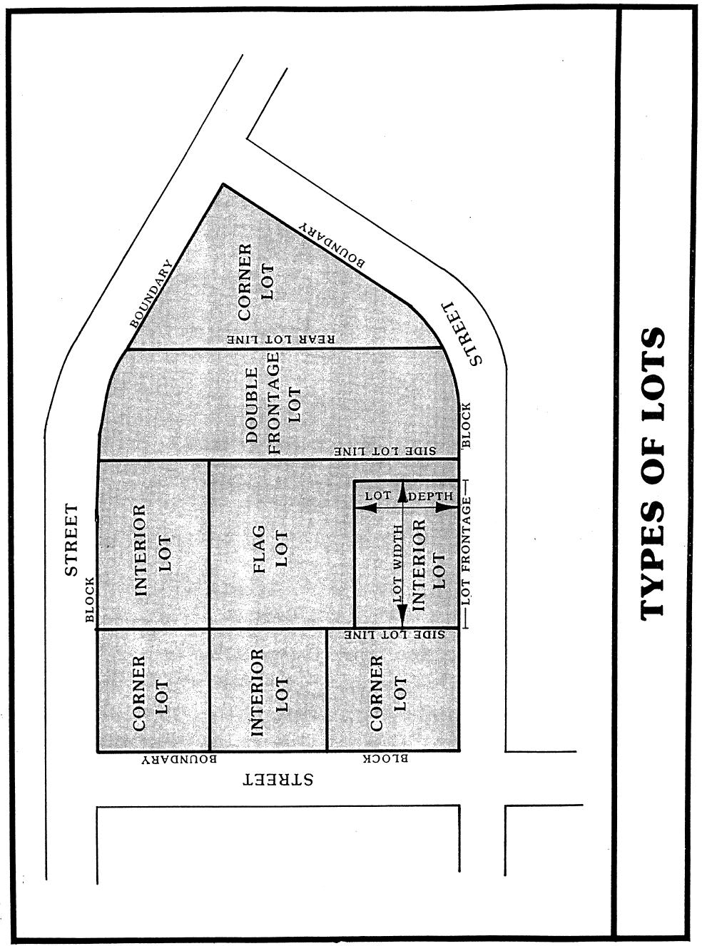
13 Design Plat - A map of a proposed subdivision showing the lot sizes and layout, location and sizes of streets and used as an aid in discussing the design of the proposed subdivision. Developer - The legal or beneficial owner of a lot or of any land included in a proposed development including the holder of an option or contract to purchase, or other persons having enforceable proprietary interests in such land, and which undertakes the activities covered by these regulations. In as much as the subdivision plan drawings are merely a necessary means to the end of assuring satisfactory development, the term "developer" includes "subdivider", "owner" or "builder" even though the persons and their precise interests may vary at different project stages. Drainage - (1) Surface water runoff; (2) the removal of surface water or ground water from land by drains, grading or other means which include runoff controls to minimize erosion and sedimentation during and after construction or development, the means for preserving the water supply and the prevention or alleviation of flooding. Dwelling Unit - A room, or rooms connected together constituting a separate, independent housekeeping establishment for owner occupancy, rental or lease on a daily, weekly, monthly, or longer basis; physically separated from any other room(s) or dwelling units which may be in the same structure; and containing independent cooking and sleeping facilities. Easement - Authorization by a property owner for the use by another, for a specified purpose, of any designated part of their property. Easement Vehicular - the right granted by the owner of land to another party by deed or prescription to allow vehicular access across one parcel of land to another. Easement, Utility - the right granted by the owner of land to allow utility facilities to be constructed, maintained or preserved. Utility easements shall include, but are not limited to, easements for storm drainage, water lines, sewer lines, electric power lines, and pipe lines. Easement, Drainage - A perpetual, unobstructed easement across property reserved to carry water drainage along specified routes to natural water courses. Drainage easements shall not be filled or built upon in any way that will impede the flow of surface water. Final Plat - The final map or drawing and accompanying materials, with all required signatures/approvals of every public utility and entity required and described in these regulations, on which the subdivider's plan of the subdivision is presented to the Planning Commission for approval and which, if approved by the Commission, is recorded with the County Register of Deeds. Flag Lot - An interior lot located to the rear of another lot but with a narrow portion of the lot extending to the street. The narrow portion of the lot that extends to the street shall be 12
14 the minimum required width per these regulations and must be suitable for ingress and egress to the parcel. Flood - A general overflow of a stream which results in inundation of lands not normally covered by water. Floodway Encroachment Limits - The lines marking the limits of floodways on official federal, state and local floodplain maps. Floodway Fringe - The area adjoining a watercourse which, although not lying within a floodway, has been or may hereafter be covered by a one hundred (100) year flood event. Grading - Any stripping, cutting, filling, compacting, stockpiling of earth or land, including the land in its cut or filled condition. Health Authority - The director of the county or district health department having jurisdiction over the county health, or their duly authorized representative. Highway, Limited Access - A freeway or expressway providing a traffic way for through traffic, in respect to which owners or occupants of abutting property(s) or lands and other persons have no legal right of access to or from the traffic way, except at such points and in such manner as may be determined by the public authority having jurisdiction over such traffic way. Homeowners Association - A community association that can apply to any type of residential development, which is organized in the development of which individual owners share common interests in open space, structures or facilities. Improvements - Physical changes made to raw land and structures on or under the land surface in order to make the land more usable for man's activities. Typical improvements in these regulations would include but not be limited to grading, street pavement, curbs, gutters, drainage ditches, storm and sanitary sewers, street name signs and street trees. Individual Sewage Disposal System - A septic tank, seepage title sewage disposal system, or any other sewage treatment device other than a public treatment system approved by the appropriate governmental representative. Land Subject to Flood. Anything which can be expected to be reached by floodwater because of its proximity to a stream and/or because it is below a designated elevation shall be considered to be subject to flood. Land Use Plan - A plan showing the existing and proposed location, extent and intensity of development of land to be used in the future for varying types of residential, commercial, industrial, agricultural, recreational, educational and other public and private purposes or combination of purposes. 13

15 Lot. A portion or parcel of land separated from other portions or parcels by description as on a subdivision plat or record of survey map or as described by metes and bounds, and intended for transfer of ownership or for building development. For the purpose of these regulations, the term does not include any portion of a dedicated right-of-way. Lot, Corner - A lot situated at the intersection of two (2) or more streets. Lot Depth - The average distance from the street line of the lot to its rear line measured in the general direction of the side lines of the lot. Lot, Double Frontage - Double frontage lot means a lot with street frontage along two opposite boundaries. On a double frontage lot both street lines shall be deemed front lot lines unless Zoning Code District states otherwise. (See Types of Lots Figure on page 39) Lot Frontage - That dimension of a lot or portion of a lot abutting on a street excluding the side dimension of a corner lot. Lot, Reverse Frontage - A reverse frontage lot is a double frontage lot for which the boundary along one of the streets is established as the rear lot line, and over the rear of which is a utility easement. The rear lot line of the lot shall be that boundary abutting a primary arterial, railroad right-of-way or other disadvantageous use. Major Road Plan - The plan adopted by the Planning Commission, pursuant to Sections and , Tennessee Code Annotated, showing, among other things, the general location, character and extent of public ways, and the removal, relocation, extension, widening, narrowing, vacating, abandonment or change of use of existing public ways is registered at the McMinn County Register of Deeds Office as the City of Athens Major Street and Road Plan. Major Subdivision. All divisions of a tract or parcel of land into five (5) or more lots, building sites or other divisions for the purpose, whether immediate or future, for sale or building development; and includes all division of land into two (2) or more lots involving a new street, or a change in existing streets; or divisions of land involving the extension of water, sewer or gas lines and includes re-subdivisions and, where appropriate to the context, 14
16 relates to the process of subdividing or to the land or area subdivided. The following are not included within this definition: a. testamentary division of property; b. partnership division of property between two (2) or more owners of an undivided interest by court order; or c. the division of land into parcels of five (5) acres or more not requiring new street or utility construction. However, utility construction does not include the mere extension of individual service pipes or lines for the purpose of directly connecting a single lot, site or other division to existing utility mains. The creation of a tract or parcel of less than five (5) acres shall be deemed a subdivision and subject to the provisions of this chapter whether or not it fronts on an existing street or road, except where land is partitioned among the owners by the court. Minor Subdivision. All divisions of a tract into four (4) or less lots, building sites or other divisions for the purpose, whether immediate or future, of sale or building development, and where appropriate to the context, relates to the process of subdividing or to the land or area subdivided. All divisions of land involving a new street; a change in an existing street; or the extension of water or sewer lines are not included within this definition. In simpler terms: A subdivision is considered minor when it contains four (4) or less lots and no streets, utilities or other improvements are to be made. Mobile Home or Trailer: A detached single-family dwelling unit, which is constructed as a single self-contained unit and mounted on a single chassis designed to be used with or without a permanent foundation. A mobile home contains the following characteristics: a. Designed for long-term occupancy, and containing sleeping accommodations, a flush toilet, a tub or shower bath and kitchen facilities, with plumbing and electrical connections provided for attachment to outside systems. b. Designed to be transported after fabrication on its own wheels, or on a flatbed or other trailers or detachable wheels. c. Arriving at the site where it is to be occupied as a complete dwelling including major appliances and furniture, and ready for occupancy except for minor and incidental unpacking and assembly operations, location on foundation supports, connection to utilities and the like. Mobile Home Park: Any area, tract, site or plot of land whereupon two or more mobile homes, as herein defined, are placed, located or maintained, or intended to be placed, located, or maintained, and shall include all accessory buildings used or intended to be used as part of the equipment thereof. 15
17 Mobile Home Space: A plot of ground within a mobile home park designated for the accommodation of one (1) mobile home. National Flood Insurance Program - A program established by the U.S. Government in the National Flood Insurance Act of 1968, and expanded in the Flood Disaster Protection Act of 1973, in order to provide flood insurance at rates made affordable through a federal subsidy in local political jurisdictions which adopt and enforce floodplain management programs meeting the requirements of the National Flood Insurance Program regulations. The program regulations are found at 24 Code of Federal Regulations, Chapter X, Subchapter B. Open Space - Any parcel or area of land or water essentially unimproved and set aside, dedicated, designated or reserved for public or private use or enjoyment, or for the use and enjoyment of owners and occupants of land adjoining or neighboring such open space. Owner - Any person, group of persons, firm or firms, corporation or corporations, or any other legal entity having title to or sufficient proprietary interest in the real property to seek subdivision or development of that property. Percolation Test - An examination of subsoil used in determining the acceptability of the site and the design of the subsurface disposal system. Performance Bond - See Surety Instrument. Planning Commission. The Athens Municipal Regional Planning Commission. Preliminary Plat - The preliminary drawing or drawings, described in these regulations, indicating the proposed manner of layout of the subdivision to be submitted to the Planning Commission for approval. Public Improvements - Any drainage ditch, roadway, parkway, sidewalk, pedestrian way, tree, lawn, off-street parking area, lot improvement, or other facility for which the local government may ultimately assume the responsibility for maintenance and operation or which may affect an improvement for which government responsibility is established. Public Uses - Public parks, schools and administrative, cultural and service buildings, not including public land or buildings devoted solely to storage and maintenance of equipment and material. Public Utility - Any person, firm, corporation, municipal department or board duly authorized to furnish under state or municipal regulations to the public electricity, telephony, gas, communications, transportation, water, or sewer. Public Way - Any publicly owned street, alley, sidewalk, or lane right-of-way which provides for movement of pedestrians or vehicles. 16
18 Reserve Strip - A narrow strip of land between a public street and adjacent lots which is designated on a recorded subdivision plat or property deed as land over which vehicular travel is not permitted. Re-subdivision - A change in a map of an approved or recorded subdivision plat if such change affects any street layout on such map or area reserved thereon for public use, or any lot line; or if it affects any map or plan legally recorded prior to the adoption of any regulations controlling the subdivision of land. Right-of-Way - A strip of land occupied or intended to be occupied by a public way, crosswalk, railroad, electric transmission or distribution line, oil or gas pipeline, water main, sanitary or storm sewer line, or for another special use. The usage of the term "right-ofway" for land platting purposes shall mean that every right-of-way hereafter established and shown on a Final Plat is to be separate and distinct from the lots or parcels adjoining such right-of-way and shall not be included within the dimension areas of such lots or parcels. Roadway - The portion of the street right-of-way which contains the street pavement, curb, and gutter, and is used primarily as a channel for vehicular movement and secondarily as a drainage channel for storm water. In these regulations the pavement is measured from face to face of the curbs. Setback - A line established by the City of Athens Zoning Ordinance and in some instances by these subdivision regulations themselves, generally parallel with and measured from the lot line, defining the limits of a yard in which no building, other than in some instances an accessory building, or structure may be located above or below ground, except as may be provided in said codes. Street. A way for vehicular traffic, whether designated as an avenue, arterial, collector, boulevard, road, highway, expressway, lane, alley, or other way, and for the purpose of these regulations, "streets" are divided into the following categories: a. Arterials and Collectors - any street designated as such in the Athens, Tennessee, Transportation Plan (the same streets may also be known as major thoroughfares). b. Secondary Collector - a collector street which carries traffic from local streets to major thoroughfares. c. Local Street - a neighborhood street used primarily for access to the abutting properties. d. Marginal Access Street - a minor street parallel and adjacent to major thoroughfares which offers access to abutting properties. e. Alley - a minor way used for service access to the back or side of properties otherwise abutting on a street. 17
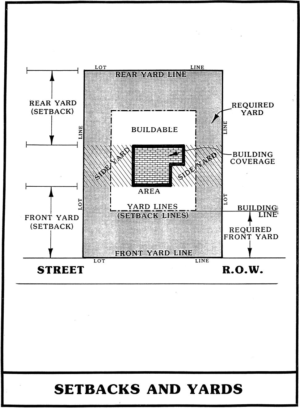
19 f. Cul-de-sac - a local street with only one outlet, sometimes called a "dead-end" street. Street Furniture - Any improvements placed within the street right-of-way, such as utility poles, street signs, etc. Street Grade - The officially established grade of the street upon which a lot fronts. If there is no officially established grade, the existing grade of the street at the midpoint of the lot shall be taken as the street grade. Structure - Anything constructed above or below ground. Subdivider - Any person who (1) having an interest in land, causes it, directly or indirectly, to be divided into a subdivision or who (2) directly or indirectly, sells, leases, or develops, or offers to sell, lease, or develop, or advertises for sale, lease or development, any interest, lot, parcel, site, unit, or plot in a subdivision or who (3) engages, directly or indirectly, or through an agent in the business of selling, leasing, developing, or offering for sale, lease, or development a subdivision or any interest, lot, parcel, site, unit, or plot in a subdivision or who (4) is directly or indirectly controlled by or under direct or indirect common control with any of the foregoing. Subdivision - "Subdivision" means the division of a tract or parcel of land into two (2) or more lots, sites, or other divisions requiring new street or utility construction, or any division of less than five (5) acres for the purpose, whether immediate or future, of sale or building development, and includes re-subdivision and when appropriate to the context, relates to the process of re-subdividing or to the land or area subdivided. (See Section and , Tennessee Code Annotated) Surety Instrument - Any form of security, including a cash deposit, surety bond, collateral, property or letter of credit in an amount and form satisfactory to the Planning Commission, such security to bind the one posting the bond to perform required acts, such as constructing subdivision improvements with the condition that the security shall be forfeited if such acts are not performed. Temporary Improvement - Any improvement built and maintained by a subdivider during construction of the subdivision and prior to release of the surety for completion of required improvements. Yard, Front - An open space on the same lot with a main building, extending the full width of the lot and situated between the street line and the front line of the building projected to the side lines of the lot. The depth of the front yard shall be measured between the front line (extended) of the building and the street line. Yard, Rear - A yard extending across the rear of a lot between the side lot lines and being the required minimum horizontal distance between the rear lot line and the rear building line. On all lots, except corner lots, the rear yard shall be opposite the front yard. On corner lots, the rear yard shall be defined at the time the building permit is issued. 18
20 Yard, Side - An open space on the same lot with the building, situated between the building and the side line of the lot and extending from the front yard to the rear yard. Any lot line not a rear line or a front line shall be deemed a side line. Zoning Ordinance or Resolution - A statute, legally adopted pursuant to Title 13, Chapters 4 or 7, Tennessee Code Annotated, for the purpose of regulating by district, land development or use for a designated area. For the purpose of these Subdivision Regulations, the City of Athens Zoning Ordinance. 19
21 ARTICLE 4: - PLATTING JURISDICTION, ENFORCEMENT AND PENALTIES FOR VIOLATION The enforcement of these regulations and penalties for the unapproved recordation or transfers of land are provided by state law in the authority granted by public acts of the State of Tennessee. Section 41. Platting Authority. From and after the passage of these regulations, the Planning Commission shall be the official platting authority, and no plat of a land subdivision shall be entitled to record in the office of the McMinn County Register of Deeds unless it shall have the approval of the Planning Commission inscribed thereon. The filing or recording of a plat of a subdivision without the approval of the Planning Commission, as required by these regulations, is declared to be a misdemeanor, punishable by law, with each day of noncompliance being a separate offense. Section 42. Use of Plat. The transfer of, agreement to sell, or negotiation to sell land by reference to or exhibition of, or other use of a subdivision plat that has not been given final approval by the Planning Commission and recorded in the office of the McMinn County Register of Deeds is prohibited, and the description by metes and bounds in the instrument of transfer or other document shall not exempt the transaction from such penalties. Section 43. Enforcement. No plat or plan of a subdivision located within the area of planning jurisdiction shall be filed or recorded by the McMinn County Register of Deeds until said plat or plan has received final approval in writing by the Planning Commission as provided in Section , Tennessee Code Annotated. Section 44. Opening and Improving Public Streets (Roads). No public officer, authority or county governing body shall accept, layout, open, improve, grade, pave, or light any street, lay or authorize the laying of water mains or sewers, or the construction of other facilities or utilities in any street located within the area of planning jurisdiction unless such street shall have been accepted, opened or otherwise received the legal status of a public street prior to the adoption of these regulations, or unless such street corresponds in its location and lines to a street shown on a subdivision plat approved by the Planning Commission, or on a street plan made and adopted by the Commission as provided in Section , Tennessee Code Annotated. Section 45. Erection of Buildings. No building permit shall be issued and no building shall be erected on any lot in a proposed subdivision within the area of jurisdiction of the Planning Commission unless final plat approval is granted and the plat recorded at the Resister of Deeds office. Within the corporate limits of the City of Athens, any building or structure erected in violation of this section shall be deemed an unlawful building or structure, and the building inspector or the city attorney may bring action to enjoin such erection or cause it to be vacated or removed. Section 46. Penalties. No county register shall receive, file or record a plat of a subdivision within the planning region without the approval of the Planning Commission as required in Section 20
22 , Tennessee Code Annotated, and any county recorder so doing shall be deemed guilty of a misdemeanor, punishable as other misdemeanors as provided by law. Section , Tennessee Code Annotated, provides that whoever being the owner or agent of the owner of any land, transfers or sells or agrees to sell or negotiates to sell such land by reference to or exhibition of or by other use of a plat of subdivision of such land without having submitted a plat of such subdivision to the Planning Commission and obtained its approval as required before such plat be recorded in the office of the appropriate county register, shall be deemed guilty of a misdemeanor, punishable as other misdemeanors as provided by law; and the description by metes and bounds in the instrument or other document used in the process of selling or transferring shall not exempt the transaction from such penalties. The city, through its attorney or other official, designated by its chief legislative body, may enjoin such transfer or sale of agreement by action or injunction. In addition, those who purchase the unapproved lots will have a cloud on their title, will be denied building permits if it is known the lot is illegal, and may have legal recourse against the developer. 21
23 22
24 ARTICLE 5: - GENERAL REQUIREMENTS Section 51. Name of Subdivision. The name of the subdivision must have the approval of the Planning Commission. The name shall not duplicate or closely approximate the name of an existing subdivision. Section 52. Access. Access to every subdivision lot shall be provided over a public street or a private street built to City Standards. Section 53. Public Use Areas. When features of other plans adopted by the Planning Commission (such as schools or other public building sites, parks or other land for public use) are located in whole or in part in a land subdivision, land for such features shall be either dedicated or reserved by the subdivider for acquisition within one (1) year by the appropriate public agency. Whenever a plat proposes the dedication of land to public uses that the Planning Commission finds not required or not suitable for such use, the Planning Commission shall refuse to approve the plat, and shall notify the governing body of the reasons for such action. Where public use is to be made of the property and where the residents of the subdivision will receive primary benefit, the dedication of the property should be encouraged. Where the public use is for the public as a whole, the community should pay proportionately for the acquisition of reserved areas within a reasonable time. A reasonable time is to be determined according to the circumstances, because the subdivider should not be required to hold their land idle for a lengthy and indefinite period. Section 54. Suitability of the Land. The Planning Commission shall not approve the subdivision of land if, from adequate investigations conducted by all public agencies concerned, it has been determined that in the best interest of the public the site is not suitable for planning and development purposes of the kind proposed. This includes land which is: a. Physically unsuitable because of flooding, bad drainage, steep slopes, rock formations, unsuitable soil, and other features which may endanger health, life, or property, aggravate erosion, increase the flood hazard, or necessitate expenditure of public funds for supply and maintenance of services and/or which other public agencies have investigated and found to be not in the best interest of the public. b. Unsuitably located by reason of being scattered or premature subdivision of land which would involve danger or injury to the health, safety, property, or economic utilization because of lack of or adverse effect on water supply, schools, proper drainage, good transportation, or other public services or facilities that would necessitate an excessive expenditure of public funds for supply or maintenance of such services or elimination of danger. 23
25 Section 55. Individual Mobile Home Parks and Subdivisions. The requirements and regulations of the City of Athens Zoning Code Section R-4 MOBILE HOME PARK DISTRICT shall be satisfied and the approval of the local health authority must be secured prior to approval by the Planning Commission of any mobile home or travel trailer park. A mobile home subdivision shall meet the general requirements of these regulations prior to the approval of any plat and before the sale or lease of any individual mobile home lots. 24
26 ARTICLE 6: - GENERAL REQUIREMENTS FOR STREETS AND OTHER RIGHTS-OF- WAY Section 61. Conformance to Adopted Transportation Plan. All streets and other features of the Transportation Plan of Athens, Tennessee, shall be platted by the subdivider in the location and to the dimensions indicated on the Transportation Plan adopted by the Planning Commission. Section 62. Continuation of Existing Streets. Existing streets shall be continued at the same or greater width, but in no case less than the required width. Section 63. Street Connections. Where proposed streets are to adjoin existing streets, the developer must make the connection at their expense and meet all street design requirements set forth in these regulations. Section 64. Street Elevations. The Planning Commission may require, where necessary, profiles and elevations of streets in floodways, as defined in these regulations. No street shall be approved which is more than two (2) feet below flood elevation. Fill may be used for streets in areas subject to flood provided such fill does not unduly increase flood heights. Drainage openings shall be so designed as to not restrict the flow of water and unduly increase the flood heights. Section 65. Street Names. The street names shall require the approval of the Planning Commission. Streets that are obviously in alignment with streets already existing and named shall be given the name of the existing street. Section 66. Restriction of Access. When a tract fronts on an arterial or collector street, the Planning Commission may require such lots to be provided with frontage on a marginal access street or may require reverse frontage lots. Section 67. Alleys. Alleys may be required at the rear of all lots used for multi-family, commercial or industrial developments but shall not be provided in one- and two-family residential developments unless the subdivider provides evidence satisfactory to the Planning Commission of the need for alleys or if the Conservation Subdivision Regulations of Article 16 are being utilized. Section 68. Reserve Strips. There shall be no reserve strips controlling access to streets, except where the control of such strips is definitely placed with the city under conditions approved by the Planning Commission. Section 69. Utility and Stormwater Easements. Drainage easements having a minimum width of fifteen (15) feet shall be provided where deemed necessary along each side or rear lot line for utility lines and underground mains and cables. Easements of the same or necessary greater width shall be required along the lines of or across lots, where necessary, for the extension of existing or planned utilities. All subdivisions have to meet all the easement requirements of the Athens Stormwater Management Policy. 25
27 Section 610. Private Streets. All proposed private streets have to be constructed to at least the same standards as all public streets. Section 611. Gated Facility or Community. All gated facilities or communities must be accessed through a private street that meets Section 610 of these subdivision regulations. Prior to the installation or replacement of a security gate or barrier at a gated facility or community, the developer or owner shall obtain security gate or barrier approval from the Athens Municipal- Regional Planning Commission. Approval shall only be issued for a security gate or barrier meeting the requirements of this section. Prior to any changes, alterations or blocking of private streets, plans detailing the change accompanied by drawings, shall be submitted to the Athens Municipal-Regional Planning Commission for approval. Each preliminary plat, final plat, or revised final plat for a private street and gated subdivision as provided for in this article shall require the approval of the Athens Municipal-Regional Planning Commission. All private streets within a subdivision shall be identified on the final plat for the benefit of all lots in the subdivisions. The private streets shall be owned by the platted lot owner and maintained by the property owners association. The maintenance and upkeep of any security gate or barrier shall be the sole responsibility of the developer, owner or any duly incorporated and active association having jurisdiction of the gated facility or community. Inoperative security gates or barriers shall be repaired immediately. Inoperative gates shall be locked in the open position until repairs are made. Abandoned gates shall be permanently locked in the open position or removed completely. All security gates or barriers shall be equipped with a radio operated receiver/controller capable of receiving signals from a police department, sheriff's department (if the gated facility or community is in the Growth Boundary outside the City of Athens corporate boundary), fire department, utility and emergency medical services' radio transceivers serving the gated facility or community that allow emergency responders and other necessary on-duty employees to open the security gate or barrier by use of the equipment. The party or parties controlling the operation and maintenance of the security gate or barrier shall be liable for any damages caused by the improper operation of the security gate or barrier. 26
28 ARTICLE 7: - STREET DESIGN REQUIREMENTS Section 71. Street Right-of-Way Widths. The right-of-way width shall be the distance across a street from property line to property line. Minimum street right-of-way width shall be as follows: a. Major Arterials feet, or as (See Transportation Plan, may be required Athens, Tennessee) b. Minor Arterials...80 feet (See Transportation Plan) c. Primary Collectors...60 feet Collector streets are those which carry traffic from minor streets to the major system of arterial streets of a residential development and streets for major circulation within such a development. d. Local Streets (Neighborhood)...50 feet The purpose of a local street is to provide access to property abutting the public right-ofway. This includes vehicular and pedestrian access. Moving traffic is a secondary function of local streets. e. Marginal Access Streets...50 feet Marginal access streets are minor streets which are parallel to and adjacent to arterial streets and highways; and which provide access to abutting properties and protection from through traffic. f. Alleys...20 feet Alleys are minor public ways used primarily for service access to the back or side of properties otherwise abutting on a street. g. Cul-de-sacs feet depending on type Cul-de-sacs are permanent dead-end streets or courts designed so that they may or may not be extended in the future. 27
 feet with an outside pavement radius of at least forty (30) feet. h. Temporary Cul-de-sacs.")
29 Except where topographic or other conditions make a greater length unavoidable, cul-desacs, or dead-end streets, shall not be greater in length than one thousand (1000) feet. They shall be provided at the closed end with a turn-around having a property line radius of at least fifty (40) feet with an outside pavement radius of at least forty (30) feet. h. Temporary Cul-de-sacs feet depending on type Where in the opinion of the Planning Commission, it is desirable to provide for street access to adjoining property, proposed streets shall be extended by dedication to the boundary of such property. Such dead-end streets having a length greater than two hundred (200) feet shall be provided with a temporary turn-around of either a circular or back-and-turn design. 28
30 Where deemed necessary by the Planning Commission, adequate rights-of-way shall be dedicated to connect with any temporary dead-end streets adjoining the subdivision. Cul-de-sac Designs Section 72. Additional Width on Existing Streets. Subdivisions that adjoin existing streets shall dedicate additional right-of-way to meet the minimum street width requirements. a. The entire right-of-way shall be dedicated where any part of the subdivision is on both sides of the existing street; and b. Where the subdivision is located on only one (1) side of an existing street, the amount of right-of-way to be dedicated is as follows: 1. If the land across the roadway from the proposed subdivision has not been subdivided or developed, the subdivider is only required to dedicate one-half (1/2) of the required right-of-way, measured from the center line of the existing right-ofway. 2. If the land across the roadway has been subdivided or developed, the subdivider is required to provide enough additional right-of-way on their side of the roadway to bring the total right-of-way to the required width (in no case less than fifty (50) feet). 29
31 Section 73. Minimum Street Pavement Widths. Street pavement widths shall be as follows unless Planning Commission and Director of Public Works approve alternatives: a. Major Arterials feet, or greater, or as may be required b. Minor Arterials feet, or greater, or as may be required c. Primary Collectors feet, or greater, or as may be required d. Minor Streets (neighborhood or local streets)...22 feet (face of curb to face of curb) e. Alleys...16 feet f. Cul-de-sacs...30 feet g. In certain instances of proposed neighborhoods or local business areas, the minimum pavement widths shall be increased to accommodate a twelve (12) foot wide turning lane for turning movements of vehicles into and out of necessary off-street parking areas without interference to traffic. NOTE: The pavement widths are measured from face of curb to face of curb. These widths are considered the minimum necessary to accommodate modern traffic. Street parking must, of course, be considered in the pavement widths. Where no street parking is permitted or none is anticipated, allowances may be made. A parallel parking lane normally requires eight (8) feet. On minor streets a moving traffic lane should have a minimum of ten (10) feet. On neighborhood streets where the abutting property has adequate off-street parking and traffic moves slower, provision for one (1) lane of parking and two (2) nine (9) foot traffic lanes may be adequate. (Pavement widths for major streets are normally a responsibility of the governing body.) Section 74. Street Grades. Maximum and minimum street grades shall be fourteen (14) percent and one percent (1 %) respectively. NOTE: These street grade limits are considered to be the optimum requirements to provide adequate safety. Different topographical situations may necessitate adjustment. Section 75. Horizontal Curves. Where a deflection angle of more than ten (10) degrees (See illustration in following page) in the alignment of a street occurs, the street shall have a centerline radius of not less than the following: 30
32 a. Major thoroughfares feet b. Collectors feet c. Local streets feet Section 76. Vertical Curves. Every change in grade shall be connected by a vertical curve constructed so as to afford a minimum sight distance of two hundred (200) feet, said sight distance being measured from the driver's eyes, which are assumed to be four and one-half (4 1/2) feet above the pavement, to an object four (4) inches high on the pavement. Where, in the opinion of the Planning Commission, topography warrants it, profiles of all streets showing natural and finished grades drawn to a scale of not less than one (1) inch equals one hundred (100) feet horizontally and one (1) inch equals twenty (20) feet vertically shall be required. Section 77. Intersections. Street intersections shall be as nearly at right angles as is possible, and no intersection shall be at an angle of less than sixty (60) degrees. Curb radii at street intersections shall not be less than twenty (20) feet, and where the angle of a street intersection is less than seventy-five (75) degrees; the Planning Commission may require a greater curb radius. Whenever necessary to permit the construction of a curb having a desirable radius without curtailing the sidewalk at a street corner to less than normal width, the property line at such street corner shall be rounded or otherwise set back sufficiently to permit such construction. Section 78. Tangents. Between reverse curves there shall be a tangent having a length of not less than one hundred (100) feet. Section 79. Street Jogs. Street jogs with centerline offsets of less than one hundred fifty (150) feet shall not be allowed. 31
33 32
34 33
35 34
36 ARTICLE 8: - DESIGN STANDARDS FOR BLOCKS AND LOTS Section 81. Block Lengths and Widths. Block lengths and widths shall be as follows: a. blocks shall be no greater than one thousand two hundred (1,200) feet nor less than three hundred (300) feet in length, except in unusual circumstances; and b. blocks shall be wide enough to provide two (2) tiers of lots of minimum depth, except where abutting upon major streets or where other situations make this requirement impractical. Section 82. Flood-Free Building Site. Each lot in a subdivision shall contain a flood-free building site. The entire buildable area of each lot shall be located outside any special flood hazard area shown on the most current FEMA Flood Insurance Rate Maps. Section 83. Lot Sizes. Residential lots shall meet the lot width and lot area requirements of the Zoning Ordinance. In the absence of a Zoning Ordinance, residential lots shall not be less than eighty (80) feet wide at the setback (building) line with the exception of Conservation Residential Development as provided with the Zoning Ordinance of the City of Athens. Other lot size requirements shall be as follows: a. Residential lots shall have a depth of not less than one hundred (100) feet and not greater than three (3) times the width of the lot at the building line, unless unusual circumstances make these limitations impractical. Residential lots in the City of Athens shall also conform to the Athens Zoning Code for minimum lot sizes in each zoning district. b. Lots not served by public water and sanitary sewer systems shall be at least twenty five thousand (25,000) square feet in area or of a size specified by the McMinn County Environmental Specialist to adequately accommodate both a fresh water-well and septic tank on the same lot. Where individual septic tanks are used on lots served by a public water system, minimum lot size shall of twenty thousand (20,000) square feet or of a size specified by the McMinn County Environmental Specialist. c. Residential corner lots shall have adequate width to meet building setback requirements for both abutting streets. d. Commercial and industrial lots shall be adequate in size to provide service areas and offstreet parking suitable for the type of use and development contemplated and shall also conform to the Athens Zoning Code for minimum lot sizes in each zoning district. e. New subdivisions of land shall not be platted for commercial or industrial purposes unless the subdivider can demonstrate to the Planning Commission that each lot provides the following: 1. A site that does not unduly interfere with through traffic. (Each industrial subdivision or area shall utilize a single collector for all heavy traffic between the area and the general system of streets and roads. All local industrial streets and 35
37 individual industrial parcels shall be oriented at right angles with the collector and with adjacent railroads whenever possible and feasible.) 2. An integrated parking area. 3. A buffer against any adverse effect on any present or future adjacent residences. All lots in the City of Athens will comply with the buffering requirements of the City of Athens Landscape Ordinance. 4. A parcel size sufficient in area to allow future expansion. Section 84. Lot Lines. All lot lines shall be perpendicular or radial to street lines, unless impractical because of topographic or other features. Section 85. Building Setback Lines. A building setback line meeting the front yard setback requirements of the Zoning Ordinance shall be established on all lots. In the absence of a Zoning Ordinance, the front yard setback shall be a minimum of thirty-five (35) feet from the street right-of-way lines. Other minimum setback lines shall be as follows: a. from the side property line..15 feet b. from rear property line.35 feet c. from side street line which abuts.30 feet a minor street (corner lot) or as may be required Section 86. Lot Abutting Public Streets. Each purposed lot shall abut upon a dedicated public street or an approved private street, built to city standards, at least fifty 50 feet, excluding certain flag lots. Lots located on a cul-de-sac shall have a minimum of 30 foot of street frontage and must also be designed to have a minimum 50 feet of width at the setback line. Section 87. Double and Reverse Frontage Lots. Double frontage lots should be avoided, except where essential to provide separate residential development from traffic arteries or to overcome specific disadvantages of topography and orientation. Reverse frontage lots shall have a depth of not less than one hundred fifty (150) feet. A planted evergreen screen easement at least ten (10) feet wide, across which there shall be no right-of-access, shall be provided along the line of lots abutting a traffic artery or other incompatible land use. Section 88. Flag Lots. In the Athens Planning Region, flag lots shall be allowed only if they meet these requirements: a. For flag lots of one (1) acre or less, the access strip shall be a maximum of 300 feet in length and a minimum of 25 feet in width; 36
38 b. For flag lots of more than one (1) acre, the access strip shall be a maximum of 500 feet in length and a minimum of 50 feet in width. (This wider access strip will allow room for a public street when and if the flag lot is ever re-subdivided.) c. The overall subdivision shall be designed so that the point where the access strip of the flag lot abuts the public street shall be safe for vehicular ingress and egress as far as visibility and grade are concerned since, unlike the purchaser of a conventional lot, the owner of a flag lot will have no other choice as to driveway location. (The safety of this intersection is even more important if the flag lot is ever made into a subdivision housing a number of families. d. Whenever 50 foot wide access strip is required, the developer shall locate it on land which affords a grade which would meet Section 74 so that if the flag lot is subdivided, the planning commission will be able to approve the grade of the new public road built on the right-of-way necessary to construct a street meeting the requirements of Section 74. (This requirement is needed so that the city does not, at a future date, have a dangerous road which is difficult to maintain and to serve public vehicles such as buses, fire trucks, etc.) e. Within the portion of the flag lot which doesn't include the access strip, the various building setbacks for front, side and rear shall still apply and be measured from the boundaries of the portion excluding the access strip. f. Minimum lot sizes shall be calculated, excluding the access strip. g. No more than two flag lot access strips shall be located side-by-side. 37
39 38
40 39
41 ARTICLE 9: - PRE-APPLICATION PROCEDURE FOR MAJOR SUBDIVISION Whenever a major subdivision of a tract of land within the Athens Planning Region is proposed, the subdivider is urged to consult early and informally with the Community Development Department. (See Article 15 for Review Procedure of Minor Subdivision Plats.) The subdivider may submit sketch plans and data showing existing conditions within the site and in its vicinity and the proposed layout and development of the subdivision. No fee shall be charged for the preapplication review and no formal application for this consultation shall be required. NOTE: (1) The purpose of the pre-application review is to afford the subdivider an opportunity to avail himself of the advice and assistance of the Planning Commission in order to facilitate the subsequent preparation and approval of plans. (2) The various plat reviews required by these regulations may properly be made by the Community Development Department Staff. Approval or disapproval in every subdivision case, excluding exempt plats and administrative approved plats, must be by action of the Commission. All plats regardless of type will require the signature of the Secretary of the Planning Commission for recording. 40
42 ARTICLE 10: - PRELIMINARY PLAT SPECIFICATIONS FOR MAJOR SUBDIVISION (SEE ARTICLE 15 FOR MINOR SUBDIVISION) Section 101. Scale. The preliminary plat shall be clearly and legibly drawn at a scale not smaller than one hundred (100) feet to one (1) inch. Section 102. Sheet Size. Sheet size shall be twenty (20) by twenty (20) inches, or shall be the sheet size required by the County Register of Deeds for recording purposes. If the complete plat cannot be shown on one (1) sheet of this size, it may be shown on more than one (1) sheet with an index map on a separate sheet of the same size. Section 103. Ground Elevation. Contours shall be shown at vertical intervals of two (2) feet. Section 104. Information to be Provided on Preliminary Plat. The preliminary plat shall contain the following information: a. name of subdivision; b. name and address of owner of record, subdivider, and surveyor; c. north point, graphic scale and date; d. vicinity map showing location and acreage of subdivision; e. exact boundary lines of the tract by bearing and distances; f. names of adjoining property owners and/or subdivisions; g. existing streets, buildings, water courses, railroads, culverts, utilities and easements on and adjacent to the tract; h. proposed design including streets and alleys with proposed street names, lot lines with approximate dimensions, easements, land to be reserved or dedicated for public uses and any land to be used for purposes other than single-family dwellings; i. block numbers and lot numbers; 41
43 ****VISUAL EXAMPLE ONLY- written rules in this document pertaining to subdivision development override any thing illustrated in the Preliminary Plat graphic shown below: 42
44 j. plans of proposed utility layouts (sewers, water, gas and electricity) showing feasible connections to the existing or any proposed utility systems and drainage. When connections to certain public utilities are not practical, any proposed individual water supply and/or sewage disposal system must be approved by the county health department. k. where public sewerage and/or water are not available, the following shall be shown: 1. Areas to be used for sewage disposal on each lot; 2. Water wells (existing and/or proposed); 3. Rock outcroppings, marshes, springs, sinkholes, natural storm drains and other outstanding topographical features; and l. minimum building front yard setback lines; m. the present zoning classification, if any, on the land to be subdivided and on the adjoining land; n. contour lines at least for every two (2) foot change in elevation; o. Such street cross-section and centerline profiles as may be required by the Public Works Department and/or Planning Commission; and p. if any portion of the land being subdivided is subject to flood, as defined in these regulations, the limit of such flood shall be shown. 43
45 ARTICLE 11: - PROCEDURE FOR MAJOR PRELIMINARY PLAT APPROVAL Section 111. Application for Preliminary Plat Approval. Following the pre-application review of a proposed major subdivision the subdivider shall submit to the Community Development Department, at least fifteen (15) days prior to the next regular meeting of the Planning Commission, the following: a. a letter requesting review and approval of a preliminary plat and giving the name and address of the person to whom the notice of the hearing by the Planning Commission on the preliminary plat shall be sent, and b. five (5) copies of the preliminary plat and other documents, as specified in Article 11. NOTE: Five (5) copies of the preliminary plat and other documents are suggested to provide a review and record copy for: 1. Planning Commission; 2. Subdivider; 3. Local Utility Department or Company; and 4. County Environmentalist Office; and 5. Public Works Department. Section 112. Review of Preliminary Plat. The Planning Commission shall check the plat for conformance to these regulations and shall afford a hearing on the preliminary plat, notice of the time and place of which shall be sent by the Secretary of the Planning Commission to the person designated in the letter requesting preliminary plat review and approval, not less than five (5) days prior to the date of the hearing. Thereafter, the Planning Commission shall give tentative approval or disapproval of the preliminary plat. A notation of the action shall be made in the minutes of the meeting. Two (2) copies of a list containing the reasons for disapproval, if the preliminary plat is disapproved, shall be issued. One (1) copy shall be returned to the subdivider or their agent and one (1) copy added to the records of the Planning Commission. Tentative approval of a preliminary plat does not constitute approval of a final plat. It indicates only approval of the layout as a guide to the preparation of the final plat. Tentative approval shall expire and be null and void after a period of one (1) year unless an extension of time is applied for by the subdivider or their representative and approved by the Planning Commission. This Tentative approval is vested for three (3) years from the original passage date under the subdivision standards adopted at the time of passage. However, if extensions are not approved during the one year period mentioned above on any of the two subsequent years following the original approval date, then the vesting is lost and the development will have to comply with any current subdivision regulations adopted. If action on a preliminary plat is not taken by the Planning Commission within sixty (60) days of the date of submittal, the preliminary plat shall be considered approved and a certificate of approval shall be issued on demand. However, the applicant for approval may waive this requirement and consent to an extension of time by stating in writing on the preliminary plat that they wish to waive the 60 day period. 44
46 Section 113. Certificate of Tentative Approval. Two (2) Certificates of Tentative Approval of the Preliminary Plat by the Planning Commission shall be issued: One (1) copy for the subdivider or their agent and one (1) for the Planning Commission records. The certificate shall contain the following: "Pursuant to the Subdivision Regulations of Athens, Tennessee, all the requirements of tentative approval have been fulfilled. Therefore, the 'Preliminary Plat' of Subdivision has been approved by the Athens Regional Planning Commission on, 20, subject to the following modifications. This approval does not constitute approval of a final plat. This Certificate of Tentative Approval shall expire and be null and void on, 20. (One year later) This Tentative approval is vested for three (3) years from the original passage date under the subdivision standards adopted at the time of passage. However, if extensions are not approved during the one year period mentioned above on any of the two subsequent years following the original approval date, then the vesting is lost and the development will have to comply with any current subdivision regulations adopted. 1. Certificate of Tentative Approval vesting extension shall expire and be null and void on, 20 Secretary. AMRPC 2. Certificate of Tentative Approval vesting extension shall expire and be null and void on, 20 Secretary. AMRPC Secretary, Athens Regional Planning Commission 45
47 ARTICLE 12: - FINAL APPROVAL OF MAJOR SUBDIVISION Prior to the approval of a final subdivision plat, an agreement shall be reached between the subdivider or their agent and the City of Athens with regard to the installation of all road improvements, utility construction, and other improvements called for in the subdivision plat. The subdivider shall be required to have installed at their expense the following improvements, which are minimums and additional requirements may be required by the Public Works Director or their designee to overcome problem areas. The subdivider at their expense, may contract with the City of Athens or a private firm to install the necessary improvements. Section 121. Requirements for Construction Drawings. After approval of a preliminary plat, (see Article 11) the subdivider shall submit a complete set of Construction Drawings to the City of Athens, Local Utilities Board and the official State Agency for approval. The plans or drawings shall be prepared by a licensed engineer and shall include: a. Street plans, profile, specifications and cross sections. b. Utility plans, profile, specifications and typical cross sections. c. Drainage design and specifications. d. Other data and calculations as the agencies may require. e. Traffic Control and Signage Upon written approval from the City of Athens, the Local Utilities Board and the State Agency, of the Construction Drawings, the subdivider shall make application for a Construction Permit from the Public Works Department and the Community Development Department. With the issuance of the permit the subdivider shall be free to contract for the installation of the improvements. The subdivider shall call for inspections from the appropriate agency during the progress of construction as per approved specifications. Section 122. Monuments. a. Concrete monuments four (4) inches in diameter or four (4) inches square, three (3) feet long, with a flat top, shall be set at all road corners, at all points where the road lines intersect the exterior boundaries of the subdivision, and at angle points of curve in each road. The top of the monument shall have an indented cross to identify properly the location and shall be set flush with the finished grade. b. All other lot corners shall be marked with iron pipe or iron pin not less than three-fourths (3/4) inches in diameter and twenty-four (24) inches long and driven so as to be flush with the finished grade. 46
48 Section 123. Grading. All streets, roads and alleys shall be graded by the subdivider to the required cross section. Due to special topographic conditions, deviation from the above will be allowed only with special approval of the Planning Commission. Where roads are constructed under or adjacent to existing electric transmission or distribution lines, the nearest edge of the roadway surface shall be a minimum of fifteen (15) feet from any transmission line structure and all grading for the road shall be done in a manner which will not disturb the structure or result in erosion endangering the structure. In the case of electric transmission or distribution lines, the clearance from the road to the nearest conductor shall meet the requirements of the National Electric Safety Code. a. Preparation. Before grading is started, the entire right-of-way area shall be first cleared of all stumps, roots, brush and other objectionable materials and all trees not intended for preservation. The roadway portion of the right-of-way shall be cleared of objectionable materials, such as topsoil and loose fill, down to a suitable level of stable soil. b. Cuts. All tree stumps, boulders and other obstructions shall be removed to a depth of two (2) feet below the sub-grade or to a depth necessary to provide a suitable stable soil. Rock, when encountered, shall be scarified to a depth of twelve (12) inches below the sub-grade. This provision applies to the roadway and not necessarily to the entire right-of-way width. c. Fill. All suitable material from roadway cuts may be used in the construction of fills, approaches or at other places as needed. Excess materials, including organic materials, soft clays, etc., shall be removed from the development site. The fill shall be spread in layers not to exceed six (6) inches loose and compacted to a minimum of 80% of maximum density. The filling of utility trenches and other places not accessible to a roller shall be mechanically tamped with a suitable tool. Utility trenches that are located beneath streets and other vehicular traffic areas should be backfilled completely with an approved crushed stone and mechanically tamped. All fill areas in the final subgrade of any public street should be compacted to Public Works Standards. Section 124. Installation of Utilities. After grading is completed and approved and before any base is applied, all of the required underground work--water mains, sewer lines, gas mains, etc., and all service connections shall be installed completely and approved throughout the subdivision. Section 125. Street or Road Base. The base shall consist of crushed stone, Grade D, Class B, compacted to six (6) inches, and constructed as specified in Section 303, Tennessee Department of Highways', Standard Specifications for Road and Bridge Construction, NOTE: Standards and specifications as indicated in the Tennessee Department of Highways', Standard Specifications for Road and Bridge Construction, are subject to periodic revision. Revisions made in Sections 35 and 104 should be incorporated in new road construction. Section 126. Asphaltic Concrete Surface Course (Hot Mix). The road surface (paved surface) shall consist of three (3) inches of approved asphalt course. 47
49 Section 127. Street or Road Base and Surface with Extruded Curb. If the subdivider proposes to utilize an approved extruded curb, the following requirements shall be met: a. Street Base. The street base shall consist of crushed stone Grade D, Class B, compacted to six (6) inches. b. Asphaltic Binder. The road surface shall consist of two (2) inches of approved asphalt binder (The extruded curbs shall be laid to true and even forms on the binder). c. Asphalt Topping. The road surface shall consist of one (1) inch of approved asphalt topping (see City of Athens for approved asphalt specifications). Section 128. Handicap Ramps. In all subdivisions where sidewalks, curbs and gutters are required, handicap ramps shall be installed at all crosswalks so as to make the transition from street to sidewalk easily negotiable for physically handicapped persons in wheelchairs and for others who may have difficulty in making the step up or down from curb level to street level. This requirement is not subject to waiver and shall comply with the most current ADA standard. Section 129 Curbs and Gutters. Concrete curbs shall be installed by the developer or subdivider on both sides of all new streets within the Athens Planning Region. The curbs shall be backfilled with a suitable material and the fill shall slope toward the storm drainage system or curb line. Where access streets to adjoining properties are provided and they provide no other frontage for lots, they shall be curbed to the property line. Where a temporary turnaround or cul-de-sac is provided, curbs shall end at the transition curb in such a way to facilitate a smooth continuation of the future curbing. a. Material Specifications. All curbing is to be constructed of Portland Cement type concrete. b. Design Specification. Extruded Design All curbing shall be of no lower classification than poured in-place or machine formed curbing formed or extruded to the following dimensions: eight (8) inches wide at the base, six (6) inches wide at the top, and eight (8) inches tall. (After the application of asphalt topping of the street, the curb should measure no less than seven (7) inches tall). Curb and Gutter All extruded or poured in-place combined curb and gutter shall be installed to the following dimensions: curb six (6) inches wide and eight (8) inches tall at the face and twelve (12) inches tall at the rear. Gutter: twelve (12) inches to the face of curb. Exceptions Any exceptions to the above material or design specifications should be submitted to the City of Athens for approval prior to any construction. The Public Works Director may allow a none curb roadway design if bio-retention, swales are used when adequate shoulders are designed 48
50 Section 1210 Curb Cuts and Non-Residential Driveway Aprons. All curb cuts and the installation of non-residential driveway aprons shall be approved by the Athens Department of Public Works and shall be in a manner that insures positive drainage to the street. An expansion joint with filler shall be provided at each edge of the driveway apron where it abuts the curb and gutter. The driveway apron shall be constructed of either concrete or asphalt material and shall be paved from the edge of paved road to the end of the public right-of-way. Section Storm Drainage. The City of Athens Stormwater Management policy, which describes in detail all requirements, technical guidelines, and design criteria for the provision of storm drainage and water quality management shall be enforced in all subdivisions within the corporate limits as well as all subdivisions within the City of Athens Growth Boundary. Section Water Supply System. Within the corporate limits of the City of Athens, water mains and appurtenances properly connected with the community water supply and approved by the State of Tennessee Department of Public Health shall be constructed in each subdivision to adequately serve all lots for domestic use and fire protection. All construction of water lines and appurtenances may be made by the water utility district serving the area, either with their own forces or by contract, upon the subdivider making proper bond or financial arrangements with said district. The subdivider may construct said water lines and appurtenances but said construction shall be subject at all times to the inspection and approval of said district or district authority and all inspections will be at the cost of the subdivider. Within the City of Athens Growth Boundary, water mains and appurtenances properly connected with the community water supply and approved by the State of Tennessee Department of Public Health, shall be constructed in each subdivision to adequately serve all lots for domestic use and fire protection when an existing six (6) inch water main is within 1,500 feet of any portion of the property being proposed for subdivision when measured along the right-of-way. All water mains, except services, shall not be less than six (6) inches in diameter and of a material approved by the local utility authority. Fire hydrants shall be installed in all subdivisions within the Athens city limits. Fire hydrants shall be installed in all subdivisions within the Athens Planning Region where an adequate public water supply is available, and are allowed by the appropriate utility district. The fire hydrants shall be located at the end of each line and no home or building shall be more than five hundred (500) feet from a fire hydrant. In special cases such as cross streets when six (6) inch mains are provided, four (4) inch mains may be acceptable provided that adequate fire protection may be furnished. The specifications of all material, including but not limited to fire hydrants, and the manner in which all lines and appurtenances are laid shall meet the inspection and approval of the local utility authority. All water construction plans for subdivisions shall include a service from the main water line to the property line of each proposed lot in order that each proposed lot, at the time of construction, may be served by water without the installing of additional lines or appurtenances. 49
51 The entire cost and expense of installing the required water supply system including the connection to the existing water supply and including but not limited to the cost of pipe, valves, fittings, fire hydrants, trenching, backfilling, and services shall be borne by the subdivider including the stipulated payment for tapping and metering the system to serve each lot. The provisions of this section shall apply to all major subdivisions and may apply to minor subdivisions if deemed appropriate by the Athens Regional Planning Commission. Section Sewage Disposal. When any portion of a proposed subdivision is located within five hundred (500) feet of an existing public sanitary sewer line, sanitary sewers shall be installed to serve all the lots within the subdivision. Should the subdivision have elevations which are below those of the nearest public sanitary sewer, a lift station shall be installed by the subdivider provided the public sanitary sewer is within a reasonable distance of all portion of the subdivision. Alternative designs utilizing grinder pumps may be used upon approval by the local district authority. All sanitary sewer construction shall be built in accordance with the rules and regulations of the Tennessee Department of Public Health. All construction of sanitary sewers and appurtenances shall be by an appropriate utility district, either with their own forces or by contract, upon the subdivider making proper bond or financial arrangements with said district. The subdivider may construct such sanitary sewers and appurtenances but said construction shall be subject at all times to the inspection and approval of said district authority and all inspections will be at the cost of the subdivider. All sewer lines except a house service shall be no less than eight (8) inches of a material approved by the Federal Housing Administration. Manholes shall be constructed to standard utility specifications and located not more than four hundred (400) feet apart and at each change in direction and/or grade. Force mains shall be no less than four (4) inch pipe. Force main design for grinder pumps shall be approved by the local district authority and shall be a minimum of two (2) inches in diameter. Lift stations shall be prefabricated steel ejector type or duplex pump type. All construction in general shall conform to the requirements of and shall meet the approval of said district authority. All sewer construction plans for subdivisions shall include a house service from the main sewer line to the property line of each proposed lot in order that each proposed lot at the time of construction may be served by sewer without the installing of additional lines. The end of each house service shall be properly marked. The entire cost and expense of installing the required sanitary sewage system including the connection to the existing public sanitary sewer line and including but not limited to the cost of pipe, manholes, lift stations, force mains, trenching, excavation, backfill and services shall be borne by the subdivider including the stipulated payment for tapping the system to serve each lot. Where a subdivision is located beyond the service limits as determined by the Planning Commission, the subdivider may elect to have the lots served by individual sewage disposal systems. Should individual sewage disposal systems be proposed, satisfactory evidence of acceptability in the form of certified approved percolation tests shall be required. Subdivisions 50
52 shall also have lot sizes which are adequate for the installation of the proposed individual system and all such subdivisions shall be approved by the McMinn County Health Authority, in writing. The provisions of this section shall apply to all major subdivisions and may apply to minor subdivisions if deemed appropriate by the Athens Regional Planning Commission. NOTE: Upon receipt of a preliminary plat, the Health Authority reviews the data and a field investigation of each lot is made. If percolation rates are acceptable, other topographic features including lot sizes are considered. In addition to unsatisfactory percolation test results, lots may be deemed unacceptable because of rock outcroppings, gullies, natural storm drains, excessive slope and the like. In view of topographic features and percolation test results, the maximum amount of available unusable area for subsurface disposal is determined for each lot. By using the Recommended Guide for the Location, Design, and Construction of Septic Tanks and Disposal Fields, 1967, Tennessee Department of Public Health, calculations are made to determine the maximum number of bedrooms for a home and/or the maximum daily flow of sewage from establishments or institutions allowable for each lot. These data limitations and restrictions will be entered on the preliminary plat by the Health Authority and shall be shown on the final plat. This does not preclude the developer from enlarging lot sizes, combining unsuitable lots with acceptable ones, or designating certain lots for uses not requiring sewage disposal facilities as long as other requirements of the Planning Commission and other agencies are satisfied and provided that the above named alternatives are reviewed and approved prior to the preparation of the final plat. Section Sidewalks. For the safety of pedestrians and of children at play or on approaches to community facilities (schools, parks, etc) installation of sidewalks on one side of the streets shall be required with adequate crosswalks that are in accordance with the MUTCD standards. Sidewalks in all areas of the city and areas designated as the Athens Growth Boundary shall be required in residential areas on one side of the street on all local and minor streets. Sidewalks in all areas of the city and areas designated as the Athens Growth Boundary shall be installed on both sides of the any roads classified as Collectors and above. The following specifications shall be met: sidewalks shall be located not less than one (1) foot from the property line to prevent interference or encroachment by fencing, walls, hedges or other planting or structures placed on the property line at a later date. In single-family residential areas concrete sidewalks shall be four (4) feet wide and four (4) inches thick. In multi-family or group housing development sidewalks shall be five (5) feet wide and four (4) inches thick. In commercial areas, sidewalks shall be eight (8) feet wide and four (4) inches thick. Section Guarantee in Lieu of Completed Improvements. No final subdivision plat shall be approved by the Planning Commission or accepted for record by the County Register of Deeds, until one (1) of the following conditions has been met: a. All required improvements have been constructed in a satisfactory manner and approved by the Planning Commission; or 51
53 b. The Planning Commission has accepted a surety bond or certified check in an amount equal to the estimated cost of installation plus 25% of the required improvements, whereby improvements may be made and utilities installed without cost to the city, county, or other reasonable utility system in the event of default by the subdivider. NOTE: The Planning Commission shall set the amount of the bond based upon the cost of improvements estimated by the Public Works Department or other responsible utility district or official designated by the Planning Commission. Section Maintenance Bond a. All improvements, whether constructed by the developer or by the city using the developer's bond, shall have a maintenance bond to pay for any repairs during the first eighteen (18) months after construction. 1. The city agrees to attempt to contact the developer prior to making any repairs, unless these repairs are deemed by the city to be of an emergency nature, to give the developer an opportunity to make the repairs prior to calling the bond. 2. The maintenance bond shall cover 40 percent of the value of all road and drainage improvements. 3. The bond shall be released upon expiration of the required time, with a final inspection by the Director of Public Works or their Designee, a favorable recommendation by the city attorney, and approval by the Athens Municipal Regional Planning Commission. 52
54 ARTICLE 13: - FINAL PLAT SPECIFICATIONS Section 131. Final Plat Specifications. The final plat shall conform to and meet the specifications of the preliminary plat (Article 11) with the following additions: a. bearings and distances to the nearest existing street lines or bench marks or other permanent monuments (not less than three (3) shall be accurately described on the plat); b. municipal, county and land lot lines accurately tied to the lines of the subdivision by distance and angles when such lines traverse or are reasonably close to the subdivision; c exact boundary lines of the tract, determined by a survey, giving distances to the nearest minute, which shall be balanced and closed with an error closure not to exceed one (1) in seven thousand five hundred(7,500); d. name of subdivision, exact location, widths and names of all streets and alleys within the immediately adjoining tract; e. street centerlines showing angles of deflection, angles of intersection, radii and lengths of tangents; f. lot lines with dimensions to the nearest one-tenth (1/10) of a foot and bearings; g. lots numbered in numerical order and blocks lettered alphabetically; h. location, dimensions and purposes of any easements and any areas to be reserved or dedicated for public use and any stormwater detention/retention areas required by the Athens Stormwater Ordinance; i. accurate location, material and description of existing and proposed monuments and markers; j. a statement, either directly on the plat or in an identified attached document, or any private covenants; k. if any portion of the land being subdivided is subject to flood, as defined in these regulations, the limit of such flood shall be shown; and l. modifications or limitations on the number of bedrooms allowed on each lot when septic systems are approval by McMinn County Environment Specialist (when applicable) *****NOTE: "As built" drawings of detention/retention areas and profile of all streets, sewers, and storm drains shall be furnished to the city upon completion of the project. 53
55 ****VISUAL EXAMPLE ONLY- written rules in this document pertaining to subdivision development override any thing illustrated in the Final Plat graphic shown below: 54
56 Section 132. Surveyor's Certification. A registered or approved land surveyor's certification shall be placed directly on the final plat as follows: "It is hereby certified that this plat is true and correct and was prepared from an actual survey of the property by me or under my supervision; and that all monuments shown here on actually exist and their location, size, type and material are correctly shown; and that all surveying requirements of the Subdivision Regulations of Athens, Tennessee, have been fully complied with." By: Date: Section 133. Owner's Certification. As owner's certification shall be placed on the final plat, as follows: An Owner's Certification shall be placed on the final plat as follows: "OWNER'S CERTIFICATION" "The owner/s of the land shown on this plat and whose name/s is/are subscribed hereto, in person or through a duly authorized agent, certifies that they own the land being subdivided; that there are no previous private restrictions against subdividing; that all Tennessee state taxes, McMinn County taxes, and other assessments now due on this land have been paid; and that they are dedicating the road rights-of-way if they are designated as public streets and any other areas so designated and is also establishing easements as specified on the plat." Agent OR Owner Date Date Section 134. Street Certification. A certificate shall be placed on the final plat as follows: "I hereby certify that the streets, surface drainage systems and related improvements, shown on the plat, have been completed to proper specifications and according to required design standards." Date Public Works Director Section 135. Certification of Utilities and County Environmental Specialist. The Local Utilities Board shall certify that the water and sewage disposal system and other improvements indicated on the plat have been completed to proper specifications and per design standards. Where the required improvements have not been completed, the city attorney shall certify that approved bond, or security, has been posted to insure their completion. A certificate signed by Local Utilities Representative shall be placed on the final plat as follows: "Utility Certificate" 55
57 "I hereby certify that the water and sewage systems indicated on the plat have been installed according to the required specifications and design standards of the subdivision regulations." Date Local Utilities Board Where septic tanks are to be used in lieu of public sewerage within the Growth Boundary, the local health authority shall certify that lot areas shown on the plat are adequate to accommodate individual septic tank systems as restricted. A certificate signed by the County Environmental Specialist shall be placed on the final plat as follows: "I hereby certify that the lot areas shown on the plat of Subdivision are adequate to accommodate individual septic tank systems according to the restrictions stated on the plat and that the percolation test results shown on the plat indicate that the soil conditions are adequate for the installation of individual sewage disposal systems. Date County Environmental Specialist Section 136. Gas Certificate. A certificate signed by the manager of the utility gas system shall be placed on the final plat as follows: "Gas Certificate" "I hereby certify that adequate easements have been allowed where needed for gas lines in this subdivision." Date Local Utility Board Section 137. Certification of Issuance of Drainage and Road Maintenance Bond "I hereby certify that a maintenance bond has been issued to Athens, TN which covers 40% of the value of the drainage and road improvements shown on this plat. Said bond will remain in the possession of this office for eighteen (18) months, unless called upon by the appropriate authority for any improvements to the drainage system and/or road(s) shown on this plat." Date Athens Public Works Director 56
58 ARTICLE 14: - REVIEW PROCEDURE FOR FINAL PLAT APPROVAL OF A MAJOR SUBDIVISION (SEE ARTICLE 15 FOR MINOR SUBDIVISION) Section 141. Application for Final Plat Approval. After the preliminary plat of a proposed major land subdivision has been given tentative approval by the Planning Commission, the subdivider may, within one (1) year from tentative approval, submit to the Planning Commission at least fifteen (15) days prior to the next regular meeting of the Planning Commission, the following: a. a letter requesting review and approval of a final plat, giving the name and address of the person to whom the notice of the hearing by the Planning Commission on the final plat shall be sent; and b. five (5) copies of the final plat and other documents as specified in Article 14. The copies shall be made from the original which shall be drawn in permanent ink on permanent reproducible material, no larger than sixteen and one-half (16-1/2) inches by twenty-two (22) inches. The certificates shall be placed on the original reproducible plat to avoid hand lettering each copy, however, only the five (5) copies shall have signatures. NOTE: The original plat is to be kept by the developer for their use. The five (5) prints will provide a copy for 1) two (2) copies for the County Register of Deeds to record; 2) one for the local Planning Commission; 3) one for the Public Works Department; and 4) one for the McMinn County Environmental Specialist.(when applicable) Section 142. Review of Final Plat. The Planning Commission shall check the final plat for conformance with the tentatively approved preliminary plat, and with the rules and regulations of this document. Thereafter, the Planning Commission shall approve or disapprove the final plat. A notation of the action of the Planning Commission shall be made on the original Velum/Mylar of the final plat, including a statement of the reasons for disapproval if the plat is disapproved. If action on a final plat is not taken by the Planning Commission within sixty (60) days of the date of submittal, the final plat shall be considered approved and a certificate of approval shall be issued on demand. However, the applicant for approval may waive this requirement and consent to an extension of time by stating so in writing on the Final Plat. NOTE: All certifications with appropriate signatures shall be placed on all six (6) copies of the plat and any others that may be deemed necessary. Certifications could possibly be placed on the plats by means of rubber stamps, leaving a blank for the appropriate signature. No certification or signatures should be placed on the reproducible copy. Section 143. A Certificate of Approval of the Final Plat by the Planning Commission. If the subdivision is approved, the Secretary of the Planning Commission shall include a certificate of approval of the final plat directly on the copies of the plat, as follows: 57
59 "All the requirements of approval having been fulfilled pursuant to the Subdivision Regulations of Athens, Tennessee, this final plat was given approval by the Athens Regional Planning Commission effective, 20." Date Secretary Athens Municipal-Regional Planning Commission Section 144. Recording of Final Plat. Upon approval of a final plat, the subdivider shall have the final plat recorded in the office of the McMinn County Register of Deeds. 58
60 ARTICLE 15: - REVIEW PROCEDURE FOR MINOR SUBDIVISION PLATS Section 151. Whenever a minor subdivision is proposed, the requirements of the applicable sections of Articles 12 and 13 must be met. The requirements of Articles 9, 10, 11, and 14 shall not apply except as herein provided. The following procedures for application review and approval shall govern. NOTE: A subdivision is considered minor when it contains four (4) or less lots and no streets, utilities or other improvements are to be made; see Article 3 for definition. Section 152. The subdivider shall submit to the Secretary of the Planning Commission six (6) copies of the survey (hereafter called the "plat") of the proposed minor subdivision prepared by an approved land surveyor. The plat shall be submitted to the secretary of the Planning Commission at least fifteen (15) days prior to the next regularly meeting of the Planning Commission in order to receive consideration at said meeting. Section 153. If any portion of the land being subdivided is subject to flood, as defined in Article 5 of these regulations, the limit of such flood shall be shown. Section 154. The plat shall be clearly and legibly drawn at a suitable scale and shall contain all information normally required in an official survey with a surveyor's certification plus: a. the name and address of owner of record; b. a vicinity map showing the location and acreage of the subdivision; c. the existing streets, buildings, water courses, utilities and easements; and d. the present zoning classification, if any, on the land to be subdivided and on the adjoining land. Certificates that shall be required are: (1) owner's certification and (2) certification of Planning Commission's approval directly on the plat as prescribed for the subdivision plats in Article 14 and any other certificates deemed necessary by the Planning Commission. NOTE: Where septic tanks are to be used in a minor subdivision, the Planning Commission shall require certificates of approval by the Health Authority in which instance all requirements regarding submission of data review and approval procedures as applicable to major subdivisions shall apply. Section 155. The Planning Commission shall check the plat for conformance to the rules and regulations. Thereafter, the Planning Commission shall approve or disapprove the plat. A notation of action shall be made on all copies of the plat, including a statement of the reasons for disapproval, if the plat is disapproved. 59
61 If action is not taken by the Planning Commission within sixty (60) days from the date of submittal, the plan shall be considered approved and a certificate of approval shall be issued on demand. However, the applicant for approval may waive this requirement and consent to an extension of time. 60

62 ARTICLE 16: - REVIEW PROCEDURE FOR CONSERVATION SUBDIVISION PLATS Section 161 Purpose- Conservation Subdivisions enable a development that groups units on the more buildable portion of a tract, while preserving at least 50 percent of the tract including natural drainage systems, open space, and environmentally and culturally sensitive areas. The purpose of Conservation Subdivisions is to: a. Provide for the preservation of open space as a watershed protection measure. b. Permit flexibility of design in order to promote environmentally sensitive and efficient use of the land c. Preserve in perpetuity: 1) Unique or sensitive natural resources such as groundwater, floodplains and floodways, wetlands, streams, steep slopes, woodlands and wildlife corridors and habitat. 2) Scenic views. 3) Historic and archaeological sites. d. Permit grouping of houses and structures on less environmentally sensitive soils that will reduce the amount of infrastructure, including paved surfaces and utility easements, necessary for residential development. e. Minimize land disturbance and removal of vegetation during construction resulting in reduced erosion and sedimentation. f. Promote interconnected greenways and wildlife and other natural corridors through the community. Figure 16-1: Subdivision Types Section 162 Applicability Conservation Subdivisions shall be permitted in all residential zones within the City of Athens and anywhere inside the growth boundary in rural McMinn County. All Conservation Subdivisions inside the municipal boundary of the City of Athens are subject to the requirements of the City of Athens Zoning Code. Section 163 Minimum Area of Subdivision The minimum area of the subdivision shall be no less than 2 acres inside the City of Athens municipal boundary. Inside the growth boundary, the minimum subdivision size will be determined by adequacy of a sewage disposal system. The Planning Commission may consider a smaller area inside the city of Athens less than 2 acres if the applicant can demonstrate one of the following: 61
63 a. The proposed Conservation Lands provide a connection between unconnected, existing areas of open space or other protected areas and shall not result in providing only narrow or isolated fragments of Conservation Lands. b. The Conservation Subdivision would ensure a unique natural, cultural or historical area will be protected. Section 164 Approval Procedures 1. Approval of Conservation Subdivisions shall follow the Procedures for Major Plat Approval set out in Article 14 of these regulations and also a Concept Plan, Development Plan and Final Conservation Ownership and Management Plan will be required for approval. In addition for Conservation Subdivisions, a pre-application conference shall be required. 2. The Planning Commission shall review a proposed Conservation Subdivision and shall make a determination that the proposal: a. Conforms to and is consistent with the purpose of the Conservation Subdivision as described in the Section 161. b. Provides sufficient protection for the lands designated as Conservation Lands. 3. The Planning Commission shall make a determination that the quality of the lands designated as Conservation Lands merit the use of Article 16 to develop the subdivision. 4. The Planning Commission may impose specific limitations and requirements, including any not addressed by these regulations, so as to ensure that the proposed development, including, but not limited to design of the proposed structures and locations of the building lots, respects the unique character of the resources to be conserved as Conservation Lands, the abutting land uses, and the larger community in which the property is located. 5. Concept Plan. In addition to standard subdivision review, review of the concept plan for a Conservation Subdivision shall include: a. Survey and marking of the boundaries of the areas to be included as Conservation Lands as described in Sections as well as all phasing boundaries. b. Location of all areas proposed for grading and other land disturbance with respect to notable features of natural, historical, or cultural significance identified by the applicant as part of the existing conditions submission. c. Proposal for minimization and mitigation of development impacts on resources to be conserved. d. Impact of proposed development on the identified cultural and natural resources. e. Suitability of the proposed areas to provide additions to the existing open space network and greenway systems and to provide terminal vistas, parks, green spaces and other open spaces. f. Proposal for conservation easements and dedications. g. If applicable, proposal for preservation of farmland. h. Delineation of alternative lot size standards to be employed. i. Preliminary Conservation Ownership and Management Plan outlining the entities proposed to be responsible for maintaining various elements of the property and describing proposed management objectives and techniques. 6. Development Plan. A description of the measures to be taken to minimize and control adverse impacts on the Conservation Lands during and following the period of site disturbance and construction shall be required. 62
64 7. Final Conservation Ownership and Management Plan. In addition to the final plat requirements listed in Article 14, a Final Conservation Ownership and Management Plan, detailing the precise boundaries and exact acreage of all proposed Conservation Lands and the entities to be responsible for maintaining various elements of the property and describing proposed management objectives and techniques shall be required. Conservation Lands shall be shown as open space on the Final Plat. Section 165 Subdivision Density. The density of the subdivision will be based on underlying zone of the City of Athens Official Zoning Map, or by the Health Departments approval of lots sizes in the areas without sewer within the Athens Growth boundary. Section 166 Lot Requirements 1. Lot Dimensions. The lot dimensions shall be as described in the City of Athens Zoning Code. 2. Lot Frontage. Each lot shall have frontage on a street or approved alleyway. 3. Lot Frontage on an Open Space. The Planning Commission may consider a Conservation Subdivision with lots fronting onto an open space with vehicular access from an alley, as illustrated in Figure All such alleys shall meet the requirements of the Public Works Department and the Fire Marshal. Figure 16-2: Lot Frontage on Open Space Section 167 Conservation Lands 1. Conservation Lands. Conservation Lands are the undisturbed areas of at least 50 percent of the tract to be set aside. Conservation lands are made up of Primary and Secondary Conservation areas. All lands identified as Primary Conservation areas shall be Conservation Lands. If the Primary Conservation area makes up less than 50 percent of the tract, the balance of the required Conservation Lands shall be made up of Secondary Conservation Areas. 63
65 2. Primary Conservation Areas. The following shall be considered Primary Conservation areas and shall be included as Conservation Lands, unless the applicant demonstrates that this provision would be counter to the purposes of a Conservation Subdivision: a. The 100-year floodplain. b. All perennial and intermittent streams and associated floodways with a 75-foot corridor measured from the outer edge of the floodway. c. Contiguous slopes over 20 percent. d. Wetlands. e. Known habitat for rare, threatened, or endangered species. f. Archaeological sites, cemeteries and burial grounds. 3. Secondary Conservation Areas. Secondary Conservation areas shall be prioritized on the tract in terms of their highest to least suitability for inclusion in the Conservation Lands. The following shall be considered Secondary Conservation areas and shall be included in the Conservation Lands to meet at least minimum area percentage requirements for conservation lands: a. Existing healthy, native forests (containing species defined by the Athens Landscape Ordinance or species approved by the director of Public Works) of a least one-acre contiguous area. b. Prime farmland soils and land in agricultural use. c. Designated historic and specimen trees. d. Other significant natural features and scenic view areas. e. Existing and planned trails that connect the tract to neighboring areas. f. Contiguous slopes between 15 and 20 percent. g. Significant historical and cultural sites. 4. Additional Lands Set Aside. Land that is dedicated for use for a sanitary sewer disposal, whether for a public system or an individual sewage disposal system or other sewage disposal system approved by Athens Utility Board, or land that is dedicated for conventional stormwater management devices, that require a disturbance to the land, shall be set aside for such purposes and not included as Conservation Lands. Section 168 Lot Arrangement 1. Four Step Design Process for Conservation Subdivisions. All concept plans for Conservation Subdivisions shall include documentation of a four-step design process in determining the layout of proposed conservation lands, house sites, streets and lot lines as described below and illustrated in Figure Step 1: Delineation of Conservation Lands a. The percentage and acreage of required Conservation Lands shall be calculated by the applicant and submitted as part of the concept plan. Road rights-of-way shall not be counted towards the required minimum open space. b. Lands to be included as Conservation lands shall be determined in the following manner: 1. All Primary Conservation areas, unless the applicant demonstrates that this provision would be counter to the purposes of a Conservation Subdivision. 64

66 2. If the Primary Conservation areas do not make up at least 50 percent of the tract, Secondary Conservation areas which shall be delineated to meet at least the minimum area percentage requirements. Secondary Conservations areas shall be chosen for inclusion based on the priorities determined in Section 167, the configuration of the tract, the tract s context to adjacent resource areas, and the applicant's subdivision objectives. c. Conservation Lands shall be delineated outside of individual development lots in a manner clearly indicating their boundaries as well as types of resources included within them. Figure 16-3: Four-Step Design Process for Conservation Subdivisions 3. Step 2: Location of Building Areas. Potential building areas shall be tentatively located using the map delineating Conservation Lands, supplemented by existing conditions data required for concept plan approval. Building areas should generally be located not closer than 100 feet from Primary Conservation areas and 50 feet from Secondary Conservation areas, taking into consideration the potential negative impacts of residential development on such areas as well as the potential positive benefits of such locations to provide attractive views and visual settings for residences. Locating building areas on ridges, hilltops, along peripheral public roads or in other visually prominent areas should be minimized. 4. Step 3: Alignment of Streets and Trails. After designating the building areas, a street plan shall be designed to provide vehicular access to each building area, complying with the standards in these Subdivision Regulations and bearing a logical relationship to the topography of the property. Impacts of the street plan on proposed Conservation Lands shall be minimized, particularly with respect to crossing environmentally sensitive areas such as wetlands, streams, and slopes exceeding 15 percent. Street connections shall minimize the number of cul-de-sacs and facilitate access to and from building areas in different parts of the property and adjoining properties. 65
ARTICLE 3 DEFINITIONS
 Sections: 3-1 Rules of Construction 3-2 Definitions ARTICLE 3 DEFINITIONS SECTION 3-1 RULES OF CONSTRUCTION 3-101. a. The language set forth in these regulations shall be interpreted in accordance with
Subdivision Regulations. for the. City of Dayton, Tennessee
 Subdivision Regulations for the City of Dayton, Tennessee Prepared for the Dayton Municipal Planning Commission April, 1996 (as amended through June, 2006) by the Local Planning Assistance Office 540 McCallie
ARTICLE 15. RULES, REGULATIONS AND DEFINITIONS
 ARTICLE 15. RULES, REGULATIONS AND DEFINITIONS Section 1. Interpretation and Construction: The following rules and regulations regarding interpretation and construction of the Ulysses-Grant County, Kansas,
SUBDIVISION REGULATIONS. Meigs County, Tennessee. Prepared For The. Meigs County Regional Planning Commission
 SUBDIVISION REGULATIONS Meigs County, Tennessee Prepared For The Meigs County Regional Planning Commission APRIL 1994 (Amended through October, 2007) (Amended through October 2011) (Amended through December
THE COUNTY BOARD OF SUPERVISORS OF THE COUNTY OF DOUGLAS DOES ORDAIN AS FOLLOWS:
 8.1 SUBDIVISION CONTROL ORDINANCE THE COUNTY BOARD OF SUPERVISORS OF THE COUNTY OF DOUGLAS DOES ORDAIN AS FOLLOWS: SECTION I. GENERAL INTERPRETATION This ordinance shall not repeal, impair or modify private
-MENDOCINO COUNTY PLANNING AND BUILDING SERVICES- DIVISION OF LAND REGULATIONS TITLE 17
 ARTICLE VI -- GENERAL REGULATIONS AND PROVISIONS Sec. 17-50. Sec. 17-51 General Plan. Sec. 17-52 Lot and Block Design and Configuration. Sec. 17-53 Lot Access. Sec. 17-54 Private Roads. Sec. 17-55 Water
Table of Contents CHAPTER 1 INTRODUCTION
 Table of Contents CHAPTER 1 INTRODUCTION Section: 01.00. Preamble 01.01. Purpose 01.02. Enactment Clause 01.03. Short Title 01.00. Preamble. PURSUANT TO THE AUTHORITY SET FORTH IN SECTION 13-4-301 THROUGH
CHAPTER 1 INTRODUCTION
 CHAPTER 1 INTRODUCTION Section 01.01. Preamble 01.02. Purpose 01.03. Enactment Clause 01.04. Title Section 01.01. Preamble. REGULATIONS CONTROLLING THE SUBDIVISION OF LAND IN DAYTON, TENNESSEE; REQUIRING
Table of Contents MCMINN COUNTY SUBDIVISION REGULATIONS TITLE ARTICLE 1 SHORT TITLE, PREAMBLE AND ENACTMENT CLAUSE
 Table of Contents MCMINN COUNTY SUBDIVISION REGULATIONS TITLE REGULATIONS CONTROLLING THE SUBDIVISION OF LAND IN MCMINN COUNTY, TENNESSEE: REQUIRING AND REGULATING THE PREPARATION AND PRESENTATION OF PRELIMINARY
Appendix A. Definitions
 Definitions 1. Terms Defined. Words contained in this are those having a special meaning relative to the purposes of this Ordinance. Words not listed in this section shall be defined by reference to: (1)
ORDINANCE NO. Be it ordained by the City Council of the City of Abilene, Texas:
 ORDINANCE NO. An ordinance repealing Chapter 23, Subpart B of the Code of the City of Abilene, Texas, entitled Mobile Homes and Vacation Travel Trailers; stating the authority; setting forth the scope
MUNICIPAL SUBDIVISION REGULATIONS MUNFORD, TENNESSEE
 MUNICIPAL SUBDIVISION REGULATIONS MUNFORD, TENNESSEE MUNFORD MUNICIPAL SUBDIVISION REGULATIONS As officially readopted on November 12, 2013 Prepared by the MUNFORD MUNICIPAL / REGIONAL PLANNING COMMISSION
SUBDIVISION REGULATIONS WINCHESTER, TENNESSEE ADOPTED JANUARY 18, 1971
 SUBDIVISION REGULATIONS WINCHESTER, TENNESSEE ADOPTED JANUARY 18, 1971 AMENDED THROUGH JULY 31, 2016 THE SUBDIVISION REGULATIONS OF WINCHESTER, TENNESSEE, AND ITS PLANNING REGION ADOPTED: JANUARY 18,
CHAPTER 5. Subdivisions Regulations
 CHAPTER 5 Subdivisions Regulations 10-5-1 Introduction and Purpose 10-5-2 Definitions 10-5-3 General Provisions 10-5-4 Procedure for Submitting Subdivisions 10-5-5 Design Standards; Streets and Lots 10-5-6
WASCO COUNTY PRELIMINARY SUBDIVISION APPLICATION
 WASCO COUNTY PRELIMINARY SUBDIVISION APPLICATION DETAILED SPECIFIC WRITTEN REQUEST File Number: SDV- Number of Proposed Lots & their Dimensions: PRELIMINARY SUBDIVISION PLAN REQUIREMENTS The approval of
a. provide for the continuation of collector streets and thoroughfare streets between adjacent subdivisions;
 Section 7.07. Intent The requirements of this Section are intended to provide for the orderly growth of the Town of Holly Springs and its extra-territorial jurisdiction by establishing guidelines for:
ARTICLE VI. SUBDIVISION STANDARDS, PUBLIC
 ARTICLE VI. SUBDIVISION STANDARDS, PUBLIC IMPROVEMENTS, AND DESIGN REQUIREMENTS ARTICLE VI. SUBDIVISION STANDARDS, PUBLIC IMPROVEMENTS, AND DESIGN REQUIREMENTS DIVISION 1. GENERAL PROVISIONS Sec. 21-6100.
SUBDIVISION REGULATIONS
 SUBDIVISION REGULATIONS Greene County, Tennessee Greene County Regional Planning Commission April 1972 Amended January, 2013 Prepared for: GREENE COUNTY REGIONAL PLANNING COMMISSION James Carter, Chairman
Bolivar Subdivision Regulations Prepared by the BOLIVAR MUNICIPAL-REGIONAL PLANNING COMMISSION
 Bolivar Subdivision Regulations Prepared by the BOLIVAR MUNICIPAL-REGIONAL PLANNING COMMISSION Danny Cheshire, Chairman Tracy Byrum, Alderman, Secretary Jody Jackson Lajuana Hamer Tony Kirk E.W. McKinnie
610 LAND DIVISIONS AND PROPERTY LINE ADJUSTMENTS OUTSIDE A UGB
 ARTICLE VI: LAND DIVISIONS AND PROPERTY LINE ADJUSTMENTS VI-21 610 LAND DIVISIONS AND PROPERTY LINE ADJUSTMENTS OUTSIDE A UGB 610-1 Property Line Adjustments (Property Line Relocation) A property line
ELK RAPIDS TOWNSHIP ANTRIM COUNTY, MICHIGAN ORDINANCE NO
 ELK RAPIDS TOWNSHIP ANTRIM COUNTY, MICHIGAN ORDINANCE NO. 3-2011 AN ORDINANCE TO REPLACE THE SUBDIVISION CONTROL ORDINANCE WITH A NEW SUBDIVISION DEVELOPMENT ORDINANCE, IN ACCORD WITH THE LAND DIVISION
Table of Contents CHAPTER 1 INTRODUCTION
 Table of Contents CHAPTER 1 INTRODUCTION Section: 01.00. Preamble 01.01. Purpose 01.02. Enactment Clause 01.03. Title 01.00. Preamble. PURSUANT TO THE AUTHORITY SET FORTH IN SECTION 13-4-301 THROUGH SECTION
13-2 SUBDIVISION PLANS AND PLATS REQUIRED EXCEPTIONS Subdivision Plats Required To be Recorded
 ARTICLE XIII SUBDIVISIONS 13-1 INTENT AND PURPOSE 13-1-1 Intent: It is the intent of the County Commission through the adoption of this Article to more fully avail itself of the power granted under 17-27-601
FREQUENTLY USED PLANNING & ZONING TERMS
 City Of Mustang FREQUENTLY USED PLANNING & ZONING TERMS Abut: Having property lines, street lines, or zoning district lines in common. Accessory Structure: A structure of secondary importance or function
SUBDIVISION STANDARDS BEDFORD COUNTY, TENNESSEE. Certified by the Bedford County Regional Planning Commission. November 20, 1997.
 SUBDIVISION STANDARDS OF BEDFORD COUNTY, TENNESSEE Certified by the Bedford County Regional Planning Commission November 20, 1997 Effective Date November 24, 1997 Page 1 of 39 TABLE OF CONTENTS ARTICLE
TITLE 14 ZONING AND LAND USE CONTROL CHAPTER 1 MUNICIPAL PLANNING COMMISSION
 14-1 TITLE 14 ZONING AND LAND USE CONTROL CHAPTER 1. MUNICIPAL PLANNING COMMISSION. 2. ZONING ORDINANCE. 3. MOBILE HOMES (TRAILERS). CHAPTER 1 MUNICIPAL PLANNING COMMISSION SECTION 14-101. Creation and
SUBDIVISION REGULATIONS
 SUBDIVISION REGULATIONS FOR THE CITY OF SELMER As Updated November 2007 PREPARED FOR THE SELMER MUNICIPAL-REGIONAL PLANNING COMMISSION Rascoe Rhea, Chairman Glenn Mutters, Vice Chairman Bruce Manley, Secretary
Chapter Plat Design (LMC)
") Chapter 18.14 Plat Design (LMC) Sections: 18.14.010 Lot width 18.14.020 Right-of-way requirements 18.14.030 Pipe stem lots 18.14.040 Division resulting in minimum lot sizes 18.14.050 Flood prone and bad
Chapter 18.14 Plat Design (LMC) Sections: 18.14.010 Lot width 18.14.020 Right-of-way requirements 18.14.030 Pipe stem lots 18.14.040 Division resulting in minimum lot sizes 18.14.050 Flood prone and bad
Chapter 22 LAND USE* Article III. Subdivisions
 Chapter 22 LAND USE* Article III. Subdivisions Sec. 22-256. Authority to Regulate. Sec. 22-257. Scope; plat required. Sec. 22-258. Definitions. Sec. 22-259. Interpretations and Meanings. Sec. 22-260. Procedure
PRELIMINARY PLATS. The following documents are provided as required by the City of Conroe for use in the above titled platting submittals:
 Public Works Engineering Division CITY OF CONROE PRELIMINARY PLATS The following documents are provided as required by the City of Conroe for use in the above titled platting submittals: Submittal Questionnaire
BEAR CREEK TOWNSHIP EMMET COUNTY, MICHIGAN. PRIVATE ROAD ORDINANCE Ordinance No. 11A-99. (to replace prior Private Road Ordinance No.
 BEAR CREEK TOWNSHIP EMMET COUNTY, MICHIGAN PRIVATE ROAD ORDINANCE Ordinance No. 11A-99 (to replace prior Private Road Ordinance No. 11-99) An Ordinance to protect the health, safety, and general welfare
I. Requirements for All Applications. C D W
 108-16.1. Application checklists. Checklist for Required Submissions to the Planning Board or Zoning Board of Adjustment of Monroe Township All required submissions are to be made to the Administrative
Planning Grant Contract No. SC P-8 (G) South Carolina State Development Board Division of Community Planning of the Development and Research Center
 South Carolina State Development Board Division of Community Planning of the Development and Research Center") SUBDIVISION REGULATIONS Prepared for: Planning and Zoning Commission Anderson, South Carolina The preparation of this report was financed in part through an Urban Planning grant from the Department of
SUBDIVISION REGULATIONS Prepared for: Planning and Zoning Commission Anderson, South Carolina The preparation of this report was financed in part through an Urban Planning grant from the Department of
Condominium Unit Requirements.
 ARTICLE 19 CONDOMINIUM REGULATIONS Section 19.01 Purpose. The purpose of this Article is to regulate projects that divide real property under a contractual arrangement known as a condominium. New and conversion
SUBDIVISION REGULATIONS
 CHAPTER 41 SUBDIVISION REGULATIONS 41.01 Short Title 41.17 Presentation to Commission or Board of Supervisors 41.02 Purpose 41.18 Subdivision Classified 41.03 Application 41.19 Plats Required 41.04 Recording
SUBDIVISION DESIGN PRINCIPLES AND STANDARDS
 SECTION 15-200 SUBDIVISION DESIGN PRINCIPLES AND STANDARDS 15-201 STREET DESIGN PRINCIPLES 15-201.01 Streets shall generally conform to the collector and major street plan adopted by the Planning Commission
SECTION 7000 LAND DEVELOPMENT REQUIREMENTS
 SECTION 7000 LAND DEVELOPMENT REQUIREMENTS 7000 LAND DEVELOPMENT REQUIREMENTS... 1 7001 LEGISLATIVE AUTHORITY... 1 7001.1 LAND DEVELOPMENT... 1 7001.1.1 Title 40, Idaho Code... 1 7001.1.2 Idaho Code 40-1415
CITY OF SAND SPRINGS CODE OF ORDINACES TITLE 16
 CITY OF SAND SPRINGS CODE OF ORDINACES TITLE 16 10/30/2018 TITLE 16 SUBDIVISIONS Chapters: 16.04 GENERAL PROVISIONS 16.08 DEFINITIONS 16.12 APPLICATION PROCESS 16.16 SPECIFICATIONS FOR DOCUMENTS 16.20
ARTICLE 23 CONDOMINIUM STANDARDS
 ARTICLE 23 CONDOMINIUM STANDARDS Section 23.01 Intent. The intent of this Article is to provide regulatory standards for condominiums and site condominiums similar to those required for projects developed
ORDINANCE NO. 41. PRIVATE ROAD ORDINANCE As Amended Through April 10, 2008
 ORDINANCE NO. 41 PRIVATE ROAD ORDINANCE As Amended Through April 10, 2008 An Ordinance to protect the health, safety, and general welfare of the inhabitants of Port Sheldon Township. The Township of Port
CITY OF HOBBS ORDINANCE NO..
 CITY OF HOBBS ORDINANCE NO.. AN ORDINANCE TO AMEND TITLE 16 OF THE HOBBS MUNICIPAL CODE IN ITS ENTIRETY. BE IT ORDAINED BY THE GOVERNING BODY OF THE CITY OF HOBBS, NEW MEXICO, that the following Chapter
This Ordinance is adopted under the authority and provisions of the General Statutes of North Carolina, Article 6, Chapter 153A 121.
 Section 74, Regulations Governing Manufactured Home Parks 1. Purpose The purpose of these regulations to be known and cited as the Madison County Manufactured Home Park Ordinance is to regulate and guide
SECTION 11 PLANNING & ZONING. SUBDIVISION CONTROL Ord. No. 176 Adopted: December 10, 1969
 SUBDIVISION CONTROL Ord. No. 176 Adopted: December 10, 1969 An ordinance enacted under Act 288, Public Acts of 1967, as amended, of the State of Michigan establishing regulations governing the subdivision
Defining Subdivisions in Tennessee. Annual Planning Commissioner Training October 2017
 Defining Subdivisions in Tennessee Annual Planning Commissioner Training October 2017 What is a Subdivision? Tennessee Code Annotated 13-3-401 & 13-4-301 (B) (i) "Subdivision" means, in all counties except
CHAPTER 23 SUBDIVISIONS. Article 1. General Provisions. Article 2. Administration. Division 1. General Provisions.
 CHAPTER 23 SUBDIVISIONS Article 1. General Provisions. Section 23-1. Section 23-2. Section 23-3. Section 23-4. Section 23-5. Title. Scope of chapter. Definitions. Penalty. Appeals. Article 2. Administration.
SUBDIVISION REGULATIONS
 SUBDIVISION REGULATIONS KANAWHA COUNTY, WEST VIRGINIA KANAWHA COUNTY SUBDIVISION REGULATIONS TABLE OF CONTENTS PARAGRAPH PAGE SECTION I. AUTHORITY Purpose 101 2 Grant of Power 102 2 Effective Date 103
SUBDIVISION REGULATIONS
 SUBDIVISION REGULATIONS BRISTOL, TENNESSEE SUBDIVISION REGULATIONS PREPARED BY THE BRISTOL, TENNESSEE PLANNING COMMISSION BRISTOL, TENNESSEE APRIL 2017 SUBDIVISION REGULATIONS TABLE OF CONTENTS ARTICLE
TOWN OF LOXLEY, ALABAMA
 TOWN OF LOXLEY, ALABAMA SUBDIVISION REGULATIONS Adopted July 8, 1991 With Amendments Through June 27, 2013 Subdivision Regulations for the Town of Loxley, Alabama TABLE OF CONTENTS PAGE NUMBER ARTICLE
TOWNSHIP OF BORDENTOWN LAND DEVELOPMENT APPLICATION CHECKLIST. General Requirements for all Applications
 TOWNSHIP OF BORDENTOWN LAND DEVELOPMENT APPLICATION CHECKLIST This CHECKLIST has been adopted in accordance with Section 25:807 of the Land Development Ordinance of the Township of Bordentown and will
Application for Preliminary Plat Checklist
 Application for Preliminary Plat Checklist Note: No portion of an existing parcel may be sold or transferred to another party without first legally subdividing the property according to the City of Richmond
SUBDIVISION PROCEDURES AND REGULATIONS. for the Town of Stratford, New Hampshire
 SUBDIVISION PROCEDURES AND REGULATIONS for the Town of Stratford, New Hampshire TABLE OF CONTENTS Page A. PRE-APPLICATION 2 B. PRELIMINARY PLAN REQUIREMENTS 3 C. PRELIMINARY PLAN REVIEW 5 Site Plan Review
E L M E R B O R O U G H L A N D U S E B O A R D APPLICATION COVER SHEET (to be completed for all applications and appeals)
") E L M E R B O R O U G H L A N D U S E B O A R D APPLICATION COVER SHEET (to be completed for all applications and appeals) 1. Name(s): 2. Address: 3. Telephone Number(s): 4. E-mail: 5. Owner Name(s) (if
E L M E R B O R O U G H L A N D U S E B O A R D APPLICATION COVER SHEET (to be completed for all applications and appeals) 1. Name(s): 2. Address: 3. Telephone Number(s): 4. E-mail: 5. Owner Name(s) (if
WARREN COUNTY, IOWA CHAPTER 46 CHAPTER 46 SUBDIVISION REGULATIONS
 TITLE V- PROPERTY AND LAND USE CHAPTER 46 SUBDIVISION REGULATIONS 46.01 Title and Jurisdiction 46.09 Subdivision Design Standards 46.02 Definitions 46.10 Preliminary Plat Requirements 46.03 Filing Process
Memorandum: October 13, 2008 REVISED To: Trowbridge Township Planning Commission From: P. Hudson, AICP Re: Suggested New Ordinance
 1 Memorandum: October 13, 2008 REVISED 2-11-09 To: Trowbridge Township Planning Commission From: P. Hudson, AICP Re: Suggested New Ordinance Because of changes in both the Michigan Planning Enabling Act
VILLAGE OF SOUTH RUSSELL SUBDIVISION RULES. Revised
 VILLAGE OF SOUTH RUSSELL SUBDIVISION RULES Revised 7 2 96 1 TABLE OF CONTENTS CHAPTER 1: TITLE AND SCOPE Page 1.00 Title 1 1.01 Jurisdiction 1 1.02 Objectives 1 1.03 Interpretation 1 1.04 Separability
ARTICLE 1: GENERAL PROVISIONS
 ARTICLE 1 GENERAL PROVISIONS AN ORDINANCE REGULATING THE SUBDIVISION OF LAND PRESCRIBING STANDARDS FOR SUBDIVISIONS AND FOR THE IMPROVEMENT THEREOF, PRESCRIBING PROCEDURES FOR THE REVIEW OF PROPOSED SUBDIVISION
FINAL PLAT APPLICATION
 FINAL PLAT APPLICATION (Page 1 of 3) LEGAL OWNER(s): NAME: STREET ADDRESS OWNER(s): CITY, STATE, ZIP CODE: PHONE NUMBER: BILLING ADDRESS: NAME OF ENGINEER/SURVEYOR: Engineer/Surveyor Address, Phone: PROPERTY
VERGENNES TOWNSHIP, KENT COUNTY, MICHIGAN ORDINANCE AMENDMENT Ordinance Adopted May 17, 2004
 VERGENNES TOWNSHIP, KENT COUNTY, MICHIGAN ORDINANCE AMENDMENT Ordinance 2004-8 Adopted May 17, 2004 Private Road Ordinance Amendments An ordinance to amend portions of Section 202.000 Private Roads. The
MOBILE HOME PARKS. MOBILE HOME: A manufactured, relocatable dwelling unit which may not meet the minimum requirements of the Uniform Building Code.
 Title 10 Zoning Ordinance Definitions: MOBILE HOME PARKS MOBILE HOME: A manufactured, relocatable dwelling unit which may not meet the minimum requirements of the Uniform Building Code. MOBILE HOME COURT:
c) Stub streets shall be required as follows:
 Stub streets shall be required as follows:") Sec. 7.2.1 / Streets 7.2 DESIGN STANDARDS 7.2.1 Streets A) Interconnectivity 1) Conformity with Apex Transportation Plan. The subdivision s street system shall conform to the Apex Transportation Plan.
Sec. 7.2.1 / Streets 7.2 DESIGN STANDARDS 7.2.1 Streets A) Interconnectivity 1) Conformity with Apex Transportation Plan. The subdivision s street system shall conform to the Apex Transportation Plan.
MINOR PLAT. The following documents are provided as required by the City of Conroe for use in the above titled platting submittals:
 Public Works - Engineering Division CITY OF CONROE MINOR PLAT The following documents are provided as required by the City of Conroe for use in the above titled platting submittals: Submittal Questionnaire
TITLE 25. SUBDIVISIONS 1
 TITLE 25. SUBDIVISIONS 1 Sections: Chapter 25.01 General Provisions. Section 25.01.01 Short Title. Section 25.01.02 Purposes. Section 25.01.03 Final Plat Required Before Lots May be Sold. Section 25.01.04
Short Title. This title shall be known as the "subdivision ordinance" of the City of Denver, Iowa. (Ord (part), 1992)
, 1992)") Title 19 PLATS AND SUBDIVISIONS Chapters: 19.01 General Provisions 19.02 Minor Plats 19.03 Preliminary Plats 19.04 Final Plats 19.05 Standards and Specifications 19.06 Other Provisions Chapter 19.01 GENERAL
Title 19 PLATS AND SUBDIVISIONS Chapters: 19.01 General Provisions 19.02 Minor Plats 19.03 Preliminary Plats 19.04 Final Plats 19.05 Standards and Specifications 19.06 Other Provisions Chapter 19.01 GENERAL
BRIDGETON SUBDIVISION APPLICATION CHECKLIST
 APPLICATION NAME AND # CHECKLIST COMPLETED BY: DATE: Signature and printed name BRIDGETON SUBDIVISION APPLICATION CHECKLIST TO SUBDIVISION APPLICANTS: The attached checklist is to assist you in the submission
CITY OF STURGIS Title 19-1 TITLE 19 SUBDIVISION OF LAND
 CITY OF STURGIS Title 19-1 TITLE 19 SUBDIVISION OF LAND BE IT ORDAINED by the Common Council of the City of Sturgis, Meade County, South Dakota, that the current Title 19 shall be replaced in its entirety
THE LAND SUBDIVISION REGULATIONS PERRYVILLE, MISSOURI
 215 North West Street Perryville, MO 63775-1327 573-547-2594 Phone; 573-547-6474 Fax THE LAND SUBDIVISION REGULATIONS OF PERRYVILLE, MISSOURI Page 1 THE LAND SUBDIVISION REGULATIONS OF PERRYVILLE, MISSOURI
Special Use Permit - Planned Unit Development Checklist. Property Address:
 Special Use Permit - Planned Unit Development Checklist Special Use Permit Number. Parcel Code/s #28-11- - - Property Address: Applicant: ARTICLE VIII Ordinance Reference - Section 8.1.2 Permit Procedures:
PRELMINARY PLAT CHECKLIST
 PRELMINARY PLAT CHECKLIST A. All preliminary plat submitted for approval shall be prepared by a Registered Professional Land Surveyor. B. Preliminary plats must be drawn to a scale of XXX with such accuracy
Title 17 MOBILE HOMES AND RECREATIONAL VEHICLES
 17.04 General Provisions Title 17 MOBILE HOMES AND RECREATIONAL VEHICLES 17.04.010 General provisions 17.04.020 Application 17.04.030 Interpretation 17.04.040 Mobile homes and recreational vehicles--location
TOWN OF CHAPIN, SOUTH CAROLINA SUBDIVISION REGULATIONS
 TOWN OF CHAPIN, SOUTH CAROLINA SUBDIVISION REGULATIONS ADOPTED: April, 1999 REVISED: March, 2005 PREPARED BY THE CHAPIN TOWN PLANNING COMMISSION TOWN OF CHAPIN, SOUTH CAROLINA SUBDIVISION REGULATIONS Prepared
CITY OF TIFFIN IOWA SUBDIVISION ORDINANCE NO
 CITY OF TIFFIN IOWA SUBDIVISION ORDINANCE NO. 1998-218 Other Applicable Ordinances: No. 2006-278 RECOUPMENT FEES ORD 2012-319 Amending Provisions Relating To Subdivisons EDITS by Planning and Zoning 2012.
SUBDIVISION REGULATIONS. for the CITY OF LAKE PARK, GEORGIA
 SUBDIVISION REGULATIONS for the CITY OF LAKE PARK, GEORGIA Adopted February 7, 1989 ** As amended through May 2, 2006 Prepared and Maintained by Greater Lowndes Planning Commission South Georgia Regional
Box Elder County Land Use Management & Development Code Article 3: Zoning Districts
 Chapter 3-6 Mobile Homes, Mobile Home Subdivisions, & Recreational Vehicle Parks Box Elder Zoning Ordinance as Adopted October 2007 Sections. 3-6-010. Purpose and Intent. 3-6-020. Conditional Use Permit
TOWN OF LEWISTON PLANNING BOARD APPLICATION
 TOWN OF LEWISTON PLANNING BOARD APPLICATION DESCRIPTION OF PROPOSED REQUEST: Name of Property Owner: Phone #: Name of Applicant:Phone #: Address or Location of Proposal:_SBL# Size of Parcel or Structure:Existing
Chapter 510 STREETS, SIDEWALKS AND OTHER PUBLIC PLACES
 Chapter 510 STREETS, SIDEWALKS AND OTHER PUBLIC PLACES ARTICLE I Streets, Sidewalks, Alleys and Driveways Regulations and Specifications Section 510.010. Conveyance of Land. [Ord. No. 224 1(60.010), 6-8-1998]
HENRY COUNTY, OHIO SUBDIVISION REGULATIONS AND DESIGN STANDARDS TABLE OF CONTENTS. TABLE OF CONTENTS... i-v. PREAMBLE... vi
 HENRY COUNTY, OHIO SUBDIVISION REGULATIONS AND DESIGN STANDARDS TABLE OF CONTENTS TABLE OF CONTENTS... i-v PAGE PREAMBLE... vi ARTICLE I GENERAL PROVISIONS 100 TITLE... 1 102 PURPOSE... 1 104 ADMINISTRATION...
APPLICATION PROCEDURE
 ANTRIM PLANNING BOARD P. O. Box 517 Antrim, New Hampshire 03440 Phone: 603-588-6785 FAX: 603-588-2969 APPLICATION FORM AND CHECKLIST FOR MINOR OR MAJOR SITE PLAN REVIEW File Date Received By APPLICATION
STATE OF MICHIGAN COUNTY OF BERRIEN ORONOKO CHARTER TOWNSHIP PRIVATE ROAD ORDINANCE ORDINANCE NO. 65
 STATE OF MICHIGAN COUNTY OF BERRIEN ORONOKO CHARTER TOWNSHIP PRIVATE ROAD ORDINANCE ORDINANCE NO. 65 AN ORDINANCE TO REQUIRE THAT ALL LOTS OR PARCELS OF LAND WHICH DO NOT ABUT PUBLIC STREETS ABUT A PRIVATE
ARTICLE 13 CONDOMINIUM REGULATIONS
 ARTICLE 13 CONDOMINIUM REGULATIONS Section 13.01 Purpose. The purpose of this Article is to regulate projects that divide real property under a contractual arrangement known as a condominium. New and conversion
TOWNSHIP OF MARION LIVINGSTON COUNTY, MICHIGAN SUBDIVISION ORDINANCE NO. 5
 TOWNSHIP OF MARION LIVINGSTON COUNTY, MICHIGAN SUBDIVISION ORDINANCE NO. 5 An ordinance regulating the subdivision of land in the Township of Marion, requiring and regulating the preparation and presentation
CHAPTER 18 SUBDIVISION AND PLATTING INTRODUCTION DEFINITIONS GENERAL PROVISIONS PROCEDURE PRELIMINARY PLAT
 CHAPTER 18 SUBDIVISION AND PLATTING 18.01 Statutory Authorization 18.02 Title 18.03 Purpose and Intent 18.04 Interpretation 18.05 Validity 18.06 Conflicting Ordinances 18.07 Effective Date 18.10 Definitions
ARTICLE SINGLE FAMILY SITE CONDOMINIUM DEVELOPMENT STANDARDS
 ARTICLE 28.00 SINGLE FAMILY SITE CONDOMINIUM DEVELOPMENT STANDARDS Section 28.01 PURPOSE The purpose of this Article is to recognize that conventional single family developments, traditionally developed
REGULATIONS SWEETWATER, TN
 SUBDIVISION REGULATIONS SWEETWATER, TN AMENDED AND CODIFIED JULY 2009 SUBDIVISION REGULATIONS OF SWEETWATER, TN AND ITS PLANNING REGION TABLE OF CONTENTS CHAPTER PAGE ARTICLE I ARTICLE II A. Purpose...................................................
4. No subdivision shall contain a lot that is less than the minimum dimensions set out in the applicable zoning district regulations.
 Article 8 Subdivisions Part 1 Major and Minor Subdivisions Section 161: Purpose The intent of these regulations is to protect the public health, safety and welfare by providing for the orderly growth and
LAURENS COUNTY MOBILE HOME PARK ORDINANCE ARTICLE 1 GENERAL
 LAURENS COUNTY MOBILE HOME PARK ORDINANCE ARTICLE 1 GENERAL 1.1 AUTHORITY AND JURISDICTION. The 1983 Georgia Constitution grants authority to the governing authority of the county to regulate land development
ARTICLE XVI SUBDIVISION DEVELOPMENT
 ARTICLE XVI SUBDIVISION DEVELOPMENT 16.0 The division of land into 4 or more lots that will require the construction or extension of public streets, water or sanitary sewerage (other than the direct connection
Chapter 34 SUBDIVISION OF LAND Last updated December 2014
 Chapter 34 SUBDIVISION OF LAND Last updated December 2014 In General Sections: 34.010 Planning Commission 34.020 Purpose of Subdivision Regulations: Approval of Plats 34.030 Definitions 34.040 Procedure
TITLE 18 Subdivisions
 TITLE 18 Subdivisions ADMINISTRATION: 18.02 General Provisions 2 18.04 Definitions 6 18.06 Exceptions to Requirements 12 18.08 Enforcement 14 DIVISIONS OF LAND: 18.20 Tentative Parcel Maps 15 18.22 Tentative
CONDOMINIUM REGULATIONS
 ARTICLE 37 CONDOMINIUM REGULATIONS SECTION 37.01. Purpose The purpose of this Article is to regulate projects that divide real property under a contractual arrangement known as a condominium. New and conversion
ARTICLE IV: DEVELOPMENT STANDARDS
 ARTICLE IV: DEVELOPMENT STANDARDS IV-53 409 PRIVATE STREETS A private street means any way that provides ingress to, or egress from, property by means of vehicles or other means, or that provides travel
PART 19 SUBDIVISION DEVELOPMENT CHAPTER 1 SUBDIVISION REGULATIONS ARTICLE A GENERAL PROVISIONS ARTICLE B DESIGN STANDARDS
 19-101 Purpose and intent. 19-102 Short title. 19-103 Authority. 19-104 Jurisdiction. 19-105 Definitions. PART 19 SUBDIVISION DEVELOPMENT CHAPTER 1 SUBDIVISION REGULATIONS ARTICLE A GENERAL PROVISIONS
SUBDIVISION CONTROL, PLATTING OF LANDS, AND LAND DIVISION
 SUBDIVISION CONTROL, PLATTING OF LANDS, AND LAND DIVISION Section I. Title/Purpose. This Ordinance is entitled Subdivision Control and Platting of Lands. The purpose of this Ordinance is as follows: To
SUBDIVISION REGULATIONS ANDERSON COUNTY TENNESSEE. As Adopted by Anderson County Regional Planning Commission NOVEMBER 2007
 SUBDIVISION REGULATIONS OF ANDERSON COUNTY TENNESSEE As Adopted by Anderson County Regional Planning Commission NOVEMBER 2007 1 TABLE OF CONTENTS ARTICLE I PURPOSE, AUTHORITY, AND JURISDICTION 4 A. Purpose
SUBCHAPTER 02C - SECONDARY ROADS SECTION SECTION SECONDARY ROADS
 SUBCHAPTER 02C - SECONDARY ROADS SECTION SECTION.0100 - SECONDARY ROADS Note: The Department of Transportation publishes a volume entitled "Minimum Design and Construction Criteria for Subdivision Streets"
CITY OF COZAD DAWSON COUNTY, NEBRASKA
 CITY OF COZAD DAWSON COUNTY, NEBRASKA SUBDIVISION REGULATIONS ADOPTED BY THE CITY OF COZAD, NEBRASKA Prepared By TABLE OF CONTENTS ARTICLE 1: TITLE, PURPOSE, AND DEFINITIONS... 1 SECTION 1.01 NAME AND
Article 10. Project Design and Construction Standards. Table of Contents DIVISION I. PROJECT DESIGN page
 Article 10. Project Design and Construction Standards Table of Contents page Sec. 1001. Purpose of Article 10.... 10-1 Sec. 1002. Standards incorporated by reference.... 10-1 Sec. 1002.01. Standard design
ARTICLE V GATED DEVELOPMENTS GENERAL REQUIREMENTS & STANDARDS OF DESIGN
 ARTICLE V GATED DEVELOPMENTS GENERAL REQUIREMENTS & STANDARDS OF DESIGN A. Applicability The regulations in this Article V shall apply to gated developments, and where applicable, to subdivisions served
CHAPTER 2 - SUBDIVISION AND PLATTING ORDINANCE OF DUBUQUE COUNTY, IOWA
 CHAPTER 2 - SUBDIVISION AND PLATTING ORDINANCE OF DUBUQUE COUNTY, IOWA Adopted February 11, 1991 Amended April 24, 1995 Amended May 10, 1999 Amended June 8, 2001 Amended October 19, 2009 Amended June 6,
CITY OF EAU CLAIRE, WISCONSIN. SPECIAL ASSESSMENT POLICY (Dated: November 8, 2016)
") CITY OF EAU CLAIRE, WISCONSIN SPECIAL ASSESSMENT POLICY (Dated: November 8, 2016) (Adopted by reference by Ordinance No. 7207 adopted November 8, 2016) PURPOSE The purpose of this Policy is to assure fair
CITY OF EAU CLAIRE, WISCONSIN SPECIAL ASSESSMENT POLICY (Dated: November 8, 2016) (Adopted by reference by Ordinance No. 7207 adopted November 8, 2016) PURPOSE The purpose of this Policy is to assure fair
Chapter Sidewalk Construction and Improvement Standards
 Chapter 19.22 Sidewalk Construction and Improvement Standards 19.22.010 Intent and policy. 19.22.020 Construction of this chapter, statement of purpose, fundamental principle. 19.22.030 Simultaneous construction