Chapter 8 INTRODUCTION.2. STATE SUBDIVISION REGULATIONS 2 State Review (Objecting Authorities) Local Review (Approving Authorities) Basis for Approval
|
|
|
- Bertina Shields
- 5 years ago
- Views:
Transcription
 Local Review (Approving Authorities) Basis for Approval LOCAL LAND DIVISION REGULATIONS 6 General Organization of a Subdivision")
1 INTRODUCTION.2 STATE SUBDIVISION REGULATIONS 2 State Review (Objecting Authorities) Local Review (Approving Authorities) Basis for Approval LOCAL LAND DIVISION REGULATIONS 6 General Organization of a Subdivision Ordinance Variations on Conventional Subdivision Design Ordinance Adoption and Amendment Design Considerations for Local Land Divisions REVIEW OF LAND DIVISIONS AND SUBDIVISIONS 9 Plat Review Appealing Plat Decisions Certified Survey Maps ADDITIONAL RESOURCES Recommended Resources Sample Pre-Application Checklist Sample Application Forms Sample Preliminary and Final Plat Sample Certified Survey Map Sample Staff Report 1
2 INTRODUCTION Much of the form and character of a community is determined by the design of subdivisions and the standards by which they are built. State statutes regulate the technical and procedural aspects of dividing land for development and provide minimum standards for subdivisions related to sanitation, street access and layout. Local communities (counties, towns, cities and villages) may also adopt local land division or subdivision regulations. Local ordinances may be more restrictive than the state with regard to the number or size of lots regulated. Local ordinances tend to focus on the density, layout and design of new developments. They may also require developers to provide public improvements such as roads, storm sewers, water supply systems, landscaping or signage. If a local community does not exert control over local land divisions, the result may be excessive or premature division of land, poor quality or substandard development, or partial or inadequate infrastructure development. Among its many purposes, land division regulations can help a community to: Address health and safety issues such as stormwater runoff and emergency access. Ensure new development is adequately served by public facilities such as roads and parks. Provide for the efficient placement and delivery of public services and facilities. Promote neighborhood designs that meet the needs of residents. Ensure accurate legal descriptions of properties. Avoid disputes regarding the sale, transfer or subdivision of land. Protect other community interests outlined in a comprehensive plan or local ordinance. 2 State Defined Subdivision a division of a lot, parcel or tract of land by the same owner that creates 5 or more parcels or building sites of 1½ acre or less, or successive divisions of land by the same owner within a five year period that result in 5 or more parcels of 1½ acre or less. Wis. Stat (12) Local Land Division local ordinances may be more restrictive than the state definition with regard to the number or size of lots regulated. This publication will generally use the term land division to refer to all such developments. Wis. Stat STATE SUBDIVISION REGULATIONS The State of Wisconsin regulates divisions of land that result in five or more parcels of one and a half acre or less within a five year period. State subdivisions (and local land divisions, if required by ordinance) must undergo review by a number of state, county and local agencies. These agencies are often referred to as objecting and approving authorities, as described below. State Review (Objecting Authorities) A proposed plat that meets the state definition of a subdivision must be submitted to the Department of Administration who is responsible for forwarding it to other appropriate state and local agencies for review. The following agencies are authorized to review and may object to a plat based on criteria outlined in state statutes and administrative rules: 1 1 Wis. Stat also lists the Department of Safety and Professional Services as an objecting authority. In July 2000, Wis. Admin. Code, Chs. Comm 83 and 85 (now SPS 383 and 385) were repealed and recreated eliminating the department s review authority. Local approval of plats may still be conditioned on compliance with these rules.

3 Department of Administration all subdivisions are reviewed for compliance with surveying, layout, mapping and plat submittal requirements. Department of Transportation subdivisions that abut a state trunk or connecting highway are reviewed for public safety issues and the preservation of public interest and investments. County Planning Agency subdivisions that are not served by public sewers are reviewed for lot size and lot elevation necessary for proper sanitary conditions. 2 Subdivisions located in select municipalities are reviewed for conflicts with parks, highways, airports, schools and other planned public developments. 3 State agencies may delegate review of any of these matters to a local official. If an objecting authority (or its authorized agent) objects to a plat, the subdivision cannot be approved until the objection has been satisfied. Image: University of Minnesota, Metropolitan Design Center Image Bank 2 This authority was delegated to counties by the Department of Safety and Professional Services. 3 Under Wis. Stat (2)(b), county planning agencies that employ a full-time employee and adopt a policy requiring submission of plats are considered objecting authorities. If no county planning agency exists and the plat abuts a county park, it may be reviewed by the county park commission or park manager. Counties currently acting as objecting authorities include: Brown, Calumet, Dane, Dodge, Door, Fond du Lac, Jefferson, Juneau, Manitowoc, Milwaukee, Oconto, Racine, Rock, St. Croix, Sheboygan, Washington, Waukesha, and Winnebago. 3 Plat a map of a subdivision. A plat may be submitted for approval in two phases: A preliminary plat shows the salient features of a subdivision necessary for preliminary approval. The map should be drawn to scale showing the location and exterior boundaries of the parcel to be divided and the approximate location of lots and other improvements. A final plat is a subdivision map prepared for recording. It should incorporate changes discussed during preliminary plat review, if applicable, and must meet detailed layout, surveying, mapping and submittal requirements described in state statutes. Wis. Stat Local Review (Approving Authorities) Prior to recording a plat, local approving authorities must demonstrate their acceptance of a subdivision by signing the plat. This authority exists even if the community has not adopted a local land division ordinance. The following bodies are authorized to review and approve subdivisions located within their jurisdiction: City Council if the subdivision is located in the city or its extraterritorial plat approval jurisdiction. Village Board if the subdivision is located in the village or its extraterritorial plat approval jurisdiction. Town Board if the subdivision is located in the town or an area whose annexation is being contested by the town. County Planning Agency if the subdivision is located in an unincorporated area of the county. 4 4 Wis. Stat The county planning agency must employ a full-time employee to have jurisdiction in extraterritorial plat review areas.

4 If a proposed subdivision falls within the jurisdiction of multiple approving authorities it must obtain approval from each. For example, if a plat is located outside the corporate limits of a city or village but within the municipality s extraterritorial plat approval jurisdiction, it must obtain approval from the town, municipality and county. A local government may authorize the plan commission to review and approve preliminary or final plats. A local government may also cooperate with another city, village, town, county or regional planning commission to review and/or approve plats. However, final plats dedicating streets, highways or other lands must be approved by the local governing body. Extraterritorial Plat Review The extraterritorial plat approval jurisdiction extends 3 miles from the boundaries of a first, second or third class city, and 1½ miles from the boundaries of a fourth class city or village. If the extraterritorial jurisdiction of a city or village overlaps, a line is drawn equidistant from the boundaries of each so that their review authority does not overlap. Basis for Approval Approval of preliminary or final plats may only be conditioned on the following factors: 5 Compliance with a local ordinance in place when the plat was submitted. Consistency with an adopted comprehensive plan, master plan or official map. 6 Installation of public improvements or financial guarantees necessary to ensure installation. 7 Payment by the developer for alterations to utilities that fall within the public rightof-way. Creation of easements for solar or wind energy access. Rules of the Department of Transportation (Trans 233) related to subdivisions that abut a state trunk or connecting highway. Rules of the Department of Safety and Professional Services (SPS 385) related to lot size and lot elevation necessary for proper sanitary conditions if not served by public sewers. Other requirements described in Wis. Stat. Ch A local government may not reject a plat unless it conflicts with an existing local ordinance, plan, official map, statute or rule. In the case where state statutes, administrative rules or local ordinances conflict, the plat must comply with the most restrictive requirement. 8 Extraterritorial plat approval authority applies automatically if a city or village has adopted a local land division ordinance or official map. A municipality may adopt a resolution waiving its right to approve plats in its extraterritorial area. Wis. Stat and Wis. Stat State ex rel. Columbia Corp. v. Town of Pacific, 92 Wis. 2d 767, 286 N.W.2d 252 (1979). Lake City Corp. v. City of Mequon, 207 Wis. 2d. 156, 58 N.W.2d 100 (1997). 7 A town, city or village must adopt a local ordinance requiring public improvements. Cities and villages may not require public improvements in an extraterritorial area. Pederson v. Town of Windsor, 191 Wis. 2d 664, 530 N.W.2d 427 (Ct. App. 1996). Counties do not have authority to require public improvements. Rogers Dev. v. Rock County Planning and Dev. Committee, 2003 WI App 113, 265 Wis. 2d 214, 666 N.W.2d 504, Wis. Stat (4) and 61 Atty. Gen. 289.

5 What rules apply to shoreland development? State subdivision regulations All state-defined subdivisions that abut a navigable lake or stream are required to provide at least 60 feet of public access every one-half mile. Additionally, subdivisions located within 500 feet of the ordinary high water mark of navigable waters are required to provide either a public sewage disposal system or adequate drainage and building setbacks necessary to ensure property sanitary sewage. Local approval of preliminary or final plats may be conditioned on these items. Wis. Stat (3) and (2m) County land division regulations Counties are required to regulate land divisions in shoreland areas that result in the creation of three or more parcels of five acres or less within a five year period. Sewered lots are required to have a minimum average width of 65 feet and be a minimum of 10,000 square feet in size. Unsewered lots are required to have a minimum average width of 100 feet and be a minimum of 20,000 square feet in size. Structures must be set back at least 75 feet from the water s edge. Local regulations may be more restrictive than the state standards. Wis. Admin. NR (1)(a) and (2) What rules apply to condominium developments? A condominium is a form of ownership in which each dwelling unit is owned by the occupant and the land is held in common ownership, typically by all occupants. Wisconsin s subdivision laws do not apply to condominium developments because land is not being subdivided. However, the provisions of a local subdivision ordinance may apply if the ordinance specifically says so. In addition, Chapter 703 of the Wisconsin Statutes provides detailed regulations for the creation of condominiums. Wis. Stat (1) What rules apply to planned unit developments? A planned unit development is a tool for allowing greater flexibility in the siting and design of development. Planned unit developments are typically reviewed and approved as a package and often include a mix of land uses (office, retail, residential), intensities (single-family, apartment, townhome), and other special design features. Most communities regulate planned unit developments through their local zoning ordinance. However, some communities also regulate PUDs through their land division ordinance to ensure that they comply with local design and improvement standards. If lots within a planned unit development are created with a subdivision plat, they are subject to review by state and local objecting and approving authorities. 5
, or with regard to layout, design or public improvement requirements.")
6 LOCAL LAND DIVISION REGULATIONS Counties, towns, cities and villages that have established a planning agency may adopt local land division regulations that are more restrictive than state standards. Local ordinances are usually more restrictive with regard to the number and size of lots regulated (i.e. fewer than five parcels or larger than one and a half acre), or with regard to layout, design or public improvement requirements. Local ordinances may not be more restrictive with regard to time limits, deadlines, notice requirements, or other provisions that provide protections for the subdivider. General Organization of a Land Division Ordinance Most land division ordinances contain the following sections: Title, Authority and Purpose. This section identifies the state enabling legislation which empowers the community to adopt land division regulations and describes the ordinance purpose. General Provisions. This section includes definitions of terms and describes the area affected by the ordinance. Land Division Procedures. This section describes procedures and requirements for dividing land. Depending on the number and size of lots created, communities often distinguish between state subdivisions and major or minor land divisions. A plat approval process or certified survey map may be required depending on the number and size of lots created. Design and Development Standards. This section describes minimum design standards related to street arrangement, block sizes, lot sizes, lighting, road and drainage gradients, stormwater management, integration of natural features, and similar physical criteria. Public Improvements. As a condition of approval, a local government may require a developer to dedicate land, fees in lieu of land, easements, or public improvements 6 necessary to serve the new development. Roads, sidewalks, monuments, street signs, public utilities, water lines, sewers, storm drains, landscaping, and other onsite improvements may also be required. Administration, Enforcement and Fees. This section identifies application and review fees and the process for appealing plat decisions. Financial guarantees, such as a letter of credit or performance bond may be required to ensure that improvements are completed in a specified time period. Variations on Conventional Subdivision Design Local land division regulations may incorporate a variety of community design concepts, such as those profiled below. In most cases, additional tools such as zoning, site planning, and comprehensive planning are needed to achieve these types of development. Conservation Subdivision Design Conservation subdivision design, also known as cluster or open space design, aims to conserve high-quality natural features by clustering development on limited areas of a site. Reduced lot sizes are offset by natural features maintained in common open space. Modifications to existing zoning, subdivision, or unified development codes may be required to allow conservation subdivisions. A land trust or homeowners association may be needed to manage the open space. Sugarcreek Preserve in Elkhorn, Wisconsin features 52 home sites among 177 acres of permanently preserved open space. Image:

, also known as new urbanism or neo traditional design, strives to create compact pedestrianoriented")
7 Smith s Crossing in Sun Prairie, Wisconsin incorporates a mix of residential, commercial, civic and open space. Ordinance Adoption and Amendment The authority and procedure for a town, city, village or county to adopt or amend a local land division ordinance is outlined in state statutes and summarized below: 9 Image: Traditional Neighborhood Design Traditional neighborhood design (TND), also known as new urbanism or neo traditional design, strives to create compact pedestrianoriented neighborhoods containing a mix of land use and public open space. Conventional land division and zoning codes, which require large lots, deep setbacks, wide streets and separation of uses, may need to be modified to allow TNDs. Planned unit developments are another tool to implement TNDs. Low Impact Development Low impact development (LID) utilizes an ecosystem approach to minimize impacts of new development on water flows and water quality in lakes, streams and groundwater. LID utilizes a variety of techniques such as reduced impervious surfaces, bioretention, and maintenance of natural features to maintain and enhance pre-development hydrologic systems. LID principles may be incorporated into existing stormwater management ordinances, land division regulations or site design guidelines Preparation of Draft Ordinance. The ordinance or amendment is typically prepared by the plan commission, planning and zoning staff, legal counsel, or a private consulting firm at the direction of the governing body. Local ordinances and amendments must be guided by and consistent with an adopted comprehensive plan Plan Commission Recommendation. The plan commission must review and provide a recommendation on the draft ordinance prior to adoption by the governing body Public Notice and Hearing. A hearing must be held on the draft ordinance following publication of a class 2 notice. Opportunities for public participation prior to the hearing are recommended to ensure that the ordinance is understood and accepted by the public. 4. Adoption and Publication. After holding a public hearing and receiving the recommendation of its plan commission, the governing body may adopt the land division ordinance. The adopted ordinance must be published in a form suitable for public distribution. The St. Francis Addition in Cross Plains, Wisconsin features multiple bioretention and infiltration areas. 9 Wis. Stat The comprehensive planning law requires new or amended land division and subdivision ordinances to be consistent with an adopted comprehensive plan beginning on January 1, Wis. Stat Wis. Stat (5) 7 Image:
8 Design Considerations for Local Land Divisions Following are some basic design principles to incorporate in local land division ordinances and consider when reviewing plats: 1. Proper relationship to surrounding land uses. Is the proposed land division consistent with the land use types and intensities envisioned in the adopted comprehensive plan? Is it compatible with existing land uses in the area and with the zoning for the site? 2. Proper relationship to the natural resource base. Does the proposed land division conflict with environmental corridors or other natural resource features identified in the comprehensive plan? (i.e. agriculture, woodlands, surface water, groundwater, wildlife habitat, etc.) Are the conditions of the site suitable for the type of development proposed? (i.e. avoid steep slopes, shallow bedrock, areas prone to flooding, erosion and other hazards) 3. Proper design of internal features and details. Does the layout of the proposed land division take advantage of existing topography and natural features? Does the size, shape and orientation of lots provide for proper building envelopes, viewsheds, solar access, and other desired design features? Do the streets provide access for emergency vehicles and connections to neighboring streets and arterials? Is the stormwater management system adequately designed to accommodate runoff and avoid flooding? 4. Provision for community facilities and services. Does the layout of the proposed land division lend itself to the efficient and costeffective provision of public facilities and services? Can public sanitary sewers, water supply systems, stormwater management systems, public utilities, roads, and mass transit services be readily extended to the proposed land division? Is the capacity of these systems adequate to meet the proposed demand? Is access provided to nearby school and park sites, shopping facilities, places of employment, and other features of neighborhood, community or regional concern? 5. Creation of an integrated design. Does the proposed land division include focal points such as historic buildings, specimen trees, public buildings, schools or park sites? Does the proposed land division include any integrated design features such as landscaping, street trees, lighting, signage or thematic architectural design? 6. Sequencing and financing. Will the proposed land division be proposed and constructed in phases? How will the proposed land division be financed? What portions will be paid for by the community and by the developer? Through what mechanisms? Adapted from the Land Division Control Guide Southeastern Wisconsin Regional Planning Commission. Available online: 8
9 REVIEW OF LAND DIVISIONS AND SUBDIVISIONS Different review and approval processes are associated with land divisions depending on the number and size of lots created. Statedefined subdivisions are required to undergo state-level plat review. Local land division ordinances may require that divisions resulting in fewer than five parcels or parcels greater than one and one half acre undergo the same process or a substantially similar process. Unless a local ordinance provides otherwise, divisions that result in four or less parcels may be approved through a certified survey map. Major and Minor Land Divisions Communities use various terms to regulate and describe divisions of land. Depending on the number and size of lots created within a given period of time, they may be referred to as state-defined subdivisions, major or minor land divisions, or simply, land divisions. Two common terms are explored below. Major Land Division a division of land usually resulting in five or more parcels of a particular size; generally approved through a plat review process. Plat Review Plat review is required of state-defined subdivisions and most major land divisions, as that term is used locally. The first two steps in the following process are optional but may be required by a local ordinance: Pre-application conference (optional) Early in the process, it is helpful to provide landowners and developers with an overview of the development review process and a checklist of requirements. Some communities require submission of a conceptual sketch of the land division. This enables the plan commission, governing body and staff to review the proposal, make suggestions, and point out issues related to compliance with local plans, ordinances and state law. This is an informal step designed to save the developer and local municipality time and money over the long-run. 2. Preliminary plat approval (optional) Following the pre-application conference, the applicant may be required by a local ordinance or may opt to submit detailed plans and maps to the local unit of government showing the layout of streets, lots, utility connections, natural features, topography and other 12 Wis. Stat and Minor Land Division a division of land usually resulting in four or less parcels of a particular size; usually approved through a certified survey map. pertinent information. The governing body or plan commission has 90 days to review these materials and make a decision to approve, conditionally approve, or reject the preliminary plat. Failure to act within this time period or extend the period for review constitutes approval. State statutes do not require, but it is recommended that local ordinances include review by objecting agencies. To comply with common law due process requirements, a public notice and hearing are recommended prior to preliminary plat approval. The local ordinance should contain specific hearing and notice requirements. 3. Final plat approval (required) Applicants are required to submit a final plat to the Department of Administration. The Department is responsible for forwarding copies of the plat to all applicable approving and objecting authorities and may do so at the expense of the subdivider. The Department has 30 days and other objecting agencies have 20 days to review and object to the plat. The governing body or plan commission has 60 days to approve or reject the plat. If the final plat

 Prior to final plat approval, the land must be surveyed by a registered land surveyor and monuments installed.")
10 complies with local plans and ordinances, satisfies objecting agencies, and conforms substantially to an approved preliminary plat and any conditions placed on it, it is entitled to approval. Failure to act within 60 days or to extend the period for review constitutes approval, unless an objection has been registered. If the plat was not submitted for preliminary approval, a hearing and public notice are recommended prior to final approval. 4. Survey and recording (required) Prior to final plat approval, the land must be surveyed by a registered land surveyor and monuments installed. The final approved plat and accompanying certificates of compliance are filed with the county register of deeds, which is responsible for providing notice to all objecting and approving authorities. The plat must be recorded within 12 months of last approval and within 36 months of first approval. The act of recording the plat has the effect of conveying all of the public dedications noted on the plat to the city, village, or town concerned. Role of the Plan Commission in Plat Review All land divisions located within the platting jurisdiction of a city, village or town (with village powers) must be submitted to the plan commission for review and an advisory recommendation before the governing body takes final action. The governing body may also authorize the plan commission to review and approve preliminary or final plats. However, final plats dedicating streets, highways or other lands must be approved by the governing body. Wis. Stat (5) and (3) Appealing Plat Decisions Any person aggrieved by an objection to or failure to approve a plat may appeal the decision to circuit court within 30 days of being notified of the decision. 13 Parties to the appeal include the approving authorities and, where the failure to approve is based on an unsatisfied objection, the agency making the objection. The court will review the record following common law standards of certiorari: Jurisdiction Was the body making the decision authorized to do so? Proper Procedures Did it follow the proper procedures? Proper Legal Standards Did it follow the proper legal standards? Unbiased Decision-Maker Was the action arbitrary, oppressive or unreasonable and representative of its will and not its judgment? Substantial Evidence Could a fair and reasonable person have reached the same conclusion based on facts in the record? If the court finds the action of an approving or objecting authority arbitrary, unreasonable or discriminatory, it will direct that the plat be approved Wis. Stat (5)
11 Certified Survey Maps Unless a local ordinance provides otherwise, land divisions that result in four or less parcels may be reviewed and approved in an expedited manner through the creation of a certified survey map: Certified survey map. Land divisions that result in four or less parcels may be surveyed, monumented and mapped by a registered land surveyor. 2. Approval. The local governing body or plan commission has 90 days to approve, conditionally approve or reject the certified survey map, stating conditions of approval or reasons for denial. Some local ordinances also require review by objecting agencies. 3. Recording. The approved certified survey map must be filed with the county register of deeds within 6 months of the last approval and 24 months of the first approval. 14 Wis. Stat
12 RECOMMENDED RESOURCES Land Divisions and Subdivisions Wisconsin Platting Manual Wisconsin Department of Administration, Plat Review Unit. Available online: Land Division Control Guide Southeastern Wisconsin Regional Planning Commission. Available online: Guide to Community Planning in Wisconsin, Chapter 7: Ohm, Brian. University of Wisconsin-Madison/Extension. Available online: The full text of Wisconsin s Subdivision Law can found in Wisconsin Statutes Ch. 236 and may be accessed on the internet at Model Ordinances Model Land Division Ordinance Southeastern Wisconsin Regional Planning Commission. Available online: Sample Subdivision Ordinance for Use by Towns Wisconsin Towns Association. Available online: An Ordinance for a Conservation Subdivision University of Wisconsin-Extension. Available online: 12

13 Sample Pre-Application Checklist 13
14 City of New Berlin, Developers Handbook, Available: 14
15 Sample Application Form City of New Berlin, Subdivision Application Form. Available: 15


16 Sample Preliminary Plat Materials Woodland Meadows Subdivision, City of New Berlin, WI City of New Berlin, Development Projects and Applications. Available: 16

17 Sample Final Plat 17
18 Sample Certificates of Compliance 18

19 Sample Completed Application Form 19

20 Sample Context Map 20

21 Sample Certified Survey Map 21


22 Sample Staff Report City of Beloit, Plan Commission Agenda Packet, December 7, Available: 22
Guide to Preliminary Plans
 Guide to Preliminary Plans Introduction The Douglas County is committed to providing open, transparent application processes to the public. This Guide is provided to assist anyone interested in the procedures
Guide to Combined Preliminary and Final Plats
 Guide to Combined Preliminary and Final Plats Introduction The Douglas County is committed to providing open, transparent application processes to the public. This Guide is provided to assist anyone interested
Appendix J - Planned Unit Development (PUD)
") Appendix J - Planned Unit Development (PUD) Intent and Purpose The purpose of the PUD is: 1. To provide development that is consistent with the Comprehensive Land Use Plan and promote the goals and objectives
Appendix J - Planned Unit Development (PUD) Intent and Purpose The purpose of the PUD is: 1. To provide development that is consistent with the Comprehensive Land Use Plan and promote the goals and objectives
Zoning and Subdivision Regulations. Rebecca Roberts Center for Land Use Education UW Stevens Point/Extension
 Zoning and Subdivision Regulations Rebecca Roberts Center for Land Use Education UW Stevens Point/Extension Land Use Tools Comprehensive Plan describes the future vision of the community and how to achieve
THE COUNTY BOARD OF SUPERVISORS OF THE COUNTY OF DOUGLAS DOES ORDAIN AS FOLLOWS:
 8.1 SUBDIVISION CONTROL ORDINANCE THE COUNTY BOARD OF SUPERVISORS OF THE COUNTY OF DOUGLAS DOES ORDAIN AS FOLLOWS: SECTION I. GENERAL INTERPRETATION This ordinance shall not repeal, impair or modify private
Guide to Minor Developments
 Guide to Minor Developments Introduction The Douglas County (DCD) is committed to providing open, transparent application processes to the public. This Guide is provided to assist anyone interested in
CHAPTER 3 PRELIMINARY PLAT
 10-3-1 10-3-3 SECTION: CHAPTER 3 PRELIMINARY PLAT 10-3-1: Consultation 10-3-2: Filing 10-3-3: Requirements 10-3-4: Approval 10-3-5: Time Limitation 10-3-6: Grading Limitation 10-3-1: CONSULTATION: Each
Certified Survey Map (CSM) Submittal Updated: 6/29/18
 Submittal Updated: 6/29/18") Certified Survey Map (CSM) Submittal Updated: 6/29/18 Town of Middleton 7555 W. Old Sauk Road Verona, WI 53593-9700 Phone: 608-833-5887 Fax: 608-833-8996 info@town.middleton.wi.us The Town of Middleton
Certified Survey Map (CSM) Submittal Updated: 6/29/18 Town of Middleton 7555 W. Old Sauk Road Verona, WI 53593-9700 Phone: 608-833-5887 Fax: 608-833-8996 info@town.middleton.wi.us The Town of Middleton
SECTION 4: PRELIMINARY PLAT
 SECTION 4: PRELIMINARY PLAT After the completion of the sketch plan process, if submitted, the owner or developer shall file with the City an application for preliminary plat. The preliminary plat stage
A GUIDE TO PROCEDURES FOR: SUBDIVISIONS & CONDOMINIUM CONVERSION
 A GUIDE TO PROCEDURES FOR: SUBDIVISIONS & CONDOMINIUM CONVERSION A GUIDE TO PROCEDURES FOR: SUBDIVISIONS (TENTATIVE MAPS) PURPOSE Definition: A subdivision is defined as the division of any improved or
MAJOR SUBDIVISION PRELIMINARY PLAT CHECKLIST
 TOWNSHIP OF EGG HARBOR PLANNING BOARD/ZONING BOARD OF ADJUSTMENT 3515 BARGAINTOWN ROAD EGG HARBOR TOWNSHIP, NJ 08234 MAJOR SUBDIVISION PRELIMINARY PLAT CHECKLIST The following checklist is designed to
TOWN OF ROXBURY PLANNING BOARD
 UPDATED: APRIL 2011 TOWN OF ROXBURY PLANNING BOARD Applicant s Guide for Subdivision Review The Town Planning Board administers the subdivision review process. This guide has been prepared in order to
CHAPTER 18 SUBDIVISION AND PLATTING ORDINANCE OF THE TOWN OF OSCEOLA CODE OF ORDINANCES
 TOWN OF OSCEOLA POLK COUNTY WISCONSIN ORDINANCE # 18-03-03 CHAPTER 18 SUBDIVISION AND PLATTING ORDINANCE OF THE TOWN OF OSCEOLA CODE OF ORDINANCES 18.01 Purpose Adopted 3/08/99, Amended 5/12/03, 7/9/07,
Special Use Permit - Planned Unit Development Checklist. Property Address:
 Special Use Permit - Planned Unit Development Checklist Special Use Permit Number. Parcel Code/s #28-11- - - Property Address: Applicant: ARTICLE VIII Ordinance Reference - Section 8.1.2 Permit Procedures:
TENTATIVE MAP INFORMATION SHEET
 TENTATIVE MAP INFORMATION SHEET GENERAL INFORMATION This information sheet explains how your Tentative Map application will be processed, what fees you must pay, and what plans you must submit. If you
Chapter 405 SUBDIVISION OF LAND. [HISTORY: Adopted by the Town Board of the Town of Middle Inlet Amendments noted where applicable.
 Chapter 405 SUBDIVISION OF LAND [HISTORY: Adopted by the Town Board of the Town of Middle Inlet 6-9-2005. Amendments noted where applicable.] Citations See Ch. 14. Planning Commission See Ch. 106. Driveways
PRELIMINARY PLAT CHECK LIST
 PRELIMINARY PLAT CHECK LIST Name of Proposed Subdivision: The following items must be included with the initial submittal of a Preliminary Plat: Application, filled out completely Project Narrative Pre-application
Appendix C SUMMARY OF LAND USE-RELATED EXTRATERRITORIAL AUTHORITIES
 #235120-2 NMA/RMB 3/13/17 Appendix C SUMMARY OF LAND USE-RELATED EXTRATERRITORIAL AUTHORITIES Introduction Cities and villages in Wisconsin have several types of extraterritorial authority that may affect
Tentative Map Application Review Procedures
 FOR REFERENCE ONLY This page is not part of the application. Tentative Map Application Review Procedures The tentative map process in Churchill County is designed to provide a mechanism in order to divide
Dane County Planning & Development Land Division Review
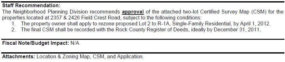
 Dane County Planning & Development Land Division Review Date: June 26, 2012 To: Zoning & Land Regulation Committee From: Daniel Everson, Land Division Review Re: Revere Trails (preliminary plat) Town of
CONDITIONAL USE PERMIT (CUP)
") CONDITIONAL USE PERMIT (CUP) LAND DEVELOPMENT APPLICATION FORM DEPARTMENT OF PLANNING 300 East Main Street, Sun Prairie, WI 53590-2227 (608)825-1107 FAX (608)825-1194 Applications will not be processed
CONDITIONAL USE PERMIT (CUP) LAND DEVELOPMENT APPLICATION FORM DEPARTMENT OF PLANNING 300 East Main Street, Sun Prairie, WI 53590-2227 (608)825-1107 FAX (608)825-1194 Applications will not be processed
ARTICLE 6 PRELIMINARY PLAT
 ARTICLE 6 PRELIMINARY PLAT SECTION: 30-06-01: Preliminary Plat 30-06-02: Information Required for Preliminary Plat 30-06-03: Determination of Requirement for Environmental Review Documents 30-06-04: Additional
ARTICLE 15 - PLANNED UNIT DEVELOPMENT
 Section 15.1 - Intent. ARTICLE 15 - PLANNED UNIT DEVELOPMENT A PUD, or Planned Unit Development, is not a District per se, but rather a set of standards that may be applied to a development type. The Planned
City of Sanibel. Planning Department STAFF REPORT
 City of Sanibel Planning Department STAFF REPORT Planning Commission Meeting: July 23, 2013 Planning Commission Agenda Item: No 7b. Application Number: 13-7438DP Applicant Name: Attorney Beverly Grady
Conditional Use Permit / Standard Subdivision Application
 Conditional Use Permit / Standard Subdivision Application Name of Proposed Subdivision: Total Area (Acres) Is Proposed Subdivision to be built in phases? Number of Lots If yes, how many phases? Applicant/Owner
MIDWAY CITY Municipal Code
 MIDWAY CITY Municipal Code TITLE 9 ANNEXATION CHAPTER 9.01 PURPOSE CHAPTER 9.02 GENERAL REQUIREMENTS CHAPTER 9.03 PROPERTY OWNER INITIATION OF ANNEXATION CHAPTER 9.04 PROCEDURES FOR CONSIDERATION OF PETITION
1105 SUBDIVISIONS, PARTITIONS, REPLATS, CONDOMINIUM PLATS, AND VACATIONS OF RECORDED PLATS
 1105 SUBDIVISIONS, PARTITIONS, REPLATS, CONDOMINIUM PLATS, AND VACATIONS OF RECORDED PLATS 1105.01 PURPOSE AND APPLICABILITY Section 1105 is adopted to provide standards, criteria, and procedures under
LAND DIVISION ORDINANCE
 LAND DIVISION ORDINANCE TOWN OF OMRO, WISCONSIN Chapter 7 Adopted on June 20, 2016 Resolution #2016-01 TABLE OF CONTENTS Section Page DEFINITIONS 7.00 Definitions 1 INTRODUCTION 7.01 Authority 5 7.02 Title
ARTICLE 8C SITE CONDOMINIUM DEVELOPMENT ORDINANCE
 ARTICLE 8C SITE CONDOMINIUM DEVELOPMENT ORDINANCE SECTION 8C.01 PURPOSE It is the purpose of this Ordinance to insure that plans for development within Oceola Township proposed under the provisions of
CHAPTER 45 SUBDIVISION ORDINANCE CHAPTER 45 LAND DIVISION AND SUBDIVISION REGULATIONS
 CHAPTER 45 LAND DIVISION AND SUBDIVISION REGULATIONS 45.01 TITLE 45.02 INTENT AND PURPOSE 45.03 GENERAL REQUIREMENTS (1) Conformance with Policies (2) Land Suitability (3) Determination of Adequacy of
APPLICATION FOR MAJOR SUBDIVISION APPROVAL (PRELIMINARY PLAT)
") 209 S. Main Street Marysville, Ohio 43040 Phone: (937) 645-7350 Fax: (937) 645-7351 www.marysvilleohio.org APPLICATION FOR MAJOR SUBDIVISION APPROVAL (PRELIMINARY PLAT) *** IMPORTANT INFORMATION ~ Please
209 S. Main Street Marysville, Ohio 43040 Phone: (937) 645-7350 Fax: (937) 645-7351 www.marysvilleohio.org APPLICATION FOR MAJOR SUBDIVISION APPROVAL (PRELIMINARY PLAT) *** IMPORTANT INFORMATION ~ Please
SUBDIVISION APPLICATION CHECKLIST SKETCH PLAN PRELIMINARY PLAT FINAL PLAT
 RECEIVED STAMP SUBDIVISION APPLICATION CHECKLIST SKETCH PLAN PRELIMINARY PLAT FINAL PLAT A checklist of background information and submission requirements for processing of a sketch plan, preliminary plat
City of Prior Lake APPLICATION FOR COMBINED PRELIMINARY AND FINAL PLAT
 Case File No. Property Identification No. City of Prior Lake APPLICATION FOR COMBINED PRELIMINARY AND FINAL PLAT Requested Action Brief description of proposed project (Please describe the proposed amendment,
CHAPTER 10 Planned Unit Development Zoning Districts
 CHAPTER 10 Planned Unit Development Zoning Districts Section 10.1 Intent and Purpose The Planned Unit Development (PUD) districts are intended to offer design flexibility for projects that further the
SECTION 16. "PUD" PLANNED UNIT DEVELOPMENT OVERLAY DISTRICT
 SECTION 6. "PUD" PLANNED UNIT DEVELOPMENT OVERLAY DISTRICT Subsection. Purpose. This district is established to achieve the coordinated integration of land parcels and large commercial and retail establishments
ARTICLE SINGLE FAMILY SITE CONDOMINIUM DEVELOPMENT STANDARDS
 ARTICLE 28.00 SINGLE FAMILY SITE CONDOMINIUM DEVELOPMENT STANDARDS Section 28.01 PURPOSE The purpose of this Article is to recognize that conventional single family developments, traditionally developed
Chapter 100 Planned Unit Development in Corvallis Urban Fringe
 100.100 Scope and Purpose. Chapter 100 Planned Unit Development in Corvallis Urban Fringe (1) All applications for land divisions in the Urban Residential (UR) and Flood Plain Agriculture (FPA) zones within
CHAPTER 11 SUBDIVISION ORDINANCE CODE OF ORDINANCES OF THE COUNTY OF FLORENCE, WISCONSIN
 CHAPTER 11 SUBDIVISION ORDINANCE CODE OF ORDINANCES OF THE COUNTY OF FLORENCE, WISCONSIN LIST COUNTY OF FLORENCE OFFICIALS COUNTY BOARD Edwin Kelley, Chairman Robert Wicklund, Vice Chairman Larry Dzekute
610 LAND DIVISIONS AND PROPERTY LINE ADJUSTMENTS OUTSIDE A UGB
 ARTICLE VI: LAND DIVISIONS AND PROPERTY LINE ADJUSTMENTS VI-21 610 LAND DIVISIONS AND PROPERTY LINE ADJUSTMENTS OUTSIDE A UGB 610-1 Property Line Adjustments (Property Line Relocation) A property line
ARTICLE V PRELIMINARY PLAN SUBMISSION
 ARTICLE V PRELIMINARY PLAN SUBMISSION 501. Plan Requirements a. On or before the 25 th day of the month prior to a regularly scheduled meeting of the Planning Commission, the applicant shall submit two
Town of Prairie du Sac Sauk County, WI. Land Division Ordinance 07-3
 Town of Prairie du Sac Sauk County, WI Land Division Ordinance 07-3 1.01 DISCLAIMER (1) Multiple Jurisdictions. All persons reviewing the provisions of this Ordinance should be aware that the Town of Prairie
PLANNING AND ZONING DEPARTMENT
 Town of Minturn Development Review Process: Guide To Planned Unit Developments (Concept Plan) This guide describes the Planned Unit Development Process. This guide should be utilized in conjunction with
Workshop for Local Planning and Zoning Officials. Rebecca Roberts Center for Land Use Education UW Stevens Point/Extension
 Workshop for Local Planning and Zoning Officials Rebecca Roberts Center for Land Use Education UW Stevens Point/Extension Roles and Governing Body Responsibilities Staff Boards/Committees Land Use Tools
ZONING & LAND USE APPLICATION
 City of Maple Plain 5050 Independence St P.O. Box 97 Maple Plain, MN 55359 Office: (763) 479-0515 Fax: (763) 479-0519 ZONING & LAND USE APPLICATION APPLICANT INFORMATION Applicant Name Company, if applicable
ARTICLE 13 CONDOMINIUM REGULATIONS
 ARTICLE 13 CONDOMINIUM REGULATIONS Section 13.01 Purpose. The purpose of this Article is to regulate projects that divide real property under a contractual arrangement known as a condominium. New and conversion
ARTICLE 100 SUBDIVISION APPLICATION PROCEDURE AND APPROVAL PROCESS
 ARTICLE 100 SUBDIVISION APPLICATION PROCEDURE AND APPROVAL PROCESS 100.01 General Procedure 100.02 Exempt Subdivision 100.03 Administrative Subdivision 100.04 Major Subdivision 100.05 Signing and Recording
CITY OF SARALAND PRELIMINARY SUBDIVISION PLAT REVIEW
 PRELIMINARY SUBDIVISION PLAT REVIEW Application Number: Date Plat Submitted: Name of Subdivision: Name of Owner: Owner Address: (Street or P.O. Box) Telephone #: (City) (State) (Zip) E-mail: Name of Authorized
STATE OF MICHIGAN COUNTY OF MARQUETTE, TOWNSHIP OF NEGAUNEE LAND DIVISION, SUBDIVISION AND CONDOMINIUM ORDINANCE
 STATE OF MICHIGAN COUNTY OF MARQUETTE, TOWNSHIP OF NEGAUNEE LAND DIVISION, SUBDIVISION AND CONDOMINIUM ORDINANCE Adopted: August 8 th, 2008 Effective: August 28 th, 2008 Sec.100. Title ARTICLE I GENERAL
A Guide to the Municipal Planning Process in Saskatchewan
 A Guide to the Municipal Planning Process in Saskatchewan A look at the municipal development permit and the subdivision approval process in Saskatchewan May 2008 Prepared By: Community Planning Branch
SECTION 10 STANDARD PLATS
 SECTION 10 - STANDARD PLATS Subdivision 1: Purpose Standard Plats allow the subdivision of land into lots smaller than the minimum metes and bounds size in the zoning district, and control road development
Plans shall be drawn at a readable scale, signed, and sealed by a Florida Registered Engineer. The application package shall include:
 CHAPTER 400. SECTION 403. PERMIT TYPES AND APPLICATIONS SITE DEVELOPMENT 403.3. Preliminary Site Plans (PSP) A. Intent and Purpose PSPs are used to identify existing site conditions and demonstrate general
Article 6: Planned Unit Developments
 LUDC 2013 GARFIELD COUNTY, COLORADO Article 6: Planned Unit Developments ARTICLE 6 PLANNED UNIT DEVELOPMENTS TABLE OF CONTENTS DIVISION 1. GENERAL.... 1 6-101. GENERAL PROVISIONS.... 1 A. Purpose....
Article Optional Method Requirements
 Article 59-6. Optional Method Requirements [DIV. 6.1. MPDU DEVELOPMENT IN RURAL RESIDENTIAL AND RESIDENTIAL ZONES Sec. 6.1.1. General Requirements... 6 2 Sec. 6.1.2. General Site and Building Type Mix...
Planned Unit Development (PUD). Sections:
. Sections:") Chapter 19.07. Planned Unit Development (PUD). Sections: 19.07.01. Purpose. 19.07.02. PUD Definition and Design Compatibility. 19.07.03. General PUD Standards. 19.07.04. Underlying Zones. 19.07.05. Permitted
Chapter 19.07. Planned Unit Development (PUD). Sections: 19.07.01. Purpose. 19.07.02. PUD Definition and Design Compatibility. 19.07.03. General PUD Standards. 19.07.04. Underlying Zones. 19.07.05. Permitted
CITY OF CORNING TENTATIVE MAPS
 CITY OF CORNING TENTATIVE MAPS APPLICANT S GUIDE TO PROCEDURES WHAT IS A TENTATIVE MAP? A division of land for the purpose of sale, lease, or finance requires submittal of a map for City approval showing
I. Requirements for All Applications. C D W
 108-16.1. Application checklists. Checklist for Required Submissions to the Planning Board or Zoning Board of Adjustment of Monroe Township All required submissions are to be made to the Administrative
CHAPTER 11 SUBDIVISION ORDINANCE CODE OF ORDINANCES OF THE COUNTY OF FLORENCE, WISCONSIN
 CHAPTER 11 SUBDIVISION ORDINANCE CODE OF ORDINANCES OF THE COUNTY OF FLORENCE, WISCONSIN This Page Intentionally Left Blank LIST COUNTY OF FLORENCE OFFICIALS COUNTY BOARD Jeanette Bomberg, Chair Edwin
THE SUBDIVISION AND LAND DEVELOPMENT REVIEW PROCESS
 THE SUBDIVISION AND LAND DEVELOPMENT REVIEW PROCESS INTRODUCTION: Howard County Subdivision and Land Development Regulations are intended to promote the health, safety and general welfare of County residents.
SUBDIVISION APPLICATION
 SUBDIVISION APPLICATION Community Planning and Economic Development Development Services Division 250 South 4 th Street, Room 300 Minneapolis MN 55415-1316 612-673-3000 This application packet is used
WASCO COUNTY PRELIMINARY SUBDIVISION APPLICATION
 WASCO COUNTY PRELIMINARY SUBDIVISION APPLICATION DETAILED SPECIFIC WRITTEN REQUEST File Number: SDV- Number of Proposed Lots & their Dimensions: PRELIMINARY SUBDIVISION PLAN REQUIREMENTS The approval of
SUBDIVISION REGULATIONS
 CHAPTER 14 SUBDIVISION REGULATIONS 14-100 Provisions 14-200 Preliminary Plat 14-300 Final Plat 14-400 Replat 14-500 Minor Subdivision 14-600 Administrative Replat 14-700 Vacation of Roadways, Public Easements,
Town of Shelburne, Vermont
 Town of Shelburne, Vermont CHARTERED 1763 P.O. BOX 88 5420 SHELBURNE ROAD SHELBURNE, VT 05482 www.shelburnevt.org 802-985-5118 * * Also available in alternate formats in accordance with the Americans With
Residential Minor Subdivision Review Checklist
 Residential Minor Subdivision Review Checklist Plan Submittal Requirements: 2 full sets of stamped plans Electric submittal - all plans contained in a single PDF 3 full sets if commercial kitchen or dining
CITY OF GROVER BEACH COMMUNITY DEVELOPMENT DEPARTMENT Tentative Map Checklist
 CITY OF GROVER BEACH COMMUNITY DEVELOPMENT DEPARTMENT Tentative Map Checklist The following list includes all of the items you must submit for a complete application. Some specific types of information
Town of Lisbon, Maine SUBDIVISION REVIEW APPLICATION
 Date Received: Fee Paid (amount): Applicant: Town of Lisbon, Maine SUBDIVISION REVIEW APPLICATION Subdivision Name/Title: This application must be received at the Town Office by close of business on the
Draft Zoning Changes for the 2nd Planning Board Public Hearing, January 22, 2018.
 Draft Zoning Changes for the 2nd Planning Board Public Hearing, January 22, 2018. No changes were made at the 1st Public Hearing. Proposed wording for the 1 st Public Hearing in red, eliminated text in
Application for Sketch Plan Review
 Town of Standish 175 Northeast Road Standish, ME - 04084 Phone: (207)642-3461 Fax: (207) 642-5181 Application for Sketch Plan Review Applicant & Owner Information 1) Name of Applicant: Address: Phone:
Condominium Unit Requirements.
 ARTICLE 19 CONDOMINIUM REGULATIONS Section 19.01 Purpose. The purpose of this Article is to regulate projects that divide real property under a contractual arrangement known as a condominium. New and conversion
LETTER OF APPLICATION
 Description of Proposed Land Division: LETTER OF APPLICATION The proposed land division would split a 1.94 acres rectangular lot into two lots. The general configuration would have one lot in front of
BRIDGETON SUBDIVISION APPLICATION CHECKLIST
 APPLICATION NAME AND # CHECKLIST COMPLETED BY: DATE: Signature and printed name BRIDGETON SUBDIVISION APPLICATION CHECKLIST TO SUBDIVISION APPLICANTS: The attached checklist is to assist you in the submission
Medical Marijuana Special Exception Use Information
 Medical Marijuana Special Exception Use Information The Special Exception Use information below is a modified version of the Unified Development Code. It clarifies the current section 5:104 Special Exceptions
APPENDIX C-1 DEVELOPING FINDINGS OF FACT & CONCLUSIONS OF LAW FOR PLANNING AND ZONING
 APPENDIX C-1 DEVELOPING FINDINGS OF FACT & CONCLUSIONS OF LAW FOR PLANNING AND ZONING Amended: 9/2011; 9/2014; Page! i DEVELOPING FINDINGS OF FACT, AND CONCLUSIONS OF LAW 1. Developing the following information
Open Space Model Ordinance
 Open Space Model Ordinance Section I. Background Open space development has numerous environmental and community benefits, including: 1) Reduces the impervious cover in a development. Impervious cover
CHAPTER 18 LAND DIVISION ORDINANCE
 CHAPTER 18 LAND DIVISION ORDINANCE Adopted by the Common Council on May 12, 2009 (Ordinance #1296) Prepared by the City of Muskego Community Development Department i CHAPTER 18 SUBDIVISION AND PLATTING
FINAL DRAFT 12/1/16, Rev. to 7/18/17
 FINAL DRAFT 12/1/16, Rev. to 7/18/17 (As Adopted 8/8/17 Effective 9/1/17) SHELTON PLANNING AND ZONING COMMISSION Proposed Amendments to Zoning Regulations I. Amend Section 23 PERMITTED USES by inserting
LAND DIVISION AND SUBDIVISION CODE. Town of Springdale Dane County, Wisconsin
 1 2 3 4 5 6 7 8 9 10 11 12 13 14 15 16 17 18 19 20 21 22 23 24 25 26 27 28 29 30 31 32 33 34 35 36 37 38 39 40 41 42 43 44 45 46 Town of Springdale Dane County, Wisconsin Chapter 3. SUBCHAPTER 1 INTRODUCTION
DRAFT FOR PUBLIC HEARING (rev. March, 2016)
") Chapter 200. ZONING Article VI. Conservation/Cluster Subdivisions 200-45. Intent and Purpose These provisions are intended to: A. Guide the future growth and development of the community consistent with
Chapter 200. ZONING Article VI. Conservation/Cluster Subdivisions 200-45. Intent and Purpose These provisions are intended to: A. Guide the future growth and development of the community consistent with
Township of Collier 2418 Hilltop Road Presto, PA 15142
 Township of Collier 2418 Hilltop Road Presto, PA 15142 Fees: Major: 2 checks $600 + $50 per lot & $1700 Escrow) APPLICATION FOR SUBDIVISION major FINAL only Plans must be folded Rolled plans will not be
HOW TO APPLY FOR A USE PERMIT
 HOW TO APPLY FOR A USE PERMIT MENDOCINO COUNTY PLANNING AND BUILDING SERVICES What is the purpose of a use permit? Throughout the County, people use their properties in many different ways. They build
Page 75-1 rev
 75.01 75.05 TITLE 14 PLANNING AND DEVELOPMENT Chapter 75 Land Division and Subdivision Regulations Chapter 76 Naming Roads and Numbering Buildings Chapter 78 Special Regulation of Structures and Trees
POLK COUNTY CHAPTER 18 SUBDIVISION ORDINANCE
 POLK COUNTY CHAPTER 18 SUBDIVISION ORDINANCE Ordinance No. 13-17 Polk County Chapter 18 Subdivision Ordinance Enacted: March 21, 2017; Published: March 29, 2017 Effective Date: March 29, 2017 Polk County
DEVELOPMENT PLAN ORDINANCE
 DEVELOPMENT PLAN ORDINANCE CITY OF GLASGOW Ordinance No. 2026 SECTION A. Section 1. INTENT AND PURPOSE The purpose of this Ordinance is to establish and define development plans, which may be utilized
201 General Provisions
 201 General Provisions 201.01 Title 201.09 Amendments 201.02 Purpose and Intent 201.10 Public Purpose 201.03 Authority 201.11 Variances and Appeals 201.04 Jurisdiction 201.12 Nonconformances 201.05 Enactment
LAND DIVISION ORDINANCE TOWN OF ADDISON WASHINGTON COUNTY WISCONSIN
 LAND DIVISION ORDINANCE TOWN OF ADDISON WASHINGTON COUNTY WISCONSIN SOUTHEASTERN WISCONSIN REGIONAL PLANNING COMMISSION TOWN OF ADDISON OFFICIALS Town Board Supervisors Chairman... Robert Bingen Supervisors...Don
A.3. ARTICLE 7 PLAN REQUIREMENTS FOR MINOR SUBDIVISION AND/OR LAND DEVELOPMENT
 700. 701.A.3. ARTICLE 7 PLAN REQUIREMENTS FOR MINOR SUBDIVISION AND/OR LAND DEVELOPMENT SECTION 700 PURPOSE The purpose of this Article is to set forth a streamlined set of Plan Requirements for minor
A. Appropriate agency responsible for transportation review for the subject property.
 7.8.10 Procedure Any person desiring to create a minor subdivision shall submit to the Commission for approval an application on forms provided by the Division, and a record plat in conformance with the
SUBMITTAL REQUIREMENTS: The number indicates the number of copies for submittal (if applicable).
.") Office Use Only Preliminary Long Plat Long Subdivision Applicant Checklist PLANNING, COMMUNITY, & ECONOMIC DEVELOPMENT DEPARTMENT PRELIMINARY LONG PLAT LONG SUBDIVISION CHECKLIST Mailing Address: P.O.
Office Use Only Preliminary Long Plat Long Subdivision Applicant Checklist PLANNING, COMMUNITY, & ECONOMIC DEVELOPMENT DEPARTMENT PRELIMINARY LONG PLAT LONG SUBDIVISION CHECKLIST Mailing Address: P.O.
City of Altamonte Springs Developer s Guide
 Section 6 SUBDIVISION PLAN & PLAT REVIEW PROCESS This section contains information, applications, and checklists related to the subdivision development plan and plat review process in Altamonte Springs.
SHEBOYGAN COUNTY SUBDIVISION ORDINANCE
 1 SHEBOYGAN COUNTY SUBDIVISION ORDINANCE 71.01 AUTHORITY... 3 71.02 TITLE... 3 71.03 PURPOSE... 3 71.04 SEVERABILITY AND NON-LIABILITY... 3 71.05 REPEAL... 3 71.06 ABROGATION AND GREATER RESTRICTIONS...
City of Prior Lake APPLICATION FOR REGISTERED LAND SURVEY
 Case File No. Property Identification No. City of Prior Lake APPLICATION FOR REGISTERED LAND SURVEY Requested Action Brief description of proposed project (Please describe the proposed amendment, project,
APPLICATION for MINOR SUBDIVISION REVIEW for CONCEPT and FINAL PLAT within COALVILLE CITY. Project Name: Project Address or Area: Name of Owner:
 APPLICATION for MINOR SUBDIVISION REVIEW for CONCEPT and FINAL PLAT within COALVILLE CITY For Office Use Only: Application #: Application Date: PC Approval Date: CC Approval Date: Community Development
AN ORDINANCE TO AMEND SECTION OF THE RAPID CITY MUNICIPAL CODE TO ALLOW FOR ADMINISTRATIVE DISSOLUTION OF PLANNED DEVELOPMENTS
 Ordinance No. 6231 AN ORDINANCE TO AMEND SECTION 17.50.050 OF THE RAPID CITY MUNICIPAL CODE TO ALLOW FOR ADMINISTRATIVE DISSOLUTION OF PLANNED DEVELOPMENTS WHEREAS, the City of Rapid City has adopted a
CONDITIONAL USE PERMIT Application Packet
 CONDITIONAL USE PERMIT Application Packet Community Development Department 1020 East Pioneer Road, Draper, UT 84020 (801) 576-6539 Fax (801) 576-6526 Dear Applicant, This application packet has been developed
CHAPTER SUBDIVISION MAPS
 CHAPTER 19.66 SUBDIVISION MAPS SUBDIVISION MAPS 19.66 Section Page 19.66.010 Purpose... IV-56 19.66.020 Application... IV-57 19.66.030 Exclusions... IV-57 19.66.040 Effect of Annexation... IV-57 19.66.050
Town of Norwich, Vermont SUBDIVISION REGULATIONS
 Town of Norwich, Vermont SUBDIVISION REGULATIONS Adopted: August 6, 2002 Amended: February 8, 2006 Prepared by Norwich Planning Commission with the assistance of: Burnt Rock Inc. A ssociates in Community
CHECKLIST FOR DEVELOPMENT REVIEW
 CHECKLIST FOR DEVELOPMENT REVIEW Petitions and related documents and plans for land development or other proposals regulated by Title 16 of the Municipal Code (Development Ordinance) and Title 17 of the
Major Subdivision Application Packet. Revised June 2018
 Major Subdivision Application Packet Revised June 2018 Caroline County Department of Planning and Community Development 233 West Broaddus Avenue Bowling Green, VA 22427 www.co.caroline.va.us Phone: 804-633-4303
Subdivision and Land Development Regulations. Jefferson County, West Virginia
 Subdivision and Land Development Regulations Jefferson County, West Virginia Adopted October 9, 2008 Amended September 29, 2016 Amendment Reference This document contains additions and amendments approved
A. Preserve natural resources as identified in the Comprehensive Plan.
 1370.08 Conservation Residential Overlay District. Subd. 1 Findings. The City finds that the lands and resources within the Conservation Residential Overlay District are a unique and valuable resource
APPLICATION PACKET SINGLE FAMILY CLUSTER HOUSING OPTION REVIEW
 APPLICATION PACKET SINGLE FAMILY CLUSTER HOUSING OPTION REVIEW COMMUNITY DEVELOPMENT DEPARTMENT CHARTER TOWNSHIP OF PLYMOUTH 9955 N. Haggerty Road Plymouth, MI 48170 Fees Revised 9.13.2017 1. PURPOSE APPLICATION