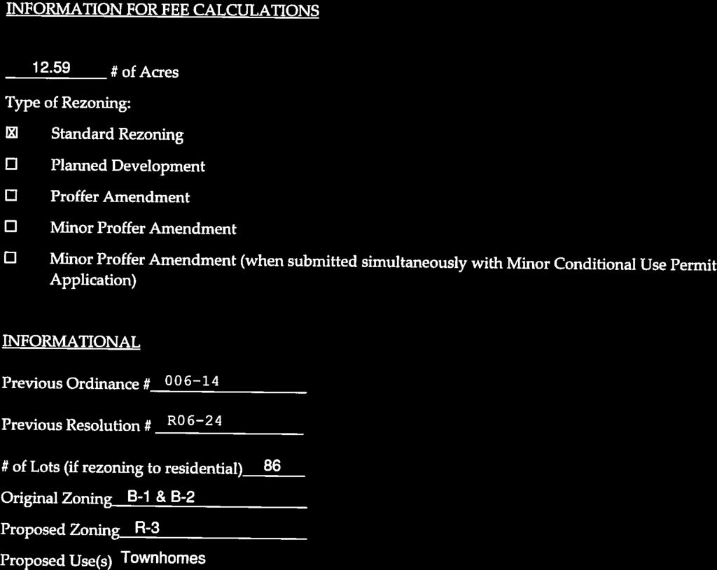
Attachment 1 O Zoning Map. Zoning History
|
|
|
- Alaina Copeland
- 5 years ago
- Views:
Transcription


1
, on 12.")
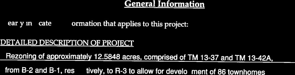
2 Attachment 1 O17-10 BACKGROUND REPORT Quantico Village, LLC (Applicant) is requesting a reclassification from the B-1, Convenience Commercial and B-2, Urban Commercial Zoning Districts to the R-3, Urban Residential High Density Zoning District, to allow for the construction of 86 townhouse residential units on Tax Map Parcel Nos and 13-42A (Property), on acres, located on the south side of Telegraph Road, 1,200 feet east of Jefferson Davis Highway. The zoning map below highlights the rezoning area in red outline. Zoning History Zoning Map The Property was rezoned from R-4, Manufactured Home to B-2, Urban Commercial on October 17, 2006 with proffers. The current proffered B-2 zoning development scheme envisions a mixed use of commercial and residential apartment units in up to 180,200 square feet of buildings. The residential uses were not specifically proffered, but there are proffer contributions of $10,000 per unit. The residential units would have been permitted at the time in the B-2 district under the Commercial Apartment use designation. Subsequently on September 2, 2008, the Commercial Apartment use was deleted as a permitted use from the B-2 Zoning District. In September of 2009, a site plan was submitted for 180,200 square feet of office/warehouse space but was not approved. No other development activity on the Property has occurred to date. Existing Conditions The Property is surrounded by a variety of residential uses, including single-family detached, townhome, and mobile home units. The parcels to be developed are currently undeveloped. No resource protection areas have been identified. There are wetlands that bisect the Property.

3 Attachment 1 O17-10 Page 2 The site has varying topography including a level high plateau on the eastern end, steep slope down to a level area in the middle of the Property where the wetlands are located and steep slopes upward to a peak in the western portion of the site. The elevations are clearly identified on the existing conditions exhibit, page 2 of the Generalized Development Plan (GDP). Generalized Development Plan (GDP) Site Aerial View The GDP (Attachment 6) depicts the proposed design of the site to include 86 townhouse lots. A 10-foot buffer and a board fence will be present along the Property boundaries to the east, north, and south. There will be a single access point off of Telegraph Road, with dedicated left and right turn lanes out of the site, and a deceleration lane on Telegraph Road. The internal streets are designed to account for the varying topography. The townhouse units in the eastern portion of the Property sit on the upper plateau. A neighborhood street circles down to the central area of the site where more townhouse units sit at a lower elevation. Retaining walls would likely be required between these two areas. Secondary vehicle access was requested by Fire and Rescue staff, but the Applicant was unable to secure a connection at this time. To address this concern, vehicle turn-around areas for emergency vehicles would be provided in the central area of the Property. The western portion of the Property would remain undeveloped open space where the topography is more severe. The GDP reflects 7.92 acres of open space accounting for approximately 63% of the Property. This exceeds the 25% minimum required by the R-3 Zoning District. The open space will be used for stormwater management facilities, wetland preservation, natural areas, and community recreation. For community recreation use, a tot lot is proposed to be constructed, in the location shown on the GDP. The tot lot will include a swing set, sliding and climbing equipment, and a bench.
, which is under the 1,000 VPD threshold requiring a TIA.")
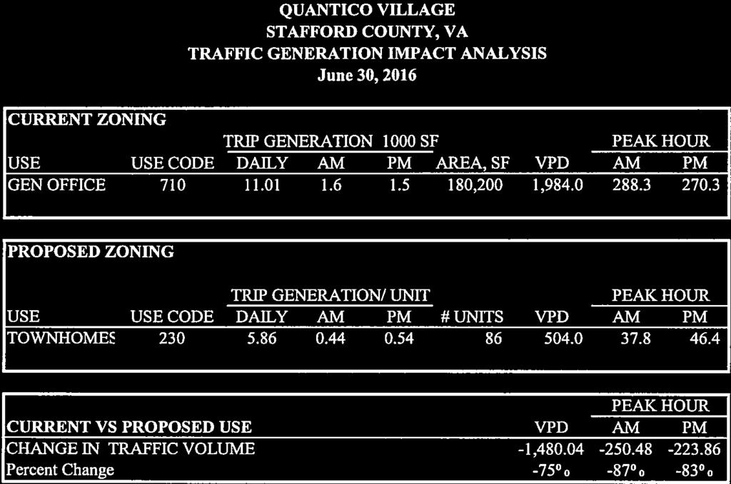
4 Attachment 1 O17-10 Page 3 Generalized Development Plan Transportation A transportation impact analysis (TIA) was not required with this application. It was estimated that the use would generate up to 504 vehicle trips per day (VPD), which is under the 1,000 VPD threshold requiring a TIA. In addition, as noted in this report, this zoning action would reduce the potential amount of traffic to 25% of what might occur under the current B-2 Zoning District. The B-2 zoning of the site, allowing up to 180,200 square feet of office space, is equivalent to 1,984 VPD. In addition to the proposed entrance improvements, the applicant will need to meet site distance requirements on Telegraph Road which will be reviewed as part of the preliminary plan. Comprehensive Plan The Comprehensive Plan identifies this site as being within the Boswell s Corner Planning Area. This Planning Area includes a conceptual land use plan, which recommends the site for business and industry and highway commercial future land use.


5 Attachment 1 O17-10 Page 4 Boswell s Corner Planning Area - Land Use Concept Redevelopment Area Plan The Boswell s Corner Redevelopment Area Plan (RDA Plan), a separate element of the Comprehensive Plan that was adopted in 2011, applies to this area as well and includes a higher level of detail. The RDA Plan as it was being developed envisioned a mixed-use urban scale development pattern, including a grid pattern network of streets and various types of residential and commercial uses. This is reflected in many of the illustrations in the RDA Plan, as shown on page 5. The RDA Plan identifies residential uses in the location of the subject Property. Upon adoption of the RDA Plan, due to the proximity to Quantico and potential conflicting uses, new residential use was limited with the approval resolution specifying that no more residential should be permitted beyond what already exists or is permitted by-right. Therefore, the proposal is not fully consistent with the goals of the RDA Plan. An argument can be made that the residential uses fit the concept envisioned for this area, although the use may not be in concert with the final recommendations of the RDA Plan.


, as identified in the recently")

6 Attachment 1 O17-10 Page 5 Portion of Boswell s Corner Master Redevelopment Plan Site highlighted in Red Staff notes that the residential use does fit in with the adjacent established residential neighborhoods and commercial development of the site may not be realistic without consolidation with adjacent parcels. Military Influence Area Zones Given the proximity to Marine Corps Base Quantico (Base), the proposed development lies within the Military Influence Area Zone (MIA Zone), as identified in the recently amended Comprehensive Plan. The MIA Zone is divided into sub-zones. The Property is within Zone 2.2. The Comprehensive Plan identifies use compatibility of various uses in each zone, by low, moderate or high impact. In Zone 2.2, residential is identified as having moderate impact. MIA Zones
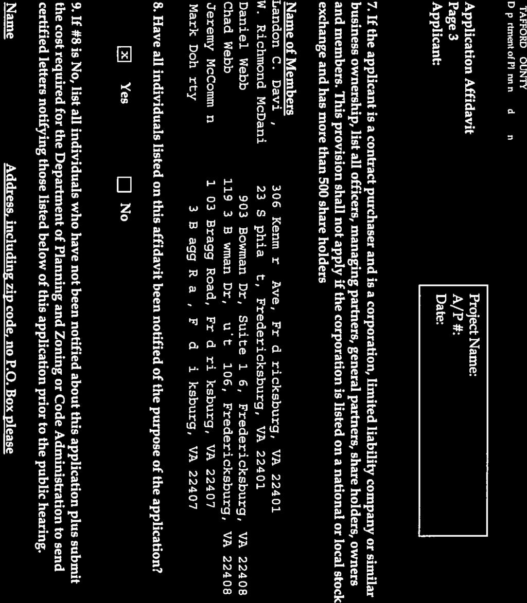
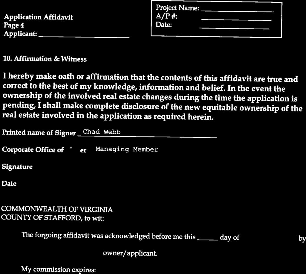
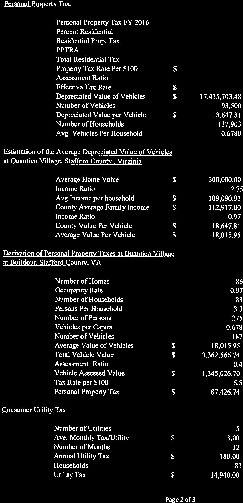
7 Attachment 1 O17-10 Page 6 Mitigation recommendations include sound attenuation, height limits, lighting controls and special reviews. As an attempt to address this issue, the Applicant is proffering to incorporate soundproofing construction materials, and provide real estate marketing disclosure notices to notify future purchasers that activities on the Base make noise and can be distracting. Proffers require construction design specifications for the exterior walls, roofs, and windows that reduce ambient exterior noise levels within each residential unit to a 45dBa Ldn (Average Daily Noise Level) or less. The application was provided to Base staff. In discussions with the Base Planning staff, they were not opposed to the project. Fiscal Impacts Staff notes that the County-wide average annual fiscal impact is -$1, per single-family attached dwelling unit, based on a study prepared for the 2010 Comprehensive Plan. Applied to all 86 new dwellings, this equals a negative impact of -$117, annually. That impact is based on the average sales price of single-family, attached dwelling units in the County and is not reflective of the sales prices of homes within the proposed development. Monetary Proffers Staff notes that this application was submitted on June 30, 2016, prior to the effective date of the amended residential proffer legislation pursuant to Virginia Code A proffer statement dated January 24, 2017, was submitted with this application (Attachment 4). Monetary proffers include per-unit contributions of $14,500 for the 86 new lots. This amount is below the recommended County proffer guideline of $41,557 for townhomes. No consideration of by-right credits can be made in this case given the B-2 zoning, and fact that the prior commercial apartments are no longer a permitted use. As County proffer guidelines recommend, the proffer contribution is allocated to different public facility types. The table on the following page shows a comparison of the proffer guidelines to the recommended proffer as it relates to public facility types for townhouse units: Public Facility Type County Guidelines Applicant Proffer Parks and Recreation $8,923 $4, Schools $18,299 $5, Libraries $737 $ Fire and Rescue $951 $ Transportation $12,082 $3, General Government $565 $ Total $41,557 $14, Proffer Summary The Applicant submitted the following proffers: Require the property to be developed in conformance with the GDP with some modifications permitted for the location of the entrance and stormwater management facilities; Limit the development to 86 townhouse dwelling units;

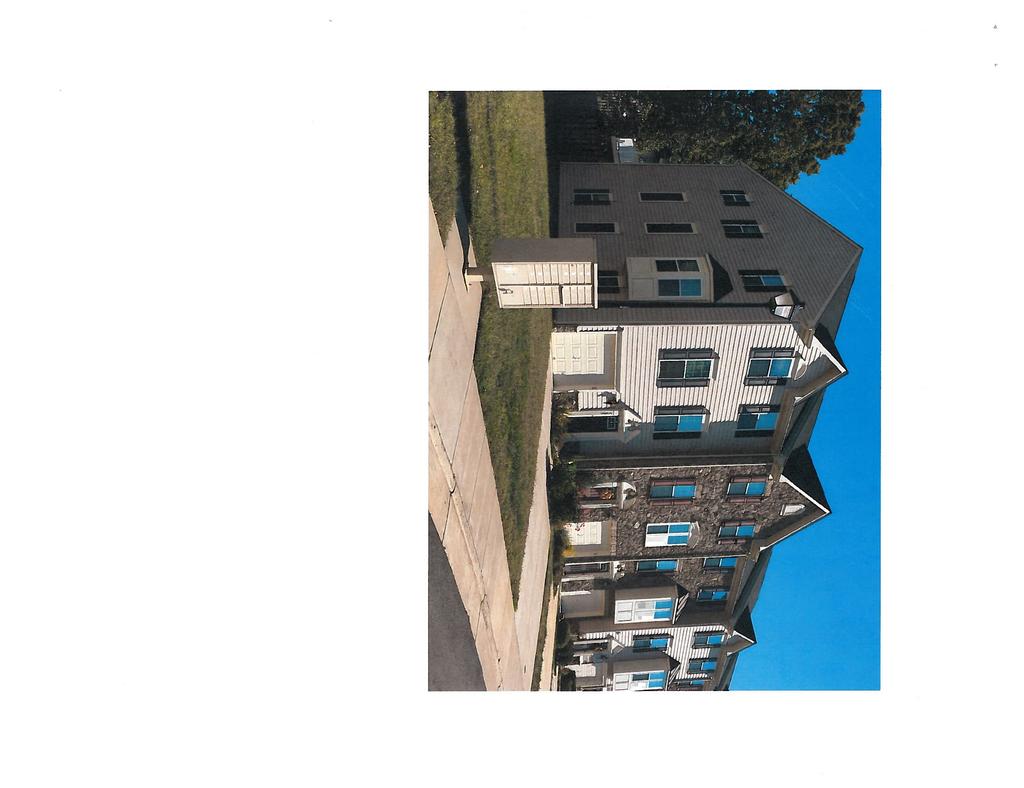
8 Attachment 1 O17-10 Page 7 Require the construction of a tot lot prior to the 16 th occupancy permit being issued; Require the payment of $14, per unit in cash proffers upon the issuance of the certificate of occupancy for each unit, subject to annual adjustments; Require the installation of a right-turn lane on Telegraph Road into the development, as shown on the GDP; Require the architectural design of the townhomes to be in conformance with submitted architectural photo; and For the purpose of mitigating land use compatibility issues with the Military Influence Area, require: o Construction design specifications that reduce ambient exterior noise levels within each residential unit to a 45 dba Ldn (Average Daily Noise Level) or less; o Disclosures be provided to each purchaser regarding the developments proximity to Quantico Marine Corps Base (QMCB); and o Notification statements about QMCB be placed on all plans of development. Architectural Design For purposes of this rezoning, the architectural design of the buildings shall be in general accordance with the attached photograph marked as Exhibit A, as referenced in the proffer statement. The townhomes will be required to be constructed in accordance with these renderings. The design of these townhomes is in conformance with several of the recommendations in the Neighborhood Design Standards (NDS) Plan, including the varying style and materials, wall plane recesses, and projections from one unit to the next, and breaking up of continuous roof lines with gables. Architectural Elevations Exhibit A
9 Attachment 1 O17-10 Page 8 EVALUATION CRITERIA: Stafford County Code Sec lists 12 criteria to be considered at each public hearing for reclassification. 1. Compliance of the request with the stated requirements of the district or districts involved - The request is in compliance with the stated requirements of the R-3 Zoning District. 2. The existing use and character of the property and the surrounding property - The Property is currently vacant with conditions that create some development challenges. Land surrounding the site includes a variety of residential uses, commercial uses, a place of worship and undeveloped land. Much of the surrounding uses are buffered from this site with the exception of the mobile home park and a section of the townhome neighborhood. 3. The suitability of the property for various uses - The conditions of the site make it suitable for uses that can be developed in separated sections; the topography and sensitive natural resources require smaller development pads. The proposed use will likely require less grading and environmental impacts than the development concept contemplated with the current B-2 zoning. 4. The trend of growth and development in the surrounding area - A variety of residential uses exist in the vicinity. The vision for the future of the area supports more business and industry uses in this area. 5. The current and future requirements of the County for land - No County needs are identified on the site. 6. The transportation requirements of the project and the County, and the impact of the proposed landuse on the County s transportation network - The site has access to an existing 2-lane road. This project would reduce potential impacts from what is currently permitted by-right. 7. Requirements for schools, parks, recreational lands and facilities, and other public services, potentially generated by the proposed classification - The proposal would increase the impacts on parks, recreational lands, schools, and other public facilities. The monetary proffers include per-unit cash contributions for these facilities. Based on the proffer guidelines, impacts would not be fully mitigated. 8. The conservation of property values in the surrounding area - The proposed development should not have a negative effect on any property values in the surrounding area. Proffers would ensure an aesthetically pleasing development. Screening and buffers should minimize impacts to lower density residential uses. 9. The preservation of natural resources and the impact of the proposed uses on the natural environment - The site contains sensitive natural resources including wetlands and steep slopes. Many of the wetlands and an area of the site with the most severe steep slopes are being avoided. 10. The most appropriate use of land - The Land Use Plan recommends this area for business and industry use. The proposed uses are not consistent with this Comprehensive Plan recommendation. Despite this, the use is compatible with existing adjacent residential uses.
10 Attachment 1 O17-10 Page The timing of the development of utilities and public facilities, and the overall public costs of the development - The area is served by existing water and sewer utilities. The Applicant would install any required transportation and utility improvements for the project at their expense. The development will generate a need for additional public services, which are partially mitigated through monetary proffers. 12. The consistency, or lack thereof, of the proposed rezoning with the Stafford County Comprehensive Plan as in effect at that time - The proposal is inconsistent with the Comprehensive Plan recommendations regarding the Boswell s Corner Planning Area land-use recommendations, including Redevelopment Area Plan recommendations. The use is consistent with the NDS Plan and Military Influence Area recommendations. SUMMARY OF POSITIVE AND NEGATIVE FEATURES: POSITIVE: 1. The proposal is consistent with the established residential development pattern in the vicinity. 2. Residential use would reduce potential impacts to the transportation network, compared to existing commercial zoning. 3. Proffered building design is consistent with many of the NDS Plan recommendations. 4. The proposed use fits with the RDA Master Plan conceptual drawings. 5. The proposed use is consistent with Military Influence Area recommendations in the Comprehensive Plan NEGATIVE: 1. The proposed use is inconsistent with the Boswell s Corner Planning Area land use recommendations in the Comprehensive Plan. 2. Monetary proffers are below the per-unit amount recommended in the Proffer Guidelines to offset development impacts. RECOMMENDATION: At its meeting on January 25, 2017, the Planning Commission voted (Mr. Boswell abstained) to recommend denial of the application. Staff recommends denial of this application. Although the residential use fits in with the existing residential uses and would reduce potential transportation impacts, the proposal is inconsistent with the future vision for the area.
11 O17-10 PROPOSED BOARD OF SUPERVISORS COUNTY OF STAFFORD STAFFORD, VIRGINIA ORDINANCE At a regular meeting of the Stafford County Board of Supervisors (the Board) held in the Board Chambers, George L. Gordon, Jr., Government Center, Stafford, Virginia, on the 7 th day of March, 2017: MEMBERS: VOTE: Paul V. Milde, III, Chairman Meg Bohmke, Vice Chairman Jack R. Cavalier Wendy E. Maurer Laura A. Sellers Gary F. Snellings Robert Bob Thomas, Jr On motion of, seconded by, which carried by a vote of, the following was adopted: AN ORDINANCE TO AMEND AND REORDAIN THE STAFFORD COUNTY ZONING ORDINANCE BY AMENDING THE ZONING DISTRICT MAP TO RECLASSIFY FROM THE B-1,CONVENIENCE COMMERCIAL AND B-2, URBAN COMMERCIAL ZONING DISTRICTS TO THE R-3, URBAN RESIDENTIAL HIGH DENSITY ZONING DISTRICT, TAX MAP PARCEL NOS AND 13-42A, LOCATED WITHIN THE GRIFFIS-WIDEWATER ELECTION DISTRICT WHEREAS, Quantico Village, LLC, submitted application RC , requesting a reclassification from the B-1, Convenience Commercial and B-2, Urban Commercial Zoning Districts to the R-3, Urban Residential High Density Zoning Districts on Tax Map Parcel Nos and 13-42A, located in the Griffis-Widewater Election District; and WHEREAS, the Board carefully considered the recommendations of the Planning Commission and staff, and the public testimony, if any, received at the public hearing; and WHEREAS, the Board finds that the requested zoning amendment is compatible with the surrounding land uses and meets the criteria for a rezoning in Stafford County Code Sec ; and
12 O17-10 Page 2 WHEREAS, the Board finds that public necessity, convenience, general welfare, and good zoning practice require adoption of this Ordinance to reclassify the subject property; NOW, THEREFORE, BE IT ORDAINED by the Stafford County Board of Supervisors on this the 7 th day of March, 2017, that the Stafford County Zoning Ordinance be and it hereby is amended and reordained by amending the Zoning District Map to reclassify from the B-1, Convenience Commercial and B-2, Urban Commercial Zoning Districts to the R-3, Urban Residential High Density Zoning District, Tax Map Parcel Nos and 13-42A, with proffers entitled Voluntary Proffer Statement, dated June 30, 2016, as last revised on January 24, TCF:JAH:mz
13 R17-44 PROPOSED BOARD OF SUPERVISORS COUNTY OF STAFFORD STAFFORD, VIRGINIA RESOLUTION At a regular meeting of the Stafford County Board of Supervisors (the Board) held in the Board Chambers, George L. Gordon, Jr., Government Center, Stafford, Virginia, on the 7 th day of March, 2017: MEMBERS: VOTE: Paul V. Milde, III, Chairman Meg Bohmke, Vice Chairman Jack R. Cavalier Wendy E. Maurer Laura A. Sellers Gary F. Snellings Robert Bob Thomas, Jr On motion of, seconded by, which carried by a vote of, the following was adopted: A RESOLUTION TO DENY THE REQUEST TO AMEND AND REORDAIN THE STAFFORD COUNTY ZONING ORDINANCE BY AMENDING THE ZONING DISTRICT MAP TO RECLASSIFY FROM THE B-1, CONVENIENCE COMMERCIAL AND B-2, URBAN COMMERCIAL ZONING DISTRICTS TO THE R-3, URBAN RESIDENTIAL HIGH DENSITY ZONING DISTRICT, TAX MAP PARCEL NOS AND 13-42A, LOCATED WITHIN THE GRIFFIS-WIDEWATER ELECTION DISTRICT WHEREAS, Quantico Village, LLC, submitted application RC , requesting a reclassification from the B-1, Convenience Commercial and B-2, Urban Commercial Zoning Districts to the R-3, Urban Residential High Density Zoning Districts on Tax Map Parcel Nos and 13-42A, located in the Griffis-Widewater Election District; and WHEREAS, the Board carefully considered the recommendations of the Planning Commission and staff, and the public testimony, if any, received at the public hearing; and WHEREAS, the Board finds that the requested zoning amendment is incompatible with the surrounding land uses and does not meet the criteria for a rezoning in Stafford County Code Sec ;
14 R17-44 Page 2 NOW, THEREFORE, BE IT RESOLVED by the Stafford County Board of Supervisors on this the 7 th day of March, 2017, that application RC be and it hereby is denied. TCF:JAH:mz
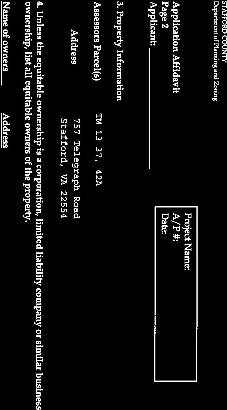
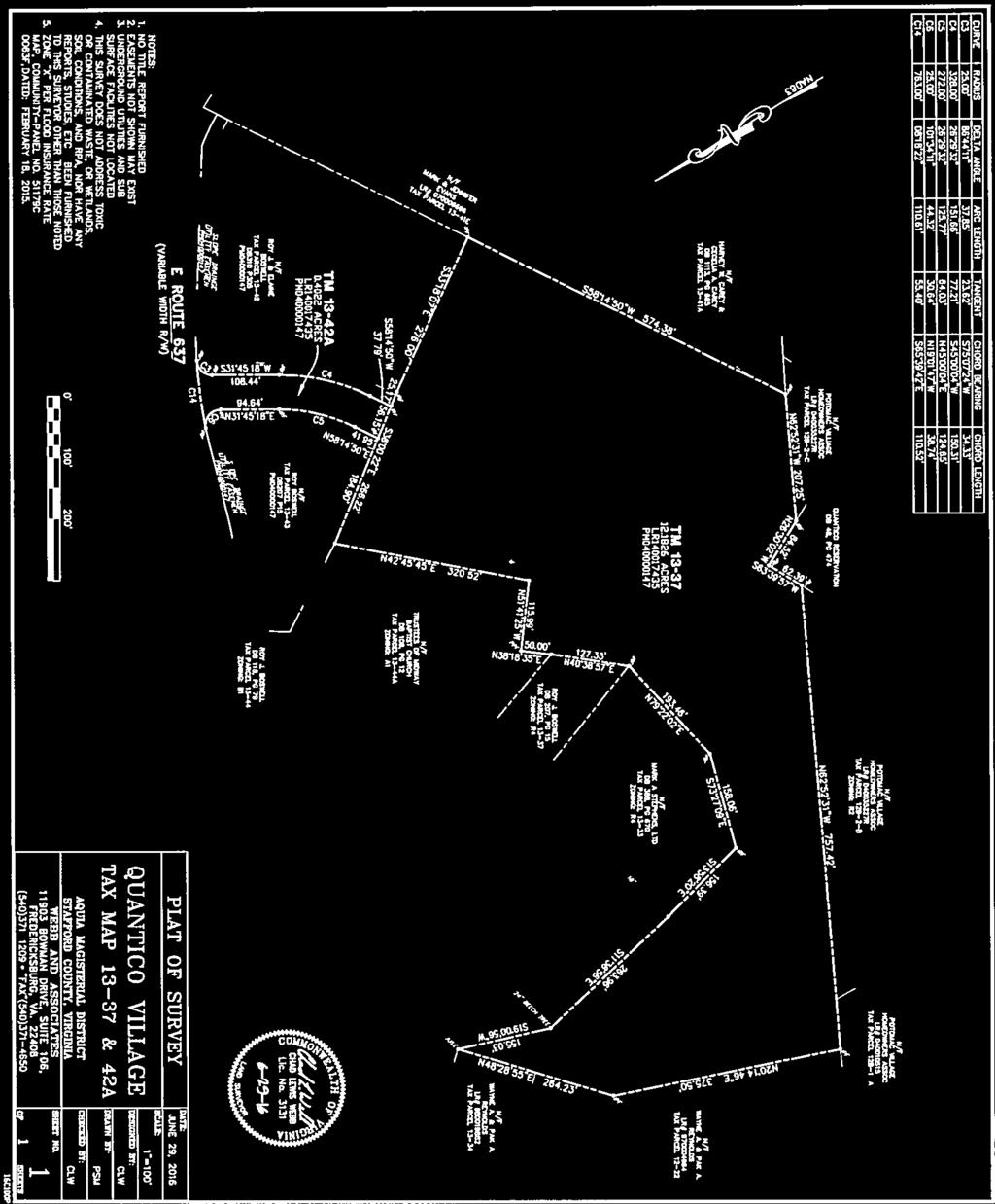
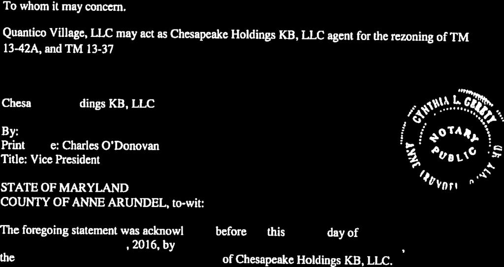
15 Voluntary Proffer Statement OWNER: PROJECT NAME: PROPERTY: Chesapeake Holdings KB, LLC Quantico Village TM 13-37, consisting of acres and TM 13-42A, consisting of acres as shown on Boundary Survey, sheet 1 of 1 prepared by Webb and associates, dated June 29, 2016 REZONING REQUEST: B-1 Convenience Commercial/B-2 Urban Commercial to R-3 Urban Residential High Density CASE NUMBER: DATE: June 30, 2016 Rev. October 6, 2016 Rev. January 24, 2017 Pursuant to Section , Et. Seq. of the Code of Virginia as amended and City Code , the Owner voluntarily proffers the following conditions which shall be applied to the Property if it is rezoned to the zoning districts identified above. References in this Voluntary Proffer Statement to plans and exhibits shall include the following: 1. Zoning Reclassification Generalized Development, Sheets 1 3 prepared by Webb and Associates, dated June 29, 2016, last revised October 6, 2016 and entitled Quantico Village 2. Boundary Survey, sheets 1 of 1 prepared by Webb and Associates, dated June 29, Land Use A. Generalized Development Plan. The development of the Property shall be in conformance with the Generalized Development Plan ( GDP ) by Webb and Associates dated June 29, The maximum number townhouses shall be 86 and will be generally located in the areas depicted on the GDP. The entrance location and/or storm water management facilities and dimensions of undeveloped areas shown on the GDP are subject to modification and/or change due to requirements of final engineering and/or compliance with governmental regulations including, but not limited to USACE, DEQ, VDOT, DHR etc. The General Development Plan is made a part of and is attached to this Proffer Statement. 1
16 2. Common Area Amenities A. Common Area Amenities. Applicant shall construct a tot lot. Tot lot shall contain, a swing set, sliding and climbing equipment, and a bench. Tot lot shall be completed prior to the 16 th occupancy permit being issued. 3. Cash Proffers A. Cash Proffers. Applicant shall pay cash proffers of $14,500 per unit to the County of Stafford. Cash proffers will be paid per unit upon the issuance of a final certificate of occupancy. 1. Cash Disbursements shall be allocated accordingly: a. Parks & Recreation: $4, b. Schools: $5, c. Library: $ d. Fire & Rescue: $ e. Transportation: $3, f. General Government: $ B. Annual Adjustments. The cumulative percentage increase (or decrease) in the Marshall & Swift Building Cost Index, for the most recently published twelve months, shall be added to (or subtracted from) the amount proffered, in the year following the rezoning, and added to (or subtracted from the recalculated amount for each subsequent year. 4. Transportation A. Turn Lane Improvements Telegraph Road. Applicant shall install right turn into the development as shown on the GDP. 5. Design Standards A. Architectural Design. Townhomes will be constructed in accordance with the townhomes shown in Exhibit-A. B. Military Influence Area Mitigation Measures For purposes of mitigating any military land use compatibility issues relating to all residential units, the Applicant agrees to the following mitigating measures: 1. To utilize construction design specifications for the exterior walls, roofs and windows that reduce ambient exterior noise levels within each residential unit to a 45dBa Ldn (Average Daily Noise Level) or less (which shall be determined prior to building permit issuance). 2
17 2. To provide purchasers of the subject units disclosure notices regarding Quantico Marine Corps Base and its proximity to the project on initial deed of transfers. 3. To provide notification statements about Quantico Marine Corps Base on all plans of development. The Applicant acknowledges that the foregoing Proffers are reasonable. The signatory below signing on behalf of the Owner covenants and warrants that he is an authorized signatory of the Owner for this Proffer Statement. Applicant Quantico Village, LLC By:. Chad Webb, Managing Member Given under my hand this 24th day of January Commonwealth of Virginia, City of Fredericksburg, To Wit: I, the undersigned, a Notary Public in and for the State and County aforesaid, do hereby certify that Chad Webb, in his capacity as Managing Member for Quantico Village, LLC whose name is signed to the foregoing bearing the date of January 24, 2017, has this day personally appeared before me in my State and City aforesaid and acknowledged the same. Notary Public:. My Commission Expires: January 31, Registration: Given under my hand this 24 th day of January

18 EXHIBIT-A 4
19 Attachment 5 O17-10 R17-44 LAND USE ACTION REQUEST BOARD OF SUPERVISORS Date: March 7, 2017 [ X ] New [ ] Revised [ ] Unfinished REQUEST: Reclassification from B-1, Convenience Commercial and B-2, Urban Commercial Zoning Districts to the R-3, Urban Residential High Density Zoning District on Tax Map Parcel Nos and 13-42A. Conforms with the Comprehensive Plan? [X] Yes [ ] No [ ] N/A CONDITIONS: See proposed Ordinance O17-10 APPLICANT: Name: Address: Chad Webb Quantico Village, LLC 1003 Bragg Road Fredericksburg, VA TAX STATUS: Paid through May 2017 PLANNING COMMISSION RECOMMENDATION: Approve [X] Deny [ ] At its meeting on January 25, 2017, the Planning Commission voted (Mr. Boswell abstained) to recommend denial of Application RC TIMING: Application Date June 30, 2016 (submitted); June 30, 2016 (completed) Advertisement Date/s February 21, 2017 and February 28, 2017 Plan. Comm. Action Date January 25, 2017 (Required) May 5, 2017 Proposed Board Action Date March 7, 2017 (Required) June 29, 2017
20 Attachment 6 Page 1 of 3
21 Attachment 6 Page 2 of 3
22 Attachment 6 Page 3 of 3


23 Attachment 7 Page 1 of 1

24 Attachment 8 Page 1 of 2

25 Attachment 8 Page 2 of 2

26 Attachment 9 Page 1 of 28

27 Attachment 9 Page 2 of 28
28 Attachment 9 Page 3 of 28
29 Attachment 9 Page 4 of 28


30 Attachment 9 Page 5 of 28

31 Attachment 9 Page 6 of 28

32 Attachment 9 Page 7 of 28

33 Attachment 9 Page 8 of 28

34 Attachment 9 Page 9 of 28

35 Attachment 9 Page 10 of 28

36 Attachment 9 Page 11 of 28

37 Attachment 9 Page 12 of 28

38 Attachment 9 Page 13 of 28


39 Attachment 9 Page 14 of 28
40 Attachment 9 Page 15 of 28

41 Attachment 9 Page 16 of 28

42 Attachment 9 Page 17 of 28

43 Attachment 9 Page 18 of 28

44 Attachment 9 Page 19 of 28

45 Attachment 9 Page 20 of 28

46 Attachment 9 Page 21 of 28


47 Attachment 9 Page 22 of 28

48 Attachment 9 Page 23 of 28

49 Attachment 9 Page 24 of 28

50 Attachment 9 Page 25 of 28


51 Attachment 9 Page 26 of 28

52 Attachment 9 Page 27 of 28


53 Attachment 9 Page 28 of 28
54 Planning Commission Minutes January 25, RC ; Reclassification - Quantico Village - A proposed zoning reclassification from the B-1, Convenience Commercial and B-2, Urban Commercial Zoning Districts to the R-3, Urban Residential High Density Zoning District, to allow for the development of 86 townhouse dwelling units on Tax Map Parcel Nos and 13-42A. The property consists of acres, located on the south side of Telegraph Road, 1,200 feet east of Jefferson Davis Highway, within the Griffis-Widewater Election District. (Time Limit: May 5, 2017) Mr. Harvey: Thank you Mr. Chairman. Again, recognize Mike Zuraf for the presentation. Mr. Zuraf: Good evening again; if I could have the computer again please. Okay, this item is for a rezoning for a project known as Quantico Village. This is a request for a reclassification from the B-1, Convenience Commercial, and B-2, Urban Commercial Zoning Districts to the R-3, Urban Residential Zoning District, on two properties that cover an area of acres. The applicant is Quantico Village, LLC. This would be for development of an 86-unit townhouse community. The site itself is on the south side of Telegraph Road, 1,200 feet east of Jefferson Davis Highway. The boundaries are highlighted with the blue line on the map that you see. The surrounding zoning and uses include a variety of residential uses on R-1, R-2, and R-4 Residential Zoning Districts. There s also a place of worship, some undeveloped land, and Quantico Marine Corps Base borders part of the site as well. With the history of this site, back in 2006 the site was rezoned from R-4, Manufactured Home zoning to B-2, Urban Commercial. The original development scheme envisioned a mixed use of commercial and residential apartment units, up to 180,000 square feet of building area. The residential fit under a commercial apartment use that was allowed at that time. In 2008, commercial apartment use, that use was deleted from the B-2 Zoning District. In 2009 a site plan was submitted for office warehouse uses but was never approved. Staff notes that given the development inactivity, the zoning district use changed deleting the commercial apartments as a by-right use and lack of specificity in the proffers, the apartments would likely not be vested. Staff notes that an official vesting determination on that has not been made though at this time. Also, no other development activity has occurred on the site since 2009, the last site plan request. Here s an aerial view of the site. The area is currently undeveloped and covered with forest land. There is no Resource Protection Areas. There are some wetlands that bisect the central area of the site. There is a high level a level high plateau area on the eastern end of the property that ll serve as one of the development pad locations. There s a steep slope then down to a kind of another level area in the middle of the site, and then steep slopes upward to a tall him on the eastern end of the site, which is on the left side of the screen. Here is an image of the General Development Plan that was submitted. And you have a single access point off of Telegraph Road, with dedicated turn lanes that the applicant would construct. Internal streets are to account for the varying topography on the site. Just to kid of highlight what I ve been talking about, this area is basically one sitting at a higher level on the site. And then there s steep slopes that kind of go down then to this other development area in the middle part of the site. And the western part is in this location which, because of the extreme topography, would remain undeveloped. There likely would be retaining walls required between this upper and lower area as part of the development details of the site. And in lieu of providing secondary vehicle access, there are vehicle turnaround areas for emergency vehicles provided in this area that s a greater distance from the entrance off of Telegraph Road. And that had been reviewed by Fire and Rescue staff and they deemed those turnarounds to be acceptable in this case. Open space accounts for approximately 63% of the property. The requirement in the zoning district would be 25%, so they far exceed that. And then a tot lot is proposed as a community amenity in this location of the site. Looking at this in relation to the Comprehensive Plan, the plan identifies the site as being within the Boswell s Corner Planning Area. This Planning Area includes this conceptual future land use plan; it recommends the site for Business and Industry and Highway Commercial Future Land Use. There are also other elements of the Comp Plan Page 1 of 6
55 Planning Commission Minutes January 25, 2017 Mr. Coen: Mr. Zuraf? Just real quickly on that slide. The area in yellow, the residential, is it logical to believe that they were already there before the Boswell Planning Area was created? Mr. Zuraf: Yeah, the area to the left, that depicts the existing townhouse project. There are 136 townhouse units that were there since I d say the early 2000s approximately. And the yellow area to the right, those are older large lot residential single-family detached homes in that location. Mr. Coen: Thank you Mr. Zuraf. Mr. Zuraf: So, there s another element of the Comprehensive Plan in this location. There is the Boswell s Corner Redevelopment Area Plan. It s a separate element that was adopted back in 2011 that applies to the area. This includes a little higher level of detail. The RDA Plan, as it was developed, envisioned a mixed use urban scale form of development, including a grid pattern network of streets and various types of residential and commercial uses at the time it was being developed. This image reflects one of the Master Concept Plans and a highlight of the location of this site in relation to that. So the plan identified residential uses at the time, but when the plan was adopted, due to the proximity to Quantico and potential impacts, the new residential uses was limited in the approval resolution specifying no more residential than already permitted. So, the use is not fully consistent with the goals of the Redevelopment Plan, although an argument could be made that the residential uses fit in the Concept Plan that was published and as part of the approval. Other than that, staff would note the residential use does fit in with the adjacent established residential uses. And commercial development of this site may not be realistic in this kind of location without consolidation with other adjacent parcels. Mr. Apicella: Mr. Chairman, before we go on, I m a little confused here that we have a Redevelopment Plan that might say one thing and a Boswell s Corner Plan that might say something different. So, how do those two pieces fit together, and which of the two pieces, if either, take any precedence? One promotes commercial; the other has a mixed use, you know, feel to it although there s some caveat that says residential that s already there kind of fits that bill. Mr. Zuraf: Yeah, it does, you know, create some confusion and again, it s those were the images that were created. The plan originally had a higher level of residential recommended; but when it was approved, there was no work to change these images and change the land use that was shown. But there was specific language in the resolution of the approval that limited the residential in this area. And the latest Comp Plan amendment with the latest Future Land Use Plan just adopted this year with recommendations for commercial development I would suggest take precedent over residential, in addition to the fact that the approval resolution discouraged the amount of residential on the plan. I m just acknowledging that there s definitely confusion on our documents when somebody s looking at that and thinking one thing. Another element of the Comp Plan deals with the proximity of this site to Quantico. A new element adopted in the plan reflects the military influence areas and the Military Influence Area Zones. These zones are divided into subzones, and this whole effort was a result of the Joint Land Use Study that occurred that started about two years ago and finished up last year between the counties of Stafford, Prince William, and Fauquier and the Base. And through this these compatibility zones were developed with kind of a matrix chart, similar to the Airport Compatibility Overlay that identifies what uses are appropriate at different levels. And residential in this location is identified as having a moderate impact. There are mitigation recommendations which include sound attenuation, height limit considerations, lighting controls, and special reviews. This evening you received a modified proffer statement that includes mitigation measures new mitigation measures under proffer 5.b. to address this concern, including sound attenuation measures and disclosure notification to new purchasers Page 2 of 6
56 Planning Commission Minutes January 25, 2017 of the proximity to Quantico. The application was also provided to Marine Corps Base Quantico staff. In discussions with Base planning staff, they did not express concerns with this proposal. They did note that they looked at the nearby Midway Island facility that s to the south of this site. They have communication equipment and they had concerns with that regarding the height of structures and they determined that the height of the structures that would occur on this site would not be an impact. So they didn t have a problem with any potential conflicts with that federal facility. The latest proffer statement also includes an increased proffer amount from $10,000 to $14,500 per unit for the 86 new lots. The amount is below the recommended County proffer guideline of $41,557 for townhomes. And in other cases there have been consideration of by-right credits made in cases, but that s not done in this case given the situation with the changes to the B-2 zone and commercial apartments. Staff notes that the application was submitted prior to the effective date of the new proffer legislation that applies to any zoning reclassification. So this request is subject to the old County proffer guidelines. Mr. Apicella: Mr. Zuraf? Mr. Zuraf: Yes. Mr. Apicella: How does this compare, the monetary contributions proposed here to what we recently approved at the Courtyards at Colonial Forge? Mr. Zuraf: That amount was I believe approximately $24,000 per unit in that case. Mr. Apicella: So this is $10,000 or so below that per unit? Mr. Zuraf: Yes. Mr. Apicella: Okay, thank you. Mr. Zuraf: This slide illustrates the building elevations included and referenced in the proffers showing the general type of character and quality of the architectural design of the dwelling units. The design of these townhomes is in conformance with several of the recommendations in the County s Neighborhood Design Standards Plan which includes the varying style and materials, wall plane recesses and projections from one unit to the next, and breaking up of continuous roof lines with features such as gables. The proffers submitted require development of the site in conformance with the General Development Plan, limits the development to 86 no more than 86 townhouse units, requires construction of a tot lot prior to the 16 th unit, the contributions I ve already mentioned, transportation improvements at the entrance, also constructing the dwellings in conformance with the images we just saw, and then the new Military Influence Area mitigation efforts that were just provided to you this evening. With the evaluation of this request, there are several positives. The proposal is consistent with the established residential development pattern in some of the nearby properties. The residential use would reduce the potential impacts to the transportation network, compared to what the potential is under the current B-2 Zoning District should that build out. The proffered building design is consistent with the Neighborhood Design Standards Plan recommendation. The proposed use fits with the RDA Master Plan concept drawings that we went over. And then also minimizes any potential land use conflicts with the Marine Corps Base Quantico. We previously had that identified as a negative, but we ve moved that over to a positive aspect given the latest proffers that were being offered on that. With the negative findings, the proposed use is inconsistent with the latest Boswell s Corner Planning Area land use recommendation which envisions commercial development in this location. And monetary proffers are below the proffer guideline Page 3 of 6
57 Planning Commission Minutes January 25, 2017 recommendations to offset potential development impacts. Given these issues and these factors, staff would recommend denial of the application despite the positive aspects that were cited. And at this point we will take any questions. Mr. Coen: Any questions for Mr. Zuraf? And seeing none, okay, thank you Mr. Zuraf. So now we go and ask if the applicant would like to speak. Mr. Webb: Good evening Chairman and Commission members. My name is Dan Webb and I m going to be representing our group in this application. Just a few things I d like to point out; I think Mike covered most everything great. You know, we feel like it really does fit well with what s constructed there. There are townhouses, a trailer park nearby, and other residential units. When we started this, we looked at the Comp Plan and when I looked at the Boswell Corner Redevelopment Plan, you know, it was very specific that residential should be here. And I know that there are some other sections in the Comp Plan that seem to contradict that but, when we started that, that was something that we really picked up on. We also met with Steve Hundley who is the Marine Corps Base Quantico Community Plan and Liaison Officer. We met with him early on and he looked at the project and he had no opposition. He said the Base, you know, certainly isn t going to come out in favor of it, but with them not coming out in opposition should say a whole lot. You know, Mike also mentioned one of the things that we just modified in our proffers is the construction materials, you know, to help mitigate the noise for the Military Land Use Compatibility. And one of the other major things is we re really reducing the potential traffic that our site would generate. With the way that it s zoned right now, it would generate close to 2,000 vehicle trips per day. What we are proposing now would limit that to right around 500 vehicle trips per day. You know, back in 2006 when the project was rezoned from R-4 to the B-2, the R-4 allowed a density of 7 dwelling units per acre, which would generate about 88 dwelling units. When the B-2 Commercial was zoned, there was an allowance for up to 75 apartments on that property, you know, with a $10,000 a lot proffer. So, we feel as though, you know, going to the R-8 which would allow us to do 7 units to the acre -- you know, we are limiting ourselves to we re right in the same number of units that has always been envisioned there. Part of the Boswell Corner Redevelopment Plan, to me what it states is that there shouldn t be any increase in the density that is allowed when that was approved in I understand in 2008 that the by-right commercial apartments were eliminated, but we still feel as though that the 75 units, there s a potential that they were vested and that they were always considered as part of the by-right use. The other item, if I could have the computer? One of the things that we re doing, we are constructing a turn lane here along Telegraph Road and we are constructing this access road, along with water and sewer that we ll be bringing up through this same area up to the project. What this is going to allow is the development of these two commercially zoned parcels right here which I think could have a real benefit. They were part of the entire project at one point, all owned by the Boswell family. And as we re bringing this road in it s going to provide the ability for those properties to develop, along with the clientele that we re going to be putting back behind the project. That s really all that I have. I d be glad to answer any questions that you may have for me. Mr. Coen: Okay, back to the camera. Any questions? I just have one question; how many bedrooms are we envisioning? Mr. Webb: Um, I mean, I would say you re going to be right around 3, 3 to 4. Mr. Coen: Okay, thank you. Alright, thank you. Are there no more questions? Seeing none, thank you sir. Thank you Mr. Webb. I now will open up the public hearing. Remember, this is an opportunity to speak on this item. The same ground rules apply as before. When you come up, speak to the Planning Page 4 of 6
58 Planning Commission Minutes January 25, 2017 Commission as a whole. You have 3 minutes to speak. Please state your name and address when the green light comes on. The yellow light indicates you have 1 minute left, and the red light indicates that you should quickly wrap up your comments. So, is there anyone here to speak on this item? Alright, seeing none I close the public hearing. Is there any motions or actions or activity by anyone on the Board? Mr. English: Mr. Chairman, I m going to make a motion that we deny this application due to the fact that it doesn t with staff recommendations of what I m going as far as the impacts and the proffers. Mr. Coen: Okay, we have a motion to deny by Mr. English. Is there a second? Mrs. Vanuch: I ll second. Mr. Coen: Seconded by Mrs. Vanuch. Anything else Mr. English? Mr. English: No sir. Mr. Coen: Alright, anything Mrs. Vanuch? Mrs. Vanuch: I just echo Darryl s comments. Sorry, I m losing my voice. Mr. Coen: I m surrounded by two people who are both ill. Alright, any other comments from anyone else? Mr. Apicella. Mr. Apicella: Mr. Chairman, on the one hand I agree that the project could reduce the amount of potential traffic, and that s a positive. But I m still stuck with the fact, and that s why I asked the question about what may be an inconsistency but, as staff indicated, the Boswell s Corner Plan as it exists now takes precedence and it does call for commercial. And there s at least a potential for an access point off of Route 1, if they can negotiate an entrance along that parcel. And the other thing that strongly struck out at me, and that s why I asked the question about the last townhouse rezoning, or R-3 rezoning that we had come in front of us just a couple months ago, was significantly greater the proffer amount that was offered in that case. So, in this particular case, I don t believe the proffers come close to the County s guidelines and they do not sufficiently mitigate the impact, especially in comparison of what we ve gotten in the past. So, I apologize, but those are the reasons I m not going to support it. We re one stop on this two stop journey, so we ll see how it goes from here. Thank you. Mr. Coen: Alright. Mr. Rhodes: Mr. Chairman? Mr. Coen: Yes Mr. Rhodes. Mr. Rhodes: I would I actually understand what the new iteration with our Comp Plan (inaudible). I m not sure that this is inconsistent given that it s got the commercial pieces that are abutting Telegraph Road. I think that that kind of complements. The dynamic that still drives me though is while our proffer guidelines, when they were in place or whatever status they are now considered, I don t think we would have ever gotten to those levels. I think we ve always wrestled with that reality. The fact is, I do echo Mr. Apicella s comments in that the level is significantly below the other similar levels we ve been seeing Page 5 of 6
59 Planning Commission Minutes January 25, 2017 on these types of projects, larger townhomes and other items, and I think that that s really that and one other nitpicky point would be the problematic aspects I have on the application. If we were beyond that, then I would have just talked about a second tot lot or something else or more centrally located tot lot on the GDP. But, I mean, that would have been hugely on the margins of miniscule of the items. But I think the issue that might be considered to be confronted when this goes to the Board of Supervisors, at least as one person here, I really only sit on the level of proffers given the realities of school and other dynamics and how it has to offset and mitigate the implications it has on the County. That s really the only thing that holds me in a compromised position. So, that s it. Thank you Mr. Chairman. Mr. Coen: Thank you Mr. Rhodes. Anyone else? Alright, I will echo the sentiments of everybody who s spoken about the consistency with other proffers, and I ve been consistent on that my entire time on this body of trying to be consistent about how we get and what we get in proffers, particularly if it s 3 to 4 bedrooms. That s a large number. And so there are many logical reasons, as staff pointed out in his report. I go along with what staff has said which was to go for rejection of it. Alright, so we have a motion before us to deny the Quantico Village application; if we will vote. Alright, and so the motion for denial has passed by 6 to 1 with 1 abstention, which was Mr. Boswell 6 to 0 with 1 abstention (Mr. Boswell abstained). Page 6 of 6
RC ; Reclassification The Garrison at Stafford Proffer Amendment (formerly Stafford Village Center)
") Board of Supervisors Robert Bob Thomas, Jr., Chairman Laura A. Sellers, Vice Chairman Meg Bohmke Jack R. Cavalier Wendy E. Maurer Paul V. Milde, III Gary F. Snellings Anthony J. Romanello, ICMA CM County
Board of Supervisors Robert Bob Thomas, Jr., Chairman Laura A. Sellers, Vice Chairman Meg Bohmke Jack R. Cavalier Wendy E. Maurer Paul V. Milde, III Gary F. Snellings Anthony J. Romanello, ICMA CM County
SUBJECT: CUP ; Conditional Use Permit - Telegraph Road Vehicle Sales / Storage
 2 Board of Supervisors Robert Bob Thomas, Jr., Chairman Laura A. Sellers, Vice Chairman Meg Bohmke Jack R. Cavalier Wendy E. Maurer Paul V. Milde, III Gary F. Snellings August 24, 2016 Anthony J. Romanello,
RC ; Reclassification - The Courtyards of Colonial Forge
 3 Board of Supervisors Robert Bob Thomas, Jr., Chairman Laura A. Sellers, Vice Chairman Meg Bohmke Jack R. Cavalier Wendy E. Maurer Paul V. Milde, III Gary F. Snellings November 9, 2016 C. Douglas Barnes
Amendments to the Subdivision and Zoning Ordinances Regarding Open Space Land in Cluster Subdivisions
 Board of Supervisors Gary F. Snellings, Chairman Laura A. Sellers, Vice Chairman Meg Bohmke Jack R. Cavalier Paul V. Milde, III Cord A. Sterling Robert Bob Thomas, Jr. 10 May 13, 2015 Anthony J. Romanello,
1101 Washington Avenue Fredericksburg, VA 22401
 1 Board of Supervisors Robert Bob Thomas, Jr., Chairman Laura A. Sellers, Vice Chairman Meg Bohmke Jack R. Cavalier Wendy E. Maurer Paul V. Milde, III Gary F. Snellings December 14, 2016 C. Douglas Barnes
Amendment to the Zoning and Subdivision Ordinances; Consider Repeal Cluster Development Standards
 2 Board of Supervisors Meg Bohmke, Chairman Gary F. Snellings, Vice Chairman Jack R. Cavalier Thomas C. Coen L. Mark Dudenhefer Wendy E. Maurer Cindy C. Shelton February 28, 2018 Thomas C. Foley County
Zoning Text Amendment to Allow Hotels and Public Parking Lots as By- Right Uses in the M-1 Zoning District
 5 Board of Supervisors Robert Bob Thomas, Jr., Chairman Laura A. Sellers, Vice Chairman Meg Bohmke Jack R. Cavalier Wendy E. Maurer Paul V. Milde, III Gary F. Snellings September 28, 2016 C. Douglas Barnes
CUP ; Conditional Use Permit - 5 Twelve Convenience Store Expansion
 Board of Supervisors Meg Bohmke, Chairman Gary F. Snellings, Vice Chairman Jack R. Cavalier Thomas C. Coen L. Mark Dudenhefer Wendy E. Maurer Cindy C. Shelton 2 March 28, 2018 Thomas C. Foley County Administrator
North side of Garrisonville Road, approximately 275 feet east of Center Street
 2 Board of Supervisors Gary F. Snellings, Chairman Laura A. Sellers, Vice Chairman Meg Bohmke Jack R. Cavalier Paul V. Milde, III Cord A. Sterling Robert Bob Thomas, Jr. December 9, 2015 Anthony J. Romanello,
Attachment 1 R15-03 R15-04
 Attachment 1 R15-03 R15-04 BACKGROUND REPORT The Board is asked to consider a request for a conditional use permit (CUP) to allow a drive-through facility within the HC, Highway Corridor Overlay Zoning
Habitat for Humanity is a non-profit organization that provides affordable housing for low income families.
 Attachment 1 R16-31 BACKGROUND REPORT On March 11, 2011, the Board authorized the conveyance of two parcels in Lake Arrowhead Subdivision (Tax Map Parcel Nos. 8B-G-18 and -19), to Greater Fredericksburg
Attachment 1. O17-17 Page 2
 Attachment 1 O17-17 Page 2 BACKGROUND REPORT LCT and JSC, LLC (Applicant) is requesting a zoning reclassification from the R-1, Suburban Residential Zoning District to the B-1, Convenience Commercial Zoning
RC ; Reclassification - Falmouth Village Commercial
 Board of Supervisors Paul V. Milde, III, Chairman Meg Bohmke, Vice Chairman Jack R. Cavalier Wendy E. Maurer Gary F. Snellings Laura A. Sellers Robert Bob Thomas, Jr. Thomas C. Foley County Administrator
PROPOSED BOARD OF SUPERVISORS COUNTY OF STAFFORD STAFFORD, VIRGINIA RESOLUTION
 Attachment 2 R16-348 PROPOSED BOARD OF SUPERVISORS COUNTY OF STAFFORD STAFFORD, VIRGINIA RESOLUTION At a regular meeting of the Stafford County Board of Supervisors (the Board) held in the Board Chambers,
Amendments to Transfer of Development Rights Program
 Board of Supervisors Jack R. Cavalier, Chairman Gary F. Snellings, Vice Chairman Meg Bohmke Paul V. Milde, III Laura A. Sellers Cord A. Sterling Robert Bob Thomas, Jr. Anthony J. Romanello, ICMA CM County
Attachment 1 R BACKGROUND REPORT
 BACKGROUND REPORT Attachment 1 R16-310 The Board is asked to consider authorizing the Interim County Administrator to execute deeds of conveyance for the acquisition of Tax Map Parcel Nos. 47-39, 47-39B,
Boise City Planning & Zoning Commission Minutes November 3, 2014 Page 1
 Page 1 PUD14-00020 / 2 NORTH HOMES, LLC Location: 2818 W. Madison Avenue CONDITIONAL USE PERMIT FOR A FOUR UNIT PLANNED RESIDENTIAL DEVELOPMENT ON 0.28 ACRES LOCATED AT 2818 & 2836 W. MADISON AVENUE IN
BACKGROUND REPORT. Zoning Map
 Attachment 1 O14-32 R14-193 BACKGROUND REPORT The Board is asked to consider a request to amend proffered conditions on Assessor's Parcel 21-50B, zoned B-2, Urban Commercial, to modify building size and
Town of Cary, North Carolina Rezoning Staff Report 14-REZ-31 Cary Park PDD Amendment (Waterford II) Town Council Meeting January 15, 2015
 Town Council Meeting January 15, 2015") Town of Cary, North Carolina Rezoning Staff Report 14-REZ-31 Cary Park PDD Amendment (Waterford II) Town Council Meeting January 15, 2015 REQUEST To amend the Town of Cary Official Zoning Map by amending
Town of Cary, North Carolina Rezoning Staff Report 14-REZ-31 Cary Park PDD Amendment (Waterford II) Town Council Meeting January 15, 2015 REQUEST To amend the Town of Cary Official Zoning Map by amending
O-I (Office-Institutional) and AG-1(Agricultural)
 and AG-1(Agricultural)") PROPERTY INFORMATION ADDRESS 3503 and 3505 Bethany Bend DISTRICT, LAND LOTS 2/1 973 and 974 OVERLAY DISTRICT State Route 9 PETITION NUMBERS EXISTING ZONING O-I (Office-Institutional) and AG-1(Agricultural)
PROPERTY INFORMATION ADDRESS 3503 and 3505 Bethany Bend DISTRICT, LAND LOTS 2/1 973 and 974 OVERLAY DISTRICT State Route 9 PETITION NUMBERS EXISTING ZONING O-I (Office-Institutional) and AG-1(Agricultural)
Staff Report. Planning Commission Public Hearing: October 17, 2007 Staff Recommendation: Denial
 COUNTY OF PRINCE WILLIAM 5 County Complex Court, Prince William, Virginia 22192-9201 PLANNING (703) 792-6830 Metro 631-1703, Ext. 6830 FAX (703) 792-4401 OFFICE Internet www.pwcgov.org Stephen K. Griffin,
SUB ; Courthouse Manor, Preliminary Subdivision Plan
 5 Board of Supervisors Gary F. Snellings, Chairman Laura A. Sellers, Vice Chairman Meg Bohmke Jack R. Cavalier Paul V. Milde, III Cord A. Sterling Robert Bob Thomas, Jr. October 14, 2015 Anthony J. Romanello,
Attachment 1 R Page 1
 Attachment 1 R15-101 Page 1 BACKGROUND REPORT The Board identified the completion of road improvements on Truslow Road (SR-652), between Berea Church Road (SR-654) and Plantation Drive (SR-1706), as a
9. REZONING NO Vicinity of the northwest corner of 143 rd Street and Metcalf Avenue
 9. REZONING NO. 2002-15 Vicinity of the northwest corner of 143 rd Street and Metcalf Avenue 1. APPLICANT: Andrew Schlagel is the applicant for this request. 2. REQUESTED ACTION: The applicant is requesting
22 September 12, 2012 Public Hearing APPLICANT: JAPANESE AUTO MASTERS, INC.
 22 September 12, 2012 Public Hearing APPLICANT: JAPANESE AUTO MASTERS, INC. PROPERTY OWNER: JJJ PARTNERSHIP STAFF PLANNER: Karen Prochilo REQUEST: Modification of Conditional Change of Zoning approved
CITY OF ANN ARBOR, MICHIGAN
 CITY OF ANN ARBOR, MICHIGAN 100 North Fifth Avenue, P.O. Box 8647, Ann Arbor, Michigan 48107-8647 www.a2gov.org Administration (734)794-6210 Community Development Services (734) 622-9025 Parks & Recreation
Agenda Information Sheet
 Page 90 Agenda Information Sheet December 13, 2018 Agenda Item Z-18-10 - Conduct a public hearing and consider approval of an ordinance rezoning a 33.4 tract of land out of the H. Teal Survey Abstract
Village WASHINGTON TOWNSHIP MASTER PLAN SYNTHESIS. Page 197
 Village P l a n WASHINGTON TOWNSHIP MASTER PLAN SYNTHESIS Page 197 SECTION 11.0 MASTER PLAN SYNTHESIS INTRODUCTION The proposals presented in the various plans result in a graphic synthesis: The Land Use
Request Conditional Rezoning (R-5D Residential Duplex District and I-1 Light Industrial District to Conditional A-36 Apartment District)
") Request Conditional Rezoning (R-5D Residential Duplex District and I-1 Light Industrial District to Conditional A-36 Apartment District) Staff Planner Ashby Moss Location 5833 Sandpit Road & Nearby Parcels
Request Conditional Rezoning (R-5D Residential Duplex District and I-1 Light Industrial District to Conditional A-36 Apartment District) Staff Planner Ashby Moss Location 5833 Sandpit Road & Nearby Parcels
REZONING APPLICATION INSTRUCTIONS
 REZONING APPLICATION INSTRUCTIONS All required information, as stated on the Rezoning Application Checklist, must be included to qualify as a complete application. Upon receipt, staff will review the application
ZRTD , Glenn Drive. M. Tyler Klein, AICP, Project Manager, Planning and Zoning John Merrithew, Acting Director, Planning and Zoning
 DEPARTMENT OF PLANNING Date of Hearing: AND ZONING STAFF REPORT # 4 BOARD OF SUPERVISORS PUBLIC HEARING SUBJECT: ELECTION DISTRICT: ZRTD-2014-0003, 22675 Glenn Drive Broad Run CRITICAL ACTION DATE: September
BARROW COUNTY, GEORGIA
 BARROW COUNTY, GEORGIA Application For Rezoning, Special Use, and Change in Conditions BARROW COUNTY DEPARTMENT OF PLANNING AND DEVELOPMENT 30 North Broad Street Winder, Georgia 30680 770-307-3034 APPLICATION
AAAA. Planning and Zoning Staff Report Lake Shore Land Holdings, LLC CU-PH Analysis
 AAAA Planning and Zoning Staff Report Lake Shore Land Holdings, LLC CU-PH2016-28 Hearing Date: April 21, 2016 Development Services Department Applicant: BRS Architects/Cindy Huebert Staff: Kyle McCormick,
NOTICE OF MEETING AND AGENDA FOR THE PLANNING COMMISSION OF SPRINGVILLE, UTAH... JANUARY 23, 2018
 NOTICE OF MEETING AND AGENDA FOR THE PLANNING COMMISSION OF SPRINGVILLE, UTAH............................ JANUARY 23, 2018 Notice is hereby given that the Planning Commission will hold a public meeting
DEPARTMENT OF PLANNING JEFFERSON PARISH, LOUISIANA
 DEPARTMENT OF PLANNING JEFFERSON PARISH, LOUISIANA SUBDIVISION REPORT DOCKET NO: ES-89-15-PF SUMMARY NO: COUNCIL DISTRICT 2 Paul D. Johnston COUNCIL AT LARGE: A Chris Roberts B Elton M. Lagasse ADVERTISING
CUP95-02 & CUP990433; Conditional Use Permits FREDERICKSBURG PUBLIC AUTO AUCTION
 Attachment 1 R15-279 BACKGROUND REPORT The property in question consists of three parcels, Tax Map Parcel Nos. 45-78A, 53-5 and 53-5C (Property). The Board is asked to consider revoking a conditional use
RECOMMENDATION REPORT
 DEPARTMENT OF CITY PLANNING RECOMMENDATION REPORT City Planning Commission Date: August 27, 2009 Time: After 8:30 AM Place: City Hall 200 North Spring Street Los Angeles, CA 90012 Public Hearing: Completed
DEVELOPMENT DEPARTMENT STAFF REPORT DRESDEN HEIGHTS PHASE II DCI
 DEVELOPMENT DEPARTMENT Meeting Date: January 10, 2019 Item #: PZ2019-393 Project Name: Applicant and Owner: Proposed Development: Requests: STAFF REPORT DRESDEN HEIGHTS PHASE II DCI Dresden Heights Phase
Town of Cary, North Carolina Rezoning Staff Report 12-REZ-27 Morris Branch Town Council Public Hearing January 24, 2013
 Town of Cary, North Carolina Rezoning Staff Report 12-REZ-27 Morris Branch Town Council Public Hearing January 24, 2013 REQUEST To amend the Town of Cary Official Zoning Map to rezone approximately 9.0
Land Use. Land Use Categories. Chart 5.1. Nepeuskun Existing Land Use Inventory. Overview
 Land Use State Comprehensive Planning Requirements for this Chapter A compilation of objectives, policies, goals, maps and programs to guide the future development and redevelopment of public and private
DEPARTMENT OF PLANNING Application for Variances, Special Exceptions through the Board of Adjustment
 DEPARTMENT OF PLANNING Application for Variances, Special Exceptions through the Board of Adjustment Dear Applicant: To assist you in completing this application and providing the Board with sufficient
USE PERMIT AND VARIANCE APPLICATION
 USE PERMIT AND VARIANCE APPLICATION Case No. BOARD OF ZONING APPEALS APPLICATION FOR USE PERMITS AND VARIANCES ARLINGTON COUNTY, VIRGINIA D E P A R T M E N T O F C O M M U N I T Y P L A N N I N G, H O
REGULAR MEETING OF LURAY PLANNING COMMISSION APRIL 13, 2016
 REGULAR MEETING OF LURAY PLANNING COMMISSION The Luray Planning Commission met on Wednesday, April 13, 2016 at 7:00 p.m. in regular session. The meeting was held in the Luray Town Council Chambers at 45
Staff Report PLANNED DEVELOPMENT. Salt Lake City Planning Commission. From: Lauren Parisi, Associate Planner; Date: December 14, 2016
 Staff Report PLANNING DIVISION COMMUNITY & NEIGHBORHOODS To: Salt Lake City Planning Commission From: Lauren Parisi, Associate Planner; 801-535-7932 Date: December 14, 2016 Re: 1611 South 1600 East PLANNED
Town of Bayfield Planning Commission Meeting September 8, US Highway 160B Bayfield, CO 81122
 Planning Commissioners Present: Bob McGraw (Chairman), Ed Morlan (Vice-Chairman), Dr. Rick K. Smith (Mayor), Dan Ford (Town Board Member), Gabe Candelaria, Michelle Nelson Planning Commissioners Absent:
8/17/16 PC Meeting 1
 1 GENERAL INFORMATION OWNER/APPLICANT: Thomas Corff & Terry Moberly (1943 13 th St.) 19328 Towercrest Dr. Oregon City, OR 97045 Michael & Jill Parker (1983 13 th St.) 1708 Oak St. Lake Oswego, OR 97034
CITY OF CHARLOTTESVILLE DEPARTMENT OF NEIGHBORHOOD DEVELOPMENT SERVICES STAFF REPORT APPLICATION FOR A SPECIAL USE PERMIT
 CITY OF CHARLOTTESVILLE DEPARTMENT OF NEIGHBORHOOD DEVELOPMENT SERVICES STAFF REPORT APPLICATION FOR A SPECIAL USE PERMIT PLANNING COMMISSION AND CITY COUNCIL JOINT PUBLIC HEARING DATE OF HEARING: December
PLANNING COMMISSION STAFF REPORT
 PLANNING COMMISSION STAFF REPORT West Capitol Hill Zoning Map Amendment Petition No. PLNPCM2011-00665 Located approximately at 548 W 300 North Street, 543 W 400 North Street, and 375 N 500 West Street
Boise City Planning & Zoning Commission Minutes August 5, 2013 Page 1
 Page 1 CAR13-00010 / JSO VENTURES, LLC Location: 7000 E. Columbia Road REZONE 21.19 ACRES FROM A-1 (OPEN LAND) TO R-1C (SINGLE-FAMILY RESIDENTIAL 8 DWELLING UNITS.ACRE) SUB13-00022 / BONNEVILLE POINT SUBDIVISION
Honeybrooke Subdivision CITY COUNCIL PACKAGE FOR MARCH 24, 2015
 Docket Item "A" R(C)-14-14 Honeybrooke Subdivision CITY COUNCIL PACKAGE FOR MARCH 24, 2015 Page 1 2 Application Summary 3 6 Planning Commission Draft Minutes 7 11 Proffer Statement 12 15 Staff Reports:
4 June 11, 2014 Public Hearing
 4 June 11, 2014 Public Hearing APPLICANT: FRANKLIN JOHNSTON MANAGEMENT DEVELOPMENT, L.L.C. PROPERTY OWNER: TRUSTEES OF FIRST LYNNHAVEN BAPTIST CHURCH STAFF PLANNER: Stephen J. White REQUEST: Change of
R(C) Gray s Pointe. Docket Item "A" CITY COUNCIL PACKAGE FOR MARCH 21, 2017
 Gray s Pointe. Docket Item A CITY COUNCIL PACKAGE FOR MARCH 21, 2017") Docket Item "A" CITY COUNCIL PACKAGE FOR MARCH 21, 2017 R(C)-15-13 Gray s Pointe Page 1 3 Application Summary 4 5 Memo(s) to City Council: February 14, 2017 6 7 February 1, 2017 8 10 December 28, 2016
Docket Item "A" CITY COUNCIL PACKAGE FOR MARCH 21, 2017 R(C)-15-13 Gray s Pointe Page 1 3 Application Summary 4 5 Memo(s) to City Council: February 14, 2017 6 7 February 1, 2017 8 10 December 28, 2016
3 July 13, 2011 Public Hearing APPLICANT / PROPERTY OWNER: MARQUETTE & ASSOCIATES, L.L.C. /G.S. DEVELOPERS, L.L.C.
 3 July 13, 2011 Public Hearing APPLICANT / PROPERTY OWNER: MARQUETTE & ASSOCIATES, L.L.C. /G.S. DEVELOPERS, L.L.C. STAFF PLANNER: Faith Christie REQUEST: Conditional Change of Zoning (AG-2 Agricultural
ECONOMIC DEVELOPMENT ZONE COMMITTEE (EDZC) MEETING MONDAY, MAY 21, :00 A.M. CITY HALL, COUNCIL CHAMBERS, VERO BEACH, FLORIDA A G E N D A
 MEETING MONDAY, MAY 21, :00 A.M. CITY HALL, COUNCIL CHAMBERS, VERO BEACH, FLORIDA A G E N D A") 1. CALL TO ORDER 2. APPROVAL OF MINUTES A) April 16, 2018 3. PUBLIC COMMENT 4. NEW BUSINESS ECONOMIC DEVELOPMENT ZONE COMMITTEE (EDZC) MEETING MONDAY, MAY 21, 2018 10:00 A.M. CITY HALL, COUNCIL CHAMBERS,
1. CALL TO ORDER 2. APPROVAL OF MINUTES A) April 16, 2018 3. PUBLIC COMMENT 4. NEW BUSINESS ECONOMIC DEVELOPMENT ZONE COMMITTEE (EDZC) MEETING MONDAY, MAY 21, 2018 10:00 A.M. CITY HALL, COUNCIL CHAMBERS,
R(C) Rolling Hills Estates. Docket Item "E" CITY COUNCIL PACKAGE FOR FEBRUARY 16, 2016
 Rolling Hills Estates. Docket Item E CITY COUNCIL PACKAGE FOR FEBRUARY 16, 2016") Docket Item "E" R(C)-15-29 Rolling Hills Estates CITY COUNCIL PACKAGE FOR FEBRUARY 16, 2016 Page 1 2 Application Summary 3 11 Proffer Statement 12 16 Planning Commission Draft Minutes 17 21 Staff Reports:
Docket Item "E" R(C)-15-29 Rolling Hills Estates CITY COUNCIL PACKAGE FOR FEBRUARY 16, 2016 Page 1 2 Application Summary 3 11 Proffer Statement 12 16 Planning Commission Draft Minutes 17 21 Staff Reports:
CITY OF NORTH LAS VEGAS MEMORANDUM
 CITY OF NORTH LAS VEGAS MEMORANDUM TO: FROM: SUBJECT: Planning Commission Community Development and Compliance Department # 28 ) AMP-03-15; Coleman Airpark II & III - Comprehensive Plan Amendment (Public
1 September 9, 2015 Public Hearing
 1 September 9, 2015 Public Hearing APPLICANT & PROPERTY OWNER: HOLLOMON- BROWN FUNERAL HOME, INC. STAFF PLANNER: Carolyn A.K. Smith REQUEST: Change of Zoning (R-5D Residential District to Conditional O-2
MINUTES OF REGULAR MEETING OF THE PLANNING & ZONING COMMISSION OF THE CITY OF LUFKIN, TEXAS, HELD ON THE NOVEMBER 25, 1991 AT 5:00 P.M.
 MINUTES OF REGULAR MEETING OF THE PLANNING & ZONING COMMISSION OF THE CITY OF LUFKIN, TEXAS, HELD ON THE NOVEMBER 25, 1991 AT 5:00 P.M. On the 25th day of November, 1991, the Planning and Zoning Commission
RESOLUTION NO WHEREAS, an airport land use report was subsequently prepared by Johnson Aviation for the City of Perris; and
 RESOLUTION NO. 4202 A RESOLUTION OF THE CITY COUNCIL OF THE CITY OF PERRIS, COUNTY OF RIVERSIDE, STATE OF CALIFORNIA, OVERRULING THE RIVERSIDE COUNTY AIRPORT LAND USE COMMISSION (ALUC) FINDING OF INCONSISTENCY
MEMORANDUM. Douglas Hutchens, Interim City Manag~ August 4, 2016 / Greg Rice, Director of Planning & Development
 Agenda Item: Meeting Date: PH-1 8/18/16 TO: THROUGH: DATE: FROM: SUBJECT: PRESENTER: RECOMMENDATION: BUDGET IMP ACT: PAST ACTION: NEXT ACTION: ATTACHMENTS: BACKGROUND: City Commission MEMORANDUM Douglas
IN THE OFFICE OF ADMINISTRATIVE HEARINGS CASE NUMBER S SNYDER DEVELOPMENT CORPORATION THIRD ASSESSMENT DISTRICT DATE HEARD: JULY 2, 2014
 IN THE OFFICE OF ADMINISTRATIVE HEARINGS CASE NUMBER 2014-0039-S SNYDER DEVELOPMENT CORPORATION THIRD ASSESSMENT DISTRICT DATE HEARD: JULY 2, 2014 ORDERED BY: DOUGLAS CLARK HOLLMANN ADMINISTRATIVE HEARING
R E S O L U T I O N. B. Development Data Summary
 R E S O L U T I O N WHEREAS, the Prince George s County Planning Board has reviewed DPLS-333 requesting a Departure from Parking and Loading Standards for 19 parking spaces in accordance with Subtitle
COUNTY OF ALBEMARLE APPLICATION FOR FAMILY DIVISION. Family Division = $742 (Provide 5 copies of plat)
") Page 1 APPLICATION FOR FAMILY DIVISION Family Division = $742 (Provide 5 copies of plat) Tier 2 Groundwater Review = $355 (Required for all plats showing lots less than 21 acres) Tier 3 Groundwater Review
Page 1 APPLICATION FOR FAMILY DIVISION Family Division = $742 (Provide 5 copies of plat) Tier 2 Groundwater Review = $355 (Required for all plats showing lots less than 21 acres) Tier 3 Groundwater Review
MINUTES MANHATTAN BOARD OF ZONING APPEALS City Commission Room, City Hall 1101 Poyntz Avenue Wednesday, July 9, :00 PM
 MINUTES MANHATTAN BOARD OF ZONING APPEALS City Commission Room, City Hall 1101 Poyntz Avenue Wednesday, July 9, 2014 7:00 PM MEMBERS PRESENT: Harry Hardy, Chairperson; Connie Hamilton, Vice Chairperson;
PLANNING COMMISSION PUBLIC HEARING STAFF REPORT ZRTD NVA DEVELOPMENT
 Date of Hearing: PLANNING COMMISSION PUBLIC HEARING STAFF REPORT SUBJECT: ELECTION DISTRICT: ZRTD-2016-0005 NVA DEVELOPMENT Broad Run CRITICAL ACTION DATE: July 18, 2017 STAFF CONTACTS: APPLICANT: Jacqueline
COUNTY OF ALBEMARLE PLANNING STAFF REPORT SUMMARY
 COUNTY OF ALBEMARLE PLANNING STAFF REPORT SUMMARY Project Name: ZMA 2011-00006, Albemarle Health and Rehab Center and SP 2011-00014, Albemarle Health and Rehab Center Planning Commission Public Hearing:
HOMER TOWNSHIP PLANNING COMMISSION LAND USE APPLICATION
 LAND USE APPLICATION 1-APPLICATION FOR: (check all that apply) Site plan Rezoning-regular PUD Special use Rezoning-spot Subdivision Rezoning-conditional 2-APPLICANT/PARCEL INFORMATION - Applicant is property
MONTGOMERY COUNTY PLANNING BOARD
 MONTGOMERY COUNTYPLANNING BOARD T H E MARYLAND-NATIONAL CAPITAL PARK A N D P L A N N I N G C O M M I S S I O N MCPB NO. 10-100 Preliminary Plan No. 120100210 Date of Hearing: July 1, 2010 MONTGOMERY COUNTY
- CITY OF CLOVIS - REPORT TO THE PLANNING COMMISSION
 AGENDA ITEM NO: X-A - CITY OF CLOVIS - REPORT TO THE PLANNING COMMISSION TO: FROM: Clovis Planning Commission Planning and Development Services DATE: March 22, 2018 SUBJECT: Consider Approval Res. 18-,
Town of Cary, North Carolina Rezoning Staff Report. 956 W. Chatham Street. Town Council Meeting January 9, 2014
 Town of Cary, North Carolina Rezoning Staff Report 13-REZ-22 956 W. Chatham Street Town Council Meeting January 9, 2014 REQUEST To amend the Town of Cary Official Zoning Map by rezoning 0.85 acres located
Request. Recommendation. Recommended Motion. Planning Division Department of Community and Economic Development
 PLANNING COMMISSION STAFF REPORT Legislative Item 900 South 900 East Rezone Zoning Map Amendment PLNPCM2010-00360 700 East 900 East, 700 South 900 South December 12, 2012 Applicant: City Council Luke Garrott
ORDINANCE NO
 Item 4 Attachment A ORDINANCE NO. 2017-346 AN ORDINANCE OF THE CITY COUNCIL OF THE CITY OF CALABASAS, CALIFORNIA AMENDING CHAPTER 17.22 OF THE CALABASAS MUNICIPAL CODE, AFFORDABLE HOUSING, TO BRING INTO
BOARD OF SUPERVISORS BUSINESS MEETING ACTION ITEM
 BOARD OF SUPERVISORS BUSINESS MEETING ACTION ITEM Date of Meeting: October 4, 2016 # 15a SUBJECT: ELECTION DISTRICT: CRITICAL ACTION DATE: STAFF CONTACTS: TRANSPORTATION AND LAND USE COMMITTEE REPORT:
Courtyards at Kinnamon Park Sketch Plan
 Courtyards at Kinnamon Park Sketch Plan Courtyards at Kinnamon Park Sketch Plan Staff Analysis PART 1: PROJECT SUMMARY Applicant: EPCON Communities Property Owner: Johnsie M. Kinnamon Heirs, Douglas and
Cobb County Community Development Agency Zoning Division 1150 Powder Springs St. Marietta, Georgia 30064
 Cobb County Community Development Agency Zoning Division 1150 Powder Springs St. Marietta, Georgia 30064 Case # Z-63 Public Hearing Dates: PC: 11-06-18 BOC: 11-20-18 SITE BACKGROUND Applicant: Loyd Development
CASTLES OF CALEDON URBAN DESIGN REPORT
 CASTLES OF CALEDON URBAN DESIGN REPORT PROPOSED RESIDENTIAL DEVELOPMENT CALEDON, ONTARIO 10 JULY, 2015 TABLE CONTENTS: 1.0 DEVELOPMENT 4.0 CONCLUSION 1.1 Introduction 1.2 Castles of Caledon- Urban Design
PLANNING COMMISSION PUBLIC HEARING STAFF REPORT ZRTD FAIRFAX MARBLE & GRANITE
 Date of Hearing: PLANNING COMMISSION PUBLIC HEARING STAFF REPORT SUBJECT: ELECTION DISTRICT: ZRTD-2016-0009 FAIRFAX MARBLE & GRANITE Broad Run CRITICAL ACTION DATE: September 27, 2017 STAFF CONTACTS: APPLICANT:
ARLINGTON COUNTY, VIRGINIA. County Board Agenda Item Meeting of June 17, 2017
 ARLINGTON COUNTY, VIRGINIA County Board Agenda Item Meeting of June 17, 2017 DATE: June 9, 2017 SUBJECT: Request to authorize advertisement of public hearings by the Planning Commission and County Board
PLANNING DEPARTMENT Application for a Type 2 Use through the Board of Adjustment & Appeals
 PLANNING DEPARTMENT Application for a Type 2 Use through the Board of Adjustment & Appeals Dear Applicant: Type 2 uses (formerly called Special Exceptions) are uses that may be approved if certain criteria
CASE NUMBER: 16SN0504 APPLICANT: Windswept Development LLC
 CASE NUMBER: 16SN0504 APPLICANT: Windswept Development LLC ADDENDUM CHESTERFIELD COUNTY, VIRGINIA Magisterial District: MIDLOTHIAN 2200 N Otterdale Road Board of Supervisors (BOS) Public Hearing Date:
ADDRESS / DESCRIPTION: Northeast corner of Sandbridge Road and Atwoodtown Road ELECTION DISTRICT: PRINCESS ANNE
 10 & 11 March 14, 2012 Public Hearing APPLICANT: MARLYN DEVELOPMENT CORPORATION PROPERTY OWNER: CORAL DEVELOPMENT, LLC STAFF PLANNER: Faith Christie REQUEST: Modification of Conditional Change of Zoning
Docket Item "C" R(C)-07-34(Rev 7/15) Eastwyck Crossing Apartments
-07-34(Rev 7/15) Eastwyck Crossing Apartments") Docket Item "C" R(C)-07-34(Rev 7/15) Eastwyck Crossing Apartments CITY COUNCIL PACKAGE FOR JANUARY 19, 2016 Page 1 2 Application Summary 3 8 Revised Proffer Statement 9 12 Planning Commission Draft Minutes
Docket Item "C" R(C)-07-34(Rev 7/15) Eastwyck Crossing Apartments CITY COUNCIL PACKAGE FOR JANUARY 19, 2016 Page 1 2 Application Summary 3 8 Revised Proffer Statement 9 12 Planning Commission Draft Minutes
City Of Woodland City Council Meeting Agenda Summary Sheet
 City Of Woodland City Council Meeting Agenda Summary Sheet Agenda Item: Ordinance 1284, Approving the Proposed Schurman Trial Run Trust Comprehensive Plan Map Amendment and Concurrent Rezone (Final Reading)
PLAINFIELD CHARTER TOWNSHIP COMMUNITY DEVELOPMENT DEPARTMENT PLANNING, ZONING & BUILDING SERVICES MEMORANDUM
 PLAINFIELD CHARTER TOWNSHIP COMMUNITY DEVELOPMENT DEPARTMENT PLANNING, ZONING & BUILDING SERVICES 6161 BELMONT AVENUE N.E. BELMONT, MI 49306 PHONE 616-364-1190 FAX: 616-364-1170 www.plainfieldchartertwp.org
BOARD OF SUPERVISORS BUSINESS MEETING ACTION ITEM
 BOARD OF SUPERVISORS BUSINESS MEETING ACTION ITEM Date of Meeting: October 20, 2016 # 13b SUBJECT: ELECTION DISTRICT: CRITICAL ACTION DATE: STAFF CONTACTS: TRANSPORTATION AND LAND USE COMMITTEE REPORT:
Request Conditional Rezoning (R-7.5 Residential to Conditional A-18 Apartment) Staff Recommendation Approval. Staff Planner Jimmy McNamara
 Staff Recommendation Approval. Staff Planner Jimmy McNamara") Applicants Property Owners Baker Villas, LLC; Ocean Rental Properties, LLC; James Edward Sollner; & Linda Susan Sollner Public Hearing November 8, 2017 City Council Election District Kempsville Agenda
Applicants Property Owners Baker Villas, LLC; Ocean Rental Properties, LLC; James Edward Sollner; & Linda Susan Sollner Public Hearing November 8, 2017 City Council Election District Kempsville Agenda
Finnerty, Shawn & Lori Water Front Setback
 BONNER COUNTY PLANNING DEPARTMENT BOARD OF COUNTY COMMISSIONERS STAFF REPORT FOR JANUARY 10, 2018 Project Name: Finnerty, Shawn & Lori Water Front Setback File Number, Type: FILE #V492-17, Variance Request
PROFFER FORM. Date of Proffer Signatures: ZMA # Berkmar Business Park Tax Map and Parcel Number(s): , E and a portion of G
: , E and a portion of G") PROFFER FORM Original Proffer X Amendment Date of Proffer Signatures: 5.68Acres to be rezoned from C-1 and R-6 to NMD Pursuant to Section 33.3 of the Albemarle County Zoning Ordinance, the Owner hereby
PROFFER FORM Original Proffer X Amendment Date of Proffer Signatures: 5.68Acres to be rezoned from C-1 and R-6 to NMD Pursuant to Section 33.3 of the Albemarle County Zoning Ordinance, the Owner hereby
Resolution No. The following resolution is now offered and read:
 Resolution No. RESOLUTION OF THE BOARD OF SUPERVISORS OF IMPERIAL COUNTY CALIFORNIA, GRANTING TENTATIVE APPROVAL OF CANCELLATION OF WILLIAMSON ACT LAND CONSERVATION CONTRACT ON LAND LOCATED AT 7096 ENGLISH
ROSEMEAD CITY COUNCIL STAFF REPORT
 ROSEMEAD CITY COUNCIL STAFF REPORT TO THE HONORABLE MAYOR AND CITY COUNCIL FROM JEFF ALLRED CITY MANAGER DATE JUNE 9 2015 6 SUBJECT MUNICIPAL CODE AMENDMENT 15 02 AMENDING CHAPTERS 17 04 AND 17 72 OF TITLE
Urban Planning and Land Use
 Urban Planning and Land Use 701 North 7th Street, Room 423 Kansas City, Kansas 66101 Email: planninginfo@wycokck.org Phone: (913) 573-5750 Fax: (913) 573-5796 www.wycokck.org/planning To: City Planning
Policy Issues City of Knoxville Zoning Code Update
 Policy Issues City of Knoxville Zoning Code Update ADU's (Accessory Dwelling Units) The draft zoning ordinance update permits ADU s as an accessory use in all single-family residential zoning districts.
REZONING APPLICATION PACKET
 REZONING APPLICATION PACKET Shenandoah County Office of Community Development 600 N. Main St., Suite 107 Woodstock, VA 22664 Phone: 540-459-6185 Fax: 540-459-6193 http://shenandoahcountyva.us/zoning/ Ver.
Hearing Date: April 17, 2014
 Community Development Department SUBJECT: ACTION ITEM: PUBLIC HEARING: PLANNING COMMISSION STAFF REPORT Comprehensive Plan CPA #13-01; Comprehensive Plan Amendment (CPA) _ X_ YES X NO _ Hearing Date: April
CITY OF WINTER PARK Planning & Zoning Board. Regular Meeting September 6, 2016 City Hall, Commission Chambers MINUTES
 CITY OF WINTER PARK Planning & Zoning Board Regular Meeting September 6, 2016 City Hall, Commission Chambers 6:00 p.m. MINUTES Chairman James Johnston called the meeting to order at 6:00 p.m. in the Commission
MIDWAY CITY Municipal Code
 MIDWAY CITY Municipal Code TITLE 9 ANNEXATION CHAPTER 9.01 PURPOSE CHAPTER 9.02 GENERAL REQUIREMENTS CHAPTER 9.03 PROPERTY OWNER INITIATION OF ANNEXATION CHAPTER 9.04 PROCEDURES FOR CONSIDERATION OF PETITION
3 NOVEMBER 9, 2011 Public Hearing APPLICANT:
 REQUEST: Conditional Change of Zoning (B-2 & I-1 to Conditional A-18) 3 NOVEMBER 9, 2011 Public Hearing APPLICANT: S.L. NUSBAUM REALTY COMPANY PROPERTY OWNER: USF PROPCO II, LLC STAFF PLANNER: Leslie Bonilla
ZONING AMENDMENT & SUBDIVISION STAFF REPORT Date: July 3, 2014
 ZONING AMENDMENT & SUBDIVISION STAFF REPORT Date: July 3, 2014 APPLICANT NAME SUBDIVISION NAME LOCATION Georgia Crown Distributing Subdivision Georgia Crown Distributing Subdivision Southwest corner of
PALM BEACH COUNTY PLANNING, ZONING AND BUILDING DEPARTMENT ZONING DIVISION ZONING COMMISSION VARIANCE STAFF REPORT 8/5/2010
 PALM BEACH COUNTY PLANNING, ZONING AND BUILDING DEPARTMENT ZONING DIVISION ZONING COMMISSION VARIANCE STAFF REPORT 8/5/2010 APPLICATION NO. CODE SECTION REQUIRED PROPOSED VARIANCE ZV-2010-00658 V1 3.E.1.C.2.a.1
KNOXVILLE/KNOX COUNTY METROPOLITAN PLANNING COMMISSION PLAN AMENDMENT/REZONING REPORT
 KNOXVILLE/KNOX COUNTY METROPOLITAN PLANNING COMMISSION PLAN AMENDMENT/REZONING REPORT FILE #: 4-G-12-RZ 4-C-12-SP AGENDA ITEM #: 27 AGENDA DATE: 5/10/2012 POSTPONEMENT(S): 4/12/12 APPLICANT: OWNER(S):