Magna Metro Township Planning Commission Public Meeting Agenda. Thursday, June 8, :30 P.M.
|
|
|
- Leonard Maxwell
- 5 years ago
- Views:
Transcription
1 Planning and Development Services 2001 S. State Street N3-600 Salt Lake City, UT Phone: (385) Fax: (385) Magna Metro Township Planning Commission Public Meeting Agenda Thursday, June 8, :30 P.M. Location WEBSTER CENTER 8952 WEST MAGNA MAIN STREET MAGNA, (385) UPON REQUEST, WITH 5 WORKING DAYS NOTICE, REASONABLE ACCOMMODATIONS FOR QUALIFIED INDIVIDUALS MAY BE PROVIDED. PLEASE CONTACT WENDY GURR AT TTY USERS SHOULD CALL 711. The Planning Commission Public Meeting is a public forum where, depending on the agenda item, the Planning Commission may receive comment and recommendations from applicants, the public, applicable agencies and County staff regarding land use applications and other items on the Commission s agenda. In addition, it is where the Planning Commission takes action on these items, which may include: approval, approval with conditions, denial, continuance or recommendation to other bodies as applicable. BUSINESS MEETING 1) Approval of Minutes from the May 11, 2017 meeting. 2) Other Business Items (as needed) PUBLIC HEARINGS (Continued from 04/13/2017) - Christopher Clifford requests preliminary subdivision plat approval for the proposed 66 lot Oquirrh Meadows Phase 4 subdivision. Location: 8992 West Newhouse Drive. Zone: R-1-6 and R-1-6z/c. Community Council: Magna. Planner: Todd A. Draper, AICP (Continued from 05/11/2017) - Matthew Loveland is requesting approval for a rezone of 7.6 acres from A-1 z/c to R-1-4. Location: 7792, 7824, 7762, 7746, and 7758 West 2820 South. Community Council: Magna. Planner: Spencer Hymas Murray Sharp is requesting a rezone from A-20 (Agricultural) to M-2 (Manufacturing). Location: 2330 and 2232 South 7200 West. Community Council: Magna. Planner: Jeff Miller Gary Clark is asking permission to build a detached garage in his backyard. Constructing this accessory structure places the property over the 800 square foot limit for accessory use and requires PC approval. Address: 2768 South Spencer Avenue; Parcel Area:.31 Acre; Zone: R-2-6.5; Community Council: Magna; Planner: Tom C. Zumbado. June 8, 2017 Page 1 of 2 AGENDA MAGNA METRO TOWNSHIP
2 30286 Planning and Development Services is requesting approval and adoption of updates to the flag lot policy for the Magna Metro Township Planner: Todd A. Draper, AICP. ADJOURN June 8, 2017 Page 2 of 2 AGENDA MAGNA METRO TOWNSHIP
3 Planning and Development Services 2001 S. State Street N3-600 Salt Lake City, UT Phone: (385) Fax: (385) MEETING MINUTE SUMMARY MAGNA METRO TOWNSHIP PLANNING COMMISSION MEETING Thursday, May 11, :30 p.m. Approximate meeting length: 55 minutes Number of public in attendance: 10 Summary Prepared by: Wendy Gurr Meeting Conducted by: Commissioner Collard *NOTE: Staff Reports referenced in this document can be found on the State and County websites, or from Salt Lake County Planning & Development Services. ATTENDANCE Commissioners and Staff: Commissioners Public Business Mtg Mtg Dan Cripps (Vice Chair) x Sara VanRoosendaal x x Nathan Pilcher Clare Collard (Chair) x x Mark Elieson Mickey Sudbury x x Aaron Weight Todd Richards x x Ammon Lockwood Absent x x x x Planning Staff / DA Public Mtg Business Mtg Wendy Gurr x x Max Johnson Spencer Hymas x x Todd Draper Tom Zumbado x x Jeff Miller x x BUSINESS MEETING Meeting began at 6:30 p.m. 1) Approval of Minutes from the April 13, 2017 meeting. Motion: To approve minutes from the April 13, 2017 meeting as presented. Motion by: Commissioner Richards 2 nd by: Commissioner Sudbury Vote: Commissioners voted unanimous in favor (of commissioners present) 2) Other Business Items (as needed) Salt Lake County Planning Staff Wendy Gurr reminded commissioners of the special working meeting on May 24 th. PUBLIC HEARINGS Hearings began at 6:33 p.m Tyler Whiting & Brittany Patterson are requesting a rezone from A-20 to M-2. Parcel Area:.87 Acre. Location: 7525 West Tempo Road. Community Council: Magna. Planner: Tom C. Zumbado. Magna Metro Township Planning Commission May 11, 2017 Meeting Summary Page 1 of 4
4 Salt Lake County Planning and Development Services Planner Tom Zumbado provided an analysis of the staff report. Commissioner Richards asked what the acreage is on this parcel. Mr. Zumbado advised.87 acre. Commissioner Cripps arrived at 6:40 pm Speaker # 1: Applicant Name: Tyler Whiting Address: 2128 Drewbay Road Comments: Mr. Whiting had nothing to add. PUBLIC PORTION OF MEETING OPENED Commissioner Collard asked what the purpose is. Mr. Whiting said they operate two businesses. What they want to do is a contractors storage yard. They d like to build an office. Storage of dumpsters, trucks and equipment and an office. Commissioner Cripps asked if he owns any other property. Mr. Whiting said owns north and south properties. Commissioner Cripps asked if there was a right of way. Mr. Whiting said the roadway is property of county section between them and water treatment plant has been vacated. Mr. Whiting said its 1.20 acres, could include the road. PUBLIC PORTION OF MEETING CLOSED Motion: To recommend approval of application #30317 to the Magna Metro Township Council as presented. Motion by: Commissioner Richards 2 nd by: Commissioner VanRoosendaal Vote: Commissioners voted unanimous in favor (of commissioners present) Matthew Loveland is requesting approval for a rezone of 7.6 acres from A-1 z/c to R-1-4. Location: 7792, 7824, 7762, 7746, and 7758 West 2820 South. Community Council: Magna. Planner: Spencer Hymas Salt Lake County Planning and Development Services Planner Spencer Hymas provided an analysis of the staff report. Commissioner Richards asked if surrounding zoning was looked up. Mr. Hymas said green is A-1. Commissioner Richards asked about the subdivision. Mr. Hymas said is R-1-8 and this would end up being another phase. Commissioner Richards asked in the first phase and first strip is an R-1-6 and R-1-8 doesn t fit. Could be an opportunity with R-1-4 density restriction, buffer and height. Commissioner VanRoosendaal asked if Fieldstone would make adjustments to phase one. Mr. Hymas said still left up for negotiation. Speaker # 1: Citizen Name: Jed Taylor Address: 7736 West 2820 South PUBLIC PORTION OF MEETING OPENED Magna Metro Township Planning Commission May 11, 2017 Meeting Summary Page 2 of 4
5 Comments: Mr. Taylor said when you allowed Fieldstone, now they re doing 4000 square foot lots. His property abuts this property. Will there be a space between back of their property and where they are building and how big of a fence square foot lots, plus homes behind is ghetto. Creating a whole mess with no space. Where will they be built. Allowing too small of lots with 10 times more people. Speaker # 2: Citizen Name: Troy Belliston Address: 7744 West 2820 South Comments: Mr. Belliston said he knows bigger lots have been approved. Don t know why trying to lower now, but doesn t leave a whole lot of choice. Asked not to accept the R-1-4. Speaker # 3: Citizen Name: Murray Sharp Address: 8777 West Helen Drive Comments: Mr. Sharp said he hopes for bigger lots to develop into a community. Smaller lots don t help. Recommend develop bigger lots and expand for bigger homes and bring in an upgrade. Speaker # 4: Citizen Name: Troy Larsen Address: 2674 South 8000 West Comments: Mr. Larsen said when Phillip Stone came in and did the subdivision they re working on. Irate people made adjustments for buffer zones and property lines and now doing away with smaller size homes. He has behind him R-1-4. Homes aren t attractive and don t live for a long time, and they park on their grass. Not improving Magna by R-1-4. Need vision for Magna and make it a better place. Doesn t want smaller lot sizes and recommends denial and make him come back with bigger lots. Speaker # 5: Citizen Name: Rick Nuesmeyer Address: 3277 South 8000 West Comments: Mr. Nuesmeyer said Mr. Hymas is in on all negotiations. Fieldstone isn t here and they know they don t want R-1-4, they made a deal they would go to R-1-6. Nobody wants that and now they bought another piece of property. They don t want to not do anything, but don t R-1-4. He asked who Mr. Hymas is working for the people in Magna or Fieldstone. He would like to make sure they know and a lot of people are upset. Mr. Hymas said he has no interest in this property financially any way, shape or form. His recommendation is strictly what is in the general plan. If it is developed into a PUD, 50% is open space and amenities. Mr. Hymas said he takes Magna seriously and did a good job basing what in the plans. We don t know what price the seller is selling for. They request an opportunity to speak to the community and continue this item. They are currently under contract and have not been purchased. Speaker # 6: Citizen Name: Troy Belliston Address: 7744 West 2820 South Comments: Mr. Belliston said this was approved an all houses crammed in small, except for the parkways and walkways. Speaker # 1: Citizen Name: Jed Taylor Address: 7736 West 2820 South Magna Metro Township Planning Commission May 11, 2017 Meeting Summary Page 3 of 4
6 Comments: Mr. Taylor said a lot of lots aren t 4000 square feet and people parked on the sides of the roads, it s a disaster if you put the small lots. PUBLIC PORTION OF MEETING CLOSED Commissioner Richards said no less than R-1-6, would go R-1-8. Commissioner Sudbury said only growth is on the west side, so why the tiny lots. Commissioner VanRoosendaal has many questions on how this effects other phases. Commissioner Cripps said this is hard to swallow. Motion: To continue application #30384 to the June 8 th meeting at the request of the applicant. Motion by: Commissioner VanRoosendaal 2 nd by: Commissioner Cripps Vote: Commissioners voted unanimous in favor (of commissioners present) Murray Sharp is requesting a rezone from A-20 (Agricultural) to M-2 (Manufacturing). Location: 2232 South 7200 West. Community Council: Magna. Planner: Jeff Miller Salt Lake County Planning and Development Services Planner Jeff Miller provided an analysis of the staff report. Commissioner Cripps asked about the other parcel below. Mr. Miller said not owned by the property owner, but by an adjoining neighbor. Commissioner Cripps asked if M-2 to the south owns the property. PUBLIC PORTION OF MEETING OPENED Speaker # 1: Applicant Name: Murray Sharp Address: 8777 West Helen Drive Comments: Mr. Sharp said he has nothing further to add. PUBLIC PORTION OF MEETING CLOSED Motion: To recommend approval of application #30361 to the Magna Metro Township Council as presented. Motion by: Commissioner Richards 2 nd by: Commissioner VanRoosendaal Vote: Commissioners voted unanimous in favor (of commissioners present) Mr. Miller said the applicant will reach out to the neighbor if they are interested in being part of the rezone and would be brought back before this body. MEETING ADJOURNED Time Adjourned 7:25 p.m. Magna Metro Township Planning Commission May 11, 2017 Meeting Summary Page 4 of 4
7 File # Subdivision Summary and Recommendation Public Body: Magna Metro Planning Commission Meeting Date: June 8, 2017 Parcel ID s: ; ; Current Zone: R Property Addresses: 3287 South 9200 West 3234 South 9100 West 8992 West Newhouse Drive Request: Subdivision Approval Community Council: Magna Metro Township: Magna Planner: Todd A. Draper, AICP Planning Staff Recommendation: Approval with conditions Applicant Name: Christopher Clifford PROJECT DESCRIPTION Continued from the April 13, 2017 meeting. The applicant is requesting preliminary subdivision plat approval for the proposed 64 lot Oquirrh Meadows Phase 4 subdivision. Rezoning of those parcels zoned R-1-6 z/c to R-1-6 by the Magna Metro Township Council has been approved. The subdivision has been reduced by one lot since previously appearing before the Magna Metro Township Planning Commission. SITE & VICINITY DESCRIPTION (see attached map) The property is located on the West side of the Magna Metro Township adjacent to 9200 West. The zoning in the area is predominantly single family residential with Kennecott owned, industrially zoned land to the West. The adjoining property to the North, East and South is zoned R-1-8. The parcels are currently vacant.
 5 feet and 11 feet, or 8 feet and 8 feet 30 feet (15 feet with")
8 Request: 64 Lot Subdivision File #: LAND USE CONSIDERATIONS Requirement Standard Proposed Compliance Verified Height 35 feet 35 feet Yes Front Yard Setback 25 feet 25 feet Yes Side Yard Setback Rear Yard Setback Landscaping Buffers & Setback Modifications 5 feet and 11 feet, or 8 feet and 8 feet 30 feet (15 feet with Garage) 5 feet and 11 feet, or 8 feet and 8 feet 30 feet (15 feet with Garage) Yes Yes n/a n/a Yes Lot Width 60 feet 60 feet Yes Parking 2 spaces per dwelling unit 2 spaces per dwelling unit Yes Bike Parking n/a n/a Yes Lot Coverage No more than 25% of the rear yard No more than 25% of the rear yard Lot Area 6,000 sq. ft. min. 6,000 sq. ft. min. Yes Yes GENERAL PLAN CONSIDERATIONS The following are excerpts of goals and objectives from the Magna General Plan related to community design and housing choices and which could be pertinent in evaluating the subdivision proposal: Goal 2: COMMUNITY Develop communities with quality urban design that encourage social interaction and support family and community relationships, as well as healthy, active lifestyles. Objective 2.1: Preserve and foster the concepts of good community design at the city, neighborhood, and project level. Subdivision Summary Page 2 of 8
9 Request: 64 Lot Subdivision File #: Objective 2.3: Develop a network of physical connections that maximize the number of potential routes between neighborhoods that improves access to schools, churches, public facilities, and commercial centers. Goal 5: HOUSING CHOICES Provide diverse housing choices for a variety of needs and income levels to create places where all citizens are welcome to live. Objective 5.1: Provide sufficient housing for current and future populations that are appropriate, safe, and affordable for a range of income levels. Objective 5.2: Consider life-cycle housing alternatives that allow for aging populations to age in place, as well as provide diverse housing choice for other demographic groups. Objective 5.3: Promote a diverse mix of housing options through higher density, mixed-use development in appropriate areas, especially along the historic Main Street corridor. Objective 5.4: Encourage residential development that establishes a variety of lot sizes, dwelling types, densities, and price points, as well as an appropriate balance of owner occupied and rental units. Objective 5.5: Develop safe and visually pleasing residential neighborhoods that are integrated into the natural environment with open space, trails, and green systems. Objective 5.6: Develop programs and neighborhoods that will make home ownership attractive and possible for all members of the community. ISSUES OF CONCERN/PROPOSED MITIGATION Not all reviewers have approved of the current preliminary subdivision plat as drawn. New plans were not received in time to have all reviewers complete their review prior to the updating of this report. From the previous plans, Planning staff noted that an emergency vehicle turn around had not been provided for in Phase 1 as required at the end of the proposed Crystal Clear Street, and an existing easement for storm water known to exist on the property had also not been located or shown on the preliminary plat. Also, the traffic engineer identified on the previous plans that a portion of the extension of Newhouse Drive that does not comply with roadway design standards and must be redesigned, which would affect the layout of the adjoining lots. The new proposed preliminary plat does partially show the location of a fire department turn around, but lacks some of the necessary labels and descriptions. Some of these are on other plans in the submittal package. The roadway curve has been realigned, but has not yet received approved by the traffic engineer. Staff continues to believe however that these issues can be dealt with during the continued technical review process and could issue the preliminary plat approval letter once all remaining issues are resolved. If the Magna Metro Township Planning Commission however continues to feel otherwise, staff would recommend continuance of the item for up to the October 12 th meeting to allow for the application to come back to the Planning Commission as soon as it receive approval from all reviewers, on any available meeting up to that date. The applicant has indicated verbally to staff that he intends to solicit the two property owners to the North of this property with property fronting on 9100 West, to petition to have that section of the roadway vacated in an effort Subdivision Summary Page 3 of 8
10 Request: 64 Lot Subdivision File #: to eliminate the requirement that this subdivision connect to 9100 West. Staff has indicated that such a vacation would be contrary to the stated goals and objectives of the General Plan. No application for this vacation has been submitted at this time, should an application be submitted and ultimately approved the design of the subdivision could be further altered, and a return to the planning commission at that time may be required. NEIGHBORHOOD RESPONSE Neighborhood response receive up to this point, including at the previous Planning Commission meeting has been generally in favor of the development as it would be an improvement to the area and would eliminate some of the detrimental effects the current vacant property is having on the neighborhood. REVIEWING AGENCIES RESPONSE (Updates in Red) AGENCY: Geology Review DATE: 3/20/2017 RECOMMENDATION: Conceptual Approval Additional Items Required 1. The Geotechnical Engineering report is prepared using the outdated seismic requirements and need to be updated for the 2015 IBC spectral analysis for seismic design. 2. Footing excavations shall be inspected and approved in writing by a qualified Geotechnical Engineer prior to placement of concrete forms & rebar, where applicable 3. Follow the recommendations in geotechnical report for the site AGENCY: Grading Review DATE: 3/17/2017 RECOMMENDATION: Conceptual Approval Additional Items Required 1. Received a copy of the Geotechnical reports prepared by AGEC and Wilding Engineering, Both identify No Ground water during investigation, and raise concerns with perched from canal to the south. Both reports completed when canal was dry according to the reports. 2. Received a copy of the phase 1 environmental report from AGRA, which raised two concerns, I will assume unless informed otherwise that Salt lake County Health Will address in their review. 3. Grading and Drainage plans showing how the lot drainage is to be controlled and directed to an approved outlet (Lot drainage area is limited to 13,500 Sq.ft. Before having to enter down drain) 4. Development of a Low Impact Design methodology for the development. 5. Phasing plans for construction 6. Erosion Control plans and planned BMP's (construction & long term) 7. Submit a Copy of the Storm Water Pollution Prevention Plan (SWPPP) document for review and comment, a template can be found on the State of Utah DEQ Website under Water Quality, Stormwater, Construction. 8. All site Grading shall be completed under the Grading permit process administered through planning and Development Services. 9. Prior to permitting a copy of the recorded SWMA and SWMP shall be submitted. 10. Prior to permitting a copy of the Notice of Intent(NOI) from the State of Utah DEQ shall be submitted. 11. Prior to Permitting a Pre-Construction Meeting shall be held on site. AGENCY: Grading Review DATE: 5/22/2017 RECOMMENDATION: Conceptual Approval Additional Items Required 1. All grading to develop the subdivision is to be completed under the grading permit process administered through planning and development services Subdivision Summary Page 4 of 8
11 Request: 64 Lot Subdivision File #: Recommendations of the Geotechnical Engineering report shall be implemented into the subdivision grading designs. 3. Footing excavations shall be inspected and approved in writing by a qualified Geotechnical Engineer prior to the placement of concrete forms or rebar. 4. At the time of the Grading permit: a. A pre-construction meeting shall be held on site, with the Owner, Designer, Special inspector's, County and Contractor's prior to the permit being issued b. Need to submit site grading and drainage plans, including the proposed lot development and drainage patterns, including erosion control plans for the development. c. Need to submit two copies of the UPDES Construction General permit Stormwater pollution prevention plan (SWPPP) signed by the owners and contractors and designer. d. Need to submit a copy of the Notice of Intent (NOI) signed by the Owner and Contractor. e. Need to provide erosion control plans and BMP's for the Development. AGENCY: Urban Hydrology Review DATE: 3/28/2017 RECOMMENDATION: Conceptual Approval Additional Items Required 1. Initial Engineering checking and review fee of $90/lot due at this time. 2. Salt Lake County recommends combining the two retention ponds by the use of pipes and easements to allow for future connection and potential reduction of pond size. It is not recommended to have Sewer run through the middle of the pond. 3. Flood Control Permit coordination required with proximity to SLCO Flood Control facility Utah and Salt Lake Canal. 4. Provide drainage plan showing how storm water from the 100 year 24 hour storm will be contained on the property or routed to an approved Salt Lake County system at a rate of 1 cfs or less. Storm drain impact fees may be able to be refunded if Retention basins are converted to detention basins and connected to the storm drain system similar to that shown in the Master Plan. 5. By the use of drainage arrows (with percentage and direction) and drainage easements provide details of how 100 year storm will be directed safely away from adjoining lots. 6. Provide details of the proposed retention basins including cross sections, volume, side slope, High water mark and freeboard. Provide a connection between retention basins. 7. Need to detail how is storm water quality being addressed before storm water enters detention basin. 8. Provide details of the proposed inlet boxes that meet Salt Lake County Standards. Cover is to be 2 feet on all pipes, except 1 foot cover is acceptable on all RCP pipes. 9. Show percentage of grade with direction of flow of all storm water. 10. Label Street names and provide address on drainage plan. 11. Show elevations at appropriate locations, and existing and proposed contour lines. 12. Final Grading and Drainage Plan is required to be stamped and signed by a Utah Professional Engineer (Section A). 13. As there is an irrigation component, Utah & Salt Lake Canal, water master must approve all drawings that show what will happen to irrigation ditches. Water master s approval is required as a signature block on the final drawings that show irrigation prior to approval. 14. Provide Engineer s estimate of storm drain improvements for bond estimate after plans are finalized. (Section A) AGENCY: Health Department DATE: 3/14/2017 (6/1/2017) RECOMMENDATION: Conceptual Approval Additional Items Required 1. Provide water and sewer availability letters. AGENCY: Planning Review DATE: 3/28/2017 Subdivision Summary Page 5 of 8
12 Request: 64 Lot Subdivision File #: RECOMMENDATION: Review not approved revisions required. 1. How will the open space and detention basins be maintained? Will there be an HOA? 2. The open space near 9200 West must be added to the adjacent lot 406 ( ). 3. Existing storm water easements need to be shown, if intended to be vacated or amended a separate application for such must be filed. 4. Each phase must stand on its own. Stub streets not allowed, need a full cul-de-sac turn around for phase 1. AGENCY: Traffic Engineer Review DATE: 3/28/2017 RECOMMENDATION: Review not approved revisions required. 1. All roadways shall be designed in accordance with a 25 mph design speeds using AASHTO's guidelines, principles, and practices. The radius of the curve on Newhouse Drive (see redlines) does not meet minimum. Super-elevation is not allowed on residential streets. 2. Complete roadway improvement plans, including plan and profile, must be submitted for technical review 3. All roadway improvements, private or public, must comply with County Standards. (See ordinance and Standard Plans for Public Works Construction). A performance bond is required for all improvements. AGENCY: County Surveyor DATE: 3/21/2017 RECOMMENDATION: Conceptual Approval Additional Items Required 1. Please make sure all previous comments have been addressed from the February 13th, 2017 review and show on Preliminary / Final Plats for approval. 2. Show dedicated portion of 9200 West with specific language "Area hereby dedicated to Salt Lake County". 3. Show all proposed easements for canal, ditches, sewer, etc. on preliminary plat. AGENCY: Unified Fire Authority DATE: 3/10/2017 (5/23/2017) RECOMMENDATION: Conceptual Approval - 1. Install roads, street signs, and fire hydrants per plans. AGENCY: Building Review DATE: 3/10/2017 (5/24/2017) RECOMMENDATION: Conceptual Approval 1. No issues or comments with the subdivision plan. Building permits are required for the construction of the homes. 2. At time of building permit application, provide complete building plans showing compliance with current building code. 3. At time of building permit application, provide fire flow verification and/or show how compliance is going to be made with any Unified Fire District Guidelines. AGENCY: Public Works Operations DATE: 3/31/2017 (5/23/2017) RECOMMENDATION: Conceptual Approval 1. Recommend a community or cluster mailbox on Leonidas Dr. to prevent mailboxes for lots from being blocked by snow. Compliance with current building, construction, engineering, fire, health, landscape and safety standards will be verified prior to final approval. Subdivision Summary Page 6 of 8
13 Request: 64 Lot Subdivision File #: PLANNING STAFF ANALYSIS Subdivision. "Subdivision" means any land that is divided, resubdivided or proposed to be divided into two or more lots, parcels, sites, units, plots or other division of land for the purpose, whether immediate or future, for offer, sale, lease or development. Subdivision does not include a bona fide division or partition of agricultural land for agricultural purposes, provided that such agricultural land shall be subject to the requirements of the subdivision ordinance upon the conversion of the land from agricultural use to residential, commercial or manufacturing use. Further, this definition shall not apply to the sale or conveyance of any parcel of land which may be shown as one of the lots of a subdivision of which a plat has theretofore been recorded in the office of the county recorder. The word "subdivide" and any derivative thereof shall have reference to the term subdivision as defined in this section Procedure generally. The planning commission shall be the land use authority for subdivisions. In order to assure that each subdivision fully complies with the provisions of this title, the director or director's designee shall administer formal application and review procedures for subdivisions. An application shall not be deemed complete until the full application, fees and all required materials have been submitted. The payment of a partial fee and submission of preliminary plans for a pre-submittal review does not constitute a complete application. Each process shall include the following components: A. An application procedure, which shall include: 1. Submission of an application form, as designed by the director or director's designee to clearly indicate the type of application, property address, applicant information, and other pertinent information; 2. Submission of supplementary materials, including a legal description, property plat, the required number of plans/preliminary plats, and mailing labels (if required) for notifications; 3. Payment of fees, as required under Title 3, Revenue and Finance. B. A review procedure, which shall include: 1. An on-site review by the director or director's designee as provided by Utah Code 17-27a-303; 2. Review of the submitted site plan/preliminary plat for compliance with county land use ordinances; 3. Reference of the application and site plan/preliminary plat to any other government agency and/or affected entity which the director or director's designee deems necessary to protect the health, safety, and welfare of the public and to ensure the project's compliance with all applicable ordinances and codes; 4. The processing of any exception requests that have been made in conjunction with the subdivision application. C. A preliminary plat approval procedure, which shall include: 1. Confirmation that all necessary agencies have responded to the requests for recommendation with a recommendation of approval or approval with conditions; 2. Integration of the recommendations from the other government agencies and affected entities involved above into the preliminary plat; 3. Receipt of a recommendation from the planning staff; 4. Approval of the preliminary plat as outlined in Section , and issuing a preliminary plat approval letter. D. A final plat approval procedure, which shall include: Subdivision Summary Page 7 of 8
14 Request: 64 Lot Subdivision File #: An engineering review to ensure that the final plat complies with all conditions of approval of the preliminary plat and to ensure that the final plat complies with the design standards, codes, and ordinances and with minimum engineering/surveying requirements; 2. A check of appropriate background information, such as: lot access, property title, record of survey, field boundary verification, etc.; 3. The collection of the necessary approval signatures (planning commission representative, director or director's designee, health department, district attorney, county mayor or their designees) on the final plat; 4. Payment of final fees and bond; 5. Recordation of the plat. Staff has reviewed the proposed subdivision along with the other reviewing agencies for compliance with applicable codes and ordinances. Where deficiencies have been found (as noted in the sections above or in comments previously provided to the applicant). Staff believes that these deficiencies can be corrected through the submittal of a revised preliminary plat and plans and the subsequent technical review process. PLANNING STAFF RECOMMENDATION Planning Staff recommends that the Magna Township Planning Commission grant approval of the proposed Oquirrh Meadows Phase 4 Subdivision subject to the following condition: 1. That the requested and identified revisions be made to the preliminary plat and subdivision plans to bring them into conformance with ordinance requirements prior to staff granting final approval. 2. Compliance with all conditions of the individual reviewers and reviewing agencies. Alternatively, if the Magna Metro Township Planning Commission continues to feel that the outstanding issues need to be resolved before the planning commission grants approval, staff would recommend continuance of the item up to the October 12 th meeting. This would allow for the application to come back to the Planning Commission on any available meeting up to that date as soon as it receives the approval from all necessary reviewers. Subdivision Summary Page 8 of 8

15 File #29593 Zoning Map R-1-8 R-1-6 z/c M-2 R-1-8 R-1-6 R-1-8

16 File #29593 Aerial Map
17 6,000 SQ FT SURVEYOR'S CERTIFICATE: OQUIRRH MEADOWS PHASE 4 SUBDIVISION VICINITY MAP BOUNDARY DESCRIPTION: B MAGNA PROJECT SITE LOT 417 7,817 SQ FT ACRES LOT 418 6,740 SQ FT ACRES LOT 419 7,190 SQ FT ACRES LOT 420 LOT 421 LOT 422 LOT 423 LOT 424 LOT 425 6,725 SQ FT 6,000 SQ FT 6,000 SQ FT 6,000 SQ FT 6,000 SQ FT 6,000 SQ FT ACRES ACRES ACRES ACRES ACRES ACRES OPEN SPACE/DETENTION 1 21,710 SQ FT ACRES LOT 416 7,136 SQ FT ACRES LOT ,530 SQ FT ACRES LOT 415 7,235 SQ FT ACRES LOT ,709 SQ FT LOT ACRES 8,914 SQ FT ACRES LOT 414 LOT 407 8,164 SQ FT 7,239 SQ FT ACRES ACRES LOT 401 6,379 SQ FT ACRES LOT 408 LOT 402 LOT 412 7,292 SQ FT 9,523 SQ FT 6,628 SQ FT ACRES ACRES ACRES LOT 409 LOT 403 7,609 SQ FT 6,431 SQ FT ACRES ACRES LOT 410 7,418 SQ FT LOT ACRES 7,222 SQ FT LOT ACRES 7,414 SQ FT ACRES LOT 405 9,763 SQ FT ACRES LOT 464 LOT 463 LOT 462 LOT 461 6,005 SQ FT 6,000 SQ FT 6,000 SQ FT 6,000 SQ FT ACRES ACRES ACRES ACRES LOT 451 LOT 452 LOT 453 LOT 454 6,005 SQ FT 6,000 SQ FT 6,000 SQ FT 6,000 SQ FT ACRES ACRES ACRES ACRES LOT 450 8,277 SQ FT ACRES LOT 449 9,145 SQ FT ACRES LOT 460 LOT 459 LOT 458 6,000 SQ FT 6,000 SQ FT 6,009 SQ FT ACRES ACRES ACRES LOT 455 LOT 456 LOT 457 6,000 SQ FT 6,009 SQ FT ACRES ACRES ACRES LOT 447 LOT 446 7,111 SQ FT 7,115 SQ FT ACRES ACRES LOT 445 8,208 SQ FT ACRES LOT 426 6,531 SQ FT ACRES OPEN SPACE/DETENTION 2 LOT 438 LOT ,029 SQ FT 6,052 SQ FT 10,457 SQ FT ACRES ACRES LOT 427 LOT ACRES 6,282 SQ FT 6,205 SQ FT ACRES ACRES LOT 436 LOT 428 7,533 SQ FT 6,287 SQ FT ACRES ACRES LOT 429 6,291 SQ FT LOT ACRES 8,160 SQ FT ACRES LOT 433 LOT 440 LOT 434 7,695 SQ FT 7,688 SQ FT LOT 430 7,082 SQ FT ACRES ACRES 6,834 SQ FT ACRES ACRES LOT 431 8,198 SQ FT ACRES LOT 432 7,440 SQ FT ACRES LEGEND BASIS OF BEARING: GENERAL NOTES: OWNER'S DEDICATION OQUIRRH MEADOWS PHASE 4 SUBDIVISION LOT 448 8,511 SQ FT ACRES LOT ,140 SQ FT ACRES LOT ,040 SQ FT ACRES LOT 442 9,344 SQ FT ACRES LOT 441 8,901 SQ FT ACRES ACKNOWLEDGMENT: ACKNOWLEDGMENT: UTAH AND SALT LAKE CANAL COMPANY QUESTAR UTILITY MAGNA WATER SHEET 1 OF 2 LOCATED IN THE SOUTHEAST QUARTER OF SECTION 30, TOWNSHIP 1 SOUTH, RANGE 2 WEST, SALT LAKE BASE AND MERIDIAN ENGINEERING AND FLOOD CONTROL PLANNING COMMISSION HEALTH PLANNING AND DEVELOPMENT SERVICES DIVISION APPROVAL AS TO FORM MAYOR SALT LAKE COUNTY RECORDER
18 OQUIRRH MEADOWS SUBDIVISION PHASE 4 PRELIMINARY UTILITY PLAN DRAWING NOTES: PHASE 4A PHASE 4B NO. REVISION DATE PROJECT INFORMATION OQUIRRH MEADOWS SUBDIVISION PHASE 4 PRELIMINARY UTILITY PLAN MAGNA, UTAH DRAWN JRP CHECKED PROJECT # MEC DATE /08/15 ENGINEER'S STAMP SCALE SHEET 1" = 60' C201
19 OQUIRRH MEADOWS PHASE 4 OVERALL GRADING PLAN DRAWING NOTES: NO. REVISION DATE PROJECT INFORMATION OQUIRRH MEADOWS PHASE 4 OVERALL GRADING PLAN MAGNA, UTAH DRAWN JRP CHECKED PROJECT # MEC DATE /17/15 ENGINEER'S STAMP SCALE SHEET 1" = 60' C202
20
21

22
23
24
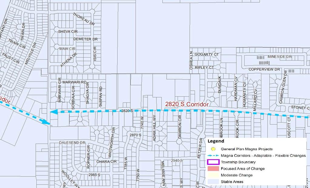
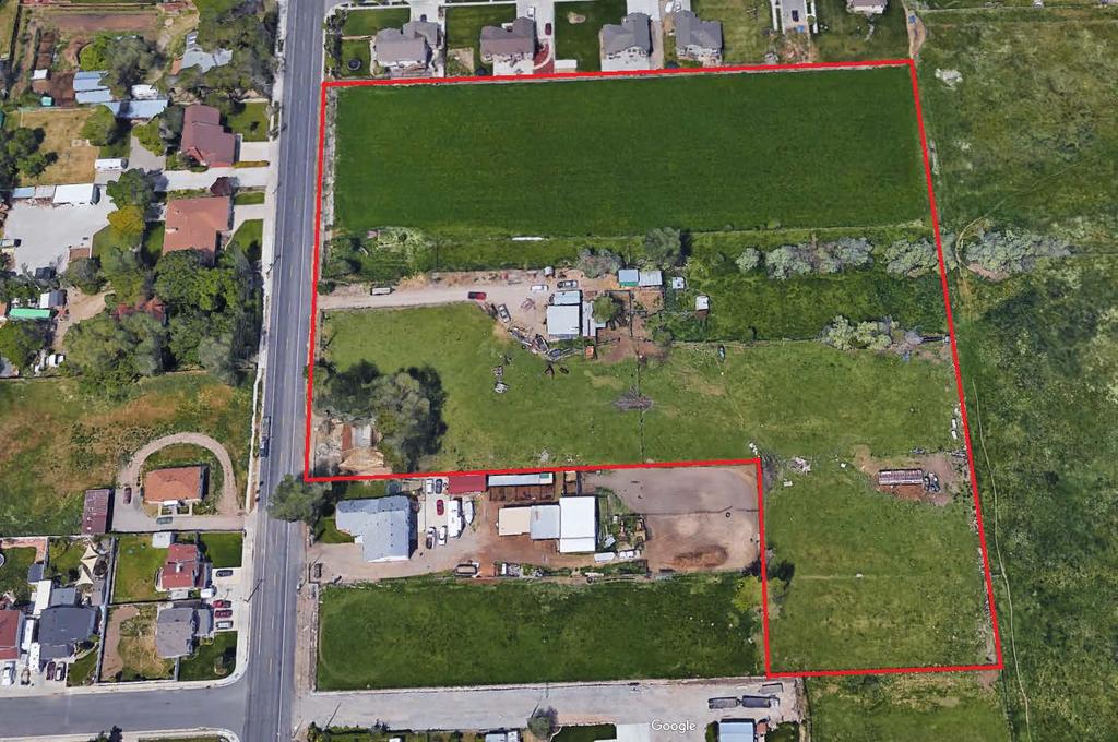
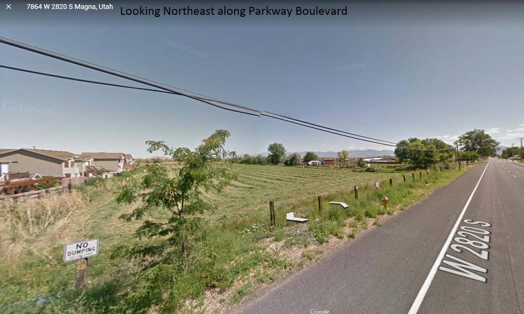
 Proposed Zone: R 1 4 Property Address: 7762 West 2820 South Request: Rezone Township: Magna Planner: Spencer Hymas Planning Commission Recommendation: Not Yet")

25 File # Rezone Summary and Recommendation Public Body: Magna Planning Commission Meeting Date: June 8, 2017 Parcel IDs: ; ; ; ; Current Zone: A 1 z/c (No Duplexes) Proposed Zone: R 1 4 Property Address: 7762 West 2820 South Request: Rezone Township: Magna Planner: Spencer Hymas Planning Commission Recommendation: Not Yet Received Planning Staff Recommendation: Approval Applicant Name: Matthew Loveland PROJECT DESCRIPTION Matthew Loveland is requesting approval for a rezone of 7.6 acres from A-1 z/c to R-1-4. The zoning condition prohibits duplexes/two-family dwellings. It is intended that the property associated with the rezone will be a future phase in the Fieldstone Master Planned Development that is currently under review with staff. SITE & VICINITY DESCRIPTION (see attached map) The property associated with the rezone is surrounded by other property zoned A-1 z/c. To the north is phase 1 of Fieldstone s Master Planned Development with zones ranging from R-1-4 to R-1-6. To the east, south and west of Parkway Boulevard, the uses are single and two-family residential and the lot sizes range from 10,000 square feet down to 2,500 square feet. ZONE CONSIDERATIONS Requirement A 1 R 1 4 Height 35 feet 35 feet Front Yard Setback 30 feet 20 feet Side Yard Setback 8 & 10 feet (18 feet total) 5 feet (10 feet total) Rear Yard Setback 15 feet 15 feet Lot Width 65 feet 25 feet Lot Area 10,000 square feet 4,000 square feet
26 Request: Rezone File #: Compatibility with existing buildings in terms of size, scale and height. Compliance with Landscaping Requirements Verified. Compliance with the General Plan. Yes N/A Yes GENERAL PLAN CONSIDERATIONS The general plan map identified Parkway Boulevard (2820 S) as a Corridor that can provide for adaptable - flexible changes. Staff believes this proposal is within the bounds for consideration. The proposed rezone would contribute to the following goals and objectives within the general plan: Goal 2: Develop communities with quality urban design than encourage social interaction and support family and community relationships, as well as healthy, active lifestyles. Staff believes the design associated with the master planned community is in line with this goal. Adding another phase to the master planned community would provide more open space and access opportunities/connections to the rest of the community and the trail. Goal 3: Promote land use development patterns that provide a high quality of life to all and offer choice in mobility. Objective 3.2: Develop bicycle routes and paths that can be integrated with the street network and also with trail systems, canals, and greenways. Adding additional mobility connections to the community contributes towards this goal. Part of the master planned community incorporates the development of a significant trail along the canal. Goal 5: Provide diverse housing choices for a variety of needs and income levels to create places where all citizens are welcome to live. Objective 5.1: Provide sufficient housing for current and future populations that are appropriate, safe, and affordable for a range of income levels. Objective 5.2: Consider life-cycle housing alternatives that allow for aging populations to age in place, as well as provide diverse housing choices for other demographic groups. Objective 5.3: Promote a diverse mix of housing options through higher density, mixed-use development in appropriate areas. Objective 5.4: Encourage residential development that establishes a variety of lot sizes, dwelling types, densities, and price points, as well as an appropriate balance of owner occupied and rental units. Objective 5.5: Develop safe and visually pleasing residential neighborhoods that are integrated into the natural environment with open space, trails, and green systems. The proposed rezone may contribute towards the goals above. Adding additional phases to the master planned development would satisfy the goals and objectives above as it would create a range of housing options that would appeal to a range of income levels. Staff believes that the mixture of densities is being proposed in an appropriate area; that it will be safe, visually pleasing and integrated into the environment with open space, trails, and green systems. In review of the Magna General Plan, staff believes that the proposed rezone could contribute to many of the goals and objectives defined in the plan. Staff also believes that the area being proposed for rezone is a suitable location for the proposed density mixture. The overall density will be approximately 10 units per acre and will be designed to buffer from existing and proposed uses. Rezone Summary Page 2 of 3
27 Request: Rezone File #: NEIGHBORHOOD RESPONSE None has been received at the time of this report. Staff will provide updates to the planning commission on responses received. PLANNING COMMISSIONS RESPONSE Not yet received. PLANNING STAFF ANALYSIS Conditions to zoning map amendment. A. In order to provide more specific land use designations and land development suitability; to ensure that proposed development is compatible with surrounding neighborhoods; and to provide notice to property owners of limitations and requirements for development of property, conditions may be attached to any zoning map amendment which limit or restrict the following: 1.Uses; 2.Dwelling unit density; 3.Building square footage; 4.Height of structures. B. A zoning map amendment attaching any of the conditions set forth in subsection A shall be designated ZC after the zoning classification on the zoning map and any such conditions shall be placed on record with the planning commission and recorded with the county recorder. C. In the event any zoning condition is declared invalid by a court of competent jurisdiction, then the entire zoning map amendment shall be void. Any deletion in or change to zoning condition shall be considered an amendment to the zoning ordinance and shall be subject to the requirements of this chapter Determination of council. The Magna Metro Township Council, after review of the recommendation of the planning commission, may approve, deny, alter or remand for further review and consideration any application for zone change referred to the council by the planning commission. PLANNING STAFF RECOMMENDATION Planning Staff has reviewed the rezone request and has recommended approval of the proposed rezone. This recommendation is based upon the Magna General Plan map which identifies this area along a significant corridor that can sustain higher density; the project's potential contribution to several of the goals and objectives identified in the Magna General Plan; and the proposals connection to the master planned community to the north. Rezone Summary Page 3 of 3
28
29

30
31
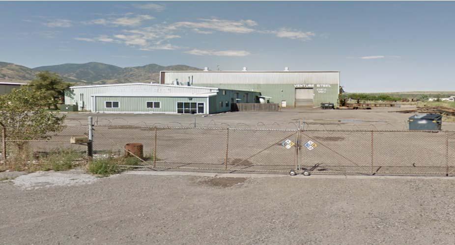
32 File # Rezone Summary and Recommendation Public Body: Magna Metro Township Planning Commission Meeting Date: June 8, 2017 Parcel IDs: , , and Current Zones: A-20 and M-1 Proposed Zone: M-2 Property Addresses: 2232 & 2330 South 7200 West Request: Rezone from A-20 (Agricultural) and M-1 (Manufacturing) to M-2 (Manufacturing) Community Council: Magna Metro Township: Magna Planner: Jeff Miller Planning Commission Recommendation: Recommendation of Approval for 2232 South Planning Staff Recommendation: Approval Applicant Name: Murray Sharp PROJECT DESCRIPTION Murray Armstrong is requesting a rezone from A-20 (Agricultural) to M-2 (Manufacturing) for two parcels, and a rezone from M-1 (Manufacturing) to M-2 (Manufacturing) for one parcel. The subject property located at 2232 South is 4.75 acres in size, and is currently being used as a Trucking Yard. Two-thirds of the existing parcel is currently zoned M-2, with the remaining one-third zoned A-20. The portion of the property zoned agricultural does not meet the minimum lot size of 20 acres for the A-20 zone. The subject properties located at 2330 South are 0.99 acres in size for the parcel currently zoned A-20, and 0.16 acres in size for the parcel currently zoned M-1. The primary parcel located at 2330 South is 2.70 acres in size, is currently zoned M-2, and is being used for Steel Fabrication. The applicant has requested the proposed rezone, to allow all parcels for both addresses to be under one zoning designation. SITE & VICINITY DESCRIPTION (see attached map) The subject properties are surrounded by parcels in the M-1 and M-2 zones, as well as some parcels located in West Valley City, which appear to be industrial.

33 Request: Rezone from A-20 (Agricultural) to M-2 (Manufacturing) File #: ZONE CONSIDERATIONS Height Requirement Existing Zone (A-20) Proposed Zone (M-2) Front Yard Setback Except as otherwise provided by the term of a conditional use permit, no structure in the A-20 zone shall exceed a height equal to the distance between such structure and the nearest property line of the parcel on which it is situated. 50 Feet None No commercial or industrial building or structure shall be located closer than 20 Feet to any street. Side Yard Setback 20 Feet None Rear Yard Setback 50 Feet None Lot Width 200 Feet None Lot Area 20 Acres None Lot Coverage None No building, structure or group of buildings, with their accessory buildings, shall cover more than 80 percent of the area of the lot. Conditional Use Summary Page 2 of 4
34 Request: Rezone from A-20 (Agricultural) to M-2 (Manufacturing) File #: Requirement Existing Zone (M-1) Proposed Zone (M-2) Height None None Front Yard Setback No commercial or industrial building or structure shall be located closer than 20 Feet to any street. No commercial or industrial building or structure shall be located closer than 20 Feet to any street. Side Yard Setback None None Rear Yard Setback None None Lot Width None None Lot Area None None Lot Coverage No building, structure or group of buildings, with their accessory buildings, shall cover more than 80 percent of the area of the lot. No building, structure or group of buildings, with their accessory buildings, shall cover more than 80 percent of the area of the lot. ISSUES OF CONCERN/PROPOSED MITIGATION Planning Staff has not identified any issues of concern with the proposed rezone request. NEIGHBORHOOD RESPONSE Planning Staff has not received any response from the surrounding neighbors as of the completion of this report. Any responses that are received will be presented to the Magna Township Planning Commission on June 8, PLANNING COMMISSIONS RESPONSE This item was heard by the Magna Metro Township Planning Commission on May 11, They made a recommendation of approval to rezone the property located at: 2232 South 7200 West. There was some discussion during the meeting about the application potentially coming back before the planning commission, if the property owner to the south (located at 2330 South) wanted to be part of the rezone application. This property owner has an isolated parcel in the A-20 zone, as well as a narrow parcel zoned M-1. This adjoining neighbor has chosen to be part of the requested rezone, in order to allow all three of the parcels located at 2330 South to be under one zoning designation. REVIEWING AGENCIES RESPONSE Compliance with current building, construction, engineering, fire, health, landscape and safety standards will be verified prior to final approval of any structures built on this property, if the properties are rezoned to M-2. PLANNING STAFF ANALYSIS Conditions to zoning map amendment. A. In order to provide more specific land use designations and land development suitability; to ensure that proposed development is compatible with surrounding neighborhoods; and to provide notice to property owners of limitations and requirements for development of property, conditions may be attached to any zoning map amendment which limit or restrict the following: 1. Uses; Conditional Use Summary Page 3 of 4
35 Request: Rezone from A-20 (Agricultural) to M-2 (Manufacturing) File #: Dwelling unit density; 3. Building square footage; 4. Height of structures. B. A zoning map amendment attaching any of the conditions set forth in subsection A shall be designated ZC after the zoning classification on the zoning map and any such conditions shall be placed on record with the planning commission and recorded with the county recorder. Planning Staff has analyzed the proposed rezone from A-20 and M-1 to M-2, and has found that the request is cohesive with the surrounding uses and zones. PLANNING STAFF RECOMMENDATION County Ordinance [ ] The council, after review of the recommendation of the planning commission, may approve, deny, alter or remand for further review and consideration any application for zone change referred to the council by the planning commission. Staff has reviewed this rezone request for compliance with the standards set forth in the Magna Metro Township Zoning Ordinance (Title 19), and for compatibility with existing neighboring land uses, and recommends that the Magna Metro Township Planning Commission provides a recommendation of approval to the Magna Metro Township Council for the requested rezone. Conditional Use Summary Page 4 of 4
36 File # 30361: Rezone from A-20 (Agricultural) & M-1 (Manufacturing) to M-2 (Manufacturing) 2232 South 7200 West (Parcel # ), 2330 South 7200 West (Parcel # , and ) M-1 A-20 M-2 M-2 M-2 A-20 A-20 M-2 M-2 A-20 West Valley City A-20 M-1 M-2 A-20 M-1
 M-1 A-20 M-2 M-2 M-2 A-20 A-20 M-2 M-2 A-20 West Valley City A-20 M-2 M-1 A-20 M-1")
37 File # 30361: Rezone from A-20 (Agricultural) & M-1 (Manufacturing) to M-2 (Manufacturing) 2232 South 7200 West (Parcel # ), 2330 South 7200 West (Parcel # , and ) M-1 A-20 M-2 M-2 M-2 A-20 A-20 M-2 M-2 A-20 West Valley City A-20 M-2 M-1 A-20 M-1


38
39
40 File #30235 Conditional Use Summary and Recommendation Public Body: Magna Planning Commission Meeting Date: June 8, 2017 Parcel ID: Current Zone: R Property Address: 2768 South Spencer Ave. Request: Accessory Structures Exceeding 800 Ft² Planner: Tom C. Zumbado Planning Staff Recommendation: Approval Applicant Name: Gary Clark Township: Magna Metro Township PROJECT DESCRIPTION Gary Clark is asking permission to build a detached garage in his backyard. Constructing this accessory structure places the property over the 800 square foot limit for accessory use and requires PC approval. SITE & VICINITY DESCRIPTION (see attached map) The subject property for File #30235 is located on a.31 acre parcel along S West. It is surrounded on all sides by R zoning, with sections of C-3 zoning one block to the north and R-1-6 zoning one block south.
 Zone C-3 Zone R-2-6.5 Zone R-2-6.5 Zone C-3 Zone R-2-6.5 Zone R-2-6.5 Zone R-2-6.5 Zone R-1-6 Zone R-1-6 Conditional Use Summary Page 2 of 5")
41 Request: Accessory Structure Request File #: File #30235: Zoning Map (Subject property outlined in red.) Zone C-3 Zone R Zone R Zone C-3 Zone R Zone R Zone R Zone R-1-6 Zone R-1-6 Conditional Use Summary Page 2 of 5
42 Request: Accessory Structure Request File #: LAND USE CONSIDERATIONS Requirement Standard Proposed Compliance Verified Height (Acc Bldg) 20 Feet 12 Feet Yes Front Yard Setback (Acc Bldg) Side Yard Setback (Acc Bldg) Rear Yard Setback (Acc Bldg) Min 6 Feet from Dwelling Feet Yes 1 Foot 20 Feet Yes 1 Foot 5.6 Feet Yes Lot Width 60 Feet Feet Yes Rear Yard Coverage No accessory building or group of accessory buildings shall cover more 14.3% Yes than 25% of the rear yard. Lot Area 6000 Square Feet Square Feet Yes NEIGHBORHOOD RESPONSE As of May , there has been no neighborhood response to File # REVIEWING AGENCIES RESPONSE AGENCY: Planning DATE: 23MAY17 RECOMMENDATION: Approved With Comments 1. Project meets accessory structure coverage requirements for zoning. 2. Applicant has been instructed to submit a geohazard disclosure form. 3. No light source (light bulb, fluorescent tube, or other direct source of light used to illuminate a parking area) shall be visible beyond the property line of any off-street parking area ( of the zoning ordinance). 4. Any modifications to approved plans must be approved by SLCo Township Services, in writing, prior to the changes being implemented in the field. AGENCY: Geology DATE: 26APR17 RECOMMENDATION: Approved With Comments 1. The site occurs in a moderate liquefaction zone; therefore, the Geological Hazards Disclosure and Acknowledgement Form" needs to be filled out, recorded, and submitted. AGENCY: Hydrology DATE: 8MAY17 RECOMMENDATION: Approved With Comments 1. Show how the storm water from the new garage roof will be directed and/or managed on the property to minimize ponding and run off impacts on surrounding properties and specifically to the north before being routed to the street as shown. Soils in this area of Magna have exhibited very low permeability. AGENCY: Building RECOMMENDATION: Approved With Comments DATE: 26APR17 Conditional Use Summary Page 3 of 5
43 Request: Accessory Structure Request File #: A building permit is required for the new accessory building construction. At time of permit application, please provide construction drawings showing code compliance. Compliance with current building, construction, engineering, fire, health, landscape and safety standards will be verified prior to final approval. PLANNING STAFF ANALYSIS Building, accessory. "Accessory building" means a detached, subordinate building clearly incidental to and located upon the same lot occupied by the main building. Also, a building clearly incidental to an agriculture or animal care land use located on a lot in an agriculture zone, which lot meets the minimum lot size for such zone and is not under one acre in area. Staff has verified that the proposed detached private garage for File #30293 is an accessory building Garage, private. "Private garage" means an accessory building designed or used for the storage of not more than four automobiles owned and used by the occupants of the building to which it is accessory; provided, that on a lot occupied by a multiple dwelling, the private garage may be designed and used for the storage of one and onehalf times as many automobiles as there are dwelling units in the multiple dwelling. A garage shall be considered part of a dwelling if the garage and the dwelling have a roof or wall in common. A private garage may not be used for storage of more than one truck for each family dwelling upon the premises, and no such truck shall exceed two and one-half tons capacity. Staff has verified that the proposed accessory building for File #30293 is a detached private garage Conditional uses. Conditional uses in the R-2 zones are as follows: - Accessory uses and buildings customarily incidental to a conditional use. Any accessory building or buildings where the total square footage exceeds eight hundred square feet on lots under one half-acre or one thousand two hundred square feet on lots one-half acre or larger. Staff has verified that the proposed accessory building for File #30235 is a conditional use in the R zone. In addition, staff has verified that the total area of accessory buildings within the property would equal to 1161 square feet with the added garage, placing it over the 800 ft² limit Coverage of rear yards. No accessory building or group of accessory buildings shall cover more than twenty-five percent of the rear yard. Existing Accessory Structures: 361 ft² Proposed Accessory Structure: 800 ft² Total Accessory Structures: 1161 ft² Total Backyard: ft² 1161 is calculated to 14.3% of Staff has verified that the total coverage of accessory buildings on property does not exceed 25% Conditional Use Standards for approval. A. The proposed site development plan shall comply with all applicable provisions of the zoning ordinance, including parking, building setbacks, and building height. B. The proposed use and site development plan shall comply with all other applicable laws and ordinances. Conditional Use Summary Page 4 of 5
44 Request: Accessory Structure Request File #: C. The proposed use and site development plan shall not present a serious traffic hazard due to poor site design or to anticipated traffic increases on the nearby road system which exceed the amounts called for under the county transportation master plan. D. The proposed use and site development plan shall not pose a serious threat to the safety of persons who will work on, reside on, or visit the property nor pose a serious threat to the safety of residents or properties in the vicinity by failure to adequately address the following issues: fire safety, geologic hazards, soil or slope conditions, liquefaction potential, site grading/topography, storm drainage/flood control, high ground water, environmental health hazards, or wetlands. E. The proposed use and site development plan shall not adversely impact properties in the vicinity of the site through lack of compatibility with nearby buildings in terms of size, scale, height, or noncompliance with community general plan standards. Staff has verified that File #30235 meets all standards of approval for conditional uses. PLANNING STAFF RECOMMENDATION Staff recommends the approval of the conditional use File # Conditional Use Summary Page 5 of 5

45 File #30235: Aerial Image Conditional Use Request: Accessory Structure 2768 S. Spencer Ave. (Subject property outlined in red.).
Magna Metro Township Council Meeting Public Meeting Agenda. Tuesday, July 18, :00 P.M.
 Planning and Development Services 2001 S. State Street N3-600 Salt Lake City, UT 84190-4050 Phone: (385) 468-6700 Fax: (385) 468-6674 www.pwpds.slco.org Magna Metro Township Council Meeting Public Meeting
Staff Report to the North Ogden Planning Commission
 Staff Report to the North Ogden Planning Commission SYNOPSIS / APPLICATION INFORMATION Application Request: Consideration and action on an administrative application for final approval for the Legacy North
White City Metro Township Planning Commission Public Meeting Agenda
 Planning and Development Services 2001 S. State Street N3-600 Salt Lake City, UT 84190-4050 Phone: (385) 468-6700 Fax: (385) 468-6674 www.pwpds.slco.org White City Metro Township Planning Commission Public
Staff Report to the North Ogden City Council
 Staff Report to the North Ogden City Council SYNOPSIS / APPLICATION INFORMATION Application Request: Consideration and action on an administrative application to provide comments on the preliminary plan
Staff Report: Date: Applicant: Property Identification: Acreage of Request: Current Zoning of Requested Area: Requested Action: Attached:
 Staff Report: Completed by Jeff Palmer Director of Planning & Zoning Date: November 7, 2018, Updated November 20, 2018 Applicant: Greg Smith, Oberer Land Developer agent for Ronald Montgomery ET AL Property
COMMERCIAL SITE PLAN & CONDITIONAL USE PERMIT REVIEW PROCESS & CHECKLIST
 Community Development 110 South Main Street Springville, UT 84663 COMMERCIAL SITE PLAN & CONDITIONAL USE PERMIT REVIEW PROCESS & CHECKLIST 801.491.7861 www.springville.org Prior to the issuance of a building
Staff Report: Date: Applicant: Property Identification: Acreage of Request: Current Zoning of Requested Area: Requested Action: Attached:
 Staff Report: Completed by Jeff Palmer Director of Planning & Zoning Date: November 7, 2018 Applicant: Greg Smith, Oberer Land Developer agent for Ronald Montgomery ET AL Property Identification: Frontage
ORDINANCE NOW THEREFORE, BE IT ENACTED BY THE CITY COMMISSION OF THE CITY OF WINTER GARDEN, FLORIDA, AS FOLLOWS:
 ORDINANCE 12-02 AN ORDINANCE OF THE CITY OF WINTER GARDEN, FLORIDA, AMENDING ARTICLE V OF CHAPTER 118 OF THE WINTER GARDEN CODE OF ORDINANCES ENTITLED PLANNED UNIT DEVELOPMENTS CREATING URBAN VILLAGE PLANNED
CHAPTER 26 PLANNING AND ZONING ARTICLE VII. MOBILE HOMES AND RECREATIONAL VEHICLE (RV) PARKS. Recreational Vehicle (RV) Park Development Standards
 PARKS. Recreational Vehicle (RV) Park Development Standards") CHAPTER 26 PLANNING AND ZONING ARTICLE VII. MOBILE HOMES AND RECREATIONAL VEHICLE (RV) PARKS. Section 26-VII-1. Section 26-VII-2. Section 26-VII-3. Section 26-VII-4. Section 26-VII-5. Purpose Permitted
CHAPTER 26 PLANNING AND ZONING ARTICLE VII. MOBILE HOMES AND RECREATIONAL VEHICLE (RV) PARKS. Section 26-VII-1. Section 26-VII-2. Section 26-VII-3. Section 26-VII-4. Section 26-VII-5. Purpose Permitted
BOSSIER CITY PARISH METROPOLITAN PLANNING COMMISSION 620 Benton Rd. Bossier City, LA Phone: Fax: PRELIMINARY PLAT
 (OFFICE USE ONLY) Application Fee: Paid: Date: CASE # Project Information BOSSIER CITY PARISH METROPOLITAN PLANNING COMMISSION 620 Benton Rd. Bossier City, LA 71111 Phone: 318-741-8824 Fax: 318-741-8827
SUBDIVISION APPLICATION CHECKLIST SKETCH PLAN PRELIMINARY PLAT FINAL PLAT
 RECEIVED STAMP SUBDIVISION APPLICATION CHECKLIST SKETCH PLAN PRELIMINARY PLAT FINAL PLAT A checklist of background information and submission requirements for processing of a sketch plan, preliminary plat
Preliminary Subdivision Application (Major) (Four (4) lots or more)
 (Four (4) lots or more)") Gunnison City Offices www.gunnisoncity.org 38 West Center Gunnison, Utah 84634 (435) 528 7969 Date of Application: Preliminary Subdivision Application (Major) (Four (4) lots or more) APPLICANT INFORMATION
Gunnison City Offices www.gunnisoncity.org 38 West Center Gunnison, Utah 84634 (435) 528 7969 Date of Application: Preliminary Subdivision Application (Major) (Four (4) lots or more) APPLICANT INFORMATION
PLNSUB Meridian Commerce Center Subdivision Amendment & PLNPCM Meridian Commerce Center Street Closure
 Staff Report PLANNING DIVISION COMMUNITY & ECONOMIC DEVELOPMENT To: From: Salt Lake City Planning Commission Daniel Echeverria, 801-535-7165, daniel.echeverria@slcgov.com Date: September 4, 2014 Re: PLNSUB2014-000469
MINUTES of the Vernal City PLANNING COMMISSION Vernal City Council Chambers 447 East Main Street August 13, 2009
 MINUTES of the Vernal City PLANNING COMMISSION Vernal City Council Chambers 447 East Main Street Members Present: Freida Parker, Shirley Wilkins, Gordon Seitz, Eric Olsen, Sonja Norton, Troy Allred Alternates
Marion County Board of County Commissioners
 Marion County Board of County Commissioners Date: 12/29/2015 P&Z: 12/28/2015 BCC: 1/12/2016 Item Number 160113Z Type of Application Rezoning Request From: A-1 (General Agriculture) To: PUD (Planned Unit
WEST BOUNTIFUL PLANNING COMMISSION
 Mayor Kenneth Romney City Engineer/ Zoning Administrator Ben White City Recorder Cathy Brightwell WEST BOUNTIFUL PLANNING COMMISSION 550 North 800 West West Bountiful, Utah 84087 Phone (801) 292-4486 FAX
Condominium Unit Requirements.
 ARTICLE 19 CONDOMINIUM REGULATIONS Section 19.01 Purpose. The purpose of this Article is to regulate projects that divide real property under a contractual arrangement known as a condominium. New and conversion
ORDINANCE WHEREAS, the adoption of this Ordinance shall not be construed as an admission that the aforesaid claim has merit or is correct; and
 ORDINANCE 12-24 AN ORDINANCE OF THE CITY OF WINTER GARDEN, FLORIDA, REPEALING ORDINANCE 12-02 AND REPLACING IT WITH THE AMENDMENTS TO ARTICLE V OF CHAPTER 118 OF THE WINTER GARDEN CODE OF ORDINANCES CONTAINED
MIDWAY CITY Planning Office 75 North 100 West Phone: x105 Midway, Utah Fax:
 MIDWAY CITY Planning Office 75 North 100 West Phone: 435-654-3223 x105 Midway, Utah 84049 Fax: 435-654-2830 mhenke@midwaycityut.org Preliminary/ Final Application for Small Scale Subdivision Application
Section Preliminary Plat Checklist and Application Forms
 Section 201 - Preliminary Plat Checklist and Application Forms PRELIMINARY SUBDIVISION PLAT REVIEW PROCESS CHART PRELIMINARY SUBDIVISION PLAT APPLICATION PRELIMINARY PLAT REVIEW CHECKLIST CITY OF NAMPA
ARTICLE 13 CONDOMINIUM REGULATIONS
 ARTICLE 13 CONDOMINIUM REGULATIONS Section 13.01 Purpose. The purpose of this Article is to regulate projects that divide real property under a contractual arrangement known as a condominium. New and conversion
Special Use Permit - Planned Unit Development Checklist. Property Address:
 Special Use Permit - Planned Unit Development Checklist Special Use Permit Number. Parcel Code/s #28-11- - - Property Address: Applicant: ARTICLE VIII Ordinance Reference - Section 8.1.2 Permit Procedures:
STAFF REPORT Administrative Subdivision Hearing West 150 South Street, Parcel # , and
 Petition Number: 490-06-24 STAFF REPORT Administrative Subdivision Hearing Project Name: Project Location: Project Type: Applicant: Planning Staff: Haight Industrial Subdivision 5550 West 150 South Street,
TOWN OF LEWISTON PLANNING BOARD APPLICATION
 TOWN OF LEWISTON PLANNING BOARD APPLICATION DESCRIPTION OF PROPOSED REQUEST: Name of Property Owner: Phone #: Name of Applicant:Phone #: Address or Location of Proposal:_SBL# Size of Parcel or Structure:Existing
CONCEPT PLAN APPLICATION Meeting with Staff Commercial Projects
 COMMUNITY DEVELOPMENT City of South Salt Lake Community Development Department 220 E. Morris Avenue South Salt Lake City, Utah 84115 Phone (801) 483-6011 Fax (801) 483-6060 CONCEPT PLAN APPLICATION Meeting
CONDOMINIUM REGULATIONS
 ARTICLE 37 CONDOMINIUM REGULATIONS SECTION 37.01. Purpose The purpose of this Article is to regulate projects that divide real property under a contractual arrangement known as a condominium. New and conversion
City of Prior Lake APPLICATION FOR COMBINED PRELIMINARY AND FINAL PLAT
 Case File No. Property Identification No. City of Prior Lake APPLICATION FOR COMBINED PRELIMINARY AND FINAL PLAT Requested Action Brief description of proposed project (Please describe the proposed amendment,
Tentative Map Application Review Procedures
 FOR REFERENCE ONLY This page is not part of the application. Tentative Map Application Review Procedures The tentative map process in Churchill County is designed to provide a mechanism in order to divide
REQUEST FOR COUNCIL ACTION
 REQUEST FOR COUNCIL ACTION To: From: Mayor & City Council Dan Boles, AICP, Senior Planner Date: November 18, 2014 Subject: Applicant Presentation: Staff Presentation: Hoggan Lane Plat Amendment Jarin Dana
PLANNED UNIT DEVELOPMENTS (Ordinance No.: 3036, 12/3/07; Repealed & Replaced by Ordinance No.: 4166, 10/15/12)
") 159.62 PLANNED UNIT DEVELOPMENTS (Ordinance No.: 3036, 12/3/07; Repealed & Replaced by Ordinance No.: 4166, 10/15/12) A. PURPOSE 1. General. The Planned Unit Development (PUD) approach provides the flexibility
159.62 PLANNED UNIT DEVELOPMENTS (Ordinance No.: 3036, 12/3/07; Repealed & Replaced by Ordinance No.: 4166, 10/15/12) A. PURPOSE 1. General. The Planned Unit Development (PUD) approach provides the flexibility
ZONING AMENDMENT, PLANNED UNIT DEVELOPMENT & SUBDIVISION STAFF REPORT Date: August 8, 2013
 ZONING AMENDMENT, PLANNED UNIT DEVELOPMENT & SUBDIVISION STAFF REPORT Date: August 8, 2013 NAME SUBDIVISION NAME PV-Magnolia, LLC Twelve Trees Subdivision LOCATION 2860, 2862 and 2866 Pleasant Valley Road
UPPER MOUNT BETHEL TOWNSHIP NORTHAMPTON COUNTY, PENNSYLVANIA
 UPPER MOUNT BETHEL TOWNSHIP NORTHAMPTON COUNTY, PENNSYLVANIA JOINDER DEED / LOT CONSOLIDATION TOWNSHIP REVIEW PROCESS When accepting proposed Joinder Deeds / Lot Consolidations, review the Joinder Deed
ALPINE TOWNSHIP PLANNING COMMISSION REGULAR MEETING June 15, 2017
 Page 1 of 6 ALPINE TOWNSHIP PLANNING COMMISSION REGULAR MEETING 17-26 CALL TO ORDER / APPROVAL OF THE REGULAR MEETING MINUTES OF MAY 18, 2017 AND THE / PUBLIC COMMENT ON NON-AGENDA ITEMS The Alpine Township
DAUPHIN CREEK ESTATES SUBDIVISION
 # 12 SUB-000076-2017 DAUPHIN CREEK ESTATES SUBDIVISION Engineering Comments: FINAL PLAT COMMENTS (should be addressed prior to submitting the FINAL PLAT for review and/or signature by the City Engineer):
APPLICATION for MINOR SUBDIVISION REVIEW for CONCEPT and FINAL PLAT within COALVILLE CITY. Project Name: Project Address or Area: Name of Owner:
 APPLICATION for MINOR SUBDIVISION REVIEW for CONCEPT and FINAL PLAT within COALVILLE CITY For Office Use Only: Application #: Application Date: PC Approval Date: CC Approval Date: Community Development
City of Prior Lake APPLICATION FOR PRELIMINARY PLAT
 City of Prior Lake APPLICATION FOR PRELIMINARY PLAT Requested Action Brief description of proposed project (Please describe the proposed amendment, project, or variance request. Attach additional sheets
City of Prior Lake APPLICATION FOR REGISTERED LAND SURVEY
 Case File No. Property Identification No. City of Prior Lake APPLICATION FOR REGISTERED LAND SURVEY Requested Action Brief description of proposed project (Please describe the proposed amendment, project,
MAPLETON CITY CORPORATION. Step 7: Upon final approval and prior to plat recording the applicant shall provide the following:
 MAPLETON CITY CORPORATION Subdivision Process The City s subdivision requirements are designed to facilitate orderly, safe and efficient development and to implement the adopted General Plan. Below is
Final Plats for Major Residential and Commercial Subdivisions Checklist
 Project Name: : This form is a checklist of Zoning Ordinance requirements for major residential and commercial subdivision plats to assist the applicant in their submittal. It is not intended to be a comprehensive
Preliminary Subdivision Application (Minor) (Three (3) lots or less)
 (Three (3) lots or less)") Gunnison City Offices www.gunnisoncity.org 38 West Center Gunnison, Utah 84634 (435) 528 7969 Date of Application: Preliminary Subdivision Application (Minor) (Three (3) lots or less) APPLICANT INFORMATION
Gunnison City Offices www.gunnisoncity.org 38 West Center Gunnison, Utah 84634 (435) 528 7969 Date of Application: Preliminary Subdivision Application (Minor) (Three (3) lots or less) APPLICANT INFORMATION
EXHIBIT D. Planned Unit Development Written Description April 13, 2016 Rouen Cove Phase II PUD
 1 EXHIBIT D Planned Unit Development Written Description April 13, 2016 Rouen Cove Phase II PUD Development # 8986.001 Developer: Curtis L. Hart Hart Resources LLC 8051 Tara Lane Jacksonville, Florida
SECTION 4: PRELIMINARY PLAT
 SECTION 4: PRELIMINARY PLAT After the completion of the sketch plan process, if submitted, the owner or developer shall file with the City an application for preliminary plat. The preliminary plat stage
RIVERDALE CITY PLANNING COMMISSION APPLICATION FOR RESIDENTIAL SUBDIVISION SITE PLAN APPROVAL
 Community Development 4600 So. Weber River Drive Riverdale, Utah 84405 RIVERDALE CITY PLANNING COMMISSION APPLICATION FOR RESIDENTIAL SUBDIVISION SITE PLAN APPROVAL CASE NO: DATE SUBMITTED: APPLICANT S
Planning Commission Application Summary
 Planning Commission Application Summary Project Name: Ballard Property Rezone Address: 12773 & 12775 South 300 East, 415 East Pheasant View Dr. Current Zoning: RA1 (Residential 40,000 sq. ft. minimum)
Lake County Planning, Building and Development Department
 SUBMISSION CHECKLIST FOR SUBDIVISION FINAL PLAT Lake County Planning, Building and Development Department 500 W. Winchester Rd. Unit 101 Libertyville, Illinois 60048-1331 Telephone (847) 377-2600 E-mail:
BY THE CITY COMMISSION ORDINANCE NO.:
 BY THE CITY COMMISSION ORDINANCE NO.: 2005-0868 AN ORDINANCE BY THE CITY COMMISSION OF THE CITY OF DADE CITY, FLORIDA CREATING A DEVELOPMENT REVIEW PROCEDURES ORDINANCE; PROVIDING FOR INTENT, PURPOSE,
City of Brooklyn Park Planning Commission Staff Report
 City of Brooklyn Park Planning Commission Staff Report Agenda Item: 6D Meeting Date: August 9, 2017 Originating Agenda Section: Public Hearing Department: Community Development Resolution: X Ordinance:
PLANNING COMMISSION MINUTES OF MEETING Wednesday, December 12, :00 p.m.
 0 PLANNING COMMISSION MINUTES OF MEETING Wednesday, December, 0 :00 p.m. A quorum being present at Centerville City Hall, North Main Street, Centerville, Utah, the meeting of the Centerville City Planning
Residential Major Subdivision Review Checklist
 Residential Major Subdivision Review Checklist Plan Submittal Requirements: 2 full sets of stamped plans Electric submittal - all plans contained in a single PDF 3 full sets if commercial kitchen or dining
Watertown City Council
 City of Watertown Watertown City Council 2/14/2017 Agenda Item: Riverpointe Subdivision 2 nd Replat Request for Action: Sketch Plan Department: Planning Request for Action Request: Paxmar, LLC (Applicant)
PLANNING COMMISSION STAFF REPORT
 PLANNING COMMISSION STAFF REPORT ZONING MAP AMENDMENT PLNPCM2011-00091- Zoning Map Amendment PLNSUB2011-00090 Subdivision Amendment Approximately 700 North Columbus Court August 10, 2011 Planning and Zoning
City of Ferndale CITY COUNCIL STAFF REPORT
 SUBJECT: Final Plat Approval DATE: January 19, 2016 FROM: Haylie Miller, Assistant Planner PRESENTATION BY: Haylie Miller City of Ferndale CITY COUNCIL STAFF REPORT MEETING DATE: January 19, 2016 AGENDA
Planned Residence District (PR) To review a plan to construct 11 single family homes on approximately 4.01 acres.
 To review a plan to construct 11 single family homes on approximately 4.01 acres.") STAFF REPORT PLANNING & ZONING COMMISSION Village Green Municipal Building, Council Chambers 47 Hall Street Wednesday, March 13, 2019 7:00 P.M. 1. FINAL DEVELOPMENT PLAN REVIEW Applicant: Romanelli and
STAFF REPORT PLANNING & ZONING COMMISSION Village Green Municipal Building, Council Chambers 47 Hall Street Wednesday, March 13, 2019 7:00 P.M. 1. FINAL DEVELOPMENT PLAN REVIEW Applicant: Romanelli and
PLANNED UNIT DEVELOPMENTS
 PLANNED UNIT DEVELOPMENTS SECTION 9.01 DESCRIPTION AND PURPOSE. A. The purpose of a planned unit development (PUD) is to permit greater flexibility in development than is generally possible under standard
CITY OF ALBERT LEA PLANNING COMMISSION ADVISORY BOARD
 CITY OF ALBERT LEA PLANNING COMMISSION ADVISORY BOARD 9/1/2015, 5:30 p.m. City Council Chambers AGENDA A. CALL TO ORDER AND ROLL CALL B. APPROVAL OF THE AGENDA C. APPROVAL OF MINUTES 1. PC Minutes from
Planning Department Oconee County, Georgia
 Planning Department Oconee County, Georgia STAFF REPORT REZONE CASE #: 6985 DATE: October 31, 2016 STAFF REPORT BY: Andrew C. Stern, Planner APPLICANT NAME: Williams & Associates, Land Planners PC PROPERTY
APPLICATION FOR MAJOR SUBDIVISION APPROVAL (PRELIMINARY PLAT)
") 209 S. Main Street Marysville, Ohio 43040 Phone: (937) 645-7350 Fax: (937) 645-7351 www.marysvilleohio.org APPLICATION FOR MAJOR SUBDIVISION APPROVAL (PRELIMINARY PLAT) *** IMPORTANT INFORMATION ~ Please
209 S. Main Street Marysville, Ohio 43040 Phone: (937) 645-7350 Fax: (937) 645-7351 www.marysvilleohio.org APPLICATION FOR MAJOR SUBDIVISION APPROVAL (PRELIMINARY PLAT) *** IMPORTANT INFORMATION ~ Please
SECTION 10.7 R-PUD (RESIDENTIAL PLANNED UNIT DEVELOPMENT) ZONE
 ZONE") Article X Zones 10-20 SECTION 10.7 R-PUD (RESIDENTIAL PLANNED UNIT DEVELOPMENT) ZONE A. PURPOSE AND INTENT: The R-PUD Residential PUD Zone is intended to provide alternative, voluntary zoning procedures
Article X Zones 10-20 SECTION 10.7 R-PUD (RESIDENTIAL PLANNED UNIT DEVELOPMENT) ZONE A. PURPOSE AND INTENT: The R-PUD Residential PUD Zone is intended to provide alternative, voluntary zoning procedures
BRIDGETON SUBDIVISION APPLICATION CHECKLIST
 APPLICATION NAME AND # CHECKLIST COMPLETED BY: DATE: Signature and printed name BRIDGETON SUBDIVISION APPLICATION CHECKLIST TO SUBDIVISION APPLICANTS: The attached checklist is to assist you in the submission
ARTICLE 8C SITE CONDOMINIUM DEVELOPMENT ORDINANCE
 ARTICLE 8C SITE CONDOMINIUM DEVELOPMENT ORDINANCE SECTION 8C.01 PURPOSE It is the purpose of this Ordinance to insure that plans for development within Oceola Township proposed under the provisions of
Salem Township Zoning Ordinance Page 50-1 ARTICLE 50.0: PUD PLANNED UNIT DEVELOPMENT
 Salem Township Zoning Ordinance Page 50-1 ARTICLE 50.0 PLANNED UNIT DEVELOPMENT Section 50.01 Purpose The provisions of this Article provide enabling authority and standards for the submission, review,
ARTICLE FIVE FINAL DRAFT
 ARTICLE FIVE 021218 FINAL DRAFT Sec. 503.6 Open Space Preservation Option Open Space Preservation Option Open Space Preservation developments may be approved in the AR, R-1, R-2 and R-3 zoning districts,
Conditional Use Sketch Plan Application Non-Residential Zone
 For Office Use Only Fees received by: Date of submittal: Amount Paid: Receipt #: Initial Review, all of the required supporting materials have been provided: Sketch Plan Meeting Date: Conditional Use Sketch
The following regulations shall apply in the R-E District:
 "R-E" RESIDENTIAL ESTATE DISTRICT (8/06) The following regulations shall apply in the R-E District: 1. Uses Permitted: The following uses are permitted. A Zoning Certificate may be required as provided
City of Poulsbo PLANNING COMMISSION
 City of Poulsbo PLANNING COMMISSION Tuesday, April 5, 2016 MINUTES Members Present James Thayer (JT), Bob Nordnes (BN), Ray Stevens (RS), Kate Nunes (KN) Members Absent Shane Skelley (SS), Gordon Hanson
City of Leavenworth DEPARTMENT OF DEVELOPMENT SERVICES MAJOR SUBDIVISION APPLICATION 1
 Proposed Name of Subdivision: City of Leavenworth DEPARTMENT OF DEVELOPMENT SERVICES MAJOR SUBDIVISION APPLICATION 1 FOR PRELIMINARY SUBDIVISION APPROVAL This application must be filled out legibly, in
ZONING AMENDMENT & SUBDIVISION STAFF REPORT Date: November 3, 2016
 ZONING AMENDMENT & SUBDIVISION STAFF REPORT Date: November 3, 2016 APPLICANT NAME SUBDIVISION NAME David Shumer 5955 Airport Subdivision CITY COUNCIL DISTRICT District 6 5955 Airport Boulevard, 754 Linlen
APPLICATION PROCESS FOR PROJECT REVIEW
 APPLICATION PROCESS FOR PROJECT REVIEW 290 NORTH 100 WEST, LOGAN UT 84321 PHONE (435) 716-9021 FAX (435) 716-9001 www.loganutah.org THE PROJECT REVIEW PROCESS The application must be complete and submitted
R e z o n i n g A p p l i c a t i o n S u b m i s s i o n R e q u i r e m e n t s
 H O R R Y C O U N T Y P L A N N I N G & Z O N I N G 1 3 0 1 2 N D A V E., S U I T E 1 D - 0 9 C O N W A Y, S. C. 2 9 5 2 6 P H O N E : 8 4 3. 9 1 5. 5 3 4 0 F A X : 8 4 3. 9 1 5. 6 3 4 1 R e z o n i n
CHAPTER 10 Planned Unit Development Zoning Districts
 CHAPTER 10 Planned Unit Development Zoning Districts Section 10.1 Intent and Purpose The Planned Unit Development (PUD) districts are intended to offer design flexibility for projects that further the
EDGERTON CITY HALL PLANNING COMMISSION MEETING REGULAR SESSION March 12, 2019
 EDGERTON CITY HALL PLANNING COMMISSION MEETING REGULAR SESSION The met in regular session with Chair John Daley calling the meeting to order at 7:00 p.m. All present participated in the Pledge of Allegiance.
ARTICLE 9 SPECIFICATIONS FOR DOCUMENTS TO BE SUBMITTED
 ARTICLE 9 SPECIFICATIONS FOR DOCUMENTS TO BE SUBMITTED SECTION 950 GENERALLY All applications shall be properly signed and filed by the owner or, with the owner s specific written consent, a contract purchaser
APPLICATION FOR SUBDIVISION APPROVAL OF A SKETCH PLAN with checklist
 Prior to filing any application for SUBDIVISION approval, the applicant shall request in writing that the zoning administrator schedule a pre-submission conference. APPLICATION TO THE PLANNING BOARD TOWN
CITY OF OCOEE LAND DEVELOPMENT CODE SUFFICIENCY TABLE WITH NOTES
 CITY OF OCOEE LAND DEVELOPMENT CODE SUFFICIENCY TABLE WITH NOTES The Sufficiency Table is a checklist to help identify the types of information and documentation needed for various types of projects. The
SUBMITTAL REQUIREMENTS
 PRELIMINARY PLAT APPLICATION ***A PRE-APPLICATION MEETING WITH CITY STAFF IS REQUIRED FOR THIS APPLICATION*** DATE STAMP FOR CITY USE ONLY PROJECT NAME (if any): TO BE FILLED OUT BY APPLICANT PROJECT STREET
Residential Minor Subdivision Review Checklist
 Residential Minor Subdivision Review Checklist Plan Submittal Requirements: 2 full sets of stamped plans Electric submittal - all plans contained in a single PDF 3 full sets if commercial kitchen or dining
FINAL PLAT SUBMITTAL CHECKLIST
 FINAL PLAT SUBMITTAL CHECKLIST The submission requirements for a Final Plat Review are found beginning in Section 24-4-40 of the Weld County Code. The Weld County Code is available on line at www.co.weld.co.us
TOWN OF ORO VALLEY PLANNING & ZONING COMMISSION MEETING DATE: December 6, 2011
 PLANNING & ZONING COMMISSION MEETING DATE: December 6, 2011 TO: FROM: SUBJECT: PLANNING & ZONING COMMISSION Matt Michels, Senior Planner mmichels@orovalleyaz.gov; tel. 229-4822 Public Hearing: Rancho de
Individual Well Individual Septic. Community Well 19. What is the proposed method of sewage disposal? Public. None
 Please Answer the Following Questions: (attach sheet if needed). What type of facility is being proposed? Campground Recreational Vehicle (RV) Park Both 2. What is the total acreage of the proposed facility?
Cover Letter with Narrative Statement
 Cover Letter with Narrative Statement March 31, 2017 rev July 27, 2017 RE: Rushton Pointe Residential Planned Unit Development Application for Public Hearing for RPUD Rezone PL2015 000 0306 Mr. Eric Johnson,
Plans shall be drawn at a readable scale, signed, and sealed by a Florida Registered Engineer. The application package shall include:
 CHAPTER 400. SECTION 403. PERMIT TYPES AND APPLICATIONS SITE DEVELOPMENT 403.3. Preliminary Site Plans (PSP) A. Intent and Purpose PSPs are used to identify existing site conditions and demonstrate general
COLUMBIA COUNTY LAND DEVELOPMENT SERVICES COURTHOUSE 230 STRAND ST. HELENS, OREGON (503) APPLICANT: Name:
 APPLICANT: Name:") COLUMBIA COUNTY LAND DEVELOPMENT SERVICES COURTHOUSE 230 STRAND ST. HELENS, OREGON 97051 (503) 397-1501 PARTITION General Information File No. APPLICANT: Name: Mailing address: City State Zip Code Phone
COLUMBIA COUNTY LAND DEVELOPMENT SERVICES COURTHOUSE 230 STRAND ST. HELENS, OREGON 97051 (503) 397-1501 PARTITION General Information File No. APPLICANT: Name: Mailing address: City State Zip Code Phone
ATTENDING THE MEETING Robert Balogh, Vice-Chairman Sonia Stopperich, Supervisor Marcus Staley, Supervisor Bob Ross, Supervisor
 SPECIAL HEARING - TUESDAY, APRIL 12, 2016 PAGE 1 The North Strabane Township Board of Supervisors held a Special Meeting- Conditional Use Hearing, Tuesday, April 12, 2016, at approximately 6:30 P.M., at
CITY OF SARALAND PRELIMINARY SUBDIVISION PLAT REVIEW
 PRELIMINARY SUBDIVISION PLAT REVIEW Application Number: Date Plat Submitted: Name of Subdivision: Name of Owner: Owner Address: (Street or P.O. Box) Telephone #: (City) (State) (Zip) E-mail: Name of Authorized
STATE OF ALABAMA SHELBY COUNTY
 STATE OF ALABAMA SHELBY COUNTY Members Present: Members Absent: Staff Present: SHELBY COUNTY PLANNING COMMISSION MINUTES Regular Meeting March 6, 2017 6:00 PM Michael O Kelley, Chairman; Jim Davis, Vice
APPLICATION PACKET LAND SPLIT OR COMBINATION REVIEW
 APPLICATION PACKET LAND SPLIT OR COMBINATION REVIEW COMMUNITY DEVELOPMENT DEPARTMENT CHARTER TOWNSHIP OF PLYMOUTH 9955 N. Haggerty Road Plymouth, MI 48170 Fees Revised 7/01/2012 APPLICATION PACKET LAND
Guide to Combined Preliminary and Final Plats
 Guide to Combined Preliminary and Final Plats Introduction The Douglas County is committed to providing open, transparent application processes to the public. This Guide is provided to assist anyone interested
Time Extension Staff Report
 Time Extension Staff Report Subdivision Name Therrin Subdivision File Number SUB06-00020 Approval Time Extension for Lead Agency Boise City Certification Signature of Boise City Engineer Annexation Date
CHECKLIST FOR DEVELOPMENT REVIEW
 CHECKLIST FOR DEVELOPMENT REVIEW Petitions and related documents and plans for land development or other proposals regulated by Title 16 of the Municipal Code (Development Ordinance) and Title 17 of the
BYRON TOWNSHIP ZONING APPLICATION
 BYRON TOWNSHIP ZONING APPLICATION Phone: (616) 878-9104 * Fax: (616) 878-3980 * Website: www.byrontownship.org This application will not be accepted if incomplete. APPLICATION FOR & REQUIRED COPIES Private
City of Nogales Planning & Zoning Commission Rezoning Application
 City of Nogales Planning & Zoning Commission Rezoning Application REZONING APPLICATION PROCEDURES 1450 N. Hohokam Nogales, Arizona 85621 Office (520) 285-5747 FAX (520) 287-6946 T.D.D. (520) The following
A Final Plat will be reviewed concurrently with any other development review application(s) that is required.
 that is required.") RELATED FACTS TO KNOW: Adams County Recording Requirements, Annexation, Common Wall Subdivision, Development Plan (PUD Development Permit), Fees, Helpful Contact Information, Lot Line Adjustment, Neighborhood
RELATED FACTS TO KNOW: Adams County Recording Requirements, Annexation, Common Wall Subdivision, Development Plan (PUD Development Permit), Fees, Helpful Contact Information, Lot Line Adjustment, Neighborhood
MINUTES PARK TOWNSHIP PLANNING COMMISSION Park Township Hall nd Street Holland, MI Regular Meeting September 12, :30 P.M.
 MINUTES PARK TOWNSHIP PLANNING COMMISSION Park Township Hall 52 152 nd Street Holland, MI 49418 Regular Meeting September 12, 2018 6:30 P.M. DRAFT COPY CALL TO ORDER: Chair Pfost called to order the regular
Time Extension Staff Report
 Time Extension Staff Report Subdivision Name Lunara Subdivision File Number SUB07-00019 Approval Time Extension for Lead Agency Boise City Certification Signature of Boise City Engineer Annexation Date
SECTION 16. "PUD" PLANNED UNIT DEVELOPMENT OVERLAY DISTRICT
 SECTION 6. "PUD" PLANNED UNIT DEVELOPMENT OVERLAY DISTRICT Subsection. Purpose. This district is established to achieve the coordinated integration of land parcels and large commercial and retail establishments
Preliminary Plat/Final Plat Application
 Melissa Municipal Center 3411 Barker Avenue Melissa, Texas 75454 Phone: (972) 838-2036 Applicant: Date: Address: Phone: Contact: Fax: E-mail: Propose Addition Name: Acres: Existing Zoning: Propose Zoning:
MAJOR SUBDIVISION PRELIMINARY PLAT CHECKLIST
 TOWNSHIP OF EGG HARBOR PLANNING BOARD/ZONING BOARD OF ADJUSTMENT 3515 BARGAINTOWN ROAD EGG HARBOR TOWNSHIP, NJ 08234 MAJOR SUBDIVISION PRELIMINARY PLAT CHECKLIST The following checklist is designed to
PLANNED UNIT DEVELOPMENT & SUBDIVISION STAFF REPORT Date: November 17, 2016
 PLANNED UNIT DEVELOPMENT & SUBDIVISION STAFF REPORT Date: November 17, 2016 DEVELOPMENT NAME SUBDIVISION NAME LOCATION Autonation Ford of Mobile Autonation Ford of Mobile Subdivision 901, 909, and 925
E L M E R B O R O U G H L A N D U S E B O A R D APPLICATION COVER SHEET (to be completed for all applications and appeals)
") E L M E R B O R O U G H L A N D U S E B O A R D APPLICATION COVER SHEET (to be completed for all applications and appeals) 1. Name(s): 2. Address: 3. Telephone Number(s): 4. E-mail: 5. Owner Name(s) (if
E L M E R B O R O U G H L A N D U S E B O A R D APPLICATION COVER SHEET (to be completed for all applications and appeals) 1. Name(s): 2. Address: 3. Telephone Number(s): 4. E-mail: 5. Owner Name(s) (if
Group Sewer Only** 80 Ft Frontage* 20,000 Sq. Ft. (.46 acre) Minimum** 120 Ft Frontage* 20,000 Sq. Ft. (.46acre) Minimum** 150 Ft Frontage*
 Minimum** 120 Ft Frontage* 20,000 Sq. Ft. (.46acre) Minimum** 150 Ft Frontage*") Residential Lots Minimum Chart The minimum lot size of any minor subdivision where there is no public sewers shall be as shown below or as required by township zoning and/or the Tuscarawas General Health
Residential Lots Minimum Chart The minimum lot size of any minor subdivision where there is no public sewers shall be as shown below or as required by township zoning and/or the Tuscarawas General Health