June 23, 2009 Initial Meeting RURAL FRAMEWORK COMMITEE
|
|
|
- Charla Johns
- 5 years ago
- Views:
Transcription


1 June 23, 2009 Initial Meeting RURAL FRAMEWORK COMMITEE
2 Committee Member Introductions One minute summary Name Subarea location/stakeholder identification What do you hope will come out of this rural framework effort? We ll do half now/half in middle of meeting
3 Committee Tasks Submit recommendations on a framework of rural land use policies and regulations by October 15th. Review existing framework and assess rural values/visual preferences. Hold topically-focused work sessions to examine key issues. Develop rural development concepts from which staff will draft rural regulations. Hold feed-back open houses with public. Present formal recommendations to BCC at the Oct. 27 th land use meeting.
4 Notes on Scope Primarily geared towards refining (considering the future applicability of) bonus-density, cluster development regulations for use within the non-urban (rural/semi-rural) subareas. May also consider appropriateness of semi-rural development in subareas slated for rural-only development. Cannot address all rural land use and lifestyle issues in depth with this effort, but can make future recommendations. Committee may continue beyond October 15 th.
5
6
7 Committee Expectations Ground Rules Generally agree up-front on the scope of work and timeline Participate effectively during limited meeting times Review materials provided Speak and act respectfully to all Operate on consensus basis where possible; vote when necessary Make your expertise available questions and concerns
8 Committee Web Site Will house most Committee materials by meeting/open house event: Agendas Background information/reports Meeting handouts Powerpoint presentations Meeting minutes Draft recommendations/committee findings Includes a blog where the public can be asked to comment on specific issues/documents
9 Trends in zoning, subdivision and development Nancy Gedeon, Community Services, Demographics RURAL LAND USE PATTERNS
10 More introductions
11 Overview of Douglas County Land Use Policies and Regulations Applicable to Rural Development Jeanette L. Bare, AICP Principal Planner EXISTING RURAL FRAMEWORK
12 Framework Overview Comprehensive Plan General community plan that guides land use decisions and implemented by: 1) Zoning Use, intensity and other land use restrictions defined by District 2) Subdivision Division of land into lots, tracts and streets for sale or transfer 3) Construction permitting Specific codes applied to public facilities and private buildings
13 Comprehensive Master Plan Guide for general land use and development of the County 2030 Land Use Plan Map Sets forth key goals, policies and objectives by Planning Area: Urban (Primary, Separated, Chatfield) Non-urban (7 subareas) Rural Communities (Franktown, Sedalia, Louviers) Municipalities (and IGA areas) Resource maps highlight key elements : Water Supply, Bedrock Aquifers, Class 3 Hazards, Steeply Dipping Bedrock, & Wildlife Resources Other Plans: Recreation and Tourism; Parks, Trails, and Open Space; Transportation; & Minerals Extraction Updated every few years by the Planning Commission
14
15 Comp Plan Policies for Rural Areas Rural/Semi-rural (Nonurban) Areas and Rural Communities Defined (mapped) planning areas with land use and density recommendations General narrative and overall policy statements for nonurban Subarea specific policies Other applicable sections Community Resources and Services, Water Supply, Wildlife, Environmental Quality, and Transportation

16
17 Nonurban (Rural/Semi-Rural) Rural) Area Goals Protect and conserve the natural and rural character Ranching, farming Significant Wildlife habitats and biotic systems Important scenic views (ridgelines and highway viewsheds) Community separators Community identity and sense of place Stewardship of open space and natural areas in perpetuity protection Ensure land use and design is compatible with the natural and rural character (Compatible) nature and intensity of development Healthy community design (trails/recreation)
18 Master Plan Definitions Nonurban Density Categories: Semi-Rural (Gross) density of 1 dwelling unit per acres (Generally corresponds to RR, ER, and LRR Districts) Rural (Gross) maximum density of 1 dwelling unit per 17.5 acres (Generally corresponds to A-1, including Cluster-35 and former RSP Plans) Gross Density total units/total acreage of a subdivision/project (not minimum lot size)
19 Comp Plan Definitions Rural Area Large tracts of land, typically used for ranching or farming operations. A maximum density of 1 du/17.5 acres may be achieved through the County s Rural Site Plan process. Semi-Rural Area Defined at a density that can range from 1 du per 2.5 acres to 1 du/17.49 acres. Greater densities, up to 1 du/2.0 acres, can be achieved as the result of a density bonus or approved PD zoning.
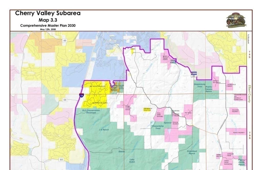
 Density Policies 4: Northeast")

 5: Cherry Valley- RURAL ONLY 1/17.")
20 Nonurban Subarea 2: High Plains -RURAL (semi-rural generally not supported) Density Policies 4: Northeast 1, 3, 6: Chatfield Valley, Indian Creek and West Plum Creek RURAL ONLY 1/ du/17.5 ac SEMI-RURAL du/ac 7: Pike National Forest & Foothills RURAL ONLY 1 du/35 ac (no RSPs) 5: Cherry Valley- RURAL ONLY 1/17.5
21 Subarea goals Development Residential Type and Density Northeast Subarea ( acre density): Semi-rural intensity supported where it is a logical infill ( acre density) Rural Site Plans (bonus cluster) may be supported High Plateau Subarea (17.5 acre density or less): Low intensity rural; semi rural GENERALLY NOT supported Rural Site Plans (bonus cluster) may be supported Chatfield Valley, Cherry Valley, Indian Creek, West Plum Creek Subareas (17.5 acre density or less): Low intensity rural; semi-rural NOT supported Rural Site Plans (bonus cluster) may be supported Pike Forest and Foothills (35 acre density or less): Semi-rural intensity INCONSISTENT with plan Cluster-35 Plans (not RSPs) supported for this area COMMERCIAL/INDUSTRIAL REZONINGS ARE NOT SUPPORTED IN NONURBAN
22 Rural Community Plans Sedalia and Louviers. Use/density proposals for A-1 lands lands to be determined based on site specific considerations guided by general policy statements. Franktown. A-1 areas divided into: Semi-rural ( B - 1 du/5 acres) Rural ( A - 1 du/17.5 through RSP), and Rural/semi-rural transition areas (1 du/10 acres).
23 Zoning Resolution Defines use, density and bulk requirements by District Official zoning map and written regulations
24 Zoning Resolution Elements Straight Zones (A-1, RR, GI, etc ) Planned Development Districts (PD) Cluster 35 and Rural Site Plans (C-35) Site Improvement Plans (SIP) Uses Allowed by Special Review (USR) Overlay Zones Rezonings and Amendments Variances and Appeals
25
26 Types of Districts: Straight-Zones Planned Development Districts Overlay Districts IGA s with Parker and Castle Rock Wildfire Hazard Floodplain Water Supply Centennial Airport
27 Subject to Public Hearing (PC/BCC) Use by Special Review Map Change or Rezoning to either a different straight zone or PD Amendment (to any portion of the written regulations) Variance (non-use) or Appeal of an Administrative Decision (Board of Adjustment)
28 Administratively-Approved Approved Plans Site Improvement Plans (commercial/industrial and multi-family, administrative review, and USR uses) Rural Site Plans Cluster-35 Plan
29 Zoning Development Standards Single Family Residential: Permitted uses: principal, accessory, special review Min. Lot Size Max. Gross Density Max. Building Height Min. Building Setbacks Utility requirements Parking Animals o o o o o o o Additional standards for Commercial and Multi-family, Bonus-density & Cluster Singlefamily Plans, and Admin. Reviews & USRs: Lighting Landscaping Bldg. envelopes Bldg. elevations/design Open space set asides Wildlife friendly fencing Operational restrictions
30 Rural Area Zone Districts A -1/Agricultural ( acre) Cluster 35 (1 du/35 ac max density) cluster (no bonus) Former/now repealed RSP (1 du/17.5 ac max density) % bonusdensity cluster LRR/Large Rural Residential ( acre) Density bonus up to 40% (open space/central water/design) RR/Rural Residential (5 9.9 acre) Density bonus up to 35% (open space/central water/design) ER/Estate Residential ( acre) Requires central water Density Bonus up to 20% (open space/design) SR/Suburban Residential (9000 square feet) Requires central and sewer Actual lot size, NOT zone district designation, determines permitted uses and setbacks.
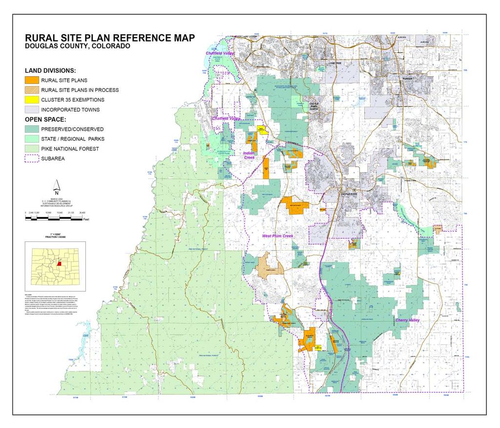
31 Approved PDs, RSPs,, and C-35 C Plans 8 Nonurban Planned Developments (all semi-rural densities): Keene Ranch, Bell Mountain Ranch, The Canyons N/S (separate), Fox Hill, Scott Road, Reata South PD, River Canyon PD, 14 approved Rural Site Plans (rural: 1 du/17.5 ac max) 9 located in West Plum Creek, 2 in Franktown, 1 in Cherry Valley, 2 in Chatfield Valley, 1 in Indian Creek 8 utilized 100% bonus/remainder used 20-40% 583 residential lots approved Approximately 7500 acres preserved in protected open space tracts, and more through private covenants within lots For 100% bonus RSPs, lots sizes have ranged from 2.5 to 10 acres. For lower bonus RSPs, lots sizes have been in the acres range. 2 RSPs in process (and one pending recordation) 4 Cluster-35 Plans (rural: 1 du/35 ac max)
32
33 Overlay Zones applying to Rural Use by Special Review Section 21 (compatible uses requiring additional review to ensure appropriate intensity, site design, and impact mitigation). Animals Section 24 (animal units permitted, grazing/devegetation standards, horse boarding) Water Supply Section 18A (sets forth water supply standards for Margins A, B, C and Pike/Rampart when coupled with specific land use processes subdivisions and rezonings.) Wildfire Hazard Section 17 (requires mitigation implementation plans for at-risk areas implemented through land use processes and driveway permits). Floodplain Section 18 (restricts development in defined floodplains) Parker and Castle Rock IGA s Sections 19A and 19B (sets forth rules for development within the Town s planning areas and within defined county buffer areas). Natural Landforms Protection (IBC) for designated properties, sets forth design standards for driveway construction in hazard, steep slope and high visibility areas (mostly along the mountain backdrop)
34 Subdivision Resolution Plats create legal lots, tracts, and roads for subsequent transfer and development Review process to ensure adequate services and general build-ability PC/BCC and administrative processes Certain exemptions from subdivision
35
36 Land Divisions and Subdivisions in Rural/Semi-Rural Areas Senate Bill state statute allows 35-acre land divisions without local government subdivision approval. Grandfathers land divisions approved prior to acre divisions still subject to roadway and basic life-safety standard reviews by County. D.C. Subdivision Resolution Sketch, Preliminary and Final Plat (2-3 steps) Minor Development Plat (4 or fewer lots, up to 10 in some cases) Exemptions from Subdivision (limited review/bcc meeting): Lots created by certain kinds of legal actions Boundary line adjustments (no parcels created) Lots with more than one principal dwelling Former RSPs and C-35 Plans Public/quasi public uses
37 Construction Permitting Building permits for private structures and utilities Public Works Permits for roads, grading and drainage
38 Construction Permitting for Rural Areas Building permit codes: IBC and IRC and related codes (covers construction, plumbing, electrical, energy, fuel and gas. Also includes provisions for driveway design, wildfire mitigation and water supply for firefighting purposes) IFC (Fire Code) Public Works codes: Douglas County Roadway Design and Construction Standards -for roadways Douglas County Storm Drainage Design and Technical Criteria Manual - for drainage Douglas County Grading, Erosion, and Sediment Control (GESC) Manual - for grading Wildfire Hazard Regulations (Appendix 58) provide minimum access standards (formerly NFPA299) and the Natural Landform Protection Regulations (IRC appendix) cover driveway designs in special areas.
39 Other constraints on local land use decision making State Enabling Legislation for Counties and Cities SB 35 Planning and Land Use (including annexation for cities) 1041 (Matters of State Interest) Federal or Other Governmental Preemptions Communication facilities (cell and electricity) Agriculture Mining Schools Churches (RLUPA) Private covenants Intergovernmental Agreements Regulatory authorities/permitting processes Colorado Dept. of Health and Tri-County Health Local Fire Districts State Engineers Office Basin Authorities DRCOG Special Districts Other statutes and case law Takings, vesting, due process, eminent domain
40 Next Steps July 14 th visual preference (values assessment) exercise and rural values guiding principals Topical work sessions/rural concept development
41
Rural Framework Committee
 Rural Framework Committee www.douglas.co.us/commissioners/adhoc/rural_framework_committee.html Community Planning and Sustainable Development Dept. Summary for Sept. 29, 2009 Open House Douglas County
Guide to Combined Preliminary and Final Plats
 Guide to Combined Preliminary and Final Plats Introduction The Douglas County is committed to providing open, transparent application processes to the public. This Guide is provided to assist anyone interested
DOUGLAS COUNTY SUBDIVISION RESOLUTION Article 4 Preliminary Plan 10/13/2015
 ARTICLE 4 PRELIMINARY PLAN 401 Intent An in-depth analysis of the proposed subdivision, including a review of the design considering the ability to obtain water and sanitation, identified geologic hazards,
Guide to Minor Developments
 Guide to Minor Developments Introduction The Douglas County (DCD) is committed to providing open, transparent application processes to the public. This Guide is provided to assist anyone interested in
-Section Contents- 201 Districts Overlay Districts Incorporation of Maps District Boundaries...
 SECTION 2 GENERAL REQUIREMENTS AND EXCEPTIONS -Section Contents- ZONING DISTRICTS 201 Districts... 2-2 202 Overlay Districts... 2-2 203 Incorporation of Maps... 2-3 204 District Boundaries... 2-3 LAND
Guide to Preliminary Plans
 Guide to Preliminary Plans Introduction The Douglas County is committed to providing open, transparent application processes to the public. This Guide is provided to assist anyone interested in the procedures
USE BY SPECIAL REVIEW STAFF REPORT- UPDATE
 ~~DOUGLAS COl-U~!X www.douglas.co.us Department of Community Development Planning Services USE BY SPECIAL REVIEW STAFF REPORT- UPDATE December 2, 2014 TO: FROM: RE: Douglas County Planning Commission Pam
DOUGLAS COUNTY ZONING RESOLUTION Section 4 LRR - Large Rural Residential District 3/10/99. -Section Contents-
 SECTION 4 LRR LARGE RURAL RESIDENTIAL DISTRICT -Section Contents- 401 Intent... 4-2 402 Principal Uses... 4-2 403 Accessory Uses... 4-3 404 Uses Permitted by Special Review... 4-4 405 Land Dedication...
TOWN OF ORO VALLEY PLANNING & ZONING COMMISSION MEETING DATE: December 6, 2011
 PLANNING & ZONING COMMISSION MEETING DATE: December 6, 2011 TO: FROM: SUBJECT: PLANNING & ZONING COMMISSION Matt Michels, Senior Planner mmichels@orovalleyaz.gov; tel. 229-4822 Public Hearing: Rancho de
SUBDIVISION REGULATIONS
 CHAPTER 14 SUBDIVISION REGULATIONS 14-100 Provisions 14-200 Preliminary Plat 14-300 Final Plat 14-400 Replat 14-500 Minor Subdivision 14-600 Administrative Replat 14-700 Vacation of Roadways, Public Easements,
4. If any perennial surface water passes through or along the property lines of the acreage, a minimum of 200 feet or frontage should be required.
 b. Provide adequate acreage for appropriate productive use of rural residential land, such as small numbers of livestock, large gardens, etc. 3. Minimum of 200 feet of frontage on an improved county or
The Ranches Sketch Plan
 The Ranches Sketch Plan APPLICATION: RURAL LAND USE PROCESS (AKA CLUSTER DEVELOPMENT) HEARING DATES: Planning Commission: 12 July 2017 at 6:30 pm Board of County Commissioners: TBD APPLICANT: REQUEST:
River Rock Estates Sketch Plan, a proposed major subdivision in S24, T35N R2W NMPM on County Rd 119 (PLN18-336)
") MEMORANDUM Archuleta County Development Services Planning Department 1122 HWY 84 P. O. Box 1507 Pagosa Springs, Colorado 81147 970-264-1390 Fax 970-264-3338 TO: Archuleta County Planning Commission FROM:
MEMORANDUM Archuleta County Development Services Planning Department 1122 HWY 84 P. O. Box 1507 Pagosa Springs, Colorado 81147 970-264-1390 Fax 970-264-3338 TO: Archuleta County Planning Commission FROM:
SKETCH PLAN REVIEW SPECIAL EXCEPTION, SPECIAL REVIEW,
 www.larimer.org Planning Department 200 W. Oak Street 3 rd Floor Fort Collins, CO 80521 970-498-7683 SKETCH PLAN REVIEW SKETCH PLAN REVIEW for Conservation Developments, Planned Land Divisions, Subdivisions,
Guide to Replats. Step 1. Step 2. Step 3. Step 4. Step 5. Step 6. Step 7. Step 8. Step 9. Step 10
 Guide to Replats Introduction Douglas County is committed to providing open, transparent application processes to the public. This Guide is provided to assist anyone interested in the procedures and expectations
Project File #: SF Project Name: Jackson Ranch Filing No. 4 Parcel Nos.: , and
 COMMISSIONERS: DARRYL GLENN (PRESIDENT) MARK WALLER (PRESIDENT PRO TEMPORE) STAN VANDERWERF LONGINOS GONZALEZ PEGGY LITTLETON PLANNING AND COMMUNITY DEVELOPMENT DEPARTMENT CRAIG DOSSEY, EXECUTIVE DIRECTOR
Canyons South. Annexation Impact Report. September 1, 2015
 Canyons South Annexation Impact Report September 1, 2015 1 Introduction This Annexation Impact Report has been prepared to meet the statutory requirements set forth in Colorado Revised Statutes 31 12 108.5
APPLICATION FOR SUBDIVISION APPROVAL OF A SKETCH PLAN with checklist
 Prior to filing any application for SUBDIVISION approval, the applicant shall request in writing that the zoning administrator schedule a pre-submission conference. APPLICATION TO THE PLANNING BOARD TOWN
SITE PLAN REVIEW ADMINISTRATIVE REVIEW. Please Note: Once submitted to the County, all application materials become a matter of public record.
 200 W. Oak Street, 3rd Floor Fort Collins, CO 80521 (970) 498-7683 / larimer.org/planning SITE PLAN REVIEW ADMINISTRATIVE REVIEW The submittal requirements listed in this packet are intended to collect
Chapter 100 Planned Unit Development in Corvallis Urban Fringe
 100.100 Scope and Purpose. Chapter 100 Planned Unit Development in Corvallis Urban Fringe (1) All applications for land divisions in the Urban Residential (UR) and Flood Plain Agriculture (FPA) zones within
ARTICLE 6 MINOR DEVELOPMENT FINAL PLAT Single-Family Residential
 ARTICLE 6 MINOR DEVELOPMENT FINAL PLAT Single-Family Residential 601 Intent The intent of the minor development is to provide a streamlined review process for the creation of ten or fewer single-family
Appendix J - Planned Unit Development (PUD)
") Appendix J - Planned Unit Development (PUD) Intent and Purpose The purpose of the PUD is: 1. To provide development that is consistent with the Comprehensive Land Use Plan and promote the goals and objectives
Appendix J - Planned Unit Development (PUD) Intent and Purpose The purpose of the PUD is: 1. To provide development that is consistent with the Comprehensive Land Use Plan and promote the goals and objectives
CCC XXX Rural Neighborhood Conservation (NC)
") CCC 33.10.XXX Rural Neighborhood Conservation (NC) Purpose: Maintain low density rural residential areas and associated uses commonly found in rural areas consistent with the local character of the distinctive
CCC 33.10.XXX Rural Neighborhood Conservation (NC) Purpose: Maintain low density rural residential areas and associated uses commonly found in rural areas consistent with the local character of the distinctive
Conservation Design Subdivision Option
 Sheridan County, Wyoming Conservation Design Subdivision Option Recent Amendments to Zoning and Subdivision Rules and Regulations Adopted November 2010 Mark Reid, County Planner 1 County Road #255 traffic
Open Space Model Ordinance
 Open Space Model Ordinance Section I. Background Open space development has numerous environmental and community benefits, including: 1) Reduces the impervious cover in a development. Impervious cover
Claudia Stuart, Williamson Act Program Manager and Nick Hernandez, Planning Intern
 Land Conservation (Williamson) Act Advisory Committee STAFF REPORT September 15, 2014 Prepared by: Claudia Stuart, Williamson Act Program Manager and Nick Hernandez, Planning Intern Subject: Discussion:
MINERAL COUNTY PLANNING STAFF FINDINGS OF FACT Proposed Elk Run at St. Regis. February 12, 2017
 MINERAL COUNTY PLANNING STAFF FINDINGS OF FACT Proposed The proposed is a five-lot subdivision and is located approximately one mile east of St. Regis on Old Highway 10 East. The property is located in
REPLACEMENT EXHIBIT 2 SECOND AMENDMENT TO THE COMPREHENSIVE DEVELOPMENT PLAN
 REPLACEMENT EXHIBIT 2 SECOND AMENDMENT TO THE COMPREHENSIVE DEVELOPMENT PLAN User s Guide for the Douglas County Town of Parker Intergovernmental Agreement (IGA) Please be advised that approved amendments
SANTA BARBARA COUNTY ZONING ADMINISTRATOR STAFF REPORT February 15, 2013
 SANTA BARBARA COUNTY ZONING ADMINISTRATOR STAFF REPORT February 15, 2013 PROJECT: Galbraith Lot Line Adjustment HEARING DATE: March 4, 2013 STAFF/PHONE: J. Ritterbeck, (805) 568-3509 GENERAL INFORMATION
GWINNETT COUNTY CSO CONSERVATION SUBDIVISION OVERLAY DISTRICT REQUIREMENTS
 GWINNETT COUNTY CSO CONSERVATION SUBDIVISION OVERLAY DISTRICT REQUIREMENTS Section 1316. CSO Conservation Subdivision Overlay District. 1. Purposes. The purposes of this overlay district are as follows:
CITY OF DURHAM DURHAM COUNTY NORTH CAROLINA. Zoning Map Change Report. RR Existing Zoning. Rural Rural Density Residential Site Characteristics
 CITY OF DURHAM DURHAM COUNTY NORTH CAROLINA Zoning Map Change Report Meeting Date: February 26, 2007 Reference Name Arrowhead () Jurisdiction County Proposed Zoning RR Existing Zoning RS-20 Request Proposed
SUBURBAN AND URBAN RESIDENTIAL LAND USE
 SUBURBAN AND URBAN RESIDENTIAL LAND USE GOAL 1 DISCOURAGE URBAN AND SUBURBAN DEVELOPMENT OUTSIDE INCORPORATED AREAS IN WHITMAN COUNTY, EXCEPT WITHIN DESIGNATED UNINCORPORATED COMMUNITIES, AND THOSE AREAS
Larimer County Planning Dept. Procedural Guide for 1041 PERMITS
 - Larimer County Planning Dept. Procedural Guide for 1041 PERMITS PLEASE NOTE: A PRE-APPLICATION CONFERENCE IS REQUIRED PRIOR TO SUBMITTING THIS APPLICATION. PURPOSE: State Statutes allow local governments
Conservation Design Subdivisions
 Conservation Design Subdivisions An excerpt from the Rules and Regulations Governing Division of Land in Sheridan County, Wyoming, November 5, 2010 Sheridan County Public Works Department 224 S. Main Street
Concept Plan Project Narrative For 852 River Ranch Court
 Concept Plan Project Narrative For 852 River Ranch Court Date: January 5, 2016 Prepared by: Robert W. Jones II, P.E. Vortex Engineering, Inc. 2394 Patterson Rd., Ste 201 Grand Junction, CO 81505 970-245-9051
REPRESENTATIVE: Centerline Solutions Table Mountain Parkway Golden, CO 80403
 COMMISSIONERS: DARRYL GLENN (PRESIDENT) MARK WALLER (PRESIDENT PRO TEMPORE) STAN VANDERWERF LONGINOS GONZALEZ PEGGY LITTLETON PLANNING AND COMMUNITY DEVELOPMENT DEPARTMENT CRAIG DOSSEY, EXECUTIVE DIRECTOR
1101 MAIN STREET ANDREWS NC PHONE FAX MAYOR NANCY J. CURTIS MEMORANDUM
 1101 MAIN STREET ANDREWS NC 28901 PHONE 828-321-3113 FAX 828-321-4159 MAYOR NANCY J. CURTIS ALDERMAN RAY FRAZIER ALDERMAN JERRY PULLIUM ALDERMAN GARY JAMES ALDERMAN PHIL HORTON MEMORANDUM March 7, 2017
Amendment to the Zoning and Subdivision Ordinances; Consider Repeal Cluster Development Standards
 2 Board of Supervisors Meg Bohmke, Chairman Gary F. Snellings, Vice Chairman Jack R. Cavalier Thomas C. Coen L. Mark Dudenhefer Wendy E. Maurer Cindy C. Shelton February 28, 2018 Thomas C. Foley County
STAFF REPORT. Permit Number: Lee. Kitsap County Board of Commissioners; Kitsap County Planning Commission
 STAFF REPORT Permit Number: 15 00689 Lee DATE: March 2, 2016 TO: FROM: Kitsap County Board of Commissioners; Kitsap County Planning Commission Katrina Knutson, AICP, Senior Planner, DCD and Jeff Arango,
Article XII. R-1 Agricultural-Low Density Residential District
 Article XII R-1 Agricultural-Low Density Residential District Section 1200. Declaration of Legislative Intent In expansion of the Declaration of Legislative Intent and Statement of Community Development
Rural Element Update. May 21, 2013
 Rural Element Update May 21, 2013 1 Today s presentation Issues Planning Commission Recommendation Staff Recommendations Schedule 2 Issue 1 Variety of Rural Densities Compliance Order: The Board noted
STAFF REPORT. Permit Number: Porter. Kitsap County Board of Commissioners; Kitsap County Planning Commission
 STAFF REPORT Permit Number: 15 00461 Porter DATE: November 9, 2015 TO: FROM: Kitsap County Board of Commissioners; Kitsap County Planning Commission Katrina Knutson, AICP, Senior Planner, DCD and Jeff
FINAL DRAFT 12/1/16, Rev. to 7/18/17
 FINAL DRAFT 12/1/16, Rev. to 7/18/17 (As Adopted 8/8/17 Effective 9/1/17) SHELTON PLANNING AND ZONING COMMISSION Proposed Amendments to Zoning Regulations I. Amend Section 23 PERMITTED USES by inserting
La Plata Land Use Code (LUC) DRAFT Page 1
 DRAFT Page 1") SUBPART B LAND USE CODE (LUC)... 2 CHAPTER 62 AUTHORITY, PURPOSE, JURISDICTION, AND APPLICATION... 2 SUBCHAPTER 62-1 GENERAL PROVISIONS... 2 SUBCHAPTER 62-2 EFFECT OF CODE... 7 CHAPTER 63 ZONING DISTRICTS
SUBPART B LAND USE CODE (LUC)... 2 CHAPTER 62 AUTHORITY, PURPOSE, JURISDICTION, AND APPLICATION... 2 SUBCHAPTER 62-1 GENERAL PROVISIONS... 2 SUBCHAPTER 62-2 EFFECT OF CODE... 7 CHAPTER 63 ZONING DISTRICTS
PINE CANYON PD ZONING REGULATIONS
 Review Notes: Green highlight = blanks to be completed before recording. 1. DEFINITIONS For purposes of the PD Plan and these Zoning Regulations: (1) capitalized terms used but not defined in the PD Plan
MS MINOR SUBDIVISION TREVITHICK
 MS-02-015 341.12 MINOR SUBDIVISION TREVITHICK A request by Danny Trevithick for a one-lot Minor Subdivision on five acres. The property is zoned A-35 (Agricultural) District and is located ¼ mile south
2030 General Plan. December 6, 7 pm
 2030 General Plan GPAC Meeting #9 GPAC Meeting #9 December 6, 7 pm City Council Input on Working Draft Land Use Map Council discussed GPAC & PC versions of the working draft land use map 11/28 Council
DOUGLAS COUNTY SUBDIVISION RESOLUTION Article 7 Replat 10/13/2015
 ARTICLE 7 REPLAT 701 Intent To provide a review process for the replatting of an existing subdivision plat or superblock final plat. The process shall vary according to the nature of the proposed amendment,
Planning Commission Hearing Date: 2/21/2017 Board of County Commissioners Hearing Date: 3/8/2017
 COMMISSIONERS: DARRYL GLENN (PRESIDENT) MARK WALLER (PRESIDENT PRO TEMPORE) STAN VANDERWERF LONGINOS GONZALEZ PEGGY LITTLETON PLANNING AND COMMUNITY DEVELOPMENT DEPARTMENT CRAIG DOSSEY, EXECUTIVE DIRECTOR
SUBDIVISION APPLICATION (CHECK THE BOX THAT APPLIES)
") GARFIELD COUNTY Building & Planning Department 108 8 th Street, Suite 401 Glenwood Springs, Colorado 81601 Telephone: 970.945.8212 Facsimile: 970.384.3470 www.garfield-county.com SUBDIVISION APPLICATION
GARFIELD COUNTY Building & Planning Department 108 8 th Street, Suite 401 Glenwood Springs, Colorado 81601 Telephone: 970.945.8212 Facsimile: 970.384.3470 www.garfield-county.com SUBDIVISION APPLICATION
Letter of Intent May 2017 (Revised November 2017)
") THE BEACH AT WOODMOOR LETTER OF INTENT MAY 2017 (REVISED NOVEMBER 2017) OWNER/APPLICANT: CONSULTANT: Lake Woodmoor Holdings LLC N.E.S. Inc. 1755 Telstar Drive, Suite 211 619 North Cascade Avenue Colorado
THE BEACH AT WOODMOOR LETTER OF INTENT MAY 2017 (REVISED NOVEMBER 2017) OWNER/APPLICANT: CONSULTANT: Lake Woodmoor Holdings LLC N.E.S. Inc. 1755 Telstar Drive, Suite 211 619 North Cascade Avenue Colorado
ZRTD , Glenn Drive. M. Tyler Klein, AICP, Project Manager, Planning and Zoning John Merrithew, Acting Director, Planning and Zoning
 DEPARTMENT OF PLANNING Date of Hearing: AND ZONING STAFF REPORT # 4 BOARD OF SUPERVISORS PUBLIC HEARING SUBJECT: ELECTION DISTRICT: ZRTD-2014-0003, 22675 Glenn Drive Broad Run CRITICAL ACTION DATE: September
SUBDIVISION REGULATIONS for Lawrence and the Unincorporated Areas of Douglas County, KS
 SUBDIVISION REGULATIONS for Lawrence and the Unincorporated Areas of Douglas County, KS December 19, 2006 Edition Amended: 09/11/07; 12/04/07; 03/25/08; 09/10/08 Amended: January 6, 2009 Article 8 Subdivision
Appendix A: Guide to Zoning Categories Prince George's County, Maryland
 Appendix A: Guide to Zoning Categories Prince George's County, Maryland RESIDENTIAL ZONES 1 Updated November 2010 R-O-S: Reserved Open Space - Provides for permanent maintenance of certain areas of land
DOUGLAS COUNTY ZONING RESOLUTION Section 3A Rural Site Plan 03/10/99
 Section 3A Rural Site Plan 03/10/99 SECTION 3A RURAL SITE PLAN (Amended 4/14/09) The Rural Site Plan regulations are hereby repealed as of April 14, 2009. Rural Site Plans approved prior to this date shall
Triangle Special Planning Area Update. Community Workshop #5 September 17, 2018
 Triangle Special Planning Area Update Community Workshop #5 September 17, 2018 Welcome and Introductions Recap of the Project and Discussion to Date Meeting Agenda Review Draft SPA Revisions Discuss Outstanding
ARTICLE 14 PLANNED UNIT DEVELOPMENT (PUD) DISTRICT
 DISTRICT") ARTICLE 14 PLANNED UNIT DEVELOPMENT (PUD) DISTRICT Section 14.01 Intent. It is the intent of this Article to allow the use of the planned unit development (PUD) process, as authorized by the Michigan Zoning
ARTICLE 14 PLANNED UNIT DEVELOPMENT (PUD) DISTRICT Section 14.01 Intent. It is the intent of this Article to allow the use of the planned unit development (PUD) process, as authorized by the Michigan Zoning
Rezone property from RR(T)D3, D1(T)D3, and RR(T)D15 to D3 and D15 along North Douglas Highway.
D3, D1(T)D3, and RR(T)D15 to D3 and D15 along North Douglas Highway.") DATE: TO: FROM: Planning Commission Chrissy McNally, Planner Community Development Department FILE NO.: AME2013 0016 PROPOSAL: Rezone property from RR(T)D3, D1(T)D3, and RR(T)D15 to D3 and D15 along North
DATE: TO: FROM: Planning Commission Chrissy McNally, Planner Community Development Department FILE NO.: AME2013 0016 PROPOSAL: Rezone property from RR(T)D3, D1(T)D3, and RR(T)D15 to D3 and D15 along North
Midwest City, Oklahoma Zoning Ordinance
 2010 Midwest City, Oklahoma Zoning Ordinance 9/2/2010 Table of Contents Section 1. General Provisions... 5 1.1. Citation... 5 1.2. Authority... 5 1.3. Purpose... 5 1.4. Nature and Application... 5 1.5.
REPRESENTATIVE: Julie & Brad Nicodemus Black Squirrel Road Colorado Springs, CO 80809
 COMMISSIONERS: DARRYL GLENN (PRESIDENT) MARK WALLER (PRESIDENT PRO TEMPORE) STAN VANDERWERF LONGINOS GONZALEZ PEGGY LITTLETON PLANNING AND COMMUNITY DEVELOPMENT DEPARTMENT CRAIG DOSSEY, EXECUTIVE DIRECTOR
Comment: the Plan endeavors to conserve resources that can nurture additional development. What kind of resources, environmental, capital, or etc.?
 Memorandum TO: Peggy Fiandaca and Curt Dunham, Partners for Strategic Action Inc. FROM: Jessica Sarkissian, CMX DATE: September 4, 2008 SUBJECT: Proposed 2008 Draft Comprehensive Plan Comments This memo
MINUTES 7:30 PM. Block 40, Lots 8 & 8.04 Minor Subdivision Tumble Falls Road Completeness Determination
 MINUTES 7:30 PM PRESENT: R. Dodds ABSENT: P. Lubitz D. Haywood L. Riggio J. Mathieu M. Syrnick S. McNicol L. Voronin, Alt #1 J. Strasser C. Ely, Alt #2 CALL TO ORDER The meeting was called to order by
STAFF REPORT. Permit Number: Garland. Kitsap County Board of Commissioners; Kitsap County Planning Commission
 STAFF REPORT Permit Number: 15 00686 Garland DATE: February 25, 2016 TO: FROM: Kitsap County Board of Commissioners; Kitsap County Planning Commission Katrina Knutson, AICP, Senior Planner, DCD and Jeff
Land Use. Land Use Categories. Chart 5.1. Nepeuskun Existing Land Use Inventory. Overview
 Land Use State Comprehensive Planning Requirements for this Chapter A compilation of objectives, policies, goals, maps and programs to guide the future development and redevelopment of public and private
Achieving the Community Vision through Excellence, Dedication and Service
 Development Services Department 100 N. Wilcox Street, Castle Rock CO 80104 Planner of the Day 303-660-1393 Applicant Information Preliminary Project Application (PPA) Achieving the Community Vision through
Public Hearing. Item # 16. Meeting Date: June 3, 2014
 Item # 16 Meeting Date: June 3, 2014 Public Hearing Ordinance No. 2014-18: An Ordinance Amending the Town s Zone District Map by Approving the Plum Creek Ridge Planned Development Plan Amendment No. 1
Article 5: Divisions of Land
 LUDC 2013 GARFIELD COUNTY, COLORADO Article 5: Divisions of Land Article 5 Divisions of Land Table of Contents DIVISION 1. GENERAL PROVISIONS.... 1 5-101. Types of Land Division.... 1 A. Definition of
WHY ARE WE UPDATING THE RURAL AREA LAND DEVELOPMENT REGULATIONS (LDRS)?
?") PROCESS OVERVIEW WHY ARE WE UPDATING THE RURAL AREA LAND DEVELOPMENT REGULATIONS (LDRS)? The Rural Area LDRs are being updated to implement the Comprehensive Plan adopted in May 2012. Current regulations
PROCESS OVERVIEW WHY ARE WE UPDATING THE RURAL AREA LAND DEVELOPMENT REGULATIONS (LDRS)? The Rural Area LDRs are being updated to implement the Comprehensive Plan adopted in May 2012. Current regulations
To provide for the review of the final engineering plans, the subdivision improvement agreement, public dedications, and other legal agreements.
 ARTICLE 5 FINAL PLAT 501 Intent DOUGLAS COUNTY SUBDIVISION RESOLUTION To provide for the review of the final engineering plans, the subdivision improvement agreement, public dedications, and other legal
HHLT Educational Forum: Conservation Subdivisions and the Open Space Overlay. February 5th 2018 Winter Hill
 HHLT Educational Forum: Conservation Subdivisions and the Open Space Overlay February 5th 2018 Winter Hill 1 Topics Covered SECTION I II III IV V TOPIC Comprehensive Plan Open Space Index Conservation
El Paso County Development Review System Adopted Fee Schedule (2005)
") Special Districts Special District 5 (multiple districts for the same project is one fee) D $6,300 Special District Amendment 5 D $3,950 Master Plans Master Plan, Master Plan Amendment D $11,900 Land Use
Special Districts Special District 5 (multiple districts for the same project is one fee) D $6,300 Special District Amendment 5 D $3,950 Master Plans Master Plan, Master Plan Amendment D $11,900 Land Use
SECTION 6. RESIDENTIAL DISTRICTS
 SECTION 6. RESIDENTIAL DISTRICTS 6.1 RESIDENTIAL DISTRICTS PURPOSE 6.2 PERMITTED AND CONDITIONAL USES 6.3 LOT AND BUILDING BULK REGULATIONS 6.4 GENERAL STANDARDS OF APPLICABILITY 6.1 RESIDENTIAL DISTRICTS
AN ORDINANCE AMENDING THE CITY ZONING ORDINANCE AND THE OFFICIAL CODE OF THE CITY OF CLARKSVILLE RELATIVE TO CLUSTER OPTION DEVELOPMENTS
 ORDINANCE 74-2012-13 AN ORDINANCE AMENDING THE CITY ZONING ORDINANCE AND THE OFFICIAL CODE OF THE CITY OF CLARKSVILLE RELATIVE TO CLUSTER OPTION DEVELOPMENTS BE IT ORDAINED BY THE CITY COUNCIL OF THE CITY
Draft Zoning Changes for the 2nd Planning Board Public Hearing, January 22, 2018.
 Draft Zoning Changes for the 2nd Planning Board Public Hearing, January 22, 2018. No changes were made at the 1st Public Hearing. Proposed wording for the 1 st Public Hearing in red, eliminated text in
TABLE OF CONTENTS CHAPTER 1 INTRODUCTORY PROVISIONS Section 1 Purposes. 6. Section 2 Statutory Authorization. 7.
 An Ordinance requiring permits for buildings, structures and the uses thereof; for land uses and for water supply and sewage treatment facilities; establishing minimum lot sizes, setbacks and side yards,
Town of Norwich, Vermont SUBDIVISION REGULATIONS
 Town of Norwich, Vermont SUBDIVISION REGULATIONS Adopted: August 6, 2002 Amended: February 8, 2006 Prepared by Norwich Planning Commission with the assistance of: Burnt Rock Inc. A ssociates in Community
RE: 6. GILL/GREEN COMPREHENSIVE PLAN AMENDMENT, REZONING AND PRELIMINARY PLAT
 commission memo DATE: Thursday - August 9, 2018 TO: Marion Planning & Zoning Commission FROM: David N. Hockett, AICP Principal Planner RE: 6. GILL/GREEN COMPREHENSIVE PLAN AMENDMENT, REZONING AND PRELIMINARY
MINOR BOUNDARY LINE ADJUSTMENT PROCESS GUIDE
 MINOR BOUNDARY LINE ADJUSTMENT PROCESS GUIDE Clear Creek County Planning Department P.O. Box 2000 Georgetown, Colorado 80444 (303) 679-2436 phone (303) 569-1103 fax 1 PURPOSE To establish criteria and
Town of Cary, North Carolina Rezoning Staff Report 14-REZ-20 Habitat for Humanity Evans Road Town Council Meeting October 16, 2014
 Town of Cary, North Carolina Rezoning Staff Report 14-REZ-20 Habitat for Humanity Evans Road Town Council Meeting October 16, 2014 REQUEST To amend the Town of Cary Official Zoning Map by rezoning 0.53
STAFF SUMMARY FOR Z18-09 CONDITIONAL ZONING DISTRICT APPLICATION
 STAFF SUMMARY FOR Z18-09 CONDITIONAL ZONING DISTRICT APPLICATION APPLICATION SUMMARY Case Number: Z18-09 Request: Conditional R-10 Zoning District in order to develop a performance residential development
DATE: August 25, 2006 FILE NO.: E
 REFERRAL Development Services Department OCP & Zoning Bylaw Amendment Application DATE: August 25, 2006 FILE NO.: E-06-07171.000.015 FROM: RE: S. Theurer, Planning Services Manager Referral from Regional
Planning Department Oconee County, Georgia
 Planning Department Oconee County, Georgia STAFF REPORT REZONE CASE #: 6985 DATE: October 31, 2016 STAFF REPORT BY: Andrew C. Stern, Planner APPLICANT NAME: Williams & Associates, Land Planners PC PROPERTY
1. an RSF-R, RSF-1, RSF-2, RSF-4, RMF-5, or RMF-8 zoning district; or
 Chapter 9 INCENTIVES 9.1 General 9.1.1 Review and Approval Procedure Projects requesting bonuses under this chapter for land that has not been platted, or for land that is being voluntarily replatted,
4.2 LAND USE INTRODUCTION
 4.2 LAND USE INTRODUCTION This section of the EIR addresses potential impacts from the Fresno County General Plan Update on land use in two general areas: land use compatibility and plan consistency. Under
PLANNING COMMISSION PUBLIC HEARING STAFF REPORT ZRTD FAIRFAX MARBLE & GRANITE
 Date of Hearing: PLANNING COMMISSION PUBLIC HEARING STAFF REPORT SUBJECT: ELECTION DISTRICT: ZRTD-2016-0009 FAIRFAX MARBLE & GRANITE Broad Run CRITICAL ACTION DATE: September 27, 2017 STAFF CONTACTS: APPLICANT:
Town of. River Falls. Land Use Element Vierbicher Associates, Inc
 Town of River Falls 2005 Vierbicher Associates, Inc Contents Contents s. 66.1001(2)(h) Wis. Stats................................................. ii Introduction................................................................
Project File #: VA Project Name: Beauperthuy Variance Parcel Nos.: , , , ,
 COMMISSIONERS: DARRYL GLENN (PRESIDENT) MARK WALLER (PRESIDENT PRO TEMPORE) STAN VANDERWERF LONGINOS GONZALEZ PEGGY LITTLETON PLANNING AND COMMUNITY DEVELOPMENT DEPARTMENT CRAIG DOSSEY, EXECUTIVE DIRECTOR
TOWNSHIP ZONING ORDINANCE PETERS TOWNSHIP PLANNING DEPARTMENT JUNE, E. McMURRAY ROAD McMURRAY, PA 1531 (724)
") EXECUTIVE PROPOSED SUMMARY PETERS Summary: Peters Township Zoning Ordinance TOWNSHIP ZONING ORDINANCE JUNE, 2017 PETERS TOWNSHIP PLANNING DEPARTMENT 610 E. McMURRAY ROAD McMURRAY, PA 1531 (724) 942-5005
EXECUTIVE PROPOSED SUMMARY PETERS Summary: Peters Township Zoning Ordinance TOWNSHIP ZONING ORDINANCE JUNE, 2017 PETERS TOWNSHIP PLANNING DEPARTMENT 610 E. McMURRAY ROAD McMURRAY, PA 1531 (724) 942-5005
Marion County Board of County Commissioners
 Marion County Board of County Commissioners Date: 12/29/2015 P&Z: 12/28/2015 BCC: 1/12/2016 Item Number 160113Z Type of Application Rezoning Request From: A-1 (General Agriculture) To: PUD (Planned Unit
ZONING ORDINANCE: OPEN SPACE COMMUNITY. Hamburg Township, MI
 ZONING ORDINANCE: OPEN SPACE COMMUNITY Hamburg Township, MI ARTICLE 14.00 OPEN SPACE COMMUNITY (Adopted 1/16/92) Section 14.1. Intent It is the intent of this Article to offer an alternative to traditional
APPENDIX C-1 DEVELOPING FINDINGS OF FACT & CONCLUSIONS OF LAW FOR PLANNING AND ZONING
 APPENDIX C-1 DEVELOPING FINDINGS OF FACT & CONCLUSIONS OF LAW FOR PLANNING AND ZONING Amended: 9/2011; 9/2014; Page! i DEVELOPING FINDINGS OF FACT, AND CONCLUSIONS OF LAW 1. Developing the following information
PLANNED UNIT DEVELOPMENTS
 PLANNED UNIT DEVELOPMENTS SECTION 9.01 DESCRIPTION AND PURPOSE. A. The purpose of a planned unit development (PUD) is to permit greater flexibility in development than is generally possible under standard
PUBLIC SITE PLAN. Please Note: Once submitted to the County, all application materials become a matter of public record. SUBMITTAL REQUIREMENTS
 200 W. Oak Street, 3rd Floor Fort Collins, CO 80521 (970) 498-7683 / larimer.org/planning PUBLIC SITE PLAN The submittal requirements listed in this packet are intended to collect all of the information
LARAMIE COUNTY PLANNING & DEVELOPMENT DEPARTMENT
 LARAMIE COUNTY PLANNING & DEVELOPMENT DEPARTMENT Planning Building MEMORANDUM TO: FROM: Laramie County Planning Commission Brett Walker, Planner DATE: January 25, 2018 TITLE: Review and action of a Subdivision
Residential Project Convenience Facilities
 Standards for Specific Land Uses 35.42.220 E. Findings. The review authority shall approve a Land Use Permit in compliance with Subsection 35.82.110.E (Findings required for approval) or a Conditional
Land Use. Existing Land Use
 8 Land Use 8.1 Land Use Chapter Purpose and Contents This element includes a brief summary of existing land use conditions and trends followed by a series of goals, objectives, and recommendations to guide
SUBDIVISION APPLICATION CHECKLIST SKETCH PLAN PRELIMINARY PLAT FINAL PLAT
 RECEIVED STAMP SUBDIVISION APPLICATION CHECKLIST SKETCH PLAN PRELIMINARY PLAT FINAL PLAT A checklist of background information and submission requirements for processing of a sketch plan, preliminary plat
8Land Use. The Land Use Plan consists of the following elements:
 8Land Use 1. Introduction The Land Use Plan consists of the following elements: 1. Introduction 2. Existing Conditions 3. Opportunities for Redevelopment 4. Land Use Projections 5. Future Land Use Policies
Individual Well Individual Septic. Community Well 19. What is the proposed method of sewage disposal? Public. None
 Please Answer the Following Questions: (attach sheet if needed). What type of facility is being proposed? Campground Recreational Vehicle (RV) Park Both 2. What is the total acreage of the proposed facility?
174 North King Street Workforce Housing Development Downtown Jackson, Wyoming
 174 North King Street Workforce Housing Development Downtown Jackson, Wyoming Request for Proposals Release Date November 7, 2017 Information Session December 4, 2017 Submission Deadline February 9, 2018