E WASHINGTON COUNTY OREGON. Andy Back, Planning and Development Services Manager
|
|
|
- Shanon Armstrong
- 5 years ago
- Views:
Transcription

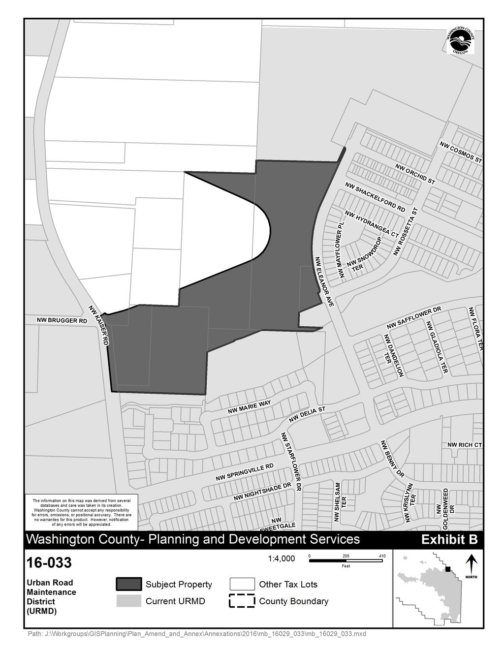
1 Exhibit A E WASHINGTON COUNTY OREGON August 8, 2016 To: From: Subject: Board of Commissioners Andy Back, Planning and Development Services Manager MINOR BOUNDARY CHANGE CASEFILE NOS LRP/BC - ANNEXATION TO TUALATIN HILLS PARK & RECREATION DISTRICT LRP/BC - ANNEXATION TO TUALATIN VALLEY WATER DISTRICT LRP/BC - ANNEXATION TO CLEAN WATER SERVICES DISTRICT LRP/BC - ANNEXATION TO ENHANCED SHERIFF S PATROL DISTRICT LRP/BC - ANNEXATION TO URBAN ROAD MAINTENANCE DISTRICT STAFF REPORT For the August 23, 2016 Board of Commissioners hearing (The public hearing will begin no sooner than 6:30 PM) STAFF RECOMMENDATION Based on the analysis and findings in this staff report, staff recommends that the Board APPROVE Minor Boundary Change Casefiles No LRP/BC to LRP/BC with the approvals becoming effective immediately. REQUESTED ACTION It is proposed that five (5) parcels, a portion of three (3) other parcels, and rights-of-way on NW Brugger Road and NW Kaiser Road totaling approximately 18 acres, located north of NW Springville Road between NW Kaiser Road and NW Eleanor Avenue, be annexed into the following five service districts: Tualatin Hills Park & Recreation District (THPRD), Tualatin Valley Water District (TVWD), Clean Water Services District (CWS), Enhanced Sheriff s Patrol District (ESPD) and Urban Road Maintenance District (URMD). Applicant / Owner: Polygon WLH, LCC Applicant s Representative: Stacy Connery of Pacific Community Design Department of Land Use & Transportation Long Range Planning Division 155 N. First Avenue, Suite , Hillsboro, OR phone: (503) fax: (503)
2 Board of Commissioners Staff Report Casefile No to LRP/BC August 8, 2016 Page 2 of 6 Affected Property: Five (5) parcels, a portion of three (3) other parcels, and rights-ofway on NW Brugger Road and NW Kaiser Road at totaling approximately 18 acres at NW Springville Road and 6850, 6880, and 6900 NW Kaiser Road (four parcels are not addressed). Specifically at Map and Tax Lots: 1N117A (portion), 1N117A (portion), 1N117A000803, (portion), 1N117AD20500, 1N117AD , 1N117DB08500, 1N117DB08600, and 1N117DB13400 ENDORSEMENTS THPRD provided a general endorsement of all annexations in the North Bethany Subarea Plan Area on December 9, 2013 (Resolution No ). TVWD provided a general endorsement of all annexations in the North Bethany Subarea Plan Area on February 15, 2012 under Resolution No The Board of County Commissioners (Board) endorsed the request as the Board of Directors of CWS as required by statute through District Resolution & Order on November 6, The Board endorsed the request as the Board of Directors of ESPD as required by statute through District Resolution & Order 12-3 on November 6, The Board endorsed the request as the Board of Directors of URMD as required by statute through District Resolution & Order 12-2 on November 6, CITIZEN PARTICIPATION Notice of this hearing inviting testimony from interested parties was provided as required by statute and Metro Code. Notice consisted of: 1) Posting notices near the parcels and in the Public Services Building at least 20 days prior to the hearing; 2) Publishing notice twice in The Oregonian; 3) Mailing notices to all affected local governments and adjacent property owners. At the time of writing this staff report no comments were received. FINANCIAL IMPACT There are no known financial impacts associated with these minor boundary changes to prevent the Board from approving the annexation.
3 Board of Commissioners Staff Report Casefile No to LRP/BC August 8, 2016 Page 3 of 6 LEGAL ISSUES There are no known legal impacts associated with these minor boundary changes to prevent the Board from approving the annexations. If the Board approves the proposal, the boundary changes would become effective immediately. BACKGROUND A consent petition of the property owners initiated these proposals (Casefile No LRP/BC to LRP/BC). The petition meets the requirement for initiation set forth in ORS (annexation without election by petition of landowner), ORS (section of statute that specifies contents of petition) and Metro Code (a) (lists minimum requirements for petition). The parcels to be annexed are located inside the Urban Growth Boundary within unincorporated Washington County. The annexation is for five (5) parcels, a portion of three (3) parcels, and rights-of-way on NW Brugger Road and NW Kaiser Road totaling approximately 18 acres. The site is described as sloped with one single-family residence and land previously used as a nursery with a man-made irrigation pond. The current total assessed value of the site being annexed is approximately $1,300,000. REASON FOR ANNEXATION The applicant desires to annex into these five service districts to meet the requirements for development within the North Bethany Subarea Plan area under the Community Development Code (CDC) Section A which requires that the applicant demonstrate that: The property (ies) has been annexed to the following jurisdictions: Clean Water Services, Metro, Tualatin Hills Park & Recreation District, Tualatin Valley Fire and Rescue, Enhanced Sheriff s Patrol District, Enhanced Sheriff s Patrol District and Urban Road Maintenance District. The applicant is proposing to construct a 180-unit single and multi-family residential planned development. CRITERIA Oregon Revised Statute Chapter 198 directs the Board to consider the local comprehensive plan for the area and any service agreement executed between a local government and the affected district. A second set of criteria can be found in the Metro Code. To approve a boundary change, the reviewing entity [the County Board] must apply the criteria and consider the factors set forth in the Code. To approve a boundary change the county must:
4 Board of Commissioners Staff Report Casefile No to LRP/BC August 8, 2016 Page 4 of 6 (1) Find that the change is consistent with expressly applicable provisions in: (A) Any applicable urban service agreement adopted pursuant to ORS ; (B) Any applicable annexation plan adopted pursuant to ORS ; (C) (D) (E) (F) Any applicable cooperative planning agreement adopted pursuant to ORS (2) between the affected entity and a necessary party; Any applicable public facility plan adopted pursuant to a statewide planning goal on public facilities and services; Any applicable comprehensive plan; and Any applicable concept plan. (2) Consider whether the boundary change would: (A) (B) (C) Promote the timely, orderly and economic provision of public facilities and services; Affect the quality and quantity of urban services; and Eliminate or avoid unnecessary duplication of facilities and services. The property to be annexed is not covered by an urban service agreement or a cooperative planning agreement. The county s Comprehensive Plan contains no policies relating directly to the annexation of lands into the five service districts. However, in the development of the North Bethany Subarea Plan (a concept plan), standards were created in the Community Development Code requiring developments within the North Bethany Area to be annexed into six service districts: Metro, CWS, THPRD, TVWD, ESPD and URMD. The applicant is working with Metro to be included in the Metro jurisdictional boundary as this boundary review is not in the purview of the county. Staff finds the proposed annexation will not result in duplication of facilities and services as THPRD, TVWD, CWS, ESPD and URMD are the sole providers for unincorporated Washington County for their specific type of districts. Compliance with Section shows compliance with the applicable concept plan and promotes the timely, orderly and economic provision of public facilities and services in this area.
5 Board of Commissioners Staff Report Casefile No to LRP/BC August 8, 2016 Page 5 of 6 LAND USE PLANNING REGIONAL PLANNING General Information The property to be annexed is inside the regional Urban Growth Boundary (UGB), but not in Metro s jurisdictional boundary. Prior to development approval, the property must be annexed into Metro s jurisdictional boundary, which the applicant has submitted. Regional Framework and Functional Plans The law that requires Metro to adopt criteria for boundary changes specifically states that Metro shall... ensure that a boundary change is in compliance with the Metro regional framework plan as defined in ORS and cooperative agreements and urban service agreements adopted pursuant to ORS 195." ORS states, Metro regional framework plan means the regional framework plan required by the 1992 Metro Charter or its separate components. The Regional Framework Plan was reviewed and found not to contain specific criteria applicable to boundary changes. There are two adopted regional functional plans, the Urban Growth Management Functional Plan and the Regional Transportation Plan, which were examined and found not to contain any directly applicable standards and criteria for boundary changes. Staff finds these requests comply with regional criteria for annexation. COUNTY PLANNING The county s Comprehensive Framework Plan for the Urban Area Policy 15 is relevant to this annexation request. Implementation Strategy h of Policy 15 says: The county will: h. Not oppose proposed annexations to a special service district: 1. That are consistent with an urban service agreement; or 2. If no urban service agreement applies to the property, the property lies within an area for which the district is designated a party in a cooperative agreement adopted pursuant to ORS and the district has adopted a Master Plan for the area. Annexations to special service districts that are consistent with an adopted urban service agreement are deemed to be consistent with the Washington County Plan. The property to be annexed is not covered by an urban service agreement or a cooperative planning agreement. The county s Comprehensive Plan contains no policies relating directly to the annexation of lands into the five service districts. However, Section of the CDC is relevant to these annexations. It states:
6 Board of Commissioners Staff Report Casefile No to LRP/BC August 8, 2016 Page 6 of an application for development approval within the North Bethany Subarea Plan shall be denied unless the applicant demonstrates that: A. The property(ies) has been annexed to the following jurisdictions: Clean Water Services, Metro, Tualatin Hills Park & Recreation District, Tualatin Valley Fire and Rescue, Tualatin Valley Water District, Enhanced Sheriff s Patrol District, and Urban Road Maintenance District. The CDC section above requires land within the North Bethany Subarea Plan be annexed to several service districts prior to development. These requested annexations would satisfy that CDC requirement. FACILITIES AND SERVICES ORS 195 Agreements: ORS 195 requires agreements between providers of urban services. Urban services are defined as: sanitary sewers, water, fire protection, parks, open space, recreation and streets, roads and mass transit. These agreements are to specify which governmental entity will provide which service to which area in the long term. The counties are responsible for facilitating the creation of these agreements. Water: The project area would be served by a 12-inch TVWD water line located at NW Eleanor Avenue and NW Shackelford Road. The applicant is requesting annexation into this service district. Sewer: The project area will access an existing 8-inch sanitary sewer line located at NW Brugger Road and NW Kaiser Road. The applicant is requesting annexation into this service district. Storm Drainage: CWS has responsibility for surface water management within the Washington County urban growth boundary. The proposed development would drain to facilities provided by Bethany Creek, flowing through the site. The applicant is requesting annexation into this service district. Parks and Recreation: The subject parcels are located within THPRD s ultimate service area. The applicant is requesting annexation into this service district. Transportation: The roadways surrounding the parcels are or will be maintained by the county. URMD provides an additional level of service to the urban unincorporated areas of the county. The applicant is requesting annexation into this service district for the subject parcel. Fire: Tualatin Valley Fire & Rescue provides fire and emergency services to this area. Station No. 68 is located at NW Evergreen St. Police: Washington County provides a general level of police services through the county Sheriff s office. ESPD provides an additional level of service to the urban unincorporated areas of the county. The applicant has requested annexation into ESPD for the subject parcels.
7
8
9
10
11


12 August 2, 2016 EXHIBIT A LEGAL DESCRIPTION Job No Annexation Tracts HH and NN, plat of Polygon at Bethany Creek Falls No. 2, Tract SS, plat of Polygon at Bethany Creek Falls No. 3, the land described in Document No , and portions of the lands described in Document Nos , , , and , Washington County Records, in the Northeast, Southwest, and Southeast Quarters of Section 17, Township 1 North, Range 1 West, Willamette Meridian, Washington County, State of Oregon, more particularly described as follows: BEGINNING at the most easterly corner of said Tract NN ; thence along the southerly line of said Tract NN, South 68 03'29" West, a distance of feet to the Southwest corner of said Tract NN ; thence along the westerly line of Tract J, plat of Polygon at Bethany Creek Falls, South 01 47'44" West, a distance of feet to the Southwest corner of said Tract J ; thence along the southerly line of said Tract J and the northerly line of Tract I, plat of Polygon at Bethany Creek Falls, South 88 12'16" East, a distance of feet to an angle point on the northerly line of said Tract I ; thence along said northerly line, South 67 38'32" West, a distance of feet to the most westerly corner of said Tract I ; thence along the northerly line of Archibald Bull Donation Land Claim No. 50, North 88 30'05" West, a distance of feet to the most easterly corner of said Tract SS ; thence along the southerly line of said Tract SS, South 68 03'42" West, a distance of feet to an angle point; thence continuing along said southerly line, South 73 36'18" West, a distance of feet to an angle point; thence continuing along said southerly line, South 51 35'29" West, a distance of feet to an angle point; thence continuing along said southerly line, South 68 03'42" West, a distance of feet to the most southerly corner of said Tract SS ; SW Main Street, Tigard, OR [T] [F] Page 1 of 5
13 thence along the westerly line of Tract RR of said plat of Polygon at Bethany Creek Falls No. 3, South 02 22'20" West, a distance of feet to the Northeast corner of Tract A, plat of Crossing at North Bethany ; thence along the northerly line of said Tract A and the southerly line of said land described in Document No , North 88 13'33" West, a distance of feet to the Southwest corner of said land; thence along the westerly lines of said lands described in Document Nos and , North 05 40'02" West, a distance of feet to an angle point; thence continuing along said westerly line, North 39 57'59" West, a distance of 2.96 feet to the Northwest corner of said land described in Document No ; thence continuing along the southerly line of said land described in Document No , North 87 55'59" West, a distance of feet to the Southwest corner of said land; thence along the westerly line of said land, North 35 22'05" West, a distance of feet; thence leaving said westerly line, North 54 37'55" East, a distance of feet; thence along a foot radius non-tangential curve, concave northerly, with a radius point bearing North 57 33'26" East, arc length of feet, central angle of 72 26'39", chord distance of feet, and chord bearing of South 68 39'53" East; thence North 75 06'47" East, a distance of feet; thence along a foot radius tangential curve to the left, arc length of feet, central angle of 05 17'38", chord distance of feet, and chord bearing of North 72 27'58" East; thence North 69 49'09" East, a distance of feet to a point on the northerly line of said land described in Document No ; thence along said northerly line and the northerly line of the land described in Document No , South 88 14'50" East, a distance of feet to the most westerly Southwest corner of said land described in Document No ; thence along the westerly line of said land described in Document No , North 02 21'10" East, a distance of feet; thence leaving said westerly line, North 68 03'29" East, a distance of feet; thence along a foot radius tangential curve to the left, arc length of feet, central angle of '18", chord distance of feet, and chord bearing of North 01 09'20" East; Pacific Community Design, Inc SW Main Street, Tigard, OR [T] [F] Page 2 of 5
14 thence North 65 44'48" West, a distance of feet to a point on the westerly line of said land described in Document No ; thence along said westerly line, North 02 21'10" East, a distance of 0.48 feet to the Northwest corner of said land described in Document No ; thence along the northerly line of said land described in Document No , South 88 29'20" East, a distance of feet to the Northeast corner of said land described in Document No ; thence along the westerly line of said land described in Document No , North 02 23'09" East, a distance of feet to the Southwest corner of Lot 3, plat of Fishback Acres ; thence along the southerly line of said Lot 3, South 88 36'00" East, a distance of feet to an angle point on the westerly line of said Tract HH ; thence along said westerly line, North 24 07'22" East, a distance of feet to the most northerly corner of said Tract HH ; thence along the easterly line of said Tract HH, along a foot radius non-tangential curve, concave westerly, with a radius point bearing South 36 20'07" West, arc length of feet, central angle of 78 06'59", chord distance of feet, and chord bearing of South 14 36'23" East to a point of tangency; thence along the westerly Right-of-Way line of NW Eleanor Avenue, South 24 27'06" West, a distance of feet to a point of tangential curvature; thence continuing along said westerly Right-of-Way line, along a foot radius tangential curve to the left, arc length of feet, central angle of 45 45'10", chord distance of feet, and chord bearing of South 01 34'32" West to a point of tangency; thence continuing along said westerly Right-of-Way line, South 21 18'03" East, a distance of 5.45 feet to a point of tangential curvature; thence along the easterly line of said Tract NN, along a foot radius tangential curve to the right, arc length of feet, central angle of 89 21'33", chord distance of feet, and chord bearing of South 23 22'43" West to a point of tangency; thence continuing along said easterly line, South 68 03'29" West, a distance of 2.89 feet to an angle point; Pacific Community Design, Inc SW Main Street, Tigard, OR [T] [F] Page 3 of 5

15 thence continuing along said easterly line, South 21 56'31" East, a distance of feet to the POINT OF BEGINNING. Containing acres, more or less. Basis of bearings being plat of Polygon at Bethany Creek Falls No. 3, Washington County Plat Records. REGISTERED PROFESSIONAL LAND SURVEYOR OREGON JULY 9, 2002 TRAVIS C. JANSEN RENEWS: 6/30/2017 Pacific Community Design, Inc SW Main Street, Tigard, OR [T] [F] Page 4 of 5
16 N:\proj\ \09 Drawings\06 Survey\Legals\ Annexation Legal.dwg - SHEET: Legal Aug. 2, 16-11:23 AM garrett SW Main St Tigard, OR [T] [F]
AGENDA BILL. Beaverton City Council Beaverton, Oregon
 AGENDA BILL Beaverton City Council Beaverton, Oregon 7-16-2013 SUBJECT: An Ordinance Annexing One Parcel FOR AGENDA OF: 7-9-2e-1-3- BILL NO: 13156 Located at 4245 SW 10t h Avenue and Adjacent Public Right-of-Way
AGENDA BILL. Beaverton City Council Beaverton, Oregon BUDGET IMPACT AMOUNT BUDGETED $0
 AGENDA BILL SUBJECT: Beaverton City Council Beaverton, Oregon An Ordinance Annexing a Portion of Three Parcels Along NW 112 1 h Avenue to the City of Beaverton, Adding the Property to the Central Beaverton
VICINITY MAP SCALE 1'' = 2000'
 CITY CREEK ANNEXATION TO THE CITY OF THORNTON LOCATED IN THE SOUTHWEST QUARTER OF SECTION 11 AND THE WEST HALF OF SECTION 14, TOWNSHIP 1 SOUTH, RANGE 68 WEST OF THE 6TH PRINCIPAL MERIDIAN, COUNTY OF ADAMS,
CITY OF WACONIA RESOLUTION
 CITY OF WACONIA RESOLUTION 2014-212 TOWNSHIP OF LAKETOWN RESOLUTION~~- \0 JOINT RESOLUTION STIPULATING TO THE AMENDMENT OF ORDERLY ANNEXATION AGREEMENT NO. 76-47 AND TO THE ORDERLY ANNEXATION OF THE RYLAND
AGENDA BILL. Beaverton City Council Beaverton, Oregon EXHIBITS: BUDGET IMPACT AMOUNT BUDGETED $0
 AGENDA BILL Beaverton City Council Beaverton, Oregon SUBJECT: An Ordinance Annexing One Parcel Located at 7440 SW 78 1 h Avenue to the City of Beaverton, Adding the Property to the Denny Whitford I Raleigh
CITY OF OCALA CITY COUNCIL REPORT Council Meeting Date: 06/06/17
 CITY OF OCALA CITY COUNCIL REPORT Council Meeting Date: 06/06/17 Subject: Large Scale Land Use Map Amendment Submitted By: David Boston Department: Growth Management STAFF RECOMMENDATION (Motion Ready):
David L. Brown, Construction Services Manager
 Memorandum Date: 2/02/2013 Order Date: 2/27/2013 TO: DEPARTMENT: PRESENTED BY: AGENDA ITEM TITLE: Board of County s Public Works David L. Brown, Construction Services Manager In the Matter of Authorizing
AGENDA BILL. Beaverton City Council Beaverton, Oregon. PROCEEDING: First Reading EXHIBITS: Ordinance with Exhibit A: Legal Description BUDGET IMPACT
 AGENDA BILL Beaverton City Council Beaverton, Oregon SUBJECT: An Ordinance Vacating a Portion of Right-of-Way Located Along SW Ardenwood Street; SV 2013-0001 FOR AGENDA OF: Mayor's Approval: 7/!:~O: 13169
Subject: Ordinance 1657, Annexation of 3.55 acres of land at 3015 and 3001 Parker Road.
 Agenda Report 2016-12-12-09 Date: December 8, 2016 To: From: Russ Axelrod, Mayor Members, West Linn City Council Jennifer Arnold, Planning Department Through: John Boyd, Interim Community Development Director
AGENDA BILL. Beaverton City Council Beaverton, Oregon BUDGET IMPACT EXPENDITURE AMOUNT APPROPRIATION REQUIRED $0 BUDGETED $0 REQUIRED $0
 AGENDA BILL Beaverton City Council Beaverton, Oregon SUBJECT: A Public Hearing to Consider Annexing FOR AGENDA OF: 11-13-12 BILL NO: 12231 Twenty-one (21) Parcels Located Generally North of SW Scholls
ORDINANCE NO AN ORDINANCE To Be Entitled:
 3808 AN ORDINANCE To Be Entitled: AN ORDINANCE OF THE CITY COUNCIL OF THE CITY OF FORT MYERS, FLORIDA, REZONING FROM COMMERCIAL GENERAL TO PLANNED UNIT DEVELOPMENT AND APPROVING THE DEVELOPMENT PLAN FOR
DRAINAGE AND UTILITY EASEMENT. That Bruce Conrad, a single adult, hereinafter referred to as Grantor for good and
 DRAINAGE AND UTILITY EASEMENT KNOW ALL PERSONS BY THESE PRESENTS: That Bruce Conrad, a single adult, hereinafter referred to as Grantor for good and valuable consideration, the receipt and sufficiency
CHAPTER XIX ANNEXATION ARTICLE 1. ANNEXATION
 CHAPTER XIX ANNEXATION ARTICLE 1. ANNEXATION 19.0101 JABORSKY ADDITION: WHEREAS, The City of Belfield pursuant to Section 40-51.2-07 of the North Dakota Century Code has amended having passed a Resolution
GeoPoint 213 Hobbs Street Tampa, Florida
 AIRPORT ROAD PINELAND P.R.D. SUBDIVISION - PHASES 2 & 3 DESCRIPTION: A parcel of land lying in Sections 13 and 24, Township 14 South, Range 31 East, Volusia County, Florida, and being more particularly
GeoPoint 1403 E. 5th Avenue Tampa, Florida
 AIRPORT ROAD PINELAND P.R.D. SUBDIVISION - PHASE 1 DEDICATION: CERTIFICATE OF REVIEW BY SURVEYOR, CITY OF ORMOND BEACH DEDICATION: THIS IS TO CERTIFY THAT FORESTAR (USA) REAL ESTATE GROUP INC., A DELAWARE
AVENIR COMMUNITY DEVELOPMENT DISTRICT CITY OF PALM BEACH GARDENS SPECIAL BOARD MEETING JANUARY 11, :00 A.M.
 AVENIR COMMUNITY DEVELOPMENT DISTRICT CITY OF PALM BEACH GARDENS SPECIAL BOARD MEETING JANUARY 11, 2018 11:00 A.M. Special District Services, Inc. The Oaks Center 2501A Burns Road Palm Beach Gardens, FL
WHEREAS, the Petition was filed by PATRICK AND KIMBERLY SHULER for the vacation of plat on property described herein; and
 VP 15-0003 RESOLUTION 2-16 A RESOLUTION PROVIDING FOR THE VACATION OF PLAT FOR A PUBLIC UTILITY AND DRAINAGE EASEMENT UNDERLYING A PREVIOUSLY VACATED RIGHT-OF-WAY BEING A PART OF SW 28 PLACE ADJACENT TO
ADOPTED ORDINANCE LUT LUT LUT LUT
 ADOPTED ORDINANCE 2016 811 10/4/2016 Consider Proposed A-Engrossed Ordinance No. 811 - An Ordinance Amending the Community Development Code to Adopt Federal Emergency Management Agency (FEMA) Requirements
610 LAND DIVISIONS AND PROPERTY LINE ADJUSTMENTS OUTSIDE A UGB
 ARTICLE VI: LAND DIVISIONS AND PROPERTY LINE ADJUSTMENTS VI-21 610 LAND DIVISIONS AND PROPERTY LINE ADJUSTMENTS OUTSIDE A UGB 610-1 Property Line Adjustments (Property Line Relocation) A property line
IRC INTERNATIONAL REALTY CORPORATION
 Rental Rate: $16/SF 3480 Pelican Colony Blvd., Estero, Florida 34134 IRC INTERNATIONAL REALTY CORPORATION 3838 Tamiami Trail North, Suite 416 Naples, FL 34103 (P) 239.213.4000 rainer@inter-realty.com www.inter-realty.com
COUNCIL AGENDA MEMO ITEM NO. III - #1
 COUNCIL AGENDA MEMO ITEM NO. III - #1 FROM: Anton Jelinek, Director of Utilities MEETING: October 24, 2017 SUBJECT: PRESENTER: Permanent Utility and Right-of-Way Easement Anton Jelinek Discussion: At the
NOTICE OF ADOPTED CHANGE TO A COMPREHENSIVE PLAN OR LAND USE REGULATION
 NOTICE OF ADOPTED CHANGE TO A COMPREHENSIVE PLAN OR LAND USE REGULATION Date: Jurisdiction: Local file no.: DLCD file no.: May 17, 2016 City of Lebanon 16-02-09 002-16 The Department of Land Conservation
OFFICIAL SUMMARY OF AN ORDINANCE TO CONVEY CERTAIN RAMSEY COUNTY PARK AND OPEN SPACE LANDS TO THE CITY OF MAPLEWOOD.
 OFFICIAL SUMMARY OF AN ORDINANCE TO CONVEY CERTAIN RAMSEY COUNTY PARK AND OPEN SPACE LANDS TO THE CITY OF MAPLEWOOD. This ordinance authorizes the conveyance of park and open space land owned by Ramsey
ABBREVIATION LEGEND SITE INFORMATION:
 SITE INFORMATION: Current Zone: R-3 PUD, governed by Fox Hollow 2nd MDA Basis of Elevations: Northeast Corner of Section 13, T6S, R1W, S.L.B. & M Elevation: 4599.26 (Benchmark) ABBREVIATION LEGEND Owners:
in Book 10019, at Page 9432, 352 feet, more, or less, to the North right of way of 3350 South Street; thence West along said right of way 93 feet,
 Public notice is hereby given that the Millcreek Community Reinvestment Agency (the Agency ) will hold a public hearing on Tuesday, November 13, 2018, commencing at 7:30 p.m. or as soon thereafter as the
RESOLUTION NO. R To Acquire Real Property Interests Required for the Operations and Maintenance Satellite Facility
 RESOLUTION NO. R2015-35 To Acquire Real Property Interests Required for the Operations and Maintenance Satellite Facility MEETING: DATE: TYPE OF ACTION: STAFF CONTACT: Capital Committee Board PROPOSED
CITY OF HIAWATHA, IOWA TOWN VILLAGE CENTER URBAN REVITALIZATION PLAN. for the TOWN VILLAGE CENTER URBAN REVITALIZATION AREA
 CITY OF HIAWATHA, IOWA TOWN VILLAGE CENTER URBAN REVITALIZATION PLAN for the TOWN VILLAGE CENTER URBAN REVITALIZATION AREA 2018 1 INTRODUCTION The Urban Revitalization Act, Chapter 404 of the Code of Iowa,
City Council Agenda Item #13_ Meeting of March 6, 2017
 City Council Agenda Item #13_ Meeting of March 6, 2017 Description Recommendation Resolution vacating a sump easement and drainage and utility easements located at 1555 Linner Road. Hold the public hearing
Dact= Bk:31661 Ps: 116
 Dact= 33591 Bk:31661 Ps: 116 AMENDMENT TO THE MASTER DECLARATION OF COVENANTS, CONDITIONS AND RESTRICTIONS FOR DUNSTAN CROSSING [Submission of Project Phase IIIl CHAMBERLAIN CONSTRUCTION, INC., a Maine
ATTACHMENT B GRANT DEED. This deed is in satisfaction of the Eminent Domain Action Case No. GRANT DEED
 GRANT DEED RECORDING REQUESTED BY AND WHEN RECORDED MAIL TO: County of Orange County Executive Office CEO Real Estate 333 W. Santa Ana Blvd. Bldg. 10 Santa Ana, California 92701 AND MAIL TAX STATEMENTS
There is no fiscal impact associated with this Individual Development Approval.
 CRP-06-01 R2/13-97500005 Citibank Temporary Drive-Through 700-998 South Federal Highway The Via Mizner property is approximately 6.8 acres in area and is situated on the north side of Camino Real, east
ORDINANCE NO. Z REZONING NO
 ORDINANCE NO. Z- 3960 REZONING NO. 2018-00014 AN ORDINANCE RELATING TO ZONING: AMENDING CERTAIN ZONING REGULATIONS SHOWN ON SHEET NO. 15 OF THE ZONING DISTRICT MAP INCORPORATED BY REFERENCE BY OVERLAND
INTERGOVERNMENTAL AGREEMENT
 INTERGOVERNMENTAL AGREEMENT This Intergovernmental Agreement (this Agreement) is made and entered into as of December 1, 2010, by and between the VILLAGE OF BIG ROCK, an Illinois municipal corporation
RESOLUTION NO. R
 RESOLUTION NO. R-2016-1832 RESOLUTION APPROVING ZONING APPLICATION ZV/DOAlR-2016-00660 (CONTROL NO. 1998-00089) a Requested Use APPLICATION OF 2860 Ranch House Road LLC, Scotts Gas LLC, Ranch House Prop
RESOLUTION NO. RD:EEH:LCP
 RESOLUTION NO. A RESOLUTION OF THE COUNCIL OF THE CITY OF SAN JOSE CONDITIONALLY VACATING A PORTION OF MERIDIAN AVENUE, SOUTH OF FRUITDALE AVENUE, AND RESERVING A PUBLIC SERVICE EASEMENT OVER THE VACATED
to St. Louis County by deed recorded in Book 7954, Page 235 in the St. Louis County, Missouri
 Recommendation of Planning Commission BILL NO. 4032 ORDINANCE NO. 2015-3971 AN ORDINANCE ENACTING A CONDITIONAL USE PERMIT FOR AN ELECTRICAL SUBSTATION AT 11520 DORSETT ROAD Petition of Ameren Missouri)
ORDINANCE N0.18-ll6. WHEREAS, City has prepared a Service Plan for said tract which is attached as Exhibit "A" to this ordinance; &
 c: 0 ORDINANCE N0.18-ll6 AN ORDINANCE ANNEXING THE HEREINAFTER DESCRIBED TERRITORY TO THE CITY OF FORT STOCKTON, PECOS COUNTY, TEXAS, AND EXTENDING THE BOUNDARY LIMITS OF SAID CITY SO AS TO INCLUDE SAID
JOINT RESOLUTION AMENDING JOINT RESOLUTION AS TO ORDERLY ANNEXATION: THE TOWN OF STILLWATER AND CITY OF STILLWATER
 JOINT RESOLUTION AMENDING JOINT RESOLUTION AS TO ORDERLY ANNEXATION: THE TOWN OF STILLWATER AND CITY OF STILLWATER WHEREAS, the Town of Stillwater and the City of Stillwater, Washington County, Minnesota,
LISA ANDERSON-OGILVIE, AICP DEPUTY COMMUNITY DEVELOPMENT DIRECTOR AND PLANNING ADMINISTRATOR
 FOR MEETING OF: December 12, 2018 CASE NO.: VUL18-01 TO: FROM: HEARINGS OFFICER LISA ANDERSON-OGILVIE, AICP DEPUTY COMMUNITY DEVELOPMENT DIRECTOR AND PLANNING ADMINISTRATOR SUBJECT: VALIDATION OF UNIT
UNOPPOSED ORDER GRANTING RECEIVER'S MOTION TO APPROVE THE SALE OF REAL PROPERTY OWNED BY MAMC EMERALD CAY, LLC
 IN THE CIRCUIT COURT OF THE ELEVENTH JUDICIAL CIRCUIT IN AND FOR MIAMI-DADE COUNTY, FLORIDA STATE OF FLORIDA, OFFICE OF FINANCIAL REGULATION, Plaintiff, v. BERMAN MORTGAGE CORPORATION, a Florida corporation,
Business Item No xxx
 Business Item No. 2015-xxx Metropolitan Parks and Open Space Commission Meeting date: October 6, 2015 For the Community Development Committee meeting of October 19, 2015 For the Metropolitan Council meeting
Sketch & Legal Description of Mitigation Bank and Ingress/Egress Access Easements
 Appendix H: Sketch & Legal Description of Mitigation Bank and Ingress/Egress Access Easements Tippen Bay Wetland Mitigation Bank DeSoto County, Florida Prepared by: September, 2017 Original file
CONVEYANCE - COMMONWEALTH PROPERTY IN THE BOROUGH OF EAST STROUDSBURG, MONROE COUNTY Act of Jul. 1, 2016, P.L., No. 65 Cl.
 CONVEYANCE - COMMONWEALTH PROPERTY IN THE BOROUGH OF EAST STROUDSBURG, MONROE COUNTY Act of Jul. 1, 2016, P.L., No. 65 Cl. 85 An Act Authorizing the Department of General Services, with the approval of
AGENDA UPDATE ECONOMIC DEVELOPMENT & FINANCE STANDING COMMITTEE MEETING MONDAY, AUGUST 10, 2015 III. COMMITTEE AGENDA
 AGENDA UPDATE ECONOMIC DEVELOPMENT & FINANCE STANDING COMMITTEE MEETING MONDAY, AUGUST 10, 2015 III. COMMITTEE AGENDA REVISED ITEM NO. 4 150217.ORDINANCE: VACATION VILLAGE AREAS 1 AND 2A Synopsis: A revised
Regular Agenda / Public Hearing for Board of Commissioners meeting January 7, 2015
 Rebecca W. Arnold, Commissioner Sara M. Baker, Commissioner Jim D. Hansen, Commissioner Kent Goldthorpe, Commissioner Paul Woods, Commissioner TO: FROM: ACHD Board of Commissioners & Bruce S. Wong, Director
----':c RESOLUTION NO. ZR
 RESOLUTION NO. ZR-2018-015 RESOLUTION APPROVING ZONING APPLICATION ZV-2017-02395 CONTROL NO. 1980-00215 TYPE II VARIANCE (STAND ALONE) APPLICATION OF Gleneagles Country Club Inc BY WGINC, AGENT (GLENEAGLES
Case JMC-7A Doc 1133 Filed 01/31/17 EOD 01/31/17 13:25:18 Pg 1 of 10 SO ORDERED: January 31, 2017.
 Case 16-07207-JMC-7A Doc 1133 Filed 01/31/17 EOD 01/31/17 13:25:18 Pg 1 of 10 SO ORDERED: January 31, 2017. James M. Carr United States Bankruptcy Judge UNITED STATES BANKRUPTCY COURT SOUTHERN DISTRICT
Final Plat Mapping Requirements
 CURRENT PLANNING DIVISION 410 E. 5 th Street Loveland, CO 80537 970-962-2523 eplan-planning@cityofloveland.org cityofloveland.org/dc Final Plat Mapping Requirements All Final plats shall comply with the
Ownership and Encumbrance Report
 Ownership and Encumbrance Report First American Issuing Office: First American Title Insurance Company 2233 Lee Road, Suites 110B Winter Park, FL 32789 Customer Reference Number: First American File Number:
COUNCIL COMMUNICATION
 Meeting Date: October 24, 2017 COUNCIL COMMUNICATION Agenda Item: Agenda Location: Public Hearings Work Plan # Legal Review: X 1 st Reading 2 nd Reading Subject: A public hearing regarding Zoning and a
Oakland County Michigan Register of Deeds Plat Engineering, GIS, & Remonumentation Dept. Ph: (248) Fax (248)
 Fax (248)") Oakland County Michigan Register of Deeds Plat Engineering, GIS, & Remonumentation Dept. Ph: (248)-858-1447 Fax (248)-858-7466 Requirements Needed for Final Plat Approval No. General Requirements. 1 Routing
Oakland County Michigan Register of Deeds Plat Engineering, GIS, & Remonumentation Dept. Ph: (248)-858-1447 Fax (248)-858-7466 Requirements Needed for Final Plat Approval No. General Requirements. 1 Routing
BOSSIER CITY PARISH METROPOLITAN PLANNING COMMISSION 620 Benton Rd. Bossier City, LA Phone: Fax: PRELIMINARY PLAT
 (OFFICE USE ONLY) Application Fee: Paid: Date: CASE # Project Information BOSSIER CITY PARISH METROPOLITAN PLANNING COMMISSION 620 Benton Rd. Bossier City, LA 71111 Phone: 318-741-8824 Fax: 318-741-8827
RESOLUTION NO. ZR
 RESOLUTION NO. ZR-2015-004 RESOLUTION APPROVING ZONING APPLICATION SV/ZV/Z-2014-01624 (CONTROL NO. 2009-02465) TYPE II VARIANCE (CONCURRENT) APPLICATION OF MPC 3 LLC BY CPH, Inc, Baker & Hostetler LLP,
TOWN OF LYONS, COLORADO ORDINANCE NO. 1017
 TOWN OF LYONS, COLORADO ORDINANCE NO. 1017 AN ORDINANCE OF THE BOARD OF TRUSTEES OF THE TOWN OF LYONS ANNEXING TO THE TOWN OF LYONS CERTAIN REAL PROPERTY OWNED BY THE TOWN OF LYONS WHEREAS, the Town of
WATERFORD LANDING COMMUNITY DEVELOPMENT DISTRICT REGULAR MEETING AGENDA
 WATERFORD LANDING COMMUNITY DEVELOPMENT DISTRICT REGULAR MEETING AGENDA January 31, 2019 Waterford Landing Community Development District OFFICE OF THE DISTRICT MANAGER 2300 Glades Road, Suite 410W Boca
The Filing Fee for a Minor Plat is $ PLUS $20.00 per lot created
 DEPARTMENT OF COMMUNITY DEVELOPMENT MINOR PLAT PROCEDURE The Filing Fee for a Minor Plat is $250.00 PLUS $20.00 per lot created Description: The purpose of a Minor Plat is to allow property to be platted
LIST OF TAX FORFEITED LAND # FOR SALE TO PUBLIC
 LIST OF TAX FORFEITED LAND #218-1 FOR SALE TO PUBLIC Residential Properties RADON WARNING STATEMENT The Minnesota Department of Health strongly recommends that ALL homebuyers have an indoor radon test
BILL NO (Emergency Measure) ORDINANCE NO. 5072
 ORDINANCE NO. 5072") BILL NO. 5210 (Emergency Measure) ORDINANCE NO. 5072 AN ORDINANCE AUTHORIZING THE MAYOR TO EXECUTE WITH MICHELSON-HADLEY HEIGHTS DEVELOPMENT, LLC, A CONTRACT AND QUIT CLAIM DEED CONVEYING CERTAIN PROPERTIES
BILL NO. 5210 (Emergency Measure) ORDINANCE NO. 5072 AN ORDINANCE AUTHORIZING THE MAYOR TO EXECUTE WITH MICHELSON-HADLEY HEIGHTS DEVELOPMENT, LLC, A CONTRACT AND QUIT CLAIM DEED CONVEYING CERTAIN PROPERTIES
PLANNING COMMISSION STAFF REPORT
 PLANNING COMMISSION STAFF REPORT Alder-Robinson Subdivision Amending the Amended Plat of the Arcadia Heights Plat A Subdivision Case #PLNSUB2010-00044 2857 East 2100 South June 23, 2010 Applicant: Greg
MINNETONKA PLANNING COMMISSION October 26, Rear yard setback variance for a deck expansion at 5732 Kipling Avenue
 MINNETONKA PLANNING COMMISSION October 26, 2017 Brief Description Rear yard setback variance for a deck expansion at 5732 Kipling Avenue Recommendation Adopt the resolution approving the variance Background
ORDINANCE NO.: Adopted: August 2, 2005 Amended: March 27, 2007 Amended: September 23, Fillmore County Rural Addressing Ordinance
 ORDINANCE NO.: 2005-01 Adopted: August 2, 2005 Amended: March 27, 2007 Amended: September 23, 2008 Fillmore County Rural Addressing Ordinance Section 1 Purpose, Scope and Statutory Authorization 1-1 Purpose.
Map Filing Law. 46: Effective date This act shall take effect January first, one thousand nine hundred and fiftyfour.
 46:23-9.8. Effective date This act shall take effect January first, one thousand nine hundred and fiftyfour. L.1953, c. 358, p. 1941, s. 8. 46:23-9.9. Short title This act shall be known and may be cited
PRELMINARY PLAT CHECKLIST
 PRELMINARY PLAT CHECKLIST A. All preliminary plat submitted for approval shall be prepared by a Registered Professional Land Surveyor. B. Preliminary plats must be drawn to a scale of XXX with such accuracy
City Council Information Form
 City Council Information Form DATE: 08/13/2014 ASSIGNED STAFF: Robert McKay DEPARTMENT: Planning&Development TYPE OF FORM: Ordinances Form No.: 4490 APPROVALS: None ISSUE/REQUEST: AN ORDINANCE VACATING
Add on item to regular section of agenda: FDOT Draft Tentative Work Program
 MEMORANDUM To: Robin Meyer, AICP, Planning Section Manager From: Bobbi Roy, Planning Coordinator Date: December 3, 2014 Subject: Agenda Update for the December 4, 2014 Board of County Commissioners Land
The North 140 Feet of Lot 4, Block 6, Metcalf View Second Plat, a subdivision of land in the City of Overland Park, Johnson County, Kansas.
 NOTICE OF PUBLIC HEARING CITY PLANNING COMMISSION CITY OF OVERLAND PARK, KANSAS Notice is hereby given that the City Planning Commission of Overland Park, Kansas, will hold a public hearing Monday, June
Canyons South. Annexation Impact Report. September 1, 2015
 Canyons South Annexation Impact Report September 1, 2015 1 Introduction This Annexation Impact Report has been prepared to meet the statutory requirements set forth in Colorado Revised Statutes 31 12 108.5
A favorable recommendation to the City Council is requested.
 To: Sycamore Plan Commission From: Brian Gregory, City Manager Date: October 8, 2015 Re: October 12, 2015 Plan Commission Meeting The Plan Commission has two action items. A. Consideration of a request
Reservations of all oil, gas, mineral, geothermal, and water rights.
 Form A- 158 County of Sandoval WARRANTY DEED Recorp New Mexico Associates Limited Partnership 11, a New Mexico limited Partnership hereinafter referred to as the Grantor, for valuable consideration paid,
URBANIZATION ELEMENT. PREPARED BY CITY OF MEDFORD PLANNING DEPARTMENT 200 SOUTH IVY STREET MEDFORD, OREGON
 PREPARED BY CITY OF MEDFORD PLANNING DEPARTMENT 200 SOUTH IVY STREET MEDFORD, OREGON 97501 plnmed@ci.medford.or.us ROBERT O. SCOTT, AICP, PLANNING DIRECTOR COMPREHENSIVE PLANNING SECTION MARK GALLAGHER,
FIFTH AMENDMENT OF DECLARATION OF DEED RESTRICTIONS AND DEDICATIONS FOR PINEHURST ESTATES (A Clatsop County, Oregon Subdivision)
") After Recording Return To: W. Louis Larson 990 Astor Street Astoria, OR 97103 FIFTH AMENDMENT OF DECLARATION OF DEED RESTRICTIONS AND DEDICATIONS FOR PINEHURST ESTATES (A Clatsop County, Oregon Subdivision)
After Recording Return To: W. Louis Larson 990 Astor Street Astoria, OR 97103 FIFTH AMENDMENT OF DECLARATION OF DEED RESTRICTIONS AND DEDICATIONS FOR PINEHURST ESTATES (A Clatsop County, Oregon Subdivision)
ARTICLE V: PUBLIC FACILITIES AND SERVICES V PUBLIC FACILITY AND SERVICE REQUIREMENTS
 ARTICLE V: PUBLIC FACILITIES AND SERVICES V 1 501 PUBLIC FACILITY AND SERVICE REQUIREMENTS 501 1 Intent and Purpose The intent of this Section is to identify those public facilities and services that are
STATE OF MINNESOTA OFFICE OF ADMINISTRATIVE HEARINGS
 OAH 84-0330-32990 STATE OF MINNESOTA OFFICE OF ADMINISTRATIVE HEARINGS In the Matter of the Annexation of Certain Real Property to the City of Houston from Houston Township (MBAU A-7959) FINDINGS OF FACT,
STAFF REPORT. For the Sept. 18, 2018 Board of Commissioners Hearing (The public hearing will begin no sooner than 10:00 a.m.)
") Sept. 10, 2018 To: From: Subject: Washington County Board of Commissioners Andy Back, Manager Planning and Development Services PROPOSED LAND USE ORDINANCE NO. 839 - An Ordinance Amending the Washington
Sept. 10, 2018 To: From: Subject: Washington County Board of Commissioners Andy Back, Manager Planning and Development Services PROPOSED LAND USE ORDINANCE NO. 839 - An Ordinance Amending the Washington
RESOLUTION NO. R
 RESOLUTION NO. R-2011-0222 RESOLUTION APPROVING ZONING APPLICATION ZV/ZlCA-2010-01433 (CONTROL NO. 2009-02385) an Official Zoning Map Amendment with a Conditional Overlay Zone (COZ) APPLICATION OF Delray
PLANNING SERVICES MEMORANDUM
 PLANNING SERVICES MEMORANDUM March 13, 2017 TO: FROM: SUBJECT: City Council Brian Schweigl, Associate Planner Consideration and action on final Certified Survey Map (CSM) 17002-C, City of Janesville, 2
In Rem Foreclosure of Tax Liens By Lafayette County For Tax Years
 In Rem Foreclosure of Tax Liens By Lafayette County For Tax Years 2007-2011 Properties owned by Lafayette County, WI Sealed Bid Auction Date: November 13, 2015 Sealed Bid Auction Time: 11:00 a.m. Sealed
Planning Commission Staff Report Rezone Hearing Date: September 26, 2018
 Planning Commission Staff Report Rezone Hearing Date: September 26, 2018 ITEM 3 Gardner and Associates requests a Zone Change from Public Facilities (PF) to R1.6PD to facilitate a 33-lot subdivision, located
ARTICLES OF INCORPORATION
 Cherry Creek Vista Homeowners Association June, 2009 The following pages were retyped from copies of the original documents. The original documents are available through the Arapahoe County, Colorado,
City of Grande Prairie Development Services Department
 City of Grande Prairie Development Services Department COUNTRYSIDE SOUTH OUTLINE PLAN Prepared by: GPEC Consulting Ltd. #202, 10712-100th Street Grande Prairie, AB Council Resolution of August 20, 2001
The complete Petition to Vacate was submitted by Thomas Hoolihan of Seago Group Inc., Raymond F. Dibble, Trustee, and 3everly A. Dibble, Trustee.
 K rion REOUFSTED: Adopt a Resolution on Petition VAC2001-00063 to Vacate a portion of the cul-de-sac for River Club Ct. (f.k Nalter Hagen Ct.) as recorded in Plat Book 34, Page 13, in the Public Records
CHAPTER House Bill No. 1039
 CHAPTER 2016-257 House Bill No. 1039 An act relating to the Babcock Ranch Community Independent Special District, Charlotte and Lee Counties; amending chapter 2007-306, Laws of Florida; expanding the Babcock
RESOLUTION R EAST COUNTY MIDDLE SCHOOL SCHOOL SITE PLAN SSP DTS
 RESOLUTION R-18-003 EAST COUNTY MIDDLE SCHOOL SCHOOL SITE PLAN SSP-17-02 DTS20170502 A RESOLUTION OF THE BOARD OF COUNTY COMMISSIONERS OF MANATEE COUNTY, FLORIDA, REGARDING LAND DEVELOPMENT; ALLOWING FOR
RESOLUTION NO. ZR
 RESOLUTION NO. ZR-2018-018 RESOLUTION APPROVING ZONING APPLICATION ZV/ABN/DOA/CA-2017-00354 (CONTROL NO. 1984-00058) TYPE II VARIANCE (CONCURRENT) APPLICATION OF Regions Bank BY Gunster, Yoakley & Stewart,
RESOLUTION NO. R
 RESOLUTION NO. R-2009-0485 RESOLUTION APPROVING ZONING APPLICATION Z-2008-01745 (CONTROL NO. 2003-00062) OFFICIAL ZONING MAP AMENDMENT (REZONING) WITH A CONDITIONAL OVERLAY ZONE (COZ) APPLICATION OF Habitat
As Introduced. 131st General Assembly Regular Session H. B. No
 131st General Assembly Regular Session H. B. No. 239 2015-2016 Representative Sears A B I L L To amend section 5120.092 and to enact section 5120.80 of the Revised Code to allow the Director of Budget
WORTHINGTON CITY COUNCIL REGULAR MEETING, JULY 11, 2011
 WORTHINGTON CITY COUNCIL REGULAR MEETING, JULY 11, 2011 The meeting was called to order at 7:00 p.m. in City Hall Council Chambers by Mayor Alan E. Oberloh with the following Aldermen present: Lyle Ten
To provide for the review of the final engineering plans, the subdivision improvement agreement, public dedications, and other legal agreements.
 ARTICLE 5 FINAL PLAT 501 Intent DOUGLAS COUNTY SUBDIVISION RESOLUTION To provide for the review of the final engineering plans, the subdivision improvement agreement, public dedications, and other legal
AGENDA MEMORANDUM. An Ordinance Amending the Town s Zone District Map by Approving the Calvary Chapel Castle Rock Planned Development Plan (PD)
") Meeting Date: April 27, 2017 AGENDA MEMORANDUM To: From: Title: Planning Commission Kathy Marx, Senior Planner, Development Services An Ordinance Amending the Town s Zone District Map by Approving the
Meeting Date: April 27, 2017 AGENDA MEMORANDUM To: From: Title: Planning Commission Kathy Marx, Senior Planner, Development Services An Ordinance Amending the Town s Zone District Map by Approving the
ORDINANCE NO (PROPOSED)
") ORDINANCE NO. 1603 (PROPOSED) AN ORDINANCE OF THE CITY OF COCOA BEACH, BREVARD COUNTY, FLORIDA; AMENDING THE COCOA BEACH COMPREHENSIVE PLAN BY AMENDING THE FUTURE LAND USE MAP 2025 (FLUE 2) BY CHANGING
ORDINANCE NO. 1603 (PROPOSED) AN ORDINANCE OF THE CITY OF COCOA BEACH, BREVARD COUNTY, FLORIDA; AMENDING THE COCOA BEACH COMPREHENSIVE PLAN BY AMENDING THE FUTURE LAND USE MAP 2025 (FLUE 2) BY CHANGING
ORDINANCE NO AN ORDINANCE AMENDING THE URBANA ZONING MAP. (Rezoning Multiple Properties to B-4 / Plan Case No.
 Passed: March 05, 2018 Signed: March 06, 2018 ORDINANCE NO. 2018-03-019 AN ORDINANCE AMENDING THE URBANA ZONING MAP (Rezoning Multiple Properties to B-4 / Plan Case No. 2329-M-18) WHEREAS, the Urbana Zoning
DEED AND DEDICATION FOR PUBLIC RIGHT OF WAY
 TO : BOARD OF DIRECTORS FROM : GARY PLATT, EXEC. DIRECTOR BUSINESS AND OPERATIONS SUBJECT : CITY OF STANWOOD CONSTRUCTION EASEMENT AND RIGHT-OF-WAY DEDICATION DATE : MARCH 17, 2009 TYPE : ACTION NEEDED
Commonwealth Land Title Insurance Company. Policy (or Policies) to be issued: (a) Owner's Policy ( ALTA Own. Policy (10/17/92) )
 to be issued: (a) Owner's Policy ( ALTA Own. Policy (10/17/92) )") SCHEDULE A 1. Commitment Date: July 17, 2006 at 07:00 AM 2. Policy (or Policies) to be issued: Policy Amount (a) Owner's Policy ( ALTA Own. Policy (10/17/92) ) $ 200,000.00 Proposed Insured: To Be Determined
SCHEDULE A 1. Commitment Date: July 17, 2006 at 07:00 AM 2. Policy (or Policies) to be issued: Policy Amount (a) Owner's Policy ( ALTA Own. Policy (10/17/92) ) $ 200,000.00 Proposed Insured: To Be Determined
APPLICATION FOR PRELIMINARY PLAT CERRO GORDO COUNTY, IOWA
 APPLICATION FOR PRELIMINARY PLAT CERRO GORDO COUNTY, IOWA Before subdividing any tract of land and previous to the filing of an Application for conditional approval of the Preliminary Plat, the subdivider
ORDINANCE NO. CID-3087
 ORDINANCE NO. CID-3087 AN ORDINANCE MAKING FINDINGS AS TO THE NATURE AND ADVISABILITY OF CREATING A COMMUNITY IMPROVEMENT DISTRICT AT THE NORTHEAST CORNER OF 91 ST STREET AND METCALF AVENUE; CREATING SAID
City Council Agenda Item #13_ Meeting of October 10, 2016
 City Council Agenda Item #13_ Meeting of October 10, 2016 Brief Description Recommendation Resolution approving vacation of existing drainage and utility easements located at 4301 Highview Place and an
WYANDOT COUNTY BASIC STANDARDS FOR THE APPROVAL OF REAL ESTATE DEED TRANSFERS & LAND CONTRACT AGREEMENTS
 GENERAL In compliance with Section 315.251 of the Ohio Revised Code, the County Auditor and the County Engineer have adopted these written standards governing the conveyance of real property in Wyandot
MAJOR RESIDENTIAL AND NONRESIDENTIAL SUBDIVISIONS
 MAJOR RESIDENTIAL AND NONRESIDENTIAL SUBDIVISIONS Final Plats The applicant shall schedule a Pre-Application meeting with Planning Staff at least seven (7) working days prior to submittal of the application.
PDP DESCRIBED HEREIN; PROPERTY LOCATED AT 3000 DEL PRADO BOULEVARD NORTH; GRANTING REPLAT OF LOTS 7 THROUGH 122, BLOCK 8018; GRANTING
 PDP15-0007 ORDINANCE 54-15 AN ORDINANCE AMENDING ORDINANCE 84-04, AS AMENDED BY ORDINANCE 88-05, APPROVING A PLANNED DEVELOPMENT PROJECT IN THE CITY OF CAPE CORAL, FLORIDA ENTITLED "ENGLE AT ENTRADA" NOW
LOCATION MAP: AERIAL PHOTOGRAPH, 2015:
 LOCATION MAP: AERIAL PHOTOGRAPH, 2015: ORDINANCE NO. AN ORDINANCE OF THE CITY OF BRYAN, TEXAS, AMENDING CHAPTER 130, ZONING, OF THE CITY OF BRYAN CODE OF ORDINANCES, BY CHANGING THE ZONING CLASSIFICATION