Master Plan Review POTOMAC. Approved and Adopted March Updated January 2013
|
|
|
- Jeffery McKenzie
- 5 years ago
- Views:
Transcription
1 Master Plan Review POTOMAC Approved and Adopted March 2002

2 BACKGROUND ZONING CODE REWRITE In 2007, the Montgomery County Council directed the Planning Department to undertake a comprehensive zoning ordinance rewrite. Last rewritten in 1977, the current 1,200 + page code is viewed as antiquated and hard to use with standards that have failed to keep pace with modern development practices. With only about four percent of land in the County available for greenfield development, the new zoning code can play a crucial role in guiding redevelopment to areas like surface parking lots and strip shopping centers. An updated zoning code is important for achieving the kind of growth Montgomery County policymakers and residents want. Initial sections of the new code were drafted by Code Studio, a zoning consultant. These drafts were subsequently analyzed and edited by planners based on feedback from the Zoning Advisory Panel (a citizen panel appointed by the Planning Board to weigh in on the project s direction), county agency representatives, residents and other stakeholders. In September 2012, planning staff began the release of a draft code in sections accompanied by a report highlighting changes from the current code. The staff drafts were reviewed at length by the Planning Board. After several public sessions and many worksessions, the Board is nearing the end of its review. After additional worksessions in February to consider definitions, parking and other outstanding issues, the Board will undertake an implementation review, where they will evaluate and make recommendations on potential zone changes. Later this spring, following the completion of the text and implementation review, a Planning Board Draft will be sent to County Council for consideration. ZONE IMPLEMENTATION PROCESS An important aspect of the Zoning Rewrite process is the potential simplification of 123 existing zones into about 30 proposed zones. While some of the proposed zones are a direct one-to-one translation of existing zones, others are the result of combining existing zones with similar standards. Additionally, existing zones that are not currently mapped or are no longer used in the County have been eliminated from the proposed code. Through the implementation process, Montgomery County aims to simplify the number of zones, eliminate redundancy, and clarify development standards. A full translation table for all zones can be found in the documents section of our website:.
3 Agricultural, Residential, and Industrial Zone Implementation: For agricultural and rural zones, the existing zones will be translated to proposed zones on a one-toone basis, with the exception of the Low Density Rural Cluster zone which is not currently used in the County and will be eliminated. Many of the existing residential zones will remain the same. Other residential zones will be combined with existing zones that have similar development standards. The R-4Plex zone, which is not currently mapped anywhere in the county, will be removed from the proposed code. Implementation of Industrial zones will combine similar zones (Rural Service, I-1, and R+D) into the proposed Industrial Moderate (IM) zone. The existing heavy industrial zone (I-2) will be renamed as the Industrial Heavy (IH) zone. Examples: Agricultural and Rural Rural Density Transfer (RDT) Agricultural Reserve (AR) Residential R-60 (detached residential) R-60/TDR (detached residential) R-60 (detached residential)
4 Commercial and Mixed-Use Zone Implementation: Parcels located in the existing Commercial, Mixed-use, Central Business District (CBD), and Transit Station zones will be translated into one of the proposed Commercial/Residential (CR) or Employment (E) Zones using a two-tiered process. First, decisions about specific parcels in these zones were based on recommendations within the Master Plan. Planning staff reviewed each Master Plan in the County. When the Master Plan provided specific recommendations about allowed density, height, or mix of uses for individual commercial or mixed-use parcels, those recommendations were used to build the formula of the proposed zone. This ensures consistency with currently allowed density and height, and helps codify Master Plan recommendations in a parcel-specific manner. Second, if the Master Plan did not make specific recommendations, the current zone changed to a proposed zone on a one-to-one basis or the proposed zone was determined using a specific standardized decision tree (see example below). The standardized decision tree translates existing zones by considering each specific parcel s proximity to single-family neighborhoods or other factors. The goal of the implementation decision tree is to retain currently allowed heights and densities and maintain context sensitivity. Example: C-1 Convenience Commercial Confronts or abuts R-150 or less intense then NR-1.0 H-45 Abuts R-90, R-60, R-40, or R-MH then CRN-0.5 C-0.5 R-0.25 H-35 C-1 if Confronts R-90, R-60, R-40, or R-MH then CRT-0.75 C-0.5 R-0.5 H-45 Confronts or abuts RT or more intense then CRT-1.0 C-0.75 R-0.75 H-45

5 POTOMAC PLAN HIGHLIGHTS The Potomac Subregion Master Plan was approved and adopted in March An important goal of the Master Plan is make the environment the pre-eminent policy determinant in the Potomac Subregion. The Master Plan provides recommendations in four main areas: the environment, land use, transportation, community facilities. Environment: Maintain and reaffirm a low-density residential green wedge for most of the Subregion Augment existing stream valley parks and provide additional protection for water quality by the acquisition of key vacant parcels Acquire unique forest areas in the Greenbriar watershed, to be preserved as conservation park land. Reconfirm the Piney Branch Special Protection Area Limit sewer extensions to within the recommended sewer envelope Explore the ultimate use of the Rockville Crushed Stone Quarry as a regional reservoir Land Use: Rezone a limited number of development and redevelopment sites Rezone the Cabin John Center to provide development flexibility while ensuring neighborhood compatibility through the site plan review process Amend the 1980 Master Plan recommendation for Fortune Parc in order to create a mixed-use development Propose alternative uses for two of Potomac s stone quarries as their reserves become exhausted Create a Rural Village Overlay Zone for Darnestown Village center to address its unique characteristics Protect the Chesapeake and Ohio Canal National Historic Park, major transportation Chesapeake & Ohio Canal National Historic Park corridors, and residential communities from incompatible design of special exception uses Avoid excessive concentration of special exceptions along major transportation corridors
6 Transportation: Maintain Potomac s two-lane road policy that limits road capacity expansion Designate nine identified roads or road segments as rustic or exceptional rustic Do not recommend a new Potomac River crossing within the Subregion Adjust road classifications to provide a rational hierarchy Provide an interconnected system of Class I bikeways Support as a priority, a study of paratransit options for Tobytown Community Facilities Acquire surplus school sites as new parks Establish a greenway system of park trails, primarily with a natural surface Acquire sites for the North Potomac community recreation center, fire station, and a regional services center satellite office Expand the Scotland community center
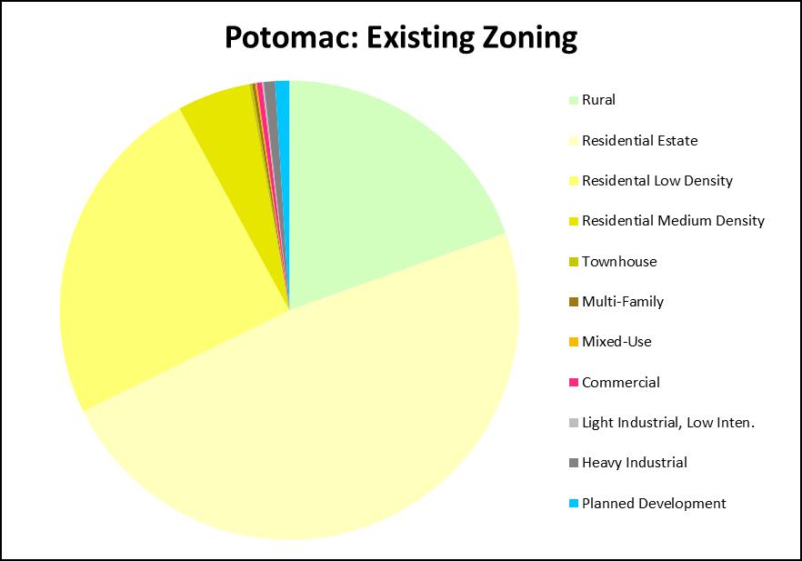
7 ZONE TRANSLATION The Potomac Planning Area currently has 31 zones: 2 Rural, 18 Residential, 4 Commercial, 2 Mixed-Use, 2 Industrial, and 3 Planned Development. Existing Rural RC: Rural Cluster RNC: Rural Neighborhood Cluster Existing Residential: RE-2: Detached Unit, Single-Family RE-2/TDR: Detached Unit, Single-Family RE-2C: Detached Unit, Single-Family RE-2C/TDR: Detached Unit, Single-Family RE-1: Detached Unit, Single-Family R-200: Detached Unit, Single-Family R-200/TDR: Detached Unit, Single-Family R-150: Detached Unit, Single-Family R-90: Detached Unit, Single-Family R-90/TDR: Detached Unit, Single-Family RT-6: Townhouse, Single-Family RT-8: Townhouse, Single-Family RT-10: Townhosue, Single-Family RT-12.5: Townhouse, Single-Family RT:15: Townhouse, Single-Family R-30: Multi-Family, Low Density R-20: Multi-Family, Medium Density R-H: Multi-Family, High-Rise Existing Commercial C-1: Convenience Commercial C-2: General Commercial C-INN: Country Inn O-M: Office Building, Moderate Intensity Existing Mixed-Use: RMX-1/TDR: Residential Mixed-Use RMX-2C: Residential Mixed-Use Existing Industrial: I-3: Light Industrial I-2: Heavy Industrial Existing Planned Development PD-2: Planned Development PD-3: Planned Development PD-5: Planned Development Standard Translation: The existing RC and RNC zones will remain. The existing RE-1 will remain RE-1. The existing RE-2 and RE- 2/TDR will combine into the RE-2 zone. The C-INN zone will revert to the zone it had prior to rezoning to C-INN, in this case, RE-2. The RE-2C, and RE-2C/TDR will combine to form RE-2C. The existing R-200, R- 200/TDR, and R-150 zones will be combined into the R-200 (Residential Low Density) zone. The existing R-90 and R-90/TDR will be merged into R-90 (Residential Medium Density). The residential TDR zones will be incorporated into a new TDR Overlay zone. The existing RT-6, RT-8, RT-10, RT-12.5, and RT-15 will remain RT (Townhouse) respectively. The R-30, R- 20, and R-H zones will remain.
8 The Existing I-2 will be renamed IH (Industrial Heavy) and the existing I-3 will translate to the proposed EOF (Employment Office) zone. The existing Planned Development zones will remain as they are. The existing Commercial and Mixed-Use zones will translate to the specific proposed CRN (Commercial Residential Neighborhood), CRT (Commercial Residential Town), NR (Neighborhood Retail), GR (General Retail), and EOF (Employment Office) zones using both the standard translation criteria and specific Master Plan recommendations. Commercial and Mixed-Use parcels that do not have specific Master Plan recommendations will translate to the proposed zone based on the standard zoning translation table. Master Plan Recommended Translation: Several Potomac parcels will translate to the proposed zones based on Potomac Subregion Master Plan recommendations. We refer to these as non-standard translations. These parcels and the Master Plan guided translations are shown below.

9 MASTER PLAN-DRIVEN TRANSLATIONS
10 MASTER PLAN-DRIVEN TRANSLATIONS
11 MASTER PLAN-DRIVEN TRANSLATIONS
12 MASTER PLAN-DRIVEN TRANSLATIONS Area 1 Existing Zoning C-1 (Rural Village Center Overlay) Proposed Zoning CRN-0.25 C-0.25 R-0.0 H-35 Number of Parcels 9 Reason for Non- Rural Village Center Overlay Standard Translation Modification Overall density limited to Commercial density limited to Residential density limited to 0.0. Height limited to 35 feet. Relevant Text Montgomery County Zoning Ordinance 59-C (2)(B) Density. Except as noted below, the floor area ratio for commercial uses is limited to FAR 0.2, and is computed only on the area of the underlying commercially zoned portion of the site and Montgomery County Zoning Ordinance 59-C (2)(D) Building height. No building may exceed a height of 35 feet. Area 2 Existing Zoning I-3 Proposed Zoning EOF-1.0 H-75 Number of Parcels 173 Reason for Non- Master Plan recommendations regarding density. Standard Translation Modification FAR limited to 1.0. Relevant Text Potomac Subregion Master Plan (2002): Page Including the adjacent Lot 40 [#3 below], the allowable density on the site will not exceed 850,000 square feet (0.39 FAR) of commercial space or, without Lot 40, 800,000 square feet; office, street retail, and hotel, 300 apartments, and 150 single family homes. An additional 150 dwelling units may be provided as part of a TDR program.
13 MASTER PLAN-DRIVEN TRANSLATIONS Area 3 Existing Zoning O-M Proposed Zoning EOF-1.0 H-75 Number of Parcels 3 Reason for Non- Master Plan recommendations regarding density. Standard Translation Modification FAR limited to 1.0. Relevant Text Potomac Subregion Master Plan (2002): Page Including the adjacent Lot 40, the allowable density on the site [includes #2 above] will not exceed 850,000 square feet (0.39 FAR) of commercial space or, without Lot 40, 800,000 square feet; office, street retail, and hotel, 300 apartments, and 150 single family homes. An additional 150 dwelling units may be provided as part of a TDR program. Area 4 Existing Zoning RMX-2C Proposed Zoning CRT-0.75 C-0.5 R-0.5 H-35 Number of Parcels 5 Reason for Non- Master Plan recommendations regarding density and height. Standard Translation Modification Overall FAR limited to Residential FAR limited to 0.5. Height limited to 35 feet. Relevant Text Potomac Subregion Master Plan (2002): Page Commercial development is limited to 300,000 square feet of gross floor area. Housing is not permitted under the standard method. Under the optional method, the following residential components are permitted up to a total of 135 dwelling units (including MPDUs) Heights of buildings, including combinations of housing and structured parking, shall not exceed 35 feet to ensure a scale compatible with the surrounding neihborhoods. Area 5 Existing Zoning C-1 Proposed Zoning CRT-1.0 C-0.75 R-75 H-35 Number of Parcels 7 Reason for Non- Master Plan recommendations regarding height. Standard Translation Modification Height limited to 35 feet. Relevant Text Potomac Subregion Master Plan (2002): Page Provide ground floor retail in compatible buildings not more than 35 feet high.
14 MASTER PLAN-DRIVEN TRANSLATIONS Area 6 Existing Zoning C-1 Proposed Zoning NR-1.0 H-35 Number of Parcels 5 Reason for Non- Master Plan recommendations regarding height. Standard Translation Modification Height limited to 35 feet. Relevant Text Potomac Subregion Master Plan (2002): Page Provide ground floor retail in compatible buildings not more than 35 feet high. Area 7 Existing Zoning RMX-1/TDR Proposed Zoning CRT-0.5 C-0.25 R-0.5 H-60 Number of Parcels 2 Reason for Non- Master Plan recommendations regarding height and density. Standard Translation Modification Overall FAR limited to 0.5, commercial to 0.25, residential to 0.5. Height limited to 60 feet. Relevant Text Potomac Subregion Master Plan (2002): Page The maximum density on the site must not exceed 80 single family units (including MPDUs) under the standard method. A waiver of the requirement for 15 percent detached dwelling is recommended. Under the optional method, up to 97 units (including MPDUs) are permitted Maximum height for any portion of building to be five stories.
15 ZONE TRANSLATION Potomac Existing Proposed Zone Acres Percent Zone Acres Percent RC 7, RC 7, RNC RNC RE-1 1, RE-1 1, RE-2 14, RE-2/TDR RE-2 14, C-INN RE-2C RE-2C/TDR RE-2C 1, R R-200 7, R-200 8, R-200/TDR 1, R-90 1, R-90/TDR R-90 1, RT RT RT RT RT RT RT RT RT RT R R R R R-H R-H RMX-1/TDR CRT-0.5 C-0.25 R-0.5 H RMX-2C CRT-0.75 C-0.5 R-0.5 H CRN-0.25 C-0.25 R-0.0 H C CRT-1.0 C-0.75 R-0.75 H NR-1.0 H NR-1.0 H C CRT-2.5 C-1.5 R-1.5 H GR-1.5 H EOF-1.5 H O-M EOF-1.0 H-75 I I IH PD PD PD PD PD PD Grand Total 36, Grand Total 36,864.21
16

17 PLANNING AREA CONTEXT
18 EXISTING ZONING MAP Existing Zones Rural RC RNC Residential Estate RE-1 RE-2 & RE-2/TDR RE-2C & RE-2C/TD Residential Low Density R-150 R-200 & R-200/TD Residential Medium Density R-90 & R-90/TDR Townhouse RT-6 RT-8 RT-10 RT-12.5 RT-15 Multi-Family R-H R-20 R-30 Commercial C-1 C-2 O-M C-Inn Mixed-Use RMX-1/TDR RMX-2C Light Industrial I-3 Heavy Industrial I-2 I-2 Planned Development PD-2 PD-3 PD-5

19 PROPOSED ZONING MAP Proposed Zones Rural RC RNC Residential Estate RE-1 RE-2 RE-2C Residential Low Density R-200 Residential Medium Density R-90 Townhouse RT-6 RT-8 RT-10 RT-12.5 RT-15 Multi-Family R-H R-20 R-30 Comm/Res- Neighborhood CRN Comm/Res- Town CRT General Retail GR Employment, Office EOF Neighborhood Retail NR Heavy Industrial IH I-2 Planned Development PD-2 PD-3 PD-5
Master Plan Review DAMASCUS. Approved and Adopted May Damascus Page 1 of 19 Updated July 2014 based on Adopted DMA
 Master Plan Review DAMASCUS Approved and Adopted May 2006 Damascus Page 1 of 19 Updated July 2014 based on Adopted DMA ONING CODE REWRITE BACKGROUND In 2007, the Montgomery County Council directed the
Master Plan Review OLNEY. Approved and Adopted April Updated September
 Master Plan Review OLNEY Approved and Adopted April 2005 BACKGROUND ZONING CODE REWRITE In 2007, the Montgomery County Council directed the Planning Department to undertake a comprehensive zoning ordinance
Master Plan Review SILVER SPRING CBD. Approved and Adopted February Updated January 2013
 Master Plan Review SILVER SPRING CBD Approved and Adopted February 2000 BACKGROUND ZONING CODE REWRITE In 2007, the Montgomery County Council directed the Planning Department to undertake a comprehensive
GAITHERSBURG VICINITY
 Master Plan Review GAITHERSBURG VICINITY Approved and Adopted 1985 Gaithersburg Vicinity Page 1 of 11 Updated July 2014 based on Adopted DMA ONING CODE REWRITE BACKGROUND In 2007, the Montgomery County
Master Plan Review WESTBARD
 Master Plan Review WESTBARD Approved and Adopted 1982 Westbard Page 1 of 15 Updated July 2014 based on Adopted DMA ONING CODE REWRITE BACKGROUND In 2007, the Montgomery County Council directed the Planning
PRESERVATION OF AGRICULTURE
 Master Plan Review PRESERVATION OF AGRICULTURE & RURAL OPEN SPACE Approved and Adopted 1980 BACKGROUND ZONING CODE REWRITE In 2007, the Montgomery County Council directed the Planning Department to undertake
PHED DRAFT Zoning Translation
 Symbol Name Symbol Name Agricultural & Rural RDT Rural Density Transfer AR Agricultural Reserve R Rural R Rural RC Rural Cluster RC Rural Cluster LDRC Low Density Rural Cluster No area zoned LDRC. Zone
Use of the Zoning Ordinance
 Use of the Zoning Ordinance 1. Coordination with Other Chapters A. The use of structures and land within Montgomery County must satisfy all other applicable provisions as well as this Chapter, whether
Article Optional Method Requirements
 Article 59-6. Optional Method Requirements [DIV. 6.1. MPDU DEVELOPMENT IN RURAL RESIDENTIAL AND RESIDENTIAL ZONES Sec. 6.1.1. General Requirements... 6 2 Sec. 6.1.2. General Site and Building Type Mix...
Chapter 59 Montgomery county zoning ordinance planning board draft
 Chapter 59 Montgomery county zoning ordinance planning board draft Use of the Zoning Ordinance 1. Coordination with Other Chapters A. The use of structures and land within Montgomery County must satisfy
Article Zones and Zoning Map
 Division 2.1. Zones Established Council Draft Article 59-2. Zones and Zoning Map Section 2.1.1. Requirements for All Zones A. Zones established in Article 59-2 must satisfy: 1. Definitions under Article
Article Floating Zone Requirements
 Division 5.1. In General Article 59-5. Floating Zone Requirements Section 5.1.1. Zone Categories There are 4 categories of Floating zones: A. Residential Floating zones (Division 5.2); B. Commercial/Residential
Zoning Code Training MONTGOMERY COUNTY PLANNING DEPARTMENT. Maryland-National Capital Park and Planning Commission
 Zoning Code Training Highlights New code was adopted on March 5 & DMA was adopted on July 15. Both become effective on October 30. ZTA 14-09 was approved Sept 30 and updates, clarifies, and corrects errors
MONTGOMERY COUNTY PLANNING DEPARTMENT THE MARYLAND-NATIONAL CAPITAL PARK AND PLANNING COMMISSION
 MONTGOMERY COUNTY PLANNING DEPARTMENT THE MARYLAND-NATIONAL CAPITAL PARK AND PLANNING COMMISSION MCPB Item No. Date: 4-30-15 Zoning Text Amendment (ZTA) No. 15-06, Rural Cluster Zone - Land Use and Setbacks
Article Zones and Zoning Map
 Article 59-2. Zones and Zoning Map [Div. 2.1. Zones Established Sec. 2.1.1. Requirements for all Zones... 2 2 Sec. 2.1.2. Zoning Categories...2 2 Sec. 2.1.3. Agricultural Zone...2 2 Sec. 2.1.4. Rural Residential
Presentation. Agenda Item # 1. Meeting Date February 3, Erkin Ozberk, Planner. Prepared By. Brian T. Kenner City Manager.
 Agenda Item # 1 Presentation Meeting Date February 3, 2014 Prepared By Approved By Erkin Ozberk, Planner Brian T. Kenner City Manager Discussion Item Background Update on Montgomery County s Zoning Code
Staff Memorandum. From: Pamela Dunn, Joshua Sloan,
 THE MARYLAND-NATIONAL CAPITAL PARK AND PLANNING COMMISSION MONTGOMERY COUNTY PLANNING DEPARTMENT Date: May 17, 2013 Staff Memorandum To: Via: Montgomery County Planning Board Rose Krasnow, Interim Planning
Article Zones [DIV ZONES ESTABLISHED DIV ZONING MAP
 Article 59-2. Zones [DIV. 2.1. ZONES ESTABLISHED Sec. 2.1.1. Requirements for all Zones... 2 2 Sec. 2.1.2. Zoning Categories...2 2 Sec. 2.1.3. Agricultural Zone...2 2 Sec. 2.1.4. Rural Residential Zones...
ARTICLE ZONES DIV ZONES ESTABLISHED DIV ZONING MAP
 ARTICLE 59-2. ZONES DIV. 2.1. ZONES ESTABLISHED SEC. 2.1.1. REQUIREMENTS FOR ALL ZONES... 2 2 SEC. 2.1.2. REGULATIONS FOR ESTABLISHMENT OF ZONES...2 2 SEC. 2.1.3. AGRICULTURAL ZONES...2 2 SEC. 2.1.4. RURAL
MPDU Law Update 9/10/2018 1
 Montgomery Planning 9/10/2018 MPDU Law Update MPDU Law Update 9/10/2018 1 Lisa Govoni, Housing Planner lisa.govoni@montgomeryplanning.org (301) 650-5624 Background Bill 34 17 Introduced 10/31/17 Bill 38-17
Briefing: Zoning Ordinance Rewrite. April 5, 2013 Montgomery County Planning Department
 Briefing: Zoning Ordinance Rewrite April 5, 2013 Montgomery County Planning Department Topics Goals and Objectives Brief History & Outreach The Big Picture Highlighted Changes What s New How the Pieces
Rose Krasnow, Acting Director,
 MONTGOMERY COUNTY PLANNING DEPARTMENT THE MARYLAND-NATIONAL CAPITAL PARK AND PLANNING COMMISSION Zoning Ordinance Implementation MCPB Item No. 10 Date: 3-7-13 Rose Krasnow, Acting Director, Rose.Krasnow@montgomeryplanning.org,
ARTICLE OPTIONAL METHOD REGULATIONS
 ARTICLE 59-6. OPTIONAL METHOD REGULATIONS DIV. 6.1. MPDU DEVELOPMENT IN RURAL RESIDENTIAL AND RESIDENTIAL ZONES SEC. 6.1.1. GENERAL REQUIREMENTS... 6 2 SEC. 6.1.2. GENERAL SITE AND BUILDING T PE MIX...
MONTGOMERY COUNTY PLANNING DEPARTMENT THE MARYLAND-NATIONAL CAPITAL PARK AND PLANNING COMMISSION
 MONTGOMERY COUNTY PLANNING DEPARTMENT THE MARYLAND-NATIONAL CAPITAL PARK AND PLANNING COMMISSION MCPB Item No. 9 Date: 06-21-12 Proposed Zoning Text Amendment Revising the Requirements for Permitting Accessory
Jcouncilmembers should bring their copy of the Plan to the meeting.i. PHED Committee #lb October 30, 2017 MEMORANDUM. October 26, 2017 TO:
 PHED Committee #lb October 30, 2017 MEMORANDUM October 26, 2017 TO: FROM: Planning, Housing, and Economic Development (PHED) Committee Marlene Michaelso1ltnior Legislative Analyst SUBJECT: White Flint
Zoning Rewrite Implementation Worksession #1. Agricultural, Rural Residential, & Residential Zones March 12, 2013
 Zoning Rewrite Implementation Worksession #1 Agricultural, Rural Residential, & Residential Zones March 12, 2013 Agricultural Zone No Optional Method No Floating Zones Current RDT 106,735.15 acres 37.77%
Residential Capacity Estimate
 Residential Capacity Estimate Montgomery County Department of Park & Planning Research & Technology Center January 2005 Current plans allow 75,000 more housing units. by Matthew Greene, Research Planner
MONTGOMERY COUNTY PLANNING DEPARTMENT THE MARYLAND-NATIONAL CAPITAL PARK AND PLANNING COMMISSION
 MONTGOMERY COUNTY PLANNING DEPARTMENT THE MARYLAND-NATIONAL CAPITAL PARK AND PLANNING COMMISSION MCPB Item No. 3 Date: 05-03-12 Proposed Zoning Text Amendment Revising the Requirements for permitting Accessory
Attachment 4 ANALYSIS I. Current Special Exception Use Standards for Accessory Apartments (Also See Attachment 2 Table for Quick Comparison)
") The Planning Board conducted the first of its public hearings/worksessions on the proposed accessory apartment provisions on May 3, 2012. At that time, the Board determined that additional input from stakeholders
The Planning Board conducted the first of its public hearings/worksessions on the proposed accessory apartment provisions on May 3, 2012. At that time, the Board determined that additional input from stakeholders
MEMORANDUM. Action-Revised Zoning Text Amendment 16-20, Overlay Zone -Bethesda
 AGENDA ITEM #7 July 11, 2017 Action MEMORANDUM TO: FROM: County Council A/' Jeffrey L. Zyontz, {enior Legislative Analyst July 7, 2017 SUBJECT: Action-Revised Zoning Text Amendment 16-20, Overlay Zone
Marion County Board of County Commissioners
 Marion County Board of County Commissioners Date: 12/29/2015 P&Z: 12/28/2015 BCC: 1/12/2016 Item Number 160113Z Type of Application Rezoning Request From: A-1 (General Agriculture) To: PUD (Planned Unit
Chapter 59 Montgomery County Zoning Ordinance [Planning Board] Preliminary PHED Committee Draft
![Chapter 59 Montgomery County Zoning Ordinance [Planning Board] Preliminary PHED Committee Draft](/thumbs/93/113878370.jpg "Chapter 59 Montgomery County Zoning Ordinance [Planning Board] Preliminary PHED Committee Draft") Chapter 59 Montgomery County Zoning Ordinance [Planning Board] Preliminary PHED Committee Draft [Use of the Zoning Ordinance 1. Coordination with Other Chapters A. The use of structures and land within
Chapter 59 Montgomery County Zoning Ordinance [Planning Board] Preliminary PHED Committee Draft [Use of the Zoning Ordinance 1. Coordination with Other Chapters A. The use of structures and land within
Implementation. Approved Master Plan and SMA for Henson Creek-South Potomac 103
 Implementation Approved Master Plan and SMA for Henson Creek-South Potomac 103 104 Approved Master Plan and SMA for Henson Creek-South Potomac Sectional Map Amendment The land use recommendations in the
Midwest City, Oklahoma Zoning Ordinance
 2010 Midwest City, Oklahoma Zoning Ordinance 9/2/2010 Table of Contents Section 1. General Provisions... 5 1.1. Citation... 5 1.2. Authority... 5 1.3. Purpose... 5 1.4. Nature and Application... 5 1.5.
Work Session 2 l Planning Board April 14, 2016
 Work Session 2 l Planning Board April 14, 2016 Tentative Schedule March 24, 2016 April 14, 2016 May 19, 2016 June 2016 Work Session #1: History, Zoning Approach, Affordable Housing Work Session #2: Site
Bylaw No , being "Official Community Plan Bylaw, 2016" Schedule "A" DRAFT
 Bylaw No. 2600-2016, being "Official Community Plan Bylaw, 2016" Schedule "A" Urban Structure + Growth Plan Urban Structure Land use and growth management are among the most powerful policy tools at the
Article [[Euclidean Zone Requirements: In General and Standard Method]] Development Standards for Euclidean Zones
![Article [[Euclidean Zone Requirements: In General and Standard Method]] Development Standards for Euclidean Zones](/thumbs/89/99391929.jpg "Article [[Euclidean Zone Requirements: In General and Standard Method]] Development Standards for Euclidean Zones") Article 59-4. [[Euclidean Zone Requirements: In General and Standard Method]] Development Standards for Euclidean Zones [Div. 4.1. Rules for All Zones Sec. 4.1.1. Development Options... 4 3 Sec. 4.1.2.
Article 59-4. [[Euclidean Zone Requirements: In General and Standard Method]] Development Standards for Euclidean Zones [Div. 4.1. Rules for All Zones Sec. 4.1.1. Development Options... 4 3 Sec. 4.1.2.
Article Euclidean Zone Requirements: In General and Standard Method
 Article 59-4. Euclidean Zone Requirements: In General and Standard Method [DIV. 4.1. RULES FOR ALL ZONES Sec. 4.1.1. Development Options... 4 3 Sec. 4.1.2. Compliance Required... 4 3 Sec. 4.1.3. Building
Planning Board Worksession No.4: Parklawn South District and Randolph Hills District
 Planning Board Worksession No.4: Parklawn South District and Randolph Hills District Prior Worksessions January 27: Focused on transportation analysis and staging recommendations in the Draft Plan. February
PURCHASE OF DEVELOPMENT RIGHTS AND TRANSFER OF DEVELOPMENT RIGHTS CASE STUDIES
 PURCHASE OF DEVELOPMENT RIGHTS AND TRANSFER OF DEVELOPMENT RIGHTS CASE STUDIES Prepared for Boone County Planning Commission By American Farmland Trust May 4, 2001 Table of Contents Page Number Montgomery
9. C-S-C to R-R. Approved SMA/ZAPS/SE 200' Scale Change Number Zoning Change Area of Change. 9 C-S-C to R-R 0.80± acres SMA 7/24/84 210SE04
 9 C-S-C to R-R 0.80± acres SMA 7/24/84 210SE04 Use and Location: Undeveloped land on the southeast side of Allentown Road, approximately three-quarters of a mile southwest of its intersection with Temple
MONTGOMERY COUNTY PLANNING DEPARTMENT
 MONTGOMERY COUNTY PLANNING DEPARTMENT THE MARYLAND-NATIONAL CAPITAL PARK AND PLANNING COMMISSION MCPB Item No. Date: 1-12-17 Zoning Text Amendment (ZTA) No. 16-17, Height Encroachments Townhouses GR PD
Glenmont Sector Plan. Planning Board Public Hearing February 14, spoken testimony letters reports
 Planning Board Public Hearing February 14, 2013 spoken testimony letters email reports Complete set of written testimony and the public hearing transcript is available at the information desk upon request
Zoning Districts Agriculture Low Density Rural Residential Moderate Density Rural Residential High Density Rural Residential Manufactured Home Park
 Zoning 201 Zoning Districts Agriculture Low Density Rural Residential Moderate Density Rural Residential High Density Rural Residential Manufactured Home Park Commercial Lakeside Commercial Rural Transitional
Staff Report. Planning Commission Public Hearing: October 17, 2007 Staff Recommendation: Denial
 COUNTY OF PRINCE WILLIAM 5 County Complex Court, Prince William, Virginia 22192-9201 PLANNING (703) 792-6830 Metro 631-1703, Ext. 6830 FAX (703) 792-4401 OFFICE Internet www.pwcgov.org Stephen K. Griffin,
Comprehensive Plan Amendment #PLN , Reserve at Cannon Branch (Coles Magisterial District)
") COUNTY OF PRINCE WILLIAM 5 County Complex Court, Prince William, Virginia 22192-9201 PLANNING (703) 792-7615 FAX (703) 792-4758 OFFICE Internet www.pwcgov.org Christopher M. Price, AICP Director of Planning
COUNTY OF PRINCE WILLIAM 5 County Complex Court, Prince William, Virginia 22192-9201 PLANNING (703) 792-7615 FAX (703) 792-4758 OFFICE Internet www.pwcgov.org Christopher M. Price, AICP Director of Planning
STAFF REPORT. Permit Number: Unlimited. Kitsap County Board of Commissioners; Kitsap County Planning Commission
 STAFF REPORT Permit Number: 15 00550 Unlimited DATE: March 2, 2016 TO: FROM: Kitsap County Board of Commissioners; Kitsap County Planning Commission Katrina Knutson, AICP, Senior Planner, DCD and Jeff
Appendix A: Guide to Zoning Categories Prince George's County, Maryland
 Appendix A: Guide to Zoning Categories Prince George's County, Maryland RESIDENTIAL ZONES 1 Updated November 2010 R-O-S: Reserved Open Space - Provides for permanent maintenance of certain areas of land
MONTGOMERY COUNTY PLANNING DEPARTMENT THE MARYLAND-NATIONAL CAPITAL PARK AND PLANNING COMMISSION. Description
 MONTGOMERY COUNTY PLANNING DEPARTMENT THE MARYLAND-NATIONAL CAPITAL PARK AND PLANNING COMMISSION MCPB Item No. 9 Date: 3/26/15 Sandy Spring Rural Village Plan: Sectional Map Amendment Kristin O Connor,
PUBLIC DRAFT May 2017 Zoning Districts Use Regulations Definitions (partial)
") PUBLIC DRAFT May 2017 Zoning Districts Use Regulations Definitions (partial) Table of Contents Subchapter 1: General Provisions... 1 Subchapter 2: Administration & Procedures... 3 Subchapter 3: Zoning
PUBLIC DRAFT May 2017 Zoning Districts Use Regulations Definitions (partial) Table of Contents Subchapter 1: General Provisions... 1 Subchapter 2: Administration & Procedures... 3 Subchapter 3: Zoning
MONTGOMERY COUNTY PLANNING DEPARTMENT THE MARYLAND-NATIONAL CAPITAL PARK AND PLANNING COMMISSION
 MONTGOMERY COUNTY PLANNING DEPARTMENT THE MARYLAND-NATIONAL CAPITAL PARK AND PLANNING COMMISSION MCPB Item No. 10 Date: 6-20-13 Zoning Text Amendment (ZTA) No. 13-05, US 29 Overlay Zone Standards Gregory
Planning Board Work Session #2 June 7, 2018
 Planning Board Work Session #2 June 7, 2018 1 WORK SESSION #2: OVERVIEW Summary of Work Session #1 Single-Family Parcels at Robindale Drive Department of Recreation Administrative Offices Land Use and
Generic Environmental Impact Statement. Build-Out Analysis. City of Buffalo, New York. Prepared by:
 Generic Environmental Impact Statement Build-Out Analysis City of Buffalo, New York 2015 Prepared by: TABLE OF CONTENTS 1.0 INTRODUCTION 1 2.0 METHODOLOGY 2 3.0 EXISTING LAND USE 3 4.0 EXISTING ZONING
PC Staff Report 11/18/2013 Z Item No. 1-1
 Z-13-00401 Item No. 1-1 PLANNING COMMISSION REPORT Regular Agenda - Public Hearing Item PC Staff Report 11/18/2013 ITEM NO. 1: Z-13-00401 IG (General Industrial) District TO CS (Strip Commercial) District;
In order to permit maximum applicability of the PUD District, PUD-1 and PUD-2 Districts are hereby created.
 ARTICLE III. PUD ned Unit Development Overlay District 205-128. Purpose. The PUD ned Unit Development Overlay District is intended to provide flexibility in the design of planned projects; to encourage
PLANNING FOR OUR FUTURE
 PLANNING FOR OUR FUTURE ELLSWORTH TOWNSHIP LAND USE AND POLICY PLAN The purpose of this Plan is to serve as a guide for the Township Trustees, Zoning Commission, Board of Zoning Appeals, developers, employers,
TREASURE COAST REGIONAL PLANNING COUNCIL M E M O R A N D U M. To: Council Members AGENDA ITEM 4F
 TREASURE COAST REGIONAL PLANNING COUNCIL M E M O R A N D U M To: Council Members AGENDA ITEM 4F From: Date: Subject: Staff September 21, 2007 Council Meeting Local Government Comprehensive Plan Review
Chapter 10: Implementation
 Chapter 10: Introduction Once the Comprehensive Plan has been adopted by the City of Oakdale, the City can begin to implement the goals and strategies to make this vision a reality. This chapter will set
CONFIRMATION OF DIRECTION APRIL 2010
 Montgomery County Revised Zoning Code CONFIRMATION OF DIRECTION APRIL 2010 C O D E S T U D I O Rhodeside & Harwell Farr Associates Nelson\Nygaard Today s Presentation Project Update Approach Project Objectives
STAFF REPORT. Community Development Director PO Box 4755 Beaverton, OR 97076
 STAFF REPORT HEARING DATE: July 7, 2010 TO: Planning Commission STAFF: Jana Fox, Assistant Planner PROPOSAL: Southeast Beaverton Office Commercial Zoning Map Amendment (ZMA2010-0006) LOCATION: The subject
City of Oshkosh Zoning Update
 City of Oshkosh Zoning Update The Zoning Rewrite Process Commenced in June of 2013 with selection of Vandewalle and Associates as zoning rewrite consultants. Consultants, City Staff, Plan Commission, and
1. Future Land Use FLU6.6.8 Land uses within the Rural Service Area portion of the Wekiva Study Area shall be limited to very low and low intensity
 1. Future Land Use FLU6.6.8 Land uses within the Rural Service Area portion of the Wekiva Study Area shall be limited to very low and low intensity uses to the greatest extent possible. Existing land uses
Build-Out Analysis. Methodology
 Build-Out Analysis Methodology PRINCE WILLIAM COUNTY PLANNING OFFICE 5 County Complex Court Prince William, Virginia 22192-9201 (703) 792-7615 www.pwcgov.org/planning Christopher M. Price, AICP Director
Article Zones Retained From Previous Ordinance
 Article 59-9. Zones Retained From Previous Ordinance DIV. 9.1. IN GENERAL Sec. 9.1.1. applicability... 9 2 Sec. 9.1.2. Modification of zones... 9 2 DIV. 9.2. RESIDENTIAL FLOATING ZONES Sec. 9.2.1. zones
Division 59-C-10. RMX Zones-Residential Mixed Use Development. [Note]
![Division 59-C-10. RMX Zones-Residential Mixed Use Development. [Note]](/thumbs/78/77243902.jpg "Division 59-C-10. RMX Zones-Residential Mixed Use Development. [Note]") Key Text highlighted in bright green deals with floating zones and will be addressed in the coming months. Text highlighted in turquoise deals with grandfathering language and will be addressed in the
Key Text highlighted in bright green deals with floating zones and will be addressed in the coming months. Text highlighted in turquoise deals with grandfathering language and will be addressed in the
Staff Report & Recommendation Rezoning Case RZ Date of Report: June 6, 2014 Report by: Doug Stacks
 Staff Report & Recommendation Rezoning Case RZ-2014-02 Date of Report: June 6, 2014 Report by: Doug Stacks Hearing Dates: Planning Commission June 26, 2014 Mayor and Council July 14, 2014 GENERAL INFORMATION
Primary Districts Established 4
 4.1 GENERAL PURPOSE SECTION 4 PRIMARY DISTRICTS ESTABLISHED The Town of Waxhaw, North Carolina is hereby divided into PRIMARY ZONING DISTRICTS as designated herein and as shown on the Official Zoning Map.
Village WASHINGTON TOWNSHIP MASTER PLAN SYNTHESIS. Page 197
 Village P l a n WASHINGTON TOWNSHIP MASTER PLAN SYNTHESIS Page 197 SECTION 11.0 MASTER PLAN SYNTHESIS INTRODUCTION The proposals presented in the various plans result in a graphic synthesis: The Land Use
Annotated Outline of a New Zoning Ordinance... 1
 Contents Annotated Outline of a New Zoning Ordinance... 1 Article 1: General Provisions... 1 Title and Effective Date... 1 Purpose... 1 Implementation of Comprehensive Plan... 1 Official Zoning Map...
ARTICLE 3: Zone Districts
 ARTICLE 3: Zone Districts... 3-1 17.3.1: General...3-1 17.3.1.1: Purpose and Intent... 3-1 17.3.2: Districts and Maps...3-1 17.3.2.1: Applicability... 3-1 17.3.2.2: Creation of Districts... 3-1 17.3.2.3:
Metropolitan Planning Commission. DATE: April 5, 2016
 TO: FROM: Metropolitan Planning Commission MPC Staff DATE: April 5, 2016 SUBJECT: Petition of Nine Line Inc. Robert McCorkle, Agent PIN: 2-1034-01-002 380.5 Acres Aldermanic District: 5 (Shabazz) County
EXHIBIT B FINDINGS OF FACT BEND DEVELOPMENT CODE (BDC) UPDATE AMENDMENT PZ
 UPDATE AMENDMENT PZ") EXHIBIT B FINDINGS OF FACT BEND DEVELOPMENT CODE (BDC) UPDATE AMENDMENT PZ 18-0524 Procedural Findings Notice of the proposed amendments was provided to the Department of Land Conservation and Development
EXHIBIT B FINDINGS OF FACT BEND DEVELOPMENT CODE (BDC) UPDATE AMENDMENT PZ 18-0524 Procedural Findings Notice of the proposed amendments was provided to the Department of Land Conservation and Development
density framework ILLUSTRATION 3: DENSITY (4:1 FSR) EXPRESSED THROUGH BUILT FORM Example 1
 EXPRESSED THROUGH BUILT FORM Example 1") density framework 4 ILLUSTRATION 3: DENSITY (4:1 FSR) EXPRESSED THROUGH BUILT FORM INTRODUCTION The Downtown Core Area contains a broad range of building forms within its relatively compact area. These
density framework 4 ILLUSTRATION 3: DENSITY (4:1 FSR) EXPRESSED THROUGH BUILT FORM INTRODUCTION The Downtown Core Area contains a broad range of building forms within its relatively compact area. These
Article XII. R-1 Agricultural-Low Density Residential District
 Article XII R-1 Agricultural-Low Density Residential District Section 1200. Declaration of Legislative Intent In expansion of the Declaration of Legislative Intent and Statement of Community Development
4 LAND USE 4.1 OBJECTIVES
 4 LAND USE The Land Use Element of the Specific Plan establishes objectives, policies, and standards for the distribution, location and extent of land uses to be permitted in the Central Larkspur Specific
White Oak Science Gateway Master Plan Staff Draft AFFORDABLE HOUSING ANALYSIS. March 8, 2013
 White Oak Science Gateway Master Plan Staff Draft AFFORDABLE HOUSING ANALYSIS March 8, 2013 Executive Summary The Draft White Oak Science Gateway (WOSG) Master Plan encourages development of higher density,
PLANNING COMMISSION WILLIAMSBURG, VIRGINIA WORK SESSION AGENDA Wednesday, May 23, 2012
 PLANNING COMMISSION WILLIAMSBURG, VIRGINIA WORK SESSION AGENDA Wednesday, May 23, 2012 The meeting will be called to order in the third floor Conference Room (Room 310), Williamsburg Municipal Building,
MEMORANDUM. Action - Revised Zoning Text Amendment 16-20, Overlay Zone - Bethesda
 AGENDA ITEM #4B July 18, 2017 Action MEMORANDUM July 11, 2017 TO: FROM: SUBJECT: County Council flj- Jeffrey L. Zyont&enior Legislative Analyst Action - Revised Zoning Text Amendment 16-20, Overlay Zone
MONTGOMERY COUNTY PLANNING DEPARTMENT THE MARYLAND-NATIONAL CAPITAL PARK AND PLANNING COMMISSION
 MONTGOMERY COUNTY PLANNING DEPARTMENT THE MARYLAND-NATIONAL CAPITAL PARK AND PLANNING COMMISSION MCPB Item No. 10 Date: 07-12-12 Zoning Text Amendment (ZTA) No. 12-09, Planned Development (PD) Zones -
ZONING CLASSIFICATION SUMMARY SHEET
 Growth and Resource Management Planning and Development Services 123 West Indiana Avenue Room 202 DeLand, Florida 32720-4253 Telephone (386) 943-7059 Fax (386) 626-6570 www.volusia.org ZONING CLASSIFICATION
PLANNING COMMISSION REPORT Regular Agenda - Public Hearing Item
 Z-11-25-09; Z-11-26-09; Z-11-28-09 Item No. 2-1 PC Staff Report 3/28/11 PLANNING COMMISSION REPORT Regular Agenda - Public Hearing Item ITEM NO. 2A RM32 TO MU;.19 ACRES; 1340 TENNESSEE ST (MJL) Z-1-1-11:
1. an RSF-R, RSF-1, RSF-2, RSF-4, RMF-5, or RMF-8 zoning district; or
 Chapter 9 INCENTIVES 9.1 General 9.1.1 Review and Approval Procedure Projects requesting bonuses under this chapter for land that has not been platted, or for land that is being voluntarily replatted,
SECTION 3. Housing. Appendix A LAND USE DEFINITIONS
 SECTION 3 Housing A Appendix A LAND USE DEFINITIONS A-2 Housing Commission Attachment B Appendix A Land Use Definitions INTRODUCTION The Land Use Map (Figure A-1) of Community Vision 2040 illustrates the
CZMP Workshop Preserving Your Community & The Environment From Development Impacts
 CZMP Workshop Preserving Your Community & The Environment From Development Impacts Sponsored By Community & Environmental Defense Services 410-654-3021 www.ceds.org/bcmd Help@ceds.org Greater Baltimore
BALTIMORE ZONING CODE: PRELIMINARY ANNOTATED OUTLINE
 BALTIMORE ZONING CODE: PRELIMINARY ANNOTATED OUTLINE Prepared by May 2009 BALTIMORE ZONING CODE: PRELIMINARY ANNOTATED OUTLINE INTRODUCTION The following is a preliminary version of an outline for the
MONTGOMERY COUNTY PLANNING DEPARTMENT THE MARYLAND-NATIONAL CAPITAL PARK AND PLANNING COMMISSION
 MONTGOMERY COUNTY PLANNING DEPARTMENT THE MARYLAND-NATIONAL CAPITAL PARK AND PLANNING COMMISSION MCPB Item No. Date: 7/12/12 Worksession No. 2: Burtonsville Crossroads Neighborhood Plan Kristin O Connor,
CITY PLAN COMMISSION THURSDAY, JULY 19, 2018 Planner: Vasavi Pilla. FILE NUMBER: DCA DATE INITIATED: December 14, 2017
 CITY PLAN COMMISSION THURSDAY, JULY 19, 2018 Planner: Vasavi Pilla FILE NUMBER: DCA 178-009 DATE INITIATED: December 14, 2017 TOPIC: Code amendment for a live/work accessory use CITY COUNCIL DISTRICTS:
Charlottesville Planning Commission, Neighborhood Associations & News Media
 CITY OF CHARLOTTESVILLE A World Class City Department of Neighborhood Development Services City Hall Post Office Box 911 Charlottesville, Virginia 22902 Telephone 434-970-3182 Fax 434-970-3359 www.charlottesville.org
Town of Yucca Valley GENERAL PLAN 1
 Town of Yucca Valley GENERAL PLAN 1 This page intentionally left blank. 3 HOUSING ELEMENT The Housing Element is intended to guide residential development and preservation consistent with the overall values
ARTICLE 3 ZONING DISTRICTS AND ZONING MAP. Table of Contents
 ARTICLE 3 ZONING DISTRICTS AND ZONING MAP Table of Contents 3-1 Establishment of Zoning Districts... 1 A. General Use Zoning Districts... 1 B. Conditional Zoning Districts... 3 C. Overlay Zoning Districts...
Housing & Residential Intensification Study Discussion Paper Township of King
 Housing & Residential Intensification Study Discussion Paper Prepared by Planning Department January 2011 1.0 Background 1.1 Provincial Policies (Greenbelt and Growth Plan) Since 2001, the Province of
ARTICLE EUCLIDEAN ZONING DISTRICT REGULATIONS DIV RULES FOR ALL ZONES
 ARTICLE 59-4. EUCLIDEAN ZONING DISTRICT REGULATIONS DIV. 4.1. RULES FOR ALL ZONES DIV. 4.4. RESIDENTIAL ZONES SEC. 4.1.1. DEVELOPMENT OPTIONS... 4 3 SEC. 4.4.1. METHODS OF DEVELOPMENT... 4 25 SEC. 4.1.2.
Indicates Council-recommended changes Introduced by: Mr. Tackett Date of introduction: June 14, 2016 SUBSTITUTE NO. 1 TO ORDINANCE NO.
 Indicates Council-recommended changes Introduced by: Mr. Tackett Date of introduction: June 14, 2016 SUBSTITUTE NO. 1 TO ORDINANCE NO. 16-067 TO AMEND NEW CASTLE COUNTY CODE CHAPTER 40 (ALSO KNOWN AS THE
RE: 6. GILL/GREEN COMPREHENSIVE PLAN AMENDMENT, REZONING AND PRELIMINARY PLAT
 commission memo DATE: Thursday - August 9, 2018 TO: Marion Planning & Zoning Commission FROM: David N. Hockett, AICP Principal Planner RE: 6. GILL/GREEN COMPREHENSIVE PLAN AMENDMENT, REZONING AND PRELIMINARY
VILLAGE OF NORTHBROOK AFFORDABLE HOUSING PLAN
 VILLAGE OF NORTHBROOK AFFORDABLE HOUSING PLAN I. AUTHORITY In 2003, the Illinois General Assembly adopted Public Act 93-0595, the Affordable Housing Planning and Appeals Act, which became effective January
County of Loudoun. Department of Planning MEMORANDUM
 County of Loudoun Department of Planning MEMORANDUM DATE: September 3, 2013 TO: FROM: Marchant Schneider, Project Manager Land Use Review Marie Genovese, AICP, Planner III, Community Planning SUBJECT:
PROPOSED FINDINGS OF FACT BENDER URBAN GROWTH BOUNDARY EXPANSION AND ANNEXATION REQUEST April 3, Background
 PROPOSED FINDINGS OF FACT BENDER URBAN GROWTH BOUNDARY EXPANSION AND ANNEXATION REQUEST April 3, 2016 Background The owners of TL300, 301, 302, 303, and 304, 3N1027BD - properties abutting the City Limits
A Zoning Ordinance Comprehensive Update Zoning Ordinance Study Group Meeting August 20, 2012
 A Zoning Ordinance Comprehensive Update Zoning Ordinance Study Group Meeting August 20, 2012 Sioux Falls Zoning Ordinance Study Group How long will this take? How do I participate? What is the goal of
MONTGOMERY COUNTY RENTAL HOUSING STUDY. NEIGHBORHOOD ASSESSMENT June 2016
 MONTGOMERY COUNTY RENTAL HOUSING STUDY NEIGHBORHOOD ASSESSMENT June 2016 AGENDA Model Neighborhood Presentation Neighborhood Discussion Timeline Discussion Next Steps 2 WORK COMPLETED Socioeconomic Analysis
Staff Report: Date: Applicant: Property Identification: Acreage of Request: Current Zoning of Requested Area: Requested Action: Attached:
 Staff Report: Completed by Jeff Palmer Director of Planning & Zoning Date: November 7, 2018 Applicant: Greg Smith, Oberer Land Developer agent for Ronald Montgomery ET AL Property Identification: Frontage