Land Use Planning to Protect Open Space :
|
|
|
- Ernest Chapman
- 5 years ago
- Views:
Transcription


1 Land Use Planning to Protect Open Space : Conservation Subdivisions Salt Lake City, Utah. September 11, 2008


2 Center for Green Space Design a nonprofit organization that conserves open lands by helping communities plan and implement open space networks W: P:
3 One of the human rights that isn t officially guaranteed in this country is an agreement that the places you grow up caring about will be there for you when you re ready to start a family of your own. Robert Yaro


4 Gap in the planning process: - No common understanding of open space - Real estate development is the primary focus
5 Four principles for addressing the gap in the planning process 1) Systems Thinking Rules: We need to understand the system and view it as a system. 2) First Things First: The land, that is. 3) Bottom Line: It s all a local effort. 4) Policy is the first line of defense.
6 4) Policy is the first line of defense. Four principles for addressing the gap 1) Systems in the planning Thinking process Rules : 1) Systems Thinking Rules: We need to understand the system and view it as a system. we need to understand the system and view it as a system. 2) First Things First: The land, that is. 3) Bottom Line: It s all a local effort.
7 Open Space Types C ultural E cological D evelopmental A gricultural R ecreational

8 Cultural Viewpoints Viewsheds Future facilities Outdoor classrooms Culturally significant locations Historically significant locations Scenic/cultural corridors

9 Ecological Ecological corridors Slope Water quality Drainage Geology Wildlife Vegetation

10 Developmental Future obligations Property ownership Infrastructure locations Intracommunity corridors Past development patterns Current development patterns Existing open spaces in developed areas
11 Agricultural Soils Fields Canals Ranches & farms Ancillary facilities Cattle herd corridors Agricultural corridors

12 Recreational Trails Private facilities Community facilities Quasi-public locations Future levels of services Natural areas of passive activities Greenway or recreational corridors
13 Identify Understand Prioritize = Comprehensive Understanding
14 4) Policy is the first line of defense. Four principles for addressing the gap 2) in First the planning things first process : 1) Systems Thinking Rules: We need to understand the system and view the it land, as a system. that is 2) First Things First: The land, that is. 3) Bottom Line: It s all a local effort.
15 Imagine the Difference at a City, County, Regional or National Scale
16 4) Policy is the first line of defense. Four principles 3) Bottom for addressing Line : the gap in the planning process 1) Systems Thinking Rules: We need it s to all understand a local effort the system and view it as a system. (the workshop process) 2) First Things First: The land, that is. 3) Bottom Line: It s all a local effort.


17 Community Workshops Project Support

18 Visioning Visioning for Conservation But also Visioning for Growth
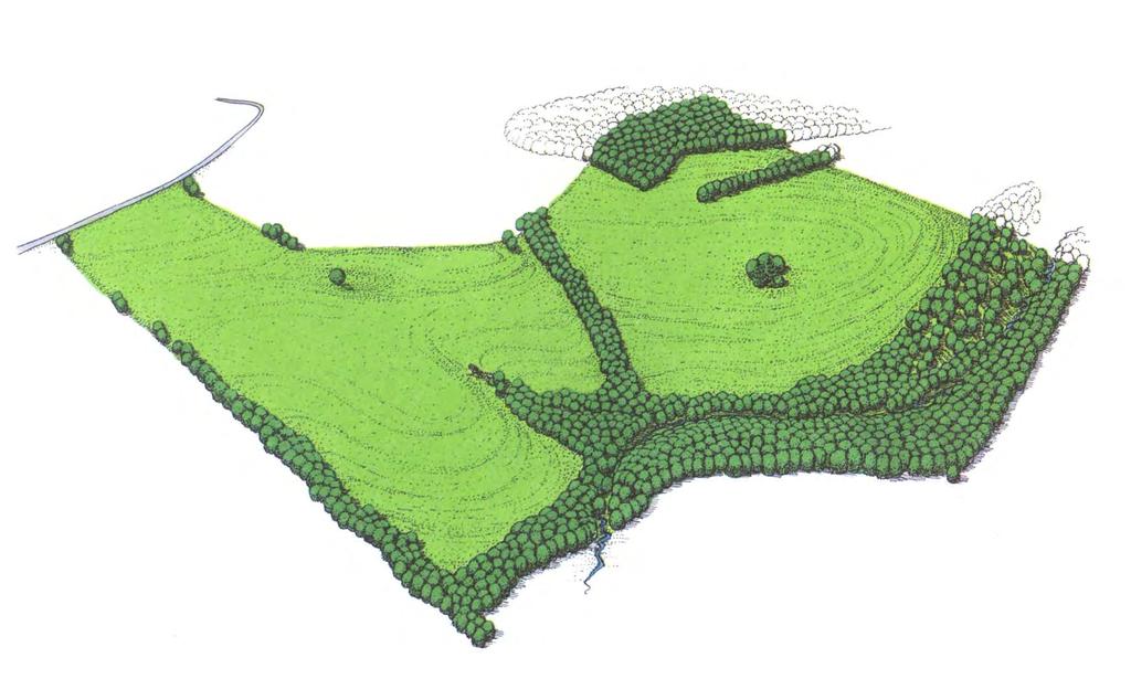
19 4) Policy is the first line of defense. 4) Policy is the Four principles for addressing the gap First in Line the planning of Defense process : 1) Systems Thinking Rules: We need to understand the system and view it as a system. updating policy to yield conservation 2) First Things First: The land, that is. 3) Bottom Line: It s all a local effort.
20 Sprawl is not an immutable expression of the American character, the love affair with the automobile, or the dream of a house in the suburbs. To a great extent it has been shaped by public policies. - Sunders Hillyer
21 Conservation Subdivisions

22 What is a conservation subdivision? Development where half or more of the buildable land area is designated as undivided, permanent open space Ideal for less developed areas on the urban fringe

23 What are the major benefits? Density neutral Respects property rights; landowner maintains full by right density Conserves cultural, ecological, agricultural and recreational assets Respects quality of life; community maintains its character

24 What is the potential? When conservation subdivisions are used as a building block, a community can create a permanently protected interconnected network of permanent open space. if you don t know where you re going, you might end up someplace else. Casey Stengel
25 Key ideas for conservation subdivisions 1. A significant proportion of open space 50% open space requirement (permanently protected heritage) 2. A permanent feature of the community Conservation easements on open spaces 3. A network of open lands Connectivity (benefits to recreation, wildlife, agriculture, etc.) 4. Accessible to residents 80% of units directly on open space (direct access) Access to public lands (along river, in mountains) 5. Quality open lands Open spaces have apparent value (not developmental leftovers) Open spaces are properly maintained (ownership, landscape and stewardship plans)
26 Conservation Subdivision Design a conventional approach a different pattern of development (Randall Arendt graphics)
27 Before Development
28 A Four Step Design Process 1. Locate open space 2. Locate houses 3. Locate transportation 4. Locate lot lines (Randall Arendt graphics)
29 Primary conservation areas (Randall Arendt graphics)

30 Secondary conservation areas (Randall Arendt graphics)

31 Potential Development Areas (Randall Arendt graphics)
32 Locating House Sites (Randall Arendt graphics)

33 Aligning Streets and Trails (Randall Arendt graphics)
34 Drawing in the Lot Lines (Randall Arendt graphics)
35 The Conservation Subdivision
36 A Different Pattern a conventional approach a different pattern of development (Randall Arendt graphics)
37
38 Development pattern under a typical code (Randall Arendt graphics)
39 Farm-style conservation subdivision (Randall Arendt graphics)
40 Farm-style conservation subdivision ((Randall Arendt graphics)

41 Farm-style a view from the road
42 Conservation Tools to Augment the Conservation- Style Development Process
43 Tools 1. Conservation Easements 2. Conservancy Lots 3. Transfer of Development Rights ( TDR ) 4. Purchase of Development Rights ( PDR ) 5. Density Bonus Program 6. Endowments 7. Traditional Neighborhood Development ( TND ) 8. Landowners Compact 9. Limited Development

44 Conservation Easement A permanent restriction placed on a piece of property to protect the resources or functions natural or manmade associated with the parcel. Fisher Bottom Conservation Easement Upper Snake River, Idaho

45 Conservation Easement In the case of open space, the easement precludes future real estate development and identifies permitted and prohibited uses. Conservation easement plans and a subsequent plan review is an essential part of the real estate development process. Baker Ranch, Gunnison, Colorado

46 Conservation Easements Different than other deed restrictions Administered by a third party Paid a stewardship fee in exchange for stewardship responsibilities Green Creek, Yampa Valley, Colorado
47 Conservation Easement A legacy building tool Over time, 50% of remaining lands would be conserved Great assurance for homebuyers that open land will remain open We know that the swing areas will be at least half green Great for landowners desirous of conserving their lifestyle Working landscapes get the acreage they need Charitable tax treatment provides advantages
48 Tools 1. Conservation Easements 2. Conservancy Lot 3. Transfer of Development Rights ( TDR ) 4. Purchase of Development Rights ( PDR ) 5. Density Bonus Program 6. Endowments 7. Traditional Neighborhood Development ( TND ) 8. Landowners Compact 9. Limited Development
49 Conservancy Lot A large, privately owned lot that encompasses part of an area identified as permanent open space. The purpose of the conservancy lot is to provide surrounding residents with visual access to open space while keeping the land under private ownership and maintenance. Only a small, delineated portion of such lots may be developed; the remainder must be protected through conservation easements and used in conformance with standards for green space land.
50 Tools 1. Conservation Easements 2. Conservancy Lots 3. Transfer of Development Rights ( TDR ) 4. Purchase of Development Rights ( PDR ) 5. Density Bonus Program 6. Endowments 7. Traditional Neighborhood Development ( TND ) 8. Landowners Compact 9. Limited Development
51 Premise: Property owners possess a bundle of rights that run with the land.
.")
52 Transfer of Development Rights (TDR) TDR programs permit a landowner to separate and sell the right to develop to a third party (i.e. transfer this right to another).
53 Transfer of Development Rights (TDR) TDR programs permit a landowner to separate and sell the right to develop to a third party (i.e. transfer this right to another). Realize economic value of land (often viewed as a landowner s 401K ) Allow land to be assessed at a lower tax rate, decreasing property and inheritance taxes on the land Maintain current use of land Purchaser is usually a developer
54 Transfer of Development Rights (TDR) TDR programs permit a developer to build more density in an area that can support it
 5. Density Bonus Program 6. Endowments 7. Traditional Neighborhood Development ( TND ) 8.")
55 Tools 1. Conservancy Lot 2. Conservation Easements 3. Transfer of Development Rights ( TDR ) 4. Purchase of Development Rights ( PDR ) 5. Density Bonus Program 6. Endowments 7. Traditional Neighborhood Development ( TND ) 8. Landowners Compact 9. Limited Development
 Allow land to be assessed at a lower tax rate, decreasing property and inheritance taxes on the land Maintain current use of")
56 Purchase of Development Rights (PDR) PDR programs permit a landowner to separate and sell the right to develop to a third party (i.e. sell this right to another). Realize some economic value of land (often viewed as a landowner s 401K ) Allow land to be assessed at a lower tax rate, decreasing property and inheritance taxes on the land Maintain current use of land Purchaser is a conservation-minded third party
57 Tools 1. Conservation Easements 2. Conservancy Lots 3. Transfer of Development Rights ( TDR ) 4. Purchase of Development Rights ( PDR ) 5. Density Bonus Program 6. Endowments 7. Traditional Neighborhood Development ( TND ) 8. Landowners Compact 9. Limited Development
58 Five Ideas for Plan Updates 1. Vision for Open Space Conservation 2. Expanded Definition of Sensitive Lands 3. Open Space Network Map 4. (More) Conservation Design Concurrent with the Development Process 5. Conservation Tools to Augment the Conservation- Style Development Process
59 Vision for Open Space Conservation A significant proportion of community 50% open space requirement for development (permanently protected heritage) A permanent feature of the community Conservation easements on all designated open space A network of open lands Connectivity (benefits to recreation, wildlife, agriculture, etc.) Accessible to residents 80% of units directly on open space (direct access) Access to public lands (along river, in mountains)
 Inclusive uses and functions Beyond the scope of a typical recreation and trails plan (sensitive")
60 Open Space Network Map Quality open lands Open spaces have apparent value (not developmental leftovers) Open spaces are properly maintained (ownership, landscape and stewardship plans) Inclusive uses and functions Beyond the scope of a typical recreation and trails plan (sensitive lands, etc.)
61 Goals: 1. To develop a citywide open space plan with in our regional context. To clearly articulate where open space and development should be located and what type it should be. 2. To explore open space conservation options and develop implementation tools. Adopt the open space plan. Adopt corresponding general plan language. Set the stage for subdivision and zoning updates that support city goals.

62 Progress only earns its name when what we gain is more valuable than what we lose. - Alexander Pope
FINAL DRAFT 12/1/16, Rev. to 7/18/17
 FINAL DRAFT 12/1/16, Rev. to 7/18/17 (As Adopted 8/8/17 Effective 9/1/17) SHELTON PLANNING AND ZONING COMMISSION Proposed Amendments to Zoning Regulations I. Amend Section 23 PERMITTED USES by inserting
ARTICLE XI - CONSERVATION SUBDIVISIONS
 ARTICLE XI - CONSERVATION SUBDIVISIONS Section 1101: Purpose and Intent. This Article is intended to provide for residential subdivisions that are designed based first and foremost on the preservation
Conservation Easement Stewardship
 Conservation Easements are effective tools to preserve significant natural, historical or cultural resources. Conservation Easement Stewardship Level of Service Standards March 2013 The mission of the
Open Space. Introduction. Vision. Defining Open Space. Midway City 2017 General Plan
 Open Space Midway City 2017 General Plan Introduction The importance of preserving open space to meet the goals and objectives of the General Plan cannot be overstated. Indeed, references to preserving
Instructions: Script:
 Before the course, select four of the 11 tool topics to insert into the presentation, including at least one tool from each of the three goal categories. Replace each tool placeholder slide with the slides
Land Trust of Santa Cruz County. Strategic Plan. July 2012 to June This is a public version of a more detailed internal plan.
 Land Trust of Santa Cruz County Strategic Plan July 2012 to June 2015 This is a public version of a more detailed internal plan. Over the next three years the Land Trust will pursue four critical strategies.
Chapter 100 Planned Unit Development in Corvallis Urban Fringe
 100.100 Scope and Purpose. Chapter 100 Planned Unit Development in Corvallis Urban Fringe (1) All applications for land divisions in the Urban Residential (UR) and Flood Plain Agriculture (FPA) zones within
2011 AICP Review Course
 2011 AICP Review Course March 2011 Alex Dambach, AICP, PP Director of Policy, Planning, and Development City of East Orange Exam Content A. Strategic planning/visioning B. Goal setting C. Research methods
Tools for Conservation: Land Trusts & Easements
 Tools for Conservation: Land Trusts & s CSS 235 Dr. Ed Krumpe 2 4 Basic Ways to Protect Land Acquisition the only permanent solution? Regulation Protect sensitive areas Control development patterns Address
PROJECT SCORING GUIDANCE. Introduction: National Proiect Selection:
 FOREST LEGACY PROGRAM PROJECT SCORING GUIDANCE Introduction: This document provides guidance to the National Review Panel on how to score individual Forest Legacy Program (FLP) projects, including additional
A. Preserve natural resources as identified in the Comprehensive Plan.
 1370.08 Conservation Residential Overlay District. Subd. 1 Findings. The City finds that the lands and resources within the Conservation Residential Overlay District are a unique and valuable resource
You have a special connection to your land.
 FINK RANCH 188 acres of pristine wetland habitat along the Madison River protected You have a special connection to your land. Whether your family has been farming here for generations or you recently
HHLT Educational Forum: Conservation Subdivisions and the Open Space Overlay. February 5th 2018 Winter Hill
 HHLT Educational Forum: Conservation Subdivisions and the Open Space Overlay February 5th 2018 Winter Hill 1 Topics Covered SECTION I II III IV V TOPIC Comprehensive Plan Open Space Index Conservation
Preserving Forested Lands
 Preserving Forested Lands Maryland Woodland Stewards October 3, 2014 Megan Benjamin, Western & Central Region Planner Forestlands in Maryland Forests cover 41% of the State 2.6 million acres Ownership
Plan Making and Implementation AICP EXAM REVIEW. February 12-13, 2010 Georgia Tech Student Center
 Plan Making and Implementation AICP EXAM REVIEW February 12-13, 2010 Georgia Tech Student Center Plan Making and Implementation A. Visioning and goal setting B. Quantitative and qualitative research methods
Midway City Council 4 December 2018 Regular Meeting. Ordinance / General Plan Amendment
 Midway City Council 4 December 2018 Regular Meeting Ordinance 2018-23 / General Plan Amendment CITY COUNCIL MEETING STAFF REPORT DATE OF MEETING: December 4, 2018 DOCUMENT: NAME OF APPLICANT: AGENDA ITEM:
Midway City Council 16 October 2018 Work Meeting. Ordinance / General Plan Amendment
 Midway City Council 16 October 2018 Work Meeting Ordinance 2018-23 / General Plan Amendment CITY COUNCIL MEETING STAFF REPORT DATE OF MEETING: October 16, 2018 DOCUMENT: NAME OF APPLICANT: AGENDA ITEM:
Land Use. Existing Land Use
 8 Land Use 8.1 Land Use Chapter Purpose and Contents This element includes a brief summary of existing land use conditions and trends followed by a series of goals, objectives, and recommendations to guide
1. Future Land Use FLU6.6.8 Land uses within the Rural Service Area portion of the Wekiva Study Area shall be limited to very low and low intensity
 1. Future Land Use FLU6.6.8 Land uses within the Rural Service Area portion of the Wekiva Study Area shall be limited to very low and low intensity uses to the greatest extent possible. Existing land uses
Preserving Rural Landscapes Using Transferable Development Rights and Other Open Land Preservation Tools. December Alberta, Canada
 Boulder County, Colorado Preserving Rural Landscapes Using Transferable Development Rights and Other Open Land Preservation Tools December 2010 - Alberta, Canada Our mission to conserve natural, cultural
Town of Falmouth s Four Step Design Process for Subdivisions in the Resource Conservation Zoning Overlay District
 Town of Falmouth s Four Step Design Process for Subdivisions in the Resource Conservation Zoning Overlay District All subdivisions shall be designed in accordance with the following four-step process.
Planned Unit Development (PUD). Sections:
. Sections:") Chapter 19.07. Planned Unit Development (PUD). Sections: 19.07.01. Purpose. 19.07.02. PUD Definition and Design Compatibility. 19.07.03. General PUD Standards. 19.07.04. Underlying Zones. 19.07.05. Permitted
Chapter 19.07. Planned Unit Development (PUD). Sections: 19.07.01. Purpose. 19.07.02. PUD Definition and Design Compatibility. 19.07.03. General PUD Standards. 19.07.04. Underlying Zones. 19.07.05. Permitted
B. Subarea Provisions, including the Design Elements and Area of Special Concern and Potential Park/Open Space/Recreation Requirements;
 ARTICLE III: LAND USE DISTRICTS III-1 300 INTRODUCTION Article III of the Washington County Community Development Code consists of the primary and overlay districts which apply to the unincorporated areas
ARTICLE FIVE FINAL DRAFT
 ARTICLE FIVE 021218 FINAL DRAFT Sec. 503.6 Open Space Preservation Option Open Space Preservation Option Open Space Preservation developments may be approved in the AR, R-1, R-2 and R-3 zoning districts,
About Conservation Easements
 Section Three: Farm Transfer Tools About Conservation Easements Editor s note: One question that our education collaborative has fielded consistently throughout the years is about conservation easements.
MARK TWAIN LAKE MASTER PLAN CLARENCE CANNON DAM AND MARK TWAIN LAKE MONROE CITY, MISSOURI
 MARK TWAIN LAKE MASTER PLAN CLARENCE CANNON DAM AND MARK TWAIN LAKE MONROE CITY, MISSOURI CHAPTER 4 LAND ALLOCATION, LAND CLASSIFICATION, WATER SURFACE, AND EASEMENT LANDS This Master Plan is a land use
Chapter XX Purchase of Development Rights Program
 Chapter XX Purchase of Development Rights Program Short Title. This ordinance is to be known and may be cited as the Purchase of Development Rights ( PDR ) Program. Purpose Pursuant to the authority granted
APPENDIX B. Fee Simple v. Conservation Easement Acquisitions NTCOG Water Quality Greenprint - Training Workshops
 APPENDIX B Fee Simple v. Conservation Easement Acquisitions NTCOG Water Quality Greenprint - Training Workshops Lake Arlington Watershed and Lewisville Lake East Watershed June 21, 2011 Presenter Talking
Transfer of Development Rights. February 13, 2017
 Transfer of Development Rights City Council Meeting February 13, 2017 Overview What were working on Transfer of Development Rights King County / COS Interlocal TDR Regulations Q & A Transfer of Development
1. an RSF-R, RSF-1, RSF-2, RSF-4, RMF-5, or RMF-8 zoning district; or
 Chapter 9 INCENTIVES 9.1 General 9.1.1 Review and Approval Procedure Projects requesting bonuses under this chapter for land that has not been platted, or for land that is being voluntarily replatted,
Four American TDR Programs
 Four American TDR Programs In February of 2007, the Miistakis Institute had the opportunity to visit and review in depth the following four different successful Transfer of Development Rights (TDR) programs
TOWN OF BALLSTON WORKSHOP SUMMARY OF PROPOSED ZONING CHANGES
 TOWN OF BALLSTON WORKSHOP SUMMARY OF PROPOSED ZONING CHANGES Presentation August 7, 2017 Presented by Nan Stolzenburg AICP CEP Community Planning & Environmental Associates OVERALL GOALS OF PROJECT To
Reconciling Development and Conservation:
 Reconciling Development and Conservation: Applying Transfer of Development Credits (TDC) Programs in Alberta Guy Greenaway and Kimberly Good Miistakis Institute Alberta Association of Municipal Districts
CITY OF FORT COLLINS NATURAL AREAS AND CONSERVED LANDS EASEMENT POLICY
 CITY OF FORT COLLINS NATURAL AREAS AND CONSERVED LANDS EASEMENT POLICY Adopted January 3, 2012 PURPOSE: The purpose of the policy statement is to clarify the policies and procedures of the City of Fort
Draft Zoning Changes for the 2nd Planning Board Public Hearing, January 22, 2018.
 Draft Zoning Changes for the 2nd Planning Board Public Hearing, January 22, 2018. No changes were made at the 1st Public Hearing. Proposed wording for the 1 st Public Hearing in red, eliminated text in
Farmland and Open Space Preservation Purchase of Development Rights Program Frequently Asked Questions
 Farmland and Open Space Preservation Purchase of Development Rights Program Frequently Asked Questions Why should a community consider farmland preservation programs? Farmland preservation is important
2016 Highlands Region Land Preservation Status Report
 State of New Jersey Highlands Water Protection and Planning Council 100 North Road (Route 513) Chester, New Jersey 07930-2322 (908) 879-6737 (908) 879-4205 (fax) www.nj.gov/njhighlands 2016 Highlands Region
UNOFFICIAL COPY OF HOUSE BILL 1272 A BILL ENTITLED
 UNOFFICIAL COPY OF HOUSE BILL 1272 M4 6lr0525 By: Delegates Smigiel, Kelley, Rosenberg, and Sossi Introduced and read first time: February 10, 2006 Assigned to: Environmental Matters 1 AN ACT concerning
Urban Fringe Development Area Project Update And Staff Recommendation
 Urban Fringe Development Area Project Update And Staff Recommendation July 30, 2008 July 30, 2008 Urban Fringe Development Area Project Table of Contents Introduction, Background, and Next Steps 3 Constraints:
Plan Making and Implementation AICP EXAM REVIEW. February 11-12, 2011 Georgia Tech Student Center
 Plan Making and Implementation AICP EXAM REVIEW February 11-12, 2011 Georgia Tech Student Center Subject Matter in Plan Making and Implementation (30%) A. Visioning and goal setting B. Quantitative and
FINAL DRAFT 10/23/06 ARTICLE VI
 FINAL DRAFT 10/23/06 ARTICLE VI 185-41.1. Planned Residential Development A. Purpose and Intent. The purposes of the Planned Residential Development (PRD) bylaw are to maintain the rural character of Dover,
Rural Framework Committee
 Rural Framework Committee www.douglas.co.us/commissioners/adhoc/rural_framework_committee.html Community Planning and Sustainable Development Dept. Summary for Sept. 29, 2009 Open House Douglas County
FARMLAND AMENITY PROTECTION. A Brief Guide To Conservation Easements
 FARMLAND AMENITY PROTECTION A Brief Guide To Conservation Easements The purpose of this guide is to help landowners access their land amenity value and to provide direction to be compensated for this value.
Governor s Environmental Advisory Council October 5, 2006
 Governor s Environmental Advisory Council October 5, 2006 Presented by Ernie Cox, Family Lands Remembered, LLC Photos by Alto Bud Adams, Jr. and Carlton Ward, Jr. Committee for a Sustainable Treasure Coast
DOUGLAS COUNTY ZONING RESOLUTION Section 4 LRR - Large Rural Residential District 3/10/99. -Section Contents-
 SECTION 4 LRR LARGE RURAL RESIDENTIAL DISTRICT -Section Contents- 401 Intent... 4-2 402 Principal Uses... 4-2 403 Accessory Uses... 4-3 404 Uses Permitted by Special Review... 4-4 405 Land Dedication...
Presented on behalf of The Morris Land Trust September 11, 2009 By Melissa Spear Connecticut Conservation Practitioners, LLC
 Presented on behalf of The Morris Land Trust September 11, 2009 By Melissa Spear Connecticut Conservation Practitioners, LLC Total Land Area 3,275,760 Acres CLEAR Data 2006 clear.uconn.edu CLEAR 2006 (clear.uconn.edu)
Conservation Design Subdivision Option
 Sheridan County, Wyoming Conservation Design Subdivision Option Recent Amendments to Zoning and Subdivision Rules and Regulations Adopted November 2010 Mark Reid, County Planner 1 County Road #255 traffic
Chapter VIII. Conservation Easements: Valuing Property Subject to a Qualified Conservation Contribution
 A. Overview and Purpose Chap. VIII Conservation Easements: Valuing... Jacobson & Becker 91 Chapter VIII Conservation Easements: Valuing Property Subject to a Qualified Conservation Contribution Forest
Midway City Council 2 October 2018 Regular Meeting. Issuance of General Obligation Bonds / Public Meeting
 Midway City Council 2 October 2018 Regular Meeting Issuance of General Obligation Bonds / Public Meeting Memo Date: 29 September 2018 To: Mayor, City Council and Staff Cc: File From: Brad Wilson, City
The GIS Behind Dakota County s FARMLAND AND NATURAL AREAS PROGRAM
 The GIS Behind Dakota County s FARMLAND AND NATURAL AREAS PROGRAM The Farmland and Natural Areas Program is a voluntary program in which Dakota County and other partners work with willing landowners to
DESCRIPTION OF A LAND TRUST
 DESCRIPTION OF A LAND TRUST What is a land trust? Land trusts are non-profit organizations that work hand-in-hand with landowners to protect our valuable natural resources. Land trusts have become increasingly
2018 Highlands Region Land Preservation Status Report
 2018 Highlands Region Land Preservation Status Report Highlands Development Credit (HDC) properties (l to r): Tewksbury Township, Hunterdon County; Mount Olive, Morris County; Independence Township, Warren
Skagit Countywide UGA Open Space Concept Plan Frequently Asked Questions (FAQs)
") Skagit Countywide UGA Open Space Concept Plan Frequently Asked Questions (FAQs) Following are answers to some of the basic questions that have been asked about this plan: 1 Background 1.1 What is an Urban
Skagit Countywide UGA Open Space Concept Plan Frequently Asked Questions (FAQs) Following are answers to some of the basic questions that have been asked about this plan: 1 Background 1.1 What is an Urban
Remains eligible for state or federal farm programs. Can use land as collateral for loans. Can reserve home lots for children
 December 2002 B-1132 Conservation Easements: An Introductory Review for Wyoming By Allison Perrigo and Jon Iversen, William D. Ruckelshaus Institute of Environment and Natural Resources William D. Ruckelshaus
Conservation Design Development Amendment to Zoning Ordinance as adopted by Town Council December 8, 2010
 Conservation Design Development Amendment to Zoning Ordinance as adopted by Town Council December 8, 2010 Definitions Add: Cluster- A site planning technique that concentrates buildings in specific areas
Georgia Conservation Tax Credit Program Frequently Asked Questions
 Georgia Conservation Tax Credit Program Frequently Asked Questions What are the minimum requirements for eligibility under the Georgia Conservation Tax Credit Program (GCTCP)? Individual and corporate
Flinders Avenue, Lara Planning Scheme Amendment Combined Application for Rezoning and Multi-Lot Subdivision Reference : Decembe
 143-179 Flinders Avenue, Lara Planning Scheme Amendment Combined Application for Rezoning and Multi-Lot Subdivision Reference: 14134-03 TGM Group Geelong Melbourne Ballarat 1/27-31 Myers Street (PO Box
Chapter SPECIAL USE ZONING DISTRICTS
 Chapter 20.20 Sections: 20.20.010 Urban Transition (U-T) Zoning District 20.20.020 Planned Development (P-D) Zoning Districts 20.20.010 Urban Transition (U-T) Zoning District A. Purpose. The purpose of
Conservation Development in the West: Trends in Regulation and Practice SARAH REED, LIBA PEJCHAR & LINDSAY EX
 Conservation Development in the West: Trends in Regulation and Practice SARAH REED, LIBA PEJCHAR & LINDSAY EX AGENDA 1. DEFINITIONS AND TRENDS 2. REGULATIONS AND INCENTIVES 3. CASE STUDY OF LAND USE AND
DRAFT FOR PUBLIC HEARING (rev. March, 2016)
") Chapter 200. ZONING Article VI. Conservation/Cluster Subdivisions 200-45. Intent and Purpose These provisions are intended to: A. Guide the future growth and development of the community consistent with
Chapter 200. ZONING Article VI. Conservation/Cluster Subdivisions 200-45. Intent and Purpose These provisions are intended to: A. Guide the future growth and development of the community consistent with
Density Transfer Credits. A workable approach to TDR for New Hampshire
 Density Transfer Credits A workable approach to TDR for New Hampshire Outline Why is DTC / TDR important for our future? What is DTC / TDR? Elements of a DTC program Implementing a DTC Program Development
Executive Summary Cache County TDR Feasibility Study
 Executive Summary Cache County TDR Feasibility Study Draft: October 2003 Cache County Executive Summary: Table of Contents I. Background... 1 II. Process... 2 III. Sample Feasibility Study... 3 IV. Conclusions...
protect your place Guide to Understanding Conservation Easements
 protect your place Guide to Understanding Conservation Easements To the Landowner Founded in 1990, the Teton Regional Land Trust is a community-based non-profit conservation organization that works to
Summary of Recommended Changes to the Town of Ballston Zoning Law and Key Items for Ongoing Discussion
 Summary of Recommended Changes to the Town of Ballston and Key Items for Ongoing Discussion Major Themes Incorporated to Bring Zoning into Consistency with Comprehensive Plan 1. Removed PUDD as allowable
Preserving Working Landscapes. LTA Rally October 2006 Nashville, Tennessee
 Preserving Working Landscapes LTA Rally October 2006 Nashville, Tennessee American Farmland Trust AFT Overview Founded in 1980 Farmers and Conservationists Dedicated to Farmland Conservation National Offices
1. How does the enhanced easement incentive change the law for conservation donations?
 ENHANCED CONSERVATION EASEMENT TAX INCENTIVES (Extended Through 2011) By allowing conservation easement donors to deduct up to 50 percent of their income (100 percent for farmers, ranchers and forest landowners)
OPEN SPACE & RECREATION PLAN
 OPEN SPACE & RECREATION PLAN HOPEWELL TOWNSHIP Cumberland County, New Jersey Prepared by: Hopewell Township Environmental Commission Final October 2011 (THIS PAGE INTENTIONALLY LEFT BLANK) PUBLIC MEETINGS
CONSERVATION EASEMENTS
 CONSERVATION EASEMENTS Prepared for the Colorado Cattlemen's Agricultural Land Trust January 2007 By Lawrence R. Kueter, Esq. Isaacson, Rosenbaum, Woods & Levy, P.C. Suite 2200 633 17th Street Denver,
CHAPTER Committee Substitute for Committee Substitute for Senate Bill No. 2188
 CHAPTER 2004-372 Committee Substitute for Committee Substitute for Senate Bill No. 2188 An act relating to land development; amending s. 197.502, F.S.; providing for the issuance of an escheatment tax
MEMORANDUM. Michael D. Minton, Esq., Brad R. Gould, Esq. and Richard I. Withers, Esq.
 Dean, Mead, Minton & Zwemer 1903 South 25th Street, Suite 200 P.O. Box 2757 (ZIP 34954) Fort Pierce, Florida 34947 772-464-7700 772-464-7877 Fax www.deanmead.com Orlando Fort Pierce Viera MICHAEL MINTON
Guide to Planned Giving
 Guide to Planned Giving Leave it to nature, forever. Tax ID# 91-1533402 For more information: Skagit Land Trust 1020 S Third Street - PO Box 1017 Mount Vernon, WA 98273 360.428.7878 Molly Doran, Executive
Transfer of Development Rights (TDR) Program in Frederick County, VA. Frederick County Department of Planning and Development
 Program in Frederick County, VA. Frederick County Department of Planning and Development") Transfer of Development Rights (TDR) Program in Frederick County, VA Frederick County Department of Planning and Development Farmer Scenario/Issue Farmer has good productive farm land. Products of the
Transfer of Development Rights (TDR) Program in Frederick County, VA Frederick County Department of Planning and Development Farmer Scenario/Issue Farmer has good productive farm land. Products of the
SECTION 3. Housing. Appendix A LAND USE DEFINITIONS
 SECTION 3 Housing A Appendix A LAND USE DEFINITIONS A-2 Housing Commission Attachment B Appendix A Land Use Definitions INTRODUCTION The Land Use Map (Figure A-1) of Community Vision 2040 illustrates the
APPLICATION FOR SUBDIVISION APPROVAL OF A SKETCH PLAN with checklist
 Prior to filing any application for SUBDIVISION approval, the applicant shall request in writing that the zoning administrator schedule a pre-submission conference. APPLICATION TO THE PLANNING BOARD TOWN
WHY ARE WE UPDATING THE RURAL AREA LAND DEVELOPMENT REGULATIONS (LDRS)?
?") PROCESS OVERVIEW WHY ARE WE UPDATING THE RURAL AREA LAND DEVELOPMENT REGULATIONS (LDRS)? The Rural Area LDRs are being updated to implement the Comprehensive Plan adopted in May 2012. Current regulations
PROCESS OVERVIEW WHY ARE WE UPDATING THE RURAL AREA LAND DEVELOPMENT REGULATIONS (LDRS)? The Rural Area LDRs are being updated to implement the Comprehensive Plan adopted in May 2012. Current regulations
Joseph B.C. Fitzsimons. Chase Currie, Ph.D. Blair Fitzsimons. Uhl, Fitzsimons, Jewett & Burton. Joint Venture. Land Trust
 Joseph B.C. Fitzsimons Uhl, Fitzsimons, Jewett & Burton Chase Currie, Ph.D. Blair Fitzsimons Rancho San Pedro Texas Agricultural Joint Venture Land Trust TEXAS LAND CONSERVATION CONFERENCE 2016 Part One:
A. GREEN INFRASTRUCTURE AND OPEN SPACE PLANNING
 III. BEST PRACTICES/POLICY ANALYSIS The second most important tool in developing the Parks and Open Space Plan is an analysis of policies of other jurisdictions. Additionally, various national and state
CHAIRMAN WOLPERT AND MEMBERS OF THE HOUSE LOCAL AND MUNICIPAL GOVERNMENT AND URBAN REVITALIZATION COMMITTEE
 TO: FROM: SUBJECT: CHAIRMAN WOLPERT AND MEMBERS OF THE HOUSE LOCAL AND MUNICIPAL GOVERNMENT AND URBAN REVITALIZATION COMMITTEE LARRY LONG, EXECUTIVE DIRECTOR COUNTY COMMISSIONERS ASSOCIATION OF OHIO (CCAO)
Conservancy Mission. Leveraging GIS Technologies in Chesapeake Conservation and Restoration 10/17/2018
 Leveraging GIS Technologies in Chesapeake Conservation and Restoration Rachel Soobitsky Geospatial Project Manager Chesapeake Conservancy Conservation Innovation Center Kristin Kirkwood Executive Director
El Dorado County Overview of the General Plan and County Code/Zoning Ordinances. A. General Plan
 El Dorado County Overview of the General Plan and County Code/Zoning Ordinances A. General Plan General Plan Purpose (From July 2004 Page 1Introduction El Dorado County General Plan) The General Plan provides
Siskiyou Land Trust. Strategic Plan Update
 Siskiyou Land Trust Strategic Plan Update 2018-2023 Issued by the Board of Directors of Siskiyou Land Trust, May 2018 Our Mission: The Siskiyou Land Trust is dedicated to long-term stewardship of agricultural,
Measuring the Scope of Federal Land Ownership
 Measuring the Scope of Federal Land Ownership Angela Logomasini During much of American history, landuse regulation was not a federal issue. The American system was biased against an active federal role
Agricultural Lease Bid Process and Policy Updated September 21, 2017
 Agricultural Lease Bid Process and Policy Updated September 21, 2017 Introduction: Pitkin County Open Space & Trails (OST) was established by the voters of Pitkin County in 1990 with the following mission;
Village of Perry Zoning Ordinance Update Draft Diagnostic Report
 Village of Perry Zoning Ordinance Update Draft Diagnostic Report Background The Village of Perry began work on a new comprehensive plan in 2014. After a year of committee meetings and public outreach,
Greene Land Trust. Balancing Sound Development and Effective Conservation
 Balancing Sound Development and Effective Conservation Comprehensive Approach The is dedicated to protecting the many places that make Greene County such a special place: Scenic vistas that inspired the
SHOHOLA TOWNSHIP PIKE COUNTY, PENNSYLVANIA
 ORDINANCE NO. 60 SHOHOLA TOWNSHIP PIKE COUNTY, PENNSYLVANIA AN ORDINANCE AMENDING THE SHOHOLA TOWNSHIP ZONING ORDINANCE OF APRIL 12, 1990, TO: ITEM 1 - ADD AND AMEND DEFINITIONS... 1 ITEM 2 - CREATE THE
Transfer of Development Rights (TDR) in Practice
 in Practice") Transfer of Development Rights (TDR) in Practice Transfer of Development Rights (TDR) programs use market forces to simultaneously promote conservation in high value natural, agricultural, and open space
Transfer of Development Rights (TDR) in Practice Transfer of Development Rights (TDR) programs use market forces to simultaneously promote conservation in high value natural, agricultural, and open space
13 Sectional Map Amendment
 13 Sectional Map Amendment Introduction This chapter reviews land use and zoning policies and practices in Prince George s County and presents the proposed zoning in the sectional map amendment (SMA) to
ORDINANCE NO OA
 ORDINANCE NO. 2013 11-OA AN ORDINANCE OF THE TOWNSHIP OF BERKELEY, COUNTY OF OCEAN, STATE OF NEW JERSEY, AMENDING THE TOWNSHIP CODE OF THE TOWNSHIP OF BERKELEY, SO AS TO CREATE ARTICLE XX, ENTITLED VOLUNTARY
Comprehensive Plan 2030
 Introduction The purpose of this chapter of the Comprehensive Plan is to accurately describe, in words and images, the goals and visions for the future of Clearfield, as determined by the people who live
Conservation tax credits. a landowner s guide. conservation resource center Tax Credit Exchange
 Conservation tax credits a landowner s guide conservation resource center Tax Credit Exchange The Conservation Resource Center Tax Credit Exchange 820 Pearl Street, Suite F Boulder, CO 80302 ph: 303.544.1044
Open Space Model Ordinance
 Open Space Model Ordinance Section I. Background Open space development has numerous environmental and community benefits, including: 1) Reduces the impervious cover in a development. Impervious cover
Affordable Housing Incentives. Regional TOD Advisory Committee June 15, 2018
 Affordable Housing Incentives Regional TOD Advisory Committee June 15, 2018 August 2, 2017 GTC: Affordable Housing Incentives Strategy 17: Leverage Market Value through Incentives for Affordability Technical
Working Together to Conserve Land
 Working Together to Conserve Land A Resource for Landowners Protecting land for future generations About Loon Echo was formed as a 501(c)(3)nonprofit organization in 1987 to preserve land in the northern
PENINSULA TOWNSHIP DONATION of DEVELOPMENT RIGHTS ORDINANCE (DDR, No. 45)
") PENINSULA TOWNSHIP DONATION of DEVELOPMENT RIGHTS ORDINANCE (DDR, No. 45) THE TOWNSHIP OF PENINSULA, GRAND TRAVERSE COUNTY, MICHIGAN ORDAINS: Section 101 General Provisions A. Title: This Ordinance shall
PENINSULA TOWNSHIP DONATION of DEVELOPMENT RIGHTS ORDINANCE (DDR, No. 45) THE TOWNSHIP OF PENINSULA, GRAND TRAVERSE COUNTY, MICHIGAN ORDAINS: Section 101 General Provisions A. Title: This Ordinance shall
MIDWAY CITY Municipal Code
 MIDWAY CITY Municipal Code TITLE 9 ANNEXATION CHAPTER 9.01 PURPOSE CHAPTER 9.02 GENERAL REQUIREMENTS CHAPTER 9.03 PROPERTY OWNER INITIATION OF ANNEXATION CHAPTER 9.04 PROCEDURES FOR CONSIDERATION OF PETITION
APPENDIX 4 GROWING GREENER WORKBOOK
 APPENDIX 4 GROWING GREENER WORKBOOK MODEL COMPREHENSIVE PLAN LANGUAGE DESCRIBING ORDINANCE IMPROVEMENTS NEEDED TO IMPLEMENT CONSERVATION PLANNING OBJECTIVES Model Comprehensive Plan Language Describing
Wood River Land Trust Staff Report
 Wood River Land Trust Staff Report Date: July 9, 2014 To: Board of Directors From: Staff, Keri York Regarding: MacConnell Agricultural Lands Easement Action Item Action Item: The item for consideration
Community Development Department Planning Division 1600 First Street + P.O. Box 660 Napa, CA Napa (707)
") Community Development Department Planning Division 1600 First Street + P.O. Box 660 Napa, CA 94559-0660 Napa (707) 257-9530 PLANNING COMMISSION STAFF REPORT JUNE 16, 2016 AGENDA ITEM # 6.B. 16-0056-EXT;
Community Development Department Planning Division 1600 First Street + P.O. Box 660 Napa, CA 94559-0660 Napa (707) 257-9530 PLANNING COMMISSION STAFF REPORT JUNE 16, 2016 AGENDA ITEM # 6.B. 16-0056-EXT;
CONSERVATION EASEMENTS FREQUENTLY ASKED QUESTIONS
 CONSERVATION EASEMENTS FREQUENTLY ASKED QUESTIONS CCALT Founder and Steamboat rancher, Jay Fetcher notes, You shouldn t even be considering a conservation easement unless two things have happened: (1)