2018 EASEMENT DEDICATION PACKET
|
|
|
- Brittany Carter
- 5 years ago
- Views:
Transcription

1 2018 EASEMENT DEDICATION PACKET (INCLUDES PARCELS OF LAND, EASEMENTS, AND RIGHTS-OF-WAY FOR PUBLIC USE) Information Packet There are various situations in which easements, rights-of-way, and parcels of land may be dedicated to the City for public use. If a new subdivision plat is not being required, Real Property Services requires these dedications to be made to the City by separate conveyance document. There is no processing fee or application form for dedications. You will, however, have to hire a surveyor (registered in Colorado) to prepare a legal description and illustration using our Property Description Specifications (included in this packet). Real Property will also need information from the owner on the legal name of the entity making the dedication so conveyance documents can be filled out correctly. We have provided an Ownership Information Sheet in this packet for the owner to fill in the required information. This information must be correct and current. If we cannot verify the ownership information provided, you may have to obtain a title commitment or title policy. If these dedications are on land that does not belong to this owner/developer (i.e. abutting parcel of land), it is the owner s responsibility to acquire the easement or parcel for the City, pay any compensation, etc. The City will not participate in any negotiations or agreements. This packet deals with dedications only. It contains the step-by-step process on how to do an easement or parcel of land dedication to the City of Aurora, the specifications for the description and illustration, examples of how those documents should be prepared, and everything else you ll need to do your submittal. If you have questions after you ve reviewed this packet, get in touch with Maurice Brooks (mbrooks@auroragov.org) in Real Property at For additional information on easement releases, Revocable Licenses, subdivision plat checklists, and other items that Real Property works with check out our website at REQUIRED ITEMS for Dedication submittals: Ownership Information Sheet completely and accurately filled out Legal description prepared to Property Description Specifications Illustration prepared to Property Description Specifications Current Certificate of Taxes Due (if parcel of land or right-of-way) A Metes and Bounds closure sheet(s) for legal descriptions With Five (5) or more descriptions submitted an overall AutoCAD drawing and a computer disk with all easements and/or parcels of land represented All required items must be submitted at the same time. Rev. 12/31/17
2 STEPS FOR PROCESSING DEDICATIONS: 1. Review this packet then contact Maurice Brooks in Real Property Services at to discuss your particular situation and any questions you may have. 2. Hire a surveyor to prepare the legal description and illustration using the attached Property Description Specifications. 3. or bring the legal description(s), illustration(s), *closure sheet(s), a PDF (overall view) or AutoCAD computer disk with 5 or more submittals and Ownership Information Sheet to Real Property Services at E. Alameda Parkway, Suite 3218, Aurora, CO We do not accept incomplete submittals. (Electronic submittals are acceptable) If parcels of land or rights-of-way are being dedicated in Fee Simple, we will also need a Certificate of Taxes Due. This may be obtained from the County Treasurer. 4. The information submitted will be reviewed and the surveyor will be contacted by on any changes that must be made. This step continues until all documents are acceptable to Real Property. 5. Once the documents are acceptable, a conveyance document will be prepared that will legally dedicate the easement and/or parcel to the City and the description and illustration will be attached. 6. The conveyance document, description and illustration are routed to various City staff for review and approval. If changes are asked for from the review staff, Real Property will get back in touch with the contact person. 7. Once the conveyance documents have routed and been approved by the City, Real Property will return them to the contact person to obtain the property owner s signature. The document must be signed by the property owner, notarized, and returned to Real Property. 8. When completed, Real Property will send the conveyance documents to the county to be recorded. From the time Real Property receives the original submittal, it usually takes 4-6 weeks to complete the process. The majority of that time period depends on how quickly the changes can be done, items corrected and returned to Real Property, the length of time it takes to obtain the owner s signature, etc. Building permits cannot be signed until the documents are ready to record, nor will Real Property record any related site plans or subdivision plats. * Closure sheets and AutoCAD computer disk requirement is new. Due to the large number of plats and separate documents for developing areas in the City of Aurora Rev. 12/31/17
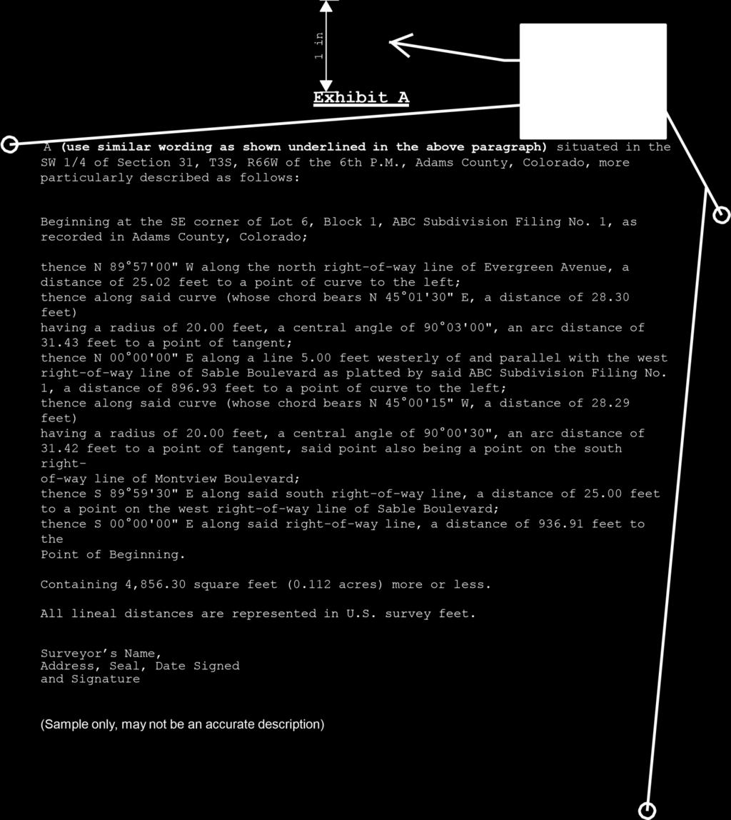
3 PROPERTY DESCRIPTION SPECIFICATIONS (See Example of Legal Description) Descriptions submitted to the Real Property Services Division will not be accepted unless prepared by a professional land surveyor registered in the State of Colorado, and shall conform to the following required criteria: 1. Submit an original typewritten legal description on letter size plain white paper (8 x 11 ). Electronic submittals of PDF s are acceptable. No paper with company logos will be accepted. 2. Each description must have an introduction which states the existing use of the property described, the location of the property, (Section, Township, Range, P.M.), and the subdivision name and filing number, if applicable. Samples are provided in this packet. 3. The body of the description must contain sufficient information to avoid any ambiguities or the necessity for assumptions. 4. The description must close mathematically with a ratio of closure of at least 1 : 10,000. Distances should be represented in U.S. survey feet. 5. The point of beginning must be tied to an established land corner or to a point identifiable on a recorded subdivision plat. 6. Metes and bounds descriptions are preferred whenever possible. Centerline descriptions will be accepted only when: A. The point of beginning and the point of terminus are described in the text and are tied to independent control points. B. The land described is uniform in width (from the described centerline) throughout its entire length. C. The sidelines of the land described are at all points parallel with the described centerline. D. Land (or easement) descriptions that deviate from any of the foregoing conditions must be written in a metes and bounds format. 7. The area shall be expressed in square feet and acres. 8. Each description shall be signed and sealed in accordance with C.R.S (2) which presently states: All documents, plats, and reports resulting from the practice of land surveying shall be identified with and bear the seal or exact copy thereof, signature, and date of signature of the land surveyor in responsible charge." 9. Do you need to be in compliance with C.R.S concerning the deposit of land survey plats? 10. Each description shall have a heading similar to Exhibit A. With the subsequent descriptions to be consecutively lettered Exhibits. (Example: Exhibit A, Exhibit B, Exhibit C, etc.) Rev. 12/31/17
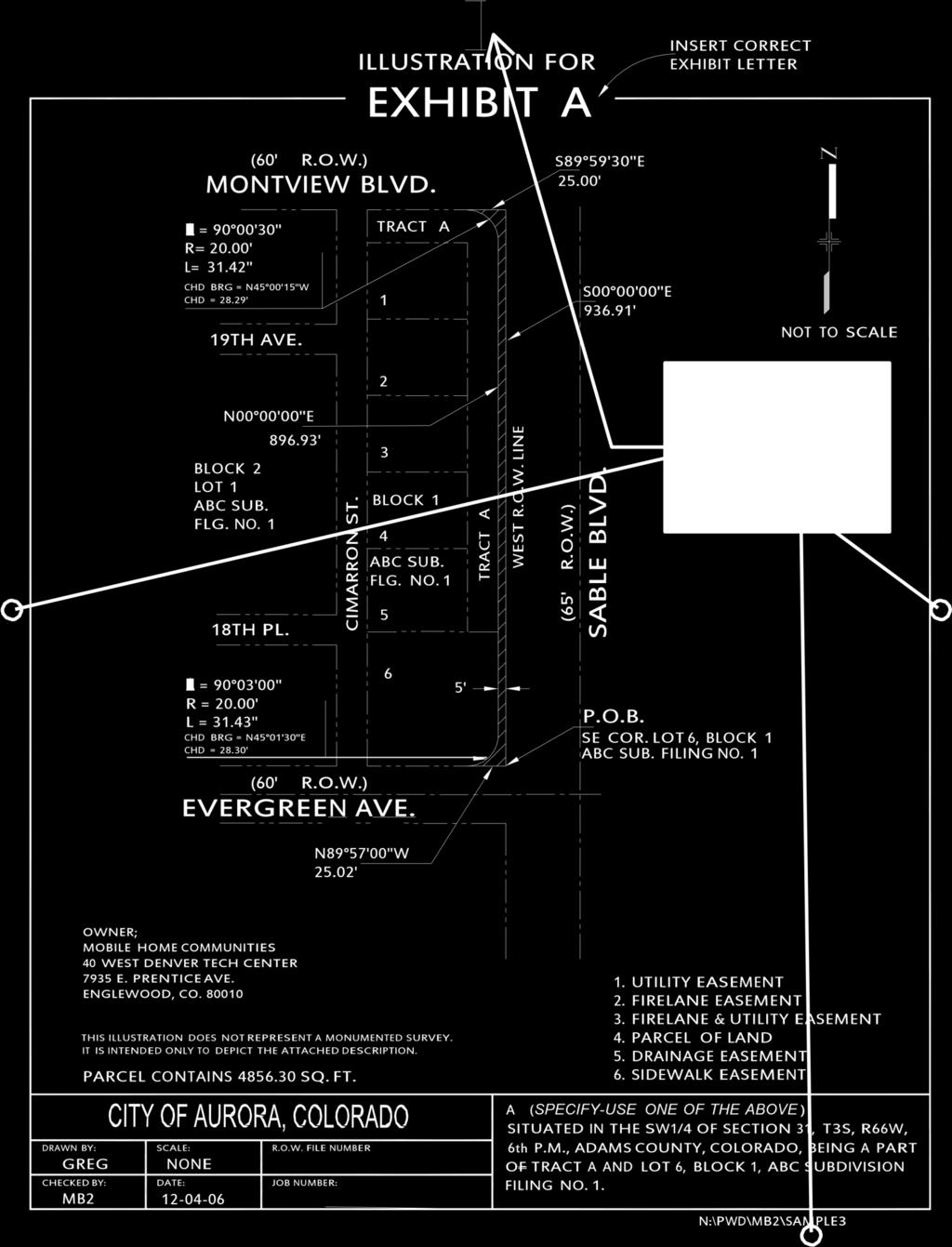
4 ILLUSTRATION SPECIFICATIONS (See Illustration for Exhibit A as an example) An illustration shall accompany each property description conforming to the following format: 1. A paper drawing in ink or computer generated and plotted representation done according to the example. 2. Lettering to be AutoCAD, Leroy or professional grade lettering. 3. Size is to be 8 x 11. Please note the County margin spaces 4. The following disclaimer statement must appear on each exhibit: "THIS ILLUSTRATION DOES NOT REPRESENT A MONUMENTED SURVEY. IT IS INTENDED ONLY TO DEPICT THE ATTACHED DESCRIPTION." 5. The heading at the top of the sheet should read Illustration for Exhibit (insert letter). 6. A City of Aurora title block should be at the bottom of each Illustration. Double Click on the attachment folder for the AutoCAD Drawing for the Blank Illustration COA Title Block 7. Bearings, distances, and curve data should be shown on the illustration and should match the legal description. 8. Show a bar and ratio scale and north arrow. 9. Label all street names and alleys. 10. Name and address of owner. 11. Label the lot and block numbers and the subdivision plat names and filing numbers. 12. Each illustration shall be signed and sealed in accordance with C.R.S (2) which presently states: "All documents, plats, and reports resulting from the practice of land surveying shall be identified with and bear the seal or exact copy thereof, signature, and date of signature of the land surveyor in responsible charge."
5 REQUIRED MONUMENTATION FOR RIGHTS-OF-WAY DEDICATED BY SEPARATE DOCUMENT (See Example C) Monuments shall be physically placed in the field at: - Street intersections - Cul-de-sac radius points - Points of curve, tangency where necessary to preserve a line of sight between proposed street centerline monuments (excluding minor tracts) need to show the appropriate centerline bearings, distances, and curve data - Other points as may be determined by the City Engineer or designee An Illustration shall be prepared using the above Illustration Specifications. In addition to those specifications, add the following: - Legend identifying symbol for monument box - Symbol identifying locations of monument box - Note added to legend symbol used for monument boxes: (a & b) Colorado Revised Statutes (9) (a) The top of the monument for any corner required by this section which is within the traffic area of a publicly named dedicated or deeded street, road, or highway shall be placed one-half foot below the roadway surface. (b) If the roadway surface is pavement two inches thick or greater, the monument shall include a monument box the top of which shall be set flush with the surface of the pavement These monument boxes are considered a public improvement and must be identified in the civil engineering drawings (contact the Engineering Dept. for additional information). The process for determining the location of the monument boxes will be consistent with the line of sight method. Current practice requires this type of monumentation of the centerline of street rights-of-way that are within the boundaries of a new subdivision plat. Rev. 12/31/17
6 INTRODUCTORY PARAGRAPH SAMPLES (See Exhibit A) The following are examples of typical introduction paragraphs for the legal descriptions. A. UTILITY EASEMENTS (which include all easements for water, sanitary and storm sewer lines, fire hydrants, and water meters) - A utility easement, feet wide, situated in the NW 1/4 of Section 12, T4S, R67W of the 6th P.M., Arapahoe County, Colorado, being a part of Lot 1, Block 1, XYZ Subdivision Filing No. 1, more particularly described as follows: B. FIRE LANE EASEMENTS - A fire lane easement, feet wide, situated in the NW 1/4 of Section 12, T4S, R67W of the 6th P.M., Arapahoe County, Colorado, being a part of Lot 1, Block 1, XYZ Subdivision Filing No. 1, more particularly described as follows: C. FIRE LANE AND UTILITY EASEMENTS - A fire lane and utility easement, feet wide, situated in the NW 1/4 of Section 12, T4S, R67W of the 6th P.M., Arapahoe County, Colorado, being a part of Lot 1, Block 1, XYZ Subdivision Filing No. 1, more particularly described as follows: D. SIDEWALK EASEMENTS (which includes all Handicapped Ramps and sidewalks) - A sidewalk easement, 5.00 feet wide, situated in the NW 1/4 of Section 12, T4S, R67W of the 6th P.M., Arapahoe County, Colorado, being a part of Lot 1, Block 1, XYZ Subdivision Filing No. 1, more particularly described as follows: E. RIGHT-OF-WAY AND OTHER PUBLIC USE PARCELS (streets, lot corner radii, and other parcels for public use) - A parcel of land feet wide, situated in the NW 1/4 of Section 12, T4S, R67W of the 6th P.M., Arapahoe County, Colorado, being a part of Lot 1, Block 1, XYZ Subdivision Filing No. 1, more particularly described as follows: F. CENTERLINE DESCRIPTIONS - A utility easement feet wide, situated in the NW 1/4 of Section 26, T4S, R66W of the 6th P.M., Arapahoe County, Colorado, being a part of Lot 1, Block 1, XYZ Subdivision Filing No. 1, being 8.00 feet on each side of the following described centerline: Rev. 12/31/17

7 Rev. 12/31/17
8
9
10 Legal Description and Illustration Check List (FOR SURVEYOR S USE) 1. General Format: a. 8 x 11 size plain white paper: New page margin changes b. Original document c. Exhibit (insert letter) at top of the page margin d. No company logo or title blocks on document 2. Introduction or Preamble: a. Intended use (i.e. type of easement, parcel of land, etc.) b. Section, Township, Range designations c. Lot, Block numbers and subdivision plat name and filing No. (if applicable) d. Related books and pages noted 3. Body: a. Metes and Bounds Descriptions 1. Tied out (i.e. subdivision plat or section corner) 2. Fits other related documents (i.e. plats or recorded separate document dedications) 3. Coordinate configuration with the affected departments 4. Use passing calls to clarify points (Example: Thence N E a distance of feet to a point on the southerly line of that utility easement recorded in Adams County, Colorado in Book 2642 at Page 269.) 5. Point of Commencement identified 6. Point of Beginning identified 7. Closure check to (1 : 10,000 ratio) 8. Distances represented in U.S. survey feet 9. Area stated (square footage and acreage) b. Centerline Descriptions 1. Point of Commencement identified 2. Point of Beginning identified and tied to independent control point 3. Point of Terminus identified and tied to independent control point 4. Fits other related documents 5. Area stated (square footage and acreage) c. Would you like to add a Basis of Bearing Statement? d. Seal of Surveyor 1. Signature and Date through the seal Illustration for the Exhibit 1. 8 x 11 size plain paper: see County page margin requirements 2. Title: Illustration for Exhibit (Insert the exhibit letter) 3. Disclaimer Statement: This illustration does not represent 4. City of Aurora Title Block 5. All bearings and distances with areas agrees with description 6. Scale ratio correct (with Bar Scale added) 7. North arrow 8. Names of lots, blocks and subdivision plats affected 9. Street names correct 10. Name(s) & Address(es) of the owner(s) of the property Double Click on the attachment folder for the AutoCAD Drawing for the Blank Illustration COA Title Block

11 Rev. 12/31/17
Real Property Services Division 2016 SUBDIVISION PLAT CHECKLIST
 Real Property Services Division 2016 SUBDIVISION PLAT CHECKLIST Created primarily for the use of Surveyors, CAD operators, and technical support staff for the preparation of subdivision plats. INTRODUCTION:
City of Fort Lupton Amended Plat Process
 City of Fort Lupton Amended Plat Process Purpose The Amended Plat process is an administrative process to amend a recorded Plat. An Amended Subdivision is an administrative revision to a recorded Subdivision
FINAL PLAT. Community Development Department 8101 Ralston Road Arvada, Colorado 80002
 FINAL PLAT Community Development Department 8101 Ralston Road Arvada, Colorado 80002 September 2015 FINAL SUBDIVISION PLAT Final Subdivision Plat Review Applications for a Final Plat shall be submitted
Department of Development Services Engineering; Survey Plat Review Group SPRG
 Department of Development Services Engineering; Survey Plat Review Group SPRG CITY OF DALLAS LEGAL DESCRIPTION PREPARATION GUIDELINE AND CHECKLIST The following guideline and checklist are provided to
Ballard City Final Plat Check List
 Ballard City Final Plat Check List TO BE COMPLETED BY BOTH THE DEVELOPER AND THE CITY Design: Check: Check each of the following items for compliance with adopted City Standards, Titles, General Plans
Plats and subdivisions; mapping requirements. (a) Size Requirements. All land plats presented to the register of deeds for recording in the
 Size Requirements. All land plats presented to the register of deeds for recording in the") 47-30. Plats and subdivisions; mapping requirements. (a) Size Requirements. All land plats presented to the register of deeds for recording in the registry of a county in North Carolina after September
47-30. Plats and subdivisions; mapping requirements. (a) Size Requirements. All land plats presented to the register of deeds for recording in the registry of a county in North Carolina after September
MINOR SUBDIVISION PLAT
 MINOR SUBDIVISION PLAT Community Development Department 8101 Ralston Road Arvada, Colorado 80002 MINOR SUBDIVISION PLAT Subdivisions consisting of five (5) or fewer lots are eligible for the minor subdivision
MINOR SUBDIVISION PLAT
 MINOR SUBDIVISION PLAT Community Development Department 8101 Ralston Road Arvada, Colorado 80002 September 2015 MINOR SUBDIVISION PLAT Subdivisions consisting of five (5) or fewer lots are eligible for
Final Plat Mapping Requirements
 CURRENT PLANNING DIVISION 410 E. 5 th Street Loveland, CO 80537 970-962-2523 eplan-planning@cityofloveland.org cityofloveland.org/dc Final Plat Mapping Requirements All Final plats shall comply with the
SUBDIVISION APPLICATION
 SUBDIVISION APPLICATION Preliminary Plat Minor Plat Final Plat Amended Plat Applicant Name: Owner (if different from applicant) Name: Company: Company: Address: Address: City, State, Zip City, State, Zip
DAUPHIN CREEK ESTATES SUBDIVISION
 # 12 SUB-000076-2017 DAUPHIN CREEK ESTATES SUBDIVISION Engineering Comments: FINAL PLAT COMMENTS (should be addressed prior to submitting the FINAL PLAT for review and/or signature by the City Engineer):
DALLAS WATER UTILITIES WATER/WASTEWATER COVENANT
 DALLAS WATER UTILITIES WATER/WASTEWATER COVENANT Procedure for obtaining a water and wastewater covenant, water covenant, or wastewater covenant; Required for initial submittal: 1. One letter from the
Preliminary Plat/Final Plat Application
 Melissa Municipal Center 3411 Barker Avenue Melissa, Texas 75454 Phone: (972) 838-2036 Applicant: Date: Address: Phone: Contact: Fax: E-mail: Propose Addition Name: Acres: Existing Zoning: Propose Zoning:
To provide for the review of the final engineering plans, the subdivision improvement agreement, public dedications, and other legal agreements.
 ARTICLE 5 FINAL PLAT 501 Intent DOUGLAS COUNTY SUBDIVISION RESOLUTION To provide for the review of the final engineering plans, the subdivision improvement agreement, public dedications, and other legal
Division of Land Application
 FOR PLANNING USE ONLY Application # DIV Application Fee Receipt No. Filing Date Completeness Date Division of Land Application A. PROJECT INFORMATION 1. Project Name: 2. Address of Subject Property: 3.
FINAL MAP PLAN CHECK
 Engineering Division 201 North Broadway, Escondido, CA 92025 (760) 839-4651, FAX (760) 839-4597 FINAL MAP PLAN CHECK To: Date: Project: Address: Check No: Attn: VIA: The attached FINAL MAP has been reviewed
WASTEWATER BACKFLOW RELEASE PROCEDURES
 WASTEWATER BACKFLOW RELEASE PROCEDURES PROCEDURE FOR OBTAINING A WASTEWATER RELEASE FOR PRIVATE DEVELOPMENT PROJECTS: PLEASE NOTE THAT THE WASTEWATER BACKFLOW RELEASE DOCUMENT MUST FOLLOW THE CITY S PROCEDURES.
PARCEL MAP CHECK ENG
 Engineering Division 201 North Broadway, Escondido, CA 92025 (760) 839-4651, FAX (760) 839-4597 PARCEL MAP CHECK ENG To: Date: Project: Site Address Check No. Attn: Via: The attached plans have been reviewed
SUBDIVISION AND LAND DEVELOPMENT. 185 Attachment 20
 185 Attachment 20 APPENDIX S Plat No. Date of Submission Twp. Fee $ Dauphin Co. Fee $ TOWNSHIP OF DERRY SUBDIVISION OR LAND DEVELOPMENT PLAN SUBMISSION APPLICATION This block for Twp. use only 1. Title
City of Colleyville Community Development Department. Subdivision Application Packet
 Community Development Department Subdivision Application Packet 1 Development Application Fees 100 Main Street Colleyville TX 76034 817.503.1050 Zoning Zoning Change $ 500 + $5 per acre Planned Unit Development
PROCEDURE. Chapter 12: Subdivision Regulations
 SECTION 14-600 ADMINISTRATIVE REPLAT PROCEDURE 14-601 INTENT These procedures are to provide an abbreviated process for Replat applications that demonstrate compliance with the criteria contained herein.
REQUIREMENTS FOR ALL INSTRUMENTS OF CONVEYANCE IN HARDIN COUNTY, OHIO
 REQUIREMENTS FOR ALL INSTRUMENTS OF CONVEYANCE IN HARDIN COUNTY, OHIO Effective Date: Michael L. Smith, P.E., P.S. Hardin County Engineer Michael T. Bacon Hardin County Auditor 1 I. GENERAL In compliance
Change In The Name Of Owner (s) Of Land.
 Of Land.") Clermont County TRANSFER AND CONVEYANCE STANDARDS OF THE CLERMONT COUNTY AUDITOR AND THE CLERMONT COUNTY ENGINEER AS ADOPTED UNDER OHIO REVISED CODE SECTION 319.203, AS A RESULT OF TWO PUBLIC HEARINGS
Clermont County TRANSFER AND CONVEYANCE STANDARDS OF THE CLERMONT COUNTY AUDITOR AND THE CLERMONT COUNTY ENGINEER AS ADOPTED UNDER OHIO REVISED CODE SECTION 319.203, AS A RESULT OF TWO PUBLIC HEARINGS
Oakland County Michigan Register of Deeds Plat Engineering, GIS, & Remonumentation Dept. Ph: (248) Fax (248)
 Fax (248)") Oakland County Michigan Register of Deeds Plat Engineering, GIS, & Remonumentation Dept. Ph: (248)-858-1447 Fax (248)-858-7466 Requirements Needed for Final Plat Approval No. General Requirements. 1 Routing
Oakland County Michigan Register of Deeds Plat Engineering, GIS, & Remonumentation Dept. Ph: (248)-858-1447 Fax (248)-858-7466 Requirements Needed for Final Plat Approval No. General Requirements. 1 Routing
Minimum Requirements. In Carroll County, Ohio
 Minimum Requirements For Instruments of Conveyance In Carroll County, Ohio Revision History: Original Effective Date: June 1, 2000 Revision Effective Date: October 2, 2017 Foreword Section 319.203 of the
Application for Preliminary Plat Checklist
 Application for Preliminary Plat Checklist Note: No portion of an existing parcel may be sold or transferred to another party without first legally subdividing the property according to the City of Richmond
Final Plat Approval of a Minor Subdivision Application Packet
 Final Plat Approval of a Minor Subdivision Application Packet 1. Application Packet. Be sure to complete and submit all the required materials that are a part of this Application Packet. Failure to do
Administrative Plat Application Form
 1 Administrative Plat Application Form This form shall be submitted with each application for an administrative plat. CONTACT INFORMATION Applicant Architect (if different) Property Owner (if different)
PLANNING AND DEVELOPMENT DEPARTMENT PRELIMINARY PLAT APPLICATION
 PLANNING AND DEVELOPMENT DEPARTMENT PRELIMINARY PLAT APPLICATION IT IS INCUMBENT UPON THE APPLICANT TO SUBMIT COMPLETE AND CORRECT INFORMATION. ANY MISLEADING, DECEPTIVE, INCOMPLETE OR INCORRECT INFORMATION
Survey and Recording Requirements
 Article C: Sec. 14-1-40 Survey and Recording Requirements Survey Requirements. (a) (b) (c) Prior to the final approval of land divisions to which this Chapter applies, the owner of the land shall have
Final Plat Approval of a Major Subdivision Application Packet
 Final Plat Approval of a Major Subdivision Application Packet 1. Application Packet. Be sure to complete and submit all the required materials that are a part of this Application Packet. Failure to do
APPROVAL REQUIREMENTS
 APPROVAL REQUIREMENTS FOR INSTRUMENTS OF CONVEYANCE IN ERIE COUNTY, OHIO DRAFT Requirements for all instruments of Conveyance in Erie County, revised and effective, 2014. An Erie County policy governing
MINOR SUBDIVISION APPLICATION
 Planning and Development 510 N. Baker St. Mount Dora, FL 32757 352-735-7112 Fax: 352-735-7191 plandev@cityofmountdora.com Date: Project Name: MINOR SUBDIVISION APPLICATION 1. Applicant s Name: 2. Property
Auditor's Office Tuscarawas County
 Auditor's Office Tuscarawas County MATT JUDY, Auditor Telephone 125 E. High Avenue (330) 365-3220 New Philadelphia, Ohio 44663 Fax: (330) 365-3397 TO: FROM: Title Companies, Surveyors, Attorneys & Financial
Standards for All Instruments of Conveyance
 Standards for All Instruments of Conveyance Perry County, Ohio Effective Date: May 1, 1997 Effective Date of Revision: April 1, 2011 Page 2 of 12 Minimum Standards for all Instruments of Conveyance Perry
A lot line or terminology adjustment will be reviewed concurrently with any other development review application(s) that are required.
 that are required.") RELATED FACTS TO KNOW: Adams County Recording Requirements, Annexation, Common Wall Subdivision, Development Plan (PUD Development Permit), Fees, Helpful Contact Information, Neighborhood Meeting, Park
RELATED FACTS TO KNOW: Adams County Recording Requirements, Annexation, Common Wall Subdivision, Development Plan (PUD Development Permit), Fees, Helpful Contact Information, Neighborhood Meeting, Park
City of Lakewood Plat Specifications
 City of Lakewood Plat Specifications Revised 12/15/2015 Plat Checklist.1 Notes, Certifications and Acknowledgements..5 Electronic Submittal Information... 20 Sheet Layout.21 A Professional Land Surveyor,
SUBMITTAL REQUIREMENTS: The number indicates the number of copies for submittal (if applicable).
.") Office Use Only Preliminary Long Plat Long Subdivision Applicant Checklist PLANNING, COMMUNITY, & ECONOMIC DEVELOPMENT DEPARTMENT FINAL LONG PLAT LONG SUBDIVISION CHECKLIST Mailing Address: P.O. Box 547,
Office Use Only Preliminary Long Plat Long Subdivision Applicant Checklist PLANNING, COMMUNITY, & ECONOMIC DEVELOPMENT DEPARTMENT FINAL LONG PLAT LONG SUBDIVISION CHECKLIST Mailing Address: P.O. Box 547,
WYANDOT COUNTY BASIC STANDARDS FOR THE APPROVAL OF REAL ESTATE DEED TRANSFERS & LAND CONTRACT AGREEMENTS
 GENERAL In compliance with Section 315.251 of the Ohio Revised Code, the County Auditor and the County Engineer have adopted these written standards governing the conveyance of real property in Wyandot
B. The proposed parcel(s) of land shall be in compliance with the current zoning requirements.
 of land shall be in compliance with the current zoning requirements.") SECTION 14-900 SUBDIVISION EXEMPTION 14-901 INTENT To establish criteria and a review process whereby the Board of County Commissioners may grant Exemptions from the definition of the terms subdivision
SECTION 14-900 SUBDIVISION EXEMPTION 14-901 INTENT To establish criteria and a review process whereby the Board of County Commissioners may grant Exemptions from the definition of the terms subdivision
DIVISION 2 - CONSTRUCTION PLAN AND MISCELLANEOUS REQUIREMENTS
 DIVISION 2 - CONSTRUCTION PLAN AND MISCELLANEOUS REQUIREMENTS 2.1 Required Plan Sheets 2.2 Drawing Requirements 2.3 Graphic Standards 2.4 Easements 2.5 Utility Locations 2.6 Private Facility Locations
The Filing Fee for a Minor Plat is $ PLUS $20.00 per lot created
 DEPARTMENT OF COMMUNITY DEVELOPMENT MINOR PLAT PROCEDURE The Filing Fee for a Minor Plat is $250.00 PLUS $20.00 per lot created Description: The purpose of a Minor Plat is to allow property to be platted
REQUIREMENTS For Subdivision Plats, Administrative Subdivision Plats, Deposit Surveys and Deeds December 2016
 REQUIREMENTS For Subdivision Plats, Administrative Subdivision Plats, Deposit Surveys and Deeds December 2016 General Requirements - All plats shall have the information necessary to delineate and reestablish
STANDARDS GOVERNING CONVEYANCES OF REAL PROPERTY
 STANDARDS GOVERNING CONVEYANCES OF REAL PROPERTY Hancock County, Ohio Charity A. Rauschenberg, Hancock County Auditor Steven C. Wilson, Hancock County Engineer Revised: March 1, 2007 TRANSFER AND CONVEYANCE
SECTION SITE SURVEYS
 PART 1 - GENERAL 1.1 DESCRIPTION SECTION 02 21 00 SPEC WRITER NOTES: 1. Use this section only for NCA projects. 2. Delete between //---// if not applicable to project. Also delete any other item or paragraph
CHAPTER FINAL AND PARCEL MAPS
 CHAPTER 19.48 FINAL AND PARCEL MAPS Section Page 19.48.010 General... IV-25 19.48.020 Phasing... IV-25 19.48.030 Survey Required... IV-26 19.49.040 Form... IV-26 19.48.050 Contents... IV-27 19.48.060 Preliminary
Final Subdivision Plat
 Final Subdivision Plat Application Packet Public Works Department New Development Division 175 East 200 North St. George, UT 84770 Office (435) 627-4120 Dear Applicant, This packet has been prepared to
Requirements for All Instruments of Conveyance in Logan County, Ohio
 Requirements for All Instruments of Conveyance in Logan County, Ohio Effective Date: April 11, 1997 It is the intent of these requirements to provide a standard method of checking legal descriptions for
APPENDIX C: PLAT SPECIFICATIONS AND CERTIFICATES
 APPENDIX C: PLAT SPECIFICATIONS AND CERTIFICATES A. Drawing. All plats for recording must be submitted on photographically reproducible and dimensionally stable polyester sheets such as Mylar, Cronar or
GENERAL. All authors of conveyance instruments are encouraged to contact the County Auditor s Office well in advance of transfer.
 GENERAL In accordance with Section 319.203 of the Ohio Revised Code, the Geauga County Auditor and the Geauga County Engineer, by agreement, hereby establish the following standards governing the conveyance
INFORMATION & PROCEDURES FOR CHANGE OF ZONING REQUESTS AND CONDITIONAL USE PERMITS
 INFORMATION & PROCEDURES FOR CHANGE OF ZONING REQUESTS AND CONDITIONAL USE PERMITS The applicant is strongly encouraged to attend a pre-application meeting for the project prior to submittal of a zoning
PRELMINARY PLAT CHECKLIST
 PRELMINARY PLAT CHECKLIST A. All preliminary plat submitted for approval shall be prepared by a Registered Professional Land Surveyor. B. Preliminary plats must be drawn to a scale of XXX with such accuracy
MINOR PLAT. The following documents are provided as required by the City of Conroe for use in the above titled platting submittals:
 Public Works - Engineering Division CITY OF CONROE MINOR PLAT The following documents are provided as required by the City of Conroe for use in the above titled platting submittals: Submittal Questionnaire
INSTRUCTIONS FINAL PLAT APPROVAL APPLICATION
 INSTRUCTIONS FINAL PLAT APPROVAL APPLICATION 1. The applicant/agent shall fill out the attached application. The attached application form must be completely filled in before it can be filed. Portions
PLANNING COMMISSION APPLICATION - INSTRUCTIONS AND CHECKLIST
 City of North Royalton Mayor Robert A. Stefanik Community Development, Building Division Dan Kulchytsky Building Commissioner 11545 Royalton Road, North Royalton, OH 44133 Phone: 440-582-3000 Fax: 440-582-3089
CITY OF DECATUR, TEXAS
 Final Plat or Amending Plat / Replat Checklist A submittal of a complete application will facilitate a timely review. Failure of the applicant to provide required information or obtain a waiver from the
R/W PREQUALIFICATION ODOT, 3/14/2018
 R/W PREQUALIFICATION ODOT, 3/14/2018 BRETT SHEARER, C.O. REAL ESTATE PROPOSED RIGHT OF WAY DESIGN 172 PROPOSED RIGHT OF WAY DESIGN PROPOSED RIGHT OF WAY DESIGN Section 3200 Types of Title 173 PROPOSED
Submittal Requirements: Subdivision Plat (Final)
") s Planning and Zoning Submittal Requirements: Subdivision Plat (Final) 1. Application form, APO fees, and filing fee. Transportation Development Review Fee please contact Engineering at (970) 221-6605
s Planning and Zoning Submittal Requirements: Subdivision Plat (Final) 1. Application form, APO fees, and filing fee. Transportation Development Review Fee please contact Engineering at (970) 221-6605
A Final Plat will be reviewed concurrently with any other development review application(s) that is required.
 that is required.") RELATED FACTS TO KNOW: Adams County Recording Requirements, Annexation, Common Wall Subdivision, Development Plan (PUD Development Permit), Fees, Helpful Contact Information, Lot Line Adjustment, Neighborhood
RELATED FACTS TO KNOW: Adams County Recording Requirements, Annexation, Common Wall Subdivision, Development Plan (PUD Development Permit), Fees, Helpful Contact Information, Lot Line Adjustment, Neighborhood
REQUIREMENTS FOR ALL INSTRUMENTS OF CONVEYANCE IN GREENE COUNTY
 REQUIREMENTS FOR ALL INSTRUMENTS OF CONVEYANCE IN GREENE COUNTY A Greene County policy governing procedures and requirements for acceptance of documents for instruments of conveyance is hereby established.
SUBDIVISION PLAT CHECKLIST. The following information shall be include on the plat:
 SUBDIVISION PLAT CHECKLIST Subdivision Name: Land Surveyor: Owner/Developer: Date Submitted: The following information shall be include on the plat: The plat shall be drawn at a scale of one inch equals
SUBDIVISION APPLICATION
 STAFF USE ONLY Date Submitted: Received by: Fee paid: Project # REQUIRED SUBMITTALS Application Fee: $600.00 (up to 5 lots) + $50.00 (per lot above 5) Publication Fee: $300.00 Mailing Fee: $6.00 per hearing
Residential Minor Subdivision Review Checklist
 Residential Minor Subdivision Review Checklist Plan Submittal Requirements: 2 full sets of stamped plans Electric submittal - all plans contained in a single PDF 3 full sets if commercial kitchen or dining
Boundary Line Adjustment Application
 Boundary Line Adjustment Application A COMPLETE APPLICATION is required at the time of submittal. REQUIRED SUBMITTALS: 1. Application form 2. Application Fee - $500.00. 3. Current title report 4. Three
APPLICATION FOR MAJOR SUBDIVISION APPROVAL (FINAL PLAT)
") 209 S. Main Street Marysville, Ohio 43040 Phone: (937) 645-7350 Fax: (937) 645-7351 www.marysvilleohio.org APPLICATION FOR MAJOR SUBDIVISION APPROVAL (FINAL PLAT) *** IMPORTANT INFORMATION ~ Please read
209 S. Main Street Marysville, Ohio 43040 Phone: (937) 645-7350 Fax: (937) 645-7351 www.marysvilleohio.org APPLICATION FOR MAJOR SUBDIVISION APPROVAL (FINAL PLAT) *** IMPORTANT INFORMATION ~ Please read
CHAPTER 32 SUBDIVISIONS SECTION TITLE PAGE NO.
 Page 1 of 46 CHAPTER 32 SUBDIVISIONS SECTION TITLE PAGE NO. SECTION 32-1 Purpose of Ordinance 3 SECTION 32-2 Definitions 3 SECTION 32-3 Staff Sketch Review 4 SECTION 32-4 Subdivision and PUD Plats Required
Certified Survey Review Instructions
 DEARBORN COUNTY PLAN COMMISSION County Administration Building, 165 Mary St., Lawrenceburg, IN 47025 Phone (812) 537-8821 Fax (812) 532-2029 Website: www.dearborncounty.org/planning Certified Survey Review
City of Leavenworth DEPARTMENT OF DEVELOPMENT SERVICES MAJOR SUBDIVISION APPLICATION 1
 Proposed Name of Subdivision: City of Leavenworth DEPARTMENT OF DEVELOPMENT SERVICES MAJOR SUBDIVISION APPLICATION 1 FOR PRELIMINARY SUBDIVISION APPROVAL This application must be filled out legibly, in
DAWSON COUNTY MINOR PLAT REVIEW CHECKLIST $50.00 FEE PER PLAT REVIEW, $5.00 FEE FOR SCAN & CD FOR RECORDING
 DAWSON COUNTY MINOR PLAT REVIEW CHECKLIST $50.00 FEE PER PLAT REVIEW, $5.00 FEE FOR SCAN & CD FOR RECORDING NAME ON PLAT: CONTACT/PHONE #: NAMED STREET/ADDRESS: LAND LOT: DISTRICT: SECTION: ZONING: SETBACKS:
GENERAL ASSEMBLY OF NORTH CAROLINA SESSION 2017 H 1 HOUSE BILL 454* Short Title: Surveying and Plat Recording Changes. (Public)
") GENERAL ASSEMBLY OF NORTH CAROLINA SESSION H 1 HOUSE BILL * Short Title: Surveying and Plat Recording Changes. (Public) Sponsors: Referred to: Representative Arp. For a complete list of sponsors, refer
GENERAL ASSEMBLY OF NORTH CAROLINA SESSION H 1 HOUSE BILL * Short Title: Surveying and Plat Recording Changes. (Public) Sponsors: Referred to: Representative Arp. For a complete list of sponsors, refer
SUBMITTAL REQUIREMENTS
 PRELIMINARY PLAT APPLICATION ***A PRE-APPLICATION MEETING WITH CITY STAFF IS REQUIRED FOR THIS APPLICATION*** DATE STAMP FOR CITY USE ONLY PROJECT NAME (if any): TO BE FILLED OUT BY APPLICANT PROJECT STREET
CITY OF LEE S SUMMIT MINOR PLAT PROCESS. Purpose of Minor Plats
 MINOR PLAT PROCESS Purpose of Minor Plats The City of Lee s Summit requires that all property be platted before a building permit is issued. Platting involves the subdivision of land into lots or tracts.
Administrative Application Duplex Subdivisions
 Department of Community Development 75 South Frontage Road Vail, CO 81657 Tel: 970-479-2128 www.vailgov.com Development Review Coordinator Administrative Application Duplex Subdivisions General Information:
PRELIMINARY PLATS. The following documents are provided as required by the City of Conroe for use in the above titled platting submittals:
 Public Works Engineering Division CITY OF CONROE PRELIMINARY PLATS The following documents are provided as required by the City of Conroe for use in the above titled platting submittals: Submittal Questionnaire
NOT TO BE SUBMITTED WITH SKETCH DESIGN APPROVAL Subdivision Checklist: Major Subdivision Final Plat
 Must be received with review fee (equal to $200.00, plus $25.00 per lot) no later than 15 days prior to Planning Board meeting, which is normally the first Monday of the month (certain holidays may modify
CITY OF BEVERLY HILLS Department of Public Works and Transportation Civil Engineering Division FINAL MAP SUBMITTAL PROCESS Transmitted
 CITY OF BEVERLY HILLS Department of Public Works and Transportation Civil Engineering Division FINAL MAP SUBMITTAL PROCESS Transmitted From To* Planning Department Civil Engineering Division RKA Consulting
R/W PREQUALIFICATION ODOT, 3/14/2018 PROPERTY MAP SHEET
 R/W PREQUALIFICATION ODOT, 3/14/2018 3A Title Block 3B Sheet Heading 3C Station Limit Flags 3D Revision Block 3E Ownership Name and Number 3F Centerline Stationing 3G Proposed R/W and Pavement 3H Structures
MINOR SUBDIVISION PLAT CHECKLIST
 MINOR SUBDIVISION PLAT CHECKLIST Project Name: Tax ID #: Project Number: Date: _ Reviewed By: Telephone: NOTES: All lots on septic systems must comply with the Fulton County Health Department requirements
Minor Subdivision Application
 FOR PLANNING USE ONLY Application # SD Application Fee $1,000.00 Receipt No. Filing Date Completeness Date Minor Subdivision Application A. PROJECT INFORMATION 1. Project Name: 2. Address of Subject Property:
PLANNING COMMISSION SUBDIVISION PLAT APPLICATION
 PLANNING COMMISSION SUBDIVISION PLAT APPLICATION Economic Development Department 3468 North Fulton Avenue Hapeville, Georgia 30354 Phone - 404.669.8269 Fax 404.669.3302 Rev. 09/23/16 1 The following information
CITY OF FAYETTEVILLE, ARKANSAS FINAL PLAT FOR STAFF USE ONLY FINAL PLAT FEE: $ $ Date Application Submitted: Date Accepted as Complete:
 CITY OF FAYETTEVILLE, ARKANSAS FINAL PLAT FOR STAFF USE ONLY FINAL PLAT FEE: $200.00-$800.00 Date Application Submitted: Date Accepted as Complete: Project Number: Public Hearing S-T-R: PP#: Zone: Please
FINAL PLAT APPLICATION
 FINAL PLAT APPLICATION (Page 1 of 3) LEGAL OWNER(s): NAME: STREET ADDRESS OWNER(s): CITY, STATE, ZIP CODE: PHONE NUMBER: BILLING ADDRESS: NAME OF ENGINEER/SURVEYOR: Engineer/Surveyor Address, Phone: PROPERTY
TOWNSHIP OF BORDENTOWN LAND DEVELOPMENT APPLICATION CHECKLIST. General Requirements for all Applications
 TOWNSHIP OF BORDENTOWN LAND DEVELOPMENT APPLICATION CHECKLIST This CHECKLIST has been adopted in accordance with Section 25:807 of the Land Development Ordinance of the Township of Bordentown and will
APPLICATION PROCEDURE
 ANTRIM PLANNING BOARD P. O. Box 517 Antrim, New Hampshire 03440 Phone: 603-588-6785 FAX: 603-588-2969 APPLICATION FORM AND CHECKLIST FOR MINOR OR MAJOR SITE PLAN REVIEW File Date Received By APPLICATION
Residential Major Subdivision Review Checklist
 Residential Major Subdivision Review Checklist Plan Submittal Requirements: 2 full sets of stamped plans Electric submittal - all plans contained in a single PDF 3 full sets if commercial kitchen or dining
OTTAWA COUNTY LEGAL DESCRIPTION REVIEW GUIDELINES
 OTTAWA COUNTY LEGAL DESCRIPTION REVIEW GUIDELINES APPROVED BY: RONALD P. LAJTI, JR., P.E., P.S. OTTAWA COUNTY ENGINEER APPROVED BY: LAWRENCE HARTLAUB OTTAWA COUNTY AUDITOR EFFECTIVE DATE: January 1, 2017
Enforcement of Minimum Survey Standards
 Presented By: F. Anthony Rettke, P.S., Tax Map Supervisor, Franklin County John Greenhalge, Executive Director, State Board of Registration n the Ohio Revised Code, Section 315.251: If a deed conveying
ARTICLE 900 PLAT AND PLAN REQUIREMENTS
 ARTICLE 900 PLAT AND PLAN REQUIREMENTS SEC. 900.1 ITEMS TO BE SHOWN ON PLAT OR PLAN General (1) Property lines of all property owners adjacent to the exterior boundaries of the project shall be located
7. EASEMENTS Label Established Lines Affecting Tract and/or Mentioned in its Legal Description:
 7. EASEMENTS 7.010 General All sewers shall be constructed in easements with working room. Existing easements without working room may only be used if revised to include working room. All public sewers,
APP. FEE: $ DATE & TIME LOCATION: 1/4 SECTION SECTION TOWNSHIP RANGE STREET ADDRESS AND GENERAL LOCATION OF PROPERTY CITY, STATE PHONE (DAY):
:") REVERSION TO ACREAGE PURSUANT TO N.R.S. 278.490 through 478.4965 Elko County Planning & Zoning 155 South 9th Street, Elko, NV 89801 (775) 738-6816 or 738-2266 APPLICATION MUST BE SUBMITTED WITH ALL REQUIRED
REVERSION TO ACREAGE PURSUANT TO N.R.S. 278.490 through 478.4965 Elko County Planning & Zoning 155 South 9th Street, Elko, NV 89801 (775) 738-6816 or 738-2266 APPLICATION MUST BE SUBMITTED WITH ALL REQUIRED
Plan and Zoning Commission Review Process
 . Village of Northfield Plan and Zoning Commission Review Process.......... Department of Community Development and Building Village of Northfield Department of Community Development and Building 361 Happ
Plat Checklist PLAT TYPES AND DESCRIPTIONS
 Master Plan / Revision to Master Plan (For Platting Purposes Only) Preliminary/Final Plat Preliminary Plat Final Plat Minor Plat Replat Amended Plat Plat Checklist So that we may efficiently review your
COUNTY OF ALBEMARLE APPLICATION FOR FAMILY DIVISION. Family Division = $742 (Provide 5 copies of plat)
") Page 1 APPLICATION FOR FAMILY DIVISION Family Division = $742 (Provide 5 copies of plat) Tier 2 Groundwater Review = $355 (Required for all plats showing lots less than 21 acres) Tier 3 Groundwater Review
Page 1 APPLICATION FOR FAMILY DIVISION Family Division = $742 (Provide 5 copies of plat) Tier 2 Groundwater Review = $355 (Required for all plats showing lots less than 21 acres) Tier 3 Groundwater Review
JEFFERSON COUNTY, ALABAMA
 JEFFERSON COUNTY, ALABAMA Major Development Checklist, Notes and Information A Major Development is any proposed new structure or addition to an existing structure which will cause a change in the topography
CITY OF STRONGSVILLE PLANNING COMMISSION APPLICATION CLUSTER SUBDIVISION
 CITY OF STRONGSVILLE PLANNING COMMISSION APPLICATION CLUSTER SUBDIVISION After meeting with City Planner, George Smerigan (if necessary) regarding zoning requirements, submit the following: An application
CARROLL COUNTY BUREAU OF DEVELOPMENT REVIEW OFF-CONVEYANCE SUBMITTAL CHECKLIST AND REVIEW FEE SHEET NOTICE: INCOMPLETE SUBMITTALS WILL BE RETURNED
 CARROLL COUNTY BUREAU OF DEVELOPMENT REVIEW OFF-CONVEYANCE SUBMITTAL CHECKLIST AND REVIEW FEE SHEET An off-conveyance submittal shall include all items as specified in Section 103-7 of the Code of Public
ALBA BEACH SUBDIVISION, RESUBDIVISION OF LOT 17
 ALBA BEACH SUBDIVISION, RESUBDIVISION OF LOT 17 Engineering Comments: FINAL PLAT COMMENTS (should be addressed prior to submitting the FINAL PLAT for acceptance and signature by the City Engineer): A.
A. Appropriate agency responsible for transportation review for the subject property.
 7.8.10 Procedure Any person desiring to create a minor subdivision shall submit to the Commission for approval an application on forms provided by the Division, and a record plat in conformance with the
Gates County Planning and Zoning
 Gates County Planning and Zoning PO Box 411, 200 Court Street, Gatesville, NC 27938 phone: 252-357-2411 fax: 252-357-0073 Application for Technical Review Committee For Staff Use Only: Date: Application
PLYMOUTH PLANNING BOARD APPLICATION FOR A MINOR SUBDIVISION OR MAJOR SUBDIVISION
 CASE # PLYMOUTH PLANNING BOARD APPLICATION FOR A MINOR SUBDIVISION OR MAJOR SUBDIVISION The undersigned Applicant hereby submits to the Plymouth Planning Board a completed application for a proposed minor