Installation Boundary Mapping and the DoD Real Property Inventory Program
|
|
|
- Owen Conley
- 6 years ago
- Views:
Transcription


1 Installation Boundary Mapping and the DoD Real Property Inventory Program 11 October 2007 SAME Mid-Atlantic Regional Conference Jeff Swallow
2 Real Property History Real Property data reported to the Office of the Secretary of Defense (OSD) Need to accurately report the DoD land interest for financial accountability Audit reports state that DoD can not properly account for and report real property Unreliable or unauditable valuations and asset information Lack of integration of financial and property systems
3 Real Property Need What s Missing? Formal Guidance and Specific Implementation Protocols for geospatial capture of Real Property Assets Integrated business processes for managing Property, Plant, & Equipment (PP&E) across DoD Practical strategy to aggregate the data across multiple sources Recognize DoD s strengths and weaknesses Site (and Asset) unique identification registry Necessary Outcomes Assignment of unique identifiers to all real property sites and assets Enable linkage to personnel, property, and environmental systems Reduced information asset management cost and increased productivity Results Real Property Inventory Requirements


4 RPUID Registry Concept DISDI Viewer (GIS) DoD Metadata & XML Registries RPUID Registry RP Analyst ODS / Data Warehouse Component Geo-databases IFS ACES RP infads WHS User Interface Enterprise Services Layer FSM FAD Recap Federal Reports Congress TMA Systems DLA Systems DoDEA Systems


 or Land Parcel Over 571,000 facilities on")
5 Real Property UID Hierarchy Installations are composed of one or more Sites. Sites are: Managed by a single Service A contiguous area of land Installation Site Unique Identification Project Focus Sites are composed of one or more Land Parcels and/or Facilities Site A Site B Site.. Asset Unique Identification Project Focus An individual Facility (e.g., building, structure, linear structure) or Land Parcel Over 571,000 facilities on over 29M acres Facility(ies) Land Parcel(s) Facility(ies) Land Parcel(s)

6 FY06 RPI Pilot Project Installation Boundary Mapping for Land Geospatial Data Model Demonstrate an optimized and validated methodology of parcel compilation for DoD installations Compilation per Real Property Inventory Requirements, Jan 05 Deliverables per DoD RPI Site and Land Recommendations for the SDSFIE, Sep 05 May 2006 Pilot Study Report Documents processes, metrics & Lessons Learned Includes recommendations for future parcel creation efforts Furnishes specific & practical protocols for building Parcels & RP Sites
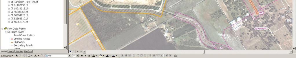
7 ODUSD(I&E) Phase 1 Scorecard Goals Accomplished: Established new geo-data model for capturing RPI sites and land parcels DoDwide Validated geospatial data collection process and synchronization with Real Property Unique Identifier (RPUIR) registry Established per-unit data collection costs Process Confirmed Mapped parcels using land descriptions from legal deeds Compiled sites in accordance with RPIR rules 18 installations in National Capital Region (NCR) and USACE Seattle District area Data delivered May 06, distributed to Services Jun 06 Sites and Land Parcels Dover AFB, DE Site Boundaries Land Parcels (owned) Land Parcels (non-owned)

![2007] RPI_Parcels [Andrews](/docs-images/79/79182297/images/8-10.jpg "Pilot 2006] New Level of")

8 RPIR Work Product Installation_Area [CIP 2007] RPI_Parcels [Andrews Pilot 2006] New Level of Data Granularity Attributes per RPIR Guidance Interactions w PPE Spectrum
9 Lessons Learned Research Identify responsible installation level POC Obtain most recent tract register or parcel listing per installation when available Initial site visit to where vesting documents are stored to determine level of effort for research Perform additional research at state and local level Determine boundary of site to acquire full imagery of site Original Reservations additional research needed to determine parcel boundaries labeled as prior acquisitions or original reservations on RESM Official list of installation names and site determinations before compilation to ensure consistency with the DoD Site Registry
10 Lessons Learned Compilation Compile adjacent installations among different services simultaneously (Ft Lewis McChord AFB) Compile all components of the site at same time (outgrants, disposals, parcels) Use imagery along with vesting documents to resolve erosion and accretion Use COGO supplemented with digitization when vesting document is incomplete Geodatabase Feature class created to handle non-polygonal tracts Manage the RPI geodatabase versions using Microsoft Visio Feature level metadata need link to records in geodatabase as to the status of the parcel (complete, issues, etc.) Review and revise topology rules Update metadata guide to include all features
11 ODUSD(I&E) Phase Projects Real Property Inventory Requirements (RPIR) Projects 2005 OSD Pilot Phase I: Land Parcel Mapping Process development 18 Installations in National Capital Area and Seattle USACE 2006 OSD RP Land Parcel Mapping Phase II & Environmental Liability Reconciliation Pilot 50 Installations across Army, Navy, Air Force and Marines USAF Land Parcel Mapping Project 40 Air Force installations
12 Phase II Approach Compilation methodology through services Army Digitized existing Audited tract maps Air Force and Navy using existing deeds, legal documents, and tract maps gathered at the installation level to compile installation

13 Personnel RPI Personnel Technical Manager - a licensed surveyor responsible for the RPI Land Parcel compilation Survey/GIS Technician Performs parcel COGO or digitization from deeds and tract maps GIS Manager responsible for data migration, QAQC and final data formatting

14 Workflow
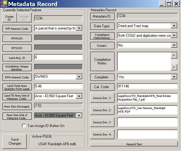
15 Spatial Data Components SDSFIE Compliant Personal Geodatabase RPI Land Parcel Area - Polygons representing the geographic extent of owned land parcels and less-than-fee surface rights RPI Land Parcel Line Linear components representing the land interest in which there is no area RPI Sites - RPI site boundaries shall represent the geographic extent of all contiguous land parcels in which the DoD has legal interest. RPI Disposals Land reassigned to other DoD entities, transfer to another DoD or Non DoD entity, exchange, donation, loss by disaster, demolition, and sale RPI Outgrants Polygons representing the geographic extent of lands outgranted by DoD Feature Level Metadata Object table linked to the spatial tables, capturing how the data was created, what source documents used, and any issues encountered during compilation Topology rules enforced
16 Compilation Overview Collect all legal documentation, existing data Review/Scrub Legal Instruments COGO Using ArcMap tools Attribute Data Create Feature Level Metadata Review Data w/technical Manager Approve by Technical Manager Metadata QAQC Review Draft Data w/installation Deliver Final data approved by RPO at Installation


17 Compilation Roles Technical Manager and Survey/GI Techs GIS Manager Research/Scrub/Review legal data Digitize and Compile deeds Complete attribution Finalize Land Parcel decisions Review compilation w/rpo Create Site Summary Report Create Sites Perform topology checks Perform spatial/attribution checks Prepare data for final delivery
18 Compilation Process Determine Sites to Compile Extract Sites for ACES roll up or site listings provided by services
19 Compilation Process Document Preparation Scrubbing All available Project maps in PDF format (Tract map or latest final audit map) Tract identifiers Site Summary Report- Create a word document for summary report at startup. Document as much as possible explaining thoroughly any decisions or issues encountered as you progress with the process. Objective - to be able to complete a one to one correlation between tract # s shown on map and tract # s shown on tract registry as to whether the tract is fee, less than fee, or disposed of.


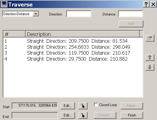
20 Compilation Process Examples of scrubbed data FEE Green Less-Than-Fee Magenta Disposal - Blue


21 Compilation Process Review Deeds & Compare to Tract Map


22 DoD RPI Land Parcel Inventory Compilation Process
23 Compilation Process RPI Land Parcels QAQC and Attribution Initial QAQC Topology Checks Attribution RPI Site Creation and Attribution RPI Site Creation Topology Checks RPI Site Comparison and attribution Metadata Final Delivery of RPI Geodatabase and Report

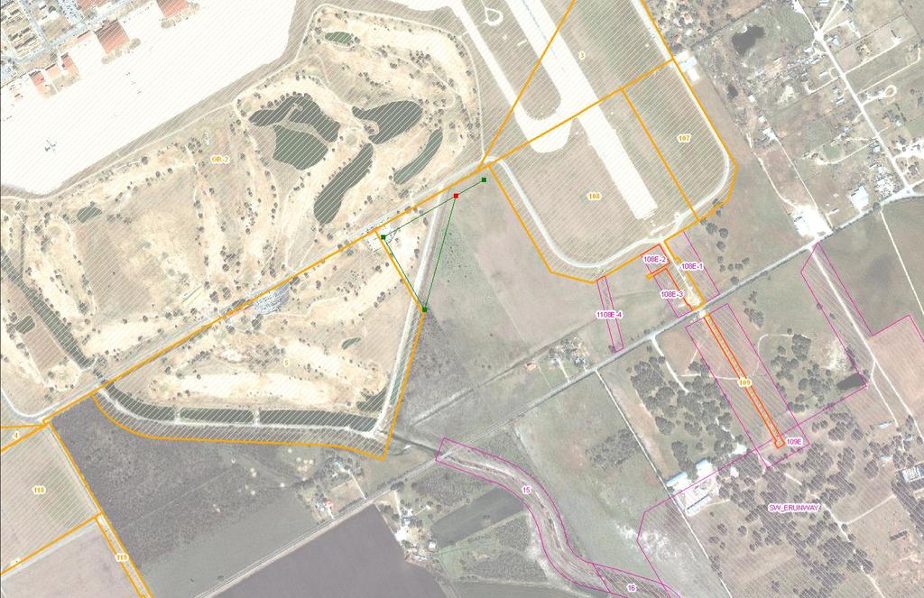
24 McConnell AFB Case Study Shows location of found monuments near McConnell
25 McConnell AFB Case Study T28S R2E Sec 13 Sec 24 Sec 18 Sec 19 T28S R1E Point 200 Ground Point 200
26 McConnell AFB Case Study Point 201 Sec 28 Sec 25 Sec 19 Sec 30 T28S R2E T28S R1E Ground Point 201
27 McConnell AFB Case Study Tract 138-E Sec 24 Sec 25 Point 202 T28S R1E Ground Point 202


28 Holloman AFB Case Study The data set that was used was the most accurate available without doing an actual survey.
29 Questions? Jeff Swallow (757) Matt Schrader (618)
30 Real Property Accountability Real Property Accountability (RPA) provides the warfighter and CBMs access to near-real time secure, accurate and reliable information on real property assets, and environment, safety, and occupational health sustainability. Objectives: Access to more reliable and accurate real property and Environment, Safety, and Occupational Health (ESOH) information for both warfighter and business mission use. The ability to link individual people and personal property to specific real property assets. The ability to link people, real and personal property to specific environmental sites and liabilities. Decreased operational cost and cycle times, enabled by increased consistency of data, reduced re-work and data calls. Improved accuracy and auditability of financial statements.
Integrating the Enterprise
 Integrating the Enterprise Lora Muchmore, Director, Business Enterprise Integration Office of the Deputy Under Secretary of Defense (Installations and Environment) Session F, Business Transformation May
Department of Defense Real Property Inventory (RPI) Initiative
 Initiative") Department of Defense Real Property Inventory (RPI) Initiative Lora Muchmore Deputy Director Business Transformation Directorate ODUSD (Installations & Environment) July 19, 2004 What is Real Property
Department of Defense Real Property Inventory (RPI) Initiative Lora Muchmore Deputy Director Business Transformation Directorate ODUSD (Installations & Environment) July 19, 2004 What is Real Property
Bureau of Land Management MAPPS Federal Update Donald Buhler Cadastral, Lands, and Realty Management April 14, 2015
 Bureau of Land Management MAPPS Federal Update Donald Buhler Cadastral, Lands, and Realty Management April 14, 2015 Division of Cadastral, Lands and Realty Management 1 BLM Mission Manages 247 million
Defense Health Agency PROCEDURAL INSTRUCTION
 Defense Health Agency PROCEDURAL INSTRUCTION NUMBER 4165.01 DHA Facilities Division SUBJECT: Real Property Asset (RPA) Management References: See Enclosure 1 1. PURPOSE. This Defense Health Agency-Procedural
ParcelMap BC Compiling a Parcel Fabric for the Province of British Columbia. Presented by: Ellen Styner (General Manager) and Wendy Amy (GIS Manager)
 and Wendy Amy (GIS Manager)") ParcelMap BC Compiling a Parcel Fabric for the Province of British Columbia Presented by: Ellen Styner (General Manager) and Wendy Amy (GIS Manager) Who is MNC? MNC is a geomatics engineering firm with
ParcelMap BC Compiling a Parcel Fabric for the Province of British Columbia Presented by: Ellen Styner (General Manager) and Wendy Amy (GIS Manager) Who is MNC? MNC is a geomatics engineering firm with
2018 Assessment Roll Edit Guide for Parcel-Level Geographical Information System (GIS) Information
 Information") 2018 Assessment Roll Edit Guide for Parcel-Level Geographical Information System (GIS) Information Florida Department of Revenue Property Tax Oversight January 2, 2018 Intended Users This edit guide is
2018 Assessment Roll Edit Guide for Parcel-Level Geographical Information System (GIS) Information Florida Department of Revenue Property Tax Oversight January 2, 2018 Intended Users This edit guide is
ASSESSOR'S OFFICE I. DEPARTMENT MISSION OR MANDATE OR GOAL
 ASSESSOR'S OFFICE I. DEPARTMENT MISSION OR MANDATE OR GOAL The purpose of the Assessor's Office is to produce a timely roll of all property subject to local assessment; administer legally permissible exemptions;
A CADASTRAL GEODATA BASE FOR LAND ADMINISTRATION USING ARCGIS CADASTRAL FABRIC MODEL A CASE STUDY OF UWANI ENUGU, ENUGU STATE, NIGERIA
 A CADASTRAL GEODATA BASE FOR LAND ADMINISTRATION USING ARCGIS CADASTRAL FABRIC MODEL A CASE STUDY OF UWANI ENUGU, ENUGU STATE, NIGERIA BY Ndukwu, Raphael. Ike Department of Geoinformatics & Surveying University
Bureau of Land Management
 Bureau of Land Management MAPPS Federal Update Donald Buhler Cadastral, Lands, and Realty Management April 1, 2014 Division of Cadastral, Lands and Realty Management 1 BLM Mission Manages 247 million surface
Land Administration and Spatial Enablement Victoria s Experience. Chris McRae, Executive Director Land Victoria
 Land Administration and Spatial Enablement Victoria s Experience Chris McRae, Executive Director Land Victoria 4 th UN Land Administration Forum, October 2011 Outline About Land Victoria Land Victoria
Accountability and Custody for Government Property and Contract Property
 OUSD(AT&L) Acquisition Resources & Analysis (ARA) Property and Equipment Policy Accountability and Custody for Government Property and Contract Property Accountability for Government Property Objective:
The Challenge to Implement International Cadastral Models Case Finland 1
 The Challenge to Implement International Cadastral Models Case Finland 1 Tarja MYLLYMÄKI and Tarja PYKÄLÄ, Finland Key words: cadastre, modelling, LADM, INSPIRE SUMMARY Efforts are currently made to develop
New Models for Property Data Verification and Valuation
 New Models for Property Data Verification and Valuation for 2006 IAAO Councils and Sections Joint Seminar May 9-11, 2006 Charleston, South Carolina Presented by George Donatello, CMS Principal Consultant
Marine Spatial Data Infrastructure (MSDI) & The Marine Cadastre Application. April 10, 2018
 & The Marine Cadastre Application. April 10, 2018") Marine Spatial Data Infrastructure (MSDI) & The Marine Cadastre Application April 10, 2018 A Collaborative Pilot Project Vision of CHS: A framework of geographic data, metadata, users and tools Intent
Marine Spatial Data Infrastructure (MSDI) & The Marine Cadastre Application April 10, 2018 A Collaborative Pilot Project Vision of CHS: A framework of geographic data, metadata, users and tools Intent
Theme Strategic Plan for Cadastral Theme
 Theme Strategic Plan for Cadastral Theme Bureau of Land Management Cadastral Survey Federal Geographic Data Committee (FGDC) 2017 2021 April 2017 - Progress and Update Cadastral Theme Implementation Plan
Defense Logistics Agency INSTRUCTION
 Defense Logistics Agency INSTRUCTION DLAI 4165.01 Effective June 10, 2013 DS SUBJECT: Acquisition and Disposal of Real Estate References: Refer to Enclosure 1. 1. PURPOSE. This Instruction describes Defense
GFP (Government Furnished Property) and CAP (Contractor Acquired Property) Basics
 and CAP (Contractor Acquired Property) Basics") GFP (Government Furnished Property) and CAP (Contractor Acquired Property) Basics presented by Amber Barber Property and Equipment Policy April 30, 2010 KNOWLEDGE. CONFIDENCE. TRUST. Defense Property Accountability
GFP (Government Furnished Property) and CAP (Contractor Acquired Property) Basics presented by Amber Barber Property and Equipment Policy April 30, 2010 KNOWLEDGE. CONFIDENCE. TRUST. Defense Property Accountability
A Geocoded Cadastral Fabric as a Precondition for a Sustainable Land Management System
 A Geocoded Fabric as a Precondition for a Sustainable Land Management System Gottfried KONECNY, Germany; J.P. LAUZON, Canada; Abdul Salam MOHAMMED, India Key words: SDI,, Parcel Boundaries, GPS-GNSS, Land
The New Technology of a Survey Data Model and Cadastral Fabric as the Foundation for a Future Land Administration System.
 The New Technology of a Survey Data Model and Cadastral Fabric as the Foundation for a Future Land Ian HARPER, Australia Key words: cadastral modelling, survey data model, Survey Accuracy, Cadastre 2014
Map Modernization Modernization Program
 FEMA Map Modernization Program Presented to Maryland Association of Floodplain and Stormwater Managers October 27, 2005 Map Modernization Program Autorun.exe 2 Map Modernization Program Outline Map Mod
Presented by: Stewart Information International, Inc. Jack McKenna
 Presented by: Stewart Information International, Inc. Jack McKenna Held at the: 2007 ESRI Survey & Engineering GIS Summit San Diego Convention Center San Diego, California June 16-19, 2007 Integrating
EM Sep 16. (This page intentionally left blank)
") (This page intentionally left blank) 2 DEPARTMENT OF THE ARMY EM 405-1-3 U.S. Army Corps of Engineers CEMP-CR Washington, DC 20314-1000 Manual No. 405-1-3 30 SEPTEMBER 2016 Real Estate GEOSPATIAL DATA
(This page intentionally left blank) 2 DEPARTMENT OF THE ARMY EM 405-1-3 U.S. Army Corps of Engineers CEMP-CR Washington, DC 20314-1000 Manual No. 405-1-3 30 SEPTEMBER 2016 Real Estate GEOSPATIAL DATA
ENVIRONMENT CANTERBURY S WEB-BASED CONTAMINATED LAND INFORMATION TRANSFER SYSTEM
 ENVIRONMENT CANTERBURY S WEB-BASED CONTAMINATED LAND INFORMATION TRANSFER SYSTEM Davina McNickel 1, Helen Davies 2, Vincent Salomon 2 1 Environment Canterbury, PO Box 345, Christchurch. Telephone: 03 365
Training the Next Generation of Appraisers The S.T.A.R.T. Program - Standards to Assure Responsible Training:
 Training the Next Generation of Appraisers The S.T.A.R.T. Program - Standards to Assure Responsible Training: An Industry Solution to the Declining Number of Appraisers Entering the Profession and Practical
PROJECT INFORMATION DOCUMENT (PID) CONCEPT STAGE Report No.: AB3229 Project Name. Land Registry and Cadastre Modernization Project Region
 CONCEPT STAGE Report No.: AB3229 Project Name. Land Registry and Cadastre Modernization Project Region") PROJECT INFORMATION DOCUMENT (PID) CONCEPT STAGE Report No.: AB3229 Project Name Land Registry and Cadastre Modernization Project Region EUROPE AND CENTRAL ASIA Sector Central government administration
PROJECT INFORMATION DOCUMENT (PID) CONCEPT STAGE Report No.: AB3229 Project Name Land Registry and Cadastre Modernization Project Region EUROPE AND CENTRAL ASIA Sector Central government administration
LRIMS Cadastre Module
 LRIMS Cadastre Module User Requirements and Functionality (Seychelles Case Study) John Latham, NRL Renato Cumani, NRL Luigi Simeone, NRL Summary Background User Requirements Business Model Application
Egyptian Nationwide Title Cadastre System
 Kholoud SAAD, Egypt Key words: Cadastre, Registration, Urban, Rural, National Cadastre, Automation, reengineering. SUMMARY With growing need for integrated information, Enterprise Solutions has become
THE TURKS & CAICOS ISLANDS
 THE TURKS & CAICOS ISLANDS CROWN LAND POLICY Empowering our people, building our nation The Ministry of Natural Resources Government Compound Grand Turk Tel: 946-2801 PREAMBLE The crown is the largest
Using GIS To Manage Surface Ownership and Right-Of-Way
 Using GIS To Manage Surface Ownership and Right-Of-Way Jeff Bute - Sr. Land Maintenance Rep. / GIS Analyst Jeff was formerly a Property Tax Right of Way and Claims field agent for the company. Now he uses
Cadastral NSDI Reference Document
 Cadastral NSDI Reference Document Version 12 October 2012 FGDC Subcommittee for Cadastral Data Cadastral NSDI Reference Document Table of Contents 1. Purpose... 1 2. Business Applications... 1 3. Terminology
PREPARING SURVEY TENDER GIS DATABASE OUTCOMES
 PREPARING SURVEY TENDER SPECIFICATIONS FOR PROJECT GIS DATABASE OUTCOMES Presentation by Ian Harper GEODATA AUSTRALIA ESRI User Conference 2009 24 st July 2009 BACKGROUND GIS databases now provide a more
EduMapping + JobMapping
 EduMapping + JobMapping Frans Rip Centre for Geoinformation, Wageningen UR 18 April 2011 1. What is EduMapping? Present GI-course descriptions Toekomst: mèt etiket Assessment by teacher Course content
ERER Pilot Measurements County & Trusted Submitter
 ERER Pilot Measurements County & Trusted Submitter ERER Task Force Consideration 1. Cost / Benefit - Consider studying existing system configurations, hardware types, outsourcing practices, and vendor
An Overview of the eplan Journey with a Focus on the Victorian eplan 2025 Roadmap Dr Hamed Olfat
 An Overview of the eplan Journey with a Focus on the n eplan 2025 Roadmap Dr Hamed Olfat eplan Coordinator Land Use Chairman of Technical Committee ICSM eplan Working Group Outline eplan Overview ICSM
Land Tenure and Geospatial Data and Technology
 Land Tenure and Geospatial Data and Technology Ioana Bouvier E3/Land and Urban, USAID Senior Geospatial Analyst January 23, 2018 January 23, 2018 1 OUTLINE 1. Overview of geospatial data and technology
FGDC Cadastral Data Subcommittee. December 2008
 FGDC Cadastral Data Subcommittee Annotated Bibliography: Foundational Documents for Building a Cadastral National Prepared by David Stage and Nancy von Meyer for the FGDC Cadastral Data Subcommittee Annotated
GIS Based Tools for County Road Management Right-of-Way Land Value Analysis. January 12, 2012
 GIS Based Tools for County Road Management Right-of-Way Land Value Analysis January 12, 2012 Reasons for Needing Accurate Land Values Asset Management 1999 GASB Statement 34 Corridor Studies Scoping Studies
11 Teranet Easement Mapping Data Acquisition
 Clause 11 in Report No. 18 of Committee of the Whole was adopted, without amendment, by the Council of The Regional Municipality of York at its meeting held on November 19, 2015. 11 Teranet Easement Mapping
Historic Environment Scotland
 Historic Environment Scotland 1 of 14 Condition Monitoring System for properties in the care of Scottish Ministers and associated collections. September 2015 2 of 14 Purpose and Scope This document sets
Tools for Asset Management. A Real Estate Perspective
 Tools for Asset Management A Real Estate Perspective Real Estate & Natural Resources Conference Kansas City, MS 8-12 April 02 Briefing Objectives Provide Overview on Real Estate Systems Background Goals
State of Washington Project Luke Rogers, University of Washington March 2010
 State of Washington Project Luke Rogers, University of Washington March 2010 Rural Technology Initiative (RTI) developed an online tutorial on how to use the Washington State Parcel and Forestland Databases
Department of Defense INSTRUCTION
 Department of Defense INSTRUCTION NUMBER 5000.64 August 13, 2002 USD(AT&L) SUBJECT: Defense Property Accountability References: (a) Under Secretary of Defense (Acquisition, Technology and Logistics) and
ParcelMap BC. Compiling a Parcel Fabric for the Province of British Columbia. WENDY AMY and ELLEN STYNER
 ParcelMap BC Compiling a Parcel Fabric for the Province of British Columbia WENDY AMY and ELLEN STYNER Who is MNC? Established in 1997, MNC is a geomatics engineering firm located in Calgary, Alberta.
TOWN OF PORT DEPOSIT. Request for Proposal RFP Cultural Resources Inventory and Risk Assessment for Cecil County Towns
 TOWN OF PORT DEPOSIT Request for Proposal RFP-02.2016 Cultural Resources Inventory and Risk Assessment for Cecil County Towns Town of Port Deposit Town of Elkton Due Date September 29, 2016 4:00 p.m. Return
City of Surrey s Digital Plan Submission Process
 City of Surrey s Digital Plan Submission Process Cadastral Update Karen Stewart, B.Tech. (GIS) Spatial Information Manager Peter Mueller, B.C.L.S., C.L.S. Survey Manager City of Surrey, British Columbia,
Equalization. Equalization. Statutory Duties. Statutory Authority
 Equalization Citizens Board of Commissioners Administrator /Controller Statutory Duties Advise and assist the Board of Commissioners in equalizing property tax assessments on a county-wide basis. File
Will County GIS Product Distribution Policy January, 2008
 Will County GIS Product Distribution Policy January, 2008 Background: The goal of this policy is to provide GIS products to users in a reasonable manner and to ensure that products released are of sufficient
Directorate of Survey and Mapping NAMIBIA. Cadastral Information System. Vehupisa Kasuko Tjatindi Surveyor Directorate of Survey and Mapping NAMIBIA
 Vehupisa Kasuko Tjatindi Directorate of Survey and Mapping NAMIBIA Tel: +64 61 965000 Directorate of Survey and Mapping NAMIBIA Cadastral Information System Introduction Over the past few decades cadastral
TOWARDS E-LAND ADMINISTRATION - ELECTRONIC PLANS OF SUBDIVISIONS IN VICTORIA
 TOWARDS E-LAND ADMINISTRATION - ELECTRONIC PLANS OF SUBDIVISIONS IN VICTORIA Mohsen Kalantari 1, Chris Lester 2, David R Boyle 3, Neil Coupar 4 1 eplan Coordinator 2 SPEAR Manager 3 Deputy Surveyor General
Cadastral PLSS Stewardship December 2010 Updated December 2013
 Cadastral PLSS Stewardship December 2010 Updated December 2013 Compiled by Bob Ader, Ben Knott, and Nancy von Meyer for the FGDC Cadastral Subcommittee Table of Contents 1. Overview... 2 2. Underlying
Questions and Answers For Recorders About Land Records And GIS Integration
 2501 Aerial Center Parkway, Suite 103, Morrisville, NC 27560 877.997.7742 Questions and Answers For Recorders About Land Records And GIS Integration Adopted by the PRIA Board on March 15, 2011 http://www.pria.us
STATE LAND AUDIT REPORT
 STATE LAND AUDIT REPORT 1 Presentation to the Portfolio Committee on Rural Development and Land Reform M514 Marks Building 30 March 2011 CHIEF SURVEYOR GENERAL Mr M RIBA Content 2 Background Project Objectives
Title: Government-Furnished Property
 Title: Government-Furnished Property Date: 9 July 2009 Number: 4.08 rev 0 Approved: Dennis M. McCarley, President 1. Policy: The government may provide or permit purchase of property for use on a contract.
What s Next for Commercial Real Estate Leveraging Technology and Local Analytics to Grow Your Commercial Real Estate Business
 What s Next for Commercial Real Estate Leveraging Technology and Local Analytics to Grow Your Commercial Real Estate Business - A PUBLICATION OF GROWTH MAPS- TABLE OF CONTENTS Intro 1 2 What Does Local
Equalization Department
 Equalization Department Citizens Board of Commissioners Administrator /Controller Equalization Director Statutory Authority Michigan Compiled Law 211.34 (3) The County Board of Commissioners of a county
LLANO CENTRAL APPRAISAL DISTRICT REAPPRAISAL PLAN FOR TAX YEARS 2017 & 2018 AS ADOPTED BY THE BOARD OF DIRECTORS
 LLANO CENTRAL APPRAISAL DISTRICT REAPPRAISAL PLAN FOR TAX YEARS 2017 & 2018 AS ADOPTED BY THE BOARD OF DIRECTORS TABLE OF CONTENTS ITEM PAGE Executive Summary 5 Revaluation Decision (Statutory or Administrative)
PROPERTY ASSESSMENT KNOWLEDGE
 A P E N DE UM NOUN A COLLECTION OF CONCISE BUT DETAILED INFORMATION ABOUT APPRAISAL AND APPRAISAL MANAGEMENT, ESPECIALLY IN THE PROPERTY ASSESSMENT INDUSTRY. PROPERTY ASSESSMENT KNOWLEDGE KNOWLEDGE AREAS
MASS REGISTRATION OF LAND PARCELS USING FIT-FOR-PURPOSE LAND ADMINISTRATION: PROCEDURES AND METHODS
 MASS REGISTRATION OF LAND PARCELS USING FIT-FOR-PURPOSE LAND ADMINISTRATION: PROCEDURES AND METHODS TAREK ZEIN Hansa Luftbild AG, Germany zein@hansaluftbild.de Paper prepared for presentation at the 2017
Geoinformation Technologies in Land Management and Beyond: Case of Georgia
 Geoinformation Technologies in Land Management and Beyond: Case of Georgia Joseph SALUKVADZE Professor, Department of Human Geography, Co-team Leader, Cadastre and Land Register Project, Co-financed by
Commanding Officer, Marine Corps Air Station, Cherry Point Distribution List REAL PROPERTY INVENTORY OPERATING MANUAL
 - ~~ UNITED STATES MARINE CORPS MARINE CORPS AIR STATION POSTAL SERVICE CENTER BOX 8003 CHERRY POINT, NORTH CAROLINA 28533-0003 11100 Ff1 AUG 2014 AIR STATION ORDER 11100 From: To: Subj: Commanding Officer,
Cadastral Framework Standards
 Cadastral Framework Standards The goal of the Data Standards and Recommendations Committee is to provide recommendations and guidelines to Indiana GIS user communities to facilitate the collection, maintenance
A Vision for a Fully Digital Cadastral Survey System
 A Vision for a Fully Digital Cadastral Survey System Anselm HAANEN, Trent GULLIVER, New Zealand Key words: cadastral survey system, digital cadastre, survey plans SUMMARY Surveyors have traditionally prepared
Public Lands Formal Disposition Application Process
 April 19, 2018 List of Documents and Webpages To access the AEP documents referenced in this schedule, search one of the following document titles at aep.alberta.ca Associated Dispositions, Access Roads
Internal Audit Report
 Internal Audit Report TxDOT Internal Audit Division Objective To determine if objectives are being met and are in compliance with current regulations. Opinion Based on the audit scope areas reviewed, control
A NOMINAL ASSET VALUE-BASED APPROACH FOR LAND READJUSTMENT AND ITS IMPLEMENTATION USING GEOGRAPHICAL INFORMATION SYSTEMS
 A NOMINAL ASSET VALUE-BASED APPROACH FOR LAND READJUSTMENT AND ITS IMPLEMENTATION USING GEOGRAPHICAL INFORMATION SYSTEMS by Tahsin YOMRALIOGLU B.Sc., M.Sc. A thesis submitted for the Degree of Doctor of
Integrated Safeguards Data Sheet (Initial)
") Public Disclosure Authorized Public Disclosure Authorized Public Disclosure Authorized Public Disclosure Authorized Integrated Safeguards Data Sheet (Initial) Section I - Basic Information Date Prepared/Updated:
Public Disclosure Authorized Public Disclosure Authorized Public Disclosure Authorized Public Disclosure Authorized Integrated Safeguards Data Sheet (Initial) Section I - Basic Information Date Prepared/Updated:
RIM Spatial Data. Subhead for title slide
 RIM Spatial Data Subhead for title slide 1. GIS Data & Map Products 2. Spatial Data Accuracy Limitations 3. Application Phase: Map and Shapefile 4. More on Boundary Creation Considerations GIS Data & Map
Flood Hazard Modelling
 Flood Hazard Modelling Identification Information Dataset Name: Rapid Flood Hazard Model, Detailed Flood Hazard Model Dataset Abstract: The flood hazard model identifies areas that may be subject to flooding
Barbados. Land. Governance. Assessment A N A L Y S I S
 Barbados Land Governance Assessment A N A L Y S I S Methodology - Activities Strengths widest participation across all spheres of land discipline. Through coverage of land administration and management.
Report and update from Working Group A on Core Data
 JOINT UN-GGIM: EUROPE ESS MEETING ON THE INTEGRATION OF STATISTICAL AND GEOSPATIAL INFORMATION LUXEMBOURG 31 MARCH 2017 Report and update from Working Group A on Core Data François Chirié, Dominique Laurent,
Midland Central Appraisal District BIENNIAL REAPPRAISAL PLAN
 BIENNIAL REAPPRAISAL PLAN FOR THE TAX YEARS 2015 AND 2016 BY THE MIDLAND CENTRAL APPRAISAL DISTRICT BOARD OF DIRECTORS September 10, 2014 TABLE OF CONTENTS ITEM PAGE Executive Summary... 4 General Overview
TREASURER S DEPARTMENT
 TREASURER S DEPARTMENT ORGANIZATIONAL CHART COUNTY TREASURER ADMINISTRATION SERVICE TO PUBLIC SERVICE TO COUNTY DEPARTMENTS SERVICE TO COUNTY GOV T DEPARTMENT DESCRIPTION The Treasurer s Office is a mandated
The Cadastral Modelling Future and The Land Surveyors Role
 The Cadastral Modelling Future and The Land Surveyors Role Ian Harper Geodata Australia ESRI Survey Summit July 2013 The Land Surveyors Future Role From Custodians of the Cadastre to Custodians of the
DEPARTMENT OF THE ARMY U.S. Army Corps of Engineers Washington, DC Regulation No May 2015
 CEMP-CR DEPARTMENT OF THE ARMY U.S. Army Corps of Engineers Washington, DC 20314-1000 ER 405-1-19 Regulation No. 405-1-19 29 May 2015 Real Estate ACQUISITION BY CONDEMNATION PROCEEDINGS 1. Purpose. Engineer
Integrating SAS and Geographic Information Systems for Regional Land Use Planning
 Integrating SAS and Geographic Information Systems for Regional Land Use Planning ABSTRACT Bill Bass, Houston-Galveston Area Council, Houston, Tx The Houston-Galveston Area Council (H-GAC) provides regional
Implementation Guidance. for. The Sustainable Growth and Agricultural Preservation Act of Senate Bill 236
 Implementation Guidance for The Sustainable Growth and Agricultural Preservation Act of 2012 Senate Bill 236 August 1, 2012 Version 2.0 Table of Contents 1. Executive Summary... 1 1.1 Bill Highlights...
Capital Assets, Supplies, Equipment, and Intangible Property
 Capital Assets, Supplies, Equipment, and Intangible Property 1 Uniform Guidance vs. OMB Circulars Prior to the Uniform Guidance, requirements governing cost Designed for DOL-ETA direct principles, administrative
Aspect of preliminary activities in the function of supporting NSDI
 Sonja DIMOVA, Republic of Macedonia Key words: e-governance, geospatial data, NSDI, INSPIRE, metadata SUMMARY The successful establishment of the NSDI in the true sense of the word cannot be performed
The World Bank Turkey Land Registration and Cadastre Modernization Project (P106284)
") Public Disclosure Authorized EUROPE AND CENTRAL ASIA Turkey Social, Urban, Rural and Resilience Global Practice Global Practice IBRD/IDA Investment Project Financing FY 2008 Seq No: 20 ARCHIVED on 20-Dec-2017
Public Disclosure Authorized EUROPE AND CENTRAL ASIA Turkey Social, Urban, Rural and Resilience Global Practice Global Practice IBRD/IDA Investment Project Financing FY 2008 Seq No: 20 ARCHIVED on 20-Dec-2017
Work Type Definition and Submittal Requirements Work Type: Right-of-Way Surveys / Land Surveys
 The first section, Work Type Definition, provides a detailed explanation of the work type. The second section, Work Type Submittal Requirements, identifies the requirements a firm must meet to become pre-qualified
Use of data in Ukraine for sustainable economic growth. Oleksandr Maliuk State Service of Ukraine for Geodesy, Cartography and Cadastre
 Use of data in Ukraine for sustainable economic growth Oleksandr Maliuk State Service of Ukraine for Geodesy, Cartography and Cadastre Kehl, 2017 Content of the presentation Ukraine & StateGeoCadastre:
GOVERNMENT. Case Study Ville de Trois Rivières streamlines property assessment
 GOVERNMENT Case Study Ville de Trois Rivières streamlines property assessment GIS-generated parcel basemap provides powerful visualization & analysis capabilities With a population of just over 130,000,
Capturing the Geographic Value of Living in 3-D3. Boulder County Assessor s s Office
 Capturing the Geographic Value of Living in 3-D3 Boulder County Assessor s s Office Introduction 2 In the city of Boulder, 25 of 37 plats in 2007 were for condos Condominiums are popping up all over Boulder
APPLICATION OF GEOGRAPHIC INFORMATION SYSTEM IN PROPERTY VALUATION. University of Nairobi
 APPLICATION OF GEOGRAPHIC INFORMATION SYSTEM IN PROPERTY VALUATION Thesis Presented by STEPHEN WAKABA GATHERU F56/69748/2013 Supervised by DR. DAVID NYIKA School of Engineering Department of Geospatial
Quarterly Review The Australian Residential Property Market and Economy
 Quarterly Review The Australian Residential Property Released January 2018 Contents Introduction 3 Housing Market 4 Mortgage Lending 11 Housing Supply 17 Demographic Overview 20 Household Finances 22 National
Map Modernization State Business Plan for Ohio January 2004 Attachment #2
 Map Modernization State Business Plan for Ohio January 2004 Attachment #2 FEDERAL EMERGENCY MANAGEMENT AGENCY COOPERATING TECHNICAL PARTNERS MEMORANDUM OF AGREEMENT AGREEMENT is made on April 22, 2003,
Government Furnished Property (GFP) and DPAS: Post Session Report
 and DPAS: Post Session Report") Government Furnished Property (GFP) and DPAS: Post Session Report Executive Summary: This Webinar covered the proper handling of Government Furnished Property (GFP). It provided background information
Government Furnished Property (GFP) and DPAS: Post Session Report Executive Summary: This Webinar covered the proper handling of Government Furnished Property (GFP). It provided background information
APPRAISAL MANAGEMENT COMPANY
 APPRAISAL MANAGEMENT COMPANY STANDARDS OF GOOD PRACTICE IN APPRAISAL MANAGEMENT JANUARY 6, 2010 POST OFFICE BOX 1196 WEXFORD, PA 15090 (P) 724-934-1420 (F) 724-934-0057 (W) WWW.TAVMA.ORG APPRAISAL MANAGEMENT
Ministry of Mines, Industry and SME
 Republic of Senegal Ministry of Mines, Industry and SME User Conference 2010 08/02/2010 COPYRIGHT 2010. SPATIAL DIMENSION (PTY) LTD. A MINING CADASTRE IN SENEGAL: IMPLEMENTATION PROCESS AND ORGANIZATIONAL
National Trust for Historic Preservation Collections Management Policy INTRODUCTION
 National Trust for Historic Preservation Collections Management Policy INTRODUCTION The National Trust for Historic Preservation and its Collections. The National Trust for Historic Preservation in the
University of Nairobi LAND INFORMATION SYSTEM FOR LAND MANAGEMENT IN KENYA. CASE STUDY: NAIROBI COUNTY, BURUBURU PHASE I ESTATE
 University of Nairobi LAND INFORMATION SYSTEM FOR LAND MANAGEMENT IN KENYA. CASE STUDY: NAIROBI COUNTY, BURUBURU PHASE I ESTATE BY Justus Amdavi F56/69371/2013 Supervisor: Mr Jasper Mwenda CONTENTS Introduction
ArcCadastre Implementations within the Middle East
 ArcCadastre Implementations within the Middle East Kholoud Saad SALAMA, Egypt Key words: Cadastre, GIS, Survey, Data Conversion, Workflow SUMMARY In recent years, cadastre systems have developed from manual
Functional system for cadastral plans
 , Republic of Macedonia Key words: Cadastre, Digital plans, Data, System SUMMARY The analysis shows that the real estate market in Republic of Macedonia grows daily. With the expansion of this market increases
GFP Reporting Under DFARS Clause Cleared For Public Release. Revision of
 GFP Reporting Under DFARS Clause 252.211-7007 Revision of 11-07-2013 Cleared For Public Release Presented by: Tom Ruckdaschel Deputy Director, Govt Property tom.ruckdaschel@dcma.mil 804-734-0505 This information:
PA Asset Disposition Post Session Report
 Post Session Report This online session will cover the DPAS Disposition process in the Property Accountability (PA) module. The concepts to be covered will include: a demonstration of the DPAS Disposition
METHODOLOGY GUIDE VALUING LANDS IN TRANSITION IN ONTARIO. Valuation Date: January 1, 2016
 METHODOLOGY GUIDE VALUING LANDS IN TRANSITION IN ONTARIO Valuation Date: January 1, 2016 August 2017 August 22, 2017 The Municipal Property Assessment Corporation (MPAC) is responsible for accurately assessing
GLOBAL GEOSPATIAL MANAGEMENT INFORMATION
 GLOBAL GEOSPATIAL MANAGEMENT INFORMATION SEOUL, KOREA 24 th to 26 th October 2011 COUNTRY REPORT - REPUBLIC OF BOTSWANA 1. INTRODUCTION 1.1. SOCIAL, ECONOMIC AND POLITICAL BACKGROUND Botswana attained
EXHIBIT B. GOVERNMENT SPECIAL PROVISIONS APPLICABLE TO PRIME CONTRACT F C-0031 [include as applicable to your subcontract]
![EXHIBIT B. GOVERNMENT SPECIAL PROVISIONS APPLICABLE TO PRIME CONTRACT F C-0031 [include as applicable to your subcontract]](/thumbs/81/84075125.jpg "EXHIBIT B. GOVERNMENT SPECIAL PROVISIONS APPLICABLE TO PRIME CONTRACT F C-0031 [include as applicable to your subcontract]") Boeing Information, Space & Defense Systems Date: July 1998 SECTION H SPECIAL CONTRACT REQUIREMENTS INDEX EXHIBIT B GOVERNMENT SPECIAL PROVISIONS APPLICABLE TO PRIME CONTRACT F33657-97-C-0031 [include
Boeing Information, Space & Defense Systems Date: July 1998 SECTION H SPECIAL CONTRACT REQUIREMENTS INDEX EXHIBIT B GOVERNMENT SPECIAL PROVISIONS APPLICABLE TO PRIME CONTRACT F33657-97-C-0031 [include
BUSI 398 Residential Property Guided Case Study
 BUSI 398 Residential Property Guided Case Study PURPOSE AND SCOPE The Residential Property Guided Case Study course BUSI 398 is intended to give the real estate appraisal student a working knowledge of
Sales of real estate units and loans
 24 July 217 Sales of real estate units and loans I quarter 217 Notarial deeds Transfers of properties of real estate units In the first quarter of 217, seasonally adjusted sales of real estate units dedicated