Flood Hazard Area Land Use Management Guidelines Sea Level Rise Amendment. Effective January 1, 2018
|
|
|
- Magdalene Butler
- 6 years ago
- Views:
Transcription
1 Flood Hazard Area Land Use Management Guidelines Sea Level Rise Amendment Effective January 1, 2018

2 What are the Flood Hazard Area Land Use Guidelines used for again?
 for various hazard types Local Government Act Local governments must consider guidelines when making bylaws for designated sea level rise")
3 Flood Hazard Area Land Use Management Guidelines Provincial guidelines intended to minimize injury and property damage resulting from floods Intended to support land use and development decisions broadly Recommend setbacks and flood construction level (FCL) for various hazard types Local Government Act Local governments must consider guidelines when making bylaws for designated sea level rise (SLR) planning areas Linked to Compensation and Disaster Financial Assistance Regulation for determining properly flood protected properties in designated SLR areas Updated by the Ministry of Forests, Lands, Natural Resource Operations and Rural Development January 2018
4 Amendment to Sections 3.5 and 3.6 The provincial guidelines have been amended to define SLR planning areas and to incorporate sea level rise into the determination of building setbacks and flood construction The amendment affects communities where potential flood levels will be increased by sea level rise The amendment comes into effect on January 1, 2018 In the absence of more site-specific studies of information by a qualified Professional Engineer, the Flood Hazard Area Land Use Management Guidelines are the recommended provincial minimum requirements for land use management in flood hazard areas
5 Flood Hazard Assessments The management of land use in coastal flood hazards may require flood hazard assessments to be completed by a suitably qualified Professional Engineer, experienced in coastal engineering. The standards of practice that these Professionals should follow include those outlined in the most recent revision of the Professional Practice Guidelines Legislated Flood Assessments in a Changing Climate in BC, published by Engineers and Geoscientists of BC. The Professional Practice Guidelines provide for use of risk based assessment methodologies not considered by this Amendment. Those choosing to base approval decisions on risk assessments prepared by Professional Engineers, must ensure the changes in risk over time due to sea level rise are fully taken into account.

6 How did this amendment come about?

7 Timeline of Milestones

8 What type of engagement and consultation took place?

9 Engagement and Consultation Review, discussion, and input was sought and incorporated into the amendment, including from the following agencies: Fisheries & Oceans Canada Natural Resources Canada Multiple Provincial Ministries Experts from the University of BC and University of Victoria and Simon Fraser University Numerous private sector professionals Engineers and Geoscientists BC 113 coastal First Nations
10 Engagement and Consultation A technical working group (TWG) was formed in 2014 consisting of 20 local governments and representation from the Union of BC Municipalities. Advice and recommendations from the TWG and from written submissions were invaluable in drafting the final amendment for approval by the Province s Water Policy and Legislation Committee. The local government representation on the TWG consisted of staff from: District of West Vancouver Town of View Royal Corporation of Delta Juan de Fuca EA (CRD) District of Squamish District of Tofino City of Vancouver City of Nanaimo District of Sooke City of Surrey Strathcona Regional District Islands Trust City of Richmond City of Campbell River Town of Qualicum Beach District of North Saanich Town of Sidney City of Victoria Capital Regional District Cowichan Valley Regional District

11 What did the science say about expected sea level rise and how far out should we be looking?

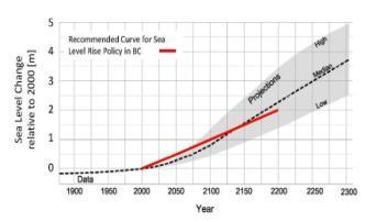
12 Recommended Curve for Sea Level Rise Gray area represents the range of sea level rise projections in scientific literature and in policies adopted in other jurisdictions (e.g. US, UK, New Zealand, Netherlands) guidelines_for_mgr_coastal_flood_land_use-2012.pdf
 Buildings, subdivisions and zoning to the year 2100 Land use strategies to the year 2200 http://www2.gov.")
13 Plan for 0.5m sea level rise by 2050, 1.0m by 2100, and 2.0m by 2200 (based on year 2000 and adjusted for regional uplift or subsidence) Buildings, subdivisions and zoning to the year 2100 Land use strategies to the year guidelines_for_mgr_coastal_flood_land_use-2012.pdf


14 What are the highlights of this amendment?
15 Amendment Highlights General In the absence of more site-specific studies or information by a qualified Professional Engineer, these guidelines are the recommended provincial minimum requirements for land use management in flood hazard areas. Current Guideline No sea level rise Flood hazard based on designated flood with a 1:200 annual exceedance probability (AEP) Amendment Sea level rise (SLR) planning encouraged SLR to 2100 for buildings, zoning, subdivisions SLR to 2200 for land use adaptation 1:200 (minimum) return period water level for combined high tide and storm surge 1:200 AEP event has a 22% probability of occurring once in a 50 year period and 39% probability of occurring once in a 100 year period.
16 Amendment Highlights Flood Construction Level Current Guideline Strait of Georgia: 1.5m above elevation of natural boundary Amendment Greater of FCLs calculated based on tsunami hazard (if present) or: Sea level rise to year 2100 Land uplift/subsidence to 2100 Outside Strait of Georgia: Determined by site-specific analysis of tsunami hazard (professional report) 1:200 Annual Exceedance Probability as determined by probabilistic analyse of tides and storm surge* Wave effects for design storm Freeboard * A more conservative combined method is available as an alternate method to determine FCLs.

17 Two Methods for Determining the Flood Construction Level in Non-Tsunami Areas

18 Two Methods for Determining the Flood Construction Level in Non-Tsunami Areas MORE CONSERVATIVE
19 Amendment Highlights Setbacks Current Guideline Amendment Strait of Georgia: Buildings: 15m from natural boundary Fill/dikes: 7.5m from natural boundary (non-erodible) Erosion hazards may require increased setbacks Special conditions for coastal bluffs Outside Strait of Georgia: Determined by site-specific analysis of tsunami hazard (professional report); minimum 30m Strait of Georgia: 15 m from estimated location of future natural boundary based on: Sea level rise to year 2100 Land uplift/subsidence to :200 water level for high tide + storm surge for design storm Wave effects for design storm Freeboard Outside Strait of Georgia: Determined by site-specific analysis of tsunami hazard (professional report); minimum 30m from estimated location of future natural boundary
20 Areas Subject to Significant Tsunami Hazard Subdivision applications in tsunami prone areas (zones A,B,C and D as shown on the Tsunami Notifications Zones for BC map following slide) Setbacks and FCL for tsunami hazards must be determined for each proposed lot by a qualified Professional Engineer experienced in coastal engineering Setback must be sufficient to protect buildings and must be at least 30m from the 2100 estimated (future) natural boundary Reductions should only be considered where the building can be built to Tsunami FCL on bedrock

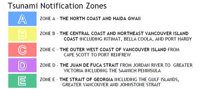
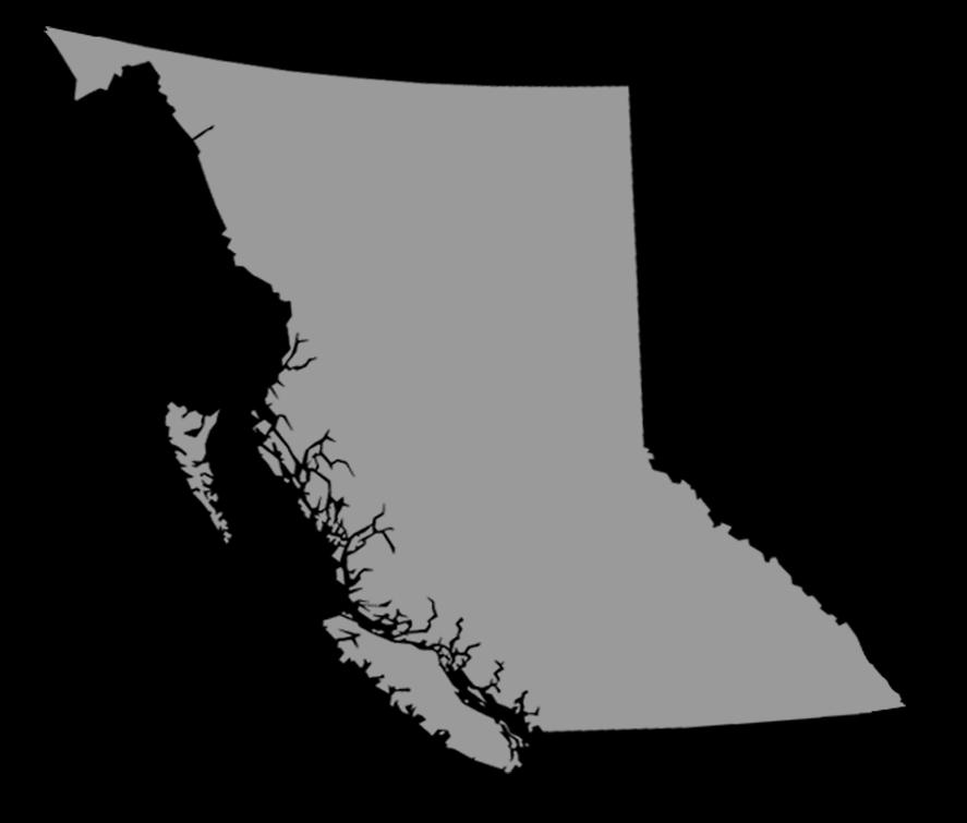
21 Tsunami Notification Zones for BC
 natural")
22 What is an estimated (future) natural boundary?
23 Boundaries Now and Then Natural boundary is defined in the Land Act: "natural boundary" means the visible high water mark of any lake, river, stream or other body of water where the presence and action of the water are so common and usual, and so long continued in all ordinary years, as to mark on the soil of the bed of the body of water a character distinct from that of its banks, in vegetation, as well as in the nature of the soil itself; For defining seal level rise planning areas a new approach involving estimating the future location of the natural boundary is required. The future natural boundary now includes for sea level rise (with regional uplift or subsidence), high tide, storm surge, wave effects, and minimum freeboard.
24 Defining the Sea Level Rise Planning Area Natural versus Estimated (Future) Natural Boundary
25 SLR Planning Areas Sea level rise planning areas should include areas exposed to coastal flood hazards, diked areas and inland floodplains adjacent to tidally influenced rivers. Lands within a designating SLR planning areas may be designated as flood plains under Section 524 of the Local Government Act to allow the specification of flood levels and setbacks, by bylaw, to address sea level rise.


26 Where can I find more information?
27 Resources Amendment to Sections 3.5 and 3.6 of the FHALUMG: Technical reports referenced in the amendment: Draft Policy Discussion Paper (Ausenco Sandwell) Sea Dike guidelines (Ausenco Sandwell) Coastal Flood Hazard Land Use (Ausenco Sandwell) Other sea level rise documents: Sea Level Rise Adaptation Primer An Examination of the Factors Affecting Relative and Absolute Sea Level in Coastal British Columbia All links were tested at the time of posting this presentation, but this document will not be updated to reflect any changes to addresses.
28 Visit the Integrated Flood Hazard Management website at:
FLOOD HAZARD AREA LAND USE MANAGEMENT GUIDELINES. May Ministry of Water, Land and Air Protection. Province of British Columbia
 FLOOD HAZARD AREA LAND USE MANAGEMENT GUIDELINES May 2004 Ministry of Water, Land and Air Protection Province of British Columbia Amended by: Ministry of Forests, Lands, Natural Resource Operations and
FLOOD HAZARD AREA LAND USE MANAGEMENT
 FLOOD HAZARD AREA LAND USE MANAGEMENT Introduction Guidance For Selection of Qualified Professionals and Preparation of Flood Hazard Assessment Reports This document is intended to provide guidance for
DISTRICT OF NORTH SAANICH B Y L A W N O A BYLAW TO MITIGATE COASTAL FLOODING HAZARDS
 DISTRICT OF NORTH SAANICH B Y L A W N O. 1439 A BYLAW TO MITIGATE COASTAL FLOODING HAZARDS WHEREAS: A. If a flood plain has been designated in a District bylaw, the Local Government Act requires that the
REGIONAL DISTRICT OF NANAIMO BYLAW NO. 1469
 REGIONAL DISTRICT OF NANAIMO BYLAW NO. 1469 A BYLAW TO ESTABLISH FLOODPLAINS, CONSTRUCTION LEVELS IN FLOODPLAINS, AND SETBACKS FOR LANDFILL AND STRUCTURES IN FLOODPLAINS WHEREAS Section 910 of the Local
Coastal Shore Jurisdiction in British Columbia
 ISSUE SHEET October 2009 Coastal Shore Jurisdiction in British Columbia Ju ris dic tion: the power, right and authority to interpret and apply the law. (Merriam Webster on-line) Who s in charge of coastal
Floodplain Regulation
 Floodplain Regulation Why Floodplain Regulation? RDCK Floodplain Bylaw Floodplain Management Bylaw No 2080, 2009 Requires minimum elevations and setbacks for floodproofing Identifies Alluvial Fan hazard
City of Chilliwack. Bylaw No. 4519
 City of Chilliwack Bylaw No. 4519 A bylaw to designate land as Floodplain and make provisions in relation to flood control, flood hazard management and development of land that is subject to flooding or
Not By Government Alone Turning Partnership into Great Regional Protected Areas in the Capital Region of British Columbia
 Not By Government Alone Turning Partnership into Great Regional Protected Areas in the Capital Region of British Columbia Jeff Ward, Manager, Planning, Conservation and Development Capital Regional District
REGIONAL DISTRICT OF KITIMAT-STIKINE BYLAW NO. 656
 REGIONAL DISTRICT OF KITIMAT-STIKINE BYLAW NO. 656 A bylaw to designate land within the Regional District of Kitimat-Stikine as a floodplain, and to establish floodplain management procedures and regulations
Ministry of Forest, Lands and Natural Resource Operations
 WHEREAS: PROVINCIAL GENERAL PERMISSION FOR THE USE OF CROWN LAND FOR PRIVATE MOORAGE VERSION: January 17, 2017 (Land Act) A. The Ministry of Forests, Lands and Natural Resource Operations ( the Ministry
Qualified Professionals, Land Owners and Developers. FROM: Development Services. DATE: November 29, 2017
 TO: Qualified Professionals, Land Owners and Developers FROM: Development Services DATE: November 29, 2017 RE: Terms of reference for Natural Hazard and/or Risk Assessments The District of Squamish (District)
NEW HOMES REGISTRY REPORT
 December 218 British Columbia s Monthly NEW HOMES REGISTRY REPORT Leading Housing Market Indicator for B.C. Registered new homes data are a leading indicator of housing and economic 1 activity in British
REPORT TO THE JUAN DE FUCA LAND USE COMMITTEE MEETING OF TUESDAY FEBRUARY 19, 2013
 REPORT TO THE JUAN DE FUCA LAND USE COMMITTEE MEETING OF TUESDAY FEBRUARY 19, 2013 PROPOSED BYLAW NO. 3759 SUBJECT PROPOSED AMENDMENTS TO THE JUAN DE FUCA LAND USE BYLAW, 1992, BYLAW NO. 2040 (AMENDMENT
SENIORS HOUSING REPORT British Columbia
 H o u s i n g M a r k e t I n f o r m a t i o n SENIORS HOUSING REPORT C a n a d a M o r t g a g e a n d H o u s i n g C o r p o r a t i o n Date Released: 2014 Highlights The demand for seniors housing
Current Issues in Managing Flood Protection Works in BC
 Current Issues in Managing Flood Protection Works in BC Electoral Area Directors Forum UBCM 2011 September 27, 2011 Bulkley River Dike Protects Houston BC - May 2011 Neil Peters P.Eng. Inspector of Dikes
DEVELOPMENT PERMIT APPLICATION REQUIREMENTS
 DEVELOPMENT PERMIT APPLICATION REQUIREMENTS Where a parcel is designated within a development permit area (DPA) by an official community plan and a proposed development is not exempt from the DPA guidelines,
Fraser River Escarpment Policy
 Fraser River Escarpment Policy Building Permit Requirements Page 1 of 2 This summary has been prepared by Inspections Services to assist property owners/builders in understanding the policies relating
Guidelines for Hazard Assessment by a Professional in the field of Geotechnical Engineering
 Box 219, 1350 Aster Street, Pemberton, BC V0N 2L0 Ph. 604-894-6371, 800-298-7753 F: 604-894-6526 info@slrd.bc.ca www.slrd.bc.ca Guidelines for Hazard Assessment by a Professional in the field of Geotechnical
Implementation Tools for Local Government
 Information Note #5: Implementation Tools for Local Government This Information Note is a guide only. It is not a substitute for the federal Fisheries Act, the provincial Riparian Areas Regulation, or
A Guide to the Municipal Planning Process in Saskatchewan
 A Guide to the Municipal Planning Process in Saskatchewan A look at the municipal development permit and the subdivision approval process in Saskatchewan May 2008 Prepared By: Community Planning Branch
ALC Bylaw Reviews. A Guide for Local Governments
 2018 ALC Bylaw Reviews A Guide for Local Governments ALC Bylaw Reviews A Guide for Local Governments This version published on: August 14, 2018 Published by: Agricultural Land Commission #201-4940 Canada
Peter Kenward. Profile. Matthew Southwest Bethel
 www.cwilson.com Peter Kenward Partner Municipal Law Commercial Real Estate 604 891 7710 pkenward@cwilson.com Profile Vancouver is a real estate city, and how land is used, developed and conserved here
May 2010 Regional Parks Land Acquisition Fund
 Bulletin 10 May 2010 Regional Parks Land Acquisition Fund Summary of 2009 Acquisitions Capital Regional District Regional Parks The Land Acquisition Fund was established in 2000 for a ten year period (2000-2009)
SUBDIVISION AND DEVELOPMENT APPLICATION FORM
 SUBDIVISION AND DEVELOPMENT APPLICATION FORM Bylaw No. 404, Subdivision and Development Standards Bylaw, 2014 APPLICATION FOR (check box): PRELIMINARY LAYOUT ASSESSMENT (PLA) PLA EXTENSION LOT LINE ADJUSTMENT
MEMO RECOMMENDATION REFERRAL
 MEMO District of Highlands 1980 Millstream Road Victoria, BC V9B 6H1 Tel: 250-474-1773 Fax: 250-474-3677 LBeckett@highlands.ca TO: Christopher D. Coates, Chief Administrative Officer FILE: Referrals FROM:
REQUEST FOR PROPOSALS
 REQUEST FOR PROPOSALS Coastal LiDAR Mapping Closing date and time: 4:00 pm on Monday, May 9, 2016 Closing Location: Regional District of Nanaimo Strategic & Community Development 6300 Hammond Bay Road
Our Proposal. The Proposal
 Page 1 The Land Trust Alliance of BC and partners are promoting the establishment of a province-wide Conservation Tax Incentive Program (CTIP). This would be established through amendment of provincial
Surrey Rental Premises Standards of Maintenance By-law. The Planning and Development Department recommends that Council:
 4 CORPORATE REPORT NO: R115 COUNCIL DATE: May 28, 2012 REGULAR COUNCIL TO: Mayor & Council DATE: May 28, 2012 FROM: General Manager, Planning and Development FILE: 4815-01 SUBJECT: Surrey Rental Premises
NO: R172 COUNCIL DATE: SEPTEMBER 9, Locational Guidelines for Private Liquor Stores (Licensee Retail Stores)
") CORPORATE REPORT NO: R172 COUNCIL DATE: SEPTEMBER 9, 2013 REGULAR COUNCIL TO: Mayor & Council DATE: September 9, 2013 FROM: General Manager, Planning and Development FILE: 0340-01 SUBJECT: Locational Guidelines
CORPORATE REPORT NO: R172 COUNCIL DATE: SEPTEMBER 9, 2013 REGULAR COUNCIL TO: Mayor & Council DATE: September 9, 2013 FROM: General Manager, Planning and Development FILE: 0340-01 SUBJECT: Locational Guidelines
CAPITAL REGIONAL DISTRICT BYLAW NO (As amended by Bylaw Nos. 2960, 3100, 3218, 3432, 3805, 3893, 3904, 4063, 4249)
") CAPITAL REGIONAL DISTRICT BYLAW NO. 2758 (As amended by Bylaw Nos. 2960, 3100, 3218, 3432, 3805, 3893, 3904, 4063, 4249) Consolidated version authorized in accordance with Bylaw No. 3014, CRD Consolidation
CAPITAL REGIONAL DISTRICT BYLAW NO. 2758 (As amended by Bylaw Nos. 2960, 3100, 3218, 3432, 3805, 3893, 3904, 4063, 4249) Consolidated version authorized in accordance with Bylaw No. 3014, CRD Consolidation
River Road - Civil Design Report. Appendix D. Flood Hazard Map. Beca //04 August // NZ // page 38
 River Road - Civil Design Report Appendix D Flood Hazard Map Beca //04 August 2016 3124460 // NZ1-12891696-39 0.39 // page 38 Regional scale flood hazard mapping Waikato Regional Council holds regional
Chapter 19. Water, Riparian, and Foreshore Rights. Key Terms. Water Rights. Riparian Rights. Chapter 19: Water, Riparian, and Foreshore Rights
 207 Chapter 19 Water, Riparian, and Foreshore Rights This chapter provides some basic background information and lists resources for research projects relating to water, riparian and foreshore rights.
Capital Regional District. Regional Parks Land Acquisition Strategy 2015 to 2017
 Capital Regional District Regional Parks Land Acquisition Strategy 2015 to 2017 CRD Board Approved July 8, 2015 Table of Contents EXECUTIVE SUMMARY.... iv 1.0 BACKGROUND... 1 2.0 PURPOSE.... 1 3.0 REGIONAL
MonthlyStatistics DECEMBER 2017
 MonthlyStatistics DECEMBER 2017 FOR IMMEDIATE RELEASE January 2, 2018 VIREB Posts the Strongest December on Record NANAIMO, BC The Vancouver Island Real Estate Board (VIREB) reports that on a seasonally
Residential Strata Title Conversion Policy, 2010
 Policy No. 8.6 Adopted by Council: October 25, 2010 Residential Strata Title Conversion Policy, 2010 Policy Statement: The District of Sooke Strata Title Conversion Policy is designed to outline the various
Application of tsunami modelling for escape and refuge planning in Aceh (Indonesia)
") Application of tsunami modelling for escape and refuge planning in Aceh (Indonesia) Odelinde Nieuwenhuis, DHV BV Deepak Vatvani, Deltares (Delft Hydraulics) Jeroen Alberts, DHV BV Dick Jansen, DHV BV May
Application of tsunami modelling for escape and refuge planning in Aceh (Indonesia) Odelinde Nieuwenhuis, DHV BV Deepak Vatvani, Deltares (Delft Hydraulics) Jeroen Alberts, DHV BV Dick Jansen, DHV BV May
Fraser River Model Project fonds
 Fraser River Model Project fonds Compiled by Erwin Wodarczak (1998) Last revised November 2010 University of British Columbia Archives Table of Contents Fonds Description o Title / Dates of Creation /
PHASED STRATA APPLICATION FORM
 PHASED STRATA APPLICATION FORM Bylaw No. 404, Subdivision and Development Standards Bylaw, 2014 APPLICATION FOR (check box): FORM P APPROVAL FORM P AMENDMENT PHASED STRATA PLAN APPROVAL DESCRIPTION OF
Manufactured Home Study
 Manufactured Home Study An Examination of Issues Facing Mobile Home Park Communities Across B.C. Date: February 2007 Presented To: BC Housing Housing Policy Branch Presented By: McClanaghan & Associates
Overview 7/6/2016. Agenda. Introduction to ParcelMap BC LGMA Annual Conference Nanaimo, BC. ParcelMap BC Primary Goal
 Agenda Overview ParcelMap BC Primary Goal ParcelMap BC Key Benefits ParcelMap BC Advisory Committee BC Assessment Grant Program Introduction to ParcelMap BC LGMA Annual Conference Nanaimo, BC Mike Thomson
Date: April 15, 2016 Meeting Date: May 6, Park for Other Land to be used for Park Purposes Bylaw No. 1233, 2016 ;
 Section G 1.1 To: From: Regional Parks Committee Renato Jadrijev, Senior Property Negotiator, Financial Services Chris Plagnol, Director, Board and Information Services/Corporate Officer, Legal and Legislative
Mayor Darrell R. Mussatto and Members of Council ENHANCED NOTICE AND ASSISTANCE OPTIONS FOR TENANT DISPLACEMENT
 14, & \ li f&a Division Manager Director CAO The Corporation of THE CITY OF NORTH VANCOUVER COMMUNITY DEVELOPMENT DEPARTMENT REPORT To: From: SUBJECT: Mayor Darrell R. Mussatto and Members of Council Wendy
VI. SAFETY ELEMENT I. INTRODUCTION A. PURPOSE B. AUTHORITY. 1. Safety
 AB 162 and SB 1241 Amendment to the Safety Element New sections are underlined, deleted sections are shown as strikethrough and the denotes text remaining in place. VI. SAFETY ELEMENT I. INTRODUCTION A.
Date: May 15, 2014 Meeting Date: May 23, Corporation of Delta Proposed Amendment to Metro Vancouver 2040: Shaping our Future for Southlands
 Section G 1.1 To: From: GVRD Board of Directors Allan Neilson, General Manager, Planning, Policy and Environment Department Elisa Campbell, Director of Regional and Strategic Planning Planning, Policy
Board of Trustees Meeting Regular Minutes - Approved March 29, 2014
 Present: Bruce Jolliffe, Comox Valley RD (Chair) Brenda Leigh, Strathcona RD (Vice-Chair) Ron Kerr, Campbell River Hugh MacKinnon, Comox Manno Theos, Courtenay Kate Greening, Cumberland Tom Duncan, Duncan
Sea-Level Rise and Flooding: Legal, Fiscal, & Regulatory Challenges for Local Governments, Part I
 Sea-Level Rise and Flooding: Legal, Fiscal, & Regulatory Challenges for Local Governments, Part I Click to edit Master title style Click to edit Master subtitle style Thomas Ruppert Coastal Planning Specialist
MonthlyStatistics JANUARY 2018
 MonthlyStatistics JANUARY 2018 FOR IMMEDIATE RELEASE February 1, 2018 Sales Return to Seasonal Norms in January NANAIMO, BC Coming off the busiest December on record, sales in the VIREB area returned to
Interior health. Subdivision Referrals and Soils Information
 Interior health Subdivision Referrals and Soils Information Contents What is a subdivision? Legislation Roles and Responsibilities Lot Size Referral Process Criteria for Authorized Person What is a Subdivision?
MonthlyStatistics MARCH 2018
 MonthlyStatistics MARCH 2018 FOR IMMEDIATE RELEASE April 3, 2018 Sales Down From 2017 But Prices Still Rising Due to Limited Inventory NANAIMO, BC Sales of single-family homes, apartments, and townhouses
Proposed Horowhenua District Plan
 Proposed Horowhenua District Plan Natural Hazards Hearing: 15 April 2013 Officer Right of Reply and Response to Commissioners Questions Officer Right of Reply We have considered the evidence presented
Summary of Changes: June 1, 2011 BN Policy and Procedure update to reflect reorganization of resource ministries April 2011
 APPROVED AMENDMENTS: Effective Date Briefing Note /Approval Summary of Changes: June 1, 2011 BN 175892 Policy and Procedure update to reflect reorganization of resource ministries April 2011 FILE: 11040-00
ARTICLE 5 MINOR SUBDIVISION/LAND DEVELOPMENT
 ARTICLE 5 MINOR SUBDIVISION/LAND DEVELOPMENT SECTION 501 ONLY FINAL PLAN REQUIRED The classification of a proposed subdivision as a "Minor Subdivision" shall only require the submission, review and approval
SURVEYING BOUNDARIES FORESHORE AND PROPERTY OUTLINE DEFINITIONS JURISDICTIONAL ISSUES TENURE ISSUES PRACTICAL SURVEY ISSUES RECOMMENDATIONS
 SURVEYING BOUNDARIES OUTLINE DEFINITIONS JURISDICTIONAL ISSUES TENURE ISSUES PRACTICAL SURVEY ISSUES RECOMMENDATIONS DEFINITIONS FORESHORE: the part of the seashore between the high water mark and the
Permits and Inspections Policy
 Planning and Development Department Permits and Inspections Division 1 Centennial Square Victoria, BC V8W 1P6 T 250.361.0344 F 250.385.1128 Permits and Inspections Policy Letters of Assurance for Tenant
ENVIRONMENTAL ASSESSMENT / INFRASTRUCTURE PROJECTS
 Mailing Address: 5 Shoreham Drive, Downsview, ON M3N 1S4 Office location: 101 Exchange Avenue, Vaughan, ON L4K 5R6 Tel: 416-661-6600 Fax: 416-661-6898 www.trca.ca ENVIRONMENTAL ASSESSMENT / INFRASTRUCTURE
Monthly Statistics Package June 2015
 Vancouver Island Real Estate Board Monthly Statistics Package June 2015 FOR IMMEDIATE RELEASE July 2, 2015 Robust Housing Market Shows No Signs of Slowing Down NANAIMO, BC A robust provincial economy and
R esearch Highlights LEVIES, FEES, CHARGES AND TAXES ON NEW HOUSING (2002) Introduction. Municipal Levies, Fees and Charges
 Introduction. Municipal Levies, Fees and Charges") R esearch Highlights December 2002 Socio-economic Series 115 LEVIES, FEES, CHARGES AND TAXES ON NEW HOUSING (2002) Introduction Government-imposed costs on new housing can be substantial. They have a direct
R esearch Highlights December 2002 Socio-economic Series 115 LEVIES, FEES, CHARGES AND TAXES ON NEW HOUSING (2002) Introduction Government-imposed costs on new housing can be substantial. They have a direct
Zoning Bylaw Amendment 1926 Vera Drive (Thomas) Lazo North (Electoral Area B) Lot C, Block 29, Comox District, Plan 32630, PID
 Lazo North (Electoral Area B) Lot C, Block 29, Comox District, Plan 32630, PID") Staff report DATE: March 27, 2018 TO: FROM: RE: Chair and Directors Electoral Areas Services Committee Russell Dyson Chief Administrative Officer Zoning Bylaw Amendment 1926 Vera Drive (Thomas) Lazo North
Staff report DATE: March 27, 2018 TO: FROM: RE: Chair and Directors Electoral Areas Services Committee Russell Dyson Chief Administrative Officer Zoning Bylaw Amendment 1926 Vera Drive (Thomas) Lazo North
Ministry of Environment and Climate Change Strategy and Ministry of Forests, Lands, Natural Resource Operations and Rural Development
 Ministry of Environment and Climate Change Strategy and Ministry of Forests, Lands, Natural Resource Operations and Rural Development NAME OF POLICY: APPLICATION: ISSUANCE: IMPLEMENTATION: LEGISLATIVE
The Permit & Licence Process at the City of Vancouver. Presented By Bob Gill July 24, 2017
 The Permit & Licence Process at the City of Vancouver Presented By Bob Gill July 24, 2017 Presentation Overview 1. Why does the City Issue Permits & Licences? 2. What types of Permits, Licences and other
DEVELOPMENT APPLICATION FORM
 #300 465 Victoria Street, Kamloops, BC V2C 2A9 Telephone: (250) 377-8673, Toll Free: 1-877-377-8673 Fax: (250) 372-5048, Website: www.tnrd.ca DEVELOPMENT APPLICATION FORM FOR OFFICE USE ONLY Date Received
MonthlyStatistics NOVEMBER 2017
 MonthlyStatistics NOVEMBER 2017 FOR IMMEDIATE RELEASE December 1, 2017 Lack of Inventory Continues to Drive Housing Market NANAIMO, BC The Vancouver Island Real Estate Board (VIREB) reports that single-family
/THE CORPORATION OF THE CITY OF PENTICTON MEMORANDUM
 /THE CORPORATION OF THE CITY OF PENTICTON MEMORANDUM TO: Administrator FILE: 6420.40 REP.# FROM: Donna Butler, Planner DATE: July 17/06 RES.# SUBJECT: Mobile Home Park Redevelopment Policy CAO COMMENTS:
REGIONAL DISTRICT OF KITIMAT-STIKINE BYLAW NO. 676
 REGIONAL DISTRICT OF KITIMAT-STIKINE BYLAW NO. 676 A Bylaw to Regulate Medical Marihuana Production Facilities within the Regional District of Kitimat-Stikine The Board of the Regional District of Kitimat-Stikine,
MonthlyStatistics MARCH 2017
 MonthlyStatistics MARCH 2017 FOR IMMEDIATE RELEASE April 3, 2017 Low Inventory Continues to Limit Vancouver Island Buyers NANAIMO, BC The Vancouver Island Real Estate Board (VIREB) reports that in March
MonthlyStatistics APRIL 2018
 MonthlyStatistics APRIL 2018 FOR IMMEDIATE RELEASE May 1, 2018 Sales Holding Steady Amid Rising House Prices NANAIMO, BC Sales of single-family homes in the VIREB area rose by 20 per cent month over month
Crown Land Use Policy: Industrial - General APPROVED AMENDMENTS: Summary of Changes: /Approval
 APPROVED AMENDMENTS: Effective Date Briefing Note /Approval Summary of Changes: March 22, 2011 BN175798 Amendment to clarify pricing for aquatic lands. March 31, 2011 BN 175892 Policy and Procedure update
4.0. Residential. 4.1 Context
 4. 0Residential 4.1 Context In 1986, around the time of Burnaby s last Official Community Plan, the City had a population of 145,000 living in 58,300 residential units. By 1996, there were 179,000 people
These can be obtained at the City s Engineering Department or on the City s website (
 Subdivision Application Guide This handout provides information on the requirements and processes for a subdivision of land. It is intended for general guidance only. Applicants should also refer to: Official
MonthlyStatistics AUGUST 2018
 MonthlyStatistics AUGUST 2018 FOR IMMEDIATE RELEASE September 4, 2018 Sales Bounce Back Slightly From July But Still Lower Than in 2017 NANAIMO, BC Sales of single-family homes in August were seven per
TEMPORARY USE PERMITS (TUP) A Guide to the Municipal Approvals Process in Chilliwack September 2014
 A Guide to the Municipal Approvals Process in Chilliwack September 2014") Planning & Strategic Initiatives Department TEMPORARY USE PERMITS (TUP) A Guide to the Municipal Approvals Process in Chilliwack September 2014 Introduction The City of Chilliwack has prepared this brochure
Planning & Strategic Initiatives Department TEMPORARY USE PERMITS (TUP) A Guide to the Municipal Approvals Process in Chilliwack September 2014 Introduction The City of Chilliwack has prepared this brochure
Land Procedure: Land Exchange Indian Reserve Lands APPROVED AMENDMENTS: Summary of Changes: /Approval
 APPROVED AMENDMENTS: Effective Date Briefing Note /Approval Summary of Changes: June 1, 2011 BN 175892 Policy and Procedure update to reflect reorganization of resource ministries April 2011 PAGE: 2 Table
Strengthening Community. Building Opportunity
 Whitecap Dakota First Nation Keeping It Rural 2015 Conference Strengthening Community Building Opportunity 1 Keeping It Rural 2015 Conference Presentation Overview Whitecap Community Profile Building the
MONTHLY STATISTICS PACKAGE
 MONTHLY STATISTICS PACKAGE FEBRUARY 2019 FOR IMMEDIATE RELEASE March 1, 2019 Guideline B-20 Continues to Dampen Housing Sales NANAIMO, BC Sales of single-family homes in February board-wide dipped by 28
MonthlyStatistics MAY 2018
 MonthlyStatistics MAY 2018 FOR IMMEDIATE RELEASE June 1, 2018 Single-Family Benchmark Price Surpasses $500,000 in May NANAIMO, BC The benchmark price of a single-family home in the VIREB area broke the
STRATA TITLE CONVERSION APPLICATION FORM
 2205 Otter Point Rd., Sooke B.C., V9Z 1J2 Tel: 250-642-1634 Fax: 250-642-0541 www.sooke.ca STRATA TITLE CONVERSION APPLICATION FORM DESCRIPTION OF PROPERTY Civic Address: Legal Description: Lot Block Section
Pop Growth Rate. Population % 5.9% 8.6. Implemented No Prevention Mandatory Unique Low (< $10,000)
") C OST E FFICIENT C LIMATE A DAPTATION IN THE N ORTH A TLANTIC 29 3.1.2. SCARBOROUGH, ME Population Density Form of Government Category CRS Rating 270/ sq. mi. Town Suburban Oceanfront Not Participating
C OST E FFICIENT C LIMATE A DAPTATION IN THE N ORTH A TLANTIC 29 3.1.2. SCARBOROUGH, ME Population Density Form of Government Category CRS Rating 270/ sq. mi. Town Suburban Oceanfront Not Participating
BC Assessment 2006 Annual Service Plan Report. Appendix C: Supplementary 2007 Assessment Roll Information - Statistics
 BC Assessment 2006 Annual Service Plan Report Appendix C: Supplementary 2007 Assessment Roll Information - Statistics Refer to: 2006 Annual Report - Performance Measures 1 and 2 Complaints to the Property
ZONING BOARD OF APPEALS APPLICATION
 ZONING BOARD OF APPEALS APPLICATION Town of Westbrook ZBA Appeal No. Land Use Department Mulvey Municipal Center, 866 Boston Post Road, Connecticut 06498 (860)-399-3047 Fax (860)-399-2084 ZBA App. Fee
MonthlyStatistics FEBRUARY 2018
 MonthlyStatistics FEBRUARY 2018 FOR IMMEDIATE RELEASE March 1, 2018 Buoyant Sellers Market Continues NANAIMO, BC Last month, 316 single-family homes sold on the Multiple Listing Service (MLS ) System compared
APPENDIX B COMPLIANCE WITH THE GOVERNMENT CODE
 APPENDIX B COMPLIANCE WITH THE GOVERNMENT CODE A. GENERAL PLAN AMENDMENT PROCEDURE In general, local governments may not amend any of the mandatory elements of the General Plan (e.g. Land Use, Open Space,
DISTRICT OF CENTRAL SAANICH SOIL REMOVAL OR DEPOSIT PERMIT APPLICATION. Applicant Information (filled out by applicant)
") SOIL REMOVAL OR DEPOSIT PERMIT APPLICATION Applicant Information (filled out by applicant Name of applicant (if company, insert company name and individual representative applying on behalf of company
SOIL REMOVAL OR DEPOSIT PERMIT APPLICATION Applicant Information (filled out by applicant Name of applicant (if company, insert company name and individual representative applying on behalf of company
Schedule A to Bylaw No. 477, 2013 APPLICATION FEES 1. Official Community Plan Bylaw Amendment $ Zoning Bylaw Amendment $ Simultaneous Of
 Schedule A to Bylaw No. 477, 2013 APPLICATION FEES 1. Official Community Plan Bylaw Amendment $1000 2. Zoning Bylaw Amendment $1000 3. Simultaneous Official Community Plan and Zoning Bylaw Amendment $1500
The Joe Rich Rural Land Use Bylaw
 The purpose of this review and update This process is a review and update of the (RLUB) future land use policies and current land use regulations to ensure that they reflect and respond to the needs of
Some Social and Policy Implications of Shore Erosion. James G. Titus U.S. Environmental Protection Agency
 Some Social and Policy Implications of Shore Erosion James G. Titus U.S. Environmental Protection Agency Four copyrighted photos included in briefing as fair use Deleted because duplication may violate
Open Space Model Ordinance
 Open Space Model Ordinance Section I. Background Open space development has numerous environmental and community benefits, including: 1) Reduces the impervious cover in a development. Impervious cover
MonthlyStatistics JULY 2018
 MonthlyStatistics JULY 2018 FOR IMMEDIATE RELEASE August 1, 2018 Prices Continue to Sizzle in Summer Housing Market NANAIMO, BC Prices of single-family homes, apartments, and townhouses continue to rise
Town of Lisbon, Maine SUBDIVISION REVIEW APPLICATION
 Date Received: Fee Paid (amount): Applicant: Town of Lisbon, Maine SUBDIVISION REVIEW APPLICATION Subdivision Name/Title: This application must be received at the Town Office by close of business on the
Monthly Statistics Package July 2016
 Vancouver Island Real Estate Board Monthly Statistics Package July 2016 FOR IMMEDIATE RELEASE August 2, 2016 Home Sales a Bit Cooler in July But Significantly Higher Than Last Year NANAIMO, BC Home sales
Temporary Use Permit Application Form
 Strategic & Community Development 6300 Hammond Bay Road Nanaimo, BC V9T 6N2 (250) 390-6510 (Nanaimo) (250) 954-3798 (District 69) 1-877-607-4111 (within BC) Fax:(250) 390-7511 planning@rdn.bc.ca Temporary
Georgia Street W, PO Box 10123, Pacific Centre, Vancouver, BC V7Y 1C6
 Select Standing Committee on Finance and Government Services c/o Parliamentary Committee Office Room 224, Parliament Buildings Victoria, BC V8V 1X4 Submitted via online consultation portal: https://consultations.leg.bc.ca/submission/create?cons=budget2018.
How to find your home s required finished floor elevation according to City s proposed new Floodplain Ordinance
 City of Mexico Beach New Floodplain Ordinance How to find your home s required finished floor elevation according to City s proposed new Floodplain Ordinance This Ordinance only affects the following property
STAFF REPORT. DATE: February 26, 2018 FILE: EASC. Chair and Directors, Electoral Areas Services Committee. Chief Administrative Officer
 STAFF REPORT DATE: February 26, 2018 TO: Chair and Directors, Electoral Areas Services Committee FILE: 0540-04 EASC FROM: RE: Dave Leitch Chief Administrative Officer BYLAWS NO. 305 & 306 CONSULTATION
ADDENDUM A TO CONTRACT OF PURCHASE AND SALE
 ADDENDUM A TO CONTRACT OF PURCHASE AND SALE The following terms replace, modify, and where applicable override the terms of the attached contract of purchase and sale, and any modifications, amendments,
METHODOLOGY GUIDE VALUING LANDS IN TRANSITION IN ONTARIO. Valuation Date: January 1, 2016
 METHODOLOGY GUIDE VALUING LANDS IN TRANSITION IN ONTARIO Valuation Date: January 1, 2016 August 2017 August 22, 2017 The Municipal Property Assessment Corporation (MPAC) is responsible for accurately assessing
CITY OF VANCOUVER ADMINISTRATIVE REPORT
 A11 CITY OF VANCOUVER ADMINISTRATIVE REPORT Report Date: September 28, 2006 Author: Cameron Gray Phone No.: 604.873.7207 RTS No.: 06245 VanRIMS No.: 11-2200-21 Meeting Date: October 17, 2006 TO: FROM:
City of Brandon Brownfield Strategy
 City of Brandon Brownfield Strategy 2017 Executive Summary A brownfield is a property, the expansion, redevelopment, or reuse of which may be complicated by the presence or potential presence of a hazardous
GOVERNMENT CODE SECTION GOVERNMENT CODE SECTION 65302
 GOVERNMENT CODE SECTION 65300 65300. Each planning agency shall prepare and the legislative body of each county and city shall adopt a comprehensive, long-term general plan for the physical development
DISTRICT OF SICAMOUS REQUEST FOR EXPRESSIONS OF INTEREST MAIN STREET REDEVELOPMENT
 District of Sicamous 446 Main Street PO Box 219 Sicamous, BC V0E 2V0 T: 250 836 2477 F: 250 836 4314 E: info@sicamous.ca sicamous.ca DISTRICT OF SICAMOUS REQUEST FOR EXPRESSIONS OF INTEREST MAIN STREET
For Committee. Mobile Home Park Redevelopment Tenant Assistance Policy
 For Committee Our File: 10-5080-01/000/2005-1 Doc #: 376372.v1 To: From: Subject: For: City Manager General Manager Planning and Development Mobile Home Park Redevelopment Tenant Assistance Policy Committee