CITY OF MORDEN BY-LAW Ken Wiebe Mayor. John Scarce
|
|
|
- Bertha Davis
- 6 years ago
- Views:
Transcription
 of the The Planning Act (the Act), the Morden-Stanley-Thompson-Winkler (MSTW) Planning District, which includes the City of Morden, has, by")
1 BY-LAW BEING a by-law of the City of Morden to regulate and control the use and development of land and buildings within the municipal limits of the City of Morden. WHEREAS pursuant to the provisions of Subsection 40(1) of the The Planning Act (the Act), the Morden-Stanley-Thompson-Winkler (MSTW) Planning District, which includes the City of Morden, has, by By-law, adopted The MSTW Planning District Development Plan By-law ; AND WHEREAS Section 68 of the Act provides that a Municipal Council within a Planning District must adopt a zoning by-law that is generally consistent with the Development Plan by-law; NOW THEREFORE the Municipal Council of the City of Morden, in meeting duly assembled, enacts as follows: 1. The City of Morden Zoning By-law No , and all amendments thereto, are hereby rescinded. 2. The Zoning By-law, attached hereto and marked as Schedule A, is hereby adopted. 3. This By-law shall be known as the City of Morden Zoning By-law. 4. The City of Morden Zoning By-law shall take force and effect on the date of Third Reading of this By-law. DONE AND PASSED in Council assembled in Council Chambers, in Morden, Manitoba, this 26th day of June, A.D CITY OF MORDEN Ken Wiebe Mayor John Scarce City Manager Read a first time this 24 th day of April 2017 Read a second time as amended this 26 th day of June 2017 Read a third time this 26 th day of June 2017 I, John Scarce, City Manager for the City of Morden hereby certify the above to be a true and correct copy of Bylaw No as read a third time by Council at the Regular Meeting held on the June 26, Dated at the City of Morden, in Manitoba, this June 26, John Scarce, City Manager As amended by by-laws: 17BL18; 17BL21;
2 THE CITY OF MORDEN ZONING BY-LAW BEING SCHEDULE A ATTACHED TO BY-LAW NO OF THE CITY OF MORDEN 2
3 PART I SCOPE & ADMINISTRATION 1.0 Title & Contents 1.1 Title 1.2 Intent & Purpose 1.3 Regulation of Uses 1.4 Contents of the By-Law 1.5 Headings & Titles 1.6 Interpretation 1.7 Units of Measurement 1.8 Effective Date 1.9 Control of Development 1.10 Relationship to Former By-Laws 1.11 Validity 2.0 Non-Conforming Buildings, Structures, Lots, & Uses 3.0 Zoning District Boundaries 3.1 Zoning Maps 3.2 Boundary Determination 4.0 Approval Required for Development 5.0 Legislation, Policies, & Regulations 5.1 Compliance 5.2 Public Utilities & Services 6.0 Authority & Responsibilities of the Designated Officer 6.1 Establishment & Appointment 6.2 Designated Officer Duties & Responsibilities 6.3 Entry for Inspection & Other Purposes 6.4 Conditional Uses & Variances 6.5 Minor Variances 6.6 Public Inspection of Applications 6.7 Maintenance & Inspection of By-Law 7.0 Responsibilities of Council 8.0 Duties of the Owner 9.0 Development Procedures 9.1 General Conditions 9.2 No Development Permit Required 9.3 Development Permit Application Required Information 10.0 Conditions Attached to a Development Permit 11.0 Enforcement and Penalties 11.1 Offences 11.2 Penalties 11.3 Suspension or Revocation of the Development Permit 12.0 Zoning Amendments 12.1 Text & Mapping Amendments 12.2 Review & Processing of Amendments 12.3 Notification of Amendments 13.0 Conditional Uses & Variances 13.1 Conditional Uses 13.2 Variances 14.0 Subdivisions PART II GENERAL PROVISIONS 15.0 Applicability 16.0 Connecting to Municipal Services 17.0 Streets 18.0 Moving of Structures 19.0 Land Drainage 20.0 Building Grade 21.0 Excavation, Stripping, & Grading 22.0 Land Use 22.1 Use Categories 22.2 Permitted, Conditional, Accessory, Temporary, Not Permitted, & Prohibited Uses 22.3 Use Specific Standards 23.0 Dimensions & Design 23.1 Built Form 23.2 Exterior Lighting, Landscaping, & Screening 3
4 23.3 Parking, Loading, & Waste Materials Storage 23.4 Signs PART III ZONING DISTRICTS 24.0 Applicability 25.0 Residential Districts 25.1 Intent 25.2 Land Use 25.3 Dimensions & Design 26.0 Commercial & Institutional Districts 26.1 Intent 26.2 Land Use 26.3 Dimensions & Design 27.0 Industrial Districts 27.1 Intent 27.2 Land Use 27.3 Dimensions & Design 28.0 Agricultural, Parks, & Public Works Districts 28.1 Intent 28.2 Land Use 28.3 Dimensions & Design 29.0 Mixed-Use Districts 29.1 Intent 29.2 Land Use 29.3 Dimensions & Design PART IV USE SPECIFIC STANDARDS 30.0 Applicability 30.1 Secondary Suites Vehicular-Oriented Uses 30.2 Garden Suites 30.3 Home Occupations 30.4 Bed & Breakfasts 30.5 Multiple Family Dwellings in Townhouse Form 30.6 Bare Land Condominium Developments 30.7 Swimming Pools 30.8 Vehicular-oriented Uses 30.9 Restaurants & Drinks Establishments Campsites Adult Uses Adjacent to Residential & Residential-related, Public & Institutional, Cultural & Entertainment Areas Group Homes Buildings & Structures Accessory to Farming/Ranching Livestock Production Operations 3015 Aggregate Extraction Operations Mobile Food Vehicles PART V SPECIAL YARDS 31.0 Applicability 31.1 Flood Risk Areas 31.2 Solid Waste Disposal Facilities 31.3 Wastewater Treatment Areas 31.4 Railway Lines & Facilities 31.5 High Pressure Natural Gas & Hydro Transmission Utilities 31.6 Provincial Highways 31.7 Airport Vicinity Area 31.8 Commercial or Industrial Development Adjacent to Residential Districts 31.9 Livestock Production Operations Natural Resource Developments Lake Minnewasta Area PART VI ZONING DISTRICT OVERLAYS 32.0 Applicability 32.1 Pembina Connection 32.2 Heritage Homes 4
5 PART VII - DEFINITIONS 33.0 General Definitions 34.0 Use Definitions PART VIII ZONING MAP 5
6 PART I SCOPE & ADMINISTRATION 1.0 Title & Contents 1.1 Title This by-law may be cited as the City of Morden Zoning By-law and shall apply to all lands within the limits of the City of Morden. 1.2 Intent & Purpose The regulations established by this by-law are deemed necessary in order: 1) To ensure general conformity with the objectives and policies of the MSTW Planning District Development Plan. 2) To outline the authorities, responsibilities, and duties of City of Morden Council (Council), the Designated Officer, and the landowner and/or developer as they relate to this by-law. 3) To regulate the following: a) all buildings and structures erected hereafter; b) all uses or changes in use of all buildings, structures and land established hereafter; c) all structural alterations, relocations, or demolitions of existing buildings and structures occurring hereafter; d) the increase or decrease of the average grade of a site by 0.5 ft [0.15 m] or more in height; and e) all enlargements or additions to existing buildings, structures, and uses. 1.3 Regulation of Uses 1) No land, building, or structure shall be constructed, enlarged, placed, used, or occupied except for a use that: a) is listed in the zoning district as: i) a permitted use development; ii) a conditional use development, subject to approval as such; b) is an accessory use, building, or structure; c) is a temporary use, building, or structure authorized for a period of time by the Designated Officer; or d) has been granted a use variance in accordance with the Act. 2) Where any land, building, or structure is used for more than one purpose, all provisions of the by-law relating to each use shall apply. Where there is a conflict, the more restrictive regulations shall govern. 1.4 Contents of the by-law The contents of this by-law include: 1) Part I provides the Scope & Administration. 2) Part II provides the General Provisions. 3) Part III provides the Zoning Districts. 4) Part IV provides the Use Specific Standards. 5) Part V provides the Special Yards. 6) Part VI provides the Zoning District Overlays. 7) Part VII provides the Definitions. 8) Part VIII provides the Zoning Maps. 1.5 Headings & Titles 6
7 Despite any other provision of this by-law or any other by-law passed by Council to the contrary, headings and titles within this by-law shall be deemed to form part of the text of this by-law. 1.6 Interpretation Terms and words in this by-law as defined in the Act have the meaning expressed therein. Other terms and words, unless the context otherwise requires, are defined in PART VII. 1) Words, phrases, and terms defined herein shall be given the defined meaning. 2) Words, phrases, and terms neither defined herein nor defined in other bylaws of the City of Morden shall be given their usual and customary meaning except where, in the opinion of Council, the context indicates a different meaning. 3) The phrase used for includes arranged for, maintained for, designed for, or occupied for. 4) Unless the context clearly indicates the contrary, where a regulation involves two or more items, conditions, provisions, or events connected by the conjunctions and, or, or and/or, the conjunctions shall be interpreted as follows: a) and indicates that all the connected items, conditions, provisions, or events shall apply; b) or indicates that the connected items, conditions, provisions, or events shall apply singly but not in combination; and c) and/or indicates that all the connected items, conditions, provisions, or events may apply singly or in combination. 5) The word includes shall not limit a term to the specified example, but is intended to extend the meaning to all instances or circumstances of like kind or character. 1.7 Units of Measurement For convenience, this by-law contains both metric and imperial measurements. In cases where a discrepancy occurs between the metric and imperial standards, the imperial unit shall govern. 1.8 Effective Date This by-law shall be in full force and effect when the Council of the City of Morden has given it 3 rd Reading. 1.9 Control of Development No development, other than that designated in section 9.2, shall be undertaken in the City of Morden unless an application has been approved and a Development Permit has been issued Relationship to Former By-Laws The adoption of this by-law shall not prevent any pending or future legal action to deal with any existing land use violations Validity Should a court of competent jurisdiction declare any section or part of a section of this by-law invalid, the same shall not affect provisions of the by-law as a whole or any part thereof beyond that which is declared invalid. 2.0 Non-Conforming Buildings, Structures, Lots, & Uses 1) When on or before the day on which this by-law or any by-law for the amendment of it comes into force, a Development Permit has been issued, and the enactment of the by-law would render the development in respect of which the permit was issued a non-conforming building, structure, lot, or use, the Development Permit continues in effect despite the enactment of the by-law. 7
8 2) A non-conforming use of part of a lot shall not be extended or transferred in whole or in part to any other part of the lot and no additional buildings shall be erected upon the lot while the non-conforming use continues. 3) A building containing a non-conforming use may be enlarged or extended, provided that the enlargement or extension conforms to all applicable dimensional standards for the zoning district in which the building is located. 4) Any legal existing lot that does not conform to the minimum lot area, lot width, or access regulations herein for the zoning district within which it is located shall be deemed to be a complying lot, may continue to be used as if it conformed to all such regulations, and may have a building constructed or altered on the land if all other requirements of the zoning by-law are met such as yards, building height, and floor area. 5) A lot that is separated from the street upon which it would otherwise front by a parcel acquired by the City of Morden for the purpose of future streetwidening shall be deemed to have frontage on that street and a building or structure may be erected, enlarged, altered, or repaired and used on such lot provided that it conforms to all other requirements of this by-law. 6) A lot that has a lesser area and/or width than required by this by-law that is created by expropriation, street-widening, or other land acquisition by the City of Morden and the non-conformity is due to no other cause, the lot is deemed to comply with this by-law and a building or structure may be erected, altered, enlarged, or repaired and used provided that it conforms to all other requirements of this by-law. 7) A building or structure that has lesser yards than required by this by-law that is created in the manner described in (6), the building or structure is deemed to comply with this by-law. 8) Any owner may apply for a Non-Conforming Certificate in accordance with provisions of the Act and, in so doing, must provide adequate documentation to support the application, to the satisfaction of the Designated Officer. 9) A non-conformity may be altered beyond what is provided for in sections 2.0 (1) to 2.0 (7), by way of a variance order by Council. 3.0 Zoning District Boundaries 3.1 Zoning Maps The Zoning Maps are Part VIII of this by-law, which divide the City of Morden into Zoning Districts and specify regulations applying to particular lands. 3.2 Boundary Determination Should uncertainty or dispute arise relative to the precise location of the boundary of any zoning district, as depicted on the Zoning Maps, the location shall be determined by the following: 1) Where a zoning district boundary is shown as approximately following the centre of streets, lanes, or other public thoroughfares, it shall be deemed to follow the centre line thereof. 2) Where a zoning district boundary is shown as approximately following the boundary of a site, the site boundary shall be deemed to be the boundary of the zoning district for that portion of the zoning district boundary which approximates the site boundary. 3) Where a zoning district boundary is shown approximately following municipal limits, it shall be deemed to be following municipal limits. 4) Where a zoning district boundary is shown as approximately following the centre of pipelines, railway lines, or utility easements, it shall be deemed to follow the centre line of the right-of-way thereof. 8
9 5) Where a zoning district is shown as approximately following a topographic contour line or a top-of-bank line, it shall be deemed to follow the said line. In the event of a change in the said line, it shall be deemed as moving with that line. 6) Where a zoning district boundary is shown as being parallel to or as an extension of features noted above, it shall be so construed. 7) Where features on the ground do not correspond with those shown on the Zoning Map or in other circumstances not mentioned above, the Designated Officer shall interpret the zoning district boundaries. 8) Where a zoning district boundary is not located in conformity with sections 3.1(1) to 3.1(7), and in effect divides or splits a registered parcel of land into more than one zoning district: a) the disposition of the said boundaries shall be determined by dimensions indicated on the Zoning Maps or by measurements directly scaled from the Zoning Maps; and b) each such portion of the said parcel of land shall be used in accordance with the applicable zoning district regulations of this bylaw as if it were a separate site. 4.0 Approval Required for Development No person shall: 1) Commence, or cause or allow to be commenced, a development without a Development Permit which has been issued under the provisions of this by-law, unless specifically exempted under section ) Carry on, or cause or allow to be carried on, a development without a Development Permit which has been issued under the provisions of this by-law, unless specifically exempted under section Legislation, Policies, & Regulations 5.1 Compliance 1) A person applying for, or in possession of, a valid Development Permit is not relieved from full responsibility for ascertaining and complying with or carrying out development in accordance with: a) the regulations of the National Building Code as well as applicable municipal building regulations and provincial building regulations; b) the MSTW Planning District Development Plan; c) any other relevant federal or provincial legislation or regulation; d) any relevant municipal by-law; and e) the conditions of any caveat, covenant, site plan, development agreement, easement, variance order, conditional use order, or other instrument affecting a building or land. 2) Whenever provisions contained in any relevant federal or provincial legislation or regulation or municipal by-law impose overlapping regulations, laws, or policies over the use of land, buildings, or structures or contain any restrictions covering any of the same subject matter contained herein, the most restrictive or highest standard shall apply. 3) Whenever the provisions of a special agreement or development agreement entered into between the City of Morden and a developer, or the conditions of a variance or conditional use order, impose overlapping regulations over the use of land, buildings, or structures or contain any restrictions covering any of the same subject matter contained in this bylaw, the most restrictive or highest standard shall govern. 4) The Government of Canada and the Government of Manitoba are not bound or restricted by any regulation of this by-law. These governments are encouraged, however, to permit only those developments that are consistent with the regulations of this by-law. 5.2 Public Utilities & Protection & Emergency Service Uses 9
10 Nothing in this by-law shall be so interpreted as to interfere with the construction, maintenance, and operation of the facilities of any public utility or Protection & emergency service use. 6.0 Authority & Responsibilities of the Designated Officer 6.1 Establishment & Appointment The Designated Officer shall be a person appointed by the Council of the City of Morden to occupy the position of Designated Officer to carry out the duties and responsibilities as set out in this and other sections of the by-law. 6.2 Designated Officer Duties & Responsibilities The Designated Officer: 1) Shall assist and advise members of the public with respect to the requirements of the by-law. 2) Shall receive and review each Development Permit application to determine whether it conforms to the MSTW Planning Development Plan, the Morden City Plan, all applicable regulations of this by-law, other municipal by-laws, the conditions of any caveat, covenant, site plan, development agreement, easement, variance order, conditional use order, or any other instrument affecting a building or land. 3) Shall receive, review, and process completed applications for Development Permits, conditional uses, variances, and amendments to the by-law and issue Development Permits in accordance with the by-law. 4) May refer a Development Permit application to any federal, provincial, or municipal department or any other agency or body deemed appropriate to obtain comments on the application. 5) Shall approve, without conditions, an application for a Development Permit provided the development complies with the regulations of this by-law, or shall refuse an application for a Development Permit if the development does not comply with the regulations of this By-law unless s/he uses his/her discretion pursuant to section 6.4 of this by-law. 6) May give notice of her/his decision on Development Permit applications as follows: a) where an application has been approved, notice to the applicant shall be given in writing; or b) where an application has been refused, notice to the applicant shall be given in writing and such notice shall state the reason for refusal. 7) May, when a person who is unsatisfied with a decision of the Designated Officer, request that Council review the decision or order by written notice within 14 days after the person receives the decision or order. After giving the person a reasonable opportunity to be heard, Council may confirm, alter, substitute, or cancel the Designated Officer s decision. 8) Shall issue zoning memoranda. 9) Shall issue certificates of non-conformity. 10) Shall perform other such duties as described elsewhere in this by-law or as required by Council. 6.3 Entry for Inspection & Other Purposes The Designated Officer 1) May, after giving reasonable notice to the owner or occupier of the land and/or a building or structure to be entered: a) enter the land, building, or structure at any reasonable time for the purpose of administering or enforcing this by-law in accordance with the Act; b) request that materials or information be produced to assist in inspection, remedy, or enforcement; and 10
11 c) make copies of anything related to the inspection, remedy, or enforcement. 2) Must display or produce on request identification showing his/her official capacity. 3) Need not, in an emergency or in extraordinary circumstances, give reasonable notice or enter at a reasonable time and may undertake inspection, remedy, or enforcement activities referred to in section 6.3(1) of this by-law without the consent of the owner or occupant. 6.4 Minor Variances The Designated Officer may approve, with or without conditions, a minor variance not to exceed 10% of the regulations of this by-law governing height, distance, area, and scale dimensions, intensity of use regulations, or number of required parking spaces. Notwithstanding sections 7.0 and 13.0, the Designated Officer s approval of a minor variance does not require public notice and is not subject to appeal. 6.5 Conditional Uses & Variances The Designated Officer may: 1) Approve an application to establish any use identified as a conditional use. 2) Approve an application to vary specific provisions of this by-law. 6.6 Public Inspection of Applications The Designated Officer shall ensure that a Register of Applications is maintained and is made available to any interested person during normal office hours. 6.7 Maintenance & Inspection of By-Law The Designated Officer shall: 1) Make available to the public copies of this by-law and all subsequent amendments thereto during normal municipal office hours. 2) Charge the specified fee for supplying copies of this by-law. 7.0 Responsibilities of Council Subject to the provisions of the Act, Council is responsible for: 8.0 Duties of the Owner 1) Enacting this by-law. 2) Approving or rejecting applications to amend or repeal this by-law. 3) Hearing and approving or rejecting conditional use applications referred by the Designated Officer, hearing and approving or rejecting appeals of the Designated Officer s decisions on conditional use applications, and considering revoking authorized conditional use orders for violation of any conditions imposed by it. 4) Hearing and approving or rejecting variance applications referred by the Designated Officer, hearing and approving or rejecting appeals of the Designated Officer s decisions on variance applications, and considering revoking authorized variance orders for violation of any conditions imposed by it. 1) Neither the granting of a Development Permit nor the approval of drawings and specifications or inspections made by the Designated Officer shall in any way relieve the owner of the responsibility of complying with the regulations of this by-law or of any relevant by-laws of the City of Morden. 2) Every owner shall: a) permit the Designated Officer to enter any building or premises for the purpose of administering or enforcing this by-law at all 11
12 reasonable times and with the consent of the owner in accordance with section 6.3 of this By-law; b) after the development application has been approved and the Development Permit issued, notify the Designated Officer and obtain her/his approval before doing any work that differs from the approved documents filed; c) be responsible for obtaining from the appropriate authorities all permits or licenses relating to the buildings, grades, plumbing, blasting, street, occupancy, electrical, highways, and any other permits required in connection with the proposed work; and d) be responsible for ensuring the installation and ongoing maintenance of buildings, structures, signs, landscaping, and other matters set forth in this by-law and any conditions of Development Permits, conditional use and variance orders, development agreements, or other instruments intended to ensure compliance. 9.0 Development Procedures 9.1 General Conditions 1) An application for a Development Permit shall not be considered to have been received until the applicant has submitted all information required pursuant to this section of the by-law, section 9.3, and any information specifically required pursuant to the regulations of the applicable zoning district or any other section of this by-law and until the applicant has paid the appropriate fee. 2) Despite section 9.1(1) of this by-law, the Designated Officer may consider an application complete if the development is of such a nature as to enable a decision to be made on the application without all of the information required in this section of the By-law. 3) The Designated Officer may require an applicant to submit such additional information as s/he considers necessary to verify compliance of the proposed use or development with the regulations of this by-law. 4) Despite section 9.2(4) of this By-law, a Development Permit for an accessory building cannot be issued unless a Development Permit for the principal building has also been issued. 5) The approval of any application or drawing or the issuing of a Development Permit shall not prevent the Designated Officer from thereafter requiring the correction of errors, nor from prohibiting the development being carried out when the development is in violation of this by-law. 6) Where an application for a Development Permit is determined to contain incorrect information, no Development Permit shall be issued until the applicant corrects such information. 7) Any Development Permit issued on the basis of incorrect information contained in the application shall be invalid. 9.2 No Development Permit Required No Development Permit is required under this by-law for developments listed below, provided that such developments comply with Parts II, III, IV, V, VI, and VIII. This exemption does not relieve the applicant or landowner from obtaining approvals from other government agencies. Developments exempted are as follows: 1) Regular maintenance and repair of any development. 2) Sidewalks and patios which are accessory to a private development. 3) A fence, wing wall, or gate not exceeding 6.5 ft [2 m] in height provided such structures comply with all dimensional standards of the applicable zoning district. Snow fences may be established on a seasonal basis and, as such, are exempt from district dimensional standards. 4) An accessory building that: a) is less than 110 sq ft [10 sq m] in area; and 12
13 b) does not exceed 15 ft [4.5 m] or 1 storey in height. 5) An unenclosed deck or a deck enclosed by a railing or parapet wall all of which having a floor less than 2 ft [0.6 m] above grade or where the deck floor is level with or below the floor height of the building s main level. 6) A wheelchair ramp or any other fixture or mechanism intended in order to assist with accessibility. 7) Landscaping where the existing grade and natural surface drainage pattern are not materially altered. 8) The erection or placement of a temporary building, the sole purpose of which is incidental to the construction of a permanent building for which a development permit has been granted, provided the temporary building is removed within 30 days of substantial completion of the permanent building. 9) The following types of signs are exempt but this shall not relieve the owner or person in control of such signs from erecting and maintaining the signs in a safe condition and placed in such a way that signs will not interfere with, obstruct the view of, or be confused with a traffic signal, warning sign, or informational device: a) any sign that replaces a sign that complies with section 23.4 and any regulations applicable to the zoning district; b) signs of a duly constituted government body, including traffic or regulating devices, legal notices, railway crossings, danger, or other emergency signs; c) signs posted by duly constituted public authorities in performance of their public duties; d) signs required by law, government order, or regulation; e) election signs; f) flags or emblems of a political, civic, educational, or religious organization; g) signs promoting specific community events of less than 100 sq ft [10 sq m] in sign surface area, subject to a Council-endorsed agreement; h) memorial signs or tablets of bronze, brass, stone, or other noncombustible materials when built into or attached to the walls of a building or other structure provided such tablets bear only the name of the owner, the name and use of the building, the date of erection of the building, and/or reading matter commemorating a person or event; i) signs advertising the sale, lease, or rental of property, premises, or buildings on that site of less than 11 sq ft [1 sq m] in sign surface area; j) signs advertising the construction of a building of less than 22 sq ft [2 sq m] in sign surface area; k) signs advertising the development of a new neighbourhood or multitenant retail area of less than 150 sq ft [14 sq m] in sign surface area and provided it is removed within 30 days after the date of the sale of the final lot; l) signs identifying seasonal businesses of less than 22 sq ft [2 sq m] in sign surface area; and m) changeable copy sandwich board and folding signs of less than 11 sq ft [1 sq m] in sign surface area. 10) The use of farmland, farm buildings, and farm structures for permitted agricultural activities, excluding Livestock production operations. 11) When a change in land use is from one permitted agricultural activity to another permitted agricultural activity, excluding livestock production operations. 12) Temporary buildings, structures, and uses associated with fairs, events, games, exhibitions, public markets, sales in public places, transient traders, and similar provided the necessary approvals under The Municipal Act and The Buildings and Mobile Homes Act are obtained as required. 13
14 13) Private communications facilities or towers, accessory to a residence or to a business, not exceeding 35 ft [11 m] in height above grade, provided such facilities or towers comply with all dimensional standards of the applicable zoning district. 14) Public monuments, statuary, and similar historic or memorial markers. 9.3 Development Permit Application Required Information Along with the appropriate Development Permit application form fully and accurately completed and the relevant application fee, the following information shall be submitted: 1) Municipal address. 2) Legal description of the land on which the proposed development is to occur. 3) Applicant's name, address, and interest in the land and, if the applicant is not the property owner, a letter from the property owner authorizing the applicant to apply for a Development Permit. 4) Description of the work to be performed with respect to: a) change in current occupancy of land use; or b) description of proposed development or building operations. 5) Status of title issued within 1 year of Development Permit application. 6) Building location certificate or land survey issued within 1 year of Development Permit application. 7) Identification of the scale of the development with respect to: a) gross floor area of the development; b) area of the site covered; c) height of the structure; d) number of storeys; and e) number of dwelling units, if applicable. 8) Dimensioned site plan showing the following: a) directional north arrow; b) site boundaries and dimensions; c) location of all buildings or structures in relation to property lines; d) setbacks and yard dimensions; e) dimensioned layout of existing and proposed parking areas, driveways, vehicle entrances and exits, and abutting public roadways; f) location of sidewalks and walkways; g) loading, storage, outdoor service, and display areas; h) location of fences, screening, retaining walls, trees, landscaping, and other physical features both existing and proposed on the site and in the adjoining boulevard; i) location and dimensions of any attached or free-standing signs, including: i. overall dimensions of the sign, including all sign boxes and cabinets; ii. description or illustration of the copy to be displayed on the sign; iii. method of illumination; iv. location of the sign on the building or on the site; v. clearance from grade from the lowest portion of the sign; vi. maximum extension of the sign above the building roof or parapet wall; vii. distance of the maximum projection of the sign beyond the building wall; and viii. any sidewalks, pedestrian passageways, or public roadways that the proposed sign will extend over. 14
15 9) Dimensioned floor plans indicating all uses or occupancies, storage areas, and waste holding areas. 10) Dimensioned drawings indicating elevations, sections, and massing of buildings. 11) Dimensioned landscape plan, containing the following information for the site and adjacent boulevards: a) all existing and proposed physical features including grade changes, vegetation, berm contours, walls, fences, outdoor furniture and fixtures, surface utilities, and paving; b) all existing and proposed shrubs and trees labelled by their common name, botanical name, and size; and c) construction or installation specifications for all items proposed under a) and b) Conditions Attached to a Development Permit The Designated Officer or Council may: 1) As a condition of issuing a Development Permit, require the applicant to make satisfactory arrangements for the supply of electricity and/or natural gas, for pedestrian and vehicular access, and for lot grading in order to ensure compliance with this and other municipal by-laws. 2) With respect to a conditional use or variance, impose such conditions on the order as deemed appropriate, having regard to the regulations of this by-law, other municipal by-laws, provincial and federal government legislation or regulations, and matters raised at the public hearing. 3) Pursuant to a conditional use order, a variance order, or a zoning amendment by-law, require that an applicant enter into a Development Agreement or an interim agreement, which shall be attached to and form part of such Development Permit, to do all or any of the following: a) construct or pay for the construction of or improvement to a public roadway required to give access to the development; b) construct or pay for the construction of or improvement to vehicular and pedestrian access points to the site from public roadways and construct these accesses; c) install or pay for the installation of utilities that are necessary to serve the development; d) pay the recovery costs of services which have already been installed; e) repair, improve, reinstate, or pay for the repair, improvement, or reinstatement, of any street furniture, curbing, sidewalk, boulevard landscaping, and tree planting which may be damaged or destroyed or otherwise harmed by the development or building operations upon the site; and f) construct or pay for the construction of or improvement to land drainage works that are necessary to serve the development. 4) The Designated Officer or Council may require any agreement entered into pursuant to section 10.0 (3) of this by-law to be caveated against the title to the site at the Land Titles Office Enforcement & Penalties 11.1 Offences 1) Any owner, lessee, tenant, or occupant of land or of a building or a structure thereon who, with respect to such land, building, structure, or sign contravenes or causes, suffers, or permits a contravention of any provision of the Act, a Development Permit, a Development Agreement, or this bylaw commits an offence. 2) Any contractor, worker, or other person who constructs or establishes a building, structure, or sign, or makes an addition or alteration thereto, commits an offence: a) if a Development Permit is required but has not been issued or is not subsisting under this by-law; or 15
16 b) if a condition of a Development Permit issued under this by-law is contravened Suspension or Revocation of the Development Permit 1) The Designated Officer may suspend or revoke a Development Permit where: a) the applicant fails to comply with the conditions of issuance of a permit; b) any person undertakes or causes or permits any development on a site contrary to the terms or conditions of a permit; c) the development has not been established or partially established within 1 year after issuance of the permit; d) the permit was issued in error; or e) the permit was issued on the basis of incorrect information. 2) Any person who undertakes, causes, or allows any development on a site without a Development Permit, or after a permit has been suspended or revoked, shall discontinue such development upon notice in writing issued by the Designated Officer, and shall not resume such development unless a permit has been issued or the permit reinstated. 3) Where a sign contravenes the regulations of this by-law or the terms or conditions of a Development Permit, the Designated Officer may by written notice order the owner or the person responsible for the contravening sign to take such measures as are specified in the notice to alter the sign so that it complies with the regulations of this by-law or to remove the sign. Failure to remove abandoned or unlawful signs, or to comply with the measures specified in the notice by the Designated Officer, shall result in the removal of the sign by the municipality with the owner or the person responsible for the contravening sign assuming liability for all removal costs. 4) Where the Designated Officer finds a sign to be abandoned, s/he may by written notice order the registered owner, the person in possession of the site or building, or the person responsible for the abandoned sign to remove the sign within 7 days after receipt of the notice or to take such measures as are specified in the notice to alter or refurbish the sign Penalties 1) In addition to suspension and revocation under 11.2, fines and penalties for offences will be imposed as provided for in the Act Zoning Amendments 12.1 Text & Mapping Amendments 1) Any person applying to amend Parts II, III, IV, V, VI, or VIII of this by-law shall apply in writing to the Designated Officer, furnishing reasons in support of the application and requesting that the Designated Officer submit the application to Council. 2) If a person applies to Council in any manner for an amendment to Parts II, III, IV, V, VI, or VIII of this by-law, Council shall require him/her to submit his/her application to the Designated Officer, pay the relevant fees, and provide the information specified in section 9.3 before it considers the amendment proposed by such person Review & Processing of Amendments 1) Upon receipt of an application for a zoning amendment, the Designated Officer shall forward the application to Council for review. 2) If Council deems it appropriate to give the application 1 st reading, the Designated Officer shall then examine the proposed amendment or undertake an investigation and analysis of the potential impacts of development under the proposed zoning district. The analysis shall be based upon the full development potential of the uses and development regulations specified in the proposed zoning district and not on the merits of any particular development proposal. 16
17 The analysis may, among other things, consider the following impact criteria: a) relationship to and compliance with the MSTW Planning District Development Plan, Morden City Plan, and Council policy; b) compatibility with surrounding development in terms of land use function, scale, and intensity of development; c) traffic impacts; d) relationship to, or impacts on, utility services and public facilities such as recreational facilities and schools; e) relationship to municipal land, right-of-way, or easement regulations; f) effect on stability, retention, and rehabilitation of desirable existing uses and/or buildings in the area; g) necessity and appropriateness of the proposed zoning district in view of the stated intentions of the applicant; h) relationship to the documented concerns and opinions of area residents regarding the application; i) groundwater and soil conditions; and j) topographical, physical, and natural features. 3) The Designated Officer may prepare a written report on the proposed amendment and shall advise the applicant of the hearing date. 4) The Designated Officer may, at her/his discretion, present for the consideration of Council any proposed amendment to this by-law, and the proposed amendment shall be accompanied by the report and recommendation of the Designated Officer. 5) Council, in its discretion, may initiate any amendment to this by-law, and prior to the approval of any amendment, Council may refer the proposal to the Designated Officer for his/her report and recommendation. 6) When a Development Agreement is to be entered into between the municipality and the applicant, the applicant shall pay to the municipality, in addition to any other fee required pursuant to this or any other by-law, a Development Agreement fee Notification of Amendments Prior to consideration by Council of a proposed zoning amendment, the Designated Officer shall place a public notice in compliance with the Act Conditional Uses & Variances 13.1 Conditional Uses 1) Where a use is classified as a conditional use and exists as an allowable use at the date of the adoption of this by-law or amendments thereto, it shall be considered as a legally existing conditional use. 2) Any change in a conditional use shall be subject to the provisions of this section and the appropriate provisions of the Act. 3) A property owner may file an application to use land for a use listed as a conditional use in this by-law. 4) A conditional use application shall be filed with the Designated Officer and be accompanied by the relevant fee and the information specified in section ) In reviewing the application, the Designated Officer will consider the following impact criteria: a) relationship to and compliance with the MSTW Planning District Development Plan, Morden City Plan, and Council policy; b) compatibility with surrounding development in terms of land use function and scale of development; c) traffic impacts; d) relationship to or impacts on utility services and public facilities such as recreational facilities and schools; 17
18 e) relationship to municipal land, right-of-way, or easement regulations; f) effect on stability, retention, and rehabilitation of desirable existing uses and/or buildings in the area; g) relationship to the documented concerns and opinions of area residents regarding the application; h) groundwater and soil conditions; and i) topographical, physical, and natural features. 7) An application for a conditional use shall be processed and may be approved by the Designated Officer. In determining her/his decision to approve, the Designated Officer must be satisfied that the conditional use meets the statutory criteria that the proposed development: a) will be compatible with the general nature of the surrounding area; b) will not be detrimental to the health or general welfare of people living or working in the surrounding area; and c) is generally consistent with the applicable provisions of the development plan by-law, the zoning by-law, and any secondary plan by-law. 8) If the Designated Officer is satisfied that the conditional use application meets the statutory criteria, s/he will place a public notice of the approval that includes procedures for considering appeal of the approval. 9) If the Designated Officer is not satisfied that the conditional use application meets the statutory criteria or if an appeal of the Designated Officer s approval is received within 14 days of the approval being posted, s/he will place a public notice in compliance with the Act and the application will be approved or rejected by Council. 10) If warranted, the Designated Officer or Council may impose conditions to ensure that the proposed development will not significantly impact the municipality. These could include: a) adding buffer measures such as increased yard setbacks, berms, and fencing; b) adding measures to deal with potential impacts such as noise, odour, and vibration; c) limiting the hours of operation; d) imposing design and siting requirements including landscaping, outdoor lighting, refuse and storage areas, and building design and architectural appearance; e) requiring that the owner/applicant upgrade certain municipal services such as roads and ditches; f) requiring a letter of credit related to municipal improvements such as road or drainage works; g) requiring liability insurance protecting the municipality from any future legal claims, including environmental contamination to water sources; or h) entering into a development agreement between the owner/applicant and the municipality. 9) Unless otherwise provided in a conditional use order, all approved conditional uses: a) shall be operated in accordance with all plans and documents submitted as part of the application; and b) shall comply with all other applicable provisions of this by-law Variances 1) Any property owner who believes this by-law adversely affects his/her property rights may apply for a variance of specific provisions of the by-law insofar as they apply to the affected property and, in applying, must demonstrate the adverse effect. 2) A variance application shall be filed with the Designated Officer and be accompanied by the relevant fee and the information specified in section
19 14.0 Subdivisions 3) An application for a variance shall be processed and may be approved by the Designated Officer. In determining her/his decision to approve, the Designated Officer must be satisfied that the variance meets the statutory criteria that the proposed development: a) will be compatible with the general nature of the surrounding area; b) will not be detrimental to the health or general welfare of people living or working in the surrounding area; c) is the minimum modification of a zoning by-law to relieve the injurious affect; d) is generally consistent with the applicable provisions of the development plan by-law, the zoning by-law, and any secondary plan by-law. 4) If the Designated Officer is satisfied that the variance application meets the statutory criteria, s/he will place a public notice of the approval that includes procedures for considering appeal of the approval. 5) If the Designated Officer is not satisfied that the variance application meets the statutory criteria or if an appeal of the Designated Officer s approval is received within 14 days of the approval being posted, s/he will place a public notice in compliance with the Act and the application will be approved or rejected by Council. 6) If warranted, the Designated Officer or Council may impose conditions to ensure that the proposed development will not significantly impact the municipality, in accordance with section 13.1(10). 1) Subject to section 14.0(2) and 14.0(3) of this by-law, no parcel of land shall hereafter be divided into sites, unless each site conforms to the regulations of the zoning district in which the site is located. 2) Council may, as provided in the Act, vary the regulations as they apply to an individual site, subject to complying with the objectives and policies of the MSTW Planning District Development Plan, Morden City Plan, and Council policy. 3) An existing undersized lot may be increased in area and/or frontage and still remain an existing undersized lot if, after the increase, the lot still remains undersized. 19
20 PART II GENERAL PROVISIONS 15.0 Applicability The General Provisions apply to any development on any site, irrespective of the zoning district within which it is located. District-specific regulations are provided in Part III Connecting to Municipal Services 17.0 Streets 1) All new principal buildings constructed on a site that is serviced by municipal sewer or water shall be connected to such services. 2) All new developments must be serviced by municipal sewer and water, to the satisfaction of the Designated Officer or Council. 1) Every lot or parcel must have frontage on an open and improved public road, unless intervening property has been acquired by the municipality for the purpose of future road widening. In such an instance, the property shall be deemed to have frontage. 2) No building or structure shall be erected upon any land designated for a future road allowance by Council. Any development adjacent to said future road allowance shall comply with the regulations of the by-law as if the said future road allowance was already in existence Moving of Structures 19.0 Land Drainage 20.0 Building Grade 1) No person shall move any structure or part thereof off his/her property to any other location within the municipality unless that structure or part is made to conform to the regulations of this by-law applicable to the zoning district to which it is to be moved. 2) Before moving a building or part thereof to a new location, the property owner shall apply for a Development Permit and, as a condition of the permit, enter into an agreement with the municipality containing an undertaking of the owner to pay all damages arising out of the move and such other terms and conditions as the Designated Officer deems necessary. 3) In the event a new building or structure is not established within 1 year upon completion of removal of a building from a site, the old foundation shall be removed, any excavation shall be filled, the ground shall be leveled and the site shall be put in a safe condition, to the satisfaction of the Designated Officer. 1) A Development Permit shall be required for any drainage works undertaken on any lands, where it is proposed to alter or divert the natural course of a watercourse. 2) Notwithstanding any other regulation of this by-law, the Designated Officer may refuse a Development Permit for, or prohibit, any drainage works to be undertaken on lands where it has been determined that such works would create an adverse effect on adjacent public or private lands or where adjacent drains are insufficient to accommodate the added runoff. 1) No building or structure shall be erected without first obtaining from the Designated Officer written instructions as to the grade for the building or structures to be erected, which shall be in accordance with any applicable 20
21 lot grading by-law. It shall be the continuing obligation of the property owner to maintain lot grades for adequate site drainage and to ensure that the level of the surrounding fill at the building line shall not be less than the Flood Protection Level. 2) The grade of any site shall not be raised or lowered by more than 0.5 ft [0.15 m] of the adjacent site without the approval of the Designated Officer. When evaluating the raising or lowering of the grade of any site by 0.5 ft [0.15 m] or more, flood level information, street elevation, service installations, elevation of adjacent sites, drainage, and other pertinent factors shall be taken into consideration Excavation, Stripping, & Grading 1) For the purpose of this section of the by-law, excavation shall mean excavation other than for construction or building purposes including but not limited to topsoil stripping and the construction of artificial bodies of water. 2) A person wishing to excavate, strip, or grade land shall: a) comply with municipal by-laws that regulate the excavation, stripping, or grading of land; and b) provide the following details in her/his Development Permit application: i. the location and area of the site on which the excavation, stripping, or grading is to take place; ii. the existing land use and vegetation; iii. the type and dimensions of the excavation to be made and the effect on existing drainage patterns; and iv. the condition in which the excavation is to be left when the operation is complete or the final disposition to be made of the area from which the topsoil is to be removed, including the action which is to be taken for restoring the condition of the surface of the land to be affected and for preventing, controlling, or lessening the creation of erosion or dust from the land. 3) The Designated Officer shall consider every application for a permit to excavate land and shall not issue a Development Permit unless s/he is satisfied that: a) the operation will be carried out so as to create a minimum of dust and environmental disturbance; and b) the operation is one which, in the opinion of the Designated Officer, is necessary for the use and development of the land in question. 4) The Designated Officer may require, as a condition of issuing a permit to excavate land, that the applicant take the precautions and follow the methods prescribed by the Designated Officer for the prevention or control of dust or any other nuisance caused by the proposed operation and for the reclamation of the site if required Land Use 22.1 Use Categories Land use in this by-law is organized on the basis of Use Categories. The intent is to group uses with common functional or physical characteristics into broader categories. Use Categories organize a range of uses that are permitted, conditional, and accessory in the City of Morden. The uses listed under the Use Categories are inclusive; an exhaustive list is not provided. Use Categories include: 1) Residential and Residential-related Use Category Means uses primarily associated with living accommodations, including private dwellings and group care facilities. 2) Commercial Use Category Means uses primarily associated with sale or rental of goods, provision of services, and offices. 21
22 3) Cultural & Entertainment Use Category Means uses primarily associated with the viewing of and interaction with cultural materials and with indoor and outdoor entertainment venues. 4) Public & Institutional Use Category Means uses primarily associated with education, community services, healthcare, and religious assembly. 5) Private Motor Vehicle-related Use Category Means uses primarily associated with the repair, storage, or movement of cars, trucks, motorcycles, recreational vehicles, boats, snowmobiles, trailers, and similar vehicles. This category also includes fuel sales, drive-in or drive-through facilities, and parking areas as a principal use of land. 6) Transportation, Utility, and Communications Use Category Means uses primarily associated with: transportation-related operations such as plane, train, bus, and boat uses; utility-related facilities such as electrical, heating/cooling, and public works yards not including processing of bulk compost, recyclables, and solid waste; communications-related facilities and infrastructure such as switchboard stations. 7) Industrial Use Category Means uses primarily associated with manufacturing, assembly, warehousing, freight movement, processing, waste handling, salvage, and raw material handling and storage. 8) Agricultural Use Category Means uses primarily associated with farming, ranching, horticulture, floriculture, viticulture, and apiculture. 9) Accessory Use Category Means uses anticipated to be established in conjunction with or subsequent to the establishment of a principal use or uses of the property. Where the Land Use Table identifies a use in the Accessory Use Category that use may only be established as an accessory use Permitted, Conditional, Temporary, Not Permitted, & Prohibited Uses In addition to this Part, Part III provides specific Land Use regulations applicable to each zoning district. The district Land Use Table identifies which uses are permitted and conditional within that district. No new use or expansion of an existing use of land may be established contrary to the Land Use regulations of the applicable district. Uses identified as conditional are subject to scrutiny to determine that the proposed uses are suitable at specific locations within the district and at specific scales and intensities. A conditional use order must be granted prior to establishing a conditional use. 1) Permitted Uses The symbol P within the Land Use Table refers to a use that is permitted. Permitted uses are subject to all other applicable regulations of this by-law, including the Use Specific Standards set forth in Part IV, the Special Yards set forth in Part V, and the Zoning District Overlay requirements of Part VI. 2) Conditional Uses The symbol C within the Land Use Table refers to a use that is conditional. Conditional uses may be established or extended subject to the procedures of The Planning Act and section 13.0 of this by-law. Conditional uses are subject to all other applicable regulations of this bylaw, including the Use Specific Standards set forth in Part IV, the Special Yards set forth in Part V, and the Zoning District Overlay requirements of Part VI. 3) Temporary Uses Means uses that may be established for a specific period of time, as either the principal or accessory use of a property during this period. a) A Development Permit for a temporary use shall be subject to such terms and conditions as required by the Designated Officer, intended to ensure the use does not have a detrimental effect on its immediate vicinity or on the broader area; 22
23 b) Each Development Permit issued for a temporary use shall be valid for the period specified by the Designated Officer, up to 1 year in duration, with renewal of the term at the discretion of the Designated Officer. 4) Not Permitted Uses If a use is not specifically identified in the Land Use Table, or deemed similar by the Designated Officer pursuant to section 6.0, the use is not permitted. 5) Prohibited Uses Land uses incompatible with the MSTW District Development Plan, Morden City Plan, and other City of Morden policies are prohibited and shall not be deemed similar to permitted or conditional uses pursuant to section 6.0. Prohibited Uses include: a) Hookah bar; b) Outdoor solid fuel fire appliance; c) Anhydrous ammonia facility; and d) Any use deemed noxious or offensive Use Specific Standards 1) In addition to its status as a permitted, conditional, accessory, or temporary use a Land Use may also be subject to additional standards that are applicable to functional characteristics of the specific use. The Land Use must comply with these standards. The standards are referenced in the Land Use Tables, with cross-reference to Part IV and to the applicable section within that Part that imposes these additional standards. 2) An application to establish a permitted use or conditional use that does not meet the applicable Use Specific Standard may only be approved through the variance procedure. 3) Where a Use Specific Standard limits the maximum size of a use onsite or the location of certain uses within a building or buildings, for the purposes of this by-law, maximum size refers to the floor area of each individual use to which the standard applies; it does not limit the aggregate size of a number of uses operating on the property or within the building or buildings Dimensions & Design 23.1 Built Form Built form is regulated in this by-law on the basis of building height, yards, site area, site width, and density. This part of the by-law provides regulations applicable to development throughout the City of Morden, regardless of the specific zoning district within which a site is located. In addition to this Part, Parts III-VI provide specific Dimensions & Design regulations applicable to each zoning district. The district Built Form Table identifies specific built form regulations applicable to that district. 1) Yards on Corner Lots & Through Lots a) In the case of a corner lot, the front yard shall be the yard abutting the front lot line. b) Despite section 23.0(1), the Designated Officer may require any corner lot to provide an additional front yard or yards other than that required, having regard to the orientation and access of adjacent developments. c) The Designated Officer may require a through lot to provide a front yard on each public road; at least one front yard shall be provided. 2) Projections into Required Yards The following features may project into a required yard to the extent provided for below: a) Uncovered walks, wheelchair ramps, fire escapes, trellises, flagpoles, lighting fixtures, lampposts, eavestroughs, downspouts, and leads; b) Verandas, porches, eaves, shade projections, unenclosed steps, cantilevers, chimneys or parts of a chimney, belt courses, sills, 23
24 together with any other architectural features which in the opinion of the Designated Officer are of a similar character, provided such projections do not exceed 2 ft [0.6 m] in any case; cannot be closer than 2 ft [0.6 m] to the property lines in RS-S, RS-L, and RT districts; c) Uncovered patios in front yards in all Commercial & Institutional districts; in side yards in all Commercial & Institutional districts, provided they are located no closer than 5 ft [1.5 m] from an existing residential use unless the patio provides sufficient noise attenuation as determined by the Designated Officer; d) Bay, bow, oriel, or similar windows, provided that such projections do not exceed 2 ft [0.6 m]; e) Balconies, provided that such projections do not exceed 2 ft [0.6 m]; f) Non-structural awnings and canopies in RM-S, RM-M, and RM- L districts, in all Commercial & Institutional districts, in all Industrial districts, and in all Mixed-use districts; g) A fence and/or hedge shall be permitted in a required yard, subject to the following: i. Meeting the maximum fence/hedge height specified in the relevant zoning district; ii. The permitted height of any fence and/or hedge can be increased or decreased to reflect the grade of surrounding sites, at the discretion of the Designated Officer. iii. Electric, barbed wire fences and snow fences shall not be permitted in any district except in the case of Commercial and Industrial Use Class developments where the top 0.60 m. (2.00 ft.) of the fence may be barbed wire for security purposes. Notwithstanding this provision, snow fences may be placed on property as determined by the Designated Officer. iv. Fence construction materials may include: 1 minimum 0.75 in [2 cm] thick douglas fir, cedar, or hemlock; 2 vinyl or composite; 3 ornamental block; 4 brick; 5 metal; 6 combination of the above materials; and 7 other durable materials, as determined by the Designated Officer. h) A parking area when comprised of parking spaces required under this by-law, provided that no parking area in any zoning district shall be located within the first 15 ft [4.5 m] of a required front yard or the first 15 ft [4.5 m] of a required corner side yard, if located between the building and the public right-of-way. This shall not prohibit driveways and aisles within the required front or corner side yard; i) Any loading space required under the regulations of this by-law, provided it shall not be in a required front yard or within 10 ft [3 m] of the boundary of any Residential district or existing residential use. This shall not prohibit driveways and aisles within the required front or corner side yard; and j) A swimming pool shall be permitted within a required side or rear yard, provided it is not located within 5 ft [1.5 m] of any property line and subject to section ) Vertical Projections In determining whether a development conforms to the maximum height permissible in any zoning district, the following features, when attached or affixed to the principal building, shall not be considered for the purpose of height determination: a) Architectural features such as steeples, belfries, domes, or spires; b) Mechanical facilities such as chimney stacks, elevator housings, roof stairway accesses, water or other tanks, ventilating equipment; c) Skylights and fire walls; 24
25 d) Accessory communications structures or masts, up to a maximum 35 ft [11 m] height; e) Flag poles; and f) Similar structures, as determined by the Designated Officer. 4) Accessory Buildings & Structures a) Where any building or structure on a site, other than an unenclosed deck at the main floor level or lower, is attached to a principal building by a roof, an open or enclosed structure above grade, a floor or a foundation which is above grade, or any structure below grade allowing access between the buildings such as a parking garage or a corridor or passageway connecting the buildings, it is considered a part of the building and is not an accessory building; b) No accessory building or structure shall be constructed on any site prior to the time of construction of the principal building to which it is accessory; c) No accessory building or structure shall be located within a dedicated easement or right-of-way; and d) An accessory garage shall not have a door height exceeding 10 ft [3 m], unless accessory to a farming/ranching or other Agricultural use. 5) Temporary Buildings & Structures a) A Development Permit for a temporary building or structure shall be subject to such terms and conditions as determined by the Designated Officer; b) Each Development Permit issued for a temporary building or structure shall be valid for the period specified by the Designated Officer, up to 1 year in duration. Renewal of the term will be at the discretion of the Designated Officer. c) Temporary buildings and structures shall not exceed sq ft [93 sq m] in area and 15 ft [4.5 m] in height; d) Specific to canvas buildings, these buildings may be permitted on a seasonal basis in Residential, Commercial & Institutional, and Mixed-Use districts subject to district regulations regarding placement of accessory buildings, but shall not be allowed at any time within the portion of a property between the front building wall and any public street right-of-way unless authorized by the Designated Officer and subject to terms and conditions set out in the Development Permit; e) Specific to canvas buildings, these buildings may be permitted in Industrial and Agricultural, Parks, & Public Works districts as follows: i. If on-site for up to 90 days per calendar year: Shall be classified as a Temporary Use. Shall be located to the rear and/or side of the principal building and - for sites less than 2.5 acres [1 hectare] there shall be no more than 2 canvas buildings; - for sites between 2.5 acres [1 hectare] and 5 acres [2 hectares] there shall be no more than 4 canvas buildings; and - for sites greater than 5 acres [2 hectares] there shall be no more than 6 canvas buildings; ii. If on-site for more than 90 days per calendar year: Shall be classified as an accessory building and subject to section (4) and the relevant zoning district accessory building regulations or as a principal building and subject to section (4) and the relevant zoning district principal building regulations; f) Specific to metal shipping containers, these buildings may be permitted on a temporary basis in Residential, Commercial & Institutional, and Mixed-Use districts within front, rear, and side yards for a maximum period of 90 days and when authorized by the Designated Officer and subject to terms and conditions set out in the Development Permit; g) Specific to metal shipping containers, these buildings may be permitted in Industrial and Agricultural, Parks, & Public Works districts as follows: i. If on-site for fewer than 90 days per calendar year: 25
26 Shall be classified as a Temporary Use. Shall be located to the rear and/or side of the principal building. For sites, less than 2.5 acres [1 hectare] there shall be no more than 2 metal storage containers; for sites between 2.5 acres [1 hectare] and 5 acres [2 hectares] there shall be no more than 4 metal storage containers; and for sites greater than 5 acres [2 hectares] there shall be no more than 6 metal storage containers; ii. If on-site for more than 90 days per calendar: Shall be classified as an accessory building and subject to section (4) and the relevant zoning district accessory building regulations or as a principal building and subject to section (4) and the relevant zoning district principal building regulations Exterior Lighting, Landscaping, & Screening Exterior lighting, landscaping, and screening are regulated in this by-law in order to achieve compatibility among adjacent properties and with the public realm, including through measures intended to adequately buffer or screen potentially incompatible developments. This part of the by-law provides regulations applicable to development throughout the City of Morden, regardless of the specific zoning district within which a site is located. In addition to this Part, Parts III-VI provide specific lighting, landscaping, and screening regulations applicable to each zoning district. 1) Exterior Lighting a) Shall be low-glare in nature and located, oriented, and shielded so that light fixtures are not directed at any adjoining properties; b) Shall not interfere with the effectiveness of any traffic control devices; c) Shall not, if ground-mounted, exceed a maximum height of 20 ft [6 m], unless equipped with full cut-off fixtures or shielded to the satisfaction of the Designated Officer. 2) Landscaping & Screening a) In accordance with section 9.3, a landscape plan must be submitted as a component of a Development Permit application for all developments excluding single-family and two-family dwellings and no landscaping work shall be commenced unless the landscape plan is approved by the Designated Officer; b) The property owner shall be responsible for landscape installation and maintenance, which may be secured as follows. i. The Designated Officer may require, as a condition of zoning amendment, conditional use, or variance approval or as required in a Development Agreement that the applicant provide an irrevocable letter of credit in the full amount of the estimated landscaping cost. ii. The letter of credit may be redeemed by the municipality should the landscaping not be completed in accordance with this bylaw and the landscape plan within 1 growing season following commencement of site development; c) The horticultural standards of the Canadian Nursery Trades Association shall be used as a reference for plant selection; d) Trees shall be provided on the basis of a minimum 1 tree for each 484 sq ft [45 sq m] of any required yard; e) Each required tree when planted shall be a minimum: i. deciduous 2.5 inch [63 mm] dbh; ii. evergreen 8 ft [2.4 m] height; f) Where off-street parking for 8 or more vehicles is provided outside and at grade on a site and that is visible from an abutting Residential district, the parking area shall be fenced, have a planting screen, or include a combination. The location, height, and construction of such fence or installation of such planting screen shall be in accordance with the fence/hedge regulations of the relevant district; g) Where off-street parking for 50 or more vehicles is provided outside and at grade on a site, there shall be landscaped open space within the parking area as follows: 26
27 - Landscaped open space in the parking areas shall be provided in the minimum amount of 16 sq ft [1.5 sq m] for each parking space. - The required landscaping shall be located in multiple areas, placed at intervals within the parking area so as to reduce large, continuous expanses of parking and to provide visual relief; h) In the case of exterior storage, including but not limited to lumber yards and similar uses where because of the anticipated height of materials stored a screen planting would not be sufficient, a fence, earthen berm, or combination thereof, with sufficient height to substantially block the view, shall be substituted for the planting screen option specified above; i) Where, because of conditions not conducive to good horticultural practices, a screen planting cannot reasonably be expected to survive, the Designated Officer shall require a masonry wall, fence, earthen berm, or combination to be substituted for the planting screen option specified above; j) In addition to d) to i), all portions of a site not occupied by principal and accessory buildings, parking and loading areas, and driveways shall be landscaped and shown as such in the landscape plan required under (a) Parking, Loading, & Waste Materials Storage Parking, loading, and waste materials storage are regulated in this by-law in order to sufficiently accommodate these property amenities onsite, with attention to how they may affect adjacent properties and to their interaction with the public street network. This part of the by-law provides regulations applicable to development throughout the City of Morden, regardless of the specific zoning district within which a site is located. In addition to this Part, Parts III-VI provide specific parking, loading, and waste materials storage regulations applicable to each zoning district. 1) Parking When new development is proposed, including a change of use, or when any existing development is enlarged or increased in capacity, then offstreet vehicular parking shall be provided in accordance with the regulations contained in this section of the by-law as follows: a) Each use shall provide parking spaces in accordance with the Accessory Off-Street Parking Table in this section or as specified in the relevant zoning district; b) Where a proposed use is not listed in the Off-Street Parking Table, the parking requirement shall be determined by the Designated Officer; c) Where the parking space requirement is determined by reference to a unit such as the number of bedrooms or to floor area, no parking spaces shall be required for any resulting fractional number; d) Where the parking space requirement is determined by reference to floor area, this shall refer to the principal building or buildings and shall not include any areas in the building used for parking and loading and for any areas used for dedicated incidental storage, mechanical equipment, or similar spaces; e) In the case of the multiple use of a site, the parking required for each individual use shall be determined and the total shall be deemed to be the parking requirement for the site, unless the applicant can demonstrate through a Transportation Demand Management study that there is a complementary use of the parking facilities which would warrant a reduction in the parking regulations, and subject to the approval of the Designated Officer; f) All accessory off-street parking spaces shall be located on the same site as the use served. Should parking spaces be available off-site, the applicant may submit a TDM study that proposes shared use of the off-site parking complement. The shared parking arrangement may include off-site parking located no further than 440 ft [134 m] from the site it serves and is subject to an agreement being in place 27
28 that ensures the parking requirements can continue to be met, and subject to the approval of the Designated Officer; g) Notwithstanding (a) through (f) and any accessory parking district requirements specified in the relevant zoning district, all new developments shall provide a minimum of 1 parking space onsite that meets the accessible parking space dimensions; h) Off-street parking spaces may be open to the sky or enclosed within a structure; i) An accessory off-street parking area, including its driveways, aisles, and parking spaces, shall be surfaced and designed in such a manner that there will be no free flow of water onto either adjacent properties or along/across public sidewalks; j) Accessory off-street parking spaces excluding single family and two family dwellings shall be provided with bumper guards, wheel stops, fences, or masonry walls in order to prevent a vehicle from encroaching into or crossing onto adjacent public or private property; k) The accessory off-street parking spaces shall not be used for motor vehicle repair work and, where required, shall not be occupied by portable signs; l) Where off-street parking spaces and aisles abut a Residential district, the owner or developer of the parking area shall construct and maintain a fence, wall, hedge, earthen berm, or combination; m) Accessory off-street parking areas shall be dimensioned as specified in the Parking Area Dimensions Table, except as provided in (n), (o), and (p); n) For parallel parking, the length of a parking space with an open end shall be a minimum of 18 ft [5.5 m]; o) Every 10 th required parking space must be an accessible space, located in close proximity to the building entrance or main pedestrian access to the building, and be a minimum of 10 ft [3 m] in width; p) For parking spaces other than parallel parking spaces, up to 20% of the required parking spaces may be of a length shorter than that required above, to a minimum of 15 ft [4.6 m]; q) Driveways shall also conform to the dimensions and surfacing specified in the relevant zoning district; r) Portions of a vehicular entrance/exit located within the public rightof-way shall be subject to Morden s municipal by-laws. 28
29 ACCESSORY OFF-STREET PARKING TABLE USE CATEGORY & Uses REQUIRED PARKING SPACES RESIDENTIAL & RESIDENTIAL-RELATED Multiple family - bachelor - 1 bedroom - 2 bedrooms - 3+ bedrooms Single & Two family COMMERCIAL General Funeral service Hotel/motel/hostel CULTURAL & ENTERTAINMENT General Amusement establishment Entertainment establishment Library/museum/gallery/cultural exhibit Recreation facility Religious institution PUBLIC & INSTITUTIONAL 0.5 / dwelling unit 0.75 / dwelling unit 1 / dwelling unit 1.5 / dwelling unit Plus, 1 visitor parking space for every 10 required parking spaces 1 / dwelling unit 1 / 500 sq ft [46.5 sq m] of floor area 1 / 5 seats in assembly area 1 / guest room or sleeping unit Exempt 1 / 5 seats or 10 ft [3 m] of bench space in assembly area. Where there are no fixed seats, 1 / 100 sq ft [9.3 sq m] of public assembly room floor area General 1 / 2 employees on shift College/university/trade school 1.5 / classroom, plus 1 / 100 sq ft [9.3 sq m] of assembly School, secondary room floor area Hospital 1 / 3 employees on shift Institutional residence 1 / 10 dwelling units or sleeping units, plus 1 / 3 employees on shift School, elementary & junior high 1 / classroom, plus 1 / 250 sq ft [23 sq m] of assembly room floor area TRANSPORTATION, UTILITY, & COMMUNICATIONS General Studio, broadcasting & motion picture PRIVATE MOTOR VEHICLE-RELATED Exempt 1 / 500 sq ft [46.5 sq m] of floor area General 1 / 500 sq ft [46.5 sq m] of floor area up to sq ft [93 sq m]; 1 / sq ft [93 sq m] above INDUSTRIAL General 1 / 1000 sq ft [93 sq m] of floor area AGRICULTURAL General Agri-business Exempt 1 / 1000 sq ft [93 sq m] of floor area or 1 / 5 employees on shift, greater of Angle of Parking PARKING AREA DIMENSIONS TABLE Minimum Parking Space Dimensions Minimum Oneway Parking Aisle Width Minimum Twoway Parking Aisle Width degree 8.5 ft [2.6 m] wide X 18 ft [5.5 m] long 20 ft [6 m] 20 ft [6 m] degree 6.5 ft [2 m] vertical clearance 18 ft [5.5 m] 20 ft [6 m] 0 49 degree 12 ft [3.6 m] 20 ft [6 m] Parallel 8.5 ft [2.6 m] wide X 20 ft [6 m] long 12 ft [3.6 m] 20 ft [6 m] 6.5 [2 m] vertical clearance 2) Loading When new development is proposed, including a change of use, or when any existing development is enlarged or increased in capacity, then off- 29
30 street vehicular loading spaces shall be provided in accordance with the regulations contained in this section of the by-law as follows: a) Each use shall provide loading spaces in accordance with the Accessory Off-Street Loading Table in this section or as specified in the relevant zoning district; b) Where a proposed use is not listed in the district Off-Street Loading Table, the loading requirement shall be determined by the Designated Officer; c) Where the loading space requirement is determined by reference to a unit such as the number of employees or to floor area, no loading spaces shall be required for any resulting fractional number; d) Where the loading space requirement is determined by reference to floor area, this shall not include any areas in the building used for loading, parking, and any areas used for dedicated incidental storage, mechanical equipment, or similar spaces; e) All accessory off-street loading spaces shall be located on the same site as the use served and vehicle backing and turning movements shall be restricted to the site; no vehicles entering or exiting the site shall cause interference with pedestrians along sidewalks or within boulevards or with vehicles on the adjoining or abutting public roads and lanes; f) Off-street loading spaces may be open to the sky or enclosed within a structure; g) An accessory off-street loading area, including its driveways, aisles, and loading spaces, shall be surfaced and designed in such a manner that there will be no free flow of water onto either adjacent properties or along/across public sidewalks; h) Where off-street loading spaces and aisles abut a Residential district, the owner or developer of the loading area shall construct and maintain a fence, wall, hedge, earthen berm, or combination; i) Each required loading space be: - Small space 12 ft [3.65 m] minimum width and 20 ft [6 m] minimum length; - Large space 12 ft [3.65 m] minimum width and 35 ft [6 m] minimum length; i) Driveways shall conform to dimensions specified in the relevant zoning district; j) Portions of vehicular entrance/exit located within the public right-ofway shall be subject to Morden s municipal by-laws. 30
31 ACCESSORY OFF-STREET LOADING TABLE USE CATEGORY & Uses REQUIRED LOADING SPACES COMMERCIAL General Office CULTURAL & ENTERTAINMENT General Amusement establishment Entertainment establishment Library/museum/gallery/cultural exhibit Recreation facility Religious institution Studio, broadcasting & motion picture PUBLIC & INSTITUTIONAL General Child care centre College/university/trade school Park Private members club School, elementary & junior high School, secondary Hospital INDUSTRIAL General 0 for up to 5000 sq ft [465 sq m] of floor area; 1 small space for between 5001 sqft [465 sq m] and sq ft [1400 sq m]; 1 additional small space for each sq ft [2300 sq m] 0 for up to sq ft [1400 sq m] of floor area; 1 small space for between sq ft [1400 sq m] and sq ft [2800 sq m]; 1 additional small space for each sq ft [2300 sq m], up to a maximum of 5 Exempt 0 for up to 5000 sq ft [465 sq m] of floor area; 1 small space for between 5001 sq ft [465 sq m] and sq ft [1400 sq m]; 1 additional small space for each sq ft [2300 sq m] Exempt 0 for up to 5000 sq ft [465 sq m] of floor area; 1 small space for between 5001 sq ft [465 sq m] and sq ft [1400 sq m]; 1 additional small space for each sq ft [2300 sq m] 1 small space for up to sq ft [1400 sq m] of floor area; 0 large space for up to sq ft [2800 sq m]; 1 large space for between sq ft [2800 sq m] and sq ft [4300 sq m]; 1 additional large space for each sq ft [2800 sq m], up to a maximum of 5 1 small space for up to sq ft [1400 sq m] of floor area; 0 large space for up to sq ft [2800 sq m]; 1 large space for between sq ft [2800 sq m] and sq ft [4200 sq m]; 1 additional large space for each sq ft [2300 sq m], up to a maximum of 5 3) Waste Materials Storage Dedicated waste material receptacles are not required for any new development, change of use, or expansion of existing development. Where possible, such service facilities are expected to be located within principal and accessory buildings. When located outside, the following regulations shall be met: a) Waste material receptacles and other waste materials storage areas shall be located to the rear of the front wall of the principal building; b) Waste material receptacles and other waste materials storage areas shall be located a minimum 5 ft [1.5 m] from any side or rear property line. No waste material receptacle or other waste materials storage area shall be located within a special yard provided for in section 31.8; c) Waste material receptacles and other waste materials storage areas shall be screened from the view of any dwelling by a 6 ft [1.8 m] opaque fence, wall, walled enclosure, or combination Signs 31
32 Signs are regulated in this by-law law in order to achieve compatibility among adjacent properties and with the public realm, including through measures intended to sufficiently provide for building and business identification. This part of the by-law provides regulations applicable to development throughout the City of Morden, regardless of the specific zoning district within which a site is located. In addition to this Part, Parts III-VI provide sign regulations applicable to each zoning district. 1) Accessory Signs All accessory signs shall be developed in accordance with the following regulations and as specified in the Accessory Sign Table: a) No sign shall be erected, operated, used, or maintained which: i. due to its position, shape, colour, format, or illumination obstructs the view of or may be confused with an official traffic sign, signal, or device as determined by the Designated Officer; ii. displays flashing lights resembling those used by police, fire, ambulance, and other emergency vehicles; v. includes a swinging or swaying motion; vi. if an awning, canopy, free-standing, or projecting sign, has a vii. grade to bottom of sign clearance of less than 8 ft [2.4m]; is located within a public right-of-way, without the consent of the Designated Officer and subject to terms and conditions specified in an agreement with the municipality; b) Fascia signs shall not have letters over 32 inches [80 cm] in height, and the total width of fascia signs shall not exceed 80% of the building width; c) Free standing signs are limited to no more than 1 per lot, except on a corner lot or through lot or as specified in the table. d) Directional signs are limited to no more than 1 per site entrance/exit, except as specified in the table. e) Event signs are additional sign opportunities for uses that schedule events as part of their typical operations, beyond the use identification allotments specified in the table. f) No awning, canopy, or projecting sign shall be erected over a public right-of-way unless and until an easement agreement has been entered into with the City and the sign shall comply with the following: i. if supported on posts or by braces, brackets, or supports on or extending over a public right-of-way, the braces, brackets, or supports shall be hidden from view and above the height of the roof line of the canopy or awning; and ii. shall not be constructed in such a manner that drainage from the canopy or awning falls on or is directed towards any public right-of-way. 32
33 USE CATEGORY & Uses ACCESSORY SIGN TABLE SIGN TYPE SIGN FORM SURFACE AREA MAXIMUM HEIGHT MAXIMUM RESIDENTIAL & RESIDENTIAL-RELATED Group home Multiple family Building Identification Directional COMMERCIAL; PRIVATE MOTOR VEHICLE-RELATED; INDUSTRIAL Attached or Free-standing Attached or Free-standing 24 sq ft [7.3 sq m] If attached, below 2 nd floor ceiling; If free-standing, 10 ft [3 m] 1 sign per entrance or exit, 12 sq ft [1.1 sq m] per sign; 2 signs per combined entrance/exit, 12 sq ft [1.1 sq m] per sign General Building & Use Identification Attached 25% of street-facing building wall for each single occupancy, to a maximum of 200 sq ft [18.58 sq m]; Combined maximum of 600 sq ft [55.74 sq m] for multiple occupancy Below 2 nd floor ceiling Building & Use Identification Directional CULTURAL & ENTERTAINMENT Free-standing 250 sq ft [23 sq m] for first 100 ft [30 m] of street frontage; 250 sq ft [23 sq m] for each additional 100 ft [30 m] of street frontage Attached or Free-standing 1 sign per entrance or exit, 12 sq ft [1.1 sq m] per sign; 2 signs per combined entrance/exit, 12 sq ft [1.1 sq m] per sign 35 ft [10.67 m] General Building & Use Identification Attached 25% of street-facing building wall for each single occupancy, to a maximum of 200 sq ft [18.58 sq m]; Combined maximum of 600 sq ft [55.74 sq m] for multiple occupancy Below parapet Building & Use Identification Directional Event PUBLIC & INSTITUTIONAL Free-standing 250 sq ft [23 sq m] for first 100 ft [30 m] of street frontage; 250 sq ft [23 sq m] for each additional 100 ft [30 m] of street frontage Attached or Free-standing Attached or Freestanding 1 sign per entrance or exit, 12 sq ft [1.1 sq m] per sign; 2 signs per combined entrance/exit, 12 sq ft [1.1 sq m] per sign 128 sq ft [12 sq m] 35 ft [10.67 m] General Building & Use Identification Directional Attached or Free-standing Attached or Free-standing Event Attached or Free-standing TRANSPORTATION, UTILITY, & COMMUNICATIONS AGRICULTURAL 50 sq ft [4.65 sq m]; 25 sq ft [2.32 sq m] if the site abuts the site of a Residential & Residentialrelated Use 1 sign per entrance or exit, 12 sq ft [1.1 sq m] per sign; 2 signs per combined entrance/exit, 12 sq ft [1.1 sq m] per sign 64 sq ft [6 sq m] If attached, below 2 nd floor ceiling; If free-standing, 35 ft [10.67 m] General Studio, broadcast & motion picture Building & Use Identification Directional Building & Use Identification Directional Event Attached or Free-standing Attached or Free-standing Attached or Free-standing Attached or Free-standing Attached or Free-standing 32 sq ft [3 sq m] If attached, below 2 nd floor ceiling; If free-standing, 35 ft m] 32 sq ft [3 sq m] If attached, below 2 nd floor ceiling; If free-standing, 35 ft m] 1 sign per entrance or exit, 12 sq ft [1.1 sq m] per sign; 2 signs per combined entrance/exit, 12 sq ft [1.1 sq m] per sign 64 sq ft [6 sq m] 33
34 2) Portable Signs All portable signs shall be developed in accordance with the following regulations and as specified in the Portable Sign Table: a) Portable signs are only allowed in Commercial & Institutional, Industrial, and Mixed-Use districts; b) A portable sign shall comply with the yard regulations of the zoning district within which it is located; c) Flashing or scintillating portable signs are not permitted; d) No portable sign shall be placed in such a way that it may interfere with, obstruct the view of, or be confused with an authorized traffic signal, warning sign, or other regulatory or informational device, and in no circumstances, shall it be located within 10 ft [3.05 m] from the nearest part of any exit or entrance driveway or within a required off-street parking space; e) A portable sign shall only be established on a temporary basis and shall be subject to such terms and conditions as determined by the Designated Officer. Each Development Permit issued for a portable sign shall be valid for the period specified by the Designated Officer, up to 6 months in duration. Renewal of the term will be at the discretion of the Designated Officer. PORTABLE SIGN TABLE ZONING DISTRICT NUMBER OF SIGNS SURFACE AREA MAXIMUM HEIGHT MAXIMUM COMMERCIAL & INSTITUTIONAL; INDUSTRIAL; MIXED-USE 1 sign per lot, where lot borders a single public street; 1 sign per frontage, where lot borders more than one public street; 2 signs may be established, no less than 50 ft [15 m] apart, where lot dimension along public street exceeds 100 ft [30 m] 50 sq ft [4.65 sq m] 10 ft [3 m] 3) Non-accessory Signs For the purposes of this by-law, non-accessory signs are considered to be a use of land. As such they are subject to the Land Use regulations for each district, including Use Specific Standards. 34
35 PART III ZONING DISTRICTS 24.0 Applicability This part establishes the zoning districts, indicates the basic intent of each district, and identifies land use and dimensions & design specific to each district where these components differ from the General Provisions provided for in Part II. Where the Part II and Part III regulations differ, the district-specific regulations in this part govern Residential Districts 25.1 Intent Residential Single-Family Districts RS-S & RS-L These districts are intended to accommodate single-family dwellings as well as associated or compatible uses. Residential Two-Family District RT This district is intended to accommodate two-family dwellings as well as associated or compatible uses. Residential Multiple-Family Districts RM-S, RM-M, & RM-L These districts are intended to accommodate multiple-family dwellings as well as associated or compatible uses. Residential Mobile Home District RMH This district is intended to accommodate mobile home dwellings and associated or compatible uses. Rural Residential RR To accommodate single-family residential and associated or compatible development in a rural setting Land Use No new use or expansion of an existing use in any residential district may be established except in conformity with the Residential Districts Use Table. 35
36 RESIDENTIAL DISTRICTS USE TABLE P = Permitted C = Conditional * = Use Specific Standard applicable USE CATEGORIES and uses RS-S, RS-L RESIDENTIAL & RESIDENTIAL-RELATED RT RM-S, RM-M, RM-L RMH RR USE SPECIFIC STANDARD Group home P* P* P P Mobile home P Multiple family P* 30.5, 30.6 Rooming house C Single family P P C P Two family C P P CULTURAL & ENTERTAINMENT Library/museum/ C C P gallery/cultural exhibit Religious institution C C P PUBLIC & INSTITUTIONAL Child care centre P C P Institutional residence C C P Park P P P P P Protection & emergency P P P P service Recreation facility, indoor C C P C Recreation facility, outdoor C C C School, elementary & middle P P P School, secondary C C P TRANSPORTATION, UTILITY, & COMMUNICATIONS Road/utility reserve P P P P P Utility & works yard C C ACCESSORY Bed & breakfast C* C* C* C* 30.4 Business support service, P ground level Child care, home-based P P P Drinks establishment, ground C level Farm produce outlet, to single P family Garden suite C* C* 30.2 Home occupation, minor P* P* P* P* P* 30.3 Home occupation, major C* C* C* C* C* 30.3 Kennel/shelter, to single C family Neighbourhood retail, ground P level Office C Personal service, ground P level Residential related farm, to P single family Restaurant, ground level P Secondary suite P* P* P* P* 30.1 Sign P P Specialized agriculture, to P single family Stable/riding academy, to P single family Studio, dance/photo/ P music/design, ground level Swimming pool, to single- & two-family P* P* P* P* Dimensions & Design No person may erect a building or structure in any residential district unless the building or structure complies with the Residential Districts Built Form Table and any other regulations in this section. 36
37 RESIDENTIAL DISTRICTS BUILT FORM TABLE DISTRICT & use RS-S LOT AREA sqft [sq m] LOT WIDTH ft [m] FRONT YARD ft [m] REAR YARD ft [m] SIDE YARD ft [m] REVERSE CORNER SIDE YARD ft [m] HEIGH T ft [m] LOT COVERAGE % LOT AREA/ DWELLING UNIT sq ft [sq m] Minimum Maximum Minimum General 4000 [372] 40 [12] 20 [6] 25 [7.6] 4 [1.2] 12 [3.65] 35 [10.7] [372] Park n/a n/a n/a n/a n/a n/a n/a n/a Road/utility reserve Utility RS-L General 5000 [465] 50 [15.2] 25 [7.6] 25 [7.6] 4 [1.2] 12 [3.65] 35 [10.7] [465] Park n/a n/a n/a n/a n/a n/a n/a n/a Road/utility reserve Utility RT General 5000 [465] 50 [15.2] 25 [7.6] 25 [7.6] 4 [1.2] 12 [3.65] 35 [10.7] [232.5] Park n/a n/a n/a n/a n/a n/a n/a n/a Road/utility reserve Utility RM-S General 5000 [465] 50 [15.2] 25 [7.6] 25 [7.6] 4 [1.2] 12 [3.65] 35 [10.7] [155] Park n/a n/a n/a n/a n/a n/a n/a n/a Road/utility reserve Utility RM-M General 5000 [465] 50 [15.2] 25 [7.6] 25 [7.6] 10 [3] 15 [4.6] 45 [13.7] [116] Park n/a n/a n/a n/a n/a n/a n/a n/a Road/utility reserve Utility RM-L General 5000 [465] 50 [15.2] 25 [7.6] 25 [7.6] 10 [3] 15 [4.6] 60 [18.3] [77.4] Park n/a n/a n/a n/a n/a n/a n/a n/a Road/utility reserve Utility RMH General 4500 [418] 45 [13.7] 10 [3] 15 [4.6] 5 [1.5] 10 [3] 35 [10.7] [418] Park n/a n/a n/a n/a n/a n/a n/a n/a Road/utility reserve Utility RR General 2 acres [0.8 hect] Park Road/utility reserve Utility 200 [61] 125 [38] 25 [7.6] 25 [7.6] 25 [7.6] 35 [10.7] n/a n/a n/a n/a n/a n/a n/a n/a 50 2 acres [0.8 hect] 37
38 1) Built Form a) Front Yard Building Alignment for All Residential Districts Excluding reverse corner lots, where lots comprising 40% or more of the street block are developed with buildings that front on the street, the modal average front yard setback of the existing buildings shall be the minimum front yard requirement for that block. Where a new house or addition is proposed between two lots with existing houses, the new house or addition shall provide a minimum front yard setback equivalent to the average of these two adjacent lots. b) Side Yard Exceptions for All Residential Districts For the purpose of side yard regulations, dwellings that have common party walls [e.g. two-family side-by-side dwellings, townhouse dwellings, and bareland condo dwellings] shall be considered as one building occupying one lot. Side yard regulations shall not apply along the common party walls. c) Side Yard for Vehicle Access for All Residential Districts When no public lane is located at the rear of a site and no garage is integrated into the principal building, a minimum 12 ft [3.7 m] interior side yard shall be provided. d) Accessory Building Limitations for All Residential Districts i. Accessory buildings in residential districts without direct driveway or aisle access to a public road or lane shall have a maximum area of 300 sq ft [28 sq m]; ii. Where there is no direct driveway or aisle access to a public street or lane, an accessory building shall not have a door greater than 7 feet [2 m] in width. e) Side Yard Reduction for Accessory Buildings in RS-L, RS-S, & RT districts Where an accessory building is located to the rear of the rear wall of the main building, the side yard for the accessory building may be reduced as follows: i. 2 ft [0.6 m] where the building length abutting the side property line is 24 ft [7.3 m] or less; or ii. 3 ft [1 m] where the building length abutting the side property line exceeds 24 ft [7.3 m]. f) Side yard reduction for Accessory Buildings in RM-S, RM-M, & RM-L districts Where an accessory building is located to the rear of the rear wall of the main building, the side yard for the accessory building may be reduced as follows: i. 5 ft [1.5 m] where the building length abutting the side property line is 24 ft [7.3 m] or less; ii. 10 ft [3 m] where the building length abutting the side property line exceeds 24 ft [7.3 m]. g) Rear yard reduction for Accessory Buildings in All Residential Districts Where an accessory building is located to the rear of the rear wall of the main building, the rear yard for the accessory building may be reduced to 5 ft [1.5 m]. h) Accessory Building Limitations in RS-1, RS-2, & RT districts i. Subject to site coverage maximum, the total floor area of accessory buildings and structures on a lot shall not exceed 800 sq ft [75 sq m]; ii. The maximum height of accessory buildings and structures shall not exceed 15 ft [4.5 m]. i) Accessory Building Limitations in RM-S, RM-M, & RM-L districts i. The maximum height of accessory buildings and structures shall not exceed 15 ft [4.5 m]. j) Development Requirements for RMH district All mobile home developments shall meet the following requirements: i. A central open space area shall be established and landscaped and shall be equal in area to the greater of 200 sq ft [18.5 sq m] per mobile home space or 2400 sq ft [223 sq m] overall; 38
39 ii. iii. iv. iv. An internal roadway shall be established to serve all mobile home spaces and shall have a minimum width of 40 ft [12 m], of which a minimum width of 24 ft [7.3 m] shall be hardsurfaced; The maximum height of accessory buildings and structures shall not exceed 15 ft [4.5 m]; Where an accessory building is located to the rear of the rear wall of the main building, the minimum side yard for the accessory building shall be 2 ft [0.6 m]; Every mobile home park operator shall provide the following: - connections to the municipal sewer and water system at each space; - electrical and telephone service outlets at each space; - storage of refuse, garbage, and debris in a sanitary manner at a location readily accessible to all mobile homes but not more than 440 ft [135 m] from any mobile home dwelling; - roadway and walkway illumination subject to the approval of the Designated Officer; - clear marking of the boundaries of each mobile home space and identification of each space by a numbered sign; - landscaping, including grass, trees, and shrubbery, in all areas of the mobile home park not occupied by mobile home pads, mobile home additions, storage areas, roadways, driveways, parking spaces, and other structures or facilities. 2) Exterior Lighting, Landscaping, & Screening a) Fence and Hedge Height Limitations in All Residential Districts Fences and hedges shall not be higher, measured from the general ground level at a distance of 2 ft [0.6 m] from within the lot line of the site on which the fence is to be constructed, than: i. 4 ft [1.2 m] in a required front yard; ii. 6.5 ft [2.00 m] in a required side or rear yard. 3) Parking, Loading, & Waste Materials Storage a) Parking & Loading Driveway Dimensions Driveways providing access to public roads shall be in accordance with the following: i. For multiple family, commercial, and public & institutional developments in all residential districts: - minimum 12 ft [3.6 m] and maximum 24 ft [7.2 m] width for one-way; - minimum 20 ft [6 m] and maximum 30 ft [9 m] width for two-way. ii. For multiple family development in townhouse form: - minimum 10 ft [3 m] and maximum 24 ft [7.2 m] width; - where lot width is less than 28 ft [8.5 m], maximum width shall be reduced in order to ensure a minimum 2.5 ft [0.75 m] setback from side property line on each side of the driveway. b) Parking & Loading Area Surfacing Parking and loading areas shall be surfaced in accordance with the following: i. For multiple family, commercial, and public & institutional developments in all residential districts: - concrete, asphalt, concrete pavers, or combination for all parking and loading areas other than that portion of a property located behind the rear wall of the principal building, where the property is adjacent to a fronting road only; - for that portion located behind the rear wall, compacted aggregate surfacing may be provided; - concrete, asphalt, concrete pavers, or combination for all parking and loading areas, where the property is adjacent to a front road and a rear or side lane or adjacent to a front road and a rear or side road; 39
40 c) Parking Location Restrictions in RS-L, RS-S, & RT Districts Required parking spaces shall be wholly provided on the same site as the principal building in these residential districts. d) Vehicle Limitations in RS-L, RS-S, & RT Districts Boats, trailers, and motor homes may be parked on these residential properties if they are owned by the property owner or tenant, intended for the use of that property owner or tenant, and subject to the following: i. The vehicles are located entirely on the residential property; ii. The vehicles may be parked within a front or side yard only iv. on an improved driveway; The vehicles are not used as a residential dwelling or for any other permanent or temporary occupancy; v. No more than 6 vehicles [includes passenger cars, trucks, boats, trailers, travel trailers, motor homes, and similar] may be parked on a residential property and, of these, no more than 4 vehicles shall be located between the front property line and the front wall of the residential building; vi. No commercial vehicle exceeding a maximum gross vehicle weight of lb [4 600 kg] may be parked on a residential property. 4) Signs See the Accessory Sign Table in section 23.4 for sign regulations Commercial & Institutional Districts 26.1 Intent Commercial Neighbourhood District CN This district is intended to accommodate local-scale development that serves daily household or personal needs of neighbourhood residents. Commercial Central District CC This district is intended to accommodate a variety and mix of downtown development. Commercial Highway Districts CH & CHR These districts are intended to accommodate commercial development along major roadways. Institutional District I This district is intended to accommodate a variety of community, educational, religious, and other institutional facilities Land Use No new use or expansion of an existing use in any commercial & institutional district may be established except in conformity with the Commercial & Institutional Districts Use Table. 40
41 COMMERCIAL & INSTITUTIONAL DISTRICTS USE TABLE P = Permitted C = Conditional * = Use Specific Standard applicable USE CATEGORIES and uses RESIDENTIAL & RESIDENTIAL-RELATED CN CC CH CHR I USE SPECIFIC STANDARD Group home P P P Multiple family, ground level C* C* C* C* C* 30.5, 30.6 Multiple family, upper levels C P P P C Rooming house C Single family C C Two family C C COMMERCIAL Auction establishment C P C Automotive, sales & rental C P C Business support service P P P Drinks establishment C* P* P* P* 30.9 Funeral services C P C P Greenhouse & nursery sales P C Heavy equipment, sales & service P C Hotel/motel/hostel P P C Mail/courier depot P P C Micro brewery/distillery/ winery P P P Neighbourhood retail P P P P C Office P P P C Pawn shop C C C C Personal services P P P P C Restaurant C* P* P* P* 30.9 Retail sales P P P P Studio, dance/music/ photo/ design P P P P C Trailer/RV/mobile home, sales & rental P C Warehouse sales C P C CULTURAL & ENTERTAINMENT Amusement establishment, indoor P P P Amusement establishment, outdoor C C Casino P P P C Entertainment establishment, indoor P P C C Entertainment establishment, outdoor C C Library/museum/gallery/ cultural exhibit C P P P P Private members club C P P P C Religious institution C C P P P PUBLIC & INSTITUTIONAL Animal Hospital P P P Campsite C* Cemetery C C Child care centre P P P P P College/university/trade school P P P P Hospital C P P P Institutional residence, ground level C P P P Institutional residence, upper levels P P P P Kennel/shelter C C Park P P P P P Protection & emergency service P P P P P Recreation facility, indoor C P P P C Recreation facility, outdoor C C C C Research institution P P P C School, elementary & middle P C C C P School, secondary C C P P P Veterinary P P P P P TRANSPORTATION, UTILITY, & COMMUNICATIONS Road/utility reserve P P P P P Sign, non-accessory C C C Studio, broadcast/ motion picture C P P P P Transport terminal/ freight yard P P Utility & works yard P P P P P 41
42 COMMERCIAL & INSTITUTIONAL DISTRICTS USE TABLE P = Permitted C = Conditional * = Use Specific Standard applicable USE CATEGORIES and uses PRIVATE MOTOR VEHICLE-RELATED CN CC CH CHR I USE SPECIFIC STANDARD Automotive & equipment repair service C* P* C* 30.8 Car wash C* C* P* C* 30.8 Fuel sales C* C* P* C* 30.8 Parking, non-accessory C P C C Truck stop P C INDUSTRIAL Brewery/distillery/ winery C C Commercial kitchen/ catering service P C Contractor establishment C C Manufacture/assembly/repair/packaging C P C from prepared materials Mini storage C AGRICULTURAL Agri-business ACCESSORY C Bed & breakfast, to single family C* P* P* 30.4 Drive-in/drive-through, to restaurant - P* P* 30.8 Drive-in/drive-through, to vehicle P* P* 30.8 service Drive-in/drive-through, to personal service or retail sales P* P* 30.8 Home occupation, major to single family P* P* P* 30.3 Home occupation, minor to single family P* P* P* 30.3 Micro brewery/distillery/ P P P winery, to restaurant or drinks establishment Mobile food cart P* P* P* Mobile food cart, to catering/commercial P P P P kitchen Sign P P P P P Swimming pool, to single & two family P* P* Dimensions & Design No person may erect a building or structure in any commercial & institutional district unless the building or structure complies with the Commercial & Institutional Districts Built Form Table and any other regulations in this section. 42
43 COMMERCIAL & INSTITUTIONAL DISTRICTS BUILT FORM TABLE DISTRICT & use CN LOT AREA sq ft [sq m] LOT WIDTH ft [m] FRONT YARD ft [m] REAR YARD ft [m] SIDE YARD ft [m] REVERSE CORNER SIDE YARD ft [m] HEIGHT ft [m] LOT COVERAGE % LOT AREA/ DWELLING UNIT sq ft [sq m] Minimum Maximum Minimum General [233] [7.6] [7.6] [7.6] [1.5] [3.65] [10.7] Multiple family 2500 [233] 25 [7.6] 25 [7.6] 25 [7.6] 5 [1.5] 12 [3.65] 35 [10.7] [155] Park n/a n/a n/a n/a n/a n/a n/a n/a Road/utility reserve Utility CC General 2500 [233] Multiple family 2500 [233] PRIVATE MOTOR VEHICLE-RELATED uses Hotel/motel/hostel Warehouse sales Park Road/utility reserve Utility CH 5000 [465] 25 [7.6] 25 [7.6] 50 [15.2] 0 [0] 5 [1.5] at grade ; 10 [3] above 2 nd floor ceilin g 0 [0] 25 [7.6] 25 [7.6] 25 [7.6] 0 [0] 4 [1.5] 0 [0] 0 [0] 5 [1.5] 0 [0] 45 [13.7] 50 [15.2] 45 [13.7] n/a n/a n/a n/a n/a n/a n/a n/a [77.4] General [930] [30.4] [13.7] [7.6] [13.7] [13.7] [10.7] Multiple family [930] 100 [30.4] 45 [13.7] 25 [7.6] 45 [13.7] 60 [18.3] 35 [10.7] [116] Park n/a n/a n/a n/a n/a n/a n/a n/a Road/utility reserve Utility CHR General [465] [15.2] [7.6] [7.6] [3] [4.6] [10.7] Multiple family 5000 [465] 50 [15.2] 25 [7.6 ] 25 [7.6] 10 [3] 15 [4.6] 35 [10.7] [116] Park n/a n/a n/a n/a n/a n/a n/a n/a Road/utility reserve Utility I General [1858] [61] [7.6] [7.6] [4.6] [4.6] [10.7] Institutional residence [743] [18.3] [7.6] [7.6] [1.5] [3.65] [10.7] Multiple family 8000 [743] 60 [18.3] 25 [7.6] 25 [7.6] 15 [4.6] 15 [4.6] 35 [10.7] [116] Park Road/utility reserve Utility n/a n/a n/a n/a n/a n/a n/a n/a 80 43
44 1) Built Form a) Side Yards in CN & CC Districts i. A minimum side yard of 5 ft [1.5 m] shall be required where a site abuts the lot line of a residential district; ii. For multiple-family buildings in the CC district, the minimum side yard may be reduced to 0 ft [0 m], where an existing building along the shared property line provides a 0 ft [0 m] side yard and has no windows, doors, or similar openings in the wall facing the shared property line; iii. For multiple-family buildings, a minimum side yard of 10 ft [3 m] shall be required for 3 rd -storey and above, where a site abuts the lot line of a residential district. b) Lot Width and Front Yard Reductions in the CH District i. Lot width may be reduced to 75 ft [23 m] where a site is a corner lot or has direct access to a frontage/service road, at the discretion of the Designated Officer; ii. Front yard may be reduced to 30 ft [9 m] where a site is a corner lot or has direct access to a frontage/service road, at the discretion of the Designated Officer. c) Accessory Buildings in All Commercial & Institutional Districts The maximum height of accessory buildings or structures on a site which abuts the lot line of a residential district shall not exceed 20 ft [6 m]. d) Rear yard reduction for Accessory Buildings in All Commercial & Institutional districts Where an accessory building is located to the rear of the rear wall of the main building, the rear yard for the accessory building may be reduced to 5 ft [1.5 m]. e) Side Yard Reduction for Accessory Buildings in CN & CC districts Where an accessory building is located to the rear of the rear wall of the main building, the side yard for the accessory building may be reduced as follows: i. 2 ft [0.6 m] where the building length abutting the side property line is 24 ft [7.3 m] or less; ii. 3 ft [1 m] where the building length abutting the side property line exceeds 24 ft [7.3 m]. f) Side Yard Reduction for Accessory Buildings in CH, CHR, & I Where an accessory building is located to the rear of the rear wall of the main building, the side yard for the accessory building districts may be reduced to 5 ft [1.5 m]. 2) Exterior Lighting, Landscaping, & Screening a) Fences & Hedges in All Commercial & Institutional Districts Fences and hedges in commercial & institutional districts shall not: i. exceed maximum height of 4 ft [1.2 m] in a front yard, 6.5 ft [2 m] in a side yard, or 12 ft [3.66m] in a rear yard; ii. outside storage shall not be allowed to project above the height of the fence and/or hedge. b) Barbed Wire Fences in All Commercial & Institutional Districts The top 2 ft [0.6 m] of a fence may be barbed wire for security purposes. 3) Parking, Loading, & Waste Materials Storage a) Parking & Loading Driveway Dimensions Driveways providing access to public roads shall be in accordance with the following: i. For all developments in all commercial & institutional districts: - minimum 12 ft [3.6 m] and maximum 24 ft [7.2 m] width for one-way; - minimum 20 ft [6 m] and maximum 30 ft [9 m] width for two-way. ii. For multiple-family development in townhouse form: - minimum 10 ft [3 m] and maximum 24 ft [7.2 m] width; 44
45 iii. - where lot width is less than 28 ft [8.5 m], maximum width shall be reduced in order to ensure minimum 2.5 ft [0.75 m] setback from side property line on each side of the driveway. For developments in the CC district, access to lanes may be provided directly from parking spaces arranged perpendicular to the lane, instead of via a driveway. b) Parking & Loading Area Surfacing Parking and loading areas shall be surfaced in accordance with the following: i. For developments in all commercial & institutional districts: - concrete, asphalt, concrete pavers, or combination for all parking and loading areas other than that portion of a property located behind the rear wall of the principal building, where the property is adjacent to a fronting road only; - for that portion located behind the rear wall, compacted aggregate surfacing may be provided; - concrete, asphalt, concrete pavers, or combination for all parking and loading areas, where the property is adjacent to a front road and a rear or side lane or adjacent to a front road and a rear or side road. c) Offsite Parking Space Locations for All Commercial & Institutional Districts Required parking spaces may be located offsite but shall be located no further than 440 feet [134 m] from the commercial site, subject to a TDM study satisfactory to the Designated Officer. Such distance shall be measured along an accessible public roadway from nearest boundary of the property to the nearest off-street parking space. d) Loading & Waste Materials Storage Locations No loading, storage, trash collection, or outdoor service or display area shall be permitted within a required side yard. Loading, storage and trash collection areas shall be located to the rear or sides of the principal building and shall be screened from view from any adjacent sites and public roads in accordance with section If the rear or side lot lines of a site abut the lot line of a residential district and these areas are used for loading, storage, trash collection, or outdoor service or display area, these operations shall be screened in accordance with section e) Parking Space Allotment in the CC District All existing and new uses within buildings located in the CC district and constructed prior to the adoption of this by-law are exempt from parking space requirements specified in the Off-Street Parking Table. f) Loading Space Allotment in the CC District All existing and new uses within buildings located in the CC district and constructed prior to the adoption of this by-law are exempt from loading space requirements specified in the Off-Street Loading Table. For uses within new buildings in this district, loading spaces shall be provided in accordance with the following: i. Where the table specifies 0 spaces are required, 0 spaces shall be provided; ii. Where the table specifies 1 space is required, 0 spaces shall be provided; iii. Where the table specifies 1 additional space is required, 1 space shall be provided. 4) Signs See the Accessory Sign Table in section 23.4 for sign regulations Industrial Districts 27.1 Intent Industrial Business MB 45
46 This district is intended to accommodate light industrial and related business development with primarily interior operations. Industrial General MG This district is intended to accommodate a range of industrial development, including interior and exterior operations Land Use No new use or expansion of an existing use in any industrial district may be established except in conformity with the Industrial Districts Use Table. 46
47 P = Permitted USE CATEGORIES and uses COMMERCIAL INDUSTRIAL DISTRICTS USE TABLE C = Conditional * = Use Specific Standard applicable MB MG USE SPECIFIC STANDARD Auction establishment P C Automotive sales & service C Business support service C Drinks establishment C* C* 30.8, 30.9 Funeral services P P Greenhouse & nursery sales P P Heavy equipment sales & service P P Mail/courier depot P P Office C Personal services C Restaurant C* C* 30.8, 30.9 Retail sales C Trailer/RV/mobile home sales & rental P P Warehouse sales P P CULTURAL & ENTERTAINMENT Amusement establishment, indoor C C Amusement establishment, outdoor C C Entertainment establishment, indoor P Entertainment establishment, outdoor P Religious institution C PUBLIC & INSTITUTIONAL Animal hospital P C Child care centre C College/university/trade school P Hospital P Kennel/shelter P C Park P P Protection & emergency service P P Recreation facility, indoor P C Recreation facility, outdoor P C Research institution P P Veterinary P C TRANSPORTATION, UTILITY, & COMMUNICATIONS Aircraft landing field C C Airport C Road/utility reserve P P Sign, non-accessory C C Studio, Broadcast/ motion picture P P Transport terminal/ freight yard P P Utility & works yard P P PRIVATE MOTOR-VEHICLE RELATED Automotive & equipment repair service P* P* 30.8 Car wash P* C* 30.8 Parking, non-accessory P P Truck stop C C INDUSTRIAL Abattoir C Batching plant C Brewery/distillery/ winery C P Bulk storage facility C Commercial kitchen/ catering service P P Commercial laundry/ P P dry-cleaning plant Contractor establishment P P Fleet service/towing & storage facility P P Grain elevator C P Manufacture/assembly/ repair/ packaging of P P products from prepared materials Manufacture from semi-finished or raw materials C P Mini storage P P Printing/publishing P P Storage compound C Trucking operation P P Warehouse P P 47
48 P = Permitted USE CATEGORIES and uses AGRICULTURAL INDUSTRIAL DISTRICTS USE TABLE C = Conditional * = Use Specific Standard applicable MB MG USE SPECIFIC STANDARD Agri-business C P Warehouse, agricultural crop protection C C ACCESSORY Drive-in/drive-through, to restaurant C* C* 30.8 Drive-in/drive-through, to vehicle service P* P* 30.8 Drive-in/drive-through, to personal service & retail P* P* 30.8 sales Mobile food cart P* P* Sign P P 27.3 Dimensions & Design No person may erect a building or structure in any industrial district unless the building or structure complies with the Industrial Districts Built Form Table and any other regulations in this section. INDUSTRIAL DISTRICTS BUILT FORM TABLE DISTRICT & use MB LOT AREA sq ft [sq m] LOT WIDTH ft [m] FRONT YARD ft [m] REAR YARD ft [m] INT SIDE YARD ft [m] REVERSE CORNER SIDE YARD ft [m] HEIGHT ft [m] LOT COVERAGE% Minimum Maximum Minimum General [465] [15.2] [6] [3] [3] [4.6] [13.7] Park n/a n/a n/a n/a n/a n/a n/a n/a Road/utility reserve Utility MG General [930] [30.4] [7.6] [3] [3] [4.6] [13.7] Park Road/utility reserve Utility n/a n/a n/a n/a n/a n/a n/a n/a 1) Built Form a) Lot Width Reduction for the MB district: i. Lot width may be reduced to 50 ft [15 m] where a site is a corner lot or has direct access to a frontage/service road, at the discretion of the Designated Officer. b) Lot Width Reduction for the MG district: i. Lot width may be reduced to 75 ft [23 m] where a site is a corner lot or has direct access to a frontage/service road, at the discretion of the Designated Officer. c) Accessory Buildings in All Industrial Districts i. The maximum height of accessory buildings or structures shall not exceed 30 ft [9 m]; ii. The maximum height of accessory buildings within 30 ft [9 m] of a residential district shall not exceed 20 ft [6 m]. d) Rear Yard Reduction for Accessory Buildings in All Industrial districts Where an accessory building is located to the rear of the rear wall of the main building, the rear yard for the accessory building may be reduced to 10 ft [3 m]. e) Side Yard Reduction for Accessory Buildings in All Industrial Districts 48
49 Where an accessory building is located to the rear of the rear wall of the main building, the side yard for the accessory building districts may be reduced to 10 ft [3 m]; f) Yard Reduction Adjacent to Railway Line or Railway Siding in All Industrial Districts Any loading, unloading, transloading, or similar operation may be conducted in any yard abutting a railway line or railway siding. 2) Exterior Lighting, Landscaping, & Screening a) Fences & Hedges in All Industrial Districts Fences and hedges in industrial districts shall not exceed maximum height of 4 ft [1.2 m] in a front yard, 6.5 ft [2 m] in a side yard, or 12 ft [3.66m] in a rear yard. b) Barbed Wire Fences in All Industrial Districts The top 2 ft [0.6 m] of a fence may be barbed wire for security purposes. 3) Parking, Loading, & Waste Materials Storage a) Off-Site Parking Space Locations for All Industrial Districts Required parking spaces may be located off-site but shall be located no further than 440 feet [134 m] from the industrial site, subject to a TDM study satisfactory to the Designated Officer. Such distance shall be measured along an accessible public roadway from nearest boundary of the property to the nearest parking space. b) Driveway Dimensions & Surfacing c) Parking & Loading Driveway Dimensions Driveways providing access to public roads shall be in accordance with the following: i. For all developments in the MB district: - minimum 12 ft [3.6 m] and maximum 24 ft [7.2 m] width for one-way; - minimum 20 ft [6 m] and maximum 30 ft [9 m] width for two-way. ii. For all developments in the MG district: - minimum 15 ft [4.5 m] and maximum 30 ft [9 m] width for one-way; - minimum 24 ft [7.2 m] and maximum 40 ft [12 m] for twoway. d) Parking & Loading Area Surfacing Parking and loading areas shall be surfaced in accordance with the following: i. For developments in the MB district: - concrete, asphalt, concrete pavers, or combination for all parking and loading areas other than that portion of a property located behind the front wall of the principal building, where the property is adjacent to a fronting road only; - for that portion located behind the front wall of the principal building, compacted aggregate surfacing may be provided; - concrete, asphalt, concrete pavers, or combination for all parking and loading areas, where the property is adjacent to a front road and a rear or side lane or adjacent to a front road and a rear or side road. ii. For developments in the MG district: - concrete, asphalt, concrete pavers, or combination for all parking and loading areas located within the first 25 ft [7.62 m] of front yard depth; - for all other portions, compacted aggregate surfacing may be provided. e) Waste Materials Storage & Business-related Materials Storage Outside storage and waste materials storage shall be located to the rear of a line commencing and at parallel to the front wall of the principal building and any such storage materials shall not be allowed to project above the height of the fence and/or hedge. 49
50 4) Signs See the Accessory Sign Table in section 23.4 for sign regulations Agricultural, Parks, & Public Works Districts 28.1 Intent Community Reserve CR This district is intended to reserve land for future Urban Neighbourhood, Urban Employment, Urban Activity, and Urban Parks & Open Space development as identified by the MSTW Planning District Development Plan. Parks & Recreation PR To accommodate passive open space and active recreational development. Public Works PW To provide for municipal lands, facilities, and utilities Land Use No new use or expansion of an existing use in any agricultural, parks, & public works district may be established except in conformity with the Agricultural, Parks, & Public Works District Use Table. 50
51 AGRICULTURAL, PARKS, & PUBLIC WORKS DISTRICTS USE TABLE P = Permitted C = Conditional * = Use Specific Standard applicable USE CATEGORIES and uses CR PR PW USE SPECIFIC STANDARD RESIDENTIAL & RESIDENTIAL-RELATED Single family CULTURAL & ENTERTAINMENT Amusement establishment, outdoor Entertainment establishment, outdoor Library/museum/ gallery/cultural exhibit PUBLIC & INSTITUTIONAL C C P P Campsite C P C Cemetery C Child care centre P Kennel/shelter C Park P P P Protection & emergency service P P P Recreation facility, indoor P Recreation facility, outdoor P TRANSPORTATION, UTILITY, & COMMUNICATIONS Aircraft landing field C Airport C Footpath P P Road/utility reserve P P P Sign, non-accessory C Utility & works yard P P P INDUSTRIAL Aggregate extraction operation C Heavy equipment sales & service C AGRICULTURAL Farming/ranching P* Farmstead dwelling P Livestock production operation C* Wildlife & conservation reserve P P P ACCESSORY Bed & breakfast, to single family & farmstead dwelling P* 30.4 Drinks establishment, to Public & Institutional and Cultural P & Entertainment uses Farm produce outlet, to single family & farmstead dwelling P Greenhouse & nursery sales, to farming/ranching P Home occupation, major P* 30.3 Home occupation, minor P* 30.3 Kennel/shelter/ breeding facility, to single family & farmstead dwelling P Mobile food cart P* Neighbourhood retail, to Public & Institutional and Cultural P & Entertainment uses Restaurant, to Public & Institutional and Cultural & Entertainment uses P Sign P P P Specialized agriculture, to single family & farmstead P dwelling Stable/riding academy, to single family & farmstead dwelling P Swimming pool, to single family & farmstead dwelling P* Dimensions & Design No person may erect a building or structure in any agricultural, parks, & public works district unless the building or structure complies with the Agricultural, Parks, & Public Works Districts Built Form Table and any other regulations in this section. 51
52 AGRICULTURAL, PARKS, & PUBLIC WORKS DISTRICTS BUILT FORM TABLE DISTRICT & use CR LOT AREA sq ft [sq m] LOT WIDTH ft [m] FRONT YARD ft [m] REAR YARD ft [m] SIDE YARD ft [m] REVERSE CORNER SIDE YARD ft [m] HEIGHT ft [m] LOT COVERAGE % LOT AREA/ DWELLING UNIT sq ft [sq m] Minimum Maximum Minimum General 20 acres [8 hect] Farmstead dwelling 1 acre [0.4 hect] Park Road/utility reserve Utility 600 [183] 200 [61] 50 [15.2] 30 [9.1] 25 [7.6] 25 [7.6] 15 [4.6] 15 [4.6] 15 [4.6] 15 [4.6] 35 [10.7] 35 [10.7] n/a n/a n/a n/a n/a n/a n/a n/a 50 n/a 1 acre [0.4 hect] PR General [3716 ] Park Road/utility reserve Utility PW 200 [61] 25 [7.6] 25 [7.6] 15 [4.6] 15 [4.6] 35 [10.7] n/a n/a n/a n/a n/a n/a n/a n/a General n/a n/a n/a n/a n/a n/a n/a n/a 50 1) Built Form a) Accessory Buildings in All Agricultural, Parks, & Public Works Districts i. The maximum height of accessory buildings or structures shall not exceed 35 ft [10.5 m]; ii. The maximum height of accessory buildings within 35 ft [9 m] of a residential district shall not exceed 20 ft [6 m]. 2) Exterior Lighting, Landscaping, & Screening a) Fences & Hedges in All Agricultural, Parks, & Public Works Districts Fences and hedges in agricultural, parks, & public works districts districts shall not exceed maximum height of 10 ft [3 m], for all types other than chain link fences. There shall be no height limits for chain link fences in these districts. 3) Parking, Loading, & Waste Materials Storage a) Off-Site Parking Space Locations in All Agricultural, Parks, & Public Works Districts Required parking spaces may be located off-site but shall be located no further than 440 feet [134 m] from the agricultural, parks, or public works site, subject to a TDM study satisfactory to the Designated Officer. Such distance shall be measured along an accessible public roadway from nearest boundary of the property to the nearest parking space. b) Parking & Loading Driveway Dimensions Driveways providing access to public roads shall be in accordance with the following: i. For all developments in all agricultural, parks, and public works districts: - minimum 12 ft [3.6 m] and maximum 24 ft [7.2 m] width for one-way; - minimum 20 ft [6 m] and maximum 30 ft [9 m] width for two-way. 52
53 c) Parking & Loading Area Surfacing Parking and loading areas shall be surfaced in accordance with the following: ii. For developments in all agricultural, parks, & public works districts: - concrete, asphalt, concrete pavers, or combination for all parking and loading areas located within the first 25 ft [ m] of front yard depth; - for all other portions, compacted aggregate surfacing may be provided. 4) Signs See the Accessory Sign Table in section 23.4 for sign regulations Mixed-Use Districts 29.1 Intent Mixed-Use Corridor MUC To accommodate a mix of development along a major roadway encompassing several sites. Mixed-Use Node - MUN To accommodate a fine-grained mix of development on a site-specific basis Land Use No new use or expansion of an existing use in any mixed-use district may be established except in conformity with the Mixed-use Districts Use Table. 53
54 MIXED-USE DISTRICTS USE TABLE P = Permitted C = Conditional * = Use Specific Standard applicable USE CATEGORIES and uses RESIDENTIAL & RESIDENTIAL-RELATED MUC MUN USE SPECIFIC STANDARD Group home P P Multiple family P* P* 30.5, 30.6 COMMERCIAL Automotive, sales & rental C C Business support service P P Commercial kitchen/ catering service P C Drinks establishment, ground level P* P* 30.9 Drinks establishment, upper levels C* C* 30.9 Hotel/motel/hostel P P Micro brewery/distillery/ winery, ground level P P Neighbourhood retail P P Office P P Pawn shop C C Personal services P P Restaurant, ground level P* P* 30.9 Restaurant, upper levels C* C* 30.9 Retail sales P P Studio, dance/ music/photo/design P P Warehouse sales C C CULTURAL & ENTERTAINMENT Amusement establishment, indoor P P Amusement establishment, outdoor C Casino P C Entertainment establishment, indoor P P Entertainment establishment, outdoor C Library/museum/ gallery/cultural exhibit P P Private members club P P Religious institution P C PUBLIC & INSTITUTIONAL Child care centre P P College/university/ P P trade school Hospital C C Institutional residence P P Park P P Protection & emergency service P P Recreation facility, indoor P P Recreation facility, outdoor C Research institution P C School, secondary P P Veterinary P P TRANSPORTATION, UTILITY, & COMMUNICATIONS Road/utility reserve P P Sign, non-accessory C C Studio, Broadcast/ motion picture P P Utility & works yard P P PRIVATE MOTOR-VEHICLE RELATED Automotive & equipment repair service C* 30.8 Car wash C* 30.8 Fuel sales C* 30.8 Parking, non-accessory C C Truck stop C INDUSTRIAL Brewery/distillery/winery C Commercial kitchen/ catering service C C Contractor establishment C Manufacture/assembly/repair/ P C Packaging of products from prepared materials Mini storage C ACCESSORY Micro brewery/distillery/ winery, to restaurant or drinks establishment P P Mobile food cart P* P* Sign P P 54
55 29.3 Dimensions & Design No person may erect a building or structure in any mixed-use district unless the building or structure complies with the Mixed-use Districts Built Form Table and any other regulations in this section. MIXED-USE DISTRICTS BUILT FORM TABLE DISTRICT & use MUC LOT AREA sq ft [sq m] LOT WIDTH ft [m] FRONT YARD ft [m] REAR YARD ft [m] SIDE YARD ft [m] REVERSE CORNER SIDE YARD ft [m] HEIGHT ft [m] LOT COVERAGE % LOT AREA/ DWELLING UNIT sq ft [sq m] Minimum Maximum Minimum General 5000 [465] Multiple family 5000 [465] Park Road/utility reserve Utility MUN General 5000 [465] Multiple family 5000 [465] Park Road/utility reserve Utility 50 [15.2] 50 [15.2] 0 [0] 5 [1.5] at grade; 10 [3] above 2 nd floor ceiling 10 [3] 10 [3] 5 [1.5] 1 st & 2 nd st; 10 [3] above 5 [1.5] 1 st & 2 nd st; 10 [3] above 10 [3] 10 [3] 45 [13.7] 45 [13.7] n/a n/a n/a n/a n/a n/a n/a n/a 50 [15.2] 50 [15.2] 0 [0] 5 [1.5] at grade; 10 [3] above 2 nd floor ceiling 10 [3] 10 [3] 5 [1.5] 1 st & 2 nd st; 10 [3] above 5 [1.5] 1 st & 2 nd st; 10 [3] above 10 [3] 10 [3] 60 [18.3] 60 [18.3 ] n/a n/a n/a n/a n/a n/a n/a n/a [77.4] [77.4] 1) Built Form a) Side yard reduction for Accessory Buildings in All Mixed-Use districts Where an accessory building is located to the rear of the rear wall of the main building, the side yard for the accessory building may be reduced as follows: i. 5 ft [1.5 m] where the building length abutting the side property line is 24 ft [7.3 m] or less; ii. 10 ft [3 m] where the building length abutting the side property line exceeds 24 ft [7.3 m]. b) Rear yard reduction for Accessory Buildings in All Mixed-Use Districts Where an accessory building is located to the rear of the rear wall of the main building, the rear yard for the accessory building may be reduced to 5 ft [1.5 m]. c) Accessory Buildings in All Mixed-Use Districts i. The maximum height of accessory buildings or structures shall not exceed 20 ft [6 m]; 55
56 ii. The maximum height of accessory buildings within 30 ft [9 m] of a residential district shall not exceed 15 ft [4.5 m]. 2) Exterior Lighting, Landscaping, & Screening a) Fence and Hedge Height Limitations in All Mixed-use Districts Fences and hedges shall not be higher, measured from the general ground level at a distance of 2 ft [0.6 m] from within the lot line of the site on which the fence is to be constructed, than: i. 4 ft [1.2 m] in a required front yard; ii. 6.5 ft [2.00 m] in a required side or rear yard. 3) Parking, Loading, & Waste Materials Storage a) Parking & Loading Driveway Dimensions Driveways providing access to public roads shall be in accordance with the following: i. For all developments in all mixed-use districts: - minimum 12 ft [3.6 m] and maximum 24 ft [7.2 m] width for one-way; - minimum 20 ft [6 m] and maximum 30 ft [9 m] width for two-way. ii. For multiple-family development in townhouse form: - minimum 10 ft [3 m] and maximum 24 ft [7.2 m] width; - where lot width is less than 28 ft [8.5 m], maximum width shall be reduced in order to ensure minimum 2.5 ft [0.75 m] setback from side property line on each side of the driveway. b) Parking & Loading Area Surfacing Parking and loading areas shall be surfaced in accordance with the following: i. For all developments in all mixed-use districts: - concrete, asphalt, concrete pavers, or combination for all parking and loading areas other than that portion of a property located behind the rear wall of the principal building, where the property is adjacent to a fronting road only; - for that portion located behind the rear wall, compacted aggregate surfacing may be provided; - concrete, asphalt, concrete pavers, or combination for all parking and loading areas, where the property is adjacent to a front road and a rear or side lane or adjacent to a front road and a rear or side road. c) Off-Site Parking Space Locations for All Mixed-use Districts Required parking spaces may be located off-site but shall be located no further than 440 feet [134 m] from the mixed-use site, subject to a TDM study satisfactory to the Designated Officer. Such distance shall be measured along an accessible public roadway from nearest boundary of the property to the nearest parking space. d) Parking Space Allotment for All Mixed-use Districts For all uses, the minimum parking space requirement specified in the Off-Street Parking Table may be reduced up to 25%. e) Loading & Waste Materials Storage Locations No loading, storage, trash collection, or outdoor service or display area shall be permitted within a required side yard. Loading, storage and trash collection areas shall be located to the rear or sides of the principal building and shall be screened from view from any adjacent sites and public roads in accordance with section If the rear or side lot lines of a site abut the lot line of a residential district and these areas are used for loading, storage, trash collection, or outdoor service or display area, these operations shall be screened in accordance with section ) Signs See the Accessory Sign Table in section 23.4 for sign regulations. 56
57 PART IV USE SPECIFIC STANDARDS 30.0 Applicability 30.1 Secondary Suites A Secondary suite is permitted as an accessory use in a single family dwelling located in any zoning district provided that: 1) The principal dwelling is on a lot of not less than 4000 sq ft [372 sq m]; 2) Properties containing a Secondary suite contain a minimum of 2 off-street parking spaces; 3) The Secondary suite not exceed a floor area of 800 sq ft [75 sq m] or 40% of the floor area of the principal building, whichever is less; 4) The Secondary suite contains a minimum of 2 rooms, one of which being a bathroom; 5) Only 1 entrance to the residence is visible from the front street, unless the residence contained an additional street-facing entrance prior to the creation of the Secondary suite; 6) Only 1 Secondary suite is permitted per single family dwelling Garden Suites A Garden Suite is conditional as an accessory use to a single family dwelling in any zoning district and provided that: 1) Garden suites will not be permitted on properties smaller than 5000 sq ft [465 sq m] in size. 2) The Garden suite not exceed a floor area of 800 sq ft [75 sq m] or 40% of the floor area of the principal building, whichever is less; 3) Garden suites shall comply with the yard requirements applicable to accessory buildings. 4) Vehicular access to the Garden suite shall be provided via an existing driveway. 5) Garden Suites shall be connected to the municipal water and sewer systems. 6) Only 1 Garden suite may be established per lot on which a single family dwelling exists. Where a lot already contains a single family dwelling with a Secondary suite, a Garden suite is not permitted Home Occupations A Home occupation shall comply with the following regulations: 1) The Home occupation shall not include adult uses, Automotive & equipment repair shop, or Fleet service/tow & storage service. 2) There shall be no outdoor business activity and no storage of material or equipment associated with the Home occupation. 3) The Home occupation shall be operated by the occupants of the residence without the employment of other persons. 4) Notwithstanding section 23.4 and the relevant zoning district sign regulations, the Home occupation may have 1 non-illuminated identification sign not exceeding 3 sq ft [0.3 sq m], indicating the name of the occupant and/or Home occupation of the occupant, provided the sign is attached to and parallel with the wall of the principal or accessory building. 57
58 5) The Home occupation shall be operated as an accessory use only, and shall not change the external appearance of the residence. 6) A Minor home occupation within a principal or accessory building shall not exceed a maximum floor area of 300 sq ft [28 sq m], shall not require more than 1 business-related visit per day at the dwelling, and shall not be visible from outside the building or change the external appearance of the residence. 7) A Major home occupation within a principal or accessory building shall not exceed a maximum floor area of 484 sq ft [45 sq m], may require more than 1 business-related visit per day at the dwelling, and may be visible from outside the building but shall not change the external appearance of the residence. 8) In addition to the information specified in section 9.3, an application for a Minor or Major home occupation shall include a description of the business to be undertaken at the premises, an indication of the number of businessrelated visits per week, parking provision details, and location & types of materials or equipment associated with the business. 9) The Home occupation shall not be permitted if, in the opinion of the Designated Officer, such use would be more appropriately located in a Commercial & Institutional or Industrial district having regard for, among other matters, the overall compatibility of the use with the residential character or the area. 10) A Development Permit for a Home occupation is not transferable to a new homeowner or occupant Bed & Breakfasts A Bed & breakfast shall comply with the following regulations: 1) There shall be no exterior display or advertisement larger than 6 sq ft [0.5 Sq m] in area and no sign shall be illuminated. 2) The Bed & breakfast shall not generate vehicular traffic or parking that is in excess of what is normally characteristic of the area. 3) The Bed & breakfast shall be operated by a live-in owner as an accessory use only and shall not change the external appearance of the residence. 4) The Bed & breakfast shall have a maximum of 3 guest suites in the RS-S, RS-L, RT, RM-S, RM-M, RM-L, and CC districts. 5) Meals shall be limited to the owners/occupants of the Bed & breakfast and resident guests therein, with no cooking facilities allowed in the guest suites. 6) In addition to the parking regulations for the primary use, one additional onsite parking space shall be provided for each guest suite. 7) Approved smoke alarms shall be required: a) in every guest suite; and b) in the common corridor of every storey or floor level, even if no guest suite is provided on that storey or floor level. The smoke alarms are to be electrically hard wired to each other in cases where major renovations are to take place. 8) An approved 2.20 kg. (4.85 lb.) multipurpose portable fire extinguisher shall be visibly mounted near the kitchen exit door, preferably the door leading directly outdoors Multiple Family Dwellings in Townhouse Form Where a multiple-family development consists of a series of townhouses, the overall site may be designed to accommodate separate lots for each townhouse in accordance with the following: 58
59 1) The overall multiple family site must meet the minimum RM-S, RM-M, or RM-L district built form requirements as specified in Part III and in the Residential Districts Built Form Table; 2) Each separate townhouse lot may only accommodate 1 townhouse; 3) Each separate townhouse lot must have frontage on a public street; 4) Each separate townhouse lot must provide a minimum lot area of 1600 sq ft [150 sq m] and a minimum lot width of 16 ft [5 m]; 5) No side yard is required along a party wall Bare Land Condominium Developments 1) Each bare land unit, which is delineated by horizontal land boundaries, shall be considered a lot as defined herein for the purposes of determining lot area, lot width, yards, and other requirements. 2) Those common elements, which will be ordinarily used for vehicular and pedestrian movements, including streets and lanes but not including sidewalks and pathways or parking areas, shall be considered: a) a street, as defined herein, where such thoroughfare exceeds 33 ft [10 m] in width; and b) a lane, as defined herein, where such thoroughfare does not exceed 33 ft [10 m] in width Swimming Pools A swimming pool accessory to a Single family or Two family dwelling shall be enclosed with a fence or other suitable barrier constructed in accordance with the following requirements: 1) A minimum height of 5 ft [1.5 m]. 2) There shall be no openings, other than a door to a building or a gate as described in (3), and it shall not be possible for a child to crawl under either the fence or the gate. 3) Any gate shall be self-closing, shall be at least 5 ft [1.5 m] in height and shall be equipped with a lockable latch to prevent unauthorized entry. 4) Where a chain link fence is used, the mesh size shall not exceed 2 in [50 mm] and the wire shall be at least 11 gauge. 5) Where other than a chain link fence is used, the outside surface of the fence or gate shall be relatively smooth so as not to provide foot or toe holds Vehicular-Oriented Uses A vehicular-oriented use shall comply with the following regulations: 1) In addition to those uses identified in the relevant district use tables, any use that includes a drive-in or drive-through component shall comply with these regulations: a) The minimum property frontage and depth shall be 100 ft [30 m]; b) Stacking space shall be provided for drive-through services as follows: i. For Restaurants and Drinks establishments with drivethrough service, a minimum of 3 in-bound stacking spaces shall be provided for vehicles approaching the drive-up service window or order box and 3 stacking spaces between the window/order box and the pick-up window. 1 stacking space shall be provided between the pick-up window and the property exit for each service position and this space shall be located so as not to interfere with service to the next vehicle; ii. For Automotive & equipment repair service establishments and Car washes with drive-through service, a minimum of 3 59
60 iii. iv. in-bound and 2 out-bound stacking spaces shall be provided for each service bay, except that in the case of a complete service car wash a minimum of 20 in-bound and 5 outbound stacking spaces shall be provided; For Personal service establishments [e.g. financial institutions, pharmacies] with drive-through service, a minimum of 3 in-bound stacking spaces and 1 out-bound stacking space shall be provided for each service window or machine; All stacking spaces shall be a minimum of 8.5 ft [2.6 m] wide and 18 ft [5.5 m] long. 2) Pump islands and underground storage tanks operated in conjunction with all Private Motor Vehicle-related uses comply with the following additional regulations: a) All pump islands and underground storage tanks shall be located at least 20 ft [6 m] from any boundary of the site or designated parking area on the site; b) A canopy over a pump island may extend to within 10 ft [3 m] of the property boundary. The canopy area shall not constitute part of the site coverage for principal or accessory buildings Restaurants & Drinks Establishments 1) Other than for pick-up & delivery operations, all Restaurants & Drinks establishments shall provide parking according to the following: a) 30% of the floor area [minus exemptions granted under section 23.3(1)] shall be subject to providing the minimum 1 parking space per 500 sq ft [46.5 sq m] requirement specified in the Accessory Offstreet Parking Table; b) The remaining 70% of the floor area shall be subject to providing 1 parking space per 250 sq ft [23 sq m]. 2) Restaurants and Drinks establishments operating as pick-up & delivery shall provide parking according to the Accessory Off-street Parking Table Campsites All campsites shall provide: 1) A central open space area equivalent to 200 sq ft [19 sq m] per camping space or an aggregate of 2400 sq ft [223 sq m], whichever is greater. 2) An all-weather internal roadway to serve all camping spaces with a minimum driving surface width of 18 ft [5.5 m], with the surface materials to standards approved by the Designated Officer. 3) At least 1 parking space per camping space. 4) Sanitary refuse storage at a location readily accessible to all camping spaces but not more than 440 ft [134 m] from any camping space. 5) Illumination of all internal roadways and walkways to standards approved by the Designated Officer. 6) Service buildings or structures accessory to and for the common use of tenants or for the administration of the campsite, including washroom/shower buildings, outdoor cooking areas, or convenience store. A dwelling unit shall be permitted when contained within the same building as the administration office or store. 7) Clear marking of the boundaries of each camping space and identification of each space by a numbered sign. 8) Utility services and onsite liquid waste storage facilities in the form of a holding tank in a suitable location for use of tenants. 60
61 30.11 Adult Uses Adjacent to Residential & Residential-related, Public & Institutional, Cultural & Entertainment Uses 1) An establishment where the principal business activity relates to adult entertainment, including striptease and pornographic video and magazine or book sales, must be fully enclosed within its own free standing building; and 2) Such an establishment shall maintain a minimum separation distance of 1000 ft [305 m] from any designated Residential & Residential-related, Public & Institutional, or Cultural & Entertainment uses Group Homes 1) A Group home with accommodation for up to 6 residents shall be permitted; 2) A Group home with accommodations for more than 6 residents may be allowed subject to conditional use approval Buildings & Structures Accessory to Farming/Ranching 1) A building or structure accessory to a Farming/ranching use may exceed the maximum building height regulation Livestock Production Operations 1) New Livestock production operations and expansions of existing Livestock production operations beyond that provided for under (2) shall not be permitted. 2) The conditional use process as it applies to Livestock production operations is only available under the following circumstances: a) When the proposal is to change to a different category of livestock; or b) When the proposal is to increase the number of animal units by no more than 100 animal units than were present on the date this bylaw came into force-and-effect. 3) Where a Livestock production operation is located within 2625 ft [800 m] of one or more other Livestock production operations, and where those operations raise the same category of livestock and are owned by the same individuals, corporation, partnership, or other entity, or where they share a common manure storage facility, they shall be deemed to be 1 Livestock production operation for the purposes of this by-law. 4) Except for the dwelling unit of the operator of the Livestock production operation, mutual separation distances shall be maintained between Livestock production operations and a dwelling unit or designated area for use as an urban centre, park area, or recreational area in accordance with the Livestock Production Operation Separation Distance Table 61
62 LIVESTOCK PRODUCTION OPERATION SEPARATION DISTANCE TABLE Minimum Separation Distance Size of Livestock Production Operation in Animal Units To Earthen Manure Storage Facility 10 to ft [200 m] 101 to ft [300 m] 201 to ft [400 m] 301 to ft [450 m] 401 to ft [500 m] 801 to ft [600 m] 801 to ft [600 m] 1601 to ft [700 m] 3201 to ft [800 m] 6401 to ft [900 m] ft [1000 m] From Dwelling To Animal Housing Facility and Nonearthen Manure Storage Facility 328 ft [100 m] 492 ft [150 m] 656 ft [200 m] 738 ft [225 m] 820 ft [250 m] 984 ft [300 m] 984 ft [300 m] 1148 ft [350 m] 1312 ft [400 m] 1476 ft [450 m] 1640 ft [500 m] To Earthen Manure Storage Facility 2625 ft [800 m] 3937 ft [1200 m] ft [1600 m] 5906 ft [1800 m] 6561 ft [2000 m] 7874 ft [2400 m] 7874 ft [2400 m] 9186 ft [2800 m] ft [3200 m] ft [3600 m] ft [4000 m] From Designated Area To Animal Housing Facility and Nonearthen Manure Storage Facility 1739 ft [530 m] 2625 ft [800 m] 3511 ft [1070 m] 3937 ft [1200 m] 4364 ft [1330 m] 5249 ft [1600 m] 5249 ft [1600 m] 6135 ft [1870 m] 6988 ft [2130 m] 7874 ft [2400 m] 8760 ft [2670 m] Aggregate Extraction Operations In order to meet the goals of the Provincial Land Use Policies regarding Mineral Resources [Policy Area 8] and the policies of the MSTW Planning District Development Plan regarding Aggregate Resources [section 2.9], Aggregate extraction operations shall only be allowed in the CR district and subject to the proponent submitting the additional information specified in section 9.3, submitting the additional information specified in (1) to (5), and subject to entering into a Development Agreement with the City of Morden. 1) A key map showing the subject property and surrounding properties; 2) A site plan showing: the boundaries of the subject property; the area or areas to be excavated; the staging of excavations; existing buildings and uses; proposed buildings and uses; and the locations of existing buildings and uses on surrounding properties within 500 ft [152 m] of the subject property. The site plan shall also show: the location and dimensions of areas intended for stockpiling of stripped topsoil and overburden; for stockpiling excavated aggregate; and of existing or proposed landscape buffers and berms; 3) A transportation plan showing the location and dimensions of: existing and proposed vehicular access and egress locations; location and dimensions of onsite roads, parking areas, and loading/vehicle staging areas; the proposed hauling route plan on adjacent roads and highways; and additional information pertaining to traffic volumes and road maintenance practices as requested by the Designated Officer; 4) An operations plan identifying: proposed hours of operation; blasting procedures; and noise/dust/vibration abatement and mitigation measures; 5) A rehabilitation plan demonstrating intended staging and practices for progressive post-extraction rehabilitation Mobile Food Vehicles A Mobile food cart may only be established on a lot once a principal building or use exists and subject to the following: 62
63 1) The Mobile food vehicle must be licensed by the Government of Manitoba and meet all applicable provincial health and road safety legislation and regulations. 2) The Mobile food vehicle shall not operate between the hours of 11:00 p.m. and 7:00 a.m. and must be removed from the site on a daily basis. 3) The Mobile food vehicle must not be located within 50 ft [15 m] of the nearest property line of a Restaurant or RS-S or RS-L district. 63
64 PART V SPECIAL YARDS 31.0 Applicability 31.1 Flood Risk Areas 1) Notwithstanding any other provision of this by-law, the Designated Officer may: a) Refuse to issue a development permit where the proposed building or structure, as determined by Council, is located within the floodway of a waterbody, stream, drain, watercourse, or is low-lying, marshy, or subject to periodic flooding and where Council has determined that placement of said structure would impede the flow of water or floodwaters and/or create a hazard to life, limb or property; or b) Where Council has determined that the specific hazard has not been defined or where the proposed building or structure is to be located within the floodway fringe of a river, stream, drain or watercourse, or is otherwise subject to periodic flooding or runoff, permit such lands to be developed provided that: i. permanent structures shall be setback from all water courses a distance of a least 10 times the height of the bank above normal summer water level or 200 ft [61 m], whichever is greater [see Map 31.1]; ii. permanent structures shall be protected from flooding by raising the building site and access to the flood protection level, which is 2 ft [0.6 m] above the flood level. The level of the surrounding fill at the building line shall not be less than the flood protection level and shall not slope more than 0.5 ft [0.15 m] for a horizontal distance of 15 ft [4.6 m] from the building line and not more than1 ft [0.3 m] vertically to 4 ft [1.22 m] horizontally thereafter; iii. the elevation of the main floor shall be a minimum of 1 ft [0.3 m] above the flood protection level; iv. basements, if constructed, shall: - have the elevation of the basement floor not lower than the flood protection level by: 2 ft [0.6 m] if the fill material is pervious such as sand; or 5.5 ft [1.68 m] if the fill material is impervious such as clay - not contain habitable space - not be used for storage of immovable materials or hazardous materials that are buoyant, flammable, explosive, or toxic - not contain any electrical circuit breaker panels. - be provided with a sump pit - have back-up valves in the sewer pipes or pipes leading to a holding tank or disposal field. 2) Notwithstanding any other provision of this by-law, the Designated Officer may: a) Refuse a Development Permit where Council has determined that the proposed building or structure is to be located on lands subject to erosion, bank instability, sloughing or is to be located on low-lying wetlands having insufficient bearing strength to accommodate said building or structure; or b) Require that the proposed building or structure be constructed and located in such a manner as to negate the effects of the hazard. 3) The Designated Officer may require that the applicant provide, at his/her own expense, such flood levels, elevations, or other geotechnical data as may be required for its determination with respect to subsections 1) and 2) above. 4) Council may, prior to the issuance of a development permit, consult with Provincial Government officials Solid Waste Disposal Facilities 64
65 No dwelling unit shall be located within 1320 ft [400 m] of the boundary of any active solid waste disposal ground, including recycling and compost processing facilities that involved outdoor operations [see Map 31.2], unless: 1) Certified by a Professional Engineer of Manitoba that there will be no migration of methane gas. 2) Approved by Manitoba Sustainable Development Wastewater Treatment Areas No dwelling unit shall be located within 1320 ft [400 m] of the boundary of a wastewater treatment area or facility [see Map 31.3] Railway Lines & Facilities No dwelling unit shall be located any closer to the boundary of a railway line or facility [see Map 31.4] than the following: 1) 1000 ft [305 m] to freight rail yards. 2) 100 ft [30 m] to principal and secondary main lines. 3) 50 ft [15 m] to principal branch, secondary branch, and spur lines High Pressure Natural Gas & Hydro Transmission Utilities No dwelling unit shall be located within 50 ft [15 m] from a right-of-way established for the transmission of high-pressure natural gas or for the transmission of hydro electricity in excess of 100 kilovolts [see Map 31.5]. In addition, for any development located within 200 metres from the centre line of such utilities, consultation with the applicable utility must be initiated prior to submitting an application for a Development Permit Provincial Highways Where the setbacks to buildings and structures specified in this by-law differ from those established under The Highways Protection Act, The Highways and Transportation Act, or a Highway Traffic Board permit, the more restrictive standard governs [see Map 31.6 for provincial highway locations] Airport Vicinity Area 1) No buildings or structures shall be erected within 200 ft [60 m] of a strip parallel to and on either side of the centerline of a runway; and 800 ft [240 m] from either end of a runway. 2) In the vicinity of an airport or airstrip: a) No building or structure along the edge of a runway shall exceed a height of 1 ft [0.3 m] vertical for every 5 ft [1.5 m] measured horizontally from the edge of the runway, as illustrated [Figure 31.7]; and b) No building or structure located in the takeoff or approach paths to a runway shall exceed a height of 1 ft [0.31 m] vertical for every 25 ft [7.6 m] measured horizontally from the ends of the runway strip and diverging 10% from the extension of the edges of the runway, as illustrated below. 65
66 31.8 Commercial or Industrial Developments Adjacent to Residential Districts 1) Where a Commercial Highway, Industrial General, or Industrial Business district property line abuts any Residential district, the property located in the Commercial Highway, Industrial General, or Industrial Business district shall provide a minimum 50 ft [15 m] yard between the commercial/ industrial building and the shared property line. 2) Where a Commercial Highway, Industrial General, or Industrial Business district property s side yard abuts any Residential district property s side yard, the required front yard of the Residential district property shall extend 25 ft [12 m] into the Commercial Highway, Industrial General, or Industrial Business. 3) The landscaped area within the special yards referred to in 1) shall comply with the following: a) For Commercial Highway and Industrial Business districts, a minimum 25 ft [7.6 m] landscaped area is required in accordance with section 23.3 and no parking, loading, materials storage, waste materials storage, display area, or business-related service shall be located within this landscaped area; b) For the Industrial General district, a minimum 40 ft [12 m] landscaped area is required in accordance with section 23.3 and no parking, loading, materials storage, waste materials storage, display area, or business-related service shall be located within this landscaped area Livestock Production Operations No dwelling unit or designated area for use as an urban centre, park area, or recreational area shall be located within the Minimum Separation Distance from an existing livestock production operation, as specified in section Aggregate Extraction Operations 1) No use in the Residential, Commercial & Institutional, Public & Institutional, or Cultural & Entertainment use categories shall be located within 500 ft [150 m] of any existing Aggregate extraction operation or any lands designated as having High or Medium Aggregate Resource Potential in accordance with the MSTW Planning District Development Plan. 2) Any use not excluded under section (1) that is otherwise permitted or conditional within the relevant district and located within 500 ft [150 m] of any existing Aggregate extraction operation or any lands designated as having High or Medium Aggregate Resource Potential, shall be considered a conditional use in order to determine its compatibility with the resource Lake Minnewasta Area No development shall be located between the Development Setback Line and Lake Minnewasta [See Map 31.11], including but not limited to additional loading or removal of fill near the top of slope, unless: 1) A detailed stability evaluation is completed by a geotechnical engineer and submitted by the property owner along with all other information required under section 9.3, to the satisfaction of the Designated Officer. The stability evaluation must be sufficiently detailed to ensure that the proposed 66
67 development and any related slope stability works [e.g. riprap, caissons] do not have an adverse effect on adjacent properties or on the shoreline. 2) Approved by Manitoba Sustainable Development. 67
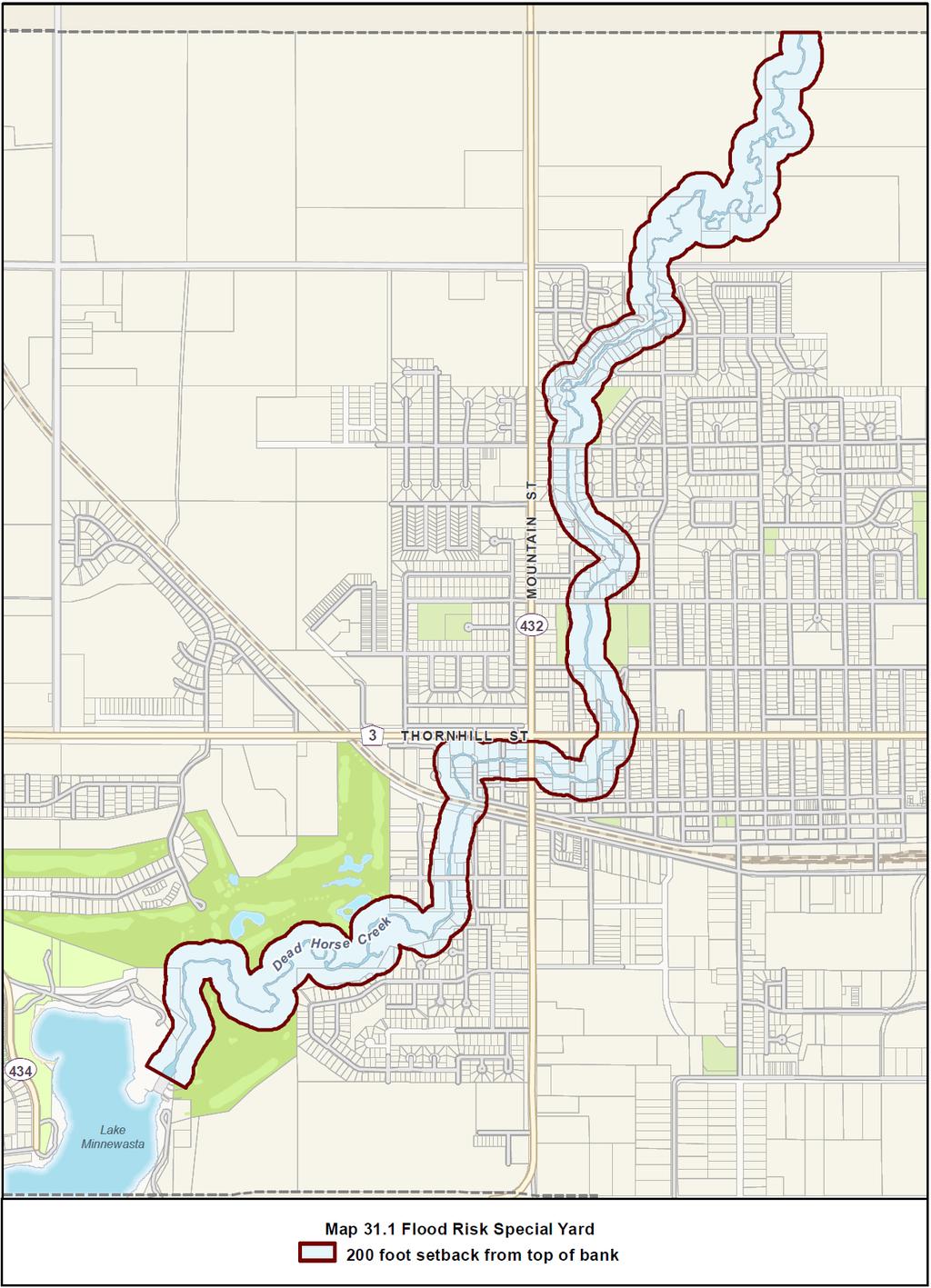
68 68
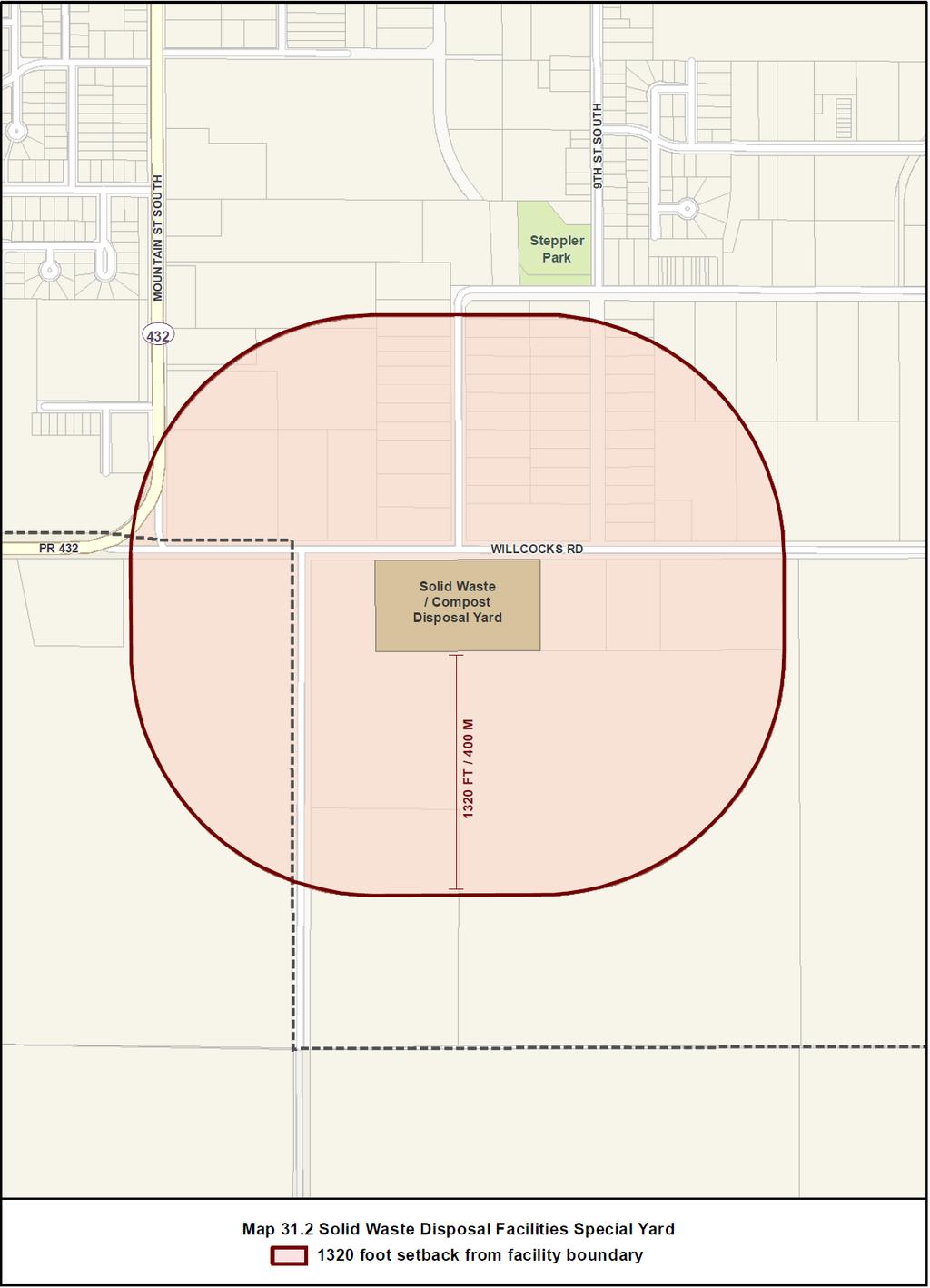
69 69
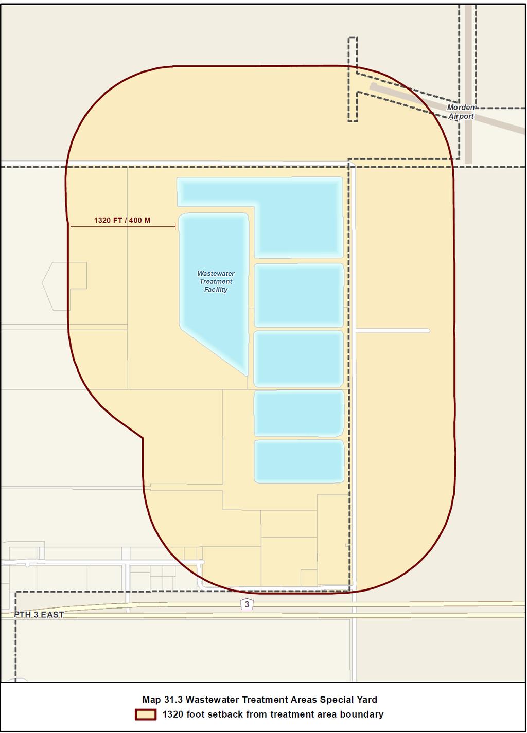
70 70
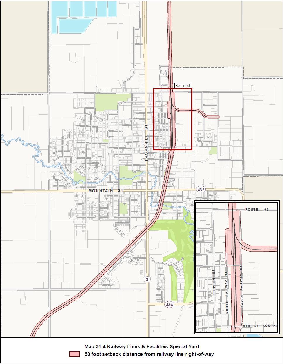
71 71
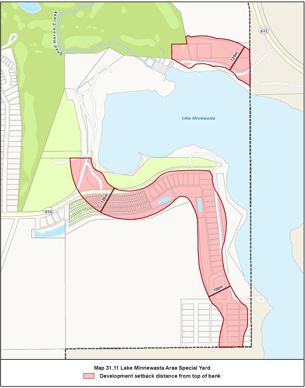
72 72
73 PART VI ZONING DISTRICT OVERLAYS 32.0 Applicability In addition to the regulations set forth in Parts II, III, IV, and V, properties located within the areas identified in the sections that follow are subject to requirements intended to consider and address more particular geographic contexts as set out in an area-specific plan. Zoning district overlays alter but do not replace the underlying zoning district or districts. Also, each overlay is unique to the particular geographic context and is not expected to be used at other locations. 1) To be eligible, the zoning district overlay must include: a) a map showing the area subject to the overlay that clearly identifies the overlay and the location and boundaries of the underlying zoning districts; b) the name, location, and boundaries of the applicable area-specific plan if different from the overlay area; and c) the regulations altered by the overlay. 2) The zoning district overlay may substitute unique regulations for those specified in the underlying district. Where this results in conflicting regulations, the zoning district overlay regulations shall govern. 3) The zoning district overlay may alter the underlying district regulations, application submission requirements, and review and approval procedures as follows: a) Permitted and conditional uses; b) Intensity of development; c) Dimensional requirements; d) Parking and loading allocations and dimensions; e) Sign allocations and dimensions; and f) Development bonusing; g) Building and site design guidelines Pembina Connection 1) Purpose The Pembina Connection Zoning District Overlay is intended to enable the development of an integrated, large-scale commercial centre. In addition, through the introduction of development guidelines and review procedures, this overlay seeks to ensure that as individual sites are initially developed and as they may subsequently be redeveloped the sites will continue to contribute to the cohesive standard of development applicable to the overall overlay area. 2) Applicability The Pembina Connection Zoning District Overlay applies to all portions of the area shown on Map 32.1 Pembina Connection Zoning District Overlay. 3) Overlay Regulations a) Land Use Notwithstanding the regulations provided in Parts II, III, and IV the following principal uses shall be permitted or conditional in the overlay area: - Auction establishment C - School, secondary C - Hospital C - Institutional residence C - Research institution C - Transport terminal/freight yard C - Utility & works yard C - Manufacture/assembly/repair/ Packaging of products from Prepared products C - Automotive & equipment repair service C - Fuel sales C - Funeral services C - Car wash C - Truck stop C 73
74 Notwithstanding the regulations provided in Parts II and III, the following principal uses shall be not permitted in the overlay area: - School, elementary & middle NP - Campsite NP - Recreation facility, outdoor NP - Amusement establishment, outdoor NP - Religious institution NP - Entertainment establishment, outdoor NP - Commercial kitchen/catering service NP - Contractor establishment NP - Heavy equipment, sales & service NP - Mini storage NP - Agri-business NP - Kennel/shelter NP b) Dimensions & Design Notwithstanding the regulations provided in Parts II and III, the following dimensions and design requirements shall apply in the overlay area: i. Built Form - Minimum lot area 5000 sq ft [465 sq m] - Minimum lot width 50 ft [15.24 m] - Minimum front yard 20 ft [6 m] - Minimum rear yard 25 ft [7.62 m] - Minimum interior side yard 10 ft [3 m] - Minimum reverse corner side yard 15 ft [4.5 m] - Maximum building height 45 ft [13.5 m] - Maximum building height, Multiple family building 60 ft [18 m] - Maximum lot coverage 60% ii. Exterior Lighting, Landscaping, & Screening Site lighting and landscaping elements are expected to make key contributions towards a consistent and memorable commercial development. As such, these elements shall be considered an integral component of each development and are not merely decorative or cover for leftover site portions. Lighting: - To ensure a unified exterior lighting design, parking lot lights are to be Lithonia Lighting Contour Series KAD W Metal Halide 400 Watt or suitable substitute as determined by the Designated Officer; luminaire and pole to be Dark Bronze; lights to be located at minimum 120 ft [36.5 m] on centre; poles to be installed within curbed areas isolated from traffic movements - Building lighting: lighting must be provided that emphasizes building entrances. Landscaping: - For street edge landscaping: minimum 1 deciduous tree [minimum 2.5 in / 6.35 cm dbh] or coniferous tree [minimum 6 ft / 1.8 m height] for every 30 ft [9 m] of street frontage; plus minimum 3 shrubs [minimum 2 gallon [9 litre] container] for every 20 ft / 6 m of street frontage - For parking lot interior landscaping: minimum 5% of parking area must be landscaped; minimum 1 shrub for every 100 sq ft [9 sq m] of interior landscaping area; minimum 5 ft [1.5 m] landscape island width - For building foundation landscaping: minimum 1 shrub for every 10 ft [3 m] of building wall facing a public right-of-way or containing a building entrance 74
75 iii. Parking, Loading, & Waste Materials Storage Areas - Large paved parking areas must be visually interrupted along their edges by introducing clusters of the landscaping specified in street edge landscaping and/or vertical structures every 120 ft [36 m] - Loading and waste materials storage areas must be located out of view from adjacent public right-of-way, or shielded from view with significant landscaping, fence, wall, or combination to the satisfaction of the Designated Officer c) Signs - Overall Pembina Connection multi-tenant signs are to be prominent and, as such, are to be a height of 40 ft [12 m] - Individual free-standing site signs are to be subordinate to the overall Pembina Connection multi-tenant signs and, as such, are restricted to a maximum height of 30 ft [9 m]. 4) Overlay Guidelines & Review Procedures a) With the exception of temporary buildings and structures, all development, redevelopment, expansion, and exterior alteration visible from public rights-of-way is subject to design review. b) Design review is intended to ensure each development, redevelopment, expansion, and exterior alteration within the overlay area is consistent with the Pembina Connection Development Guidelines [as adopted by Council on July 16 th 2012 and as amended from time to time]. This document seeks to assist property owners, design professionals, the Designated Officer, and other parties involved in preparing, reviewing, and approving development proposals. Distinct from regulations, the guidelines provide a benchmark for development to achieve rather than specify a rigid means to achieve the benchmark. c) In addition to the information required under section 9.3, the Designated Officer may require that additional information be submitted in order to assist with the design review process. Design review approval must be granted by the Designated Officer prior to issuance of a development permit or building permit and before construction commences. d) Generally, the development guidelines focus on the following: i. Building Orientation & Configuration; ii. Pedestrian System; iii. Customer & Service Vehicle System; iv. Landscape; v. Lights; vi. Building Design; and vii. Signs. 75
76 76
77 32.2 Heritage Homes 1) Purpose The Heritage Homes Zoning District Overlay is intended to assist with the conservation and ongoing use of Morden s municipally designated heritage homes. This overlay seeks to ensure that the significant and wellpreserved legacy embodied by these homes is conserved and that they continue to contribute to the city s identity. The overlay provides eligible properties with additional development opportunities, in those circumstances where the underlying zoning district restricts otherwise compatible development. In addition to regulations, the overlay introduces development guidelines and review procedures intended to guide the adaptive reuse of eligible properties. 2) Applicability The Heritage Homes Zoning District Overlay applies to all properties shown on Map 32.2 Heritage Homes Zoning District Overlay. 3) Overlay Regulations a) Land Use Notwithstanding the regulations provided in Parts II, III, and IV the following principal uses shall be permitted or conditional in the overlay area: Two family P Multiple family P Library/museum/gallery/cultural exhibit Child care centre P P Hotel/motel/hostel, if located along regional street or abutting a commercial zoning district Office Personal services Retail sales C P P P Restaurant, if located along regional street or abutting a commercial zoning district Studio, dance/music/photo/design P*; C if not P Microbrewery/distillery/winery, if located along regional street or abutting a commercial zoning district P; NP if not Veterinary, if located along regional street or abutting a commercial zoning district C Studio, broadcast/motion picture, if located along regional street or 77
78 abutting a commercial zoning district P; C if not College/university/trade school, if located along regional street or abutting a commercial zoning district P; C if not * a restaurant established in a heritage home is not subject to Use Specific Standards under Part IV. Notwithstanding the regulations provided in Parts II, III, and IV the following uses shall be permitted or conditional in the overlay area when accessory to a residential use: Bed & Breakfast Business support, ground level Major home occupation Neighbourhood retail, ground level Office Personal services, ground level Retail sales, ground level P** P P** P P P P Restaurant, ground level, if located along regional street or abutting a commercial zoning district P; C if not Studio, dance/music/photo/design, if located along regional street or abutting a commercial zoning district P; C if not ** identifies uses subject to Use Specific Standards under Part IV. b) Dimensions & Design Notwithstanding the regulations provided in Parts II and III, the following dimensions and design requirements shall apply in the overlay area: i. Built Form - All properties located within the RS-L, RS-S, and RT underlying districts may introduce dwelling units up to a maximum of 1 unit per 1000 sq ft [93 sq m] of lot area; - All properties located within the RM-S, RM-M, RM-L, CN, CC, CHR, CH, MUC, and MUN underlying districts may introduce dwelling units up to the maximum number expressed in the applicable Built Form Table. ii. Transfer of Development Rights - Any unused residential density provided for under i. above may be transferred from a heritage home site to another property zoned RM-S, RM-M, RM-L, CN, CC, CHR, CH, MUC, or MUN provided the other property is located within the same block as the heritage home or no further than 400 ft [120 m] from the heritage home site, whichever is greater; 78
79 - The property owners must execute a caveat that is attached to and recorded on the title of both the heritage home site transferring and the site receiving the density; - The caveat must reflect the respective increase and decrease of density, in a form satisfactory to the City of Morden. iii. Parking, Loading, & Waste Materials Storage Areas - All parking, loading, and waste materials storage areas shall be constructed and located in accordance with the applicable underlying zoning district standards, unless doing so conflicts with the heritage home s municipal heritage designation and any specified elements deemed integral to the designation; - All properties are exempt from the parking and loading space requirements specified in the Off-Street Parking Table and Off-Street Loading Table, respectively. c) Signs Notwithstanding the regulations provided in Parts II and III the following sign dimensions and design requirements shall apply in the overlay area: - Building & Use Identification signs are restricted to a maximum of 24 sq ft [7.3 sq m], with height restricted to 1 st floor ceiling if attached or 10 ft [3 m] if free-standing; - Directional signs are restricted to a maximum of 1 sign per entrance or exit and 12 sq ft [1.1 sq m] per sign. 4) Overlay Guidelines & Review Procedures a) With the exception of temporary buildings and structures and those works specified in d), all development, redevelopment, expansion, and alterations are subject to design review. b) Design review is intended to ensure each development, redevelopment, expansion, and exterior alteration within the overlay is consistent with the home s municipal heritage designation [as captured in the applicable designation by-law, provided for under The Heritage Resources Act] and with the Parks Canada Standards and Guidelines for the Conservation of Historic Places in Canada. Distinct from regulations, the guidelines provide a benchmark for development to achieve rather than specify a rigid means to achieve the benchmark. c) In addition to the information required under section 9.3, the Designated Officer may require that additional information be submitted in order to assist with the design review process. Design review approval must be granted by the Designated Officer prior to issuance of a development permit or building permit and before construction/renovation commences. d) The following works may be undertaken without review by the Designated Officer or issuance of a development permit, unless the municipal heritage designation specifies these elements are integral to the designation of the heritage home: i. any interior renovations or alterations; ii. routine maintenance or minor repairs to buildings and structures that do not significantly alter the appearance of the exterior of 79

80 the building or structure and do not involve the permanent removal of or damage to heritage attributes; iii. repairs to the existing roof or replacement of existing roof materials provided the basic form and composition of the roof is not altered and removing existing or installing new eavestroughs, downspouts, or leads; iv. painting or stripping paint from trim, cladding, doors, window frames, eavestroughs/downspouts/leads, and minor architectural elements, provided paint is not to be applied to previously unpainted masonry elements and paint is not to be removed from a masonry building façade; v. installing new doors and windows at the same locations and of the same approximate size; vi. installing, pruning, and maintaining vegetative landscaping [e.g. lawn, planting beds, shrubbery, ornamental trees] and removing or installing hard landscaping [e.g. driveways, footpaths, patios]; vii. maintaining or installing fencing; ii. Installing or expanding any accessibility elements [e.g. railings, ramps, lifts] that do not involve the permanent removal of or damage to heritage attributes. And by adding Map 32.2 Heritage Homes Zoning Development Overlay following subsection
81 PART VII - DEFINITIONS 33.0 General Definitions Abut means immediately contiguous to or physically touching, and when used with respect to a site, means that the site physically touches upon another site or piece of land, and shares a lot line or boundary line with it. Accessibility means the ability of persons with disabilities to enter and use facilities without having to encounter and navigate obstacles that are not inherent in the design of the facility, consistent with The Accessibility for Manitobans Act and associated standards. Accessory means, when used to describe a use, building or structure, said use, building or structure is naturally or normally incidental, subordinate, and exclusively devoted to the principal use or building, and located on the same lot or site. Act means The Planning Act of Manitoba. Adult entertainment facility means an establishment where the principal business activity relates to adult entertainment, including striptease and pornographic video and magazine or book sales. Bare land condominium means a condominium plan upon which one or more units are defined by delineation of horizontal boundaries of the unit without reference to any buildings. Basement means the portion of a building or structure which is wholly or partially below grade, having above grade no more than 6 ft [1.8 m] of its clean height which lies below the finished level of the floor directly above or being a minimum depth of 4 ft [1.2 m]. Bedroom means a habitable room located within a dwelling unit that is used primarily for sleeping. Bulk fuel storage tank means a tank used for the bulk storage of petroleum products or other flammable liquids legally stored within a structure or establishment that is incidental to the primary use of the site. Canvas building means a portable shelter consisting of, but not limited to, woven, non-woven, or petro-chemical based pliable materials such as canvas, nylon, mylar, visqueen, or similar materials stretched over a rigid supporting framework of poles, ropes, or pegs. Conditional use means a use of a building or land as a conditional use in this by-law that may be approved in accordance with The Planning Act. Conditional uses are uses that have unique or widely varying operating characteristics, may have potential operational or other impacts on adjacent properties, or may have unusual site development demands. Conditional use order means an order in respect of an application for a conditional use. Density means an expression of the total number of dwelling units in relation to the total land area to be developed, expressed as a ratio of dwelling units per land area [i.e. acres, hectares, square feet, square metres]. Designated Officer means the person appointed by the Morden City Council to carry out duties and responsibilities assigned to that person by City Council. Development Permit means a permit authorizing development that is subject to a zoning bylaw, issued by the City of Morden. Development setback line means the minimum setback of permanent structures from Lake Minnewasta, as recommended by the Lake Minnewasta Carrying Capacity Study and as captured in Part 10 of the MSTW Planning District Development Plan [including Map 24]. Display, outdoor means an outside display of goods and/or materials for sale, accessory to a retails sales use. Goods and materials may be directly available to the consumer for purchase. 81
82 Drive-in/drive-through means a use designed and operated to allow patrons, while outside on the premises in motor vehicles, to order, request, exchange, or receive goods or services. Dwelling means a building or portion of a building designed or used for residential occupancy. It does not include establishments for commercial accommodations, such as Hotel, Motel, or Hostel. Family means one or more persons voluntarily associated, plus any dependents, living together as an independent, self-governing single housekeeping unit. Flood-proofed means measures taken to ensure that a structure or building is safe from the effects of flooding and includes prohibiting openings of any kind such as windows, doors and vents, or electrical equipment below the flood datum. Flood protection level means, in reference to a building site s elevation, a point that is 2 feet [0.6 metres] above the flood level as determined by the Government of Manitoba. Flood risk area means land adjacent to a watercourse that is divided into two parts, namely: the Floodway and the Floodway Fringe. The Floodway includes the area where the majority of floodwaters pass. The Floodway Fringe includes the area outside the Floodway that may be subjected to periodic flooding or inundation of floodwaters. Frontage means all that portion of a site fronting on a street and measured between side lot lines. Grade means the average of the finished ground surface at the midpoint of each wall of a building. In the case where the wall is parallel to and within 5 ft [1.5 m] of a public sidewalk, the ground surface shall be measured at the sidewalk. Height means, when used in reference to a building or structure, the vertical distance between the horizontal plane through grade and a horizontal plane through: a) the highest point of the roof in the case of a building with a flat roof or a roof having a slope of less than 20 degrees; and b) the average level between eaves and ridges in the case of a pitched, gambrel, mansard, or hipped roof, or a roof having a slope of 20 degrees or more, provided that in such cases the ridge line of the roof shall not extend more than 5 ft [1.5 m] above the building height. Landscaping means any combination of trees, shrubs, flowers, grass, or other horticultural elements, decorative stonework, paving, screening, or other architectural elements, all of which are designed to enhance the visual amenity of a site or to provide a screen between sites in order to mitigate objectionable features between them. Loading Aisle means that portion of a loading facility or area that provides vehicular access to a loading space, not directly from a driveway or street. May be shared with a parking aisle. Driveway means that portion of a loading facility or area that provides vehicular access to a loading aisle or space. May be shared with a parking driveway. Space means that portion of a loading facility or area, excluding vehicle manoeuvring areas such as aisles and driveways, that will accommodate one motor vehicle. Lot Area is measured as the amount of gross land area contained within the property lines of the lot or parcel. Corner is a lot that abuts the intersection of two or more public streets or that abuts the approximately perpendicular intersection of two or more frontages of the same public street. Coverage is measured as the percentage of the total lot area covered by buildings. Depth is the depth of the lot from the street, measured as the horizontal distance between the centre points in the front and rear lot lines, generally equal to the horizontal length of the lot depth line. 82
83 Front line is, in the case of an interior lot, the lot limit that abuts the public street; is, in the case of a through lot, the lot limits that abut public streets; or is, in the case of a corner lot, the frontage that is the continuation of the front lot line of an abutting interior lot or, if none, those frontages that, as front lot lines, accord with the intent and purposes of yard requirements. Interior is a lot with frontage on only one public street. Rear line is the lot limit that is most nearly parallel to the front lot line; or any lot limit that is in whole or in part the rear lot line of an abutting lot and as a rear lot line accords with the intent and purpose of yard requirements; or, in the case of a lot where the side lot lines intersect, the rear lot line is deemed to be a line 10 ft [3 m] in length, located within the lot, parallel to and at the maximum distance from the front lot line. Reverse corner is a corner lot, the rear lot line of which abuts the side lot line of another lot. Side line means any lot limit that intersects with a front lot line and is not a rear lot line in accordance with the intent and purposes of yard requirements. Through is a lot that abuts two or more public streets but does not abut the intersection of those streets. Width is the lesser of the horizontal distance between the side lot lines of a lot, measured at right angles to the lot depth line at a point midway between the front and rear lot lines, or at 40 ft [12 m] from the front lot line, whichever is the lesser. Metal shipping container means a prefabricated metal structure designed for use as an individual shipping container in accordance with international standards. Mobile home means a portable dwelling unit that is capable of being transported on its own chassis and running gear by towing or other means, is placed on the chassis or body of a motor vehicle, or forms part of a motor vehicle and is designated to be used as living quarters and that conforms with The Buildings & Mobile Homes Act with respect to CSA Standard No. Z240 or to such standards as may be subsequently defined by CSA. Does not include site-built, modular, or ready-to-move dwellings and CSA Standard No. A277. Mobile home park means land under one ownership upon which mobile home spaces are provided for rent or purchase. Mobile home site means a site in a mobile home park that may be rented or purchased for the placement of a mobile home. Parking Aisle means that portion of a parking facility or area that provides vehicular access to a parking space, not directly from a driveway or street. Driveway means that portion of a parking facility or area that provides vehicular access to a parking aisle or space. Space means that portion of a parking facility or area, excluding vehicle manoeuvring areas such as aisles and driveways, that will accommodate one motor vehicle. Accessible space means that portion of a parking facility or area, excluding vehicle manoeuvring areas such as aisles and driveways, that will accommodate one motor vehicle and that has been designed and dimensioned in order to accommodate persons with disabilities, consistent with The Accessibility for Manitobans Act and associated standards. Party wall means a wall forming part of a building and used for separation of adjoining buildings occupied, constructed, or adapted to be occupied by different persons or businesses. Permitted use means a use permitted in a zoning district that may be established without the requirement for City Council or Designated Officer approval. Pick-up & delivery operation means a Restaurant service that consists of food preparation, with consumption primarily offsite. May include counter or table service for onsite consumption consisting of no more than 8 seats. 83
84 Principal building means any building on a lot or lands that contains approved principal uses, as opposed to buildings that contain only accessory or incidental uses and buildings that contain only storage or support functions associated with principal use operations. Principal use means the primary or predominant use of any lot, lands, building, or structure. Prohibited use means a use of land deemed incompatible with the Urban Areas designated in the MSTW Planning District Development Plan, and that are not permitted and may not be established by conditional use or use variance. Sign Accessory means any writing [including letter, word, or numeral], pictorial representation [including illustration or decoration], emblem [including device, symbol, logo, or trademark], flag [including banner or pennant but not the flag of any nation or government], and anything designed or intended to, or having the effect of, announcing, identifying, directing attention to, or advertising any building or use located on the same lot or lands. Copy means letters, graphics, or characters that comprise the sign message. Portable means a sign that is mounted on a trailer, vehicle, stand, or similar support structure which is designed in such a manner that the sign can be readily relocated to another site and which may include copy that can be changed through the use of removable characters or panels. Sandwich board means a sign that is not permanently attached or affixed to the ground or to a building or structure and that includes a top hinge, to allow for an A-frame configuration, with sign faces on either side of the hinged joint. Surface area means the area of a sign covered by a single rectangle drawn around the extremities of the message contained on the sign and, in the case of a multi-face sign, comprises half of the total of all sign faces. Sign form Attached means a sign that is attached to the exterior of a building. May include fascia, awning, banner, marquee, blade, volumetric, canopy, or other attached forms. Free-standing means a sign that is supported by a permanent, independent structure and is not attached to a building. Includes pylon, pedestal, monument, and other freestanding forms. Sign type Building identification means a sign that identifies a building by name, logo, or street address. Directional means a sign that indicates vehicular access to or egress from a parking or loading area. Event means a sign that indicates the time, date, and type of event or events scheduled for a venue located on the same lot or lands. Use identification means a sign that identifies a business, service, institution, owner, or resident by name, logo, street address, or combination and which may direct attention to a business, service, or commodity conducted, offered, or sold on the same lot or lands. Sleeping unit means a habitable room, or a group of two or more habitable rooms, not equipped with self-contained cooking facilities, providing accommodation for not more than two persons. Stacking space means an on-site queuing area for a passenger vehicle that is separated from other vehicular traffic and pedestrian circulation by barriers, markings or signs. Storage, outdoor means the storage of merchandise, goods, inventory, materials or equipment or other items that are not intended for immediate sale and do not constitute outdoor display, by locating them outside. 84
85 Storey means that portion of a building situated between the surface of any floor and the surface of the floor next above it and, if there is no floor above it, that portion between the surface of such floor and the ceiling above it, but does not include a basement. Street means a public thoroughfare or highway, but does not include a public lane. Swimming pool means a swimming pool or other water recreational facility located on the property of a single family, two family, or farmstead dwelling and that is used solely by the occupants of the dwelling and their guests. Does not include public swimming pools or semipublic swimming pools as defined by the Manitoba Swimming Pools and Other Water Facilities Regulation. Townhouse means a building containing 3 or more dwelling units wherein each dwelling has its own independent entrance from the outside, wherein no unit is located above another unit, and wherein each unit is separated from the others by common vertical walls. Variance means the modification of a regulation in this by-law that is approved in accordance with The Planning Act. Variance order means an order in respect of an application for a variance. Yard Front means an open area on a lot that is clear from ground to sky, except as otherwise exempted, extending along the full length of the front lot line, the depth of which is measured perpendicularly and radially to the front lot line. Rear means an open area on a lot that is clear from ground to sky, except as otherwise exempted, extending along the full length of the rear lot line, the depth of which is measured perpendicularly and radially to the rear lot line. Reverse corner side means an open area on a lot that is clear from ground to sky, except as otherwise exempted, extending along the full length of the reverse corner side lot line, the depth of which is measured perpendicularly to the reverse corner side lot line. Side means an open area on a lot that is clear from ground to sky, except as otherwise exempted, extending along the full length of the side lot line, the depth of which is measured perpendicularly to the side lot line. Zoning district means an area for which this by-law has established uniform regulations and requirements governing the use, dimensions, and operational characteristics of buildings and premises located within the zoning district, as depicted on the zoning map or maps Use Definitions Residential & Residential-related Use Category Group home means a building in which residents reside who require professional or non-professional care, guidance, and supervision. This use may include staff not requiring care at the home and generally has only one kitchen and dining area for the common use of residents. The home is licensed under applicable provincial legislation and regulation. Mobile home means a mobile home containing only one dwelling. Does not include camper, motor home, or similar recreational vehicle intended for temporary occupancy. Multiple family means a building containing three or more dwellings, with dwellings arranged in a vertical or horizontal manner, either served by separate entrances or common corridors and entrance. Rooming house means a building, other than a Hotel, Motel, or Hostel, that provides living units with separate sleeping areas and some combination of shared bath or toilet facilities. The building may or may not have separate or shared cooking facilities for residents. Single family means a building containing only one dwelling, that is separate from any other dwelling or building. Does not include Mobile home. 85
86 Two family means a building containing two dwellings, with dwellings horizontally divided along party wall or vertically divided at ceiling of main floor dwelling. Commercial Use Category Auction establishment means a use that is specifically intended for the auctioning of goods and equipment, including the temporary storage of such goods and equipment. Automotive sales & rental means a use involving the storage, display, sale, or lease of new or used vehicles such as automobiles, trucks, motorcycles, and similar vehicles. Includes accessory repair/service of such vehicles. Business support services means a use providing support to businesses characterized by printing, duplicating, binding, photographic processing, blueprinting, sale/rental and repair of business equipment, or combination. Drinks establishment means a use primarily involved in the sale of beverages, licensed by the Government of Manitoba under The Liquor and Lotteries Act, for consumption on the premises. Funeral services means a use that includes storage of deceased human bodies prior to burial or cremation or a building used for the preparation of the deceased for burial and ceremonies connected with the burial or cremation. Greenhouse & nursery sales means a use primarily involved in the raising, storage, and sale of produce and related materials, that includes but is not limited to bulbs, seeds, tools, soil and planting media, fertilizers, plants, and seedlings to the general public. Hotel/motel/hostel means a building or portion of a building providing temporary accommodation in individual guest rooms or communal guest suites, with or without provision for cooking in any individual guest room or communal suite. Mail/courier depot means a use involving the loading, sorting, and unloading of letters and packages for distribution to offsite locations. Includes incidental Retail sales of related products and related Business support and Personal services. Micro brewery/distillery/winery means a use involving the blending, brewing, distilling, bottling, sampling, and other related operations are conducted within a building up to a maximum of 5000 sq ft [465 sq m] of floor area devoted to production of beer, liquor, and wine. Includes incidental retail sales for consumption on or off site, with area devoted to onsite consumption limited to the lesser of a maximum of 1000 sq ft [93 sq m] or 20% of the overall floor area. Does not include Brewery/distillery/winery or Micro brewery/distillery/winery accessory to a Restaurant or Drinks establishment. Neighbourhood retail means a use that involves the sale of rental of new or used products directly to the general public, within a building up to a maximum of 3000 sq ft [280 sq m] of floor area. Also includes incidental Personal Services within this floor area, but does not include Auction establishment, Pawnshop, or Warehouse sales. Office means a use that typically involves back-of-counter administrative and management operations associated with a personal service, business support service, retail sales, or other principal use. Does not include direct services or sales to the general public. Pawnshop means a use where money is loaned on security of personal property left in pawn and pledged as collateral for the loan and where such property may be redeemed by the seller in a fixed period of time or sold to the general public. Personal services means a use that involves providing services directly to the general public. Also includes incidental Retail sales. Restaurant means a use primarily involved in the preparation and sale of food to be sold to the general public for consumption on or off the premises. Retail sales means a use that involves the sale or rental of new or used products directly to the general public. Also includes incidental Personal services, but does not include Auction establishment, Pawnshop, or Warehouse sales. 86
87 Studio, dance/photography/music/design means a use intended for those engaged in the application, teaching, or performance of fine arts such as drawing and painting, vocal and instrumental music, sculpture, writing, and dancing. Trailer, RV, mobile home sales & rental means a use involving the storage, display, sale, or lease of new or used trailers, recreational vehicles, and mobile homes. Includes accessory repair/service of such vehicles. Warehouse sales means a use involving the wholesale or retail sale of a limited range of bulky goods where the size and nature of the goods being sold typically requires large floor areas for direct display to the purchaser or consumer, including furniture, flooring, major appliances, and building materials. Cultural & Entertainment Use Category Amusement establishment, indoor means a use involving the playing of table or video games for customer entertainment in an indoor setting. Amusement establishment, outdoor means a use involving amusement parks, midways, go-cart tracks, miniature golf, car racing, sled racing, or similar activities for customer entertainment in an outdoor setting. Casino means a use involving facilities for patrons to participate in gaming opportunities. Includes gaming tables, slot machines, video gaming, or bingo and keno games. Entertainment establishment, indoor means a use involving the showing of motion pictures or dramatic, dance, musical, or other live performances in an indoor setting. Primarily spectator-oriented. Includes cinema, theatre, concert hall, or auditorium. Entertainment establishment, outdoor means a use involving the showing of motion pictures or dramatic, dance, musical, or other live performances in an outdoor setting. Primarily spectator-oriented. Includes drive-in cinema, outdoor stage venue, amphitheatre, or pavilion. Library, museum, gallery, cultural exhibit means a use involving collections of literary, artistic, musical, and similar reference materials available to the public through a variety of media. Also includes a use involving collection, preservation, and exhibition of works or objects of historical, cultural, artistic, or scientific value. Private members club means a use by a not for profit organization incorporated by the Government of Canada or the Government of Manitoba. Includes facilities for meetings, social events, and recreational activities of philanthropic, social service, athletic, business or fraternal organizations. Does not include onsite residences. Religious institution means a place of worship and related activities, typically involving public assembly and meeting. Public & Institutional Use Category Animal hospital means a use that involves the care and treatment of domestic animals that includes in-patient services, with hospitalization for 5 or more days. Does not include Kennel/shelter. Campsite means a use of land that involves seasonal short-term accommodations and on which tents, campers, motor homes, and similar recreational vehicles may be placed for occupancy. Does not include year-round placement or occupancy. Cemetery means a use primarily involving the entombment of the deceased and may include accessory uses such as crematoria, cineraria, columbaria, and mausoleums. Childcare centre means a use involving care, educational activities, and supervision of children in the daytime and evening, licensed by the Government of Manitoba under The Community Child Care Standards Act. Does not include overnight accommodations. College/university/trade school means an educational facility providing instruction for students in an accredited university, college, or trade school program. Includes accessory student residences. 87
88 Hospital means a use that involves outpatient and inpatient medical treatment and may include overnight stays. Treatment includes diagnostic, laboratory, surgical, counselling, and rehabilitation of patients. Institutional residence means a building containing living accommodations for one or more residents who meet the provincial definition for elderly person or infirm person under The Elderly and Infirm Persons Housing Act. This use may include staff not requiring care at the residence and generally has only one kitchen and dining area for the common use of residents. The residence is licensed under applicable provincial legislation and regulation. Kennel/shelter facility means a use that involves the care and breeding of domestic animals that does not include hospitalization. Includes incidental grooming service and sale of products accessory to the kennel/shelter use. Does not include Veterinary or Animal hospital. Park means a use of land specifically designed or reserved for the general public for active or passive recreational use and includes natural and human-designed landscaping, facilities, playing fields, buildings, and other structures that are consistent with the general purposes of public parkland, whether or not such recreational facilities are publicly operated, operated by other organizations pursuant to arrangements with the public authority owning the park, or are publicly operated but on leased privately-owned property. Protection & emergency services means a use required for the public protection of persons and property from injury, harm, or damage together with the incidental storage of equipment and vehicles. Typical uses includes police station, fire hall, and related training facilities. Recreation facility, indoor means a use involving recreational, social, or multi-purpose activities where patrons are primarily participants and any spectators are incidental and attend on a non-recurring basis, occurring in an indoor setting. Includes recreation and leisure centres, hockey and skating rinks, curling rinks, swimming pools, bowling alleys, racquet clubs, rifle and pistol ranges, community halls, and community centres. Recreation facility, outdoor means a use involving recreational, social, or multipurpose activities where patrons are primarily participants and any spectators are incidental and attend on a non-recurring basis, occurring in an outdoor setting. Includes playing fields, hockey and skating rinks, curling rinks, swimming pools, tennis courts, golf courses, running tracks, and velodromes. Research institution means a use involving scientific research, product design, development, and testing, and limited manufacturing necessary for the production of prototypes. School, elementary & middle means an educational facility providing instruction to students from kindergarten up to but not including high school. School, secondary means an education facility providing instruction to students at the high school level. Veterinary means a use that involves the care and treatment of domestic animals that is primarily of an out-patient nature, with hospitalization for 4 or fewer days. Does not include Animal hospital or Kennel/shelter. Transportation, Utility, & Communications Use Category Aircraft landing strip means a use involving the take-off and landing of aircraft for personal use. Airport means the use of land for the take-off and landing of aircraft and includes related buildings and structures such as aircraft storage and maintenance hangars, taxiways, and navigational equipment and facilities. Footpath means a sidewalk, trail, walkway, or similar pathway for pedestrian and cyclist use that is not located within a street right-of-way. 88
89 Road/utility reserve means land assembled for the purpose of establishing a future public road, public sidewalk, footpath, or utility right-of-way. Does not include Utility & works yard. Sign, non-accessory means a sign displaying copy that directs attention to a business, activity, product, or service that are not the principal products sold or the principal business, activity, or service that is provided onsite. Includes attached and free-standing sign forms. Studio, broadcasting/motion picture means a use that involves production of motion pictures, videos, television programs, radio programs, or sound recordings. Includes incidental accessory rehearsal space for dance, music, or other performing arts. Transport terminal/freight yard means a use that involves the transfer, temporary storage, and distribution of cargo where trucks and trains load and unload on a routine and ongoing basis. Includes temporary truck and railcar storage awaiting cargo order assembly. Also includes incidental office and warehouse uses. Utility & works yard means a use that involves a system, plant, pipeline, transmission line, and related facilities intended to provide public utility service to the general public. Includes landfill, sewage treatment, waste compaction and transfer, electrical stations and substations, and recycling and composting facilities. Private Motor Vehicle-related Use Category Automotive & equipment repair service means a use involving the servicing, repairing, and restoring of automobiles, motorcycles, snowmobiles, and similar vehicles. Includes incidental retail sale of related accessories and parts. Includes muffler, transmission, brake, oil/fluid change, glass, upholstery, and body repair & paint operations. Does not include sale of automobiles, motorcycles, snowmobiles, and similar vehicles. Car wash means a use that involves the cleaning of motor vehicles operated by onsite employees of the public, along with incidental motor vehicle products sales. Fuel sales means a use that involves the retail sale of gasoline and other petroleum products, along with incidental motor vehicle products sales. Parking area, non-accessory means a use involving motor vehicle parking that is not primarily intended for residents, employees, or customers of an onsite development. Includes unenclosed surface, enclosed surface, and enclosed above- and below-grade parking areas. Truck stop means a highway-oriented operation that includes a combination of fuel sales, vehicle repair services, restaurants, and similar uses primarily intended to serve the trucking industry and travelling public. Industrial Use Category Abattoir means a use involving the slaughtering and processing of animals. Aggregate extraction operation means a use involving the onsite preparation, extraction, and primary processing of raw materials found on or under the site or accessible from the site. Includes aggregate extraction, stone quarry, and gravel pit. Includes accessory equipment and supplies, stockpiling of materials extracted onsite, site office and warehouse. Does not include processing of raw materials transported to the site from other locations. Batching plant means a use involving the manufacturing of asphalt or concrete from raw materials. Brewery/distillery/winery means a use involving the blending, brewing, distilling, bottling, sampling, and other related operations are conducted within a building. Does not include Micro brewery/distillery/winery as a principal use or Micro brewery/distillery/winery accessory to a Restaurant or Drinks establishment. Bulk storage facility means a use involving outdoor storage or tank storage of large quantities of raw materials or industrial-related goods such as liquids, fuels, gases, minerals, pipes, fertilizers, and grain. 89
90 Commercial kitchen/catering service means a use involving the preparation of food products, primarily for distribution and consumption offsite and that exceeds 5000 sq ft [465 sq m] of production area. Includes incidental retail sales directly to the public. May also include Mobile food carts and delivery vehicles onsite. Commercial laundry/dry-cleaning plant means a use involving dry-cleaning, laundry, or linen services and that exceeds 5000 sq ft [465 sq m] of production area. Includes incidental garment repair and personal services directly to the public. Contractor establishment means a use involving the provision of building construction, landscaping, concrete, heating/air conditioning and ventilation, electrical, plumbing, and similar construction services that require onsite storage for materials, equipment, and vehicles associated with contractor services. Includes incidental sales, display, office, or technical support services accessory to the contractor establishment. Fleet service/towing & storage facility means a use involving a fleet of vehicles for the delivery of people, goods, or services where such vehicles are not available for sale or long-term lease. May also involve a motor vehicle towing service, with temporary storage of vehicles. Includes taxi services, ambulance services, bus lines, tow truck and trailering services. Grain elevator means a use involving the receiving, shipping, handling, or storing of agricultural commodities such as barley, wheat, oats, soybeans, and similar products. Heavy equipment sales & service means a use involving the sale, rental, and repair of heavy vehicles, machinery, or mechanical equipment typically used in building, roadway, manufacturing, assembly and processing operations, and agricultural production. Manufacture/assembly/repair/packaging of products from prepared materials means a use involving the modifying, blending, or fitting-together of previously processed or manufactured components into a complete product. Includes assembly and packaging of products. Does not include operations that produce excessive noise, vibration, or odour and does not include hazardous, combustible, or explosive materials. Manufacture from semi-finished or raw materials means a use involving the processing, treatment, preparation, packing, transportation, handling, and storage of semifinished or raw materials. Mini storage means a use involving storage spaces available to the public on a for hire basis. Includes storage for motor vehicles and storage provided in portable containers transported to the mini storage site. Printing/publishing means a use involving printing, lithographing, blueprinting, or silkscreen printing; for platemaking or engraving as allied to the printing or publishing industries; for the publishing and printing of newspapers, magazines, periodicals, books, almanacs, maps, pamphlets, flyers, or similar matter; or for book-binding and associated binding and finishing operations. Storage compound means a use involving the outdoor storage of goods and materials that does not include onsite buildings or structures. Includes wrecking yard. Trucking operation means a use involving the storing, servicing, repairing, cleaning, or loading of trucks and transport trailers. Also includes card-lock fuel sales. Warehouse means a use involving the storage and distribution of materials, goods, or products, entirely within an enclosed building. Agricultural Use Category Agri-business means a use that includes the sale and repair of goods to the agricultural sector. Includes farm equipment and machinery repair, bulk fuel sales, feed and fertilizer supply sales, livestock auction establishments, and commercial seed cleaning facilities. Farming/ranching means the use of land for agricultural purposes, including farming, pasturage, apiculture, aquaculture, floriculture, and horticulture. Does not include Livestock production operations or Wildlife & conservation reserves. 90
91 Farmstead dwelling means a dwelling that is accessory to a farm operation and is on a parcel that includes associated agricultural buildings and structures. Livestock production operation means a use that involves keeping at least 10 animal units of livestock and includes all associated manure collection facilities. Stable/riding academy means a use accessory to a farming/ranching or farmstead dwelling use that involves the training or horses and riders and may include riding stables. Warehouse, agricultural crop protection means a facility used to store, blend, or distribute chemicals used for crop protection and production. Products include herbicides, insecticides, fungicides, rodenticides, and fertilizers. Does not include anhydrous ammonia facility. Wildlife & conservation reserve means lands designated by the Government of Manitoba for the protection and conservation of wildlife. Includes wildlife management areas. Accessory Category Bed & Breakfast means a hospitality use of a dwelling in which temporary overnight and breakfast is provided to guests for remuneration. Does not include Hotel/motel/hostel. Child care, home-based means the use of a portion of a dwelling unit for the provision of child care services provided by a resident of the dwelling, up to a maximum of 8 children. The operation meets all applicable provincial legislation and regulations. Farm produce outlet means a use accessory to a Farming/ranching or Farmstead dwelling use that involves sale of farm produce sold on a seasonal basis. Garden suite means a self-contained accessory dwelling unit separate from but on the same lot as a Single family dwelling building. A Garden suite has its own separate cooking, sleeping, and bath/toilet facilities. Does not include Two family dwelling, Multiple family dwelling, Rooming house, or Group home. Home occupation, major means the business use of a portion of a dwelling unit by a resident of that dwelling or a single non-resident and that is accessory to the dwelling. The Home occupation operations may be visible or detectable from outside the property, but the operations do not alter the building s exterior. Home occupation, minor means the business use of a portion of a dwelling unit by a resident of that dwelling and that is accessory to the dwelling. No aspects of the Home occupation operations are visible or detectable from outside the property. Micro brewery/distillery/winery means a Micro brewery/distillery/winery use that is accessory to a Restaurant or Drinks establishment. Includes incidental retail sales for consumption on or off site, with area devoted to onsite consumption limited to 50% of the overall floor area. Does not include Micro brewery/distillery/winery or Brewery/distillery/ winery as a principal use. Mobile food cart means a use involving the sale of prepared foods from a cart that is designed to be transported to a site from a Commercial kitchen/catering service operation on a daily basis, subject to meeting all applicable provincial legislation and regulations. Secondary suite means a self-contained accessory dwelling unit within a Single family dwelling building. A Secondary suite has its own separate cooking, sleeping, and bath/toilet facilities and has direct access to the outside without passing through any part of the Single family dwelling unit. Does not include Two family dwelling, Multiple family dwelling, Rooming house, or Group home. Specialized agriculture means small-scale agricultural pursuits incidental to a Rural residential use involving high value, lower volume, intensively managed practices where agricultural produce is grown and may include greenhouse production, honey production and processing, horticultural production including vegetables, fruit or mushrooms, and production of trees or shrubs. Includes direct sale of produce to the consumer by means of roadside stands, farm stores, u-pick operations, and farmers markets and direct sale to restaurants or retailers. 91
92 Swimming pool means the use of a swimming pool accessory to a Single family, Two family, or Farmstead dwelling. Does not include public or semi-public swimming pools as provided for under The Public Health Act and defined in the Swimming Pools and Other Water Recreational Facilities Regulation. 92

93 PART VIII ZONING MAP 93
EXCERPTS FROM HALIFAX REGIONAL MUNICIPALITY CHARTER
 EXCERPTS FROM HALIFAX REGIONAL MUNICIPALITY CHARTER Municipal planning strategy 227 The Council may adopt a municipal planning strategy for all, or part, of the Municipality and there may be separate strategies
Temporary Sign By-law
 THE CORPORATION OF THE TOWN OF WHITBY Temporary Sign By-law Being a By-law to regulate temporary signs and other temporary advertising devices By-law #5696-05 Consolidated Version As Amended by By-laws:
SOIL DEPOSIT BYLAW
 SOIL DEPOSIT BYLAW 5506-2015 THE FOLLOWING DOCUMENT HAS BEEN REPRODUCED FOR CONVENIENCE ONLY and is a consolidation of "District of Mission Soil Deposit with the following amending bylaws: Bylaw Number
Town of Whitby By-law #
 Town of Whitby By-law # 7015-15 Site Plan Control By-law Being a By-law to designate the Town of Whitby as a Site Plan Control Area and to delegate to the Commissioner of Planning the approval of plans
TOWN OF WATERVILLE VALLEY NEW HAMPSHIRE SITE PLAN REVIEW REGULATIONS
 TOWN OF WATERVILLE VALLEY NEW HAMPSHIRE Effective date March 17, 1981 Revised March 16, 1982 Revised March 13, 1986 Revised March 10, 1987 Revised March 14, 2013 Revised March 8, 2016 TOWN OF WATERVILLE
ARTICLE 24 SITE PLAN REVIEW
 ARTICLE 24 SITE PLAN REVIEW 24.1 PURPOSE: The intent of these Ordinance provisions is to provide for consultation and cooperation between the land developer and the Township Planning Commission in order
By-Law of The Corporation of the City of Oshawa
 By-Law 85-2006 of The Corporation of the City of Oshawa being a by-law to control the dumping of fill, removal of topsoil and alteration of grades. WHEREAS s. 142 of the Municipal Act, 2001, S.O. 2001,
CHAPTER XVIII SITE PLAN REVIEW
 CHAPTER XVIII SITE PLAN REVIEW Section 18.1 Section 18.2 Description and Purpose. The purpose of this chapter is to provide standards and procedures under which applicants would submit, and the Township
BY-LAW NO As amended by By-law No
 BY-LAW NO. 2014-256 As amended by By-law No. 2015-142 A by-law of the City of Ottawa designating the area within the territorial limits of the City of Ottawa as an area of site plan control. WHEREAS Section
THE CORPORATION OF THE TOWN OF INGERSOLL BY-LAW NO
 THE CORPORATION OF THE TOWN OF INGERSOLL BY-LAW NO. 13-4720 Being a By-Law to provide for regulating and governing of property boundary fences in the Town of Ingersoll. WHEREAS subsection 5(3) of the Municipal
APPLICATION PROCEDURE
 ANTRIM PLANNING BOARD P. O. Box 517 Antrim, New Hampshire 03440 Phone: 603-588-6785 FAX: 603-588-2969 APPLICATION FORM AND CHECKLIST FOR MINOR OR MAJOR SITE PLAN REVIEW File Date Received By APPLICATION
LAND USE BYLAW NO SEPTEMBER 2017
 LAND USE BYLAW NO. 397 17 SEPTEMBER 2017 Prepared by TABLE OF CONTENTS ADMINISTRATION GENERAL Section 1 Title... Administration 1 Section 2 Purpose... Administration 1 Section 3 Effective Date... Administration
MOBILE HOME PARK ORDINANCE OF THE TOWN OF LIVERMORE FALLS
 1 Section I. TITLE MOBILE HOME PARK ORDINANCE OF THE TOWN OF LIVERMORE FALLS This ordinance shall be known and cited as the Mobile Home Park Ordinance of the Town of Livermore Falls, Maine. Section II.
(a) Commercial uses on Laurel Avenue, abutting the TRO District to the
 Commercial uses on Laurel Avenue, abutting the TRO District to the") 32X Zoning Code 150.36 TRANSITIONAL RESIDENTIAL OVERLAY DISTRICT. (A) Intent and purpose. (1) It is the intent of the Transitional Residential Overlay District (hereinafter referred to as the "TRO District")
32X Zoning Code 150.36 TRANSITIONAL RESIDENTIAL OVERLAY DISTRICT. (A) Intent and purpose. (1) It is the intent of the Transitional Residential Overlay District (hereinafter referred to as the "TRO District")
ADP Rescind 3 rd Reading
 CITY OF TERRACE ADP-02-1524 Rescind 3 rd Reading BYLAW NO. 2015 A BYLAW TO REGULATE MANUFACTURED HOME PARKS WITHIN THE CITY OF TERRACE WHEREAS Section 63 of the Community Charter, provides that Council
Town of Truckee. Contents. Article I - Development Code Enactment and Applicability. Chapter Purpose and Effect of Development Code...
 Town of Truckee TITLE 18 - DEVELOPMENT CODE Article I - Development Code Enactment and Applicability Chapter 18.01 - Purpose and Effect of Development Code... I-3 18.01.010 - Title... I-3 18.01.020 - Purposes
Subdivision By-law No. 5208
 No. 5208 Being a By-law to Control the Subdivision of Land THE COUNCIL OF THE CITY OF VANCOUVER in open meeting assembled, enacts as follows: 1 Short Title 1.1 This By-law may be cited as the. 2 Definitions
ARTICLE 15. RULES, REGULATIONS AND DEFINITIONS
 ARTICLE 15. RULES, REGULATIONS AND DEFINITIONS Section 1. Interpretation and Construction: The following rules and regulations regarding interpretation and construction of the Ulysses-Grant County, Kansas,
THE CITY OF WINNIPEG. BY-LAW No. 127/2016, as amended
 THE CITY OF WINNIPEG BY-LAW No. 127/2016, as amended A By-law of The City of Winnipeg to impose fees on new development to assist with the costs associated with accommodating and managing growth and development.
(CONSOLIDATED TO BYLAW NO ) A BYLAW TO REGULATE MANUFACTURED HOME PARKS WITHIN THE CITY OF TERRACE
 A BYLAW TO REGULATE MANUFACTURED HOME PARKS WITHIN THE CITY OF TERRACE") CITY OF TERRACE BYLAW NO. 2099 2016 (CONSOLIDATED TO BYLAW NO. 2106-2016) A BYLAW TO REGULATE MANUFACTURED HOME PARKS WITHIN THE CITY OF TERRACE WHEREAS Section 63 of the Community Charter, provides that
CITY OF TERRACE BYLAW NO. 2099 2016 (CONSOLIDATED TO BYLAW NO. 2106-2016) A BYLAW TO REGULATE MANUFACTURED HOME PARKS WITHIN THE CITY OF TERRACE WHEREAS Section 63 of the Community Charter, provides that
ARTICLE 2: General Provisions
 ARTICLE 2: General Provisions 2-10 Intent The basic intent of the Town of Orange s Zoning Ordinance is to implement the goals and objectives of the adopted Town of Orange Comprehensive Plan, hereafter
THE CITY OF WINNIPEG. BY-LAW No. 127/2016, as amended
 THE CITY OF WINNIPEG BY-LAW No. 127/2016, as amended A By-law of The City of Winnipeg to impose fees on new development to assist with the costs associated with accommodating and managing growth and development.
HUERFANO COUNTY SIGN REGULATIONS SECTION 14.00
 TABLE OF CONTENTS Section Title Page 14.01 SIGN CODE... 14-1 14.01.01 Intent and Purpose... 14-1 14.02 GENERAL PROVISIONS... 14-1 14.02.01 Title... 14-1 14.02.02 Repeal... 14-1 14.02.03 Scope and Applicability
MUNICIPAL DISTRICT OF ROCKY VIEW NO. 44 ELBOW VALLEY WEST DIRECT CONTROL DISTRICT BYLAW C
 This document has been consolidated for convenience only. A current listing of any and all amendments can be obtained from the Municpal District Office Bylaw No. Date of Approval Amendment Type Bylaw C-6042-2005
DRAFT PARK COUNTY US HIGHWAY 89 SOUTH EAST RIVER ROAD OLD YELLOWSTONE TRAIL ZONING DISTRICT REGULATIONS
 Formatting: Changes recommended by the Board and accepted by the County Commission are formatted in RED: Changes made by the Park County Commission are formatted in YELLOW highlight: and changes made by
Village of Barons LAND USE BYLAW NO January Consolidated to Bylaw No. 710, October 2018
 Village of Barons LAND USE BYLAW NO. 677 January 2013 Consolidated to Bylaw No. 710, October 2018 Prepared by. January 2013 Village of Barons Land Use Bylaw No. 677 Amendments Bylaw No. Amendment Description
St. Mary s County Comprehensive Zoning Ordinance Article 1. GENERAL PROVISIONS
 0 0 0 0 ARTICLE. GENERAL PROVISIONS CHAPTER 0 TITLE, PURPOSE AND ORGANIZATION Sections: 0. Title. 0. Authority. 0. Purpose. 0. Organization of the Zoning Ordinance. 0. Official Zoning Map. 0. Applicability.
ARTICLE VII. NONCONFORMITIES. Section 700. Purpose.
 ARTICLE VII. NONCONFORMITIES. Section 700. Purpose. The purpose of this chapter is to regulate and limit the development and continued existence of legal uses, structures, lots, and signs established either
Contents PART 1 INTERPRETATION AND PURPOSE. 1 Title 2 Definitions 3 Interpretation and Purpose PART 2 ADMINISTRATION
 NO. 17-113 BUILDING AND PLUMBING REGULATION BYLAW A BYLAW OF THE CITY OF VICTORIA The purpose of this Bylaw is to regulate the construction, alteration, repair, and demolition of buildings and other structures
ORDINANCE NO. Be it ordained by the City Council of the City of Abilene, Texas:
 ORDINANCE NO. An ordinance repealing Chapter 23, Subpart B of the Code of the City of Abilene, Texas, entitled Mobile Homes and Vacation Travel Trailers; stating the authority; setting forth the scope
UPPER MOUNT BETHEL TOWNSHIP NORTHAMPTON COUNTY, PENNSYLVANIA
 UPPER MOUNT BETHEL TOWNSHIP NORTHAMPTON COUNTY, PENNSYLVANIA JOINDER DEED / LOT CONSOLIDATION TOWNSHIP REVIEW PROCESS When accepting proposed Joinder Deeds / Lot Consolidations, review the Joinder Deed
LAND USE BYLAW NO. 747
 TOWN OF PICTURE BUTTE LAND USE BYLAW NO. 747 Prepared by the OLDMAN RIVER INTERMUNICIPAL SERVICE AGENCY June 1998 Amended to Bylaw No. 792-06 TABLE OF CONTENTS TITLE... 1 DATE OF COMMENCEMENT... 1 REPEAL
ARTICLE VI. SPECIAL EXCEPTION REGULATIONS
 ARTICLE VI. SPECIAL EXCEPTION REGULATIONS SECTION 601. GENERAL DESCRIPTION Special exceptions are deemed to be permitted uses in their respective districts, subject to the satisfaction of the requirements
7.20 Article 7.20 Nonconformities
 Article Nonconformities.01 Intent It is the intent of this ordinance to permit legal nonconforming lots, structures, or uses to continue until they are removed but not to encourage their survival. For
CHAPTER 21.11: NONCONFORMITIES...1
 0 0 TABLE OF CONTENTS CHAPTER.: NONCONFORMITIES.....0 General Provisions... A. Purpose... B. Authority to Continue... C. Determination of Nonconformity Status... D. Nonconformities Created Through Government
ARTICLE SINGLE FAMILY SITE CONDOMINIUM DEVELOPMENT STANDARDS
 ARTICLE 28.00 SINGLE FAMILY SITE CONDOMINIUM DEVELOPMENT STANDARDS Section 28.01 PURPOSE The purpose of this Article is to recognize that conventional single family developments, traditionally developed
201 General Provisions
 201 General Provisions 201.01 Title 201.09 Amendments 201.02 Purpose and Intent 201.10 Public Purpose 201.03 Authority 201.11 Variances and Appeals 201.04 Jurisdiction 201.12 Nonconformances 201.05 Enactment
CHAPTER 154: SIGNS. Section
 CHAPTER 154: SIGNS Section 154.01 Permit required 154.02 Where prohibited 154.03 Street decorations 154.04 Approval by state 154.05 Purpose 154.06 Definitions 154.07 General sign and street graphics regulations
By-Law of The Corporation of the City of Oshawa
 By-Law 74-2002 of The Corporation of the City of Oshawa being a by-law to provide for the numbering of buildings and vacant lots in the City of Oshawa. RECITALS Section 210(112) of the Municipal Act provides
the conditions contained in their respective Orders until January 1, 2025, at the discretion of the Director of Planning, Property and Development.
 Part 4: Use Regulations Temporary Uses and Structures Purpose the conditions contained in their respective Orders until January 1, 2025, at the discretion of the Director of Planning, Property and Development.
PICKENS COUNTY UNIFIED DEVELOPMENT STANDARDS ORDINANCE. Organization of the Ordinance
 PICKENS COUNTY UNIFIED DEVELOPMENT STANDARDS ORDINANCE Organization of the Ordinance Article 1. Article 2. Article 3. Article 4. Article 5. Article 6. Article 7. Adoption, Applicability and Interpretation
CHAPTER 13 SIGNS 13-1
 SECTION 13.1 PURPOSE AND INTENT The purpose of this Chapter is to promote traffic safety, public safety, and the conservation of property values through the application of reasonable controls over the
(voice) (fax) (voice) (fax) Site Plan Review
 (fax) (voice) (fax) Site Plan Review") Town of South Boston PO Box 417 455 Ferry Street South Boston Virginia 24592 Planning Department Public Works Department (Engineering) 434.575.4241 (voice) 434.575.4275 (fax) 434.575.4260 (voice) 434.575.4275
Town of South Boston PO Box 417 455 Ferry Street South Boston Virginia 24592 Planning Department Public Works Department (Engineering) 434.575.4241 (voice) 434.575.4275 (fax) 434.575.4260 (voice) 434.575.4275
NONCONFORMITIES ARTICLE 39. Charter Township of Commerce Page 39-1 Zoning Ordinance. Article 39 Nonconformities
 ARTICLE 39 NONCONFORMITIES SECTION 39.01. Intent and Purpose It is recognized that there exists within the districts established by this Ordinance lots, structures, sites and uses which were lawful prior
Article 11.0 Nonconformities
 Sec. 11.1 Generally The purpose of this Article is to establish regulations and limitations on the continued existence of uses, lots, structures, signs, parking areas and other development features that
CITY OF HENDERSON TABLE OF CONTENTS. Section 101: Purpose... 1 Section 102: Authority... 1 GENERAL REGULATIONS APPLIED TO ALL DISTRICTS
 TABLE OF CONTENTS ARTICLE 100: PURPOSE AND AUTHORITY Section 101: Purpose... 1 Section 102: Authority... 1 ARTICLE 200: GENERAL REGULATIONS APPLIED TO ALL DISTRICTS Section 201: Jurisdiction and Zoning
ARTICLE 4.00 NONCONFORMITIES
 Section 4.01 -- INTENT ARTICLE 4.00 NONCONFORMITIES Nonconformities are uses, structures, buildings, or lots which do not conform to one or more provisions or requirements of this Ordinance or a subsequent
THE CORPORATION OF THE CITY OF MISSISSAUGA ROAD OCCUPANCY, LOT GRADING AND MUNICIPAL SERVICES PROTECTION DEPOSIT BY-LAW
 THE CORPORATION OF THE CITY OF MISSISSAUGA ROAD OCCUPANCY, LOT GRADING AND MUNICIPAL SERVICES PROTECTION DEPOSIT BY-LAW 251-12 (amended by 208-14, 287-16, 167-17, 227-18) WHEREAS pursuant to the Municipal
Article 18. Sign Regulations
 Article 18. Sign Regulations Section 18.01 Purpose and Intent Section 18.02 Use Regulations Section 18.03 Classification of Signs Section 18.04 Structural Types Section 18.05 General Standards Section
VILLAGE OF ALIX LAND USE BYLAW NO. 396/11
 VILLAGE OF ALIX LAND USE BYLAW NO. 396/11 HOW TO USE THIS BYLAW Alix s Land Use Bylaw establishes the regulations that govern how land and buildings can be developed in the Village. The regulations vary
Midwest City, Oklahoma Zoning Ordinance
 2010 Midwest City, Oklahoma Zoning Ordinance 9/2/2010 Table of Contents Section 1. General Provisions... 5 1.1. Citation... 5 1.2. Authority... 5 1.3. Purpose... 5 1.4. Nature and Application... 5 1.5.
Appendix A. Definitions
 Definitions 1. Terms Defined. Words contained in this are those having a special meaning relative to the purposes of this Ordinance. Words not listed in this section shall be defined by reference to: (1)
ARTICLE 8C SITE CONDOMINIUM DEVELOPMENT ORDINANCE
 ARTICLE 8C SITE CONDOMINIUM DEVELOPMENT ORDINANCE SECTION 8C.01 PURPOSE It is the purpose of this Ordinance to insure that plans for development within Oceola Township proposed under the provisions of
THE CORPORATION OF THE MUNICIPALITY OF THAMES CENTRE BY-LAW NO
 THE CORPORATION OF THE MUNICIPALITY OF THAMES CENTRE BY-LAW NO. 78-2016 Being a By-law to authorize the execution of a Site Plan Agreement with AIL International Inc. relating to the property at Part of
CHARTER TOWNSHIP OF SUPERIOR WASHTENAW COUNTY, MICHIGAN PRIVATE ROAD ORDINANCE ORDINANCE NO. 163
 PAGE 163-1 CHARTER TOWNSHIP OF SUPERIOR WASHTENAW COUNTY, MICHIGAN PRIVATE ROAD ORDINANCE ORDINANCE NO. 163 AN ORDINANCE OF THE CHARTER TOWNSHIP OF SUPERIOR ESTABLISHING PROVISIONS FOR APPROVAL OF PRIVATE
THE CORPORATION OF THE CITY OF MISSISSAUGA ROAD OCCUPANCY, LOT GRADING, MUNICIPAL SERVICES PROTECTION BY-LAW
 THE CORPORATION OF THE CITY OF MISSISSAUGA BY-LAW 432-08 WHEREAS pursuant to the Municipal Act, 2001, S.O. 2001, c.25, as amended, a municipality may enact by-laws to regulate or prohibit in regard to:
A BY-LAW RESPECTING THE SUBDIVISION OF LAND IN THE MUNICIPALITY OF THE DISTRICT OF LUNENBURG
 A BY-LAW RESPECTING THE SUBDIVISION OF LAND IN THE MUNICIPALITY OF THE DISTRICT OF LUNENBURG Approved by Municipal Council on May 4, 1999 CONSOLIDATED EDITION This CONSOLIDATED EDITION is prepared for
ARTICLE 3 DEFINITIONS
 Sections: 3-1 Rules of Construction 3-2 Definitions ARTICLE 3 DEFINITIONS SECTION 3-1 RULES OF CONSTRUCTION 3-101. a. The language set forth in these regulations shall be interpreted in accordance with
Chapter 21. Streets and Sidewalks
 Chapter 21 Streets and Sidewalks 21-101. Provisions 21-102. Application for Permit 21-103. Issuance of Permit 21-104. Written Notice 21-105. Inspection 21-106. Penalties 21-201. Definitions 21-202. New
THE CORPORATION OF THE CITY OF PENTICTON NON-PROFIT REGISTRATION
 This is a consolidated bylaw prepared by the City of Penticton for convenience only. The City does not warrant that the information contained in this consolidation is current. It is the responsibility
ARTICLE 10 NONCONFORMITIES
 SECTION 10.01 - GENERAL PROVISIONS ARTICLE 10 NONCONFORMITIES A. Lots, structures, and uses of land and structures that were lawful before this Ordinance was adopted or amended and which would be prohibited,
17.0 NONCONFORMITIES CHAPTER 17: NONCONFORMITIES Purpose and Applicability
 17.0 NONCONFORMITIES 17.1 Purpose and Applicability The purpose of this section is to regulate and limit the continued existence of uses and structures established prior to the effective date of this Ordinance
Waseca County Planning and Zoning Office
 Waseca County Planning and Zoning Office 300 North State Street Waseca, Minnesota 56093 Phone: 507-835-0650 Fax: 507-837-5310 Form no. PZ 081009 Web Site: www.co.waseca.mn.us FEES: 1) CUP FEE- $400.00
ZONING BYLAW NO OF THE RURAL MUNICIPALITY OF MERVIN NO. 499
 ZONING BYLAW NO. 94-4 OF THE RURAL MUNICIPALITY OF MERVIN NO. 499 Being Schedule B to Bylaw No. 94-4 of the Rural Municipality of Mervin No. 499 Consolidated version including the following Amendments
Signs along highways shall meet all of the requirements of the zoning districts in which they are located.
 SECTION 39 SIGNS 39.1 INTENT 39.1.1 The intent of this section is to regulate signs as defined hereinafter, to protect the safety of users of the streets and highways, to assure compatibility with uses
Greenfield Development Requirements
 Greenfield Development Requirements Planning & Engineering Department City of Yorkton Saskatchewan 2014 Summary Greenfield Development refers to the development of raw land to a finished state as residential,
BY-LAW NO BUILDING BY-LAW
 BY-LAW NO. 4-99 BUILDING BY-LAW The Council of the town of Rothesay, under authority vested in it by Section 59 of the Community Planning Act, R.S.N.B. (1973) Chapter C-12, and amendments thereto, enacts
Condominium Unit Requirements.
 ARTICLE 19 CONDOMINIUM REGULATIONS Section 19.01 Purpose. The purpose of this Article is to regulate projects that divide real property under a contractual arrangement known as a condominium. New and conversion
Chapter 15: Non-Conformities
 Chapter 15: Non-Conformities Section 15.1 Purpose... 15-2 Section 15.2 Non-Conforming Vacant Lots... 15-2 Section 15.3 Non-Conforming Buildings or Structures... 15-3 Section 15.4 Non-Conforming Uses...
Record of Amendments to Water Regulation and Fee Bylaw No. 967 Amending Bylaw No. 984 Section 12, Schedule A September 19, Section 4.
 Record of Amendments to Water Regulation and Fee Bylaw No. 967 Amending Bylaw No. Summary of Amendments Date of Adoption 984 Section 12, Schedule A September 19, 2011 999 Section 4.2, Schedule A April
TOWNSHIP OF UPPER MACUNGIE LEHIGH COUNTY, PENNSYLVANIA. ORDINANCE NO [To be considered for Adoption June 1, 2017]
![TOWNSHIP OF UPPER MACUNGIE LEHIGH COUNTY, PENNSYLVANIA. ORDINANCE NO [To be considered for Adoption June 1, 2017]](/thumbs/91/106428876.jpg "TOWNSHIP OF UPPER MACUNGIE LEHIGH COUNTY, PENNSYLVANIA. ORDINANCE NO [To be considered for Adoption June 1, 2017]") TOWNSHIP OF UPPER MACUNGIE LEHIGH COUNTY, PENNSYLVANIA ORDINANCE NO. 2017 05 [To be considered for Adoption June 1, 2017] AN ORDINANCE OF THE BOARD OF SUPERVISORS OF THE TOWNSHIP OF UPPER MACUNGIE, LEHIGH
TOWNSHIP OF UPPER MACUNGIE LEHIGH COUNTY, PENNSYLVANIA ORDINANCE NO. 2017 05 [To be considered for Adoption June 1, 2017] AN ORDINANCE OF THE BOARD OF SUPERVISORS OF THE TOWNSHIP OF UPPER MACUNGIE, LEHIGH
THE CORPORATION OF THE CITY OF MISSISSAUGA ROAD OCCUPANCY, LOT GRADING, MUNICIPAL SERVICES PROTECTION DEPOSIT BY-LAW
 THE CORPORATION OF THE CITY OF MISSISSAUGA ROAD OCCUPANCY, LOT GRADING, MUNICIPAL SERVICES PROTECTION DEPOSIT BY-LAW 300-11 WHEREAS pursuant to the Municipal Act, 2001, S.O. 2001, c.25, as amended, a municipality
SOIL TRANSPORT, DEPOSIT, AND REMOVAL REGULATION (2011)
") Community Governance Act SOIL TRANSPORT, DEPOSIT, AND REMOVAL REGULATION (2011) Date Enacted: 17 August 2011 Order Number: O.041-2011 Last Amended: 8 May 2015 This version of the Regulation is not the
Community Governance Act SOIL TRANSPORT, DEPOSIT, AND REMOVAL REGULATION (2011) Date Enacted: 17 August 2011 Order Number: O.041-2011 Last Amended: 8 May 2015 This version of the Regulation is not the
CHARTER TOWNSHIP OF KALAMAZOO KALAMAZOO COUNTY, MICHIGAN ORDINANCE NO. KALAMAZOO CHARTER TOWNSHIP SIDEWALK ORDINANCE
 CHARTER TOWNSHIP OF KALAMAZOO KALAMAZOO COUNTY, MICHIGAN ORDINANCE NO. KALAMAZOO CHARTER TOWNSHIP SIDEWALK ORDINANCE An Ordinance enacted pursuant to Michigan Public Act 246 of 1931 and Public Act 359
ARTICLE III GENERAL PROCEDURES, MINOR PLANS AND FEE SCHEDULES
 ARTICLE III GENERAL PROCEDURES, MINOR PLANS AND FEE SCHEDULES 301. Prior to Submission a. Copies of this Ordinance shall be available on request, at cost, for the use of any person who desires information
THE CORPORATION OF THE CITY OF GUELPH. WHEREAS the City of Guelph will experience growth through development and redevelopment;
 THE CORPORATION OF THE CITY OF GUELPH By-law Number (2014)-19692 A by-law for the imposition of Development Charges and to repeal By-law Number (2009) 18729 WHEREAS the City of Guelph will experience growth
TITLE XV: LAND USAGE 150.BUILDING REGULATIONS 151.FLOOD DAMAGE PREVENTION 153.[RESERVED] 154.COMPREHENSIVE PLAN 155.SUBDIVISION AND ZONING CODE
![TITLE XV: LAND USAGE 150.BUILDING REGULATIONS 151.FLOOD DAMAGE PREVENTION 153.[RESERVED] 154.COMPREHENSIVE PLAN 155.SUBDIVISION AND ZONING CODE](/thumbs/86/94109177.jpg "TITLE XV: LAND USAGE 150.BUILDING REGULATIONS 151.FLOOD DAMAGE PREVENTION 153.[RESERVED] 154.COMPREHENSIVE PLAN 155.SUBDIVISION AND ZONING CODE") 1 TITLE XV: LAND USAGE Chapter 150.BUILDING REGULATIONS 151.FLOOD DAMAGE PREVENTION 152.SIGN AND BILLBOARD REGULATIONS 153.[RESERVED] 154.COMPREHENSIVE PLAN 155.SUBDIVISION AND ZONING CODE 2006 S-2 1 2
1 TITLE XV: LAND USAGE Chapter 150.BUILDING REGULATIONS 151.FLOOD DAMAGE PREVENTION 152.SIGN AND BILLBOARD REGULATIONS 153.[RESERVED] 154.COMPREHENSIVE PLAN 155.SUBDIVISION AND ZONING CODE 2006 S-2 1 2
CHAPTER 14 PLANNED UNIT DEVELOPMENTS
 9-14-1 9-14-1 CHAPTER 14 PLANNED UNIT DEVELOPMENTS SECTION: 9-14-1: Purpose 9-14-2: Governing Provisions 9-14-3: Minimum Area 9-14-4: Uses Permitted 9-14-5: Common Open Space 9-14-6: Utility Requirements
THE CORPORATION OF THE TOWN OF EAST GWILLIMBURY BY-LAW 2016-
 THE CORPORATION OF THE TOWN OF EAST GWILLIMBURY BY-LAW 2016- TO GOVERN THE ISSUANCE AND ADMINISTRATION OF BUILDING AND DEMOLITION PERMITS, AS WELL AS AN ADDENDUM TO THE CORPORATE CODE OF CONDUCT Whereas
ARTICLE 1 GENERAL PROVISIONS
 ARTICLE 1 GENERAL PROVISIONS SECTION 100 TITLE This Ordinance shall be known and cited as the "Rice Township Subdivision and Land Development Ordinance." SECTION 101 AUTHORITY Rice Township is empowered
TITLE 14 ZONING AND LAND USE CONTROL CHAPTER 1 MUNICIPAL PLANNING COMMISSION
 14-1 TITLE 14 ZONING AND LAND USE CONTROL CHAPTER 1. MUNICIPAL PLANNING COMMISSION. 2. ZONING ORDINANCE. 3. MOBILE HOMES (TRAILERS). CHAPTER 1 MUNICIPAL PLANNING COMMISSION SECTION 14-101. Creation and
REGIONAL DISTRICT OF NORTH OKANAGAN SUBDIVISION SERVICING BYLAW NO. 2600, 2013
 REGIONAL DISTRICT OF NORTH OKANAGAN SUBDIVISION SERVICING BYLAW NO. 2600, 2013 Page 3 TABLE OF CONTENTS SECTION -100- SCOPE AND APPLICABILTY... 4 101 Title... 4 102 Application... 4 103 Compliance with
ARTICLE 5 GENERAL REQUIREMENTS
 5.1 SUITABILITY OF THE LAND ARTICLE 5 GENERAL REQUIREMENTS 5.1.1 Land subject to flooding, improper drainage or erosion, and land deemed to be unsuitable for development due to steep slope, unsuitable
SHAWNEE COUNTY, KANSAS
 SHAWNEE COUNTY, KANSAS Instructions for SIGN PERMIT APPLICATION READ THOROUGHLY BEFORE SUBMITTING APPLICATION These instructions are provided to aid applicants of unincorporated Shawnee County in completing
CHAPTER 154 RIGHTS OF WAY
 CHAPTER 154 RIGHTS OF WAY 154.01 Purpose and Rule of Interpretation 154.09 City Construction and Paving 154.02 Franchise, License or Lease Required 154.10 Design Notice to City 154.03 Fees Required 154.11
Residential Project Convenience Facilities
 Standards for Specific Land Uses 35.42.220 E. Findings. The review authority shall approve a Land Use Permit in compliance with Subsection 35.82.110.E (Findings required for approval) or a Conditional
The Corporation of the Township of Springwater By-Law No
 P a g e 1 The Corporation of the Township of Springwater By-Law No. 2018-006 Being a by-law to regulate and prohibit the placing or dumping of fill and site alterations in the Township of Springwater (Cut
MUNICIPALITY OF THE DISTRICT OF CLARE SUBDIVISION BY-LAW
 MUNICIPALITY OF THE DISTRICT OF CLARE SUBDIVISION BY-LAW 1 Table of Contents PART 1 - TITLE... 4 PART 2 - INTERPRETATION... 4 PART 3 - DEFINITIONS... 4 PART 4 - PROCEDURE FOR APPROVAL OF PLANS OR INSTRUMENTS
ARTICLE 7: PLOT PLANS AND SITE PLAN REQUIREMENTS AND REVIEW
 ARTICLE 7: PLOT PLANS AND SITE PLAN REQUIREMENTS AND REVIEW Section 7.0 - Purpose The purpose of this article is to specify the documents and/or drawings required for a Site Plan Review or a Plot Plan
SUBDIVISION AND DEVELOPMENT REGULATION
 Land Use Planning and Development Act SUBDIVISION AND DEVELOPMENT REGULATION Date Enacted: 3 April 2009 Order Number: O.027-2009 Last Amended: 29 July 2015 This version of the Regulation is not the official
Regional District of Central Kootenay Subdivision Bylaw No. 2159, 2011
 Regional District of Central Kootenay Subdivision Bylaw No. 2159, 2011 Adopted September 2011 Page 1 of 21 TABLE OF CONTENTS PART 1 - TITLE... 2 PART 2 - PURPOSE... 2 PART 3 - APPLICATION AND ADMINISTRATION...
TOWN OF SIDNEY BYLAW 1390
 The contents of this Bylaw are produced and consolidated for convenience only. Every effort has been made to ensure the accuracy and completeness of the material, however, the Town cannot guarantee its
FREQUENTLY USED PLANNING & ZONING TERMS
 City Of Mustang FREQUENTLY USED PLANNING & ZONING TERMS Abut: Having property lines, street lines, or zoning district lines in common. Accessory Structure: A structure of secondary importance or function
All of the following must be submitted before the Planning Department can process the application:
 CITY OF WEST COVINA PLANNING DEPARTMENT Instructions for filing for a Conditional Use Permit All of the following must be submitted before the Planning Department can process the application: 1. Application
The Corporation of the Township of Springwater. By-Law
 The Corporation of the Township of Springwater By-Law 2007 053 Being a by-law to prohibit or regulate the removal, placing or dumping of fill or the alteration of the grade of land. (Cut and Fill Regulation
Bylaw No Private Sewer and Water Service Connection Bylaw, Codified to Bylaw No (December 18, 2017)
") Bylaw No. 8880 Private Sewer and Water Service Connection Bylaw, 2010 Codified to Bylaw No. 9477 (December 18, 2017) BYLAW NO. 8880 The Private Sewer and Water Service Connection Bylaw, 2010 Whereas pursuant
Bylaw No. 8880 Private Sewer and Water Service Connection Bylaw, 2010 Codified to Bylaw No. 9477 (December 18, 2017) BYLAW NO. 8880 The Private Sewer and Water Service Connection Bylaw, 2010 Whereas pursuant
Annex A STRATA TITLE LAW DIFC LAW NO. 5 OF Amended and Restated
 Annex A STRATA TITLE LAW DIFC LAW NO. 5 OF 2007 Amended and Restated CONTENTS PART 1: GENERAL 1 1. Title... 1 2. Legislative Authority... 1 3. Application of this Law... 1 4. Purpose of this Law... 1 5.
CONDOMINIUM REGULATIONS
 ARTICLE 37 CONDOMINIUM REGULATIONS SECTION 37.01. Purpose The purpose of this Article is to regulate projects that divide real property under a contractual arrangement known as a condominium. New and conversion
ARTICLE 7. SPECIFIC USE STANDARDS
 ARTICLE 7. SPECIFIC USE STANDARDS Section 7.1 Applicability The following standards apply to specified uses in all zoning districts in which such uses are allowed. Section 7.2 Accessory Apartments (A)
Town of Brookeville Zoning Ordinance
 Town of Brookeville Zoning Ordinance Article I. In General Section 10-101. Purpose: The Town of Brookeville has been included on the National Register of Historic Places since 1979 and designated as an