WEST BOUNTIFUL PLANNING COMMISSION
|
|
|
- Erik Small
- 6 years ago
- Views:
Transcription
1 Mayor Kenneth Romney City Engineer/ Zoning Administrator Ben White City Recorder Cathy Brightwell WEST BOUNTIFUL PLANNING COMMISSION 550 North 800 West West Bountiful, Utah Phone (801) FAX (801) Chairman Denis Hopkinson Commissioners Laura Charchenko Mike Cottle Alan Malan Corey Sweat THE WEST BOUNTIFUL PLANNING COMMISSION WILL HOLD A MEETING BEGINNING AT 7:30 PM ON TUESDAY, DECEMBER 12, 2017 AT THE CITY OFFICES Welcome. Prayer/Thought by Invitation 1. Accept agenda. 2. Consider Conditional Use Application for Axis Driveline & Drivetrain, LLC., at 847 W 500 South. 3. Consider Conditional Use Application for an Accessory Dwelling Unit for Al Jones at 161 N 1450 West. 4. Consider Preliminary Plat for High Gate Estates at 1100 West and 100 North. 5. Consider Conceptual Plat for West Yard Subdivision at Approximately 1200 North and 1410 West, and Set Public Hearing. 6. Discuss Changes to Yard Regulations in Title 17, and Set Public Hearing. 7. Staff report. 8. Consider approval of minutes from November 28, 2017 meeting. 9. Adjourn Individuals needing special accommodations including auxiliary communicative aids and services during the meeting should notify Cathy Brightwell at twenty-four (24) hours before the meeting. This notice has been sent to the Clipper Publishing Company, and was posted on the State Public Notice website and the City s website on December 8, 2017 by Cathy Brightwell, City Recorder.

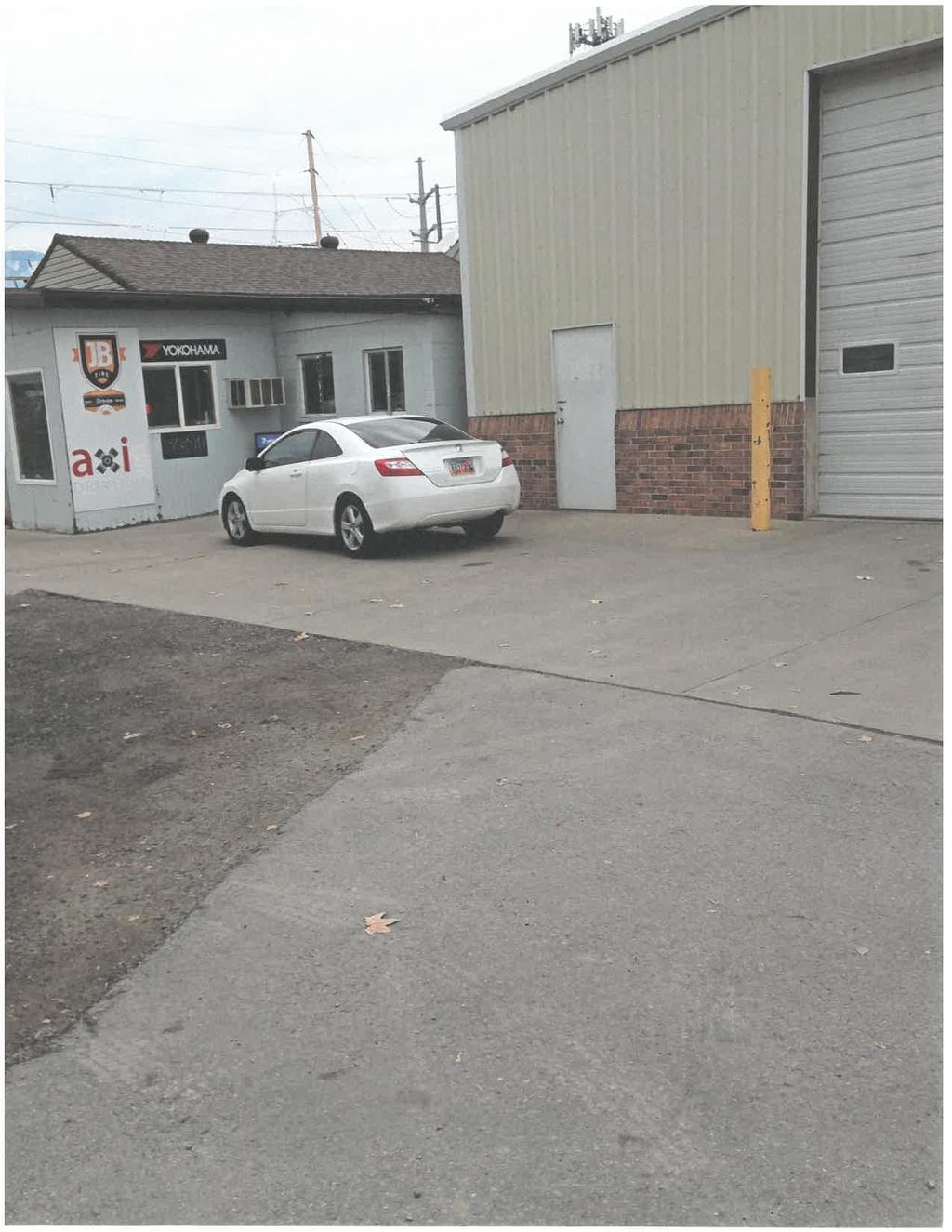
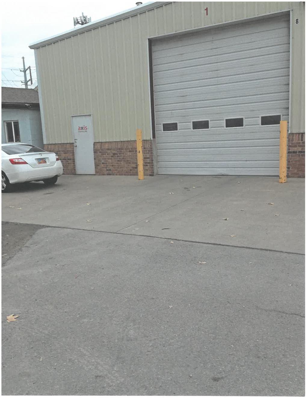
2 MEMORANDUM TO: Planning Commission MEETING DATE: September 21, 2017 FROM: Cathy Brightwell RE: Axis Driveline & Drivetrain, LLC Staff received an application from Eric Banford on December 1, 2017 for a conditional use permit for Axis Driveline & Drivetrain, LLC, located at 847 W 500 South. Axis Driveline intends to provide automotive driveline and drivetrain rebuild and repair. Mr. Banford has secured garage space from Ralph Smith Company that will accommodate 2 vehicles inside the bay. It is unlikely there will be more vehicles on site but if there are, they will be stored in a fenced in area out of site of the street. The West Bountiful City Municipal Code, Commercial Highway (C-H) zone, Section lists motor vehicle sales and service and outdoor storage of retail vehicle inventory as a conditional use which may be approved by the planning commission. The Conditional Use ordinance, Section , requires the planning commission to consider whether: 1. The proposed use at the particular location is necessary or desirable to provide a service or facility that will contribute to the general well-being of the neighborhood and the community; 2. The proposed use will not be detrimental to the health, safety, or general welfare of persons residing or working in the vicinity, or injurious to property or improvements in the vicinity; 3. The proposed use and/or accompanying improvements will not inordinately impact schools, utilities, and streets; 4. The proposed use will provide for appropriate buffering of uses and buildings, proper parking and traffic circulation, the use of building materials and landscaping which are in harmony with the area, and compatibility with adjoining uses; 5. The proposed use will comply with the regulations and conditions specified in the land use ordinance for such use; and 6. The conditions to be imposed in the conditional use permit will mitigate the reasonably anticipated detrimental effects of the proposed use and accomplish the purposes of this subsection. 550 North 800 West, West Bountiful, UT (801)
3 Page 2 Staff recommends the following conditions be required with granting of this conditional use permit, consistent with similar businesses in the area: 1. Fire Inspection approval (scheduled for December 12); 2. Vehicles to be serviced will be stored either inside the garage bay or in a fenced area out of site of the street, no other outdoor storage will be allowed; 3. Upon issuance of this Permit, Axis Driveline & Drivetrain, LLC., will purchase a West Bountiful City business license. 550 North 800 West, West Bountiful, UT (801)
4
5
6 MEMORANDUM TO: Planning Commission DATE: December 8, 2017 FROM: Ben White RE: ADU at 161 N 1450 West Mr. Jones desires to construct a new house for his family at 161 North 1450 West. He also intends to construct a swimming pool next to the house. In preparation for the pool, a pool house (apartment), connected to the house via a small breeze way, is proposed. Since the apartment is a separate dwelling unit, an Accessory Dwelling Unit (ADU) Conditional Use Permit is required before it could be occupied. WBMC Chapter allows a conditional use ADU subject to the development standards specifically listed in Section , and listed below. A. Location. An accessory dwelling unit (ADU) shall be allowed only within or attached to an owner-occupied single family dwelling. B. Number of Accessory Dwelling Units. A maximum of one (1) ADU shall be allowed within or attached to each single family dwelling. No lot or parcel shall contain more than one ADU. C. Parking. Adequate parking shall be made available to accommodate the residential use of an ADU, subject to the residential use parking requirements. At least one (1) space shall be designated for the ADU. Parking stalls shall be paved with concrete, masonry, asphalt, or concrete pavers. D. Utility Metering. No separate utility metering for the ADU shall be allowed, and the utility service shall be in the property owner s name. E. Size of Accessory Dwelling Unit. An ADU shall contain a minimum of 300 square feet; provided, that the dimensions and sizes of living areas, kitchen areas, sleeping areas and bathroom facilities comply with applicable provisions of this title and the current building codes adopted by the City. F. Construction Codes. An ADU shall comply with the construction housing codes in effect at the time the ADU is constructed, created as a separate dwelling, or subsequently remodeled. This shall include the obtaining of a building permit or other permits as the codes may require. G. Architecture. An ADU that is added onto an existing single family dwelling or a new single family dwelling that is designed to accommodate an ADU shall not resemble a multi-family structure in terms of the scattered placement of garage doors, carports, or number or location of outside entries or porches. 550 North 800 West, West Bountiful, UT (801)
7 H. Owner Occupied. The owner of the property on which the ADU is located, as listed in the County Recorder s Office, must reside on the property as their principal residence. At no time shall both the ADU and the primary single family dwelling be rented as separate units. Staff recommends the following Findings of Fact and Conditions be applied to this conditional use permit. Findings: 1. The proposed use at the particular location is necessary or desirable to provide a service or facility that will contribute to the general well-being of the neighborhood and the community; 2. The proposed use will not be detrimental to the health, safety, or general welfare of persons residing or working in the vicinity, or injurious to property or improvements in the vicinity; 3. The proposed use and/or accompanying improvements will not inordinately impact schools, utilities, and streets; 4. The conditions to be imposed in the conditional use permit will mitigate the reasonably anticipated detrimental effects of the proposed use and accomplish the purposes of this subsection. Typical conditions for an ADU include: 1. Provide adequate parking. 2. Meet current building code. 3. The permit is not transferable. If at any time the home is not occupied by the applicant or his immediate family or the applicant sells the property, the permit shall be revoked pursuant to If the applicant decides to lease the ADU, they will include in any lease document, language that the lease will terminate upon sale of the property. 550 North 800 West, West Bountiful, UT (801)

8
9 MEMORANDUM TO: Planning Commission DATE: December 8, 2017 FROM: Ben White RE: High Gate Subdivision Onion Patch Securities, LLC, is proposing a residential development consisting of 27 1-acre lots located between 1100 W and 1450 W south of the Mill Creek canal. The development includes lots that conform to the A-1 zone requirements and open space parcels to be maintained by an H.O.A. As with nearly all properties left to develop, this property has its own unique challenges. 1. The principal entrance to the development will be off of 1100 West at approximately 100 South. The Development includes a 110 foot by 800 foot strip of land which is to be deeded as street right of way. A six-foot-wide sidewalk along one side is proposed along this section of road. An entry landscape island is proposed to be constructed in the middle of the street right of way. 2. The second means of access to the development is a southerly continuation of 1450 West. The developer does not own all the property for the street continuation in its current alignment. The adjoining property owner (Al Jones) and Onion Patch have executed an agreement for the right of way dedication and street construction. In short, they will each pay half the road cost in front of the Jones property. 3. Davis County has agreed to allow a direct discharge into the canal in return for other contributions by the developer. As of the time writing this memo, public works has not had the opportunity to comment on the proposal that the storm drain run between lots 1 and 2 before discharging into the canal. Staff would also like to eliminate the detention basin near lot 13 and pipe that water straight to the canal. 4. The Developer owns a large parcel of land west of this development. The Sewer District has agreed to construct the sewer line to the west and the property owner has agreed to grant the easement. This sewer line will eliminate the need for a sewer lift station West is included to extend south to the development boundary with a temporary vehicle turnaround. There is a 0.5 acre parcel at the south end of the road that can be approved as a commercial use. It is in the B-U zone and not the A-1 zone. 6. Street lights are included along the entry road off 1100 West and at intersections and in the culde-sacs. 7. Fire hydrants are shown on the preliminary plat. 550 North 800 West, West Bountiful, UT (801)
10 8. A Holly Frontier wastewater drain line cuts through the property. The Sewer District will be intercepting and rerouting the flow in 1100 West. The result is that the line through the development will either be abandoned in place or the pipeline removed. 9. A remnant parcel of ground is property off 1450 N against Mill Creek Meadows. The developer is working with the adjoining property for its sale. 10. Jack Williams owns the property to the south of the development. He has expressed a desire for street access. As proposed, the development will provide access to the Williams property at the west end (1450 W) and at the east end of Lot 14 where the right of way aligns with the south property boundary. 11. A portion of the Mill Creek channel is located within this development. The Developer owns the ground and Davis County has an easement. As the plat is currently drawn, Mill Creek is included within the lots. A fence will be maintained between the Mill Creek channel and the home owners rear yards. This means that property owners who own parts of the Mill Creek channel will not have direct access to portions of their property. 12. West Avenue will be renamed. 550 North 800 West, West Bountiful, UT (801)
11
12 MEMORANDUM TO: Planning Commission DATE: December 5, 2017 FROM: Ben White RE: New West Yard Subdivision South Davis Sewer District has agreed to sell West Bountiful City approximately half of their property at approximately 1410 West 1200 North. The Sewer District acquired land from UDOT following the construction of the Legacy Highway. The City is interested in pursuing the construction of a new public work facility at this location. The land parcel is currently acres. The City is purchasing 5.37 acres of this parcel plus a 0.33 acre parcel in unincorporated Davis County. Where this is a subdivision, staff is suggesting we proceed with a public hearing and the standard subdivision process for this property. Rather than a plat, staff is suggesting the exemption from a plat procedure as outlined in state code. A draft of the approval certificate is attached together with the property survey. 550 North 800 West, West Bountiful, UT (801)
13 WHEN RECORDED, RETURN TO: West Bountiful City Corporation Attn: City Recorder 550 North 800 West West Bountiful, Utah WEST BOUNTIFUL CITY LAND USE AUTHORITY S CERTIFICATE OF WRITTEN APPROVAL OF SMALL SUBDIVISION WITHOUT A PLAT In accordance with Utah Code Ann. 10-9a-605, as amended, Exemptions from plat requirement, and West Bountiful Municipal Code (F), as amended, Waiver for Minor or Small Subdivisions, the City Council of West Bountiful City (the City ), acting as the City s land use authority, hereby certifies that the proposed subdivision of the property located at approximately 1410 West 1200 North, West Bountiful, Utah, referred to in the attached record of survey map (the Property ), has met the following requirements: 1. The City has provided notice as required by ordinance. 2. The proposed subdivision is not traversed by the mapped lines of a proposed street as shown in the West Bountiful General Plan and does not require the dedication of any land for street or other public purposes. 3. The proposed subdivision has been approved by the culinary water authority and the sanitary sewer authority. 4. The proposed subdivision is located in a zoned area. 5. The proposed subdivision conforms to all applicable land use ordinances or has properly received a variance from the requirements of an otherwise conflicting and applicable land use ordinance. The City Council, as land use authority, hereby approves and authorizes the subdivision of the Property as outlined in the attached metes and bounds description of the Property. DATED this day, 20. WEST BOUNTIFUL CITY Attest: Mayor City Recorder
14 ACKNOWLEDGMENT STATE OF UTAH ) : ss County of Davis ) On the day of February, 2018, personally appeared before me and who, being duly sworn, acknowledged that they are the Mayor and City Recorder, respectively, of West Bountiful City, and that they signed the foregoing instrument on behalf of the City by authority of the City Council. Notary Public
15 N 0 02'54" W 60.00' ' MSD S 0 00'25" E S 0 03'37" W (R) 60.00' 30.1' ' ' ' GP GP ' GP GP 60.00' SURVEYOR S CERTIFICATE I, Kirk Peter Morgan, do hereby certify that I am a Professional Land Surveyor, and that I hold certificate number , as prescribed by the laws of the State of Utah, and that under my direction a survey has been made of the following described property recorded as Entry No in Book 5101 at Page 76 in the NARRATIVE The purpose of this survey is to establish the boundary of a tract of land prior to the sale of a part of the tract to West Bountiful City and to prepare three legal descriptions (Parcels 2-4) to facilitate this transaction. Also a legal description of a part of the 1200 North Street right of way that is to be vacated by West Bountiful PARCEL 3 A parcel of land in fee, being part of an entire tract of property, situate in the SW1/4 of Section 14, T.2 N., R. 1 W., S.L.B.& M. The boundaries of said parcel of land are described as follows: FOUND: DAVIS COUNTY STD. BC MONUMENT office of the Davis County Recorder: A tract of land situate in the SE1/4 SW1/4 of Section 14, T. 2 N., R. 1 W., S.L.B. & M. The boundaries of said tract of land are described as follows: Beginning at the Southeast corner of said entire tract, which point is m ( ft.) N.0 33'01"W. along the Quarter Section line from the South Quarter corner of said Section 14 as monumented with a county Brass Cap; and running thence N.0 33'01"W m ( ft.) along the easterly line of said tract of land to the southeasterly right of way line of a highway know as Project No. 0067; thence along said southeasterly right of way line the following two (2) courses and distances: (1) thence S.54 40'26"W m ( ft.) to the point of tangency with a m (1,892.06ft.)-radius curve to the left; (2) thence Southwesterly m ( ft.) along the arc of said curve (Note: Chord to said curve bears S.48 51'07"W. for a distance of m ( ft)); thence S.89 56'04"E m ( ft.); thence S.0 03'37"W m ( ft.); thence N '04"E m (36.40 ft.); thence S.0 32'56"E m (4.56 ft.) to the southerly line of said tract of land; thence S.89 56'21"E m ( ft.), more or less, along said southerly boundary line and the north right of way line of 1200 North Street to the point of beginning. The above described tract of land contains 46,729 sq meters ( acres), more or less. SUBJECT TO a perpetual easement and right-of-way in favor of the Utah Department of Transportation, to maintain drainage ditches upon part of an entire tract of land, situate in the SE1/4 SW1/4 of Section 14, T. 2 N., R.1 W., S.L.B. & M. The boundaries of said part of land are described as follows: Beginning at a point m ( ft.) N.0 33'01"W. along the Quarter Section line, m ( ft.) N.89 56'21"W. along the north line of 1200 North Street, m (4.56 ft.) N.00 32'56"W., m. (36.40 ft.) S.89 27'04"W. and m ( ft.) N.0 03'37"E. to the true point of beginning from the South Quarter corner of said Section 14 as monumented with a county Brass Cap; and running thence N.0 03'37"E m ( ft) to the southeasterly right of way line of a highway known as Project No. 0067; thence Southwesterly m ( ft.) along said southeasterly right of way line, along the arc a m (1,892.06)-foot radius curve to the left (Note: Chord to said curve bears S.45 17'12"W. for a distance of m ( ft.)); thence S.89 56'04"E m ( ft.) to the point of beginning. The above described part of an entire tract of land contains 579 sq meters ( acre), more or less. City (Parcel 1) was prepared. Davis County Section Corner Monuments were recovered and used as the basis of bearing for this survey as shown on this plat. The bearings of the record description were rotated 0 04'02" counterclockwise to match this basis of bearing. The legal descriptions of Parcels 1-4 are based on the Davis County Surveyor s basis of bearing. The corners of the parcels were staked on the ground with 5/8 rebar with aluminum caps stamped "ESI Engineering" as shown on this plat. PARCEL 1 A parcel of land, being part of the existing right of way of 1200 North Street, West Bountiful, situate in the SW1/4 of Section 14, T.2 N., R. 1 W., S.L.B.& M. The boundaries of said parcel of land are described as follows: Beginning at the intersection of the northerly right of way line of said 1200 North Street and the northwesterly right of way and no-access line of State Route 67 (Legacy Parkway), which point is N.0 37'03"W feet along the Quarter Section line and S.89 59'37"W feet from the South Quarter Corner of said Section 14; and running thence S.40 23'22"W feet along said northwesterly right of way and no-access line to the southerly right of way line of said 1200 North Street; thence S.89 59'37"W feet along said southerly right of way line to the westerly boundary line of said Southwest Quarter of Section 14; thence N.0 02'54"W feet along said section line to the northerly right of way line of said 1200 North Street; thence N.89 59'37"E feet along said northerly right of way line to the point of beginning. The above described parcel of land contains 59,577 square feet or acres. Note: Basis of bearing, N.0 37'03"W. along the Quarter Section line, as per Davis County Survey s published data. Rotate above bearings 0 04'02" clockwise to equal record deed bearings. PARCEL 2 A parcel of land in fee, being part of an entire tract of property, situate in the SW1/4 of Section 14, T.2 N., R. 1 W., S.L.B.& M. The boundaries of said parcel of land are described as follows: Beginning at a point in the easterly boundary line of said entire tract, which point is feet N.0 37'03"W. along the Quarter Section line from the South Quarter Corner of said Section 14; and running thence S.89 55'58"W feet to the Beginning at southeast corner of said entire tract, which point is feet N.0 37'03"W. along the Quarter Section line from the South Quarter Corner of said Section 14; and running thence S.89 59'37"W feet along the southerly boundary line of said entire tract; thence N.0 37'03"W feet to the southeasterly right of way and no-access line of State Route 67 (Legacy Parkway); thence N.54 36'24"E feet along said southeasterly right of way and no-access line; thence N.89 55'58"E feet to the easterly boundary line of said entire tract; thence S.0 37'03"E feet along said easterly boundary line to the point of beginning. The above described parcel of land contains 233,835 square feet or acres of which 4,716 square feet or acre lies within the existing right of way of 1200 North Street. Balance 229,119 square feet or acres. Note: Basis of bearing, N.0 37'03"W. along the Quarter Section line, as per Davis County Survey s published data. Rotate above bearings 0 04'02" clockwise to equal record deed bearings. PARCEL 4 A parcel of land in fee, being part of an entire tract of property, situate in the SW1/4 of Section 14, T.2 N., R. 1 W., S.L.B.& M. The boundaries of said parcel of land are described as follows: Beginning at a point in the southerly boundary line of said entire tract, which point is feet N.0 37'03"W. along the Quarter Section line and feet S.89 59'37"W. from the South Quarter Corner of said Section 14; and running thence S.89 59'37"W feet; thence N.0 36'58"W feet; thence S.89 23'02"W feet; thence N.0 00'25"W feet; thence S.89 59'54"W feet to the southeasterly right of way and no-access line of State Route 67 (Legacy Parkway); thence along said southeasterly right of way and no-access line the following two (2) courses and distances: (1) northeasterly feet along the arc of a foot radius non-tangent curve to the right (Note: Chord to said curve bears N.48 47'05"E. for a distance of feet); thence (2) N.54 36'24"E feet; thence S.0 37'03"E feet to the point of beginning. The above described parcel of land contains 254,797 square feet or acres of which 6,226 square feet or acre lies within the existing right of way of 1200 North Street. Balance 248,571 square feet or acres Note: Basis of bearing, N.0 37'03"W. along the Quarter Section line, as per Davis County Survey s published data. Rotate above bearings 0 04'02" clockwise to equal record deed bearings. STATE ROUTE 67 (LEGACY PARKW AY) ' S 54 40'26" W (R) S 54 36'24" W ' ' ' PARCEL ACRES S 89 55'58" W ' N 0 37'03" W ' QUARTER SECTION LINE - BASIS OF BEARING EPP EP N 0 37'03" W ' (D.C.S.) ' (M EAS.) N 0 33'01" W (R) P.O.B. Parcel 2 50' 50' 100' 0' N T.2 N. R.1 W. S.L.B. & M. SCALE IN FEET southeasterly right of way and no-access line of State Route 67 (Legacy Parkway); N 0 37'03" W ' DATE KIRK PETER MORGAN UTAH LICENSE NO thence N.54 36'24"E feet along said southeasterly right of way and no-access line to the northeast corner of said entire tract; thence S.0 37'03"E feet along said easterly boundary line to the point of beginning. The above described parcel of land contains 14,377 square feet or acre. Note: Basis of bearing, N.0 37'03"W. along the Quarter Section line, as per Davis County Survey s published data. Rotate above bearings 0 04'02" clockwise to equal record deed bearings. SW 1/4 SEC ' SD UDOT PERPETUAL DRAINAGE EASEMENT R= ' D=11 38'39" L=384.51' MSD PARCEL ACRES SOUTH DAVIS SEWER DISTRICT PARCEL ACRES EPP EP SE 1/4 SEC. 14 WILLIAM GOLDBERG AND KATHRYN GOLDBERG N 89 59'54" E S 89 56'04" E (R) 1200 NORTH STREET N 89 59'37" E ' S 89 59'37' W ' SOUTH DAVIS SEWER DISTRICT PARCEL ACRES P.O.B. Parcel ' S 40 23'22" W S 89 59'37" W ' UTAH DEPARTMENT OF TRANSPORTATION SD 1200 NORTH STREET MSS SS N 89 23'02" E 36.40' N 89 27'04" E (R) S 0 36'58" E 4.56' S 0 32'56" E (R) EPP P.O.B. Parcel 4 EP EP EP R/W LINE (PERSCRIPTIVE) EP DEED LINE (RECORD) R/W LINE (PERSCRIPTIVE) EPP ' N 89 59'37" E ' S 89 56'21" E (R) EPP EPP DEED LINE (RECORD) SS MSS ' R/W LINE (PER ROCKIN V ACRES PLAT) EDGE OF PAVEMENT EDGE OF PAVEMENT EPP EP P.O.B. Overall & Parcel 3 LEGEND EP SS SD SD EPP MSS MSD DAVIS CO. SECTION CORNER MONUMENT DAVIS COUNTY STREET MONUMENT UTILITY POLE - ELECTRIC MANHOLE - SANITARY SEWER MANHOLE - STORM DRAIN CLEAN OUT BOX - STORM DRAIN WATER VALVE FIRE HYDRANT SET 5/8" REBAR WITH CAP (R) DESIGNATES RECORD BEARING SOUTH DAVIS SEWER DISTRICT STATE ROUTE 67 (LEGACY PARKW AY) UTAH DEPARTMENT OF TRANSPORTATION SW 1/4 SEC. 14 WEST BOUINTIFUL CITY LOT 1 LOT 3 LOT 2 ROCKIN V ACRES SUBDIVISION FOUND: DAVIS COUNTY STD. BC MONUMENT NW 1/4 SEC. 23 NE 1/4 SEC. 23 REVISION DATE BY DESCRIPTION DESIGN KPM DRAWN KPM CHECKED CRH DATE 10/5/17 RECORD OF SURVEY PLAT SOUTH DAVIS SEWER DISTRICT PROPERTY 1500 WEST, 1200 NORTH WEST BOUNTIFUL, UTAH WEST BOUNTIFUL CITY 550 NORTH, 800 WEST WEST BOUNTIFUL, UTAH ESI ENGINEERING CONSULTING ENGINEERS AND LAND SURVEYORS 3500 SOUTH MAIN STREET SUITE 206 SALT LAKE CITY, UTAH TEL:(801) SHEET 1 OF 1 PROJECT NO

16 MEMORANDUM TO: Planning Commission DATE: December 5, 2017 FROM: Ben White RE: Yard Regulations About a year ago, the city made changes the yard regulations which included relaxed fencing requirements and formally recognizing street side yards for corner lots different than side yards for lots not on a street corner. It has come to staff s attention as we have applied the new code language to various situations in the city, that the language is not as clear as it could be. Included with this memo is a redline version of the proposed changes. The changes better identify the required setbacks for main structures and accessory structures. The change also clarifies what setbacks can or cannot be modified by a conditional use permit. Since the setback language is the same in all three residential zones (R 1 10, R 1 22 and A 1), only code section is included. The intent is that any changes would apply equally to all sections. 550 North 800 West, West Bountiful, UT (801)
17 "Setback" means the distance between a lot line and a structure on the lot. Setbacks are measured from the lot line to the nearest foundation or column. For a main structure in any residential district, a maximum two foot cantilever that does not extend to the ground, such as a bay window or chimney, is allowed in the setback area "Yard" means a required open space on a lot, other than a court, unoccupied and unobstructed from the ground upward, except as permitted elsewhere in this title. Yard, Front. "Front yard" means a space on the same lot with a building, between the front line of the building and the front lot line, and extending across the full width of the lot. The "depth" of the front yard is the minimum distance between the front lot line and the front line of the building. Yard, Rear. "Rear yard" means a space on the same lot with a building, between the rear line of the building and the rear lot line, and extending the full width of the lot; provided that in a corner lot, the rear yard extends only from the side lot line to the street side yard. The "depth" of the rear yard is the minimum distance between the rear lot line and the rear line of the building. Yard, Side. "Side yard" means a space on the same lot with a building, between the side line of the building and the side lot line and extending from the front yard to the rear yard. The "width" of the side yard shall be the minimum distance between the side lot line and the side line of the building. Yard, Street Side. "Street side yard" means the space on the same lot with a building, between the side line of the building and the street side lot line and extending from the front yard to the rear lot line. The "width" of the street side yard is the minimum distance between the street side lot line and the side line of the building Yard Regulations The following regulations apply in the residential district R-1-10: A. Minimum Setbacks. 1. Front yard. The minimum front yard setback for all structures is thirty (30) feet, except as otherwise allowed in this Code. 2. Side yard. Formatted: Left a. The minimum side yard setback for all main structures is ten (10) feet for any one side. Main structures shall have, with a combined total of twentyfour (24) feet for both sides. b. On a corner lot, the minimum street side yard setback for a main structure is twenty (20) feet. c. Accessory structures may be erected up to within three (3) feet of the street side lot line if: a. The accessory structure is set back from the front lot line farther than the rear line of the main structure; b. Is two hundred (200) square feet or less; c. Has a maximum height of nine (9) feet measured from the lowest finish ground level to the highest part of the roof; and d. Complies with other requirements of this Code. d. Accessory structures larger than two hundred (200) square feet and taller than nine (9) feet may be constructed within the street side yard if the
18 structure meets the minimum street side yard setback for main structures and complies with other requirements of this Code. e. The minimum side yard and street side yard setback for accessory structures is six (6) feet, or three (3) feet if built to fire code standards, unless otherwise approved as a conditional use by the planning commission. 3. Rear yard. a. The minimum rear yard setback for all main structures is thirty (30) feet. b. The minimum rear yard setback for accessory structures is six (6) feet, or three (3) feet if built to fire code standards., unless otherwise approved as a conditional use by the planning commission. c. A deck may encroach into a rear yard setback only with a conditional use permit meeting the following criteria: a. The entire deck is at least twenty (20) feet from the rear property line; b. The deck does not encroach more than 200 square feet into the setback area; c. The floor of the deck is no higher than the highest finished floor of the main structure; d. The portion of the deck that extends into the rear yard setback cannot be covered; e. The railing cannot be more than forty-eight (48) inches high and must be less than twenty-five (25%) non-transparent; and f. The deck satisfies other conditions required by the planning commission. B. Distance between main structures and accessory buildings. The minimum distance between all main structures and accessory use buildings shall be ten (10) feet, unless otherwise approved by the planning commission as a conditional use. A conditional use cannot reduce the minimum required front, side, street side or rear yard setbacks. C. No building on recorded easements. Main structures and permanent accessory buildings shall not be built on or over any recorded easements (i.e., public utility easements, etc.) D. Lot standards and street frontage. Except as otherwise provided in this title, every lot hereafter created or modified shall have such area, width and depth as is required by this title for the district in which such lot is located and shall have frontage upon a public street or upon a private street or right-of-way approved by the planning commission, before a building permit may be issued. E. Yard space for one building only. No required yard or other open space around an existing building or which is hereafter provided around any building for the purpose of complying with the provisions of this title shall be considered as providing a yard or open space for any other building. Nor shall any yard or other required open space on an adjoining lot be considered as providing a yard or open space on a lot where building is established. F. Area of structure and accessory building. No structure or accessory building or group of structures or accessory buildings in any residential district shall cover more than thirty-five percent (35%) of the rear yard. G. Sales or lease of space. No space needed to meet the width, yard, area, coverage, parking or other requirements of this title for a lot or building may be sold or leased away from such lot or building H. Other Building and Structure Restrictions. No structure, including any structure exempt from a building permit, shall be allowed in any part of a required front, side or street side yard setback except landscape enhancements, such as trellises and arbors, shall be allowed subject to other applicable regulations. Any such landscape enhancement in the
19 front, side or street side yard shall be limited to a gross area of ten (10) square feet or less, a width no greater than sixty (60) inches, and a height no greater than ninety-six (96) inches and shall be subject to applicable site triangle area restrictions.
20
21 1 2 West Bountiful City PENDING November 28, 2017 Planning Commission Posting of Agenda - The agenda for this meeting was posted on the State of Utah Public Notice website and on the West Bountiful City website on November 21, 2017 per state statutory requirement Minutes of the Planning Commission meeting of West Bountiful City held on Tuesday, November 28, 2017 at West Bountiful City Hall, Davis County, Utah Those in Attendance: MEMBERS PRESENT: Chairman Denis Hopkinson, Alan Malan, Laura Charchenko, Corey Sweat, Mike Cottle, and Council member Kelly Enquist STAFF PRESENT: Ben White (City Engineer), Cathy Brightwell (Recorder), Debbie McKean (Secretary) VISITORS: Gary Jacketta, Mike Brodsky, Zach Brodsky, Mark Preece, Nick Mingo, Chelsey Berg, Mike George, Lynne George, Chris Jenson, and Rob Jenson. The regular Planning Commission Meeting was called to order at 7:30 pm by Chairman Denis Hopkinson. Mike Cottle offered a prayer Accept Agenda Chairman Hopkinson reviewed the agenda. Mike Cottle moved to accept the agenda as presented. Corey Sweat seconded the motion. Voting was unanimous in favor among members present. 2. Consider Planned Unit Development for Kinross Estates at Porter Lane and 1100 West by Hamlet Homes Commissioner packets included a memorandum dated November 21, 2017 from Ben White regarding Kinross Estates PUD Application with attached diagrams and the development agreement. Ben White noted that this new proposal from the Hamlet Development for a Planned Unit Development (PUD) still includes 34 lots on 23 acres in the R-1-22 zone. Their previous proposal was denied at the last meeting. He noted there have been some alterations made which are listed below. 4 lots proposed on Porter have been reduced to 3 lots all over 20,000 sq.ft. Some lots have been reconfigured and the subdivision still is proposing 34 lots consisting of 5 lots - 11,000 to 15,000 sq. ft., 14 lots - 15,000 to 20,000 sq. ft., and 15 lots over 20,000 sq. ft. Note: a half acre is 21,700 sq. ft. 3 acres of open space remain. CCRs include the city s farm animal ordinance. Operable vehicles can be stored on property.
22 Lots cannot be further subdivided. All required studies have been concluded and are available at City Hall for review. Commission Comments: Alan Malan is still bothered by the 1700 ft. dead-end road. He asked about fencing around the contaminated area. The fencing is proposed to be a rail fence along street and a square field fence around the balance of the area. Mr. Malan is still opposed to the number of small lots and would prefer the lots on the west be extended to the road. Laura Charchenko identified an inconsistency between the development agreement and CCRs regarding construction and sales trailers and asked that it be fixed. Preliminary plat easement for the open space needs to be in writing. She stated that if all the studies meet engineering standards and pass legal she supports them. The three-way agreement needs to be settled. Corey Sweat for the most part supports the PUD but suggests that 2 lots need to be removed in order to better comply to the half-acre standard. He does not want to see any quarter acre lots and proposed some options to enlarge them. He wants to make sure that lots close to half acre are not decreased in size to make the smaller lots larger. Elimination of 2 lots would help fix the problem. Mike Cottle does not want smaller lots; he may be okay with a couple third acre lots Michael Brodsky took the stand and apologized for the frequency that he has burdened them with this development. He is torn trying to make this development financially viable for the developer and seller and appease the Commission with the open space feel. He further explained the challenges of the property to create a subdivision. He feels that they have tried to make a reasonable trade off in maintaining a rural feel along 1100 West with open space and along Porter Lane with larger lots. He stated that there will be a production trailer on site during construction but there will be no sales trailer; he will correct the difference between the development agreement and the CCR s. Mr. Brodsky said the 1700 ft. dead-end road will be resolved when the property to the south is developed and the stub roads are completed. If the commission prefers to break up the open space and run the road out to 1100 West, he is willing to do that but needs direction from them. Commissioners were polled and there is only one Commissioner that has issues with the length of the road. Corey Sweat likes the open space parcel but the power easements will dictate that the space remains open anyway even with individual owners. Mr. Brodsky stated that one benefit may be that individual property owners will collect debris on the lots which will not be allowed on a single open space parcel. Chairman Hopkinson does not like extending lots to make them longer as he considers them too narrow already. Long skinny lots can be problematic. He is concerned with the east side of the development and feels that by removing lot # 4 and spreading it to lot 5 and 6 would make them closer to the ½ acre. Alan Malan feels all the lots on the west side need to be ½ acres. Some discussion took place regarding some possible realignments of lots to increase their size.
23 Mr. Brodsky stated that they may be able to shift the main road to the west enough to increase the size of lots along its east side. He said they are willing to make the smaller lots closer to 15,000 sq.ft, and will commit to still have fifteen lots over 20,000 sq.ft. He asked the commission to consider approving the PUD based on this commitment and he will bring back the drawings once they are complete. Chairman Hopkinson reminded the Commissioners of the feedback they have received from letters of citizen s and the public hearing. The half-acre zone should be adhered to as best as possible, although the reason for the PUD is for exceptions from the zone and in this case, give the developer some flexibility with the many challenges this area presents. Chairman Hopkinson proposed that the redraw be in front of them before approving the Preliminary Plat. Laura Charchenko was concerned that moving the road would create a domino effect to some of the other lots. She feels it is important to have the physical drawings in front of us to review. Kelly Enquist questioned the benefit the city is receiving to approve this as a PUD. He is also concerned with the egress and ingress of the development. Mike Cottle inquired what the benefit is of this PUD to the City. Chairman Hopkinson responded that it is no real benefit to the City but gives the developer some flexibility and therefore allows the area to be improved by developing it. Mr. Brodsky noted that if a PUD is not approved then the City gives up control of the development agreement and such so they could be at liberty to develop anyway they want on half acre lots. Chairman Hopkinson encouraged Mr. Brodsky to be patient as they are close to having something that they can approve. All the legal documents are in order up to this point. Discussion will be only on the lot sizes at the next meeting. Corey Sweat asked if Staff could provide a side by side comparisons of the two site plans for Kinross Estates for the next meeting. Staff committed to do their best to provide them with the documentation. Mike Cottle wants to review the letters from public hearing. ACTION TAKEN: Corey Sweat moved to table the approval of the PUD until a current plat plan as discussed, this evening. Alan Malan seconded the motion and voting was unanimous in favor Staff Report Ben White: Noted that there will be some Code language proposals brought before them regarding side yards after the first of the year
24 Cathy Brightwell: Announced that Christmas on Onion Street will be this next Monday. Newsletter will be out by Friday. She asked if they wanted to hold the meeting scheduled on December 26 th. Commissioners will likely cancel the December 26 th meeting Consider Approval of Minutes from November 14, ACTION TAKEN: Laura Charchenko moved to approve of the minutes of the November 14, 2017 meeting as corrected. Corey Sweat seconded the motion and voting was unanimous in favor Adjournment ACTION TAKEN: Alan Malan moved to adjourn the regular session of the Planning Commission meeting at 8:40 p.m. Laura Charchenko seconded the motion. Voting was unanimous in favor The foregoing was approved by the West Bountiful City Planning Commission on December 12, 2017, by unanimous vote of all members present Cathy Brightwell City Recorder 134
WEST BOUNTIFUL PLANNING COMMISSION
 Mayor Kenneth Romney City Engineer/ Zoning Administrator Ben White City Recorder Cathy Brightwell WEST BOUNTIFUL PLANNING COMMISSION 550 North 800 West West Bountiful, Utah 84087 Phone (801) 292-4486 FAX
550 North 800 West West Bountiful, Utah Phone (801) FAX (801) PLANNING COMMISSION MEETING
 FAX (801) PLANNING COMMISSION MEETING") Mayor Kenneth Romney City Council James Ahlstrom James Bruhn Kelly Enquist Debbie McKean Mark Preece WEST BOUNTIFUL CITY 550 North 800 West West Bountiful, Utah 84087 Phone (801) 292-4486 FAX (801) 292-6355
Mayor Kenneth Romney City Council James Ahlstrom James Bruhn Kelly Enquist Debbie McKean Mark Preece WEST BOUNTIFUL CITY 550 North 800 West West Bountiful, Utah 84087 Phone (801) 292-4486 FAX (801) 292-6355
WEST BOUNTIFUL PLANNING COMMISSION
 Mayor Kenneth Romney City Engineer/ Zoning Administrator Ben White City Recorder Cathy Brightwell WEST BOUNTIFUL PLANNING COMMISSION 550 North 800 West West Bountiful, Utah 84087 Phone (801) 292-4486 FAX
ABBREVIATION LEGEND SITE INFORMATION:
 SITE INFORMATION: Current Zone: R-3 PUD, governed by Fox Hollow 2nd MDA Basis of Elevations: Northeast Corner of Section 13, T6S, R1W, S.L.B. & M Elevation: 4599.26 (Benchmark) ABBREVIATION LEGEND Owners:
PLANNING COMMISSION STAFF REPORT
 PLANNING COMMISSION STAFF REPORT Alder-Robinson Subdivision Amending the Amended Plat of the Arcadia Heights Plat A Subdivision Case #PLNSUB2010-00044 2857 East 2100 South June 23, 2010 Applicant: Greg
Preliminary Subdivision Application (Minor) (Three (3) lots or less)
 (Three (3) lots or less)") Gunnison City Offices www.gunnisoncity.org 38 West Center Gunnison, Utah 84634 (435) 528 7969 Date of Application: Preliminary Subdivision Application (Minor) (Three (3) lots or less) APPLICANT INFORMATION
Gunnison City Offices www.gunnisoncity.org 38 West Center Gunnison, Utah 84634 (435) 528 7969 Date of Application: Preliminary Subdivision Application (Minor) (Three (3) lots or less) APPLICANT INFORMATION
FINAL PLAT GUIDE TO SUBDIVIDING PROPERTY. Background
 FINAL PLAT GUIDE TO SUBDIVIDING PROPERTY Background A final plat is the second step in the process of subdividing land into separate parcels for future sale or lease. Once a preliminary plat has been approved
ADMINISTRATIVE HEARING STAFF REPORT Country Club Acres Second Amended Subdivision Amendment PLNSUB E Parkway Avenue December 12, 2013
 ADMINISTRATIVE HEARING STAFF REPORT Country Club Acres Second Amended Subdivision Amendment PLNSUB2013-00925 2167 E Parkway Avenue December 12, 2013 Planning Division Department of Community & Economic
SUBDIVISION APPLICATION
 SUBDIVISION APPLICATION Preliminary Plat Minor Plat Final Plat Amended Plat Applicant Name: Owner (if different from applicant) Name: Company: Company: Address: Address: City, State, Zip City, State, Zip
Preliminary Subdivision Application (Major) (Four (4) lots or more)
 (Four (4) lots or more)") Gunnison City Offices www.gunnisoncity.org 38 West Center Gunnison, Utah 84634 (435) 528 7969 Date of Application: Preliminary Subdivision Application (Major) (Four (4) lots or more) APPLICANT INFORMATION
Gunnison City Offices www.gunnisoncity.org 38 West Center Gunnison, Utah 84634 (435) 528 7969 Date of Application: Preliminary Subdivision Application (Major) (Four (4) lots or more) APPLICANT INFORMATION
Planning Commission Work Meeting Minutes Thursday, October 18, 2018 City Council Chambers 220 East Morris Avenue Time 6:45 p.m.
 Planning Commission Work Meeting Minutes Thursday, October 18, 2018 City Council Chambers 220 East Morris Avenue Time 6:45 p.m. Commission Members Present: Jeremy Carter Susan Dickstein Chad Ewell Beth
Staff Report to the North Ogden Planning Commission
 Staff Report to the North Ogden Planning Commission SYNOPSIS / APPLICATION INFORMATION Application Request: Consideration and action on an administrative application for final approval for the Legacy North
DIVISION 2 - CONSTRUCTION PLAN AND MISCELLANEOUS REQUIREMENTS
 DIVISION 2 - CONSTRUCTION PLAN AND MISCELLANEOUS REQUIREMENTS 2.1 Required Plan Sheets 2.2 Drawing Requirements 2.3 Graphic Standards 2.4 Easements 2.5 Utility Locations 2.6 Private Facility Locations
SECTION 10.7 R-PUD (RESIDENTIAL PLANNED UNIT DEVELOPMENT) ZONE
 ZONE") Article X Zones 10-20 SECTION 10.7 R-PUD (RESIDENTIAL PLANNED UNIT DEVELOPMENT) ZONE A. PURPOSE AND INTENT: The R-PUD Residential PUD Zone is intended to provide alternative, voluntary zoning procedures
Article X Zones 10-20 SECTION 10.7 R-PUD (RESIDENTIAL PLANNED UNIT DEVELOPMENT) ZONE A. PURPOSE AND INTENT: The R-PUD Residential PUD Zone is intended to provide alternative, voluntary zoning procedures
CHAPTER 26 PLANNING AND ZONING ARTICLE VII. MOBILE HOMES AND RECREATIONAL VEHICLE (RV) PARKS. Recreational Vehicle (RV) Park Development Standards
 PARKS. Recreational Vehicle (RV) Park Development Standards") CHAPTER 26 PLANNING AND ZONING ARTICLE VII. MOBILE HOMES AND RECREATIONAL VEHICLE (RV) PARKS. Section 26-VII-1. Section 26-VII-2. Section 26-VII-3. Section 26-VII-4. Section 26-VII-5. Purpose Permitted
CHAPTER 26 PLANNING AND ZONING ARTICLE VII. MOBILE HOMES AND RECREATIONAL VEHICLE (RV) PARKS. Section 26-VII-1. Section 26-VII-2. Section 26-VII-3. Section 26-VII-4. Section 26-VII-5. Purpose Permitted
ORDINANCE NO AN ORDINANCE To Be Entitled:
 3808 AN ORDINANCE To Be Entitled: AN ORDINANCE OF THE CITY COUNCIL OF THE CITY OF FORT MYERS, FLORIDA, REZONING FROM COMMERCIAL GENERAL TO PLANNED UNIT DEVELOPMENT AND APPROVING THE DEVELOPMENT PLAN FOR
610 LAND DIVISIONS AND PROPERTY LINE ADJUSTMENTS OUTSIDE A UGB
 ARTICLE VI: LAND DIVISIONS AND PROPERTY LINE ADJUSTMENTS VI-21 610 LAND DIVISIONS AND PROPERTY LINE ADJUSTMENTS OUTSIDE A UGB 610-1 Property Line Adjustments (Property Line Relocation) A property line
Staff Report to the North Ogden City Council
 Staff Report to the North Ogden City Council SYNOPSIS / APPLICATION INFORMATION Application Request: Consideration and action on an administrative application to provide comments on the preliminary plan
CERTIFIED SURVEY MAP
 SCONSIN STATE PLANE N:389676.12 E:2130390.15 Center of Section 23 CERTIFIED SURVEY MAP 734.06' THE (PRITCHETTE) ORIGINAL PLAT OF ALL IN THE NW 1 4 OF THE SE 1 4 OF FRACTIONAL SECTION 23, T7N, R9E, IN THE
ORDINANCE NO. Be it ordained by the City Council of the City of Abilene, Texas:
 ORDINANCE NO. An ordinance repealing Chapter 23, Subpart B of the Code of the City of Abilene, Texas, entitled Mobile Homes and Vacation Travel Trailers; stating the authority; setting forth the scope
A favorable recommendation to the City Council is requested.
 To: Sycamore Plan Commission From: Brian Gregory, City Manager Date: October 8, 2015 Re: October 12, 2015 Plan Commission Meeting The Plan Commission has two action items. A. Consideration of a request
MINOR PLAT. The following documents are provided as required by the City of Conroe for use in the above titled platting submittals:
 Public Works - Engineering Division CITY OF CONROE MINOR PLAT The following documents are provided as required by the City of Conroe for use in the above titled platting submittals: Submittal Questionnaire
ARTICLE 3 DEFINITIONS
 Sections: 3-1 Rules of Construction 3-2 Definitions ARTICLE 3 DEFINITIONS SECTION 3-1 RULES OF CONSTRUCTION 3-101. a. The language set forth in these regulations shall be interpreted in accordance with
II. What Type of Development Requires Site Plan Review? There are five situations where a site plan review is required:
 I. What is a Site Plan Review? Site Plan Review is a process where the construction of new buildings, new additions, and certain types of canopies and/or tax-exempt institutions are reviewed by the City
The following regulations shall apply in the R-E District:
 "R-E" RESIDENTIAL ESTATE DISTRICT (8/06) The following regulations shall apply in the R-E District: 1. Uses Permitted: The following uses are permitted. A Zoning Certificate may be required as provided
Township of Little Egg Harbor Planning Board 665 Radio Road Little Egg Harbor, New Jersey Phone: ext. 221 Fax:
 BLOCK(S) LOT(S) Township of Little Egg Harbor Planning Board 665 Radio Road Little Egg Harbor, New Jersey 08087 Phone: 609-296-7241 ext. 221 Fax: 609-294-3040 Development Application Amended Development
VICINITY MAP SCALE 1'' = 2000'
 CITY CREEK ANNEXATION TO THE CITY OF THORNTON LOCATED IN THE SOUTHWEST QUARTER OF SECTION 11 AND THE WEST HALF OF SECTION 14, TOWNSHIP 1 SOUTH, RANGE 68 WEST OF THE 6TH PRINCIPAL MERIDIAN, COUNTY OF ADAMS,
MINOR SUBDIVISION PLAT CHECKLIST
 MINOR SUBDIVISION PLAT CHECKLIST Project Name: Tax ID #: Project Number: Date: _ Reviewed By: Telephone: NOTES: All lots on septic systems must comply with the Fulton County Health Department requirements
CHAPTER XIX ANNEXATION ARTICLE 1. ANNEXATION
 CHAPTER XIX ANNEXATION ARTICLE 1. ANNEXATION 19.0101 JABORSKY ADDITION: WHEREAS, The City of Belfield pursuant to Section 40-51.2-07 of the North Dakota Century Code has amended having passed a Resolution
STAFF REPORT Administrative Subdivision Hearing West 150 South Street, Parcel # , and
 Petition Number: 490-06-24 STAFF REPORT Administrative Subdivision Hearing Project Name: Project Location: Project Type: Applicant: Planning Staff: Haight Industrial Subdivision 5550 West 150 South Street,
MINOR SUBDIVISION APPLICATION
 Planning and Development 510 N. Baker St. Mount Dora, FL 32757 352-735-7112 Fax: 352-735-7191 plandev@cityofmountdora.com Date: Project Name: MINOR SUBDIVISION APPLICATION 1. Applicant s Name: 2. Property
ARTICLE 900 PLAT AND PLAN REQUIREMENTS
 ARTICLE 900 PLAT AND PLAN REQUIREMENTS SEC. 900.1 ITEMS TO BE SHOWN ON PLAT OR PLAN General (1) Property lines of all property owners adjacent to the exterior boundaries of the project shall be located
COUNCIL AGENDA MEMO ITEM NO. III - #1
 COUNCIL AGENDA MEMO ITEM NO. III - #1 FROM: Anton Jelinek, Director of Utilities MEETING: October 24, 2017 SUBJECT: PRESENTER: Permanent Utility and Right-of-Way Easement Anton Jelinek Discussion: At the
ORDINANCE NO. O-5-10
 ORDINANCE NO. O-5-10 AN ORDINANCE OF THE TOWN COMMISSION OF THE TOWN OF PALM BEACH SHORES, FLORIDA, AMENDING THE TOWN CODE OF ORDINANCES AT APPENDIX A. ZONING. SECTION VI. DISTRICT B REGULATIONS BY AMENDING
Planning Commission recommends APPROVAL of the amendment to Article 4, Article 7, and Article 14 as presented by Staff on 6/19/17.
 DATE: June 20, 2017 TO: FROM: SUBJECT: Mayor and City Council Planning Director Zoning Ordinance Amendment Article 4, Article 7, and Article 14 related to accessory uses, fences, walls, and administrative
ORDINANCE NO. 41. PRIVATE ROAD ORDINANCE As Amended Through April 10, 2008
 ORDINANCE NO. 41 PRIVATE ROAD ORDINANCE As Amended Through April 10, 2008 An Ordinance to protect the health, safety, and general welfare of the inhabitants of Port Sheldon Township. The Township of Port
SUBDIVISION DESIGN PRINCIPLES AND STANDARDS
 SECTION 15-200 SUBDIVISION DESIGN PRINCIPLES AND STANDARDS 15-201 STREET DESIGN PRINCIPLES 15-201.01 Streets shall generally conform to the collector and major street plan adopted by the Planning Commission
RIVERDALE CITY PLANNING COMMISSION APPLICATION FOR RESIDENTIAL SUBDIVISION SITE PLAN APPROVAL
 Community Development 4600 So. Weber River Drive Riverdale, Utah 84405 RIVERDALE CITY PLANNING COMMISSION APPLICATION FOR RESIDENTIAL SUBDIVISION SITE PLAN APPROVAL CASE NO: DATE SUBMITTED: APPLICANT S
ELK RAPIDS TOWNSHIP ANTRIM COUNTY, MICHIGAN ORDINANCE NO
 ELK RAPIDS TOWNSHIP ANTRIM COUNTY, MICHIGAN ORDINANCE NO. 3-2011 AN ORDINANCE TO REPLACE THE SUBDIVISION CONTROL ORDINANCE WITH A NEW SUBDIVISION DEVELOPMENT ORDINANCE, IN ACCORD WITH THE LAND DIVISION
MEMORANDUM. Monday, November 19, :00 p.m. Kiawah Island BZA Meeting Packet
 MEMORANDUM TO: FROM: Town of Kiawah Island BZA Members John Taylor, Jr., Planning Director DATE: November 9, 2018 SUBJECT: Monday, November 19, 2018 4:00 p.m. Kiawah Island BZA Meeting Packet Attached
COMMERCIAL SITE PLAN & CONDITIONAL USE PERMIT REVIEW PROCESS & CHECKLIST
 Community Development 110 South Main Street Springville, UT 84663 COMMERCIAL SITE PLAN & CONDITIONAL USE PERMIT REVIEW PROCESS & CHECKLIST 801.491.7861 www.springville.org Prior to the issuance of a building
Community Dev. Coord./Deputy City Recorder
 1 2 3 4 5 6 7 8 9 10 11 12 13 14 15 16 17 18 19 20 21 22 23 24 25 26 27 28 29 30 31 32 33 34 35 36 37 38 39 40 41 42 43 44 45 46 NORTH OGDEN PLANNING COMMISSION MEETING MINUTES December 18, 2013 The North
MAPLETON CITY CORPORATION. Step 7: Upon final approval and prior to plat recording the applicant shall provide the following:
 MAPLETON CITY CORPORATION Subdivision Process The City s subdivision requirements are designed to facilitate orderly, safe and efficient development and to implement the adopted General Plan. Below is
FINAL SUBDIVISION AND LAND DEVELOPMENT PLAN CHECKLIST. Plan Name. Applicant's Name:
 TOWNSHIP OF UPPER ST. CLAIR FINAL SUBDIVISION AND LAND DEVELOPMENT PLAN CHECKLIST Date Filed Plan Name PLC Applicant's Name: Phone Filing Date for Final Application Final Plat 114.22. FINAL APPLICATION
BEAR CREEK TOWNSHIP EMMET COUNTY, MICHIGAN. PRIVATE ROAD ORDINANCE Ordinance No. 11A-99. (to replace prior Private Road Ordinance No.
 BEAR CREEK TOWNSHIP EMMET COUNTY, MICHIGAN PRIVATE ROAD ORDINANCE Ordinance No. 11A-99 (to replace prior Private Road Ordinance No. 11-99) An Ordinance to protect the health, safety, and general welfare
ARTICLE 15 - PLANNED UNIT DEVELOPMENT
 Section 15.1 - Intent. ARTICLE 15 - PLANNED UNIT DEVELOPMENT A PUD, or Planned Unit Development, is not a District per se, but rather a set of standards that may be applied to a development type. The Planned
Planning Commission Application Summary
 Planning Commission Application Summary Project Name: Academy Office Park Plat Amendment Request Address: 339 West 13490 South Current Zoning: CSD-DPMU Hearing Date: August 11, 2016 Summary of Request
WEST BOUNTIFUL PLANNING COMMISSION
 Mayor Kenneth Romney City Engineer/ Zoning Administrator Ben White City Recorder Cathy Brightwell WEST BOUNTIFUL PLANNING COMMISSION 550 North 800 West West Bountiful, Utah 84087 Phone (801) 292-4486 FAX
RESOLUTION TO FORM THE REDSTONE PARKWAY BENEFIT DISTRICT
 Agenda Item No. 8A November 10, 2015 TO: FROM: SUBJECT: Honorable Mayor and City Council Attention: Laura C. Kuhn, City Manager Steven L. Hartwig, Director of Public Works/City Engineer RESOLUTION TO FORM
COMMUNITY DEVELOPMENT DEPARTMENT
 COMMUNITY DEVELOPMENT DEPARTMENT SUBDIVISION APPLICATION - PRELIMINARY FOR CITY USE ONLY Date Received: Date Determined Complete: Fees Paid: PC Meeting: CC Meeting: $250 + $25 per lot; plus all applicable
CITY OF VICTORIA Location Map
 CITY OF VICTORIA Location Map Map Date: 2/8/2019 ± 0 0.05 0.1 0.2 0.3 0.4 mi Hawks Pointe City of Victoria, Carver County GIS CITY OF VICTORIA COUNTY OF CARVER STATE OF MINNESOTA ORDINANCE NO. XX AN
SUBMITTAL REQUIREMENTS
 PRELIMINARY PLAT APPLICATION ***A PRE-APPLICATION MEETING WITH CITY STAFF IS REQUIRED FOR THIS APPLICATION*** DATE STAMP FOR CITY USE ONLY PROJECT NAME (if any): TO BE FILLED OUT BY APPLICANT PROJECT STREET
PLANNED UNIT DEVELOPMENT & SUBDIVISION STAFF REPORT Date: November 17, 2016
 PLANNED UNIT DEVELOPMENT & SUBDIVISION STAFF REPORT Date: November 17, 2016 DEVELOPMENT NAME SUBDIVISION NAME LOCATION Autonation Ford of Mobile Autonation Ford of Mobile Subdivision 901, 909, and 925
The City Council of the City of Sulphur, Louisiana, met in special session at its
 July 12, 2018 The City Council of the City of Sulphur, Louisiana, met in special session at its regular meeting place in the Council Chambers, Sulphur, Louisiana, on July 12, 2018 at 5:00 p.m., after full
SECTION 6 - APPROVAL OF PLATS. Whenever any subdivision of land is proposed, and before any permit for the
 SECTION 6 - APPROVAL OF PLATS 6-1 APPROVAL REQUIRED BEFORE SALE Whenever any subdivision of land is proposed, and before any permit for the erection of a structure shall be granted, the subdivider or his
Ballard City Final Plat Check List
 Ballard City Final Plat Check List TO BE COMPLETED BY BOTH THE DEVELOPER AND THE CITY Design: Check: Check each of the following items for compliance with adopted City Standards, Titles, General Plans
13-2 SUBDIVISION PLANS AND PLATS REQUIRED EXCEPTIONS Subdivision Plats Required To be Recorded
 ARTICLE XIII SUBDIVISIONS 13-1 INTENT AND PURPOSE 13-1-1 Intent: It is the intent of the County Commission through the adoption of this Article to more fully avail itself of the power granted under 17-27-601
CHAPTER 32 SUBDIVISIONS SECTION TITLE PAGE NO.
 Page 1 of 46 CHAPTER 32 SUBDIVISIONS SECTION TITLE PAGE NO. SECTION 32-1 Purpose of Ordinance 3 SECTION 32-2 Definitions 3 SECTION 32-3 Staff Sketch Review 4 SECTION 32-4 Subdivision and PUD Plats Required
Oakland County Michigan Register of Deeds Plat Engineering, GIS, & Remonumentation Dept. Ph: (248) Fax (248)
 Fax (248)") Oakland County Michigan Register of Deeds Plat Engineering, GIS, & Remonumentation Dept. Ph: (248)-858-1447 Fax (248)-858-7466 Requirements Needed for Final Plat Approval No. General Requirements. 1 Routing
Oakland County Michigan Register of Deeds Plat Engineering, GIS, & Remonumentation Dept. Ph: (248)-858-1447 Fax (248)-858-7466 Requirements Needed for Final Plat Approval No. General Requirements. 1 Routing
MINOR SUBDIVISION PLAT
 MINOR SUBDIVISION PLAT Community Development Department 8101 Ralston Road Arvada, Colorado 80002 September 2015 MINOR SUBDIVISION PLAT Subdivisions consisting of five (5) or fewer lots are eligible for
TOWN OF EASTCHESTER BUILDING AND PLANNING DEPARTMENT PLANNING BOARD APPLICATION PACKAGE SUBDIVISIONS
 TOWN OF EASTCHESTER BUILDING AND PLANNING DEPARTMENT 40 Mill Road (914) 771-3317 building@eastchester.org Eastchester, NY 10709 (914) 771-3322 Fax www.eastchester.org TABLE OF CONTENTS PLANNING BOARD APPLICATION
ARTICLE IV: DEVELOPMENT STANDARDS
 ARTICLE IV: DEVELOPMENT STANDARDS IV-53 409 PRIVATE STREETS A private street means any way that provides ingress to, or egress from, property by means of vehicles or other means, or that provides travel
Plan and Zoning Commission Review Process
 . Village of Northfield Plan and Zoning Commission Review Process.......... Department of Community Development and Building Village of Northfield Department of Community Development and Building 361 Happ
PUD Ordinance - Cascade Lakes Plat #10 of 1995
 PUD Ordinance - Cascade Lakes Plat #10 of 1995 CASCADE CHARTER TOWNSHIP Ordinance #10 of 1995 AN ORDINANCE TO AMEND THE CASCADE CHARTER TOWNSHIP ZONING ORDINANCE AND ZONING MAP TO ESTABLISH THE CASCADE
PLANNING COMMISSION REPORT Non-Public Hearing Item
 PC Staff Report 09/21/2015 Item No. 2B - 1 PLANNING COMMISSION REPORT Non-Public Hearing Item PC Staff Report 09/212015 ITEM NO. 2B: FINAL PLAT FOR MORGAN ADDITION; 800 MONTEREY WAY (MKM) : Consider a
FINAL PLAT. Community Development Department 8101 Ralston Road Arvada, Colorado 80002
 FINAL PLAT Community Development Department 8101 Ralston Road Arvada, Colorado 80002 September 2015 FINAL SUBDIVISION PLAT Final Subdivision Plat Review Applications for a Final Plat shall be submitted
Section Preliminary Plat Checklist and Application Forms
 Section 201 - Preliminary Plat Checklist and Application Forms PRELIMINARY SUBDIVISION PLAT REVIEW PROCESS CHART PRELIMINARY SUBDIVISION PLAT APPLICATION PRELIMINARY PLAT REVIEW CHECKLIST CITY OF NAMPA
Residential Major Subdivision Review Checklist
 Residential Major Subdivision Review Checklist Plan Submittal Requirements: 2 full sets of stamped plans Electric submittal - all plans contained in a single PDF 3 full sets if commercial kitchen or dining
CHAPTER 3 PRELIMINARY PLAT
 10-3-1 10-3-3 SECTION: CHAPTER 3 PRELIMINARY PLAT 10-3-1: Consultation 10-3-2: Filing 10-3-3: Requirements 10-3-4: Approval 10-3-5: Time Limitation 10-3-6: Grading Limitation 10-3-1: CONSULTATION: Each
City of Shenandoah Development Package
 Upon completion return application to Development@shenandoahtx.us City of Shenandoah Development Package Documentation includes the following: Fee Schedule Platting Development Check List & Outline Development
AAAA. Planning and Zoning Staff Report Zoning Text Amendment, ZOA-PH Request
 AAAA Hearing Date: September 3, 2015 Planning and Zoning Staff Report Zoning Text Amendment, ZOA-PH2015-23 Development Services Department Applicant: Request Staff: Christian Samples, 455-5958 csamples@canyonco.org
Final Plat Mapping Requirements
 CURRENT PLANNING DIVISION 410 E. 5 th Street Loveland, CO 80537 970-962-2523 eplan-planning@cityofloveland.org cityofloveland.org/dc Final Plat Mapping Requirements All Final plats shall comply with the
MINOR SUBDIVISION PLAT
 MINOR SUBDIVISION PLAT Community Development Department 8101 Ralston Road Arvada, Colorado 80002 MINOR SUBDIVISION PLAT Subdivisions consisting of five (5) or fewer lots are eligible for the minor subdivision
City of Melissa, Texas Plat Dedication Language
 City of Melissa, Texas Plat Dedication Language [INCLUDE THE FOLLOWING DEDICATION LANGUAGE FOR INDIVIDUALS (MODIFY APPROPRIATELY TO REFLECT EXACTLY AS SHOWN ON PROPERTY DEED)]: NOW THEREFORE, KNOW ALL
CITY OF SARATOGA SPRINGS ZONING ORDINANCE
 Appendix C: 8. The Village At Saratoga Planned Unit Development (formerly 241.8) Chapter 241.8 AN ORDINANCE PROVIDING FOR THE ESTABLISHMENT OF A PLANNED UNIT DEVELOPMENT DISTRICT TO BE KNOWN AS "THE VILLAGE
Planning Commission Work Meeting Minutes Thursday, January 17, 2019 City Council Chambers 220 East Morris Avenue Time 6:30 p.m.
 Planning Commission Work Meeting Minutes Thursday, January 17, 2019 City Council Chambers 220 East Morris Avenue Time 6:30 p.m. Commission Members Present: Staff Members Present: Laura Vernon, Chair Jeremy
A. Appropriate agency responsible for transportation review for the subject property.
 7.8.10 Procedure Any person desiring to create a minor subdivision shall submit to the Commission for approval an application on forms provided by the Division, and a record plat in conformance with the
-MENDOCINO COUNTY PLANNING AND BUILDING SERVICES- DIVISION OF LAND REGULATIONS TITLE 17
 ARTICLE VI -- GENERAL REGULATIONS AND PROVISIONS Sec. 17-50. Sec. 17-51 General Plan. Sec. 17-52 Lot and Block Design and Configuration. Sec. 17-53 Lot Access. Sec. 17-54 Private Roads. Sec. 17-55 Water
PLANNING SERVICES MEMORANDUM
 PLANNING SERVICES MEMORANDUM March 13, 2017 TO: FROM: SUBJECT: City Council Brian Schweigl, Associate Planner Consideration and action on final Certified Survey Map (CSM) 17002-C, City of Janesville, 2
SUBJECT: Application for Planned Unit Development and Rezoning 1725 Winnetka Road
 TO: FROM: CHAIRMAN BILL VASELOPULOS AND MEMBERS OF THE PLAN & ZONING COMMISSION STEVE GUTIERREZ DIRECTOR OF COMMUNITY DEVELOPMENT MEETING DATE: September 5, 2017 SUBJECT: Application for Planned Unit Development
City of East Orange. Department of Policy, Planning and Development LAND USE APPLICATION & SITE PLAN REVIEW CHECKLIST
 Department of Policy, Planning and Development LAND USE APPLICATION & SITE PLAN REVIEW CHECKLIST COMPLETE: Applicant Information: Type of Proposal: OFFICE USE ONLY: New Residential Case #: Date: New Accessory
DECLARATION OF COVENANTS, CONDITIONS AND RESTRICTIONS HICKORY NUT OF WILDEWOOD ASSOCIATION, INC.
 DECLARATION OF COVENANTS, CONDITIONS AND RESTRICTIONS OF HICKORY NUT OF WILDEWOOD ASSOCIATION, INC. THIS DECLARATION, made and entered into this 17 th day of February, 1987 by PARAGON BUILDERS, INC., a
PLANNING COMMISSION MINUTES OF MEETING Wednesday, December 12, :00 p.m.
 0 PLANNING COMMISSION MINUTES OF MEETING Wednesday, December, 0 :00 p.m. A quorum being present at Centerville City Hall, North Main Street, Centerville, Utah, the meeting of the Centerville City Planning
NOTICE OF A REGULAR MEETING OF THE ENID-GARFIELD COUNTY METROPOLITAN AREA PLANNING COMMISSION
 NOTICE OF A REGULAR MEETING OF THE ENID-GARFIELD COUNTY METROPOLITAN AREA PLANNING COMMISSION Notice is hereby given that the Enid-Garfield County Metropolitan Area Planning Commission will meet in regular
ARTICLE SCHEDULE OF REGULATIONS
 ARTICLE 21.00 SCHEDULE OF REGULATIONS FOOTNOTES TO ARTICLE 21.00 SCHEDULE OF REGULATIONS a. If one or both public sanitary sewers and/or public water supply are not available minimum lot size shall be
Subdivision, Development Plan and PUD Design Standards Porter County Unified Development Ordinance
 Chapter Subdivision, Development Plan and PUD Design Standards Porter County Unified Development Ordinance 20 Bradley E. Johnson, AICP website www.groundrulesinc.com Design Standards Section Name Page
DECLARATION OF RESTRICTIONS AND EASEMENTS OF OAKWOOD MEADOWS SUBDIVISION
 DECLARATION OF RESTRICTIONS AND EASEMENTS OF OAKWOOD MEADOWS SUBDIVISION WHEREAS, OAKWOOD MEADOWS, a subdivision of part of the Southwest quarter of Section 24, Town 1 North, Range 6 East, Green Oak Township,
CONCEPT PLAN APPLICATION Meeting with Staff Commercial Projects
 COMMUNITY DEVELOPMENT City of South Salt Lake Community Development Department 220 E. Morris Avenue South Salt Lake City, Utah 84115 Phone (801) 483-6011 Fax (801) 483-6060 CONCEPT PLAN APPLICATION Meeting
AGENDA. 2. Review of Agenda by the Board and Addition of items of New Business to the Agenda for Consideration by the Board
 BOARD OF ADJUSTMENT/APPEALS REGULAR MEETING October 24, 2013 7:00 P.M. Town Board Chambers, 301 Walnut Street, Windsor, CO 80550 The Town of Windsor will make reasonable accommodations for access to Town
AGENDA. PLANNING COMMISSION 2267 North 1500 West Clinton City, UT Phone: (801) Fax: (801) Web Site:
 Fax: (801) Web Site:") PLANNING COMMISSION 2267 North 1500 West Clinton City, UT 84015 Phone: (801) 614-0740 Fax: (801) 614-0752 Web Site: www.clintoncity.net Clinton City Planning Commission Chairman Jacob Briggs Vice Chairman
PLANNING COMMISSION 2267 North 1500 West Clinton City, UT 84015 Phone: (801) 614-0740 Fax: (801) 614-0752 Web Site: www.clintoncity.net Clinton City Planning Commission Chairman Jacob Briggs Vice Chairman
ARTICLE 15. RULES, REGULATIONS AND DEFINITIONS
 ARTICLE 15. RULES, REGULATIONS AND DEFINITIONS Section 1. Interpretation and Construction: The following rules and regulations regarding interpretation and construction of the Ulysses-Grant County, Kansas,
ARTICLE 900 PLAT AND PLAN REQUIREMENTS
 Final SEC. 900.01 ARTICLE 900 PLAT AND PLAN REQUIREMENTS General provisions. (a) Scale. The scale of all plats and plans shall be a minimum of 1 to 100 ft. (b) Size. The minimum page size for all plats
Title 17 MOBILE HOMES AND RECREATIONAL VEHICLES
 17.04 General Provisions Title 17 MOBILE HOMES AND RECREATIONAL VEHICLES 17.04.010 General provisions 17.04.020 Application 17.04.030 Interpretation 17.04.040 Mobile homes and recreational vehicles--location
WILTON MANORS, Island City 2020 WILTON DRIVE, WILTON MANORS, FLORIDA 33305
 WILTON MANORS, Island City 2020 WILTON DRIVE, WILTON MANORS, FLORIDA 33305 COMMUNITY DEVELOPMENT SERVICES (954) 390-2180 FAX: (954) 567-6069 PLAT APPLICATION PACKAGE This package includes: General Submittal
MINUTES of the Vernal City PLANNING COMMISSION Vernal City Council Chambers 447 East Main Street August 13, 2009
 MINUTES of the Vernal City PLANNING COMMISSION Vernal City Council Chambers 447 East Main Street Members Present: Freida Parker, Shirley Wilkins, Gordon Seitz, Eric Olsen, Sonja Norton, Troy Allred Alternates
BONNER COUNTY PLANNING DEPARTMENT
 BONNER COUNTY PLANNING DEPARTMENT 1500 HIGHWAY 2, SUITE 208, SANDPOINT, ID 83864 (208) 265-1458 (208) 265-1463 (FAX) planning@bonnercountyid.gov (email) www.bonnercounty.us (web page) INFORMATION SHEET
Time Extension Staff Report
 Time Extension Staff Report Subdivision Name Lunara Subdivision File Number SUB07-00019 Approval Time Extension for Lead Agency Boise City Certification Signature of Boise City Engineer Annexation Date
City of Colleyville Community Development Department. Subdivision Application Packet
 Community Development Department Subdivision Application Packet 1 Development Application Fees 100 Main Street Colleyville TX 76034 817.503.1050 Zoning Zoning Change $ 500 + $5 per acre Planned Unit Development
This Ordinance is adopted under the authority and provisions of the General Statutes of North Carolina, Article 6, Chapter 153A 121.
 Section 74, Regulations Governing Manufactured Home Parks 1. Purpose The purpose of these regulations to be known and cited as the Madison County Manufactured Home Park Ordinance is to regulate and guide
ORDINANCE NO. Z REZONING NO
 ORDINANCE NO. Z- 3960 REZONING NO. 2018-00014 AN ORDINANCE RELATING TO ZONING: AMENDING CERTAIN ZONING REGULATIONS SHOWN ON SHEET NO. 15 OF THE ZONING DISTRICT MAP INCORPORATED BY REFERENCE BY OVERLAND