REPORT OF THE PLANNING AND DEVELOPMENT DEPARTMENT FOR APPLICATION FOR REZONING ORDINANCE TO PLANNED UNIT DEVELOPMENT JANUARY 21, 2015
|
|
|
- Simon Dickerson
- 6 years ago
- Views:
Transcription
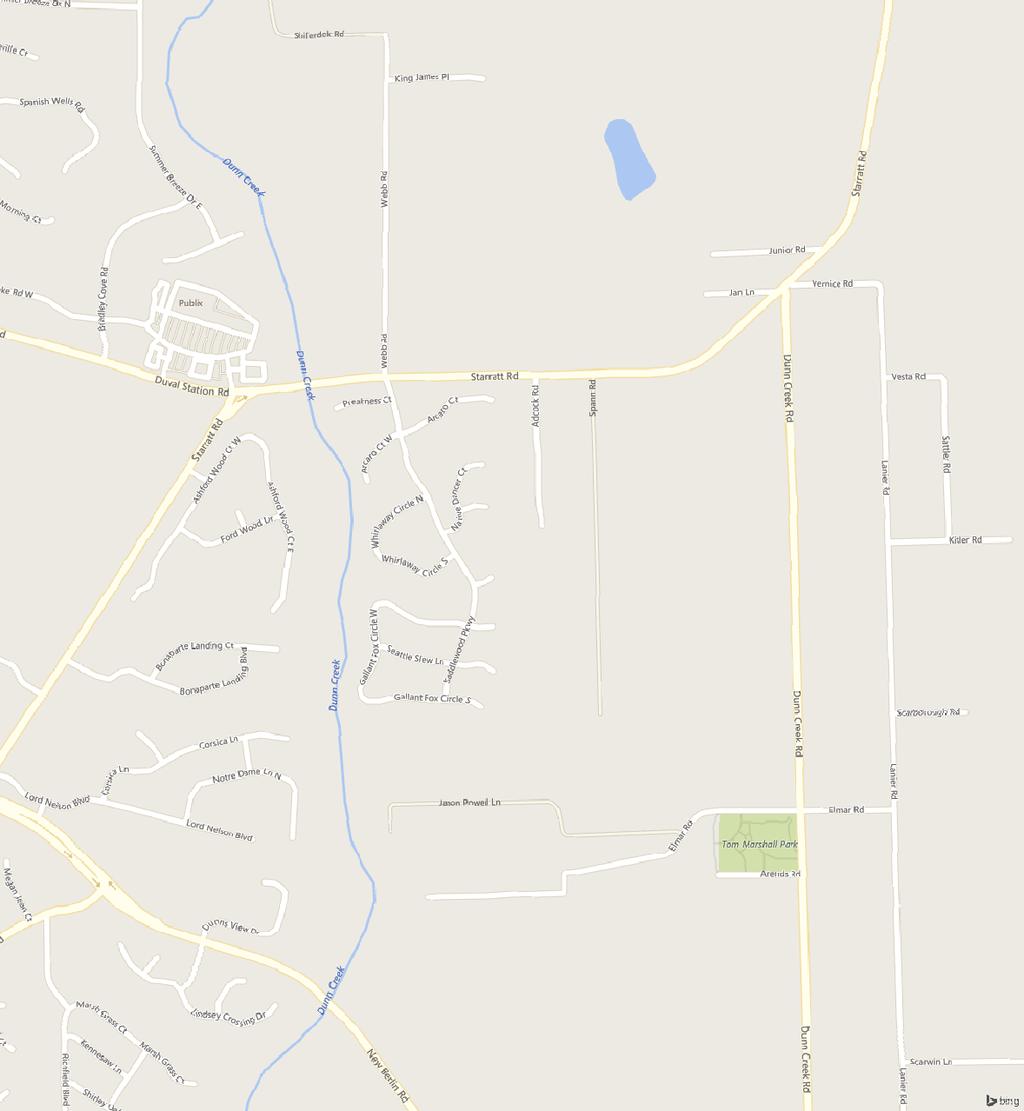
1 REPORT OF THE PLANNING AND DEVELOPMENT DEPARTMENT FOR APPLICATION FOR REZONING ORDINANCE TO PLANNED UNIT DEVELOPMENT JANUARY 21, AWH The Planning and Development Department hereby forwards to the Planning Commission and Land Use and Zoning Committee and City Council its comments and recommendation regarding Application for Rezoning Ordinance to Planned Unit Development. Location: The south side of Starratt Road; between Saddlewood Parkway and Dunn Creek Road Real Estate Number(s): , , , , , , , , Current Zoning District: Proposed Zoning District: Current Land Use Category: Planning District: Residential Rural-Acre (RR-Acre) Planned Unit Development (PUD) Low Density Residential (LDR) North City Council District: The Honorable Al Ferraro, District 2 Planning Commissioner: Applicant/Agent: Owner(s): Staff Recommendation: Marshall Adkison Curtis L. Hart Hart Resources LLC 8051 Tara Lane Jacksonville, Florida Bankers Capital Group LLC C/O State Bank & Trust Co Peachtree Road NE, Suite 1900 Atlanta, Georgia APPROVE WITH CONDITION GENERAL INFORMATION Application for Planned Unit Development seeks to rezone approximately acres of property from Residential Rural-Acre (RR-Acre) to Planned Unit Development
2 January 21, 2016 Page 2 (PUD). The PUD zoning district is being requested to permit the development of a 97 lot single family subdivision. The layout of the subdivision will provide for a development scheme that is compatible with the established pattern of development in the nearby area and bring a competitive and additional housing product to the North Jacksonville area. The rezoning to PUD will have 60 foot wide lots. Maximum height of structures will be similar to those found in the conventional Code; setbacks will be similar to conventional Zoning Districts, with front setbacks deviating from the standard 20 feet for structures, to 15 feet for the front of the main structure, and 20 feet for the attached garage. Lot coverages are requested to be slightly higher at 60%. Only acres of the site will be developed with single family lots/dwellings, with the remainder in passive open space, stormwater ponds, and road infrastructure. The applicant has proposed 1.43 acres of land for active recreation. The developer intends to integrate and blend the proposed development into the surrounding area and also afford nearby residents and adjacent property owners the convenience of pedestrian access the project that will hopefully be beneficial to them. The proposed PUD rezoning would allow the property to be developed as a mixed-use development containing commercial, office and multi-family uses (townhome and condominium) designed to benefit and serve the rapidly growing North Jacksonville area and the project s surrounding community. CRITERIA FOR REVIEW Pursuant to the provisions of Section of the Zoning Code, the Planning and Development Department, Planning Commission and City Council (including the appropriate committee) shall evaluate and consider the following criteria of an application for rezoning to Planned Unit Development. (1) Is the proposed zoning district consistent with the 2030 Comprehensive Plan? Yes. The Planning and Development Department finds that the subject property is located in the Low Density Residential (LDR) functional land use category as defined by the Future Land Use Map series (FLUMs) contained within the Future Land Use Element (FLUE) adopted as part of the 2030 Comprehensive Plan. The LDR functional land use category permits housing developments in a gross density range of up to seven (7) dwelling units per acre when full urban services are available to the site. This PUD proposes a gross density of 2.97 dwelling units to the acre and will have full urban services available to the site. The uses provided herein shall be applicable to all LDR sites within the Suburban Area: Principal Uses: Single family and Multi-family dwellings; Commercial retail sales and service establishments when incorporated into mixed use developments which utilize the Traditional Neighborhood Development (TND) concept and such uses are limited to 25 percent of the TND site area: and other uses associated with and developed as an integral component of TND. Secondary Uses: Secondary uses shall be permitted pursuant to the Residential land use introduction. In addition the following secondary uses may also be permitted: Borrow pits; Animals other than household pets; Foster care homes; Drive through facilities in conjunction
3 January 21, 2016 Page 3 with a permitted use; Assisted living facilities and housing for the elderly, so long as said facilities are located within three miles of a hospital and on an arterial roadway; and Commercial retail sales and service establishments when the site is located at the intersection of roads classified as collector or higher on the Functional Highway Classification Map, however logical extensions and expansions of preexisting commercial retail sales and service establishments are exempt from the roadway classification and intersection requirements. Therefore, the proposed rezoning is consistent with the FLUMs adopted as part of the 2030 Comprehensive Plan pursuant to Chapter 650 Comprehensive planning for future development of the Ordinance Code. A description of the category is noted below. (2) Does the proposed rezoning further the goals, objectives and policies of the 2030 Comprehensive Plan? The evaluation of the goals, objectives and policies of the Comprehensive Plan can be found later in this report. (3) Does the proposed rezoning conflict with any portion of the City s land use Regulations? The written description and the site plan of the intended plan of development meet all portions of the City s land use regulations and further their intent by providing specific development standards. Pursuant to the provisions of Section (d) of the Zoning Code, the Planning and Development Department, Planning Commission and City Council (including the appropriate committee) shall evaluate and consider the following criteria for rezoning to Planned Unit Development district: (1) Consistency with the 2030 Comprehensive Plan In accordance with Section Advisory recommendation on amendment of Zoning Code or rezoning of land of the Zoning Code, the subject property is within the following functional land use category as identified in the Future Land Use Map series (FLUMs): Low Density Residential (LDR). This proposed rezoning to Planned Unit Development is consistent with the 2030 Comprehensive Plan, and furthers the following goals, objectives and policies contained herein, including: FLUE Objective 1.1 Ensure that the type, rate, and distribution of growth in the City results in compact and compatible land use patterns, an increasingly efficient urban service delivery system and discourages proliferation of urban sprawl through implementation of regulatory programs, intergovernmental coordination mechanisms, and public/private coordination.
4 January 21, 2016 Page 4 FLUE Policy Permit development only if it does not exceed the densities and intensities established in the Future Land Use Element as defined by the Future Land Use map category description and their associated provisions. FLUE Policy Promote the use of Planned Unit Developments (PUDs), cluster developments, and other innovative site planning and smart growth techniques in all commercial, industrial and residential plan categories, in order to allow for appropriate combinations of complementary land uses, and innovation in site planning and design, subject to the standards of this element and all applicable local, regional, State and federal regulations. FLUE Policy The City shall provide for development of a wide variety of housing types by area, consistent with the housing needs characteristics and socioeconomic profiles of the City's households as described in the Housing Element. The proposed PUD differs from the usual application of the Zoning Code because it contains a unified development plan incorporating similar design themes and other development criteria. The creation of a master planned development affords an efficient use of the land. The site is designed around and along wetland areas with limitations on site development in consideration of wetlands. Substantially more open space will be provided than from the usual application of the zoning code. The proposed PUD allows for a maximum lot coverage of 60%, which would allow for larger homes consistent with demand in this area. It also allows for a maximum of 97 lots at a minimum lot size of 6,000 square feet. By doing a PUD it will allow the developer to provide unique architectural features and conditions. The request differs from the usual application of the Zoning Code because it contains a unified development plan incorporating similar design themes and other development criteria. The creation of a master planned development affords an efficient use of the land. The site is designed around and along wetland areas with limitations on site development in consideration of wetlands. Substantially more open space will be provided than from the usual application of the zoning code. (2) Consistency with the Concurrency Mobility and Management System Pursuant to the provisions of Chapter 655 Concurrency Mobility and Management System of the Ordinance Code, the development will be required to comply with all appropriate requirements of the Concurrency Mobility and Management System Office (CMSO) prior to development approvals. (3) Allocation of residential land use This proposed Planned Unit Development intends to utilize lands for a single family development. This proposed development will not exceed the projected holding capacity reflected in Table L-20, Land Use Acreage Allocation Analysis For 2030 Comprehensive Plan s Future Land Use Element, contained within the Future Land Use Element (FLUE) of the 2030 Comprehensive Plan.
5 January 21, 2016 Page 5 The Duval County School Board reviewed this application submittal and has the following comments: 1. Student generation by the proposed use (97 residential units) 32 students 2. Schools affected Oceanway Elementary currently at 85% capacity; Oceanway Middle currently at 112% capacity; First Coast HS currently at 95% capacity. (4) Internal compatibility This proposed PUD is consistent with the internal compatibility factors with specific reference to the following: The development shall address access and circulation within the site. The proposed PUD limits the uses permitted on the subject property to single-family with a common development scheme, unified architectural theme that contains special provisions for signage, landscaping, buffering, sidewalks, and other issues relating to the common areas and those used for vehicular and pedestrian traffic. Access to the property is available from Starratt Road. Final design and location of the access points are subject to the review and approval of the City Traffic Engineer and the Planning and Development Department. The existence or absence of, and the location of open spaces, plazas, recreational areas and common areas: The proposed PUD will provide recreation/common areas for the community at a ratio of a minimum of 1 acre per every 100 lots. In addition, ponds and wetlands will comprise a large portion of the site providing additional passive open space. Traffic and pedestrian circulation patterns: The PUD proposes one access point off of Dunn Avenue and will contain sidewalks which meet the 2030 Comprehensive Plan. The final location of the access point is subject to the review of the FDOT and the Development Services Division. The proposed PUD contains limitations on the uses permitted on the property as well as a common development scheme that contains provisions for signage, landscaping, sidewalks, recreation and open space and other requirements relating to common areas and vehicular and pedestrian traffic. The final design and engineering plans shall be subject to the review and approval of the City Traffic Engineer. This acre parcel is undeveloped and has a single entrance point from Starratt Road. Primary access to the site will be from Starratt Road. The internal roadways/circulation within the site will provided by an approved road to be given to the City. An exterior sidewalk will be provided along Starratt Road and the proposed internal access roads consistent with the Comprehensive Plan. Prior to verification of substantial compliance pursuant to Section (G) Zoning Code, the vehicular access and design of said access points and interior vehicular circulation, connections, and termination of roadways including design of pavement, right-of-way width, and general design, will be submitted to Planning Department, Transportation Planning, Public Works and Traffic Engineer. This roadway layout is a conceptual and may be adjusted for engineering, geometry and other requirements.
6 January 21, 2016 Page 6 The use and variety of building setback lines, separations, and buffering: The proposed PUD written description contains development standards which are the similar to the current Zoning Code requirements for the RLD-60 zoning district. The development will be required to provide shade trees, landscape buffers, and tree mitigation meeting the minimum standards of the City of Jacksonville Landscape and Tree Protection Regulations. The PUD contains limitations on the uses permitted on the property as well as a common development scheme that contains provisions for signage, landscaping, sidewalks, recreation and open space and other requirements relating to common areas and vehicular and pedestrian traffic. A summary of the development is as follows: Total Gross Acres Acres Amount of Land Use for Single Family Acres Total Number of Units Single Family 97 Active Recreation Area 1.43 Acres Total Passive Open Space (Ponds, Wetlands & Open Space) Acres Amount of Public & Private R/W 4.16 Acres. Maximum Lot Coverage 60% The applicant has not demonstrated a need to increase the lot coverage to 60%. The Zoning Code permits lot coverage to 50%. The Department is of the opinion that increasing the lot coverage will be a detriment to the health, safety and welfare of the residents by reducing the amount of open space on each lot. Signage: The applicant proposes one (1) double-faced or two (2) single-faced signs not to exceed twenty-four (24) square feet in area and twelve (12) feet in height. Signs may be externally illuminated. Directional signs not exceeding a maximum of four (4) square feet in area. Other signs shall be meet be in accordance with Part 13 of the Zoning Code. Any other factor deemed relevant to the privacy, safety, preservation, protection or welfare of any use within the proposed Planned Unit Development: The proposed development will cluster building sites on the upland; thereby allowing for preservation of existing wetlands. (5) External Compatibility Based on the written description of the intended plan of development and site plan, the Planning and Development Department finds that external compatibility is achieved by the following: The type, number and location of surrounding external uses: The proposed project is within an area where residential development dominates the area. If approved as conditioned the PUD would add another subdivision with flexibility in the location, type and size of the homes to the community and increase the housing options in/for the area.
7 January 21, 2016 Page 7 The Comprehensive Plan and existing zoning on surrounding lands: The adjacent uses, zoning and land use categories are as follows: Adjacent Land Use Zoning Current Use Property Category District North LDR RR-Acre Starratt Rd/SF homes/undeveloped South LDR RR-Acre SF homes/undeveloped land East LDR RR-Acre SF homes/undeveloped land West LDR RLD-90 SF residential development (6) Intensity of Development The PUD is appropriate at this location with specific reference to the following: The existing residential density and intensity of use of surrounding lands: The use is consistent with the residential density and intensity of surrounding lands. This PUD proposes a gross density of 2.97 dwelling units to the acre and over 12 acres of recreational and passive open space, and differs from the usual application of the Zoning Code because it contains a significant amount of wetlands on the site and will be designed around and along wetland areas which limits site development in consideration of wetlands. Substantially more open space will be provided for than with the usual application of the zoning code. It will afford a development with a different option of single family lot sizes within a residential community in keeping with the area s pattern of development. The availability and location of utility services and public facilities and services: Water, sanitary sewer and electric service will be provided by the JEA. (7) Usable open spaces plazas, recreation areas. The PUD will provide a recreation/common area for the community of at least 1.43 acres in size. In addition, ponds and wetlands will comprise over 15 acres, providing additional passive open space. (8) Impact on wetlands Surveying of a 2004 Geographical Information Systems shape file did identify wetlands onsite. Any development impacting wetlands will be permitted pursuant to local, state and federal permitting requirements. (9) Listed species regulations With only acres, a wildlife survey is not required.


8 January 21, 2016 Page 8 (10) Off-street parking including loading and unloading areas. The written description indicates the site will be developed in accordance with Part 6 of the Zoning Code. On each lot, a driveway will be provided large enough to accommodate two automobiles. (11) Sidewalks, trails, and bikeways The project will contain a pedestrian system that meets the 2030 Comprehensive Plan. SUPPLEMENTAL INFORMATION Upon visual inspection of the subject property on January 11, 2016, the required Notice of Public Hearing signs were posted. RECOMMENDATION Based on the foregoing, it is the recommendation of the Planning and Development Department that the application for Rezoning be APPROVED with the following exhibits: 1. The original legal description dated October 13, The original written description dated October 17, The original site plan dated November 16, The development shall proceed in accordance with the Development Services Division memorandum dated December 21, 2015 or as otherwise approved by the Planning and Development Department. Based on the foregoing, it is the recommendation of the Planning and Development Department that the application for Rezoning be APPROVED subject to the following condition, which may only be changed through a rezoning: 1. Lot coverage shall not exceed fifty (50) percent.

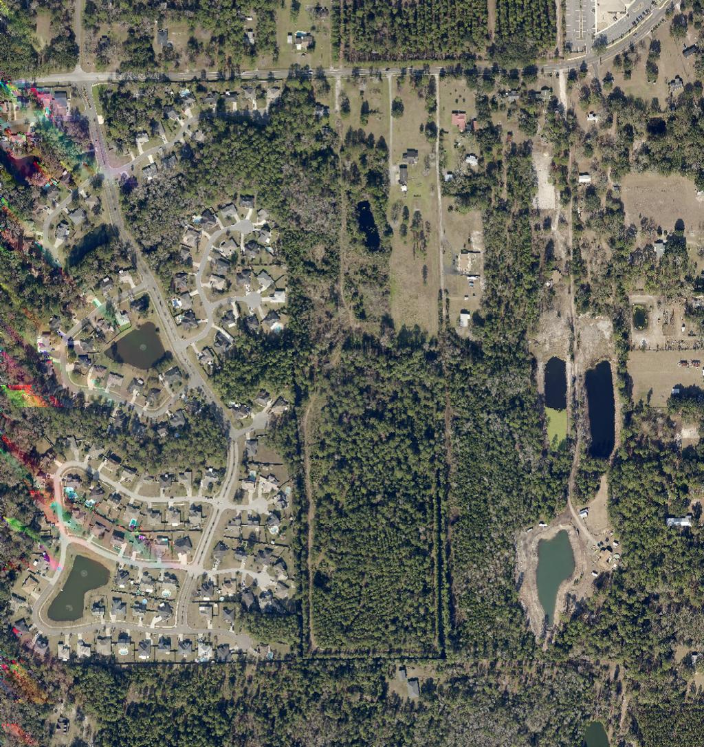
9 Aerial view of the subject site facing north January 21, 2016 Page 9


10 January 21, 2016 Page 10 The subject site facing south from Starratt Rd. The subject site facing southeast from Starratt Rd.


11 January 21, 2016 Page 11 The subject site on the left facing southwest from Starratt Rd. The subject site on the right facing southeast from Starratt Rd.
12 January 21, 2016 Page 12 PUD WEBB ROAD RLD-70 RLD-120 ARCARO COURT RLD-90 SADDLEWOOD PARKWAY RLD-60 RLD-90 RLD-90 RLD-90 NATIVE DANCER COURT WAR ADMIRAL COURT BOLD RULER COURT GALLANT FOX CIRCLE NORTH SEATTLE SLEW LANE GALLANT FOX CIRCLE SOUTH RLD100A RR-Acre STARRATT ROAD SPANN ROAD RR-Acre RR-Acre RR-Acre RR-Acre RLD100A RLD100A RR-Acre REQUEST SOUGHT: FROM: RR-Acre # W N E S TO: PUD ORDINANCE NUMBER: ORD EXHIBIT "2" TRACKING NUMBER: T Feet COUNCIL DISTRICT: Exhibit 2 2

13 D E V E L O P M E N T S E R V I C E S December 21, 2015 MEMORANDUM TO: Bruce Lewis, City Planner Supervisor Planning and Development Department Andy Hetzel, City Planner II FROM: Subject: Lisa King Traffic Technician Senior Avery Park PUD R Upon review of the referenced application and based on the information provided to date, the Development Services Division has the following comments: 1. Provide a left turn lane on Starratt Road at subdivision entrance. Turn lane shall be designed to FDOT Index 301 standards with a minimum 100 queue. 2. Roadways shall meet the design standards of Section 3 of the Land Development Procedures Manual. 3. Provide internal and external sidewalks per the 2030 Comprehensive Plan and Land Development Procedures Manual. 4. Signs, fences, walls and landscaping shall be located so that horizontal line of sight is unobstructed at intersections and shall meet clear zone requirements. Please understand that this does not constitute approval of the design elements. Approval of the design elements (driveway location, dimensions, roadway geometry, traffic circulation, etc.) shall be facilitated through the 10-set and 10- set review process. If you have any questions regarding the comment outlined above, please call me directly at R Avery Park fka R Dunn Creek (withdrawn) P L A N N I N G AND D E V E L O P M E N T 214 N. Hogan Street Suite 2100 Jacksonville, FL Phone: Fax:
14 Application For Rezoning To PUD Print Page 1 of 4 12/7/2015 Application For Rezoning To PUD Planning and Development Department Info Ordinance # Staff Sign-Off/Date AH / 11/02/2015 Filing Date 10/20/2015 Number of Signs to Post 2 Hearing Dates: 1st City Council 01/26/2016 Planning Comission 01/21/2016 Land Use & Zoning 02/02/2016 2nd City Council N/A Neighborhood Association EDEN GROUP, INC. Neighborhood Action Plan/Corridor Study N/A Application Info Tracking # 976 Application Status PENDING Date Started 10/17/2015 Date Submitted 10/19/2015 General Information On Applicant Last Name First Name HART CURTIS Middle Name L Company Name HART RESOURCES LLC Mailing Address 8051 TARA LANE City JACKSONVILLE State FL Zip Code Phone Fax CURTISHART1972@ATT.NET General Information On Owner(s) Check to fill first Owner with Applicant Info Last Name HINTON Company/Trust Name BANKERS CAPITAL GROUP LLC First Name WES Middle Name Mailing Address 3399 PEACHTREE NE SUITE 1900 City ATLANTA State GA Zip Code Phone Fax Property Information Previous Zoning Application Filed For Site? If Yes, State Application No(s) Map RE# Council District Planning District From Zoning District(s) To Zoning District Map
15 Application For Rezoning To PUD Print Page 2 of 4 12/7/ RR-ACRE PUD Map RR-ACRE PUD Map RR-ACRE PUD Map RR-ACRE PUD Map RR-ACRE PUD Map RR-ACRE PUD Map RR-ACRE PUD Map RR-ACRE PUD Map RR-ACRE PUD Ensure that RE# is a 10 digit number with a space (###### ####) Existing Land Use Category LDR Land Use Category Proposed? If Yes, State Land Use Application # Total Land Area (Nearest 1/100th of an Acre) Proposed PUD Name AVERY PARK Development Number Justification For Rezoning Application THIS IS 32 ACRES OF LDR LAND USE PROPERTY ON A COLLECTOR STREET WITH CITY WATER AND SEWER AVAILABLE, THE PARCEL IS VACANT. THE REZONING WILL BE CONSISTENT WITH THE COMPREHENSIVE PLAN FOR FUTURE DEVELOPMENT IN THIS AREA. THIS ZONING WILL BE COMPATIBLE WITH THE NORTH JACKSONVILLE VISION PLAN. Location Of Property General Location SOUTH OF STARRATT ROAD AND EAST OF FIRST COAST HIGH SCHOOL House # 1190 Street Name, Type and Direction STARRATT RD Zip Code Between Streets WEBB ROAD and SPANN ROAD Required Attachments For Formal, Complete application The following items must be labeled as exhibits and attached to application in the order prescribed below. All pages of the application must be on 8½" X 11" paper with provision for page numbering by the staff as prescribed in the application instructions manual. Please check each item below and the PUD Check List for inclusion of information required. Exhibit 1 Exhibit A Exhibit B A very clear, accurate and legible legal description of the property that must be only and entirely placed on the JP&DD formatted forms provided with the application package. The legal description may be either lot and block or metes and bounds. Property Ownership Affidavit Notarized Letter(s). Agent Authorization - Notarized letter(s) designating the agent.
16 Application For Rezoning To PUD Print Page 3 of 4 12/7/2015 Exhibit C Exhibit D Exhibit E Exhibit F Exhibit G Binding Letter. Written description in accordance with the PUD Checklist and with provision for dual page numbering by the JP&DD staff. Scalable site plan with provision for dual page numbering by the JP&DD staff drawn at a scale large enough to clearly indicate the following: (a) North arrow and scale; (b) Property lines and dimensions of the site; (c) Building locations and building lot coverage; (d) Parking area; (e) Required Landscaped Areas; (f) All ingress and egress locations (driveways, alleys and easements) within 660 feet; (g) Adjacent streets and rights-of-way; (h) jurisdictional wetlands; and (i) existing site conditions and improvements that will be undisturbed. Land Use Table Copy of the deed to indicate proof of property ownership. Supplemental Information Supplemental Information items are submitted separately and not part of the formal application Exhibit H Aerial Photograph. Exhibit I Listed Species Survey (If the proposed site is greater than fifty acres). Exhibit J Other Information as required by the Department (i.e.-*building elevations, *signage details, traffic analysis, etc.). Exhibit K Site Location Map. Public Hearings And Posting Of Signs No application will be accepted until all the requested information has been supplied and the required fee has been paid. Acceptance of a completed application does not guarantee its approval by the City Council. The applicant will be notified of public hearing dates on this application upon the filing of the application. The applicant or authorized agent MUST BE PRESENT at the public hearings. The required SIGN(S) must be POSTED on the property BY THE APPLICANT within 5 days after the filing of an application. The sign(s) may be removed only after final action of the Council and must be removed within 10 days of such action. The applicant must also pay for the required public notice stating the nature of the proposed request which is required to be published in an approved newspaper AT LEAST 14 DAYS IN ADVANCE OF THE PUBLIC HEARING. (The Daily Record - 10 North Newnan Street, Jacksonville, FL (904) Fax (904) ) Advertising costs are payable by the applicant directly to the newspaper and the applicant must furnish PROOF OF PUBLICATION to the Planning and Development Department, 214 North Hogan Street, Ed Ball Building, Suite 300, Jacksonville, Florida, 32202, prior to the public hearing. Application Certification I, hereby, certify that I am the owner or the authorized agent of the owner(s) of the property described herein, that all answers to the questions in this application and all information contained in the material attached to and made a part of this application, are accurate and true to the best of my knowledge and belief. I also attest that all required information for this rezoning application is completed and duly attached in the prescribed order. Furthermore, if the package is found to be lacking the above requirements, I understand that the application will be returned for correct information. Agreed to and submitted Filing Fee Information 1) Rezoning Application's General Base Fee: $2, ) Plus Cost Per Acre or Portion Thereof $10.00 /acre: $330.00
17 Application For Rezoning To PUD Print Page 4 of 4 12/7/2015 3) Plus Notification Costs Per Addressee 63 $7.00 /each: $ ) Total Rezoning Application Cost (Not to Exceed $15,000.00): $2, NOTE: Advertising Costs To Be Billed to Owner/Agent
18 EXHIBIT 1 OVERALL LEGAL DESCRIPTION A PORTION OF THE WEST ½ OF SECTION 30, OF A SUBDIVISION OF THE JOHN BROWARD GRANT IN GOVERNMENT SECTION 37, TOWNSHIP 1 NORTH, RANGE 27 EAST, DUVAL COUNTY, FLORIDA, AND BEING A PORTION OF THE LANDS DESCRIBED AND RECORDED IN OFFICIAL RECORDS 15470, PAGE 1470 AND BEING MORE PARTICULARLY DESCRIBED AS FOLLOWS: FOR A POINT OF BEGINNING COMMENCE AT THE SOUTHWEST CORNER OF SAID OFFICIAL RECORDS 15470, PAGE 1470, ALSO BEING THE SOUTHEAST CORNER OF SADDLEWOOD UNIT FIVE, AS RECORDED IN PLAT BOOK 55, PAGES 87-87C; THENCE NORTH WEST, ALONG THE WEST LINE OF SAID OFFICIAL RECORDS 15470, PAGE 1470, ALSO BEING THE EAST LINE OF SAID SADDLEWOOD UNIT FIVE, THE EAST LINE OF SAID SADDLEWOOD UNIT FOUR, AS RECORDED IN PLAT BOOK 54, PAGES 76-76C, AND SADDLEWOOD UNIT TWO, AS RECORDED IN PLAT BOOK 53, PAGES 22-22D, AND SADDLEWOOD UNIT ONE, AS RECORDED IN PLAT BOOK 52, PAGES 16-16D, A DISTANCE OF 2, FEET TO A NORTHWEST CORNER OF SAID OFFICIAL RECORDS 15470, PAGE 1470; THENCE NORTH EAST ALONG A NORTH LINE OF SAID OFFICIAL RECORDS 15470, PAGE 1470, A DISTANCE OF FEET; THENCE NORTH WEST ALONG A WESTERLY LINE OF SAID OFFICIAL RECORDS 15470, PAGE 1470, ALSO BEING THE EAST LINE OF LANDS DESCRIBED AND RECORDED IN OFFICIAL RECORDS 13257, PAGE 1385 (PARCEL 1), A DISTANCE OF TO THE NORTHEAST CORNER OF SAID PARCEL 1 AND A POINT ON THE SOUTH RIGHT OF WAY LINE OF STARRAT ROAD (A 60 FOOT RIGHT OF WAY); THENCE NORTH EAST ALONG SAID SOUTH RIGHT OF WAY LINE, A DISTANCE OF FEET TO A NORTHEAST CORNER OF SAID OFFICIAL RECORDS 15470, PAGE 1470; THENCE THE FOLLOWING THREE (3) COURSES AND DISTANCES ALONG AN EASTERLY LINE OF SAID OFFICIAL RECORDS 15470, PAGE 1470: COURSE NO. 1, SOUTH EAST, 1, FEET; COURSE NO. 2, NORTH EAST, FEET; COURSE NO. 3, SOUTH EAST, 1, FEET TO A SOUTHEAST CORNER OF SAID OFFICIAL RECORDS 15470, PAGE 1470; THENCE SOUTH WEST, ALONG THE SOUTH LINE OF SAID OFFICIAL RECORDS 15470, PAGE 1470, A DISTANCE OF FEET TO THE POINT OF BEGINNING. CONTAINING ACRES, MORE OR LESS.
19
20


21
22
23


24
25 1 EXHIBIT D Planned Unit Development Written Description October 17, 2015 Avery Park PUD Developer: Curtis L. Hart Hart Resources LLC 8051 Tara Lane Jacksonville, Florida office Owners: Bankers Capital Group LLC C/o State Bank & Trust Co Peachtree Road NE, Suite 1900 Atlanta, Georgia Engineer: Surveyor: Property Address Dunn and Associates 8375 Dix Ellis Trail, Suite 102 Jacksonville, FL Clarson and Associates Naldo Avenue Jacksonville, Florida Starratt Road Zoning Current: RR Proposed: PUD The subject property is currently zoned RR and has a Residential Land Use Designation of LDR on the 2030 Comprehensive Plan Future Land Use Element. This PUD application is consistent with the 2030 Comprehensive Plan and the land use designation. Land Use Wetlands: LDR There is a small amount of wetland on the East edge of this property, as noted on the site plan. If any wetlands are impacted they will be permitted according to local, state and federal requirements. Wild Life Survey With only acres, a wildlife survey is not required. Page of Page of
26 2 DESCRIPTION OF PLAN The subject property is approximately acres, hereafter referred to as the Property, and is legally described on Exhibit 1. The Property is identified as land described under Real Estate Numbers , , , , , , & and the owner of the Property is Bankers Capital Group LLC a Georgia limited liability company. The Property is located at 1190 Starratt Road, east of First Coast high School and is currently vacant wooded land. This PUD is necessary to establish the layout of the subdivision and provide for a development scheme that is compatible with the established pattern of development in the nearby area. This property is bound on the North, South, East and West by land use category of Low Density Residential (LDR). There are a variety of uses within this LDR land use category from a tree farm to residential subdivisions. This proposed 60 foot lot single family development, with only 2.97 units to the acre, will have minimal impact on the area. This acre parcel is vacant and has a single entry from Starratt Road. Access will be off of Starratt Road on City maintained streets. Avery Park PUD will be developed in one or two phases and contain no more than 97 lots. All lots will have a minimum of 6,000 square feet. We are providing a park for the use of the homeowners as indicated on the site plan. There is a large City Recreation Park within 5 miles of this site also. City Sewer will be utilized by building a pump station onsite to be dedicated to JEA. DIFFERENCE BETWEEN PUD AND USUAL APPLICATION This Application for a PUD allows for a maximum lot coverage of 60%, which would allow for larger homes consistent with demand in this area. It also allows for a maximum of 97 lots at a minimum lot size of 6,000 square feet. By doing a PUD it will allow the developer to provide unique architectural features and conditions. CHARACTER OF LAND This acres are currently vacant and has a topographical slope to the South. The property is primarily wooded. PERMITTED USES: Detached, site-built single-family dwellings. PERMITTED USES BY RIGHT: Home Occupation meeting the performance standards and development criteria set forth in Part 4 of the City of Jacksonville Zoning Code. PERMITTED ACCESSORY USES AND STRUCTURES: Accessory uses and structures are allowed as defined in Section of the Zoning Code. RESTRICTION ON USES: Dumpsters, propane tanks and similar appurtenances must be screened from any roadways by landscaping or opaque fencing which is aesthetically compatible with other structures located, or to be located, on the Property. Page of Page of
27 3 DESIGN CRITERIA: 1. Single family Acreage: Maximum number of lots: Minimum Lot Width: 60 feet. 4. Minimum Lot Area: 6,000 square feet 5. Maximum Lot Coverage: 60% by all buildings and structures. 6. Minimum Set Backs: Front yard: 15 feet for the house front and 20 feet for the garage. Side Yard 5 feet, Rear yard 10 feet 7. Maximum Building height: 35 feet Air conditioning or other equipment designed to serve the main structure may be located in the required rear or side yard. Where lots are located on roadway curves or cul-de-sacs the Building Restriction Line (BRL) will be 15 feet notwithstanding the lot width at the BRL. On any corner lot notwithstanding the code the side yard setback shall be 5 feet. ADDITIONAL DESIGN CRITERIA 1. FENCING Homeowners will be allowed to construct a 6-ft high fence in their rear & side yards. For homes with a secondary front yard, homeowners will be allowed to construct a 6-ft high fence no closer than 10 feet from the second front yard property line. 2. PARKING REOUIREMENTS On each lot, a driveway will be provided large enough to accommodate two automobiles. 3. VEHICULAR ACCESS Vehicular access to the property will be provided from a public street, Starratt Road as noted on the site plan. The site plan attached as Exhibit E and made a part of this application, clearly shows the access. 4. LANDSCAPE The Property shall be developed in accordance with Part 12 Landscape Regulations of the Zoning Code. 5. DRAINAGE The drainage will be routed through the Stormwater treatment system as per St. Johns River Water Management District criteria, treated and then discharged. Stormwater retention systems will be constructed on site as needed. 6. PHASING This project may be developed in one or two phases and development will commence after permits are issued. 7. UTILITIES Page of Page of
28 4 The project will be served with public water and sewer service by JEA. 8. SIGNAGE At developer's option, either (i) one non-illuminated double faced sign not exceeding a maximum of twenty-four (24) square feet in area, excluding border and columns, or (ii) a maximum of two single-faced signs, non-illuminated, not exceeding a maximum of twenty-four (24) square feet in area, per sign, excluding border and columns, may be erected along Starratt Road on either side of the subdivision entrance road, and/or in a median within the subdivision entrance road. Sign materials shall include brick, stone or stucco borders and/or columns. Front entrance signage shall be landscaped and irrigated and may have indirect lighting. Also, there will be particular signage relative to lot and home sales i.e.: for sale signs, informative contractor signs, model home signs, etc. Real estate signs (in compliance with Section , Zoning Code) and construction signs (in compliance with Section , Zoning Code) also will be permitted. Temporary sign(s) of a maximum of twenty-four (24) square feet in area and twelve (12) feet in height for model homes also shall be permitted. All maintenance of signs shall be the responsibility of Developer and/or owners association. 9. SIDEWALKS Sidewalks will be provided as per the requirements of the City of Jacksonville Comprehensive Plan. 10. RECREATION AND OPEN SPACES We are providing a park for the use of the homeowners as indicated on the site plan. There is a large City Recreation Park within 5 miles of this site. 11. LEGEND A. Total Gross Acres Acres B. Amount of Land Use as Single Family Acres C. Total Number of Units Single Family: 97 D. Active Recreation 1.43 Acres D. Total Passive Open Space (Ponds, Wetlands & Open Space) Acres E. Amount of Public & Private R/W 4.16 Acres. F. Maximum Lot Coverage 60% 12. CIRCULATION AND ROADWAY DESIGN Prior to verification of substantial compliance pursuant to Section (G) Zoning Code, the vehicular access and design of said access Points and interior vehicular circulation, connections, and termination of Roadways including design of pavement, right-of-way width, and general design, will be submitted to Planning Department, Transportation Planning, Public Works and Traffic Engineer. This roadway layout is a conceptual and may be adjusted for engineering, geometry and other requirements. 13. HOMEOWNER ASSOCIATION A Homeowner Association will be in place to provide for the continued operation and maintenance of those areas and functions described herein and facilities which are not to be provided or operated or maintained by the city. SUCCESSOR IN TITLE All successors in title to the property shall be bound to the terms and conditions of this PUD. Page of Page of
29 LEGEND = WETLANDS = WETLAND IMPACT SITE SUMMARY FLOOD ZONE Dunn & Associates, Inc. CIVIL ENGINEERS / LAND PLANNERS
30
31
32
33
34
35
36
37
38
39
40
EXHIBIT D. Planned Unit Development Written Description April 13, 2016 Rouen Cove Phase II PUD
 1 EXHIBIT D Planned Unit Development Written Description April 13, 2016 Rouen Cove Phase II PUD Development # 8986.001 Developer: Curtis L. Hart Hart Resources LLC 8051 Tara Lane Jacksonville, Florida
REPORT OF THE PLANNING AND DEVELOPMENT DEPARTMENT FOR APPLICATION FOR REZONING ORDINANCE TO PLANNED UNIT DEVELOPMENT FEBRUARY 5, 2015
 2015-49 BEL REPORT OF THE PLANNING AND DEVELOPMENT DEPARTMENT FOR APPLICATION FOR REZONING ORDINANCE 2015-49 TO PLANNED UNIT DEVELOPMENT FEBRUARY 5, 2015 The Planning and Development Department hereby
REPORT OF THE PLANNING AND DEVELOPMENT DEPARTMENT FOR APPLICATION FOR REZONING ORDINANCE TO PLANNED UNIT DEVELOPMENT MAY 18, 2017
 BEL REPORT OF THE PLANNING AND DEVELOPMENT DEPARTMENT FOR APPLICATION FOR REZONING ORDINANCE 2016-805 TO PLANNED UNIT DEVELOPMENT MAY 18, 2017 The Planning and Development Department hereby forwards to
REPORT OF THE PLANNING AND DEVELOPMENT DEPARTMENT FOR APPLICATION FOR REZONING ORDINANCE TO PLANNED UNIT DEVELOPMENT SEPTEMBER 22, 2016
 BEL REPORT OF THE PLANNING AND DEVELOPMENT DEPARTMENT FOR APPLICATION FOR REZONING ORDINANCE 2016-576 TO PLANNED UNIT DEVELOPMENT SEPTEMBER 22, 2016 The Planning and Development Department hereby forwards
REPORT OF THE PLANNING AND DEVELOPMENT DEPARTMENT FOR APPLICATION FOR REZONING ORDINANCE TO PLANNED UNIT DEVELOPMENT JANUARY 8, 2015
 214-49 BEL REPORT OF THE PLANNING AND DEVELOPMENT DEPARTMENT FOR APPLICATION FOR REZONING ORDINANCE 214-49 TO PLANNED UNIT DEVELOPMENT JANUARY 8, 215 The Planning and Development Department hereby forwards
Application For Rezoning To Conventional Zoning District
 Application For Rezoning To Conventional Zoning District Print http://maps.coj.net/luzap/appconvprint.aspx Page 1 of 3 1/28/216 Application For Rezoning To Conventional Zoning District Planning and Development
REPORT OF THE PLANNING AND DEVELOPMENT DEPARTMENT FOR APPLICATION FOR REZONING ORDINANCE TO PLANNED UNIT DEVELOPMENT APRIL 21, 2016
 BEL REPORT OF THE PLANNING AND DEVELOPMENT DEPARTMENT FOR APPLICATION FOR REZONING ORDINANCE TO PLANNED UNIT DEVELOPMENT APRIL 21, 2016 The Planning and Development Department hereby forwards to the Planning
Exhibit D. Tallow Ridge PUD. Written Description. Date: January 5, E. City Development Number:
 Exhibit D Tallow Ridge PUD Written Description Date: January 5, 2016 I. SUMMARY DESCRIPTION OF THE PROPERTY A. Current Land Use Designation: RR B. Current Zoning District: PUD C. Requested Zoning District:
REPORT OF THE PLANNING AND DEVELOPMENT DEPARTMENT FOR APPLICATION FOR REZONING ORDINANCE TO PLANNED UNIT DEVELOPMENT MAY 8, 2014
 BEL REPORT OF THE PLANNING AND DEVELOPMENT DEPARTMENT FOR APPLICATION FOR REZONING ORDINANCE TO PLANNED UNIT DEVELOPMENT MAY 8, 2014 The Planning and Development Department hereby forwards to the Planning
REPORT OF THE PLANNING AND DEVELOPMENT DEPARTMENT FOR APPLICATION FOR REZONING ORDINANCE TO PLANNED UNIT DEVELOPMENT AUGUST 20, 2015
 BEL REPORT OF THE PLANNING AND DEVELOPMENT DEPARTMENT FOR APPLICATION FOR REZONING ORDINANCE TO PLANNED UNIT DEVELOPMENT AUGUST 20, 2015 The Planning and Development Department hereby forwards to the Planning
Application For Rezoning To PUD
 Application For Rezoning To PUD Print http://maps.coj.net/luzap/apppudprint.aspx Page 1 of 4 10/13/2016 Application For Rezoning To PUD Planning and Development Department Info Ordinance # 2016-0577 Staff
REPORT OF THE PLANNING AND DEVELOPMENT DEPARTMENT FOR APPLICATION FOR REZONING ORDINANCE TO PLANNED UNIT DEVELOPMENT SEPTEMBER 3, 2015
 AAG REPORT OF THE PLANNING AND DEVELOPMENT DEPARTMENT FOR APPLICATION FOR REZONING ORDINANCE TO PLANNED UNIT DEVELOPMENT SEPTEMBER 3, 2015 The Planning and Development Department hereby forwards to the
EXHIBIT D. WRITTEN DESCRIPTION For. TOWNSEND VILLAGE PUD December 23, 2015 (Revised)
") I. PROJECT DESCRIPTION EXHIBIT D WRITTEN DESCRIPTION For TOWNSEND VILLAGE PUD December 23, 2015 (Revised) A. This 7.2 acre single-family residential project is located on the East side of Townsend Boulevard,
I. PROJECT DESCRIPTION EXHIBIT D WRITTEN DESCRIPTION For TOWNSEND VILLAGE PUD December 23, 2015 (Revised) A. This 7.2 acre single-family residential project is located on the East side of Townsend Boulevard,
AWH REPORT OF THE PLANNING AND DEVELOPMENT DEPARTMENT FOR APPLICATION FOR REZONING ORDINANCE MAY 7, 2015
 AWH REPORT OF THE PLANNING AND DEVELOPMENT DEPARTMENT FOR APPLICATION FOR REZONING ORDINANCE 2015-0243 MAY 7, 2015 The Planning and Development Department hereby forwards to the Planning Commission, Land
REPORT OF THE PLANNING AND DEVELOPMENT DEPARTMENT FOR APPLICATION FOR REZONING ORDINANCE TO PLANNED UNIT DEVELOPMENT MAY 7, 2015
 2015-0240 AAG REPORT OF THE PLANNING AND DEVELOPMENT DEPARTMENT FOR APPLICATION FOR REZONING ORDINANCE 2015-0240 TO PLANNED UNIT DEVELOPMENT MAY 7, 2015 The Planning and Development Department hereby forwards
Cover Letter with Narrative Statement
 Cover Letter with Narrative Statement March 31, 2017 rev July 27, 2017 RE: Rushton Pointe Residential Planned Unit Development Application for Public Hearing for RPUD Rezone PL2015 000 0306 Mr. Eric Johnson,
Individual Well Individual Septic. Community Well 19. What is the proposed method of sewage disposal? Public. None
 Please Answer the Following Questions: (attach sheet if needed). What type of facility is being proposed? Campground Recreational Vehicle (RV) Park Both 2. What is the total acreage of the proposed facility?
Article 7: Residential Land Use and Development Requirements
 Article 7: Residential Land Use and Section 701: Statement of Intent (A) (B) (C) The intent of Article 7 is to develop certain land use and development requirements for the residential uses within Cumru
Staff Report: Date: Applicant: Property Identification: Acreage of Request: Current Zoning of Requested Area: Requested Action: Attached:
 Staff Report: Completed by Jeff Palmer Director of Planning & Zoning Date: November 7, 2018, Updated November 20, 2018 Applicant: Greg Smith, Oberer Land Developer agent for Ronald Montgomery ET AL Property
APPLICATION FOR ZONING CHANGE
 PROPERTY DESCRIPTION APPLICANT/AGENT PROPERTY OWNER(S) Application # APPLICATION FOR ZONING CHANGE Date of Application Name(s): Mailing Address: City: State: Zip: Telephone Number: Fax #: E-mail Address:
Planning Department Oconee County, Georgia
 Planning Department Oconee County, Georgia STAFF REPORT REZONE CASE #: 6985 DATE: October 31, 2016 STAFF REPORT BY: Andrew C. Stern, Planner APPLICANT NAME: Williams & Associates, Land Planners PC PROPERTY
SECTION 10.7 R-PUD (RESIDENTIAL PLANNED UNIT DEVELOPMENT) ZONE
 ZONE") Article X Zones 10-20 SECTION 10.7 R-PUD (RESIDENTIAL PLANNED UNIT DEVELOPMENT) ZONE A. PURPOSE AND INTENT: The R-PUD Residential PUD Zone is intended to provide alternative, voluntary zoning procedures
Article X Zones 10-20 SECTION 10.7 R-PUD (RESIDENTIAL PLANNED UNIT DEVELOPMENT) ZONE A. PURPOSE AND INTENT: The R-PUD Residential PUD Zone is intended to provide alternative, voluntary zoning procedures
PLANNED DEVELOPMENT DISTRICT STANDARDS. Cadence Site
 PLANNED DEVELOPMENT DISTRICT STANDARDS Cadence Site A Planned Development District 1. Statement of General Facts, Conditions and Objectives Property Size: Approximately 57.51 Acres York County Tax Map
The following regulations shall apply in the R-E District:
 "R-E" RESIDENTIAL ESTATE DISTRICT (8/06) The following regulations shall apply in the R-E District: 1. Uses Permitted: The following uses are permitted. A Zoning Certificate may be required as provided
TOOELE COUNTY LAND USE ORDINANCE CHAPTER 31 Page 1
 CHAPTER 31 PLANNED COMMUNITY ZONE (P-C) Section 31-1 Definitions. 31-2 Purpose. 31-3 Land use districts. 31-4 P-C zone area minimum requirements. 31-5 Permitted uses. 31-6 Conditional uses. 31-7 Planning
Site Plan Application
 Site Plan Application City of St. Pete Beach Community Development Department 155 Corey Avenue St. Pete Beach, Florida 33706 (727) 367-2735 www.stpetebeach.org Case Number: PROPERTY OWNER: Name: Address:
ARTICLE 14 PLANNED UNIT DEVELOPMENT (PUD) DISTRICT
 DISTRICT") ARTICLE 14 PLANNED UNIT DEVELOPMENT (PUD) DISTRICT Section 14.01 Intent. It is the intent of this Article to allow the use of the planned unit development (PUD) process, as authorized by the Michigan Zoning
ARTICLE 14 PLANNED UNIT DEVELOPMENT (PUD) DISTRICT Section 14.01 Intent. It is the intent of this Article to allow the use of the planned unit development (PUD) process, as authorized by the Michigan Zoning
Nassau County Department of Planning & Economic Opportunity Nassau Place Yulee, Florida 32097
 Nassau County Department of Planning & Economic Opportunity 96161 Nassau Place Yulee, Florida 32097 APPLICATION AND INSTRUCTIONS FOR FUTURE LAND USE MAP AMENDMENT (TEN (10) ACRES OR MORE) NOTICE: Florida
Section 1: US 19 Overlay District
 Section 1: US 19 Overlay District Section 1.1 Intent and Purpose The purpose of the US Highway 19 Overlay District is to manage access to land development along US Highway 19 in a manner that preserves
Chapter 22 PLANNED UNIT DEVELOPMENT.
 Chapter 22 PLANNED UNIT DEVELOPMENT. Sec. 22.1 INTENT. The use of land and the construction and use of buildings and other structures as Planned Unit Developments in Georgetown Township may be established
Staff Report: Date: Applicant: Property Identification: Acreage of Request: Current Zoning of Requested Area: Requested Action: Attached:
 Staff Report: Completed by Jeff Palmer Director of Planning & Zoning Date: November 7, 2018 Applicant: Greg Smith, Oberer Land Developer agent for Ronald Montgomery ET AL Property Identification: Frontage
Exhibit THIRD AMENDED PUD WRITTEN DESCRIPTION. Willens Claire Lane PUD
 Exhibit D THIRD AMENDED PUD WRITTEN DESCRIPTION Willens Claire Lane PUD Date: May 7, 14 Current Zoning District: PUD Current Land Use Designation: RPI Proposed Zoning District: PUD RE #: 166- I. PROJECT
PLANNED UNIT DEVELOPMENT (PUD)
") SECTION 38.01. ARTICLE 38 PLANNED UNIT DEVELOPMENT (PUD) Purpose The purpose of this Article is to implement the provisions of the Michigan Zoning Enabling Act, Public Act 110 of 2006, as amended, authorizing
SECTION 38.01. ARTICLE 38 PLANNED UNIT DEVELOPMENT (PUD) Purpose The purpose of this Article is to implement the provisions of the Michigan Zoning Enabling Act, Public Act 110 of 2006, as amended, authorizing
Special Exception Use Order Application
 Development Services Department Planning Division CITY OF OVIEDO 400 Alexandria Boulevard Oviedo, Florida 32765 Application No. Date Received Pre-application Meeting Date Phone: (407) 971-5775 (407)971-5819
ZONING ORDINANCE: OPEN SPACE COMMUNITY. Hamburg Township, MI
 ZONING ORDINANCE: OPEN SPACE COMMUNITY Hamburg Township, MI ARTICLE 14.00 OPEN SPACE COMMUNITY (Adopted 1/16/92) Section 14.1. Intent It is the intent of this Article to offer an alternative to traditional
ORDINANCE NOW THEREFORE, BE IT ENACTED BY THE CITY COMMISSION OF THE CITY OF WINTER GARDEN, FLORIDA, AS FOLLOWS:
 ORDINANCE 12-02 AN ORDINANCE OF THE CITY OF WINTER GARDEN, FLORIDA, AMENDING ARTICLE V OF CHAPTER 118 OF THE WINTER GARDEN CODE OF ORDINANCES ENTITLED PLANNED UNIT DEVELOPMENTS CREATING URBAN VILLAGE PLANNED
Planned Residential Development ( PRD ) Application
 Application") FOR PLANNING USE ONLY Application # PRD Application Fee $ Receipt No. Filing Date Completeness Date Planned Residential Development ( PRD ) Application A. PROJECT INFORMATION 1. Project Name: 2. Address
FOR PLANNING USE ONLY Application # PRD Application Fee $ Receipt No. Filing Date Completeness Date Planned Residential Development ( PRD ) Application A. PROJECT INFORMATION 1. Project Name: 2. Address
COMPREHENSIVE PLAN FUTURE LAND USE MAP AMENDMENT APPLICATION
 COUNTY STAFF DATA ONLY Date Received: Project No. CPA-20 - GADSDEN COUNTY DEPARTMENT OF PLANNING & COMMUNITY DEVELOPMENT 1-B East Jefferson Street, Post Office Box 1799, Quincy, FL 32353-1799 PLANNING
Form 11.A.9.17 INSTRUCTIONS FOR APPLICATION FOR PLAT WAIVER (Art. 11.A.8)
") Form 11.A.9.17 INSTRUCTIONS FOR APPLICATION FOR PLAT WAIVER (Art. 11.A.8) All questions in each part must be completed. When a question is not applicable to the property, enter "N/A" or other phrase indicating
Form 11.A.9.17 INSTRUCTIONS FOR APPLICATION FOR PLAT WAIVER (Art. 11.A.8) All questions in each part must be completed. When a question is not applicable to the property, enter "N/A" or other phrase indicating
ARTICLE 9 SPECIFICATIONS FOR DOCUMENTS TO BE SUBMITTED
 ARTICLE 9 SPECIFICATIONS FOR DOCUMENTS TO BE SUBMITTED SECTION 950 GENERALLY All applications shall be properly signed and filed by the owner or, with the owner s specific written consent, a contract purchaser
AGENDA ITEM SUMMARY GLADES COUNTY BOARD OF COUNTY COMMISSIONERS
 AGENDA ITEM SUMMARY GLADES COUNTY BOARD OF COUNTY COMMISSIONERS SUBJECT: Case Number COMP17-01, Legend Moto LLC This is a Legislative Hearing. DEPARTMENT REQUEST: The Community Development Department requests
SPECIAL ZONING DISTRICTS
 SPECIAL ZONING DISTRICTS 5.01 5.99 RESERVED 5.100 PLANNED DEVELOPMENTS: Purpose: This district is intended to accommodate unified design of residential, commercial, office, professional services, retail
LABEL PLEASE NOTE: ALL APPLICATIONS AND SITE PLANS MUST BE COMPLETED IN BLACK OR BLUE INK ONLY Intake by:
 STAFF USE ONLY Thurston County Resource Stewardship 2000 Lakeridge Dr. S.W. Olympia, WA 98502 (360)786-5490 / (360)754-2939 (Fax) TDD Line (360) 754-2933 Email: permit@co.thurston.wa.us Supplemental Application
BY THE CITY COMMISSION ORDINANCE NO.:
 BY THE CITY COMMISSION ORDINANCE NO.: 2005-0868 AN ORDINANCE BY THE CITY COMMISSION OF THE CITY OF DADE CITY, FLORIDA CREATING A DEVELOPMENT REVIEW PROCEDURES ORDINANCE; PROVIDING FOR INTENT, PURPOSE,
Kitsap County Department of Community Development. Administrative Staff Report
 Kitsap County Department of Community Development Administrative Staff Report Report Date: Application Complete Date: March 15, 2018 Application Submittal Date: March 12, 2018 Project Name: Nikki Lee Salon
CHAPTER34 PRUD - PLANNED RESIDENTIAL UNIT DEVELOPMENT
 CHAPTER34 PRUD - PLANNED RESIDENTIAL UNIT DEVELOPMENT 17-34-1 17-34-2 17-34-3 17-34-4 17-34-5 17-34-6 17-34-7 17-34-8 17-34-9 Purpose Planned Residential Unit Development Defined Planned Residential Unit
Operating Standards Attachment to Development Application
 Planning & Development Services 2255 W Berry Ave. Littleton, CO 80120 Phone: 303-795-3748 Mon-Fri: 8am-5pm www.littletongov.org Operating Standards Attachment to Development Application 1 PLANNED DEVELOPMENT
ARTICLE 15 - PLANNED UNIT DEVELOPMENT
 Section 15.1 - Intent. ARTICLE 15 - PLANNED UNIT DEVELOPMENT A PUD, or Planned Unit Development, is not a District per se, but rather a set of standards that may be applied to a development type. The Planned
ORDINANCE WHEREAS, the adoption of this Ordinance shall not be construed as an admission that the aforesaid claim has merit or is correct; and
 ORDINANCE 12-24 AN ORDINANCE OF THE CITY OF WINTER GARDEN, FLORIDA, REPEALING ORDINANCE 12-02 AND REPLACING IT WITH THE AMENDMENTS TO ARTICLE V OF CHAPTER 118 OF THE WINTER GARDEN CODE OF ORDINANCES CONTAINED
MINOR SUBDIVISION FINAL PLAT APPLICATION Town of Apex, North Carolina
 MINOR SUBDIVISION FINAL PLAT APPLICATION Town of Apex, North Carolina This document is a public record under the North Carolina Public Records Act and may be published on the Town s website or disclosed
AN ORDINANCE TO AMEND SECTION OF THE RAPID CITY MUNICIPAL CODE TO ALLOW FOR ADMINISTRATIVE DISSOLUTION OF PLANNED DEVELOPMENTS
 Ordinance No. 6231 AN ORDINANCE TO AMEND SECTION 17.50.050 OF THE RAPID CITY MUNICIPAL CODE TO ALLOW FOR ADMINISTRATIVE DISSOLUTION OF PLANNED DEVELOPMENTS WHEREAS, the City of Rapid City has adopted a
CONDOMINIUM REGULATIONS
 ARTICLE 37 CONDOMINIUM REGULATIONS SECTION 37.01. Purpose The purpose of this Article is to regulate projects that divide real property under a contractual arrangement known as a condominium. New and conversion
Division of Land Application
 FOR PLANNING USE ONLY Application # DIV Application Fee Receipt No. Filing Date Completeness Date Division of Land Application A. PROJECT INFORMATION 1. Project Name: 2. Address of Subject Property: 3.
Plat/Site Plan Application
 Instructions Plat/Site Plan Application For your application to be officially accepted for processing, you must complete this application in full. The owner/agent certification must be signed and notarized
File Name: Conditional Use Application_2017
 Office Use Only Recv d: By: App #: #: Meeting Date: Conditional Use Application 2017 FEE: $2,500.00. The fee is payable upon application submittal. *Any additional meeting with mailed & published notice
CITY OF OCOEE LAND DEVELOPMENT CODE SUFFICIENCY TABLE WITH NOTES
 CITY OF OCOEE LAND DEVELOPMENT CODE SUFFICIENCY TABLE WITH NOTES The Sufficiency Table is a checklist to help identify the types of information and documentation needed for various types of projects. The
Planned Unit Development (PUD). Sections:
. Sections:") Chapter 19.07. Planned Unit Development (PUD). Sections: 19.07.01. Purpose. 19.07.02. PUD Definition and Design Compatibility. 19.07.03. General PUD Standards. 19.07.04. Underlying Zones. 19.07.05. Permitted
Chapter 19.07. Planned Unit Development (PUD). Sections: 19.07.01. Purpose. 19.07.02. PUD Definition and Design Compatibility. 19.07.03. General PUD Standards. 19.07.04. Underlying Zones. 19.07.05. Permitted
Special Use Permit - Planned Unit Development Checklist. Property Address:
 Special Use Permit - Planned Unit Development Checklist Special Use Permit Number. Parcel Code/s #28-11- - - Property Address: Applicant: ARTICLE VIII Ordinance Reference - Section 8.1.2 Permit Procedures:
MASTER SUBDIVISION FINAL PLAT APPLICATION Town of Apex, North Carolina
 MASTER SUBDIVISION FINAL PLAT APPLICATION Town of Apex, North Carolina This document is a public record under the North Carolina Public Records Act and may be published to the Town s website or disclosed
FOR OFFICE USE ONLY Date Submitted Received By Fees Paid $ Receipt No. Received By Application No. Application Complete Final Action Date
 COMMERCIAL, INDUSTRIAL, & MANUFACTURING SITE PLAN (CIM) APPLICATION Mariposa County Planning Department 5100 Bullion Street, P.O. Box 2039 Mariposa, CA 95338 Telephone (209) 966-5151 FAX (209) 742-5024
PERMITTED USES: Within the MX-1 Mixed Use Neighborhood District the following uses are permitted:
 6.25 MX-1 - MIXED USE NEIGHBORHOOD 6.25.1 INTENT: The purpose of the MX-1 Mixed Use Neighborhood District is to accommodate the development of a wide-range of residential and compatible non-residential
APPLICATION FOR PUBLIC HEARING FOR:
 APPLICATION FOR PUBLIC HEARING FOR: AMENDMENT TO PUD (PUDA) PUD REZONE (PUDZ) PUD TO PUD REZONE (PUDZ-A) PETITION NO PROJECT NAME DATE PROCESSED To be completed by staff APPLICANT INFORMATION NAME OF APPLICANT(S)
UPPER MOUNT BETHEL TOWNSHIP NORTHAMPTON COUNTY, PENNSYLVANIA
 UPPER MOUNT BETHEL TOWNSHIP NORTHAMPTON COUNTY, PENNSYLVANIA JOINDER DEED / LOT CONSOLIDATION TOWNSHIP REVIEW PROCESS When accepting proposed Joinder Deeds / Lot Consolidations, review the Joinder Deed
Waseca County Planning and Zoning Office
 Waseca County Planning and Zoning Office 300 North State Street Waseca, Minnesota 56093 Phone: 507-835-0650 Fax: 507-837-5310 Form no. PZ 081009 Web Site: www.co.waseca.mn.us FEES: 1) CUP FEE- $400.00
SUBJECT PARCEL(S) Property Owner(s) TMS Number Approximate Acreage Carolina Park Development, LLC
 Property Owner(s) TMS Number Approximate Acreage Carolina Park Development, LLC") Staff Report Special Planning Commission Meeting November 19, 2014 For reference, the Zoning Code and Land Development Regulations are available online. AGENDA ITEM 5c. SKETCH PLAN APPROVAL REQUEST: Request
Staff Report Special Planning Commission Meeting November 19, 2014 For reference, the Zoning Code and Land Development Regulations are available online. AGENDA ITEM 5c. SKETCH PLAN APPROVAL REQUEST: Request
Draft Model Access Management Overlay Ordinance
 Draft Model Access Management Overlay Ordinance This model was developed using the City of Hutchinson and the Trunk Highway 7 corridor. The basic provisions of this model may be adopted by any jurisdiction
Plans shall be drawn at a readable scale, signed, and sealed by a Florida Registered Engineer. The application package shall include:
 CHAPTER 400. SECTION 403. PERMIT TYPES AND APPLICATIONS SITE DEVELOPMENT 403.3. Preliminary Site Plans (PSP) A. Intent and Purpose PSPs are used to identify existing site conditions and demonstrate general
ARTICLE 23 CONDOMINIUM STANDARDS
 ARTICLE 23 CONDOMINIUM STANDARDS Section 23.01 Intent. The intent of this Article is to provide regulatory standards for condominiums and site condominiums similar to those required for projects developed
 Petition for Amendment #2 to the Existing Planned Unit Development known as VILLA VIZCAYA For Villa Vizcaya LLC 625 Marquette Ave., South; Minneapolis, Mn., 55479 Presented to: City of Port St Lucie Planning
TOWN OF MELBOURNE BEACH 2016 DEVELOPMENT APPLICATION
 TOWN OF MELBOURNE BEACH 2016 DEVELOPMENT APPLICATION I. SUBMITTAL REQUIREMENTS: 1. Fees per current schedule. 2. Deed to property. 3. Pre-Application meeting is mandatory. Contact the Building Official
1 September 9, 2015 Public Hearing
 1 September 9, 2015 Public Hearing APPLICANT & PROPERTY OWNER: HOLLOMON- BROWN FUNERAL HOME, INC. STAFF PLANNER: Carolyn A.K. Smith REQUEST: Change of Zoning (R-5D Residential District to Conditional O-2
CHAPTER 14 PLANNED UNIT DEVELOPMENTS
 9-14-1 9-14-1 CHAPTER 14 PLANNED UNIT DEVELOPMENTS SECTION: 9-14-1: Purpose 9-14-2: Governing Provisions 9-14-3: Minimum Area 9-14-4: Uses Permitted 9-14-5: Common Open Space 9-14-6: Utility Requirements
Chapter Planned Residential Development Overlay
 Chapter 19.29 Planned Residential Development Overlay Sections 010 Purpose 020 Scope 030 Definitions 030 Minimum Size 040 Allowable Uses 050 Minimum Development Standards 060 Density Bonus 070 Open Space
PLANNED UNIT DEVELOPMENT APPLICATION
 ` PLANNED UNIT DEVELOPMENT APPLICATION CHESAPEAKE PLANNING DEPARTMENT PUD Creation PUD Modification APPLICATION NUMBER: (Assigned by Chesapeake Planning Department) GENERAL INFORMATION Project 1. Applicant(s):
Exhibit "A" have applied for a re-zoning and re-classification of that property from OPEN RURAL (OR) to that of a PLANNED UNIT DEVELOPMENT (PUD); and
 to that of a PLANNED UNIT DEVELOPMENT (PUD); and") I NSTR # 200632845 OR BK 61439 PGS 0728-0750 RECORDED 06/24/2066 12:25:50 PR JOHN Q. CRAWFOKD CLERK OF CIRCUIT COURT NASSAU COUNTY, FLORIDA RECORDING FEES 1.37.80 ORDINANCE NO. 2006-65 AN ORDINANCE AMENDING
I NSTR # 200632845 OR BK 61439 PGS 0728-0750 RECORDED 06/24/2066 12:25:50 PR JOHN Q. CRAWFOKD CLERK OF CIRCUIT COURT NASSAU COUNTY, FLORIDA RECORDING FEES 1.37.80 ORDINANCE NO. 2006-65 AN ORDINANCE AMENDING
Letter of Intent May 2017 (Revised November 2017)
") THE BEACH AT WOODMOOR LETTER OF INTENT MAY 2017 (REVISED NOVEMBER 2017) OWNER/APPLICANT: CONSULTANT: Lake Woodmoor Holdings LLC N.E.S. Inc. 1755 Telstar Drive, Suite 211 619 North Cascade Avenue Colorado
THE BEACH AT WOODMOOR LETTER OF INTENT MAY 2017 (REVISED NOVEMBER 2017) OWNER/APPLICANT: CONSULTANT: Lake Woodmoor Holdings LLC N.E.S. Inc. 1755 Telstar Drive, Suite 211 619 North Cascade Avenue Colorado
Glades County Staff Report and Recommendation REZONING
 Glades County Staff Report and Recommendation REZONING CASE NUMBER: RZ15-01 DATE: October 2, 2015 CASE TYPE: Application for Rezoning REQUEST: J.J. Wiggins Memorial Trust is requesting a rezoning of 22.1±
619. Planned Development District (PD)
") 619. Planned Development District (PD) Intent. The purpose of the Planned Development District (sometimes hereinafter referred to as PD) is to provide opportunities to create more desirable environments
619. Planned Development District (PD) Intent. The purpose of the Planned Development District (sometimes hereinafter referred to as PD) is to provide opportunities to create more desirable environments
O-I (Office-Institutional) and AG-1(Agricultural)
 and AG-1(Agricultural)") PROPERTY INFORMATION ADDRESS 3503 and 3505 Bethany Bend DISTRICT, LAND LOTS 2/1 973 and 974 OVERLAY DISTRICT State Route 9 PETITION NUMBERS EXISTING ZONING O-I (Office-Institutional) and AG-1(Agricultural)
PROPERTY INFORMATION ADDRESS 3503 and 3505 Bethany Bend DISTRICT, LAND LOTS 2/1 973 and 974 OVERLAY DISTRICT State Route 9 PETITION NUMBERS EXISTING ZONING O-I (Office-Institutional) and AG-1(Agricultural)
Guide to Preliminary Plans
 Guide to Preliminary Plans Introduction The Douglas County is committed to providing open, transparent application processes to the public. This Guide is provided to assist anyone interested in the procedures
PALM BEACH COUNTY PLANNING, ZONING AND BUILDING DEPARTMENT ZONING DIVISION
 PALM BEACH COUNTY PLANNING, ZONING AND BUILDING DEPARTMENT ZONING DIVISION Application No.: DOA-2014-01111 Application Name: World Class Academy Control No.: 1998-00052 Applicant: World Class Academy Inc
Larimer County Planning Dept. Procedural Guide for 1041 PERMITS
 - Larimer County Planning Dept. Procedural Guide for 1041 PERMITS PLEASE NOTE: A PRE-APPLICATION CONFERENCE IS REQUIRED PRIOR TO SUBMITTING THIS APPLICATION. PURPOSE: State Statutes allow local governments
City and County of Broomfield, Colorado
 City and County of Broomfield, Colorado CITY COUNCIL AGENDA MEMORANDUM To: From: Mayor and City Council George Di Ciero, City and County Manager Teri Malies, Principal Planner Terrance Ware, Planning Director
PLANNED UNIT DEVELOPMENTS (Ordinance No.: 3036, 12/3/07; Repealed & Replaced by Ordinance No.: 4166, 10/15/12)
") 159.62 PLANNED UNIT DEVELOPMENTS (Ordinance No.: 3036, 12/3/07; Repealed & Replaced by Ordinance No.: 4166, 10/15/12) A. PURPOSE 1. General. The Planned Unit Development (PUD) approach provides the flexibility
159.62 PLANNED UNIT DEVELOPMENTS (Ordinance No.: 3036, 12/3/07; Repealed & Replaced by Ordinance No.: 4166, 10/15/12) A. PURPOSE 1. General. The Planned Unit Development (PUD) approach provides the flexibility
PINE RIDGE COMMONS PUD AMEND ORDINANCE NUMBER 99-94
 PINE RIDGE COMMONS PUD AMEND ORDINANCE NUMBER 99-94 Title page of the Planned Unit Development Document, previously attached as Exhibit A to the PUD document of Ordinance Number 99-94, the Pine Ridge commons
I. Requirements for All Applications. C D W
 108-16.1. Application checklists. Checklist for Required Submissions to the Planning Board or Zoning Board of Adjustment of Monroe Township All required submissions are to be made to the Administrative
SUBMISSION REQUIREMENTS AND INSTRUCTIONS FOR MINOR REVISIONS TO PUD PLANS
 WEST CHESTER TOWNSHIP, BUTLER COUNTY, OHIO COMMUNITY DEVELOPMENT DEPARTMENT 9577 Beckett Road, Suite 100, West Chester, Ohio 45069 TELEPHONE: (513) 777-4214 www.westchesteroh.org SUBMISSION REQUIREMENTS
PUD Ordinance - Cascade Lakes Plat #10 of 1995
 PUD Ordinance - Cascade Lakes Plat #10 of 1995 CASCADE CHARTER TOWNSHIP Ordinance #10 of 1995 AN ORDINANCE TO AMEND THE CASCADE CHARTER TOWNSHIP ZONING ORDINANCE AND ZONING MAP TO ESTABLISH THE CASCADE
BARROW COUNTY, GEORGIA
 BARROW COUNTY, GEORGIA Application For Rezoning, Special Use, and Change in Conditions BARROW COUNTY DEPARTMENT OF PLANNING AND DEVELOPMENT 30 North Broad Street Winder, Georgia 30680 770-307-3034 APPLICATION
TOWN OF ORO VALLEY PLANNING & ZONING COMMISSION MEETING DATE: December 6, 2011
 PLANNING & ZONING COMMISSION MEETING DATE: December 6, 2011 TO: FROM: SUBJECT: PLANNING & ZONING COMMISSION Matt Michels, Senior Planner mmichels@orovalleyaz.gov; tel. 229-4822 Public Hearing: Rancho de
In order to permit maximum applicability of the PUD District, PUD-1 and PUD-2 Districts are hereby created.
 ARTICLE III. PUD ned Unit Development Overlay District 205-128. Purpose. The PUD ned Unit Development Overlay District is intended to provide flexibility in the design of planned projects; to encourage
Glades County Staff Report and Recommendation Unified Staff Report for Small Scale Plan Amendment and Rezoning
 Glades County Staff Report and Recommendation Unified Staff Report for Small Scale Plan Amendment and Rezoning CASE NUMBERS: COMP17-02 and RZ17-02 DATE of STAFF REPORT: May 1, 2017 CASE TYPE: Application
DAUPHIN CREEK ESTATES SUBDIVISION
 # 12 SUB-000076-2017 DAUPHIN CREEK ESTATES SUBDIVISION Engineering Comments: FINAL PLAT COMMENTS (should be addressed prior to submitting the FINAL PLAT for review and/or signature by the City Engineer):
APPLICATION PACKET LAND SPLIT OR COMBINATION REVIEW
 APPLICATION PACKET LAND SPLIT OR COMBINATION REVIEW COMMUNITY DEVELOPMENT DEPARTMENT CHARTER TOWNSHIP OF PLYMOUTH 9955 N. Haggerty Road Plymouth, MI 48170 Fees Revised 9.13.2017 APPLICATION PACKET LAND
ARTICLE 5.0 SCHEDULE OF REGULATIONS
 ARTICLE 5.0 SCHEDULE OF REGULATIONS Section 5.101 Table of Dimensional Standards by District. Dimensional Standards AG AG with sewer Districts Rural Residential Business Other SF SF with sewer R-1 R-1
ARTICLE 24 PRIVATE ROAD, SHARED PRIVATE DRIVEWAY AND ACCESS EASEMENT STANDARDS
 ARTICLE 24 PRIVATE ROAD, SHARED PRIVATE DRIVEWAY AND ACCESS EASEMENT STANDARDS SECTION 24.00 INTENT AND PURPOSE The standards of this Article provide for the design, construction and maintenance of private
ARTICLE IV: DEVELOPMENT STANDARDS
 ARTICLE IV: DEVELOPMENT STANDARDS IV-53 409 PRIVATE STREETS A private street means any way that provides ingress to, or egress from, property by means of vehicles or other means, or that provides travel
Watertown City Council
 City of Watertown Watertown City Council 2/14/2017 Agenda Item: Riverpointe Subdivision 2 nd Replat Request for Action: Sketch Plan Department: Planning Request for Action Request: Paxmar, LLC (Applicant)
CONDITIONAL USE PERMIT APPLICATION FOR AN EXCAVATION/BORROW PIT INSTRUCTIONS
 City of Chesapeake Department of Planning Post Office Box 15225 Chesapeake, Virginia 23328-5225 (757) 382-6176 FAX (757) 382-6406 CONDITIONAL USE PERMIT APPLICATION FOR AN EXCAVATION/BORROW PIT INSTRUCTIONS
Cobb County Community Development Agency Zoning Division 1150 Powder Springs St. Marietta, Georgia 30064
 Cobb County Community Development Agency Zoning Division 1150 Powder Springs St. Marietta, Georgia 30064 Case # Z-63 Public Hearing Dates: PC: 11-06-18 BOC: 11-20-18 SITE BACKGROUND Applicant: Loyd Development