RIM Reserve Easements 101
|
|
|
- Ralph Jefferson
- 6 years ago
- Views:
Transcription


1 RIM Reserve Easements BWSR Academy BWSR Academy 2011

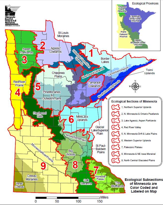
2 History RIM Reserve was established in 1986 Concept was initially proposed in 1984 by the Citizen Commission to Promote Hunting and Fishing in MN, established by Gov. Perpich Farm crisis in the 80 s helped establish RIM as a way to not only benefit wildlife, but to help financially strapped farmers First appropriation in 1986 was for $10 M
3 History Early easements ( 86 & 87) were 10 year easements Highly erodible land was only eligible land type in first years Many other eligible land types were added by legislation in the late 80s Permanent Wetland Preserves (PWP) was added in 1991 as part of WCA
4 1994 MN River Citizens Advisory Comm. adopts plan to restore the MN River. Top two recommendations are: 1) Restore floodplains and riparian areas, 2) Restore wetlands BWSR allocates 50% of all RIM funds to easements in the MN River Watershed 1997 First RIM WRP partnership 30-year NRCS easement plus a perpetual RIM easement 1998 MN River CREP 2005 CREP II in the Red River, Lower Mississippi, Missouri/ DesMoines watersheds 2007 RIM-WRP Partnership with NRCS 2010 Legacy Amendment Passes, CWF & OHF Funding for RIM begins
5 Reinvest in Minnesota Resources Act 103F.505 PURPOSE AND POLICY. It is the purpose of sections 103F.505 to 103F.531 to restore certain marginal agricultural land and protect environmentally sensitive areas to enhance soil and water quality, minimize damage to flood-prone areas, sequester carbon, and support native plant, fish, and wildlife habitats. It is state policy to encourage the restoration of wetlands and riparian lands and promote the retirement of marginal, highly erodible land, particularly land adjacent to public waters, drainage systems, wetlands, and locally designated priority waters. History: 1990 c 391 art 6 s 71; 1992 c 415 s 1; 2009 c 172 art 2 s 12; 2009 c 176 art 1 s 31


6 Bonding Clean Water Funds Outdoor Heritage Funds RIM Funding ReInvest in Minnesota license plates: -Funds received go to the DNR for their RIM: Critical Habitat program (purchase of critical habitat, nongame research, habitat enrichment, and educational programs).

7 RIM Funding Bonding Authorized by MN Statutes to fund specific programs. Dependent on Legislature: they may choose to appropriate funds toward programs Clean Water Funds Part of Legacy Funding Dependent on Legislature (Clean Water Council s recommends which programs/projects get funded) Oriented toward surface & groundwater protection Outdoor Heritage Funds Part of Legacy Funding Dependent on Legislature (LSOHC Outdoor Heritage Council recommends which programs/projects get funded) Oriented toward habitat protection & restoration
8 RIM Program Types Bonding Flexible: Can be used for several program types Flood damaged lands Clean Water Funds Buffer Program Wellhead Protection Outdoor Heritage Funds Buffer Program (wildlifeenhanced) Wetland Restorations (incl. RIM- WRP) Grasslands Army Compatible Use Buffer (ACUB) Wild Rice Lake Protection

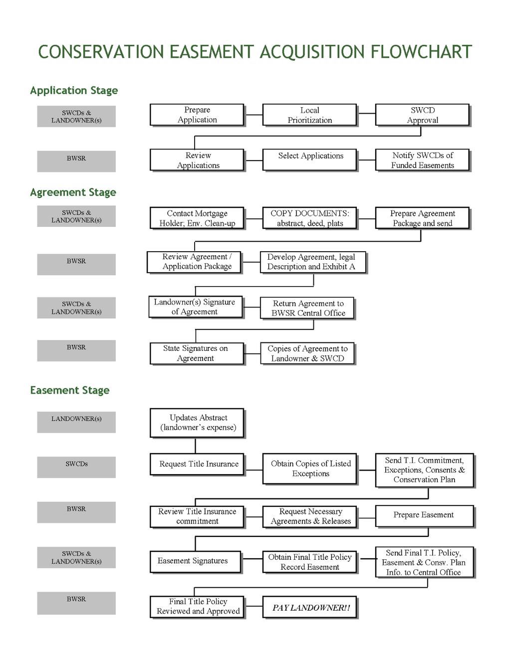
9 Accomplishments Over 6000 Easements Protecting over 250,000 acres
10 to protect soil and water quality and support fish and wildlife habitat RIM s focus has been riparian and wetland restoration easements since 1992 when Gov. Carlson issued his challenge to clean up the MN River, as a result...

11 ~1,200 wetland restoration easements on 75,000 acres

12 3,100 riparian easements on 92,000 acres

13 What IS a Conservation Easement? A voluntary agreement between a landowner and qualifying private or governmental organization That sets forth specific restrictions on future land use. Acquiring an easement is a purchase of some of the legal rights to the property Easement acquisition uses the same process as a fee title sale of the land. In MN, the legal basis for state easements as a conservation tool is provided for in Chapter 84C of the Minnesota Statutes.

14 An Easement is a Legal Document It takes the form of a binding contract Filed (recorded) in the public records (County Recorder) of the county in which the land is located. The State serves as guardian for the land s conservation values, monitoring the property regularly to assure that easement terms are upheld, and can enforce via the courts.
15 Key Aspects of Conservation Easements Landowner retains title to property and all associated rights and obligations of ownership (aside from restrictions/rights mentioned in the RIM Easement) Property remains privately owned An easement DOES NOT require that land be accessible to the public Runs with the title to the land; all future owners are bound by it s terms. A new easement does not affect previously recorded documents May affect property s resale value May, or may not, lower property tax assessments

16 Easement Processing Three distinct stages: Application Agreement Easement
17

18 The RIM Handbook has been updated (refresh your browser)
19 Application Phase The applicant visits the field office. Eligibility is determined. Field review of offered acreage. RIM Application is prepared, prioritized and ranked if necessary and forwarded to BWSR. SWCD notified of funding decision and Agreement package items are requested as needed.
20 Landowner Eligibility Landowner means an individual or entity that is not prohibited from owning agricultural land under section and either owns eligible land or is purchasing eligible land under a contract for deed. (Transcribed from Minnesota Statutes ) All partnerships and corporations except Limited Liability Partnerships and General Partnerships must be certified by the MN Dept. of Ag
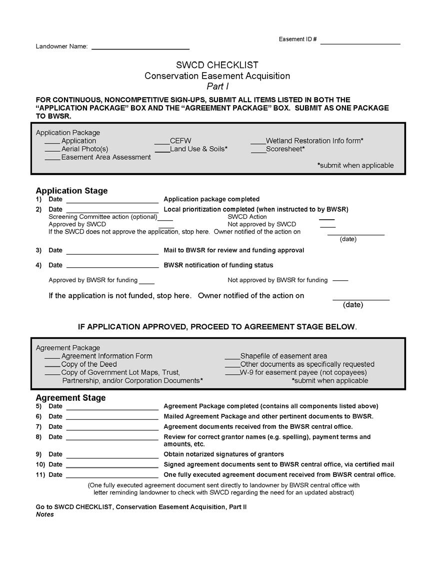
21 The SWCD Checklist An invaluable reference source of items needed and steps to take throughout the easement acquisition process. Available on the BWSR Website under Handbook & Forms:
22
23 The Application Package Conservation Easement Application Aerial Photo Area Assessment Conservation Easement Financial Worksheet (CEFW) for easement payment Land Use and Soils form (crop history) Scoresheet
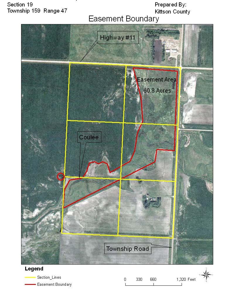
24 Aerial Photo Show the following: Boundaries of proposed easement area. River, streams, ditches, lakes, etc. including name/number designation. Dimension and distance information; especially important when enrolling parts of existing crop fields.
25 Aerial Photo Section corners/center. All known utilities. Building sites. ID info for existing or proposed easements on adjoining properties. Other pertinent info.
26
27 Application Phase The applicant visits the field office. Eligibility is determined. Field review of offered acreage. RIM Application is prepared, prioritized and ranked if necessary and forwarded to BWSR. SWCD notified of funding decision and Agreement package items are requested as needed.
28 The Agreement Package Agreement Information Form Copy of the deed Shapefile of easement area W-9 for easement & practice payee Other items, as requested
29 Copy of Deed(s) Landowner must provide most current deed(s) that show ownership Other items as required to clarify ownership, such as: Corporation or partnership docs (operating agreement, bylaws, meeting minutes, etc.) Government lot maps and/or plat maps Death certificates
30 Shapefile of Easement Area Submit easement boundary shape files electronically to BWSR, St. Paul. Attach *.shp, *.shx and *.dbf files to electronic files. Send to
31 Agreement Information Form Stipulates who is to receive payment for easements and practices. Easement payments must go to owner Like Kind Land Exchanges are the only exception (if applicable) Co-payees to be listed on check. State does not do assignment to pay contractors directly for practice payment reimbursements like USDA.
32
 This form is needed for the primary payee listed on the backside of the Agreement Information")
33 Federal IRS W-9 Form State s financial management system (SWIFT) requires this form to set up a Vendor (payee) This form is needed for the primary payee listed on the backside of the Agreement Information Form.
34
35 Agreement Stage Once BWSR has all needed documents, we map the easement boundary and draft the RIM Agreement Often, acres change (several reasons, including road ROWs, Government Lot boundaries, etc.) BWSR sends the SWCD an with the new revised shapefile BWSR requests a revised payment calculation worksheet (CEFW) and Crop History sheet, if applicable.
36 Agreement Stage

37 Agreement Stage Agreement consists of: Agreement signature page, Legal description, and Exhibit A map.
38 Agreement Stage The Agreement for Conservation Easement creates a legal contract between the landowner and the state discloses the terms of the easement identifies the parties involved, ownership, easement boundary, legal description, payment info, land title responsibilities allows the landowner to crop or graze the area during the easement acquisition process enables the state to encumber the funds required
39 The Agreement for Easement Agreement is sent (1 copy) to the SWCD for the landowner(s) signature. SWCD reviews the agreements for accuracy of grantor and payment information, legal description and Exhibit A before meeting with the landowner to sign. The agreement is reviewed in detail with the landowner this is a legal binding document. Landowner(s) sign the RIM Agreement. Signatures are notarized at time of signature.
40 The Agreement The SWCD sends signed agreement back to BWSR St. Paul for the state s signature. One fully executed document is sent to the landowner, and a copy to the SWCD along with a letter explaining the next steps. DO NOT RECORD THE AGREEMENT!!!!
41 Page 1 of Checklist Complete Application Stage Agreement Stage Easement Stage

42 What s a Title Commitment? And How Do I Get One??
43 Title Insurance Don t Be Afraid! Three very important resources Easement Stage (Handbook Chapter) Title Insurance Procedures quick reference guide for you & your agent Specimen Title Insurance Policy you and your title agent should both have a copy. Available at ~ (under the Handbook Chapters heading)
44 What is a Title Commitment? A document issued by a title agent that outlines the agent s intent to issue a final title policy and what the policy will cover. Why is a Title Policy Needed? It protects the State, in case something is found at a later time that might effect the property s title. Title Insurance is protecting an easement interest we had invested in.
45 Obtain a title commitment by providing the title agent of your choice with: Title Insurance Request form copy of the signed RIM Agreement an updated abstract (landowner) If county has electronic land records you may not need, check with title agent Helps to bring Title Ins. Specimen Policy and Title Insurance Procedures guide if working with new title agent
46 8/05 Easement I.D. Date Requested Date Needed TITLE INSURANCE REQUEST 1. Requested by : Soil and Water Conservation District Address: Telephone No: 2. Landowner Name: Full Address: Telephone No: 3. Policy amount: 4. Legal description of Property: (Attach copy if necessary) 5. Loan No (if mortgaged): 6. Occupant: (if not owner) * Insured: State of Minnesota, Board of Water and Soil Resources, 520 Lafayette Rd., St. Paul, MN * Bill to the Soil and Water Conservation District Listed Above. (See Number 1.)
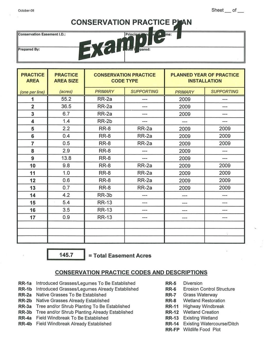
47
48 You Received the Commitment from the Title Agent. Now What? Once you have the title commitment in hand, you should review it for the following On Schedule A verify correct amount of insurance, name of insured (Board of Water & Soil Resources, State of Minnesota), name of landowner, legal description. On Schedule BI review the requirements and start to work on meeting them. Common requirements are mortgage consents or releases, affidavits of identity, and the recorded easement.
49 There s more.? On Schedule BII (Exceptions) make sure taxes are current. review the items listed, such as utility easements, judgments, liens, highway easements, mineral rights, other conservation easements etc. With the exception of road/highway easements, your title agent should include copies of the items listed. In the case of utility easements, please include an aerial photo with the location of the utility marked.
50 Reimbursement for Title Expenses The state will reimburse the SWCD for expenses incurred relating to the purchase of the title insurance policy. (Use the Reimbursement Request form) Updating of the abstract is not included in the above, this cost is responsibility of the landowner. If your county has electronic land records, title agent may not need updated abstract.
51 The Easement Phase BWSR St. Paul reviews title commitment and conservation plan Issues are resolved and clear title is established. Easement document is prepared and sent to SWCD for landowner signature.
52 The Easement Phase Easement document is reviewed for accuracy and signed by landowner. A gap check is performed by the title agent. If no new encumbrances, the easement is recorded by title agent. A final title policy is issued by the title agent and sent to BWSR St. Paul with the recorded easement.
53 The Easement Phase State s attorney reviews the file BWSR issues easement payment. State has 30 days to issue payment check from the date of AG approval

54 Conservation Plans for RIM RIM Reserve law requires all areas of an easement to be established and maintained in permanent native vegetation or water.
55 Conservation Plan consists of: Conservation Plan (signature page) Conservation Practice Plan Conservation Easement Practice Payment Worksheet (CEPPW) Plan Map Also seeding and planting plans, construction plans, and O & M plans.
56
57
58
59
60 Important Points on Plans For each practice area identified, a primary practice must be designated. This is the permanent practice cover expected to exist on the easement in the long-term. Some primary practices will also require the establishment of a supporting practice, example: RR-2a supporting, RR-8 primary


61 Conservation Practice Implementation and Payment Once a practice is installed or partially installed, the SWCD certifies that the practice meets standards and specifications and submits a cost-share voucher to BWSR St. Paul for reimbursement on behalf of the landowner.
62 COST SHARE VOUCHERS When preparing vouchers, please refer to the Conservation Plan Implementation section of the handbook for complete instructions. This information is available on BWSRs website at -- ENT.pdf
63
64 COST SHARE VOUCHERS IMPORTANT POINTS: One practice type per voucher (RR2 etc) Practice Area and Acres Completed boxes must be the same as shown on the CEPPW and Practice plan for the Practice Type specified on the voucher! This means get out your CEPPW and conservation practice plan and use it to fill out the voucher The exception is for supporting practice types (ex. seeding only the fringe of a RR-8 wetland)
65 COST SHARE VOUCHERS Choosing Installation, Establishment, or Reinstallation Installation should be checked if the work that involved preparing the land, planting trees, seeding of grasses, wetland restoration construction activities, etc. Establishment should be checked if there is any work done during the early growth stages of a practice such as mowing, chemical applications, etc. Reinstallation should be selected if after the installation is completed, the land requires any of the original installations be repeated due to failure. A Practice Implementation Request Form is required and must be approved before a Cost-Share Voucher payment on a reinstallation is sent to the Central Office.
66 COST SHARE VOUCHERS Choosing Partial vs. Final Partial should be checked if the payment amount requested or work completed represents only part of the total amount allowed, AND more money will be needed later to finish the installation. There should be no completion date included until the practice is completely installed. Final should be selected if the installation is complete.
67 COST SHARE VOUCHERS One word of advice make sure the voucher you submit agrees with the Conservation Easement Practice Payment Worksheet (CEPPW) and the practice plan on file. If it does not, the voucher will not be approved and paid!
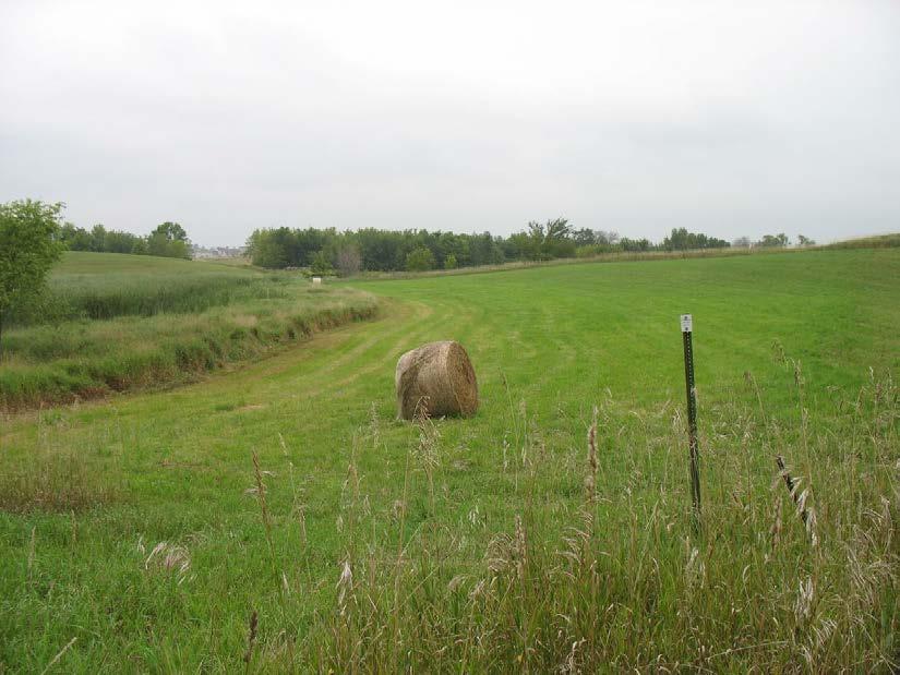
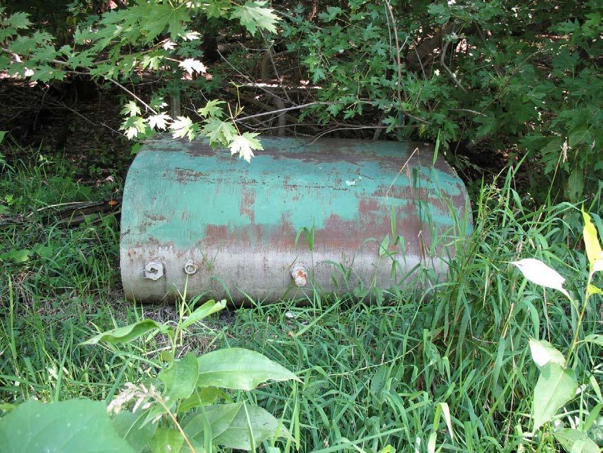
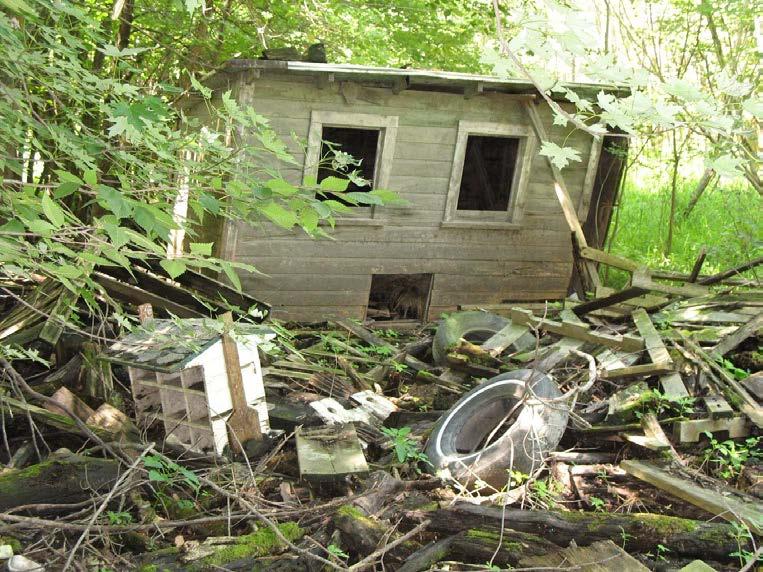
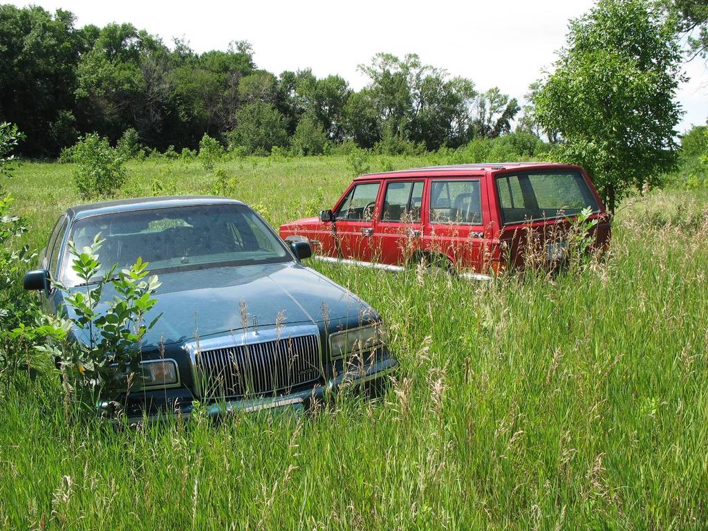
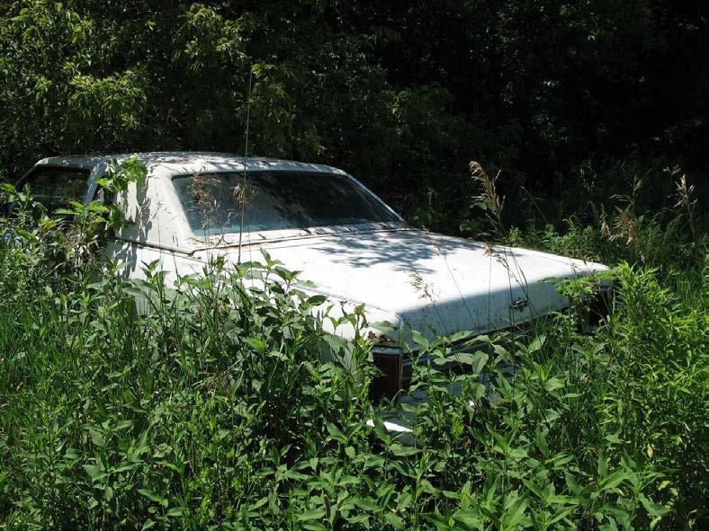
68
69 RIM Reserve Conservation Easements Monitoring Management Enforcement
70 Stake Easement Boundaries Very important where cropland is adjacent! Non-lineal boundaries Stakes and fence posts are a reimbursed expense
71 SWCD Roles with Long-Term Management on Easements Perform site inspections Notify BWSR of ownership changes on easement lands (Ownership Change Form) Work with landowners on: weed control habitat improvement violations conservation plan changes, etc.
72 Inspection Schedule Every year for 5 years after recording Every 3 rd year thereafter Use site inspection form and make sure landowner gets a copy!!
73 Inspections Are Important! Meet with landowner or operator if possible Provide guidance on issues that need attention
74 Weed Control is Important! RIM does cost-share on spraying and clipping up to program maximums during the practice establishment period (2-3 years). After the establishment period, any maintenance is the landowner s responsibility. Cost-share beyond the establishment period must be requested by the landowner (Practice Implementation Request Form). BWSR has Native Revegetation Funds available! These funds must be requested by submitting a PIRF. Use these funds to accomplish the following: -Convert brome to native vegetation -Interseeding of forbs into current stand
75 ~ Not Allowed ~ Permanent cabin, home or any other storage facility Cell towers Wind generators Driveways Wells, septic systems Dumping of any solid wastes Timber harvest without an approved plan Motocross tracks Big game shooting preserves (The above list is not to be considered all inclusive)

76 Examples of Violations
77
78
79 ~ Allowed ~ Activities that do not destroy the cover: Deer stands and hunting blinds Camping Limited mowing of trails for camping / hunting access Motorized vehicles only if they do not destroy cover or cause erosion Horseback riding Be reasonable and use common sense!!
80 Vegetative Management activities are allowed and encouraged Habitat management policy allows activities intended to improve the cover Prescribed burns, grazing, haying, light disking, and timber harvest all are allowed if they are part of an approved management plan. Our bonding legislation provides an opportunity to acquire funding to enhance and restore native species on existing easements. Must include planting of additional native species. Request these funds with the Practice Implementation Request form. $200,000 still available!
81 You find a violation then what? Document the violation on the site inspection form and contact the landowner (Sending a letter is not enough). If landowner does not fix the problem, SWCD initiates corrective action transmittal (form found in handbook) SWCD BWSR Easement Staff BWSR Board Attorney General

82 Boundaries may appear different from the shapefile layer. This is not an automatic violation!
83 RIM Services Grants Currently ~$50/easement from general fund revenues In addition: BWSR has been reimbursing SWCDs at $2,000 per easement for new program initiatives. Reimbursement process will be changing- more info forthcoming! Up to $3,500 per easement for technical assistance related to wetland restorations
84 Easement Alterations BWSR has authority to alter or terminate easements MS 103F.535 subd.5 if it determines that the public interest and general welfare are better served by the alteration or release. How does BWSR define this public interest? Safety issues Public infrastructure projects
85 Easement Alteration Policy Adopted by BWSR June 24, Public Projects (Utilities) $500 processing fee 2 X current RIM payment rate for released acres
86 Easement Alteration Policy Private landowner requests Minimum 2:1 replacement acres for changes associated with farming NO buyout provision! $500 processing fee Board will not approve if alteration will result in building or development of any kind, or to enable a sale to a potential buyer.
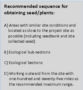
87 Native Vegetation Requirements 2009 Legislation (MS 84.02) was repealed in 2011 legislative session. Dan Shaw, BWSR Veg Specialist, has worked to develop new guidelines. Native Vegetation Establishment and Enhancement Guidelines (June 2015) Key Concepts of new Guidelines 1)Local Decision Making 2)A Consistent Standard 3)Focus on Local Seed and Plant Sources 4)Pursuing Information and Innovation

88 Vegetation Guidelines for RIM
89
90 Seed/Plant Requirements for RIM Dependent on project type RIM Riparian Buffer Use NRCS 393 practice standard as guide Could use as little as a 3 species mix if small area right next to brome/reed canary with high likelihood of succession (adding 20 ft. to 30 ft. CRP filter strip to meet min 50 ft. requirement) Should use higher species mix if establishing large riparian buffer (possibly use NRCS 643 Standard) Encourage more diverse mix of warm season grasses & forbs (perhaps a species mix) NRCS 393 Practice Standard: Filter Strip NRCS 643 Practice Standard: Restoration & Management of Declining Habitats
91 Bill Penning, Conservation Easement Section Manager, Tim Koehler, Sr. Program Advisor Tim Fredbo, Easement Specialist Polly Remick, Easement Program Analyst Kristie Mack, Easement Acquisition Specialist, Sr. Char Falconer, Easement Development Specialist Seth Weeks, Geographic Information Specialist Dave Rickert, Easement Acquisition Specialist Karli Tyma, Easement Acquisition Specialist Luke Anderson, Easement Acquisition Specialist Grant Bullemer, Easement Acquisition Specialist Heather Staff, Office and Administrative Specialist Tabor Hoek, Private Lands Specialist John Voz, Working Lands Specialist , , , , , , , , , , , , , ,
92 RIM Reserve easements, must continue to make wildlife habitat and clean water a priority! Thanks for your time.
RIM 201. BWSR Academy 2013
 RIM 201 BWSR Academy 2013 presented by. The Easement Witches History Citizen Commission to Promote Hunting and Fishing in MN, (established by Gov. Perpich) proposes the concept of RIM in 1984 Reinvest
Conservation Plans, Vouchers, & PIRFs
 Conservation Plans, Vouchers, & PIRFs Outline Conservation Plan Preparation Voucher Preparation PIRFs vs. Revision Requests Violations & Veg Guidelines Outline Conservation Plan Preparation Benefits of
Minnesota Water Quality and Habitat Conservation Reserve Enhancement Program (MN CREP) Overview February 14, 2017
 Overview February 14, 2017") Minnesota Water Quality and Habitat Conservation Reserve Enhancement Program (MN CREP) Overview February 14, 2017 1 MN Conservation Reserve Enhancement Program (MN CREP) General Overview Practices, Outcomes,
Minnesota Water Quality and Habitat Conservation Reserve Enhancement Program (MN CREP) Overview February 14, 2017 1 MN Conservation Reserve Enhancement Program (MN CREP) General Overview Practices, Outcomes,
Implementation of Permanent Easements and Associated Nutrient Load Reductions
 1 Minnesota Nutrient Reduction Strategy Agricultural Sector/BWSR RIM Program Measure Implementation of Permanent and Associated Nutrient Load Reductions Measure Background Visual Depiction The map in Figure
Conservation Easement Stewardship
 Conservation Easements are effective tools to preserve significant natural, historical or cultural resources. Conservation Easement Stewardship Level of Service Standards March 2013 The mission of the
Lessard Sams Outdoor Heritage Council
 Lessard Sams Outdoor Heritage Council MEMO: Agenda Item # 10 DATE: December 11, 2014 SUBJECT: PRESENTER: 2015 Legislative Appropriation Recommendation Bill Heather Koop, LSOHC staff Background: On October
Changes to the SFIA Program:
 Changes to the SFIA Program: What it means for landowners and service providers SFEC U of MN Extension Webinar January 16, 2018 John Carlson MN DNR Forestry Private Forest Management/SFIA Program Coordinator
WRP COMPATIBLE USE PERMITS
 WRP COMPATIBLE USE PERMITS By statute, WRP easements are acquired to protect, restore, and enhance the functions of wetland ecosystems for migratory birds and wetland dependent wildlife Reservations in
SUBCHAPTER 59F CONSERVATION RESERVE ENHANCEMENY ENHANCEMENT PROGRAM (CREP) STATE PORTION OF THE PROGRAM
 STATE PORTION OF THE PROGRAM") SUBCHAPTER 59F CONSERVATION RESERVE ENHANCEMENY ENHANCEMENT PROGRAM (CREP) STATE PORTION OF THE PROGRAM SECTION.0100 - CONSERVATION RESERVE ENHANCEMENT PROGRAM (CREP) -- STATE PORTION OF THE PROGRAM 02
SUBCHAPTER 59F CONSERVATION RESERVE ENHANCEMENY ENHANCEMENT PROGRAM (CREP) STATE PORTION OF THE PROGRAM SECTION.0100 - CONSERVATION RESERVE ENHANCEMENT PROGRAM (CREP) -- STATE PORTION OF THE PROGRAM 02
Georgia Conservation Tax Credit Program Frequently Asked Questions
 Georgia Conservation Tax Credit Program Frequently Asked Questions What are the minimum requirements for eligibility under the Georgia Conservation Tax Credit Program (GCTCP)? Individual and corporate
An Accounting Tradeoff Between WRP and Government Payments. Authors Gregory Ibendahl Mississippi State University
 An Accounting Tradeoff Between WRP and Government Payments Authors Gregory Ibendahl Mississippi State University ibendahl@agecon.msstate.edu Selected Paper prepared for presentation at the Southern Agricultural
Administrative Penalty Order (APO) Plan for Buffer Law Implementation
 Plan for Buffer Law Implementation") Administrative Penalty Order (APO) Plan for Buffer Law Implementation June 28, 2017 This document was adopted by the Board of Water and Soil Resources (BWSR) pursuant to Minn. Stat. 103B.101, subd. 12(a)
Administrative Penalty Order (APO) Plan for Buffer Law Implementation June 28, 2017 This document was adopted by the Board of Water and Soil Resources (BWSR) pursuant to Minn. Stat. 103B.101, subd. 12(a)
2015 WETLAND CONSERVATION ACT STATUTE CHANGES
 2015 WETLAND CONSERVATION ACT STATUTE CHANGES Summary of Key Statute Changes and Related Legislation with Explanations This summary includes excerpts from Laws of MN 2015, Chapter 4, Article 4. It includes
Conservation Partners Legacy Grant Application
 CPL Applications (Total to date: 129) Spreadsheet Conservation Partners Legacy Grant Application CPL1000084 Name and Contact Project Identifier: CPL1000084 Project Name: CREP Easement Invasive Species
Establishing a Wetland Bank in Minnesota
 Establishing a Wetland Bank in Minnesota Updated February 1, 2018 This document provides a general summary of the key steps in establishing an individual wetland bank site within the state wetland banking
Conservation Easements
 INFORMATION BRIEF Minnesota House of Representatives Research Department 600 State Office Building St. Paul, MN 55155 John Helland, Legislative Analyst 651-296-5039 January 2005 Conservation Easements
Buffer and Soil Loss Statutes, as amended in 2017 by Laws of Minnesota 2017, Chapter 93 (S.F. 844)
") Buffer and Soil Loss Statutes, as amended in 2017 by Laws of Minnesota 2017, Chapter 93 (S.F. 844) May 30, 2017 103B.101 BOARD OF WATER AND SOIL RESOURCES Subd. 12. Authority to issue penalty orders. (a)
Buffer and Soil Loss Statutes, as amended in 2017 by Laws of Minnesota 2017, Chapter 93 (S.F. 844) May 30, 2017 103B.101 BOARD OF WATER AND SOIL RESOURCES Subd. 12. Authority to issue penalty orders. (a)
LAKE OF THE WOODS COUNTY WETLAND CONSERVATION ORDINANCE OF 2002
 Ordinance # LAKE OF THE WOODS COUNTY WETLAND CONSERVATION ORDINANCE OF 2002 ARTICLE 1 TITLE AND PURPOSE Section 1.1. Title This Ordinance shall be known, cited and referred to as the Lake of the Woods
Environment and Natural Resources Trust Fund Request for Proposals (RFP)
") Environment and Natural Resources Trust Fund 2012-2013 Request for Proposals (RFP) Project Title: Southeast Minnesota Sensitive Habitat Protection Program (SHPP) ENRTF ID: 067-D Topic Area: D. Land Acquisition
Environment and Natural Resources Trust Fund 2012-2013 Request for Proposals (RFP) Project Title: Southeast Minnesota Sensitive Habitat Protection Program (SHPP) ENRTF ID: 067-D Topic Area: D. Land Acquisition
Wildlife Habitat Conservation and Management Program
 EXHIBIT 1 PC-2015-4106 ODFW Guide Wildlife Habitat Conservation and Management Program Manual for Counties and Cities Oregon Department of Fish and Wildlife March 2006 Table of Contents 1. Introduction
The GIS Behind Dakota County s FARMLAND AND NATURAL AREAS PROGRAM
 The GIS Behind Dakota County s FARMLAND AND NATURAL AREAS PROGRAM The Farmland and Natural Areas Program is a voluntary program in which Dakota County and other partners work with willing landowners to
Subtitle H Agricultural Conservation Easement Program
 1 1 1 1 1 1 0 1 0 1 0 Subtitle H Agricultural Conservation Easement Program SEC.. [1 U.S.C. ] ESTABLISHMENT AND PURPOSES. (a) Establishment. The Secretary shall establish an agricultural conservation easement
PROJECT SCORING GUIDANCE. Introduction: National Proiect Selection:
 FOREST LEGACY PROGRAM PROJECT SCORING GUIDANCE Introduction: This document provides guidance to the National Review Panel on how to score individual Forest Legacy Program (FLP) projects, including additional
113,923,000. Article 1 Sec moves to amend H.F. No as follows: 1.2 Delete everything after the enacting clause and insert:
 1.1... moves to amend H.F. No. 4167 as follows: 1.2 Delete everything after the enacting clause and insert: 1.3 "ARTICLE 1 1.4 OUTDOOR HERITAGE FUND 1.5 Section 1. OUTDOOR HERITAGE APPROPRIATION. 1.6 The
RECITALS. B. WHEREAS, Ranch, its successors and assigns, are referred to in the Easement as the Grantor ; and
 Basic Components of Management Plans Associated with Conservation Easement Acquisitions Where A Land Trust Or other third party Is the Grantee April 17, 2012 Key: Text in normal font, without highlight,
2015 Reinvest in Minnesota (RIM) Reserve Wetlands Program
 Reserve Wetlands Program") 2015 Reinvest in Minnesota (RIM) Reserve Wetlands Program Eligibility Guidance Document 1/16/15 The purpose of the RIM Wetlands Program is to identify and enroll under permanent easement lands that contain
2015 Reinvest in Minnesota (RIM) Reserve Wetlands Program Eligibility Guidance Document 1/16/15 The purpose of the RIM Wetlands Program is to identify and enroll under permanent easement lands that contain
Minnesota Board of Water and Soil Resources Wetland Conservation Act 2017 Annual Reporting Form
 Minnesota Board of Water and Soil Resources Wetland Conservation Act 2017 Annual Reporting Form Use the tab key to navigate between fields. Local Government Unit (LGU): Becker SWCD Organization Type: SWCD
Using Easements to Conserve Biodiversity. Jeff Lerner Defenders of Wildlife
 Using Easements to Conserve Biodiversity Jeff Lerner Defenders of Wildlife jlerner@defenders.org Northeast LTA June 10, 2006 Defenders of Wildlife Mission: to protect native wild animals and plants in
PARTNERSHIP AGREEMENT
 Agreement #_ WORKING GRASSLAND PARTNERSHIP AGREEMENT This agreement (with attachments) made this day of, 20, by and between Name (Husband/Wife) and Address, herein after referred to as (whether one or
Conservation Design Subdivisions
 Conservation Design Subdivisions An excerpt from the Rules and Regulations Governing Division of Land in Sheridan County, Wyoming, November 5, 2010 Sheridan County Public Works Department 224 S. Main Street
Chapter 100 Planned Unit Development in Corvallis Urban Fringe
 100.100 Scope and Purpose. Chapter 100 Planned Unit Development in Corvallis Urban Fringe (1) All applications for land divisions in the Urban Residential (UR) and Flood Plain Agriculture (FPA) zones within
Conservation Easement Best Management Practices
 Conservation Easement Best Management Practices Natural Resources Department April 2013 The mission of the Larimer County Natural Resources Department is to establish, protect and manage significant regional
PARTNERSHIP AGREEMENT
 Agreement #_ WORKING GRASSLAND PARTNERSHIP AGREEMENT This agreement (with attachments) made this day of, 20, by and between Name and Address, herein after referred to as (whether one or more) and the North
AGRICULTURAL CONSERVATION EASEMENT PROGRAM AGRICULTURAL LAND EASEMENTS
 AGRICULTURAL CONSERVATION EASEMENT PROGRAM AGRICULTURAL LAND EASEMENTS OVERVIEW The Agricultural Conservation Easement Program (ACEP) is a voluntary federal conservation program implemented by the USDA
Par Overview (Continued) MN CREP III Signup Process Flow
 MN CREP III Signup Process Flow") 171 Overview (Continued) D MN CREP III Signup Process Flow The following flow chart is a step by step guide to assist county offices in the MN CREP III offer process: County Office Guide for Sign Up Activities
171 Overview (Continued) D MN CREP III Signup Process Flow The following flow chart is a step by step guide to assist county offices in the MN CREP III offer process: County Office Guide for Sign Up Activities
Part 9: Paying for It. by James L. Cummins
 So You Now Have the Old Home Place Part 9: Paying for It by James L. Cummins Cropland can be leased and/or used to establish dove fields. This is the ninth and final segment in a series titled So You Now
RIM Spatial Data. Subhead for title slide
 RIM Spatial Data Subhead for title slide 1. GIS Data & Map Products 2. Spatial Data Accuracy Limitations 3. Application Phase: Map and Shapefile 4. More on Boundary Creation Considerations GIS Data & Map
Issues in Wetland Protection
 This document is made available electronically by the Minnesota Legislative Reference Library as part of an ongoing digital archiving project. http://www.leg.state.mn.us/lrl/lrl.asp John Helland, Legislative
METROPOLITAN COUNCIL 390 North Robert Street, St. Paul, MN Phone (651) TDD (651)
 TDD (651)") METROPOLITAN COUNCIL 390 North Robert Street, St. Paul, MN 55101 Phone (651) 602-1000 TDD (651) 291-0904 DATE: December 26, 2012 TO: Metropolitan Parks and Open Space Commission FROM: Jan Youngquist, AICP;
METROPOLITAN COUNCIL 390 North Robert Street, St. Paul, MN 55101 Phone (651) 602-1000 TDD (651) 291-0904 DATE: December 26, 2012 TO: Metropolitan Parks and Open Space Commission FROM: Jan Youngquist, AICP;
Community Development Committee
 Community Development Committee For the Metropolitan Council meeting of February 13, 2013 Committee Report Business Item 2013-29 ADVISORY INFORMATION Date Prepared: January 25, 2013 Subject: Rice Creek
Remains eligible for state or federal farm programs. Can use land as collateral for loans. Can reserve home lots for children
 December 2002 B-1132 Conservation Easements: An Introductory Review for Wyoming By Allison Perrigo and Jon Iversen, William D. Ruckelshaus Institute of Environment and Natural Resources William D. Ruckelshaus
CONSERVATION EASEMENT INCLUDING MITIGATION
 After recording return to: GRANTOR: GRANTEE: GRANTEE (Trustee): LEGAL DESCRIPTION: TAX PARCEL I.D. #: REFERENCE # s: WHATCOM COUNTY N/A CONSERVATION EASEMENT INCLUDING MITIGATION This grant of a conservation
MODEL DEED RESTRICTION FOR THE PENNSYLVANIA STATE PROGRAMMATIC GENERAL PERMIT-3 (PASPGP-3) DECLARATION OF RESTRICTIVE COVENANTS FOR CONSERVATION
 DECLARATION OF RESTRICTIVE COVENANTS FOR CONSERVATION") MODEL DEED RESTRICTION FOR THE PENNSYLVANIA STATE PROGRAMMATIC GENERAL PERMIT-3 (PASPGP-3) DECLARATION OF RESTRICTIVE COVENANTS FOR CONSERVATION THIS DECLARATION OF RESTRICTIVE COVENANTS FOR CONSERVATION
MODEL DEED RESTRICTION FOR THE PENNSYLVANIA STATE PROGRAMMATIC GENERAL PERMIT-3 (PASPGP-3) DECLARATION OF RESTRICTIVE COVENANTS FOR CONSERVATION THIS DECLARATION OF RESTRICTIVE COVENANTS FOR CONSERVATION
Rice County Buffer Ordinance
 Rice County Buffer Ordinance CHAPTER 640 STATUTORY AUTHORIZATION AND PURPOSE 640.1 Statutory Authorization: This buffer ordinance is adopted pursuant to the authorization and policies contained in Minn.
City of Prior Lake APPLICATION FOR COMBINED PRELIMINARY AND FINAL PLAT
 Case File No. Property Identification No. City of Prior Lake APPLICATION FOR COMBINED PRELIMINARY AND FINAL PLAT Requested Action Brief description of proposed project (Please describe the proposed amendment,
City of Prior Lake APPLICATION FOR REGISTERED LAND SURVEY
 Case File No. Property Identification No. City of Prior Lake APPLICATION FOR REGISTERED LAND SURVEY Requested Action Brief description of proposed project (Please describe the proposed amendment, project,
Kent/MSU Extension Attn: Stacy Byers 775 Ball Ave NE Grand Rapids, MI Tel: (616)
") 2017 KENT COUNTY PURCHASE OF DEVELOPMENT RIGHTS (PDR) PROGRAM Kent/MSU Extension Attn: Stacy Byers 775 Ball Ave NE Grand Rapids, MI 49503 Email: stacy@sheridanland.com Tel: (616) 632-7878 FOR OFFICIAL
2017 KENT COUNTY PURCHASE OF DEVELOPMENT RIGHTS (PDR) PROGRAM Kent/MSU Extension Attn: Stacy Byers 775 Ball Ave NE Grand Rapids, MI 49503 Email: stacy@sheridanland.com Tel: (616) 632-7878 FOR OFFICIAL
Establishing an Individual Wetland Bank Site in Minnesota
 Establishing an Individual Wetland Bank Site in Minnesota March 14, 2013 This document provides a general summary of the key steps in establishing a an individual wetland bank site within the state wetland
BROCHURE # 37 OPEN SPACE
 BROCHURE # 37 OPEN SPACE The information and instructions in this publication are to be used when applying for assessment on the basis of current use under the open space laws, chapter 84.34 RCW and chapter
Application Procedures for Easements or Rights of Way on City of Fort Collins Natural Areas and Conserved Lands March 2012
 Application Procedures for Easements or Rights of Way on City of Fort Collins Natural Areas and Conserved Lands March 2012 IMPORTANT NOTE: This document was created to accompany the City of Fort Collins
PURCHASE OF DEVELOPMENT RIGHTS (PDR) APPLICATION
 APPLICATION") OTTAWA COUNTY PURCHASE OF DEVELOPMENT RIGHTS (PDR) PROGRAM (Contact Information) FOR OFFICIAL USE ONLY Application Number PURCHASE OF DEVELOPMENT RIGHTS (PDR) APPLICATION This information is required by
OTTAWA COUNTY PURCHASE OF DEVELOPMENT RIGHTS (PDR) PROGRAM (Contact Information) FOR OFFICIAL USE ONLY Application Number PURCHASE OF DEVELOPMENT RIGHTS (PDR) APPLICATION This information is required by
DESCRIPTION OF A LAND TRUST
 DESCRIPTION OF A LAND TRUST What is a land trust? Land trusts are non-profit organizations that work hand-in-hand with landowners to protect our valuable natural resources. Land trusts have become increasingly
MITIGATION POLICY FOR DISTRICT-PROTECTED LANDS
 MITIGATION POLICY FOR DISTRICT-PROTECTED LANDS Approved by the District Board of Directors on July 18, 2017 The following Mitigation Policy is intended to inform the evaluation of environmental mitigation-related
NRCS Conservation Programs
 NRCS Conservation Programs 2014 Farm Bill The 2014 Farm Bill streamlines and simplifies NRCS conservation programs and allows better targeting of conservation and priority resource concerns. Among other
Instructions to the Applicant
 CONDITIONAL USE PERMIT APPLICATION Lake of the Woods County Land and Water Planning Office 206 8 th Avenue Southeast, Suite #290 Baudette MN 56623-2867 www.co.lake-of-the-woods.mn.us Phone: (218) 634-1945
Easement Grant of Easement for Habitat Protection
 Date: Grantor(s): XXXXXXXXXX Grantee: Tri-Basin Natural Resources District, (hereinafter referred to as Tri-Basin NRD)1308 2 nd St., Holdrege NE 68949 Protected Property: See Exhibit A attached for legal
54TH LEGISLATURE - STATE OF NEW MEXICO - FIRST SESSION, 2019
 HOUSE BILL TH LEGISLATURE - STATE OF NEW MEXICO - FIRST SESSION, 0 INTRODUCED BY Roberto "Bobby J. Gonzales and Jim R. Trujillo and Susan K. Herrera and Carlos R. Cisneros and Peter Wirth 0 AN ACT RELATING
SIBLEY COUNTY. Article 330 Buffer Ordinance of the Code of Ordinances of the County of Sibley
 SIBLEY COUNTY Article 330 Buffer Ordinance of the Code of Ordinances of the County of Sibley ARTICLE 330. BUFFER ORDINANCE SECTION 330.1 STATUTORY AUTHORIZATION AND POLICY SUBD 330.1.1 Statutory Authorization
III. Cooperator Responsibilities
 III. Cooperator Responsibilities A. Cooperators 1. Landowner a. Definition A landowner is any person, firm, or corporation that holds title to any lands located within the soil and water conservation district.
Agriculture & Business Management Notes...
 Agriculture & Business Management Notes... Fixed-Cash Crop Lease Agreements Quick Notes... The tenant produces crops on the land and makes general management decisions as if the land were owned by the
FARMLAND AMENITY PROTECTION. A Brief Guide To Conservation Easements
 FARMLAND AMENITY PROTECTION A Brief Guide To Conservation Easements The purpose of this guide is to help landowners access their land amenity value and to provide direction to be compensated for this value.
Open Space Taxation Act
 Open Space Taxation Act WASHINGTON STATE DEPARTMENT OF REVENUE JUNE 2007 The information and instructions in this brochure are to be used when applying for assessment on the basis of current use under
Guidelines for Construction of Recreational Buildings and Improvements Greater than 1000 Square Feet Outside Acceptable Development Areas
 Guidelines for Construction of Recreational Buildings and Improvements Greater than 1000 Square Feet Outside Acceptable Development Areas The following guidelines are established by the Easement Committee
AVAILABLE FUNDING OPPORTUNITIES
 APPENDIX F AVAILABLE FUNDING OPPORTUNITIES FOR GrSG HABITAT CONSERVATION F-1 F-2 Table F-1. Specific funding opportunities identified for GrSG habitat conservation. Colorado Species Partnership (CSCP)
Landowner s Guide to Conservation Incentives In Georgia
 Landowner s Guide to Conservation Incentives In Georgia Fifth Edition May 2015 Using the Guide Landowners should be aware that this guide is not inclusive of all programs available to conserve land. This
SECTION 10 STANDARD PLATS
 SECTION 10 - STANDARD PLATS Subdivision 1: Purpose Standard Plats allow the subdivision of land into lots smaller than the minimum metes and bounds size in the zoning district, and control road development
City of Prior Lake APPLICATION FOR PRELIMINARY PLAT
 City of Prior Lake APPLICATION FOR PRELIMINARY PLAT Requested Action Brief description of proposed project (Please describe the proposed amendment, project, or variance request. Attach additional sheets
PERMANENT WETLANDS PRESERVE (PWP) ELIGIBILITY INFORMATION
 ELIGIBILITY INFORMATION") PERMANENT WETLANDS PRESERVE (PWP) ELIGIBILITY INFORMATION A. WETLANDS ELIGIBLE FOR PERMANENT WETLANDS PRESERVE A.1 Statutory Purpose A.2 Program Goals A.3 Hydrologic Regimes A.4 Wetland Types B. PERMANENT
PERMANENT WETLANDS PRESERVE (PWP) ELIGIBILITY INFORMATION A. WETLANDS ELIGIBLE FOR PERMANENT WETLANDS PRESERVE A.1 Statutory Purpose A.2 Program Goals A.3 Hydrologic Regimes A.4 Wetland Types B. PERMANENT
AN INVENTORY OF CONSERVATION EASEMENT ACTIVITY IN MINNESOTA PREPARED BY THE MINNESOTA LAND TRUST
 AN INVENTORY OF CONSERVATION EASEMENT ACTIVITY IN MINNESOTA PREPARED BY THE MINNESOTA LAND TRUST Support for this project was provided in part by the Minnesota Legislature, the Blandin Foundation and others
Antelope Ridge Wind Farm Habitat Mitigation Plan November 2011
 Antelope Ridge Wind Farm Habitat Mitigation Plan November 2011 I. Introduction The Antelope Ridge Wind Farm will be constructed in two phases, in the locations as shown on the attached map, Exhibit A.
Marin County Agricultural Land Conservation Program March 1, 2014
 Marin County Agricultural Land Conservation Program March 1, 2014 I. Purpose of this Document This document describes the Marin County Agricultural Land Conservation Program (County Program). The Marin
CHAPTER 156: FARMLAND PRESERVATION. General Provisions. Qualifications and Certification of Farmland. Voluntary Agricultural Districts
 CHAPTER 156: FARMLAND PRESERVATION Section General Provisions 156.001 Definitions 156.002 Title 156.003 Authority 156.004 Purpose 156.005 Jurisdiction 156.020 Requirements 156.021 Certification Qualifications
UNOFFICIAL COPY OF HOUSE BILL 1272 A BILL ENTITLED
 UNOFFICIAL COPY OF HOUSE BILL 1272 M4 6lr0525 By: Delegates Smigiel, Kelley, Rosenberg, and Sossi Introduced and read first time: February 10, 2006 Assigned to: Environmental Matters 1 AN ACT concerning
Agricultural Lease Bid Process and Policy Updated September 21, 2017
 Agricultural Lease Bid Process and Policy Updated September 21, 2017 Introduction: Pitkin County Open Space & Trails (OST) was established by the voters of Pitkin County in 1990 with the following mission;
Claudia Stuart, Williamson Act Program Manager and Nick Hernandez, Planning Intern
 Land Conservation (Williamson) Act Advisory Committee STAFF REPORT September 15, 2014 Prepared by: Claudia Stuart, Williamson Act Program Manager and Nick Hernandez, Planning Intern Subject: Discussion:
The Maryland Rural Legacy and CREP Easement Programs
 The Maryland Rural Legacy and CREP Easement Programs The Points Based Method: The EVS Saving America s Farms and Farmland National Conference May 12, 2014 WHAT IS AN EVS? A method of awarding points to
DRAFT FOR PUBLIC HEARING (rev. March, 2016)
") Chapter 200. ZONING Article VI. Conservation/Cluster Subdivisions 200-45. Intent and Purpose These provisions are intended to: A. Guide the future growth and development of the community consistent with
Chapter 200. ZONING Article VI. Conservation/Cluster Subdivisions 200-45. Intent and Purpose These provisions are intended to: A. Guide the future growth and development of the community consistent with
SUBDIVISION APPLICATION
 SUBDIVISION APPLICATION Community Planning and Economic Development Development Services Division 250 South 4 th Street, Room 300 Minneapolis MN 55415-1316 612-673-3000 This application packet is used
PERMITTED ACTS and RURAL ENTERPRISES
 PERMITTED ACTS and RURAL ENTERPRISES Pennsylvania s Agricultural Area Security Law, known as Act 43, 3 P.S. 901. et seq., and the Regulations promulgated thereunder by the Pennsylvania Department of Agriculture
Chapter XX Purchase of Development Rights Program
 Chapter XX Purchase of Development Rights Program Short Title. This ordinance is to be known and may be cited as the Purchase of Development Rights ( PDR ) Program. Purpose Pursuant to the authority granted
4. If any perennial surface water passes through or along the property lines of the acreage, a minimum of 200 feet or frontage should be required.
 b. Provide adequate acreage for appropriate productive use of rural residential land, such as small numbers of livestock, large gardens, etc. 3. Minimum of 200 feet of frontage on an improved county or
Wood River Land Trust Staff Report
 Wood River Land Trust Staff Report Date: July 9, 2014 To: Board of Directors From: Staff, Keri York Regarding: MacConnell Agricultural Lands Easement Action Item Action Item: The item for consideration
Audit and Finance Committee Recommended Amendment to Fee Schedule
 To: From: Re: Date: Virginia Outdoors Foundation Board of Trustees Brett Glymph Audit and Finance Committee Recommended Amendment to Fee Schedule June 10, 2015 Recommendation: To sustain current operations,
RESTRICTED USE EASEMENT
 RESTRICTED USE EASEMENT THIS CONSERVATION EASEMENT ("Easement") is made this day of, 2014, by, Individually and Trustee of the Trust (the "Grantor"), and the Compatible Lands Foundation, 1305 East 15 th
PRE-PROPOSAL for the NYS Farmland Protection Implementation Grant Program
 DEBORAH MATURO Clerk ONDAGA COUNTY AGRICULTURE AND FARMLAND PROTECTION BOARD 407 Court House Syracuse, NY 13202 Phone: 315/435-2070 BRIAN REEVES Chairman Onondaga County Agriculture & Farmland Protection
WESTERLY MUNICIPAL LAND TRUST RULES AND REGULATIONS
 Trustees; Les Crandall, Chairman James Federico III Giorgio Gencarelli Gail Mallard, Secretary Nancy Martin Lise Mayers Richard Silva WESTERLY MUNICIPAL LAND TRUST WESTERLY MUNICIPAL LAND TRUST RULES AND
Open Space Preservation Program
 Open Space Preservation Program Open Space Purchase of Development Right Program Deadline: June 1, 2016 at 11:00 a.m. Ingham County Purchasing Department c/o Farmland and Open Space Preservation Board
LLC & MLLC Property Bismark Meadows Bonner County, Idaho
 Vital Ground Property Management Plan LLC & MLLC Property Bismark Meadows Bonner County, Idaho December 10, 2009 (updated 2/12/13) Ryan Lutey The Vital Ground Foundation Building T-2, Fort Missoula Road
Submittal of the Minutes from the March 9, 2011, April 5, 2011, and April 19, 2011 Cabinet Meetings.
 AGENDA BOARD OF TRUSTEES OF THE INTERNAL IMPROVEMENT TRUST FUND JUNE 16, 2011 Attachments to the items below can be viewed at the following link: http://www.dep.state.fl.us/secretary/cab/public_notices.htm
Pipestone County Buffer Ordinance
 Pipestone County Buffer Ordinance 1.0 STATUTORY AUTHORIZATION AND POLICY 1.1 Statutory authorization. This buffer ordinance is adopted pursuant to the authorization and policies contained in Minn. Stat.
LEGISLATIVE PURPOSES. 2. Provide sources of agricultural products within the state for the citizens of the state
 LEGISLATIVE PURPOSES 1. Assist in sustaining the farming community 2. Provide sources of agricultural products within the state for the citizens of the state 3. Control the urban expansion which is consuming
Title 5: ADMINISTRATIVE PROCEDURES AND SERVICES
 Title 5: ADMINISTRATIVE PROCEDURES AND SERVICES Chapter 353: LAND FOR MAINE'S FUTURE Table of Contents Part 15-A. LAND FOR MAINE'S FUTURE... Section 6200. FINDINGS... 3 Section 6201. DEFINITIONS... 3 Section
ARTICLE XI - CONSERVATION SUBDIVISIONS
 ARTICLE XI - CONSERVATION SUBDIVISIONS Section 1101: Purpose and Intent. This Article is intended to provide for residential subdivisions that are designed based first and foremost on the preservation
STATE TAX COMMISSION QUALIFIED AGRICULTURAL PROPERTY EXEMPTION GUIDELINES
 STATE TAX COMMISSION QUALIFIED AGRICULTURAL PROPERTY EXEMPTION GUIDELINES Issued by the State Tax Commission August 2018 Table of Contents What is the Qualified Agricultural Exemption?... 2 How does Property
APRIL 30, ILL. ADM. CODE 2580 CH. I, SEC. 2580
 TITLE 17: CONSERVATION CHAPTER I: DEPARTMENT OF NATURAL RESOURCES SUBCHAPTER f: ADMINISTRATIVE SERVICES PART 2580 CONSERVATION STEWARDSHIP PROGRAM Section 2580.10 Definitions 2580.20 Eligibility 2580.30
About Conservation Easements
 Section Three: Farm Transfer Tools About Conservation Easements Editor s note: One question that our education collaborative has fielded consistently throughout the years is about conservation easements.
Land Use. Existing Land Use
 8 Land Use 8.1 Land Use Chapter Purpose and Contents This element includes a brief summary of existing land use conditions and trends followed by a series of goals, objectives, and recommendations to guide
Land Asset Management Policy
 Page 1 Land Asset Management Policy The following policy is based on the needs and land assets of Beltrami County, and Minnesota Statutes. Purpose This policy is to assist Beltrami County in maintaining
WASHINGTON COUNTY BUFFER ORDINANCE TABLE OF CONTENTS
 WASHINGTON COUNTY BUFFER ORDINANCE TABLE OF CONTENTS SECTION 1. PURPOSE AND AUTHORITY... 2 SECTION 2. SCOPE... 2 SECTION 3 DEFINITIONS... 2 SECTION 4 JURISDICTION... 4 SECTION 5 BUFFER REQUIREMENTS...
2009 Project Abstract For the Period Ending June 30, 2011
 2009 Project Abstract For the Period Ending June 30, 2011 PROJECT TITLE: Habitat Acquisition for Minnesota Valley Wetland Management District of USFWS 4(h), Minnesota s Habitat Conservation Partnership